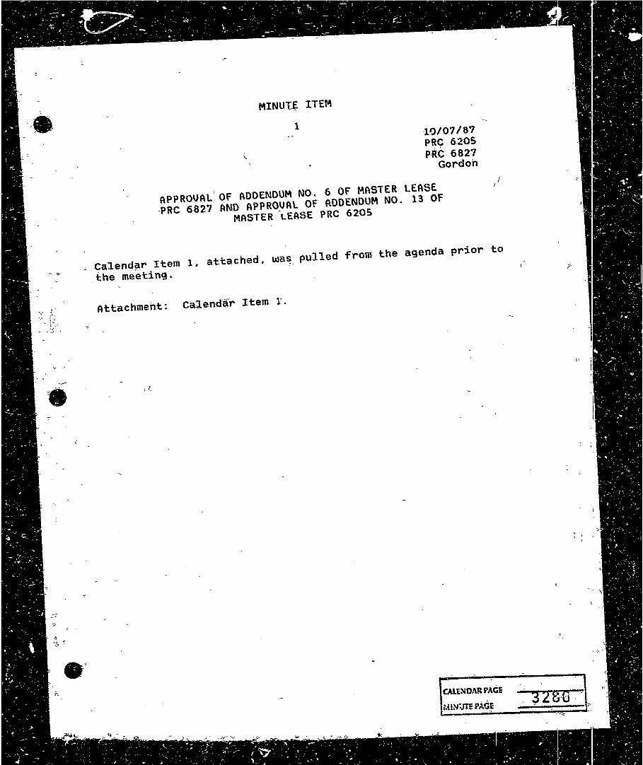
,,_,, ,, ,• • ITEM 1 -HJ/07 / 8'7 PRC 620S- P-RC 6827 Gordon APPROVAL. Of AOOENOUM NO .• 6 OF MASTER LEASE ·PRC 6827 AND APPROVAL OF ADDENDUM NO. 13 OF MASTER -LEASE PRC Calendar Item 1. attached, was pulled from agenda prior to , the meeting. Attachment: Calendar Item r . I I,

Welcome message from author
This document is posted to help you gain knowledge. Please leave a comment to let me know what you think about it! Share it to your friends and learn new things together.
Transcript
,,_,, ,,
,•
•
MINUT~ ITEM
1 -HJ/07 / 8'7 PRC 620SP-RC 6827
Gordon
APPROVAL. Of AOOENOUM NO .• 6 OF MASTER LEASE ·PRC 6827 AND APPROVAL OF ADDENDUM NO. 13 OF
MASTER -LEASE PRC 620~
~ Calendar Item 1. attached, was pulled from th~ agenda prior to
, the meeting.
Attachment: Calendar Item r .
I I,
. '
•
A 26
s -5
APPLICANT:
BACKGROUND:-
CALENDAR ITEM
APPROVAL OF ADDENDUM NO. 6 OF MASTER .LEASE PRC-0827 ANO
-APPROVAL OF_ ADDENDUM NO. 13 Of MASTER LEASE PRC 6205
P~cific .Gas and Elec;tric Company A·~tn: Erni·e Ralston. 1401 Fu1toM Street FresnQ, Cal±Forni~ 93760
10/07/SfJ PRC. 6205 PRC 6823 Gordon
At its April 25, 1985 meeting, the State Lands Commissionapprou~d ·tne, 0 issuance of Master Lease :f>RC 6827 (Minute' 'ttem 'No. 4.) to Pacifi-c Gas and Electric Company f'or qari~us ~leetric transmi~siah facilities, 6Q KU and g~i~ter, throughout Califofnia_ -
At its Augus-f--:26-, 19"82 mee.ting; tne St~te- Lands· 'Commission approved the issuance of Master Lease PRC 6205 (Minute Item No. 19) to Pacif':i.c C?as -and Electric -Company for various electric transmission facilities; less than 60 KV, throughout California.
Each mas·ter le~se provides that the ],ease may periocficalJy bt:i amended ~Y a series of a~denda for the purpose of adding to and dl;!leting from the lease the parcel·s of' land necessary for t_Jte _ distril:;>ution of electrical energy. ·
CURRENT-S!TUATIONl
L,ssee propo~es to-construct,- operate~ and m~in~ain a lt5 KU overheac;f electric· tran·smission line approximately 54. 8 miles in lengtrr. The purpose or the project is to conn~ct four cogenerarion ·plants located in San joaquin County, wi-=t'h-Les, see 1 s Tesla Substation in eastern Alameda County .
-1-.
-:-~,...,.,,..., ___ - - -·_-:: :.- ,- ~
-- - V.lENOAR PACE - -
·-
CALEND~R. _ITEM NO. nt (CONT"D). I
r
TERMS Of MASTER LEASE PRC 6827: Initial period:
Renewalr options·:
30 y~ars ·beginning May 1., ~i985.
One successive peri~d of 15-years.
Public liability ±n~µi:-anc~~! Gol!:lbined« single , ~im1~ G~verage· of $2,000,000.
r.
Current Con~ideration: =$1~,100· per ~nnum; · five'"':"yettr ·rent rev-l,ew.
TE.RMS OF MASTER ·LEASE PRC 620~: .3o years.Qeg$nn~ng Sept~mber ~~ 1982.
Initial period:
ReneU1al options: One soccessi-.v.a period Qf ..., · 1.S year~.
Public . -
l:i:abili-tY ... i~nsu~anc~: ~o.mbi_n~d ~~ngle ,, -limit cqv~raga of, $i,,.900.,QQO· r or al.1:ei-natiue a~ceatiilble to. the State Laiids Commis·S.ion. · ..
' "" - .,_ - ~· - w ~
. :Curf'~nt coosid~ratitm·: ·$~ .• SOQ per _atlh'c#n~\ five-ye~r rent ·revi~w. :-
STATUTO~Y ANO -OTHE'R REfERf.NCES: A. P.R. c. : · oi·v. 6 ,- Pari;;S l anct 2-i Div .. J,~ ~,
fl,. Cal. f\dm+ Cqde,~--~Title 2·, Diy. ~-:-t~~le. 14, o.J,.u .. 6 . · , ·~ ...
~AB 884: NIA.
-·- · 'OTHER PERTINENT INFORMATION·: l.
-J _... -
Exhibit "A-6" describes tide ,a~~csubmerged land which Lessee no lQnger ut:i.lize.s.: t.,essae 'has advised staf5 al1 .. fSlcil:i ties~ nave· been previously ren1oved from~ the:. ~ site. The daleti6h of this pfurcel ~rom Master: Lease PRC.""6827 ~s not a part 9.f, th~ p~pject referencjd herein. ·
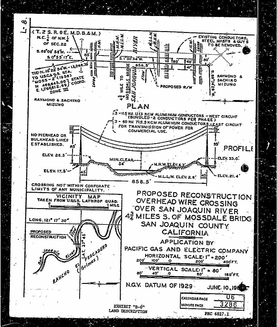
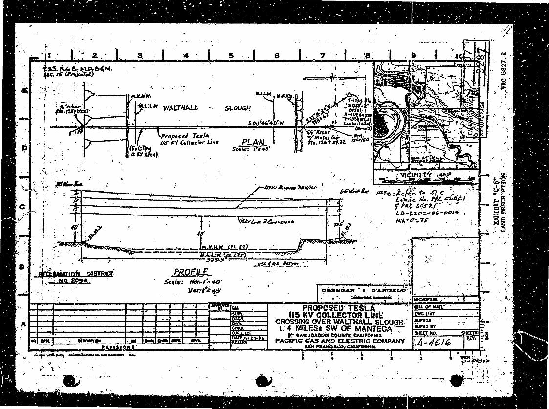
The prop6sed projecf increases the capacity of Lessee's e~±stihg· facilities to llS KV at tne cr.o-ssing sites delinea~ed in Exhibit "B-6~ and Exhibit "C-6".
I ·~
• c
•I'
. .:., . -2-
~· 12~g-e,
.• ;_:_
EXHIBITS:
•
3.
CA [ENOA'R ITEM -NO. 0.1, dcoN:r·t·o)
'Exhibi.t "A-13 11 delirieate1S tide·- and submerged land which is ·being delete-cl- -from Master. Lea'se PRC -6205·,_. bu·t added- to Mas~r Lease PRC 6·a27 as Ex'hibi t "C-6 11 , because the project i-n<:reases th~ CC!paci t-y of· the existing f~ci1:!:ties t:o tt)at which is greater ~han· 60 KV.
This ac-tiui ty increase.s and decreases _,,(he annu~l rent~l of ~kt 6~2~ and .PRC 6~05 ~i · $100, respectiu·e1·y_;
Pursuah~ to ~he Cdmmis~i9n 1 s delegation df auth~rjt~ an~ th~ Stat~ .CEQ~ Guid~liries (,t¢ ~al. Adro •. (;ode 15Q2S), the· staff h~s prepared a Propose·tt ·Negative-_Decl-aratiori identified as EIR ND ~19, ~f~te Cle~r=!-r19house No.~ 87072014. Such Propo_seq Negative D~cl~rat2on-was prepared -~n~ ~irculated for ~ublic reviq~ pursuant to the provisions oF~EQA. - : ) -Be1sed upo_n the Ini:tial St_ydy, the' Prop9seq Negatiu~ Decl~rat~on, and the comm~nts ~~t~ived in respon~e thereto, the~e is n~ substantial evidence J:hat the ,pr'otf ect 'i.oi'l~ have a significa·nt effect ory the , _ _ -~nuironment. (1'4 c_~l. Adm-:;-' Code, lSt.>-7.4) (b).'
The ~pplicant agrees to eos-ure t~~ · o
implementa·tion of the Mi'tl:gation ·Measures as -fles·cribed in the Negntiue Oeclar1'atipn.: Eac1r·1ease document· will ±ri-cluCte the Mi tigat:ion Me;:;isures as a; ·condi tiori' of the agr,eements ._ · · ·
1
4. This ~c.t:i:vi ty involve~ land'S :ide'ntif'ied· as possessing· signifi~canf i!nvironme·ntal · val'Laes puriuant to P.R.c. 6370, ~t ~eq~ but will ·not af'fec:t those si911'#ficant lands.
PRC 6827
"°A:...6 11 Land Oescripiion. 11·8-6 11 Land Description. "C~6M·iand' O~jcription. irQ-:-~• Location 'Map. -
•I ),
- , '(lfEOJ:si:if 1016718'7) -3-., •»- " -.., ... : ' ' . . ..
CALENDAR ITEM. NO. 01 (CON'r,,! 0)_
PRC 6205
"ti-l.~·'!' Land Descrl.ptiort. 11 B•l 3!' Lo~ation Map.
PRC 6827 an~ PRC 6205
ENU I RONMENT-A L-·oOCUMENT"ATl:ON
~·E;' Propos~d Negat'j.ve .peclaration
IT ~S RECOMMEND~D THAT 1HE COMMISSION:
1.-. CERTIFY TH.AT A· NEGATIVE .DECLARATION, EI'R ND 419, 1STATE CLEARINGHOUSE NO. 87072014, WAS PREPARED FOR THIS PROJ"ECT PURSUP.Nt TO THE PROVISIONS OF THE CEQA AND THA'.'F THE . . COMMISSION HAS REVIEWED AND CONSIDERED THE INFORMATION CONTAINED THEREIN.
- . -
2. DETERMINE THAT THE PROJECT, AS APP-ROVED, WILL NOT ·HAVE A SIGNIFICANT EFFECT O~ THE ENVIRONMENT~ , .
3. -
FIND THAT ~HIS ACTIVITY WILL INVOLVE LANDS IDEN:TIFIED AS POSSESSiNG SIGNIFICANT ENVIRONMENTAL VALUES PURSUANT TO P.R.C. 537Q, ET SEQ., aut THAT ·§.flCH7A~TIVITY WILL HAVE NO DIRECT OR INQIRE<;;r EFf_f:CT '0f\1 SUCH LANi;>S.
4. AUTHORIZE ISSUANCE TO PACIFIC GAS AND ~ELE~TR~C COMPANY OF - ADDENDUM NO. 6 TO -MASTER ·LEASE PRC 6827, EFFECTIVE
OCTOBER 7. 1987, IN THE FORM ON FILE IN THE PRINCIPLE OFFICE OF THE STA':fE LANDS COMMISSION WHICH DELETES FROM SAID LEASE THE LAND D.ESC.RIBED IN EXHIBIT "A-6 11 ATTACHED. AND av REF£RENCE MADE A PART HEREOF.; AND WHICH ADOS TO SAID
: LEASE THE LANDS, DELINEATED IN 6:XHIBITS ,;B-6" AND 11 c-6 1i· ATTACHED AND BY REFERENCE MADE A PART ,HEREOF, IN CONSIDERATION OF ANNUAL RENT IN, THE AMO_UNT "--OF $12. 100-. ALL
s.
' .
' "
OTHER TERMS ANO CONOITIONS Of LEASE PRC 6827, SHALL REMA.IN I~ FULL FORCE AND EFFECT. - ' -
.,.
AU'fHQRIZE J:SSUANC~ TO PACirJ:C GA-S -.AND ELECT~IC COMPANY OF ADDENDUM NO. 13 TO MASTER LEASE PRC 6205, EFFECTI-l»E -OCTOBER 1, 1987, IN THE FORM ON FILE IN THE PRINCIPLE Of:f'ICE OF THE STATE LANDS .COMMISSION WHICn DEtETES FROM SAID LEASE THE LAND OEL.INEAiED IN. E-XHIBIT "A-1:3 11 AT;rACHEO AND BY RE~ERfNCE MADE A PART HEREOF, IN CONSIDERATION OF AM'JUAL RENT IN THE ~MOUNT OF $S,900. ALL OTHE~ TERMS AND ·CONDITIONS OF LEASE PRC 6205 SHALL REMAIN IN FULL FOR~E AND EFFf,CT. -
ta_·' ,. r,. I
.-
• /<
•
. ' 1
\' - - . -
..
.,
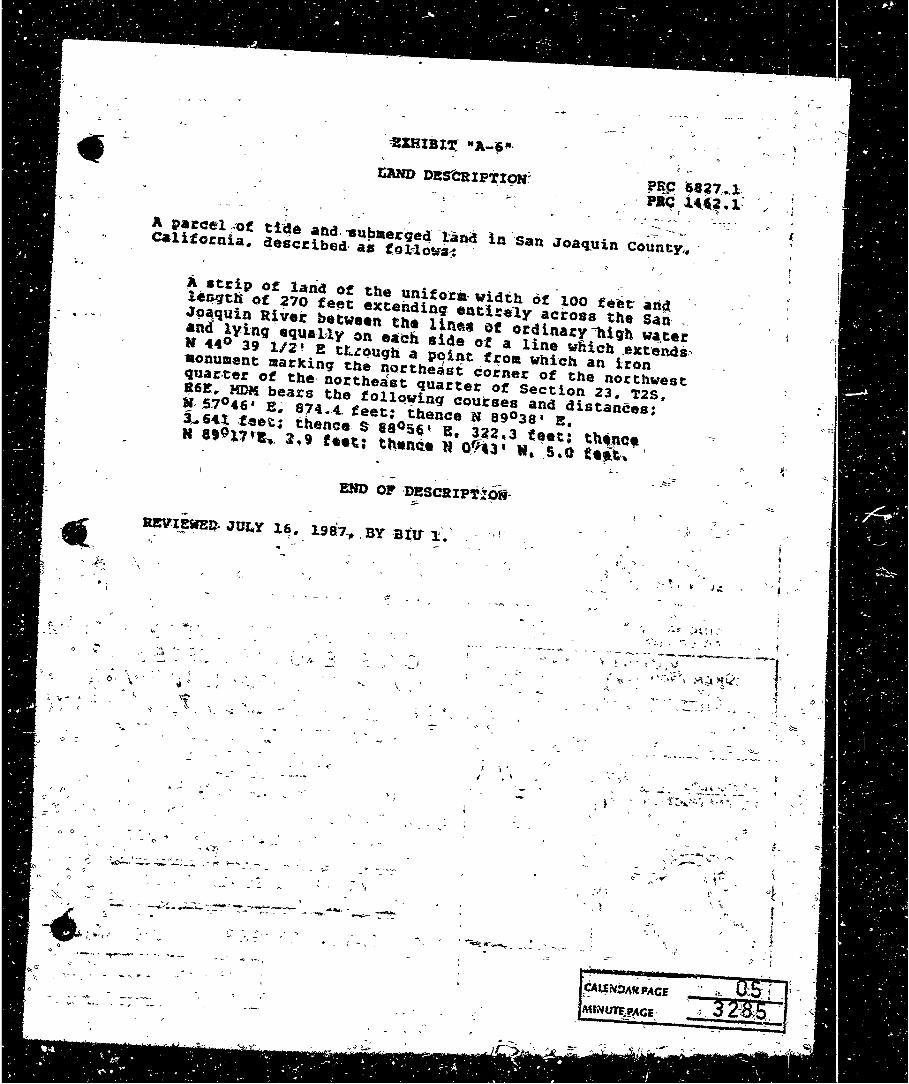
:ZXHIBJ;T,' .. A-J"·
&.AND D~s"'CRIPi'I9N~
·-
-~ .......... - ... -:;-A parc::el ~-of ti~e and ... up11erqe4· -J,.-an<! ln ··san Joaq:uin county,. C.lifornia. described· as (o1'lowa-.:
~ strip o~ land Of the unif o·ra· width ot 100 feet· arid_ ler;qth of 270 fe~t extending. entlre·1y across the Sari· . '191\quin River between th•· lln~• i>f ord1.nary"1tiqh wa.ter and lyinq equatly on each side ot a line wnich _extends:-. N 44° 39 1/2 • P! tt.ze>ugh a pqi.q.t t~oa whi-cn an iron •onument markinq the northeast corner of the northwest qua.r:.eer of the· northeast quarter ot Section 23. T2s. R6E. MDM bears the following courses and distances; ~57046• E~ 674.~. feet: ihence N a903a• E. ~ 64t .fee\':; thence. s· 88056' E, J2a. 3 'feet: thtt.nc• N et011r1-.. l .. 9 f•et; tt\•nC.e lf o.~l' N, '.S,o ft~tn. 1
-Jm\'-I~!!WE~ • .JU~Y l~, 1987.,, BY -B~tt l:~'
. • .. ,,
. (
...
·--,;, .. ~'-
- . ...
l,_ t /,. -~
.. -
- I . '
' \
-·,.J
> \ j ' I
;.
; t '-
,, .
',' ->~.:::~ -~~- ;-.. l. J41'
~ .. ~·-..,,..t ,', ~··
I. '
J· I
I .. ' ...
$.
J""!ll' ..................... i..... __ ...,..~~~(
,~~N!:>AH·PACE ' •
MfN~~CE:
RAYUOND·&.SACHIKO . Ml~fJ!<IO
CROSSING NOT-Wll"HIN C9RPORATE L.IMITS <Q.F ANY MUNICfPALITY •.
"-~ , " - ., .. • " '. c -
VICf,NITY MAP TAKEN f"RQN'wtG.s,. t..ATtfROP QUAO.
o · .. . ·Yr.·. . . -,;j·MILe. - ~. =-.a
l.ONG.1~1• 17' 30"'.
-:::, ·I·
PR·op·osEo RECON~T,RUCTldN: OVER-HEAD W(RE ·CROSSl·NG ~
-=-ovER· S,AN JOAQUIN, RIV.'ER ., 4~ M·t CES· ·s. OF, .. M.9S~DALE BRIOO:.
SAN JOAQUlN COU.NT'l' CALIFQ.RNl.6-~ ·-
APPLICATION: av·· ~ ~
PACIFIC GAS· ANO. £L~.CTRIC ~OMPANV HORIZONTAL ·scALEs I" .;.zoo'
2 00• 100• 0 . . ,200• ~ ~C(f F'T. ~ 'i • $ .... 1
-~vE::RT:ICAL SC'Ai,e!': I~• SO,~ . , . so· 40! · . ~o ·ao• l , ·rao F'T. t= _,
N.G:V. DATUM OF 1929-.. JUNE-IO,J9 .. 0 •
EXHIBIT "B-611
LAND I>ESCRIPTION
CAlENDi\R PA(i~
. MINUTE PA!;~
·,
' !-·
..... .;it ~). 2. .. ~" .· .-- " s 7 · · I .. , " JS '. ·I \'. .. ~
"~ •('
, '-' . " _J.- . l
~~·~:a:_· - -1" .:~ ....
~'i.&..lt! .. .JUi}!J$,
. f ;;.,ff - .. 14 . S~OUGll .~ '<,i_ '. I . . s 00•+1ii''tD~w.
. . i . ·1 j( -~ ~ -~
WALTH AL.~
: a;. I ':-:. t "· ; ,A. : : "" 1. ... '
·-rropo$~ Te,/&
{ • l/S KV Cellcc1•r Li1;e
ittis'f1!i1 <4.~l.Mc).
Pt.AW £c•tc·: , ... <to•
1
t .,. J'
,• . . : ~ ·· VidN tfv«· ~-~" , :. : ·
"
..... ' " N CCI ~
tJ ) g; >.,.\ 4 l ...
' '
-=~,, '°' ... .
~ ... "' - ' . "' . .•. . - ,_ ,.,,._ 11S_ ' ~·~;r..
,, 1·~ 'l :-·~,..[::."' :::.:,::::==::;::::::::'==;====~::=!:~=-t1~· : ~J·~, ( ;- ' :l . ., . .. ..- . . '--"· ; :'.:! , •. - .; ·• -.·r-.. ·co - . ..-. =, :::a: )
... -- .. 't/~'"":: ""-' --~ ~ ·,._, ~:,
/tlot<;':'l<.(~; __ .,.,, ..s.1:-c 7; ... '. .:"to1; . ..... . 9~.;. ~ -.
" . - . . I. . e :·· . . ·,.,.,,;,.,e..-i-• . . •., ,;t•' · L<.t:l-c /J •• ift!..~~/, -f ht;~ 1,(?.F1.;·- . __ _,.,·
LD -\~'l.PZ.-0~-"!>l'f..
'. NtA.;"{!t'"~ "14" i. ,, , I . . ' ... - ' : "°.l,. ,,.. . L, , : ,~ . ,. I · · J . Ii " f · : · J ·~ . · . <!!..W~~~I I • -.: -· , -----i=--==-----r..--,~~~.-- , ,,,,~... --J
. ~.:· ' \'.. 1~· )f)r ....... ~~-·( t :! • '\
,._;,;:;;:, -, L .... ::auoqYX:~------:- 11&.&.J..-W. ~ J.'1S' . . . ' ·'. . _. . . . _,,,,,,, . . . . .....U,~L""-.fli":-_; .. \ .. . -
.; -~ ~· -. ".. J;R.OfiLE
·~ .. , ........ C'"~
'"!f
' 111· ":~· ~
i~ ~: .;. , '
·".:.' ~·· "
~.;
, WiMmoff D!HRr;I; · : ··,-NQ20i4 k .
' .
"
Scclt:: lltJr../._40. ,,_._,,,.i . .., ........ ·-*" - "~ I ·caasb.a. .. • ._. »·~~~~&.~~~ i_ .•• ' . :' . • n • 1 I-"'- f
-··. ~ • ....-. r< 'i,....,._IJI ':··~' I • : '~ .. • • -~· ' 4- - ......
'' "
A I I f' . f' I I I""'"- -- . I .· -:, I I : ( ,, · I ~ . - .£1111>. ..• · --;...• .. , ·~ ...... '" ~ .... .... .,.., .... ...
RC'VISIO•S ...
- .. PROPOSED· TESLA lfS,KV COtlECTOR Lltlf::
<:ROSSING OVER WALTHALL SLOUGH·. (: 4 MILES:t SW ·OF MANTECA ---
O<' ler&L ()fl: MAn:-» -. -.. owe wr .
~ •AM .1Q.\QuiM eouMn. c:Auro1ua~ · PACIFIC GAS AND ELECTRIC COMPANY
MN llRAHCl.:O .. ~JrORNa4 .
SUPSOS SUl"SD IY SHERM). .
··:,A-4516
-.:
(,J ..... _.,..:.dif.·~ ------~ l <• - I/ • • a. I l • ,ow..(; •. •
17~~- ". "' .. 1;,;.,_
J-f ,f!lrr. ·SQ ,... Rc ~% f :S •' '
'l
Q'' ~
l '¢ f; .,.,
0--
{;)r;.. , ·1 ....
I/ -·~-~ -- ~ - _ .. ,.
.,!- ' ~ 1 I :
:.. ' • ) . f ~
•
• ~-·-!t ' -""'"' 1 •' ;$ ,_, · ~C e ·.._.," .
·~~l.. •
~ __ : ~:-~~-~~ .. •
.. .. +·-,,'
....,,. _. ---~ --,.,

- r: ..

, .: .
'I
tdot'.s~r arr · 1 -in'.
j •; R1taliRDI: MA~HL
. - 4 \ ·I _ Juu11,i-MAc111· ·
- l/7'•DR·.Y~ ·. ' -
1. •· 1:
--"':~
rRfD/A!UJ .£'P1CCH.I ·CT AL 12GJ·OR•432
'"l
.... :1· . - . . , . ,;, :l :• .. .. ':· ~,
:. :a;
.... "" ::~j .. :. :I :' . -:• ...
- .;_.
' -· :• ~· ...
Jt:!"'' b; •. ,. -
~~~1:: ~ · . ., ••• a!: .. :· .. ·hi· . .. ~: ~ .,•r "' .. ...
'~' -
·1~· ·1·.,~
... i'~
'. '' ;, .. -l(V'}• I •
·L ~ ·- ,
f' ~; =~~, ~-'
.. --:~,-~~< ..~"' - ~ } ··:..<·t ~ .:~
_,.- .... :-'.
v . -' / .. . ':- •' - I' ~ ;;-.
.'. ...~. ...:::.:. ... ., .. -. - ,~.,.......~. -;. .. . , ...:::. .... -~. . . ..'$lit-'' " .,...,.. . - -.::::- , . ,, .. , .. • .. rr·. ·-;., , • . .. '. t. ·~..., .... ' 'I .A ,~~~ ; ... i ·~ a • .,, . - " f- • • ' ~r~ ~r;:-;· ,., ·, • •;. ~-- . ., i
1
j ~ i !< 9\1;. • ..... • ~. - • ~ ·1 . . , ·r ~ . l
; '-, , ~ • '• . • I .!; ' I I I ·.'y:- ... •'.; i"· - '·J :'!'t ! ; •. -~
.. .... ";' .. ~ :!!'.-.,_ .. ...:.......]/-,_ ,..,.. ·~ .') '1' ·~· '""'!.~"~..A.:.~ ... ".... ~~ . ----. ·1r. -· ~,;:.,<>.,.~k .. <1• -. ..... " ... ~.~~..r · · k, )'-- ~"'-. ' .,; ,,,, ·.;. "'-~·. 'l , ' ., ... l .:;:, .,. ' , • . . ... . . •,. .. ,, . . .. :; >°i: ~· • .__ 'Y·' ; '< .. ,·-,.,
··1· •:: .. ' .. /,,,_ 1 ' -~--\l • ~.,:. =; j .r~ I ._ . ·-~'"\~'.°~ , ~ :: •• ' • J -+ ; ' ~~ •• '...;,.~.,..'---,--- • ., I . - ,... . 'J :. f• •:'. I ~-.;:.~ ~ . • .. -:,.1 -·- ' t
j'; .. " . 'hm •• •'"t .. ,... ... w. •-·-· .. ·"' I . f i . . . . . j
. ·~' ~ ~ ,'...,._::>
,·
'- '. .: .... ? ,.........,;.. ..;
IJ2,-..0R•<f1 - •. ~ \ ,,., .--·,t .. J •.>•••'L"'''············ t " ·- ' .---~- - ._
~ .... ::·.!·~:5~,;i~f.\7,~~.~.~.nr: .'1' P.Ot..'E L?NE.EXTENS~GN
I ~ .. ,. .... ~.r .. ,.. lo' • .. - - , • ,_,, __________ ...... _+------- -- :---·~""''1' .. \ ..... -- ·-·. -· - . . " -- --,'.. .
, •• .,.-,,_:<.•' ... ~..-~·-::·· .-.,,:--o:·· Y .. O C::.ER·'VE· Ea o..p-t!:~iil .. , '. '\ ••• I ,.J I
• ~ .... I .. ~, . ......--~..._,............... ..... " . { -'{:, , 'i.'
i1
11
q I ..
., ' 1 •· 1:
I~ • ... !:: . . I I ! ' ~
SJl~· .~~~PUIN ·COUNTY ; - t ·,l <""' ' ' -
.. ' i -
j_~
, . ·i "
"-
·-' _ . ,._,!,.'1,~' • • .. • __..- •-. • ............. ._ I • \;.JI."'!: ...., ..., - ~ ,.tit~,, ~,,," / ,... '\ ...... .. • ~ ' ' , .. ,.~... a· ,, ~ ... . ut!ff . . .... .; • . . . 1! ~· . . ' \ o .. •. :..... .,, .. • .....I\\•"' . ,. . . ' . --· "''&'" ' y ..... ~'P. . . • ,.. . • --'t . ~ •. .. 11' ~
... ·~~· ~;- / "0,.q · · .. • ·: -- PACI;FlC/GA~ i~1>, .F.Lr.CT-lll~ 'E •• ~,· •• .• • .. , . ,., sl.i.~r1t..:· .... ~sc:·Q·f:~r,.=-•!A -~·.,.:. ·1
•'~~· . -, ~ / o....\'- I ' . . • ' • • .., . ' •. • , . .:: •1>'~· ~, /- ~.,..- '. .... .. . . .. , :r -- .. -·.-:-·--;(~- ' .:1.~ -.- ___ .. • .."" .-· •• , .. . • .. • ··- ~ . ; I
' ~ Q l,, $BIBI~ 11A-il11'
i.ANo msCRif110N· .
-- ;_
· ... , -~
.. "'" ti --,---- _,, ..
""'
. ,. . ~-, i-> ,i ;P,RC 6205.1 . , ,
..,,,; J;r • ~ I ,, • ' t - ( .. " ~ '1 ' . : )'..
: ' •' ~' l " . l {
. ~--':. l: ~t~l 1.~-•. -~-~--< . .lt
- - 4l-·· - -
! ', ; ' • < < .. , ·~ < •• __ • .: ·~ ~ ' > .~ • • : ~ :. • • • "I ' )_ . • • '-. : < • ~ • < ~- -._ • ' • • ' • : • •

PRC 6205.1
. ... . ... ~ .- . • • , ,-' I •
• •, • • I • • •
~ ·. · ... ~ . '
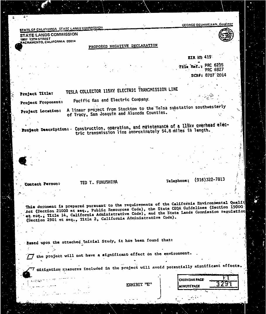
STA.Tl. o~At.tr.c1uN1~2~~~f!UJ,fOM~~1or~ ..... --.-..----""ll!=" .. _. __ ,_ ____ _.G..,EO-.R .. G..,E""'·'O•E•u,..1<,.,.M ... E.,.J1 .. AN ... ..,a..,o_,v•.t: STATE:LANos'coMMlsSION ', ,·e·~·'':-1eo1··13TH STREET ... •
. •,ACRAMENTO.C:ALl,ORNIA 9581" ' · -~A .... ~ PROPOSED NEGATIVE DECLARATION
.• -'Yfl. '.ibaf.;';· PRC 6i05 , .~ , .. :pac ·6~27
.seal: 8707°aoi4
TESLA COLLECTOR 115KV ELECTRIC TRAN~MlSSION ~JNE
Paei fi c Gas and Electric Comp~ny._ l I., /1
A linear pr<iiect fr9m Stockton tG the-"ielsa s~~station southwesterly of Tr~cy, San Joaqui·n and Alameda Counties. - '' .,_·
· hf4e&ct: DucripUQtl~ ·· Construction, opera.t-ion, and t'\a1ntenance .of a \lS~v ~vtrhead'-eltc• tric trallsmission line annroY.i-.nately 54~8 ,miles in 1ength •.
TED T •. fUKUSHlt:tA Telephone; (916}~~2-7813
~ .. ' fi ~= i ,r -· • <, - 0- ~ i: : - I
th11t d9<:-iunent µ p_repared pur•uant· to the re<1W.rements of· the Callfoinia EJ\droni>ontal. ~~ < .J.ct (Secti.on 21000 et aeq. • Publi~ Resnu~ces Code), the ~.tat~ CEQA Guide:lines (S!lctio11 15900:
.· · ~ e~ s~q. •· Title ~4, Califomia AdminiEtrat:i.ve Code), and the Stat~ Lands Commission regulati.cnl (Sect~on 2901 et seq~· Title i, Califorui~ Admi,nistrac:i.ve Cpde). ·
0 •
· B,.ased upa~ the attache~_tniti~l Stud~, it has· been found that:
·J::J the ~~oj~ct vi~l not·have ~ algnificane effect on the.environment.
·--
: )rfT OIUigntion' ::~ure,s u.ciuded
? ::.~;-;:. -;.;-; ._. ~ .._ -:-:-
' ' ~ ..... ..,.. __ .--- - , ,..~ .. -
in the pre.ject vill avo~d potentially si~nificant effects~
. I>
\
\ EXHIBIT ''E"·
.J
CALENDAR PACE'
MINUTfPACI - - . .--.. .... ~
. . '\. . _,... " ...
• • - • --~ • - •• •• ~ •• • • .. ·~ • "' t
~ . t • .
~· ... ~-- • ,', t
.. ' ,.
\') ,
\'
'
HITIGATION t1EASURE
z,-. I
' '
-~In -Cffder to, -avoid potential safety hazards posed by the 'DO\ier 'poles,-the project-,, , will" require the placement of guard r_~iling along Harlan Road.
I •
' 'f
; J" - _.-~.
;i
.... - .;-,,;
'- \ - .;_; 7
' .1·· i_ .:- : .>· -
I_
~ ,"t.; ~ l ~-«' •
~ - ,;:_:I
~ ... --- -,, .... ,._ ... ~
•• :s
°QC.. • . c: -Cl .c: -
5 .. .j
1./'
. _.,
. •
..
(,
..
... "'
:. ~ .. . .. "' ., -(,, .. u
' ,.. ~ '· ..
' . ; t . ~
,''
~
1
'.)'
~
·~
'.ft /'•
... • <
~
., ~
,,
;
,,,
" ,..
...
';
-- \•' ·'
-' ('
'II
.t,
'I, •
,,
·,
•
. ~.
: '
::-,
,
' ! .. .. . . .... ... . .... ••• .. .... =i· .!~ ~1 •• •• l.! .. •• 'ji ·'
~ ,, <>
'
,,
,,
•/
' -..- ~, ,H ,, ,, 0 Vo·, ~
0 v • "
\<...,;,
"'' "(',
0,
r /
,,
·-" "
..
•
,. ,, I
l - ,..--~-, ___ ..__ .........
\
.....
,, " < I
<>
-, '
t ,
t '•,
~ ... ;. 0 < 0
"'·:.- ()
" 0
(>
"' '
~ "
-
..... -..,
' -.

. ... • .. . "'
,. ' Jf ~\
•' ' ..
" ' ·,
, 'St•U Land• 'cmi•slon ' '1 ~i:_.:6• 1H1
;. - ' f ' \ ..
c_ :rn, L<, .: .,_t - . . = · ; , · · :Pii>:J•ct descrlptton •l•ct aent:lona ·that tb• route crot&Ha
; £:eg-.toia~e lllghV•Y ·510 vhSch ~•' dui9nat14 as a -acanic b11hvay ln · ~Mil a~irA• 'Tile fact«tbat the"zcenlp designation does nat re~lre i •1ttgai;4cn :for cle.ctr1c trarasabctori lines over :lt kUov~lta
-t· \ 11a~µi·~ 1 for.,clC:ises "the potential_ -f:9r ·s1gn1Ucant v1s~l l,!lpacta _,, ·nor -lass•~• tbe need tor aitlgat1on of such l•pacts.r 'Addli.:lonal.ly, the lack of infona1&tlon provided· r•g"rding th•
0 ;~ea.!a lvi'sual qua,litjr precludes a detcnainatlon as to ttta ~~-~~1"? for other v!S:aal iapac~s olo~ ttia route. .
I .. t~~tln~ A contains -no infonu1tion on th• cultural or ·j ~~Pjl~l:· J~C::U ~l01l9: ~* route,. •.o . ataff ~ld, ·Mt ' ei~r.JM.~~·~~~nl;.t.a~.:bpact~. to sucb. r~•ourcas. lnfo~t.ton· · ~. ~f.P-:1~. -.1~~1.n,g,.w potent.Sal bpaqt• fr09 ·ace;~~· roau,. la}' do¥".
~.. -•r~.- .az14. .palllpg· sites. 'l'rana•lsdoon Unes caa cau~• '> ~? •!9N1$~t.. ~Jl'IC.t.s 'tO c:Ultural. ancS ·i!iologic:al .re6ourc:as. Tb•·
,ft ~~~I!} . .,t~.··:1-•p&~ Js of· pani~!IX: COl,\CCm along ~pa11t5 ~f ~' H!:i!.'l! ::Jla'So\l~c;e ·s'lneys aftd \i!-•rature ·•••rch•IJ ·•r• nacea~~ry !O.,l\f,~•~ ·th•, poi•11tbl· to~ ~~,e:~ ..
:.
. ,-·i~ ~ply,aajor; .staff~• redcv iftdlcatn that. there are.• nuab•r · -::' o( !.PJ~~ ~r~is· Ali- ~blc·h ,~. :p,oject.'.iaay c:ause atgni(.ic~nt
1! en~ir'! ;111 , i~cta. • Tbase Jaaues·- r.-ed to ·b• .consilkr•d.- or : ad~~,~~f!Je-erey~r_oug~y ... -~.Aho,,. ~~~tt no~es that poitl_ori~ of
~ 1 thft ~~~~~~.cm, ;line.-·~~ •JJ;Hdy mu2er c;onstxuc~i~ •'!'~P: thou~h
liJ·. tbi ttn,,lronaepi:.l ·~1:ntatlon bas ru>t,.bet1n CIJ!IPlahd.. Glvep.
t~!·~· ·:~!.~tor6~- -th•. -~EC- St&(~ rcc.oaHnds 'tlia~ .... ,~r-~t EnxlrrN!:l'~nt!l"lJIJ>#~~ a,pqr;c. ~ propar~d for this project ~to~• .:f'~_.r-~~t~cti9n~oc;_cur,s;~ , · · , : .
i Jt~~~-)ia.v~ ~-,~-~~:C!r \lou}.d. J.,ik• c:bri&dca.t~~ ~ th.• ~~~c 1_....ata!t _coaaents, .pleail.e ·C?ntact Sharron ~ay1·or of :.y &~Aff at r r·~t1''· .:S2'·•'3!.>l;,.. . . . ! . ,, .... ~ -· .
l .. .;//. \".... - ; ,". \ " -· •• ., : <'
I • ,,
~. ' I ~;, .~ 'i: ~ ........... - ~ .
~·' -1--; r.-,-., ... ;
,...,. "" I
,. - , ';,_i .-
~~---._.,?t. ~ ,, ~· 'f
' ~ :~~-;- -":'.~ 1-.. <;>I Z: ~ .. ~ ... ,,,., ... ~ .. ~
S ~z~ .. ;.~ -· ~ a, . .'~ ~ .. ~ ~"-· \'.· ·a .:! . . < ~ ~..,, ... , !!!¥'4.!fr"'' ,,:. 'G' ..... ~ - .. ~,
. 0t•l'\'.• " •. ·. '..;• I ::.~l.,... .~ ~ : ":• ,.~
~ .... ' "<
("- ~ .
.~inr~~iJ!!,
~-~ iobart:to"~erkelsen, C2.lof ~ s~ting arwi Envlronaental·~vlstoe
,"; .. " l •\
2
... ~ \
\.
.
' .
-- -- I •. y.,.._ • .,.,,..,_.,._
" . "'
••
!JJ!!IH (ceatr.-)
... 1• • ~ 011..-t • • ..,..w-wt .. ,, IM Hil.i ef t11t 1fne .st •fl·• WIS ,.., •• 1 tit , .. INl'lUt. .. •llltr tu&allMI fN' .......... MIMl .. •h•l 11111 pretHt •1Mt'" •111Mtflt. At U't-'"41Ht •M•r. lretUIMC!l ...... . Wt "'"' .r .. u. C1Ufenaf1 .._..._.t er~.11s1i ·aal. ~wn COAsu1u4 for> s111r ttnfoas .u. c•c•rr•ce .. .t Ut fea SllNIW ·rer u.ts se.-•t of tJte·llae. A 1une1 wn cCMIMW _. ColO pouaUal kit foi 4ifls i,er• fou11d. - M to A cleslta ch.lllialt. Ula pouiU1I ... Mir tM s..-SUUMl•dll'·h 1v0t"4. AlUIOutll-• ~le post&•• ws locaUll 1111r u.e eUlir l!IOt•ti•lldea, ft wu 4eteraine•-u.u tMlct to .tlds !19htt,.1 .. a1114 kA•~·~llS~IAI ~ . .,oJt. .l.~-~~!!'I ~ 111t1l1tat -urnla c•nn.ct1• ras~lcthato:. , · 1.-. , •· • ~- _ ., ••• ; - • • , •
'· IUH .;poa tJle·INft. tl ts eur 4ttend111Ua;crt!slt ~-ttepttv• D1d1r1U011 b. ttie. •Pf'C'QfrlAta- mc .... t f6f' Ulls' prOjtct. . · , ·; , - .
'::
..
-~
;
,!,,
~
l•
',,
,.
1 • ',~ I::-'J '\'\ ",, ,
r, •·· \\ 9 ,, ,' :,:,~. / \)\~ •'
·• "
~
:; - '~
'--"! "1'i~ ...;
... . 1 :... ' 1"' .... - ~· • .. ""' .rfJ ..
...,~·~
......
-~
' ~· '
I· ,¢. ,. - ... ")"
I·. ¢ . " ,, -" ,, ~· ·.i 'It "
.. '' I ... '
~ ' ( .... I~· '<i
-. I ,.. r~ ·,
-~ r ·: ." . . ..
" , • l : . ·~; y' '/'·',..~! •.!:_,..• tJ">"
-.'f' • I VI\ ..,,,''/..'£'
... 1-~ ...... ' ',..-'- , ·/,~"~ ., .-:.~ :--
~ - 't :' ":< ~ 'i "'...o;:.~
''· { 1',.. - ,'"'. {'
' -:"' "'i ~ 1 f"t"'~ ·~ f•" . )t '~ 7
't·),_j './ : ~~ .. r < ,...~?,"' .... .. - .. ~ "&~~-
"-~ ~ 't 't. ·il: ..... ,t _nt '· ,,_ ' .. .
f ~· ·-~.i.. .._ ""•' • .. , ' ,j:!_ ,· ,.,.,.. r~, ",(>!.'{ r{
,,. ~"( :- '·; ..
,_ <
• r ...
""".: ..
',.11
'• ~ ·t . ... '•\
;:. .... ·u,;.• n > ~ 1' 't} ,f I.,.:~~ t,,~: > "'~, _
111 , -,,-h. ,LJ '%. ~ •• '
.. -.~.;• .... h-,t',.. ),,_ rj ~ -. ;r-:':.~- .. , 1
I .... .,., , ,,,~ ~ /J, ' ~ ' "f5 j
t.~f<\f/"J.. _..._·
: -~ . ,_ t t ~
.. ~ ~ ~=-...... ..: ~ ~ -.,, ·"i-¥ ....
-''' H~ . . . ·, .1 fJ ,.. · ~ - < ,_.
.. ,' • ¢

.... -•-CM• -"· . ~•.a•v .. • AIR I. ...a
MODUCJS t:::.: fW!I ~o,,.. .. , ... f~~~ .... ; ... ' ~ . ' ~. :{ - • >
' ' . • ~ t . . •t • < • ;·. l .; 'I ' ' i '. l I , ~1
!\ ,, t ~ • .,; Augu•& 2•. 298? .. I . ··L . !..; f(
-~ ~' \}
·! •" , · '~: !d!\~ DELJ#!Y · · J.... .... :... . f ;;, ~ \ ~ ~. ''•d '1:• .ruituahl..a
~ .. IUwi~ion of •. Jler.eMrd4 and .. lannl~g ~! , -*ta~ t.&~5 co.saiiia1cn :: lSOli 13th sueat. ,.
-sacrwnt:o.".J:A tseH . ,,.
.•
·• ~ .... ~egli(avir ~ciarac!on • T•d• CoU•ct:or
'' ~;""·tlectr!e.tranca!ssion i•n• crcand£) t~ k .. ' ' •
=~•r ·.Mr. •:hku5hl~•z , \ r
· ·, • <" Air Procbac~a an4 Chcalcol8 lnc., .en• of four e..;.•M•ilttiUoJ\'.pi-•j9i:ti' tll'l~ \iUi u\Uiao ·tfi• a~ve•rdenncell "~l'lt. "ailaa\'i. 'ihei• coMiti\t:a 1ri riiapani1t to''U1e"H1t;atl«la
o "~ ''"'t>iU¥l'aUtsl\ pdpi~•~ ~V' the' It.Iii ta11da ·CcahiU1n pur~\aant t:o · Qa t:a1HofJihl.£nv1ronaaht:!Al ~allty Act: r•eto1-!') •. · A:lr • ·
Q • ;Prod~ct:a~ aa •xplained below. ~elieves-t:hat the Co111111i•aion•a "' - "llivlUvls .Dei.laat:lon.~ailY,-coritoraa 1o1lth·CEQA'a nqu:l:reaenu
' ind" accpiGil\91)' Ylt~e'ita t:hat· the 'Coif.ahdan"f!naliH iU v ·,. ~gaUvit "1iacl'ara\:.'Son~ apP,i:o\le .the' Hver '·c:roillin~!' pciiU t aoueht:
'. ' by·tc&nilr •. •fut< ~1bh-'1t:'a;·~lioU~it of Dftera!fiatlon · rcfh1ctin9 ":.:.-~ .. ~.-·,at::·~pjirav~(11a·-..j:i'edld~ui1y' aa_ P~!•s1_>1c:: · _ _ ·
.... J ' ' - h < ~ > ' • ' '
~. ·" · · ; :- 1 ··.w..-'WHfel.-annt.t· thitst·:,PGanC!t.i 11111· ui. C:o&a•n~a-·on •' .' · lloMay 1n-wi»Prt ~f-t:h'i 'ffe11,-wi neclirauon. -... hli:h wn1 F · :· :i'ftcturi• i:o\:bfiU:'ar aata i:o'ntt 'idnv ·\.ha·· iti::i::\J'r&c~ of thi · ; "'" t:i1MU\;i6ii?6h~!~' ~n a.. \:.hat: the' ptoj'e'Ct i/11'1. not hav~ · H .... , i'i~niUC:AM,, ...... a ta! 'l'Cahd&•a •ct:lon• t;o·prevan't.' an_)f··such
., •ii'llc~i.~\':liaiS: ~1cnl'. • · · "· · ": · .,,,
1 ~' '· , PCandE be9an construction or~. ~rans•la,ion lin• ~ j 'In· ttay '1t'e't-; •~t•r de'ai9nin9 ·antt ;1ocati'~ ·i't !'ri -accor'dince · I l ' . ' ~ 9' °*Fti11'cahltr: pract'ices 'And ecUch'a' 'dl- the Ca"ls'fornta ~' .lt~s · 'b~~hrias-·~aN1aeiP,,n· J"CPlK:· )'~ms obtailiiiiv· au per•it• ~- - ~tch'; .til(l!'•~oif tc:'incs~ 5· 1 i~11!-hY · •"P.!f1 er~•-·. yc·s-•. raq~i red•
..... ~·" ttu.'ll.• ewt.lj-. 'mll t:Ounty jil· ii•h .:to.-l;iutn"l!cat:nain•o that an , Ii'~.. \~ .~-ra· .... ~ y ~,,... \ • ~ ~ \........ (' . • ~ -~ " • .,_ -
~..... " ~ .. ~ :t ... .. .r .. \ $"' - .I \ }- ' ' .,, "'
~··.,l' ~,i>H-: ,-":: ': ·-.;. .• • . -,. ·"' ~o:·'~ I .. , .. , .. >
~ ,"<; ~:S'' , ...• ""\':>- ..,,
i' -i :.'f ... '~ ' (
' ' ,,~ ,~ ~
' "· ... .. ' ,'
•. .. ' ... -~ l ""'
.¥. '•<,
l • I
( I
'
IESPOHSE • •
(a.ea~ 'Mh4.
-'
-; ,,
,, )"'
"
<>--
')
1'' •
;
. '
. ' ~
c
" :: ~ ·. .· .;-. 0
~.'
" .',.}
('
,,.
-' ' ''1 J ' Wt .... 1'•4"~. l'ukuahSu ~ .... ·a..nd• C<>aaia&lOA
-~~~-'~ ~~- 1517 l ((~· ,,i ' '
, ~ " . \ ' ~
... c.J.n1. Penit •b•\1aa Mcq-,ny~ rclandC tlleretore ~-:::::~ ---:-~, ti,•lid'lh•i pualt •rMl coa-p!sa.,-•• i.h au c~n4iUona Ht
"'l t~ ~I:•~)). •ti\ •cldldon. at tht, ·*•~uut. of -• !egaalator' \ \ , \ . _.. ~t.Wi"tceai ciUUna. th• -CPUC iltiaU' rlavicv1d ~Candt' • '\ \ \
IO'niCt,; loc;aUnljp t.he line and condud~:l Jn lta dr111!t. r•~rt \ ,, •~•~t•d ciood practic~a war• C)b&•rY•d. Th• report also -~ • 'di,& ..few add ~tonal iaeaau~ca \lhich. "'hSb not caacnU•1 ·
= d~~ .. 't. ai~i.9a3on ~t 4."lt P'?tential aatety e!fccu. aleht ·~' ~llll"'u--Tei1'toicit th•-~eaaurtiii ·a1i&-,a~ ·i.arr19d· ou~ toy" =:+'Ab l'iOdticti ~-~n1:a15; foe. ·has C:O..t"'.wct •· ·
1:!9~ -,., iap'fi.Wnt·~QM oi ~tioaci 'iidciidonal"'.i•,iurea'' ' ti il . ' ' tivi -1'.ri&tallnf · ' ot C\ir~tn· .'a~ -iiUectclra alc.-.9 a t.• .u;1w'1.ii'f.n ot- the -~-roj-•c:t- refe~~nccd: !n: t'lt• ctuc -st.aft
,, -~•port;)• ' ' : , , .- - . - , -- - - •. " . ,
.:: = "'·' -lhi~~•lte ·ua't• 91van th• nature of ~h• proj•c~ 0 •"4; -Uc ~.Wivnat ·~1.-.roua ·ani;anon -~da'ur .. ·th-it.' v• •\w.re c~t.W 'to·t•14'li.eri, ·'tlta-t!...albioi l\aa coiltei:tly ielra1nad
.,..·tro.·••~11\lf A'riY ~••nitatoi1 tlndUit'ct d9nUfcanc•• Citeaa.u.1 tllro .. -.c). ·-tri.t',Nswrea to l:iL~faken effectl"niy 'n•1•t• thti possibility fot'Qc:u..ibitlvelt considerabfe'~•lfecta or ad~•r••~ dlcct.• on hwa&Jil bain9a. 1t. ahou\d b• noted. ·in fact., that r '
_, u.._coi•nin'i.Zciri ·'P.l'CiJjccc• driicJ 'by th• Uni uUl iacnant• ' ' , ..,itffvi- .lJ.tfttiU is ".for Ue -co~ri~y• a P6?illaUon; -Sn- tha fohi of. •dcUct-*n Jc.it 'loii 'iaai~ilt•. aubat'anthlly· increaiiad- tai
r•v•diliis·tot'ili• ~~ti. •*~-1~nds:expinded in local · ·· -.audispJU~~i !or ·.(iiceaai"ij~9ocias ~ &crvlcia. "
'l.) • ; -, t .. ..... "\ . ' ) ~ - - ' - .
' • ·t•i Jib~ ··c,rctol'a' rdaou. Alr Pr.due,:• aupjlorta -~• ~ CoMlti•iia•·a At"vitlvalC.c\aritloft ind ~JUevei '"at h fl.Illy
c-.,l*~• v(th CiO(l: ·tf 104 hav• iriy quci~lona or·v~vld'llk• ,~ f~rtJl.ir't:lfi~~~~~ •t~··· -•o n•t ~~.,·~t· ~·call. - ·~
,,,, ~-1" ~ • - • ' - ' ;,....
:•
,--..,..)
" T-,~-~-1'·-'·;.
!; I . . .. ff~ -i,..'» .a - .,,·,. - I'
"' ' -~ >· ,. .. ; )0 1"'- .. -·· ---" ~ -•:' "'-.;: ft· ~-.. ''t•_ • ,.,.
• ' !IW' .)i ' • A n -
~ \ .:>
•
Very ~natv )'l)Ur•;
£'"i(. -;t.'~Amt i-/7:1;. · ·c•1-1 ·cra-r - · Haru1s•r of Real C•~•t•
•i l·
"-\-,,
- - •I
/
''<;e
'•
('
' ' )
~ '' ~
..;_,
.(·
('.' ,.
~'
0
, <
(<
,
~
t
0
_<:,
0

" '
.,
' ' <'> ,,
···-·------.. ---...
~ .. ... .,,,,. ....... . . ] .. :;:. ": • .:. =· .. "' . .. .. ... J ... .. , c •• O•• ..... eu• .. ; .. :: J ....... .. o ... . .. ... :: =::a ., ..... .... -.. ... (I .. • .. :t >:I;:
,,:: ... 0 ..
·~: :.: \:,o e.-
tl~ l ::.i:: ""':"'" .2 ),. -:: ...... , .... .... ... •:""t'I a.:.J ::~ .. ... 1.?._,.._, .,.~ .... 1 :r:a-:: ,
,,
... o\
(1 , .... ·"
60
' .
. .
~. ,-~:, . :~
r.,v.,. "' ,,
/) .,, " c \\ ,,, ')
" " ~
C> • "' 'j' Q
_ _.Jj .4""- •
v'
1 ,,
' 1l
,, ' . -
....

.,. Un4nat&n4 t.Sat tGanU hH ti.ally CC)apll•d vlth •11 MCJHHr)' ,11Cq11lr~81Jnt• for;properly lo:atlng th• trana•laalon 11n•·- N• ~lH'WMln•t•n4 'that. .Alr l'.roducu aniS Chaalc:lll•, inc. hac~ aa an · =c,~t dtit!'JIOr&ta ~•lib.boritn•••• coaaltt•d addltlanal raaourc•• -:,·JMlli·~atoiy. atdngent li8tl'l1raaanta, even tbouth" U• .ire~· ~l~c UtU1t1ea Ci:lulai1on (CPUC) auU concluded ;, ...- pr•Ct1cea ttare'~HnaiS !n ·t.ba dH!gn &M location Of
•' j ~ . , ' ... - . !'"'".)'{ ' ~ .
~. CIOf\Olvlt£on, cnn. ~ aupporl.w. t.h• Sbu t.ande· Couiaalon
:, a _.c1aratlon vltb raapa~ to th• ~ronaslealon ltn• fro• n co. 2'9~1a, •• 11• biliava it to aw. in tia11 cowpl'lanca ~+ . : . ·~ w~ .!-~ lt._cu anati•r any ~utlou ~ aay tiave.
\. . .. "-~ .~ .... ,-~ • ' 0 • 1-L • • • ~vny -~7· youra
: ~,,......;::;;..')' J• .,,,., .,,,_ ••• ---~·-.;· ~ -... ,·.~r·· .... t ~·· · ··· .-. ~ • '\'·;·' ... , ·:·· 'f.'~ i I • J :: ~ ' - , ~ - I <!! '.. • ,( -'~ •
, · ,. · · · • tichard N. vanilanciCrt
(• ~
">
".'.
"'• ~ • CaAaral tunaiar,. waaum·•qloa ,. !'f1'" ~ ~ r ....... - .. - -:
~ , ... ~! • •
.~--· .... ; ... 1::.~ ... • r.- f' .. ' l.-;-"":- .
., ,, '"Jo""' ~it' '"t- .. ;-.... ,, ' .
....... ~ ,,. .... - ~ ·' ~'"'-
"f I • t ' ..... '>
.. ' • ' .. 1 -'" "( ~-. -;,: I ,, ',,. ' ~ i f!.· •! l ., - ( ''I'"""' " ".,.
•!
; •''!(':::-'- .... -., .. ,.
,_,;'f~JJJI) ~· ...... , ...
't ,. ,j ·-" .. ~ ...
~ .. '· . ., ,.,,. l .•
,., - ..... <,/~' t" ;_
.• -,:"-: ... ~ -~,:·. .. ,. ,, Q< O(\'", ~ ""11'4' ..
-·· ~f I li' I, i .. , r ' "l
• >"" .... ., ., ' .. ¥ j. ~. ' ....
•"It-
,. .
,..,; .. ''"'f' -
<..' - ... ~ .. ; t- } ,, '
.v
J -
~' ~ 1 . "'¥·
• : t ... t
• •
... ~ ... 'II
·,,
~ ., .
------! ... Q vi ..,_ -. i·,.,
i~' L , ..
• .. '
'"'
z :;; ,§ .. ~"/ ')ii-~}. ,,,.~;·
·'
a~ ... . ~..£"~ - •
• ., -. ,.t,
~ ; - ~ . \ .. : 'f :,"-I
f! r:-~. ~
I~;' - ~'
, '· .. :t. I: I -.. ~
...
,"" -(>
~
<,;"
<>
" _,,... -::
. .,,
•. ~
.,
~ :>
-,.
.,
(;
~·
-::, ~
'
• ,,, " c

,,-.)n :Ptad~ l-...., ere w.~..UINI .~?Mini •• o.. ... ,..:ae " . ._. W..11'41lDr .. ~c:llllt .. CA ~tit ...... "~,, - • ' t l . ¢ r- ~ ~ , ~:·~~\\ ~....... . .
"" I t ~f"' · Augwlt 21., lH7
lllt'~ .w or.i~ahlaa . a1t.t•1-..or aa-.•arC!a anil 111uat09 &nft: UJtK cotaUHIOV· . • Ut;f~:l:l~ s'tr••~ .. ~ •. q; HIH
~f, ~atrve> o.ciaradoa - Tea111 eouector I '= i 1lS~ Zl•c:tdc b'anaaiaalon Lina, (l'G~)
...._Jl:r~-~hlaaa
'6~<= ~~·
. coca ~. a Unlt ctr C1'C tn~rnatlonai. :no~. baa .nured Into · '&_a atr•nat vltb· Mr ProdUC'l;a and ·OieatcaJa,' ·J'r.c. • _vbn~y tb•7 vlll . .upply WI v11;b ate.ua. aruLelactt!c1ty t.rc. tb• cot•n•ratlon taclll~y c:Uran~y being conatruc:ud adjacant ~ ~r Stockton p1aa~. , ·
) '
~b.9 ·Ue USJ:V ttaAD!aslon line ~roll SQM:Jcton t1) T••l•• cora hocliacta auppOrt• th• State i.-nita caulsalon'• ·1109atlv• Ddh.~at.i•: ~a\lat\'t •GI tll• Ca1'.ifornla Envlr~tal a.a&l!ty ~ (~19- We'ai.Ueva that U.• hgativ• e>eclaratlon .f1,1Uy 1:0nforaa vltb 'ct01 ,lr&fl\lt~e:aenta; ·and we raquHt that the Stat• Landa eouita&!on ~l:ial~za ~·1fegadvtl i>e~aratlon-.. _ FUrther. th• coa_1£laa1oa a~14 approve the rlver crosalng p&>ralt •• requastad, •114'~11~ its •otlca.ot DataX.lnatton r•flectlng ~1• approval
~ •• aooll"''~·~H!ble. - - . . 1t'l• p~ecc lcs vital ~ com Products aa we have' invested ~u -..," $60aOOo.ooo in ou.r facility. end have ai.en o~r .. tJ.ng tor alx J~rwt,•t qa, _.lti•a11110.. _dollar annual- =•t d!aadvab.!age veraua WI' ci-P:'Ution -~u•• of ertra .. ly bigb power co&u. our UiMniallv' bl!Jb c:Oat HUfJY ha• put joba a~ rlak - both f?Ur own ,eaglaya~ aa wall aa ~var!~ industries t!lot aupply.vsi
: tricken, eatiforal• b&aad chuic:al auppUara. ~lllaQ. tnd .. ·~"1-l· ln ~ Saft Joaq11ln county er.ca. ate. we ere stao tti• ~-1i•PJ~•t.;.~sar .pf Callfomla eorn 'in tb,J at.ta. l'ln.&Uy, va •ra ~ o( tb• l&rgiiat producna of dahy and pcultry faa4 in th• at4W~- , ,· .. . ' ~ • 'r->J'. r:--~ ,- •. .. .. • '
At~"""'~"' a.a, t:ile .bspact of t.hi• project: on corn p~u;t• .. i ().¥ ltlJ ~thoritl••· •••11 bueln•••••• faraara, rancbara &IMS ,tt;! ~ at.ata i• a19n1i1c:ant.
i ~' '""" . - . ' ••. ~j:: .: . .-:.~ ·. ' . ·:;i" ., ·' -. t:itlllllihlai•" ~~~ ..... t ..... ~ .,.~
:--ro . .. ".-:.· '., '
,.._,., ' ,~,
,•
... ~.·
t9
·j ... I I
i .
,•
: ·:..
..
·-
1£Sf'OHSE ~ :.
~
" ,)
ec-.t·~~ '
. ... . J '. . .. . ,<
...
........... .'" \ \ \' •
- 0
l ,,, .-
,;.
~ - 1r . ; " . (
-, ') o,
e
"
•' ·' J? ~.'
??.
r-:-Q
".'.' ')
a ...-"). ~
, ~ {_,
-, .. ·'' l ,.
'-
- ' ~ - , A~
1..; ,:, ! f: ,,
•.r-io. !',..,_ .. ~ .. ' • t•
I:~~ :: -~. :· ,'j
,,
.. .. .. ·-... ,.,
" •J ., .\ ~~ ,, ...
$ " c,
': t~ ' . • ~ t.-' ,
~ .~ ~ ~ ~ i- • ... t -. ~/ 't
• <.'.:f, • ' ' I J' ti .. ~ .,
'·
. ·- .
·. '"""
'·~
. ,·. ~.f t s .1'
.. ,i,....-')' ... --h .. .,. ,, ~
f' ' t - .. i, ... f'
WAlJMENT o{.SPOaTAllON ,. - ... Cl•• L. Oo&lfW> ~-u,.., ~· -~-~ '" (JP'J' ~~i-:JtH ,,
'' : II
'~•t'',20. ltl7 -'-\L·-·1 " : ., l l \ ·;
". l ., 1 ; :
·-. o aa_.cleniMhoU•- ·
10-s.J-S. SIO·l~O Pacific Gea and El•c:tric co Tela• Collector Tran1a!a1ioa Lifte .~egat1ve·~1aration SCY 1110120lt
"\~· '9i~ Jte• . 1:40t~!•ftth ltrHt , . . ( ~C~i\tO• 'C~ ,~,1~ •"'- • I ~ , •"- - l ' ·. t -•&llUC ,JU: •• Me.t . '
L~1~c~aa Ila~ ··.;~viewed -the· T~iu Collector Tranaalu~oa ·~ 11•!i•t:iwe·IM·c:1•ration "and bve no coai.ent: at t:hia u ... ~ro.-achlMlnt paraita ••i be-obtained. fro• the Distrie~ 10 Perait &n9i~er.-C~iff .•ice. t•lephon~ nu~r l20ti tt&-3Dlt.
. ;'"$
• ,,. •
;
r.;.t~t1~.
~~: ....... 1»·<'''
{ \,
-.,,.::._7-.:;' ' • •'. ~ -
'"';>'' ,,,,, ... , •'.,.,.•
~\) . . ,.-4 l• JA ... , ...
~--.l~ ~ :~'
I" ., ~
'f..4''
~.:!If"""-..~.,.,
.~:::.. "'. ~
. . l'~t<' y ~,-· --~ .,_ ,· ••
tf"IJj. ( ._ r} ·' ~ ,l;.. '>;~ !"'>. ' ·' 3"!'.,.,. ( ...
•, . .... ..... :ii:/ I ' ' ... - •• 'I"· ... -s,.:.&••"'· . ' '·1,z:, ·1/.f' i '\I~" .ii< I .t ~ ... ~~- .. l i . r .' 2~i, ~ , .. ·! , " a
"-'"''
' ' l ;_·.""- ''L, , rr
"' ,._.:_ "\;"' ---~ , __ e ........ ~-... .-.... .......
\1-&\ ~ ,11~- .- \ . ~- )....: ;-',
~· 11 f \I .,
~"'1 • f'"" • ~A
t,•" ' '
- ..
Very truly you))'
--;:>q~ OANA COWEt.L Chief, Tranaportati~n l'lasuu.ng araneb
'·
_.,'lW-!l
,·.'"
-t " ' ! ' ~ ~ '
-i:.. '::.
·.
•. '
..
I .
I . ~
~
l · 1
,
aESPOMSE·
Mo nspoase niautred.
'. ~ . '-
... ... ·~~_:., ( ·~ ~! -~,\
i<
~ \ \./
; l'
'\'• /' '""" ,_,..;/4·•- I
.:;, ~!--\ ~-·
".:>
~
.
. "' ,·
c: 0 ••
.:: <>
.,_
·• ""
''•
. ;;;:
'~

·Me~orandum
. :le' • 1~ . 1:-3• , . , < ~rdoa F. :IHV . , ··. t .. _,.!•liahrat :SHretar:r tor luoi.;rcu
"'\ ! ··- 1 '.lti• ,leao~rca1 11encr ,_, "·2'-r ~iur ·r. Fukuahl••
' f ! .. ,t ' Sh\e I.and• Couhaloft ' : l 007~.. 13tta ·$t.u.t ·
" . ! ~ · " a#icrucrit.o. Cl.. '511111 ~--· ,..,=no.. ao.u• l a.,. .. • .,.,,._
' .... i . I . ..: r .
Olli • AUG 141Hl ........ Mi-t1Teata eoneetor,. 115 1v·i1eotrl• Tranaalaatoa Lt•~ <:ICN lt~tJOH).
' -1 :. : . . . . -· » I :;Staft ~tv ftl• IHlnattoa Joard· tlaa· r•wlellff tile propoad . . -·11fliltva Daalaratloo and Eavlronaantal .I•pact. £11eaaaaat. , : · ..... 1.::·~~~~.~tot. 'for tb• aiabJitct proJHt. asuS aau the toll~nr!Dg . . _..,. ....... 1.... . .
"t- ~~~ . ..J.~4 ~••rotaaa 411croocbaa~t. oontrol ever the Lo~er I~• Joa,ula 'lver end Trlbutarlea trojact.. Each croaala& or ~ha pro~H&Ltr-aliilutoa Uni over th• Sao Joaquin atvcr and Va\ttwll Slouab will t.bcrcrora raqulr• a peraSt. fro• the aoar4
~-, ..
.' , . • •: • .
'·'· • 0 . . "
befot,• ahr&. ot· CO&'latrucUon • ·, ~ - - -
r~ acra lnforaatloa, the: project. propo~~~t .~~tif'd·ceptaot. '"f~. Edward c. Greiner. Encroachaent""i:ontr~~ Sect.Son~ t-1~··1~tb =--rHt.. Joo• •55·1• S.craacn~o, Ca1U'orl$1lt, ·t5as.-•or~elephoac lt16)~3211·)H!h ' · •
• J - -,
1r,: \' •.;. lto .. * I '•"""' , ...
.-.... :.-L:4! - "'•:,
~~, r-t "'' .,..
. , " ..
!IU11~H•.,_.
·,4! ...
.. lo, 'Lt,, I t- .. , - ~]-
' ' . . ___.. .. ~i ,,..:;,..
~ ' -....
. ,. ·'
••A ... i"'
~
f •
':"-::•
...
~ t ,),..
--
,...
* \. --!!.~~:...~:.:~~:. -.~·'" .......... ~t;~ .... +:..~::·- ........ ..- •<!'< ______ ,. -------\.--~----~ .......... _
t ' .
•••
I US~SE\
...
eo.a.it Mtetlo 1
'.
·'' ''
~, , ) .
• o
'..,.,·
~\
; , 'i •I If; ''
.,..
,,- ... ,
"
,,-11 _,.
. .....
"' .,
\. \
-.-,
, , 0
" ...... Q
~J.
~
~ .,,
, •
~,
RtCEuaAa ··Lathrop Rural Fire Department ·lA1£~$~ t.C.IOX15' I a.tAHlfCA.CALlfOllNIAlsill
--.JJ ~'.I ' l8i 3): . ,. ,alw; ,,,.4!i ~ ~ _ . 4 t;~ l {. " ' AUpJJt. 3C• ltl'7
i 1 J .. t :'MJcu~i-a " . I ~ .,.Jiit·n ~r~~·rarcJ.< .. rbna··· Seate ta•d• CCNU1t•&ioa
. SllJ~i ... llL~ S"rccL ·~ ~r ... ~ac.~, '(A,.. 't5SJ4 • :. :-:: .tl•I"• rropoud lolc£•'-h• oec:bra~ton •. :'?: ·,· 'ft(~ (fdH Co\hc:Coll" n s tt~ Elfl:l:.l'iC :TransmlHIOft Uft•)
t.-:_: ' '!·, · 7U• .. bfcc-eacea P.U: 6:0S/taC 6927
1',
,_
I;. .·, , ! . l ,: ~.-~*"· fulnaaht~. • • L.:.._:-.· _J,Arc.er · rewle:v!a::. ~e ptop6a11nt ••i:•t.h• tlec:\aHUot'I iln
~}~ ~~!C'f'Njl'tC:I. .t~~ed .J11lt 21. 1917.• J ~Id Uke .t.o e.• "'~ ~cil:'t't:h• ~,a;: fltt·•bt.rit:L•& rl~h' en rc•J.tOtUle co t.h• pa~dcu\Ar ~· :-!~ 1i.&U!l•laf'1;>": • • · •· .~ ' '· '1']'.,~c.:c!.aout.b /fa:FOltJL\t1'n!: 1. fc. t rcrsou Conucccds ,, ' ~ • ;:'" ~ Ii. ' l ' -
0 • ;~ :~i"-· ,. tuls .e.-rr.!irlaa ...... ..:ti?~ b lalaAk on die •~11&r.at. !h•f. · .. . X ha'I!• "-'A• ~hcref~rc, an •••'-•l'~.loft ~1• b1111 l'\O on~
~ '" '".:I · •:a~~·1'aii~cont.acccd• "'~" "'.1::if1-....... .. ", ~· --- ~
2) E:NVIOlll!~t~tU Dll'A.CliH·
;. :: '. ,: , , ~ -}J:,llh~t~~p.~t.ioia c.trenlat.i~n "16 (llo .I~act.) t , ~- . , Thi• p111jcit. a.1u1 C.tle ~Lent.iitl of incri:aain:: ,,,_),(cular
0 :1· · '· ' &.rarrt&: accidc'iu ... ~'" i::. ~he tnc!"c~a'focCnui.bc:I' of pol,,..-• • ~ » ·- pll!'"ll Jn t.h~ .::af£ccc.~d arc.: or i•-..e:. 'the•• SU)l!• a:-c · · • ~ . pl~•d a~ approd••C.~l)'· JOU .- 4~.l font: it1t.ervala,, al\ cloae
~ <,.;;:..~'If.• c· fHC. hi l,l'l'ti~• ,fr,,_ t.l1f' f9g Unc on Harla1t :r· · ., • •~~•• .Tl$ta. fro~t.•&~ rp11~ .-. .... ..._.dar11~it -.r;:aU!c: ctan,- in-
~ludin' d~iJ; achciol ~lck:~P·•MS· drlivery of ~cudent.G. Tlie• rout.• l• £l•ii·l.aiud 'lk)ilcra&e. c.o •·••"'>'· &».1 ·• aijor l\aaber ~oar•••>'. 01a ~r~~~-AC.* ti•n)' lHdrd and -rit.t C.l'llc:k• c.r.::avcl C.1•e aub~;cc. Crouc.a::a road· cr-.s 1;. -~:
•'•
-:r.... ~.. ~ ' ~~ . : k ,,,. _, . ,.
• ~ • • :(li)l !1Utl.1C lSE•U'1C£S1 l"' ~(Ii~ J' ... c~) .c'1t"~ . ...,~ -
· ' '.: '~:-. 11·:_14.ii~~ n..,tf.1 ~~~,.~tc~:-·4'~s~.Ct, :"ti•at:t .. c "'vtr:ar 1·,:u&1cn~• · : t - ~~ ·-~~.~Ui'.Cp> ~-1'-Ju~t; tJ~' ~-a~duiica• ii~arUi"t_r_t*cri""cy " · · ~Jt!~cal,. '"4.. V•h.i~c A.cci~Crii• «.i-t< feil 'Ui.lt"t.tiUi .prtije,.-, a . ' ' -· -~· ..... -- "•· ''1 ' ....... 1· :· .. o•. , ......... ,. ...... "' ...... -... · ·•'"-.. .,.. · .• .., ... ~1apca 'V&& ccr&.a.n_)' !i•p'ai':~ our acP•*''C•en .. ;; ... _ .. r.o
£> a: ... twaaar~i. t.o u~ cur.renc. tr-"•:.-: road i,.creaae Lbf' S'. • ~ ' ·- <pau~i.t.t ··for a•li-.d -.Ea~~al.,,~1' . H&.-ilic:•~ .g!t.;ii~ns~... ~"
.. ~) ·gl" >p~~.lut.r,._-v~J.ic1e-·4'c·ci~•"""•- . . • .. ·-•~ 1 1
~ ... ~... ' . ...,. i. .. ~, _,,..._ "~"-. ~· ' .. , . ~--ii' ~ -. . <. ,, . ., ' ' ',. •.. ' • ..... ,· .... ~- .,-., - \ .... ~ ,,, '"" 11. ~!!'-,,__· .......
t. ""' 1" ' ' - ' .. - A. '. 'f' ~ .- ' • • ,.. • ..
#'
•to •• ' ~ ~ . , ;. ; .. ·I ~ .
~'..,.-itl'!!. • f<'lll ' •• ,. - - ' '· ' , . •,,• ........ ; ·1'" ' ( . y ':"" ~ i "t' , !
:~ .T ~ ... .... \, ..... ./',· . , -. .... "Ill'~• ~T- ef'' . ,, ':'<" ... , ~ • - , < • 1 ,> ... - ' ':. " ~ J '
.. ._ ... , ~ ,,._. '""" ; ..,, ( ... ,
~- '• . "' ~, .. '. '"
... ~
I '. ;•';,. .. (~ • 1' ~
At • U:SPOllSE
1·. M'KapH of till CiUf~Sa ...... ~\ •f·f~ilt ... ~-UM•\~ •. " ::- ~·'· . •' .
i. 1• order u 0 avot• tlll 110•tf•l-sal'ct1 Ml <ts· 9'·'1 aM ,..r ,.1u~ tlll pro1fcct~!!l n~ltt tilt ••·~,,~, Ill' 1t~t~ .. 11~:t11t .,.1.-u ... ,.., hlr •• "Jue-v . f "' I\ '
~ ·-
i '· --\\ ~
' , f..._~:.; ~~ ... '
-'
-,
¢
"
,, -;
~
' ., ~
I I
" .. .,
"
'
.,
-~
,,
I'
'"
' ., (,\\
', \,
1 I
'·,.
'1
f:» ":
~
,(•
;,
'J
,:(1
,I
.. . t I
,.
\'
"
- "· -- . .
.. .. . •· .• ' ' ,. r
'" . ,. . ~.,::,
"'" ' ,, .
, " .. "'' v ~· '('
... ·-'
• f
, ',
i'' I\ •• '.I v.·
L .\' ..
,, I
''
" ''I
' ..
,.
"'
1,1 ••
')'
1· .I .. &
~' :a 1
~· ·J
C(
,..-. I•
,,
" ""
\\•
., (
••
,, \I
,,
,,
,.
.
. /' , ~ I' ~ . " .
·'
. ' , , .•
:
'" '.
• ' t
'
.
1)
.. ..
•
~
• ,t ' !
. "'
• .
' , .. .. ~ ..
t_ t .. •
', .. "'
.,, ., ,;. .. " ... " ..
h ... ':
. ., . ,;_ .

. I !'
'1 It ,, -_,
·~ L". .,; ~ •!" ), 1-
«
"' 0 0 o,
0 .,,,
(';;,.:.
t-·, <'
- . " /)
" '· -'· //
t ... '•
,~
f,\ -" ' \I >/
<Y
,-. ~
' "
·•
" /) ~
/• .._
- ..
..... •ir
. __ ... ___
"
•
;~) ~-".~,;~-...{>... ... --:•1 '..1 ~ ,.
, .. .. \
-~·~~-. ~-~ po-~\. ...
] -,
..
•, \_
' " j < -v-, ..
-·
, .. 'f: t ti
·-· .,
:~; ' .. ,, ·- ; "~· ~
" :1 '\'(1'"~l1) ~· l "
1 ~. ' • • (l 1
t:1.'tHOA1~a• , i j ... , , - ·-;.
Mt_NqrE PAOI .. ~ ' : '1t. I, .,.... -:-
,. .. ~·
l ' 1 ) -, "
;z. I"' y y
\)
,,I h~)i t"'~ t:.!
• • J
I•
. ''
' ·. I•
' ., '
.. . ,, ''
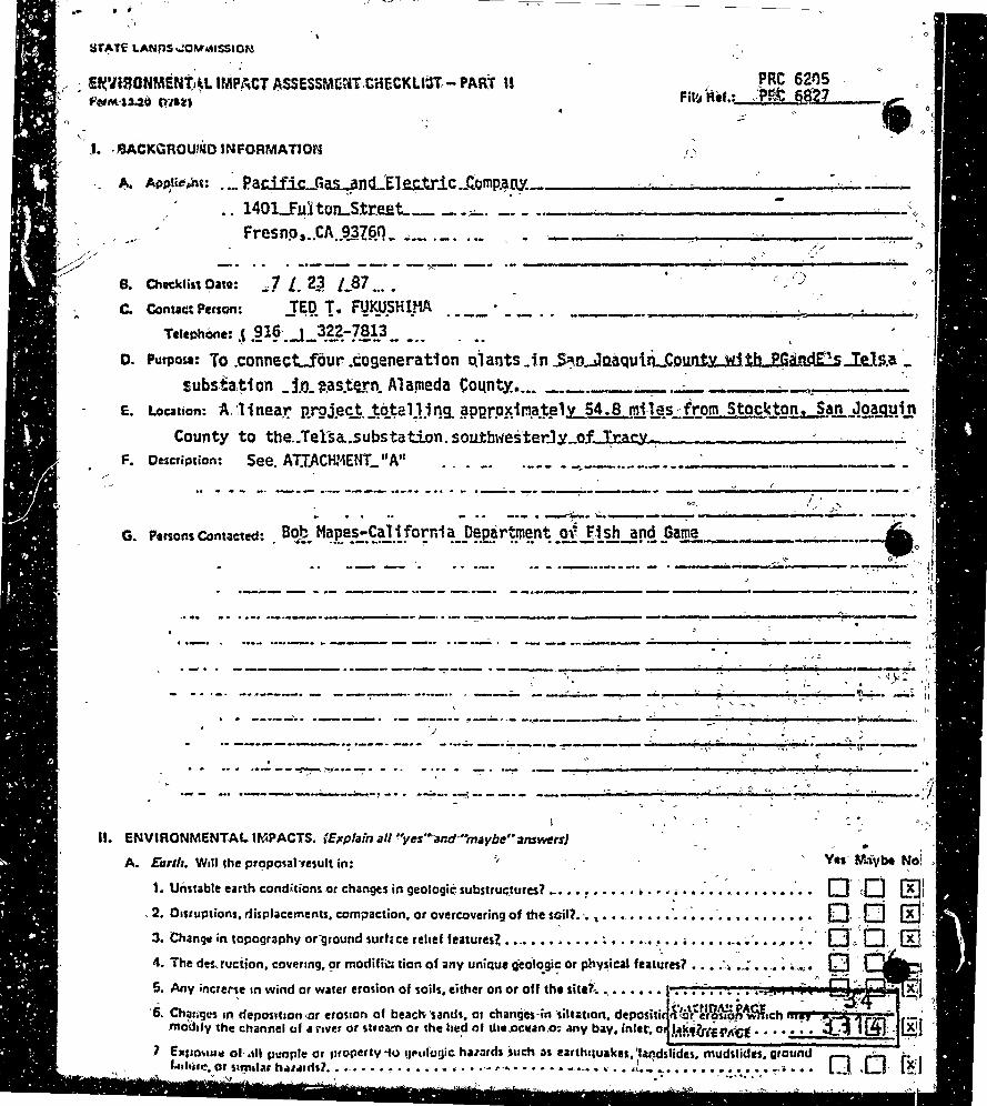
~ £ft'lUfONMENT;~L tMP/;CT ASSESSME~T.CiiECKLS:lT, - PART U f'~nt·U.2~ 0.1U,
•1._:·
.1. · '3ACKCiROU/~0 INFORMATION I\
.. ~ Pacif.k_<1~ncL'E1~tric .• C.!Jmp.~~-.,.... --------------~----1401Ju1ton...Str.eet__ --.;;;..... ______ ......__..__ _________ ...___\
·-· Frcsnp,.,CA .. 9-~!Rfl .. --- ·-· ·-- .. _ ..__ _____ ..,,,.... ________ _ ti) ,; ,/;/
. ··--- --· -- ~-_ .. 8. Chteklist Dato: :.;] L. 2~ /_87 •..•
Jr;Q. T. FIJ~U.SHIJ1A
( f)
C. Contac:t Person:
Telephone: .~ .~l~·._t_ 3.~~-?8l3 _ -·· o. Purpose: To .connecUour .cogeneration Qlants. in ..S~.o...JnaQuiiLCownL!litb.J$truf.E:!s..Iels.a ·-.,
substa.~ion _j_IJ-~.as.te.rn. Alameda Co1.tnt.Y. .... --·-----~---------,, . ... "
E. Location: A.Ji nea.1'." P..rQJ.ect. J;Q.ta 1.1.i ~g_ ~PP.rP~im.a.t!! 1y_54. S mi L~s.;: fr:om Sto~J·J,gn.,_j~Jl-~Q..a_qyi.!t County to the .• Tetsa.substation. soW:bwes'terJ.)!_of_I..,.,r._.a .... c""'y_._. -------------
F. Description: See. ATJ.ACHMENT_ 11A11 ·--- --.--..... -·--------- _____ ...... ..,
------------- • .,.._... •' ,,. i; ""· i' .II
. . .. - -""" -- ·--- ·--- ---- ··-·· -... - ·--- ~--~---
-- • ......-'~ ... .,;, • .____~-------·-/ ~-· ___ .,_ I
G. PenonsContacted: . B~~- M~p_e~~~J.!forni~--0~_2.~r~~"~-~llW...!!l!!_Gam~.- ---..;...-··--jl, / ·- ... ·-···-· .. -·· - • __ _......, -.----.::.;..'.. - ~~- . ,, 4~
·---- - -·- --- ··-- -··-· --·--------- ~i
----K-----~-·-~ ;l .. :l
..... ·--..---·------· .-.. -~--------...... ····-· ... --- -- . ·-·- . - - -- __ ..;;.........., _____________ ..--,. ______ ......._.
------. ------ -. _,._ . -----. --------.· ------~---------.. ----....;. ~ '4_.F~ ' .. . . ',','
- • • • - • -· .. .---·-· - - --~-- -·--·· • --~ - _..;:.,.;;.__ ~ .-,... ----------. •0 • ------!-+- ...... ~ it ' ' -~
' " ·' . .. --·--·· ·---. ·- __ .,,... __ !"--· ·- -·~---- ------------- i-----'
.. -------·-·---· --·- -···- --~---~~------....... -.,"-: -... , - .... - ...... ~ .... : ... ~ ·---4;~---.. . .. . ··- --~' ~···- ~. -. .. -~ .. - ~ . ·~ ·- -------~---~.-.!""-___ ...... ~~------••• ·-- _._....;..,_._~..,., - • • -~-· -~ -•..., -·- _____ .._ _________ ..__..; ..... (' __ o __ • !""'< __ ........ .,;.;.... __
I
II. ENVIRONMENTAL IMPACT.S. (E;cplain all ~·yes""and·"maybe1·~nsw1mJ
- ' A. Earth. Will the prop01alnsult in: Yes M<iybe Noi ,
1. Unstable earth conditions or changes in geologie substruc;~ures? -· •• : ••••• • ••• ." •• : •• '. • • • • • • • . • • o· ·.(j (F.ll . 2. 01s1uptions, rlisplacements, compaction, or overcoverin9 of the sail?.·.,. •••.••••• ·• ~ ~ •• -_ • , •• , • • • • • .D .. 'Q IEJ'. 3. Chang.r in topography oniround surhce re1re1 teaturesi ••.•••• : •••• : ...... ~ ••••••• ··~ .. · ...... ~. · ·a,,.< t1 fEi '. I\. The deuuciion, covering, ~r modifii!< tion of ;iny uniQua geol~gi~ or physical feat~res? •••• :. ~.: ••.• : • .. "'. ~ · -~! 5. Any increNe 1n wind or water erosion of soils, either on or off the site?:. •.••• , • • • • :· .- •••• : ,.:. _ ~ .. _ ~~1'
~ . - . ,, ~
6. Ch~.11·9c:s in deposition •Or erosion of beactw ·unch. or changes-in ·silt~t1on. depositi &·tb\~~~~~~'\.CW,c:h ""'!If '3..:~ 1@-!4 f;;'i' modify tht: channel uf a \'1vr.r or stream or the hu~ r>I the.oc:wan.o~ .my bay, inlet, o l.~~fUl£91\lit....... . .: , ~J
.1 E•r10~1u-r ol· .111 PL'Oflle or 11rorierty ·f-0 •Jf'ulU!Jic hu:uds .such :ss earth11u1kes, '.l~dslides. mud,lidts, ground Lohlo:. ar S1tJ11la1 h•1.11dil .• ·-· .•• ~ .•• •' ....... -.. ,.~ .. • • • • • • e-1-•-• .. ...,, •• ,L. ................. !''• ... . -v'\J '' • ·••"'••• o .Cl t~J

Yee Maybe No•.
1. Subs~•nri;ll ~,ir cmm1s~ium. or t11:rermr~r100 ot 11mb1~n1 au quahty' :, •••••• · ••••••.• ~--· • : • •,,• _· ~ •• -::J • '. The _crea11un of objectionable odars>. . • . • • . • . . • • : ..... -. , .•••• 11 '1 • -.............. 4 ......... .
3. Alttrillicn of au· movement. f1lo.1sture er t~pl!riture,·or 1nv c:h;inge.in climate1eitht; !ocallv or rtqfon~lv1.
h~'"'· Will 11lo iiropos.al result 1n: t -, ~
t. ·Chi!n!lH in the c:urrents,.or the COUf\~ or d1rec~i0n of water muvernents, in:ei,ther giarine·or. fresh,w1t1rs1 .... ; ~ ,Q r l.' .J x I 2. Chanyes·in.ab$orpt•on·ratits, d~ainage patterns. or the rate and ~mount of ~urfac:e water.run~f? ...... ~ ... .;. ·.:i· 10. {j. [!l ~. Alter~11ons to the course or flow of flood waters? • • • • • • • •••• • ••••• ~ ••• •·.! • ·- •.••••••• ~ • '. •••.• " tJ. 0 {!] ·~- .ri. .... ,.. :n.-•""•~ ..... -•H"a•---•~····'·~ ........... :---·· ......... _ ... _,,., .. ,, -' -;;:--- - -- - ..._ ~-- =----.:..-:-.-=-~~-=-~- t-:?-ti..:--;t:'"l.- -=-~ --· ._.._.7--•••·•·•--v•·!V-·•• ...... ~·-···----··---· •••---•1 , ......... .., ... ,. •• • ... • • • ~..-·"' ... - .._,,,. • • • • ... ~ '!'jl'" '"• • • .~";,;,.,.. •• ! .. •·•-• .... -~ ~ l!::.J
5.~0isctt•rqe into surfaet1 .Naters, or ·fn, any.alteration.of surface Wiiter·qc.1ality~ lncludingtbut'nct:limlted·ta .
0·- , -~ ·r=i
·llll'l'IPtrolture. dlssot1ted t >cygen or tur~idit\i7. • . • • • • • • • • •••• : •••• ~ • • • • • • • • • • • • • • • • • • • • • ' L.J i.:!J 6. Alter4tion of th• dtrect Otl or-me cf ffow of gro~nd waters> ••••• : •••.•••••• : •••••• : • ~ • :: • ~ • • t:J. "El' '(fil
~ - ' }> ' ~ '\ - ~ .,!
7. Change in the quantity :of ground waters. enher through direct ·additions.i::initithdrawais. or through inter· ·-O· .. _rn Iv; capuo'n of an·aquifer·by cuu or .nccavatlons?.. • • • • . ••••••.• "' •• ~~~: ·-~ •••••.• ..: • ... ~. •;..... · · l..::J ~
8 .. Sulnuntial reduction in the ·amount rif water otherwise available. for pu_bli~ wt'c~·supplies7' • .- ••••• ·• • • • ·=O · · [J ~ G. E~osur• of p.aple or property to water·~!!lated hazards such H ·floodin11 ar"tiCfal wavet7 • ·~ ••••• · ••• : • • 10' L) f X J
lQ. Si~Uic:;int ch:snqu in tht'tl!mper~ture, flow or chem:cal content o~ sur!a~e thtirmal springs7 •••••••••••
O. l'hm u,,., Will tke propos31 '""ulc in: 0 [l· f~l ''' \I .
' -l. Cha~jft fo·the tfivc~sitv of sriecies, or num~er of any species of plants (Including trees, shrubs, grzu, er~~··. ;;...
1< ;r· _ J;- fxl.
af1Ci:.tU&u:ittc J>fa11ts) •• .... , ....................... ~ ................. ,~-· •••••••• -. • • • • • • L. , ,. L":t
2. Rtduct1un ohhe numb1•f$·ohny unique. rare Of '1!riaangered ~pecies of plants7. • • • • • • • • .. • • • ... • • • • • '{] ' r .. J l?<l -. ~
3. f.ntrodu~ron of new spe~ of plants into an uea. or in a barrier to the·normaf ·riDfenish?Mnt of'exiiling ~ s~c•as?. ~ ..•....•..•..•.•.....• ,. ......• ~ ......... ~ ........ _ .... ·tt·~ a- ... "' •• ~ •• ,,. ••••
lt • ~ IM ~ ....
4. Reduct1on in acreage of any a11f1Culcural crop? ................................. , •••••••••• ~
r:x· L:!'.l
f. I . ~. ' ' .... ,
£. · A11l11:aU:ifr. Will the ilrop~sal result in: - ·~ - • A\
t·. Cllange in the· diversi~y of spe~ies, or numbers of anv. speeies of .aiUmal~ (birds. la'ld .n~mals:!n9lft~i'19 ftPtd~s. 'fish and sht'flf1$h, benthtc org:inisms, or insects)? •••••••••••••••••• · ...... ·; ••• ~ ~ ••••• ·•
2. Rtdul:tion ohhe num!;.1rs of my unique, rare or:endangereel spec1ien>hnimals7 .......... .- .:. ~·. ·: • •••
3. f~troduction·of new SP.!Cies Of ;,nimals 1ritO in .trea~ Or result IR a barrl~r to·the migration Of in~vem'eni of· 0.:
animals? ................................................................ ._. , .•• "<.·, _ ; O· .(!l ~~ Otzttrioration to exi~tio11 fish or wildlife habitat? •••••••••••••••••••••••••••• ·-~ ..... .,..~~····' ., ~Q Q [!}
·f. ;'\iii\«*. 'l\'lill th!! proposa~ result in: , .. . ,,
·:t. f~e~ 1n ttxining nois<! levels? ........... ~ •••••••••••••• , ••••••• • ~ ~ .................. , •. .,_ .. • - .(J [J, [.!] -i. e-~~U\ of Pl!0$>,11! tO·St:vt!re noise Jevit\? •••••• ~ ................ '• •••.• · •.•••••• ··~· .. H·f--• 3.. o·. : 0. {j]
·' ·Q. t~ht iuuHildrr. .Will the propos:il resuU 1n: _:..:,,. , ; •• , , . • , f \ . . • . .. ;,)r
·> 11
1. The Otoduct1on of new light or glartf' •••••••••••.•••••••••••••• ,..,~ , , •.•.••• "' •. ,.-.~-·· :.~·~ .••. ~ • CJ . 0 ,[]l __ ~ .. . f' • l\-,: ,,. If;. -,~mt·t•\!'. Will du~ propos~ result 111; , . , , .
1. A s~st12nt1 .. 1 ;ilterarion of the present or pf01nn~11 land use of an areal .•.••.• : ....... __ .. ,. . ., •• : .••••. ,,.,. ,·.(J . 0 . .[~ ·'· ,\atur11/ H"""Ut'C':l. V/111 the proposal re\ ult in: ,~. _ ·'!I·, ,
1. lncre;se.in.tho.rale of.u~ . ..or an;:naU:irai.f~SOCJtc;cs.?· .••• ~ •, '.• ....... ~A. or• ........ ~,.. V;f •·• N ~-~ ·::.~ .c:r- Q-.,:r.:"i! ' ' - ~ 2 > S··'· . . I ~ • , • ' ' . r4 ' , » • '' ~., . ~ ' . • ._,t;uu11I d11Plttio" of anv nenrtnew.1 ilu re,ouiceh ••••••••••••••• ~ ; ••• , - "' ' · ·" .-· - ,
._;· - ~ ... e- .
- ·" : t'AltffbA?~tACE" ·--:""="'T-::~·I .. MtNdtt',~(;t
2

J. RiJ. 11/ l..*plf't. Oacs lhe p1upus .. 1 result in: y ;;.._ b N . •O·l'l!'l.WY I· C
1. ~ ri~k of ~n exp~osion '?r th&- release <;if hu~~dous s~bstances (i~c:,ludin9, bt,Jt not lirriitec:f io: oil','~ticid_~. ' ,Q. · r-":l .-::1-chtmical' or rad~ahon) 1n the event of an aicc1dent or UPStt cand1t1ons? ••.••••••.•• .,. .... ., .. ,,, ........... , • , . ~ : w: L!J.
2. Possible i~~erf•renco ~ith e~ergency ,.,ponse plan or·an emer9'ncV ffacuatlan pbn? .• • !· •••• ,, • .,. ••••••. ~ ·: .Q :~ · .• K. lop_ulotlon. Will tn• propos~r renilt in: "· . .- ,
1. lholttration. dlstribution,.dtnsitY.-ilf'growth ute-of the humii'(populati0n cf tM:!fta? ' .t.. Jio.Usilfl. WiU 1he proposal :nult in:
1. Afftctlng- existing f.ouiing, o.r cre4't• •demand fouddition41 housing? ••••• , •••.•••• : .• ... • -~ .• ·•·• •.•• ·• · CJ· '0 (!] "'· ,Tnznspnnatian/Ciicu/atlon. Will .thJ. proposal tesull in! ". ' ·
l •. Gener.Ilion of.sub~tintial addition&S vehiculit.m!:lvtmtnt? ••.••• "'" ........................ -. •• e1ol •. •··•·• ~ •.••• : •G:J :O' (]] 2.NAtftc\ing txisiing ~~king f1cilitles. or ·crelt1 a demand for new Plfklng? ...... : .;; •••• ·• : • -. • ~ .,,. ~ • • • 'L:l :tJ (El. . , , . -. ·o" r.o:- iv"1 3. Sub1untial impac,t up°" existing transportaJion svuems7 •••.•••••• , ••••••• Li;.'• • • • • • • • • • • • • • .• L!3
.., 'D! 0- rii 4. AlttratioM to present p11tt!ms of circutation ~r movemtnt of ~Pl• and/or goods,? ·~ •••.••• • ,._, .• --· ··~ - . t::.J
5. Alterations to watttbome. rail.er ,tir traffic? .................... -· • • .... --· ........ ;._ .•• -~ ~· .-~. ~· •. 0. ;Q '.(!] 6. fnetease in tr~i1fil: hazards to mow. !(ehicle:I. ~C'f~lis~.9r µ~utfians1 ""'"' ...... H ··~ • ...-,. •·• ....
1
••. ,. .•• ~ • Q ~[j . f!] ' , I .
N. htlk S~n·lcn. Will th• propostl hl\11 ,v(;ltf •c:t "!~on. Gf iilyl' ln 1 flttd t~r ntw c>.f ~ttrtd •~~tat o
tml«i tn tnV ot \ht toltowlnQ artu~ . ~ , I -. - . · .. -~~ , ·o",, 0.. ,.:~ 1. Fite. Pi'Ottction? ................... , ............................ .,. ••• .._ ·-........... ·~· • • • • . ~
·2. Po!ii:e. p.rotection7 ••• .' ........................................ · ........ : .... ,.,.,. •. • :. .• ~.,, ;O. --,Q :{[) 3. ~oois? .................................................... ,. ,._ • .,. • .- .. ~· ,_. •·•. ,.. - • -;····· ... ,.,. ,. •·• ,;Q,, Q ~ 4. Puki an~.o\t-..er,reere~Uanat faci\itm2· ••••.••.•• , ............................... , .••.• ~.-: .• ...._ !'"'"·' .... 0-.q ,,, .. ~ 5. ·Miint'tnintr.-~f public facilititi, including roads? ••••••••• ~ ••••••• :.o .•••• • •••• ~,. •• • '.._ ......... • ~ o~-.:o •·oh 1 · · · ' ' ;f0~Jii_· .;. t If ~vifnmtntat s1rvicts .~ ....... o ••••• l'I .............. II. .. ~ ............. • • •••• ~ •••• ..__. • ~ L..J:... l:.J
'!"-, <- \
o. .&au. v~o the proposal result in:
1. Us« of substandal.~uncs of fuel or energy? ••••••••• .' •.•. • ............ -~~ ..... • ...... , ~ •. ,. • "· .. :t:J . o· l!:i 2. Sufis~ntiaf increase fo·dein:and up~ ~~i$ting .sou~esof ent!rg\'. ~r r!\lui(e Jh• dneli:rpmJnt.of nt~.S~al$? "' .0 q ''[!l .:, ·
P. Vtilitin. Will. ~.ht.;>.ropqsZJl m11it in l.nocd·fa~ new sv,t•m•, Qt.tubiJ~tial a\ttf•ti~ ''-thJ foO•"·"-'\ll~t"~ .c- ..
i. ~·°' 9\1\\lt•' g•>, , ...• , ••• ., • ""' •.. , -: , , , •••• , ••. , • , , \ .... , • l ••• ~ •.• ,·, \;.'I·•,.\ ... t .. ~ ~ o .. O· (ij.: 2. t.Mwl~~·\~~ t")\ttft\'Sl., .. " .... ..,. ..... , ••• , ........ , • ~,.. .. , .... , ..... 411 .: ...... ~ •• ·-· -. : •• ~· :"'- ~.;· ... ., .0 ... D .:(!] '>
"~ . . 3. Water'? ........ z • ............. ; •••••••••••• '! •••• ,. ·-· ..................... -, • ;; •• : • ~.~(I> :O~ ·o :(!];
- \ ~' ~ - - ,..
4. ~r or sept;c Un~7 ...••••... ~ ....................... : . ~ . ·• .,, •• !I~-••• : ~ ... ~~~ .- •· ... ~ • · •• ~:o·:..\ 0 J~]
s. Storm watcrr drainage? ................................. •·· ••• • • • •. : .. •• ·'; • ·-. ~ • ·;· • ~ ·• ·• ·• ~ , 0 : .. r::l·' ltl ~ ;' e. ·So~ w•llt &nd diiposat1 ••••••••.•••••••••••••••••••••••••••• ~ •••• .z~ '· •.... ·. ~ .. ·.~.·. · .Q· '. .0 ID· · . ·
,·~
·:. -""·" 1. Creation of any he"lth hazard-or potential health hazard (excluding me:ital-health)1 • ~ •••• : .•• ~-•••• ~ ·• -o lj tID .,1)
~a. Hwtff11t.ilul1h. Will the propos&l result in: ,_
:2:··ex~osure l)f people to potenti~I health hazards?, .... -:,,, •••••• .-1 ••.•••••• : •• -. • o-c ....... ,~ ~' ! •• / ;Q. C::J ,'.(!] • • I • • •
fl. ANlflt:!lcs. Will thl! proposal result in: . .
1. Tht·obstrucaion af any scenic vittia or view open to tnt public. of.will lh= pi'oPoi&lftiUft in'11il Cft.&\lon of 0 ':, .A-
an HSthtt1c1lly off,niivt 1111 optr\· \O public vlow1 •••••••••.•••••••••••••• ! •• ,.. • ,. ~ •• , •.•.• :., Q .. E:l l!r" ~ ' • .. .., ;_ • ' Jr
.. $. R~.'~'~'!.· Will,tht propas;al result in: CALENDi\t:PAC1!
i. An·rmposct upon tht qu~ity o; quantity of existing reerHtion~I oppor~unities7.'. ~tNtl,Ft,r,~tt·• .... ~ •.• ,,(i]

• •
~ - ~'
·(f· "'· ·o T. (~1/iuftl/ Rr:sm1Ttt1. . .·-Yes ~.Ybe .,.,o
.t ... w,u.u;, proposal re~ult in the 11terat1on-9f of the destruction of 1 prehi;t_aric-or hl~to_~ic .fc:h~al~ica~·si_te?. --~.D-. tl :~l 1
. . ' 2. Will the proposar 1esu1t in ad·~~·st physical or "aesthl!tte effects- 10 -a . ..Jl1'ehistoric--·o,.•his.toric--buil~inv. - - - --- - · Stn:«:iur.-. or·ohject? ...... ~ •••••• .,;. .••••••••••••••••• -~· ••••••••.•••• ~ ......... ...._. -. • • • Cl--~o ·4~1- -. .!
3. r:Toes the propllUI have the potential to cause· a physical change wh\Ch wouJChfficfun1que •t~niCcuUuriJ_ · -- -: - ·, , -) i yJJu"? •.•••• o; ..................................... -· ••••••••••••••••• !» ~ -- • ' D -- [.J ~I . '
-.
4. Will the pri:!po~r rtstrict eicisting religi~us ~r sacred uses wit~in·the potential imp1eti1tea1 .••••.•••••• _ •.• - ' .:- ... U. .4!111tda1,1,,,..-findin~-'!f S'ftnifinrnu. · ·-- -~ - · ~ · - · - · --a-:tr1~-~ :: i ,.,, '
1. O:'es ~h~.~nJject have th~ pntent~al ~a-degrade !h~qua!ityaf_th! en~ir~>~me~~!reduc:e_~~ h~~it~~of ~.!i~h or ·W1ldhfe .Jpec1es. cauw a ftsh or wildlife population to drop below selfoustain1n~ leveJ1. threaten to eliminate •.plari(1or inima~·community, reduce the number or restrict the range of~ raro or trldangeied plant or animal :~r eliminate imponant·e.1:1mplt!S of-?he major periods of-~l_ifcirnia_hi,s.to,y or-prehis.tory1 •••• , · •••
2. Oo_es th'11t .Ptoj~ct hav~ tho potential ·ta act-.. ~ve short· term. to.the disadvanta_ge of:l~nij-term.~envir{)nm1ntal goals? ••• ! ••• • .•• 4·• .................. ..:. ~- ••••• ~--· .......... ~ ••• ·• ~-;·; ................... .
0- .Ci [!J ' .. ~ .r T '
3. ~OH lht project hive impaets which ara ihdividuaUy limiltd, but cumf_dativ'eJy considfr1bl1] •• ,. "·•: • ,:.;, •. ~· · • . • -S'- ' i.
O,· Cl' I~f'~. o:· GI .,:ftt:· ' ' ..-~ 4. ·Does ·the·project hava.en11iror:ment1i' effms.\'lhich.wlll &:aU$t .whstaritial _acf,,ene effecu.an-nrJmzn;bfiiii:t~. ·. • '· ·_-.: ·-I
,eithtrdir~tlV or indirectly? .................... · ••• ~ ...... ·C:--~ •• ··- ••••.••••••. ~ ~ ,.,,; •.• :~ • .--! ·...;. _·EJ. .-0 2 IU. DJSCUSSIONOFENVIRQNMENTALEVALU~TION fSit:Camint:ntJArtaChttJJ, ·- "J " •· :· ,-~.._,,: _F.
·;
,,;-, . -'
._
- ;: ~ ...... " ""' ... ..._. ~
' -... ...--~
•
--. - _. ') '
' " . .... '
·-"'
f•~'
J' > J·: - ., '.Y~
.-.~... ; ~' 'o: , ' ... "...,..... ' I ~ ' "i'(/. fiiili1MINAav-OmRMINATION ' '-- -·· \ . '
- . cin thi-<>i11 •• 1 .................. -..... , . .. . .
0 ! fu>~ 1i.;_PtoPOHd.,,,oJ•«S:!)Utti-NoT h•" .,igi>.,,.,ntelleCi on the ,.,.: • ...,,.,, - ..,.~AT;vl;.oec.LARAt1or..J1r . ·. . ;- be '2r.ei>•red. · · ' , · o
. . f!l.1 find· .. ., •llhough the P••P•sed ;,oject could h"e uignofi""'t ell•tton:t ... •Rvi•..,..,i,,. "'"' ,.;n noi .. • significanHffiCt · - · in this .c:as~. bec3use the mitigation. !TI Hsu res described on an itt<iched sheet hav.-bftn add el$ !to the prajeci. A NEGAt~VE·
. . OECLAAA.TION will.be prei::ared. . - . . '. . " -" ·,. .
. . • j r. ~:.~:. "'PP•se~ p•o~ot MAY have.• sigmlicant effect on lh~ envfronment, and :•~N~IRO~M~~ IMPAc7t';'!~R~": \ r-.._ . . . ' < -·~·;_~~....;-..;...;.. ~-. -- I. a1· -,._ ·, ~-~. - l'-~.-·0~,-~;l'~c; ·.~ ~-oine:_ . ' i ._.j. .2l . ~~~Posit-I:
~' .. • ·- , , '"'!

.• . .. AITACHMENT "A"
T~Sfi.A.COLLEST0R PROJECT P,ESCRIPTION· )._-A
7-
.'/- -- '
I•
"rbe ·P-ro-;.iect con:si:st~· -of ·the construction of a 115 ki:'lovolt wood. po·l-e -electric ·tran:;mission line t-o connect four cogeneration ·_ ' ' plants in ·san Joaqu·in County with PGandE' s· Te33.a substation· in ea'!ltern Alameda ·County~ The exist-ing e'lect:r:ical tran:smlssion 'network in the area does not have suffici·ent unused .capacity to allow the addition oi the 16A megawatts- to ·be .genera:~ed by ~he:Se cogeneration ·plan-ts. ·Consequently, this coll;ector line is" 'Oe'itist cons-eructed to transmit the e1ect·ricity to Te:!l:a substation which i!'l tl1.e nearest substat'i.~n in the vicinity capaple ·c# ·ha.ndlinlt this additional g~neration. FGcµidE is r·equJ;r~d-."·~y the Ca·lifo-rid;a Public Utilities Commi~sion to connect the~e cogeneration plants to the elec:t·ric transmission system. -C<;>nstrud~ion ·cptnvleti:on. i:s, scheduled for Decemb.er 3, ·1987 and '1-tork has -·~t!.:re·ady commenC::ed on the portions of the Stockton and Ripon segments~ ~, . ' ' ~' ' -[
•' \ __
. The four eogenera-c.ion plants are located ~~ Corn' Prpdudts in Stockton, Libby Owens ~"ord glass 'P-la~t in: ~'4~tlµ-op,:.-:Stmp~on .Paper -plant in Ripon and· the Owens Ill·ino.is ·:glass. pfant ~e~~· of \Tracy.:• All four plants hav.e be-en. or are i·n ·th~ :P,ro"C:e:ss. o~. b~i:~g per-:-mi tte4 through the CEQA process tby t})e res_pecti ve .~uris'd;c't';ons. During .the planning ·stage of the praJect, ·route· reviews llere, ·con-4ucted with the PJ:~~ning .Departments of t}le ·c1t;e5' of :Stoc];-eon, .. ·Ripon ~d Tr?-CY and-with San Joaquin ·cc:.n.~n~y· Planning· Departmen,t •. A:1 a result oi thes~ reviews. a..1.ignmen.t c;hang~~ were ~ad,e ll,t the request oi S~oektol'!-; "~1pon and Tracy to- accomm~d~te Cl,\rr~nt lan:d use and d~velopn.tent. -P.\~ns 4 :>
Gf the 51.a mil~$ 'of l.i,ne to be constr~6ted, _19~·3··~iles :~,~5;1 will .. overbuild .. exist.ing ele.ctr--ical lines. 'This :C:-ons·ist's. of i'nstal);.tn,s new tailer poles with the transmission .. ~e·onciti'ctor:s near -~~e td;i!~· <then transf\'?r:ring the exi~ting d:istJ!'i9tf.i:i?n VO~ tas;-~ ~ cqndu.:!•n!".:a ·~o the neH poles and removing tne old p·o1e:s. 'Another '8,. 7 mil~:s ('16%) of the line will be built in irangp~.se position .. within the county or ·ei'ty road right-·of-way. ~riva-ee rights in the form o.~ a torty foot wide easement are b~i~g acquliec;l to;o·th~ remaining 26-; 8 miles (·1_9%) o·t the rout~. - · ·
The height of the poles will be between -so an~ 80 feet ·above. tlie ground depending on -copographic featur~s or whethe.r dfstributi-6n voltage condu~tors wil~ be placed o~ the same pole. ~dst 9t· the . poles will be.between 50 and SQ.feet above the grouri~~ with the taller poles located at highw~y an~'railr~ad 9rossing~~~~t~el .' tor;re~:i wi) l be used for the rivE>,r·crossing due to 'the ·le.~e;th of
··the span and ttle cli:!arance requirements. Se lf~support.ing ~teel poles. will be used at. a'ng.ie points wher.e ,guyfng is· not, posis-l'bie. ·· Conductor clearance· will meet PUC standards ·to'r, i~~ -.. r.E!'~pective vo·l tage:s. · - - ' · ,,~' -
The transmissiop line route -.the- S'l'.ockton sel'lmen t starts

south to the point the line wiil cro:5~ ~he San J9aquin River. The Ripo~ ~egment begins at the S±mpson Paper plant and -r,~~ gener~ ally ind westerly direction to where it meet~ the 0St~ck~on 3eg-
. ment at the River. From here the Tesla segmen:e cr..osses tM_River and runs in a Hesterly directi:on to i.he T-es'l:a -substa.-tion:~; - ·-, Existing land u~es along :-the ~oute consi!St of industrial a.n9- .~5=ommercial uses intersper~ed with_re~identi~l µse~ ·along the ..Stockton s~gment, transi tion'ing to ~g_ricui tural ~:ses sue~- -as. crcP,~~ds and row crops along the rest of the Stoekton segment an4 .along the majcri ty of t~ie other two- segments-. The ter.rain -is- very .f J..at -except as the lin~~ approaches the Te:sla Sub~tat:ion ~n, t11e J:.'PI-l·~·ng toothill3 of the coastal range. The rou~e crosses Inter-sta~~ 'Highway 580 which is designated a scenic highway in this .a~e4c However, the scenic: des-ignat.ion does not require mitigation -fo·r electric transmissio~ iines over ·34 kilovolts. - -
Ji more detailed. descr-iption of each .:segment is prov,ided.below'.and i~ intended.to supplement the .air photo -maps of.the ~ianmeni .. · -· ' , .,,- ' . ~ ...
Rt2ekton Segment '
·Bc~tP.: ~eginil.ing at the cogeneration plant at· ·Co'rn Product_~. the lih~ jogs west through the ind~~trial park. crossin~ the Southern Pa~iflc ~nd Western Pacific tracks para~lel to tHo exf.st;ng -i'Gap.d,E, :t_ower lines unti.l it re~che:; El Dor~do St·reet ~ 'Here the line· turns ·s.outh. within a franch.ise ~Position alo~g tne .. we:it. :s-ide ·?f El Dorado to a poin~ Just D,,.Ort~ 0.f it~ intersectfon with ·~n~er,state 5. The line jogs ea·s-t. one. bJ.-ock to Harlan Road· at this point and continues s.ou-ch in a t'ranchise position along ~Harlan ·· Boad until just south of Louise Avenue where ~he line't~rns east~ -to connect the cogeneration plant at. the. LibbY. Ow~ns Fo_Z.ci Plant;--~ Leaving the LOF Plant, the line combines with an exis~ing ll5kV line running s_outh until ii; :reaches State Route 12P. ·Th~ exist,ing line continues south across Highway 120 while the, new li~• tur~s ,east along the frontage road tv a bett~~ _P,o~itiqn for cros~ing t~e ·southern Pa.citic tracks and the ·highwci'y. From here th~1 line continues south across ·~he tracks and highway along farm roads through qrchards and grain fields before, cr<?!.5sing t·he Western·Pacific Railroad track~. The line then ~kirts around the sand and gravel opez:at~on (Oakwood L4ke Re.;sort) and continues ~lc;mg:·wopdward Avenue as it turns south, but maintains the southerly- direction as Woodward tu,,rns west again. From this- point, the line cr~sses th~ough orchards an~ row crops and across Walthall Slough, respeeting; the £·arming operation, until it reaches the crossing point a~ the edge of the San Joaq~~n River. 1hi~-segment is l3~,8 -m~les in length, witl:l 5.2 mi'les (38%) .overbµilding~ _ existing tines: 6.4 1J1il~s (46~~) of new line in ~ franchise p9si-
:
t.ion and 2._2 miles t16%) of private right~~ --=- ·. . . ..
•
f~rmrts: Required permits for this segment include We~tern'and Sou~~ern P~~ific Railroads, French Camp Slough (Cprps 9f ~ng~~· neers ~nd State Reclama-eion Board), Highway 120 (Cal trans;)·~~~" • Walthall Slough (State Land3 Commission). ..._..._......, __ ~------~""""-!"..-.~,,. -
.- . '-40 ' 33·io-. ·.
tAW:DA~ t>l.CE" •-. .. -. Mt~UTE r~GE - • "• •

••
.<
Route: Thi:s segment begins at the Simp~on Paper pl.ant in Ripon and runs west .Alon~ the edge of the sewage tre3tment ,ponds, then west al-one Hohler. Hutchinson and Perrin Reads- ·throuah row c::op:s and-orchards to the intersection of Hays Road. The line then turns north along Hays until it reaches the levee -of the San Joa~uin River. From here the l'ine ski·rts the ba~e of the levee to an ex:isting GOk~., electric trafr:smis.sion line·. These· t<ao .line~ wil;J. be placed on the same ~oles and run along the base of, the leve·e to- the ~rossing p:>i~t. This segment is 1'1.3 miles in l~ng:th,. with-6.0 miles (53%) O'fe:tbuildlng e~isting. line~. 1.9 miles (17~) of new line in a !ranc· ise positioru and ·3.4 ~iles {30~)' ~f private :iahts. ·
" E_e:mit:f: ·An encroachment peitnit wil.l be ~btained fr.om the South San.Joaquin Irri~ation District where th~ 1i.t;,,e ovel!!laps their erlsting ea:sem~nt ., ,.
- -B9ute: This s~gmen~ begins at the point on the north side ot the :river where t~fti P..ipQn and Stockton. segments .converge-.. The exlsting 60kv l·ine currently crosses the river ·Using steel ·masts. Since these mas-cs are not adequate to support both li'1eS,, a new, steel .:tower will be installed adjacent to the e~istlng' mas"t. on both sides of the river~· just downstream of the -existing ~ros-s• ing. Once the line crosses the riv~r: the eY.iting 60kv line c6ntin~s to the -sou.th and the new collector line turns to- the:uest w~~.r.e ~t picks up Lorenzen, Road. After crossing :the. De~el. Voe~~, tional Institute. the line turns south on Kas.s:on ~.oad ·:for a short distance before returning to the southwe$terly. alignment. alon·g a.~ farm road to Interstate 5, The line cont~nues west td the Western f~~ific railrpad tracks near Tracy Depot, then turns, to'parailel the south :side of the t·racks in a southwesterly direction to , Linne Road. The line then :follows ·Linne Road to Tracy ·Boulevard· · where it turn~ north for half a·mile, then west on a farm road to Corral Hollow Road. Here the line ruils north to Valpico Road~', turns west to Lammers Road. then Jogs north about 1000.feet to Join two existing electric transmi5sion tower lines. The :f·i'nal cogeneration plant located near t,he Ow~ns-Ill1noi5 plant is con• nected tq the prop.:>sed transmis,sion line just west of Lamm.ers ·' Road. The proposed lin~ then parallels these two exi!!.ting i'ines the l:'emainder of the distance to Tesla Substation. This se·gment is 29.8 miles in length. with 8.5 miles (28%) overbuilding exist-ing lines a~d.21.3 miles (72%) of private rights. - ·
Eermtt::p Crossing the San Joaquin River will,· require permits from ·the Corps of Engineers, State, Lands Commis:s1.on and the State · Reclama~ion Board. Once across the River, an easement is required·· from the Deuel Vo~ational Institute (Genera~ Ser'fice~ Depart- . ment) and encroachment/crossing permits required for Inte·rstate 5 and 580 (Caltrans)~ Southern Pacific Rail.road, We:ltern Pa.cUic · Rail'road.. the Del ta Mendota Canal (US Bureau o R~c anra · , the California Aqueduct ( Oepar~ment of W~ter R m1~'C!i~1.· .. ···~.-.:.-
M!fj_UTEP:tGE ' ..
Related Documents