UNITED STATES DEPARTMENT OF COMMERCE National Oceanic and Atmospheric Administration NATIONAL MARINE FISHERIES SERVICE West Coast Region 1201 NE Lloyd Boulevard, Suite 1100 Portland, Oregon 97232-1274 https://doi.org/10.25923/egwn-tp98 Refer to NMFS No: WCRO-2021-02361 February 25, 2022 Lt. Col. Richard T. Childers U.S. Army Corps of Engineers Walla Walla District 201 North Third Avenue Walla Walla, Washington 99362 Peter Hartman Federal Highway Administration Idaho Division 3050 Lakeharbor Lane, Suite 126 Boise, Idaho 83703 Re: Endangered Species Act Section 7 Formal Consultation and Magnuson–Stevens Fishery Conservation and Management Act Essential Fish Habitat Consultation for the Funding or Permitting of Routine Maintenance Activities on State Highways; Salmon River Basin, Clearwater River Basin, and Lower Snake-Asotin Sub-basins; HUC 170602, 170603, 17060103; Idaho. Dear Lt. Col. Childers and Mr. Hartman: Thank you for your letter of September 10, 2021, requesting initiation of consultation with NOAA’s National Marine Fisheries Service (NMFS) pursuant to section 7 of the Endangered Species Act of 1973 (ESA) (16 U.S.C. 1531 et seq.) for the Federal Highway Administration’s (FHWA) funding or permitting of routine maintenance activities on state highways. The U.S. Army Corps of Engineers (COE) will issue a Clean Water Act Section 404 permit for these actions, and is considered a secondary action agency to this consultation. Thank you, also, for your request for consultation pursuant to the essential fish habitat (EFH) provisions in Section 305(b) of the Magnuson–Stevens Fishery Conservation and Management Act [16 U.S.C. 1855(b)] (MSA) for this action. In this biological opinion (opinion), NMFS concludes that the action, as proposed, is not likely to jeopardize the continued existence of Snake River sockeye salmon, Snake River fall Chinook salmon, Snake River spring/summer Chinook salmon, and Snake River Basin steelhead, or result in the destruction or adverse modification of designated critical habitat for Snake River sockeye salmon, Snake River fall Chinook salmon, Snake River spring/summer Chinook salmon, and Snake River Basin steelhead.

Welcome message from author
This document is posted to help you gain knowledge. Please leave a comment to let me know what you think about it! Share it to your friends and learn new things together.
Transcript
UNITED STATES DEPARTMENT OF COMMERCE National Oceanic and Atmospheric Administration NATIONAL MARINE FISHERIES SERVICE West Coast Region 1201 NE Lloyd Boulevard, Suite 1100 Portland, Oregon 97232-1274
https://doi.org/10.25923/egwn-tp98 Refer to NMFS No: WCRO-2021-02361
February 25, 2022
Lt. Col. Richard T. Childers U.S. Army Corps of Engineers Walla Walla District 201 North Third Avenue Walla Walla, Washington 99362 Peter Hartman Federal Highway Administration Idaho Division 3050 Lakeharbor Lane, Suite 126 Boise, Idaho 83703 Re: Endangered Species Act Section 7 Formal Consultation and Magnuson–Stevens Fishery
Conservation and Management Act Essential Fish Habitat Consultation for the Funding or Permitting of Routine Maintenance Activities on State Highways; Salmon River Basin, Clearwater River Basin, and Lower Snake-Asotin Sub-basins; HUC 170602, 170603, 17060103; Idaho.
Dear Lt. Col. Childers and Mr. Hartman: Thank you for your letter of September 10, 2021, requesting initiation of consultation with NOAA’s National Marine Fisheries Service (NMFS) pursuant to section 7 of the Endangered Species Act of 1973 (ESA) (16 U.S.C. 1531 et seq.) for the Federal Highway Administration’s (FHWA) funding or permitting of routine maintenance activities on state highways. The U.S. Army Corps of Engineers (COE) will issue a Clean Water Act Section 404 permit for these actions, and is considered a secondary action agency to this consultation. Thank you, also, for your request for consultation pursuant to the essential fish habitat (EFH) provisions in Section 305(b) of the Magnuson–Stevens Fishery Conservation and Management Act [16 U.S.C. 1855(b)] (MSA) for this action. In this biological opinion (opinion), NMFS concludes that the action, as proposed, is not likely to jeopardize the continued existence of Snake River sockeye salmon, Snake River fall Chinook salmon, Snake River spring/summer Chinook salmon, and Snake River Basin steelhead, or result in the destruction or adverse modification of designated critical habitat for Snake River sockeye salmon, Snake River fall Chinook salmon, Snake River spring/summer Chinook salmon, and Snake River Basin steelhead.
2
As required by section 7 of the ESA, NMFS provides an incidental take statement (ITS) with the opinion. ITS describes reasonable and prudent measures (RPM), which NMFS considers necessary or appropriate to minimize the impact of incidental take associated with this action. The take statement sets forth terms and conditions, including reporting requirements, which the FHWA, the COE, and any permittee who performs any portion of the action must comply with to carry out the RPM. Incidental take from actions that meet these terms and conditions will be exempt from the ESA take prohibition. This document also includes the results of our analysis of the action’s effects on EFH pursuant to section 305(b) of the MSA, and includes four Conservation Recommendations to avoid, minimize, or otherwise offset potential adverse effects on EFH. These Conservation Recommendations are a non-identical set of the ESA Terms and Conditions. Section 305(b)(4)(B) of the MSA requires Federal agencies to provide a detailed written response to NMFS within 30 days after receiving these recommendations. If the response is inconsistent with the EFH Conservation Recommendations, the FHWA and COE must explain why the recommendations will not be followed, including the justification for any disagreements over the effects of the action and the recommendations. In response to increased oversight of overall EFH program effectiveness by the Office of Management and Budget, NMFS established a quarterly reporting requirement to determine how many Conservation Recommendations are provided as part of each EFH consultation and how many are adopted by the action agency. Therefore, in your statutory reply to the EFH portion of this consultation, NMFS asks that you clearly identify the number of Conservation Recommendations accepted. Please contact Todd Andersen at (208) 366-9586 or [email protected] if you have any questions concerning this consultation, or if you require additional information.
Sincerely, Michael P. Tehan Assistant Regional Administrator Interior Columbia Basin Office
Enclosure

3
cc: K. Urbanek – COE C. Swanson – USFWSK. Hendricks – USFWSK. Powell - USFWSS. Skaar - COEW. Terlizzi - ITDM. Lowe - ITDB. Inghram - FHWAC. Colter – SBTM. Lopez - NPTC. Fletcher - USFWS
Endangered Species Act (ESA) Section 7(a)(2) Programmatic Biological Opinion and Magnuson–Stevens Fishery Conservation and Management Act Essential Fish Habitat
Consultation
Funding or Permitting of Routine Maintenance Activities on State Highways; Salmon River Basin, Clearwater River Basin, and Lower Snake-Asotin Sub-basins; HUC 170602, 170603,
17060103; Idaho.
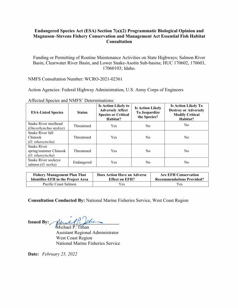
NMFS Consultation Number: WCRO-2021-02361
Action Agencies: Federal Highway Administration, U.S. Army Corps of Engineers Affected Species and NMFS’ Determinations:
ESA-Listed Species Status
Is Action Likely to Adversely Affect
Species or Critical Habitat?
Is Action Likely To Jeopardize the Species?
Is Action Likely To Destroy or Adversely
Modify Critical Habitat?
Snake River steelhead (Oncorhynchus mykiss) Threatened Yes No No
Snake River fall Chinook (O. tshawytscha)
Threatened Yes No No
Snake River spring/summer Chinook (O. tshawytscha)
Threatened Yes No No
Snake River sockeye salmon (O. nerka) Endangered Yes No No
Fishery Management Plan That
Identifies EFH in the Project Area Does Action Have an Adverse
Effect on EFH? Are EFH Conservation
Recommendations Provided? Pacific Coast Salmon Yes Yes
Consultation Conducted By: National Marine Fisheries Service, West Coast Region Issued By: ___________________________ Michael P. Tehan Assistant Regional Administrator West Coast Region National Marine Fisheries Service Date: February 25, 2022
i
TABLE OF CONTENTS
TABLE OF FIGURES ................................................................................................................... iii TABLE OF TABLES .................................................................................................................... iii ACRONYMS .................................................................................................................................. v 1. Introduction ................................................................................................................................. 1
1.1. Background ........................................................................................................................ 1 1.2. Consultation History .......................................................................................................... 1 1.3. Proposed Federal Action .................................................................................................... 2
1.3.1. Program Procedures ..................................................................................................2 1.3.2. Program Activities ....................................................................................................5 1.3.3. Best Management Practices ....................................................................................32
2. Endangered Species Act: Biological Opinion And Incidental Take Statement ........................ 41 2.1. Analytical Approach ........................................................................................................ 41 2.2. Rangewide Status of the Species and Critical Habitat ..................................................... 42
2.2.1. Status of the Species ...............................................................................................43 2.2.2. Status of Critical Habitat ........................................................................................54 2.2.3. Climate Change Implications for ESA-listed Species and their Critical Habitat ...57
2.3. Action Area ...................................................................................................................... 58 2.4. Environmental Baseline ................................................................................................... 60
2.4.1. Clearwater River Basin...........................................................................................60 2.4.2. Salmon River Basin ................................................................................................65
2.5. Effects of the Action ........................................................................................................ 86 2.5.1. Noise .......................................................................................................................91 2.5.2. Riprap Placement....................................................................................................92 2.5.3. Fish Handling and Salvage .....................................................................................94 2.5.4. Water Quality-related Effects on Fish ....................................................................99 2.5.5. Habitat-related Effects on Fish .............................................................................105 2.5.6. Effects to Critical Habitat .....................................................................................108
2.6. Cumulative Effects......................................................................................................... 112 2.7. Integration and Synthesis ............................................................................................... 113
2.7.1. Species ..................................................................................................................113 2.7.2. Critical Habitat .....................................................................................................115
2.8. Conclusion ..................................................................................................................... 116 2.9. Incidental Take Statement .............................................................................................. 116
2.9.1. Amount or Extent of Take ....................................................................................117 2.9.2. Effect of the Take .................................................................................................118 2.9.3. Reasonable and Prudent Measures .......................................................................118 2.9.4. Terms and Conditions...........................................................................................118
ii
2.10. Conservation Recommendations ................................................................................. 120 2.11. Reinitiation of Consultation ......................................................................................... 120
3. Magnuson–Stevens Fishery Conservation and Management Act Essential Fish Habitat Response ............................................................................................................................... 121 3.1. Essential Fish Habitat Affected by the Project .............................................................. 121 3.2. Adverse Effects on Essential Fish Habitat ..................................................................... 122 3.3. Essential Fish Habitat Conservation Recommendations ............................................... 122 3.4. Statutory Response Requirement ................................................................................... 123 3.5. Supplemental Consultation ............................................................................................ 123
4. Data Quality Act Documentation and Pre-Dissemination Review ......................................... 123 4.1. Utility ............................................................................................................................. 124 4.2. Integrity .......................................................................................................................... 124 4.3. Objectivity...................................................................................................................... 124
5. References ............................................................................................................................... 125 6. Appendices .............................................................................................................................. 140 Appendix A: Project Pre-notification and Monitoring Forms .................................................... 140
iii
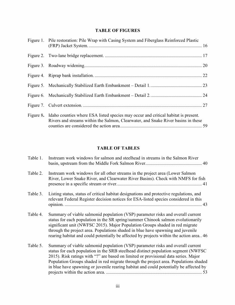
TABLE OF FIGURES
Figure 1. Pile restoration: Pile Wrap with Casing System and Fiberglass Reinforced Plastic (FRP) Jacket System. .................................................................................................. 16
Figure 2. Two-lane bridge replacement. .................................................................................... 17
Figure 3. Roadway widening...................................................................................................... 20
Figure 4. Riprap bank installation. ............................................................................................. 22
Figure 5. Mechanically Stabilized Earth Embankment – Detail 1. ............................................ 23
Figure 6. Mechanically Stabilized Earth Embankment – Detail 2. ............................................ 24
Figure 7. Culvert extension. ....................................................................................................... 27
Figure 8. Idaho counties where ESA listed species may occur and critical habitat is present. Rivers and streams within the Salmon, Clearwater, and Snake River basins in these counties are considered the action area. ...................................................................... 59
TABLE OF TABLES
Table 1. Instream work windows for salmon and steelhead in streams in the Salmon River basin, upstream from the Middle Fork Salmon River................................................. 40
Table 2. Instream work windows for all other streams in the project area (Lower Salmon River, Lower Snake River, and Clearwater River Basins). Check with NMFS for fish presence in a specific stream or river. ......................................................................... 41
Table 3. Listing status, status of critical habitat designations and protective regulations, and relevant Federal Register decision notices for ESA-listed species considered in this opinion. ....................................................................................................................... 43
Table 4. Summary of viable salmonid population (VSP) parameter risks and overall current status for each population in the SR spring/summer Chinook salmon evolutionarily significant unit (NWFSC 2015). Major Population Groups shaded in red migrate through the project area. Populations shaded in blue have spawning and juvenile rearing habitat and could potentially be affected by projects within the action area. . 46
Table 5. Summary of viable salmonid population (VSP) parameter risks and overall current status for each population in the SRB steelhead distinct population segment (NWFSC 2015). Risk ratings with “?” are based on limited or provisional data series. Major Population Groups shaded in red migrate through the project area. Populations shaded in blue have spawning or juvenile rearing habitat and could potentially be affected by projects within the action area. ................................................................................... 53
iv
Table 6. Types of sites, essential physical and biological features (PBFs), and the species life stage each PBF supports. ............................................................................................ 55
Table 7. Geographical extent of designated critical habitat within the Snake River for ESA-listed salmon and steelhead. ........................................................................................ 56
Table 8. Miles of state highway occurring within each action area sub-basin (sub-basins with both ESA-listed species and state highways). ............................................................. 60
Table 9. Pollutants of concern for 303(d) listed sub-basins in the Clearwater Basin (IDEQ 2020). .......................................................................................................................... 65
Table 10. Summary of potential pathways of effect associated with each programmatic activity. An X indicates the activity has a short-term effect on the pathway and the Y indicates a long-term effect. ....................................................................................................... 88
Table 11. Estimatesfor the number of fish across the actions that will be disturbed, injured, or killed from netting, electrofishing, de-watering, and riprap placement as a result of annual implementation of the proposed action. .......................................................... 97
v
ACRONYMS
BA Biological Assessment BLM Bureau of Land Management BMPs Best Management Practices CaO CFRP
water, 1.5% cutback asphalt, and 1.5% quick lime Carbon Fiber Reinforced Polymer
CIR Cold In-Place Recycle COE U.S. Army Corps of Engineers CRABS Cement Recycled Asphalt Base Stabilization CWA Clean Water Act dB Decibels DPS Distinct Population Segment DQA Data Quality Act EFH EPA
Essential Fish Habitat Environmental Protection Agency
ESA ESU
Endangered Species Act Evolutionarily Significant Unit
FHWA HDPE
Federal Highway Administration High Density Polyethylene
HMWM High Molecular Weight Methacrylate Seal HUC Hydrologic Unit Code HUC5 fifth-field hydrologic unit code ICTRT Interior Columbia Technical Recovery Team IDEQ Idaho Department of Environmental Quality IDFG IDL
Idaho Department of Fish and Game Idaho Department of Lands
IDWR Idaho Department of Water Resources ITD ITS
Idaho Transportation Department Incidental Take Statement
LAA LHTAC LWD MaSA
Likely to Adversely Affect Local Highway Technical Assistance Council Large Woody Debris Major Spawning Area
MOU Memorandum of Understanding MPGs MPH
Major Population Groups Miles Per Hour
MSA Magnuson–Stevens Fishery Conservation and Management Act MSE Mechanically Stabilized Earth NMFS National Marine Fisheries Service NTU NWFSC
Nephelometric Turbidity Units Northwest Fisheries Science Center
OHWM Ordinary High Water Mark
vi
Opinion OSHA PAH PBF PBT PCE
Programmatic Biological Opinion Occupational Safety and Health Association Polycyclic Aromatic Hydrocarbon Physical or Biological Features Persistent Bio-accumulative Toxicants Primary Constituent Element
PFMC PPC Psi PVC QPL RHA
Pacific Fishery Management Council Polyester Polymer Concrete Pounds Per Square Inch Polyvinyl Chloride Qualified Products List Rivers and Harbors Act
RPA Reasonable and Prudent Alternative RPMs Reasonable and Prudent Measures SEL SR SRB TMDLs TWP
Sound Exposure Level Snake River Snake River Basin Total Maximum Daily Loads Tire Tread Wear Particles
USFS U.S. Forest Service USFWS U.S. Fish and Wildlife Service VSP Viable Salmonid Populations
1
1. INTRODUCTION
This Introduction section provides information relevant to the other sections of this document and is incorporated by reference into Sections 2 and 3, below.
1.1. Background
National Marine Fisheries Service (NMFS) prepared the biological opinion (opinion) and incidental take statement (ITS) portions of this document in accordance with section 7(b) of the Endangered Species Act (ESA) of 1973 (16 U.S.C. 1531 et seq.), and implementing regulations at 50 CFR 402. We also completed an essential fish habitat (EFH) consultation on the proposed action, in accordance with section 305(b)(2) of the Magnuson–Stevens Fishery Conservation and Management Act (MSA) (16 U.S.C. 1801 et seq.) and implementing regulations at 50 CFR part 600. We completed pre-dissemination review of this document using standards for utility, integrity, and objectivity in compliance with applicable guidelines issued under the Data Quality Act (DQA) (section 515 of the Treasury and General Government Appropriations Act for Fiscal Year 2001, Public Law 106-554). The document will be available within two weeks at the NOAA Library Institutional Repository (https://repository.library.noaa.gov/welcome). A complete record of this consultation is on file at the Snake Basin Office in Boise, Idaho.
1.2. Consultation History
This opinion is based on information provided in the September 10, 2021, programmatic biological assessment (BA), prepared by the Idaho Transportation Department (ITD), and other sources of information. The BA was produced in cooperation with ITD (the Federal agent acting on behalf of the Federal Highway Administration (FHWA) for this consultation), NMFS, and the U.S. Fish and Wildlife Service (USFWS) to document projects and consult or conference, on a statewide level, under Section 7 of the ESA on the ITD actions described herein. In 2020, a working group, including NMFS personnel, was formed to provide technical assistance to ITD while developing the BA. A total of three draft BA’s were produced prior to the final BA; NMFS reviewed and provided comments on these drafts to help develop the proposed action and to clarify language. The final BA was submitted on September 10, 2021 and formal consultation was initiated on that date. The species and designated critical habitats subject to this consultation include Snake River (SR) spring/summer Chinook salmon (Oncorhynchus tshawytscha), SR fall Chinook salmon (O. tshawytscha), SR sockeye salmon (O. nerka), Snake River Basin (SRB) steelhead (O. mykiss), and designated critical habitats for all four species. In addition, the FHWA and U.S. Army Corps of Engineers (COE) requested EFH consultation for Pacific salmon (Chinook salmon and coho salmon [O. kisutch]).
2
Because this action has the potential to affect tribal trust resources, copies of the draft opinion were provided to the Nez Perce and Shoshone-Bannock Tribes on December 12, 2021.
1.3. Proposed Federal Action
Under the ESA, “action” means all activities or programs of any kind authorized, funded, or carried out, in whole or in part, by Federal agencies (50 CFR 402.02). Under the MSA, Federal action means any action authorized, funded, or undertaken, or proposed to be authorized, funded, or undertaken by a Federal agency (50 CFR 600.910). The proposed Federal action that is the subject of this consultation is the ITD’s fourteen programmatic activities that are performed annually as part of their routine road maintenance. The fourteen activities included in this consultation are: (1) Roadway Maintenance; (2) Bridge Maintenance Actions Above the Ordinary High Water Mark (3) Pile Preservation; (4) Two-lane Bridge Construction; (5) Excavation and Embankment for Roadway Construction (Earthwork); (6) Rock Scaling; (7) Roadway Widening; (8) Bank Stabilization; (9) Ditch Cleaning; (10) Small Structure Repair; (11) Culvert Installation and Maintenance; (12) Guardrail Installation; (13) Geotechnical Drilling; and (14) Pile Installation.
1.3.1.Program Procedures
The proposed Program consists of routine activities performed by the six ITD Districts in the State of Idaho and conducted via a Federal nexus with the FHWA or the COE. The Federal nexus may result from Federal funding of the project or an approval action by FHWA or from a federal permit action undertaken by the COE. In the following discussion of the Program process, the Local Highway Technical Assistance Council (LHTAC) is included, as part of that process, except that ITD will have oversight of LHTAC projects. As lead agency for Federal aid project actions involving highway projects, FHWA is responsible for compliance with Section 7 of the ESA. In accordance with implementing these regulations, including 50 CFR 402.08, FHWA has delegated authority to ITD to prepare biological evaluations and BAs, and to conduct informal consultation with USFWS and NMFS. The delegation of this authority was established in the Memorandum of Understanding (MOU), “Procedures Relating to Section 7 of the Endangered Species Act and Transportation Projects in Idaho,” between ITD, FHWA, NMFS, and USFWS. FHWA conducts formal consultation with NMFS and USFWS. The COE is responsible for ensuring compliance with Section 7 of the ESA for projects that require a CWA Section 404 permit and Section 10 of the Rivers and Harbors Act (RHA) of 1899. The COE is the lead Federal agency for state-funded projects that require a CWA Section 404 permit and/or Section 10 RHA authorization. Therefore, the COE has been identified as a secondary action agency, and their issuance of CWA and RHA permits for these actions has also been considered and analyzed in this opinion. The COE has also designated ITD as a non-Federal representative for Section 7 actions covered under the BA. The process and procedures established under the existing MOU or any successor MOU that updates or replaces it for formal and informal consultation and for “no effect” documentation remain in effect, and shall be implemented with the BA. When there is no Federal nexus, either because no Federal funds are used, no Federal permits are required, or any other means, this document does not apply.
3
The project types and descriptions in this document are implemented by State forces, Federal aid project contractors, and subcontractors on a recurring basis. In most cases, what is described is a typical sequence for conducting the activity. Any project deviation with effects measurably different from those evaluated in this document will not be covered under this Program. Multiple types of activities may be approved as components of one project within the Program. For example, a passing-lane construction project might also include bank stabilization and a culvert replacement. In these cases, the most restrictive best management practices (BMPs) from any one of the individual activity types shall apply to the project in its entirety. The Program is eligible for statewide use on ITD projects and LHTAC administered projects. In addition, LHTAC must follow the process and procedures detailed below for project review and approval, including requirements for pre-project review by ITD/FHWA and USFWS/NMFS staff. 1.3.1.1 Process The process that ITD will follow while using this document is:
1. Confirm Listed Species. ITD will confirm that each action authorized or carried out
under this document will occur within the present or historical range of an ESA-listed species, designated critical habitat, or designated essential fish habitat.
2. ITD/LHTAC Review. ITD/LHTAC will individually review each action to ensure
that all effects to listed species and their designated critical habitats are within the range of effects considered in this document. ITD/LHTAC will determine if the action has an FHWA or COE Federal nexus and therefore must follow the process outlined in the BA.
3. NMFS/USFWS/COE/FHWA Review. ITD will ensure that all actions described
within this document will be individually reviewed and approved by NMFS and USFWS. In addition:
• COE will receive project Pre-notification Forms for all actions requiring a 404 permit. • FHWA will receive project Pre-notification Forms for all Federal aid actions.
4. Notification:
a. For projects where no pathway of effect will result in take or adverse effect to critical habitat, ITD will initiate NMFS/USFWS’ review by submitting the Project Pre-notification Form or Determination Key to NMFS/USFWS with sufficient detail about the action design and construction to ensure the proposed action is consistent with all provisions of the BA. NMFS/USFWS will notify ITD within 30 calendar days if the action is approved or disqualified; and,
b. For projects where at least one pathway of effect will result in take or adverse effects to critical habitat, FHWA or COE will initiate NMFS/USFWS’ by submitting the Pre-notification Form of Determination Key to NMFS/USFWS with sufficient detail about the action design and construction to ensure the
4
proposed action is consistent with all provisions of the Program. NMFS/USFWS will notify FHWA/COE within 30 calendar days if the project is approved or disqualified.
Notifications of project effects and responses to those by NMFS/USFWS should be submitted electronically.
5. Site Access. ITD will retain right of access to sites authorized using this document in
order to monitor the use and effectiveness of permit conditions. The NMFS and USFWS will be allowed access to project sites as requested.
6. Salvage Notice: If a sick, injured or dead specimen of a threatened or endangered
species is found, ITD must notify NMFS (208-378-5696) or USFWS (208-378-5333) Office of Law Enforcement. The finder must take care in handling of sick or injured specimens to ensure effective treatment, and in handling dead specimens to preserve biological material in the best possible condition for later analysis of cause of death. The finder also has the responsibility for carrying out instructions provided by the respective Office of Law Enforcement to ensure that evidence intrinsic to the specimen is not disturbed unnecessarily.
7. Project Monitoring Forms. Within 45 days of project completion, ITD’s Districts
and LHTAC will send post-project monitoring forms and support documentation to ITD HQ for review. ITD HQ will submit the forms to NMFS, and USFWS and copy FHWA/COE as appropriate.
8. Annual Coordination. ITD will submit an annual report to NMFS and USFWS
summarizing the previous year's projects constructed under the Program. The report will include; a list of constructed projects, ESA listed species present or encountered, any exceedance of authorized take, lessons learned, and any additional information to improve future outcomes. ITD will hold a virtual follow-up meeting as needed, or as requested by NMFS or USFWS.
9. Failure to Provide Reporting May Trigger Reinitiation. If ITD fails to provide
notification of actions for NMFS/USFWS’ review, project monitoring reports, or fails to organize the annual coordination meeting, NMFS/USFWS may assume the action has been modified in a way that constitutes a modification of the proposed action in a manner and to an extent not previously considered, and may recommend reinitiation of this consultation. The monitoring forms are found in Appendix A (ITD Form 290).
10. Audits. ITD, NMFS, USFWS, FHWA and COE may conduct periodic reviews or
audits on the use of this Program. As referenced above, ITD shall allow NMFS, USFWS, FHWA, or COE the opportunity to review any actions while in progress or after completion. The purpose of this review is to ensure clearance of appropriate project types and BMP effectiveness.
5
11. Training. ITD HQ will provide an annual training opportunity for LHTAC and Districts who wish to use this Program. NMFS and USFWS will assist with the training.
12. Term of BA. The Program shall remain in effect for 10 years from the date of
issuance. ITD will request consultation with NMFS and USFWS on a new Program at the end of the 10-year term, or sooner if reinitiation triggers occur (e.g., a new species is listed, or there are significant changes to the proposed action).
1.3.2. Program Activities
1.3.2.1 Roadway Maintenance Actions (Surface Treatments) This action includes roadway maintenance activities designed to maintain or restore the integrity of existing flexible (asphalt and aggregate) pavement systems within the existing roadway prism. The methods are described in this section and include:
• Chip Seal or Emulsified Asphalt Application (Prime Coat, Tack Coat, or Fog Coat)
• Plant Mix Overlay/Inlay
• Cement Recycled Asphalt Base Stabilization (CRABS)
• Cold In-Place Recycling (CIR)
• Pavement Markings (Waterborne Paint or Preformed Thermoplastic Retroreflective Pavement Markings)
Chip Seal and Emulsified Asphalt Application (Prime Tack Coat or Fog Coat). Chip Seal, Prime Coat Tack Coat or Fog Coat applications are all designed to maintain the roadway’s integrity by preventing water infiltration and to provide skid resistance to the roadway surface. The process is as follows: (1) clean the pavement surface; (2) apply emulsified asphalt to roadway via asphalt distributer; (3) apply chips to roadway via chip spreader; (4) roll chip seal with pneumatic tire roller; (5) blot excess asphalt with sand; (6) broom excess chip seal material, remove, and dispose of excess chip seal material; and (7) if directed, apply a final thin layer of emulsified asphalt. Chips are usually produced, washed and stockpiled off-site and are trucked onto the project during construction. Liquid asphalt is also shipped by truck onto the project during construction. The finished product will ideally produce a half inch thick protective layer to the existing roadway surface. Chip seal and emulsified asphalt application is limited by temperature and specified dates, generally the hottest months of the year. Plant Mix Overlay/Inlay. This activity includes applying one or more layers of asphalt cement pavement (plant mix) over an existing roadway surface. An overlay is used to smooth a rough or cracked existing pavement and add structural strength to the roadway. The process is as follows: Prepare the existing surface by filling potholes, sealing cracks and, if needed, mill (grind) the pavement to remove pavement bulk or to smooth the surface. Apply a
6
tack coat of emulsified asphalt to promote bonding between the surfaces of the existing road and the new plant mix. Place a plant mix pavement overlay in one or more layers by placing loose mix onto the roadway or using a paver machine. Compact the overlay with pneumatic-tire roller followed by steel-drum roller. The new overlay is ready for traffic when the asphalt is cooled to below approximately 100°F internal temperature. Collect and dispose of any milling material at an approved off-site location. The plant mix is generally produced at a staging area or off-site and trucked onto the project. Cement Recycled Asphalt Base Stabilization (CRABS). This activity includes rehabilitating deficient roadways by recycling the existing pavement and base material and adding cement to restore the structural integrity of the roadway. The process is as follows: Mill (grind) and remove existing asphalt pavement at specified locations throughout the project using a roadway grinding mill. This process removes the excess material and creates a desired thickness of finished roadway. Pulverize, till and mix the roadway surface, and a portion of the underlying base material, using a CRABS machine. Using a grading machine, blade the surface a uniform thickness. Smooth the roadway using a pneumatic roller to prepare the roadway for the dry cement application. Apply dry cement and water to the pulverized material and mixed again with the CRABS machine to create a homogeneous product that bonds the material. Blade the material with a grader to achieve a smooth surface. Compact roadway surface with a vibratory roller to prepare the area for a pavement overlay. Overlay the roadway with one or more courses of plant mix pavement. CRABS applications are prohibited during precipitation events or when precipitation events are imminent. Cold In-Place Recycling (CIR). This activity includes rehabilitating deficient roadways by recycling the existing pavement and adding asphalt and quick lime to restore or enhance the pavement’s integrity. The process is as follows: Mill (grind) the existing roadway pavement nearly full depth. Further, crush the milled material and mix with water, 1.5 percent cutback asphalt and 1.5 percent quick lime (CaO). Place the mixture back onto the milled surface with a paving machine. Allow the mixture to set. Compact the mixture using pneumatic and steel drum rollers. Apply a thin layer of asphalt emulsion (fog coat). Blot excess asphalt material. Five to 7 days following the CIR, re-compact the surface and apply either a plant mix pavement overlay or double sealcoat. Pavement Markings (Waterborne Paint or Preformed Thermoplastic Retroreflective Pavement Markings). Markings on the highways have important functions in providing driver information and guidance for the road user. Marking types include, but are not limited to, pavement markings, curb coloring, colored pavements, object markers, channelizing devices, and raised or painted islands. Pavement markings will be either waterborne paint or preformed thermoplastic retroreflective pavement markings.
7
Waterborne Paint. The waterborne pavement markings are normally applied by a truck with a pressurized paint spraying system. The process is as follows: The paint is generally delivered in 250 gallon self-contained plastic paint totes that can be transferred by forklift from the supplier’s truck to the striping truck. Smaller 50–100 gallon containers are provided to the stencil truck for spraying turn lane, crosswalk, and railroad crossing pavement markings. Apply paint with a pressurized paint-spraying system according to the plans or as directed. Paints are formulated to dry rapidly (less than a minute) to minimize tracking of the paint by vehicles encountering the striping operation. Clean any spills from equipment failure or improper handling by blotting with sand or floor-dry to contain the undesired marking. Grind undesired markings off the pavement surface with a pavement grinder. Dispose of any waste material at an approved location. Preformed Thermoplastic Retroreflective Pavement Markings. The process is as follows: Grind a shallow groove into the pavement surface to allow for the placement of the marking. Apply markings by extruded or rolled methods into a shallow groove. The marking typically lasts 3 to 5 years before needing to be replaced or covered by paint. 1.3.2.2 Bridge Maintenance Actions ABOVE the Ordinary High-Water Mark (NO In-Water Work) Bridge Maintenance Activities described in the section are designed to maintain or restore existing bridge components that are located entirely above the ordinary high-water mark (OHWM). No in-water construction is allowed under these actions. The methods are described in this section and include:
• Bridge Deck Hydro-Demolition • Patch and Repair Concrete • Concrete Overlay (Silica Fume, Latex Modified, or Polyester Polymer) • Concrete Waterproofing Systems Membrane (Type C, D and E) • Epoxy and Chip Seal Overlay • Removing and Replacing Bridge Expansion Joints or Bridge Joint Header • Cleaning Bearing Seats or Replacing Bearing Pads at Abutments • Carbon Fiber Reinforced Polymer (CFRP) System • Painting Structural Steel • Bridge Embankment Restoration
Bridge Deck Hydro-Demolition. This activity includes removal of unsound bridge deck concrete or asphalt to various depths to expose a stable surface. To maintain traffic flow, the following steps will be completed for half of the bridge deck at a time. Once one side is completed, the steps will be repeated for the other half of the deck. The process is as follows: Remove the existing one half inch to one and one half inch of the asphalt overlay of the bridge deck using mechanical methods or a high-powered waterjet system (e.g., hydro-demolition). The asphalt will be removed in such a way as to not damage the
8
existing concrete deck or curbs. Clean the deck surface by sandblasting, shot-blasting, sweeping or mechanical abrasion to remove all surface dirt, grease, paint, rust, and other contaminants. Patch and Repair Concrete. This activity includes repairing and patching spalls, scaling, delamination, honeycombing, and other deteriorated concrete on the surface of the girders, deck, pier caps, columns and abutments, including removal of debris from pier cap seats and abutment seats as needed. The materials used for patching and repairing the concrete surfaces are cementitious, fast setting, non-sag, non-metallic repair mortar, which contains a corrosion inhibitor. The materials are suitable for vertical and overhead applications. The materials are used in accordance with the manufacturer’s written instructions for application of mortars. The process is as follows: Mark out and score removal areas to a specified depth of with a dry concrete saw. Remove deteriorated, loose, or unsound concrete to a minimum depth of half an inch or whatever additional depth is required to reach sound concrete. Concrete removal will be accomplished using jackhammers with a nominal rating of 15 pounds or less. Sandblast or mechanically scarify the cavity and adjacent concrete area to remove oil, grease, paint, corrosion deposits and dust. Place mortar to bring the surface back to a smooth level finish similar to the rest of the structure. If reinforcement steel becomes exposed during the removal of concrete, remove at least three fourths of an inch of concrete from around the reinforcement and patch with mortar to bond the entire periphery of the exposed reinforcement steel. If exposed reinforcement is damaged, broken or has lost more than 25 percent of its section, remove at least three fourths of an inch of concrete from around that reinforcement to allow replacement of the damaged bar or splicing a new bar to the damaged bar, as directed. Patch with mortar to bond the entire periphery of the exposed reinforcement steel. Concrete Overlays (Silica Fume, Latex Modified or Polyester Polymer Concrete (PPC) Overlay. Silica Fume and Latex Modified Overlay. This activity includes applying a Silica Fume mineral filler or Latex Modifier chemical additive to decrease the permeability of the concrete and provide a durable ride surface on bridge decks. The thickness of the silica fume or latex modified concrete overlay will vary depending on project but will generally be approximately three inches in depth. The process is as follows: Prepare deck by removing asphalt surface and approximately 1 in. of the existing concrete surface. Wash and sandblast newly exposed surface and rebar. Keep area clean by covering with plastic sheeting. Apply the concrete overlay. Concrete trucks will be allowed onto the deck surface to place the concrete in front of a concrete paving machine, which runs on rails over the deck. Groove the surface and cover with wet burlap for curing. After curing, apply a multi-part methacrylate penetrant sealer to the new surface at about one gallon of methacrylate to 100 square feet of surface area. Apply sand to the methacrylate to blot puddles and provide traction to the surface. Traffic will be kept off the new overlay for a minimum of four days and 4,500 pounds per square inch (psi) compressive strength results.
9
Polyester Polymer Concrete (PPC) Overlay. This activity includes applying a High Molecular Weight Methacrylate Seal (HMWM) membrane to fill and seal cracks in concrete surfaces, especially bridge decks. Removal of any asphaltic surface and repairs to the concrete deck must occur prior to HMWM application. The bulk of the HMWM is shipped in 55-gal drums and boxes of jars containing catalyst and reactants. The HMWM is specified to be a two or more parts chemical and shall be mixed on site. The HMWM is prepared in buckets, 5 gallons at a time. The process is as follows: Sandblast and vacuum the deck to clean and remove any loose material. Pour HMWM directly onto the deck and push liquid over the deck and into the cracks using push brooms. Workers will take care to keep the HMWM out of joints and drains. Less commonly, the HMWM is sprayed directly onto the deck surface. Apply sand to blot puddles and provide traction to the surface. No traffic may be allowed onto the treatment until the HMWM has set into a hard membrane. Time to set is temperature dependent, which may range from approximately 3 hours in 90°F temperatures to 8 hours in 60°F temperatures. The HMWM will only be applied when no rain is likely beginning 48 hours prior to the application and 4 hours following the application. The sealing penetrant will be applied and used in accordance with the manufacturer’s recommendation, and will be applied during appropriate environmental (e.g., precipitation, temperature) conditions. Concrete Waterproofing Systems (Membrane Type C, D and E). This activity includes the application of one of three Concrete Waterproofing Systems onto new or existing concrete surfaces to prevent water infiltration and preserve the structure. The methods described in this section include; Type C - Penetrating Water System, Type D - Pre-coated, Pre-formed Membrane Sheet System, and Type E - Spray-Applied Waterproofing System. The process is as follows: Prepare Surface (Applicable to all systems). Prepare surface by cleaning and drying fully cured concrete with a hydro-blast unit using water with a minimum nozzle pressure of 7,000 pounds per square inch (psi). Ensure the concrete surface to receive the membrane application is free from foreign materials, sharp concrete edges, and repairs and patches are fully cured. Type C - Penetrating Water System. This sealant penetrates the concrete surface and forms a water-repellant layer within the concrete. The penetrating water repellent is an emulsion solution of silane, siloxane, or approved generic equivalent. Apply the penetrating water repellent to the concrete’s surface as per the manufacture’s specifications. Clean adjacent surfaces of spillage or overspray, if any. The repellent will not be applied when temperatures are below 40°F or above 100°F, or when wind speeds exceed 15 miles per hour (mph). Type D - Pre-coated, Pre-formed Membrane Sheet System. Pre-coated, pre-formed membrane consists of pre-fabricated sheets, which may be self-adhesive or may require a separate bonding agent. The sheets are applied to the concrete surface prior to placing aggregate base or overlaying with plant mix pavement. Apply pre-coated, pre-formed membrane sheet to clean,
10
dry, and fully cured concrete surface as per the manufacture’s specifications. If specified, a bonding agent will be applied to the deck prior to the membrane. If a layer of aggregate base is to be placed on the membrane, first place a thin layer of sand uniformly over the membrane surface. After the layer of aggregate base is placed, apply an asphalt overlay to the required depth by depositing spreading and rolling asphalt material so the membrane is not damaged or compromised. Clean adjacent surfaces of spillage or overspray, if any. Type E Spray-Applied Waterproofing System. This system is suitable for concrete or miscellaneous metal surfaces to prevent corrosion from soluble salts on the bridge deck and approach slabs that are to be overlaid with asphalt. The coating system must be a spray-applied, 100 percent solids, fast-cure, and high-build polymer system. The Spray Applied Waterproofing System Type E System is applied in multiple phases. Apply primer by spray, squeegee, brush or roller at 130 to 200 square feet per gallon or as per manufacturer’s coverage rate. Allow primer to become tack-free before applying base waterproofing membrane. Apply the base membrane in multiple layers until specified thickness is achieved. Spray an additional topcoat membrane and immediately broadcast basalt aggregate at a specified rate to achieve at least 95 percent coverage. Apply tack coat. Place asphalt overlay to the required depth by depositing spreading and rolling asphalt material so the membrane is not damaged or compromised. Clean adjacent surfaces of spillage or overspray, if any. Epoxy and Chip Seal Overlay. This activity includes applying an epoxy and aggregate overlay to prevent water infiltration and act as an anti-icing polymer overlay. The process is as follows: Prepare surface by shot blasting with self-contained recirculating blast equipment. Shot-blasting is meant to expose the coarse aggregate and remove asphalt material, oil, dirt, rubber, curing compounds, paint carbonation, laitance, weak surface mortar or other material that may interfere with the bonding or curing of the overlay. Remove unsound areas and patch with cementitious patching material. Epoxy overlay material is an acceptable alternate patching material. Apply the epoxy chip seal overlay and aggregate using a double pass method. The double pass method applies the epoxy and aggregate in two separate layers at specified rates. Once the epoxy is cured, remove loose aggregate from the surface with moisture and oil-free compressed air, high volume leaf blowers, or vacuum broom. After removing loose aggregate, if there are any areas where epoxy has completely coated the top surface of the stone, remove the excess epoxy using a light shot or sandblast. Removing and Replacing Bridge Expansion Joints or Bridge Joint Headers. Expansion Joints. This activity includes removing and replacing existing bridge expansion joints as specified. The new bridge expansion joint system is installed after paving on the bridge has been completed. The process is as follows: Remove existing expansion joint material consisting of elastomeric concrete, steel armor angles, and concrete. Removal will be accomplished by manual, hydro-demolition, or jackhammer methods. Clean joint surfaces by hydro-demolition or sandblasting and vacuuming the surfaces to remove dirt, dust, sand, oil, grease, paint, corrosion deposits, laitance, and any bond-inhibiting materials immediately before seal installation. Repair concrete
11
spalls or breaks before installing expansion joints. Install expansion joints as per manufacturer’s recommendations, or as directed. Bridge Joint Headers. This activity includes providing and installing Polymer Bridge Joint Headers in prepared block-out areas as specified on bridge decks. The process is as follows: Provide materials such as elastomeric concrete consisting of field-mixed, 2-part polyurethane material and pre-graded aggregate mix. Clean surfaces by hydro-demolition or sandblasting and vacuuming the surfaces to remove dirt, dust, sand, oil, grease, paint, corrosion deposits, laitance, and any bond-inhibiting materials immediately before placing the elastomeric concrete. Mix and place the elastomeric concrete in accordance with the manufacturer’s written instructions and as specified. Cleaning Bearing Seats or Replacing Bearing Pads at Abutments Cleaning Bearing Seats. This activity includes cleaning bearing seats at abutments below the expansion joints. Bearing seats are defined as all horizontal surfaces at the top of abutments in the approximate plane of the girder bearings and extends over the full length of the abutment. Bearing seats have potential to collect large amounts of dirt, debris or standing water. This normally leads to problems with corrosion and deterioration. The cleaning process is as follows: Remove dirt and debris from the bearing seats in such a way that does not deposit debris into waterways or damage the existing concrete surfaces or existing bearings. Equipment used to clean bearing pads generally includes high pressure water or compressed air. Removed debris will be collected and disposed of offsite. Replacing Bearing Pads at Abutments. This activity includes replacing bearing pads including plain unreinforced elastomeric pads, reinforced elastomeric pads with steel laminates, or polytetrafluoroethylene (PTFE) pads with stainless steel matting surface at girder supports at abutments, as specified in the plans. The process is as follows: Raise all existing concrete girders concurrently without damaging the superstructure. The bridge superstructure is supported at all times that the girders are in the raised position. Clean bearing seats and prepare for new bearing pad installation. Replace bearing pads as per manufacturer’s recommendations or as specified. Removed materials will be collected and disposed of offsite. Carbon Fiber Reinforced Polymer (CFRP) System. This activity includes installing an externally bonded CFRP system to repair concrete structure components. A complete system will include all associated fiber reinforcement, polymer adhesives or resins, and protective top coating. The process is as follows: Prepare the surface by grinding or sandblasting to produce smooth, even surfaces of uniform texture and appearance, free of bulges, depressions and other imperfections. Remove all laitance, dust dirt, oil, curing compound, and other matter that could interfere with the bond between the CFRP system and concrete. Fill concavities, spalls, gaps and
12
voids with a mortar or paste. Remove dust from the surface using compressed air. Mix and apply epoxy resin and apply reinforcing fibers to achieve full saturation of the fibers. Apply the carbon fiber sheet. Apply two coats of resin overcoat. Apply successive layers of CFRP, as needed. Apply a protective top coat of paint after the CFRP system is fully cured, inspected and tested. Repair defects such as voids, air pockets or delamination by injection with epoxy resin. Installing the CFRP system requires a specific temperature range of the concrete surface. The CFRP system is not installed when moisture is present on the substrate, or when rainfall, or condensation is anticipated. If water leakage exists through cracks, the water’s ability to flow must be prevented prior to CFRP installation. Painting Structural Steel. This activity includes cleaning and painting structural steel on existing bridges as specified in the plans including: constructing containment facilities, removing paint and rust from the steel and collecting, storing and disposing of waste materials. All work will be conducted above the OHWM. The existing paint may contain lead. All work will be conducted in accordance with ITD Standard Specifications and all applicable federal, state, and local laws regulations regarding lead removal. Before work begins, the Contractor must submit a containment plan, and a lead removal and hazardous waste plan. ITD will make every effort to prevent the escape of any dust or paint, which will create an U.S. Environmental Protection Agency (EPA) or Occupational Safety and Health Association (OSHA) violation or may create a nuisance to businesses, residents, or vehicular traffic near the structure. The process is as follows: Surface Preparation. Prepare surface by one of the following methods: Solvent cleaning to remove oil and grease or other contaminants before blasting; waterjet to remove debris and salts; or abrasive blasting the steel. All water jetting and blasting operations must be done within containment that prevents release of materials or waste into waterways or the environment. Equipment and materials includes: ground covers, rigging, scaffolding, planking; containment screens, tarpaulin materials and HEPA-filtered vacuums needed to contain all paint chips, abrasive blast media, overspray, drips, and spills. The containment system is designed to be removed rapidly in case of high winds. If the containment system fails or if signs of failure are present, the Contractor must stop work immediately. Work will not resume until the failure has been corrected to the Engineer’s satisfaction. If the containment structure is removed after the abrasive blasting operations and before the coating operation, the Contractor will install a drip tarp to prevent spillage of paint into the waterway and ground surface below. All wash water and debris from water jetting must be filtered through a filter fabric capable of collecting all loose debris and particles. The Contractor will filter visible paint chips and particulates from the water before placing it into the containers. Before disposal, test the water for total toxic metals and provide sample filtration until the water is not classified as hazardous. Materials must be secured in sealed containers at the end of each daily shift. After the surface is prepared, all bare steel must be primed within 12 hours of being blast cleaned and within 24 hours if the steel has been washed.
13
Painting Structural Steel. The prepared steel will receive a stripe coat of the primer, a full primer coat, an intermediate coat, and a topcoat application. The paint will be applied by airless or conventional spray application or brush, roller or dauber application. The Contractor will take steps to control paint overspray, drips, splashes, and spills. Waste Collection and Disposal. Waste will be contained and disposed of in accordance with ITD Standard Specifications and SSPC-Guide 7. The Contractor is fully responsible for collection, storage transportation, and disposal of the hazardous waste, including soil. Bridge Embankment Restoration. This activity consists of maintaining existing or installing new permanent BMPs to effectively convey bridge deck discharge away from the structure without eroding embankment slopes or discharging sediment or contaminants directly to adjacent waterways. Permanent BMPs are long-term measures that survive the design life of a project when adequately maintained. Methods to correct erosion will vary depending on the needs of each site. Method outcomes will divert surface water away from structures without eroding embankment slopes or discharging sediments or roadway contaminants (e.g., salt, petroleum-based products) directly to adjacent waterways. Effort should be made to implement the most effective BMP with the least amount of ground disturbance. Methods to address eroded slopes may include one or a combination of the following solutions: Installation of slope drains, chutes, flumes, rock-lined channels, or other approved methods. Concentrated flows will be mitigated via outlet protection, vegetated swales, infiltration basins or other methods to prevent sediment or contaminants from being discharged to adjacent waterways. All work will be conducted above the OHWM. Best Management Practices. To minimize the potential for impacts to listed species and their habitats the Contractor will adhere to all BMPs listed in the following Subsections: 1.3.3.1 - Best Management Practices Common to All Projects 1.3.3.2 - Best Management Practices for Ground Disturbing Activities 1.3.3.3 - Best Management Practices for Work Adjacent to Aquatic Systems above the OHWM* * Only include when work adjacent to aquatic systems is anticipated. 1.3.2.3 Pile Preservation This activity includes cleaning, repairing and installing a complete preservation system to existing bridge piles located partially or entirely below the OHWM. Existing piles may be steel or reinforced concrete. The Contractor will employ one of the two methods described below to install a complete preservation system. Both systems form an anticorrosion barrier by displacing water and sealing out oxygen, effectively encapsulating the pile from the elements. Both systems require all work to be performed within a turbidity curtain. A secondary containment and recovery system is required if piles contain lead or heavy metals. Water will be monitored for elevated turbidity and pH levels throughout the duration of the in-water work.
14
All materials for the preservation system shall be part of a compatible, complete system supplied by one company. The Contractor’s employees assigned to this work shall be trained by a qualified technical representative that is a full-time employee of the company supplying the pile preservation system. Methods used to preserve piles include:
• Pile Wrap with Casing System (Figure 1) • Fiberglass Reinforced Plastic (FRP) Jacket System (Epoxy Grout Injection)
The process is as follows:Test for Lead and Heavy Metals (Applicable to both systems). Pile cleaning operations have the potential to introduce lead-based paint flakes or heavy metal (cadmium or chromium) into the water. Prior to cleaning piles, the Contractor will test the piles for the presence of lead and heavy metals. If present, the Contractor will submit a Lead and Heavy Metal Debris Containment and Recovery Plan that will include the use of an underwater vacuum to collect contaminated material. The Lead and Heavy Metal Debris Containment and Recovery Plan is in addition to the turbidity curtain installation. The Contractor will collect and dispose of waste material containing lead, chromium and cadmium in strict compliance with all applicable Federal, State and local laws, codes, rules and regulations. Install Turbidity Curtain (Applicable to both systems). The turbidity curtain is designed to help keep sedimentation and high concentrations of chemicals that elevate pH confined to the immediate work area. Properly installed turbidity curtains help to contain pH elevated water caused cement grout within the curtain (Fitch 2003). Although the turbidity curtain cannot completely restrain pH elevated water, it is anticipated to slow the mixing of contaminated water with in-stream flows so that pH values outside the curtain remain below the Idaho Administrative Procedure Act (IDAPA) threshold of 9.0.Monitoring requirements for turbidity and pH levels as described in Subsection 1.3.3.4 – Best Management Practices for Work below the Ordinary High-Water Mark (OHWM). The curtain will extend from the water’s surface to the bottom of the channel or near the bottom, depending on the depth. The turbidity curtain remains functional when placed a few feet from the channel bottom and is designed to accommodate minor fluctuating water levels. The curtain will be kept in place using anchors, concrete blocks, or steel stakes. Anchors are either vibrated into the substrate, or sit on the substrate’s surface. The use of an impact hammer pile driver outside of a cofferdam is prohibited. Each anchor is estimated to have four square feet of impact on the river bottom. Temporary Barge and Boats (Applicable to both systems). A temporary barge may be used to access the in-water work. The barges will require four feet of water to move and be assembled onshore. The barge will be secured by tying to the existing structure, lowering weights (spuds or concrete blocks) onto the substrate’s surface or vibrating temporary piles into the substrate. The use of an impact hammer pile driver to install piles outside of a cofferdam is prohibited. The boat will be used to carry materials, equipment, and construction personnel to and from the in-water worksite and barge. Materials transported in this manner could include; a pump for grout application, an air compressor, containers to collect contaminated grout water, fuel, cement, cement primer (bonding agents), epoxy paste, grout, hand tools, and power tools.
15
Clean Piles (Applicable to both systems). Clean the surface of the piles to remove aquatic growth, mud, rust, paint, loose and delaminated concrete, and any other deleterious material, which might prevent proper bonding between the preservation system and the pile surface. The piles will be cleaned using the smallest size and lowest impact and handheld equipment necessary to adequately prepare the surface. A pressure washer may also be used to prepare the pile surface. The 7000-psi pressure washer dissipates underwater in two to three feet of distance, so will have little to no impacts except on the surface of the piles. Cross Bracing Coating (Where Applicable). Apply an approved epoxy coating for underwater application to the pilings at cross bracing connection areas where the piles cannot physically be wrapped. System No 1 - Pile Wrap with Casing System. The pile-wrap system is installed by hand in the water by scuba divers working from a boat or barge. This system consists of an inner layer of tape (felt or non-woven synthetic fabric) impregnated with a petrolatum compound (petroleum-jelly) with inert siliceous fillers and passivating agents (water displacers and corrosion inhibitors) and an outer protective cover made from polyvinyl chloride (PVC), high density polyethylene (HDPE), or similar sheet materials. Primer. Apply a primer paste (epoxy), as necessary, to the pile surface to fill surface imperfections and smooth around irregular shaped fittings and flanges. The primer paste is a petrolatum compound with inert fillers and passivating agents and can contain reinforcing fibers. All epoxy will be mixed above water and delivered in a contained system, and divers will then apply the coatings to the underwater surfaces using trowels, brushes, or rollers. The epoxy is solvent-free, and inert after mixed. Pile Wrap and Casing. Apply the inner layer of the tape, impregnated with a petrolatum compound by spirally wrapping onto the pile with a minimum 1in overlap. The pile-wrap treatment will extend from either two feet above the normal high-water mark or the lowest cross bracing connection on the pile to the lowest riverbed level at the pile. After the wrap is applied, a protective cover made from PVC, HDPE, or similar sheet materials is placed around the pile and secured to form an anti-corrosion barrier. System No. 2 - Fiberglass Reinforced Plastic (FRP) Jacket System. The pile-wrap system is installed by hand in the water by scuba divers working from a boat or barge. This system involves placing FRP jacket around each pile and injecting epoxy grout between the pile and jacket to form an anticorrosion barrier. FPR Jacket Installation. The FRP jacket is made from a marine grade laminate of fiberglass reinforced plastic constructed of layers of woven roving and mat. Each jacket has one or two tongue and groove seams and, at minimum, two ports to inject the grout and collect all displaced water and chemicals. Polymer stand-offs are inserted into the jacket to maintain one half inch gap between the pile surface and the jacket. The FRP jacket will be sealed at the seams with epoxy paste and at the base with a foam gasket, and then secured with ratchet straps. Epoxy grout and paste are known to raise pH when
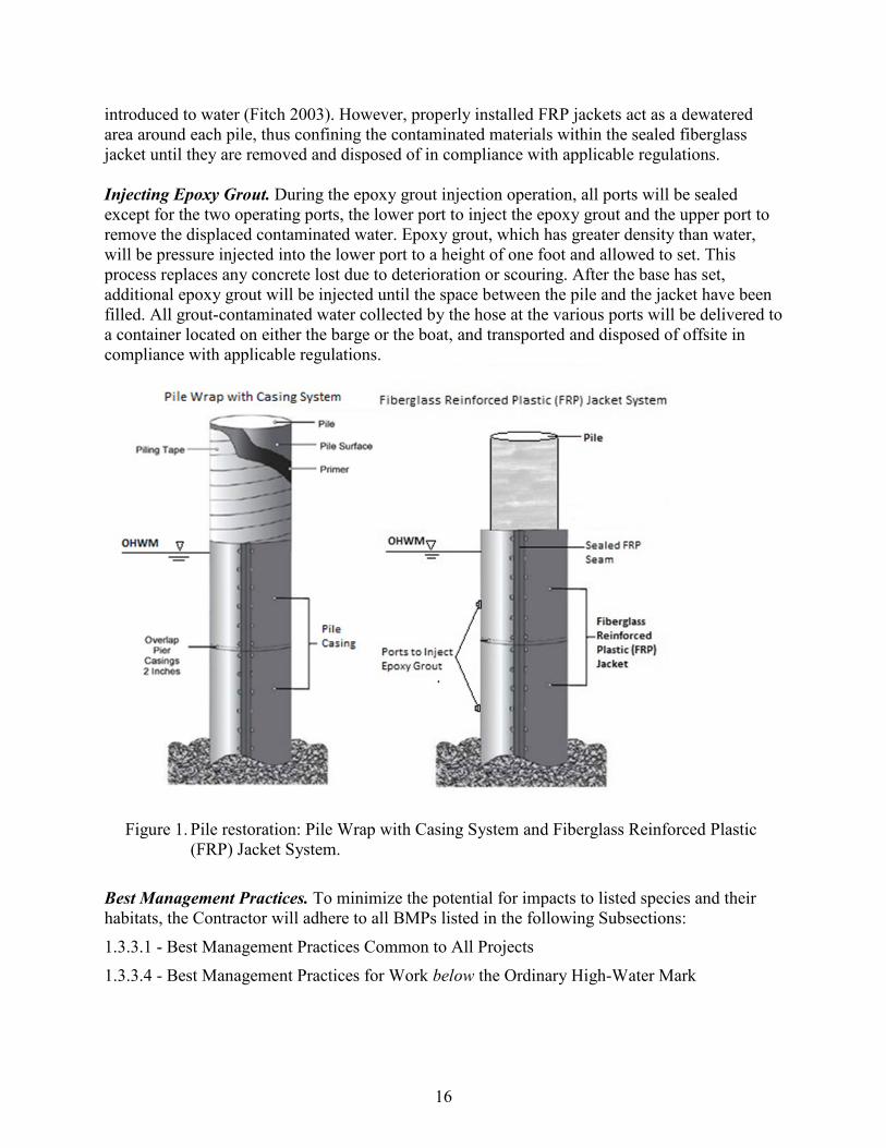
16
introduced to water (Fitch 2003). However, properly installed FRP jackets act as a dewatered area around each pile, thus confining the contaminated materials within the sealed fiberglass jacket until they are removed and disposed of in compliance with applicable regulations. Injecting Epoxy Grout. During the epoxy grout injection operation, all ports will be sealed except for the two operating ports, the lower port to inject the epoxy grout and the upper port to remove the displaced contaminated water. Epoxy grout, which has greater density than water, will be pressure injected into the lower port to a height of one foot and allowed to set. This process replaces any concrete lost due to deterioration or scouring. After the base has set, additional epoxy grout will be injected until the space between the pile and the jacket have been filled. All grout-contaminated water collected by the hose at the various ports will be delivered to a container located on either the barge or the boat, and transported and disposed of offsite in compliance with applicable regulations.
Figure 1. Pile restoration: Pile Wrap with Casing System and Fiberglass Reinforced Plastic (FRP) Jacket System.
Best Management Practices. To minimize the potential for impacts to listed species and their habitats, the Contractor will adhere to all BMPs listed in the following Subsections: 1.3.3.1 - Best Management Practices Common to All Projects 1.3.3.4 - Best Management Practices for Work below the Ordinary High-Water Mark

17
1.3.2.4. Two-lane Bridge Construction (300 cubic yards fill or less below OHWM) This activity includes replacing an existing two-lane bridge with a new single span structure (Figure 2). Existing structures are often supported by two piers and two abutments, which are commonly located below the OHWM of the channel they span. This action allows for up to 300 cubic yards (cy) of riprap below OHWM during bridge construction. However, bio-methods should be considered for bank stabilization before riprap or hard armoring. If existing structures are removed during this action, all fill located above stream bottom elevations shall be removed along with the old structure.
Figure 2. Two-lane bridge replacement.
The process is as follows: Phase One – Remove One Half of the Existing Bridge. Set up traffic control for one lane of traffic on one-half of the existing bridge. The flow of traffic through the construction area will be controlled by temporary traffic signals installed on both sides of the project area or by flaggers. Remove one-half of the existing bridge including rail, girder, and deck by saw cutting and lifting. Rail, girder, and portions of the deck and end beam abutments will be removed as one piece if possible. Portions to be removed would need to be cut free from the portion to remain, and then the piece would be lifted and removed using large or multiple construction cranes. Temporary shoring may be installed to retain the existing embankment during the removal of one-half of the existing bridge, allowing one-way traffic to be maintained during the course of construction. While the type and approximate limits of temporary shoring are not known ahead of time, all efforts will be taken to minimize intrusion into the active stream channel. Remove either partial or completely, existing piers (and walls between pier columns) down to natural stream bottom using handheld concrete saws or a stinger (e.g., excavator mounted jackhammer). Rubblization of existing bridge structures into the channel is prohibited. Phase Two – Construct One Half of the New Bridge. Construct the first half of the new bridge including abutments, wing walls, pre-stressed concrete girders, half of the deck, the parapet, and
18
half of the approach slabs on both ends of the bridge. Cranes are commonly used to set the new girders. The new abutments will be located above and behind the OHWM elevation on the existing channel side slope. This elevation clearance is essential in order to construct the new abutments out of the existing river channel.
Phase Three – Remove second half of the existing bridge and construct remaining half of new bridge. Traffic control and temporary traffic signals are shifted to accommodate one lane of traffic crossing over half of the new bridge and the temporary shoring is removed. Remove the remaining portion of the existing bridge. Remove remaining portion of existing bridge and construct remaining half of new bridge similar to that described above. Pour the concrete closure and pour strip to connect both halves of the deck together. Restore two-lane, two-way traffic. Best Management Practices. To minimize the potential for impacts to listed species and their habitats, the Contractor will adhere to all BMPs listed in the following Subsections: 1.3.3.1 - Best Management Practices Common to All Projects 1.3.3.2 - Best Management Practices for Ground Disturbing Activities 1.3.3.3 - Best Management Practices for Work Adjacent to Aquatic Systems above the Ordinary
High-Water Mark 1.3.3.4 - Best Management Practices for Work below the Ordinary High-Water Mark 1.3.2.5 Excavation and Embankment for Roadway Construction (Earthwork) This activity allows up to 100,000 cy total earth movement for each project. This total does not include moving the same material multiple times during the same project. The process is as follows: Strip topsoil and vegetation from an area and either remove soil (excavation) or place compacted soil as directed to construct roadway prism slopes (embankment). The soil may be moved to or from another section on the same project, or it may be imported or wasted off site. Equipment used will include excavators, dozers, scrapers, dump trucks, and compaction equipment. Completed cut or fill prisms will be permanently stabilized by various methods, including: rock mulch, riprap, or mulch and seeding. Excavation and Embankment may include utility relocation and culvert replacement or culvert extensions. Best Management Practices. To minimize the potential for impacts to listed species and their habitats the Contractor will adhere to all BMPs listed in the following Subsections: 1.3.3.1 - Best Management Practices Common to All Projects 1.3.3.2 - Best Management Practices for Ground Disturbing Activities 1.3.3.3 - Best Management Practices for Work Adjacent to Aquatic Systems above the Ordinary
High-Water Mark*
19
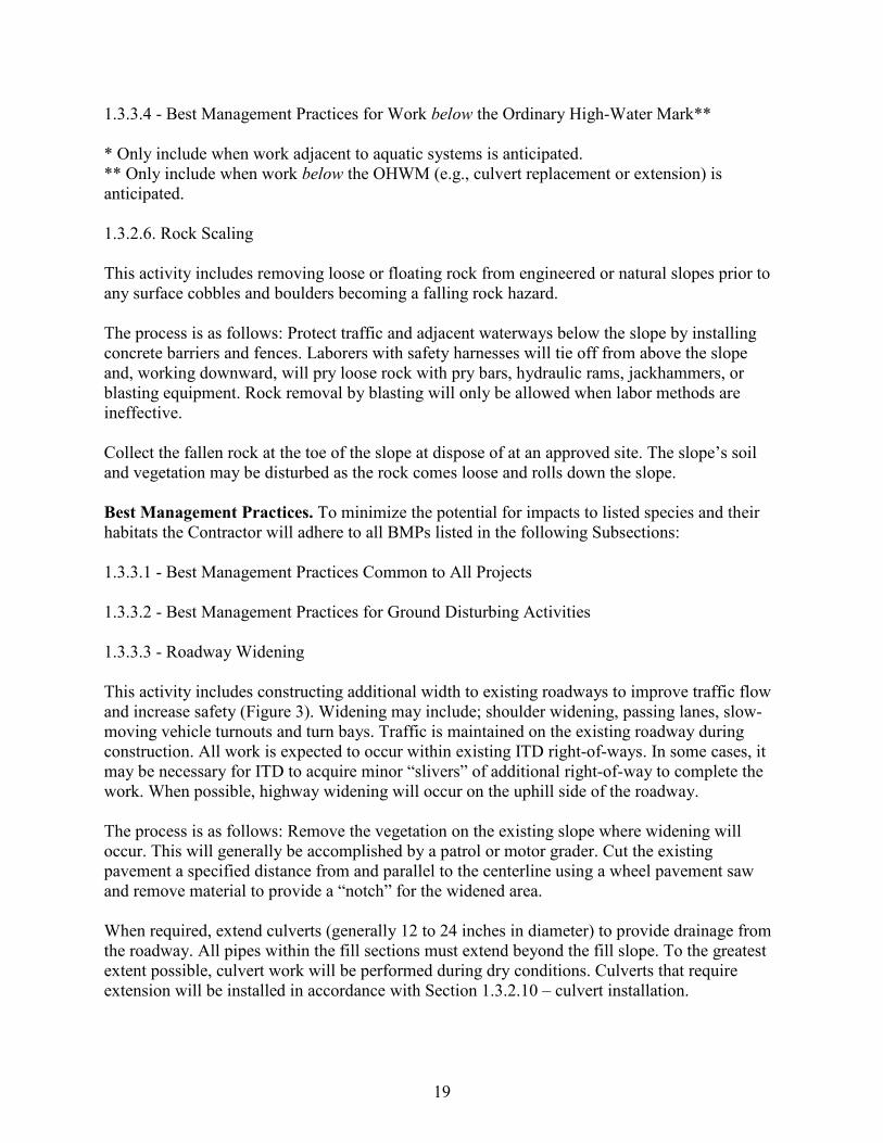
1.3.3.4 - Best Management Practices for Work below the Ordinary High-Water Mark** * Only include when work adjacent to aquatic systems is anticipated. ** Only include when work below the OHWM (e.g., culvert replacement or extension) is anticipated. 1.3.2.6. Rock Scaling This activity includes removing loose or floating rock from engineered or natural slopes prior to any surface cobbles and boulders becoming a falling rock hazard. The process is as follows: Protect traffic and adjacent waterways below the slope by installing concrete barriers and fences. Laborers with safety harnesses will tie off from above the slope and, working downward, will pry loose rock with pry bars, hydraulic rams, jackhammers, or blasting equipment. Rock removal by blasting will only be allowed when labor methods are ineffective. Collect the fallen rock at the toe of the slope at dispose of at an approved site. The slope’s soil and vegetation may be disturbed as the rock comes loose and rolls down the slope. Best Management Practices. To minimize the potential for impacts to listed species and their habitats the Contractor will adhere to all BMPs listed in the following Subsections: 1.3.3.1 - Best Management Practices Common to All Projects 1.3.3.2 - Best Management Practices for Ground Disturbing Activities 1.3.3.3 - Roadway Widening This activity includes constructing additional width to existing roadways to improve traffic flow and increase safety (Figure 3). Widening may include; shoulder widening, passing lanes, slow-moving vehicle turnouts and turn bays. Traffic is maintained on the existing roadway during construction. All work is expected to occur within existing ITD right-of-ways. In some cases, it may be necessary for ITD to acquire minor “slivers” of additional right-of-way to complete the work. When possible, highway widening will occur on the uphill side of the roadway. The process is as follows: Remove the vegetation on the existing slope where widening will occur. This will generally be accomplished by a patrol or motor grader. Cut the existing pavement a specified distance from and parallel to the centerline using a wheel pavement saw and remove material to provide a “notch” for the widened area. When required, extend culverts (generally 12 to 24 inches in diameter) to provide drainage from the roadway. All pipes within the fill sections must extend beyond the fill slope. To the greatest extent possible, culvert work will be performed during dry conditions. Culverts that require extension will be installed in accordance with Section 1.3.2.10 – culvert installation.
20
Construct the new roadway slopes by using loaders or dump trucks to either: place borrow (soil and rock) in uniform and compacted layers, beginning at the bottom of the slope; or by excavating native material and hauling it to approved locations within the project limits or hauling off site. After the roadway slopes and ditches have been constructed to the specified grades, place a layer of aggregate base followed by a layer of plant mix pavement to match the existing roadway section. A paver will be used to place the plant mix surface. Rollers and a water trucks are used for compaction.
Figure 3. Roadway widening.
Best Management Practices. To minimize the potential for impacts to listed species and their habitats the Contractor will adhere to all BMPs listed in the following Subsections: 1.3.3.1 - Best Management Practices Common to All Projects 1.3.3.2 - Best Management Practices for Ground Disturbing Activities 1.3.3.3 - Best Management Practices for Work Adjacent to Aquatic Systems above the Ordinary
High-Water Mark* 1.3.3.4 - Best Management Practices for Work below the Ordinary High-Water Mark** * Only include when work adjacent to aquatic systems is anticipated. ** Only include when work below the OHWM (e.g., culvert replacement or extension) is anticipated. 1.3.2.7. Bank Stabilization This activity includes employing one or more methods described below to stabilize the streambank and prevent further bank undercutting resulting in damage to roadway. The selected method will be based on project design criteria, hydrology, geomorphic, and scour factors. If deemed necessary by ITD, NMFS and USFWS, Hydraulic, Geomorphic Site, or Scour
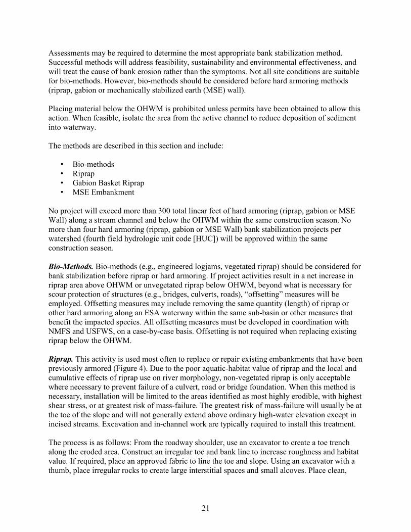
21
Assessments may be required to determine the most appropriate bank stabilization method. Successful methods will address feasibility, sustainability and environmental effectiveness, and will treat the cause of bank erosion rather than the symptoms. Not all site conditions are suitable for bio-methods. However, bio-methods should be considered before hard armoring methods (riprap, gabion or mechanically stabilized earth (MSE) wall). Placing material below the OHWM is prohibited unless permits have been obtained to allow this action. When feasible, isolate the area from the active channel to reduce deposition of sediment into waterway. The methods are described in this section and include:
• Bio-methods • Riprap • Gabion Basket Riprap • MSE Embankment
No project will exceed more than 300 total linear feet of hard armoring (riprap, gabion or MSE Wall) along a stream channel and below the OHWM within the same construction season. No more than four hard armoring (riprap, gabion or MSE Wall) bank stabilization projects per watershed (fourth field hydrologic unit code [HUC]) will be approved within the same construction season. Bio-Methods. Bio-methods (e.g., engineered logjams, vegetated riprap) should be considered for bank stabilization before riprap or hard armoring. If project activities result in a net increase in riprap area above OHWM or unvegetated riprap below OHWM, beyond what is necessary for scour protection of structures (e.g., bridges, culverts, roads), “offsetting” measures will be employed. Offsetting measures may include removing the same quantity (length) of riprap or other hard armoring along an ESA waterway within the same sub-basin or other measures that benefit the impacted species. All offsetting measures must be developed in coordination with NMFS and USFWS, on a case-by-case basis. Offsetting is not required when replacing existing riprap below the OHWM. Riprap. This activity is used most often to replace or repair existing embankments that have been previously armored (Figure 4). Due to the poor aquatic-habitat value of riprap and the local and cumulative effects of riprap use on river morphology, non-vegetated riprap is only acceptable where necessary to prevent failure of a culvert, road or bridge foundation. When this method is necessary, installation will be limited to the areas identified as most highly erodible, with highest shear stress, or at greatest risk of mass-failure. The greatest risk of mass-failure will usually be at the toe of the slope and will not generally extend above ordinary high-water elevation except in incised streams. Excavation and in-channel work are typically required to install this treatment. The process is as follows: From the roadway shoulder, use an excavator to create a toe trench along the eroded area. Construct an irregular toe and bank line to increase roughness and habitat value. If required, place an approved fabric to line the toe and slope. Using an excavator with a thumb, place irregular rocks to create large interstitial spaces and small alcoves. Place clean,
22
appropriately sized (generally 2 - 3 ft. in dia.) riprap in the toe trench and along bank slope. Granular material (generally 2- 6 in.) will be used as fill behind the riprap and above the OHWM line.
Figure 4. Riprap bank installation. Gabion Basket. Bank stabilization may take the form of gabion baskets used as a retaining wall or as a mattress to line the existing channel. Gabions are rectangular wire baskets filled with stone used as pervious, semi-flexible building blocks to protect streambanks from erosion while supporting a roadway. Rock-filled gabions can be used to armor the bed or banks of channels, divert flow away from eroding channel sections or to support a roadway section to avoid or minimize filling into a stream. Placement of riprap armor at the toes of the gabion will occur in a way that does not constrict the channel or restrict natural hydraulics. The process is as follows: Using an excavator, remove material within the footprint where the gabion basket will be placed. Prepare foundation by backfilling excavated area with granular material. Place empty gabion baskets on the prepared foundation and carefully fill and compact material in layers to avoid deformation of the basket. Gabions may vary in size, generally 3 x 3 x 6 feet for wall construction. Rock material for wall construction will be 4 in. to 8 in. in diameter. Gabion mattress rock material is 3 in. to 5 in. in diameter. The rock shall be sound, durable, well graded and clean of all dirt and fines. Materials for the gabions shall be fabricated off site and assembled at the construction site into rectangular baskets of a specified size. All exposed surfaces will have a neat and reasonably smooth appearance. No sharp stones will project through the wire mesh. If suitable, material from excavation will be utilized in backfilling the gabion walls, or disposed of at an approved site. Mechanically Stabilized Earth Embankment (MSE). MSE structures consist of constructing “blocks” made of rock or soil placed in layers supported by fabric, wire baskets or metal straps (Figures 5 and 6). MSE structures may be used for retaining walls, roadway embankment or to
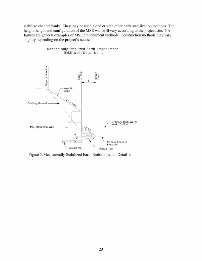
23
stabilize channel banks. They may be used alone or with other bank stabilization methods. The height, length and configuration of the MSE wall will vary according to the project site. The figures are general examples of MSE embankment methods. Construction methods may vary slightly depending on the project’s needs.
Figure 5. Mechanically Stabilized Earth Embankment – Detail 1.
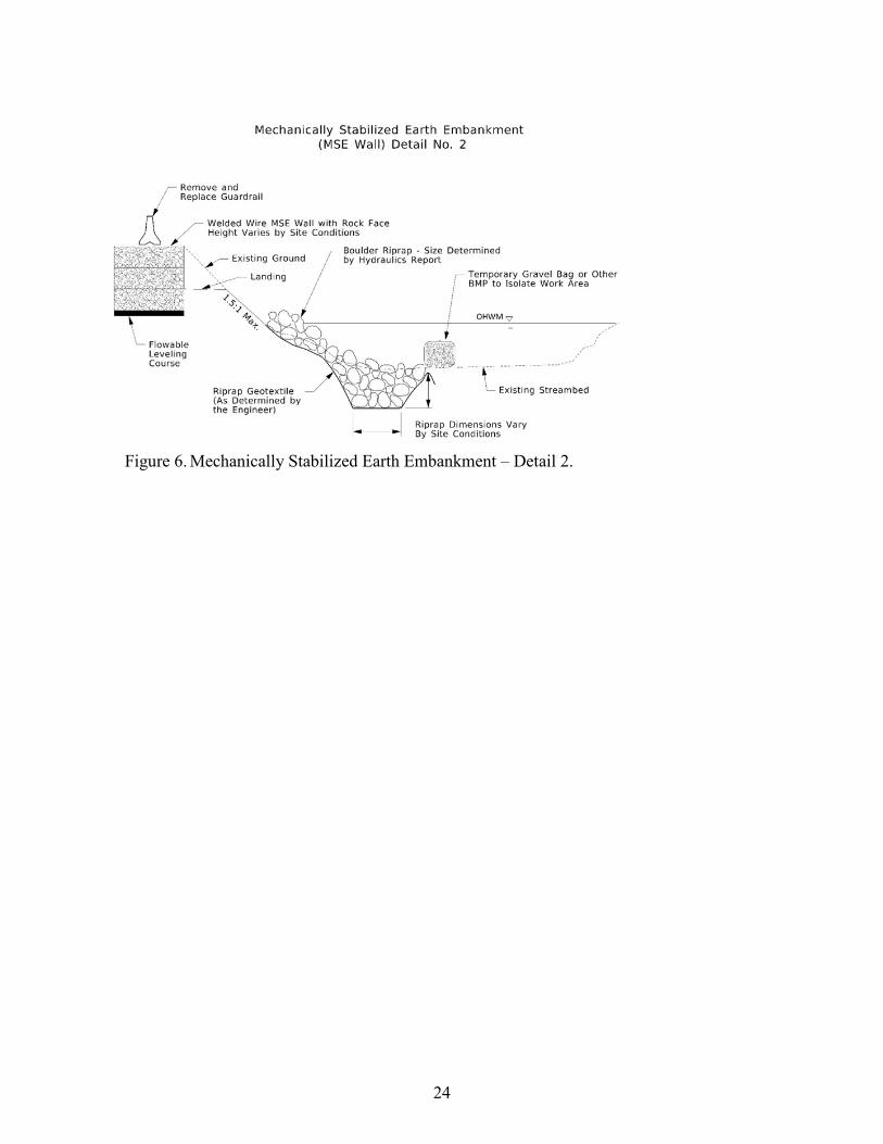
24
Figure 6. Mechanically Stabilized Earth Embankment – Detail 2.
25
The process is as follows: When feasible, isolate the work in accordance with Subsection 1.3.3.4 Best Management Practices for Work below the Ordinary High-Water Mark (OHWM). Using an excavator; remove material within the footprint where the MSE structure will be placed. If specified, place a geotextile fabric on the natural ground where the riprap will be placed. Place appropriately sized riprap at the toe of the slope and “key” into the channel bottom. Height, width and depth of riprap configuration will vary depending on the design criteria, hydrology, geomorphic, and scour factors. After riprap is placed, construct the MSE embankment by filling the supporting structures (fabric, wire baskets or metal straps) in compacted layers to the specified height and width. Occasionally, a fascia made of concrete or other material will be applied to the face of the MSE wall above the OHWM. All exposed surfaces will have a neat and reasonably smooth appearance. No sharp stones will project beyond the face. If suitable, material from excavation may be used to construct the MSE embankment, or disposed of at an approved site. Best Management Practices. To minimize the potential for impacts to listed species and their habitats the Contractor will adhere to all BMPs listed in the following Subsections: 1.3.3.1 - Best Management Practices Common to All Projects 1.3.3.4 - Best Management Practices for Work below the Ordinary High-Water Mark 1.3.2.8. Ditch Cleaning This activity includes regrading existing roadside ditches and removing deposited material to facilitate drainage and preserve the integrity of the roadway. Traffic is generally maintained on the existing roadway and the activity is generally accomplished by ITD maintenance crews. The process is as follows: Using loaders, excavators and dump trucks to remove deposited material from ditches, reshape, and to compact the material to the specified grades. Precautions will be made to avoid nicking the toe of the adjacent slope. Low spots or pockets in the flow line will be avoided or drained when possible. In some soils, it may be necessary to install permanent BMPs, e.g., ditch liners, coarse gravel or other material to prevent erosion. Rock check dams may be necessary to prevent erosion on steeper grades. Ditching will only occur in the dry and will not involve excavation in live water. Best Management Practices. To minimize the potential for impacts to listed species and their habitats the Contractor will adhere to all BMPs listed in the following Subsections: 1.3.3.1 - Best Management Practices Common to All Projects 1.3.3.2 - Best Management Practices for Ground Disturbing Activities
26
1.3.2.9. Small Structure Repair Water conveyance structures such as bridges, box culverts, stiff leg culverts, and multi-plate culverts commonly require maintenance work to repair scour or debris damage to foundation or structure footings. ITD commonly works to repair, protect, and apply preventative maintenance to these structures when this occurs. The process is as follows: Excavate loose material adjacent to the undermined area. Construct a concrete form around the undermined area using wood or other material. Pump concrete or grout into the void to completely fill the area. Repair scour areas with riprap or other approved methods. Ancillary work may include removing debris, such a logs or snags caught on the piers or abutments. Best Management Practices. To minimize the potential for impacts to listed species and their habitats the Contractor will adhere to all BMPs listed in the following Subsections: 1.3.3.1 - Best Management Practices Common to All Projects 1.3.3.2 - Best Management Practices for Ground Disturbing Activities 1.3.3.4 - Best Management Practices for Work below the Ordinary High-Water Mark 1.3.2.10. Culvert Installation and Maintenance Culvert Installation. Installation of a culvert requires consideration for traffic management. Unless a nearby and short alternate route can be used, generally the culvert will need to be replaced in two phases. Each phase, except for short delays, must allow traffic to flow continuously and safely through the project. The process is as follows: Excavate within the roadway prism to a sufficient depth to reach the flow line or grade of the waterway being conveyed. The adjacent slope grades must be graded for personnel safety and so the trench will not collapse prior to the culvert installation. When replacing a culvert in a perennial stream, the culvert will be designed to pass Q50 flows. The culvert is installed or replaced either in its entirety or one half-length at a time. If it is a replacement, the area is excavated, one-half of the old culvert is removed and the area beneath the new culvert is backfilled with aggregate base. The new half of the culvert is installed and backfilled with suitable material and compacted to avoid future settlement of the roadway. This process is repeated on the opposite side of the highway and the two halves are connected together with a band. The excavation is backfilled and the area paved with plant mix pavement to match the existing roadway elevations. Culvert Liners. Culvert liners are used to refurbish a failing or old culvert. Culvert liners are not allowed in streams with ESA-listed fish species. The liner is typically constructed of HDPE. The liner generally comes in 10- to 20-ft. sections. The installation process is as follows:
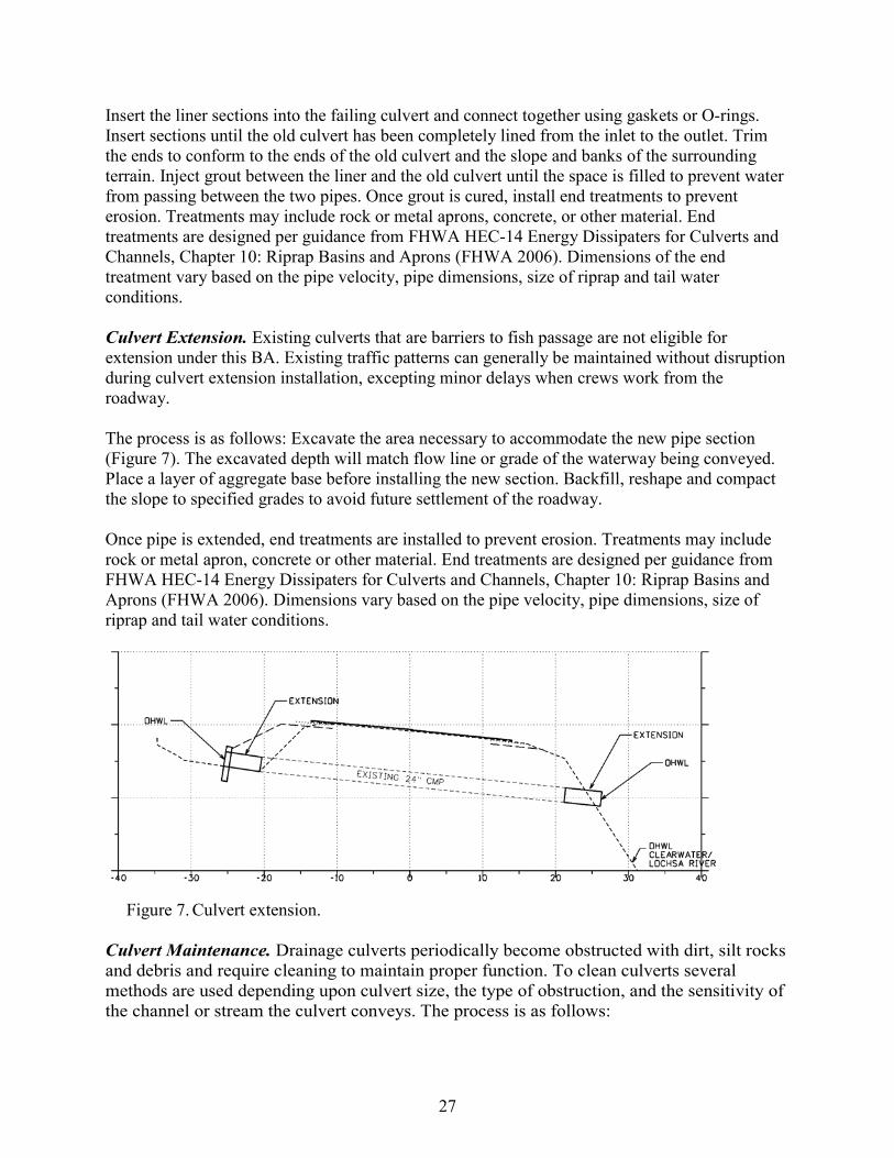
27
Insert the liner sections into the failing culvert and connect together using gaskets or O-rings. Insert sections until the old culvert has been completely lined from the inlet to the outlet. Trim the ends to conform to the ends of the old culvert and the slope and banks of the surrounding terrain. Inject grout between the liner and the old culvert until the space is filled to prevent water from passing between the two pipes. Once grout is cured, install end treatments to prevent erosion. Treatments may include rock or metal aprons, concrete, or other material. End treatments are designed per guidance from FHWA HEC-14 Energy Dissipaters for Culverts and Channels, Chapter 10: Riprap Basins and Aprons (FHWA 2006). Dimensions of the end treatment vary based on the pipe velocity, pipe dimensions, size of riprap and tail water conditions. Culvert Extension. Existing culverts that are barriers to fish passage are not eligible for extension under this BA. Existing traffic patterns can generally be maintained without disruption during culvert extension installation, excepting minor delays when crews work from the roadway. The process is as follows: Excavate the area necessary to accommodate the new pipe section (Figure 7). The excavated depth will match flow line or grade of the waterway being conveyed. Place a layer of aggregate base before installing the new section. Backfill, reshape and compact the slope to specified grades to avoid future settlement of the roadway. Once pipe is extended, end treatments are installed to prevent erosion. Treatments may include rock or metal apron, concrete or other material. End treatments are designed per guidance from FHWA HEC-14 Energy Dissipaters for Culverts and Channels, Chapter 10: Riprap Basins and Aprons (FHWA 2006). Dimensions vary based on the pipe velocity, pipe dimensions, size of riprap and tail water conditions.
Figure 7. Culvert extension.
Culvert Maintenance. Drainage culverts periodically become obstructed with dirt, silt rocks and debris and require cleaning to maintain proper function. To clean culverts several methods are used depending upon culvert size, the type of obstruction, and the sensitivity of the channel or stream the culvert conveys. The process is as follows:

28
Drag Line. This method is used for small culverts where adequate room allows for a cable or chain attached to a solid rod to be threaded through the culvert. The cable or chain is then attached to an object smaller than the diameter of the culvert. The cleanout object is then pulled through the culvert mechanically to clear the debris from the pipe. Adequate room needs to exist to allow for the use of an appropriate machine to pull the cleanout object through the pipe. Hydraulic Pressure. This method is generally used for small culverts that cannot be accessed manually or mechanically. It usually involves the use of a water tank truck; a high-pressure pump and a special rotating hose head, referred to as a “weasel.” The hose is fed into the culvert and the pressure causes it to rotate and spray simultaneously loosening and washing the debris out of the culvert. The debris is then removed from the channel and disposed of.
Manual Cleanout. This method is used when the culvert is of adequate size for access by laborers to remove the debris by hand. It is generally used in sensitive areas where running water is present at the time of the removal. It involves the use of picks, shovels, buckets, and wheelbarrows. Debris is carried to the ends of the culverts where it is then loaded into the scoop of a track hoe and removed. In some cases, the use of cofferdams might be required to divert the water around the work area. BMPs may be applied to capture sediment. Mechanical Cleanout. This method is used on culverts that are large enough to use excavators or backhoes to remove obstructions. In some cases, the excavator is located in or near the channel and reaches into the culvert from one or both ends to remove the debris. Large rocks that cannot be reached might be removed by use of a cable or could be broken up by drilling and using a low charge explosive, similar to a shotgun shell, and then removed manually. Small excavators such as bobcats or walk-behind excavators that can enter the culvert may be used. Similar to the manual cleanout method, sediment control BMPs could be required. Best Management Practices. To minimize the potential for impacts to listed species and their habitats, the Contractor will adhere to all BMPs listed in the following Subsections: 1.3.3.1 - Best Management Practices Common to All Projects 1.3.3.2 - Best Management Practices for Ground Disturbing Activities 1.3.3.4 - Best Management Practices for Work below the Ordinary High-Water Mark
29
1.3.2.11. Guardrail Installation The purpose of this activity is to restore or replace metal or concrete guardrail and terminal ends located adjacent to the highway. The activity is performed either by ITD maintenance crews or contractor. Traffic is generally maintained on the existing roadway. All work is performed within the ITD right-of-way. The process is as follows: Where guardrail currently exists, remove guardrail and terminal ends. Prepare area to receive new guardrail. Preparation generally requires excavation or fill sections to be constructed within the roadway prism. The rail length may need to be extended to reduce a hazard. If needed, place additional subgrade material in layers and compact uniformly to the desired grades. Once the subgrade is placed and compacted, place a gravel base to facilitate drainage from the roadway. Install guardrail posts by pounding them into the ground or using posthole diggers. Concrete guardrail is placed on the final compacted surface and anchored to the ground. Best Management Practices. To minimize the potential for impacts to listed species and their habitats the Contractor will adhere to all BMPs listed in the following Subsections: 1.3.3.1 - Best Management Practices Common to All Projects 1.3.3.2 - Best Management Practices for Ground Disturbing Activities 1.3.2.12. Geotechnical Drilling Geotechnical investigation is often required on ITD projects. This task commonly consists of geotechnical borings or seismic refraction surveys. ITD primarily uses four methods to retrieve soil and rock samples and to perform in situ testing. The drill method used is determined by the type of soil and rock to be penetrated, groundwater conditions, and type of samples required. The four basic methods of drilling are hollow-stem augers, rotary drilling, percussive air drilling, and core drilling. For drilling operations, a drill rig is positioned over the boring location, hydraulic rams are used to level the rig and a derrick (vertical stationary mast) is raised. Hollow-stem Augers. Hollow-stem augers are commonly used in cohesive soils or in granular soil above the groundwater level. Hollow-stem auger consists of the hollow outside section with a pilot bit and drill rod on the inside. Auger sections are 5 ft. in length. The process is as follows: Augers are attached to the drive head, which turns the auger to advance it into the soil. At the desired sampling depth, the auger is disconnected from the drive head, the drill rod and pilot bit are hoisted out of the hollow section, a soil sampling device is attached to another section of drill rod, and the sampler is lowered into the hollow auger section. Raising and lowering of the drill rod into and out of the auger sections is accomplished with wire-line hoists that run up and over the derrick and are attached to the base of the drill rig. Modified hollow-stem augers with soil tubes are capable of continuous soil sampling.
30
Continuous soil sample lengths are 5 feet long with diameters equal to the diameter of the hollow-stem auger. Soil sampling can also be accomplished using either a Standard Penetration Test split-spoon sampler or California ring sampler. These samplers are driven into the soil at the desired depth using a hydraulically operated free-falling hammer. The tube penetrates to varying depths, depending on the length of the tube and the resistance of the soil. The tube is then retrieved and the ends are sealed for transport. Once a soil sample is obtained at the desired depth, the drill rod and pilot bit are once again placed inside the hollow auger section, the drive head of the drill rig is reattached to the auger, and the auger is advanced to the next sampling depth. Soil samples will be obtained at select intervals. This process is repeated until the augers have been advanced and soil samples have been obtained to the specified depth of the boring. Rotary Drilling. Rotary tri-cone drilling is most commonly used below the groundwater level or in dense soils, granular soils, or soft weathered rock that is difficult to penetrate with augers. The process is as follows: A drill bit is used to cut the formation and drilling fluids support the borehole and lift the cuttings to the surface. The boring is advanced sequentially. Casing is advanced after the desired sample depth is reached or to a depth where the borehole can no longer be supported with drilling fluids. Casing is advanced by either being driven into the ground or rotated. Sampling is conducted in a similar manner as auger drilling. Once the borehole is cased and the samples retrieved, drilling resumes. Percussive Air Drilling. Percussive air drilling is similar to rotary tricone drilling but the drill bit cutting action is aided with a down-hole hammer operated by air. Cuttings are blown to the surface by the air. The borehole is supported by advancing casing simultaneous with the drill rod. Percussive air drilling is favored in alluvial gravels. Core Drilling. Core drilling is primarily used to bore through rock. Core drilling can be done on the ground or in the water. The process is as follows: On Ground. Diamond bits are rotated through rock while circulating drilling fluids to cool the bit and lift cuttings to the surface. The bits are circular, allowing the cut rock to pass into a 5-ft. long hollow barrel. After every 5-ft. interval is drilled halted and the barrel holding the rock is retrieved by wire line. Wire line is used to run an empty barrel back down the inside of the drill rod to the bit where it is latched into place and drilling resumes until the barrel again becomes full. Drilling fluids may be water, mud, compressed air, or compressed air with foam additive. Drilling fluids are used to cool the cutting surface of the bit and to lift the rock cuttings to the surface. Drilling liquids help stabilize the borehole wall to prevent collapse and to seal zones to prevent loss of drilling fluids into the formation. Drill mud is water and additives. The additives are not toxic and are commonly bentonite clay and polymers. While drilling, fluids are pumped through the drill rod and drill bit, up the annulus and back to the surface. Drilling fluids can be
31
discharged onto the ground surface. Water flow over the ground surface is avoided as much as possible. Where discharge on the ground surface is not permitted, drill fluids that reach the surface are contained in tubs where the rock cuttings are removed before being recirculated. While circulating down hole partial or complete fluids loss can occur into the formation. This indicates zones where open joints, fractures or voids are present. When drill fluids become contaminated with oil or other substances, special handling and precautions may require containment and disposal off-site. In Water. For in-water drilling, the drilling platform is typically placed on a temporary work bridge (barge) or wheeled vehicle positioned over the desired location. A casing is lowered to the streambed and set. Drilling takes place inside the casing similar to methods described above. Drilling fluids will be non-toxic and recycled in a closed system. There will only be a brief pulse of sediment when the casing is first set; after that, all material is contained within the casing and fluid system. Work platforms that require pile driving must be installed in accordance with Section 1.3.2.14 – Pile Installation. Best Management Practices. To minimize the potential for impacts to listed species and their habitats the Contractor will adhere to all BMPs listed in the following Subsections: 1.3.3.1 - Best Management Practices Common to All Projects 1.3.3.2 - Best Management Practices for Ground Disturbing Activities 1.3.3.4 - Best Management Practices for Work below the Ordinary High-Water Mark* * Only include when in-water drilling is anticipated. 1.3.2.13. Pile Installation Pile installation may be necessary to support abutments at the ends of structures or to support a barge during work in or above waterways. Piles will be installed either by a pneumatic vibratory pile driver or an impact hammer pile driver. A hammer pile driver may be required due to the rocky substrate. Vibratory pile drivers are often used to install temporary or non-structural piles. A vibratory pile driver installs piling into the ground by applying a rapidly alternating force to the pile. Impact hammer pile drivers are usually necessary for load bearing applications. The pile driver hammer may be suspended from the boom of a crawler crane, supported on a large pile driver frame or carried on a barge for construction in water. The hammer is guided between two parallel steel members called leads. The process is as follows: All piles driven in the stream channel will be installed within a temporary cofferdam. Cofferdam implements such as sandbags or water bladders can be placed directly on the stream or lakebed; sheet piles can be installed using a vibratory hammer only. The crane to install the sheet piles will operate from river's edge, an existing bridge deck or temporary work platform. There may be short bursts of suspended sediment as the sheet piles are driven into or removed from the substrate. Once the cofferdam is installed, the Contractor will drive a test pile to determine bearing capacity. Impact hammers are required for test piles used to determine bearing capacity. After
32
bearing capacity is determined, the Contractor will install the remaining piles as specified or directed. Pile driving may occur at any time during the duration of the project when adult and juvenile fish may be migrating. Pile installation proposed in live streams outside of temporary cofferdams is not covered by this BA and will require a full BA. Pile installation will be in strict compliance with all applicable the BMPs in Subsection 1.3.3.4. Best Management Practices. To minimize the potential for impacts to listed species and their habitats the Contractor will adhere to all BMPs listed in the following Subsections: 1.3.3.1 - Best Management Practices Common to All Projects 1.3.3.4 - Best Management Practices for Work below the Ordinary High-Water Mark
1.3.3.Best Management Practices
1.3.3.1. Best Management Practices Common to All Projects Implementation of BMPs listed below is required for all projects, unless a qualified individual has determined that the species or habitat is not present within the project area, including materials and waste areas, or project actions will have no effect to species or habitat. All work will be performed in strict compliance with all applicable Federal, State and local laws, codes, rules and regulations and ITD’s Standard Drawings and Standard and Supplemental Specifications. If inconsistencies are discovered in the contract’s documents, the most restrictive requirement will be followed. The BMPs are organized by the following categories:
o Stormwater Controls o Species Specific BMPs, Personnel Qualifications, and Survey Protocols
Stormwater Controls All projects require either a Pollution Prevention Plan (PPP) or Stormwater Pollution Prevention Plan (SWPPP) and will include the BMP’s listed below. A designated environmental monitor will visit the site at least weekly to examine the application and efficacy of the effects-minimization measures. Water quality BMPs for in-water work are included in Appendix D of the BA - Best Management Practices for work below the Ordinary High-Water Mark (OHWM). Erosion and Sediment Controls
• All BMPs will be installed according to ITD’s Best Management Practices Manual. • All temporary BMPs installed on the project will be identified on ITD’s Qualified
Products List (QPL) as “Biodegradable,” unless a biodegradable option is unavailable. Sandbags will be canvas or other approved non-synthetic material capable of
33
decomposing under ambient soil conditions into carbon dioxide, water, and other naturally occurring materials within a time period relevant to the product’s expected service life.
• Perimeter control BMPs will be installed prior to any ground disturbing activities to prevent sediment from entering waterways.
• Stormwater Plan Sheets will include the following: • Temporary and permanent BMPs • Location of on-site staging areas, off-site material, waste, borrow or equipment
storage or staging areas • Location of all hazardous materials storage areas • Location of spill kits • Identify any industrial stormwater discharges other than from project construction • Waters of the United States including wetlands
• Storm sewer inlets Pollution Prevention – Good Housekeeping Standards
• Identify Hazardous or Toxic Waste or other Pollutants of Concern and BMPs used to treat the identified pollutants of concern. Examples includes; paints, solvents, petroleum-based products, wood preservatives, additives, curing compounds and acids.
• Provide spill response and cleanup kits on all projects, and make all appropriate staff aware of their locations.
• All ITD projects shall follow the Idaho Hazardous Materials or Weapons of Mass Destruction (WMD) Incident Command and Response Support Plan and ITD Incident Management Plan. In addition, a project specific Spill Plan shall be provided by the Contractor, and should be included in the SWPPP.
• To the greatest extent possible, all staging, fueling and storage areas will be located away from and adequately buffered from aquatic areas.
• During CRABS operations, the Contractor will ensure that quick lime (CaO) or pulverized CRABS material does not enter any adjacent waterways or wetlands.
• When not in use, construction equipment will be stored away from concentrated flows of stormwater, drainage courses, inlets and bridge drains.
• Park equipment over plastic sheeting or equivalent where possible. Plastic is not a substitute for drip pans or absorbent pads.
• Equipment shall not have damaged hoses, fittings, lines, or tanks that have the potential to release pollutants into any waterway.
• 1.3.3.2. Best Management Practices for Ground Disturbing Activities The BMPs are organized by the following categories:
o General BMPs for Ground Disturbing Activities o Blasting
34
General BMPs for Ground Disturbing Activities
• Ground disturbing activities are prohibited during precipitation events or when precipitation events are imminent. Precipitation events include any rain or snow accumulations that have potential to discharge to waterways or wetlands.
• Preserve native vegetation and plant communities when practicable to serve as natural erosion controls.
• All erodible material (temporary or permanent stockpiles) will be located outside of the 100-year floodplain or greater than 300 ft. from fish-bearing streams.
• Finished slopes must be stabilized as soon as practical to prevent sediment from entering waterways.
• If shrub removal is required, it will be done in such a way that the root mass is left in place for stabilization purposes.
• Disturbed areas within riparian zones will be reclaimed with riparian vegetation similar to the existing plant communities.
• Do not locate construction staging areas, waste areas, etc., where significant adverse impact on existing vegetation may occur.
• Clearly flag or fence vegetation buffer zones to protect riparian corridors and natural drainage paths.
• To preserve riparian areas, minimize the number and width of stream crossings and cross at direct rather than oblique angles.
Blasting
• The Contractor must submit a blasting plan to the Engineer for approval including: type and height of rock fall barriers, drilling and blasting patterns, timing and duration and anticipated noise effects.
• Rock and debris will be prevented from reaching adjacent waterways. • Blasting is prohibited underwater.
1.3.3.3. Best Management Practices for Work Adjacent to Aquatic Systems above the Ordinary
High-Water Mark (OHWM) The following BMPs are required when working adjacent to waterways where ESA species or habitat is present.
• Bridge rehabilitation activities are prohibited during precipitation events or when precipitation events are imminent.
• During deck work, all bridge drains and joints will be sealed to minimize the potential for introducing residual materials to the aquatic system.
• In order to minimize the potential for introducing bridge debris (e.g., dirt, concrete, etc.) to the aquatic system, measures will be taken to minimize the potential for debris to fall into the river channel while repairing the tops of piers. Measures may include the construction of a platform below the top of the pier or the use of a temporary work bridge (barge) anchored under the pier site.
35
• Use potable water for hydro-demolition activities, when feasible. However, when necessary, water may be pumped from other sources if the following conditions are met: (1) the source does not exceed Idaho Department of Environmental Quality (IDEQ) water quality thresholds for turbidity, pH or other chemicals that are toxic to aquatic organisms; (2) the Contractor obtains required permits from the Idaho Department of Water Resources (IDWR); and (3) Minimum streams flows recommended by the Idaho Department of Fish and Game (IDFG) are not exceeded.
• When pumping water from local sources for project actions, ensure that: (1) NMFS screening criteria are met (NMFS 2011 or the most recent version); (2) redds of listed species and staging or spawning adults will not be disturbed; and (3) pumping maintains 80 percent or more of average streamflow in affected streams. NMFS approval is required for pumping that exceeds 3 cfs.
• Runoff water and residual material from hydro-demolition or any other bridge maintenance activities that have the potential to generate wastewater or residual material will be collected using a vacuum and disposed of off-site in an approved location.
• In order to minimize the potential for direct impacts to listed fish, all work will be completed from the existing bridge; no equipment or heavy machinery will enter the river channel.
1.3.3.1. Best Management Practices for Work below the Ordinary High-Water Mark The following BMPs are required when working within waterways where ESA-listed species or their habitat is present. The BMPs are organized by the following categories:
o General BMPs for Work Below the OHWM o Bridge Demolition o Pile Installation o Barges and Boats o Water Quality/Quantity Treatment o Personnel Qualifications and Protocols for Fish Handling o Work Area Isolation and Fish Handling
General BMPs for Work Below the OHWM • Work below ordinary high water of a stream or in a wetland will require consultation
with the COE, IDWR, and IDEQ at a minimum. Work below the ordinary high water mark of a stream or within wetlands will require coordination with COE, EPA, IDWR, IDEQ, and respective Tribes when work is within Reservation lands or affects ESA-related tribal trust resources.
• All work below the OHWM will take place during low flow conditions, unless otherwise infeasible.
• If riprap is required, it will be placed in a manner that will not further constrict the stream channel.
• To minimize in-water noise (e.g., pile cleaning) the Contractor will be required to use the smallest size and lowest impact, hand-held equipment necessary to perform the work.
• When pumping water from local sources for project actions, ensure that: (1) NMFS screening criteria are met (NMFS 2011 or the most recent version); (2) redds of listed
36
species and staging or spawning adults will not be disturbed; and (3) pumping maintains 80 percent or more of average streamflow in affected streams. NMFS approval is required for pumping that exceeds 3 cfs.
• When extending or replacing a culvert in a perennial stream, fish passage will be constructed into the project, if regulatory agencies (USFWS, NMFS and IDFG) deem it appropriate. Fish passage will be designed in accordance with NOAA’s publication, “Anadromous Salmonid Passage Facility Design” (2011, or the most recent version). Anadromous Salmonid Passage Facility Design (noaa.gov)
• Culvert liners shall not be used in streams with ESA-listed fish species.
Bridge Demolition
• No machinery or implements will enter the live stream. Temporary cofferdams will be constructed, if necessary, to dewater existing pier sites during pier removal.
• If a stinger is chosen to remove piers, a sandbag barrier, or similar barrier, would be placed between the pier and live water to catch any debris before it would potentially fall into live water.
• If a wet-blade concrete saw is chosen, a catch basin would be constructed at the site to collect cutting water or slurry. A shop vacuum would be used to collect the slurry for off-site disposal.
• If a dry-blade concrete saw is chosen, an enclosed containment structure would be constructed around the site to trap airborne dust particles, and a shop vacuum or other device would be used to collect the dust for off-site disposal.
Pile Installation
• Impact hammer pile driving will only be allowed within a cofferdam area and not in free-flowing water.
• Pneumatic vibratory pile drivers will be required when sheet pile is used to isolate the work area.
• To minimize sound pressure effects from pile driving, pile locations will be predrilled, unless infeasible.
• Pneumatic vibratory hammers will be used to install piles, unless impact hammer pile drivers are necessary due to substrate or load bearing determinations.
• All water will be pumped from the cofferdam to allow pile driving to occur only in dry conditions. Pumped water will be filtered through settling basins and not directly returned to the river.
• Impact hammer pile driving will only occur during daylight hours. No impact hammer- pile driving activities will occur for at least 12-hours within each 24-hour period giving migratory fish the opportunity to move through the project area without being subjected

37
to impact pile driving noise. The 12-hour period will correspond to the early evening, nighttime and early morning hours when anadromous fish generally move through the project area.
• Pile installation proposed in live streams outside of temporary cofferdams is not covered by this BA and will require a full BA.
Barges and Boats
• Barges will be lined or have a lip to contain spills. They will be outfitted with spill containment kits to contain 125 percent of the volume of materials aboard.
• Barges or boats shall be completely fueled upon arrival. If it is necessary to refuel the boats or barges in the water, absorbent pads, socks, floatation booms, or similar BMPs will be available to contain spills in the water.
• Hazardous materials will not be stored on the barge overnight, but will be transported and stored off site or in areas where adequate buffer spaces exist to prevent impacts to ESA-listed species or their habitats.
• Both the barge and any boats shall have invasive species permits and will have been inspected by Idaho Department of Agriculture before use.
Water Quality/Quantity Treatment
• Turbidity monitoring will be required for all in-water work that has potential to discharge harmful levels of sediment or pollutants. Water quality samples will be collected and NTU measurements will included on the ITD-0290 - Construction Monitoring Form (Appendix A). Measurements will be taken 100 feet above and below discharge points, or as directed by appropriate resource agency or ITD personnel.
• Identify all contributing and non-contributing impervious areas that are within and contiguous with the project area and explain how runoff from contributing impervious areas will be managed.
• Use permanent stormwater flow control and treatment BMPs to infiltrate, retain, or detain runoff to the maximum extent practicable. Permanent stormwater controls must be sufficient to retain the runoff volume produced from a 24-hour, ninety fifth percentile storm event, or can attain an equal or greater level of water quality benefits as onsite retention from a 24-hour, ninety fifth percentile storm event. Additionally, when it is necessary to discharge treated stormwater directly into surface water or a wetland, the following requirements apply:
• Apply one or more primary treatment practices found in the ITD BMP Manual, Chapter 5.
• Maintain natural drainage patterns to the maximum extent practicable. • To the maximum extent practicable, ensure that water quality treatment for
contributing impervious area runoff is completed before commingling with offsite runoff for conveyance.

38
• Prevent erosion of the flow path from the project to the receiving water and, if necessary, provide a discharge facility made entirely of manufactured elements (e.g., pipes, ditches, discharge facility protection) that extends at least to the OHWM.
Monitoring: Both turbidity and pH monitoring will be required for all in-water work where there is potential to discharge harmful levels of sediment or pH elevating pollutants and ESA-listed species are present. Both monitors will be placed at the same locations. Turbidity and pH measurements will be taken simultaneously. Measurements will be taken 100 feet above and below discharge points, or as directed by appropriate resource agency or ITD personnel. For quality control purposes, spare turbidity and pH monitoring equipment will be stored onsite.
• Turbidity: Monitors will be placed upstream of the project area, and downstream of the project area at distances specified by the appropriate resource agency or ITD. If construction results in an increase over background turbidity greater than 50 nephelometric turbidity units (NTU) instantaneously or 25 NTU over ten consecutive days, construction shall be ceased until levels return to below 25 NTU.
• pH: Monitors will be placed upstream of the project area, within the turbidity curtain and downstream of the project area at distances specified by the appropriate resource agency or ITD. As per IDAPA Idaho Code 58.01.02.250.01.a - Surface Water Quality Criteria for Aquatic Life Use Designations, the pH values for surface waters must remain between 6.5 and 9.0. For any pH values over 9.0, construction shall be ceased until pH levels return to values less than 9.0.
• Daily reports will be compiled and included with the ITD-0290 - Construction Monitoring Form. Reports will include the following minimum information:
a. Current construction activity b. Brief weather conditions (precipitation if any) c. Sampling location d. Date e. Time f. Turbidity results in NTUs g. pH values
• Instream work windows established by NMFS and USFWS will be used during project construction (see Table 1 and 2 for work windows). The work window will be documented under the construction timeframe identified on the ITD-0289- Project Pre-notification Form. For specific questions on work windows, contact NMFS (salmon and steelhead) or USFWS (bull trout).
39
Personnel Qualifications and Protocols for Work Area Isolation and Fish Handling Personnel Qualifications:
• All individuals participating in fish capture and removal operations will have the training, knowledge, skills, and ability to ensure safe handling of fish, and to ensure the safety of staff conducting the operations. If electrofishing is proposed as a means of fish capture, the directing biologist will have a minimum of 100 hours electrofishing experience in the field using similar equipment, and any individuals operating electrofishing equipment will have a minimum of 40 hours electrofishing experience under direct supervision (USFWS 2012). https://www.fws.gov/wafwo/pdf/FishExclusionProtocolsandStandards6222012%20DR.pdf).
• A Scientific Collecting Permit issued by IDFG is required to handle captured fish.
Protocols for Work Area Isolation and Fish Handling:
• When appropriate, ITD will contact the NMFS and USFWS to determine if fish removal is necessary.
• Remove fish from an exclusion area as it is slowly dewatered with methods such as hand or dip-nets, seining, trapping with minnow traps (or gee-minnow traps) or electro-fishing. When electro-fishing follow NMFS (2000) electro-fishing guidelines.
• Instream work windows established by NMFS and USFWS will be used during project construction (see Appendix F for work windows). The work window will be documented under the construction timeframe identified on the ITD-0289- Project Pre-notification Form. For specific questions on work windows, contact NMFS (salmon and steelhead) or USFWS (bull trout and Kootenai River white sturgeon).
• Isolate any work area within the wetted channel from the active stream whenever listed fish are reasonably certain to be present, or if the work area is less than 300 ft. upstream from known spawning habitats. However, work area isolation may not always be necessary or practical in certain settings (e.g., dry seasonal streambeds).
• Methods to isolate work may include; aqua-barriers, sandbags, concrete barriers or culverts placed within the active channel. These structures will either divert water to a portion of the channel away from active construction or dam the channel and completely dewater the work area in order to pass all the water through the work site in a culvert or by pump. All in-stream structures will be temporary and shall be removed once construction is complete.
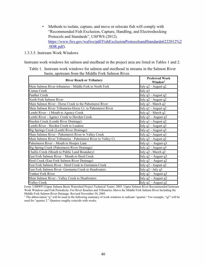
40
• Methods to isolate, capture, and move or relocate fish will comply with “Recommended Fish Exclusion, Capture, Handling, and Electroshocking Protocols and Standards”, USFWS (2012). https://www.fws.gov/wafwo/pdf/FishExclusionProtocolsandStandards6222012%2 0DR.pdf).
1.3.3.5. Instream Work Windows Instream work windows for salmon and steelhead in the project area are listed in Tables 1 and 2.
Table 1. Instream work windows for salmon and steelhead in streams in the Salmon River basin, upstream from the Middle Fork Salmon River.
River Reach or Tributary Preferred Work Window1
Main Salmon River tributaries - Middle Fork to North Fork July q2 - August q2 Camas Creek July q3 Panther Creek July q3 - August q2 North Fork Salmon River July q2 - August q2 Main Salmon River - Horse Creek to the Pahsimeroi River July q2 - March q2 Main Salmon River Tributaries-Horse Cr. to Pahsimeroi River July q1 - August q2 Lemhi River - ) Mouth to Agency Creek July q2 - March q2 Lemhi River - Agencv Creek to Havden Creek July q2 – August q3 Hayden Creek (Lemhi River Drainage) July q1 - August q2 Lemhi River - Havden Creek to Leadore July q1 - August q3 Big Springs Creek (Lemhi River Drainage) July q1 - August q3 Main Salmon River - Pahsimeroi River to Valley Creek July q2 - August q3 Main Salmon River Tributaries - Pahsimeroi River to Valley Cr. July q2 - August q2 Pahsimeroi River – Mouth to Hooper Lane July q1 – August q3 Big Spring Creek (Pahsimeroi River Drainage) July q2 - August q3 Challis Creek (Mouth to Public Land Boundary) July q2 - March q2 East Fork Salmon River – Mouth to Herd Creek July q2 – August q3 Herd Creek (East Fork Salmon River Drainage) July q2 – August q2 East Fork Salmon River - Herd Creek to Germania Creek July q2 - August q2 East Fork Salmon River- Germania Creek to Headwaters July q2 - July q3 Yankee Fork River July q2 – August q2 Main Salmon River - Valley Creek to Headwaters July q2 – August q2 Valley Creek July q2 – August q2
From: USBWP (Upper Salmon Basin Watershed Project Technical Team). 2005. Upper Salmon River Recommended Instream Work Windows and Fish Periodicity. For River Reaches and Tributaries Above the Middle Fork Salmon River Including the Middle Fork Salmon River Drainage. Revised November 30, 2005. 1 The abbreviation “q” will be used in the following summary of work windows to indicate “quarter.” For example, “q2” will be used for “quarter 2.” Quarters roughly coincide with weeks.

41
Table 2. Instream work windows for all other streams in the project area (Lower Salmon River, Lower Snake River, and Clearwater River Basins). Check with NMFS for fish presence in a specific stream or river.
Stream type Instream work window
Perennial, no listed fish Base the timing on the nearest listed fish found downstream from the project area
Perennial, listed steelhead only Preferred window is August 1 through October 30; exceptions may be made on a project-specific basis to begin work as early as July 15.
Perennial, listed steelhead and unlisted salmon
August 1 through October 30 when Chinook and coho spawning habitats are not present in the action area; July 15 through August 15 when Chinook spawning habitat is present in action area; August 1 through September 15 when coho spawning habitat is present in the action area.
Perennial, listed steelhead as well as listed salmon July 15 through August 15
Intermittent August 1 to October 30, or any time work can be completed while the stream is not flowing
2. ENDANGERED SPECIES ACT: BIOLOGICAL OPINION AND INCIDENTAL TAKE STATEMENT
The ESA establishes a national program for conserving threatened and endangered species of fish, wildlife, plants, and the habitat, upon which they depend. As required by section 7(a)(2) of the ESA, each Federal agency must ensure that its actions are not likely to jeopardize the continued existence of endangered or threatened species, or adversely modify or destroy their designated critical habitat. Per the requirements of the ESA, federal action agencies consult with NMFS and section 7(b)(3) requires that, at the conclusion of consultation, NMFS provide an opinion stating how the agency’s actions would affect listed species and their critical habitats. If incidental take is reasonably certain to occur, section 7(b)(4) requires NMFS to provide an ITS that specifies the impact of any incidental taking and includes reasonable and prudent measures (RPMs) and terms and conditions to minimize such impacts.
2.1. Analytical Approach
This opinion includes both a jeopardy analysis and an adverse modification analysis. The jeopardy analysis relies upon the regulatory definition of “jeopardize the continued existence of” a listed species, which is “to engage in an action that reasonably would be expected, directly or indirectly, to reduce appreciably the likelihood of both the survival and recovery of a listed species in the wild by reducing the reproduction, numbers, or distribution of that species” (50 CFR 402.02). Therefore, the jeopardy analysis considers both survival and recovery of the species. This opinion relies on the regulatory definition of, “destruction or adverse modification,” which means, “a direct or indirect alteration that appreciably diminishes the value of critical habitat as a whole for the conservation of a listed species” (50 CFR 402.02). The designations of critical habitat for ESA-listed salmon and steelhead use the term primary constituent element (PCE) or essential features. The 2016 critical habitat regulations (50 CFR
42
424.12) replaced these terms with physical or biological features (PBFs). The shift in terminology does not change the approach used in conducting a “destruction or adverse modification” analysis, which is the same regardless of whether the original designation identified PCEs, PBFs, or essential features. In this opinion, we use the term PBF to mean PCE or essential feature, as appropriate for the specific critical habitat. The 2019 regulations define effects of the action using the term “consequences” (50 CFR 402.02). As explained in the preamble to the regulations (84 FR 44977), that definition does not change the scope of our analysis and in this opinion we use the terms “effects” and “consequences” interchangeably. We use the following approach to determine whether a proposed action is likely to jeopardize listed species, destroy, or adversely modify critical habitat:
● Evaluate the rangewide status of the species and critical habitat expected to be adversely affected by the proposed action.
● Evaluate the environmental baseline of the species and critical habitat in the action area. ● Evaluate the effects of the proposed action on species and their habitat using an exposure-
response approach. ● Evaluate cumulative effects. ● In the integration and synthesis, add the effects of the action and cumulative effects to the
environmental baseline, and, in light of the status of the species and critical habitat, analyze whether the proposed action is likely to: (1) directly or indirectly reduce appreciably the likelihood of both the survival and recovery of a listed species in the wild by reducing the reproduction, numbers, or distribution of that species; or (2) directly or indirectly result in an alteration that appreciably diminishes the value of critical habitat as a whole for the conservation of a listed species.
● If necessary, suggest a reasonable and prudent alternative (RPA) to the proposed action.
2.2. Rangewide Status of the Species and Critical Habitat
This opinion examines the status of each species that would be adversely affected by the proposed action. The status is determined by the level of extinction risk that the listed species face, based on parameters considered in documents such as recovery plans, status reviews, and listing decisions. This informs the description of the species’ likelihood of both survival and recovery. The species status section also helps to inform the description of the species’ “reproduction, numbers, or distribution” as described in 50 CFR 402.02. The opinion also examines the condition of critical habitat throughout the designated area, evaluates the conservation value of the various watersheds that make up the designated area, and discusses the function of the PBFs that are essential for the conservation of the species. The Federal Register notices and notice dates for the species and critical habitat listings considered in this opinion are included in Table 3.
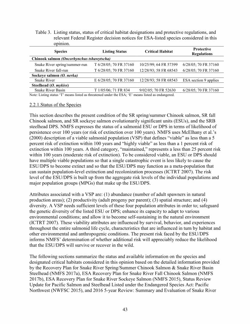
43
Table 3. Listing status, status of critical habitat designations and protective regulations, and relevant Federal Register decision notices for ESA-listed species considered in this opinion. Species Listing Status Critical Habitat Protective
Regulations Chinook salmon (Oncorhynchus tshawytscha)
Snake River spring/summer-run T 6/28/05; 70 FR 37160 10/25/99; 64 FR 57399 6/28/05; 70 FR 37160 Snake River fall-run T 6/28/05; 70 FR 37160 12/28/93; 58 FR 68543 6/28/05; 70 FR 37160
Sockeye salmon (O. nerka) Snake River E 6/28/05; 70 FR 37160 12/28/93; 58 FR 68543 ESA section 9 applies
Steelhead (O. mykiss) Snake River Basin T 1/05/06; 71 FR 834 9/02/05; 70 FR 52630 6/28/05; 70 FR 37160
Note: Listing status ‘T’ means listed as threatened under the ESA; ‘E’ means listed as endangered.
2.2.1.Status of the Species
This section describes the present condition of the SR spring/summer Chinook salmon, SR fall Chinook salmon, and SR sockeye salmon evolutionarily significant units (ESUs), and the SRB steelhead DPS. NMFS expresses the status of a salmonid ESU or DPS in terms of likelihood of persistence over 100 years (or risk of extinction over 100 years). NMFS uses McElhany et al.’s (2000) description of a viable salmonid population (VSP) that defines “viable” as less than a 5 percent risk of extinction within 100 years and “highly viable” as less than a 1 percent risk of extinction within 100 years. A third category, “maintained,” represents a less than 25 percent risk within 100 years (moderate risk of extinction). To be considered viable, an ESU or DPS should have multiple viable populations so that a single catastrophic event is less likely to cause the ESU/DPS to become extinct and so that the ESU/DPS may function as a meta-population that can sustain population-level extinction and recolonization processes (ICTRT 2007). The risk level of the ESU/DPS is built up from the aggregate risk levels of the individual populations and major population groups (MPGs) that make up the ESU/DPS. Attributes associated with a VSP are: (1) abundance (number of adult spawners in natural production areas); (2) productivity (adult progeny per parent); (3) spatial structure; and (4) diversity. A VSP needs sufficient levels of these four population attributes in order to; safeguard the genetic diversity of the listed ESU or DPS; enhance its capacity to adapt to various environmental conditions; and allow it to become self-sustaining in the natural environment (ICTRT 2007). These viability attributes are influenced by survival, behavior, and experiences throughout the entire salmonid life cycle, characteristics that are influenced in turn by habitat and other environmental and anthropogenic conditions. The present risk faced by the ESU/DPS informs NMFS’ determination of whether additional risk will appreciably reduce the likelihood that the ESU/DPS will survive or recover in the wild. The following sections summarize the status and available information on the species and designated critical habitats considered in this opinion based on the detailed information provided by the Recovery Plan for Snake River Spring/Summer Chinook Salmon & Snake River Basin Steelhead (NMFS 2017a), ESA Recovery Plan for Snake River Fall Chinook Salmon (NMFS 2017b), ESA Recovery Plan for Snake River Sockeye Salmon (NMFS 2015), Status Review Update for Pacific Salmon and Steelhead Listed under the Endangered Species Act: Pacific Northwest (NWFSC 2015), and 2016 5-year Review: Summary and Evaluation of Snake River
44
Sockeye Salmon, Snake River Spring-summer Chinook, Snake River Fall-run Chinook, Snake River Basin Steelhead (NMFS 2016). These five documents are incorporated by reference here. Additional information (e.g., abundance estimates) has become available since the latest status review (NMFS 2016) and its technical support document (NWFSC 2015). This latest information represents the best scientific and commercial data available and is also summarized in the following sections. 2.2.1.1. Snake River Spring/Summer Chinook Salmon The SR spring/summer Chinook salmon ESU was listed as threatened on April 22, 1992 (57 FR 14653). This ESU occupies the Snake River basin, which drains portions of southeastern Washington, northeastern Oregon, and north and central Idaho. Large portions of historical habitat were blocked in 1901 by the construction of Swan Falls Dam, on the Snake River, and later by construction of the three-dam Hells Canyon Complex from 1955 to 1967. Dam construction also blocked or hindered fish access to historical habitat in the Clearwater River basin as a result of the construction of Lewiston Dam (removed in 1973 but believed to have caused the extirpation of native Chinook salmon in that sub-basin). The loss of this historical habitat substantially reduced the spatial structure of this species. The production of SR spring/summer Chinook salmon was further affected by the development of the eight Federal dams and reservoirs in the mainstem lower Columbia or Snake River migration corridor between the late 1930s and early 1970s (NMFS 2017a). Several factors led to NMFS’ conclusion that SR spring/summer Chinook salmon were threatened: (1) abundance of naturally produced SR spring/summer Chinook runs had dropped to a small fraction of historical levels; (2) short-term projections were for a continued downward trend in abundance; (3) hydroelectric development on the Snake and Columbia Rivers continued to disrupt Chinook runs through altered flow regimes and impacts on estuarine habitats; and (4) habitat degradation existed throughout the region, along with risks associated with the use of outside hatchery stocks in particular areas (Good et al. 2005). On May 26, 2016, in the agency’s most recent 5-year review for Pacific salmon and steelhead, NMFS concluded that the species should remain listed as threatened (81 FR 33468). Life History. SR spring/summer Chinook salmon are characterized by their return times. Runs classified as spring Chinook salmon are counted at Bonneville Dam beginning in early March and ending the first week of June; summer runs are those Chinook salmon adults that pass Bonneville Dam from June through August. Returning adults will hold in deep mainstem and tributary pools until late summer, when they move up into tributary areas and spawn. In general, spring-run type Chinook salmon tend to spawn in higher-elevation reaches of major Snake River tributaries in mid- through late August, and summer-run Chinook salmon tend to spawn lower in Snake River tributaries in late August and September (although the spawning areas of the two runs may overlap). Spring/summer Chinook spawn follow a “stream-type” life history characterized by rearing for a full year in the spawning habitat and migrating in early to mid-spring as age-1 smolts (Healey 1991). Eggs are deposited in late summer and early fall, incubate over the following winter, and hatch in late winter and early spring of the following year. Juveniles rear through the summer,
45
and most overwinter and migrate to sea in the spring of their second year of life. Depending on the tributary and the specific habitat conditions, juveniles may migrate extensively from natal reaches into alternative summer-rearing or overwintering areas. SR spring/summer Chinook salmon return from the ocean to spawn primarily as 4- and 5-year-old fish, after 2 to 3 years in the ocean. A small fraction of the fish return as 3-year-old “jacks,” heavily predominated by males (Good et al. 2005). Spatial Structure and Diversity. The Snake River ESU includes all naturally spawning populations of spring/summer Chinook in the mainstem Snake River (below Hells Canyon Dam) and in the Tucannon River, Grande Ronde River, Imnaha River, and Salmon River sub-basins (57 FR 23458), as well as the progeny of 13 artificial propagation programs (85 FR 81822). The hatchery programs include the McCall Hatchery (South Fork Salmon River), South Fork Salmon River Eggbox, Johnson Creek, Pahsimeroi River, Yankee Fork Salmon River, Panther Creek, Sawtooth Hatchery, Tucannon River, Lostine River, Catherine Creek, Lookingglass Creek, Upper Grande Ronde River, and Imnaha River programs. The historical Snake River ESU likely also included populations in the Clearwater River drainage and extended above the Hells Canyon Dam complex. Within the Snake River ESU, the Interior Columbia Technical Recovery Team (ICTRT) identified 28 extant and 4 extirpated or functionally extirpated populations of spring/summer-run Chinook salmon, listed in Table 4 (ICTRT 2003; McClure et al. 2005). The ICTRT aggregated these populations into five MPGs: Lower Snake River, Grande Ronde River, Imnaha River, South Fork Salmon River, Middle Fork Salmon River, and Upper Salmon River. For each population, Table 4 shows the current risk ratings that the ICTRT assigned to the four parameters of a VSP (spatial structure, diversity, abundance, and productivity). Spatial structure risk is low to moderate for most populations in this ESU (NWFSC 2015) and is generally not preventing the recovery of the species. SR spring/summer Chinook salmon spawners are distributed throughout the ESU albeit at very low numbers. Diversity risk, on the other hand, is somewhat higher, driving the moderate and high combined spatial structure/diversity risks shown in Table 4 for some populations. Several populations have a high proportion of hatchery-origin spawners—particularly in the Grande Ronde, Lower Snake, and South Fork Salmon MPGs—and diversity risk will need to be lowered in multiple populations in order for the ESU to recover (ICTRT 2007; ICTRT 2010; NWFSC 2015).
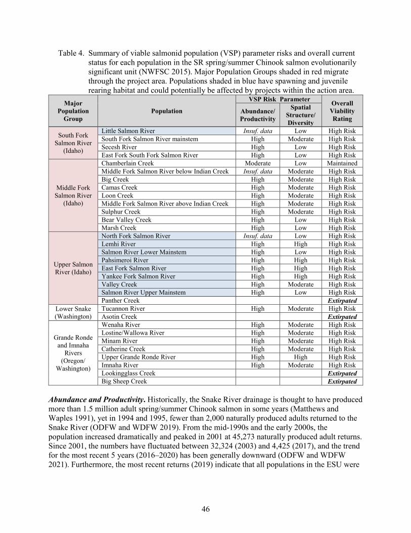
46
Table 4. Summary of viable salmonid population (VSP) parameter risks and overall current status for each population in the SR spring/summer Chinook salmon evolutionarily significant unit (NWFSC 2015). Major Population Groups shaded in red migrate through the project area. Populations shaded in blue have spawning and juvenile rearing habitat and could potentially be affected by projects within the action area.
Major Population
Group Population
VSP Risk Parameter Overall Viability Rating
Abundance/ Productivity
Spatial Structure/ Diversity
South Fork Salmon River
(Idaho)
Little Salmon River Insuf. data Low High Risk South Fork Salmon River mainstem High Moderate High Risk Secesh River High Low High Risk East Fork South Fork Salmon River High Low High Risk
Middle Fork Salmon River
(Idaho)
Chamberlain Creek Moderate Low Maintained Middle Fork Salmon River below Indian Creek Insuf. data Moderate High Risk Big Creek High Moderate High Risk Camas Creek High Moderate High Risk Loon Creek High Moderate High Risk Middle Fork Salmon River above Indian Creek High Moderate High Risk Sulphur Creek High Moderate High Risk Bear Valley Creek High Low High Risk Marsh Creek High Low High Risk
Upper Salmon River (Idaho)
North Fork Salmon River Insuf. data Low High Risk Lemhi River High High High Risk Salmon River Lower Mainstem High Low High Risk Pahsimeroi River High High High Risk East Fork Salmon River High High High Risk Yankee Fork Salmon River High High High Risk Valley Creek High Moderate High Risk Salmon River Upper Mainstem High Low High Risk Panther Creek Extirpated
Lower Snake (Washington)
Tucannon River High Moderate High Risk Asotin Creek
Extirpated
Grande Ronde and Imnaha
Rivers (Oregon/
Washington)
Wenaha River High Moderate High Risk Lostine/Wallowa River High Moderate High Risk Minam River High Moderate High Risk Catherine Creek High Moderate High Risk Upper Grande Ronde River High High High Risk Imnaha River High Moderate High Risk Lookingglass Creek Extirpated Big Sheep Creek Extirpated
Abundance and Productivity. Historically, the Snake River drainage is thought to have produced more than 1.5 million adult spring/summer Chinook salmon in some years (Matthews and Waples 1991), yet in 1994 and 1995, fewer than 2,000 naturally produced adults returned to the Snake River (ODFW and WDFW 2019). From the mid-1990s and the early 2000s, the population increased dramatically and peaked in 2001 at 45,273 naturally produced adult returns. Since 2001, the numbers have fluctuated between 32,324 (2003) and 4,425 (2017), and the trend for the most recent 5 years (2016–2020) has been generally downward (ODFW and WDFW 2021). Furthermore, the most recent returns (2019) indicate that all populations in the ESU were
47
below replacement for the 2014 brood year (Felts et al. 2020)1, which reduced abundance across the ESU. Although most populations in this ESU have increased in abundance since listing, 27 of the 28 extant populations remain at high risk of extinction due to low abundance or productivity, with one population (Chamberlin Creek) at moderate risk of extinction (NWFSC 2015). All currently extant populations of SR spring/summer Chinook salmon will likely have to increase in abundance and productivity in order for the ESU to recover (Table 4). 2.2.1.2. Snake River Fall-run Chinook Salmon The SR fall Chinook salmon ESU was listed as threatened on April 22, 1992 (57 FR 14653). This ESU occupies the Snake River basin, which drains portions of southeastern Washington, northeastern Oregon, and north or central Idaho. SR fall Chinook salmon have substantially declined in abundance from historic levels, primarily due to the loss of primary spawning and rearing areas upstream of the Hells Canyon Dam complex (57 FR 14653). Additional concerns for the species have been the high percentage of hatchery fish returning to natural spawning grounds and the relatively high aggregate harvest impacts by ocean and in-river fisheries (Good et al. 2005). On May 26, 2016, in the agency’s most recent 5-year status review for Pacific salmon and steelhead, NMFS concluded that the species should remain listed as threatened (81 FR 33468). Life History. SR fall Chinook salmon enter the Columbia River in July and August, and migrate past the lower Snake River mainstem dams from August through November. Fish spawning takes place from October through early December in the mainstem of the Snake River, primarily between Asotin Creek and Hells Canyon Dam, and in the lower reaches of several of the associated major tributaries including the Tucannon, Grande Ronde, Clearwater, Salmon, and Imnaha Rivers (Connor and Burge 2003; Ford 2011). Spawning has occasionally been observed in the tailrace areas of the four mainstem dams (Dauble et al. 1999; Dauble et al. 1995; Dauble et al. 1994; Mueller 2009). Juveniles emerge from the gravels in March and April of the following year. Until relatively recently, SR fall Chinook were assumed to follow an “ocean-type” life history (Dauble and Geist 2000; Good et al. 2005; Healey 1991; NMFS 1992) where they migrate to the Pacific Ocean during their first year of life, normally within 3 months of emergence from spawning substrate as age-0 smolts, to spend their first winter in the ocean. Ocean-type Chinook salmon juveniles tend to display a “rear as they go” rearing strategy, in which they continually move downstream through shallow shoreline habitats, their first summer and fall until they reach the ocean by winter (Connor and Burge 2003; Coutant and Whitney 2006). (Tiffan and Connor 2012) showed that sub-yearling fish favor water less than six feet deep. Several studies have shown that another life history pattern exists where a significant number of smaller SR fall Chinook juveniles overwinter in Snake River reservoirs prior to outmigration. These fish begin migration later than most, arrest their seaward migration and overwinter in
1 The return size is not known until 5 years after the brood year. Preliminary results for the 2019 redd counts indicate that the 2014 brood year will be below replacement for the vast majority (possibly all) of the populations in the Snake River spring/summer Chinook salmon ESU.

48
reservoirs on the Snake and Columbia Rivers, then resume migration and enter the ocean in early spring as age-1 smolts (Connor and Burge 2003; Connor et al. 2002; Connor et al. 2005; Hegg et al. 2013). Connor et al. (2005) termed this life history strategy “reservoir-type.” Scale samples from natural-origin adult fall Chinook salmon taken at Lower Granite Dam have indicated that approximately half of the returns overwintered in freshwater (Ford 2011). Spatial Structure and Diversity. The SR fall Chinook salmon ESU includes one extant population of fish spawning in the mainstem of the Snake River and the lower reaches of several of the associated major tributaries including the Tucannon, Grande Ronde, Clearwater, Salmon, and Imnaha Rivers. The ESU also includes four artificial propagation programs: Lyons Ferry Hatchery, Fall Chinook Acclimation Ponds, Nez Perce Tribal Hatchery, and Idaho Power Program (85 FR 81822). Historically, this ESU included one large additional population spawning in the mainstem of the Snake River upstream of the Hells Canyon Dam complex, an impassable migration barrier (NWFSC 2015). Four of the five historic major spawning areas in the Lower Snake population currently have natural-origin spawning. Spatial structure risk for the existing ESU is therefore low and is not precluding recovery of the species (NWFSC 2015). There are several diversity concerns for SR fall Chinook salmon, leading to a moderate diversity risk rating for the extant Lower Snake population. One concern is the high proportion of hatchery fish spawning across the major spawning areas within the population (NWFSC 2015; NMFS 2017b). Between 2004 and 2019, the 5-year average proportion of hatchery-origin fish has ranged from 26 percent (2007-2011) to 38 percent (2003-2007) (Tiffan and Perry 2020). The moderate diversity risk is also driven by changes in major life history patterns; shifts in phenotypic traits; high levels of genetic homogeneity in samples from natural-origin returns; selective pressure imposed by current hydropower operations; and cumulative harvest impacts (NWFSC 2015). Diversity risk will need to be reduced to low in order for this population to be considered highly viable, a requirement for recovery of the species. Low diversity risk would require that one or more major spawning areas produce a significant level of natural-origin spawners with low influence by hatchery-origin spawners (NWFSC 2015). Abundance and Productivity. Historical abundance of Snake River Fall (SRF) Chinook salmon is estimated to have been 416,000 to 650,000 adults (NMFS 2006), but numbers declined drastically over the 20th century, with only 78 natural-origin fish (ODFW and WDFW 2020) and 306 hatchery-origin fish (FPC 2019) passing Lower Granite Dam in 1990. Artificial propagation of fall Chinook salmon occurred from 1901 through 1909 and again from 1955 through 1973, but those efforts ultimately failed and, by the late 1970s, essentially all SRF Chinook salmon were natural-origin. The large-scale hatchery effort that exists today began in 1976, when Congress authorized the Lower Snake River Compensation Plan to compensate for fish and wildlife losses caused by the construction and operation of the four lower Snake River dams. The first hatchery fish from this effort returned in 1981 and hatchery returns have comprised a substantial portion of the run every year since. After 1990, abundance increased dramatically, and in 2014 the 5-year geometric mean (2010– 2014) was 11,855 natural-origin adult returns (ODFW and WDFW 2021). Five-year geometric means in the numbers of natural-origin spawners through 2020 have ranged from a high of 14,343 in 2016 to a low of 7,393 in 2020 This is well above the minimum abundance of 4,200

49
natural-origin spawners needed for highly viable status. However, the productivity estimate for the 1990–2009 brood years is 1.5, which is below the 1.7 minimum needed for highly viable status. The best available scientific and commercial data available with respect to the adult abundance of this species indicates a substantial downward trend in the abundance of natural-origin spawners from 2013 to 2020. Even with this decline, the overall abundance has remained higher than before 2005, and appear to remain above the minimum abundance threshold. NMFS will evaluate the viability risk of these more recent returns in the upcoming 5-year status review, expected in 2022. 2.2.1.3. Snake River Sockeye Salmon This ESU includes all anadromous and residual sockeye salmon from the Snake River basin in Idaho, as well as artificially propagated sockeye salmon from the Redfish Lake captive propagation and SR sockeye salmon hatchery programs (85 FR 81822). The ESU was first listed as endangered under the ESA in 1991, and the listing was reaffirmed in 2005 (70 FR 37160). Reasons for the decline of this species include high levels of historic harvest, dam construction including hydropower development on the Snake and Columbia Rivers, water diversions and water storage, predation on juvenile salmon in the mainstem river migration corridor, and active eradication of sockeye from some lakes in the 1950s and 1960s (56 FR 58619; ICTRT 2003). On May 26, 2016, in the agency’s most recent 5-year status review for Pacific salmon and steelhead, NMFS concluded that the species should remain listed as endangered (81 FR 33468). Life History. SR sockeye salmon adults enter the Columbia River primarily during June and July, and arrive in the Sawtooth Valley, peaking in August. The Sawtooth Valley supports the only remaining run of SR sockeye salmon. The adults spawn in lakeshore gravels, primarily in October (Bjornn et al. 1968). Eggs hatch in the spring between 80 and 140 days after spawning. Fry remain in the gravel for 3 to 5 weeks, emerge from April through May, and move immediately into the lake. Once there, juveniles feed on plankton for 1 to 3 years before they migrate to the ocean, leaving their natal lake in the spring from late April through May (Bjornn et al. 1968). SR sockeye salmon usually spend 2 to 3 years in the Pacific Ocean and return to Idaho in their fourth or fifth year of life. Spatial Structure and Diversity. Within the Snake River ESU, the ICTRT identified historical sockeye salmon production in five Sawtooth Valley lakes, in addition to Warm Lake and the Payette Lakes in Idaho and Wallowa Lake in Oregon (ICTRT 2003). The sockeye runs to Warm, Payette, and Wallowa Lakes are now extinct, and the ICTRT identified the Sawtooth Valley lakes as a single MPG for this ESU. The MPG consists of the Redfish, Alturas, Stanley, Yellowbelly, and Pettit Lake populations (ICTRT 2007). The only extant population is Redfish Lake, supported by a captive broodstock program. Hatchery fish from the Redfish Lake captive propagation program have also been out planted in Alturas and Pettit Lakes since the mid-1990s in an attempt to reestablish those populations (Ford 2011). With such a small number of populations in this MPG, increasing the number of populations would substantially reduce the risk faced by the ESU (ICTRT 2007). The Northwest Fisheries Science Center (NWFSC) (2015) reports some evidence of very low levels of early-timed returns

50
in some recent years from out-migrating naturally produced Alturas Lake smolts, but the ESU remains at high risk for spatial structure. Currently, the SR sockeye salmon run is highly dependent on a captive broodstock program operated at the Sawtooth Hatchery and Eagle Hatchery. Although the captive brood program rescued the ESU from extinction, diversity risk remains high without sustainable natural production (Ford 2011; NWFSC 2015). Abundance and Productivity. Prior to the turn of the 20th century (ca. 1880), around 150,000 sockeye salmon ascended the Snake River to the Wallowa, Payette, and Salmon River basins to spawn in natural lakes (Evermann 1896, as cited in Chapman et al. 1990). The Wallowa River sockeye run was considered extinct by 1905, the Payette River run was blocked by Black Canyon Dam on the Payette River in 1924, and anadromous Warm Lake sockeye in the South Fork Salmon River basin may have been trapped in Warm Lake by a land upheaval in the early 20th century (ICTRT 2003). In the Sawtooth Valley, the IDFG eradicated sockeye from Yellowbelly, Pettit, and Stanley Lakes in favor of other species in the 1950s and 1960s, and irrigation diversions led to the extirpation of sockeye in Alturas Lake in the early 1900s (ICTRT 2003), leaving only the Redfish Lake sockeye. From 1991 to 1998, a total of just 16 wild adult anadromous sockeye salmon returned to Redfish Lake. These 16 wild fish were incorporated into a captive broodstock program that began in 1992 and has since expanded so that the program currently releases hundreds of thousands of juvenile fish each year in the Sawtooth Valley (Ford 2011). Even with the increase in hatchery production, adult returns to Sawtooth Valley have varied. The highest returns were seen in 2010, 2011, and 2014, ranging from 1,099 to 1,516 during these years (Johnson et al. 2020). The general increases observed in the number of adult returns during 2008-2014 is likely due to a number of factors, including increases in hatchery production and favorable marine conditions. The highest number of adults (1,516) returned in 2014, but numbers have generally declined since that time to a low of 17 in 2019 (Johnson et al. 2020). The total number of returning adults documented in the Sawtooth Valley in 2020 was 152 (Dan Baker, IDFG, email sent to Chad Fealko, NMFS, November 2, 2021 regarding 2020 sockeye returns). The recent general decline is in part due to poor survival and growth in the ocean. The increased abundance of hatchery reared SR sockeye reduces the risk of immediate loss, yet levels of naturally produced sockeye returns remain extremely low (NWFSC 2015). The ICTRT’s viability target is at least 1,000 naturally produced spawners per year in each of Redfish and Alturas Lakes and at least 500 in Pettit Lake (ICTRT 2007). Very low numbers of adults survived upstream migration in the Columbia and Snake Rivers in 2015 due to unusually high water temperatures. The implications of this high mortality for the recovery of the species are uncertain and depend on the frequency of similar high water temperatures in future years (NWFSC 2015). The species remains at high risk across all four of the risk parameters (spatial structure, diversity, abundance, and productivity). Although the captive brood program has been highly successful in producing hatchery O. nerka, substantial increases in survival rates across all life history stages must occur in order to reestablish sustainable natural production (NWFSC 2015). In particular,
51
juvenile and adult losses during travel through the Salmon, Snake, and Columbia River migration corridor continue to present a significant threat to species recovery (NMFS 2015). 2.2.1.4. Snake River Basin Steelhead The SRB steelhead was listed as a threatened ESU on August 18, 1997 (62 FR 43937), with a revised listing as a DPS on January 5, 2006 (71 FR 834). This DPS occupies the Snake River basin, which drains portions of southeastern Washington, northeastern Oregon, and north or central Idaho. Reasons for the decline of this species include substantial modification of the seaward migration corridor by hydroelectric power development on the mainstem Snake and Columbia Rivers, loss of habitat above the Hells Canyon Dam complex on the mainstem Snake River, and widespread habitat degradation and reduced stream flows throughout the Snake River basin (Good et al. 2005). Another major concern for the species is the threat to genetic integrity from past and present hatchery practices, and the high proportion of hatchery fish in the aggregate run of SRB steelhead over Lower Granite Dam (Good et al. 2005; Ford 2011). On May 26, 2016, in the agency’s most recent 5-year status review for Pacific salmon and steelhead, NMFS concluded that the species should remain listed as threatened (81 FR 33468). Life History. Adult SRB steelhead enter the Columbia River from late June to October to begin their migration inland. After holding over the winter in larger rivers in the Snake River basin, steelhead disperse into smaller tributaries to spawn from March through May. Earlier dispersal occurs at lower elevations and later dispersal occurs at higher elevations. Juveniles emerge from the gravels in 4 to 8 weeks, and move into shallow, low-velocity areas in side channels and along channel margins to escape high velocities and predators (Everest and Chapman 1972). Juvenile steelhead then progressively move toward deeper water as they grow in size (Bjornn and Rieser 1991). Juveniles typically reside in fresh water for 1 to 3 years, although this species displays a wide diversity of life histories. Smolts migrate downstream during spring runoff, which occurs from March to mid-June depending on elevation, and typically spend 1 to 2 years in the ocean. Spatial Structure and Diversity. This species includes all naturally spawning steelhead populations below natural and manmade impassable barriers in streams in the Snake River basin of southeast Washington, northeast Oregon, and Idaho, as well as the progeny of six artificial propagation programs (85 FR 81822). The artificial propagation programs include the Dworshak National Fish Hatchery, Salmon River B-run, South Fork Clearwater B-run, East Fork Salmon River Natural, Tucannon River, and the Little Sheep Creek or Imnaha River programs. The SRB steelhead listing does not include resident forms of O. mykiss (rainbow trout) co-occurring with steelhead. The ICTRT identified 24 extant populations within this DPS, organized into five MPGs (ICTRT 2003). The ICTRT also identified a number of potential historical populations associated with watersheds above the Hells Canyon Dam complex on the mainstem Snake River, a barrier to anadromous migration. The five MPGs with extant populations are the Clearwater River, Salmon River, Grande Ronde River, Imnaha River, and Lower Snake River. In the Clearwater River, the historic North Fork population was blocked from accessing spawning and rearing habitat by Dworshak Dam. Current steelhead distribution extends throughout the DPS, such that spatial

52
structure risk is generally low. For each population in the DPS, Table 5 shows the current risk ratings for the parameters of a VSP (spatial structure, diversity, abundance, and productivity).
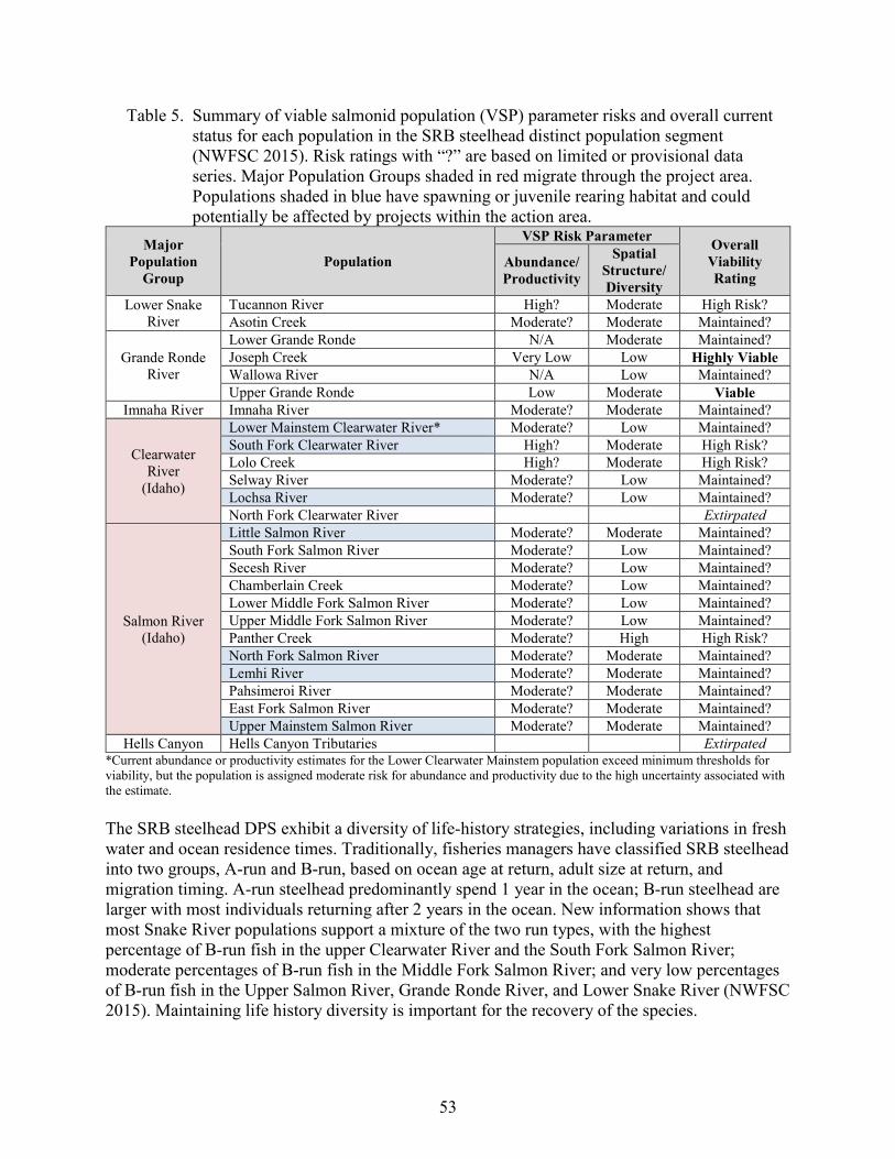
53
Table 5. Summary of viable salmonid population (VSP) parameter risks and overall current status for each population in the SRB steelhead distinct population segment (NWFSC 2015). Risk ratings with “?” are based on limited or provisional data series. Major Population Groups shaded in red migrate through the project area. Populations shaded in blue have spawning or juvenile rearing habitat and could potentially be affected by projects within the action area.
Major Population
Group Population
VSP Risk Parameter Overall Viability Rating
Abundance/ Productivity
Spatial Structure/ Diversity
Lower Snake River
Tucannon River High? Moderate High Risk? Asotin Creek Moderate? Moderate Maintained?
Grande Ronde River
Lower Grande Ronde N/A Moderate Maintained? Joseph Creek Very Low Low Highly Viable Wallowa River N/A Low Maintained? Upper Grande Ronde Low Moderate Viable
Imnaha River Imnaha River Moderate? Moderate Maintained?
Clearwater River
(Idaho)
Lower Mainstem Clearwater River* Moderate? Low Maintained? South Fork Clearwater River High? Moderate High Risk? Lolo Creek High? Moderate High Risk? Selway River Moderate? Low Maintained? Lochsa River Moderate? Low Maintained? North Fork Clearwater River Extirpated
Salmon River (Idaho)
Little Salmon River Moderate? Moderate Maintained? South Fork Salmon River Moderate? Low Maintained? Secesh River Moderate? Low Maintained? Chamberlain Creek Moderate? Low Maintained? Lower Middle Fork Salmon River Moderate? Low Maintained? Upper Middle Fork Salmon River Moderate? Low Maintained? Panther Creek Moderate? High High Risk? North Fork Salmon River Moderate? Moderate Maintained? Lemhi River Moderate? Moderate Maintained? Pahsimeroi River Moderate? Moderate Maintained? East Fork Salmon River Moderate? Moderate Maintained? Upper Mainstem Salmon River Moderate? Moderate Maintained?
Hells Canyon Hells Canyon Tributaries Extirpated *Current abundance or productivity estimates for the Lower Clearwater Mainstem population exceed minimum thresholds for viability, but the population is assigned moderate risk for abundance and productivity due to the high uncertainty associated with the estimate. The SRB steelhead DPS exhibit a diversity of life-history strategies, including variations in fresh water and ocean residence times. Traditionally, fisheries managers have classified SRB steelhead into two groups, A‐run and B‐run, based on ocean age at return, adult size at return, and migration timing. A‐run steelhead predominantly spend 1 year in the ocean; B‐run steelhead are larger with most individuals returning after 2 years in the ocean. New information shows that most Snake River populations support a mixture of the two run types, with the highest percentage of B-run fish in the upper Clearwater River and the South Fork Salmon River; moderate percentages of B-run fish in the Middle Fork Salmon River; and very low percentages of B-run fish in the Upper Salmon River, Grande Ronde River, and Lower Snake River (NWFSC 2015). Maintaining life history diversity is important for the recovery of the species.
54
Diversity risk for populations in the DPS is either moderate or low. Large numbers of hatchery steelhead are released in the Snake River, and the relative proportion of hatchery adults in natural spawning areas near major hatchery release sites remains uncertain. Moderate diversity risks for some populations are thus driven by the high proportion of hatchery fish on natural spawning grounds and the uncertainty regarding these estimates (NWFSC 2015). Reductions in hatchery-related diversity risks would increase the likelihood of these populations reaching viable status. Abundance and Productivity. Historical estimates of steelhead production for the entire Snake River basin are not available, but the basin is believed to have supported more than half the total steelhead production from the Columbia River basin (Mallet 1974, as cited in Good et al. 2005). The Clearwater River drainage alone may have historically produced 40,000 to 60,000 adults (Ecovista et al. 2003), and historical harvest data suggests that steelhead production in the Salmon River was likely higher than in the Clearwater (Hauck 1953). In contrast, at the time of listing in 1997, the 5-year geomean abundance for natural-origin steelhead passing Lower Granite Dam, which includes all but one population in the DPS, was 11,462 adults (Ford 2011). Abundance began to increase in the early 2000s, with the single year count and the 5-year geomean both peaking in 2015 at 45,789 and 34,179, respectively (ODFW and WDFW 2021). Since 2015, the numbers have declined steadily with only 9,634 natural-origin adult returns counted for the 2020 run year (ODFW and WDFW 2021). Population-specific abundance estimates exist for some but not all populations. Of the populations, for which we have data, three (Joseph Creek, Upper Grande Ronde, and Lower Clearwater) were meeting minimum abundance or productivity thresholds based on information included in the 2015 status review; however, since that time, abundance has substantially decreased. Only the 5-year (2014-2018) geometric mean of natural-origin spawners of 1,786 for the Upper Grande Ronde population appears to remain above the minimum abundance threshold established by the ICTRT (Williams 2020). The status of many of the individual populations remains uncertain, and four out of the five MPGs are not meeting viability objectives (NWFSC 2015). In order for the species to recover, more populations will need to reach viable status through increases in abundance and productivity.
2.2.2.Status of Critical Habitat
In evaluating the condition of designated critical habitat, NMFS examines the condition and trends of PBFs, which are essential to the conservation of the ESA-listed species because they support one or more life stages of the species. Proper function of these PBFs is necessary to support successful adult and juvenile migration, adult holding, spawning, incubation, rearing, and the growth and development of juvenile fish. Modification of PBFs may affect freshwater spawning, rearing or migration in the action area. Generally speaking, sites required to support one or more life stages of the ESA-listed species (i.e., sites for spawning, rearing, migration, and foraging) contain PBFs essential to the conservation of the listed species (e.g., spawning gravels, water quality and quantity, side channels, or food) (Table 6). Table 7 describes the geographical extent within the Snake River of critical habitat for each of the four ESA-listed salmon and steelhead species. Critical habitat includes the stream channel and water column with the lateral extent defined by the ordinary high-water line, or the bankfull
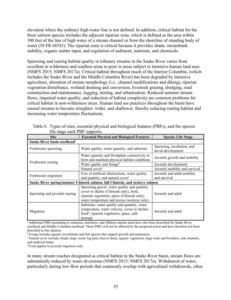
55
elevation where the ordinary high-water line is not defined. In addition, critical habitat for the three salmon species includes the adjacent riparian zone, which is defined as the area within 300 feet of the line of high water of a stream channel or from the shoreline of standing body of water (58 FR 68543). The riparian zone is critical because it provides shade, streambank stability, organic matter input, and regulation of sediment, nutrients, and chemicals. Spawning and rearing habitat quality in tributary streams in the Snake River varies from excellent in wilderness and roadless areas to poor in areas subject to intensive human land uses (NMFS 2015; NMFS 2017a). Critical habitat throughout much of the Interior Columbia, (which includes the Snake River and the Middle Columbia River) has been degraded by intensive agriculture, alteration of stream morphology (i.e., channel modifications and diking), riparian vegetation disturbance, wetland draining and conversion, livestock grazing, dredging, road construction and maintenance, logging, mining, and urbanization. Reduced summer stream flows, impaired water quality, and reduction of habitat complexity are common problems for critical habitat in non-wilderness areas. Human land use practices throughout the basin have caused streams to become straighter, wider, and shallower, thereby reducing rearing habitat and increasing water temperature fluctuations.
Table 6. Types of sites, essential physical and biological features (PBFs), and the species life stage each PBF supports. Site Essential Physical and Biological Features Species Life Stage
Snake River basin steelheada
Freshwater spawning Water quality, water quantity, and substrate Spawning, incubation, and larval development
Freshwater rearing
Water quantity and floodplain connectivity to form and maintain physical habitat conditions Juvenile growth and mobility
Water quality and forageb Juvenile development Natural coverc Juvenile mobility and survival
Freshwater migration Free of artificial obstructions, water quality and quantity, and natural coverc
Juvenile and adult mobility and survival
Snake River spring/summer Chinook salmon, fall Chinook, and sockeye salmon
Spawning and juvenile rearing
Spawning gravel, water quality and quantity, cover or shelter (Chinook only), food, riparian vegetation, space (Chinook only), water temperature and access (sockeye only)
Juvenile and adult
Migration
Substrate, water quality and quantity, water temperature, water velocity, cover or shelter, foodd, riparian vegetation, space, safe passage
Juvenile and adult
a Additional PBFs pertaining to estuarine, nearshore, and offshore marine areas have also been described for Snake River steelhead and Middle Columbia steelhead. These PBFs will not be affected by the proposed action and have therefore not been described in this opinion. b Forage includes aquatic invertebrate and fish species that support growth and maturation. c Natural cover includes shade, large wood, log jams, beaver dams, aquatic vegetation, large rocks and boulders, side channels, and undercut banks. d Food applies to juvenile migration only. In many stream reaches designated as critical habitat in the Snake River basin, stream flows are substantially reduced by water diversions (NMFS 2015; NMFS 2017a). Withdrawal of water, particularly during low-flow periods that commonly overlap with agricultural withdrawals, often
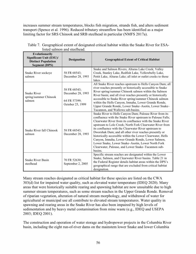
56
increases summer stream temperatures, blocks fish migration, strands fish, and alters sediment transport (Spence et al. 1996). Reduced tributary streamflow has been identified as a major limiting factor for SRS Chinook and SRB steelhead in particular (NMFS 2017a).
Table 7. Geographical extent of designated critical habitat within the Snake River for ESA-listed salmon and steelhead.
Evolutionarily Significant Unit (ESU)/
Distinct Population Segment (DPS)
Designation Geographical Extent of Critical Habitat
Snake River sockeye salmon
58 FR 68543; December 28, 1993
Snake and Salmon Rivers; Alturas Lake Creek; Valley Creek, Stanley Lake, Redfish Lake, Yellowbelly Lake, Pettit Lake, Alturas Lake; all inlet or outlet creeks to those lakes.
Snake River spring/summer Chinook salmon
58 FR 68543; December 28, 1993 64 FR 57399; October 25, 1999
All Snake River reaches upstream to Hells Canyon Dam; all river reaches presently or historically accessible to Snake River spring/summer Chinook salmon within the Salmon River basin; and all river reaches presently or historically accessible to Snake River spring/summer Chinook salmon within the Hells Canyon, Imnaha, Lower Grande Ronde, Upper Grande Ronde, Lower Snake–Asotin, Lower Snake–Tucannon, and Wallowa sub-basins.
Snake River fall Chinook salmon
58 FR 68543; December 28, 1993
Snake River to Hells Canyon Dam; Palouse River from its confluence with the Snake River upstream to Palouse Falls; Clearwater River from its confluence with the Snake River upstream to Lolo Creek; North Fork Clearwater River from its confluence with the Clearwater River upstream to Dworshak Dam; and all other river reaches presently or historically accessible within the Lower Clearwater, Hells Canyon, Imnaha, Lower Grande Ronde, Lower Salmon, Lower Snake, Lower Snake–Asotin, Lower North Fork Clearwater, Palouse, and Lower Snake–Tucannon sub-basins.
Snake River Basin steelhead
70 FR 52630; September 2, 2005
Specific stream reaches are designated within the Lower Snake, Salmon, and Clearwater River basins. Table 21 in the Federal Register details habitat areas within the DPS’s geographical range that are excluded from critical habitat designation.
Many stream reaches designated as critical habitat for these species are listed on the CWA 303(d) list for impaired water quality, such as elevated water temperature (IDEQ 2020). Many areas that were historically suitable rearing and spawning habitat are now unsuitable due to high summer stream temperatures, such as some stream reaches in the Upper Grande Ronde. Removal of riparian vegetation, alteration of natural stream morphology, and withdrawal of water for agricultural or municipal use all contribute to elevated stream temperatures. Water quality in spawning and rearing areas in the Snake River has also been impaired by high levels of sedimentation and by heavy metal contamination from mine waste (e.g., IDEQ and USEPA 2003; IDEQ 2001). The construction and operation of water storage and hydropower projects in the Columbia River basin, including the eight run-of-river dams on the mainstem lower Snake and lower Columbia
57
Rivers, have altered biological and physical attributes of the mainstem migration corridor. Hydro-system development modified natural flow regimes, resulting in warmer late summer and fall water temperature. Changes in fish communities led to increased rates of piscivorous predation on juvenile salmon and steelhead. Reservoirs and project tailraces have created opportunities for avian predators to successfully forage for smolts, and the dams themselves have created migration delays for both adult and juvenile salmonids. Physical features of dams, such as turbines, have delayed migration for both adults and juveniles. Turbines and juvenile bypass systems have also killed some out-migrating fish. However, some of these conditions have improved. The Bureau of Reclamation and COE have implemented measures in previous Columbia River System hydropower consultations to improve conditions in the juvenile and adult migration corridor including 24-hour volitional spill, surface passage routes, upgrades to juvenile bypass systems, and predator management measures. These measures are ongoing and their benefits with respect to improved functioning of the migration corridor PBFs will continue into the future.
2.2.3. Climate Change Implications for ESA-listed Species and their Critical Habitat
One factor affecting the rangewide status of Snake River salmon and steelhead, and aquatic habitat at large is climate change. The U.S. Global Change Research Program (USGCRP 2018) reports average warming in the Pacific Northwest of about 1.3ºF from 1895 to 2011, and projects an increase in average annual temperature of 3.3ºF to 9.7ºF by 2070 to 2099 (compared to the period 1970 to 1999), depending largely on total global emissions of heat-trapping gases (predictions based on a variety of emission scenarios including B1, RCP4.5, A1B, A2, A1FI, and RCP8.5 scenarios). The increases are projected to be largest in summer (Melillo et al. 2014, USGCRP 2018). The five warmest years in the 1880 to 2019 record have all occurred since 2015, while nine of the 10 warmest years have occurred since 2005 (Lindsey and Dahlman 2020). Several studies have revealed that climate change has the potential to affect ecosystems in nearly all tributaries throughout the Snake River (Battin et al. 2007; ISAB 2007). While the intensity of effects will vary by region (ISAB 2007), climate change is generally expected to alter aquatic habitat (water yield, peak flows, and stream temperature). As climate change alters the structure and distribution of rainfall, snowpack, and glaciations, each factor will in turn alter riverine hydrographs. Given the increasing certainty that climate change is occurring and is accelerating (Battin et al. 2007), NMFS anticipates salmonid habitats will be affected. Climate and hydrology models project significant reductions in both total snow pack and low-elevation snow pack in the Pacific Northwest over the next 50 years (Mote and Salathé 2009). These changes will shrink the extent of the snowmelt-dominated habitat available to salmon and may restrict our ability to conserve diverse salmon life histories. In the Pacific Northwest, most models project warmer air temperatures, increases in winter precipitation, and decreases in summer precipitation. Average temperatures in the Pacific Northwest are predicted to increase by 0.1 to 0.6°C (0.2°F to 1.0°F) per decade (Mote and Salathé 2009). Warmer air temperatures will lead to more precipitation falling as rain rather than snow. As the snow pack diminishes, seasonal hydrology will shift to more frequent and severe early large storms, changing stream flow timing, which may limit salmon survival (Mantua et al. 2009). The largest driver of climate-induced decline in salmon populations is projected to be the
58
impact of increased winter peak flows, which scour the streambed and destroy salmon eggs (Battin et al. 2007). Higher water temperatures and lower spawning flows, together with increased magnitude of winter peak flows are all likely to increase salmon mortality. The ISAB (2007) found that higher ambient air temperatures will likely cause water temperatures to rise. Salmon and steelhead require cold water for spawning and incubation. As climate change progresses and stream temperatures warm, thermal refugia will be essential to persistence of many salmonid populations. Thermal refugia are important for providing salmon and steelhead with patches of suitable habitat while allowing them to undertake migrations through or to make foraging forays into areas with greater than optimal temperatures. To avoid waters above summer maximum temperatures, juvenile rearing may be increasingly found only in the confluence of colder tributaries or other areas of cold-water refugia (Mantua et al. 2009). Climate change is expected to make recovery targets for salmon and steelhead populations more difficult to achieve. Climate change is expected to alter critical habitat by generally increasing temperature and peak flows and decreasing base flows. Although changes will not be spatially homogenous, effects of climate change are expected to decrease the capacity of critical habitat to support successful spawning, rearing, and migration. Habitat action can address the adverse impacts of climate change on salmon. Examples include restoring connections to historical floodplains and freshwater and estuarine habitats to provide fish refugia and areas to store excess floodwaters, protecting and restoring riparian vegetation to ameliorate stream temperature increases, and purchasing or applying easements to lands that provide important cold water or refuge habitat (Battin et al. 2007; ISAB 2007).
2.3. Action Area
“Action area” means all areas to be affected directly or indirectly by the Federal action and not merely the immediate area involved in the action (50 CFR 402.02). In this case, the physical environment likely to be affected covers the State of Idaho within the Salmon, Clearwater, and Snake River basins. These river basins serve as migratory corridors and habitats for spawning, rearing, and development for ESA-listed salmonids. The area also serves as EFH for Chinook salmon and coho salmon. Work will occur within the transportation right-of-ways owned by either ITD, LHTAC, or Idaho counties, or within temporary or permanent easements with private or Federally-owned agencies such as the Bureau of Land Management (BLM) and U.S. Forest Service (USFS). Support activities located outside the transportation facility (e.g., material sources and hot plants) are not covered by this Program and may require additional consultation with NMFS and USFWS. The action area includes 12 sub-basins (fourth-field HUCs), encompassing all areas potentially affected directly or indirectly by this programmatic consultation. Because of the potential for downstream effects and additive effects within watersheds, the action area encompasses entire sub-basins where ESA-listed species (and designated critical habitat) and state highways occur. Some sub-basins include considerably more miles of state highway than others, as shown in Table 8.
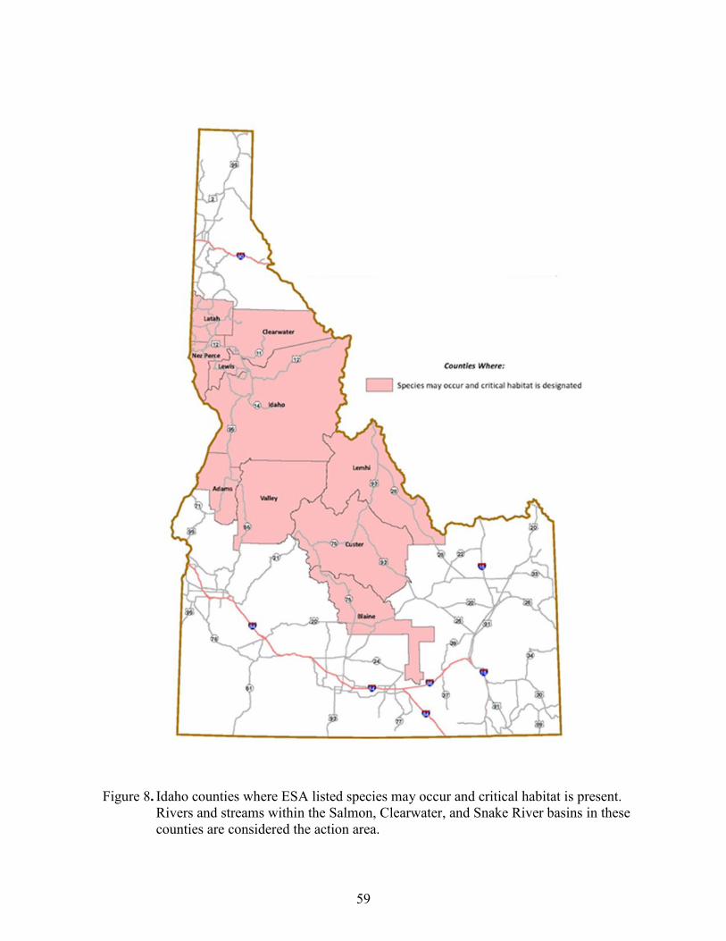
59
Figure 8. Idaho counties where ESA listed species may occur and critical habitat is present.
Rivers and streams within the Salmon, Clearwater, and Snake River basins in these counties are considered the action area.
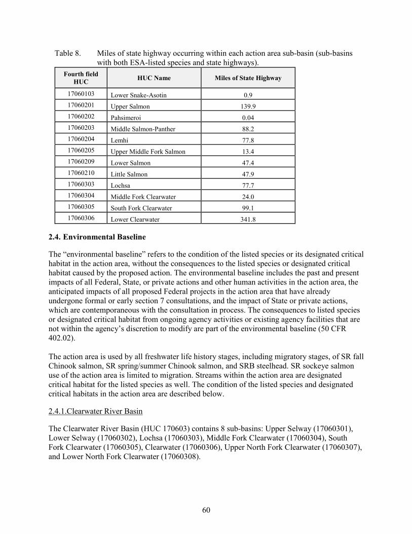
60
Table 8. Miles of state highway occurring within each action area sub-basin (sub-basins with both ESA-listed species and state highways).
Fourth field HUC HUC Name Miles of State Highway
17060103 Lower Snake-Asotin 0.9 17060201 Upper Salmon 139.9 17060202 Pahsimeroi 0.04 17060203 Middle Salmon-Panther 88.2 17060204 Lemhi 77.8 17060205 Upper Middle Fork Salmon 13.4 17060209 Lower Salmon 47.4 17060210 Little Salmon 47.9 17060303 Lochsa 77.7 17060304 Middle Fork Clearwater 24.0 17060305 South Fork Clearwater 99.1 17060306 Lower Clearwater 341.8
2.4. Environmental Baseline
The “environmental baseline” refers to the condition of the listed species or its designated critical habitat in the action area, without the consequences to the listed species or designated critical habitat caused by the proposed action. The environmental baseline includes the past and present impacts of all Federal, State, or private actions and other human activities in the action area, the anticipated impacts of all proposed Federal projects in the action area that have already undergone formal or early section 7 consultations, and the impact of State or private actions, which are contemporaneous with the consultation in process. The consequences to listed species or designated critical habitat from ongoing agency activities or existing agency facilities that are not within the agency’s discretion to modify are part of the environmental baseline (50 CFR 402.02). The action area is used by all freshwater life history stages, including migratory stages, of SR fall Chinook salmon, SR spring/summer Chinook salmon, and SRB steelhead. SR sockeye salmon use of the action area is limited to migration. Streams within the action area are designated critical habitat for the listed species as well. The condition of the listed species and designated critical habitats in the action area are described below.
2.4.1.Clearwater River Basin
The Clearwater River Basin (HUC 170603) contains 8 sub-basins: Upper Selway (17060301), Lower Selway (17060302), Lochsa (17060303), Middle Fork Clearwater (17060304), South Fork Clearwater (17060305), Clearwater (17060306), Upper North Fork Clearwater (17060307), and Lower North Fork Clearwater (17060308).
61
SR fall Chinook salmon occur in mainstem reaches in the Clearwater River basin. Current runs of SR spring/summer Chinook salmon in the Clearwater River are not part of the listed ESU. Lewiston Dam, constructed on the lower Clearwater River in 1927, blocked salmon and steelhead passage until the early 1940s (Matthews and Waples 1991). Biologists have concluded that even if a few native salmon survived the hydropower dams on the Clearwater River, the massive out plantings of nonindigenous hatchery stocks to the Clearwater system since the late 1940s have presumably substantially altered, if not eliminated, the original gene pool (Matthews and Waples 1991). SRB steelhead are found in the Lower Mainstem Clearwater River, Lolo Creek, Lochsa River, Selway River, and South Fork Clearwater River. These independent steelhead populations make up the Clearwater MPG (NMFS 2017a). 2.4.1.1. Snake River Fall Chinook Salmon The Lower Clearwater River fall Chinook salmon major spawning area (MaSA) within the SR fall Chinook ESU includes the 110-mi. reach of the mainstem Clearwater River upstream from its confluence with the Snake River at Lewiston, Idaho, to Selway Falls, and the lower reaches of the South Fork Clearwater, Middle Fork Clearwater, Potlatch, and Selway Rivers. The North Fork Clearwater River is not included in the MaSA because Dworshak Dam, which has no fish passage, is located on the North Fork 1.9 mi. above its confluence with the mainstem Clearwater River (NMFS 2017b). The Clearwater River MaSA is one of the largest producers of fall Chinook salmon in the Lower Snake River population (27 percent of all redds are in the Clearwater, based on surveys since 1992), but it produces less natural-origin fall Chinook salmon than either of the two mainstem MaSAs. It supports both a sub-yearling and an alternative yearling life-history strategy. SR fall Chinook salmon return to the Clearwater sub-basin from late August through December. Most of the fish spawn in the lower mainstem below the confluence with the North Fork (Arnsberg et al. 1992; Garcia et al. 1999, as cited in Ecovista et al. 2003). However, spawning adults have been observed throughout the mainstem Clearwater River, the Middle Fork Clearwater River, and in the lower portions of the Potlatch, South Fork Clearwater, and Selway Rivers. In 2015 biologists counted a total of 5,082 fall Chinook salmon redds in the Clearwater River basin, including 4,666 redds on the mainstem Clearwater River, 115 on the Middle Fork Clearwater, and 162 on the Selway River, and 119 on the South Fork Clearwater. From 2011 to 2016, the mean number of fall Chinook salmon redds observed in the Clearwater River basin was 2,947, ranging from 1,621 to 5,082 (Arnsberg et al. 2016). The most currently available data for the Clearwater River basin comes from 2017 and 2018 where 2,092 and 789 redds were counted, respectively (Arnsberg et al. 2018, 2019). Spawning habitat is not considered a limiting factor for fall Chinook salmon in the lower Clearwater River. Arnsberg et al. (1992) used the Instream Flow Incremental Methodology (IFIM) to quantify the amount of fall Chinook salmon spawning habitat available in the lower Clearwater River. Based on habitat suitability criteria alone, capacity was estimated at 95,000 redds; however, this was considered a liberal estimate since IFIM tends to overestimate spawning habitat in large rivers (Shirvell 1990), and other hydraulic and biological factors that
62
may influence spawning selection were not measured (Arnsberg et al. 1992). Still, the vast amount of suitable habitat measured and the number of redds documented within and around the measured sites since redd counts began in 1988 indicate that suitable spawning habitat exists. The lower Clearwater River is highly influenced by operations at Dworshak Dam. Operations to meet both local and regional flood control requirements during the winter and spring alter natural temperature and flow regimes (Ecovista et al. 2003). Refilling the reservoir in the spring reduces spring flows in the lower Clearwater, Snake, and Columbia Rivers. Since 1992, however, project operators have used summer releases from Dworshak Dam to cool water temperatures and augment flows in the lower Snake River, improving migration conditions for juvenile and adult fall Chinook salmon. Recent operations include releases of up to 14,000 cubic feet per second (cfs) between late June and mid-September. The effects of the release of cold water from Dworshak Dam in the summer are complex. Summer water temperatures in the lower Snake River can otherwise rise to harmful levels in some years, delaying or even killing both adults and juveniles. Cold-water releases from Dworshak Dam benefit SR fall Chinook salmon by reducing temperatures in the lower Snake River during the adult and juvenile migrations. However, the cold water released into the lower Clearwater River can also slow the growth of juvenile salmonids incubating and rearing in the lower Clearwater River and alter the pattern of increasing temperatures that can prompt downstream dispersal (Connor et al. 2001; ICTRT 2010). Degraded habitat conditions in some areas of the mainstem Clearwater River and tributaries due to land use activities may also affect fall Chinook salmon. Many shoreline areas along the length of the Clearwater River used by fall Chinook salmon are riprapped to protect roads and railroads. This armoring impairs the natural filtering of sediment inputs that occurs in riparian areas and cuts off access to oxbows and side channels that could provide early rearing habitats. The sub-basin also supports a variety of land uses, including agriculture, livestock grazing, timber harvest, rural residences, mining, and recreation, as well as industry in or near the city of Lewiston. These upstream activities have cumulative impacts on sediment and temperatures downstream in the reaches used by fall Chinook salmon (NMFS 2017b). While temperature impacts are generally dominated by Dworshak Dam operations, (which ameliorate naturally colder temperatures during the incubation stage and naturally warmer temperatures during the late spring or early summer juvenile rearing periods), water quality effects (primarily sediment and possible toxic inputs) from degraded upstream tributary habitats are likely affecting fall Chinook salmon survival and production. Past studies have generally indicated high survivals in the Lower Clearwater, and while egg-to-parr survivals are relatively good under current conditions, they may have been even better under historical conditions (NMFS 2017b). 2.4.1.2. Snake River Basin Steelhead The Clearwater River basin is one of five extant MPGs of steelhead that make up the SRB steelhead DPS. Within the MPG, there are five recognized populations: Lower Mainstem Clearwater River, Lolo Creek, Lochsa River, Selway River, and South Fork Clearwater River.
63
The North Fork Clearwater River population was extirpated when Dworshak dam was constructed and blocked access to formerly occupied habitat (NMFS 2017a). See Table 5 (section 2.2.1.4) for a summary of VSP parameters and overall current status for each population in the DPS. The Clearwater River basin is an expansive area that includes a wide range of environments and habitat conditions. Near-natural conditions exist in roadless areas of the Nez Perce – Clearwater National Forests, while highly altered conditions exist in the lower-elevation valleys where major road systems and urban development are concentrated. There is insufficient monitoring information available in most of this area to identify trends in habitat conditions. In locations where surveys are available, they have generally noted widespread habitat degradation in watersheds dominated by urban and agricultural uses. In watersheds where forestry is the primary land use, habitat conditions exhibit a range of habitat quality that varies with factors such as the amount of roads, timber harvest, and wildfire history. Key habitat alterations commonly affecting listed fish in Clearwater River tributaries are high summer temperatures, low flow, loss of floodplain access, and reduced channel habitat complexity. Restoration activities have been focused primarily on tributary watersheds important to steelhead such as Lapwai Creek, Potlatch River, Big Canyon Creek, Newsome Creek, and Crooked River where significant habitat alterations have occurred from historic or present-day land uses. Modest habitat improvements have been evident in stream reaches where restoration activities have occurred, but habitat alterations are extensive and most restoration projects thus far have had mostly local effects. A significant number of artificial passage barriers have been removed, but artificial passage barriers still remain in many smaller streams and in a few large streams. Based on anecdotal accounts of families that have resided in the area for multiple generations, summer stream flows have been trending toward much lower discharge and longer periods of intermittent surface flow (NMFS 2016). Recent stream inventories (Banks and Bowersox 2015; Bowersox et al. 2011; as cited in NMFS 2016) have found small intermittent streams to be a significant component of steelhead habitat in the Clearwater River basin. Intermittent streams are particularly vulnerable to effects of warmer winters that produce earlier and smaller snowmelt periods and low summer flows. Climate effects on intermittent streams are exacerbated by activities and developments that have reduced floodplain area, increased stream flashiness, or interfered with natural pool-forming processes, which are common problems in watersheds in the Clearwater River basin. Natural channel forming processes and hydrologic regimes that create thermal refugia in summer and deep pools for cover in winter are impaired in much of the area. Effects of altered groundwater hydrology on steelhead populations are poorly understood, yet this may be an important limiting factor (NMFS 2016). Wild steelhead in the Clearwater River basin exhibit a diverse life history. Dobos et al. (2020) found that there were 12 different life history trajectories for steelhead in Fish Creek, a tributary to the Lochsa River. Adult steelhead were from 3 to 7 years of age while out-migrating juveniles either swam directly to the ocean or resided up to three winters in the mainstem Clearwater River prior to ocean migration.
64
Migration timing of steelhead in the Clearwater River MPG, and the entire DPS, has changed because of anthropogenic impacts. Water releases from Dworshak Reservoir have caused adults to hold in the mainstem Clearwater River downstream of the North Fork Clearwater River for longer periods. Construction and operation of the lower Snake River dams and reservoirs have changed temperature and flow patterns, which in turn affects both juvenile and adult migration. Upstream migration of adults in the late summer and fall is often delayed because of warm mainstem temperatures. Smolt entry into the estuary has been delayed relative to historic conditions; passage through the reservoirs requires longer migration times (NMFS 2017a). Notable improvements in fish habitat have occurred throughout the Clearwater basin from passage barrier removals and in several drainages where combined effects of multiple restoration activities have improved summer stream flows or habitat complexity over long distances. Specific examples include dam removal (Troy, Idaho), channel restoration (Newsome Creek and Crooked River), and changes in operation of water diversions to increase stream flow (Lewiston Orchards) (NMFS 2016). Hatchery releases occur in three of the Clearwater River MPG’s five steelhead populations: Lower Mainstem Clearwater River, South Fork Clearwater River, and Lolo Creek. Virtually all of the hatchery fish are released in the Lower Clearwater River and South Fork Clearwater River populations, with about half the releases occurring in each area. Together, hatchery programs within this MPG currently release approximately three million fish (all B-run) annually. Most hatchery programs in this MPG are related to isolated harvest programs. No hatchery releases occur in the Selway River and Lochsa River. The natural-origin North Fork Clearwater River steelhead population was extirpated when Dworshak Dam was built in 1969 (NMFS 2017a). Fishery-related mortality of natural-origin steelhead in the Clearwater River MPG is currently not considered a threat to the steelhead populations. No state fisheries directly target natural-origin steelhead. All recreational fisheries on steelhead are largely confined to mainstem and major tributary locations and target hatchery-origin fish. State regulations require that all caught natural-origin steelhead be released unharmed; however, incidental mortalities can occur in fisheries directed on hatchery fish, or resident fish. In areas where incidental capture of natural-origin steelhead is possible, IDFG implements special rules that restrict harvest of trout to the period from Memorial Day weekend through November, when nearly all-adult natural-origin steelhead have already spawned (NMFS 2005, as cited in NMFS 2017a). Tribal fisheries for steelhead occur in the mainstem Salmon River and in the Clearwater River MPG in natural production areas as the tribes continue traditional fishing practices. The tribal fisheries are managed in accordance with approved Tribal Resource Management Plans to exert a level of impact on natural-origin steelhead populations commensurate with recovery. Table 9 shows the pollutants of concern and number of Assessment Units (AU) included on the 2018 – 2020 303(d) list of impaired water bodies for each sub-basin in the Clearwater basin.
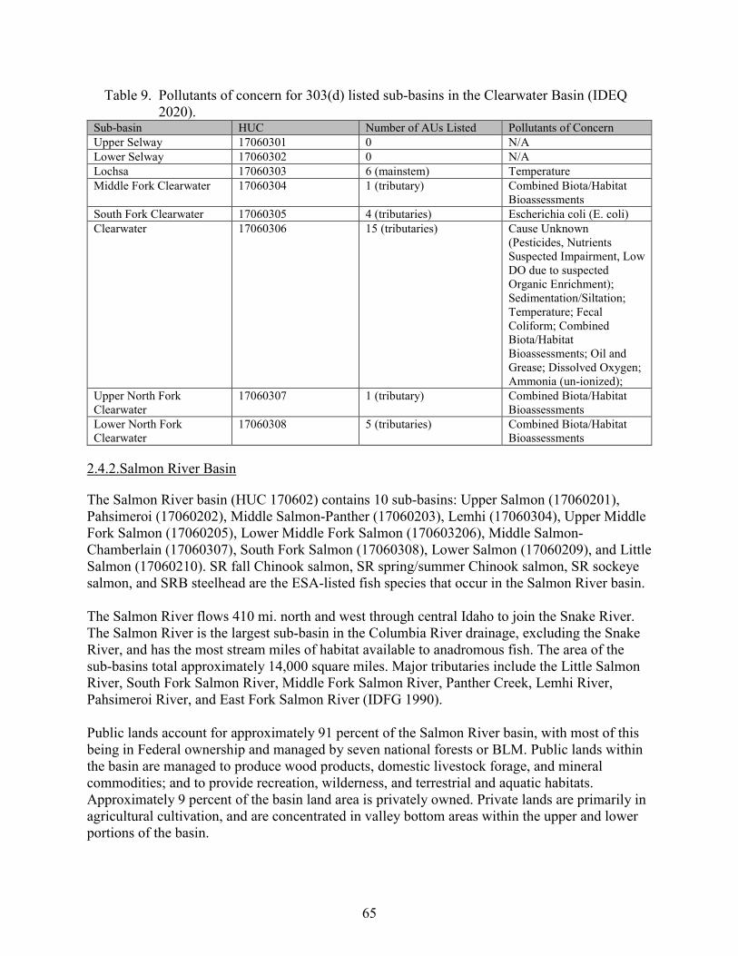
65
Table 9. Pollutants of concern for 303(d) listed sub-basins in the Clearwater Basin (IDEQ 2020).
Sub-basin HUC Number of AUs Listed Pollutants of Concern Upper Selway 17060301 0 N/A Lower Selway 17060302 0 N/A Lochsa 17060303 6 (mainstem) Temperature Middle Fork Clearwater 17060304 1 (tributary) Combined Biota/Habitat
Bioassessments South Fork Clearwater 17060305 4 (tributaries) Escherichia coli (E. coli) Clearwater 17060306 15 (tributaries) Cause Unknown
(Pesticides, Nutrients Suspected Impairment, Low DO due to suspected Organic Enrichment); Sedimentation/Siltation; Temperature; Fecal Coliform; Combined Biota/Habitat Bioassessments; Oil and Grease; Dissolved Oxygen; Ammonia (un-ionized);
Upper North Fork Clearwater
17060307 1 (tributary) Combined Biota/Habitat Bioassessments
Lower North Fork Clearwater
17060308 5 (tributaries) Combined Biota/Habitat Bioassessments
2.4.2.Salmon River Basin
The Salmon River basin (HUC 170602) contains 10 sub-basins: Upper Salmon (17060201), Pahsimeroi (17060202), Middle Salmon-Panther (17060203), Lemhi (17060304), Upper Middle Fork Salmon (17060205), Lower Middle Fork Salmon (170603206), Middle Salmon-Chamberlain (17060307), South Fork Salmon (17060308), Lower Salmon (17060209), and Little Salmon (17060210). SR fall Chinook salmon, SR spring/summer Chinook salmon, SR sockeye salmon, and SRB steelhead are the ESA-listed fish species that occur in the Salmon River basin. The Salmon River flows 410 mi. north and west through central Idaho to join the Snake River. The Salmon River is the largest sub-basin in the Columbia River drainage, excluding the Snake River, and has the most stream miles of habitat available to anadromous fish. The area of the sub-basins total approximately 14,000 square miles. Major tributaries include the Little Salmon River, South Fork Salmon River, Middle Fork Salmon River, Panther Creek, Lemhi River, Pahsimeroi River, and East Fork Salmon River (IDFG 1990). Public lands account for approximately 91 percent of the Salmon River basin, with most of this being in Federal ownership and managed by seven national forests or BLM. Public lands within the basin are managed to produce wood products, domestic livestock forage, and mineral commodities; and to provide recreation, wilderness, and terrestrial and aquatic habitats. Approximately 9 percent of the basin land area is privately owned. Private lands are primarily in agricultural cultivation, and are concentrated in valley bottom areas within the upper and lower portions of the basin.
66
Land management practices within the basin vary among landowners. The greatest proportion of National Forest lands are federally designated wilderness area or areas with low resource commodity suitability. One-third of the National Forest lands in the basin are managed intensively for forest, mineral, or range resource commodity production. The BLM lands in the basin are managed to provide domestic livestock rangeland and habitats for native species. State of Idaho endowment lands within the basin are managed for forest, mineral, or range resource commodity production. 2.4.2.1. Snake River Fall Chinook Salmon The SR fall Chinook salmon ESU represents a distinct group of Pacific salmon that is uniquely adapted to its environment. It is: (1) substantially reproductively isolated from other groups of the same species; and (2) represents an important component of the evolutionary legacy of the species. The ICTRT defined a single MPG within the ESU. The MPG contains one extant natural-origin population (Lower Snake River population) and one extirpated population (Middle Snake River population). The ICTRT identified five MaSAs within the Lower Snake River population: Upper Hells Canyon MaSA (Hells Canyon Dam on Snake River downstream to confluence with Salmon River); Lower Hells Canyon MaSA (Snake River from Salmon River confluence downstream to Lower Granite Dam pool); Clearwater River MaSA; Grande Ronde River MaSA; and Tucannon River MaSA (NMFS 2017b). Upper Hells Canyon MaSA is the primary (largest and most productive) MaSA in the Lower Snake River population and extends 59.6 mi. from Hells Canyon Dam on the Snake River downstream to the confluence with the Salmon River. Fall Chinook salmon production in the adjoining lower Imnaha and Salmon Rivers is considered part of this MaSA. The ICTRT considered spawning in the lower mainstem sections of the Imnaha and Salmon Rivers to be contiguous with and therefore part of the Upper Hells Canyon MaSA. The ICTRT considered spawning in the lower Salmon River to be contiguous with and therefore part of the Upper Hells Canyon MaSA. Data from 2000-2014 redd counts indicate that the lower Salmon River contributes a small percentage (0.8% ± 0.1%) of the basin-wide Snake River redd counts. During a single aerial survey conducted in 2015, biologists observed 142 fall Chinook salmon redds in the 105-mi reach of the mainstem Salmon River from the mouth to French Creek. From 2011 to 2016, the mean number of redds observed in the Salmon River was 62, ranging from 31 to 142 (Arnsberg et al. 2016). The most recent data indicates declining redd count numbers in the Salmon River, redd counts were 10 in 2017 (Arnsberg et al. 2018) and 14 in 2018 (Arnsberg 2019). Anecdotal accounts suggest that late spawning Chinook salmon existed historically in this area. For example, Burns (1992, as cited in NMFS 2017b) found anecdotal evidence for fall Chinook salmon spawning in the lowermost portion of the South Fork Salmon River during 1895–1890, the 1930s, and as recently as 1982 (Connor et al. 2016, as cited in NMFS 2017b). The Lower Salmon River sub-basin (HUC 17060209) is comprised of 65 waterbodies located in west central Idaho and includes the Salmon River from its mouth to French Creek. The sub-basin
67
encompasses approximately 755,000 acres, draining into the Snake River at RM 188.2. Private lands comprise the majority of the sub-basin, followed by the USFW, BLM, IDFG, and Idaho Department of Lands (IDL) (IDEQ 2010). Limited information exists on potential factors that could be limiting fall Chinook salmon use of the lower Salmon River. The lower Salmon River flows through both private and public lands, draining steep forested mountain slopes and then shrubs and grasses along the Salmon River canyon. Habitat conditions in the lower Salmon River and lower South Fork Salmon River are affected by excess fine sediment and reduced riparian vegetation from land use activities on adjacent lands and in upstream areas. Water temperatures drop in the lower Salmon River during the fall, and the plume created by cold water from the Salmon River where it enters the Snake River can provide thermal refugia for fall Chinook salmon (NMFS 2017b). 2.4.2.2. Snake River Spring/Summer Chinook Salmon In the Salmon River basin, SR spring/summer Chinook salmon are found in three MPGs: South Fork Salmon River, Middle Fork Salmon River, and Upper Salmon River. See Table 4 (section 2.2.1.1) for a summary of VSP parameters and overall current status for each population in the ESU. Section 2.2.2 describes critical habitat. Briefly, regional factors affecting all 3 MPGs (and SR fall Chinook salmon, SR sockeye salmon, and SRB steelhead to varying degrees) include Columbia River estuary and plume alterations, the mainstem Columbia and Snake Rivers hydropower system, hatchery programs, fishery management, and climate change (NMFS 2017a). South Fork Salmon River MPG. The South Fork Salmon River MPG supports a largely genetically cohesive grouping of summer-run Chinook salmon returning to the South Fork Salmon River sub-basin, as well as spring and summer Chinook salmon returning to the adjacent Little Salmon River and tributaries to the lower Salmon River mainstem. The MPG is composed of four independent populations: Little Salmon River, South Fork Salmon River Mainstem, Secesh River, and East Fork South Fork Salmon River. Three of the populations reside in the South Fork Salmon River sub-basin, which provides 887 mi. of stream accessible to anadromous fish. The Little Salmon River population resides in the Little Salmon sub-basin, which borders the South Fork Salmon watershed and contains 368 mi. of accessible habitat. The ICTRT classified the South Fork Salmon River Mainstem and East Fork South Fork Salmon River populations as Large-sized populations, and the Secesh River and Little Salmon River populations as Intermediate-sized populations (ICTRT 2007). Several parts of the South Fork Salmon River MPG are located in remote USFS land and provide high-quality, intact habitat. Habitat conditions for spring/summer Chinook salmon in many other parts of the MPG, however, have been degraded by road construction, mining, timber harvest, livestock grazing, and recreational use. These activities have reduced riparian function and vegetation, decreased recruitment of large woody debris, accelerated sediment loading, and increased water temperatures to critical levels in some areas. Roads or other human developments have disturbed riparian conditions along sections of the mainstem rivers and many of the major tributaries in the MPG. In addition, passage barriers restrict access to historical
68
spawning and rearing habitat. Presently, many degraded areas are on an improving trend due to ongoing habitat restoration efforts (NMFS 2017a). Water quality is impaired in the upper Little Salmon River watershed. In 2006, IDEQ developed Clean Water Act (CWA) total maximum daily loads (TMDLs) for both temperature and nutrients in the section of the Little Salmon River below New Meadows. In 2014, IDEQ found that Mud and Little Mud Creeks exceeded state standards for sediment and East Branch Goose Creek exceeded the standards for bacteria. TMDLs were developed to bring the creeks into compliance with the state standards (IDEQ 2014). An EPA-approved TMDL has been developed for the Secesh River and tributaries to meet bull trout spawning temperatures due to lack of shade and excess solar exposure (IDEQ 2014). Temperatures are generally acceptable for Chinook salmon spawning and rearing. In the South Fork Salmon River population, IDEQ has removed all stream reaches listed for sediment from the 303(d) list. The East Fork South Fork Salmon River is 303(d) listed for arsenic and antimony, and Sugar Creek is listed for arsenic and mercury (IDEQ 2020). Three of the four populations in the South Fork Salmon River MPG have ongoing hatchery programs, but hatchery proportions for two of the three populations have decreased marginally (NWFSC 2015). The Secesh River continues to show low hatchery proportions, reflecting some straying for hatchery programs in adjacent populations. Spatial structure and diversity risks are currently rated moderate for the South Fork Salmon River population (relatively high proportion of hatchery spawners) and low for the Secesh River, East Fork South Fork Salmon River, and Little Salmon River populations. The Little Salmon River population includes returns from large-scale hatchery releases but some of its side tributary spawning sites likely have low hatchery contributions (NMFS 2017a). Fisheries in the Columbia River estuary, mainstem Columbia River, Snake River, Salmon River, and tributary reaches continue to pose a threat to the abundance, productivity, and diversity of the South Fork Salmon River spring/summer Chinook salmon MPG. However, negotiations and agreements between the different fishery managers since the mid-1970s have reduced mortality rates on natural-origin SRS Chinook salmon and other ESA-listed species. Middle Fork Salmon River MPG. The Middle Fork Salmon River MPG consists of spring and summer Chinook salmon returning to the Middle Fork Salmon River basin, in addition to spring Chinook salmon returning to Chamberlain Creek and other nearby tributaries on the mainstem Salmon River. The MPG includes nine independent populations: (1) Big Creek, (2) Lower Middle Fork Salmon River Mainstem (below Indian Creek), (3) Upper Middle Fork Salmon River Mainstem (above Indian Creek and including the Indian Creek, Marble Creek, Pistol Creek and Rapid River drainages), (4) Camas Creek, (5) Loon Creek, (6) Sulphur Creek, (7) Bear Valley Creek, (8) Marsh Creek, and (9) Chamberlain Creek. The ICTRT classified Big Creek as a Large-size population; Bear Valley, Chamberlain Creek and the Upper Middle Fork as Intermediate-size populations; and the remaining populations as Basic-size (ICTRT 2007). No population in the MPG has received hatchery supplementation and there is no history of
69
hatchery-origin spring and summer Chinook salmon spawning in this group of populations (NMFS 2017a). Public forestlands cover much of the Middle Fork Salmon River MPG, with large portions protected in the Frank Church-River of No Return Wilderness Area. As a result, most natal habitat for these spring/summer Chinook salmon populations remains in good to excellent condition and protected from human impacts. Still, some small, localized areas in the MPG display degraded habitat conditions associated with road development, past mining, livestock grazing, irrigation diversions, timber harvest, and off-highway vehicle (OHV) and other recreational use. Presently, many degraded areas are on an improving trend due to ongoing habitat restoration. Although habitat conditions are degraded in small, localized areas within the Middle Fork Salmon River, habitat conditions throughout most of this MPG are in excellent condition. The key limiting factors affecting these populations are from outside of natal spawning and rearing areas (NMFS 2017a). In their 2020 Integrated Water Quality Monitoring and Assessment Report, IDEQ found that the majority of stream reaches in Bear Valley Creek (84.24 mi.) did not have water quality problems and fully supported beneficial uses. However, Bear Valley Creek from Elk Creek down to the Marsh Creek confluence (7.36 mi.) is 303(d) listed as impaired by both sediment and high temperature (IDEQ 2020). Much of the mainstem of Camas Creek and several of the major tributaries including Yellow Jacket Creek, Castle Creek, Duck Creek and Silver Creek were identified as temperature limited in the 2012 water quality integrated report (IDEQ 2014) and are included in the Middle Fork Salmon River Temperature TMDL to improve temperatures and fully support salmonid spawning. There are no waterbodies listed on the 303(d) list for the following populations: Loon Creek, Lower Middle Fork Salmon River, Sulphur Creek, There currently are no hatchery releases within the Middle Fork Salmon River MPG. The MPG also receives few hatchery stray from neighboring MPGs. Stray rates in all Middle Fork Salmon River MPG populations are consistently less than 1 percent (IDFG 2014, as cited in NMFS 2017a). Thus, straying of hatchery-origin fish from neighboring MPGs poses only a potential threat to spring/summer Chinook salmon populations in the Middle Fork Salmon River MPG (NMFS 2017a). Fishery-related mortality of natural-origin spring and summer Chinook salmon returning to the Middle Fork Salmon River MPG occurs in state tributary fisheries targeting hatchery-origin fish in the mainstem Salmon River. No state fisheries target spring/summer Chinook salmon within the Middle Fork Salmon River MPG because there are no hatchery releases and natural-origin fish abundance levels are not high enough to warrant the fisheries. No open sport fisheries for wild Chinook salmon have occurred in the Middle Fork Salmon River MPG since 1978 (NMFS 2017a). Tribal fisheries also affect the abundance, productivity and diversity of natural-origin spring/summer Chinook salmon returning to the Middle Fork Salmon River MPG. Returning natural-origin spring/summer Chinook salmon are exposed to tribal fisheries on the Salmon River, Bear Valley Creek, Chamberlain Creek, Marsh Creek, and other locations where the tribes continue traditional fishing practices. While the tribal harvests are generally nonselective for hatchery or natural-origin fish, the tribes limit fishery-related mortality of natural-origin
70
populations by implementing an abundance-based management framework that has been authorized under the ESA (NMFS 2017a). Upper Salmon River MPG. The Upper Salmon River MPG consists of spring and summer Chinook salmon returning to the Upper Salmon River basin upstream of the mouth of the Middle Fork Salmon River. The MPG includes nine independent populations, of which one (Panther Creek) is considered functionally extirpated: (1) North Fork Salmon River, (2) Lemhi River, (3) Salmon River Lower Mainstem (below Redfish Lake Creek), (4) Pahsimeroi River, (5) East Fork Salmon River, (6) Yankee Fork, (7) Valley Creek, (8) Salmon River Upper Mainstem (above Redfish Lake Creek), and (9) Panther Creek (extirpated) (NMFS 2017a). Federal lands managed by the USFS and BLM cover much of the upper elevation areas of the Upper Salmon River MPG, with areas included within the Sawtooth National Recreation Area, Sawtooth Wilderness Area, roadless areas, and the Boulder-White Clouds Wilderness Area, established on August 7, 2015. Lower elevation lands, including valley bottoms in many areas, are in private ownership. Land uses influencing habitat quality in the MPG include livestock grazing, timber harvest, agricultural practices, recreation, and mining. In some areas, these land uses have reduced riparian function and vegetation, decreased recruitment of large woody debris, accelerated sediment loading, and increased summer water temperatures to critical levels. Irrigation diversions reduce summer flows in most population areas, with tributaries in some reaches disconnected from main rivers. Passage barriers also restrict spring/summer Chinook salmon assess to historical spawning and rearing habitat in most population areas. Presently, some degraded areas are on an improving trend due to ongoing habitat restoration efforts (NMFS 2017a). Hatchery production is a prominent feature of the Upper Salmon River spring/summer Chinook salmon MPG. There are currently three populations within this MPG that receive hatchery releases: Pahsimeroi River, Yankee Fork Salmon River, and the Upper Salmon River Upper Mainstem (NMFS 2017a). There are currently no hatchery releases in the North Fork Salmon River, Lemhi River, Upper Salmon River Lower Mainstem, East Fork Salmon River and Valley Creek populations. However, hatchery releases occurred in the Lemhi River and East Fork Salmon River populations under previous programs. Panther Creek is considered a functionally extirpated population. The Shoshone-Bannock Tribes are currently developing a program to reestablish a summer Chinook salmon population in Panther Creek (NMFS 2017a). Fishery-related mortality of natural-origin spring and summer Chinook salmon returning to natal areas in the Upper Salmon River MPG and Salmon River occurs in state tributary fisheries targeting hatchery-origin fish in the lower and upper Salmon River. Lower and upper Salmon River fisheries target hatchery-origin spring/summer Chinook salmon returning to the Pahsimeroi River, Yankee Fork, and other upriver areas. IDFG conducts a fishery in many years along the Upper Salmon River to the Pahsimeroi River that targets Chinook salmon returning to Pahsimeroi Hatchery. State fisheries on spring/summer Chinook salmon do not currently occur within the North Fork, Panther Creek, Lemhi, East Fork, Yankee Fork, and Valley Creek population areas (NMFS 2017a).
71
Tribal fisheries also affect the abundance, productivity and diversity of natural-origin spring/summer Chinook salmon returning to the Upper Salmon River MPG. Returning natural-origin spring/summer Chinook salmon are exposed to tribal fisheries on the Salmon River and in the Upper Salmon River MPG where the tribes continue traditional fishing practices. Tribal fisheries could potentially occur in all Upper Salmon River MPG populations depending on expected population-specific abundance. While the tribal harvests are generally nonselective for hatchery or natural-origin fish, the tribes limit fishery-related mortality of natural-origin populations by implementing an abundance-based management framework that has been authorized under the ESA (NMFS 2017a). 2.4.2.3. Snake River Sockeye Salmon The ICTRT defined SR sockeye salmon as a single ESU with a single MPG, the Sawtooth Valley Lakes MPG. The group determined that the one MPG historically supported at least three independent sockeye salmon populations (Redfish, Alturas, and Stanley Lakes) (ICTRT 2007). As described below, the MPG is currently made up of one extant population (Redfish Lake) and two (Alturas Lake and Stanley Lake) to four (possibly also Pettit and Yellowbelly Lakes) other historical populations (NMFS 2015). Five lakes in the Sawtooth Valley historically contained anadromous sockeye salmon: Alturas, Pettit, Redfish, Stanley, and Yellowbelly Lakes (Bjornn et al. 1968). Currently, only the Redfish Lake population, supported by a captive broodstock program, is considered extant. However, reintroduction efforts have been ongoing in Redfish Lake since 1993, Pettit Lake since 1995, and Alturas Lake since 1997 with Redfish Lake stock (Hebdon et al. 2004). The Sawtooth Valley lakes support three forms of (O. nerka): anadromous sockeye salmon, residual sockeye salmon (resident life history), and kokanee (genetically distinct and not included in the ESA listing). Land use in the Sawtooth Valley is predominantly cattle ranching and recreation. The private lands, with ranches and scattered residences, are primarily used as pasture. Alturas Lake Creek is the only outlet stream from the lakes that crosses these private agricultural lands before entering the Salmon River. The town of Stanley had a population of 116 in the 2020 census. More than 1 million people per year visit the Sawtooth National Recreation Area, mostly in the summer (Griswold et al. 2002). Adult sockeye salmon returns to Redfish Lake during the period 1954 through 1966 were of natural-origin and ranged from 11 to 4,361 fish (Bjornn et al. 1968). In 1985, 1986, and 1987, 11, 29, and 16 sockeye salmon, respectively, were counted at the Redfish Lake weir (West Coast Salmon Biological Review Team [WCSBRT] 2003, Good et al. 2005). In 1991, at the time of the listing, only one, one, and zero Sockeye salmon had returned to Redfish Lake in the three preceding years, respectively. Biologists have also counted sockeye salmon at the Sawtooth Fish Hatchery weir since its installation on the Salmon River above Redfish Lake Creek in 1985. The weir captured three anadromous sockeye salmon in 1985 and two in 1987, but no sockeye salmon in 1986. Since

72
then, captures of additional unmarked adult sockeye salmon of unknown origin at the Sawtooth Fish Hatchery weir included one in 1988, one in 1996, three in 2002, three in 2004, one in 2006 and three in 2007. Known adult returns from Alturas Lake (confirmed by genetic analysis) were trapped at the Sawtooth Fish Hatchery weir in past years: one, one, fourteen, and two sockeye salmon in 2008, 2009, 2010, and 2011, respectively (Kozfkey 2013b, as cited in NMFS 2015). However, no sockeye have been released into Alturas Lake in recent years and only kokanee were identified in 2020 trawl samples (Johnson et al. 2021). Therefore, no SR sockeye salmon are currently expected to be found in Alturas Lake. Between 1991 and 1998, all 16 of the natural-origin adult sockeye salmon that returned to the weir at Redfish Lake were incorporated into the captive broodstock program, as well as out-migrating smolts captured between 1991 and 1993, and residual Sockeye salmon captured between 1992 and 1995 (Hebdon et al. 2004). The program has used multiple rearing sites to minimize chances of catastrophic loss of broodstock and has produced several million eggs and juveniles, as well as several thousand adults, for release into the wild (NMFS 2015). Estimates of annual returns are available through 2020. Between 1999 and 2007, more than 355 adults returned from the ocean from captive broodstock releases – almost 20 times the number of wild fish that returned in the 1990s (Flagg et al. 2004). However, this total is primarily due to large returns in the year 2000 (number: 257). Returns for 2003-2007 were relatively low, similar to the range observed between 1987 and 1999. Sockeye salmon returns increased from 2008 to 2014 with an average of 902 sockeye adults returning annually (NMFS 2015). However, since 2014 adult sockeye returns have once again declined; adult returns the last six years include 91 fish in 2015, 572 in 2016, 162 in 2017, 113 in 2018, 17 in 2019, and 151 in 2020 (Johnson et al. 2020). SR Sockeye salmon are still close to extinction, supported primarily by the captive broodstock program. As shown above, this program has substantially improved the numbers of hatchery-produced O. nerka for use in supplementation, and in recent years the levels of naturally produced sockeye salmon returns have increased. Nevertheless, substantial increases in survival rates across life history stages must occur in order to reestablish sustainable natural production (Ford 2011). Many human activities have contributed to the near extinction of SR sockeye salmon in the Snake River basin. The NMFS status review (Waples et al. 1991) that led to the original listing decision attributed the decline of this ESU to “overfishing, irrigation diversions, obstacles to migrating fish, and eradication through poisoning.” The NMFS 1991 listing decision noted that such factors as hydropower development, water withdrawal and irrigation diversions, water storage, commercial harvest, and inadequate regulatory mechanisms represented a continued threat to the ESU’s existence (56 FR 58619). NMFS’ 1991 listing decision also stated that predation impacts from piscivorous fish and marine mammals was increasing in Northwest salmonid fisheries; however, the extent of these impacts on SR sockeye salmon was unknown at that time. NMFS’ recent review of historical threats identified intense commercial harvest of sockeye salmon along with other salmon species beginning in the mid-1880s; the existence of Sunbeam Dam as a migration barrier between 1910 and early 1930s; the eradication of sockeye salmon from Sawtooth Valley lakes in the 1950s and 1960s; development of mainstem
73
hydropower projects on the lower Snake and Columbia Rivers in the 1970s and 1980s; and poor ocean conditions in 1977 through the late 1990s as factors that contributed to the species’ decline (NMFS 2008). Today, some threats (e.g., impacts from ocean and in-river fisheries, migration barriers, eradication by poisoning) that contributed to the original listing of SR sockeye salmon now present little harm to the ESU while others continue to threaten viability. Hatchery-related concerns have also been reduced through management actions, particularly through the captive broodstock program that uses an integrated broodstock program to maintain and rebuild the species’ genetic resources; however, continued caution needs to be applied to ensure that hatchery releases do not influence the species natural genetic diversity and fitness. Current habitat threats to the sockeye exist in the natal lakes (e.g., introduction and continued stocking of non-native fish); Salmon River migratory corridors (e.g., toxic pollutants, blocked access to migration corridor and natal lakes); lower mainstem Snake River to Lower Granite Reservoir (upstream dam operations); mainstem Snake and Columbia River migration corridor (hydro-system dams); and the Columbia River estuary (diking and reduced spring flows, high water temperatures). In addition to habitat threats, others sources of threats to the sockeye are hatchery operations (potential loss of genetic diversity); on-going Columbia River fisheries harvest (reduced abundance and productivity due to incidental take); predation by non-native and native fishes, birds, and marine mammals (reduction in sockeye productivity); toxics from agricultural runoff and forestry pesticide and fire retardant use); and, climate change (deterioration of water quality, water quantity and/or physical habitat) (NMFS 2015). In recent years, lethally high water temperatures in the Columbia and Snake rivers have resulted in high mortality for upstream migrating adult sockeye salmon. In 2015, hundreds of thousands of sockeye salmon died due to high temperatures in the Columbia and Snake rivers. Given the high mortality, IDFG collected adult sockeye at Lower Granite Dam and trucked them to their hatchery in Eagle, ID. Although they estimated that over 4,000 SR sockeye were counted at Bonneville Dam in 2015, IDFG was only able to capture 35 sockeye at Lower Granite Dam while 56 sockeye successfully migrated to Redfish Lake. In 2021, water temperatures were even higher and IDFG again started trapping sockeye salmon at Lower Granite Dam and trucking them to the Eagle Hatchery. Given these climate change driven increases in water temperatures, collecting and trucking sockeye, as well as other salmon, will likely become routine. 2.4.2.4. Snake River Basin Steelhead There are 12 populations of SRB steelhead in the Salmon River MPG: Little Salmon River, Chamberlain Creek, Secesh River, South Fork Salmon River, Panther Creek, Lower Middle Fork Salmon River, Upper Middle Fork Salmon River, North Fork Salmon River, Lehmi River, Pahsimeroi River, East Fork Salmon River, and Upper Mainstem Salmon River (NMFS 2017a). Little Salmon River Steelhead Population. The Little Salmon River steelhead population includes the Salmon River and its tributaries from the confluence with the Snake River upstream to the Little Salmon River. The drainage area within this steelhead population is about 1,536 square miles. There are about 1,168 mi. of stream
74
within the Little Salmon River population with less than half (556 mi) occurring downstream from natural barriers (ICTRT 2008). Land ownership within Little Salmon River steelhead population is primarily USFS (41%) and private lands (40%). The BLM, state of Idaho, and others make up the remaining (19%). Land ownership within the population is divided with private lands in the upper Little Salmon River and along the mainstem Salmon River, and with USFS lands occupying higher elevations downstream to Skookumchuck Creek. Downstream from Skookumchuck Creek the majority of the land ownership is private, state, and BLM. State and BLM lands are intermixed with private land along most of the Salmon River (NMFS 2017a). NMFS (2017a) concluded that the habitat limiting factors for the Little Salmon River steelhead population are sedimentation, passage barriers, reduced streamflow, habitat complexity, and elevated stream temperatures. IDEQ’s Integrated (303(d) and 305(b)) Report identifies stream segments that are not fully supporting their assessed beneficial uses. These impaired stream segments are listed under section 5 (impaired waters that need a TMDL), section 4c (waters impaired by non-pollutants), and section 4a (impaired waters that have an USEPA-approved TMDL) (IDEQ 2009, 2014). Excluding the Rapid River tributary, the Little Salmon River drainage has received large numbers of juvenile hatchery steelhead from the Salmon, Snake, and Clearwater drainages. Hatchery fish, classified as A-run2 based on size, ocean age, and timing characteristics have been introduced from Oxbow, Pahsimeroi, and Sawtooth hatcheries. Hatchery B-run steelhead stocked in the Little Salmon drainage are progeny of adult steelhead collected at Dworshak National Fish Hatchery on the North Fork of the Clearwater River. There is no steelhead broodstock collection facility located in the Little Salmon River drainage and returning hatchery fish that are not harvested probably spawn naturally. Thus, naturally produced steelhead in this drainage are likely a mixture of hatchery and naturally produced A-run and B-run fish (Kiefer et al 1992). Steelhead supplementation does not occur in Rapid River, and natural production maintains the run. The Rapid River steelhead run is classified for wild fish management. Hatchery-related threats to the population include incidental catch of natural-origin fish in mark-selective fisheries for hatchery-origin fish, the continued use of out-of-basin broodstock, weir operation, and the high proportion of hatchery-origin spawners and low proportion of natural-origin broodstock. Limiting factors include reduced genetic adaptiveness, possible demographic and life history changes, and increased competition for food and space (NMFS 2017a). Fisheries in the Columbia River estuary, mainstem Columbia River, Snake River, Salmon River and tributaries continue to pose a threat to Little Salmon River steelhead, an A-run population, and to other Salmon River populations. Harvest-related mortality has the potential to affect migration timing, maturation timing and size of the steelhead population; however, managers currently control harvest-related impacts through an abundance-based approach and existing
2 A‐run steelhead predominantly spend 1-year in the ocean; B‐run steelhead are larger with most individuals returning after 2 years in the ocean.
75
fishery management programs to support the recovery of natural-origin populations (NMFS 2017a). Chamberlain Creek Steelhead Population. The Chamberlain Creek steelhead population includes the Salmon River and its tributaries from the mouth of the Little Salmon River upstream to Chamberlain Creek, excluding the South Fork Salmon River drainage. The drainage area within this steelhead population is about 1,573 square miles). There are about 1,180 mi. of stream within the Chamberlain Creek population with less than half (500 mi.) occurring downstream from natural barriers. Land ownership within Chamberlain Creek steelhead population is primarily USFS (96.0%) with BLM (2.2%), state (0.2%), and private (1.6%) combined at less than five percent. The BLM administers lands near Carey Creek and downstream near Partridge Creek. Private lands are mostly scattered along the north side of Salmon River and downstream near Partridge, Elkhorn, and French Creeks. State owned land is concentrated on the south side of the Salmon River close to private and BLM lands. NMFS (2017b) concluded that the habitat limiting factors for the Chamberlain Creek steelhead population are migration barriers, sediment, habitat quality and temperature. The IDEQ’s 2018/2020 Integrated (303(d) and 305(b)) Report for the CWA includes stream segments in this population that are not fully supporting their assessed beneficial uses (IDEQ 2020). Impaired stream segments are listed in IDEQ’s 2018/2020 Integrated Report under section 4c (waters impaired by non-pollutants), and section 4a (impaired waters than have a USEPA-approved TMDL) (IDEQ 2009, 2014). There is no history of hatchery releases in the Chamberlain Creek steelhead population area. Further, strays from other hatchery programs are not known to be a problem for the population. Straying and interbreeding of hatchery-origin fish from other populations with Chamberlain Creek natural-origin steelhead remains a potential risk to the population’s life history diversity (NMFS 2017a). Fisheries in the Columbia River estuary, mainstem Columbia River, Snake River, Salmon River and tributaries continue to pose a threat to Chamberlain Creek steelhead (an A-run population), and to other Salmon River populations. Harvest-related mortality has the potential to affect migration timing, maturation timing and size of the steelhead population; however, harvest-related impacts are currently controlled through the abundance-based approach and existing fishery management programs to support the recovery of natural-origin populations (NMFS 2017a). Secesh River Steelhead Population. The Secesh River steelhead population area includes the main stem river and all tributaries. The Secesh River enters the main South Fork Salmon River near the confluence of the East Fork
76
South Fork Salmon River. The geographic area encompassed within this population has a drainage area of approximately 1,063 sq. mi. (NMFS 2017a). Land ownership within the Secesh River steelhead population is primarily USFS (98.2%) with BLM (0.8%), state (0.4%), and private (0.6%) combined at less than two percent. The BLM administers the Marshall Mountain Mining District in the upper Secesh River. Private land is located along the Secesh River near Grouse Creek and scattered patches upstream from Summit Creek. State-owned land is concentrated in one section upstream from Summit Creek. NMFS (2017a) concluded that the habitat limiting factors for the Secesh steelhead population are excess sediment and passage barriers. IDEQ’s Integrated (303(d) and 305(b)) Report identifies stream segments that are not fully supporting their assessed beneficial uses (IDEQ 2020). The Secesh River, Grouse Creek, Willow Basket Creek, and other Secesh River tributaries are listed as impaired by high temperatures due to lack of shade. IDEQ has developed TMDLs for these streams. Hatchery-origin steelhead are not currently released into the Secesh River population, nor have they been released in the past. Further, strays from other hatchery programs are not known to be a problem for the population (NMFS 2017a). Fisheries in the Columbia River estuary, mainstem Columbia River, Snake River, Salmon River and tributaries continue to pose a threat to Secesh River steelhead, a high-proportion B-run population, and to other Salmon River populations. Harvest-related mortality has the potential to affect migration timing, maturation timing and size of the steelhead population; however, managers currently control harvest-related impacts through an abundance-based approach and existing fishery management programs to support the recovery of natural-origin populations (NMFS 2017a). South Fork Salmon River Steelhead Population. The South Fork Salmon steelhead population includes the South Fork Salmon River and all of its tributaries, except the Secesh River. The South Fork Salmon River steelhead population contains three major tributaries: East Fork South Fork Salmon River, Johnson Creek, and upper South Fork Salmon River. The South Fork Salmon enters the main Salmon River downstream of the confluence with the Middle Fork Salmon River. The geographic area encompassed within this population has a drainage area of approximately 1,063 sq. mi. Land ownership within South Fork Salmon River population is primarily USFS (99.14%), with State (0.24%) and private (0.62%) combined at less than one percent. The northeast portion of the South Fork Salmon River basin is located within the boundaries of the Frank Church-River of No Return Wilderness. The USFS principally administers the land uses within the South Fork Salmon basin. The state lands include state endowment lands and homesteads that the state has purchased. Private land is scattered throughout the watershed and includes working ranches, guest ranches, private residences, recreational facilities, villages, and mining sites. Current land uses include mining, timber harvest, grazing, and recreation (NMFS 2017a).
77
Habitat limiting factors in the South Fork Salmon River steelhead population are linked to human-induced disturbances such as mining and road building. The inherently fragile parent geology combined with human disturbances and heavy precipitation makes the basin susceptible to large sediment producing events that degrade habitat quality for steelhead. Roads located near streams encroach on riparian habitat, limit potential sources of large woody debris, and create passage barriers at road-stream crossings (NMFS 2017a). The Salmon Sub-basin Assessment and Management Plan (NPCC 2004) also considered high temperatures and chemical contamination to be limiting habitat quality in the South Fork drainage. Data presented by the USFS (2006) show that temperature values often exceed current temperature criteria, but these values are considered to reflect a natural temperature regime in most of the South Fork Salmon River drainage. As indicated by IDEQ (2002), dissolved metals from past mining activity, while still present, have mainly been found at levels below State and Federal acute criteria standards. IDEQ (2002) indicated that total dissolved metals were below EPA and state criterion and are declining with each year of sampling. Reclamation and Comprehensive Environmental Response, Compensation, and Liability Act (CERCLA) efforts have addressed potential impacts from mine sites to fish and fish habitat (USFS 2007a), including removing hazardous materials toxic to aquatic organisms (USFS 2007a). The IDEQ has found that several stream segments in this population are not fully supporting their assessed beneficial uses. These impaired stream segments are listed under the CWA, section 5 (impaired waters that need a TMDL), and section 4a (impaired waters than have a USEPA-approved TMDL) (IDEQ 2020). No hatchery releases occur in the South Fork Salmon River steelhead population area. Further, strays from other hatchery programs are not known to be a problem for the population. Straying and interbreeding of hatchery-origin fish from other populations with South Fork Salmon River natural-origin steelhead remains a potential genetic risk to the population (NMFS 2017a). Fisheries in the Columbia River estuary, mainstem Columbia River, Snake River, Salmon River and tributaries continue to pose a threat to South Fork Salmon River steelhead, a B-run population, and to other Salmon River populations. Harvest-related mortality has the potential to affect migration timing, maturation timing and size of the steelhead population; however, harvest-related impacts are currently controlled through an abundance-based approach and existing fishery management programs to support the recovery of natural-origin populations (NMFS 2017a). Panther Creek Steelhead Population. The Panther Creek steelhead population includes the Salmon River and its tributaries upstream from the confluence of Chamberlain Creek (excluding the Middle Fork Salmon River watershed) to the confluence with Panther Creek. Major watersheds within the population include Panther Creek, Horse Creek, and Owl Creek. The geographic area encompassed within this population has a drainage area of approximately 993 sq. mi.
78
The Panther Creek steelhead population is currently at high risk due to a high-risk rating for spatial structure risk (NWFSC 2015). Spawning surveys will be necessary to confirm whether steelhead are currently spawning in upper Panther Creek, which would reduce the population’s spatial structure risk to low (NMFS 2017a). Land ownership within the Panther Creek population is primarily USFS (99.2%), with private at 0.8 percent. Small pockets of private ownership are concentrated in the drainages of Napias, Blackbird, and upper Panther Creeks. Land use in this population has included mining, logging, road construction, grazing, and recreation. The predominant human impact on the steelhead population has been past (NPCC 2004) and current (i.e., Idaho Cobalt Mine) mining activity. NMFS (2017a) concluded that the habitat limiting factors for the Panther Creek population are chemical pollutants, sediment, temperature, riparian conditions, surface water diversions, and migration barriers. The IDEQ’s Integrated (303(d) and 305(b)) Report identifies stream segments that are not fully supporting their assessed beneficial uses. These impaired stream segments are listed in the report under section 5 (impaired waters that need a TMDL), section 4c (waters impaired by non-pollutants), and section 4a (impaired waters than have an EPA-approved TMDL) (IDEQ 2020). Currently, no hatchery releases occur in the Panther Creek steelhead population area. Further, strays from other hatchery programs are not known to be a problem for the population. Hatchery releases did occur in the past. In 1977, and then from 1982 to 1989, steelhead were released into Panther Creek from the Pahsimeroi and Sawtooth Fish Hatcheries. Currently, hatchery-origin steelhead from the mainstem Salmon River that could stray into the Panther Creek population represent a potential threat to the Panther Creek population (NMFS 2017a). Fisheries in the Columbia River estuary, mainstem Columbia River, Snake River, Salmon River and tributaries continue to pose a threat to Panther Creek steelhead, an A-run population, and to other Salmon River populations. Harvest-related mortality has the potential to affect migration timing, maturation timing and size of the steelhead population; however, harvest-related impacts are currently controlled through an abundance-based approach and existing fishery management programs to support the recovery of natural-origin populations (NMFS 2017a). Lower Middle Fork Salmon River Steelhead Population. The Lower Middle Fork steelhead population includes the Middle Fork Salmon River watersheds downstream from Loon Creek. Major watersheds within the Lower Middle Fork include Loon Creek, Camas Creek, and Big Creek. The geographic area encompassed within this population has a drainage area of approximately 1,731 sq. mi. (NMFS 2017a). The Lower Middle Fork Salmon River steelhead population is currently at moderate risk due to a tentative moderate risk rating for abundance or productivity. Land ownership within the Lower Middle Fork Salmon River population is primarily USFS (99.4%) with state (0.23%) and private (0.36%) combined at less than 1%. The Lower Middle
79
Fork Salmon River is almost entirely contained within the Frank Church-River of No Return Wilderness. Streams situated outside the wilderness area are subject to more land management related impacts than wilderness streams. There are no major human population centers in the Middle Fork Salmon River basin and private or state-owned lands within the wilderness are typically resort type developments. NMFS (2017b) concluded that the habitat limiting factors for the Lower Middle Fork steelhead population are sediment and migration barriers. The IDEQ has found that several stream segments in this population are not fully supporting their assessed beneficial uses. For this population, there are five tributaries listed for temperature under the CWA, section 4a (impaired waters than have an EPA-approved TMDL) and section 5 (impaired waters that need a TMDL) for West Fork Camas Creek to complete bio-assessments (IDEQ 2014). There is no history of hatchery releases in the Lower Middle Fork Salmon River steelhead population area. Further, strays from other hatchery programs are not known to be a problem for the population. Straying and interbreeding of hatchery-origin fish from other population areas with natural-origin fish in this B-run steelhead population remains a potential risk to the population’s life history diversity (NMFS 2017a). Fisheries in the Columbia River estuary, mainstem Columbia River, Snake River, Salmon River and tributaries continue to pose a threat to Lower Middle Fork Salmon River steelhead, which include both B-run and A-run fish, and to other Salmon River populations. Most harvest-related mortality for steelhead returning to the Salmon River MPG occurs in the mainstem Columbia River from the mouth upstream to McNary Dam during fisheries targeting fall Chinook salmon, including tribal gillnet and dip net fisheries. Salmon River B-run steelhead experience higher harvest rates than the A-run steelhead because they are larger and more susceptible to catch in the gillnet gear, and because their timing coincides with the return of fall Chinook salmon. Harvest-related mortality has the potential to affect migration timing, maturation timing and size of the steelhead population; however, harvest-related impacts are currently controlled through an abundance-based approach and existing fishery management programs to support the recovery of natural-origin populations (NMFS 2017a). Upper Middle Fork Salmon River Steelhead Population. The Upper Middle Fork Salmon River steelhead population includes the Middle Fork Salmon River watersheds upstream from Loon Creek. Major watersheds within the Upper Middle Fork include Marble Creek, Elkhorn Creek, Rapid River, Pistol Creek, Sulphur Creek, Marsh Creek, and Bear Valley Creek. The geographic area encompassed within this population has a drainage area of approximately 1,144 sq. mi. The Upper Middle Fork Salmon River steelhead population is currently at moderate risk due to a tentative moderate risk rating for abundance or productivity (NWFSC 2015). A population-specific monitoring program will be necessary to reduce the uncertainty of this rating.
80
Land ownership within Upper Middle Fork Salmon River population is primarily USFS (99.57%), with state (0.20%) and private (0.24%) combined, which is (less than 1%). The Upper Middle Fork Salmon River is almost entirely contained within the Frank Church ─ River of No Return Wilderness. Streams situated outside the wilderness area are subject to more land management related impacts than wilderness streams. There are no major human population centers in the Middle Fork Salmon River basin, and private or state-owned lands within the wilderness are typically resort type developments. NMFS (2017a) concluded that stream habitat in the Upper Middle Fork Salmon River is well protected and in relatively good condition. Past land use activities that degraded stream habitat, such as mining and intensive livestock grazing, have now ceased. Potential habitat limiting factors such as sediment and temperature have largely been addressed and continue to improve (NMFS 2017a). The IDEQ is required by the CWA to assess all surface waters in Idaho and determine whether they meet state water quality standards and support their beneficial uses (e.g., cold-water aquatic life and salmonid spawning). The results of this assessment are included in the Integrated 303(d) and 305(b)) Report. The Integrated Report includes stream segments in this population that are not fully supporting their assessed beneficial uses (impaired stream segments) and are listed in IDEQ’s 2020 Integrated Report under the CWA, section 5 (impaired waters that need a TMDL), section 4c (waters impaired by non-pollutants), section 4b (waters having pollution control requirements other than a TMDL), and section 4a (impaired waters that have an USEPA-approved TMDL) (IDEQ 2020). There is no history of hatchery releases in the Upper Middle Fork Salmon River steelhead population area. Further, strays from other hatchery programs are not known to be a problem for the population (NMFS 2017a). Fisheries in the Columbia River estuary, mainstem Columbia River, Snake River and Salmon River continue to pose a threat to Upper Middle Fork Salmon River steelhead, which include both B-run and A-run fish, and to other Salmon River populations. Most harvest-related mortality for steelhead returning to the Salmon River MPG occurs in the mainstem Columbia River from the mouth upstream to McNary Dam during fisheries targeting fall Chinook salmon, including tribal gillnet and dip net fisheries. Salmon River B-run steelhead experience higher harvest rates than the A-run steelhead because they are larger and more susceptible to catch in the gillnet gear, and because their timing coincides with the return of fall Chinook salmon. Harvest-related mortality has the potential to affect migration timing, maturation timing and size of the steelhead population; however, harvest-related impacts are currently controlled through an abundance-based approach and existing fishery management programs to support the recovery of natural-origin populations (NMFS 2017a). North Fork Salmon Steelhead Population. The North Fork Salmon River population is located along the Idaho-Montana border and includes the North Fork Salmon River watershed and all tributaries downstream to the confluence of Panther Creek. Besides the North Fork Salmon River itself, Indian Creek is the
81
most important tributary in this steelhead population. The population geographic boundary drains approximately 483 sq. mi. (NMFS 2017a). The North Fork Salmon River steelhead population is currently at moderate risk due to a tentative moderate risk rating for abundance or productivity and a moderate risk rating for diversity (NMFS 2017a). Land ownership within the population is mostly USFS (97.8%). Private (2.1%) and state of Idaho (less than 1%) lands make up a very small portion of ownership in the population. The Salmon-Challis National Forest administers most of the land within the population boundaries, but private inholdings are located along many streams. Public lands are used for livestock grazing, timber, recreation, and a variety of other public uses. Private land management is mostly irrigated agriculture and livestock grazing in the valley bottom. Past human activities including mining, timber harvest, livestock grazing, and development have impacted this habitat for at least the last 130 years. At one time, hydraulic gold mining in the Gibbonsville area produced high levels of turbidity in the North Fork Salmon River and delivered large amounts of fine sediment to stream channels. Livestock grazing allotments occur within the Hughes Creek and Hull Creek drainages, but impacts from these activities have been declining (IDEQ 2001a, as cited in NMFS 2017a). NMFS (2017a) concluded that the key habitat limiting factors for the North Fork Salmon River population are lack of habitat complexity, reduced streamflow, and entrainment in ditches. Development along the North Fork Salmon River corridor further threatens habitat quality and may lead to limiting factors in the near future. Impassable culverts and elevated fine sediment loads exist within the population boundaries. IDEQ’s 2020 Integrated 303(d) and 305(b) Report included stream segments listed under the CWA, section 5 (303d streams); the Salmon River from the confluence of the North Fork Salmon downstream to Indian Creek is listed for temperature. (IDEQ 2020). Only one stream segment in the population, Dump Creek, is listed as impaired in section 4c (waters impaired by non-pollutants). Dump Creek is listed for sediment along 5.04 mi. The creek has a natural barrier in the lower section that prevents upstream steelhead migration. In other locations, sediment levels monitored with core sampling were variable, but most were functioning properly for quartzite parent geology (USFS 2010a, as cited in NMFS 2017a). No hatchery releases occur in the North Fork Salmon River steelhead population area. Further, strays from other hatchery programs are not known to be a problem for the population (NMFS 2017a). Fisheries in the Columbia River estuary, mainstem Columbia River, Snake River and Salmon River continue to pose a threat to Upper Middle Fork Salmon River steelhead, which include both B-run and A-run fish, and to other Salmon River populations. Most harvest-related mortality for steelhead returning to the Salmon River MPG occurs in the mainstem Columbia River from the mouth upstream to McNary Dam during fisheries targeting fall Chinook salmon, including tribal gillnet and dip net fisheries. Salmon River B-run steelhead experience higher harvest rates than the A-run steelhead because they are larger and more susceptible to catch in
82
the gillnet gear, and because their timing coincides with the return of fall Chinook salmon. Harvest-related mortality has the potential to affect migration timing, maturation timing and size of the steelhead population; however, harvest-related impacts are currently controlled through an abundance-based approach and existing fishery management programs to support the recovery of natural-origin populations (NMFS 2017a). Lemhi River Steelhead Population. The Lemhi River steelhead population area includes the Lemhi River basin, the Salmon River, and its tributaries from the confluence of the Lemhi River to the confluence of the North Fork Salmon River. The population boundaries encompass 1,472 sq. mi. The Lemhi River steelhead population is currently rated as Maintained due to a tentative moderate risk rating for abundance or productivity and a moderate risk rating for diversity (NWFSC 2015). A population-specific monitoring program is necessary to reduce the uncertainty of this rating. Abundance and productivity will need to increase for the population to achieve its proposed status of viable. Land ownership within the Lemhi River basin is mostly USFS (42%), BLM (36%), and private (19%) with a much smaller portion of ownership under the state of Idaho (3%). USFS lands occupy the upper benches and higher elevation forested lands. BLM lands are generally the low to mid elevation lands. The valley bottomlands are a mix of private, BLM and state ownership surrounding much of the mainstem Lemhi River and lower tributary stretches. The public lands are used for livestock grazing, timber, recreation, and a variety of other public uses. Private land management is mostly irrigated agriculture and livestock grazing in the valley bottom. Because of the ownership pattern in the Lemhi River basin, private ownership can have a large influence on steelhead habitats and production. NMFS (2017b) concluded that the habitat limiting factors for the Lemhi steelhead population are reduced streamflow, passage barriers, juvenile fish entrainment, poor riparian conditions, sedimentation, and elevated stream temperatures. IDEQ’s 20182020 Integrated 303(d) and 305(b) Report includes stream segments listed under section 5 (303d streams), section 4c (waters impaired by non-pollutants), and section 4a (USEPA approved TMDLs) (IDEQ 2020).Six stream segments are listed under section 5 for Escherichia coli (E.coli), nineteen segments are listed under section 4c for flow modification, and numerous stream segments are listed under 4a for either E. coli, sediment, or temperature (IDEQ 2020). No hatchery releases currently occur in the Lemhi River steelhead population area, but Salmon River releases occur below the Lemhi River for harvest augmentation. Some returning hatchery fish are not harvested in fisheries and do not recruit back to weirs or traps. Some of these steelhead from Salmon River hatchery programs could potentially stray into the Lemhi River and spawn naturally. The number and proportion of natural spawners in this population that are hatchery-origin is unknown, but could affect the population’s genetic diversity (NMFS 2017a).
83
Fisheries in the Columbia River estuary, mainstem Columbia River, Snake River and Salmon River continue to pose a threat to Lemhi River steelhead, an A-run population, and to other Salmon River populations. Harvest-related mortality has the potential to affect migration timing, maturation timing and size of the steelhead population; however, harvest-related impacts are currently controlled through an abundance-based approach and existing fishery management programs to support the recovery of natural-origin populations (NMFS 2017a). Pahsimeroi River Steelhead Population. The Pahsimeroi steelhead population includes the Pahsimeroi watershed, the Salmon River, and its tributaries from its confluence with the Pahsimeroi River downstream to its confluence with the Lemhi River. The Pahsimeroi River steelhead population geographic boundary drains approximately 1,325 sq. mi. The Pahsimeroi River steelhead population is currently at moderate risk due to a tentative moderate risk rating for abundance or productivity and a moderate risk rating for spatial structure and diversity. A population-specific monitoring program is necessary to reduce the uncertainty of the abundance or productivity rating, which is based on an average dataset for the DPS. Land ownership within the Pahsimeroi River steelhead population is mostly USFS (51.8%) and BLM (36.8%). Private (8.8%) and state of Idaho (2.6%) make up a smaller portion of ownership in the Pahsimeroi River steelhead population. The land-ownership pattern is private along valley bottoms of the Pahsimeroi River and along two large sections in the Big Creek and Patterson Creek drainages. BLM lands generally occur in the mid-elevation reaches, with USFS lands located in higher elevations. State-owned lands are township sections scattered mostly within BLM lands. In terms of land area, 30,000 acres of the Pahsimeroi River watershed are in irrigated agriculture (hay, pasture, or crop); 263,430 acres are rangelands; and the remaining 244,970 acres are primarily USFS lands (timber and range) (ISCC 1995, as cited in NMFS 2017a). IDFG operates a hatchery program in the Pahsimeroi River, with hatchery facilities and a permanent weir less than 1 mi. from the confluence with the Salmon River. The hatchery is funded by Idaho Power Company as mitigation for fishery losses related to construction of hydroelectric dams on the Snake River in Hells Canyon. The hatchery’s steelhead broodstock was largely sourced from Snake River and Hells Canyon A-run stock. NMFS (2017a) concluded that the habitat limiting factors for the Pahsimeroi steelhead population are reduced streamflow, passage barriers, sedimentation, elevated stream temperatures, degraded riparian conditions, and juvenile fish entrainment. The IDEQ’s Integrated (303(d) and 305(b)) Report for the CWA identifies Pahsimeroi River stream segments in this population that are not fully supporting their assessed beneficial uses (IDEQ 2020. The report includes stream segments listed under section 5 (303d streams), section 4c (waters impaired by non-pollutants), and section 4a (USEPA approved TMDLs) (IDEQ 2020). Section 5 listings are for the main Salmon River for temperature and bio-assessments are needed for six tributary stream segments. Section 4c listings are for flow modification in four Pahsimeroi River segments and in six tributary segments. The mainstem Pahsimeroi River has

84
eleven segments listed in section 4a for sediment, temperature, or E. coli and two tributaries are listed for sediment and temperature. Hatchery-related threats to the population include incidental catch of natural-origin fish in mark-selective fisheries for hatchery-origin fish, the continued use of out-of-basin broodstock, weir operation, and the high proportion of hatchery-origin spawners and low proportion of natural-origin broodstock. Limiting factors include reduced genetic adaptiveness, possible demographic and life history changes, and increased competition for food and space (NMFS 2017a). Fisheries in the Columbia River estuary, mainstem Columbia River, Snake River, Salmon River and tributaries continue to pose a threat to Pahsimeroi River steelhead, an A-run population, and to other Salmon River populations. Harvest-related mortality has the potential to affect migration timing, maturation timing and size of the steelhead population; however, managers currently control harvest-related impacts through an abundance-based approach and existing fishery management programs to support the recovery of natural-origin populations (NMFS 2017a). East Fork Salmon River Steelhead Population. The East Fork Salmon River population is located upstream from the Pahsimeroi River steelhead population and downstream from the Upper Mainstem Salmon River steelhead population. The East Fork Salmon River steelhead population geographic boundary drains approximately 1,273 sq. mi. The East Fork Salmon River steelhead population is currently at moderate risk due to a tentative moderate risk rating for both abundance or productivity and diversity (NWFSC 2015). A population-specific monitoring program is necessary to reduce the uncertainty of this rating (NMFS 2017a). Land ownership within the East Fork Salmon steelhead population is mostly USFS (50%) and BLM (43%). Private (5%) and state of Idaho (2%) make up a smaller portion of ownership in the population. USFS lands occupy the upper benches and higher elevation forested lands. BLM lands are generally the low to mid elevation lands. The valley bottomlands are a mix of private, BLM and state ownership, adjacent to much of the mainstem East Fork Salmon River and Salmon River. Public lands are used for livestock grazing, timber, recreation, and a variety of other public uses. Private land management is mostly irrigated agriculture and livestock grazing in the valley bottoms. NMFS (2017a) concluded that the habitat limiting factors for the East Fork Salmon steelhead population are passage barriers and juvenile fish entrainment, reduced streamflow, and poor riparian conditions. IDEQ’s Integrated (303(d) and 305(b)) Report identifies stream segments in this population that are not fully supporting their assessed beneficial uses under the CWA (IDEQ 2020). The report includes East Fork Salmon River stream segments listed under section 5 (303d streams) that require bio-assessments for 60 miles of stream. No other stream segments in the East Fork Salmon River are listed in the Integrated Report.
85
Hatchery-related threats to the population include incidental catch of natural-origin fish in mark-selective fisheries for hatchery-origin fish, the continued use of out-of-basin and out-of-MPG broodstock, weir operation, and the high proportion of hatchery-origin spawners and low proportion of natural-origin broodstock. Limiting factors include reduced genetic adaptiveness, demographic and life history changes, and increased competition for food and space (NMFS 2017a). Upper Mainstem Salmon River Steelhead Population. The Upper Mainstem Salmon steelhead population includes the Salmon River and its tributaries upstream from the confluence of the East Fork Salmon River. The Upper Mainstem Salmon steelhead population geographic boundary drains approximately 1,150 sq. mi. (NMFS 2017a). The Upper Mainstem Salmon River steelhead population is currently rated at moderate risk due to a tentative moderate risk rating for abundance or productivity and a moderate risk rating for diversity (NWFSC 2015). A population-specific monitoring program is needed to reduce the uncertainty of this rating. Land ownership within this population is mostly Federal, with the USFS at (91.4%) and BLM at (4.1%). The remainder of the land is in private (4.0%) and State (0.5%) ownership. Private land is generally concentrated in the valley bottoms, near the towns of Stanley and Clayton and along the upper Salmon River. BLM-administered land is concentrated at lower elevations between Thompson Creek and the East Fork Salmon River, and state of Idaho ownership is a few township sections scattered throughout. Many upper stream reaches in this population occur in inventoried roadless areas of Federal land, including the Sawtooth Wilderness and the Cecil D. Andrus-White Clouds Wilderness areas. The Sawtooth National Recreation Area encompasses much of the population (NMFS 2017a). NMFS (2017a) concluded that the habitat limiting factors for the Upper Mainstem Salmon steelhead population are reduced streamflow, passage barriers, degraded floodplain and riparian habitat, and juvenile fish entrainment. IDEQ’s Integrated (303(d) and 305(b)) Report identifies stream segments in this population that are not fully supporting their assessed beneficial uses under the CWA (IDEQ 2020).Listings in the Upper Mainstem Salmon are limited to the tributaries. The report includes eleven tributary stream segments listed under section 4c (waters impaired by non-pollutants) for altered flow regime and habitat alterations (IDEQ 2020). Section 4a (USEPA approved TMDLs) listings are for fourteen tributary stream segments listed for temperature or sediment (IDEQ 2020). Hatchery-related threats to the population include incidental catch of natural-origin fish in mark-selective fisheries for hatchery-origin fish, the continued use of out-of-basin and out-of-MPG broodstock, weir operation, and the high proportion of hatchery-origin spawners and low proportion of natural-origin broodstock. Limiting factors include reduced genetic adaptiveness, demographic and life history changes, and increased competition for food and space (NMFS 2017a).
86
Fisheries in the Columbia River estuary, mainstem Columbia River, Snake River, Salmon River and tributaries continue to pose a threat to Upper Mainstem Salmon River steelhead, an A-run population, and to other Salmon River populations. Harvest-related mortality has the potential to affect migration timing, maturation timing and size of the steelhead population; however, managers currently control harvest-related impacts through an abundance-based approach and existing fishery management programs to support the recovery of natural-origin populations (NMFS 2017a).
2.5. Effects of the Action
Under the ESA, “effects of the action” are all consequences to listed species or critical habitat that are caused by the proposed action, including the consequences of other activities that are caused by the proposed action. A consequence is caused by the proposed action if it would not occur but for the proposed action and it is reasonably certain to occur. Effects of the action may occur later in time and may include consequences occurring outside the immediate area involved in the action (see 50 CFR 402.17). In our analysis, which describes the effects of the proposed action, we considered 50 CFR 402.17(a) and (b). NMFS anticipates that the proposed activities would directly affect listed fish through handling, relocating, stranding, and disturbing them. In addition, there will likely be effects on water quality (e.g., increases in suspended sediment, water temperature, and chemical contamination) and potential effects on habitat (e.g., sediment deposition and streambank alteration). The magnitude of these effects will vary as a result of the nature, extent, and duration of the individual project activities, though the major factors will be whether or not any work occurs in the stream and whether ESA-listed fish are present at the time of implementation. Impacts to listed salmon and steelhead are likely to occur where projects are implemented adjacent to and over occupied stream reaches (Figure 8). Projects have the potential to affect fish and habitat in the Clearwater, Potlatch, South Fork Clearwater, Lochsa, lower Salmon, Little Salmon, North Fork Salmon, and upper Salmon Rivers as well as their tributaries. Project activities that affect ESA-listed fish and designated critical habitat include: (1) pile preservation, (2) two-lane bridge construction, (3) excavation and embankment for roadway construction, (4) roadway widening, (5) bank stabilization, (6) small structure repair, (7) culvert installation and maintenance, (8) geotechnical drilling, and (9) pile installation. The majority of adverse effects from these activities will come from non-lethal turbidity plumes. All of these categories of actions include the possibility of fish removal and handling, and the subsequent risk of killing fish. Fish removal and handling, however, will not be required for most individual projects in many of the categories of actions. Fish are seldom removed or handled during bank stabilization actions due to the difficulty of isolating the work area and the low risk of fish mortality from the actions. Similarly, fish are seldom removed or handled during small structure repair, culvert maintenance, or culvert extension. The primary instances, in which fish handling and removal will occur, are during two-lane bridge construction and culvert replacement. The placement of riprap with heavy machinery will also likely effect juvenile salmon and steelhead. Projects that may utilize riprap include bank stabilization, bridge replacement, culvert

87
installation, and roadway construction projects. In addition, there will likely be effects on water quality (e.g., increases in suspended sediment, water temperature, and chemical contamination) and potential effects on habitat (e.g., sediment deposition and streambank alteration). The magnitude of these effects will vary as a result of the nature, extent, and duration of the individual project activities, though the major factors will be whether or not any work occurs in the stream and whether ESA-listed fish are present at the time of implementation. The primary pathways for adverse effects to listed fish are noise at construction sites, riprap placement, handling and stranding at temporarily dewatered stream reaches, exposure to reduced water quality, and impact to habitat (e.g., sediment deposition). It’s anticipated that two of the pathways will result in mortality to spring/summer Chinook salmon and steelhead juveniles: 1) fish handling and subsequent stranding in dewatered reaches, (which may be followed by riprap placement), and 2) riprap placement where fish handling and dewatering do not take place prior to placement. We discuss each of these effects pathways below.
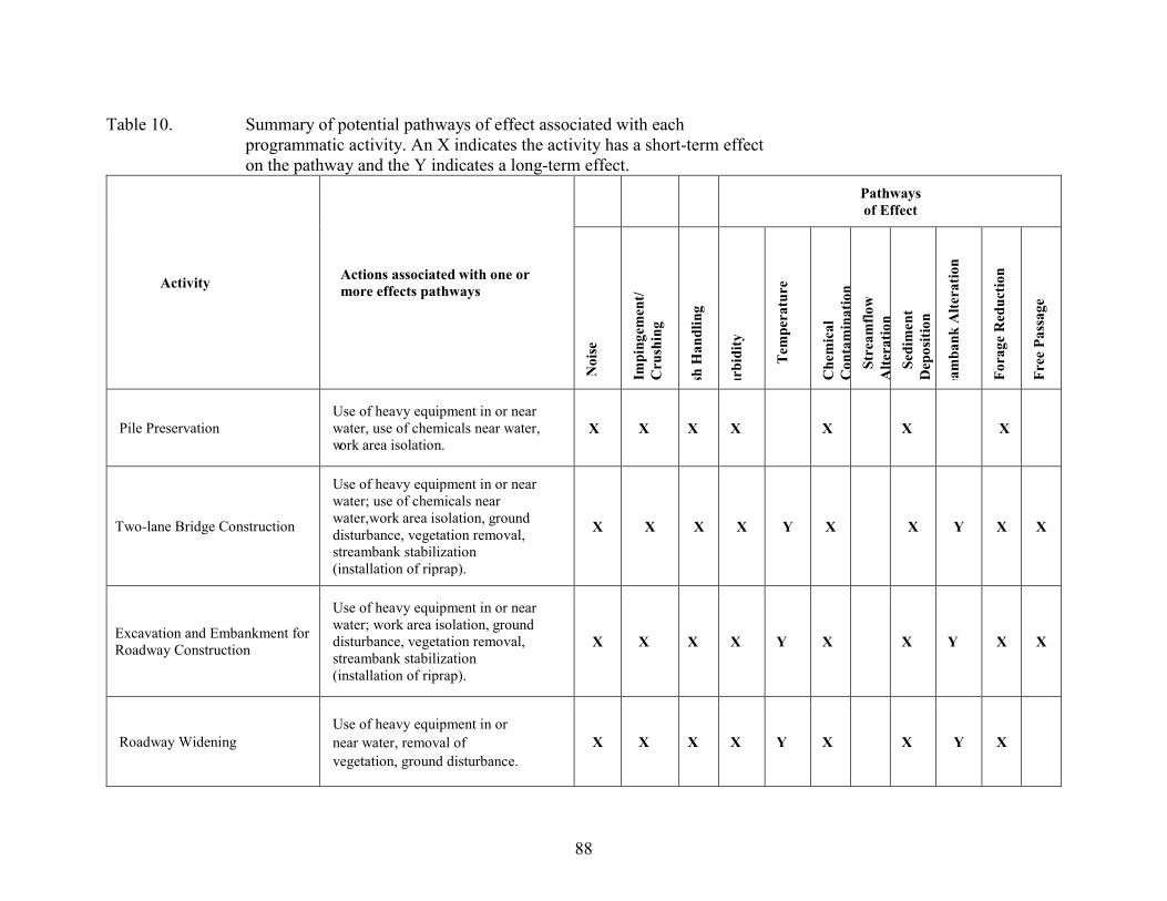
88
Table 10. Summary of potential pathways of effect associated with each programmatic activity. An X indicates the activity has a short-term effect on the pathway and the Y indicates a long-term effect.
Activity Actions associated with one or more effects pathways
Pathways of Effect
Noi
se
Impi
ngem
ent/
Cru
shin
g
sh H
andl
ing
urbi
dity
Tem
pera
ture
Che
mic
al
Con
tam
inat
ion
Stre
amflo
w
Alte
ratio
n Se
dim
ent
Dep
ositi
on
eam
bank
Alte
ratio
n
Fora
ge R
educ
tion
Free
Pas
sage
Pile Preservation Use of heavy equipment in or near water, use of chemicals near water, work area isolation.
X X X X X X X
Two-lane Bridge Construction
Use of heavy equipment in or near water; use of chemicals near water, work area isolation, ground disturbance, vegetation removal, streambank stabilization (installation of riprap).
X X X X Y X X Y X X
Excavation and Embankment for Roadway Construction
Use of heavy equipment in or near water; work area isolation, ground disturbance, vegetation removal, streambank stabilization (installation of riprap).
X X X X Y X X Y X X
Roadway Widening Use of heavy equipment in or near water, removal of vegetation, ground disturbance.
X X X X Y X X Y X
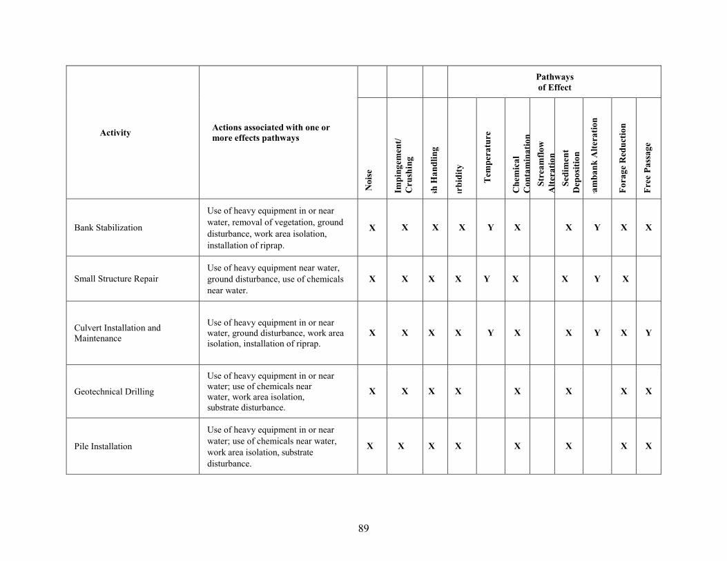
89
Activity Actions associated with one or more effects pathways
Pathways of Effect
Noi
se
Impi
ngem
ent/
Cru
shin
g
sh H
andl
ing
urbi
dity
Tem
pera
ture
Che
mic
al
Con
tam
inat
ion
Stre
amflo
w
Alte
ratio
n Se
dim
ent
Dep
ositi
on
eam
bank
Alte
ratio
n
Fora
ge R
educ
tion
Free
Pas
sage
Bank Stabilization
Use of heavy equipment in or near water, removal of vegetation, ground disturbance, work area isolation, installation of riprap.
X X X X Y X X Y X X
Small Structure Repair Use of heavy equipment near water, ground disturbance, use of chemicals near water.
X X X X Y X X Y X
Culvert Installation and Maintenance
Use of heavy equipment in or near water, ground disturbance, work area isolation, installation of riprap.
X X X X Y X X Y X Y
Geotechnical Drilling
Use of heavy equipment in or near water; use of chemicals near water, work area isolation, substrate disturbance.
X X X X X X X X
Pile Installation
Use of heavy equipment in or near water; use of chemicals near water, work area isolation, substrate disturbance.
X X X X X X X X
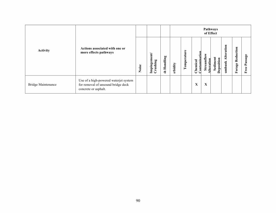
90
Activity Actions associated with one or more effects pathways
Pathways of Effect
Noi
se
Impi
ngem
ent/
Cru
shin
g
sh H
andl
ing
urbi
dity
Tem
pera
ture
Che
mic
al
Con
tam
inat
ion
Stre
amflo
w
Alte
ratio
n Se
dim
ent
Dep
ositi
on
eam
bank
Alte
ratio
n
Fora
ge R
educ
tion
Free
Pas
sage
Bridge Maintenance Use of a high-powered waterjet system for removal of unsound bridge deck concrete or asphalt.
X X
91
2.5.1.Noise
Noise from heavy equipment operating adjacent to live water may disturb fish in the immediate vicinity causing short-term displacement. Heavy equipment operation for multiple categories of activities, including geotechnical drilling, will create noise, vibration, and potentially water surface disturbance. Heavy equipment operation will only occur away from the stream channel, or in de-watered stream channels. Popper et al. (2003) and Wysocki et al. (2007) discussed potential impacts to fish from long-term exposure to anthropogenic sounds, predominately air blasts and aquaculture equipment, respectively. Popper et al. (2003) identified possible effects on fish including temporary, and potentially permanent hearing loss (via sensory hair cell damage), and masking of potentially biologically important sounds. Studies evaluated noise levels ranging from 115 to 190 decibels (dB). Wysocki et al. (2007) did not identify any adverse impacts on rainbow trout from prolonged exposure to three sound treatments common in aquaculture environments (115, 130, and 150 dB). In the studies identified by Popper et al. (2003) that caused ear damage in fishes, all evaluated fish were caged and thus incapable of moving away from the disturbance (NMFS 2012). Machinery operation adjacent to the stream will be intermittent in all cases. The FHWA (2008) indicates backhoe, grader, loader, and truck noise production ranging between 80 and 89 dB, and rock drilling noise production ranging 85 to 98 dB. Because the decibel scale is logarithmic, there is nearly a 60-fold difference between noise levels expected from programmatic actions and noise levels known to have generated adverse effects to surrogate species, as discussed above. Therefore, noise related disturbances of this magnitude are unlikely to result in injury or death. It is unknown if the expected dB levels will cause fish to temporarily move away from the disturbance or if fish will remain present. Even if fish move, they are expected to migrate only short distances to an area they feel more secure and only for a few hours in any given day. Each day fish are routinely disturbed by passing birds, walking mammals, and other fish. We do not anticipate that short-term movements caused by construction equipment or geotechnical drilling noise will result in effects different than those fish typically experience. The expected noise levels and level of disturbance will be minimal and should not result in harm. Noise from pile driving is also likely to impact fish in the immediate vicinity causing short-term displacement or injury. Pile driving may be necessary for two-lane bridge replacements, retaining walls (MSE walls), and positioning barges for bridge repair work. For bridge replacement projects, the new structure must be single-span, with the new abutments (potentially requiring pile driving) located above and behind the OHWM elevation on the existing channel side slope. To minimize the potential for adverse effects, all pile driving work will take place in dewatered work areas, during approved instream work windows. Because pile driving will not occur in-water, hydro-acoustic effects will be greatly reduced. However, sound from “dry” pile driving does travel through the substrate via “sound flanking” (Washington Department of Transportation [WSDOT] 2019). Although “dry” pile driving is not expected to result in sound pressure levels that reach the peak level threshold of 206 dBpeak determined to injure fish (California Department of Transportation [Caltrans] 2009), sound pressure levels may reach the fish disturbance threshold of 150 dBrms within the project area. For example, USFWS (2014a) found that sound pressure levels from “dry” pile driving for ITD’s Race Creek Bridge Project would reach the fish disturbance threshold up to 187 feet from the source and no harm or
92
mortality was anticipated. Potential behavioral effects include avoidance of the impact area, delays in migration, or difficulty in locating food resources (Caltrans 2015). To minimize the potential for adverse effects, all pile driving work will take place in dewatered work areas, during approved instream work windows. Caltrans (2015) reports that “Coffer dams that have been dewatered down to the mudline substantially reduce underwater pile driving sound. This is the best isolation that can be provided.” In addition, work will only occur in NMFS approved in-water work windows (Tables 1 and 2). Where applicable, other measures that may be used to minimize effects to fish from pile driving include the use of vibratory hammers,3 bubble curtains, smaller sized piles, and pile caps, limiting the number of pile strikes per day, and conducting pile driving only during daylight hours when fish are less likely to be migrating through the work area. Given these measures, pile-driving adverse sound effects are expected to be non-lethal and limited to sub-lethal disturbance of listed fish present in the vicinity of pile driving activities. Blasting may be used during the rock scaling project action and depending on the blasting location relative to the occurrence of listed fish, may disturb, injure, or kill fish through elevated sound pressure levels. However, under this Program, in-water blasting is not permitted, thereby greatly reducing potential effects. Furthermore, rock removal by blasting will only be allowed when labor methods are ineffective. The Contractor must submit a blasting plan to the Engineer for approval including: drilling and blasting patterns, timing and duration, and anticipated noise effects. Few activities requiring blasting are anticipated and no in-water blasting is allowed; therefore, blasting is not likely to kill or injure listed fish. When blasting does occur, nearby fish are expected to be displaced as they flee from the elevated sound pressure. Rearing juvenile salmon and steelhead will likely be displaced into similar habitat so minimal effect is expected. Blasting could delay migration of juvenile, adult salmon, and steelhead as they avoid blasting activities; however, time lapses between individual blasts will likely allow fish to pass safely and limit the delays to hours.
2.5.2.Riprap Placement
Placement of riprap or other material in a wetted channel with heavy equipment is reasonably certain to kill or injure fish. Adult fish will not be injured or killed by placing riprap in stream channels because they are capable of and likely to avoid project activities by readily swimming to other habitat either upstream or downstream of the disturbance. Given the proposed work windows, juvenile fall Chinook and sockeye salmon are not expected to be exposed to riprap placement. Juvenile fall Chinook salmon outmigration slightly overlaps with the beginning of the work windows; however, these fish will be actively out-migrating and would likely avoid any bank activity. Outmigration timing of sockeye salmon does not occur within the work window so juveniles should not be exposed to any activities. Juvenile spring/summer Chinook salmon and steelhead, on the other hand, may seek cover along stream margins within the wetted project area (rather than fleeing upstream or downstream) thereby exposing them to injury or death from 3 From Caltrans 2015: “Vibratory hammers generally produce less sound than impact hammers and are often employed as a mitigation measure to reduce the potential for adverse effects on fish that can result from impact pile driving. There are no established injury criteria for vibration pile driving, and resource agencies in general are not concerned that vibratory pile driving will result in adverse effects on fish.”

93
working equipment or placement of riprap. It is reasonable to conclude that juvenile salmon or steelhead may be crushed when heavy equipment is used to place riprap in the wetted channel of occupied habitat. For activities with riprap placement that include fish handling and work site isolation, the estimate of the number of juvenile spring/summer Chinook and steelhead4 killed by riprap placement is included in the stranding mortality estimate below (Table 11). Excavation and riprap placement will occur after fish handling and isolation. The mortality estimate for any fish remaining (i.e., stranded fish) after fish removal and work site isolation is 100 percent. Although stranded fish may survive dewatering by occupying a standing water pool, they will likely be killed by excavation equipment or riprap placement. However, that mortality has already been accounted for in the work site isolation stranded fish estimate 100 percent so it will not be considered in the riprap mortality estimate. Not all actions requiring riprap will be preceded by fish removal and worksite isolation. Therefore, NMFS has calculated lethal and non-lethal effects from riprap placement for juvenile steelhead and spring/summer Chinook for those actions. To do so, we made the following assumptions about the number of individuals likely to be present at a project site and about injury and death rates for excavation and riprap placement:
• A maximum of 10 project sites per year will involve the placement of riprap. No more than four projects per year will be implemented within a sub-basin (Table 8). Assuming 300-linear feet of wetted channel may be impacted at each site, and assuming the encroachment into the wetted channel is no more than 2 feet, a total of approximately 6,000 square feet of fish habitat may be impacted annually.
• Riprap sites will be in poor condition in terms of juvenile salmonid density. Many of the locations requiring bank stabilization have been previously riprapped. Stream habitat immediately adjacent to state highways is often altered by the roadway and floodplain encroachment. Therefore, NMFS believes that fish densities represented by poor habitat conditions represent the highest juvenile fish densities likely to occur in the stream reaches de-watered under this program.
• The following densities of fish are likely to be found in poor quality stream habitat in Idaho; 1.1 juvenile Chinook/100 square feet; 0.6 juvenile steelhead/100 square feet (Hall-Griswold and Petrosky 1996).
NMFS estimates that actions involving riprap placement will expose 66 juvenile SR spring/summer Chinook salmon and 36 juvenile steelhead to the risk of injury or death from crushing. Assuming that 50 percent of the fish present are able to flee unharmed, the placement of riprap will result in the death of 33 SR spring summer Chinook salmon and 18 steelhead juveniles (Table 11). The conservation measures in the proposed action should reduce the potential harm to individuals during riprap placement such that the risk of death is minimized. Adequate monitoring of the number of fish handled will be necessary to validate assumptions and to adaptively manage the programmatic consultation to reduce take levels over time. 4 Given the life histories of the species, combined with the timing of their migration and the in-water work windows, SR spring/summer Chinook salmon and SRB steelhead are most likely to be affected by activities requiring in-water work.
94
2.5.3.Fish Handling and Salvage
Fish salvage may be required when instream work areas need to be isolated and dewatered and fish do not move out of the work area on their own. Fish may be herded out of the work area or may be removed from an exclusion area as it is slowly dewatered using methods such as hand or dip-nets, seining, trapping with minnow traps (or gee-minnow traps), or electrofishing. These methods are described below. Dewatering of stream channels and associated fish-handling procedures to remove fish from these stream reaches will adversely impact individual juvenile salmon and steelhead. No adult salmon or steelhead, or sockeye salmon of any life-stage, are likely to be present during de-watering due the low-water instream work windows to be provided by NMFS. Juvenile fall Chinook are also not likely to be present at projects sites requiring de-watering (NMFS 2012). Dewatering will typically only be necessary for two-lane bridge replacements and culvert replacement projects. Fall Chinook in the action area occupy the mainstem Clearwater River, the lower mainstem Salmon River, and possibly larger tributaries of these two rivers. These rivers are all too wide for a two-lane bridge with a single-span structure. Culvert replacements may occur on small tributaries to the mainstem rivers occupied by fall Chinook, but such small tributaries do not provide habitat for rearing juvenile fall Chinook. Furthermore, most juvenile fall Chinook will have already out-migrated; those remaining will be in the process of migrating. Outmigration timing of sockeye salmon does not occur within the work window so juveniles should not be exposed to any activities. Thus, only juvenile steelhead and spring/summer Chinook salmon are likely to be present at project sites requiring de-watering and to experience negative impacts. If fish handling is required, it will be done by either electrofishing before de-watering or hand netting or trapping during or after dewatering. Qualified personnel with appropriate training and experience will conduct all fish handling. Expected effects from stream dewatering, and the capture, handling, transport, and release of ESA-listed fish will strand some fish, disrupt normal behavior, and cause short-term stress, injury, and occasional mortality. However, the number of fish expected to be handled during the term of the programmatic is very low. Post Construction Reports show that between 2010 and 2020 fish were handled during implementation of only two projects: Kid Creek Culvert Replacement (2014) and West Fork Potlatch Bridge Replacement (2020). During the Kid Creek project 80 to 100 unidentified trout and sucker species 2 – 4 in. in length were netted and released downstream (no ESA-listed fish were positively identified). During the West Fork Potlatch River project, 122 fish were handled including one listed steelhead. This information indicates that the probability of capturing and handling ESA-listed species during fish salvage is very low, with only one listed fish captured and identified during 10 years of programmatic implementation. Given these considerations, we determine that although fish handling and salvage will potentially affect listed salmonids, the number of fish affected will be very low; effects at the watershed or population level will be very minor.
95
2.5.3.1. Hand-netting (including dip-netting, seining, and trapping) At some project sites requiring dewatering of a stream reach, fish will be removed from the stream reach by netting or trapping, if they do not move out of the work isolation area on their own. This may cause some stress and harm. Capturing and handling fish causes them stress, though they typically recover fairly rapidly from the process. Types of stress likely to occur during project implementation include increased plasma levels of cortisol and glucose (Frisch and Anderson 2000; Hemre and Krogdahl 1996, as cited in NMFS 2012). Even short-term, low intensity handling may cause reduced predatory avoidance for up to 24 hours (Olla et al. 1995). The primary contributing factors to stress and death from handling are differences in water temperatures (between the river and wherever the fish are held), dissolved oxygen conditions, the amount of time that fish are held out of the water, and physical trauma. Stress on salmonids increases rapidly from handling if the water temperature exceeds 64.4°F or dissolved oxygen is below saturation. Fish that are transferred to holding tanks can experience trauma if care is not taken in the transfer process. All handled fish will be held in 5-gal buckets filled with stream water for a period only long enough to transport fish to an appropriate release site immediately upstream of the individual project sites. Buckets will be placed into the water and slowly inverted to allow captured fish to move into the selected release sites. Alternatively, netted fish may be placed back in the water upstream of the project site without delay or handling. Handling fish in this manner is likely to minimize the potential stress fish experience (NMFS 2012). Despite measures to limit impacts to listed salmonids, individuals will be adversely affected by hand netting and trapping. However, because programmatic monitoring reports show only one ESA-listed fish (i.e., steelhead) was identified during fish handling and salvage for one project during 10 years of BA implementation, the anticipated number of listed fish affected by this action netting is expected to be very low. 2.5.3.2 Electrofishing The effects of electrofishing on juvenile steelhead and spring/summer Chinook salmon will consist of the direct and indirect effects of exposure to an electric field, capture by netting, and handling associated with transferring the fish back to the river (described above). Most of the studies on the effects of electrofishing have been conducted on adult fish greater than 12 in. in length (Dalbey et al. 1996). The few studies that have been conducted on juvenile salmonids indicate that spinal injury rates are substantially lower than they are for large fish (NMFS 2012). Smaller fish intercept a smaller head-to-tail potential than larger fish (Sharber and Carothers 1988) and may therefore be subject to lower injury rates (Dalbey et al. 1996; Thompson et al. 1997). McMichael et al. (1998) found a 5.1 percent injury rate for juvenile middle Columbia River steelhead captured by electrofishing in the Yakima River sub-basin, while Ainslie et al. (1998) reported injury rates of 15 percent for direct current applications on juvenile rainbow trout. The incidence and severity of electrofishing damage is partly related to the type of equipment used and the waveform produced (Sharber and Carothers 1988; Dalbey et al. 1996; Dwyer and White 1997). Continuous direct current of low-frequency (equal or less than 30 Hz) pulsed direct current have been recommended for electrofishing because lower spinal injury rates occur with these waveforms (Dalbey et al. 1996; Ainslie et al. 1998). Only a few recent studies have examined the long-term effects of electrofishing on salmonid survival and growth (Ainslie
96
et al. 1998; Dalbey et al. 1996). These studies indicate that although some of the fish suffer spinal injury, few die as a result. However, severely injured fish grow at slower rates and sometimes show no growth at all (Dalbey et al. 1996). As explained above, electrofishing will be conducted by qualified personnel with appropriate training and experience, who will follow standard guidelines (NMFS 2000) that will minimize the levels of stress and mortality related to electrofishing. For example, field crews will be trained in observing animals for signs of stress and shown how to adjust electrofishing equipment to minimize that stress. Although McMichael et al. (1998) indicated electrofishing injury rates for wild salmonids were only 5 percent, we assume a more conservative injury rate of 25 percent (Nielson 1998) of the total number of fish electro-fished to account for variable site conditions and experience levels (NMFS 2012). However, because programmatic monitoring reports show only one ESA-listed fish (i.e., steelhead) was identified during fish handling and salvage for one project during 10 years of BA implementation, the anticipated number of listed fish affected by electrofishing is expected to be very low. NMFS has estimated potential lethal and non-lethal effects from fish handling for juvenile steelhead and spring/summer Chinook. To do so, we made the following assumptions about the number of individuals likely to be present at a project site and about injury and death rates for different fish handling methods. These assumptions lead to the calculations presented in Table 11.
• A maximum of 20 project sites per year will involve de-watering of stream reaches and handling and removal of individual ESA-listed fish from these stream reaches. An estimated maximum of six of these projects per year will be bridge replacements.
• The typical area of stream channel that would be dewatered at each bridge replacement project will be approximately 100 feet in length by 50 feet in width (25 feet in width for each pier of the old bridge). This amounts to an estimated 5,000 square feet of stream channel at each bridge, and approximately 30,000 square feet for all bridge projects per year. The typical area of stream channel to be dewatered at all other projects is based on assumptions made by NMFS for a similar programmatic culvert replacement action (NMFS 2006b), approximately 130 feet in stream length by 8 feet in bankfull width. This amounts to approximately 1,040 square feet of stream channel at each project site and 14,560 square feet for all non-bridge-replacement projects per year. Total dewatered area per year for all projects would thus be approximately 44,560 sq. ft.
• The juvenile salmonid habitat to be dewatered is generally in poor condition because it is immediately adjacent to state highways and is often altered by the roadway and floodplain encroachment. Additionally, the sites identified for dewatering are likely to be very shallow or dry at the time of dewatering. Therefore, NMFS believes that fish densities represented by poor habitat conditions represent the highest juvenile fish densities likely to occur in the stream reaches dewatered under this program.
• The following densities of fish are likely to be found in poor quality stream habitat in Idaho: 1.1 juvenile Chinook/100 square feet and 0.6 juvenile steelhead/100 square feet (Hall-Griswold and Petrosky 1996).
• 70 percent of individual fish in the dewatered areas will be captured by nets (based on USFWS 2004—an opinion for a similar action in Oregon and Washington).

97
• Of the remaining individuals, 50 percent will be captured through electrofishing (Peterson et al. 2004).
• Electrofishing will injure 25 percent of fish captured (Nielson 1998) and kill 5 percent of fish captured (Hudy 1985; McMichael et al. 1998).
• Many of the remaining fish will be collected with nets out of pools as the stream reach is slowly dewatered, but up to half may be stranded in the de-watered reach and die (7.5 percent of total fish in the stream reach before handling).
• Species and life-stages occupying dewatered stream reaches during project implementation will include juvenile spring/summer Chinook and juvenile steelhead.
Table 11. Estimatesfor the number of fish across the actions that will be disturbed,
injured, or killed from netting, electrofishing, de-watering, and riprap placement as a result of annual implementation of the proposed action.
Spring/summer Chinook Juveniles Steelhead Juveniles
Maximum # of projects to handle fish per year 20 20
Maximum # of fish in dewatered stream reaches 446 258
Maximum # of fish injured by electrofishing per year 17 10
Maximum # of fish potentially killed by electrofishing per year (also included in injury total) 3 2
Maximum # of fish killed by stranding 34 19
Maximum # of fish killed by riprap placement in activities not preceded by fish handling 33 18
Maximum total # of fish killed per year 70 39
As shown in Table 11, NMFS estimates that the proposed action will result in the capture, handling, transport, or stranding of a maximum of 446 juvenile SR spring/summer Chinook salmon and 258 juvenile SRB steelhead per year, with far fewer fish handled in most years of the 10-year programmatic action. This handling is likely to result in various levels of harm, stress, injury, or death. The conservation measures in the proposed action should reduce the potential harm to individuals during capture and transport such that the risk of injury and death is minimized. Adequate monitoring of the number of fish handled will be necessary to validate assumptions and to adaptively manage the programmatic consultation to reduce take levels over time.

98
In total, NMFS estimates that the proposed action is likely to directly result in the death of up to 70 juvenile spring/summer Chinook salmon and 39 juvenile steelhead per year (with far fewer fish killed in most years of the programmatic action), through electrofishing, placement of riprap, and stranding in dewatered stream reaches. NMFS further estimates that the proposed action will directly injure up to 17 juvenile spring/summer Chinook salmon and up to 10 juvenile steelhead per year through electrofishing. To aid in our jeopardy analysis, NMFS converted the number of juvenile spring/summer Chinook or steelhead potentially killed or injured to the number of adult equivalents potentially killed or injured per year by the proposed action. To convert the juvenile mortality and injury numbers to an estimate of the number of returning adults potentially lost or showing reduced fitness per year, NMFS made the following reasonably conservative assumptions:
• 50 percent parr-to-smolt survival for both spring/summer Chinook salmon and steelhead (Hall-Griswold and Petrosky 1996).
• 0.68 percent smolt-to-adult returns for spring/summer Chinook salmon (Arthaud and Morrow 2007).
• 0.65 percent smolt-to-adult returns for steelhead (Arthuad and Morrow 2007). • For both species, mortalities will be evenly distributed across all populations in the action
area. Ten spring/summer Chinook populations and 12 steelhead populations overlap with state highways.
Applying these assumptions, the estimated 70 juvenile spring/summer Chinook and 39 juvenile steelhead that may be killed through fish handling or riprap placement per year translate to 0.24 fewer returning Chinook adults and 0.13 fewer returning steelhead adults per year for each population in the action area. The estimated 17 juvenile spring/summer Chinook and 10 juvenile steelhead that could be injured each year translate to 0.06 spring/summer Chinook adults and 0.03 steelhead adults per population per year with potentially reduced fitness. Because most years of this programmatic action will likely see far fewer than 20 projects requiring fish handling, NMFS expects much less adult-equivalent mortality and reduced fitness than these estimates in most years. Of the four VSP parameters, fish handling could affect abundance and productivity. NMFS does not consider the potential loss of a small fraction of one adult steelhead and one adult spring/summer Chinook salmon from a single year class to be a significant reduction in abundance for a population of either species, given current population abundance levels. Likewise, this potential loss of a fraction of an adult fish per population will have an insignificant effect on productivity. At the time of listing in 1997, the 5-year geomean abundance for natural-origin steelhead passing Lower Granite Dam, which includes all but one population in the DPS, was 11,462 adults (Ford 2011). Abundance began to increase in the early 2000s, with the single year count and the 5-year geomean both peaking in 2015 at 45,789 and 34,179, respectively (ODFW and WDFW 2021). Since 2015, the numbers have declined steadily with only 9,634 natural-origin adult returns counted for the 2020-run year (ODFW and WDFW 2021). Felts et al. (2020) estimates that current 5-year mean (2015-2019) spawner abundance for spring/summer Chinook populations with state highways (those highlighted in Table 4 above) ranges from 54 to 291 adult spawners per year. The loss of 0.13 to 0.24 adult fish per year is not
99
large enough to impact steelhead and spring/summer Chinook populations, respectively, at their current abundances.
2.5.4.Water Quality-related Effects on Fish
Reductions in water quality from programmatic actions could affect juvenile salmon and steelhead. The proposed action is likely to degrade water quality through additions of suspended sediment to the water column, increases in stream temperatures, or chemical contamination. All near-stream ground disturbing activities and in-stream work have the potential to create increased levels of suspended sediment in the water column. Water quality is also likely to be adversely affected by increases in temperature caused by clearing riparian vegetation. Chemical contamination could occur any time heavy construction equipment is being used within or adjacent to the stream channel, or from stormwater runoff from new hardened surfaces (e.g., passing lanes and turnouts). 2.5.4.1. Suspended Sediment Fish exposed to elevated turbidity levels may be temporarily displaced from preferred habitat or could potentially exhibit sub-lethal responses such as gill flaring, coughing, avoidance, and increases in blood sugar levels (Bisson and Bilby 1982; Sigler et al. 1984; Berg and Northcote 1985; Servizi and Martens 1991), indicating some level of stress (Bisson and Bilby 1982; Berg and Northcote 1985; Servizi and Martens 1987). The magnitude of these stress responses is generally higher when turbidity is increased and particle size decreased (Bisson and Bilby 1982; Servizi and Martens 1987; Gregory and Northcote 1993). The most critical aspects of sediment-related effects are timing, duration, intensity and frequency of exposure (Bash et al. 2001). Depending on the level of these parameters, turbidity can cause lethal, sub-lethal, and behavioral effects in juvenile and adult salmonids (Newcombe and Jensen 1996). Although turbidity may cause stress, Gregory and Northcote (1993) have shown that moderate levels of turbidity (35 to 150 NTUs) accelerate foraging rates among juvenile Chinook salmon, likely because of reduced vulnerability to predators (camouflaging effect). Turbidity and fine sediments can alter trophic levels, reduce substrate oxygen, smother redds, and damage gills, among other deleterious effects (Spence et al. 1996). BMPs included as part of the proposed action are intended to minimize sediment delivery to stream habitat but cannot prevent all sediment due to the nature of the in-channel work. Adult sockeye salmon and juvenile spring/summer Chinook salmon, fall Chinook salmon, and steelhead may experience short-term adverse effects as a result. Substrate may inadvertently fall from excavation equipment buckets or accidentally be pushed over road or bank edges while working in close proximity to the stream channel during site preparation or during structure repair, replacement, or installation (e.g., culverts, bridges). Rain events during and following construction activities may also result in mobilization of disturbed soils resulting in stream delivery, even with sediment control measures in place (Foltz and Yanosek 2005). Rewatering of dewatered stream reaches is likely to mobilize sediment in areas disturbed by project activities, such as removal of old bridge piers and abutments. However, BMPs included in the proposed action will minimize the risk of sediment entering streams. BMPs to reduce the likelihood and intensity of sediment plumes include sediment
100
barriers between ground disturbance and the stream channel, and dewatering of streams and low-water work windows in cases where in-stream project activity is unavoidable. Sediment barriers will be placed around potentially disturbed sites where needed to prevent sediment from entering a stream directly or indirectly. An adequate supply of erosion control materials (e.g., fiber wattles or silt fences) will be on site to respond to emergencies and unforeseen problems. No machinery will enter live water. For bridge replacements, a barrier will be placed between the old bridge pier and live water to catch any falling debris during removal of the pier. Ground disturbance will not occur during or immediately after rain events or when precipitation events are imminent. Disturbances are thus likely to be of short duration because only small amounts of sediment will infrequently be introduced to the stream channel. Furthermore, turbidity will be monitored during project construction in order not to exceed Idaho State Water Quality Standards. NTU measurements will be taken 100 feet above and below discharge points, or as directed by appropriate resource agency or ITD personnel. State Water Quality Standards require that turbidity not exceed background levels by more than 50 NTUs instantaneously or more than 25 NTUs for more than 10 consecutive days, however this level of turbidity may still adversely affect listed salmonids. Many studies (e.g., Newcombe and Jensen 1996) report the effects of suspended sediment on fish, rather than turbidity. Turbidity and suspended sediment are correlated, but this correlation can vary by watershed and even within the same watershed (Henley et al. 2000). According to Newcombe and Jensen (1996), salmonids exposed to suspended sediment concentrations of 173 mg, l for one hour are likely to be negatively impacted as expressed by minor physiological stress, increased coughing, increased respiration, and reduced feeding rate. Therefore, we expect that juvenile salmon and steelhead within 600 feet (the expected extent of significant suspended sediment or turbidity [USFWS 2009a]) downstream of instream work to be adversely affected by increases in suspended sediment or turbidity. Monitoring to ensure that State Water Quality Standards are met will minimize but not eliminate the potential for adverse effects. Based on similar past projects, NMFS expects that any resulting sediment plumes associated with the proposed action should be limited to 1,600 feet or less per project and should dissipate within a few minutes to hours at any given project site (Casselli et al. 2000; Jakober 2002; USFS 2005; and USFS 2007b). Affected streams are likely to quickly return to background suspended sediment levels considering the expected small volume of sediment likely to be introduced (Casselli et al. 2000; Jakober 2002). Juvenile fish will likely respond to a turbidity plume for this distance along the streams edge by avoiding the plume and temporarily seeking alternate rearing areas. Migrating adult sockeye salmon could also be exposed to turbidity plumes; however, they migrate in larger rivers and are able to easily avoid plumes by moving to less turbid portions of the river channel. Fish present downstream from Program activities are thus expected to be able to avoid or reduce their exposure to turbidity by swimming to adjacent, less turbid habitat (i.e., behavioral response only). However, take, in the form of harming fall Chinook salmon, spring/summer Chinook salmon, and steelhead juveniles, is still likely to occur as a result of increased turbidity, as exposure of juveniles to predators will likely increase as they seek alternate rearing habitat. NMFS is unable to quantify the amount of harm to juveniles from exposure to project-related turbidity, but the amount is likely to be extremely low due to the avoidance responses explained above.
101
2.5.4.2. Temperature The proposed action is likely to reduce streamside shade through the removal of vegetation. Reductions in shade can increase the amount of solar radiation reaching the stream surface and lead to increases in steam temperatures. Elevated water temperatures may adversely affect salmonid physiology, growth, and development, alter life history patterns, induce disease, and may exacerbate competitive predator-prey interactions (Spence et al. 1996). As described in the proposed action, individual projects will be designed to preserve existing vegetation. In instances where riparian shrubs are removed during construction, vegetation will be replanted. Activities completed under this programmatic consultation will occur on existing state and local highways where much of the vegetation has already been removed; therefore, additional riparian vegetation removal is expected to be minimal and have only minor and localized effects on stream shade (NMFS 2012). 2.5.4.3. Chemical Contamination Use of construction equipment and heavy machinery adjacent to stream channels poses the risk of an accidental spill of fuel, lubricants, hydraulic fluid, or similar contaminants into the riparian zone, or directly into the water. If these contaminants enter the water, these substances could adversely affect habitat, injure or kill aquatic food organisms, or directly impact ESA-listed species. Petroleum-based contaminants such as fuel, oil, and some hydraulic fluids contain polycyclic aromatic hydrocarbons (PAHs), which can cause chronic sub-lethal effects to aquatic organisms (Neff 1985). Ethylene glycol, the primary ingredient in antifreeze, has been shown to result in sub-lethal effects to rainbow trout at concentrations of 20,400 mg/L (Beak Consultants Ltd., 1995 as cited in Staples 2001). Brake fluid is also a mixture of glycols and glycol ethers, and has about the same toxicity as antifreeze. Although all projects will require heavy machinery, equipment will not enter flowing water, which limits the potential for chemical contamination to occur. Furthermore, multiple BMPs are included in the Program aimed at minimizing the risk of fuel or oil leakage into the stream. A spill prevention and contingency plan will be prepared by the construction contractor and approved by ITD for each project prior to implementation. All staging, fueling, and storage areas will be located away from aquatic areas. Fuel spill and equipment leak contingencies and preventions included in the BA should be sufficient to minimize the risk of sub-lethal effects to ESA-listed fish and fish habitat from toxic contamination related to accidental spills (NMFS 2012) and the potential effects are expected to be limited to a few fish. The proposed action would create a limited amount of new pollutant-generating, impervious surfaces, such as passing lanes and turnouts. The proposed action does not include activities that would result in indirect effects, such as increased growth or roads that would accommodate new and increased traffic. Stormwater runoff from existing highway systems deliver a variety of chemical and sediment pollutants to streams via rain (USFWS 2014b). Highways can provide routes for microplastics, persistent bio-accumulative toxicants (PBTs, e.g. polychlorinated biphenyls (PCBs), polybrominated diphenyl ethers (PBDEs), and PAHs), and metals (e.g. copper, chromium, and zinc) into waterways. PBTs often bind to sediments and are typically found in diverse mixtures in aquatic environments along with a broad range of pesticides, nutrients, and metals, (Johnson et al. 2006; Laetz et al. 2009; Baldwin et al. 2009; Johnson et al.

102
2013). PBTs may cause neurological and developmental disorders, oxidative stress, weakened immune systems, and may cause mortality of invertebrates and fish in aquatic ecosystems (Soto et al. 1994; Major et al. 2020; WDOE 2021). PBTs are often found in mixtures together with a broad range of PAHs and metals, to which PBTs readily bind and interact, often-increasing toxicity and mobility. PAHs can be derived from petroleum products, incomplete combustion of fossil fuels, and asphalt sealants (WDOE 2021). Accumulation of PAHs can increase disease susceptibility in juvenile rainbow trout (Bravo et al. 2011) and Chinook salmon (Arkoosh et al. 2011). Tire tread wear particles (TWP) have recently been shown to cause acute mortality in juvenile (Tian et al. 2020) and adult (McIntyre et al. 2021) coho salmon. Highways and roads with higher speed limits and increased exposure produced vastly more TWP because vehicles produce their own buffeting winds and tire tread wears at much greater rates (Brahney et al. 2021). The primary causal toxicant in TWP is 6PPD-quinone, a tire protectant additive. In the Puget Sound, Washington, acute mortality of adult coho salmon occurs following rain events and the rate is correlated with road density (Feist et al. 2017). However, adult chum salmon appear to be insensitive to TWP leachate (McIntyre et al. 2021). The effects of TWP to Chinook salmon, sockeye salmon, and steelhead is unknown. Research has shown that dissolved copper and other metals found in stormwater runoff from roadways (derived from the copper in vehicle brake pads) can impair salmonid olfactory senses (Brooks 2004, as cited in USFWS 2014b). Copper bio-accumulates in invertebrates and fish (Feist et al. 2005; Layshock et al. 2021), is redox-active, and interacts with or alters many compounds in mixtures (Gauthier et al. 2015). Copper-PAH mixtures, which synergistically interact are highly toxic through several exacerbating mechanisms: copper weakens cell membranes increasing absorption of PAHs, copper chelates or hastens and preserves the bio-accumulative toxicity of PAHs; and PAHs in turn increase the bio-accumulative and redox properties of Copper (Gauthier et al. 2015). Sub-lethal effects of copper include avoidance at very low concentrations (Hecht et al. 2007) and reduced chemosensory function at slightly higher concentrations, which in turn causes maladaptive behaviors, including inability to avoid copper or to detect chemical alarm signals (McIntyre et al. 2012). Copper concentrations typically increase during spring-summer high flows when migrating juvenile salmonids are most actively feeding and growing at greatest rates (NMFS 2014). Appreciable adverse effects can be expected with increases as small as 0.6 µg/L above background concentrations (NMFS 2014). However, only three tributaries in the action area are listed Category 5 (i.e. do not meet water quality standards) for copper (IDEQ 2020). Chromium (Cr) is a redox-active metal, causing oxidative stress and oxidative-induced alterations of DNA in fish and other aquatic organisms (Eisler 1986; Sevcikova et al. 2011). Hook et al. (2006) found that Cr VI (an oxidized state of Cr) caused oxidative stress in rainbow trout. Toxicity and uptake of Cr VI is increased in conditions of pH 7.8 and lower, low DOC, and low hardness (Vanderputte et al. 1981; Eisler 1986), which exist in the action area. Comprehensive reviews show that chromium is taken up by fish and aquatic organisms through the gastrointestinal tract, respiratory tract, and the skin (Eisler 1986; Farag et al. 2006; Sevcikova et al. 2011; Bakshi and Panigrahi 2018). Chromium was the second most frequent metal to exceed Threshold Effect Concentrations in sediments of the Clearwater River and its

103
concentrations are likely to contaminate prey (e.g., amphipods, daphnids) in oligotrophic water released from Dworshak Reservoir. Chromium concentrations in some portions of the action area may cause behavioral avoidance by listed salmonids. Dietary uptake of Cr VI may cause chronic sub-lethal toxicity in juvenile salmonids and is likely to increase the toxic and absorptive properties of PBTs and other metals. However, stormwater discharges of chromium make small contributions to the degraded water and sediment quality in the lower Clearwater River, and likely throughout the action area. Zinc interacts with many chemicals and aquatic conditions of reduced pH and dissolved oxygen, low DOC, and elevated temperatures increase zinc toxicity, causing altered patterns of accumulation, metabolism, and toxicity (Eisler 1993; Farag et al. 1998). Many aquatic invertebrates and some fish may be adversely affected from ingesting zinc-contaminated particulates (Farag et al. 1998). In freshwater fish, excess zinc affects the gill epithelium, which leads to internal tissue hypoxia, reduced immunity, and may acutely include osmoregulatory failure, acidosis, and low oxygen tensions in arterial blood (Eisler 1993). Toxicity of zinc mixtures with other metals is mostly additive; however, toxicity of zinc-copper mixtures is more than additive (or synergistic) for freshwater fish and amphipods (Skidmore 1964; de March 1988). Sediments of the lower Clearwater River contain loads of zinc at concentrations that are likely to reduce and contaminate prey and cause chronic sub-lethal toxicity in juvenile salmonids and increase toxic and absorptive properties of PBTs and other metals. However, no rivers or streams in the action area are listed for zinc under CWA section 303(d) (IDEQ 2020) so exposure to zinc is expected to be minimal. Accordingly, it is likely that listed salmonids would be adversely impacted by water quality changes due to stormwater runoff, spills, other contaminant events and increased turbidity. Adult and juvenile salmon and steelhead may be exposed during migration. The risk from exposure is greatest during low flow periods when water quality tends to be poor and temperatures are higher; however, stormwater discharge is least likely during this time of year due to lower rainfall (USFWS 2014b). When properly designed, installed, and maintained, control measures and the associated BMPs improve stormwater quality (USEPA 2020; IDEQ 2020a). Structural stormwater BMPs are engineered, designed, and built to collect and treat stormwater runoff, usually by reducing flow rates, removing pollutants, or both. Structural BMPs include extended retention and detention basins, silt fences, gravity separators, rocky swales, vegetated buffers, and other designs. Green infrastructure BMPs use plant or soil systems, stormwater harvest and reuse, landscaping, or other planned designs to reduce velocity, increase filtration and infiltration. Pile preservation includes cleaning, repairing and installing a complete preservation system to existing steel or reinforced concrete bridge piles located partially or entirely below the OHWM. Treatments conducted below the OHWM may have significant effects to listed salmonids through increases in suspended sediment or turbidity, elevated pH levels, and the potential introduction of lead, cadmium, and chromium. Prior to preservation treatments, the piles will require cleaning, which has the potential to introduce lead-based paint flakes or heavy metal (cadmium or chromium) into the water. Heavy metals accumulate in the tissues of fish and become toxic if levels become too high. Absorption of metals occurs primarily through the gills and digestive track. Pile preservation treatments are expected to cause sub-lethal effects, which
104
may reduce growth and fitness by accumulated metals and avoidance of these activities. Once absorbed, heavy metals activate energy-consuming detoxification processes; thus, less energy can be used for growth. However, these treatments will include installation of turbidity curtains and turbidity and pH monitoring. In addition, the Contractor will test the piles for lead and heavy metals prior to cleaning. If present, the Contractor will submit a Lead and Heavy Metal Debris Containment and Recovery Plan that will include the use of an underwater vacuum to collect contaminated material. The Lead and Heavy Metal Debris Containment and Recovery Plan is in addition to the turbidity curtain installation. The Contractor will collect and dispose of waste material containing lead, chromium, and cadmium in strict compliance with all applicable Federal, State and local laws, codes, rules and regulations. These BMPs will minimize but not eliminate the potential for adverse effects to listed salmonids when pile preservation treatments are conducted in occupied habitat. 2.5.4.4. Streamflow Alteration The proposed action has the potential to alter streamflow through withdrawing water for road maintenance activities (e.g. hydro-demolition). Withdrawing water from small streams during times of drought can reduce flows, potentially impacting redds in shallower habitat or confining fish into diminished habitat. Drafting of water from streams using portable pumps or water tenders can disrupt essential feeding, breeding, or sheltering of juvenile and adult fish resulting in decreased fitness and exposing fish to predation. Decreased flows over redds can kill eggs and decrease egg to fry survival. Water drafting occurs during late summer and fall, during the defined work window, when flows are generally at their lowest levels. Water withdrawals for road maintenance purposes are expected to be infrequent and are expected to remove only a small portion of the total volume of water at any given time. For example, most water tenders have a capacity of between 1,000 and 4,000 gallons and pump at a flow rate of between 200 and 300 gallons per minute (0.45 – 0.67 cubic feet per second). Most state highway projects are located adjacent to larger rivers (e.g. Salmon and Clearwater rivers) so water withdrawals would likely occur from those rivers. Effects of temporary flow reductions will be minimized by using potable water for hydro-demolition activities, when feasible. However, when necessary, water may be pumped from other sources if the following conditions are met: (1) The source does not exceed IDEQ water quality thresholds for turbidity, pH or other chemicals that are toxic to aquatic organisms; (2) The Contractor obtains required permits from IDWR; and (3) Minimum streams flows recommended by IDFG are not exceeded. 2.5.4.5. Free Passage Adverse environmental baseline conditions that have been caused by preexisting transportation infrastructure and its operation and maintenance (e.g., obstructed fish passage, untreated stormwater runoff, and disconnected floodplains) still exist throughout the action area. Although fish passage barriers continue to be replaced, access to historical habitats in several tributary reaches of the Salmon and Clearwater River systems remains blocked or impaired. Barriers to fish passage include culverts that can prevent returning adults from accessing upstream spawning habitat, and juvenile fish from migrating up or down stream. Some activities, primarily culvert replacements, will improve fish passage through culverts and improve ecological connectivity between streams and floodplains or better longitudinal connectivity (up and downstream).
105
Proper road drainage upgrades and culvert replacements likely diminish the potential adverse effects of roads, including turbidity, sedimentation, by allowing drainage design features to work properly. Removing fish passage barriers and restoring hydrologic function will be beneficial in the long-term. Thousands of human-made barriers block passage to thousands of miles of freshwater spawning and rearing habitat in the Columbia River basin. Any contribution to reducing this number of passage barriers will have long-term benefits to salmonid productivity. These projects will allow or improve access to habitat. In addition, they can improve connectivity to the floodplain and improved movement of sediment and large wood, thus improving the quality of existing habitat. Access can lead to increased spawning and rearing success, and can improve growth and condition of fish (improved movement of fish and prey), leading to improved survival. When upstream spawning habitat is made available, passage restoration will improve spatial structure and possible abundance and productivity. However, it is anticipated that only a small number of impassable culverts will be replaced through the term of the program; therefore, improvements to population level abundance, productivity, and survival are expected to be small and limited to a reach-scale.
2.5.5.Habitat-related Effects on Fish
Implementation of programmatic actions may adversely affect habitat conditions within the action area, affecting habitat suitability for spawning, rearing, and migrating ESA-listed salmonids. Near and in-stream ground disturbance is likely to increase in-channel sediment deposition and have short-term effects on listed fish. Excavation at project sites and bank stabilization may alter streambank conditions and effect fish both in the short and long terms. 2.5.5.1. Sediment Deposition The pathways for sediment introduction to the stream channel were described in the suspended sediment discussion above. The same suite of BMPs proposed to reduce the potential for suspended sediment will likewise minimize the potential for in-channel sediment deposition. The potential effects of sediment deposition on fish habitat, and subsequently on individual fish, include smothering of redds and spawning gravels, changes to primary and secondary productivity, and reduction of available cover for juveniles. Egg-to-emergence survival and size of alevins is negatively affected by fine sediment intrusion into spawning gravel (Young et al. 1991). Fine sediment deposition in spawning gravel reduces the oxygen supply rate to redds (Wu 2000). However, female salmonids displace fine sediment when they dig redds, cleaning out the gravel and increasing permeability and interstitial flow (Kondolf and Wolman 1993). Given the small level of sediment likely to be introduced to streams from project activities with proposed sediment control BMPs, the process of digging a redd will likely displace most of this sediment (NMFS 2012). Furthermore, it is extremely unlikely that redds will be present within any work site during the work period due to the proposed instream work windows. Thus, sedimentation is not expected to directly affect incubating eggs or alevins (NMFS 2012). However, post-construction rains and instream flows may result in the discharge of fines into spawning and rearing areas until disturbed areas are fully stabilized; programmatic actions will have short-term adverse effects to substrates.
106
Fine sediment deposition also has the potential to adversely affect primary and secondary productivity (Spence et al. 1996; Suttle et al. (2004) found that increases in fine sediment concentration led to a change from aquatic insects available to salmonids (i.e., surface grazers and predators) to unavailable burrowing species. However, due to the BMPs included in the action to minimize sediment delivery to streams, it is expected that any effects to primary production will be minimal and short term (hours to days) for each project. Finally, fine sediment delivery to streams can reduce cover for juvenile salmonids (Bjornn and Reiser 1991). Fine sediment can fill pools as well as interstitial spaces in rocks and gravels used by fish for thermal cover and for predator avoidance (Waters 1995). Although juvenile cover could be adversely affected in the short term within the affected stream reaches, few projects will require in-water work and the anticipated effectiveness of proposed erosion control measures are expected to limit the amount of sediment generated and deposited on instream sediments. NMFS expects that juvenile cover will be affected in the short term within the affected individual 1,600-foot stream reaches; but that habitat quality will then recover as fine sediments are flushed downstream during high flows after project completion. Furthermore, it is expected that project-related sediments introduced into the stream channel will be a much smaller amount than the annual sediment budget of a watershed, such that sediment impacts from the Program will be unmeasurable at the watershed-scale (NMFS 2012). The duration of construction required to complete each activity will normally be less than one year although significant bridge repair or replacement projects may require two or three years to complete, and three to four years of upland work to complete. Projects requiring two or more years of work will cause adverse effects that last proportionally longer, and effects related to runoff from the construction site may be exacerbated by relatively large precipitation events. Fine sediment may continue to enter the stream intermittently for weeks, months, or years until riparian vegetation and floodplain vegetation are restored and a new topographic equilibrium is reached. Chemical contaminants and sediment in stormwater runoff reduce forage and impair behavior for rearing juvenile salmon and steelhead. It is expected that a small number of juvenile Chinook salmon and steelhead will experience short-term impacts (e.g. reduced foraging and fitness, effects of chemical exposure, and increased predation) while exposed to and avoiding sediment and stormwater plumes during large precipitation events. 2.5.5.2. Streambank Alteration Under the Program, bank stabilization projects involving riprap, gabion baskets, or MSE walls extending down into the stream channel could alter the habitat value of streambanks, permanently reducing the amount of habitat available for ESA-listed species. Bridge replacement projects under this Program may also involve the placement of riprap along streambanks. The placement of riprap, gabion baskets, and MSE walls can cause adverse effects to stream morphology, fish habitat, and fish populations (Schmetterling et al. 2001; Garland et al. 2002). Riprap fails to provide the intricate habitat requirements for all age classes or species that are provided by naturally vegetated banks. Streambanks with riprap often have fewer undercut banks, less low-overhead cover, and are less likely than natural streambanks to deliver large woody debris to streams (Schmetterling et al. 2001). All these effects can simplify habitat and render it less productive for aquatic organisms. Riprap may also reduce stream sinuosity, thereby
107
increasing gradient and potentially causing channel incision and floodplain abandonment where finer substrates are present. Peters et al. (1998, as cited in NMFS 2012) reported that salmonid abundance was lower at locations where banks had riprap modifications compared to natural banks. Under this program, the placement of most riprap or other bank stabilizations will replace or repair existing embankments, thus limiting the net impact on salmonid habitat. The action agency provided no information on past activities where riprap was placed; therefore, we cannot quantify or analyze the total amount that was utilized, offset, or necessary to stabilize structures. Several BMPs or project design requirements will further limit potential adverse effects on habitat. For bridge replacement projects, no more than 300 cy of riprap can be placed below the OHWM, and the riprap will be placed in a manner that will not further constrict the stream channel from existing conditions. For bank stabilization projects, installation will be limited to the areas identified as most highly erodible, with highest shear stress, or at greatest risk of mass-failure, and will only be acceptable where necessary to prevent failure of a culvert, road, or bridge foundation. For each project, riprap or other bank stabilization structures will extend for no more than 300 linear feet. No more than four bank armoring projects per sub-basin (fourth field HUC) shall be approved annually. Placement of riprap armor will occur in a way that does not significantly constrict the channel or restrict natural hydraulics. The installation of riprap and other bank stabilization structures will negatively impact small amounts of habitat. However, most projects will be in areas with existing armoring treatments and would therefore not have any new adverse effect on habitat. Due to the poor aquatic-habitat value of riprap and the local and cumulative effects of riprap use on river morphology, bio-methods (e.g., engineered logjams, vegetated riprap, and others) will be considered for bank stabilization before riprap or hard armoring. If project activities result in a net increase (area) in riprap above OHWM or unvegetated riprap below OHWM, beyond what is necessary for scour protection of structures (e.g., bridges, culverts, roads), “offsetting” measures will be employed. Offsetting measures may include removing the same quantity (length) of riprap or hard armoring along an ESA waterway within the same sub-basin or other measures that benefit the impacted species. All offsetting measures must be developed in coordination with NMFS and USFWS, on a case-by-case basis. Offsetting is not required when replacing existing riprap below the OHWM. The BMPs described above and the use of bio-methods for bank stabilization will minimize, but not eliminate, adverse effects from bank stabilization to fish habitat. Riprap applications will be limited to four per sub-basin and most will occur at existing riprapped sites; therefore, the effects will be localized and minor at the watershed scale or population level. Summary of Effects to Salmon and Steelhead For the reasons detailed in the above sections, minor effects to listed salmonids are expected from heavy equipment noise and blasting (during rock scaling). Similarly, any project related effects to listed salmonids through changes in stream temperature are expected to be minimal. More significant effects to listed salmonids are expected from hand-netting and electrofishing during fish handling or salvage; injury or death to fish during the placement of riprap; in-water or
108
near-shore work (including pile preservation) and new hardened surfaces (e.g., turn outs or passing lanes) that impact water quality through elevated levels of suspended sediment or the delivery of contaminants; and instream or near-shore activities that impact fish habitat through sediment deposition or bank alteration (e.g., riprap). BMPs implemented with the actions will minimize but not eliminate these effects.
2.5.6.Effects to Critical Habitat
Each individual project, completed as proposed, including full application of the BMPs for construction and site restoration, is likely to have the following effects on critical habitat PBFs. The particular suite of effects caused by each project will vary, depending on the scope of the project and whether its construction footprint extends into aquatic areas. Similarly, the intensity of each effect, in terms of change in the PBF from baseline condition, and severity of each effect, measured as recovery time, will vary somewhat between projects because of differences in the scope of the work. However, no project is likely to have any effect on PBFs that is greater than the full range of effects summarized here. It is likely that the function of most PBFs that are impaired at the site or reach level by the construction impact of a transportation or maintenance project completed under this opinion will only be impaired for a period of hours to months and will affect an individual project action area that includes 300-feet or less of linear bank impact. However, some impacts related to modification of riparian vegetation, floodplain alteration, bank or channel hardening, and stormwater discharge may require longer recovery times, or persist for the life of the project. Those impacts will continue to affect the quality and function of water quality, temperature, floodplain connectivity, substrate, forage, and natural cover PBFs under certain weather conditions (e.g., measurable precipitation after a long dry period) and streamflow levels (e.g., higher than bankfull elevation) as described below. However, adverse environmental baseline conditions that had been caused by preexisting transportation infrastructure and its operation and maintenance (e.g., obstructed fish passage) are likely to be improved or eliminated. For those few projects that require two or more years of work to complete, some adverse effects will last proportionally longer and effects related to runoff from the construction site may be exacerbated by winter precipitation. The number of projects anticipated is small compared to the total number of watersheds in each salmon and steelhead recovery domain, but the intensity of those project effects appears far smaller when considered as a function of their streamside footprint. The streamside footprint that will be physically disturbed by the full Program each year corresponds to the area where almost all direct construction impacts will occur except for pile driving. The linear extent of pile driving impacts on the quality and function of critical habitat will be limited primarily by the received level and duration of the sound exposure level (SEL). Stormwater runoff and floodplain fill will cause additional direct effects to critical habitat. Data are not available to estimate the frequency and full distribution of those effects but under some weather and flow conditions, they are expected to extend from the project site to the stream channel, to have adverse effects on quality and function of critical habitat under natural conditions, and to have additive adverse effects when those impacts combine with other contaminants discharged into the aquatic environment from a wide variety of sources.
109
Because the action area for individual projects is small, the intensity and severity of the effects described is relatively low, and their frequency in a given watershed is very low, any adverse effects to PBF conditions and conservation value of critical habitat at the site level or reach level are likely to quickly return to critical habitat conditions that existed before the action. Moreover, improved fish passage through culverts and more functional floodplain connectivity may have long-term beneficial effects. Summary of the effects of the action by critical habitat PBF. 1. Freshwater spawning sites:
a. Water Quantity. Actions may temporarily reduce base flows due to water withdrawals for short-term construction needs (e.g., hydro-demolition). However, given that BMPs require that pumping maintain 80 percent of average streamflow and minimum stream flows recommended by IDFG are not exceeded; effects to water quantity are expected to be both temporary and minimal. b. Water Quality. Short-term adverse effects to water quality from increased turbidity and sediment associated with instream construction and post-construction are likely to occur. Water quality is also expected to be negatively affected due to increased runoff from new impervious surfaces (e.g., passing lanes). The water quality impacts from some, but not all stormwater discharges, are likely to contain metals and other contaminants, even if treated, and may significantly degrade water quality within the mixing zone up to 300 feet downstream of stormwater outfalls (USFWS 2009a). Measurable effects from degraded water quality are expected within the action area due to the concentration of contaminants in the discharge and the cumulative concentration within the waterbody. Pile treatments conducted below the OHWM have the potential to cause elevated suspended sediment or turbidity and pH levels as well as the introduction of lead and heavy metals during pile cleaning. BMPs will minimize but not eliminate the potential for these effects. It is anticipated that the number of pile treatments completed annually will be small; therefore, effects from the action will be short-term, localized, and will not measurably affect water quality at the stream reach or watershed scales. c. Substrate. Temporary pulses of sediment and turbidity plumes are expected to cause small increases in downstream fine sediment deposition and thus negatively affect some substrates in the short term. However, because the amount of deposited fine sediments generated from an individual project will be extremely small, the next high-flow event is likely to wash these fine sediment downstream. Increased surface fines are not likely to persist beyond 6 months. Although all instream work will incorporate timing windows to reduce impacts to spawning and rearing areas, post-construction rains and instream flows may result in the discharge of fines into spawning and rearing areas until disturbed areas are fully stabilized. We expect these temporary increases to be small, especially in comparison to the annual sediment load during peak discharge. Therefore, short-term effects to substrates are expected; however, the proposed action is not likely to reduce the
110
conservation values associated with substrate and spawning gravels for any streams in the action area, other than temporarily.
2. Freshwater Rearing Sites: a. Water Quantity. Same as above. b. Floodplain Connectivity. Activities in the floodplain can cause disturbance of vegetation and soils that support floodplain and riparian function, such as delivery of large wood and particulate organic matter, shade, development of root strength for slope and bank stability, and sediment filtering and nutrient absorption from runoff (Darnell 1976; Spence et al. 1996). These disturbances can lead to changes in stream temperatures, decreases in large woody debris (LWD) recruitment, increased sediment delivery, decreased streambank stability, and reduced forage. Streambank hardening with riprap is known to cause adverse effects to natural fluvial processes, ecological diversity, fish habitat, and fish populations (Schmetterling et al. 2001). Riprap often negatively affects channel conditions and morphology (Schmetterling et al. 2001; Garland et al. 2002). The addition of riprap prevents stream lateral migration and modifies hydraulic regimes by transferring hydraulic energy, which can lead to increased erosion on opposite streambanks downstream. With certain hardening treatments, nearshore topography may be scoured, critical fish habitats can be degraded or destroyed, terrestrial and riparian habitat can be lost, and erosion of downstream streambanks can be accelerated (WDFW et al. 2002). Riprap also diminishes establishment of riparian vegetation that provides shade, organic matter, and forage to aquatic ecosystems. Water velocities in the channel may be increased with placement of riprap, creating barriers to fish migration. As reported by the Washington Department of Fish and Wildlife (WDFW) et al. (2002), juvenile life stages of salmonids are especially affected by bank stabilization projects. In low flows, juveniles depend on cover provided by undercut banks and overhanging vegetation to provide locations for resting, feeding, and protection from predation. During periods of high streamflow, juveniles often seek refuge in low velocity microhabitats, including undercut banks and off-channel habitat. Program actions will include bank stabilization measures, such as riprap placement. Excessive riprap may reduce sinuosity, thereby increasing gradient and potentially causing channel incision and floodplain abandonment where finer substrates are present (NMFS 2012). However, placement of riprap under the Program will be designed to avoid significantly constricting the channel (or affecting natural hydraulics), and would thus reduce the potential to affect floodplain connectivity. Most projects will be in areas with existing armoring treatments, and will not create new adverse impacts on habitat. In addition, bio-methods (e.g., engineered logjams, vegetated riprap, and others) will be considered for bank stabilization before riprap or hard armoring. If project activities result in a net increase (area) in riprap above OHWM or unvegetated riprap below OHWM, beyond what is necessary for scour protection of structures (e.g., bridges, culverts, roads), "offsetting" measures will be employed. Offsetting measures may include removing the same quantity (length) of riprap or hard armoring along an ESA waterway within the same sub-basin or other measures that benefit the impacted species.

111
All offsetting measures must be developed in coordination with NMFS and USFWS, on a case-by-case basis. Offsetting is not required when replacing existing riprap below the OHWM. The BMPs described above and the use of bio-methods for bank stabilization will minimize, but not eliminate, adverse effects from bank stabilization to floodplain connectivity, these effects will be localized and should not affect the conservation value of this PBF at the stream reach or watershed scales. c. Water Quality. Same as above. d. Forage. Increases in turbidity and sediment deposition may temporarily reduce macroinvertebrate communities downstream from some project sites. Pile-driving and noise from heavy machinery will temporarily alter the levels of hydro-acoustics, altering juvenile SR spring/summer Chinook and juvenile SRB steelhead's ability to utilize forage within the action area. However, the proposed instream work windows, dewatered construction sites, and reduced stream flows associated with the time of year are expected to minimize both the magnitude and duration of downstream effects to salmonid food sources. Juvenile sockeye salmon will have already out-migrated when the work windows start; so, no juveniles will be affected. Most juvenile fall Chinook salmon have out-migrated at the start of the work window; those remaining will be actively out-migrating and pass through project sites in a short amount of time, thereby limiting exposure to program effects. Thus, the proposed action should have no lasting effect on forage levels. Any reductions in invertebrates in these localized impacted stream segments may result in a temporary loss of forage for salmonids; however, recolonization by invertebrates from both upstream and downstream areas is expected to happen relatively quickly. e. Natural Cover. Natural cover includes shade, large wood, logjams, beaver dams, aquatic vegetation, large rocks and boulders, side channels, and undercut banks. In instances where riparian shrubs or trees that provide shade are removed during construction, vegetation will be replanted. Because actions completed under this programmatic consultation will occur on existing state highways that have minimal shade, riparian vegetation removal is expected to be minimal and will not have major effects to shade. Under the Program (e.g., small structure repair), large wood and logjams may be removed from bridge piers and abutments to prevent future damage and are likely to impact natural cover. However, the amount of wood removed during programmatic actions will be minimal at the stream reach and watershed scales. Bank armoring may affect undercut banks. However, most bank armoring projects will be in areas with existing armoring treatments, and will not create new adverse impacts on habitat. In addition, the use of bio-methods for bank armoring will be prioritized. Bio-methods are expected to provide additional cover and offset any loss of undercut banks due to riprap. All offsetting measures must be developed in coordination with NMFS and USFWS, on a case-by-case basis. Offsetting is not required when replacing existing riprap below the OHWM. Program actions will not affect beaver dams, large rocks and boulders, and side
112
channels. Overall, Program actions will have only localized and minimal effects to the natural cover PBF.
3. Freshwater Migration Corridors:
a. Free Passage. For culvert replacements and two-lane bridge replacements requiring dewatering of the entire width of stream channel, upstream and downstream passage for ESA-listed species will temporarily be blocked. In addition, fish salvage would adversely affect free passage in the short term (hours) as fish are either herded or netted out of stream segments prior to isolation and dewatering. Over the long term, however, access would in many cases be improved by culvert replacements, which will be designed to allow fish passage for all fish-bearing streams, thus increasing the extent of usable critical habitat. Also, elevated sound pressure levels from pile driving may impact free passage. However, these effects will be temporary (up to 12 hours), and will be minimized by not conducting pile driving in free-flowing water. Pile driving will only occur during daylight hours for a maximum of 12 hours a day, allowing free passage during early evening, nighttime, and early morning hours when anadromous fish generally move through the project area. Therefore, project activities are not expected to have long-lasting effects on the free passage PBF. b. Water Quantity. Same as above. c. Water Quality. Same as above. d. Natural Cover. Same as above.
2.6. Cumulative Effects
“Cumulative effects” are those effects of future State or private activities, not involving Federal activities, that are reasonably certain to occur within the action area of the Federal action subject to consultation [50 CFR 402.02 and 402.17(a)]. Future Federal actions that are unrelated to the proposed action are not considered in this section because they require separate consultation pursuant to section 7 of the ESA. Some continuing non-Federal activities are reasonably certain to contribute to climate effects within the action area. However, it is difficult if not impossible to distinguish between the action area’s future environmental conditions caused by global climate change that are properly part of the environmental baseline vs. cumulative effects. Therefore, all relevant future climate-related environmental conditions in the action area are described in the environmental baseline (Section 2.4). Between 2010 and 2019, the population of Idaho increased 14.0 percent (an annual average rate of 1.4 percent); however, population growth has increased in recent years with rates of 2.1 percent and 2.9 percent in 2020 and 2021, respectively. NMFS therefore assumes that future private and state actions will continue within the action area with a rate of increase similar to the increasing population density. As the human population in the action area continues to grow, demand for agricultural, commercial, or residential development is also likely to grow. The effects of new development caused by that demand are likely to reduce the conservation value of
113
the habitat within the watershed. Seventy-one percent of the action area is federally owned, which somewhat limits possible cumulative effects from private and state actions. However, private land is often clustered in valley bottoms, adjacent to occupied habitat for ESA-listed species. Many people are relocating to the state due to the vast array of recreational opportunities, resulting in increased development and recreational activities in urban areas and along river corridors. It is anticipated that the increasing population growth rate will continue and that highway (and other infrastructure) maintenance and development projects will increase at a similar rate.
2.7. Integration and Synthesis
2.7.1.Species
The Integration and Synthesis section is the final step in our assessment of the risk posed to species and critical habitat as a result of implementing the proposed action. In this section, we add the effects of the action (Section 2.5) to the environmental baseline (Section 2.4) and the cumulative effects (Section 2.6), taking into account the status of the species and critical habitat (Section 2.2), to formulate the agency’s opinion as to whether the proposed action is likely to: (1) reduce appreciably the likelihood of both the survival and recovery of a listed species in the wild by reducing its numbers, reproduction, or distribution; or (2) appreciably diminish the value of designated or proposed critical habitat as a whole for the conservation of the species. As described in Section 2.2, individuals belonging to many different ESA-listed threatened populations within the SR fall Chinook salmon ESU, SR spring/summer Chinook salmon ESU and SR Basin steelhead DPS use the action area to fully complete the migration, spawning and rearing parts of their life cycle. SR sockeye salmon, listed as endangered, utilize the action area for migration. The estimate of extinction risk for SR fall Chinook salmon is currently low (Tiffan and Perry 2020). As a result of recovery actions, SR fall, Chinook transitioned from low to high abundance during 1992–2019. The single extant population in the ESU is currently meeting the criteria for a rating of ‘viable’ developed by the ICTRT, but the ESU as a whole is not meeting the recovery goals described in the recovery plan for the species, which require the single population to be “highly viable with high certainty” and will require reintroduction of a viable population above the Hells Canyon Dam complex. In terms of risk, the recent trend for the ESU is considered to be improving (NWFSC 2015). Recently, there have been concerns about the effects of hatchery operations and high proportions of hatchery-origin spawners on the productivity and diversity of natural-origin SR fall Chinook salmon. Uncertainty remains regarding the status of the species’ productivity and diversity, whether recent high abundances can be maintained, and whether the ESU can be self-sustaining in the wild over the long term. The SR spring/summer Chinook salmon ESU is currently at a high risk of extinction. All but one of its component populations occupying the action area are also at a high risk of extinction. Since the last status review, there has been a substantial downturn in adult abundance. This downturn is thought to be driven primarily by marine environmental conditions and a decline in ocean productivity. Very large improvements in abundance will be needed to bridge the gap between
114
the current status and proposed status for many of the populations to support recovery of the SR spring/summer Chinook salmon ESU. The SRB steelhead DPS is not currently meeting its VSP criteria and is at a moderate risk of extinction. All of the component populations occupying the action area are also at a moderate risk of extinction. Similar to Snake River spring/summer Chinook salmon, adult steelhead abundance has taken a substantial downturn since the last status review. Large improvements in abundance and productivity are needed to support recovery of this species. The SR sockeye salmon ESU is at very high risk of extinction due to a small population size. Although a captive broodstock program has increased production, the ESU is still at very high risk until natural production can meet recovery goals. Habitat quality through most of the migration corridor has been heavily degraded from irrigation withdrawals, hydropower development, floodplain and estuary losses in urban areas, and impaired water quality (NMFS 2015). In recent years, high water temperatures have killed significant numbers of migrating adults. As a result, IDFG began a program to capture adults at Lower Granite Dam and truck them to hatchery facilities in Idaho. Climate change is likely to exacerbate several of the ongoing habitat issues, in particular, increased summer temperatures, and decreased summer flows in the freshwater environment, ocean acidification, and prey availability. The proposed action will kill individual fish and further impact currently degraded habitat. These effects may in turn affect the attributes of a VSP (levels of abundance, productivity, spatial structure, and diversity). The locations of the proposed activities will be spread across 18 sub-basins (fourth level HUC) that contain over 8,000 miles of critical habitat. The geographic extent of short-term adverse effects from projects does not typically overlap. The short-term adverse effects of projects will bear on far too few individual fish to affect the VSP criteria of abundance, productivity, distribution, or genetic diversity of any salmon or steelhead population, to which those individual fish belong. Effects on individual fish include handling, crushing by riprap, and exposure to turbidity and sediment. The primary effect on individual fish from the proposed action is the possibility of injury or death from fish handling, fish stranding, and placement of riprap. Dewatering, electrofishing and the other fish handling procedures are included in the action specifically in order to reduce the potential for harm, injury, or death to ESA-listed fish, but these protocols will nonetheless kill or injure a small number of individuals. No fall Chinook or sockeye salmon will be killed because these species will not be present at sites requiring dewatering and electrofishing. Juvenile fall Chinook salmon may be exposed to turbidity created by activities in the lower Salmon River; however, the juveniles will be migrating so exposure is expected to be minutes to hours. Likewise, upstream migrating adult sockeye may encounter turbidity plumes but are expected to easily avoid the plumes. The estimated 70 juvenile spring/summer Chinook and 39 juvenile steelhead that may be killed through fish handling per year translate to 0.24 fewer returning Chinook adults and 0.13 fewer returning steelhead adults per year for each population in the action area. Furthermore, NMFS expects these fractions to be far lower in most years because there will be fewer than the maximum of 20 projects requiring fish handling and riprap placement in most years.
115
NMFS does not consider the potential loss of a small fraction of one adult steelhead and one adult spring/summer Chinook salmon from one-year class a significant reduction in abundance for any population of either species, given current population abundance. At the time of listing in 1997, the 5-year geomean abundance for natural-origin steelhead passing Lower Granite Dam, which includes all but one population in the DPS, was 11,462 adults (Ford 2011). Abundance began to increase in the early 2000s, with the single year count and the 5-year geomean both peaking in 2015 at 45,789 and 34,179, respectively (ODFW and WDFW 2021). Since 2015, the numbers have declined steadily with only 9,634 natural-origin adult returns counted for the 2020-run year (ODFW and WDFW 2021). Felts et al. (2020) estimate that current 5-year mean (2015-2019) spawner abundance for spring/summer Chinook populations with state highways (those highlighted in Table 4 above) ranges from 54 to 291 adult spawners per year. Overall, Chinook spawning habitat quality and connectivity among patches of spawning habitat has been maintained or improved since 2014 (Uthe et al. 2017); therefore, increased returns of spawners would quickly result in expansion of spawning distribution. The loss of 0.24 to 0.13 adult fish per year is not large enough to impacts steelhead and spring/summer Chinook populations at their current abundances. The second effect of the action will be to expose fish to small amounts of turbidity and sediment. At individual project sites, the proposed action will cause water quality degradation in the short term (portions of one day) through temporary turbidity increases affecting up to 1,600 feet downstream from channel or riparian disturbances caused by Program activities. Juveniles within 1,600 feet are likely to migrate out of the most turbid waters thereby avoiding the highest levels of sub-lethal effects. Sediment-related impacts are not expected to cause mortality. Instream work windows are designed to avoid impacts on spawning adults or redds.
2.7.2.Critical Habitat
The environmental baseline in the action area is widely variable but NMFS assumes that transportation projects will occur at sites where the environmental baseline does not fully meet the biological requirements of individual fish due to the presence of untreated highway runoff, impaired fish passage, floodplain fill, streambank hardening, or degraded riparian conditions. Habitat improvement projects are being actively implemented through salmon recovery efforts by and a combination of Federal, tribal, state and local actions. At the same time population growth and consequent development and recreational pressures on aquatic systems are increasing throughout the state of Idaho. The extent, to which these trends may further reduce populations and degrade the quality and function of critical habitat is unknown. Activities completed under the proposed Program will result in relatively intense but brief disturbances to a small number of areas distributed throughout each recovery domain, but these disturbances will not appreciably reduce PBF’s. The effects from construction related activities are short-term and temporary, and a very small portion critical habitat for any one population will be exposed to the adverse effects of the proposed action. As described in Section 2.4, the most short-term effects of proposed activities on designated critical habitat include construction effects related to construction-site runoff, sedimentation, and floodplain connectivity. Activities have additional impacts related to pile driving, post-construction stormwater runoff, and stream bank hardening. The programmatic nature of the action prevents a precise analysis of each project covered under this opinion, but each one will be carefully designed and constrained by

116
BMP’s such that construction impacts of transportation maintenance activities will cause only short term, localized, and minor exacerbation of factors limiting the viability of the PBF’s. The longer-term impacts of transportation projects are likely to include corrections of engineering flaws in existing transportation facilities that do not currently allow for adequate fish passage, functional riparian area or floodplains, abatement of highway runoff, or by the addition of actions to offset unavoidable impacts when those standards cannot be achieved onsite. Nonetheless, the continued existence of transportation facilities into the foreseeable future is likely to adversely affect designated critical habitats through degraded stream bank conditions due to bank armoring, degraded floodplain connectivity caused by fill added to floodplains, discharge of treated or untreated highway runoff to streams, and culvert and bridge stream crossings, which act as physical or hydraulic barriers that prevent or reduce fish access to spawning or rearing habitat, or contribute to adverse stream morphological changes upstream and downstream of the crossing itself. Because the action area for individual projects is small, the intensity and severity of the effects described is relatively low, and their frequency in a given watershed is very low, any adverse effects to PBF conditions and conservation value of critical habitat at the site level or reach level are likely to quickly return to critical habitat conditions that existed before the action. When considering the status of the species, environmental baseline, effects of the action, and cumulative effects, NMFS concludes that the implementation of programmatic activities will not appreciably diminish the value of designated or proposed critical habitat as a whole for the conservation of these four species.
2.8. Conclusion
After reviewing and analyzing the current status of the listed species and critical habitat, the environmental baseline within the action area, the effects of the proposed action, the effects of other activities caused by the proposed action, and cumulative effects, it is NMFS’ opinion that the proposed action is not likely to jeopardize the continued existence of SR spring/summer Chinook, SR fall Chinook, SR sockeye, and SRB steelhead, or to destroy or adversely modify their designated critical habitat.
2.9. Incidental Take Statement
Section 9 of the ESA and Federal regulations pursuant to section 4(d) of the ESA prohibit the take of endangered and threatened species, respectively, without a special exemption. “Take” is defined as to harass, harm, pursue, hunt, shoot, wound, kill, trap, capture or collect, or to attempt to engage in any such conduct. “Harm” is further defined by regulation to include significant habitat modification or degradation that actually kills or injures fish or wildlife by significantly impairing essential behavioral patterns, including breeding, spawning, rearing, migrating, feeding, or sheltering (50 CFR 222.102). “Harass” is further defined by interim guidance as to “create the likelihood of injury to wildlife by annoying it to such an extent as to significantly disrupt normal behavioral patterns, which include, but are not limited to, breeding, feeding, or sheltering.” “Incidental take” is defined by regulation as takings that result from, but are not the purpose of, carrying out an otherwise lawful activity conducted by the Federal agency or applicant (50 CFR 402.02). Section 7(b)(4) and section 7(o)(2) provide that taking that is

117
incidental to an otherwise lawful agency action is not considered to be prohibited taking under the ESA if that action is performed in compliance with the terms and conditions of this ITS.
2.9.1. Amount or Extent of Take
The proposed action is reasonably certain to result in incidental lethal and non-lethal take of juvenile SRB steelhead and SR spring/summer Chinook salmon, and non-lethal take of SR fall Chinook salmon and SR sockeye salmon. NMFS is reasonably certain that the lethal and non-lethal incidental take described here for steelhead and spring/summer Chinook will occur because: (1) juvenile SRB steelhead and SR spring/summer Chinook salmon are known to occur in the action area during the proposed work windows; (2) some projects included in the proposed action are likely to capture, handle, and kill individuals through salvage operations including electrofishing; (3) placement of riprap may crush and kill or injure juvenile fish; and (4) projects that include in-channel work may generate turbidity that could extend up to 1,600 feet downstream from the work site. Juvenile fall Chinook and adult sockeye are not likely to be present at project sites requiring fish handling, and therefore are not likely to experience lethal take. Both species will be actively migrating in either the mainstem Salmon River (fall Chinook and sockeye salmon) or Clearwater (fall Chinook salmon) rivers; both rivers are relatively large and activities requiring fish handling (i.e. two-lane bridge and culvert replacements) will not occur. NMFS is reasonably certain that the non-lethal incidental take for juvenile fall Chinook and adult sockeye salmon will occur because: (1) juvenile SR fall Chinook and adult sockeye salmon are known to be migrating in the action area during the proposed work windows; and (2) projects that include in-channel work may generate turbidity that could extend up to 1,600 feet downstream from the work site. Turbidity generated by the proposed activities will likely (1) cause juvenile fall Chinook and adult sockeye salmon to avoid plumes by altering migration routes, and (2) cause sub-lethal responses such as gill flaring, coughing, and increases in blood sugar levels indicating some level of stress. Take caused by altered habitat conditions cannot be accurately quantified as a number of fish likely to be harmed. This is because the relationship between habitat-related effects and the distribution and abundance of fish in the action area is imprecisely known, and therefore we cannot predict how many individual fish might be taken. In such circumstances, we use the causal link established between the activity and a change in habitat conditions affecting the species to describe the extent of take. In this case, the extent of take will be described as the extent of turbidity caused by the proposed action. The extent of take will thus be exceeded if turbidity is visible above background levels at 1,600 feet downstream of the instream work. Background turbidity levels should be observed at least 200 feet upstream from the proposed work site. We can, however, quantify the number of fish that may be taken during fish salvage activities. Fish salvage will occur at an estimated maximum of 20 sites per year, affecting an average of 5,000 square feet of habitat at bridge replacement sites and 1,040 square feet at all other project sites. Given those figures, we expect that no more than 258 juvenile steelhead and 446 spring/summer run Chinook will be captured, handled, or stranded per year during salvage activities. Based on available scientific literature, NMFS expects that approximately 10 of these steelhead and 17 of these Chinook per year will be injured or die from electrofishing, an additional 19 steelhead and 34 Chinook will die per year from stranding, and that 18 steelhead
118
and 33 Chinook salmon juveniles will die from being crushed by riprap. The extent of take will be exceeded if take is greater than any of these figures. We do not anticipate that the activities would kill or injure any adult Chinook salmon and steelhead or their incubating eggs. Nor do we anticipate that any fall Chinook or sockeye salmon would be killed or injured. The extent of turbidity, the estimated numbers for juvenile steelhead and spring/summer Chinook salmon to be captured during stream dewatering, and the numbers of steelhead and spring/summer Chinook salmon killed are separate thresholds for reinitiating consultation. Exceeding any of these limits will trigger the reinitiation provisions of this Opinion.
2.9.2. Effect of the Take
In the opinion, NMFS determined that the amount or extent of anticipated take, coupled with other effects of the proposed action, is not likely to result in jeopardy to the species destruction, or adverse modification of critical habitat.
2.9.3. Reasonable and Prudent Measures
“Reasonable and prudent measures” are measures that are necessary or appropriate to minimize the impact of the amount or extent of incidental take (50 CFR 402.02). The FHWA and COE (for those measures relevant to the CWA section 404 permit) shall:
1. Avoid and minimize take of ESA-listed fish by reducing all adverse effects associated with state highway maintenance activities.
2. Develop and complete a monitoring and reporting program to confirm that the
conservation measures for the action effectively avoid and minimize the impacts of incidental take caused by the permitted activities and that the extent of take is not exceeded.
2.9.4. Terms and Conditions
In order to be exempt from the prohibitions of section 9 of the ESA, the FHWA, COE, and their cooperators, including ITD, must comply (or must ensure that any applicant complies) with the following terms and conditions. The FWHA, COE, or any applicant has a continuing duty to monitor the impacts of incidental take and must report the progress of the action and its impact on the species as specified in this ITS (50 CFR 402.14). If the entity to whom a term and condition is directed does not comply with the following terms and conditions, protective coverage for the proposed action would likely lapse.
1. To implement RPM #1 (minimize take), the FHWA and COE shall ensure that: a. BMPs are consistent with IDEQ Idaho Catalog of Storm Water Best Management
Practices. https://www2.deq.idaho.gov/admin/LEIA/api/document/download/14968
119
b. When a culvert is replaced in a fish-bearing stream, the culvert will be designed to pass 50-year storm event flows.
c. Reduce the potential number of fish hazed, captured, handled or electro-fished during fish salvage operations by reducing streamflow prior to fish salvage operations at all sites.
d. When reducing flow during the de-watering phase, rapidly remove approximately 80 percent of streamflow to encourage the greatest degree of volitional movement from the project site.
e. Ensure that holding conditions for any transported fish provide the lowest level of stress to captured individuals by maintaining local stream conditions (e.g., temperature, dissolved oxygen, etc.) in holding tanks, minimizing holding time, and preventing any predation in holding vessels.
f. Release all transported fish to a safe location as quickly as possible. Releasing fish upstream from the project site is better in that it avoids subjecting the fish to project-related sediment impacts.
g. If riparian vegetation is disturbed, an equal or greater amount will be restored. Vegetation restoration efforts should be as close as possible to the original disturbance, preferentially located within the same stream or river reach or fifth field HUC (HUC5).
h. Sediment retention structures will be monitored over the course of each project, and structures will be cleaned out by hand when the structures are fifty percent full.
2. To implement RPM #2 (monitoring), the FHWA and COE shall ensure that:
a. LHTAC completes all monitoring required by the BA and this Biological Opinion
for all projects that have the potential to adversely affect listed species.
b. All captured, handled, and killed ESA-listed fish shall be identified, counted, and reported to NMFS using the Construction Monitoring Form (Appendix A of this opinion), indicating the method of capture and cause of death.
c. Visual monitoring shall be conducted to confirm that the extent of take (1,600-
foot sediment plume) is not exceeded. Turbidity monitoring will also include NTU measurements to ensure that a sediment plume does not exceed state water quality standards for turbidity at any point. Idaho surface water quality criteria for aquatic life use designations require that below an applicable mixing zone, turbidity shall not exceed background turbidity by more than 50 NTU instantaneously or more than 25 NTU for more than 10 consecutive days. Written confirmation of turbidity monitoring results shall be included on the Construction Monitoring Form.

120
d. A post-project report (Construction Monitoring Form, Appendix A) will be
submitted to NMFS within 45 days of project completion.
e. In addition to the post-project report, a riprap utilization report shall be submitted to NMFS within 45 days of project completion. The riprap report shall include the amount, in linear feet, of: (1) total riprap used, (2) total riprap used for necessary scour protection of structures, (3) total of riprap replacing existing riprap, and (4) total amount of riprap that was offset or needs to be offset.
f. Submit post-project reports to:
Online, to: [email protected] Or:
National Marine Fisheries Service NMFS Tracking Number: WCRO-2021-02361 800 East Park Boulevard Plaza IV, Suite 220 Boise, Idaho 83712-7743
2.10. Conservation Recommendations
Section 7(a)(1) of the ESA directs Federal agencies to use their authorities to further the purposes of the ESA by carrying out conservation programs for the benefit of the threatened and endangered species. Specifically, “conservation recommendations” are suggestions regarding discretionary measures to minimize or avoid adverse effects of a proposed action on listed species or critical habitat or regarding the development of information (50 CFR 402.02). The following recommendations are discretionary measures that NMFS believes are consistent with this obligation and therefore should be carried out by the FHWA and COE:
1. To mitigate the effects of climate change on ESA-listed salmonids, follow recommendations by the ISAB (2007) to plan now for future climate conditions by implementing protective tributary and mainstem habitat measures. In particular, protect and restore riparian buffers, wetlands, and floodplains; remove stream barriers; and ensure late summer and fall tributary stream flows.
2.11. Reinitiation of Consultation
This concludes formal consultation for Funding or Permitting of Routine Maintenance Activities on State Highways in the Salmon River Basin, Clearwater River Basin, and Lower Snake-Asotin Sub-basins. Under 50 CFR 402.16(a): “Reinitiation of consultation is required and shall be requested by the Federal agency or by the Service where discretionary Federal agency involvement or control over the action has been retained or is authorized by law and: (1) if the amount or extent of
121
taking specified in the incidental take statement is exceeded; (2) if new information reveals effects of the agency action that may affect listed species or critical habitat in a manner or to an extent not previously considered; (3) if the identified action is subsequently modified in a manner that causes an effect to the listed species or critical habitat that was not considered in the biological opinion or written concurrence; or (4) if a new species is listed or critical habitat designated that may be affected by the identified action.”
3. MAGNUSON–STEVENS FISHERY CONSERVATION AND MANAGEMENT ACT ESSENTIAL FISH HABITAT RESPONSE
Section 305(b) of the Magnuson–Stevens Fishery Conservation and Management Act (MSA) directs Federal agencies to consult with NMFS on all actions or proposed actions that may adversely affect EFH. Under the MSA, this consultation is intended to promote the conservation of EFH as necessary to support sustainable fisheries and the managed species’ contribution to a healthy ecosystem. For the purposes of the MSA, EFH means “those waters and substrate necessary to fish for spawning, breeding, feeding, or growth to maturity”, and includes the physical, biological, and chemical properties that are used by fish (50 CFR 600.10). Adverse effect means any impact that reduces quality or quantity of EFH, and may include direct or indirect physical, chemical, or biological alteration of the waters or substrate and loss of (or injury to) benthic organisms, prey species and their habitat, and other ecosystem components, if such modifications reduce the quality or quantity of EFH. Adverse effects on EFH may result from actions occurring within EFH or outside of it and may include site-specific or EFH-wide impacts, including individual, cumulative, or synergistic consequences of actions (50 CFR 600.810). Section 305(b) of the MSA also requires NMFS to recommend measures that can be taken by the action agency to conserve EFH. Such recommendations may include measures to avoid, minimize, mitigate, or otherwise offset the adverse effects of the action on EFH [CFR 600.905(b)]. This analysis is based, in part, on the EFH assessment provided by the FHWA and COE and descriptions of EFH for Pacific Coast salmon (PFMC 2014) contained in the fishery management plans developed by the Pacific Fishery Management Council (PFMC) and approved by the Secretary of Commerce.
3.1. Essential Fish Habitat Affected by the Project
The action area, as described in Section 2.3 of the above opinion is also EFH for Chinook and coho salmon (PFMC 2014). The PFMC designated five habitat types as habitat areas of particular concern (HAPCs) for salmon. With the exception of estuaries, the action has the potential to affect all other HAPCs: complex channel and floodplain habitat, spawning habitat, thermal refugia, and submerged aquatic vegetation (PFMC 2014).
122
3.2. Adverse Effects on Essential Fish Habitat
Chinook salmon EFH is found in both the Clearwater and Salmon River basins, while coho salmon EFH is found only in the Clearwater River basin. Coho were historically present in these drainages but went extinct and have been reintroduced in some drainages. IDFG is cooperating with the Nez Perce Tribe and USFWS on a tribal-led initiative to reintroduce coho salmon into the Clearwater River. Historic and current coho and Chinook salmon habitats in these basins are considered EFH under the MSA. Based on information provided by the action agencies and the analysis of effects presented in the ESA portion of this document (section 2.5.5), NMFS concludes that implementation of this Program may adversely affect freshwater habitat of Pacific Coast salmon EFH.
1. Water Quality (spawning, rearing, and migration). Instream construction and post construction runoff from Program activities would adversely affect water quality through increases in sediment and turbidity. Adverse effects to water quality may also result from some stormwater discharges from new impervious surfaces (e.g., passing lanes) and pile preservation treatments. Construction related deposited sediment may adversely affect habitat substrates. Excessive riprap may reduce stream sinuosity, thereby increasing gradient and potentially causing channel incision and floodplain abandonment where finer substrates are present (NMFS 2012). Implementation of the proposed BMPs described in the BA and conservation measures such as erosion control measures and working in the dry have proven to be effective and will minimize effects to water quality.
2. Cover or Shelter (rearing and migration). Natural cover will be degraded in localized areas due to extreme road maintenance projects that involve riparian and channel disturbance and placement of riprap. These areas will be small in size and scattered throughout the action area.
3. Riparian Vegetation. The action will have very little impact on riparian vegetation. No vegetation currently exists on the bank targeted for stabilization. As described in the preceding opinion, projects will have little or no ground disturbance in riparian areas, and streambank disturbance will be limited to short segments, due to the fact that the projects would generally be located within the existing state highway right-of-ways, and to conservation measures incorporated into every project design.
4. Complex Channel and Floodplain Habitat. Actions including bank stabilization can affect access of streams to their floodplains. However, stream habitat immediately adjacent to state highways is often already altered by the roadway and floodplain encroachment. Bank stabilization activities implemented will be designed to avoid significantly constricting the channel (or affecting natural hydraulics), and will therefore reduce the potential to affect floodplain connectivity.
3.3. Essential Fish Habitat Conservation Recommendations
NMFS determined that the following EFH Conservation Recommendations are necessary to avoid, minimize, mitigate, or otherwise offset the impact of the proposed action on EFH.
1. When a culvert is replaced in a fish-bearing stream, the culvert should be designed to pass 50-year storm event flows.
123
2. If riparian vegetation is disturbed, an equal or greater amount should be restored.
3. Sediment retention structures will be monitored over the course of each project, and structures will be cleaned out by hand when the structures are one-half full.
Fully implementing these EFH Conservation Recommendations would protect, by avoiding or minimizing the adverse effects described in section 3.2, above, for Pacific Coast salmon.
3.4. Statutory Response Requirement
As required by section 305(b)(4)(B) of the MSA, the FHWA and COE must provide a detailed response in writing to NMFS within 30 days after receiving an EFH Conservation Recommendation. Such a response must be provided at least 10 days prior to final approval of the action if the response is inconsistent with any of NMFS’ EFH Conservation Recommendations unless NMFS and the Federal agency have agreed to use alternative timeframes for the Federal agency response. The response must include a description of the measures proposed by the agency for avoiding, minimizing, mitigating, or otherwise offsetting the impact of the activity on EFH. In the case of a response that is inconsistent with the Conservation Recommendations, the Federal agency must explain its reasons for not following the recommendations, including the scientific justification for any disagreements with NMFS over the anticipated effects of the action and the measures needed to avoid, minimize, mitigate, or offset such effects [50 CFR 600.920(k)(1)]. In response to increased oversight of overall EFH program effectiveness by the Office of Management and Budget, NMFS established a quarterly reporting requirement to determine how many conservation recommendations are provided as part of each EFH consultation and how many are adopted by the action agency. Therefore, we ask that in your statutory reply to the EFH portion of this consultation, you clearly identify the number of Conservation Recommendations accepted.
3.5. Supplemental Consultation
The FHWA and COE must reinitiate EFH consultation with NMFS if the proposed action is substantially revised in a way that may adversely affect EFH, or if new information becomes available that affects the basis for NMFS’ EFH Conservation Recommendations [50 CFR 600.920(l)].
4. DATA QUALITY ACT DOCUMENTATION AND PRE-DISSEMINATION REVIEW
The Data Quality Act DQA specifies three components contributing to the quality of a document. They are utility, integrity, and objectivity. This section of the opinion addresses these DQA components, documents compliance with the DQA, and certifies that this opinion has undergone pre-dissemination review.

124
4.1. Utility
Utility principally refers to ensuring that the information contained in this consultation is helpful, serviceable, and beneficial to the intended users. The intended users of this opinion are the FHWA, COE, ITD and LHTAC. Other interested users could include entities that the ITD authorizes to conduct projects that fall within the scope of these programmatic activities. Individual copies of this opinion were provided to the FHWA, COE, and ITD. The document will be available within 2 weeks at the NOAA Library Institutional Repository (https://repository.library.noaa.gov/welcome). The format and naming adheres to conventional standards for style.
4.2. Integrity
This consultation was completed on a computer system managed by NMFS in accordance with relevant information technology security policies and standards set out in Appendix III, ‘Security of Automated Information Resources,’ Office of Management and Budget Circular A-130; the Computer Security Act; and the Government Information Security Reform Act.
4.3. Objectivity
Information Product Category: Natural Resource Plan Standards: This consultation and supporting documents are clear, concise, complete, and unbiased; and were developed using commonly accepted scientific research methods. They adhere to published standards including the NMFS ESA Consultation Handbook, ESA regulations, 50 CFR 402.01 et seq., and the MSA implementing regulations regarding EFH, 50 CFR 600. Best Available Information: This consultation and supporting documents use the best available information, as referenced in the References section. The analyses in this opinion and EFH consultation contain more background on information sources and quality.
Referencing: All supporting materials, information, data and analyses are properly referenced, consistent with standard scientific referencing style.
Review Process: This consultation was drafted by NMFS staff with training in ESA and MSA implementation, and reviewed in accordance with West Coast Region ESA quality control and assurance processes.
125
5. REFERENCES
Ainslie, B. J., J. R. Post, A. J. Paul. 1998. Effects of Pulsed and Continuous DC Electrofishing
on Juvenile Rainbow Trout. North American Journal of Fisheries Management: Vol. 18, No. 4, pp. 905–918.
Arkoosh, M., S. Strickland, A. Gaest, G. Ylitalo, L. Johnson, G. Yanagida, T. Collier, J. Dietrich. 2011. Trends in organic pollutants and lipids in juvenile Snake River spring Chinook salmon with different out-migrating histories through the Lower Snake and Middle Columbia Rivers. Science of the Total Environment 409: 5086-5100.
Arnsberg, B. D., W. P. Connor, and E. Connor. 1992. Mainstem Clearwater River study: Assessment for salmonid spawning, incubation, and rearing. Final Report by the Nez Perce Tribe, Contract DEAI79-87-BP37474 to Bonneville Power Administration, Portland, Oregon.
Arnsberg, B., P. Groves, F. Mullins, and D. Milks. 2016. 2015 Snake River fall Chinook salmon spawning summary. Nez Perce Tribe, Idaho Power Company, U.S. Fish and Wildlife Service, and Washington Department of Fish and Wildlife. January 2016. 6 pp.
Arnsberg, B.D., D.S. Kellar, and D. Wickard. 2018. Nez Perce Tribal hatchery monitoring and evaluation project fall Chinook salmon supplementation in the Snake River basin annual progress report. U.S. Department of Energy Bonneville Power Administration Report No. P163330.
Arnsberg, B., B. Alcorn, K. Tiffan, B. Bickford, and A. Oakerman. 2019. 2018 Snake River fall Chinook salmon spawning summary. Nez Perce Tribe, Idaho Power Company, U.S. Geological Survey, and Washington Department of Fish and Wildlife. January 2019. 6 pp.
Arthaud, D. and M. Morrow. 2007. Migration survival of anadromous salmonids pit-tagged in the Salmon River, Idaho. American Fisheries Society, Idaho Chapter Annual Meeting, February 2007: Boise, Idaho.
Baker, D. Hatchery Manager, Idaho Department of Fish and Game, November 2, 2021. Personal communication, email to Chad Fealko, NMFS Fish Biologist, regarding sockeye returns to the Sawtooth Valley.
Bakshi, A., and A. Panigrahi. 2018. A comprehensive review on chromium induced alterations in freshwater fishes. Toxicology Reports 5: 440-447.
Baldwin, D.H., J.A. Spromberg, T.K. Collier, and N.L. Scholz. 2009. A fish of many scales: extrapolating sub-lethal pesticide exposures to the productivity of wild salmon populations. Ecological Applications 19: 2004-2015.
Bash, J., C. Cerman, and S. Bolton. 2001. Effects of Turbidity and Suspended Solids on Salmonids. Center for Streamside Studies, University of Washington. 74pp.
126
Battin, J., M.W. Wiley, M. H. Ruckelshaus, R. N. Palmer, E. Korb, K. K. Bartz, and H. Imaki. 2007. Projected impacts of climate change on salmon habitat restoration. Proceedings of the National Academy of Sciences of the United States of America 104(16):6720–6725.
Berg, L. and T.G. Northcote. 1985. Changes in territorial, gill-flaring, and feeding behavior in juvenile coho salmon (Oncorhynchus kisutch) following short-term pulses of suspended sediment. Canadian Journal of Fisheries and Aquatic Science 42:1410-1417.
Bisson, P.A. and R.E. Bilby. 1982. Avoidance of suspended sediment by juvenile coho salmon. North American Journal Fisheries Management 4:371-374.
Bjornn, T. C., D. R. Craddock, and D. R. Corley. 1968. Migration and survival of Redfish Lake, Idaho, sockeye salmon, Oncorhynchus nerka. Transactions of the American Fisheries Society. 97:360–373.
Bjornn, T. C., and D. W. Reiser. 1991. Habitat requirements of salmonids in streams. Pages 83–138 in W. R. Meehan, editor. Influences of forest and rangeland management on salmonid fishes and their habitats. American Fisheries Society, Special Publication 19. Bethesda, Maryland.
Brahney, J., N. Mahowald, M. Prank, G. Cornwell, Z. Klimont, H. Matsui, and K.A. Prather. 2021. Constraining the atmospheric limb of the plastic cycle. Proceedings of the National Academy of Sciences of the U.S.A. 118: e2020719118. https://doi.org/10.1073/pnas.2020719118
Bravo, C.F., L.R. Curtis, M.S. Myers, J.P. Meador, L.L. Johnson, J. Buzitis, T.K. Collier, J.D. Morrow, C.A. Laetz, F.J. Loge, and M.R. Arkoosh. 2011. Biomarker responses and disease susceptibility in juvenile rainbow trout Oncorhynchus mykiss fed a high molecular weight PAH mixture. Environmental Toxicology and Chemistry 30: 704-714.
Caltrans (California Department of Transportation). 2009. Technical Guidance for Assessment and Mitigation of the Hydro-acoustic Effects of Pile Driving on Fish. Final. February 2009. California Department of Transportation, Sacramento, California.
Caltrans (California Department of Transportation). 2015. Technical Guidance for Assessment and Mitigation of the Hydro-acoustic Effects of Pile Driving on Fish. Final. November 2015. California Department of Transportation, Sacramento, California. 532 pp.
Casselli, J., B. Riggers, and A. Rosquist. 2000. Seigel Creek Culvert Removal, Water Monitoring Report. Lolo National Forest, Missoula, MT. 9 pgs.
Chapman, D., W. Platts, D. Park, and M. Hill. 1990. Status of Snake River sockeye salmon. Final Report to PNUCC, June 26. Don Chapman Consultants Inc.: Boise, Idaho. 96 p.
Connor, W.P., A.P. Garcia, A.H. Connor, E.O. Garton, P.A. Groves, and J.A. Chandler. 2001. Estimating the Carrying Capacity of the Snake River for Fall Chinook Salmon Redds. Northwest Science 75(4):363–371.
127
Connor, W. P., H. L. Burge, R. Waitt, and T. C. Bjornn. 2002. Juvenile life history of wild fall Chinook salmon in the Snake and Clearwater Rivers. North American Journal of Fisheries Management 22:703–712.
Connor, W. P., and H. L. Burge. 2003. Growth of wild subyearling fall Chinook salmon in the Snake River. North American Journal of Fisheries Management 23:594–599.
Connor, W. P., J. G. Sneva, K. F. Tiffan, R. K. Steinhorst, and D. Ross. 2005. Two alternative juvenile life history types for fall Chinook salmon in the Snake River basin. Transactions of the American Fisheries Society 134:291–304.
Coutant, C. C., and R. R. Whitney. 2006. Hydroelectric system development: effects on juvenile and adult migration. Pages 249–324 in R. N. Williams, editor. Return to the River- Restoring Salmon to the Columbia River. Elsevier Academic Press, Amsterdam.
Dalbey, S.R., T.E. McMahon, and W. Fredenberg. 1996. Effect of electrofishing pulse shape and electrofishing-induced spinal injury to long-term growth and survival of wild rainbow trout. North American Journal of Fisheries Management 16:560-569.
Darnell, R.M. 1976. Impacts of construction activities in wetlands of the United States. U.S. Environmental Protection Agency, Environmental Research Laboratory. Ecological Research Series, Report No. EPA-600/3-76-045. U.S. Environmental Protection Agency, Environmental Research Laboratory. Corvallis, Oregon.
Dauble, D. D., R. L. Johnson, R. P. Mueller, C. S. Abernethy, B. J. Evans, and D. R. Geist. 1994. Identification of Fall Chinook Salmon Spawning Sites Near Lower Snake River Hydroelectric Projects. Prepared for U.S. Army Corps of Engineers Walla Walla District, by Pacific Northwest Laboratory.
Dauble, D. D., R. L. Johnson, R. P. Mueller, and C.S Abernethy. 1995. Spawning of Fall Chinook Salmon Downstream of Lower Snake River Hydroelectric Projects 1994. Prepared for U.S. Army Corps of Engineers Walla Walla District, by Pacific Northwest Laboratory.
Dauble, D. D., L. R. Johnson, and A. P. Garcia. 1999. Fall Chinook Salmon Spawning in the Tailraces of Lower Snake River Hydroelectric Projects. Transactions of the American Fisheries Society, 128:4, 672–679.
Dauble, D. D., and D. R. Geist. 2000. Comparisons of mainstem spawning and habitats for two populations of fall Chinook salmon in the Columbia River Basin. Regulated Rivers: Research and Management 16:345–361.
de March, B.G.E. 1988. Acute toxicity of binary mixtures of five cations (Cu2+, Cd2+, Zn2+, Mg2+, and K+) to the freshwater amphipod Gammarus lacustris (Sars): alternative descriptive models. Canadian Journal of Fisheries and Aquatic Sciences 45: 625-633.
128
Dobos, M.E., B.J. Bowersox, T. Copeland, and E.J. Stark. 2020. Understanding life history diversity of a wild steelhead population and managing for resiliency. North American Journal of Fisheries Management 40:1087-1099.
Dwyer, W. P. and R. G. White. 1997. Effect of Electroshock on Juvenile Arctic Grayling and Yellowstone Cutthroat Trout Growth 100 Days after Treatment. North American Journal of Fisheries Management 17:174-177.
Ecovista, Nez Perce Tribe Wildlife Division, and Washington State University Center for Environmental Education. 2003. Draft Clearwater Subbasin Assessment, Prepared for Nez Perce Tribe Watersheds Division and Idaho Soil Conservation Commission. 463 p.
Eisler, R. 1986. Chromium hazards to fish, wildlife, and invertebrates: a synoptic review. U.S. Fish and Wildlife Service Biological Report 85 (1.6). 60 pp.
Eisler, R. 1993. Zinc hazards to fish, wildlife, and invertebrates: A synoptic review. U.S. Fish and Wildlife Service, Biological Report 10, Contaminant Hazard Reviews Report 26.
Everest, F. H., and D. W. Chapman. 1972. Habitat selection and spatial interaction by juvenile Chinook salmon and steelhead trout in two Idaho streams. Journal of the Fisheries Research Board of Canada 29(1):91–100.
Farag, A.M., D.F. Woodward, J.N. Goldstein, W. Brumbaugh, and J.S. Meyer. 1998. Concentrations of metals associated with mining waste in sediments, biofilm, benthic macroinvertebrates, and fish from the Coeur d’Alene River Basin, Idaho. Archives of Environmental Contamination and Toxicology 34: 119-127.
Farag, A.M., T. May, G.D. Marty, M. Easton, D.D. Harper, E.E. Little, et al. 2006. The effect of chronic chromium exposure on the health of Chinook salmon (Oncorhynchus tshawytscha). Aquatic Toxicology 76: 246-257.
FHWA (Federal Highway Administration). 2006. Hydraulic Design of Energy Dissipaters for Culverts and Channels: Chapter 10, Riprap Basins and Aprons. Federal Highway Administration, Arlington, Virginia.
FHWA (Federal Highway Administration). 2008. Effective Noise Control During Nighttime Construction, updated July 15, 2008.
Feist, G.W., M.A.H. Webb, D.T. Gundersen, E.P. Foster, C.B. Schreck, A.G. Maule, and M.S. Fitzpatrick. 2005. Evidence of Detrimental Effects of Environmental Contaminants on Growth and Reproductive Physiology of White Sturgeon in Impounded Areas of the Columbia River. Environmental Health Perspectives 113: 1675-1682.
Feist, B.E., E.R. Buhle, D.H. Baldwin, J.A. Spromberg, S.E. Damm, J.W. Davis, and N.L. Scholz. 2017. Roads to ruin: conservation threats to a sentinel species across an urban gradient. Ecological Applications: 1-15.
129
Felts, E. A., B. Barnett, M. Davison, K.M. Lawry, C. McClure, J. R. Poole, R. Hand, M. Peterson, and E. Brown. 2020. Idaho adult Chinook Salmon monitoring. Annual report 2019. Idaho Department of Fish and Game Report 20-06.
Fitch, G.M. 2003. Final report: Minimizing the impact on water quality of placing grout underwater to repair bridge scour damage. Virginia Transportation Research Council, in cooperation with the U.S. Department of Transportation, Federal Highway Administration. Charlottesville, Virginia. June 2003.
Flagg, T.A., C.W. McAuley, P.K. Kline, M.S. Powell, D. Taki, and J.C. Gislason. 2004. Application of captive broodstock to preservation of ESA-listed stocks of Pacific salmon: Redfish Lake sockeye salmon case example. American Fisheries Society Symposium 44:387–400.
Foltz, R. B. and K. A. Yanosek. 2005. Effects of Road Obliteration on Stream Water Quality. In Managing Watersheds for Human and Natural Impacts, Engineering, Ecological, and Economic Challenges. ASCE, Williamsburg, Virginia, July 19-22, 2005.
Ford, M. J. (ed.). 2011. Status review update for Pacific salmon and steelhead listed under the Endangered Species Act: Pacific Northwest. U.S. Dept. Commer., NOAA Tech. Memo. NMFS-NWFSC-113, 281 p. https://www.westcoast.fisheries.noaa.gov/publications/status_reviews/salmon_steelhead/multiple_species/5-yr-sr.pdf
FPC (Fish Passage Center). 2019. Chinook salmon adult return data downloaded from the Fish Passage Center website (https://www.fpc.org/) in October, 2019.
Garcia, A. P., R.D. Waitt, C.A. Larsen, S.M. Bradbury, B.D. Arnsberg, M. Key, P.A. Groves. 1999. Fall Chinook salmon spawning ground surveys in the Snake River basin upriver of Lower Granite Dam, 1998. Pages 7-19 in A.P. Garcia editor. Spawning distribution of fall Chinook salmon in the Snake River. 1998 Annual Report to Bonneville Power Administration, Project number 9801003, Contract 98-AI-37776, Portland, Oregon.
Garland, R.D., K.F. Tiffan, D.W. Rondorf, and L.O. Clark. 2002. Comparison of sub-yearling fall Chinook salmon's use of riprap revetments and unaltered habitats in Lake Wallula of the Columbia River. North American Journal of Fisheries Management 22 (4):1283-1289.
Gauthier, P.T., W.P. Norwood, E.E. Prepas, and G.G. Pyle. 2015. Metal−polycyclic aromatic hydrocarbon mixture toxicity in Hyalella azteca. 2. Metal accumulation and oxidative stress as interactive co-toxic mechanisms. Environmental Science and Technology. DOI: 10.1021/acs.est.5b03233
Good, T. P., R. S. Waples, and P. Adams (editors). 2005. Updated status of Federally listed ESUs of West Coast salmon and steelhead. U.S. Dept. Commerce, NOAA Tech. Memo. NMFS-NWFSC-66, 598 p.
130
Gregory, R.S., and T.S. Northcote. 1993. Surface, planktonic, and benthic foraging by juvenile Chinook salmon (Oncorhynchus tshawytscha) in turbid laboratory conditions. Canadian Journal of Fisheries and Aquatic Sciences 50:223-240.
Griswold, R. G., D. Taki, and J. Stockner. 2002. Redfish lake sockeye salmon: nutrient supplementation as a means of restoration. American Fisheries Society Symposium 20, Bethesda, Maryland.
Hall-Griswold J., and C. Petrosky. 1996. Idaho Habitat/Natural Production Monitoring Part I, Annual Report 1995. Idaho Department of Fish and Game. IDFG 97-4, Project Number 91-73. Prepared for: U.S. Department of Energy, Bonneville Power Administration, Environment, Fish and Wildlife. Portland, OR.
Hauck, F. R. 1953. The Size and Timing of Runs of Anadromous Species of Fish in the Idaho Tributaries of the Columbia River. Prepared for the U.S. Army Corps of Engineers by the Idaho Fish and Game Department, April 1953. 16 pp.
Healey, M. C. 1991. Life history of Chinook salmon (Oncorhynchus tshawytscha). Pages 80 in C. Groot, and L. Margolis, editors. Pacific salmon life histories. University of British Columbia Press, Vancouver, Canada.
Hebdon, J.L., P. Kline, D. Taki, and T.A. Flagg. 2004. Evaluating reintroduction strategies for Redfish Lake sockeye salmon captive broodstock progeny. American Fisheries Society Symposium 44:401–413.
Hecht SA, Baldwin DH, Mebane CA, Hawkes T, Gross SJ, and Scholz NL. 2007. An overview of sensory effects on juvenile salmonids exposed to dissolved copper: Applying a benchmark concentration approach to evaluate sub-lethal neurobehavioral toxicity. National Marine Fisheries Service, NOAA Technical Memorandum NMFS-NWFSC-83, Seattle, WA.
Hegg, J., B. Kennedy, P. Chittaro, and R. Zabel. 2013. Spatial structuring of an evolving life-history strategy under altered environmental conditions. Oecologia: 1–13.
Henley, W.F., M.A. Patterson, R.J. Neves, and A. Dennis Lemly. 2000. Effects of sedimentation and turbidity on lotic food webs. Reviews in Fisheries Science 8(2):125-139.
Hook, S., A. Skillman, J. Small, and I. Schultz. 2006. Gene expression patterns in rainbow trout, Oncorhynchus mykiss, exposed to a suite of model toxicants. Aquatic Toxicology 77: 372-385.
Hudy, M. 1985. Rainbow Trout and Brook Trout mortality from high voltage AC electrofishing in a controlled environment. North American Journal of Fisheries Management 5: 475-479.
ICTRT (Interior Columbia Technical Recovery Team). 2003. Working draft. Independent populations of Chinook, steelhead, and sockeye for listed evolutionarily significant units within the Interior Columbia River domain. NOAA Fisheries. July.

131
ICTRT (Interior Columbia Technical Recovery Team). 2007. Viability Criteria for Application to Interior Columbia Basin Salmonid ESUs, Review Draft March 2007. Interior Columbia Basin Technical Recovery Team: Portland, Oregon. 261 pp.
ICTRT (Interior Columbia Technical Recovery Team). 2008. Status Summary – Snake River Steelhead DPS. National Marine Fisheries Service: Portland, Oregon. 316 pp.
ICTRT (Interior Columbia Technical Recovery Team). 2010. Status Summary – Snake River Spring/Summer Chinook Salmon ESU. Interior Columbia Technical Recovery Team: Portland, Oregon.
IDEQ (Idaho Department of Environmental Quality). 2001. Middle Salmon River–Panther Creek Subbasin Assessment and TMDL. IDEQ: Boise, Idaho. 114 p.
IDEQ (Idaho Department of Environmental Quality). 2002. South Fork Salmon River Sub-basin Assessment. Idaho Department of Environmental Quality: Boise, Idaho.
IDEQ (Idaho Department of Environmental Quality). 2009. Department of Environmental Quality Working Principles and Policies for the 2008 Integrated (303[d]/305[b]) Report. Boise, Idaho.
IDEQ (Idaho Department of Environmental Quality). 2010. Lower Salmon River and Hells Canyon Tributaries Assessments and TMDLs. DEQ Lewiston Regional Office, Lewiston Idaho.
IDEQ (Idaho Department of Environmental Quality). 2014. Idaho’s 2012 Integrated Report. Boise, Idaho
IDEQ (Idaho Department of Environmental Quality). 2020. Idaho’s 2018/2020 Integrated Report, Final. IDEQ. Boise, Idaho. 142 p.
IDEQ (Idaho Department of Environmental Quality). 2020a. Idaho Catalog of Storm Water Best Management Practices. Idaho Department of Environmental Quality. April 2020.
IDEQ (Idaho Department of Environmental Quality), and (USEPA) U.S. Environmental Protection Agency. 2003. South Fork Clearwater River Subbasin Assessment and Total Maximum Daily Loads. IDEQ: Boise, Idaho. 680 p.
IDFG (Idaho Department of Fish and Game), Nez Perce Tribe, and Shoshone-Bannock Tribes. 1990. Salmon River Sub-basin Salmon and Steelhead Production Plan, September 1, 1990. Northwest Power Planning Council, Portland, Oregon.
IDL (Idaho Department of Lands). 2020. Idaho Forest Action Plan: Resource Strategy – July 2020. Idaho Department of Lands: Boise, Idaho. 95 p.
ISAB (Independent Scientific Advisory Board). 2007. Climate change impacts on Columbia River Basin fish and wildlife. ISAB Climate Change Report, ISAB 2007-2, Northwest Power and Conservation Council, Portland, Oregon.
132
Jakober, M. J. 2002. Sheep Creek Culvert Replacement Sediment Monitoring, Bitterroot National Forest. Monitoring Report, 6 pgs.Joint Columbia River Management Staff. 2014. 2014 Joint Staff Report: Stock Status and Fisheries for Fall Chinook, Coho Salmon, Chum Salmon, Summer Steelhead, and White Sturgeon, January 14, 2014. Oregon Department of Fish and Wildlife, Washington Department of Fish and Wildlife. 88 p.
Johnson, E.J., K. Plaster, and Z. Nemeth, and J. Powell. 2020. Snake River sockeye salmon captive broodstock program annual progress report January 1, 2019 – December 31, 2019. IDFG Report Number 20-07.
Johnson, E.J., K. Plaster, and J. Powell. 2021. Snake River sockeye salmon captive broodstock program annual progress report January 1, 2020 – December 31, 2020. IDFG Report Number 21-10.
Johnson, L.L., G.M. Ylitalo, M.R. Arkoosh, A.N. Kagley, C. Stafford, J.L. Bolton, J. Buzitis, B.F. Anulacion, and T.K. Collier. 2006. Contaminant exposure in out-migrant juvenile salmon from Pacific Northwest estuaries of the United States. Environmental Monitoring and Assessment 87: 1-28.
Johnson, L. L., B. Anulacion, M. Arkoosh, O.P. Olson, C. Sloan, S.Y. Sol, J. Spromberg, D.J. Teel, G. Yanagida, and G. Ylitalo. 2013. Persistent organic pollutants in juvenile Chinook salmon in the Columbia River Basin: implications for stock recovery. Transactions of the American Fisheries Society 142: 21-40. DOI: 10.1080/00028487.2012.720627
Kiefer, S., M. Rowe, and K. Hatch. 1992. Stock summary reports for Columbia River anadromous salmonids, Volume V: Idaho sub-basins. United States Department of Energy, Bonneville Power Administration, Division of Fish and Wildlife: 548.
Kondolf, G.M. and M.G. Wolman. 1993. The sizes of salmonid spawning gravels. Water Resources Research 29(7):2275-2285.
Layshock, J., M. Webb, O. Langness, J.C. Garza, L. Heironimus, and D. Gundersen. 2021. Organochlorine and metal contaminants in the blood plasma of green sturgeon caught in Washington coastal estuaries. DOI: https://doi.org/10.21203/rs.3.rs-172046/v1
Laetz, C.A., D.H. Baldwin, T.K. Collier, V. Hebert, J.D. Stark, and N.L. Scholz. 2009. The synergistic toxicity of pesticide mixtures: implications for risk assessment and the conservation of endangered Pacific salmon. Environmental Health Perspectives 117: 348-353.
Lindsey, R., and L. Dahlman. 2020. Climate change: Global temperature. https://www.climate.gov/news-features/understanding-climate/climate-change-globaltemperature
133
Major, K.M., B.M. DeCourten, J. Li, M. Britton, M.L. Settles, A.C. Mehinto, R.E. Connon, and S.M. Brander. 2020. Early Life Exposure to Environmentally Relevant Levels of Endocrine Disruptors Drive Multigenerational and Transgenerational Epigenetic Changes in a Fish Model. Frontiers in Marine Science 7: 471. Doi: 10.3389/fmars.2020.00471
Mantua, N., I. Tohver, and A. Hamlet. 2009. Impacts of climate change on key aspects of freshwater salmon habitat in Washington State. Climate Impacts Group, University of Washington, Seattle.
Matthews, G. M., R. S. Waples. 1991. Status Review for Snake River Spring and Summer Chinook Salmon. U.S. Dept. of Commerce, NOAA Tech. Memo., NMFS-F/NWC-200. https://www.nwfsc.noaa.gov/publications/scipubs/techmemos/tm201/
McClure, M., T. Cooney, and ICTRT. 2005. Updated population delineation in the interior Columbia Basin. May 11, 2005 Memorandum to NMFS NW Regional Office, Co-managers, and other interested parties. NMFS: Seattle. 14 p.
McElhany, P., M. H. Ruckelshaus, M. J. Ford, T. C. Wainwright, and E. P. Bjorkstedt. 2000. Viable salmonid populations and the recovery of evolutionarily significant units. U.S. Department of Commerce, NOAA Technical Memorandum NMFS-NWFSC-42, Seattle, 156 p.
McIntyre, J.K., D.H. Baldwin, D.A. Beauchamp, and N.L. Scholz. 2012. Low-level copper exposures increase visibility and vulnerability of juvenile coho salmon to cutthroat trout predators. Ecological Applications. 22: 1460–1471. http://dx.doi.org/10.1890/11-2001.1
McIntyre, J.K., and 13 others. 2021. Treading water: tire wear particle leachate recreates urban runoff mortality syndrome in coho but not chum salmon. Environmental Science and Technology 2021: 11767-11774.
McMichael, G. A. L. Fritts, and T. N. Pearsons. 1998. Electrofishing Injury to Stream Salmonids; Injury Assessment at the Sample, Reach, and Stream Scales. North American Journal of Fisheries Management 18:894-904.
Melillo, J. M., T. C. Richmond, and G. W. Yohe, eds. 2014. Climate change impacts in the United States: The third national climate assessment. U.S. Global Change Research Program, Washington, D.C.
Mote, P. W., and E. P. Salathé. 2009. Future climate in the Pacific Northwest. Climate Impacts Group, University of Washington, Seattle.
Mueller, R. P. 2009. Survey of Fall Chinook Salmon Spawning Areas Downstream of Lower Snake River Hydroelectric Projects, 2008. Prepared for the U.S. Army Corps of Engineers, Walla Walla District, by Battelle Pacific Northwest Division.
NMFS (National Marine Fisheries Service). 1992. Federal Register Notice: Threatened status for Snake River spring-summer Chinook salmon, threatened status for Snake River fall Chinook salmon. Federal Register 57:78(22 April 1992):14653–14663.
134
NMFS (National Marine Fisheries Service). 2000. Guidelines for Electrofishing Waters Containing Salmonids Listed Under the Endangered Species Act. Portland, OR. 5 pp.
NMFS (National Marine Fisheries Service). 2006. National Marine Fisheries Service's comments and preliminary recommended terms and conditions for an application for a major new license for the Hells Canyon hydroelectric project (FERC No. 1971). National Marine Fisheries Service, Seattle. January 24, 2006.
NMFS. 2006b. Endangered Species Act Section 7 Formal Consultation and Magnuson-Stevens Fishery Conservation and Management Act Essential Fish Habitat Consultation for the Stream Crossing Structure Replacement and Removal Activities, Snake and Clearwater River Basins, 170601 & 170603, Idaho. National Marine Fisheries Service Northwest Region. Consultation number 2005/06396, 2005/07365, and 2005/07366.
NMFS (National Marine Fisheries Service). 2008. Endangered Species Act -Section 7(a)(2) Consultation, Biological Opinion and Magnuson–Stevens Fishery Conservation and Management Act Essential Fish Habitat Consultation. Consultation on remand for operation of the Federal Columbia River Power System, 11 Bureau of Reclamation Projects in the Columbia Basin and ESA Section 10(a)(1)(A) Permit for Juvenile Fish Transportation Program (Revised and reissued pursuant to court order, NWF v. NMFS, Civ. No. CV 01-640-RE (D. Oregon)). National Marine Fisheries Service, Portland, Oregon, May 5, 2008.
NMFS (National Marine Fisheries Service). 2011. Anadromous Salmonid Passage Facility Design. National Marine Fisheries Service, Northwest Region, Portland, Oregon. 138 pp.
NMFS (National Marine Fisheries Service). 2012. Endangered Species Act Section 7 Formal Programmatic Consultation and Magnuson–Stevens Fishery Conservation and Management Act Essential Fish Habitat Consultation for the Funding or Permitting of Routine Maintenance Activities on State Highways; Salmon River Basin, Clearwater River Basin, and Lower Snake-Asotin Subbasins;170602, 170603, 17060103; Idaho. Consultation Number: 2010/01122(FHWY) & 2010/06828(COE). National Marine Fisheries Service, Northwest Region, Seattle, Washington.
NMFS (National Marine Fisheries Service). 2014. Endangered Species Act Biological Opinion and Magnuson-Stevens Fishery Conservation and Management Act Essential Fish Habitat (EFH) Consultation Idaho Water Quality Standards for Toxic Substances. National Marine Fisheries Service, West Coast Region. NMFS Consultation Number: 2000-1484. May 7, 2014. 528 pp.
NMFS (National Marine Fisheries Service). 2015. ESA Recovery Plan for Snake River Sockeye Salmon (Oncorhynchus nerka), June 8, 2015. NOAA Fisheries, West Coast Region. 431 p. https://www.westcoast.fisheries.noaa.gov/publications/recovery_planning/salmon_steelhead/domains/interior_columbia/snake/snake_river_sockeye_recovery_plan_june_2015.pdf
135
NMFS (National Marine Fisheries Service). 2016. 2016 5-year review: Summary and evaluation of Snake River sockeye, Snake River spring-summer Chinook, Snake River fall-run Chinook, Snake River basin steelhead. NOAA Fisheries, West Coast Region. 138 p.
NMFS (National Marine Fisheries Service). 2017a. ESA Recovery Plan for Snake River Spring/Summer Chinook & Steelhead. NMFS. https://www.westcoast.fisheries.noaa.gov/publications/recovery_planning/salmon_steelhead/domains/interior_columbia/snake/Final%20Snake%20Recovery%20Plan%20Docs/final_snake_river_spring-summer_chinook_salmon_and_snake_river_basin_steelhead_recovery_plan.pdf
NMFS (National Marine Fisheries Service). 2017b. ESA Recovery Plan for Snake River Fall Chinook Salmon (Oncorhynchus tshawytscha). https://www.westcoast.fisheries.noaa.gov/publications/recovery_planning/salmon_steelhead/domains/interior_columbia/snake/Final%20Snake%20Recovery%20Plan%20Docs/final_snake_river_fall_chinook_salmon_recovery_plan.pdf
Neff, J.M. 1985. Polycyclic aromatic hydrocarbons. Pages 416-454 in G.M. Rand, and S.R. Petrocelli, eds. Fundamentals of Aquatic Toxicology. Hemisphere Publishing, Washington, D.C.
Newcombe, C.P. and J.O. Jensen. 1996. Channel Suspended Sediment and Fisheries: A Synthesis for Quantitative Assessment of Risk and Impact. North American Journal of Fisheries Management 16(4):693-727.
Nielson, J. 1998. Electrofishing California’s Endangered Fish Populations. Fisheries 23(12): 6-12.
NPCC (Northwest Power and Conservation Council). 2004. Salmon Sub-basin Plan: Salmon Sub-basin Assessment. June (draft). 221 pp.
NWFSC (Northwest Fisheries Science Center). 2015. Status review update for Pacific salmon and steelhead listed under the Endangered Species Act: Pacific Northwest. 356 p.
Olla, B.L., M.W. Davis, and C.B. Schreck. 1995. Stress-induced impairment of predator evasion and non-predator mortality in Pacific salmon. Aquaculture Research 26(6):393-398.
ODFW (Oregon Department of Fish and Wildlife), and WDFW (Washington Department of Fish and Wildlife). 2019. 2019 Joint Staff Report: Stock Status and Fisheries for Spring Chinook, Summer Chinook, Sockeye, Steelhead, and other Species. Joint Columbia River Management Staff. 97 pp.
ODFW (Oregon Department of Fish and Wildlife), and WDFW (Washington Department of Fish and Wildlife). 2020. Joint staff report: Stock status and fisheries for spring Chinook, summer Chinook, sockeye, steelhead, and other species. Joint Columbia River Management Staff. 104 pp.
136
ODFW (Oregon Department of Fish and Wildlife), and WDFW (Washington Department of Fish and Wildlife). 2021. 2021 Joint Staff Report: Stock Status and Fisheries for Spring Chinook, Summer Chinook, Sockeye, Steelhead, and other Species. Joint Columbia River Management Staff. 107 pp.
Peterson, J.T., R.F. Thurow, and J.W. Guzevich. 2004. An Evaluation of Multi-pass Electrofishing for Estimating the Abundance of Stream-Dwelling Salmonids. Transactions of the American Fisheries Society 133:462-475.
PFMC (Pacific Fishery Management Council). 2014. Appendix A to the Pacific Coast Salmon Fishery Management Plan, as modified by Amendment 18. Identification and description of essential fish habitat, adverse impacts, and recommended conservation measures for salmon.
Popper, A.N., J. Fewtrell, M.E. Smith, and R.D. McCauley. 2003. Anthropogenic Sound: Effects on the Behavior and Physiology of Fishes. Marine Technology Society Journal 37(4):35 –40.
Schmetterling, D.A., C.G. Clancy, and T.M. Brandt. 2001. Effects of riprap bank reinforcement on stream salmonids in the western United States. Fisheries 26(7):6–13.
Servizi, J. A., and D. W. Martens. 1987. Some effects of suspended Fraser River sediments on sockeye salmon (Oncorhynchus nerka), pp. 254-264. In H. D. Smith, L. Margolis, and C. C. Wood eds. Sockeye salmon (Oncorhynchus nerka) population biology and future management. Canadian Special Publications of Fisheries and Aquatic Sciences 96.
Servizi, J.A. and D.W. Martens. 1991. Effect of temperature, season, and fish size on acute lethality of suspended sediments to coho salmon (Oncorhynchus kisutch). Can. J. Fish. Aquat. Sci. 48: 493-497.
Sevcikova, M., H. Modra, A. Slaninova, and Z. Svobodova. 2011. Metals as a cause of oxidative stress in fish: a review. Veterinarni Medicina 56: 537-546.
Sharber, N. and S. Carothers. 1988. Influence of electrofishing pulse shape on spinal injuries in adult rainbow trout. North American Journal of Fisheries Management 8:117-122.
Shirvell, C.S. 1990. Role of instream root wads as juvenile coho salmon (Oncorhynchus kisutch) and steelhead trout (O. mykiss) cover habitat under varying stream flows. Canadian Journal of Fish and Aquatic Science 47: 852-86.
Sigler, J., T.C. Bjornn, and F.H. Everest. 1984. Effects of chronic turbidity on density and growth of steelhead and coho salmon. Transactions of the American Fisheries Society 113:142-150.
Skidmore, J.E. 1964. Toxicity of zinc compounds to aquatic animals, with special reference to fish. Quarterly Review of Biology 39: 227-248.

137
Soto, A.M., K.L. Chung, and C. Sonnenschein. 1994. The pesticides endosulfan, toxaphene, and dieldrin have estrogenic effects on human estrogen-sensitive cells. Environmental Health Perspectives 102: 380-383.
Spence, B., G. Lomnicky, R. Hughes, and R. P. Novitski. 1996. An ecosystem approach to salmonid conservation. TR-4501-96-6057. ManTech Environmental Research Services Corp.: Corvallis, Oregon.
Staples C.A, J.B. Williams, G.R. Craig, and K.M. Roberts. 2001. Fate, effects and potential environmental risks of ethylene glycol: a review. Chemosphere 43(3): 377-383.
Suttle, K.B., M.E. Power, J.M. Levine and C. McNeely. 2004. How fine sediment in riverbeds impairs growth and survival of juvenile salmonids. Ecological Applications 14(4):969-974.
Thompson, K.G., E.P. Bergersen, R.B. Nehring, and D.C. Bowden. 1997. Long-term effects of electrofishing on growth and body condition of brown and rainbow trout. North American Journal of Fisheries Management 17:154-159.
Tian, Z., and 28 others. 2020. A ubiquitous tire rubber-derived chemical induces acute mortality in coho salmon. Science 10.1126/science.abd6951.
Tiffan, K. F., and W. P. Connor. 2012. Seasonal Use of Shallow Water Habitat in the Lower Snake River Reservoirs by Juvenile Fall Chinook Salmon. 2010–2011 Final Report of Research to U.S. Army Corps of Engineers Walla Walla District.
Tiffan, K.F. and R.W. Perry. 2020. Reasearch, Monitoring, and Evaluation of Emerging Issues and Measures to Recover the Snake River Fall Chinook Salmon ESU. U.S. Department of Energy Bonneville Power Administration Report No. P176701
USEPA (United States Environmental Protection Agency ). 2020. Biological Evaluation and Essential Fish Habitat Assessment for Endangered Species Act Section 7 Consultation on National Pollutant Discharge Elimination System (NPDES) Municipal Stormwater Permits Located in the Lewiston, Idaho Urbanized Area: City of Lewiston and Lewis-Clark State College (IDS028061) and Idaho Transportation Department District #2 (IDS028258). U.S. EPA Region 10. August 2020.
USFS (United States Forest Service). 2005. Biological Assessment for Stream Crossing Structure Replacement and Removal Activities Affecting ESA-listed Species in Idaho National Forests (Payette, Boise, Sawtooth, Salmon-Challis, Nez Perce, and Clearwater national Forests) and Idaho/Nevada Bureau of Land Management Public lands in Challis, Cottonwood, Coeur d’ Alene, Four Rivers, Jarbidge, Salmon and Upper Snake Field Offices. Region 4, Ogden, UT. June 9, 2005.
USFS (U.S. Forest Service). 2006. Sub-watershed summary population influencing factors and risk assessment definitions. Clearwater and Nez Perce National Forests.
138
USFS (U.S. Forest Service). 2007a. Clearwater National Forest and Nez Perce National Forest. Sub-watershed summary information, United States Forest Service. Grangeville, Idaho.
USFS (U.S. Forest Service). 2007b. Completion Report Twin Creek Bridge Project. North Fork Ranger District, Salmon-Challis National Forest, Lemhi County, Idaho. 33 pp.USGCRP (U.S. Global Change Research Program). 2018. Impacts, risks, and adaptation in the United States: Fourth National Climate Assessment, Volume II [Reidmiller, D. R., C. W. Avery, D. R. Easterling, K. E. Kunkel, K. L. M. Lewis, T. K. Maycock, et al. (eds.)] Washington, D.C., USA. DOI: 10.7930/NCA4.2018.
USFWS (U.S. Fish and Wildlife Service). 2004. Biological Opinion for USDA Forest Service Fish Passage Restoration Activities in Eastern Oregon and Washington 2004-2008. Region 1, U.S. Fish and Wildlife Service. Portland, Oregon, and Western Washington Fish and Wildlife Office, Lacey, Washington.
USFWS (U.S. Fish and Wildlife Service). 2009a. Programmatic Biological Opinion for Western Washington Regions of the Washington State Department of Transportation. USFWS Reference No.: 13410-2007 -F-0004. Washington Fish and Wildlife Office, Lacey, Washington.
USFWS (U.S. Fish and Wildlife Service). 2012. Recommended Fish Exclusion, Capture, Handling, and Electroshocking Protocols and Standards. U.S. Fish and Wildlife Service Service, Washington Fish and Wildlife Office, Lacey, Washington. June 19, 2012. 14 pp.
USFWS (U.S. Fish and Wildlife Service). 2014a. Biological Opinion for the US-95 Race Creek Bridge Replacement Project. USFWS reference: 01EIFW00-2014-F-0008. Idaho Fish and Wildlife Office, Boise, Idaho.
USFWS (U.S. Fish and Wildlife Service). 2014b. Endangered Species Act -Section 7 Consultation Biological and Conference Opinion for Oregon Department of Transportation's Statewide Transportation Improvement Program 2014-2018. Reference Number: 0lEOFW00-2012-F-0020. Oregon Fish and Wildlife Office, Portland, Oregon.
USGCRP (United States Global Change Research Program). 2018. D.R. Reidmiller, C.W. Avery, D.R. Easterling, K.E. Kunkel, K.L.M. Lewis, T.K. Maycock, B.C. Stewart (Eds.), Impacts, Risks, and Adaptation in the United States: Fourth National Climate Assessment, vol. II, U.S. Global Change Research Program, Washington, DC, USA (2018), p. 1515, 10.7930/NCA4.2018.
Upper Salmon Basin Watershed Project Technical Team, 2005. Upper Salmon River recommended instream work windows and fish periodicity for river reaches and tributaries above the Middle Fork Salmon River including the Middle Fork Salmon River drainage. Upper Salmon Basin Watershed Project Technical Team. EC-7379.
Uthe, P., B. Knoth, T. Copeland, A. E. Butts, B. J. Bowersox, and J. Diluccia. 2017. Intensively monitored watersheds and restoration of salmon habitat in Idaho: ten-year summary report. Idaho Department of Fish and Game Report 17–14.

139
Vanderputte. I., J. Lubbers, and Z. Kolar. 1981. Effect of pH on uptake, tissue distribution and retention of hexavalent chromium in rainbow trout (Salmo gairdneri). Aquatic Toxicology 1: 3–18.
Waples, R. S. 1991. Definition of a "species" under the Endangered Species Act: Application to Pacific Salmon. Seattle, Washington, U.S. Department of Commerce, National Oceanic and Atmospheric Administration Technical Memorandum NMFS-F/NWC 194.
WDFW (Washington Department of Fish and Wildlife); Washington Department of Transportation; Washington Department of Ecology. 2002. Integrated streambank protection guidelines. Olympia WA: Washington State Aquatic Habitat Guidelines Program. 338p (plus appendices A–M)
WDOE (Washington Department of Ecology). 2021. https://ecology.wa.gov/Waste-Toxics/Reducing-toxic-chemicals/Addressing-priority-toxic-chemicals.
WSDOT (Washington Department of Transportation). 2019. Biological Assessment Preparation Manual; Chapter 7: Construction Noise Impact Assessment. Updated August 2019. 88 pp.
Waters, T.F. 1995. Sediment in Streams: sources, biological effects, and control. American Fisheries Society Monograph 7.
WCSBRT (West Coast Salmon Biological Review Team). 2003. Updated status of Federally listed ESUs of West Coast Salmon and steelhead. National Marine Fisheries Service, Northwest Fisheries Science Center and Southwest Fisheries Science Center.
Williams, M. 2020. Geomean data sheet with five year averages for Interior salmon and steelhead populations (UCR and MCR steelhead, Chinook, SR steelhead, sockeye, fall Chinook). Communication to L. Krasnow (NMFS) from M. Williams (NOAA Affiliate, NWFSC), 2/14/2020.
Wu, F-C. 2000. Modeling embryo survival affected by sediment deposition into salmonid spawning gravels: Application to flushing flow prescriptions. Water Resources Research 36(6):1595-1606.
Wysocki, L. E., J.W. Davidson III, M.E. Smith, S.S. Frankel, W.T. Ellison, P. M. Mazik, A.N. Popper, and J. Bebak. 2007. Effects of aquaculture production noise on hearing, growth, and disease resistance of rainbow trout Oncorhynchus mykiss. Aquaculture 272: 687-697.
Young, M.K., W.A. Hubert, and T.A. Wesche. 1991. Selection of measures of substrate composition to estimate survival to emergence of salmonids and to detect changes in stream substrates. North American Journal of Fisheries Management 11: 339-346.
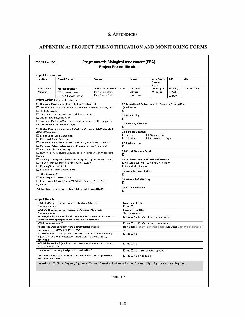
140
6. APPENDICES
APPENDIX A: PROJECT PRE-NOTIFICATION AND MONITORING FORMS

141

142

143
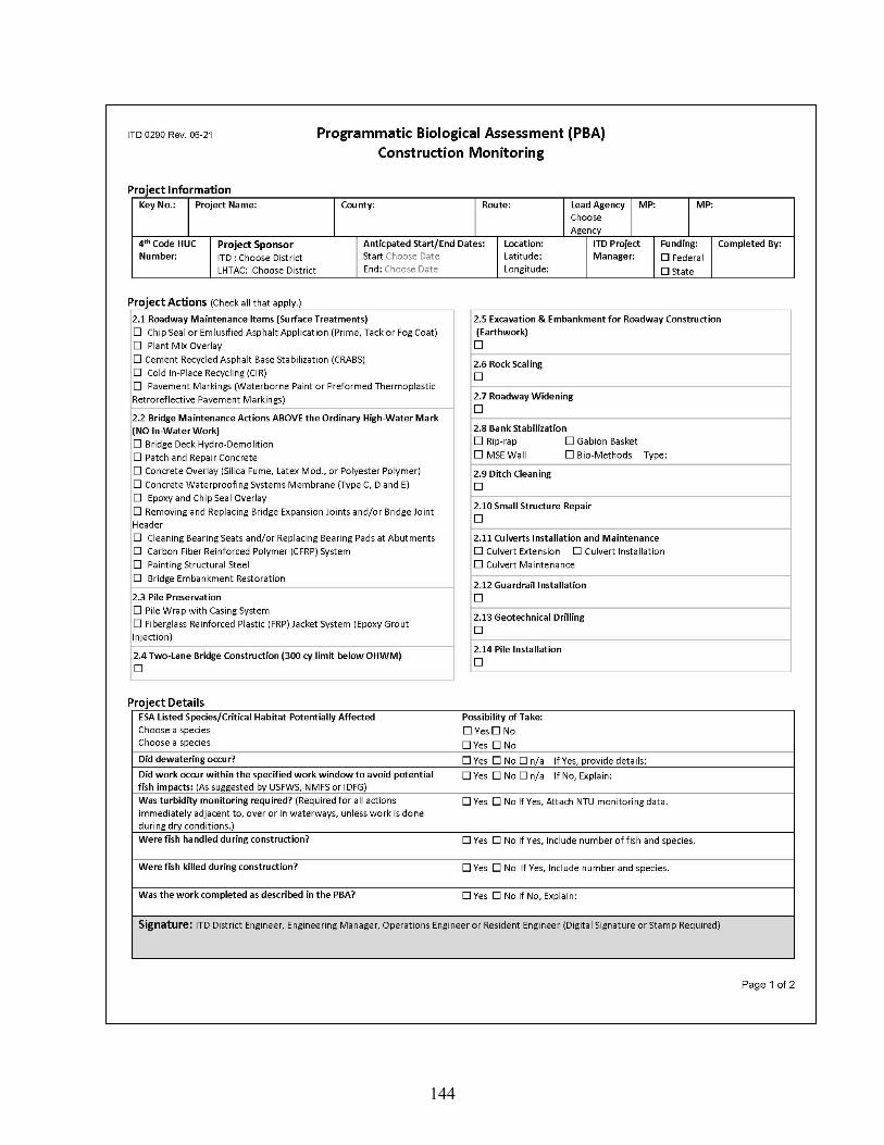
144

145
Related Documents