Overview India is highly vulnerable to natural hazards, particularly earthquakes, flood, drought, cyclone and landslides. In the last decade, India has seen some major disasters including the Bhuj earthquake in 2001 and the Tsunami in 2004. India has a coastline of 7,516 km covering 13 coastal States and Union Territories, of which 5700 km are prone to cyclones of various degrees. The coastal districts of Odisha are prone to frequent cyclonic storms and concurrent flood hazards. The Odisha Super-cyclone of 1999 killed over 8,900 people and 440,000 livestock, affected more than 15 million people and disrupted over 2 million households across 14 districts of the state. The Odisha State Disaster Management Authority (OSDMA) set up after the super cyclone of 1999 was the first Disaster Mitigation Authority set up in the country. India in the last decade has also made significant strides in moving from reactive emergency response to being proactive and implementing disaster preparedness and risk reduction initiatives. National Cyclone Risk Mitigation Project (NCRMP) The National Cyclone Risk Mitigation Project (NCRMP) is a national level Government of India (GoI) flagship programme on cyclone risk mitigation to be implemented in cyclone prone coastal States and Union Territories (UTs), focussing on ex ante risk mitigation interventions. The NCRMP is being implemented by the National Disaster Management Authority (NDMA) with assistance from the World Bank and supported by the Ministry of Home Affairs (MHA). Approach The NCRMP supports India’s major policy shift from reactive disaster response to proactive risk management and allows implementation of a demand driven programme aimed at reducing cyclone impacts in vulnerable areas and strengthening capacity of various institutions. The World Bank offers significant experience in translating national risk mitigation strategies into effective policies and implementable and sustainable investment programs. Furthermore the design and implementation of the NCRMP will offer Application of GIS for Cyclone Risk Mitigation Infrastructure National Cyclone Risk Mitigation Project – Orissa Issue #3 February 2013 Project highlights www.gfdrr.org Photo above: May 1, 2008 - Tropical Cyclone Nargis in the Bay of Bengal at 04:40 UTC. Public Disclosure Authorized Public Disclosure Authorized Public Disclosure Authorized Public Disclosure Authorized Public Disclosure Authorized Public Disclosure Authorized Public Disclosure Authorized Public Disclosure Authorized

Welcome message from author
This document is posted to help you gain knowledge. Please leave a comment to let me know what you think about it! Share it to your friends and learn new things together.
Transcript
Overview
India is highly vulnerable to natural hazards, particularly earthquakes, flood, drought, cyclone and landslides. In the last decade, India has seen some major disasters including the Bhuj earthquake in 2001 and the Tsunami in 2004. India has a coastline of 7,516 km covering 13 coastal States and Union Territories, of which 5700 km are prone to cyclones of various degrees.
The coastal districts of Odisha are prone to frequent cyclonic storms and concurrent flood hazards. The Odisha Super-cyclone of 1999 killed over 8,900 people and 440,000 livestock, affected more than 15 million people and disrupted over 2 million households across 14 districts of the state.
The Odisha State Disaster Management Authority (OSDMA) set up after the super cyclone of 1999 was the first Disaster Mitigation Authority set up in the country. India in the last decade has also made significant strides in moving from reactive emergency response to being proactive and implementing disaster preparedness and risk reduction initiatives.
National Cyclone Risk Mitigation Project (NCRMP)
The National Cyclone Risk Mitigation Project (NCRMP) is a national level Government of India (GoI) flagship programme on cyclone risk mitigation to be implemented in cyclone prone coastal States and Union Territories (UTs), focussing on ex ante risk mitigation interventions. The NCRMP is being implemented by the National Disaster Management Authority (NDMA) with assistance from the World Bank and supported by the Ministry of Home Affairs (MHA).
Approach
The NCRMP supports India’s major policy shift from reactive disaster response to proactive risk management and allows implementation of a demand driven programme aimed at reducing cyclone impacts in vulnerable areas and strengthening capacity of various institutions. The World Bank offers significant experience in translating national risk mitigation strategies into effective policies and implementable and sustainable investment programs. Furthermore the design and implementation of the NCRMP will offer
Application of GIS for Cyclone Risk Mitigation Infrastructure National Cyclone Risk Mitigation Project – Orissa
Issue #3 February 2013
Pr
oje
ct
high
light
s
www.gfdrr.org
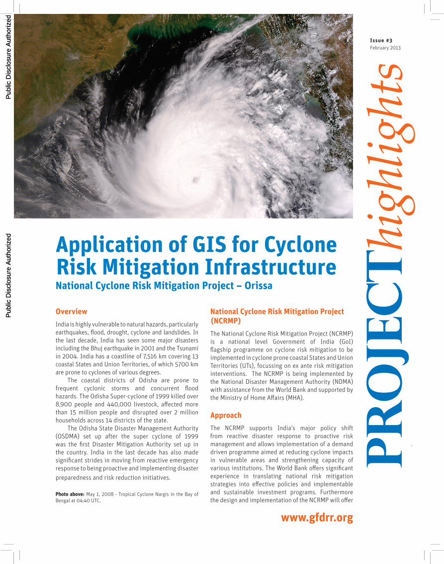
Photo above: May 1, 2008 - Tropical Cyclone Nargis in the Bay of Bengal at 04:40 UTC.
Pub
lic D
iscl
osur
e A
utho
rized
Pub
lic D
iscl
osur
e A
utho
rized
Pub
lic D
iscl
osur
e A
utho
rized
Pub
lic D
iscl
osur
e A
utho
rized
Pub
lic D
iscl
osur
e A
utho
rized
Pub
lic D
iscl
osur
e A
utho
rized
Pub
lic D
iscl
osur
e A
utho
rized
Pub
lic D
iscl
osur
e A
utho
rized
WB112742
Typewritten Text
76324

Pr
oje
ct
high
light
s
2
important lessons to be shared with other countries in their efforts to systematically address the reduction of disaster risk. The NCRMP has integrated lessons from Bangladesh’s risk mitigation efforts. Close to 500,000 people lost their lives in the cyclones that hit Bangladesh in 1970 and another 138,000 people fell victims to cyclones in 1991. However in 2007, cyclone Sidr of intensity similar to that of the 1970 cyclone resulted in 3,800 deaths. Post 1970 Bangladesh focussed strongly on cyclone risk mitigation and by 2007 it had around 2,500 cyclone shelters across 19 coastal districts, a robust Early Warning Disaster System (EWDS) along with coastal green belts and embankments in place. In 2007 when SIDR hit, over 1.5 million people benefitted from the improved EWDS and took refuge in the cyclone shelters.
The objective of the NCRMP is to reduce vulnerability of coastal communities living in the coastal states and UTs of India to cyclone and other hydro meteorological hazards through i) improved early warning and communication systems, ii) enhanced capacity of local communities to respond to disasters, iii) improved access to emergency shelter, evacuation, and protection against wind storms, flooding and storm surge in high risk areas, and iv) strengthening DRM capacity at central, state and local levels in order to enable mainstreaming of risk mitigation measures into the overall development agenda.
The four components of the NCRMP are: a) Early Warning Dissemination System (EWDS) and Capacity Building for Coastal Communities; b) Cyclone Risk Mitigation Infrastructure; c) Technical Assistance for strengthening capacity towards DRM and d) Project Management and Implementation Support
Cyclone Risk Mitigation Infrastructure component
The NCRMP is expected to be undertaken in three phases with Phase I covering the states of Odisha and Andhra Pradesh. In Odisha the implementing partner is the Odisha State Disaster Management Authority (OSDMA).
The NCRMP is spread over the six coastal districts of Balasore, Bhadrak, Kendrapada, Jagatsingpur, Puri and Ganjam that have the highest population density in the state and a high decennial growth rate. The NCRMP comprises 149 cyclone shelters and 6 shelter-cum godowns, 69 packages of link roads connecting 191 shelters to main roads and a total of 10 embankments of about 60 km length. The portfolio also includes up-grading of existing roads and providing bridges suitable for evacuation, drainage improvement measures and repair and up-grading of existing embankments, and creation of corpus funds for operation and maintenance of cyclone shelters. The objective of this component is to improve the access to emergency shelters, evacuation and protection against cyclones, wind storms, flooding and storm surge in high risk areas.
Particular attention has been given to addressing and managing social and environmental issues arising on account of location of infrastructure in coastal areas, which are environmentally sensitive and have vulnerable populations. An Environment and Social Monitoring Framework (ESMF) has been developed outlining screening, detailed assessment of social and environmental aspects. There is a provision for preparation of Environment Management Plans (EMP) and Resettlement Action Plans (RAP) as measures to mitigate risks.
Left: Schematic representation of Coastal Regulation Zones.Below: The Multipurpose Cyclone Shelter designed by IIT Kharagpur and verified by the WB – NDMA are built to function in multiple ways during non disaster time. They are disable friendly and are the responsibility of the Cy-clone Shelter Management and Maintenance Committee (CSMMC) established around each MCS.
The process of CRZ mapping is done at multiple levels. It typically starts with integration of data using topo maps from the Survey of India (SoI) and CRZ maps from Orissa Space Application Centre (ORSAC).

The Coastal Regulation Zone (CRZ) is a major concern as all the sub projects are located within 10 km from the coastline. Land along coastal stretches of bays, estuaries, backwaters, seas, creeks and other such which are influenced by tidal action have been declared as Coastal Regulation Zone (CRZ) by the GoI. Broadly CRZ includes the land between the low tide line (LTL) and high tide line (HTL), the land upto 500m from the HTL, 150m on either side of a river/creek of width 350m, 100m on either side for a river/creek that is 100 – 350m wide and the actual width of the river/creek that is less than 100m wide.
■■ For regulating developmental activities, the coastal stretches are classified into
■■ CRZ I – Ecologically sensitive and important areas and areas between the HTL and LTL
■■ CRZ II – Developed areas, close to the shore, mainly urban or built-up areas
■■ CRZ III – Undisturbed areas and those areas which do not belong to categories I or II
■■ CRZ IV – Coastal stretches in the Andaman & Nicobar, Lakshwadeep and other small islands
Majority of the planned interventions like the construction of cyclone shelters, repair or improvement of existing infrastructure like saline embankments and roads providing connectivity to cyclone shelters or tower installation for communication are unlikely to have any significant or irreversible environmental damage. However critical environmental and social issues which may arise on account of improper site selection, which become even more important in coastal areas have been avoided and considerably minimized by effectively using the Environment Screening exercise. This has ensured that no sub-project with any likelihood of creating significant or irreversible adverse impact on the environment is taken up without proper
environment assessment and analysis. To meet this objective a robust methodology supported by the use of scientific tools like the Geographical Information System (GIS) and remote sensing have been used in this project.
GIS mapping
Geographic Information System (GIS) is a computer based application of technology involving spatial and attributes information to act as a decision support tool. It keeps information in different layers and generates various combinations pertaining to the requirements of decision making. The prime objectives of inclusion of GIS/ Remote Sensing techniques for NCRMP are to help project planning and implementation and creation of data for future reference for disaster management. Since the inception of the GIS cell in the OSDMA in 2007, the databases on Administrative information, Infrastructure information, Terrain information, Climatic information, Demographic information, Resource information, Event information, others have been developed. These databases were effectively utilised in the planning phase of NCRMP.
Environment Screening
The project area is located in the sensitive coastal track of Odisha. It was a challenge to screen the project area from the environmental point of view. The availability of various thematic layers with the GIS cell of the OSDMA made this exercise relatively easy and cost effective. The Environment and Social screening involve a number of steps which include village selection and vulnerability study. All the project areas were screened using the GIS platform and necessary measures were taken accordingly. The process typically starts with integration of various thematic layers including topographic maps from the Survey of India (SoI) and CRZ maps from Odisha Space Application Centre (ORSAC). GPS data on proposed
Pr
oje
ct
high
light
s
3
Left: Example using a combination of data sets the GIS team was able to identify and demarcate the road connecting the Multipurpose Cyclone Shelter to the main road. Then using Google Earth images merged into the GIS platform they were able to verify the actual ground condition. This does not eliminate the need for actual field verification, but greatly aids the same.
Right: In the case of the Saline embankment from Khairnal to Paliabandha village Ganjam district the GIS platform allowed to simulate the coverage that the embankment would provide. They were able to optimise and redesign the embankment so as to assure better coverage.
site locations is collected from the field and positioned in the GIS data layers. The next stage is the integration of thematic layers like roads, forest land, water bodies, weather data and others that was obtained from different sources like from the Indian Meteorological Department (IMD), Indian Space Research Organisation, Forest Department, Land and Revenue Department and others. A 1 km buffer is plotted around the site to check its location with respect to forest land and other environmentally sensitive areas based on the thematic layers already integrated into the GIS. Presence of environmentally sensitive areas is ascertained and applicability of regulations is confirmed. Social consultations are carried out through the Gram Sabha and social screening is undertaken as per the guidelines. The need if any of Environment Impact Assessment (EIA) or Social Impact Assessment (SIA) and any other regulations, rules and clearances is determined and appropriate action taken.
CRZ mapping of the sites is done at multiple levels. Some sites would be clearly established as within the CRZ and others outside it, some others would be outside the CRZ but still within the vicinity of environmentally sensitive areas and some sites whose situation may not be clear. There may be need to follow up with further field verification of doubtful areas. Satellite data from various sources have been integrated into the GIS layers and been used for verification and for generating a precise picture of the site and its surrounds.
There are other details that are also verified like whether the location is on a piece of Government land, whether it is within the school campus or at least in the immediate vicinity and other such. All of which also go into establishing a well informed programme implementation plan. Thus detailed GIS mapping work has not only informed decisions on location of
infrastructure, but has also helped in project planning and implementation.
In addition, the use of GIS has helped in phasing of the work. For example out of the 149 cyclone shelters proposed, about 100 are outside CRZ and do not need any environmental clearances. They have been taken up for Phase I. For the remaining shelters that fall under the CRZ or require other environmental clearances, the processes for EIA and other clearances have been initiated.
Beyond the NCRMP, one of the significant achievements of this exercise is the integration on to a single GIS platform of the diverse data sets from multiple sources at different scales, making them compatible and useable across a wide spectrum.
Using of GIS to locate this infrastructure has assured that substantial portions of the infrastructure like roads, bridges, canals and embankments will use existing alignments and are unlikely to involve land acquisition except for minor widening/upgradation when required by design. The new Multipurpose Cyclone Shelters are planned either in existing school campuses or other government lands. The adverse impacts are likely to be negligible.
The GIS platforms created are already being used for a wide variety of other purposes like for locating developmental projects and to pin point air dropping of relief material to Indian Air Force personnel during disasters.
The use of GIS based mapping is playing a major role in achieving the objectives of the NCRMP. It is helping in enhancing the effectiveness of early warning dissemination systems and communication, improving access and evacuation and in better locating infrastructure. Managers can generate maps at micro and macro level indicating vulnerability to different extents under different threat perceptions. Locations likely to remain unaffected or remain comparatively safe can be identified, alternate routes to cyclone shelters, camps, and important locations in the event of disruption of normal surface communication can be worked out, missing links in the road network can be identified. In addition identification of existing coastal vegetation cover and analysis for plantation requirement could be made.
GIS mapping has helped not only with the location of Cyclone Risk Mitigation Infrastructure, but also greatly served in Project Management and Implementation and has helped across all the components of the NCRMP. It has strengthened capacity at central, state and local levels and mainstreamed risk mitigation into the overall development agenda. It has played a vital role not only in the successful implementation of the NCRMP in Odisha, but also is serving as an example for the programme across the country and even internationally.
Pr
oje
ct
high
light
s
Disclaimer: The findings, interpretations, and conclusions expressed herein are those of the author(s) and do not necessarily reflect the views of the Executive Directors of the International Bank for Reconstruction and Development, The World Bank or the governments they represent. The World Bank does not guarantee the accuracy of the data included in this work. The boundaries, colors, denominations, and other informa-tion shown on any map in this work do not imply any judgment on the part of The World Bank concerning the legal status of any territory or the endorsement or acceptance of such boundaries.
DISASTER RISK &CLIMATE CHANGE UNIT
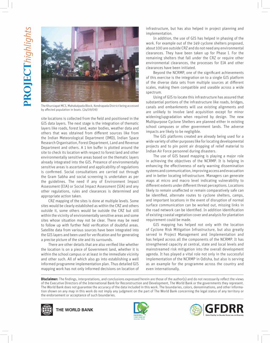
The Khursiapat MCS, Mahakalpada Block, Kendrapada District being accessed by affected population in boats. (24/09/09)
Related Documents


![Architectural Shelters Canopies and Cycle Shelters[1]](https://static.cupdf.com/doc/110x72/577d24da1a28ab4e1e9d8f13/architectural-shelters-canopies-and-cycle-shelters1.jpg)

