Conservation Objectives Series National Parks and Wildlife Service Caha Mountains SAC 000093 ISSN 2009-4086 11 Aug 2016 Page 1 of 31 Version 1

Welcome message from author
This document is posted to help you gain knowledge. Please leave a comment to let me know what you think about it! Share it to your friends and learn new things together.
Transcript
Conservation Objectives Series
National Parks and Wildlife Service
Caha Mountains SAC 000093
ISSN 2009-4086
11 Aug 2016 Page 1 of 31 Version 1

National Parks and Wildlife Service,Department of Arts, Heritage, Regional, Rural and Gaeltacht Affairs,
7 Ely Place, Dublin 2, Ireland.
Web: www.npws.ieE-mail: [email protected]
Citation:
ISSN 2009-4086Series Editor: Rebecca Jeffrey
NPWS (2016) Conservation Objectives: Caha Mountains SAC 000093. Version 1. National Parks and Wildlife Service, Department of Arts, Heritage, Regional, Rural and Gaeltacht Affairs.
11 Aug 2016 Page 2 of 31 Version 1

Introduction
European and national legislation places a collective obligation on Ireland and its citizens to maintain habitats and species in the Natura 2000 network at favourable conservation condition. The Government and its agencies are responsible for the implementation and enforcement of regulations that will ensure the ecological integrity of these sites.
A site-specific conservation objective aims to define favourable conservation condition for a particular habitat or species at that site.
Favourable conservation status of a habitat is achieved when: • its natural range, and area it covers within that range, are stable or increasing, and • the specific structure and functions which are necessary for its long-term maintenance exist and are likely to continue to exist for the foreseeable future, and • the conservation status of its typical species is favourable.
The favourable conservation status of a species is achieved when: • population dynamics data on the species concerned indicate that it is maintaining itself on a long-term basis as a viable component of its natural habitats, and • the natural range of the species is neither being reduced nor is likely to be reduced for the foreseeable future, and • there is, and will probably continue to be, a sufficiently large habitat to maintain its populations on a long-term basis.
The overall aim of the Habitats Directive is to maintain or restore the favourable conservation status of habitats and species of community interest. These habitats and species are listed in the Habitats and Birds Directives and Special Areas of Conservation and Special Protection Areas are designated to afford protection to the most vulnerable of them. These two designations are collectively known as the Natura 2000 network.
The maintenance of habitats and species within Natura 2000 sites at favourable conservation condition will contribute to the overall maintenance of favourable conservation status of those habitats and species at a national level.
1. The targets given in these conservation objectives are based on best available information at the time of writing. As more information becomes available, targets for attributes may change. These will be updated periodically, as necessary.2. An appropriate assessment based on these conservation objectives will remain valid even if the targets are subsequently updated, providing they were the most recent objectives available when the assessment was carried out. It is essential that the date and version are included when objectives are cited.3. Assessments cannot consider an attribute in isolation from the others listed for that habitat or species, or for other habitats and species listed for that site. A plan or project with an apparently small impact on one attribute may have a significant impact on another.4. Please note that the maps included in this document do not necessarily show the entire extent of the habitats and species for which the site is listed. This should be borne in mind when appropriate assessments are being carried out.5. When using these objectives, it is essential that the relevant backing/supporting documents are consulted, particularly where instructed in the targets or notes for a particular attribute.
Notes/Guidelines:
11 Aug 2016 Page 3 of 31 Version 1

Qualifying Interests
Caha Mountains SAC
* indicates a priority habitat under the Habitats Directive
000093
1024 Kerry Slug Geomalacus maculosus
1421 Killarney Fern Trichomanes speciosum
3110 Oligotrophic waters containing very few minerals of sandy plains (Littorelletalia uniflorae)
3160 Natural dystrophic lakes and ponds
4010 Northern Atlantic wet heaths with Erica tetralix
4030 European dry heaths
4060 Alpine and Boreal heaths
6230 Species-rich Nardus grasslands, on siliceous substrates in mountain areas (and submountain areas, in Continental Europe)*
7130 Blanket bogs (* if active bog)
8110 Siliceous scree of the montane to snow levels (Androsacetalia alpinae and Galeopsietalia ladani)
8210 Calcareous rocky slopes with chasmophytic vegetation
8220 Siliceous rocky slopes with chasmophytic vegetation
Please note that this SAC adjoins Glengarriff Harbour and Woodland SAC (000090). See map 2. The conservation objectives for this site should be used in conjunction with those for the adjacent site as appropriate.
11 Aug 2016 Page 4 of 31 Version 1

Supporting documents, relevant reports & publicationsSupporting documents, NPWS reports and publications are available for download from: www.npws.ie/Publications
Year : 1991
Title : Survey to locate mountain blanket bogs of scientific interest in Ireland
Author : Mooney, E.; Goodwillie, R.; Douglas, C.
Series : Unpublished Report
Year : 2011
Title : Distribution and population dynamics of the Kerry Slug, Geomalacus maculosus (Arionidae)
Author : Mc Donnell, R.J.; Gormally, M.J.
Series : Irish Wildlife Manual No. 54
Year : 2012
Title : Ireland Red List no. 8: Bryophytes
Author : Lockhart, N.; Hodgetts, N.; Holyoak, D.
Series : Ireland Red List series, NPWS
Year : 2013
Title : A survey of the benthic macrophytes of three hard-water lakes: Lough Bunny, Lough Carra and Lough Owel
Author : Roden, C.; Murphy, P.
Series : Irish Wildlife Manual No. 70
Year : 2013
Title : The status of EU protected habitats and species in Ireland. Volume 2. Habitats assessments
Author : NPWS
Series : Conservation assessments
Year : 2013
Title : The status of EU protected habitats and species in Ireland. Volume 3. Species assessments
Author : NPWS
Series : Conservation assessments
Year : 2014
Title : Guidelines for a national survey and conservation assessment of upland vegetation and habitats in Ireland, Version 2.0
Author : Perrin, P.M.; Barron, S.J.; Roche, J.R.; O’Hanrahan, B.
Series : Irish Wildlife Manual No. 79
Year : 2014
Title : National survey of upland habitats (phase 4, 2013-2014), summary report
Author : Barron, S.J.; Perrin, P.M.
Series : Unpublished report to NPWS
Year : 2014
Title : National survey of upland habitats (phase 4, 2013-2014) site report no. 16: Caha Mountains cSAC (000093), Cos. Cork and Kerry
Author : Perrin, P.M.; Roche, J.R.; Barron, S.J.; Daly, O.H.; Hodd, R.L.; Devaney, F.M.
Series : Unpublished report to NPWS
Year : 2015
Title : Habitats Directive Annex I lake habitats: a working interpretation for the purposes of site-specific conservation objectives and Article 17 reporting
Author : O Connor, Á.
Series : Unpublished document by NPWS
NPWS Documents
11 Aug 2016 Page 5 of 31 Version 1
Year : 1982
Title : Eutrophication of waters. Monitoring assessment and control
Author : OECD
Series : OECD, Paris
Year : 2000
Title : Colour in Irish lakes
Author : Free, G.; Allott, N.; Mills, P.; Kennelly, C.; Day, S.
Series : Verhandlungen Internationale Vereinigung für theoretische und angewandte Limnologie, 27: 2620-2623
Year : 2002
Title : Deterioration of Atlantic soft water macrophyte communities by acidification, eutrophication and alkalinisation
Author : Arts, G.H.P.
Series : Aquatic Botany, 73: 373-393
Year : 2006
Title : A reference-based typology and ecological assessment system for Irish lakes. Preliminary investigations. Final report. Project 2000-FS-1-M1 Ecological assessment of lakes pilot study to establish monitoring methodologies EU (WFD)
Author : Free, G.; Little, R.; Tierney, D.; Donnelly, K.; Coroni, R.
Series : EPA, Wexford
Year : 2008
Title : Water Quality in Ireland 2004-2006
Author : Clabby, K.J.; Bradley, C.; Craig, M.; Daly, D.; Lucey, J.; McGarrigle, M.; O’Boyle, S.; Tierney, D.; Bowman, J.
Series : EPA, Wexford
Year : 2009
Title : The identification, characterization and conservation value of isoetid lakes in Ireland
Author : Free, G.; Bowman, J.; McGarrigle, M.; Little, R.; Coroni, R.; Donnelly, K.; Tierney, D.; Trodd, W.
Series : Aquatic Conservation: Marine and Freshwater Ecosystems, 19 (3): 264–273
Year : 2010
Title : Water quality in Ireland 2007-2009
Author : McGarrigle, M.; Lucey, J.; Ó Cinnéide, M.
Series : EPA, Wexford
Year : 2012
Title : The impact of conifer plantation forestry on the ecology of peatland lakes
Author : Drinan, T.J.
Series : Unpublished PhD thesis, University College Cork
Year : 2015
Title : Monitoring methods for the Killarney fern (Trichomanes speciosum Willd.) in Ireland
Author : Ní Dhúill, E.; Smyth, N.; Waldren, S.; Lynn, D.
Series : Irish Wildlife Manual No. 82
Year : 2016
Title : Caha Mountains SAC (site code: 0093) Conservation objectives supporting document- upland habitats V1
Author : NPWS
Series : Conservation objectives supporting document
Other References
11 Aug 2016 Page 6 of 31 Version 1

Year : 2013
Title : Interpretation manual of European Union habitats- Eur 28
Author : European Commission- DG Environment
Series : European Commission
Year : in prep.
Title : Monitoring of hard-water lakes in Ireland using charophytes and other macrophytes
Author : Roden, C.; Murphy, P.
Series : Unpublished report to NPWS
11 Aug 2016 Page 7 of 31 Version 1

Spatial data sourcesYear : 2008
Title : OSi 1:5000 IG vector dataset
GIS Operations : WaterPolygons feature class clipped to the SAC boundary. Expert opinion used to identify Annex I habitat and to resolve any issues arising
Used For : 3110, 3160 (map 3)
Year : 2014
Title : National Survey of Upland Habitats
GIS Operations : Habitat dataset for site clipped to SAC boundary. Relevant QI selected and exported to new dataset. Expert opinion used as necessary to resolve any issues arising
Used For : 4010, 4030, 4060, 6230, 7130, 8110, 8210, 8220 (maps 4-11)
Year : 2016
Title : NPWS rare and threatened species database
GIS Operations : Dataset created from spatial references in database records. Expert opinion used as necessary to resolve any issues arising
Used For : 1024 (map 12)
11 Aug 2016 Page 8 of 31 Version 1
Conservation Objectives for : Caha Mountains SAC [000093]
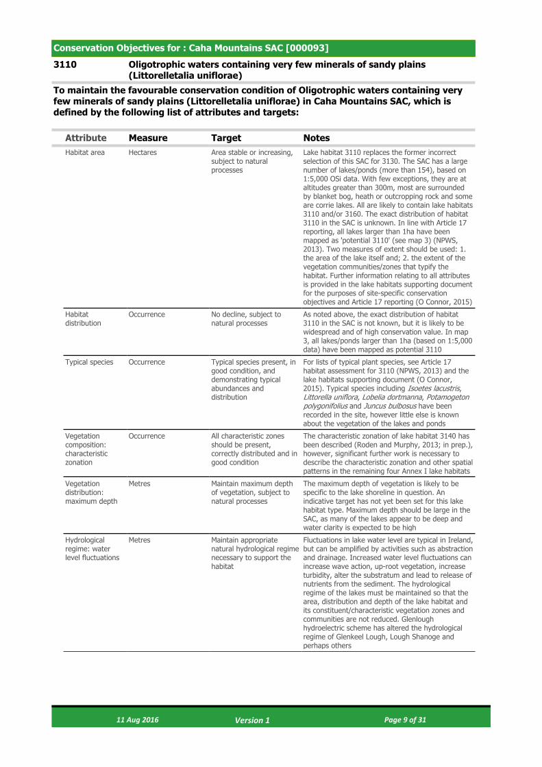
3110 Oligotrophic waters containing very few minerals of sandy plains (Littorelletalia uniflorae)
To maintain the favourable conservation condition of Oligotrophic waters containing very few minerals of sandy plains (Littorelletalia uniflorae) in Caha Mountains SAC, which is defined by the following list of attributes and targets:
Attribute Measure Target NotesHabitat area Hectares Area stable or increasing,
subject to natural processes
Lake habitat 3110 replaces the former incorrect selection of this SAC for 3130. The SAC has a large number of lakes/ponds (more than 154), based on 1:5,000 OSi data. With few exceptions, they are at altitudes greater than 300m, most are surrounded by blanket bog, heath or outcropping rock and some are corrie lakes. All are likely to contain lake habitats 3110 and/or 3160. The exact distribution of habitat 3110 in the SAC is unknown. In line with Article 17 reporting, all lakes larger than 1ha have been mapped as 'potential 3110' (see map 3) (NPWS, 2013). Two measures of extent should be used: 1. the area of the lake itself and; 2. the extent of the vegetation communities/zones that typify the habitat. Further information relating to all attributes is provided in the lake habitats supporting document for the purposes of site-specific conservation objectives and Article 17 reporting (O Connor, 2015)
Habitat distribution
Occurrence No decline, subject to natural processes
As noted above, the exact distribution of habitat 3110 in the SAC is not known, but it is likely to be widespread and of high conservation value. In map 3, all lakes/ponds larger than 1ha (based on 1:5,000 data) have been mapped as potential 3110
Typical species Occurrence Typical species present, in good condition, and demonstrating typical abundances and distribution
For lists of typical plant species, see Article 17 habitat assessment for 3110 (NPWS, 2013) and the lake habitats supporting document (O Connor, 2015). Typical species including Isoetes lacustris, Littorella uniflora, Lobelia dortmanna, Potamogeton polygonifolius and Juncus bulbosus have been recorded in the site, however little else is known about the vegetation of the lakes and ponds
Vegetation composition: characteristic zonation
Occurrence All characteristic zones should be present, correctly distributed and in good condition
The characteristic zonation of lake habitat 3140 has been described (Roden and Murphy, 2013; in prep.), however, significant further work is necessary to describe the characteristic zonation and other spatial patterns in the remaining four Annex I lake habitats
Vegetation distribution: maximum depth
Metres Maintain maximum depth of vegetation, subject to natural processes
The maximum depth of vegetation is likely to be specific to the lake shoreline in question. An indicative target has not yet been set for this lake habitat type. Maximum depth should be large in the SAC, as many of the lakes appear to be deep and water clarity is expected to be high
Hydrological regime: water level fluctuations
Metres Maintain appropriate natural hydrological regime necessary to support the habitat
Fluctuations in lake water level are typical in Ireland, but can be amplified by activities such as abstraction and drainage. Increased water level fluctuations can increase wave action, up-root vegetation, increase turbidity, alter the substratum and lead to release of nutrients from the sediment. The hydrological regime of the lakes must be maintained so that the area, distribution and depth of the lake habitat and its constituent/characteristic vegetation zones and communities are not reduced. Glenlough hydroelectric scheme has altered the hydrological regime of Glenkeel Lough, Lough Shanoge and perhaps others
11 Aug 2016 Page 9 of 31 Version 1

Lake substratum quality
Various Maintain appropriate substratum type, extent and chemistry to support the vegetation
Research is required to further characterise the substratum types (particle size and origin) and substratum quality (notably pH, calcium, iron and nutrient concentrations) favoured by each of the five Annex I lake habitats in Ireland. It is likely that the lake habitat 3110 is associated with a range of nutrient-poor substrates, from stones, cobble and gravel, through sands, silt, clay and peat. Substratum particle size is likely to vary with depth and along the shoreline within a single lake. Mud and peat substrates have been recorded in the SAC
Water quality: transparency
Metres Maintain appropriate Secchi transparency. There should be no decline in Secchi depth/transparency
Transparency relates to light penetration and, hence, to the depth of colonisation of vegetation. It can be affected by phytoplankton blooms, water colour and turbidity. A specific target has yet to be established for this Annex I lake habitat. Habitat 3110 is associated with very clear water. The OECD fixed boundary system set transparency targets for oligotrophic lakes of ≥6m annual mean Secchi disk depth, and ≥3m annual minimum Secchi disk depth. Free et al. (2009) found high isoetid abundance in lakes with Secchi depths of more than 3m. High altitude deep lakes, such as those found in the SAC, are expected to have high transparency
Water quality: nutrients
μg/l P; mg/l N Maintain the concentration of nutrients in the water column to sufficiently low levels to support the habitat and its typical species
As a nutrient-poor habitat, oligotrophic and Water Framework Directive (WFD) 'high' status targets apply. Where a lake has nutrient concentrations that are lower than these targets, there should be no decline within class, i.e. no upward trend in nutrient concentrations. For the lake habitat 3110, annual average TP concentration should be ≤10μg/l TP, average annual total ammonia concentration should be ≤0.040mg/l N and annual 95th percentile for total ammonia should be ≤0.090mg/l N. See also The European Communities Environmental Objectives (Surface Waters) Regulations 2009
Water quality: phytoplankton biomass
μg/l Chlorophyll a Maintain appropriate water quality to support the habitat, including high chlorophyll a status
Oligotrophic and WFD 'high' status targets apply to the lake habitat 3110. Where a lake has a chlorophyll a concentration that is lower than this target, there should be no decline within class, i.e. no upward trend in phytoplankton biomass. The average growing season (March-October) chlorophyll a concentration must be <5.8μg/l. The annual average chlorophyll a concentration should be <2.5μg/l and the annual peak chlorophyll a concentration should be ≤8.0μg/l. See also The European Communities Environmental Objectives (Surface Waters) Regulations 2009
Water quality: phytoplankton composition
EPA phytoplankton composition metric
Maintain appropriate water quality to support the habitat, including high phytoplankton composition status
The EPA has developed a phytoplankton composition metric for nutrient enrichment of Irish lakes. As for other water quality indicators, habitat 3110 requires WFD high status
Water quality: attached algal biomass
Algal cover and EPA phytobenthos metric
Maintain trace/ absent attached algal biomass (<5% cover) and high phytobenthos status
Nutrient enrichment can favour epiphytic and epipelic algae that can out-compete the submerged vegetation. The cover abundance of attached algae in lake habitat 3110 should, therefore, be trace/ absent (<5% cover). EPA phytobenthos can be used as an indicator of changes in attached algal biomass. As for other water quality indicators, habitat 3110 requires high phytobenthos status
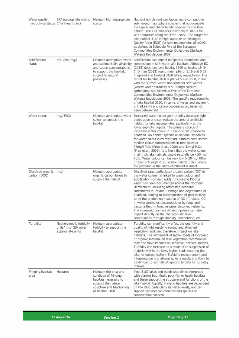
Water quality: macrophyte status
EPA macrophyte metric (The Free Index)
Maintain high macrophyte status
Nutrient enrichment can favour more competitive submerged macrophyte species that out-compete the typical and characteristic species for the lake habitat. The EPA monitors macrophyte status for WFD purposes using the ‘Free Index’. The target for lake habitat 3110 is high status or an Ecological Quality Ratio (EQR) for lake macrophytes of ≥0.90, as defined in Schedule Five of the European Communities Environmental Objectives (Surface Waters) Regulations 2009
11 Aug 2016 Page 10 of 31 Version 1

Acidification status
pH units; mg/l Maintain appropriate water and sediment pH, alkalinity and cation concentrations to support the habitat, subject to natural processes
Acidification can impact on species abundance and composition in soft water lake habitats. In Europe, acidification of isoetid lakes can lead to loss of isoetids and dominance by submerged Sphagnum mosses and Juncus bulbosus (Arts, 2002). The specific requirements of lake habitat 3110, in terms of water and sediment pH, alkalinity and cation concentration, have not been determined. For lake habitat 3110, and adopting a precautionary approach based on Arts (2002), minimum pH should not be <5.5 pH units. Maximum pH should be <9.0 pH units, in line with the surface water standards established for soft waters (where water hardness is ≤100mg/l calcium carbonate). See Schedule Five of the European Communities Environmental Objectives (Surface Waters) Regulations 2009
Water colour mg/l PtCo Maintain appropriate water colour to support the habitat
Increased water colour and turbidity decrease light penetration and can reduce the area of available habitat for lake macrophytes, particularly at the lower euphotic depths. The primary source of increased water colour in Ireland is disturbance to peatland. No habitat-specific or national standards for water colour currently exist. Studies have shown median colour concentrations in Irish lakes of 38mg/l PtCo (Free et al., 2000) and 33mg/l PtCo (Free et al., 2006). It is likely that the water colour in all Irish lake habitats would naturally be <50mg/l PtCo. Water colour can be very low (<20mg/l PtCo or even <10mg/l PtCo) in lake habitat 3110, where the peatland in the lake’s catchment is intact
Dissolved organic carbon (DOC)
mg/l Maintain appropriate organic carbon levels to support the habitat
Dissolved (and particulate) organic carbon (OC) in the water column is linked to water colour and acidification (organic acids). Increasing DOC in water has been documented across the Northern Hemisphere, including afforested peatland catchments in Ireland. Damage and degradation of peatland, leading to decomposition of peat is likely to be the predominant source of OC in Ireland. OC in water promotes decomposition by fungi and bacteria that, in turn, releases dissolved nutrients. The increased biomass of decomposers can also impact directly on the characteristic lake communities through shading, competition, etc.
Turbidity Nephelometric turbidity units/ mg/l SS/ other appropriate units
Maintain appropriate turbidity to support the habitat
Turbidity can significantly affect the quantity and quality of light reaching rooted and attached vegetation and can, therefore, impact on lake habitats. The settlement of higher loads of inorganic or organic material on lake vegetation communities may also have impacts on sensitive, delicate species. Turbidity can increase as a result of re-suspension of material within the lake, higher loads entering the lake, or eutrophication. Turbidity measurement and interpretation is challenging. As a result, it is likely to be difficult to set habitat-specific targets for turbidity in lakes
Fringing habitat: area
Hectares Maintain the area and condition of fringing habitats necessary to support the natural structure and functioning of habitat 3110
Most lake shorelines have fringing habitats of reedswamp, other swamp, fen, marsh or wet-woodland that intergrade with and support the structure and functions of the lake habitat. In this SAC, blanket bog and heath communities with outcropping rock are likely to dominate shorelines. Poor fen and flush may also occur. Equally, fringing habitats are dependent on the lake, particularly its water levels, and support wetland communities and species of conservation concern. Many of the fringing wetland habitats support higher invertebrate and plant species richness than the lake habitats themselves
11 Aug 2016 Page 11 of 31 Version 1

Conservation Objectives for : Caha Mountains SAC [000093]
3160 Natural dystrophic lakes and ponds
To maintain the favourable conservation condition of Natural dystrophic lakes and ponds in Caha Mountains SAC, which is defined by the following list of attributes and targets:
Attribute Measure Target NotesHabitat area Hectares Area stable or increasing,
subject to natural processes
The SAC has a large number of lakes and ponds (more than 154), based on 1:5,000 OSi data. Mooney et al. (1991) recorded frequent pools and small lakes with Sphagnum in the SAC. Most lakes and pools are at altitudes greater than 300m and surrounded by blanket bog, heath or outcropping rock, while some are corrie lakes. All are likely to contain lake habitats 3160 and/or 3110. The exact distribution of habitat 3160 in the SAC is unknown. In line with Article 17 reporting, all lakes larger than 1ha have been mapped as 'potential 3110' and those smaller than 1ha as 'potential 3160' (see map 3) (NPWS, 2013). Two measures of extent should be used: 1. the area of the lake itself and; 2. the extent of the vegetation communities/zones that typify the habitat. Further information relating to all attributes is provided in the lake habitats supporting document for the purposes of site-specific conservation objectives and Article 17 reporting (O Connor, 2015)
Habitat distribution
Occurrence No decline, subject to natural processes
As noted above, the exact distribution of lake habitat 3160 in the SAC is not known, but it is likely to be widespread and of high conservation value. In map 3, all lakes and ponds smaller than 1ha (based on 1:5,000 data) have been mapped as potential 3160
Typical species Occurrence Typical species present, in good condition, and demonstrating typical abundances and distribution
For lists of typical plant and invertebrate species, see Article 17 habitat assessment for 3160 (NPWS, 2013) and the lake habitats supporting document (O Connor, 2015). Mooney et al. (1991) recorded the typical species Spaghnum cuspidatum, S. auriculatum, Menyanthes trifoliata and Potamogeton polygonifolius in the frequent pools and very wet areas that occur between ridges in the SAC. They also noted floating mats and open water in these pools and that some of the small lakes are surrounded by a Sphagnum carpet, where the shelter allows
Vegetation composition: characteristic zonation
Occurrence All characteristic zones should be present, correctly distributed and in good condition
The characteristic zonation of lake habitat 3140 has been described (Roden and Murphy, 2013; in prep.), however, significant further work is necessary to describe the characteristic zonation and other spatial patterns in the other four Annex I lake habitats. Spatial patterns are likely to be relatively simple in lake habitat 3160, with limited zonation
Vegetation distribution: maximum depth
Metres Maintain maximum depth of vegetation, subject to natural processes
The maximum depth of vegetation is likely to be specific to the lake shoreline in question. An indicative target has not yet been set for this lake habitat type. Lakes in the SAC typically have very clear water and, therefore, maximum depth is expected to be large
11 Aug 2016 Page 12 of 31 Version 1

Hydrological regime: water level fluctuations
Metres Maintain appropriate natural hydrological regime necessary to support the habitat
Fluctuations in lake water level are typical in Ireland, but can be amplified by activities such as abstraction and drainage. Increased water level fluctuations can increase wave action, up-root vegetation, increase turbidity, alter the substratum and lead to release of nutrients from the sediment. The hydrological regime of the lakes must be maintained so that the area, distribution and depth of the lake habitat and its constituent/characteristic vegetation zones and communities are not reduced. Owing to their size and the sensitivity of peatland, 3160 lakes and ponds can easily be damaged or destroyed by drainage. Glenlough hydroelectric scheme has altered the hydrological regime of Glenkeel Lough, Lough Shanoge and perhaps other lakes and pools
Lake substratum quality
Various Maintain appropriate substratum type, extent and chemistry to support the vegetation
Research is required to further characterise the substratum types (particle size and origin) and substratum quality (notably pH, calcium, iron and nutrient concentrations) favoured by each of the five Annex I lake habitats in Ireland. It is likely that lake habitat 3160 is associated with nutrient-poor peat and silt substrates, which are widespread in the SAC
Water quality: transparency
Metres Maintain appropriate Secchi transparency. There should be no decline in Secchi depth/transparency
Transparency relates to light penetration and, hence, to the depth of colonisation of vegetation. It can be affected by phytoplankton blooms, water colour and turbidity. A specific target has yet to be established for this Annex I lake habitat. Habitat 3160 is associated with very clear water. The OECD fixed boundary system set transparency targets for ultra-oligotrophic lakes of ≥12m annual mean Secchi disk depth, and ≥6m annual minimum Secchi disk depth. High altitude deep lakes, such as those found in the SAC, are expected to have high transparency
Water quality: nutrients
μg/l P; mg/l N Maintain the concentration of nutrients in the water column to sufficiently low levels to support the habitat and its typical species
As a nutrient-poor habitat, oligotrophic and Water Framework Directive (WFD) 'high' status targets apply. Where a lake has nutrient concentrations that are lower than these targets, there should be no decline within class, i.e. no upward trend in nutrient concentrations. For the lake habitat 3160, annual average TP concentration should be ≤5μg/l TP, average annual total ammonia concentration should be ≤0.040mg/l N and annual 95th percentile for total ammonia should be ≤0.090mg/l N. See also The European Communities Environmental Objectives (Surface Waters) Regulations 2009
Water quality: phytoplankton biomass
μg/l Chlorophyll a Maintain appropriate water quality to support the habitat, including high chlorophyll a status
Oligotrophic and WFD 'high' status targets apply to lake habitat 3160. The average growing season (March-October) chlorophyll a concentration must be <5.8μg/l (The European Communities Environmental Objectives (Surface Waters) Regulations 2009). Where a lake has a chlorophyll a concentration that is lower than this target, there should be no decline within class, i.e. no upward trend in phytoplankton biomass. The OECD targets may be more appropriate for habitat 3160: annual average chlorophyll a concentration <1μg/l and annual peak chlorophyll a concentration ≤2.5μg/l. See also The European Communities Environmental Objectives (Surface Waters) Regulations 2009
Water quality: phytoplankton composition
EPA phytoplankton composition metric
Maintain appropriate water quality to support the habitat, including high phytoplankton composition status
The EPA has developed a phytoplankton composition metric for nutrient enrichment of Irish lakes. As for other water quality indicators, lake habitat 3160 requires WFD high status
Water quality: attached algal biomass
Algal cover and EPA phytobenthos metric
Maintain trace/ absent attached algal biomass (<5% cover) and high phytobenthos status
Nutrient enrichment can favour epiphytic and epipelic algae that can out-compete the submerged vegetation. The cover abundance of attached algae in 3160 lakes and ponds should, therefore, be trace/ absent (<5% cover). EPA phytobenthos can be used as an indicator of changes in attached algal biomass. As for other water quality indicators, lake habitat 3160 requires high phytobenthos status
11 Aug 2016 Page 13 of 31 Version 1
Water quality: macrophyte status
EPA macrophyte metric (The Free Index)
Maintain high macrophyte status
Nutrient enrichment can favour more competitive submerged macrophyte species that out-compete the typical and characteristic species for the lake habitat. The EPA monitors macrophyte status for WFD purposes using the ‘Free Index’. The target for lake habitat 3160 is high status or an Ecological Quality Ratio (EQR) for lake macrophytes of ≥0.90, as defined in Schedule Five of the European Communities Environmental Objectives (Surface Waters) Regulations 2009
Acidification status
pH units; mg/l Maintain appropriate water and sediment pH, alkalinity and cation concentrations to support the habitat, subject to natural processes
Acidification can impact on species abundance and composition in soft water lake habitats. Although EC (2013) describes lake habitat 3160 as having pH 3-6, Drinan (2012) found mean pHs of 5.16 and 5.62 in upland and lowland 3160 lakes, respectively. The target for habitat 3160 is pH >4.5 and <9.0, in line with the surface water standards for soft waters (where water hardness is ≤100mg/l calcium carbonate). See Schedule Five of the European Communities Environmental Objectives (Surface Waters) Regulations 2009. The specific requirements of lake habitat 3160, in terms of water and sediment pH, alkalinity and cation concentration, have not been determined
Water colour mg/l PtCo Maintain appropriate water colour to support the habitat
Increased water colour and turbidity decrease light penetration and can reduce the area of available habitat for lake macrophytes, particularly at the lower euphotic depths. The primary source of increased water colour in Ireland is disturbance to peatland. No habitat-specific or national standards for water colour currently exist. Studies have shown median colour concentrations in Irish lakes of 38mg/l PtCo (Free et al., 2000) and 33mgl PtCo (Free et al., 2006). It is likely that the water colour in all Irish lake habitats would naturally be <50mg/l PtCo. Water colour can be very low (<20mg/l PtCo or even <10mg/l PtCo) in lake habitat 3160, where the peatland in the lake’s catchment is intact
Dissolved organic carbon (DOC)
mg/l Maintain appropriate organic carbon levels to support the habitat
Dissolved (and particulate) organic carbon (OC) in the water column is linked to water colour and acidification (organic acids). Increasing DOC in water has been documented across the Northern Hemisphere, including afforested peatland catchments in Ireland. Damage and degradation of peatland, leading to decomposition of peat is likely to be the predominant source of OC in Ireland. OC in water promotes decomposition by fungi and bacteria that, in turn, releases dissolved nutrients. The increased biomass of decomposers can also impact directly on the characteristic lake communities through shading, competition, etc.
Turbidity Nephelometric turbidity units/ mg/l SS/ other appropriate units
Maintain appropriate turbidity to support the habitat
Turbidity can significantly affect the quantity and quality of light reaching rooted and attached vegetation and can, therefore, impact on lake habitats. The settlement of higher loads of inorganic or organic material on lake vegetation communities may also have impacts on sensitive, delicate species. Turbidity can increase as a result of re-suspension of material within the lake, higher loads entering the lake, or eutrophication. Turbidity measurement and interpretation is challenging. As a result, it is likely to be difficult to set habitat-specific targets for turbidity in lakes
Fringing habitat: area
Hectares Maintain the area and condition of fringing habitats necessary to support the natural structure and functioning of habitat 3160
Most 3160 lakes and ponds shorelines intergrade with blanket bog, flush, poor-fen or heath habitats and these support the structure and functions of the lake habitat. Equally, fringing habitats are dependent on the lake, particularly its water levels, and can support wetland communities and species of conservation concern
11 Aug 2016 Page 14 of 31 Version 1
Conservation Objectives for : Caha Mountains SAC [000093]
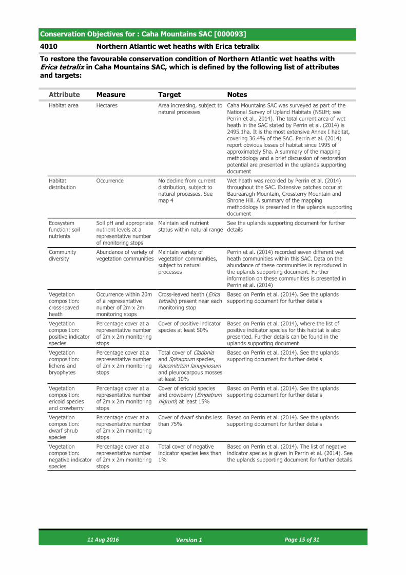
4010 Northern Atlantic wet heaths with Erica tetralix
To restore the favourable conservation condition of Northern Atlantic wet heaths with Erica tetralix in Caha Mountains SAC, which is defined by the following list of attributes and targets:
Attribute Measure Target NotesHabitat area Hectares Area increasing, subject to
natural processesCaha Mountains SAC was surveyed as part of the National Survey of Upland Habitats (NSUH; see Perrin et al., 2014). The total current area of wet heath in the SAC stated by Perrin et al. (2014) is 2495.1ha. It is the most extensive Annex I habitat, covering 36.4% of the SAC. Perrin et al. (2014) report obvious losses of habitat since 1995 of approximately 5ha. A summary of the mapping methodology and a brief discussion of restoration potential are presented in the uplands supporting document
Habitat distribution
Occurrence No decline from current distribution, subject to natural processes. See map 4
Wet heath was recorded by Perrin et al. (2014) throughout the SAC. Extensive patches occur at Baurearagh Mountain, Crossterry Mountain and Shrone Hill. A summary of the mapping methodology is presented in the uplands supporting document
Ecosystem function: soil nutrients
Soil pH and appropriate nutrient levels at a representative number of monitoring stops
Maintain soil nutrient status within natural range
See the uplands supporting document for further details
Community diversity
Abundance of variety of vegetation communities
Maintain variety of vegetation communities, subject to natural processes
Perrin et al. (2014) recorded seven different wet heath communities within this SAC. Data on the abundance of these communities is reproduced in the uplands supporting document. Further information on these communities is presented in Perrin et al. (2014)
Vegetation composition: cross-leaved heath
Occurrence within 20m of a representative number of 2m x 2m monitoring stops
Cross-leaved heath (Erica tetralix) present near each monitoring stop
Based on Perrin et al. (2014). See the uplands supporting document for further details
Vegetation composition: positive indicator species
Percentage cover at a representative number of 2m x 2m monitoring stops
Cover of positive indicator species at least 50%
Based on Perrin et al. (2014), where the list of positive indicator species for this habitat is also presented. Further details can be found in the uplands supporting document
Vegetation composition: lichens and bryophytes
Percentage cover at a representative number of 2m x 2m monitoring stops
Total cover of Cladonia and Sphagnum species, Racomitrium lanuginosum and pleurocarpous mosses at least 10%
Based on Perrin et al. (2014). See the uplands supporting document for further details
Vegetation composition: ericoid species and crowberry
Percentage cover at a representative number of 2m x 2m monitoring stops
Cover of ericoid species and crowberry (Empetrum nigrum) at least 15%
Based on Perrin et al. (2014). See the uplands supporting document for further details
Vegetation composition: dwarf shrub species
Percentage cover at a representative number of 2m x 2m monitoring stops
Cover of dwarf shrubs less than 75%
Based on Perrin et al. (2014). See the uplands supporting document for further details
Vegetation composition: negative indicator species
Percentage cover at a representative number of 2m x 2m monitoring stops
Total cover of negative indicator species less than 1%
Based on Perrin et al. (2014). The list of negative indicator species is given in Perrin et al. (2014). See the uplands supporting document for further details
11 Aug 2016 Page 15 of 31 Version 1

Vegetation composition: non-native species
Percentage cover at, and in local vicinity of, a representative number of 2m x 2m monitoring stops
Cover of non-native species less than 1%
Based on Perrin et al. (2014). See the uplands supporting document for further details. Campylopus introflexus was recorded within this habitat by Perrin et al. (2014) but did not form extensive carpets. Rhododendron ponticum is a major issue and invasion of wet heath by the species is severe at Coomerkane, on the northern slopes of Baurearagh Mountain and at Fehanagh. Cotoneaster was also recorded in this habitat
Vegetation composition: native trees and shrubs
Percentage cover in local vicinity of a representative number of monitoring stops
Cover of scattered native trees and shrubs less than 20%
Based on Perrin et al. (2014). See the uplands supporting document for further details
Vegetation composition: bracken
Percentage cover in local vicinity of a representative number of monitoring stops
Cover of bracken (Pteridium aquilinum) less than 10%
Based on Perrin et al. (2014). See the uplands supporting document for further details
Vegetation composition: soft rush
Percentage cover in local vicinity of a representative number of monitoring stops
Cover of soft rush (Juncus effusus) less than 10%
Based on Perrin et al. (2014). See the uplands supporting document for further details
Vegetation structure: Sphagnum condition
Condition at a representative number of 2m x 2m monitoring stops
Less than 10% of the Sphagnum cover is crushed, broken and/or pulled up
Based on Perrin et al. (2014). See the uplands supporting document for further details
Vegetation structure: signs of browsing
Percentage of shoots browsed at a representative number of 2m x 2m monitoring stops
Less than 33% collectively of the last complete growing season's shoots of ericoids, crowberry (Empetrum nigrum) and bog-myrtle (Myrica gale) showing signs of browsing
Based on Perrin et al. (2014). See the uplands supporting document for further details
Vegetation structure: burning
Occurrence in local vicinity of a representative number of 2m x 2m monitoring stops
No signs of burning in sensitive areas, into the moss, liverwort or lichen layer or exposure of peat surface due to burning
Based on Perrin et al. (2014), where the list of sensitive areas is also presented. See the uplands supporting document for further details
Physical structure: disturbed bare ground
Percentage cover at, and in local vicinity of, a representative number of 2m x 2m monitoring stops
Cover of disturbed bare ground less than 10%
Based on Perrin et al. (2014). See the uplands supporting document for further details
Physical structure: drainage
Percentage cover in local vicinity of a representative number of monitoring stops
Area showing signs of drainage from heavy trampling, tracking or ditches less than 10%
Based on Perrin et al. (2014). See the uplands supporting document for further details
Indicators of local distinctiveness
Occurrence and population size
No decline in distribution or population sizes of rare, threatened or scarce species associated with the habitat and no decline in status of hepatic mats associated with this habitat
Perrin et al. (2014) compiled and mapped existing rare and notable plant records for the SAC and added any new records collected during the NSUH survey. Campylopus shawii has been recorded from several stations within the habitat. This species is listed as Near Threatened in Lockhart et al. (2012) and is restricted to the south-west of the country. This and any new records should be considered within this attribute. Hepatic mats of the Calluna vulgaris-Herbertus aduncus community were recorded within this habitat by Perrin et al. (2014). No assessment of the conservation status of this community has been conducted but proposals for such an assessment are presented in Barron and Perrin (2014). See the uplands supporting document for further details
11 Aug 2016 Page 16 of 31 Version 1
Conservation Objectives for : Caha Mountains SAC [000093]
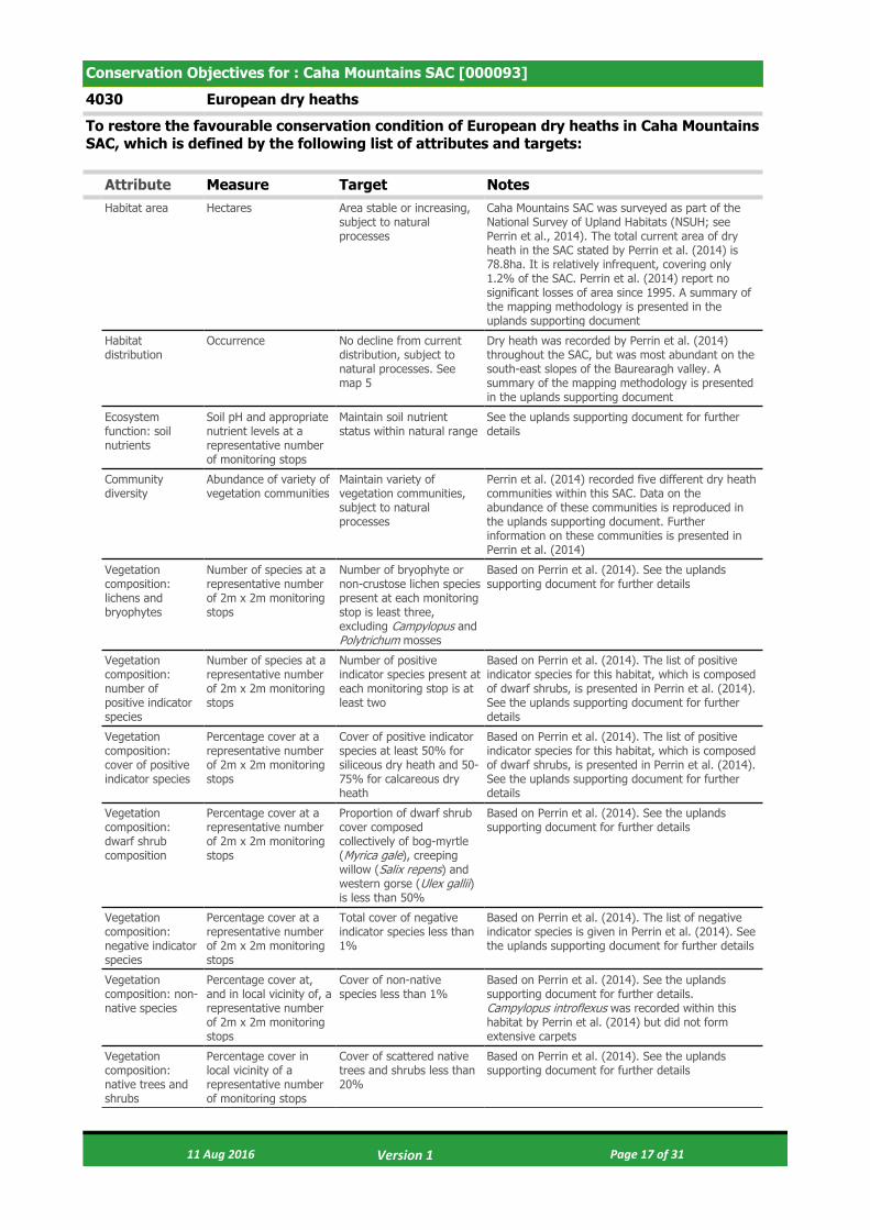
4030 European dry heaths
To restore the favourable conservation condition of European dry heaths in Caha Mountains SAC, which is defined by the following list of attributes and targets:
Attribute Measure Target NotesHabitat area Hectares Area stable or increasing,
subject to natural processes
Caha Mountains SAC was surveyed as part of the National Survey of Upland Habitats (NSUH; see Perrin et al., 2014). The total current area of dry heath in the SAC stated by Perrin et al. (2014) is 78.8ha. It is relatively infrequent, covering only 1.2% of the SAC. Perrin et al. (2014) report no significant losses of area since 1995. A summary of the mapping methodology is presented in the uplands supporting document
Habitat distribution
Occurrence No decline from current distribution, subject to natural processes. See map 5
Dry heath was recorded by Perrin et al. (2014) throughout the SAC, but was most abundant on the south-east slopes of the Baurearagh valley. A summary of the mapping methodology is presented in the uplands supporting document
Ecosystem function: soil nutrients
Soil pH and appropriate nutrient levels at a representative number of monitoring stops
Maintain soil nutrient status within natural range
See the uplands supporting document for further details
Community diversity
Abundance of variety of vegetation communities
Maintain variety of vegetation communities, subject to natural processes
Perrin et al. (2014) recorded five different dry heath communities within this SAC. Data on the abundance of these communities is reproduced in the uplands supporting document. Further information on these communities is presented in Perrin et al. (2014)
Vegetation composition: lichens and bryophytes
Number of species at a representative number of 2m x 2m monitoring stops
Number of bryophyte or non-crustose lichen species present at each monitoring stop is least three, excluding Campylopus and Polytrichum mosses
Based on Perrin et al. (2014). See the uplands supporting document for further details
Vegetation composition: number of positive indicator species
Number of species at a representative number of 2m x 2m monitoring stops
Number of positive indicator species present at each monitoring stop is at least two
Based on Perrin et al. (2014). The list of positive indicator species for this habitat, which is composed of dwarf shrubs, is presented in Perrin et al. (2014). See the uplands supporting document for further details
Vegetation composition: cover of positive indicator species
Percentage cover at a representative number of 2m x 2m monitoring stops
Cover of positive indicator species at least 50% for siliceous dry heath and 50-75% for calcareous dry heath
Based on Perrin et al. (2014). The list of positive indicator species for this habitat, which is composed of dwarf shrubs, is presented in Perrin et al. (2014). See the uplands supporting document for further details
Vegetation composition: dwarf shrub composition
Percentage cover at a representative number of 2m x 2m monitoring stops
Proportion of dwarf shrub cover composed collectively of bog-myrtle (Myrica gale), creeping willow (Salix repens) and western gorse (Ulex gallii) is less than 50%
Based on Perrin et al. (2014). See the uplands supporting document for further details
Vegetation composition: negative indicator species
Percentage cover at a representative number of 2m x 2m monitoring stops
Total cover of negative indicator species less than 1%
Based on Perrin et al. (2014). The list of negative indicator species is given in Perrin et al. (2014). See the uplands supporting document for further details
Vegetation composition: non-native species
Percentage cover at, and in local vicinity of, a representative number of 2m x 2m monitoring stops
Cover of non-native species less than 1%
Based on Perrin et al. (2014). See the uplands supporting document for further details. Campylopus introflexus was recorded within this habitat by Perrin et al. (2014) but did not form extensive carpets
Vegetation composition: native trees and shrubs
Percentage cover in local vicinity of a representative number of monitoring stops
Cover of scattered native trees and shrubs less than 20%
Based on Perrin et al. (2014). See the uplands supporting document for further details
11 Aug 2016 Page 17 of 31 Version 1

Vegetation composition: bracken
Percentage cover in local vicinity of a representative number of monitoring stops
Cover of bracken (Pteridium aquilinum) less than 10%
Based on Perrin et al. (2014). See the uplands supporting document for further details
Vegetation composition: soft rush
Percentage cover in local vicinity of a representative number of monitoring stops
Cover of soft rush (Juncus effusus) less than 10%
Based on Perrin et al. (2014). See the uplands supporting document for further details
Vegetation structure: senescent ling
Percentage cover at a representative number of 2m x 2m monitoring stops
Senescent proportion of ling (Calluna vulgaris) cover less than 50%
Based on Perrin et al. (2014). See the uplands supporting document for further details
Vegetation structure: signs of browsing
Percentage of shoots browsed at a representative number of 2m x 2m monitoring stops
Less than 33% collectively of the last complete growing season's shoots of ericoids showing signs of browsing
Based on Perrin et al. (2014). See the uplands supporting document for further details
Vegetation structure: burning
Occurrence in local vicinity of a representative number of monitoring stops
No signs of burning in sensitive areas
Based on Perrin et al. (2014). The list of sensitive areas is presented in Perrin et al. (2014). See the uplands supporting document for further details
Vegetation structure: growth phases of ling
Percentage cover in local vicinity of a representative number of monitoring stops
Outside sensitive areas, all growth phases of ling (Calluna vulgaris) should occur throughout, with at least 10% of cover in the mature phase
Based on Perrin et al. (2014). See the uplands supporting document for further details
Physical structure: disturbed bare ground
Percentage cover at, and in local vicinity of, a representative number of 2m x 2m monitoring stops
Cover of disturbed bare ground less than 10%
Based on Perrin et al. (2014). See the uplands supporting document for further details
Indicators of local distinctiveness
Occurrence and population size
No decline in distribution or population sizes of rare, threatened or scarce species associated with the habitat and no decline in status of hepatic mats associated with this habitat
Perrin et al. (2014) compiled and mapped existing rare and notable plant records for the SAC and added any new records collected during the NSUH survey. No relevant species were recorded in this habitat, however, new records should be considered within this attribute. Hepatic mats of the Calluna vulgaris-Herbertus aduncus community were recorded within this habitat by Perrin et al. (2014). No assessment of the conservation status of this community has been conducted but proposals for such an assessment are presented in Barron and Perrin (2014). See the uplands supporting document for further details
11 Aug 2016 Page 18 of 31 Version 1
Conservation Objectives for : Caha Mountains SAC [000093]
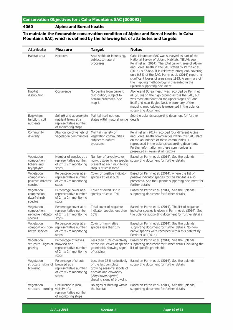
4060 Alpine and Boreal heaths
To maintain the favourable conservation condition of Alpine and Boreal heaths in Caha Mountains SAC, which is defined by the following list of attributes and targets:
Attribute Measure Target NotesHabitat area Hectares Area stable or increasing,
subject to natural processes
Caha Mountains SAC was surveyed as part of the National Survey of Upland Habitats (NSUH; see Perrin et al., 2014). The total current area of Alpine and Boreal heath in the SAC stated by Perrin et al. (2014) is 32.8ha. It is relatively infrequent, covering only 0.5% of the SAC. Perrin et al. (2014) report no significant losses of area since 1995. A summary of the mapping methodology is presented in the uplands supporting document
Habitat distribution
Occurrence No decline from current distribution, subject to natural processes. See map 6
Alpine and Boreal heath was recorded by Perrin et al. (2014) on the high ground across the SAC, but was most abundant on the upper slopes of Caha itself and near Eagles Nest. A summary of the mapping methodology is presented in the uplands supporting document
Ecosystem function: soil nutrients
Soil pH and appropriate nutrient levels at a representative number of monitoring stops
Maintain soil nutrient status within natural range
See the uplands supporting document for further details
Community diversity
Abundance of variety of vegetation communities
Maintain variety of vegetation communities, subject to natural processes
Perrin et al. (2014) recorded four different Alpine and Boreal heath communities within this SAC. Data on the abundance of these communities is reproduced in the uplands supporting document. Further information on these communities is presented in Perrin et al. (2014)
Vegetation composition: lichens and bryophytes
Number of species at a representative number of 2m x 2m monitoring stops
Number of bryophyte or non-crustose lichen species present at each monitoring stop is at least three
Based on Perrin et al. (2014). See the uplands supporting document for further details
Vegetation composition: positive indicator species
Percentage cover at a representative number of 2m x 2m monitoring stops
Cover of positive indicator species at least 66%
Based on Perrin et al. (2014), where the list of positive indicator species for this habitat is also presented. See the uplands supporting document for further details
Vegetation composition: dwarf-shrub species
Percentage cover at a representative number of 2m x 2m monitoring stops
Cover of dwarf-shrub species at least 10%
Based on Perrin et al. (2014). See the uplands supporting document for further details
Vegetation composition: negative indicator species
Percentage cover at a representative number of 2m x 2m monitoring stops
Total cover of negative indicator species less than 10%
Based on Perrin et al. (2014). The list of negative indicator species is given in Perrin et al. (2014). See the uplands supporting document for further details
Vegetation composition: non-native species
Percentage cover at a representative number of 2m x 2m monitoring stops
Cover of non-native species less than 1%
Based on Perrin et al. (2014). See the uplands supporting document for further details. No non-native species were recorded within this habitat by Perrin et al. (2014)
Vegetation structure: signs of grazing
Percentage of leaves browsed at a representative number of 2m x 2m monitoring stops
Less than 10% collectively of the live leaves of specific graminoids showing signs of grazing
Based on Perrin et al. (2014). See the uplands supporting document for further details including the list of specific graminoids
Vegetation structure: signs of browsing
Percentage of shoots browsed at a representative number of 2m x 2m monitoring stops
Less than 33% collectively of the last complete growing season's shoots of ericoids and crowberry (Empetrum nigrum) showing signs of browsing
Based on Perrin et al. (2014). See the uplands supporting document for further details
Vegetation structure: burning
Occurrence in local vicinity of a representative number of monitoring stops
No signs of burning within the habitat
Based on Perrin et al. (2014). See the uplands supporting document for further details
11 Aug 2016 Page 19 of 31 Version 1

Physical structure: disturbed bare ground
Percentage cover at, and in local vicinity of, a representative number of 2m x 2m monitoring stops
Cover of disturbed bare ground less than 10%
Based on Perrin et al. (2014). See the uplands supporting document for further details
Indicators of local distinctiveness
Occurrence and population size
No decline in distribution or population sizes of rare, threatened or scarce species associated with the habitat and no decline in status of hepatic mats associated with this habitat
Perrin et al. (2014) compiled and mapped existing rare and notable plant records for the SAC and added any new records collected during the NSUH survey. No relevant species were recorded in this habitat, however, new records should be considered within this attribute. Hepatic mats of the Calluna vulgaris-Herbertus aduncus community were recorded within this habitat by Perrin et al. (2014). No assessment of the conservation status of this community has been conducted but proposals for such an assessment are presented in Barron and Perrin (2014). See the uplands supporting document for further details
11 Aug 2016 Page 20 of 31 Version 1

Conservation Objectives for : Caha Mountains SAC [000093]
6230 Species-rich Nardus grasslands, on siliceous substrates in mountain areas (and submountain areas, in Continental Europe)
To restore the favourable conservation condition of Species-rich Nardus grasslands, on siliceous substrates in mountain areas (and submountain areas, in Continental Europe)* in Caha Mountains SAC, which is defined by the following list of attributes and targets:
Attribute Measure Target NotesHabitat area Hectares Area stable or increasing,
subject to natural processes
Caha Mountains SAC was surveyed as part of the National Survey of Upland Habitats (NSUH; see Perrin et al., 2014). The total current area of species-rich Nardus grassland in the SAC stated by Perrin et al. (2014) is 13.1ha. It is relatively infrequent, covering only 0.2% of the SAC. Perrin et al. (2014) report no significant losses of area since 1995. A summary of the mapping methodology is presented in the uplands supporting document
Habitat distribution
Occurrence No decline from current distribution, subject to natural processes. See map 7
Species-rich Nardus grassland was recorded by Perrin et al. (2014) scattered throughout the SAC. A summary of the mapping methodology is presented in the uplands supporting document
Ecosystem function: soil nutrients
Soil pH and appropriate nutrient levels at a representative number of monitoring stops
Maintain soil nutrient status within natural range
See the uplands supporting document for further details
Community diversity
Abundance of variety of vegetation communities
Maintain variety of vegetation communities, subject to natural processes
Perrin et al. (2014) recorded two different species-rich Nardus grassland communities within this SAC. Data on the abundance of these communities is reproduced in the uplands supporting document. Further information on these communities is presented in Perrin et al. (2014)
Vegetation composition: positive indicator species
Number of species at a representative number of 2m x 2m monitoring stops
Number of positive indicator species present at each monitoring stop is at least seven
Based on Perrin et al. (2014). The list of positive indicator species for this habitat is presented in Perrin et al. (2014). See the uplands supporting document for further details
Vegetation composition: high quality indicator species
Number of species at a representative number of 2m x 2m monitoring stops
At least two high quality species for base-rich examples of the habitat and at least one for base-poor examples of the habitat
Based on Perrin et al. (2014). The list of positive indicator species for this habitat is presented in Perrin et al. (2014). See the uplands supporting document for further details
Vegetation composition: species richness
Number of species at a representative number of 2m x 2m monitoring stops
Species richness at each monitoring stop at least 25
Based on Perrin et al. (2014). See the uplands supporting document for further details
Vegetation composition: non-native species
Percentage cover at a representative number of 2m x 2m monitoring stops
Cover of non-native species less than 1%
Based on Perrin et al. (2014). See the uplands supporting document for further details. Epilobium brunnescens was recorded within this habitat by Perrin et al. (2014)
Vegetation composition: negative indicator species
Percentage cover at a representative number of 2m x 2m monitoring stops
Cover of negative indicator species individually less than 10% and collectively less than 20%
Based on Perrin et al. (2014). The list of negative indicator species is given in Perrin et al. (2014). See the uplands supporting document for further details
Vegetation composition: Sphagnum cover
Percentage cover at a representative number of 2m x 2m monitoring stops
Cover of Sphagnum species less than 10%
Based on Perrin et al. (2014). See the uplands supporting document for further details
Vegetation composition: Polytrichum cover
Percentage cover at a representative number of 2m x 2m monitoring stops
Cover of Polytrichum species less than 25%
Based on Perrin et al. (2014). See the uplands supporting document for further details
Vegetation composition: scrub, bracken and heath cover
Percentage cover at a representative number of 2m x 2m monitoring stops
Cover of scrub, bracken (Pteridium aquilinum) and heath collectively less than 5%
Based on Perrin et al. (2014). See the uplands supporting document for further details
11 Aug 2016 Page 21 of 31 Version 1
Vegetation structure: forb to graminoid ratio
Percentage cover at a representative number of 2m x 2m monitoring stops
Forb component of forb:graminoid ratio is 20-90%
Based on Perrin et al. (2014). See the uplands supporting document for further details
Vegetation structure: sward height
Sward height at a representative number of 2m x 2m monitoring stops
Proportion of the sward between 5cm and 50cm tall is at least 25%
Based on Perrin et al. (2014). See the uplands supporting document for further details
Vegetation structure: litter cover
Percentage cover at a representative number of 2m x 2m monitoring stops
Cover of litter less than 20%
Based on Perrin et al. (2014). See the uplands supporting document for further details
Physical structure: disturbed bare ground
Percentage cover at a representative number of 2m x 2m monitoring stops
Cover of disturbed bare ground less than 10%
Based on Perrin et al. (2014). See the uplands supporting document for further details
Physical structure: grazing or disturbance
Percentage cover in local vicinity of a representative number of monitoring stops
Area of the habitat showing signs of serious grazing or disturbance less than 20m²
Based on Perrin et al. (2014). See the uplands supporting document for further details
Indicators of local distinctiveness
Occurrence and population size
No decline in distribution or population sizes of rare, threatened or scarce species associated with the habitat
Perrin et al. (2014) compiled and mapped existing rare and notable plant records for the SAC and added any new records collected during the NSUH survey. No relevant species were recorded in this habitat, however, new records should be considered within this attribute. See the uplands supporting document for further details
11 Aug 2016 Page 22 of 31 Version 1
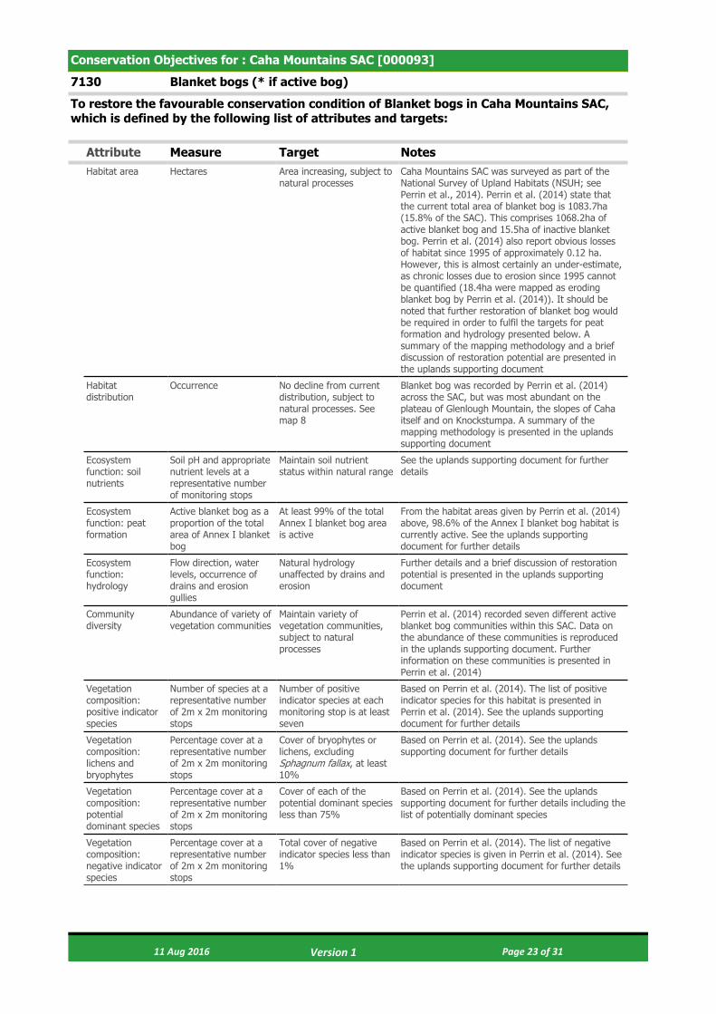
Conservation Objectives for : Caha Mountains SAC [000093]
7130 Blanket bogs (* if active bog)
To restore the favourable conservation condition of Blanket bogs in Caha Mountains SAC, which is defined by the following list of attributes and targets:
Attribute Measure Target NotesHabitat area Hectares Area increasing, subject to
natural processesCaha Mountains SAC was surveyed as part of the National Survey of Upland Habitats (NSUH; see Perrin et al., 2014). Perrin et al. (2014) state that the current total area of blanket bog is 1083.7ha (15.8% of the SAC). This comprises 1068.2ha of active blanket bog and 15.5ha of inactive blanket bog. Perrin et al. (2014) also report obvious losses of habitat since 1995 of approximately 0.12 ha. However, this is almost certainly an under-estimate, as chronic losses due to erosion since 1995 cannot be quantified (18.4ha were mapped as eroding blanket bog by Perrin et al. (2014)). It should be noted that further restoration of blanket bog would be required in order to fulfil the targets for peat formation and hydrology presented below. A summary of the mapping methodology and a brief discussion of restoration potential are presented in the uplands supporting document
Habitat distribution
Occurrence No decline from current distribution, subject to natural processes. See map 8
Blanket bog was recorded by Perrin et al. (2014) across the SAC, but was most abundant on the plateau of Glenlough Mountain, the slopes of Caha itself and on Knockstumpa. A summary of the mapping methodology is presented in the uplands supporting document
Ecosystem function: soil nutrients
Soil pH and appropriate nutrient levels at a representative number of monitoring stops
Maintain soil nutrient status within natural range
See the uplands supporting document for further details
Ecosystem function: peat formation
Active blanket bog as a proportion of the total area of Annex I blanket bog
At least 99% of the total Annex I blanket bog area is active
From the habitat areas given by Perrin et al. (2014) above, 98.6% of the Annex I blanket bog habitat is currently active. See the uplands supporting document for further details
Ecosystem function: hydrology
Flow direction, water levels, occurrence of drains and erosion gullies
Natural hydrology unaffected by drains and erosion
Further details and a brief discussion of restoration potential is presented in the uplands supporting document
Community diversity
Abundance of variety of vegetation communities
Maintain variety of vegetation communities, subject to natural processes
Perrin et al. (2014) recorded seven different active blanket bog communities within this SAC. Data on the abundance of these communities is reproduced in the uplands supporting document. Further information on these communities is presented in Perrin et al. (2014)
Vegetation composition: positive indicator species
Number of species at a representative number of 2m x 2m monitoring stops
Number of positive indicator species at each monitoring stop is at least seven
Based on Perrin et al. (2014). The list of positive indicator species for this habitat is presented in Perrin et al. (2014). See the uplands supporting document for further details
Vegetation composition: lichens and bryophytes
Percentage cover at a representative number of 2m x 2m monitoring stops
Cover of bryophytes or lichens, excluding Sphagnum fallax, at least 10%
Based on Perrin et al. (2014). See the uplands supporting document for further details
Vegetation composition: potential dominant species
Percentage cover at a representative number of 2m x 2m monitoring stops
Cover of each of the potential dominant species less than 75%
Based on Perrin et al. (2014). See the uplands supporting document for further details including the list of potentially dominant species
Vegetation composition: negative indicator species
Percentage cover at a representative number of 2m x 2m monitoring stops
Total cover of negative indicator species less than 1%
Based on Perrin et al. (2014). The list of negative indicator species is given in Perrin et al. (2014). See the uplands supporting document for further details
11 Aug 2016 Page 23 of 31 Version 1

Vegetation composition: non-native species
Percentage cover at, and in local vicinity of, a representative number of 2m x 2m monitoring stops
Cover of non-native species less than 1%
Based on Perrin et al. (2014). See the uplands supporting document for further details. Campylopus introflexus was recorded within this habitat by Perrin et al. (2014) but did not form extensive carpets
Vegetation composition: native trees and scrub
Percentage cover in local vicinity of a representative number of monitoring stops
Cover of scattered native trees and shrubs less than 10%
Based on Perrin et al. (2014). See the uplands supporting document for further details
Vegetation structure: Sphagnum condition
Condition at a representative number of 2m x 2m monitoring stops
Less than 10% of the Sphagnum cover is crushed, broken and/or pulled up
Based on Perrin et al. (2014). See the uplands supporting document for further details
Vegetation structure: signs of browsing
Percentage of shoots browsed at a representative number of 2m x 2m monitoring stops
Last complete growing season's shoots of ericoids, crowberry (Empetrum nigrum) and bog-myrtle (Myrica gale) showing signs of browsing collectively less than 33%
Based on Perrin et al. (2014). See the uplands supporting document for further details
Vegetation structure: burning
Occurrence in local vicinity of a representative number of monitoring stops
No signs of burning in sensitive areas, into the moss, liverwort or lichen layer or exposure of peat surface due to burning
Based on Perrin et al. (2014). The list of sensitive areas is presented in Perrin et al. (2014). See the uplands supporting document for further details
Physical structure: disturbed bare ground
Percentage cover at, and in local vicinity of, a representative number of 2m x 2m monitoring stops
Cover of disturbed bare ground less than 10%
Based on Perrin et al. (2014). See the uplands supporting document for further details
Physical structure: drainage
Occurrence in local vicinity of a representative number of monitoring stops
Area showing signs of drainage from heavy trampling, tracking or ditches less than 10%
Based on Perrin et al. (2014). See the uplands supporting document for further details
Physical structure: erosion
Occurrence in local vicinity of a representative number of monitoring stops
Less than 5% of the greater bog mosaic comprises erosion gullies and eroded areas
Based on Perrin et al. (2014). See the uplands supporting document for further details
Indicators of local distinctiveness
Occurrence and population size
No decline in distribution or population sizes of rare, threatened or scarce species associated with the habitat
Perrin et al. (2014) compiled and mapped existing rare and notable plant records for the SAC and added any new records collected during the NSUH survey. Campylopus shawii has been recorded from several stations within the habitat. This species is listed as Near Threatened in Lockhart et al. (2012) and is restricted to the south-west of the country. This and any new records should be considered within this attribute. See the uplands supporting document for further details
11 Aug 2016 Page 24 of 31 Version 1

Conservation Objectives for : Caha Mountains SAC [000093]
8110 Siliceous scree of the montane to snow levels (Androsacetalia alpinae and Galeopsietalia ladani)
To restore the favourable conservation condition of Siliceous scree of the montane to snow levels (Androsacetalia alpinae and Galeopsietalia ladani) in Caha Mountains SAC, which is defined by the following list of attributes and targets:
Attribute Measure Target NotesHabitat area Hectares Area stable or increasing,
subject to natural processes
Caha Mountains SAC was surveyed as part of the National Survey of Upland Habitats (NSUH; see Perrin et al., 2014). The total current area of siliceous scree in the SAC stated by Perrin et al. (2014) is 24.1ha. This covers 0.4% of the SAC. Perrin et al. (2014) report no significant losses of area since 1995. A summary of the mapping methodology is presented in the uplands supporting document
Habitat distribution
Occurrence No decline from current distribution, subject to natural processes. See map 9
Siliceous scree was recorded by Perrin et al. (2014) throughout the SAC. The most extensive patches occur in Glenlough and Glanrastel. A summary of the mapping methodology is presented in the uplands supporting document
Ecosystem function: soil nutrients
Soil pH and appropriate nutrient levels at a representative number of monitoring stops
Maintain soil nutrient status within natural range
See the uplands supporting document for further details
Vegetation composition: lichens and bryophytes
Percentage cover at a representative number of 2m x 2m monitoring stops
Cover of bryophytes and non-crustose lichen species at least 5%
Based on Perrin et al. (2014). See the uplands supporting document for further details
Vegetation composition: negative indicator species
Percentage cover at a representative number of 2m x 2m monitoring stops
Proportion of vegetation composed of negative indicator species less than 1%
Based on Perrin et al. (2014). The list of negative indicator species is given in Perrin et al. (2014). See the uplands supporting document for further details
Vegetation composition: non-native species
Percentage cover at a representative number of 2m x 2m monitoring stops
Proportion of vegetation composed of non-native species less than 1%
Based on Perrin et al. (2014). See the uplands supporting document for further details. Epilobium brunnescens was recorded within this habitat by Perrin et al. (2014)
Vegetation composition: positive indicator species
Number of species in local vicinity of a representative number of monitoring stops
Number of positive indicator species present in vicinity of each monitoring stop in block scree is at least one
Based on Perrin et al. (2014). The list of positive indicator species for this habitat is presented in Perrin et al. (2014) and is the same as for 8220 Siliceous rocky slopes. Further details can be found in the uplands supporting document
Vegetation composition: grass species and dwarf shrubs
Percentage cover in local vicinity of a representative number of monitoring stops
Total cover of grass species and dwarf shrubs less than 20%
Based on Perrin et al. (2014). See the uplands supporting document for further details
Vegetation composition: bracken, native trees and scrub
Percentage cover in local vicinity of a representative number of monitoring stops
Total cover of bracken (Pteridium aquilinum), native trees and scrub less than 25%
Based on Perrin et al. (2014). See the uplands supporting document for further details
Vegetation structure: grazing and browsing
Percentage of leaves/ shoots grazed/browsed at a representative number of 2m x 2m monitoring stops
Live leaves of forbs and shoots of dwarf shrubs showing signs of grazing or browsing collectively less than 50%
Based on Perrin et al. (2014). See the uplands supporting document for further details
Physical structure: disturbance
Percentage cover at, and in local vicinity of, a representative number of 2m x 2m monitoring stops
Ground disturbed by human and animal paths, scree running, vehicles less than 10%
Based on Perrin et al. (2014). See the uplands supporting document for further details
11 Aug 2016 Page 25 of 31 Version 1

Indicators of local distinctiveness
Occurrence and population size
No decline in distribution or population sizes of rare, threatened or scarce species associated with the habitat and no decline in status of hepatic mats associated with this habitat
Perrin et al. (2014) compiled and mapped existing rare and notable plant records for the SAC and added any new records collected during the NSUH survey. Rhabdoweisia crispata and Cyclodictyon laetevirens have been recorded from within the habitat. These species are listed as Near Threatened in Lockhart et al. (2012) with the latter found most frequently in the south-west of the country. These and any new records should be considered within this attribute. Hepatic mats of the Calluna vulgaris-Herbertus aduncus community were recorded within this habitat by Perrin et al. (2014). No assessment of the conservation status of this community has been conducted but proposals for such an assessment are presented in Barron and Perrin (2014). See the uplands supporting document for further details
11 Aug 2016 Page 26 of 31 Version 1
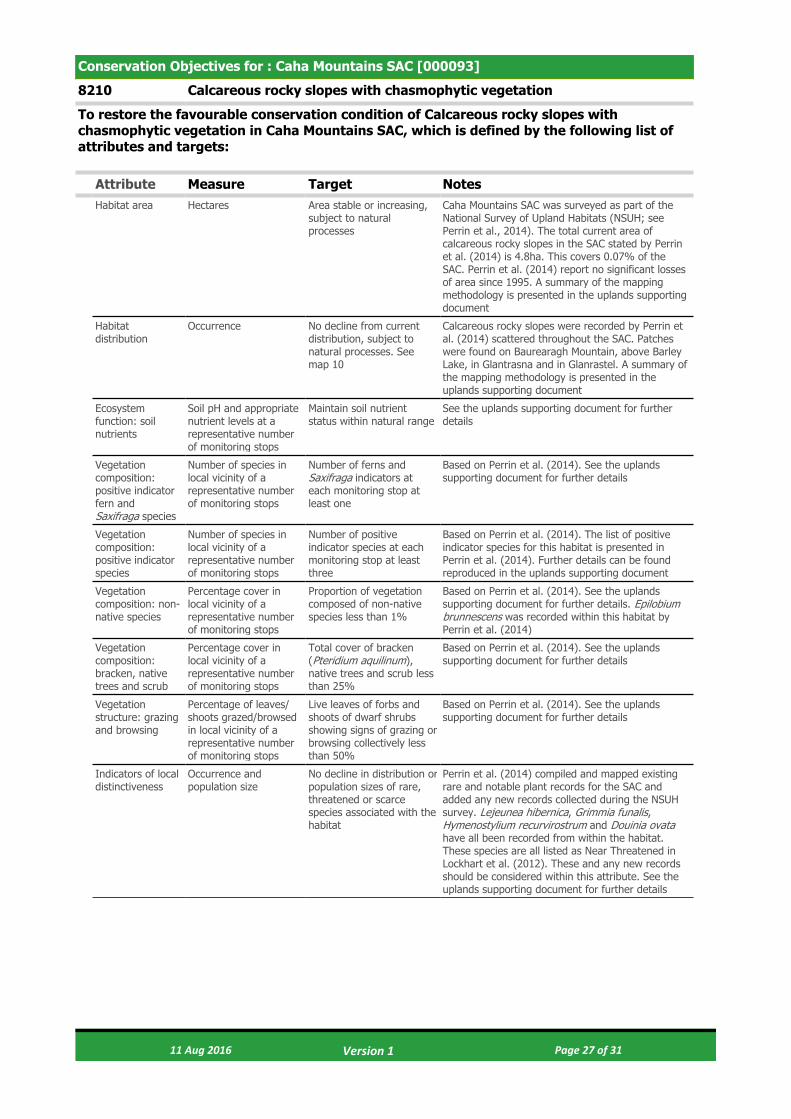
Conservation Objectives for : Caha Mountains SAC [000093]
8210 Calcareous rocky slopes with chasmophytic vegetation
To restore the favourable conservation condition of Calcareous rocky slopes with chasmophytic vegetation in Caha Mountains SAC, which is defined by the following list of attributes and targets:
Attribute Measure Target NotesHabitat area Hectares Area stable or increasing,
subject to natural processes
Caha Mountains SAC was surveyed as part of the National Survey of Upland Habitats (NSUH; see Perrin et al., 2014). The total current area of calcareous rocky slopes in the SAC stated by Perrin et al. (2014) is 4.8ha. This covers 0.07% of the SAC. Perrin et al. (2014) report no significant losses of area since 1995. A summary of the mapping methodology is presented in the uplands supporting document
Habitat distribution
Occurrence No decline from current distribution, subject to natural processes. See map 10
Calcareous rocky slopes were recorded by Perrin et al. (2014) scattered throughout the SAC. Patches were found on Baurearagh Mountain, above Barley Lake, in Glantrasna and in Glanrastel. A summary of the mapping methodology is presented in the uplands supporting document
Ecosystem function: soil nutrients
Soil pH and appropriate nutrient levels at a representative number of monitoring stops
Maintain soil nutrient status within natural range
See the uplands supporting document for further details
Vegetation composition: positive indicator fern and Saxifraga species
Number of species in local vicinity of a representative number of monitoring stops
Number of ferns and Saxifraga indicators at each monitoring stop at least one
Based on Perrin et al. (2014). See the uplands supporting document for further details
Vegetation composition: positive indicator species
Number of species in local vicinity of a representative number of monitoring stops
Number of positive indicator species at each monitoring stop at least three
Based on Perrin et al. (2014). The list of positive indicator species for this habitat is presented in Perrin et al. (2014). Further details can be found reproduced in the uplands supporting document
Vegetation composition: non-native species
Percentage cover in local vicinity of a representative number of monitoring stops
Proportion of vegetation composed of non-native species less than 1%
Based on Perrin et al. (2014). See the uplands supporting document for further details. Epilobium brunnescens was recorded within this habitat by Perrin et al. (2014)
Vegetation composition: bracken, native trees and scrub
Percentage cover in local vicinity of a representative number of monitoring stops
Total cover of bracken (Pteridium aquilinum), native trees and scrub less than 25%
Based on Perrin et al. (2014). See the uplands supporting document for further details
Vegetation structure: grazing and browsing
Percentage of leaves/ shoots grazed/browsed in local vicinity of a representative number of monitoring stops
Live leaves of forbs and shoots of dwarf shrubs showing signs of grazing or browsing collectively less than 50%
Based on Perrin et al. (2014). See the uplands supporting document for further details
Indicators of local distinctiveness
Occurrence and population size
No decline in distribution or population sizes of rare, threatened or scarce species associated with the habitat
Perrin et al. (2014) compiled and mapped existing rare and notable plant records for the SAC and added any new records collected during the NSUH survey. Lejeunea hibernica, Grimmia funalis, Hymenostylium recurvirostrum and Douinia ovata have all been recorded from within the habitat. These species are all listed as Near Threatened in Lockhart et al. (2012). These and any new records should be considered within this attribute. See the uplands supporting document for further details
11 Aug 2016 Page 27 of 31 Version 1

Conservation Objectives for : Caha Mountains SAC [000093]
8220 Siliceous rocky slopes with chasmophytic vegetation
To restore the favourable conservation condition of Siliceous rocky slopes with chasmophytic vegetation in Caha Mountains SAC, which is defined by the following list of attributes and targets:
Attribute Measure Target NotesHabitat area Hectares Area stable or increasing,
subject to natural processes
Caha Mountains SAC was surveyed as part of the National Survey of Upland Habitats (NSUH; see Perrin et al., 2014). The total current area of siliceous rocky slopes in the SAC stated by Perrin et al. (2014) is 52.6ha. This covers 0.8% of the SAC. Perrin et al. (2014) report no significant losses of area since 1995. A summary of the mapping methodology is presented in the uplands supporting document
Habitat distribution
Occurrence No decline from current distribution, subject to natural processes. See map 11
Siliceous rocky slopes were recorded by Perrin et al. (2014) scattered throughout the SAC. Patches were most abundant found on the steep cliffs in Glantrasna and in Glanrastel. A summary of the mapping methodology is presented in the uplands supporting document
Ecosystem function: soil nutrients
Soil pH and appropriate nutrient levels at a representative number of monitoring stops
Maintain soil nutrient status within natural range
See the uplands supporting document for further details
Vegetation composition: positive indicator species
Number of species at a representative number of monitoring stops
At least one positive indicator species present in vicinity of each monitoring stop
Based on Perrin et al. (2014). The list of positive indicator species for this habitat is presented in Perrin et al. (2014). Further details can be found in the uplands supporting document
Vegetation composition: non-native species
Percentage cover in local vicinity of a representative number of monitoring stops
Proportion of vegetation composed of non-native species less than 1%
Based on Perrin et al. (2014). See the uplands supporting document for further details. Epilobium brunnescens was recorded within this habitat by Perrin et al. (2014)
Vegetation composition: bracken, native trees and scrub
Percentage cover in local vicinity of a representative number of monitoring stops
Total cover of bracken (Pteridium aquilinum), native trees and scrub less than 25%
Based on Perrin et al. (2014). See the uplands supporting document for further details
Vegetation structure: grazing and browsing
Percentage of leaves/ shoots grazed/browsed in local vicinity of a representative number of monitoring stops
Live leaves of forbs and shoots of dwarf shrubs showing signs of grazing or browsing collectively less than 50%
Based on Perrin et al. (2014). See the uplands supporting document for further details
Indicators of local distinctiveness
Occurrence and population size
No decline in distribution or population sizes of rare, threatened or scarce species associated with the habitat and no decline in status of hepatic mats associated with this habitat
Perrin et al. (2014) compiled and mapped existing rare and notable plant records for the SAC and added any new records collected during the NSUH survey. Campylopus shawii has been recorded from several stations within the habitat. This species is listed as Near Threatened in Lockhart et al. (2012) and is restricted to the south-west of the country. This and any new records should be considered within this attribute. Hepatic mats of the Calluna vulgaris-Herbertus aduncus community were recorded within this habitat by Perrin et al. (2014). No assessment of the conservation status of this community has been conducted but proposals for such an assessment are presented in Barron and Perrin (2014). See the uplands supporting document for further details
11 Aug 2016 Page 28 of 31 Version 1
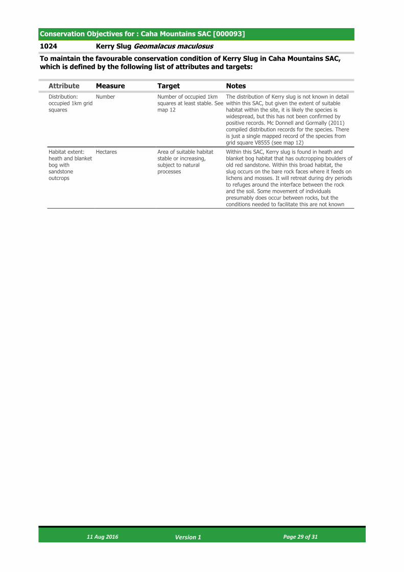
Conservation Objectives for : Caha Mountains SAC [000093]
1024 Kerry Slug Geomalacus maculosus
To maintain the favourable conservation condition of Kerry Slug in Caha Mountains SAC, which is defined by the following list of attributes and targets:
Attribute Measure Target NotesDistribution: occupied 1km grid squares
Number Number of occupied 1km squares at least stable. See map 12
The distribution of Kerry slug is not known in detail within this SAC, but given the extent of suitable habitat within the site, it is likely the species is widespread, but this has not been confirmed by positive records. Mc Donnell and Gormally (2011) compiled distribution records for the species. There is just a single mapped record of the species from grid square V8555 (see map 12)
Habitat extent: heath and blanket bog with sandstone outcrops
Hectares Area of suitable habitat stable or increasing, subject to natural processes
Within this SAC, Kerry slug is found in heath and blanket bog habitat that has outcropping boulders of old red sandstone. Within this broad habitat, the slug occurs on the bare rock faces where it feeds on lichens and mosses. It will retreat during dry periods to refuges around the interface between the rock and the soil. Some movement of individuals presumably does occur between rocks, but the conditions needed to facilitate this are not known
11 Aug 2016 Page 29 of 31 Version 1

Conservation Objectives for : Caha Mountains SAC [000093]
1421 Killarney Fern Trichomanes speciosum
To maintain the favourable conservation condition of Killarney Fern in Caha Mountains SAC, which is defined by the following list of attributes and targets:
Attribute Measure Target NotesDistribution Occurrence No loss in geographical
spread of populations, subject to natural processes
The species is currently known from one site in the SAC, within hectad V85. Its exact location is not mapped here on account of the threat posed by illegal collecting. The present status of a Co. Cork population recorded in 1898, but apparently not since, from a site variously described as "Caher mountains, near Glengariff" or "Caher mountain near Glengariff" (presumably Caha/Caha Mountains) is unknown, as is its exact location. Based on Ní Dhúill et al. (2015), NPWS (2013) and NPWS internal files
Number of populations
Number No decline, subject to natural processes
One population of the species is known from the SAC. It was first recorded here in 1996, and subsequently in 2014. Based on Ní Dhúill et al. (2015), NPWS (2013) and NPWS internal files
Number of colonies
Number No decline, subject to natural processes
The sole population of the species known from the SAC comprises a single colony. Based on Ní Dhúill et al. (2015), NPWS (2013) and NPWS internal files
Population: life-cycle stage
Type Maintain life-cycle stage composition of populations, subject to natural processes
Only the sporophyte (frond) stage has been recorded from the SAC. Based on Ní Dhúill et al. (2015), NPWS (2013) and NPWS internal files
Population size: area of occupancy
Square metres No decline, subject to natural processes
Area of occupancy estimated as 0.12m². Based on Ní Dhúill et al. (2015), NPWS (2013) and NPWS internal files
Population size: living sporophyte fronds
Number No decline, subject to natural processes
An estimated 50 fronds recorded in 2014. Based on Ní Dhúill et al. (2015), NPWS (2013) and NPWS internal files
Population structure: young and unfurling fronds
Occurrence Young (not fully expanded) and/or unfurling (crozier) fronds present in populations previously observed to have these, subject to natural processes
Young and/or unfurling fronds have not been recorded from the SAC to date. Based on Ní Dhúill et al. (2015), NPWS (2013) and NPWS internal files
Population structure: fertile fronds
Occurrence Fertile fronds present in populations previously observed to have these, subject to natural processes
Young and/or unfurling fronds have not been recorded from the SAC to date. Based on Ní Dhúill et al. (2015), NPWS (2013) and NPWS internal files
Population structure: juvenile sporophyte fronds emerging from gametophytes
Number No decline, subject to natural processes
Juvenile sporophyte fronds emerging from gametophytes have not been recorded from the SAC to date. Based on Ní Dhúill et al. (2015), NPWS (2013) and NPWS internal files
Habitat extent Hectares No loss of suitable habitat, subject to natural processes
The species grows in deeply shaded, humid situations - dripping caves, overhangs and crevices on cliffs, rocky slopes, by waterfalls, in stream ravines and gullies, on rock or soil banks in woodlands and, occasionally, under fallen trees and on the floor of damp woodlands. Whilst also occurring in these habitats, the gametophyte (filamentous) stage can grow in drier areas that do not suit the sporophyte. Based on Ní Dhúill et al. (2015), NPWS (2013) and NPWS internal files
11 Aug 2016 Page 30 of 31 Version 1

Hydrological conditions: wet/damp microhabitats
Occurrence Maintain hydrological conditions at the location of the known population - visible water source, with dripping or seeping water present and/or substrate wet/damp to touch, subject to natural processes
Based on Ní Dhúill et al. (2015), NPWS (2013) and NPWS internal files
Hydrological conditions: relative humidity
Percentage Maintain relative humidity levels at the known colony at not less than 80%, subject to natural processes
Based on Ní Dhúill et al. (2015), NPWS (2013) and NPWS internal files
Hydrological conditions: desiccated fronds
Number No increase, subject to natural processes
Presence of desiccated sporophyte fronds and gametophyte mats is indicative of unsuitable conditions. Based on Ní Dhúill et al. (2015), NPWS (2013) and NPWS internal files
Light levels: shading
Shade index score At least 4 for woodland sporophyte-only and mixed colonies; at least 5 for open upland sporophyte-only and mixed colonies; at least 6 for gametophyte-only colonies, subject to natural processes
Shade Index: 4. Moderate shade, e.g. light-medium deciduous canopy with sun flecks. 5. Permanently shaded from direct sunlight but otherwise open to sky. 6. Deep woodland (e.g. coniferous or in ravine) shade, no sun flecks. 7. Perpetual deep shade, e.g. cave entrance, beneath boulder. Woodland colonies have not been recorded from the SAC to date. Based on Ní Dhúill et al. (2015), NPWS (2013) and NPWS internal files
Woodland canopy cover
Percentage No loss of woodland canopy at, or in the vicinity of, the location of the known population and canopy cover maintained at more than 33%, subject to natural processes
Woodland management at or near to locations of the known population of the species to take account of its habitat requirements, in particular, with regard to maintenance of sufficient canopy cover. Woodland colonies have not been recorded from the SAC to date. Based on Ní Dhúill et al. (2015), NPWS (2013) and NPWS internal files
Invasive species Occurrence Maintain absence of invasive non-native and vigorous native plant species at the location of the known population or, if present, maintain vegetation cover at less than 10%, taking into account the habitat requirements of T. speciosum
In order to avoid negative impacts on T. speciosum, its habitat requirements (site hydrology, relative humidity, canopy cover, shading levels, etc.) must be taken into account in locations that are subject to or proposed for management actions to control invasive non-native and/or vigorous native plant species. Based on Ní Dhúill et al. (2015), NPWS (2013) and NPWS internal files
11 Aug 2016 Page 31 of 31 Version 1

© Ordnance Survey Ireland
Map Version 1Date: July 2016
MAP 1:CAHA MOUNTAINS SAC
CONSERVATION OBJECTIVESSAC DESIGNATION
Map to be read in conjunction with the NPWS Conservation Objectives Document.
The mapped boundaries are of an indicative and general nature only. Boundaries of designated areas are subject to revision.Ordnance Survey of Ireland Licence No EN 0059216. © Ordnance Survey of Ireland Government of Ireland.
Níl sna teorainneacha ar na léarscáileanna ach nod garshuiomhach ginearálta. Féadfar athbhreithnithe a déanamh ar theorainneacha na gceantar comharthaithe. Suirbhéarachta Ordonáis na hÉireann Ceadúnas Uimh EN 0059216. © Suirbhéarachta Ordonáis na hÉireann Rialtas na hÉireann.
LegendCaha Mountains SAC 000093
±0 1 2 3 km
SITE CODE:SAC 000093; version 3. Co. Cork / Kerry
SAC 000093
CO. CORK
Glengarriff
Killarney
Cork
CO. KERRY
Kenmare

© Ordnance Survey Ireland
Map Version 1Date: July 2016
MAP 2:CAHA MOUNTAINS SAC
CONSERVATION OBJECTIVESADJOINING DESIGNATIONS
Map to be read in conjunction with the NPWS Conservation Objectives Document.
The mapped boundaries are of an indicative and general nature only. Boundaries of designated areas are subject to revision.Ordnance Survey of Ireland Licence No EN 0059216. © Ordnance Survey of Ireland Government of Ireland.
Níl sna teorainneacha ar na léarscáileanna ach nod garshuiomhach ginearálta. Féadfar athbhreithnithe a déanamh ar theorainneacha na gceantar comharthaithe. Suirbhéarachta Ordonáis na hÉireann Ceadúnas Uimh EN 0059216. © Suirbhéarachta Ordonáis na hÉireann Rialtas na hÉireann.
LegendCaha Mountains SAC 000093Glengarriff Harbour and Woodland SAC 000090
±0 1 2 3 km
SITE CODE:SAC 000093; version 3. Co. Cork / Kerry
000093
000090

Map Version 1Date: July 2016
MAP 3:CAHA MOUNTAINS SAC
CONSERVATION OBJECTIVESLAKE HABITATS
Map to be read in conjunction with the NPWS Conservation Objectives Document.
The mapped boundaries are of an indicative and general nature only. Boundaries of designated areas are subject to revision.Ordnance Survey of Ireland Licence No EN 0059216. © Ordnance Survey of Ireland Government of Ireland.
Níl sna teorainneacha ar na léarscáileanna ach nod garshuiomhach ginearálta. Féadfar athbhreithnithe a déanamh ar theorainneacha na gceantar comharthaithe. Suirbhéarachta Ordonáis na hÉireann Ceadúnas Uimh EN 0059216. © Suirbhéarachta Ordonáis na hÉireann Rialtas na hÉireann.
LegendCaha Mountains SAC 000093OSi Discovery Series County Boundaries
Lake HabitatsPotential 3110 Oligotrophic waters containing very few minerals of sandy plains (Littorelletalia uniflorarae)Potential 3160 Potential Natural dystrophic lakes and ponds
±0 1 2 3 km
SITE CODE:SAC 000093; version 3. Co. Cork / Kerry
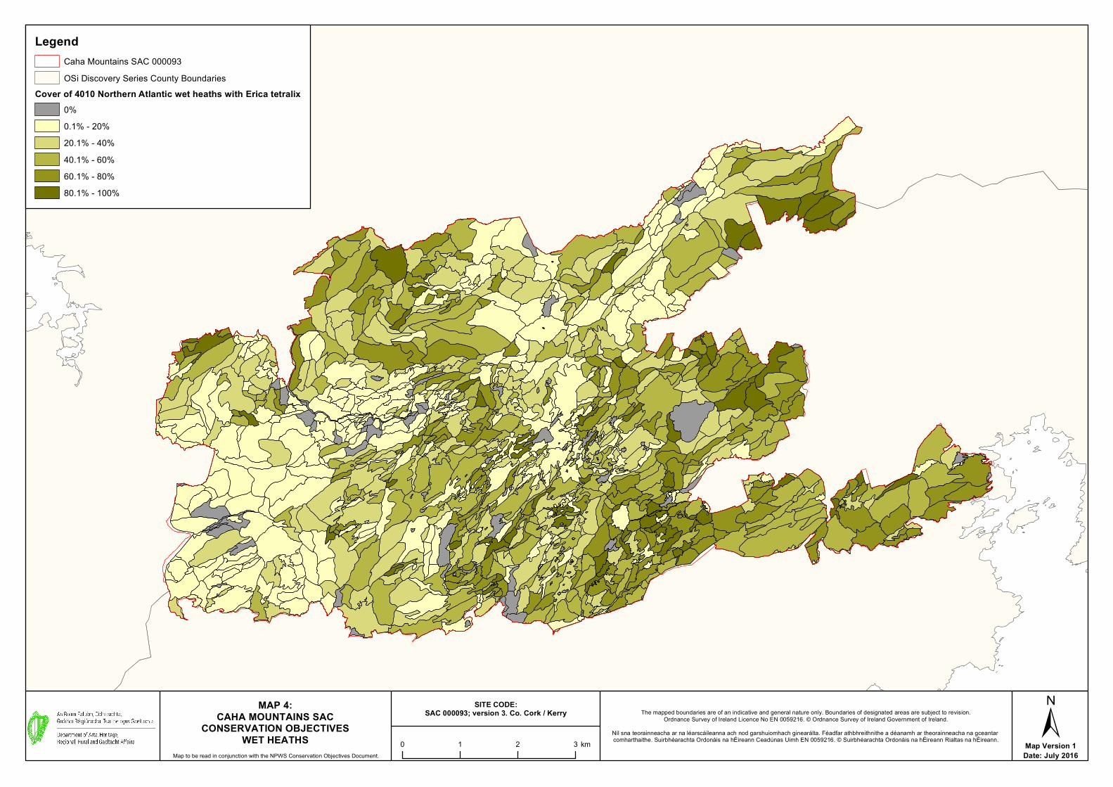
Map Version 1Date: July 2016
MAP 4:CAHA MOUNTAINS SAC
CONSERVATION OBJECTIVESWET HEATHS
Map to be read in conjunction with the NPWS Conservation Objectives Document.
The mapped boundaries are of an indicative and general nature only. Boundaries of designated areas are subject to revision.Ordnance Survey of Ireland Licence No EN 0059216. © Ordnance Survey of Ireland Government of Ireland.
Níl sna teorainneacha ar na léarscáileanna ach nod garshuiomhach ginearálta. Féadfar athbhreithnithe a déanamh ar theorainneacha na gceantar comharthaithe. Suirbhéarachta Ordonáis na hÉireann Ceadúnas Uimh EN 0059216. © Suirbhéarachta Ordonáis na hÉireann Rialtas na hÉireann.
LegendCaha Mountains SAC 000093OSi Discovery Series County Boundaries
Cover of 4010 Northern Atlantic wet heaths with Erica tetralix0%0.1% - 20%20.1% - 40%40.1% - 60%60.1% - 80%80.1% - 100%
±0 1 2 3 km
SITE CODE:SAC 000093; version 3. Co. Cork / Kerry

Map Version 1Date: July 2016
MAP 5:CAHA MOUNTAINS SAC
CONSERVATION OBJECTIVESDRY HEATHS
Map to be read in conjunction with the NPWS Conservation Objectives Document.
The mapped boundaries are of an indicative and general nature only. Boundaries of designated areas are subject to revision.Ordnance Survey of Ireland Licence No EN 0059216. © Ordnance Survey of Ireland Government of Ireland.
Níl sna teorainneacha ar na léarscáileanna ach nod garshuiomhach ginearálta. Féadfar athbhreithnithe a déanamh ar theorainneacha na gceantar comharthaithe. Suirbhéarachta Ordonáis na hÉireann Ceadúnas Uimh EN 0059216. © Suirbhéarachta Ordonáis na hÉireann Rialtas na hÉireann.
LegendCaha Mountains SAC 000093OSi Discovery Series County Boundaries
Cover of 4030 European dry heaths0%0.1% - 20%20.1% - 40%40.1% - 60%60.1% - 80%80.1% - 100%
±0 1 2 3 km
SITE CODE:SAC 000093; version 3. Co. Cork / Kerry
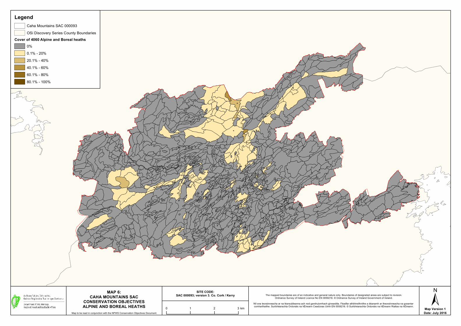
Map Version 1Date: July 2016
MAP 6:CAHA MOUNTAINS SAC
CONSERVATION OBJECTIVESALPINE AND BOREAL HEATHS
Map to be read in conjunction with the NPWS Conservation Objectives Document.
The mapped boundaries are of an indicative and general nature only. Boundaries of designated areas are subject to revision.Ordnance Survey of Ireland Licence No EN 0059216. © Ordnance Survey of Ireland Government of Ireland.
Níl sna teorainneacha ar na léarscáileanna ach nod garshuiomhach ginearálta. Féadfar athbhreithnithe a déanamh ar theorainneacha na gceantar comharthaithe. Suirbhéarachta Ordonáis na hÉireann Ceadúnas Uimh EN 0059216. © Suirbhéarachta Ordonáis na hÉireann Rialtas na hÉireann.
LegendCaha Mountains SAC 000093OSi Discovery Series County Boundaries
Cover of 4060 Alpine and Boreal heaths0%0.1% - 20%20.1% - 40%40.1% - 60%60.1% - 80%80.1% - 100%
±0 1 2 3 km
SITE CODE:SAC 000093; version 3. Co. Cork / Kerry

Map Version 1Date: July 2016
MAP 7:CAHA MOUNTAINS SAC
CONSERVATION OBJECTIVESSPECIES-RICH NARDUS UPLAND GRASSLAND*
Map to be read in conjunction with the NPWS Conservation Objectives Document.
The mapped boundaries are of an indicative and general nature only. Boundaries of designated areas are subject to revision.Ordnance Survey of Ireland Licence No EN 0059216. © Ordnance Survey of Ireland Government of Ireland.
Níl sna teorainneacha ar na léarscáileanna ach nod garshuiomhach ginearálta. Féadfar athbhreithnithe a déanamh ar theorainneacha na gceantar comharthaithe. Suirbhéarachta Ordonáis na hÉireann Ceadúnas Uimh EN 0059216. © Suirbhéarachta Ordonáis na hÉireann Rialtas na hÉireann.
LegendCaha Mountains SAC 000093OSi Discovery Series County Boundaries
Cover of 6230 *Species-rich Nardus grasslands on siliceous substrates inmountain areas (and submountain areas in continental Europe)
0%0.1% - 20%20.1% - 40%40.1% - 60%60.1% - 80%80.1% - 100%
±0 1 2 3 km
SITE CODE:SAC 000093; version 3. Co. Cork / Kerry
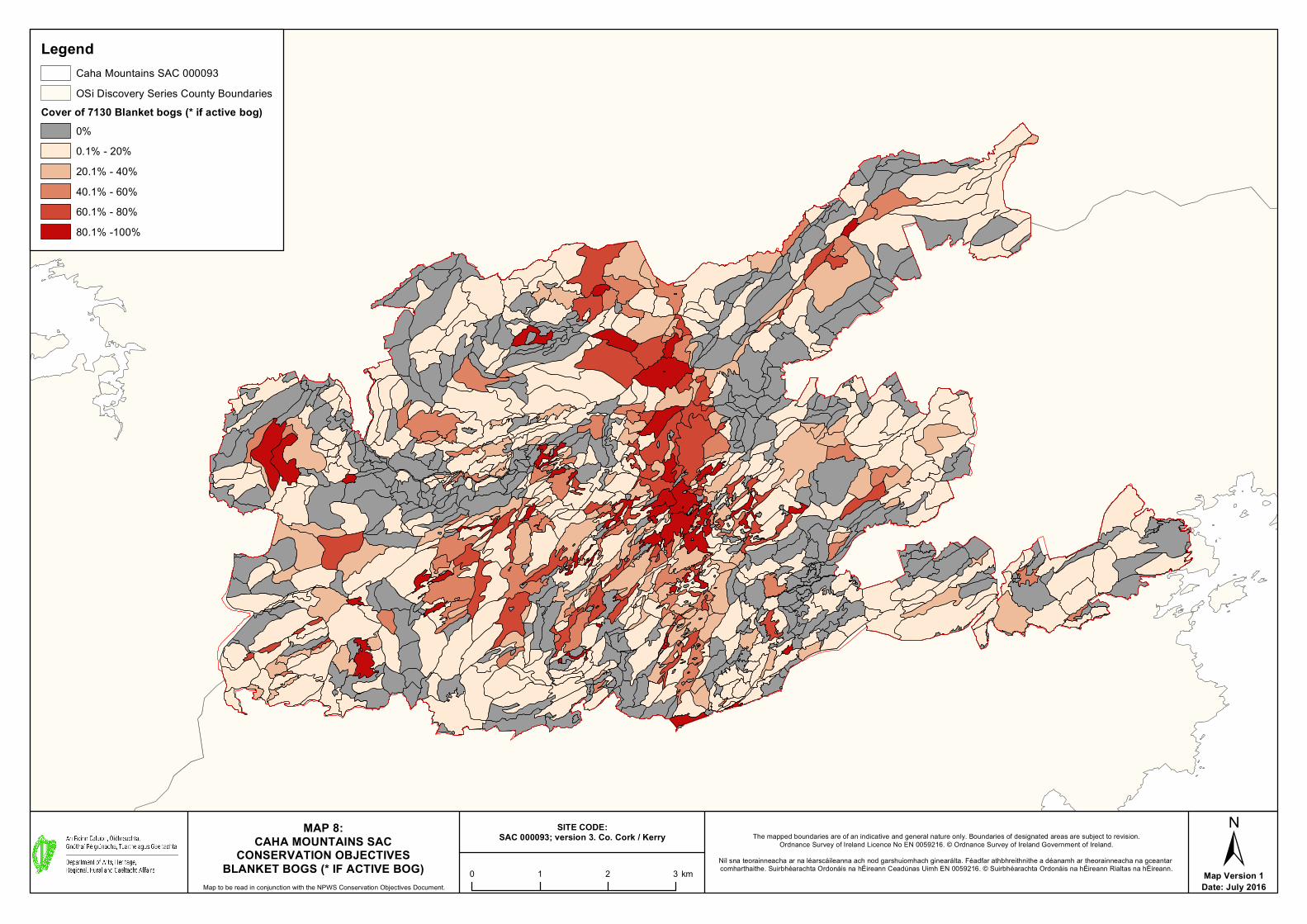
Map Version 1Date: July 2016
MAP 8:CAHA MOUNTAINS SAC
CONSERVATION OBJECTIVESBLANKET BOGS (* IF ACTIVE BOG)
Map to be read in conjunction with the NPWS Conservation Objectives Document.
The mapped boundaries are of an indicative and general nature only. Boundaries of designated areas are subject to revision.Ordnance Survey of Ireland Licence No EN 0059216. © Ordnance Survey of Ireland Government of Ireland.
Níl sna teorainneacha ar na léarscáileanna ach nod garshuiomhach ginearálta. Féadfar athbhreithnithe a déanamh ar theorainneacha na gceantar comharthaithe. Suirbhéarachta Ordonáis na hÉireann Ceadúnas Uimh EN 0059216. © Suirbhéarachta Ordonáis na hÉireann Rialtas na hÉireann.
LegendCaha Mountains SAC 000093OSi Discovery Series County Boundaries
Cover of 7130 Blanket bogs (* if active bog)0%0.1% - 20%20.1% - 40% 40.1% - 60%60.1% - 80%80.1% -100%
±0 1 2 3 km
SITE CODE:SAC 000093; version 3. Co. Cork / Kerry

Map Version 1Date: July 2016
MAP 9:CAHA MOUNTAINS SAC
CONSERVATION OBJECTIVESSILICEOUS SCREE
Map to be read in conjunction with the NPWS Conservation Objectives Document.
The mapped boundaries are of an indicative and general nature only. Boundaries of designated areas are subject to revision.Ordnance Survey of Ireland Licence No EN 0059216. © Ordnance Survey of Ireland Government of Ireland.
Níl sna teorainneacha ar na léarscáileanna ach nod garshuiomhach ginearálta. Féadfar athbhreithnithe a déanamh ar theorainneacha na gceantar comharthaithe. Suirbhéarachta Ordonáis na hÉireann Ceadúnas Uimh EN 0059216. © Suirbhéarachta Ordonáis na hÉireann Rialtas na hÉireann.
LegendCaha Mountains SAC 000093OSi Discovery Series County Boundaries
Cover of 8110 Siliceous scree of the montane to snow levels (Androsacetalia alpinae and Galeopsietalia ladani)0%0.1% - 20%20.1% - 40%40.1% - 60%60.1% - 80%80.1% - 100%
±0 1 2 3 km
SITE CODE:SAC 000093; version 3. Co. Cork / Kerry
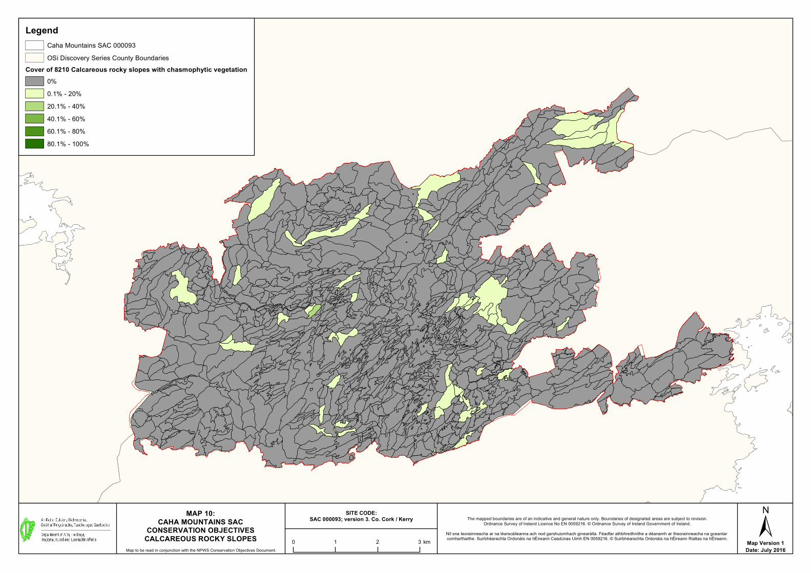
Map Version 1Date: July 2016
MAP 10:CAHA MOUNTAINS SAC
CONSERVATION OBJECTIVESCALCAREOUS ROCKY SLOPES
Map to be read in conjunction with the NPWS Conservation Objectives Document.
The mapped boundaries are of an indicative and general nature only. Boundaries of designated areas are subject to revision.Ordnance Survey of Ireland Licence No EN 0059216. © Ordnance Survey of Ireland Government of Ireland.
Níl sna teorainneacha ar na léarscáileanna ach nod garshuiomhach ginearálta. Féadfar athbhreithnithe a déanamh ar theorainneacha na gceantar comharthaithe. Suirbhéarachta Ordonáis na hÉireann Ceadúnas Uimh EN 0059216. © Suirbhéarachta Ordonáis na hÉireann Rialtas na hÉireann.
LegendCaha Mountains SAC 000093OSi Discovery Series County Boundaries
Cover of 8210 Calcareous rocky slopes with chasmophytic vegetation0%0.1% - 20%20.1% - 40%40.1% - 60%60.1% - 80%80.1% - 100%
±0 1 2 3 km
SITE CODE:SAC 000093; version 3. Co. Cork / Kerry

Map Version 1Date: July 2016
MAP 11:CAHA MOUNTAINS SAC
CONSERVATION OBJECTIVESSILICEOUS ROCKY SLOPES
Map to be read in conjunction with the NPWS Conservation Objectives Document.
The mapped boundaries are of an indicative and general nature only. Boundaries of designated areas are subject to revision.Ordnance Survey of Ireland Licence No EN 0059216. © Ordnance Survey of Ireland Government of Ireland.
Níl sna teorainneacha ar na léarscáileanna ach nod garshuiomhach ginearálta. Féadfar athbhreithnithe a déanamh ar theorainneacha na gceantar comharthaithe. Suirbhéarachta Ordonáis na hÉireann Ceadúnas Uimh EN 0059216. © Suirbhéarachta Ordonáis na hÉireann Rialtas na hÉireann.
LegendCaha Mountains SAC 000093OSi Discovery Series County Boundaries
Cover of 8220 Siliceous rocky slopes with chasmophytic vegetation0%0.1% - 20%20.1% - 40%40.1% - 60%60.1% - 80%80.1% - 100%
±0 1 2 3 km
SITE CODE:SAC 000093; version 3. Co. Cork / Kerry

Map Version 1Date: July 2016
MAP 12: CAHA MOUNTAINS SAC
CONSERVATION OBJECTIVESKERRY SLUG - GEOMALACUS MACULOSUS
Map to be read in conjunction with the NPWS Conservation Objectives Document.
The mapped boundaries are of an indicative and general nature only. Boundaries of designated areas are subject to revision.Ordnance Survey of Ireland Licence No EN 0059216. © Ordnance Survey of Ireland Government of Ireland.
Níl sna teorainneacha ar na léarscáileanna ach nod garshuiomhach ginearálta. Féadfar athbhreithnithe a déanamh ar theorainneacha na gceantar comharthaithe. Suirbhéarachta Ordonáis na hÉireann Ceadúnas Uimh EN 0059216. © Suirbhéarachta Ordonáis na hÉireann Rialtas na hÉireann.
LegendCaha Mountains SAC 0000931024 Kerry Slug - Geomalacus maculosusOSi Discovery Series County Boundaries
±0 1 2 3 km
SITE CODE:SAC 000093; version 3. Co. Cork / Kerry
V8555
Related Documents


![ISSN 2009-4086 National Parks and Wildlife Service · Conservation Objectives for : Glenomra Wood SAC [001013] 91A0 Old sessile oak woods with Ilex and Blechnum in the British Isles](https://static.cupdf.com/doc/110x72/5c65ade209d3f2826e8cfdca/issn-2009-4086-national-parks-and-wildlife-service-conservation-objectives-for.jpg)