Government of Malawi World Bank Irrigation, Rural Livelihoods and Agriculture Development Project Resettlement Policy Framework Volume 1: Social Impact Assessment Final Report March 2005 Ministry of Agriculture Capital City, Lilongwe 3 Public Disclosure Authorized Public Disclosure Authorized Public Disclosure Authorized Public Disclosure Authorized Public Disclosure Authorized Public Disclosure Authorized Public Disclosure Authorized Public Disclosure Authorized

Welcome message from author
This document is posted to help you gain knowledge. Please leave a comment to let me know what you think about it! Share it to your friends and learn new things together.
Transcript

Government of Malawi World Bank
Irrigation, Rural Livelihoods and Agriculture Development Project
Resettlement Policy Framework
Volume 1: Social Impact Assessment
Final Report
March 2005
Ministry of Agriculture Capital City, Lilongwe 3
Pub
lic D
iscl
osur
e A
utho
rized
Pub
lic D
iscl
osur
e A
utho
rized
Pub
lic D
iscl
osur
e A
utho
rized
Pub
lic D
iscl
osur
e A
utho
rized
Pub
lic D
iscl
osur
e A
utho
rized
Pub
lic D
iscl
osur
e A
utho
rized
Pub
lic D
iscl
osur
e A
utho
rized
Pub
lic D
iscl
osur
e A
utho
rized
wb406484
Typewritten Text
RP1311 v1
wb406484
Typewritten Text
ii
Irrigation, Rural Livelihoods and Agriculture Development Project
Resettlement Policy Framework
Volume 1: Social Impact Assessment
Final Report
Proponent: The Principal Secretary Ministry of Agriculture P.O. Box 30134 Capital City Lilongwe 3
Tel: (265) 1789033
(265) 1789252
Fax: (265) 1789218 (265) 1788738
Consultant: Kempton Consultancy Services Plot No. 4/354D Shire Limited Building P.O. Box 1048 Lilongwe. Malawi.
Mobile: (265) 9958136
iii
Table of Contents
Table of Contents----------------------------------------------------------------------------------------------------------------- iii
EXECUTIVE SUMMARY------------------------------------------------------------------------------------------------------- vi
ACKNOWLEDGEMENTS ---------------------------------------------------------------------------------------------------- x
LIST OF ACRONYMS ----------------------------------------------------------------------------------------------------------xi
LIST OF TABLES ---------------------------------------------------------------------------------------------------------------xii
1.0 Introduction ------------------------------------------------------------------------------------------------------------- 1
1.1 Background------------------------------------------------------------------------------------------------------------ 1
1.2 Objectives of the project -------------------------------------------------------------------------------------------- 2
1.3 Components of the project ------------------------------------------------------------------------------------------ 2
1.4 Target sub-components --------------------------------------------------------------------------------------------- 3
2.0 Objectives of the Study ------------------------------------------------------------------------------------------------ 3
3.0 Methodology ------------------------------------------------------------------------------------------------------------- 4
3.1 Desk Study ------------------------------------------------------------------------------------------------------------ 4
3.2 Focused Group Discussions---------------------------------------------------------------------------------------- 4
3.3 Key informant Interviews ------------------------------------------------------------------------------------------- 4
3.4 Consultative workshops--------------------------------------------------------------------------------------------- 5 3.4.1 First Consultative Workshop. -------------------------------------------------------------------------------------- 5 3.4.2 Second Consultative Workshop ------------------------------------------------------------------------------------ 5
3.5 The validation Committee ------------------------------------------------------------------------------------------ 5
4.0 Study target sub-components ---------------------------------------------------------------------------------------- 5
5.0 General description of visited Irrigation Schemes --------------------------------------------------------------- 6
5.1 Schemes with land Conflicts --------------------------------------------------------------------------------------- 6 5.1.1 Kambwiri Sele Irrigation Scheme, in Salima District ---------------------------------------------------------- 6
(a) Land Acquisition and Transfers ------------------------------------------------------------------------------------ 6 (b) Land Conflicts--------------------------------------------------------------------------------------------------------- 6 (c) Categories of assets--------------------------------------------------------------------------------------------------- 7 (d) Conflict Resolutions and compensation -------------------------------------------------------------------------- 7
5.1.2 Likangala and Domasi Irrigation Schemes in Zomba and Machinga Districts (A case study) ----- 7 5.1.2.1 Land Tenure Issues ------------------------------------------------------------------------------------------- 8 5.1.2.2 Landholding sizes --------------------------------------------------------------------------------------------- 9 5.1.2.3 Rehabilitation and farmers’ capacity building-----------------------------------------------------------10
5.2 Schemes Presumed to be Free From Land Conflicts------------------------------------------------------------12 5.2.1 Ngolowindo Irrigation Scheme in Salima District -------------------------------------------------------------12
(a) Land Acquisition and Transfers -----------------------------------------------------------------------------------12 (b) Land Conflicts--------------------------------------------------------------------------------------------------------13 (c) Categories of assets--------------------------------------------------------------------------------------------------13 (d) Compensation and Resettlement Issues--------------------------------------------------------------------------13

iv
(e) Conflict Resolution--------------------------------------------------------------------------------------------------13 5.2.3 Kadziwamwini Irrigation Scheme, in Salima District ---------------------------------------------------------13
(a) Land Acquisition and Transfers -----------------------------------------------------------------------------------13 (b) Land Conflicts--------------------------------------------------------------------------------------------------------14 (c) Categories of assets--------------------------------------------------------------------------------------------------14 (d) Conflict Resolutions and compensation -------------------------------------------------------------------------14
5.2.4 Nkhate Irrigation Scheme, in Chikwawa District --------------------------------------------------------------14 (a) Land Acquisition and Transfers -----------------------------------------------------------------------------------14 (b) Land Conflicts and Compensation--------------------------------------------------------------------------------15 (c) Categories of assets--------------------------------------------------------------------------------------------------15 (d) Conflict Resolutions-------------------------------------------------------------------------------------------------15
5.2.5 Muona Irrigation Scheme, in Nsanje District -------------------------------------------------------------------15 (a) Land Acquisition and Transfers -----------------------------------------------------------------------------------15 (b) Land Conflicts and Compensation--------------------------------------------------------------------------------16 (c) Categories of assets--------------------------------------------------------------------------------------------------16 (d) Conflict Resolutions-------------------------------------------------------------------------------------------------16
5.2.6 Limphasa Irrigation Scheme, Nkhata-Bay District ------------------------------------------------------------16 (a) Land Acquisition and Transfers -----------------------------------------------------------------------------------16 (b) Land Conflicts and Compensation--------------------------------------------------------------------------------16 (c) Categories of assets--------------------------------------------------------------------------------------------------17 (d) Conflict Resolutions-------------------------------------------------------------------------------------------------17 5.3 General Condition of Infrastructure on the irrigation schemes-------------------------------------------17
6.0 LEGAL AND INSTITUTIONAL FRAMEWORK FOR LAND acquisition, COMPENSATION AND RESETTLEMENT---------------------------------------------------------------------------------------------------------------18
6.1 Institutional Framework --------------------------------------------------------------------------------------------19 6.1.1 Current Institutional Framework ----------------------------------------------------------------------------------19
(a) The Ministry of Lands and Housing (MoLH)-------------------------------------------------------------------19 (b) Office of the President and Cabinet (OPC)----------------------------------------------------------------------19 (c) Ministry of Local Government (MoLG) -------------------------------------------------------------------------19 (d) Local Chiefs and Village Headmen-------------------------------------------------------------------------------19 (e) Other Line Ministries, Agencies and Non-Governmental Organizations ----------------------------------20
6.1.2 Proposed Institution Framework under the project ------------------------------------------------------------20 (a) The Project Steering Committee (PSC) --------------------------------------------------------------------------20 (b) The Project Technical Committee (PTC)------------------------------------------------------------------------20 (c) District Advisory Service and the Coordination of Project at District level -------------------------------21
6.1.3 Current Linkages During Land Acquisition, Compensation and Resettlement ---------------------21 (a) Public Projects -------------------------------------------------------------------------------------------------------21
6.1.5 Community Projects including Demand Drive Project--------------------------------------------------------22 (a) Projects Assisted through the Ministry of Agriculture --------------------------------------------------------22 (b) Projects funded by MASAF----------------------------------------------------------------------------------------23
6.1.6 Existing Administrative structures in Irrigation Schemes ----------------------------------------------------23
6.2 Review of Policies, Legislations and Implementation of Public Sector projects and sub-projects -----25 6.2.1 World Bank Operation Policy (OP 4.12) ------------------------------------------------------------------------25
(a) Policy Objectives ----------------------------------------------------------------------------------------------------25 (b) Impacts Covered -----------------------------------------------------------------------------------------------------26 (c) Jurisdiction of the Policy -------------------------------------------------------------------------------------------26
6.3 Local policies and legislation--------------------------------------------------------------------------------------27 (a) Historical Perspective---------------------------------------------------------------------------------------------------27
6.4 Local Legal Framework -------------------------------------------------------------------------------------------27 6.4.1 Existing Legal and Policy Framework ---------------------------------------------------------------------------27
6.4.1.1 The National Land Policy, 2002 and the Land Act (Cap 57:01), 1965------------------------------27 6.4.1.2 The Lands Acquisition Act (Chapter 58:04). ------------------------------------------------------------30 6.4.1.3 The Public Roads Act (Chapter 69.02) -------------------------------------------------------------------32
v
6.4.1.4 The Town and Country Planning Act (Chapter 23:01) ------------------------------------------------34 6.4.1.5 The Malawi Housing Corporation Act (Chapter 33:01) -----------------------------------------------36 6.4.1.6 The Water Resources Policy and Strategies, Water Resources 1969) and Water Works Act (1995) 36 6.4.1.7 The National Environmental Policy and the Environmental Management Act (1996)-----------37 6.4.1.8 The National Decentralisation Policy and the Local Government Act (1998)------------------37
6.5 General Availability of customary land in Malawi--------------------------------------------------------------38 6.5.1 Availability of Customary Land-----------------------------------------------------------------------------------38
(b) Customary Land suitability ----------------------------------------------------------------------------------------38 (c) Distribution of suitable customary land--------------------------------------------------------------------------38 (d) Suitability Density---------------------------------------------------------------------------------------------------38
6.5.2 Customary Land under Cultivation -----------------------------------------------------------------------------------39 (a) Distribution of customary land under cultivation --------------------------------------------------------------39 (b) Customary land Cultivation density ------------------------------------------------------------------------------39
7.0 A summary of issues identified by the study regarding land acquisition and Compensation ----------40
8.0 Discussion and Conclusion-------------------------------------------------------------------------------------------41
9.0 Recommendations -----------------------------------------------------------------------------------------------------42
Annex i: References--------------------------------------------------------------------------------------------------------45
Annex ii. List of Interviewees---------------------------------------------------------------------------------------------46
Annex iii: Summary of the development targets of project activities under the irrigation rehabilitation and development component. --------------------------------------------------------------------------------------------------48
Annex iv: Categories of losses and impacts-----------------------------------------------------------------------------49
Annex V: Compensation Schedule for selected commercial trees and crops ------------------------------------50

vi
EXECUTIVE SUMMARY The Government of Malawi has since the late 1960s constructed many small-scale irrigation schemes primarily to improve rice production. However, these schemes had limited success because government managed and controlled most of the operations from planting to marketing. The Government therefore is seeking to redress the situation by handing over these schemes to smallholder farmers and intends to secure a loan from the World Bank for the Irrigation, Rural livelihoods and Agricultural Development Project to raise their incomes by improving productivity in eleven districts of Malawi. The project will enhance extension services and technology transfer; improve market access and efficiency of smallholders; rehabilitate selected government owned irrigation schemes, develop new small-scale irrigation schemes, facilitate construction of small scale rainwater harvesting and catchment conservation; and rehabilitate and develop existing small scale reservoirs. It is likely that project activities being envisaged will result in displacement of people and may lead to negative social and economic impacts. A Resettlement Policy Framework (RPF) is therefore necessary to identify critical issues and potential problems relating to land and to develop a Land Acquisition, and Compensation Framework for the successful implementation of the project. The preparation of the RPF involved a number of activities including a desk study to identify current practices in land administration and to highlight the legal and institutional framework for compensation and resettlement; focus group discussions and key informant interviews with key stakeholders; consultations with relevant government sectors and private organisations and a meeting with the Validation Committee. In the process some selected schemes were visited to identify current land acquisition and compensation problems. In some of the schemes visited, such as in Salima district, farmers perceived that their right to land use may no longer be protected once government starts to handover scheme land to the local chiefs because some of the beneficiary farmers on the schemes are not native to the area and they think that surrounding villagers will regard the land as theirs. On the other hand land pressure is increasing due to high population growth and some farmers are claiming their land back because they were not fully compensated for the loss of houses, fruit trees, gardens, small businesses and other assets during the establishment of the scheme.

vii
In Zomba district, some farmers at likangala and Domasi Schemes were not aware as to who and in what context hand over of the former government schemes were made. Many farmers and some officials believed that the schemes were being handed over to traditional chiefs or to local people. As a consequence, considerable ambiguity now surrounds the issues of who should have rights at both Domasi and Likangala schemes. The other problem experienced in some schemes, especially Domasi and Likangala, is the unequal allocation of land. Information suggests that over the years and especially during the 1990s, scheme land had become more concentrated in the hands of affluent farmers, especially those in the positions of authority, often through renting or borrowing. Wealthier farmers own or farm more plots on average than other less influential ones. Many other problems were observed ranging from conflicts over water rights to gender conflicts. When such land problems occur on many schemes in the country there is only a District Commissioner and the Scheme management Committee to resolve the grievances and chiefs are rarely involved. There are often no clear mechanisms to address these common problems, yet when some of the schemes were being handed over to the farmers land tenure and water rights issues were not properly dealt with due to lack of a properly coordinated hand-over process. Issues that remain central to the successful implementation of transfers include inheritance and power relations amongst those in authority. Issues of land acquisition, compensation and resettlement in Malawi are handled by various institutions under the national legal framework. Some of these institutions include the Ministry of Lands and Housing (MoLH) which is mainly responsible for acquisition of land for public interest; Office of the President and Cabinet (OPC) which administers land acquisition and compensation issues at district level through the office of the District Commissioner; the Ministry of Local Government (MoLG) which is involved in land acquisition, compensation and resettlement through respective city and town assemblies; Local Chiefs and Village Headmen who are mostly responsible for allocation and administration of customary land; and Other Line Ministries, agencies and Non-Governmental Organizations responsible for other matters of land acquisition, compensation and resettlement of the displaced persons. Institutional arrangements for Demand-driven activities are based on already existing models such as the Malawi Social Action Fund and other public sector projects especially those already supported by the Word Bank. The report proposes additional institutional structures such as the Project Steering Committee (PSC), the Project Technical Committee (PTC) and the District Advisory Service and the Coordination of Project at District level to enhance project performance.

viii
There are a number of legislative provisions relating to land matters with regard to land acquisition, compensation and resettlement. The main legislation include the National Land Policy, 2002 and the Land Act (Cap 57:01), 1965 which is the principal legislation for all land matters; The Lands Acquisition Act (Chapter 58:04); the Public Roads Act (Chapter 69.02); the Town and Country Planning Act (Chapter 23:01); the Malawi Housing Corporation Act (Chapter 33:01); the Water Resources Policy and Strategies, Water Resources (1969) and Water Works Act (1995); the National Environmental Policy and the Environmental Management Act (1996); the National Decentralization Policy and the Local Government Act (1998); and other relevant Acts. Gaps have been identified between national legislation and policy and the relevant Banks safeguard policies. National provisions do not adequately articulate some of the issues related to land acquisition and involuntary resettlement of Displaced Persons. While the local legislation has adequately covered issues of land acquisition, including the procedures for compensation assessment, resettlement and grievance address mechanisms, it falls short of certain provisions spelt out in the Bank Operational Policy on involuntary resettlement (OP 4.12). Of particular concern is lack of consideration for relocation and resettlement assistance for displaced persons. From the foregoing, the following recommendations have been made: - • Prior to commencement or rehabilitation works, communities should be made
aware of the objectives of the rehabilitation works and the subsequent handover;
• The PRA process should ensure that communities are ready to take part in decision making and provision of labour as their input to the rehabilitation works;
• Communities should help to identify and prioritize rehabilitation works. This would help to address problems as identified by communities themselves in which case it would be easier for them to take part in renovations.
• There is also need to instill some confidence in the recipient as many people feel that as communities they can not run the schemes after government with all the resources failed to do so.
• While consultation with farmers is important, critical issues relating to governance responsibilities and to land and water rights and assets remain to be clarified have to be clarified prior to handover. There is generally considerable disagreement as who would be responsible for what when the schemes are transferred to farmers.
• Members of the community or beneficially communities should be allowed to make decisions affecting their schemes. However, where communities lack leadership, officials should be ready to intervene.

ix
• Stewardship of irrigation schemes or other resources based on ancestry and concepts of indigenous ownership may be a hindrance to development in a population that is increasingly mobile and therefore should be discouraged at all cost.
• Land tenure system in the irrigation schemes should be leasehold to avoid ancestral claims, increase farmers ability to access loans from financial institutions and to increase security of tenure for land holders.
• Project proponents should ensure that locals farmers around the irrigation project areas benefit from the schemes.
• A mechanism should be put in place to make sure that land is distributed fairly after transfer of schemes.
• During the handover process the Government should ensure that the following issues are addressed in a manner that will not marginalize poor members of the community, orphans widows and the age:
• Inheritance policies should be clearly spell out as to whether farmers have rights to leave plots to children and other relatives upon their death and under what conditions.
• Widows and widowers should maintain their rights to land in its totality with Scheme Management Committees having to apportion it. The same applies to orphans and the old people.
• Local legislation should be harmonized with the World Bank Operational Policy on Involuntary resettlement in dealing with issues of compensation and resettlement.
• The current arrangement of farmers associations should be encourage • Government or its cooperating partners should commission further social
studies which should be comprehensive enough to understand issues surrounding the current transfer of Government Schemes to local communities

x
ACKNOWLEDGEMENTS This social impact assessment could not have been accomplished if it were not the input of so many people and organizations from various parts of the country. Special thanks should be accorded to the management and staff of the Ministry of Agriculture for all the support provided during the study and to the World Bank for financial support for the study. We would also like to thank all district Assemblies, local leaders, community members and smallholder farmers from various districts who provided information and other support. In particular we would also like to thank the Commissioner for Lands, the Director of Irrigation Services, members of the project task team from various ministries and other private organizations for their insight and information support.

xi
LIST OF ACRONYMS ADD Agricultural Development Division BT Blantyre CLUS Customary Land Utilization Study CR Central Region DPs Displaced Persons ELUS Estates Land Utilization Study EMA Environment Management Act EPRA Extended Rural Participatory Appraisal FLAC Framework for Land Acquisition and Compensation KA Karonga KU Kasungu LL Lilongwe MASAF Malawi Social Action Fund MHG Machinga MoLG Ministry of Local Government MoLH Ministry of Lands and Housing MoWP Ministry of Works and Public Transport MZ Mzimba NGO Non Governmental Organization NR Northern Region OPC Office of the President and Cabinet PAP Project Affected Persons PCOIOLPR Presidential Commission of Inquiry on Land Reform Policy PSC Project Steering Committee PTC Project Technical Committee RPF Resettlement Policy Framework SA Salima SR Southern Region SV Shire Valley TATM Taiwanese Agricultural technical Mission
xii
LIST OF TABLES Table 1. Summary of plot holding sizes in Domasi and Likangala ---------------------------------------------------- 9 Table 2. Condition of infrastructure on the irrigation schemes ---------------------------------------------------------17 Table 3. Status of some administrative issues-------------------------------------------------------------------------------23 Table 4. Suitability density by ADD and Region ---------------------------------------------------------------------------39 Table 5. Cultivation density by ADD and Region as a percentage------------------------------------------------------39 Table 6. Distribution of the proportion of cultivated area as a percentage of suitable land --------------------40

1
1.0 Introduction
1.1 BACKGROUND
The Government of the Republic of Malawi has since the late 1960s constructed about 16 small-scale irrigation schemes primarily for rice production. The schemes had limited success primarily due to the previous operation and maintenance policy where government managed and maintained the schemes, determined the type of crops to be grown including planting dates. This implied that the level of farmers’ participation in the management, operation and maintenance of the schemes was very low. With declining levels of government support some of the schemes deteriorated both in performance and the levels of operation and maintenance while others completely closed down. The Government intends to secure a loan from the World Bank for the Irrigation, Rural livelihoods and Agricultural development project. The proposed project seeks to increase incomes and improve rural livelihoods in a sustainable manner by raising the productivity of irrigation on smallholder farms in eleven districts namely; Blantyre, Chikwawa, Nsanje, Phalombe, Zomba, Dedza, Lilongwe, Salima, Chitipa, Nkhata Bay and Rumphi. The project plans to rehabilitate selected government schemes in some of the above-mentioned districts. However, as a result of change in both economic and political environment, government intends to empower farmers to manage and operate their own schemes and therefore proposes hand over of former government schemes to the farmers. In order to achieve this, a lot remains to be done which will not only include rehabilitation of the structures but also to create an enabling environment that will allow communities to determine how they should run their schemes in the future including aspects of operation and maintenance and determination of the cropping patterns. For the successful implementation of the programme, it is imperative that some of the potential problems are resolved before the project takes off. Some of the problems relate to land ownership. Most of the government schemes were initially developed on customary land. With the transfer, some Traditional Authorities and local farmers believe that the land on the schemes is theirs and therefore demand that it should be given back to them. This has brought about land disputes. In addition, there is acute need for adequate identification and mapping out of various groups that have a stake on natural resources such as land, water, dambos etc. This is particularly so in the south where there is a lot of demand for land and other natural resources.

2
In addition, the project intends to fund the construction of small to medium scale structures such as cisterns, storage ponds and tanks to capture rainwater and surface runoff in the field and to utilise the same water for micro-irrigation. The project will also fund construction of low cost marketing structures including collection centers for farm produce based on demand by local farmers and construction of access roads. It is however anticipated that the land required for the demand driven activities will be contributed by beneficiary communities and that the rehabilitation of civil works will not lead to any significant negative impacts. All these structures will require land most of which will be customary land. Most of such land will have to be acquired from local farmers. The locations and likely impacts of demand-driven activities will only be known during project implementation. This social impact study is therefore, intended to identify critical issues and potential problems relating to land acquisition and compensation and develop a Resettlement Policy Framework (RPF) for the successful implementation of the project.
1.2 OBJECTIVES OF THE PROJECT
The project seeks to increase incomes and improve rural livelihoods in a sustainable manner by raising the productivity of smallholder farms in the selected 11 districts of Malawi. Government intends to achieve this goal by providing enabling conditions in areas of irrigation, rain water harvesting input supply, extension and technology transfer, improving farmer cooperation and provision of market support structures. The objectives of the Project therefore are:
(i.) To support the implementation of Government’s National Irrigation Development Policy and Strategy through rehabilitation of existing irrigation schemes;
(ii.) To support the implementation of Governments new extension
strategy by implementing pluralistic extension services and technology transfer to raise agricultural productivity; and
(iii.) To improve market access and efficiency of smallholders
1.3 COMPONENTS OF THE PROJECT
The proposed Irrigation, Rural Livelihoods and Agricultural Development Project (IRLADP) is an integrated project and has a number of subcomponents which include Irrigation Rehabilitation and Development, Extension and
3
Technology Transfer, Market Development and Institutional Support and Capacity Development. Of particular interest to this framework is the Irrigation Rehabilitation And Development Component. The subcomponents proposed under this component include:
(i.) Selective rehabilitation of existing government owned irrigation schemes;
(ii.) Development of new small-scale Irrigation Schemes;
(iii.) Small-scale farmer demand driven-rainwater harvesting and
catchment conservation; and
(iv.) Rehabilitation of existing small scale reservoirs and development of new reservoirs.
1.4 TARGET SUB-COMPONENTS
Project components which may require land acquisition, compensation and resettlement of the displaced persons include: (a) rehabilitation of originally government managed schemes in readiness for handover to local communities; (b) Extension of land of certain selected schemes; (c) construction of demand driven schemes; (d) Construction of and upgrading of feeder roads to allow for transportation of produce; (e) construction of markets and related infrastructure; and (f) construction of facilities for rain water harvesting and water retention including rehabilitation and construction of small scale reservoirs.
2.0 Objectives of the Study In realizing that project components being envisaged or proposed will involve land transfers and therefore compensation and resettlement, it is expected that there will be disputes and grievances relating to land. The study therefore was intended to assess the existing and potential social impacts of the proposed project’s activities with regard to land acquisition, loss of assets and incomes and other factors as identified by the mission which are either already being encountered or are likely to be encountered in the process of transfer of government irrigation schemes to beneficially communities. The findings of this study have been used in the development of a framework for Land Acquisition, Compensation and resettlement (FLAC).

4
3.0 Methodology The following methodologies were employed to achieve the task: -
3.1 DESK STUDY
Selected national documents, policies and legislations were reviewed to determine statutory arrangements on land tenure systems, land transfer requirements and tenure holder considerations, land and resource based conflicts and conflict resolutions. Documents consulted included but were not limited to the National Constitution, the National Land Policy, the Land Act, the Lands Acquisition Act, the Public Roads Act, the Town and Country Planning Act, the Malawi Housing Corporation Act, the Registered Land Act, the Agriculture Policy, the Irrigation Policy, the National Environmental Policy and Environmental Management Act 1996, the Water Resources and Water Works Act, the Local Government Act, the Presidential Commission on Land Reform and the land utilization studies; Estates Land Utilization Study (ELUS); the Customary Land Utilization Study (CLUS); and the Public Land Utilization Study (PLUS), the study on Land Resettlement Programme and Revolving Fund, just to mention a few. Where possible, case studies were used to emphasize certain situations or arrangements.
3.2 FOCUSED GROUP DISCUSSIONS
Selected irrigation schemes, villages and other stakeholders were visited and appraised using an appraisal questionnaire in the target districts. The questionnaire contained basic information concerning the land allocation practices, land tenure and resources, availability of land, attitudes and conflict over land, compensation arrangements and other observations. The study also determined whether any members of the concerned communities have been or might be rendered landless due to displacement. Recommendations have been used in the development of the framework.
3.3 KEY INFORMANT INTERVIEWS
The study targeted a few key informants who were interviewed on key issues such as existing arrangements on land tenure, process of land transfer, land transactions, security of land tenure, land and resources based conflicts, conflict resolution, agriculture and environmental situation, and major livelihood strategies.

5
Apart from key village informants the study also targeted key government officials and officials from relevant NGOs who deal with land matters. These included but not limited to District Chief Executives, Traditional Authorities (TA’s), and officials from the Ministries of Agriculture, Irrigation and Food Security; and Lands and Housing etc.
3.4 CONSULTATIVE WORKSHOPS
3.4.1 First Consultative Workshop.
The initial workshop was intended to brief key stakeholders the intentions of the study, the study methodology, the programme of activities and expected output. The workshop was also intended to enable stakeholders to comment on the identified needs, the participatory approaches developed, and the general content of the inception report..
3.4.2 Second Consultative Workshop
The second consultative workshop was intended to enable stakeholders to critically review and comment on the draft framework (FLAC) and specifications before a final copy was to be printed for submission.
3.5 THE VALIDATION COMMITTEE
A validation committee was formed during drafting of the inception report. It was mandated to validate and approve any step the consultant was taking to make sure that the objectives were achieved. The involvement of the validation committee also included participation in the consultative workshops.
4.0 Study target sub-components The study targeted issues spelt out in section 1.4 above.

6
5.0 General description of visited Irrigation Schemes
5.1 SCHEMES WITH LAND CONFLICTS
5.1.1 Kambwiri Sele Irrigation Scheme, in Salima District
The scheme is situated off Salima-Lilongwe Road in the district. Kambwiri Sele is a recent irrigation scheme in Salima District. In terms of land extent, the scheme covers land area comprising of approximately 10 hectares. Water for irrigation is pumped from the ground by a generator pump. Crops grown include; maize, vegetables, cassava and others. (a) Land Acquisition and Transfers The land on the scheme is public land, converted by government from customary land for the purpose of the scheme. Administratively, there is a Scheme Management Committee that administers the affairs of the scheme. Land transfer on the scheme is done in accordance with the regulations and rules set by the management committee. Succession or inheritance of land user right on the scheme is based on surviving family relations. However, the people in Salima and/or in most parts of the Central Region comprise of a matrilineal society. This means that inheritance issues are passed to the survivors or next generation through the female parent. At Kambwiri Sele, this issue appears to have no adverse effect on succession or inheritance of land after death of a farmer. However, it may be advisable to be on the look out in case such issues occur in future. (b) Land Conflicts There are conflicts over land between the beneficiary farmers and the surrounding villagers who regard the land as theirs. A Kambwiri Sele Scheme is composed of people indigenous to the area as well as those from outside the area. The scheme has got problems of land conflicts, however it would appear that the problems is suppressed by the fact that people regard it as a government scheme. Once rehabilitation and hand over processes start more land problems are likely to surface. For example, Chief Karonga is of the view that government should hand over the scheme to the chiefs for determination after transfers. However, beneficiary farmers don’t share this view because they believe that if the chiefs take over the schemes, their right to land use may have no protection.

7
Salima in general has a lot of land pressure problems. Kambwiri Sele scheme was constructed on land that was originally idle; of course with people claiming rights to such land. With increasing population, land seems to be getting scarcer. As a result ordinary people around the scheme prefer to have land given back as they believe that land on the scheme was given to other people not originally from the area. (c) Categories of assets Categories of assets people have include: houses, fruit trees, gardens, small businesses such as groceries. If the people were to relocate, the assets above would be some of the losses they would incur. (d) Conflict Resolutions and compensation Whenever land conflicts occur, such conflicts are referred to the scheme management committee, or local chiefs, or District Commissioner’s office for arbitration. The current conflict over Land is the hands of Chief Karonga. Some times the complainant is offered alternative land by the chief for resettlement or compensation.
5.1.2 Likangala and Domasi Irrigation Schemes in Zomba and Machinga Districts (A case study)
The Likangala and Domasi Irrigation schemes are located in the Lake Chilwa basin. Both schemes are gravity fed. Domasi Irrigation Scheme is located in Machinga District whereas the Likangala Scheme is located in Machinga District. The Domasi scheme lies towards the mouth of the Domasi River before it empties into Lake Chilwa. It is approximately 500 hectares and has a population of 1500 farmers. Competition for water resources along the Domasi River is less intense because there are few estates and no large city (Jamu et.al. 2001) The Likangala Scheme is located upstream of Lake Chilwa and draws water from the Likangala River. It is 450ha and has a population of 1300 farmers. Major water users along the Likangala River include the Zomba Municipality, tobacco estates, smallholder farmers, the irrigation scheme, and, near the lakeshore itself, wetland cultivation, fishing and livestock grazing (Ferguson and Mulwafu, 2004). The schemes were developed with the aim of developing the wetlands as well as to demonstrate to the local communities the methods and benefits of intensive cash crop production. Villagers that were originally located on the irrigation schemes were resettled, given irrigation plots or were compensated and had to
8
find their own alternative land. Unlike many similar schemes in Malawi, Domasi and Likangala schemes did not experience significant resettlement of farmers from outside the local area (Chirwa 2002). The only exception was the Malawi Young Pioneers who were brought in as trainers and disciplinarians. The Likangala and Domasi schemes differed in the condition of their physical infrastructure, degree of farmer mobilization, previous support and the source of support for renovation and transfer to farmers. Domasi scheme had a fairly constant government support while Likangala relied on farmers’ inputs for renovations (Ferguson 2004). Between the late 1960s and 1980s, the scheme received a lot of technical and financial support from government and from donors particularly the Taiwanese Agricultural Technical Mission (TATM). However the deepening economic and political crises of the late 1980s saw the withdrawal of the TATM. This forced government to considerably reduce its role in scheme management and upkeep. These schemes have experienced a fair amount of success, however, there are problems that should have been avoided had the transfers been done following comprehensive capacity building to empower communities to effectively run the schemes after transfer. 5.1.2.1 Land Tenure Issues When Government was establishing the likangala scheme, Traditional Authority Mwambo had made available a large chunk of land for irrigation purposes of which government has only utilized less than 50 % to date despite land pressure problems. The remaining land is being used illegally by the surrounding communities (Mbaru, Likapa and Ramze villages) for production of rice and other crops. The Traditional Authority, however indicated that this piece of land is still part of the scheme and government or those responsible for the management of the scheme can still use it for irrigation. It would appear that the notion of community ownership to local farmers is often understood in the narrow sense of those born in the area, an interpretation that does not take into account past movements of people. For example, the new Likangala constitution adopted in 2004, states that access to plots is dependent on being from traditional authority Mwambo. The Domasi constitution contains similar if not somewhat vague clause asserting that access is limited to citizens of Malawi who are residents of the area. There seems to be confusion at the moment as nobody is sure as to who and in what context hand over of the former government schemes were made especially in this context the Doamsi and Likangala schemes. Many farmers and some officials believe that the schemes were being handed over to traditional chiefs or to local people. As a consequence, considerable

9
ambiguity now surrounds the issues of who should have rights at both Domasi and Likangala schemes. Ferguson (2004) reports that one village headman in Likangala had encouraged farmers from his village to take over blocks B and C from other farmers. He claims that these were his ancestral lands and since the government intends to hand over the scheme to the farmers, the plots shall be allocated to local farmers from his village. Neighbouring villagers threatened that if this village is allowed to acquire the bocks of land they would also follow the same. The Domasi and Likangala schemes are located in an area of matrilineal inheritance, and many women have plots on the scheme. At Domasi for example, Concern Universal estimated that of the 1,500 registered plot holders, 47% were women. It was noted that women are allowed to register plots in their own names. At Likangala, the 2004 constitution limits the number of plots a family can hold to four and joint registration of plots in the spouses’ names is not allowed on both schemes. At both Likangala and Domasi a few women served on committees. For example, only after exhortation by the Rural Development Project officials, were 3 women out of 11 members elected to the new Scheme Management Committee at Likangala in June 2004 and 4 out of a twelve-member committee served on the Domasi Scheme Management Committee. 5.1.2.2 Landholding sizes When the irrigation scheme lands were originally parceled out, to farmers in the late 1960s to early 1970s, farmers received two to four plots, each one constituting 0.25 hectares. A baseline survey (Ferguson, 2004) revealed that the average number of plots held by respondents in 2003 was greater on the Domasi than on the Likangala Scheme. The Domasi mean was 3.9 while on the Likangala it was 2.7. Overall 18% of the sample reported farming five plots or more. The summary of plot holding sizes is shown in table 1 below. Table 1. Summary of plot holding sizes in Domasi and Likangala Number of Plots held
Domasi Likangala Total
1-2 Plots 30 (48%) 37(62%) 67(55%) 3-4 Plots 16(25%) 18(30%) 34(28%) 5-16 Plots 17(27%) 5(8%) 22(18%) Total 63(100%) 60(100%) 123(100%)

10
Source: Ferguson and Mulwafu 2004 In General, there is an unequal allocation of land. Information suggests that over the years and especially during the 1990s, scheme land had become more concentrated in the hands of the better off farmers, especially those in the positions of authority, often through renting or borrowing. Wealthier farmers own or farm more than four plots especially during the dry season cultivation. For example, even using the available survey information, 61% and 29% of those in the two highest asset classes at Domasi and Likangala respectively admitted farming five plots or more. Many newly elected committee members at Likangala and Domasi schemes have more than four plots. Some officials on the Domasi Water Users Association Executive Committee own over ten plots, while some officials on the Likangala Scheme Management Committee own more than twelve plots. Plot ownership at household level is more than the quoted figures as spouses and children often have plots registered in their names. 5.1.2.3 Rehabilitation and farmers’ capacity building A critical aspect of rehabilitation and subsequent handover of currently government management schemes is the building of capacities of recepient communities. Studies on the Domasi and Likangala schemes suggest that capacity building was not effectively synchronized with the rehabilitation process (Ferguson, 2004). Secondly, land tenure issues were not properly dealt with at the time of handover. As noted in the study, concerning the tenure status of the schemes after transfer, about 38% of community members believed that the scheme would revert to customary land. In terms of Water rights for the schemes which held a water abstraction permit, there was considerable disagreement as to who would take over the permit. 15% thought that the government would continue to hold the permit, while 18% thought that it would belong to farmers’ associations, 12% thought that individual farmers would get their own permits and 26% were of the view that the Scheme Management Committee would hold the permit. This only signifies the importance of proper training and a coordinated handover in the process of transfer to make sure that farmers understand all issues related to running of the schemes after transfer. While the goals of transfer of the irrigation schemes to farmers is to promote greater ownership, at this point, it would appear that farmers’ rights to plots will be were more uncertain at the time of transfer.
11
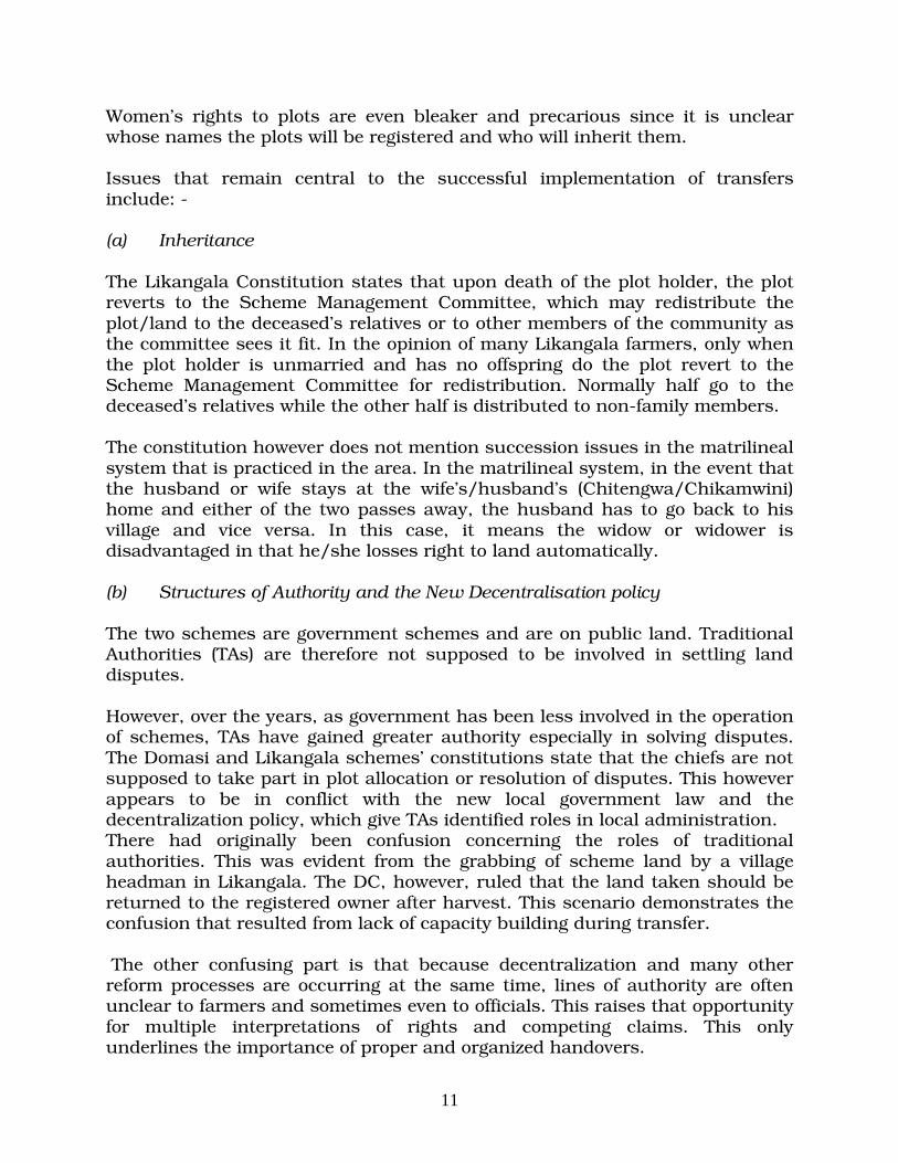
Women’s rights to plots are even bleaker and precarious since it is unclear whose names the plots will be registered and who will inherit them. Issues that remain central to the successful implementation of transfers include: - (a) Inheritance The Likangala Constitution states that upon death of the plot holder, the plot reverts to the Scheme Management Committee, which may redistribute the plot/land to the deceased’s relatives or to other members of the community as the committee sees it fit. In the opinion of many Likangala farmers, only when the plot holder is unmarried and has no offspring do the plot revert to the Scheme Management Committee for redistribution. Normally half go to the deceased’s relatives while the other half is distributed to non-family members. The constitution however does not mention succession issues in the matrilineal system that is practiced in the area. In the matrilineal system, in the event that the husband or wife stays at the wife’s/husband’s (Chitengwa/Chikamwini) home and either of the two passes away, the husband has to go back to his village and vice versa. In this case, it means the widow or widower is disadvantaged in that he/she losses right to land automatically. (b) Structures of Authority and the New Decentralisation policy The two schemes are government schemes and are on public land. Traditional Authorities (TAs) are therefore not supposed to be involved in settling land disputes. However, over the years, as government has been less involved in the operation of schemes, TAs have gained greater authority especially in solving disputes. The Domasi and Likangala schemes’ constitutions state that the chiefs are not supposed to take part in plot allocation or resolution of disputes. This however appears to be in conflict with the new local government law and the decentralization policy, which give TAs identified roles in local administration. There had originally been confusion concerning the roles of traditional authorities. This was evident from the grabbing of scheme land by a village headman in Likangala. The DC, however, ruled that the land taken should be returned to the registered owner after harvest. This scenario demonstrates the confusion that resulted from lack of capacity building during transfer. The other confusing part is that because decentralization and many other reform processes are occurring at the same time, lines of authority are often unclear to farmers and sometimes even to officials. This raises that opportunity for multiple interpretations of rights and competing claims. This only underlines the importance of proper and organized handovers.

12
Although the Water, Irrigation and environmental policies are being harmonised to resolve areas of ambiguity and conflicting roles among them, there are still questions about how the new structures these policies are creating will function on the ground. A case in point is the creation of the river basin or the Catchment Management Associations (CMAs) as proposed in the new water policy and the impending law. Malawi has been divided into seventeen large catchment areas which follows the hydrological criteria for catchment demarcation as a result many cross political and administrative boundaries. While the catchment approach makes a lot of environmental management sense, it creates another administrative hurdle that has to be negotiated. In the case of Domasi scheme where Concern Universal was contracted to train farmers, training was conducted after rehabilitation was already at an advanced stage. The survey also reports of delays in the rehabilitation works due to various factors which ranged from delays in disbursement of funds and supplies, inputs going missing, problems with local contractors, rains etc. In addition, farmers were unwilling to provide labour.
5.2 SCHEMES PRESUMED TO BE FREE FROM LAND CONFLICTS
5.2.1 Ngolowindo Irrigation Scheme in Salima District
The scheme is situated off Salima-Senga Bay Road in Salima district. The scheme was constructed from 1985-1986. The scheme covers land area of approximately 17 hectares. Water for irrigation is pumped from the ground by a generator pump. Crops grown include; maize, cassava and others.
(a) Land Acquisition and Transfers The land on the scheme was converted by government from customary land to public land for the purpose of the scheme. Beneficiary farmers on the scheme come from the local communities as well as from surrounding areas. At the moment, there are 112 beneficiary farmers comprising both male and female farmers. Administratively, there is a Scheme Management Committee that administers the affairs of the scheme. The scheme is managed as a Horticultural Cooperative Society. Land transfer on the scheme is done in accordance with the rules and regulations set by the management committee. Succession or inheritance of land user right on the scheme is based on surviving family relations. Even though the people in the

13
area comprise of a matrilineal society, no land problem was reported involving succession or inheritance of land after death of a farmer. However, problems may arise during expansion of the scheme. (b) Land Conflicts No land conflicts were reported on the scheme. However, it would appear that when renovations and other works of infrastructure start, land problems are likely to occur. (c) Categories of assets Categories of assets people have include: houses, fruit trees, gardens, small businesses such as groceries. If the people were to relocate, the assets above would be some of the losses they would incur. (d) Compensation and Resettlement Issues At Ngolowindo irrigation scheme, no land problems were reported relate to compensation. However, the desired expansion of scheme land may trigger compensation to some people. (e) Conflict Resolution Whenever land conflicts occur, such conflicts are referred to the scheme management committee, or local chiefs, or District Commissioner’s office for arbitration. However from the farmers there was no record of any conflict reaching as far as the District Commissioner.
5.2.3 Kadziwamwini Irrigation Scheme, in Salima District
The scheme is located in Chief Khombedza’s area in Salima District. The scheme was constructed in 1999. In terms of land extent, the scheme covers land area comprising of approximately 17 hectares. Water for irrigation is pumped from Kaninga River in the area. Crops grown include; maize, vegetables, cassava and others. (a) Land Acquisition and Transfers The land on the scheme is public land, converted by government from customary land for the purpose of the scheme. Beneficiary farmers on the scheme come from the local communities while others come from surrounding villages and districts. At the moment, there are 12 farming families on the scheme. Administratively, there is a Scheme Management Committee that administers the affairs of the scheme. Land transfer on the scheme is done in

14
accordance with rules and regulations set by the management committee. Succession or inheritance of land user right on the scheme is based on surviving family relations. Even though the people in the area comprise of a matrilineal society, no land problem was reported involving succession or inheritance of land after death of a farmer. Problems occur in future. (b) Land Conflicts No land conflicts were reported on the scheme. However, it would appear that when renovations and rehabilitation works start, land problems are likely to occur. (c) Categories of assets Categories of assets people have included houses, fruit trees, gardens, small businesses such as groceries. If the people were to relocate, the assets above would be some of the losses they would incur. (d) Conflict Resolutions and compensation Whenever land conflicts occur, such conflicts are referred to the scheme management committee, or local chiefs, or District Commissioner’s office for arbitration. However, since the scheme is still small, in future farmers may consider expanding the scheme land. When this happens some people will be affected with the expansion process such that compensation and resettlement issue will occur
5.2.4 Nkhate Irrigation Scheme, in Chikwawa District
The scheme is located in Chief Makuwila’s area in Chikwawa District. The scheme was constructed between 1966-1971. The scheme covers a land area comprising of approximately 283 hectares. Water for irrigation is pumped from Thangazi River. Crops grown include; rice, maize, vegetables and others. (a) Land Acquisition and Transfers The land on the scheme is public land, converted by government from customary land for the purpose of the scheme. At the moment, there are 915 farming families on the scheme. Administratively, there is a Scheme Management Committee that administers the affairs of the scheme. Land transfer on the scheme is done in accordance with the regulations and rules set by the management committee. Succession or inheritance of land user right on the scheme is based on surviving family relations. The people in Chikwawa District comprise of a patrilineal society. This means that inheritance issues are passed to the survivors or next generation through the male parent.

15
However, no land problem was reported involving succession or inheritance of land after death of a farmer. Bu, it may be advisable to be on the look out in case such problems occur in future. (b) Land Conflicts and Compensation No land conflicts were reported on the scheme. However, it would appear that when renovations and other works of infrastructure start, land problems will occur. Some of the problems may require compensation and resettlement. (c) Categories of assets Categories of assets people have include: houses, fruit trees, gardens, small businesses such as groceries. If the people were to relocate, the assets above would be some of the losses they would incur. (d) Conflict Resolutions Whenever land conflicts occur, such conflicts are referred to the scheme management committee, or local chiefs, or District Commissioner’s office for arbitration.
5.2.5 Muona Irrigation Scheme, in Nsanje District
The scheme is located in Chief Malolo’s area in Nsanje District. The scheme was constructed from 1969-1972. The scheme covers a land area of approximately 395 hectares. Water for irrigation is pumped from Thangazi River. Crops grown include; rice, maize, vegetables and others. (a) Land Acquisition and Transfers The land on the scheme is public land, converted by government from customary land for the purpose of the scheme. At the moment, there are 1250 farming families on the scheme. Administratively, there is a Scheme Management Committee that administers the affairs of the scheme. Land transfer on the scheme is done in accordance with the regulations and rules set by the management committee. Succession or inheritance of land user right on the scheme is based on surviving family relations. Even though the people in the area comprise of a patrilineal society, no land problem was reported involving succession or inheritance of land after death of a farmer. However, it may be advisable to be on the look out in case such problems occur in future.

16
(b) Land Conflicts and Compensation No land conflicts were reported on the scheme. However, it would appear that when renovations and other works of infrastructure start on the scheme, land problems will occur. Some of these problems may require compensation and resettlement. (c) Categories of assets Categories of assets people have include: houses, fruit trees, gardens, small businesses such as groceries, livestock enterprise. If the people were to relocate, the assets above would be some of the losses they would incur. (d) Conflict Resolutions Whenever land conflicts occur, such conflicts are referred to the scheme management committee, or local chiefs, or District Commissioner’s office for arbitration.
5.2.6 Limphasa Irrigation Scheme, Nkhata-Bay District
The scheme is located in Chief Kabunduli’s area in Nkhata-Bay District. The scheme was constructed from 1949-1950. In terms of land extent, the scheme covers land area comprising of approximately 380 hectares. Water for irrigation is pumped from Limphasa River in the area. Crops grown include; rice, maize, cassava, bananas and others. (a) Land Acquisition and Transfers The land on the scheme is public land, converted by government from customary land for the purpose of the scheme. At the moment, there are 1050 farming families on the scheme. Administratively, there is a Scheme Management Committee that administers the affairs of the scheme. Land transfer on the scheme is done in accordance with the regulations and rules set by the management committee. Succession or inheritance of land user right on the scheme is based on surviving family relations. Even though the people in the area comprise of a patrilineal society, no land problem was reported involving succession or inheritance of land after death of a farmer. However, it may be advisable to be on the look out in case such problems occur in future. (b) Land Conflicts and Compensation No land conflicts were reported on the scheme. However, it would appear that when renovations and other works of infrastructure start on the scheme, land

17
problems will occur. Some of these problems may require compensation and resettlement. (c) Categories of assets Categories of assets people have include: houses, fruit trees, gardens, small businesses such as groceries, livestock enterprise. If the people were to relocate, the assets above would be some of the losses they would incur. (d) Conflict Resolutions Whenever land conflicts occur, such conflicts are referred to the scheme management committee, or local chiefs, or District Commissioner’s office for arbitration. 5.3 General Condition of Infrastructure on the irrigation schemes The Schemes earmarked for rehabilitation and refurbishment include Domasi in Machinga; the Likangala complex in Zomba, Mkhate and Muona in Chikwawa; Limphasa in Nkhata Bay; and Ngolowindo irrigation scheme in Salima. In general the structures in almost all the schemes are dilapidated. Table 2 below outlines some of the condition of structures. Table 2. Condition of infrastructure on the irrigation schemes Item Infrastructure on the
scheme Condition of the infrastructure
1 Foot paths and foot bridges
Most of the footpaths and foot bridges have collapsed and are no longer useful
2 Bridges and access roads
Both bridges and roads in most schemes are in very bad shape following several years of neglect. In most cases the same access roads are also used as feeder roads for heavy trucks resulting in further deteriolation of the roads and bridges. Both will require major repairs
3 Office buildings, storage sheds, workshops
In most cases the building are dilapidated. Some have no doors or window panes or roof structures have deteriorated or are damaged.
4 Flood Protection Bands Sections of most irrigation schemes, flood bands have completely collapsed such that they can’t hold flood water to protect the schemes. They will need to be rehabilitated.

18
5 Water levels, Abstraction and utilisation
There was generally significant level of water flow in most schemes as a result of the rains at the time of the visit. Generally a disorganized water abstraction system was observed resulting into a poor water usage efficiency. This should result in water shortages, and possibly conflicts in the dry season.
6 Water Diversion structures
In most schemes, water for irrigation is diverted from the main river course into the main canals. Most of the diversion structures are in dilapidated condition and in serious need of comprehensive repairs.
7 Main and Branch canals
A few schemes have lined canals while others don’t. Most unligned canals have collapsed due to scour while the lined canals have cracked and collapsed in certain sections and will require repairs
8 Feeder Canals Most of the feeder canals are in relatively good condition. However at Muona Scheme there was no evidence of feeder canals may be due to heavy scour. There will be need to reconstruct the structure.
9 Collector and Main Drains
Most of the collector drains have significantly been scoured
10 Hydraulic structures (in-field)
Most of the structures have cracked and in some cases, plaster has worn off and in need of plastering
11 Dams and Water Reservoirs
In cases where dams have been used as a source of irrigation water, such dams have heavily silted up. For example in Njala scheme, the dam has silted up and is overgrown with weeds.
6.0 LEGAL AND INSTITUTIONAL FRAMEWORK FOR LAND acquisition, COMPENSATION AND RESETTLEMENT

19
This section covers current institutional arrangements, legal framework, administrative structures on the ground and problems related to land administration and compensation.
6.1 INSTITUTIONAL FRAMEWORK
6.1.1 Current Institutional Framework
There are a number of institutions that handle matters of land acquisition, compensation and resettlement. These institutions carry out their duties in the framework of the existing laws (i.e. what the laws say). The principal institutions that are involved in these matters are as follows: (a) The Ministry of Lands and Housing (MoLH) This is the ministry that is charged with task of land administration in Malawi. The ministry carries out a lot of functions some of which include; land acquisition for public interest, land and asset valuation, land and resource based conflicts resolution, allocation of land to various users; and granting of legal rights to such land users. (b) Office of the President and Cabinet (OPC) The office of the president and cabinet plays an important role in land acquisition, compensation and resettlement matters. This office links itself to the local people through office of the District Commissioners in the affected areas. The office of the District Commissioner represents the office of the president and cabinet at district and local levels. Money for the compensation and resettlement usually come from the office of the president and cabinet, which is paid to the affected people through the office of the District Commissioners. (c) Ministry of Local Government (MoLG) The MoLG is also involved in land acquisition, compensation and resettlement through respective city and town assemblies. As demand increases in the cities and towns to enlarge their areas of jurisdiction, more land is acquired mainly form the customary sector. These processes trigger compensation, which affect the Ministry of local Government greatly. (d) Local Chiefs and Village Headmen These are local leaders in the areas under interest. The chiefs in the customary sector represent the government. They play an important role especially in conflicts resolution and in the identification of alternative land for

20
resettlement of the displaced persons. Almost all development projects in the rural areas owe their success to the local chiefs. (e) Other Line Ministries, Agencies and Non-Governmental Organizations Other line ministries, agencies and non-governmental organizations are also involved in matters of land acquisition, compensation and resettlement of the displaced persons. When organizations or agencies require land for development project, they consult the local people informing about the their intentions. When the local people accept the proposal, such organizations are required to organize compensation for the people and provide other necessary logistics. This is mainly occurs for projects that are demand-driven.
6.1.2 Proposed Institution Framework under the project
The Government proposes to establish an independent Project Management Unit outside the government administrative system. The unit will be based in Lilongwe. Administrative staff will be employed on contract basis in order to establish s strong and responsive project management setup The composition of the PMU will be as follows: (a) The Project Steering Committee (PSC) The project steering committee will be composed of The Secretary for Agriculture and Irrigation and Food Security as Chairman • The Secretary for Local Government and Rural Development- as Vice
Chairman • The Secretary for Mines, Natural Resources and Environmental Affairs • The Secretary to Treasury • The Secretary for Water Development • The Director of Planning in the Ministry of Agriculture (Secretary to the
Project Steering Committee)
(b) The Project Technical Committee (PTC) The Project Technical Committee will provide advisory service to the Project Steering Committee. The PTC will be composed of directors of all ministries participating in the Project Steering Committee. The PTC will be Chaired by the

21
Director of Agriculture and Technical Services and the Project Coordinator will be the Secretary to the Project Technical Committee. (c) District Advisory Service and the Coordination of Project at District
level The implementation of the project in the selected districts will be under the direct supervision of the district assemblies of the respective districts. The Agriculture and Natural Resources Committee, Planning and Development Committee and the Land Committee will provide guidance during implementation. As proposed in the Environmental Impact Assessment report, it is expected that and Irrigation Advisory Body (IAB)(composed of a multi-disciplinary team of specialists will be established to support each district in implementation of project the activities at that level. The IOB will be responsible for data to day activities related to planning, design, construction and supervision of activities. The District Agriculture Development Officer will provide secretarial services and will be responsible for project monitoring and evaluation. He will report to the Project Management Unit in Lilongwe.
6.1.3 Current Linkages During Land Acquisition, Compensation and Resettlement
(a) Public Projects When matters of land acquisition, compensation and resettlement arise; institutions work together each performing a particular role. For example during planning for the Naminga-Namwera-Mangochi Road. The government through OPC wanted constructed this (1999-2002), a lot of peoples’ properties needs to be compensated and other people to relocate to new sites. First, the Ministry of Public Works (MoPW) (responsible ministry) made preliminary investigation/inspection in consultation with District Commissioner of Mangochi and Machinga. Then (MoPW) and DC’s established the extent of land and peoples’ assets to be acquire/affected. MoPW reported to OPC of facts on the ground and OPC through (MoPW) instructed the Ministry of Lands and Housing (MoLH) to make assessments of compensation for peoples’ assets. MoLH assessed buildings whereas DC’s offices assessed crops and planted trees. Assessment of crops and trees was based on the compensation schedule or list in annex iv), which was prepared by the Department of Forestry. Current this schedule is out of date, and as such does not reflect the true value the said assets. The assessment took into account: � Disturbance; � Loss of economic sources;

22
� Relocation cost; � Replacement cost for buildings and others; � Decrease in value of properties due to the road even when they did not
relocate;and � Cost incurred in meeting developments; However land for resettlement was not identified and the following were not considered: � involuntary restriction of access to legally designated forest reserve in the
area; � development or resettlement assistance; Disputes over the amounts of claims (compensation sums) were resolved by local chiefs. The properties under dispute were reassessed and necessary adjustments made. Land was not however assessed because it was customary as earlier discussed. From the foregoing, in terms of both legal and institutional frameworks, Malawi has a legal framework and an institution framework in place in as far as practice and procedures of land acquisition, compensation and resettlement are concerned. To comply or to be at par with World Bank Policy on involuntary resettlement, we need to bridge the gaps that exist in the two frameworks above.
6.1.5 Community Projects including Demand Drive Project
(a) Projects Assisted through the Ministry of Agriculture In agriculture related projects, which include demand driven irrigation projects, communities identify the need. Appraisal of a project will in most cases be done in three phases. (i) Expression of interest in the project Communities will identify a project and submit a proposal. This will be in form of a formal an application or through a Project Interest form. (ii) Desk Appraisal The ministry or financing institution conducts a desk study or desk appraisal to ascertain project viability and implementability.

23
(iii) Extended Participatory Rural Appraisal (EPRA) The EPRA is intended to sensitise communities and get their views and ideas and concerns about their proposed project. Among other things, the EPRA identifies whether; • Project ideas originated from communities themselves or not; • Whether the project is of public interest; and • Whether the community is committed to undertaking the project. Commitment will in most cases be community contribution towards the project. This will be in form of land and labour for implementation of the project, which has to be identified by the community. Where there are problems the financier will not go ahead unless those problems are sorted out amongst community members themselves. (b) Projects funded by MASAF For communities to benefit from MASAF funding, they are required to fill a Project Interest Form (PIF) where community expresses their interest in a particular project. In the form, the community pledges its contribution, which will most often be in form of land and labour. MASAF requires that all problems be ironed out before the project can be funded. If there are any problems relating to land or disagreements amongst communities, MASAF does not commit itself until such problems are sorted out.
6.1.6 Existing Administrative structures in Irrigation Schemes
In most of the schemes management is done by Scheme Management Committees. In certain cases Water Users Associations manage the activities of the scheme. Allocation of land is done by either the Scheme Management Committee in the case of Domasi and Likangala, or the Land Allocation Committee in the case of Ngolowindo and Kabmwiri sele.
Table 3. Status of some administrative issues Item Description of the
administrative issue
Status of the issues
1 Farmer Various forms of organisational structures

24
Organisation and empowerment
exist in the schemes. These include associations and cooperatives. Most of these structures are empowered to manage the activities of the scheme. However community members do not have much powers. As a result some or most officer bearers use official influence to get more land at the expense of other members. There is need for capacity building in all schemes prior to scheme transfer.
2 Land tenure and state of land
� Some schemes are demand driven, in which cases land is customary.
� In most government managed schemes, land was transferred from customary to public.
� In those that management of the scheme has been transfer to local communities, land tenure classification is remains public.
There will be need to transfer land to local people and scheme farmers
3 State of soil In some cases there is inadequate tillage due to lack of equipment. Extensive use of local implements has result in a lot of soil compaction. There will be need adequately till the soil before handover.
4 Marketing structures
There are poor marketing structures including infrastructure in most schemes. There will be need to revitalization the structures in some schemes or develop completely new structures in others.

25
6.2 REVIEW OF POLICIES, LEGISLATIONS AND IMPLEMENTATION OF PUBLIC SECTOR
PROJECTS AND SUB-PROJECTS
6.2.1 World Bank Operation Policy (OP 4.12)
World Bank experience indicates that involuntary resettlement under development projects, if unmitigated, often gives rise to severe economic, social, and environmental risks. In many cases: - • production systems are dismantled; • people face impoverishment when their productive assets or income
sources are lost; • people are relocated to environments where their productive skills may
be less applicable and the competition for resources greater; • community institutions and social networks are weakened; kin groups
are dispersed; • and cultural identity, traditional authority, and the potential for mutual
help are diminished or lost. The policy therefore provides safeguards to address and mitigate the above risks. (a) Policy Objectives World Bank policy objectives include: - The Bank believes that involuntary resettlement may cause severe long-term hardship, impoverishment, and environmental damage unless appropriate measures are carefully planned and carried out. For these reasons, the overall objectives of the Bank’s policy on involuntary resettlement are therefore: (a) To avoided or minimise involuntary resettlement where feasible, exploring all viable alternative project designs. (b) In cases where it is not feasible to avoid resettlement, resettlement activities should be conceived and executed as sustainable development programs, providing sufficient investment resources to enable the persons displaced by

26
the project to share in project benefits. Displaced persons should be meaningfully consulted and should have opportunities to participate in planning and implementing resettlement programs. (c) To ensure that Project Affected Persons (PAP) or Displaced Persons (DPs) are assisted in their efforts to improve their livelihoods and standards of living or at least to restore them, in real terms, to pre-displacement levels or to levels prevailing prior to the beginning of project implementation, whichever is higher. (b) Impacts Covered The policy covers direct economic and social impacts that both result from Bank-assisted investment projects, and are caused by: (a) The involuntary taking of land resulting in
(i) relocation or loss of shelter; (ii) lost of assets or access to assets; or (iii) loss of income sources or means of livelihood, whether or not
the affected persons must move to another location; or (b) The involuntary restriction of access to legally designated parks and
protected areas resulting in adverse impacts on the livelihoods of the displaced persons.
(c) Jurisdiction of the Policy The policy applies to all components of the project that result in involuntary resettlement, regardless of the source of financing. It also applies to other activities resulting in involuntary resettlement, that in the judgement of the Bank, are directly and significantly related to the Bank-assisted project, necessary to achieve its objectives as set forth in the project documents; and carried out, or planned to be carried out, contemporaneously with the project.
27
6.3 LOCAL POLICIES AND LEGISLATION
(a) Historical Perspective
Currently there appears to be no single policy that adequately addresses land policy issues, more especially on land acquisition and compensation. This is echoed by the findings of the Presidential Commission of Inquiry on Land Policy Reform (PCOIOLPR). The Commission reported that there is no single or comprehensive policy on land: ownership, use, management, control and transmissibility in Malawi. The problem dates back to the colonial era. Colonial policies were eclectic in nature and short term in objective. They were mainly concerned with how best to resolve conflicts between settlers and the indigenous people. At best the policies were concerned with the well being of white settlers other than the indigenous communities. At independence, little attempt was made to re-examine the land issue in a holistic manner, and this presumably was because the Government assumed that as long as the agriculture sector, and especially the estate agriculture was performing well, nothing could possibly have been wrong with land relations in the country. Secondly, a careful review of the law assisted by a comprehensive study of land legislation in Malawi from colonial to post colonial times (Msisha, 1997), suggests that the imposition of English law in general and English property concepts in particular, has stifled the evolution and growth of customary land law (PCOIOLPR, 1999).
6.4 LOCAL LEGAL FRAMEWORK
6.4.1 Existing Legal and Policy Framework
There are a number of legislations that have provisions relating to land matters with regard to land acquisition and compensation. The main legislations are as follows: - 6.4.1.1 The National Land Policy, 2002 and the Land Act (Cap 57:01),
1965
The national Land Policy was adopted in 2002 and focuses on land as a basic resource to all people in Malawi. The new policy provides opportunities for

28
people of Malawi to pursue socially and environmentally sustainable development efforts and livelihoods. The policy further highlights a number of approaches to address problems facing the resources sector in Malawi. Relevant provisions include: • Recognition of the agriculture development sector as a benefactor land
use sector in Malawi. In order to enable the ordinary Malawians to adequately participate in agriculture activities, and other modes of livelihoods, the policy guarantees full legal protection for customary land tenure to the people of Malawi;
• Recognition of the various sectoral policies and strategies in physical
planning, fisheries, environment, forestry, irrigation and wildlife and for this reason, it encourages a multi-sectoral approach to land use management at local and district level; and
• Recognition of environmental impact assessment of all big land
development projects, and those planned in fragile ecosystems, in order to protect biodiversity, water and natural resources.
The Land Act (Cap 57.01) is the principle legal framework in land administration. It classifies all land in Malawi as follows: (a) Public Land Public land is defined as all land, which is occupied by the government and any other land, not being customary land or private land and includes-
1. Any land held by the Government consequent or upon a reversion thereof from any freehold or leasehold estate; and
2. Any land which was public land within the meaning of Nyasaland or
Malawi African Trust Land) Orders (Now repealed). (b) Private Land Private land is defined as all land, which is owned, held or occupied under freehold title, or a leasehold title or a certificate of claim or which is registered as private under the Registered Land Act (Cap 58.01). (c) Customary Land Tenure It is defined as all land which is held or occupied or used under customary law but does not include public land. Customary land therefore consists of all land which is not “private” or “public” as earlier defined”. Customary land is vested

29
in the State President who delegates the stewardship of the same to the local authorities. It is a complex mixture of community rules of conduct, leadership codes and management principles relating to access to and control of land in a given social context. In Malawi customary tenure implies that the land is not owned as such but held by various communities under the authority of their chiefs. The essence of community ownership and control is that all members of a particular community have access to land and all its products without exception and that the role of chiefs is to ensure not only political protection for the community but more essentially, equitable distribution of that land among present members of the community and the future generations. Although customary tenure rules often vary in terms of detail from community to community there are general rules about control and resource preservation and conservation that remain similar across communities. Some of the general rules include; • Every individual is by virtue of being member of a given community the
right to access to land resources of that community both in space and time.
• Access rights, to which individuals are entitled, are transmissible to designated heirs in perpetuity;
• Village leaders (Headmen and Chiefs) have the power to allocate use rights to individuals or families, but the land itself cannot be permanently alienated; and
• Non-community members cannot acquire prescriptive or other rights in community land by long use, but may be granted limited access under clearly defined conditions
(d) Provisions for land acquisition, compensation and resettlement under the
Act In terms of this Act, the government can acquire land for public use, such as for development projects. Normally the acquisition of land takes place in the customary sector. The smallholder irrigation schemes, which the government constructed in the late 1960’s all took place on the customary land which was later, declared public land. Sections 27-28, Part V of the Land Act deals with land acquisition and compensation. Section 27 empowers the Minister responsible for land matters to acquire land if such land is needed for public purpose. Section 28 of the Act provides that any person affected with the said land acquisition; that person would be compensated. Factors considered for compensation include: -

30
� Disturbance � Loss or damage to any interest, which a person may have prior to the
acquisition process. � Land is not compensated for. (e) Comparison of the Acts provisions with World Bank OP 4.12 Unlike the World Bank’s policy on involuntary resettlement, the Land Act does not consider or provide for the following: � Identification of alternative land for resettlement purposes. After
compensation, the DP is required to fetch for land; � Relocation allowance for the displaced; � Offer of development assistance to the displaced; � Offer of support after displacement of the people; � Provision for a grievance delivery mechanisms and arrangements.
� losses due to involuntary restriction of access to legally designated parks
and protected areas, social amenities etc. that result in adverse impacts on the livelihoods of the displaced persons
� a clear outline and methodologies to be used in the assessment of the assets of the displaced people. It would appear that the Act presupposes that land is in abundance and that people have similar background such that the displaced persons will easily fit in.
Compared to the World Bank’s policy on involuntary resettlement, there are gaps in the Land Act when dealing with land acquisition, compensation and resettlement matters that require to be examined and bridged. 6.4.1.2 The Lands Acquisition Act (Chapter 58:04). This legislation came into effect in 1971 and is used in acquiring land, which is needed for the public purposes. The Act empowers the government or Minister responsible for land matters to acquire any class of land, whether it is customary or private land through either negotiation or compulsory. In either case, compensation is paid out to the affected people. (a) Land Acquisition, Compensation and Resettlement As outlined above, in terms of this Act, the government can acquire any class of land for public use, such as for development projects. Section 3 of the Lands

31
Acquisition Act empowers the government or Minister responsible for land matters to acquire land for the public purpose. Sections 9-10 of the, Act spell out issues of the compensation process, and assessment of assets of the affected people. Compared to the Land Act, the Lands Acquisition Act is more comprehensive in dealing with matters of land acquisition and compensation. The Act spells out the process and measures to take into consideration when dealing with the process of land acquisition and compensation. These measures/steps include: � Preliminary investigation of the land to be acquired to determine its
suitability; � Service of notice to potential or people likely to be displaced of the
government’s intention to acquire such land. This notice is gazetted. The notice may also be mounted conspicuously on the site/land to be acquired;
� A fair assessment of assets and compensation follow. Unlike the World Bank’s Policy on involuntary resettlement, the Lands Acquisition Act does not consider the following: - � Identification of alternative land for resettlement purposes; � Relocation allowances for the displaced; � Development assistance to the displaced; � Offer of support after displacement of the people; � losses due to involuntary restriction of access to legally designated parks
and protected areas that result in adverse impacts o the livelihoods of the displaced persons; and
� Like the Land Act, the Lands Acquisition Act does not clearly outline the
methodologies to be used in the assessment of the assets of the displaced persons.
• The Act also limits the grievance delivery mechanisms and arrangements by
the displaced. According to Section 10 subsection 7 of the Act, an assessment of compensation made by the Minister (government) under the Act shall be final and shall not be subject to any appeal to, or to any review by any court.

32
(b) Comparison to the World Bank Policy Comparatively, there are also gaps in the Lands Acquisition Act when dealing with land acquisition, compensation and resettlement matters that require to be reviewed in line with the World Bank Operation Policy on Land Acquisition and Involuntary Resettlement. 6.4.1.3 The Public Roads Act (Chapter 69.02) This legislation came into effect in 1962 and is used in acquiring land, which is needed for road construction (public purpose). However, for the actual acquisition of land, the Public Roads Act relies on other legislations such as the land Act. Any class of land can be acquired for the purpose of this Act. (a) Land Acquisition, Compensation and Resettlement As outlined above, land can be acquired for the purpose of public roads. The enabling legislation, the Public Roads Act spells out procedures and measures for compensation. In this respect, the Public Roads Act is one of the most comprehensive pieces of legislation when dealing with compensation issues in the country. Sections 44-50 of the Act, outline these measures/steps as follows: • According to section 44 (1)(a) in the case of customary land compensation of
the displaced person(s)shall be assessed in consultation with the local chief; • When assessing assets for compensation, the Act takes into consideration
the following scenarios;
• Relocation or resettlement on alternative land; • Where alternative land can not be made available to the displaced and the
land remaining available to the displaced for agricultural purposes is not, in the opinion of an agricultural officer, an economic unit;
• Where alternative land can be made available to the displaced person and
the making of the alternative land equally as fit for cultivation as the land which he has been deprived of is likely to involve in terms of money, materials or labour.
• Remaining land available to the displaced person for agricultural purposes
is not, in the opinion of an agricultural officer, an economic unit. In looking at these provisions, the Public Roads Act include all surface rights; that is fixed and other assets.

33
According to section 46 subsection (1), the assessment of compensation for private land, the following issues are taken into consideration: - � Market value of the land or interest therein of the claimant at the valuation
date; � Damage, if, any sustained by the person interested, at the valuation date, by
the reason of the severance of such land from his other land or other injurious affecting of his other property moveable or immoveable by reason of the exercise of the powers conferred by this Act;
� If, in consequence, of the matters giving rise to the claim, the claimant is
compelled to change his residence or place of business the reasonable expenses, if any, incidental to such change; and
� Any increase in the value of other land or other benefit of the person
interested at the valuation date likely to accrue from the construction of the road.
As noted above, the Roads Act is more comprehensive compared to the Land Act or to the Lands Acquisition Act when dealing with matters of compensation and resettlement of the displaced persons. The Public Roads Act also spells out grievance delivery mechanisms and arrangements. According to section 47 subsection (1), of the Act, in case of customary land, the claim may be made orally to the chief for the area, who shall forward the claim to the officer responsible for land matters within the district and such officer shall in turn forward the claim to the relevant highway authority. When the highway authority receives the claim, he may agree to pay the claim or forthwith make a written offer to the claimant in settlement of the claim. A grievance regarding compensation claim is lodged with the compensation board. The compensation board consists of a Resident Magistrate and two assessors appointed by the minister, and the board determines the amount of compensation by a majority decision. The minister may, with the concurrence of the Chief Justice, make rules regulating the procedure to be followed before any compensation by the Board and for constituting the Board. If the claimant or the highway authority are not satisfied with the results of compensation, they may appeal to the high court by way of petition lodged within one month from the date of the award by the compensation board or in accordance with rules made by the Chief Justice.

34
(b) Comparison to the Banks Policy From the foregoing, there are fewer gaps in the way the Public Roads Act spells out measures to be followed when dealing with land acquisition, compensation and resettlement of the displaced persons, that is, compared to the World Bank’s policy on involuntary resettlement (OP 4.12). However, compared to the Bank’s policy on involuntary resettlement, the Public Roads Act fails to deal with the following: � Development assistance to the displaced persons; � Offer of rehabilitation assistance and other support to the displaced people; � Offer of support to the host communities; and � the Act limits the grievance delivery mechanisms and arrangements by the
displaced persons. The appeal process by the aggrieved persons can only go up to the high court. The claimant is not permitted to appeal to Supreme Court. According to section 40 of the Act, there shall be no further appeal from the decision of the High Court.
6.4.1.4 The Town and Country Planning Act (Chapter 23:01) This legislation came into effect in 1948 and is used in acquiring land to plan on it orderly development and other services going along with such development. Like the Lands Acquisition Act, land for the purpose of Town and Country Planning Act, is acquired through negotiation or through compulsory acquisition.. Sections 21 subsections (1) – (2) of the Act empower the Planning Committee or the Minister to acquire land for carrying out a planning scheme. The affected people are compensated for the losses they incur in the process. (a) Land Acquisition, Compensation and Resettlement As outlined above, the Country and Planning Act empowers the Planning Committee or the Minister to acquire any class of land for the purpose of carrying out a planning scheme. The Act provides that the people affected be compensated. When the planning committee or Minister acquires the land, such land is declared a planning area. � The displaced persons are given notice of government’s intention to acquire
land; and this notice is gazetted. The notice can also be mounted conspicuously on the site/land to be acquired;
� After 21-day period, the committee has power to enter into the land; and � Asset assessment and compensation follow.

35
The Act provides for grievance delivery mechanisms and arrangements. According to section 25 subsection (1) of the Act, any dispute arising under this Act as to the right of the claimant to recover compensation, shall, upon application of any party concerned with, be heard and determined by the high court. Section 2 subsection (2) of the Act provides that any final judgment in any such case as aforesaid shall be subject to appeal, to which other final judgments of the court are subject. The legislation categorizes losses as follows: - � Disturbance; � Relocation; � Expenditure incurred in the development of property; and Like the Public Roads Act, Town and Country Planning Act is fairly comprehensive compared to the Land Act or to the Lands Acquisition Act when dealing with matters of compensation and resettlement of the displaced persons. The Act spells out grievance delivery mechanisms and arrangements, which are important elements in the compensation and resettlement matters. (b) Comparison to World Bank Policy Compared to the World Bank’s policy on involuntary resettlement, the Town and Country Planning Act also fail in a number of areas when dealing with land acquisition, compensation and resettlement matters. The Act does not provide for the following: � Development assistance or employment to the displaced; � Identification of alternative land for resettlement; � Offering of support after displacement of the people; � Offering of support to the host communities; � Involuntary restriction of access to legally designated parks and protected
areas that result into adverse impacts, on the livelihood of the displaced persons;
� Specific methodologies for assessing various assets of the displaced persons. It can be concluded that compared to the World Bank’s policy on involuntary resettlement, above, there are also gaps in the town and Country Planning Act when dealing with land acquisition, compensation and resettlement matters.

36
6.4.1.5 The Malawi Housing Corporation Act (Chapter 33:01) This legislation came into effect in 1964 to undertake the management of houses, classes of houses and housing estates. The Act established the Malawi Housing Corporation. The Corporation is also empowered to construct and develop housing estates. To undertake its functions, Malawi Housing Corporation acquires land. According to section 12 of the Act, if the corporation requires any customary land for the purposes of carrying into effect any of the provisions of this Act, it may apply for a grant, lease or other disposition in accordance with section 5 of the Land Act (Cap 57:01). Section 5 subsection (1) of the Land Act provides that the Minister may make and execute grants, leases or other dispositions of public or customary land for any such estates, interests or terms and for such purposes and on such terms and conditions, as he may think fit. Malawi Housing Corporation gets land through grant and other dispositions from the government. All procedures and measures relating to land acquisition, compensation and resettlement considerations are contained in the Land Act. Since this Act depends on the provisions of the Land Act, in dealing with compensation and resettlement issues, it also has got a lot of gaps that need to be looked into when dealing with issues of land acquisition, compensation. 6.4.1.6 The Water Resources Policy and Strategies, Water Resources
1969) and Water Works Act (1995) The Government adopted the National Water Resources Policy and Strategies in 1994 with a view to provide a comprehensive and integrated approach to water resources conservation and management within the country. The Ministry of Water Development is responsible for coordination and implementation of the policy Two main Statutes regulate water resources protection, conservation, planning and catchment management. These are the Water Resources Act and the Water Works Act. The Water Resources Act established the Water Resources Board. The Board advises the Minster responsible for water resources and the government on all issues regarding water resource protection, conservation and planning. The Act provides for the control of encroachment into protected catchment areas and water bodies such as lakes, dams and rivers. The provision has in some cases created land disputes. The Water Works Act provides legal framework for the establishment of the three water regional water boards namely, the Northern, Central and Southern Regional Water Boards. The Boards supply water and sanitation including catchment management in their respective regions of the Country. Catchment Management efforts have also often resulted in land disputes

37
6.4.1.7 The National Environmental Policy and the Environmental Management Act (1996)
The National Environmental Policy was adopted by government in 1996. It aims to narrow the gap between the degradation of natural resources on one hand and the sustainable production and economic growth on the other. It provides an umbrella framework upon which other policies can be reviewed by embracing principles of sound environmental management and sustainable development. It was recognizes the importance of private sector and Non-Governmental Organisation (NGO) participation in environmental management. The Environmental Management Act (EMA) 1996) provides that basic legal and administrative framework for environmental planning and management including environmental impact assessment for prescribed projects. Section 9 of the EMA sets out the powers, functions and duties of the Environmental Affairs Department. Section 24 of the EMA specifies the steps to be followed in the preparation of the project impact assessment. Malawi Government’s Environmental Impact Assessment guidelines were put in place in 1997, in compliance with section 24 of the Act. The guidelines provide a list of prescribed projects for environmental impact assessment. 6.4.1.8 The National Decentralisation Policy and the Local Government Act (1998) The Government of the republic of Malawi embarked on a nationwide decentralization programme in 1998. The programme was initiated to devolve political and administrative powers to resource users and custodians at the district and grass root level. The National Decentralisation Policy is the key policy that aims to promote effective local level participation in development planning and resource management currently underway in Malawi. The Local Government Act (1998) established authorities in 39 districts in Malawi to spearhead local planning and development. The Act provides a wide of duties to the local authorities, which include land resources management and administration. In the light of the proposed Irrigation, Rural livelihoods and Agriculture Development Project, local authorities are expected to play a vital role in the implementation process under the supervision of the District Agriculture Development Officer.

38
6.5 GENERAL AVAILABILITY OF CUSTOMARY LAND IN MALAWI
As mentioned above, it is expected that most of these proposed projects will require land to be acquired. Most of this land will fall in the customary category, which is already under pressure from over population and its limited availability. Availability of customery land is as follows: -
6.5.1 Availability of Customary Land
The total customary land area in Malawi is estimated at 6.1 Million hectares (CLUS1998). The majority of this land is in the central region (39.0%) followed by the Southern Region (33% and the Northern Region 28% The distribution of total customary land by ADD indicates that Mzuzu A.D.D has 19.4% of the total customary land, followed by Kasungu ADD (16.4%), Machinga 15.7% and Lilongwe ADD (14.5%). The Shire valley is the smallest ADD is the smallest one in terms of customary land area. (b) Customary Land suitability Suitability refers to the ability of a given piece or tract of land to support rain-fed agriculture under unimproved traditional management. (c) Distribution of suitable customary land The total suitable land for rain-fed cultivation is estimated at 3.446 million hectares (CLUS, 1998). The regional distribution of this follows the same pattern as that of the total customary land. The major part of the suitable land is in the central region (42.3%), followed by the Southern Region (32.8%); and Northern Region 25%. The distribution of suitable land by ADD is slightly different from that of the total customary land. Kasungu ADD is the largest(19.2%) of the total land area), followed by Mzuzu ADD (17.5%) and Machinga ADD (15.7%) and Lilongwe ADD (15.9%). (d) Suitability Density The suitability density as defined by the CLUS means the proportion of land classified as suitable for rain-fed agriculture over the total customary land. The table below presents the suitability density by ADD and region

39
Table 4. Suitability density by ADD and Region ADD/ Region
NR KA ADD
MZ ADD
CR KU ADD
SA ADD
LLADD
SR MHG ADD
BT ADD
SV ADD
Suitability Density
50.1 47.9 51.1 61.2
66.2 50.1 61.8 56.3
58.0 58.0 51.0
Source: CLUS, 1998. The rain-fed cultivation density for Malawi is estimated at 56.5%. However, the situation varies from region to region. The suitability is generally lowest in the Northern Region (50.1); and Southern Region (56.3%), and that in the Central Region (61.2%). Even within each region, the suitability varies from one ADD to another. For example in the Southern Region, the suitability density for Blantyre and Machinga ADD’s is 58% while that of Shire Valley ADD is 51%. Karonga ADD has the lowest suitability density of 47.9% in the Northern Region.
6.5.2 Customary Land under Cultivation
(a) Distribution of customary land under cultivation The total cultivated land in the customary sector is estimated at 1,980,277 hectares. The largest chunk of the cultivated customary land is located in the Central Region (45.7%) followed by the Southern Region (40.2%) and the Northern Region (14%) (PLUS, 1998). In terms of distribution of cultivated land by ADD, Lilongwe ADD has the largest with 20.4%, followed by Machinga ADD with 16.8%, Kasungu ADD with 16.1% and Blantyre ADD with 14.4%. (b) Customary land Cultivation density The cultivation density as defined by CLUS refers to the proportion of total cultivated land during a cropping season over the total customary land. This is tabulated in the table below. Table 5. Cultivation density by ADD and Region as a percentage ADD/ Region
NR KA ADD
MZ ADD
CR KU ADD
SA ADD
LLADD
SR MHG ADD
BT ADD
SV ADD
Cultivation Density
16.3 17.7 15.7 38.0
31.9 37.0 45.5 39.6
34.8 50.0 36.8
Source: CLUS, 1998.

40
The cultivation density of Malawi as a whole is estimated at 32.5%, but there are variations between the regions. The Northern Region has the lowest density (less that 20%), while the Southern Region has the highest (39.6%). In fact, the cultivation density increases as one moves from the Northern Region to the Southern Region as shown in the table above. In terms of the ADD’s, Blantyre ADD has the highest cultivation density (50%) followed by Lilongwe ADD (45.5%), Salima ADD (37%) and Shire Valley ADD (36.8%). The two ADDs in the Northern Region, Mzuzu and Karonga have the lowest cultivation densities of 17.7% and 15.7% respectively. The average cultivated land/suitable land ratio for Malawi as whole is estimated at 57.5%. In terms of the regional distribution, this ratio increases as one moves from the Northern Region to the Southern Region. The ratio is estimated at 32.6% for the Northern Region, 62.1% for the Central Region and 70.3% for the Southern Region. Table 6. Distribution of the proportion of cultivated area as a percentage
of suitable land ADD/ Region
NR KA ADD
MZ ADD
CR KU ADD
SA ADD
LL ADD
SR MHG ADD
BT ADD
SV ADD
Suitab’ty Density
50.1 47.9 51.1 61.2 66.2 50.1 61.8 56.3 58.0 58.0 51.0
Source: CLUS, 1998.
7.0 A summary of issues identified by the study regarding land acquisition and Compensation
Notwithstanding the above, there have problems associated with the way land acquisition and compensation issues are handled. Serious problems occur under customary land. ELUS study reports of conflicts involving estate owners and surrounding villages in Kasungu District. Some of the problems include the following: - • There are gaps in the provisions of the various Acts, which deal with land.
For instance, in customary areas, valuation for compensation disregards assessment of actual land because according to the Land Act such class of land belongs to the President who delegates the powers of management and determination to the local authorities;
• Valuation of some assets such as crops and trees does not reflect the
prevailing open market trends because the compensation schedule is
41
prepared for the District Commissioner’s Office by the Department of Forestry is out of date as exemplified in annex XXX;
• Most irrigation schemes do not have land disputes, however the Domasi
and Likangala schemes have posed a challenge that is likely to be faced in all irrigation schemes deemed for hand over to local communities.
• Proper sensitization of communities will be crucial for sustainability of
irrigation schemes after handover; • When land acquisition results in resettlement, the affected people are not
paid adequate compensation to take into account assistance after displacement and does not consider involuntary restriction of access to legally designated reserve areas resulting in adverse impacts on the livelihoods of the displaced persons;
• Availability of land is diminishing as reported by the studies due to
population growth. The problem is more acute in the Southern Region to be Land pressure
• There is little no assessment of impacts of cultural differences for new
comers in resettlement areas; • Usually there are delays and or no identification of alternative land to
resettle the affected people e.g. some people who were compensated in Lilongwe are not yet resettled;
• Conflict resolution mechanisms are not often comprehensively pursued;
and • Legislation does not provide for resettlement. In most cases, resettlement
is implied if one is compensated. The new Land Policy has however made provisions to address some of the short falls that exist in the Land Act with respect to Land acquisition, compensation and resettlement.
8.0 Discussion and Conclusion Firstly the consultant feels that there are gaps in the provisions of the various statutes and policy documents and therefore do not adequately articulate some of the issues related to land acquisition and involuntary resettlement of Displaced Persons. While the local legislation has adequately covered issues of land acquisition, including the procedures for compensation assessment,

42
resettlement and grievance address mechanisms, fall short of certain provisions as spelt out in the World Bank Operational Policy on involuntary resettlement. Of particular concern is lack of consideration for relocation and resettlement assistance for displaced persons. The government is embarking on transfer of some selected schemes. Experience from Likangala and Domasi schemes show that the schemes are still experiencing problems as most of the issues were not clear before commencement of rehabilitation. This should act as a lesson for proposed project schemes. Community empowerment in terms of training should precede rehabilitation works and actual handovers. Further the results of the study also seem to suggest that rules have in most cases been imposed on communities by either government officials or committee members. It was observed that communities consider or regard rehabilitation works as a government responsibility, and therefore, are reluctant to assume ownership of the scheme until it is completely refurbished. This is a bad development as it implies that communities do not understand the essence of the transfer. Community participation should start from rehabilitation so that they know and can adopt the skills for maintaining and running the schemes. Finally, there seems to be a general misconception amongst communities that when the schemes are handed over back to them, land should revert back to them because ancestrally land belonged to them. This is a bad development as it is likely to jeopardize sustainability of schemes after transfer.
9.0 Recommendations From the foregoing, the following recommendations have been made: - • Prior to commencement or rehabilitation works, communities should be
made aware of the objectives of the rehabilitation works and the subsequent handover;
• The PRA process should ensure that communities are ready to take part in
decision making and provision of labour as their input to the rehabilitation works;
• Communities should help to identify and prioritize rehabilitation works.
This would help to address problems as identified by communities themselves in which case it would be easier for them to take part in renovations.

43
• There is also need to instill some confidence in the recipient as many people
feel that as communities they can not run the schemes after government with all the resources failed to do so.
• While consultation with farmers is important, critical issues relating to
governance responsibilities and to land and water rights and assets remain to be clarified have to be clarified prior to handover. There is generally considerable disagreement as who would be responsible for what when the schemes are transferred to farmers.
• Members of the community or beneficially communities should be allowed
to make decisions affecting their schemes. However, where communities lack leadership, officials should be ready to intervene.
• Stewardship of irrigation schemes or other resources based on ancestry and
concepts of indigenous ownership may be a hindrance to development in a population that is increasingly mobile and therefore should be discouraged at all cost.
• Land tenure system in the irrigation schemes should be leasehold to avoid
ancestral claims, increase farmers ability to access loans from financial institutions and to increase security of tenure for land holders.
• Project proponents should ensure that locals farmers around the irrigation
project areas benefit from the schemes. • A mechanism should be put in place to make sure that land is distributed
fairly after transfer of schemes.
• During the handover process the Government should ensure that the following issues are addressed in a manner that will not marginalize poor members of the community, orphans widows and the age:
• Inheritance policies should be clearly spell out as to whether farmers have
rights to leave plots to children and other relatives upon their death and under what conditions.
• Widows and widowers should maintain their rights to land in its totality
with Scheme Management Committees having to apportion it. The same applies to orphans and the old people
• Local legislation should be harmonized with the World Bank Operational
Policy on Involuntary resettlement in dealing with issues of compensation and resettlement.

44
• The current arrangement of farmers associations should be encourage • Government or its cooperating partners should commission further social
studies which should be comprehensive enough to understand issues surrounding the current transfer of Government Schemes to local communities
45
Annex i: References 1. Customary Land Utilisation Study (1998). Special Land Tenure Case
Study: The Ndunda Land Registration Component; Lilongwe Land Development Programme.
2. Estates land utilization study (1997). The Organisation, Management and Population of Tobacco Estates in Malawi.
3. Ferguson A E, Mulwafu W O (2004), Irrigation Reform on Malawi’s Domasi and Likangala Irrigation Schemes: Exploring Land-Water Intersectios.
4. Landed Property Agents (1998), Study on Land Resettlement Programme and Revolving Fund.
5. Ministry of Education (2004), Resettlement Policy Framework(Education Sector Support Project 1)
6. Ministry of Lands and Housing (2004), Community Based Rural Land Development Project (Project Implementation Manual)
7 Msisha M ( 1997). Land legislation in Malawi. 8. The Environmental Management Act (1996) 9. The Irrigation Act 10. The Land Act (1965) 11. The Lands Acquisition Act (1971) 12. The Malawi Housing Corporation Act (1964) 13. The National Environmental Policy 14. The National Irrigation Policy 15. The National Land Policy 16. The Presidential Commission Of Inquiry on Land Policy Reform (1999). 17. The Public Roads Act (1962) 18. The Town and Country Planning Act (1948) 19. World Bank (2004), Operational Policy on Involuntary Resettlement

46
Annex ii. List of Interviewees Name of Interviewee Designation Contact Details Peter Dokali Director of
Administration Salima District Assembly, Private Bag 15, Salima 09264082 01262219
F.M. Bondwe Director of Public Works
Salima District Assembly, Private Bag 15, Salima 01262219
W.D. Phiri District Lands Officer Ministry of Lands and Valuation
A. Chiwanda Crops Officer Ministry of Agriculture Irrigation and Food Security 01262213/663
S.M. Matchere Horticultural Officer Ministry of Agriculture Irrigation and Food Security 01262213/663
TA Karonga Local Leader Salima District TA Mkumbira Local Leader Nkhata Bay District A. Kasote District Administrator Nkhata Bay District
Assembly G. Munkhondia Director of Finance Nkhata Bay District
Assembly Mr. Kamanga Registry Clerk Nkhata Bay District
Assembly M. Chimphepo Chief Executive Officer Nkhata Bay District
Assembly F. Manjankono Commissioner of
Lands MoLH, Lilongwe
S. Maweru Director of Irrigation Ministry of Agriculture A. Banda Villager Kandiani(LL) R. Kwelepeta District Agriculture
Officer Ministry of Agriculture, Irrigation and Food Security - Zomba
Mr. Khosa District Irrigation Officer
Ministry of Agriculture, Irrigation and Food Security - Zomba

47
H. Nkhwalanya Assistant Land Resources and Conservation Officer
Ministry of Agriculture, Irrigation and Food Security - Zomba
T/A Mwambo Local Leader Zomba District C. Chilimbiro Scheme Manager Likangala Scheme S. Thunya Chairman, Main
Committe Likangala Scheme
Wadi Saukira Scheme Member Likangala Scheme District Commissioner Zomba District

48
Annex iii: Summary of the development targets of project activities under the irrigation rehabilitation and development component.
Target of Activities Item Description of
subcomponent Development targets Target
districts 1 Rehabilitation of
small scale reservoirs and small scale irrigation schemes
1. Rehabilitation of 11 each existing small scale schemes of about 150 hectares in size each
2. rehabilitation of 14 new small scale water storage reservoirs with storage volumes of about 100,000 cubic meters
Dedza Rumphi Chikwawa
2 Development of New small scale water storage reservoirs
Construction of 14 small scale water reservoirs with storage volumes of 50,000 to 100,000 cubic meters each
Dedza Rumphi Chikwawa Lilongwe Phalombe
3 Development of small scale demand driven rainwater harvesting structures and catchment conservation
1. Construction of 1760 backyard structures, one for 10-15 households
2. Construction of 83 livestock water storage structures
3. Construction of 878 domestic water harvesting tanks
4. Development of agro-forestry demonstration plots
5. Establishment of soil conservation measures covering 3500 hectares in fragile catchment areas
Dedza Rumphi Chikwawa Lilongwe Phalombe Blantyre Nsanje Nkhata-Bay Lilongwe Salima Machinga Zomba
4 Development of new small scale irrigation schemes
Establishment of 14 new irrigation schemes within the existing small dams outlined in (2) above
Dedza Rumphi Chikwawa Lilongwe Phalombe
Projects activities 2 to 4 are likely to result in land acquisition and compensation and for resettlement.
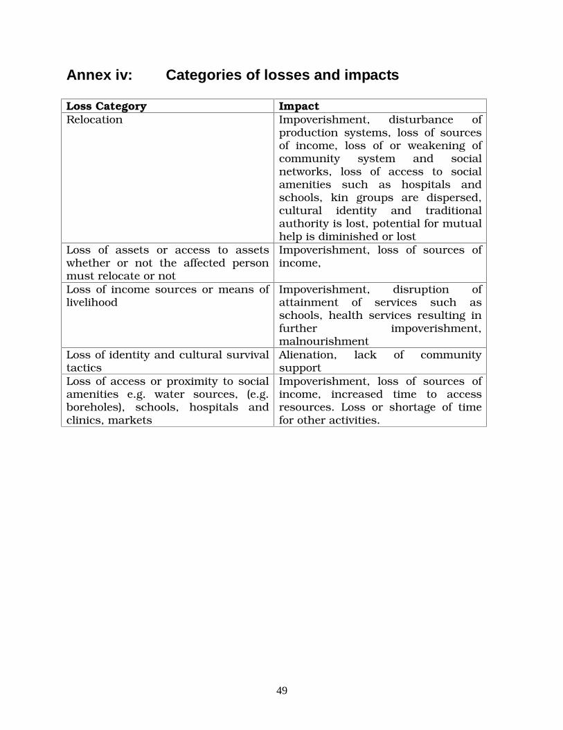
49
Annex iv: Categories of losses and impacts Loss Category Impact Relocation Impoverishment, disturbance of
production systems, loss of sources of income, loss of or weakening of community system and social networks, loss of access to social amenities such as hospitals and schools, kin groups are dispersed, cultural identity and traditional authority is lost, potential for mutual help is diminished or lost
Loss of assets or access to assets whether or not the affected person must relocate or not
Impoverishment, loss of sources of income,
Loss of income sources or means of livelihood
Impoverishment, disruption of attainment of services such as schools, health services resulting in further impoverishment, malnourishment
Loss of identity and cultural survival tactics
Alienation, lack of community support
Loss of access or proximity to social amenities e.g. water sources, (e.g. boreholes), schools, hospitals and clinics, markets
Impoverishment, loss of sources of income, increased time to access resources. Loss or shortage of time for other activities.

50
Annex V: SAMPLE OF Compensation Schedule for selected commercial trees and crops
Property Condition Rate (MK) Mango Tree Full grown 1,000.00 Mango Tree Small 500.00 Lemon tree Medium 500.00
Small 15.00 Banana stem Large 20.00
Beans (premature) Worked out per M2 6.53 Suger Cane Premature 3.00
Mature (0.5ha) 5,000.00 Cassava plot Premature (0.3ha) 1,500.00 Gmelina Tree Large 400.00 Blue Gum Tree Small 150.00 Acassia Tree Small 150.00 Cashew nut tree Large 350.00 Guava Tree Large 350.00 Source: Salima District Assembly Office
Related Documents