Michel Le Page, Simonneaux Vincent, Dejoux Jean-François Centre d’Etudes Spatiales de la Biosphère Abdelaziz EL FAZZIKI, Belaqziz Salwa Université Cadi Ayyad – Faculté des Sciences Semlalia Marrakech Jacquin Marc Magellium Michel Le Page, Simonneaux Vincent, Dejoux Jean-François Centre d’Etudes Spatiales de la Biosphère Abdelaziz EL FAZZIKI, Belaqziz Salwa Université Cadi Ayyad – Faculté des Sciences Semlalia Marrakech Jacquin Marc Magellium Irrigation decision support based on a link between pyWPS and IDL/ENVI, accessing multi-temporal WCS 2nd workshop on the use of OGC standards in meteorology 23-25/11/2009

Welcome message from author
This document is posted to help you gain knowledge. Please leave a comment to let me know what you think about it! Share it to your friends and learn new things together.
Transcript

Michel Le Page, Simonneaux Vincent, Dejoux Jean-FrançoisCentre d’Etudes Spatiales de la Biosphère
Abdelaziz EL FAZZIKI, Belaqziz SalwaUniversité Cadi Ayyad – Faculté des Sciences Semlalia Marrakech
Jacquin MarcMagellium
Michel Le Page, Simonneaux Vincent, Dejoux Jean-FrançoisCentre d’Etudes Spatiales de la Biosphère
Abdelaziz EL FAZZIKI, Belaqziz SalwaUniversité Cadi Ayyad – Faculté des Sciences Semlalia Marrakech
Jacquin MarcMagellium
Irrigation decision support
based on a link between
pyWPS and IDL/ENVI,accessing multi-temporal WCS
2nd workshop on the use of OGC standards in meteorology 23-25/11/2009
2nd workshop on the use of GIS/OGC standards in meteorology
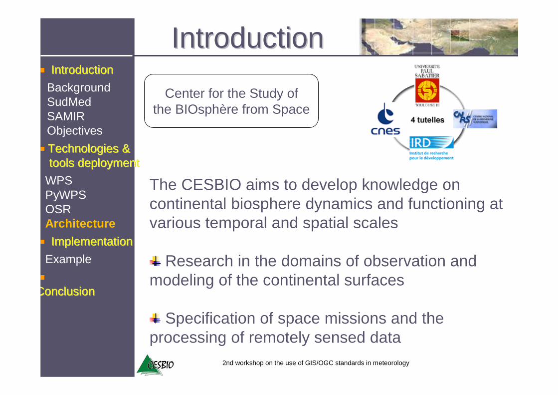
Center for the Study ofthe BIOsphère from Space
The CESBIO aims to develop knowledge on continental biosphere dynamics and functioning atvarious temporal and spatial scales
Research in the domains of observation and modeling of the continental surfaces
Specification of space missions and the processing of remotely sensed data
IntroductionIntroduction
ConclusionConclusion
Technologies & Technologies & toolstools deploymentdeployment
IntroductionIntroduction
BackgroundSudMedSAMIRObjectives
ImplementationImplementation
WPSPyWPSOSRArchitecture
Example
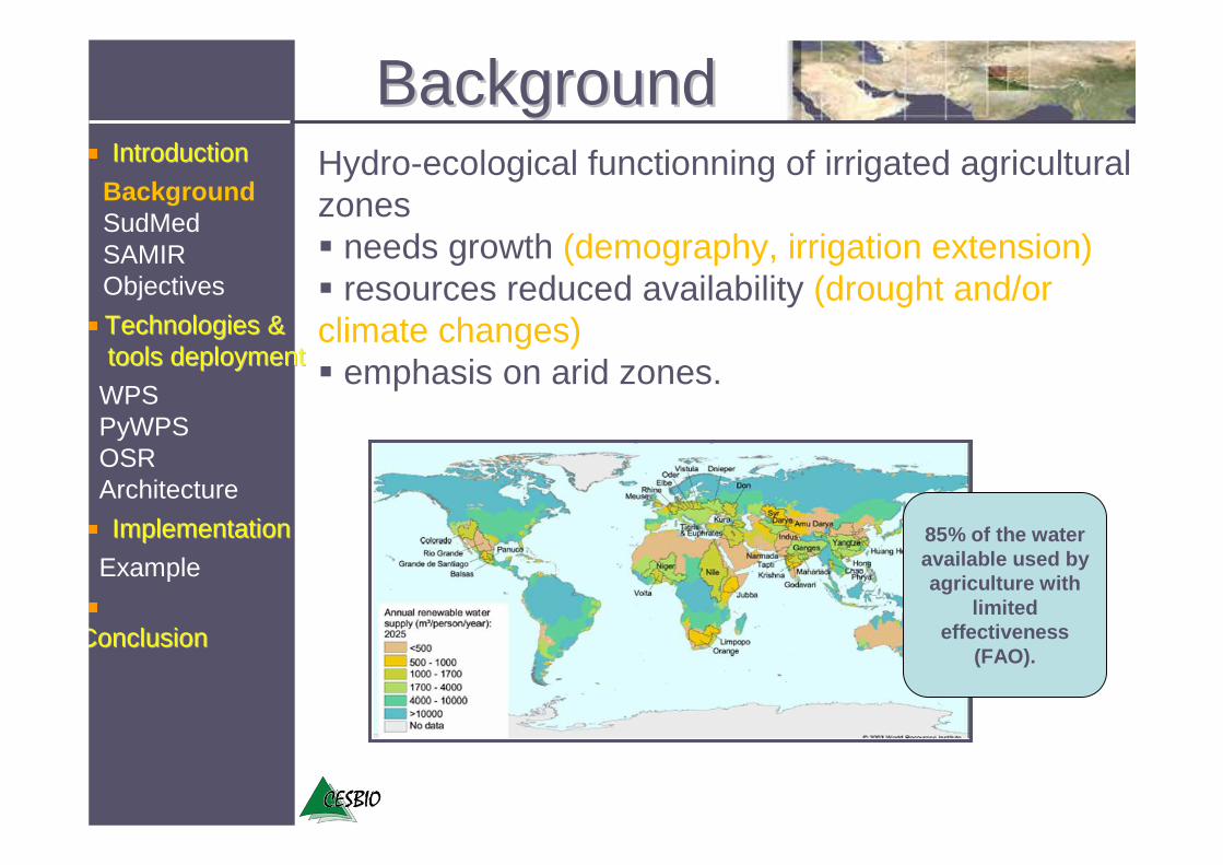
BackgroundBackgroundHydro-ecological functionning of irrigated agricultural zones� needs growth (demography, irrigation extension)� resources reduced availability (drought and/or climate changes) � emphasis on arid zones.
ConclusionConclusion
Technologies & Technologies & toolstools deploymentdeployment
IntroductionIntroduction
Background SudMedSAMIRObjectives
ImplementationImplementation
WPSPyWPSOSRArchitecture
Example85% of the water available used by agriculture with
limited effectiveness
(FAO).
2nd workshop on the use of GIS/OGC standards in meteorology
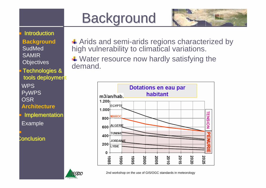
Arids and semi-arids regions characterized by high vulnerability to climatical variations.
Water resource now hardly satisfying the demand.
BackgroundBackground
ConclusionConclusion
Technologies & Technologies & toolstools deploymentdeployment
IntroductionIntroduction
Background SudMedSAMIRObjectives
ImplementationImplementation
WPSPyWPSOSRArchitecture
Example
2nd workshop on the use of GIS/OGC standards in meteorology
BackgroundBackground
ConclusionConclusion
Technologies & Technologies & toolstools deploymentdeployment
IntroductionIntroduction
Background SudMedSAMIRObjectives
ImplementationImplementation
WPSPyWPSOSRArchitecture
Example
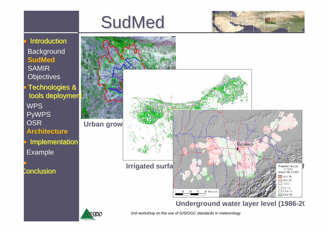
Sud OuestSud OuestSud Ouest
MerguellilMerguellilMerguellil
TensiftTensiftTensift
OronteOronteOronte
Rational use of irrigation waterRational use of irrigation water
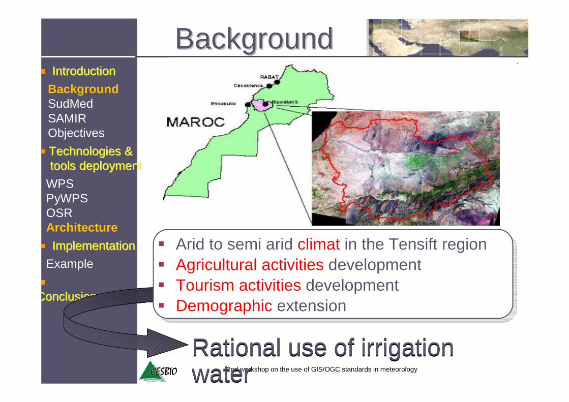
� Arid to semi arid climat in the Tensift region� Agricultural activities development� Tourism activities development� Demographic extension
2nd workshop on the use of GIS/OGC standards in meteorology
Urban growth (1975/1986/2003)
Irrigated surfaces of 1975 to 2002 ( 93.000 ha 181.000 ha)
Underground water layer level (1986- 2002)
SudMedSudMed
ConclusionConclusion
Technologies & Technologies & toolstools deploymentdeployment
IntroductionIntroduction
ImplementationImplementation
WPSPyWPSOSRArchitecture
Example
BackgroundSudMedSAMIRObjectives

2nd workshop on the use of GIS/OGC standards in meteorology
GENERAL OBJECTIVES
� To develop operational tools for state agencies for enhanced rational management of resources.
� To understand, model and predict the integrated hydro-ecological functionning of the Tensift basin.
� To develop dashboard/indicators/decision-making tools for policies makers and legislators
SudMedSudMed
ConclusionConclusion
Technologies & Technologies & toolstools deploymentdeployment
IntroductionIntroduction
ImplementationImplementation
WPSPyWPSOSRArchitecture
Example
BackgroundSudMedSAMIRObjectives

SudMedSudMed
ConclusionConclusion
Technologies & Technologies & toolstools deploymentdeployment
IntroductionIntroduction
BackgroundSudMedSAMIRObjectives
ImplementationImplementation
WPSPyWPSOSRArchitecture
Example
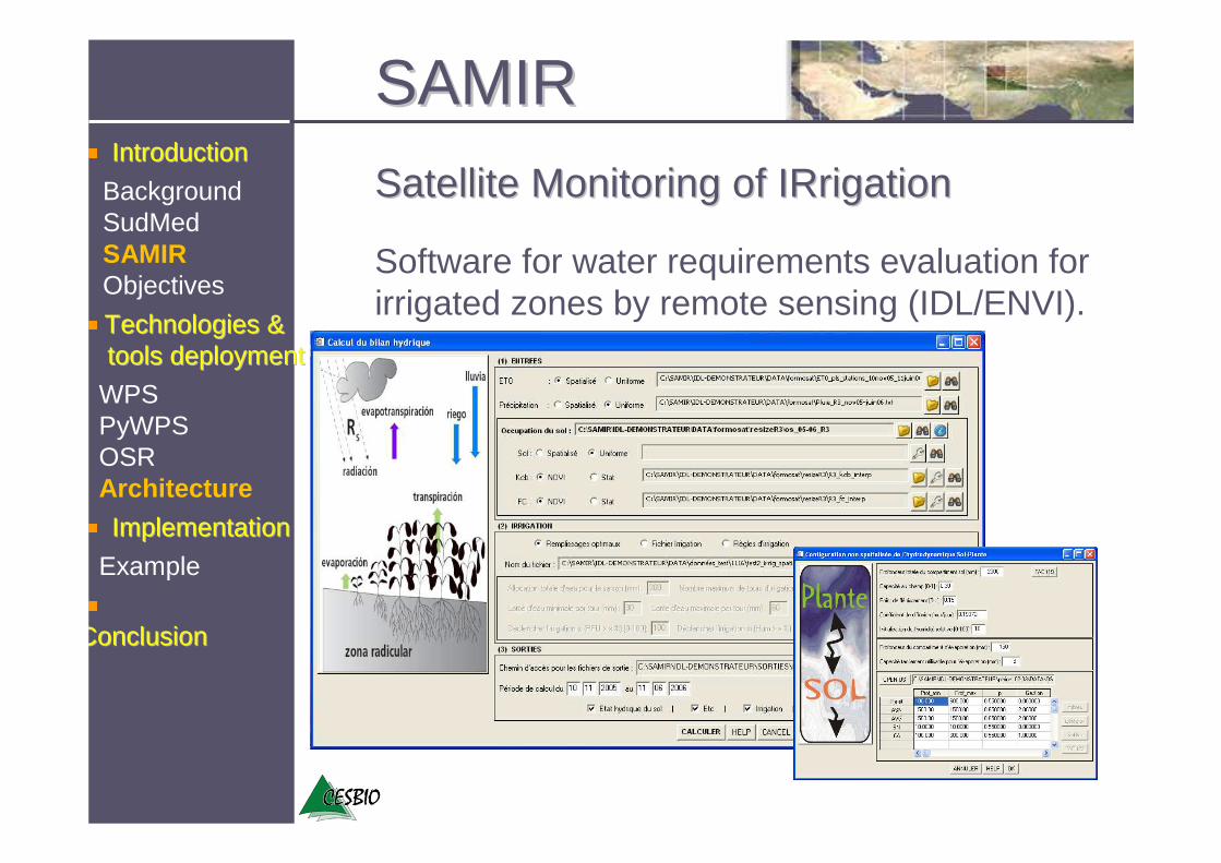
SAMIRSAMIR
Satellite Monitoring of Satellite Monitoring of IRrigationIRrigation
Software for water requirements evaluation for irrigated zones by remote sensing (IDL/ENVI).
ConclusionConclusion
Technologies & Technologies & toolstools deploymentdeployment
IntroductionIntroduction
BackgroundSudMedSAMIRObjectives
ImplementationImplementation
WPSPyWPSOSRArchitecture
Example
2nd workshop on the use of GIS/OGC standards in meteorology
SAMIRSAMIR
ConclusionConclusion
Technologies & Technologies & toolstools deploymentdeployment
IntroductionIntroduction
ImplementationImplementation
WPSPyWPSOSRArchitecture
Example
BackgroundSudMedSAMIRObjectives
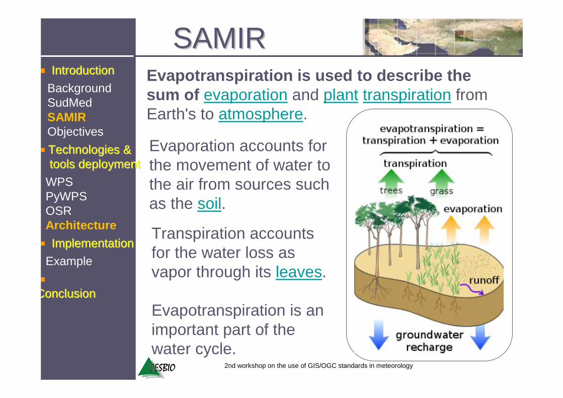
Evapotranspiration is used to describe the sum of evaporation and plant transpiration fromEarth's to atmosphere.
Evaporation accounts for the movement of water to the air from sources suchas the soil.
Transpiration accountsfor the water loss as vapor through its leaves.
Evapotranspiration is an important part of the water cycle.
2nd workshop on the use of GIS/OGC standards in meteorology
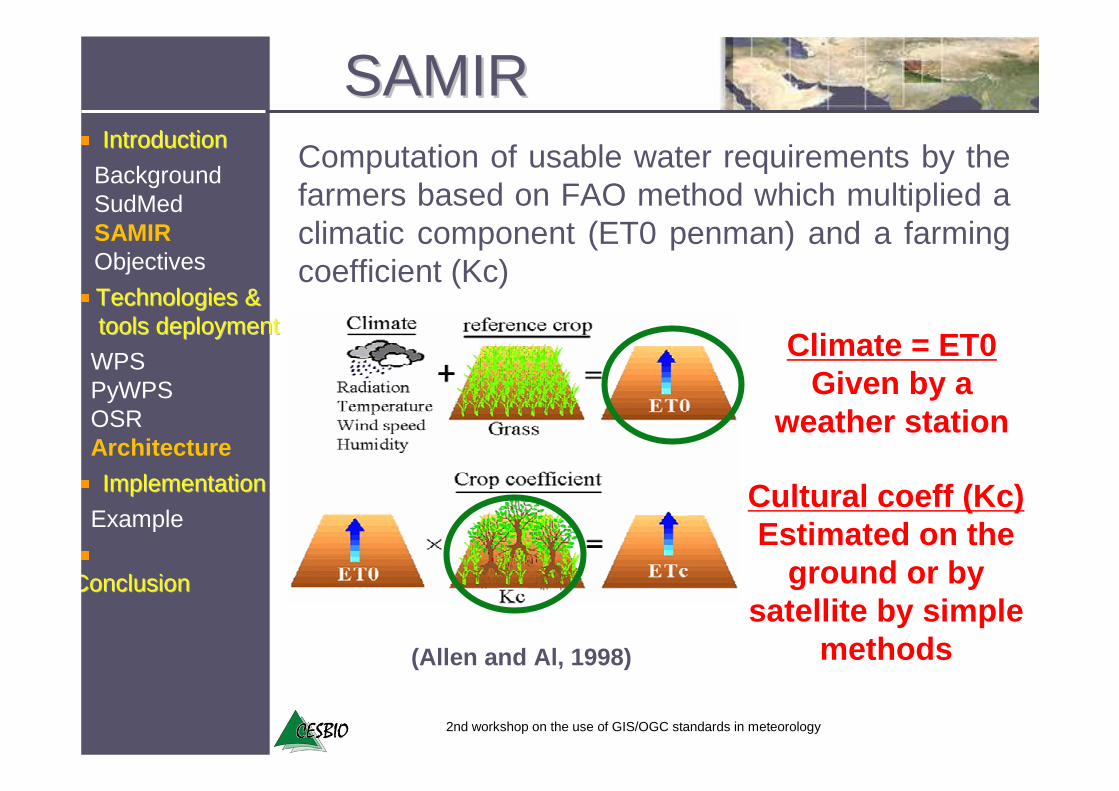
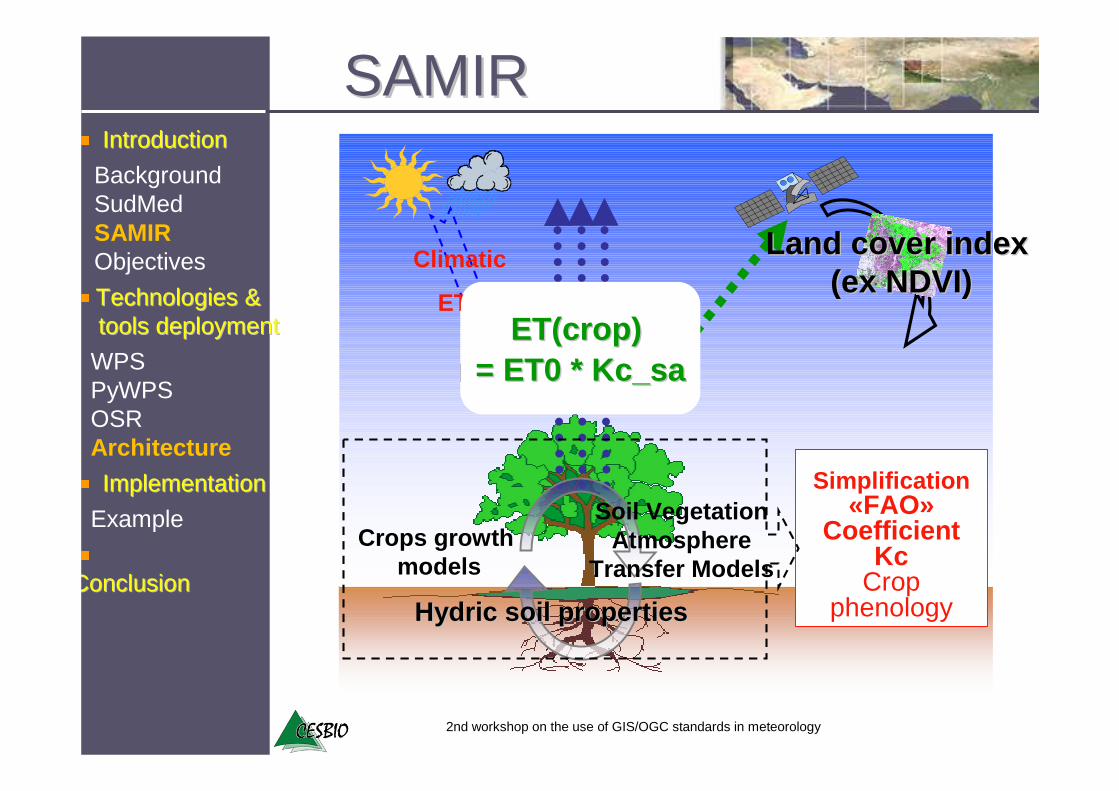
Computation of usable water requirements by the farmers based on FAO method which multiplied a climatic component (ET0 penman) and a farming coefficient (Kc)
Climate = ET0Given by a
weather station
Cultural coeff (Kc)Estimated on the
ground or by satellite by simple
methods(Allen and Al, 1998)
SAMIRSAMIR
ConclusionConclusion
Technologies & Technologies & toolstools deploymentdeployment
IntroductionIntroduction
ImplementationImplementation
WPSPyWPSOSRArchitecture
Example
BackgroundSudMedSAMIRObjectives
2nd workshop on the use of GIS/OGC standards in meteorology
Simplification«FAO»
CoefficientKc
Cropphenology
Crops growth models
Actual crop
Evapotranspiration
HydricHydric soil propertiessoil properties
Land cover index Land cover index (ex NDVI)(ex NDVI)
Climatic
ET0ET(cropET(crop ) )
= ET0 * = ET0 * Kc_saKc_sa
SAMIRSAMIR
ConclusionConclusion
Technologies & Technologies & toolstools deploymentdeployment
IntroductionIntroduction
ImplementationImplementation
WPSPyWPSOSRArchitecture
Example
BackgroundSudMedSAMIRObjectives
Soil VegetationAtmosphere
Transfer Models
2nd workshop on the use of GIS/OGC standards in meteorology
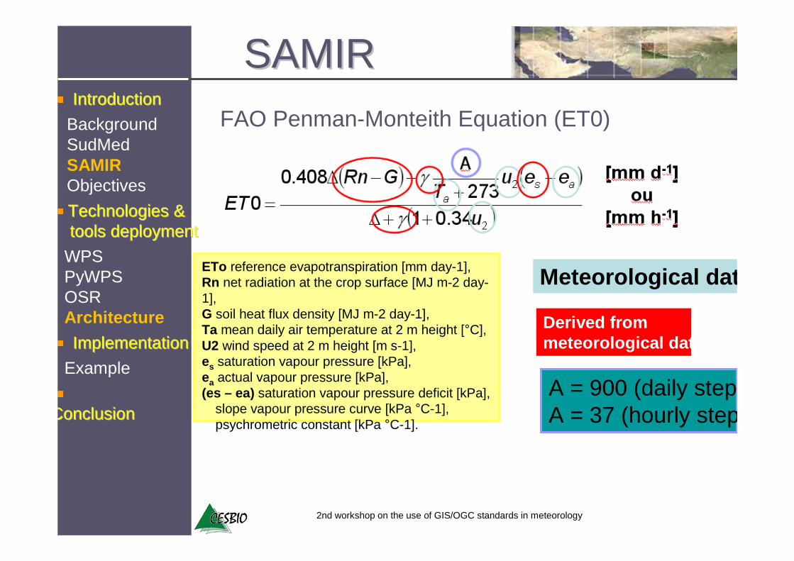
ETo reference evapotranspiration [mm day-1],Rn net radiation at the crop surface [MJ m-2 day-1],G soil heat flux density [MJ m-2 day-1],Ta mean daily air temperature at 2 m height [°C],U2 wind speed at 2 m height [m s-1],es saturation vapour pressure [kPa],ea actual vapour pressure [kPa],(es – ea) saturation vapour pressure deficit [kPa],� slope vapour pressure curve [kPa °C-1],� psychrometric constant [kPa °C-1].
Meteorological data
Derived frommeteorological data
A = 900 (daily step) A = 37 (hourly step
FAO Penman-Monteith Equation (ET0)
SAMIRSAMIR
ConclusionConclusion
Technologies & Technologies & toolstools deploymentdeployment
IntroductionIntroduction
ImplementationImplementation
WPSPyWPSOSRArchitecture
Example
BackgroundSudMedSAMIRObjectives
2nd workshop on the use of GIS/OGC standards in meteorology
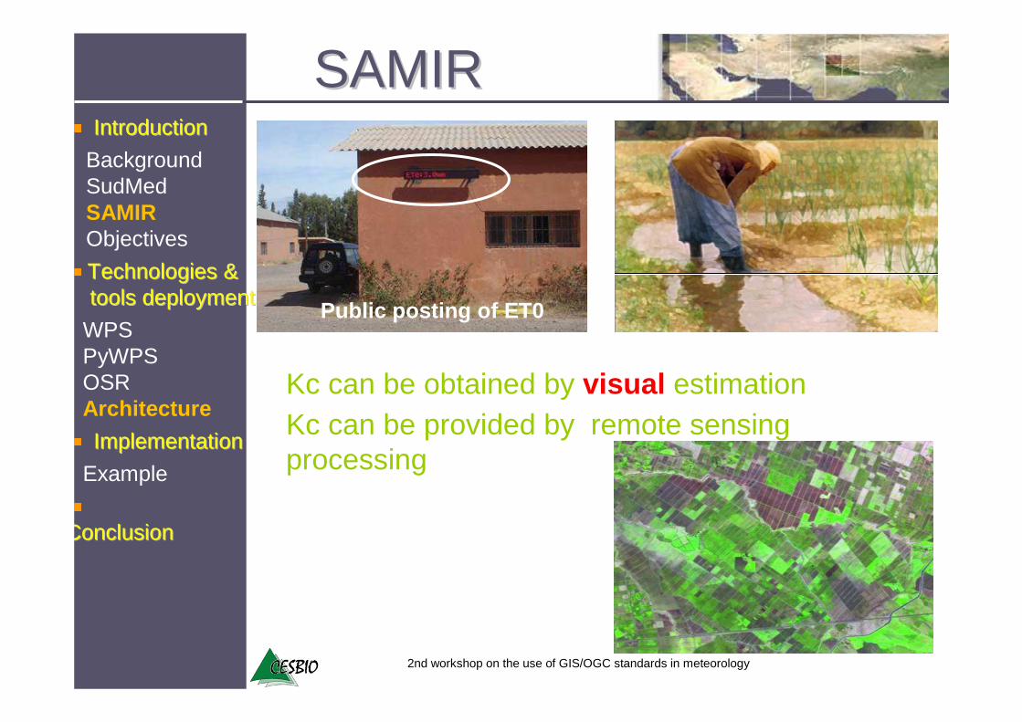
Public posting of ET0
Kc can be obtained by visual estimationKc can be provided by remote sensing processing
SAMIRSAMIR
ConclusionConclusion
Technologies & Technologies & toolstools deploymentdeployment
IntroductionIntroduction
ImplementationImplementation
WPSPyWPSOSRArchitecture
Example
BackgroundSudMedSAMIRObjectives
2nd workshop on the use of GIS/OGC standards in meteorology
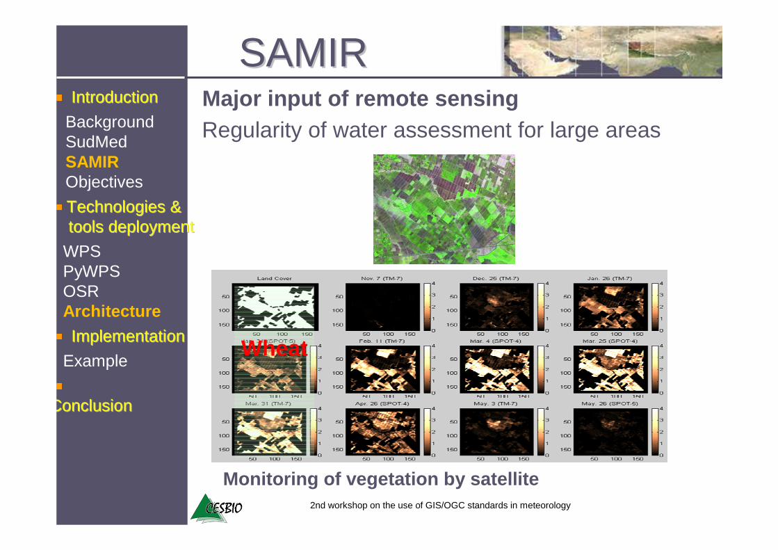
Regularity of water assessment for large areas
Wheat
Major input of remote sensing
Monitoring of vegetation by satellite
SAMIRSAMIR
ConclusionConclusion
Technologies & Technologies & toolstools deploymentdeployment
IntroductionIntroduction
ImplementationImplementation
WPSPyWPSOSRArchitecture
Example
BackgroundSudMedSAMIRObjectives
2nd workshop on the use of GIS/OGC standards in meteorology
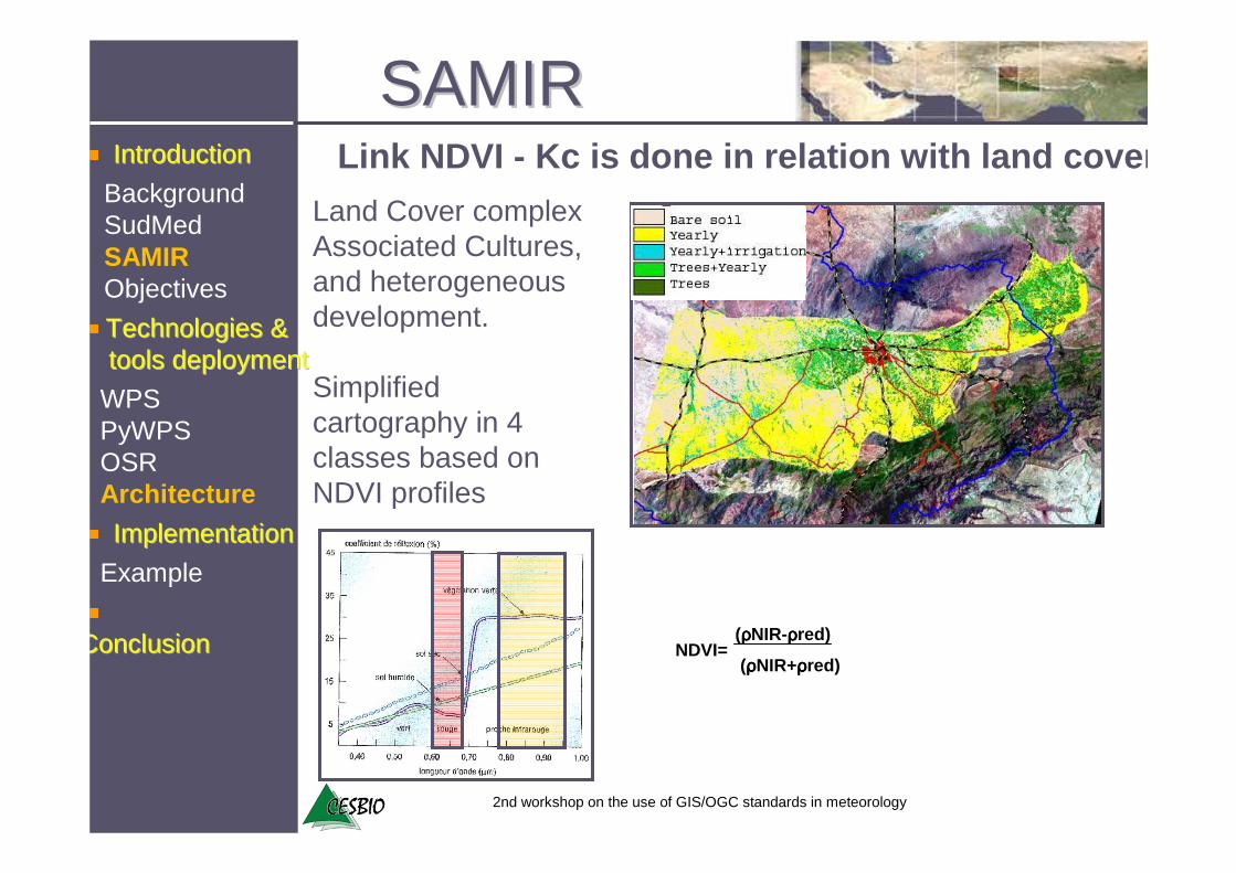
Land Cover complexAssociated Cultures, and heterogeneous development.
Simplified cartography in 4 classes based on NDVI profiles
Link NDVI - Kc is done in relation with land cover
SAMIRSAMIR
(ρρρρNIR+ρρρρred)
(ρρρρNIR-ρρρρred)NDVI=ConclusionConclusion
Technologies & Technologies & toolstools deploymentdeployment
IntroductionIntroduction
ImplementationImplementation
WPSPyWPSOSRArchitecture
Example
BackgroundSudMedSAMIRObjectives
2nd workshop on the use of GIS/OGC standards in meteorology
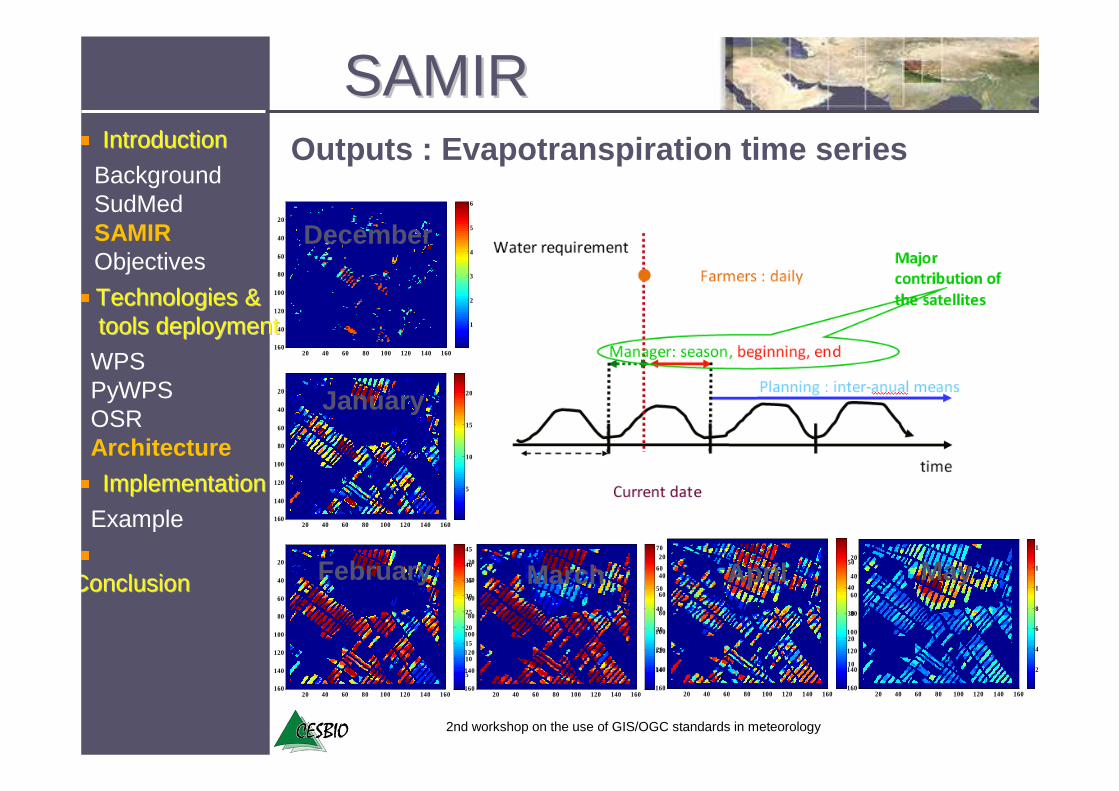
Outputs : Evapotranspiration time series
SAMIRSAMIR
20 40 60 80 100 120 140 160
20
40
60
80
100
120
140
160
1
2
3
4
5
6
20 40 60 80 100 120 140 160
20
40
60
80
100
120
140
160
5
10
15
20
20 40 60 80 100 120 140 160
20
40
60
80
100
120
140
160
5
10
15
20
25
30
35
40
45
20 40 60 80 100 120 140 160
20
40
60
80
100
120
140
160
10
20
30
40
50
60
70
20 40 60 80 100 120 140 160
20
40
60
80
100
120
140
160
10
20
30
40
50
20 40 60 80 100 120 140 160
20
40
60
80
100
120
140
160
20
40
60
80
100
120
140
December
January
February March April MayConclusionConclusion
Technologies & Technologies & toolstools deploymentdeployment
IntroductionIntroduction
ImplementationImplementation
WPSPyWPSOSRArchitecture
Example
BackgroundSudMedSAMIRObjectives
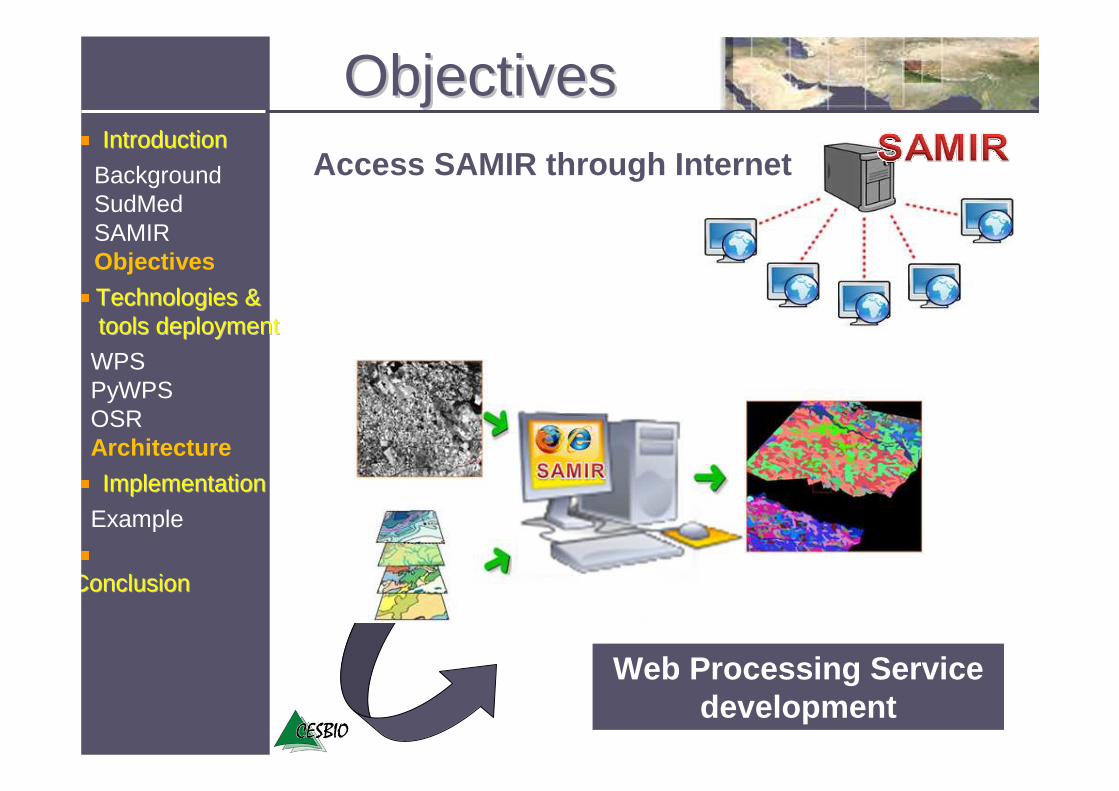
Web Processing Service development
Access SAMIR through Internet
ObjectivesObjectives
ConclusionConclusion
Technologies & Technologies & toolstools deploymentdeployment
IntroductionIntroduction
BackgroundSudMedSAMIRObjectives
ImplementationImplementation
WPSPyWPSOSRArchitecture
Example

2nd workshop on the use of GIS/OGC standards in meteorology
�Spatial data is available on the web through OGC web services (WFS, WCS)�Network & computational capacity available
Web Processing ServiceWeb Processing Service
Processing on the web is the next logical step
1. Inputs can be web-accessible URLs or embedded in the request.
2. Outputs can be stored as web-accessible URLs or embedded in the response.
3. It supports multiple input and output formats.4. It supports long-running processes.5. It supports SOAP and WSDL.
ConclusionConclusion
Technologies & Technologies & toolstools deploymentdeployment
IntroductionIntroduction
BackgroundSudMedSAMIRObjectives
ImplementationImplementation
WPSPyWPSOSRArchitecture
Example

PyWPSPyWPS�SAMIR is still under development, need to directly access the IDL/ENVI programs. The solution was to use pyWPS and IDL on a Linux platform. �PyWPS (3.1.0) implement OGC’s Web Processing Service standard
�Operable with any other tool or just with Python itself even without GRASS GIS in the background
�PyWPS does not process the data by it self. IDL,GRASS GIS, GDAL, PROJ, R and other programs can be used.
ConclusionConclusion
Technologies & Technologies & toolstools deploymentdeployment
IntroductionIntroduction
BackgroundSudMedSAMIRObjectives
ImplementationImplementation
Example
WPSPyWPSOSRArchitecture

2nd workshop on the use of GIS/OGC standards in meteorology21
OSR :Regional Spatial ObservatoryRegional Spatial Observatory� Information needed to assess water needs is not centralized � The OSR project (Regional Spatial Observatory), implements
OGC services (WMS, WFS ,WCS).� Long-term monitoring of experimental sites : collect,
production, measurements dissemination management
ConclusionConclusion
Technologies & Technologies & toolstools deploymentdeployment
IntroductionIntroduction
BackgroundSudMedSAMIRObjectives
ImplementationImplementation
Example
WPSPyWPSOSRArchitecture

2nd workshop on the use of GIS/OGC standards in meteorology
Land Cover NDVItime series
ET0 Daily time series
- Bounding Box
- Starting and ending dates
Relation Kc-Ndvi
In relation to land cover
Inputs
Computation parameters
Process parameters
ArchitectureArchitecture
ConclusionConclusion
Technologies & Technologies & toolstools deploymentdeployment
IntroductionIntroduction
BackgroundSudMedSAMIRObjectives
ImplementationImplementation
WPSPyWPSOSRArchitecture
Example
2nd workshop on the use of GIS/OGC standards in meteorology
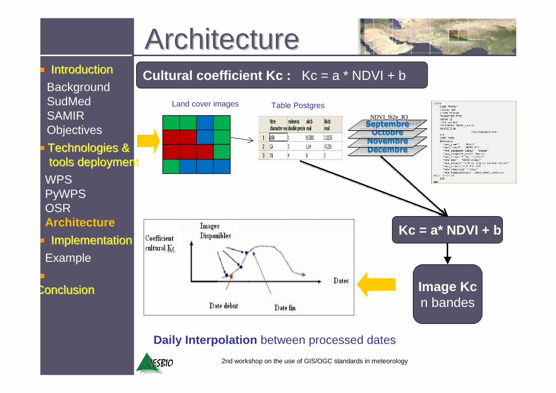
Land cover images Table Postgres
Daily Interpolation between processed dates
Cultural coefficient Kc : Kc = a * NDVI + b
Kc = a* NDVI + b
Image Kcn bandes
DecembreDecembreNovembreNovembreOctobreOctobreSeptembreSeptembre
NDVI_9i2e_R3NDVI_9i2e_R3
ArchitectureArchitecture
ConclusionConclusion
Technologies & Technologies & toolstools deploymentdeployment
IntroductionIntroduction
BackgroundSudMedSAMIRObjectives
ImplementationImplementation
WPSPyWPSOSRArchitecture
Example
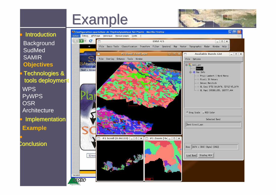
ExampleExample
ConclusionConclusion
Technologies & Technologies & toolstools deploymentdeployment
IntroductionIntroduction
BackgroundSudMedSAMIRObjectives
ImplementationImplementation
WPSPyWPSOSRArchitecture
Example
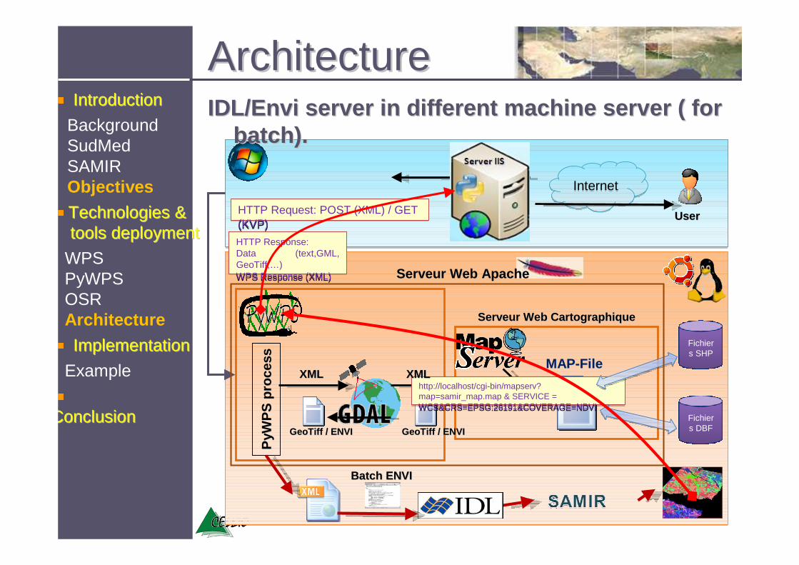
UserUser
Internet Internet
HTTP Request: POST (XML) / GET (KVP)HTTP Request: POST (XML) / GET (KVP)
ConclusionConclusion
Technologies & Technologies & toolstools deploymentdeployment
IntroductionIntroduction
BackgroundSudMedSAMIRObjectives
ImplementationImplementation
IDL/IDL/EnviEnvi server in different machine server ( for server in different machine server ( for batch).batch).
PyW
PS
PyW
PS
proc
ess
proc
ess
Fichiers SHP
Fichiers DBF
ServeurServeur Web Web CartographiqueCartographique
ServeurServeur Web ApacheWeb Apache
MAPMAP--FileFile
http://localhost/cgi-bin/mapserv? map=samir_map.map & SERVICE = WCS&CRS=EPSG:26191&COVERAGE=NDVI
http://localhost/cgi-bin/mapserv? map=samir_map.map & SERVICE = WCS&CRS=EPSG:26191&COVERAGE=NDVI
GeoTiffGeoTiff / ENVI/ ENVI GeoTiffGeoTiff / ENVI/ ENVI
XMLXML XMLXML
Batch ENVIBatch ENVI
HTTP Response: Data (text,GML, GeoTiff,…) WPS Response (XML)
HTTP Response: Data (text,GML, GeoTiff,…) WPS Response (XML)
WPSPyWPSOSRArchitecture
ArchitectureArchitecture
Example
2nd workshop on the use of GIS/OGC standards in meteorology
PerspectivesPerspectives
ConclusionConclusion
Technologies & Technologies & toolstools deploymentdeployment
IntroductionIntroduction
BackgroundSudMedSAMIRObjectives
ImplementationImplementation
WPSPyWPSOSRArchitecture
Example
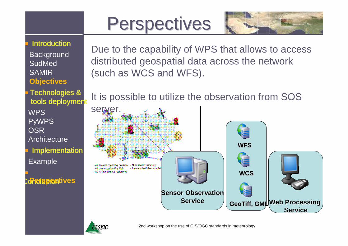
Perspectives
Due to the capability of WPS that allows to access distributed geospatial data across the network (such as WCS and WFS).
It is possible to utilize the observation from SOS server.
Sensor ObservationSensor ObservationServiceService
WFSWFS
WCSWCS
GeoTiff, GMLGeoTiff, GML Web Processing Web Processing ServiceService
2nd workshop on the use of GIS/OGC standards in meteorology
Thanks
Related Documents


