Undefined 0 (0) 1 1 IOS Press LinkedGeoData: A Core for a Web of Spatial Open Data Claus Stadler a,* , Jens Lehmann a , Konrad Höffner a , Sören Auer a a Department of Computer Science, University of Leipzig Johannisgasse 26, 04103 Leipzig, Germany {cstadler, lehmann, auer}@informatik.uni-leipzig.de, [email protected] Abstract. Data integration on and off the web requires comprehensive datasets and vocabularies to enable the disambiguation and alignment of information. Many of such real-life information integration and aggregation tasks are impossible without comprehensive background knowledge related to spatial features of the ways, structures and landscapes surrounding us. In this paper, we contribute to the development of a spatial Data Web by elaborating on how the collaboratively collected OpenStreetMap data can be interactively transformed and represented adhering to the RDF data model. We describe how this data is interlinked with other spatial data sets, how it can be made accessible for machines according to the Linked Data paradigm and for humans by means of several applications, including a faceted geo-browser. The spatial data, vocabularies, interlinks and some of the applications are openly available in the LinkedGeoData project. Keywords: Linked Data, Spatial Data, Open Data, Interlinking, RDF, RDB2RDF, OpenStreetMap, LinkedGeoData 1. Introduction The Semantic Web eases data integration tasks by providing the basis for overcoming structural and se- mantic heterogeneity through RDF and ontologies. In order to employ the Web as a medium for data and information integration, comprehensive datasets and vocabularies are required as they enable the disam- biguation and alignment of other data and informa- tion. With DBpedia [10], a large reference dataset pro- viding encyclopedic knowledge about a multitude of different domains is already available. A number of other datasets tackling domains such as entertainment, bio-medicine or bibliographic data are available in the emerging Linked Data Web 1 . Many real-life information integration and aggrega- tion tasks are, however, impossible without compre- * This work was supported by a grant from the European Union’s 7th Framework Programme provided for the projects LOD2 (GA no. 257943) and LATC (GA no. 256975). 1 See, for example, the listing at http://ckan.net/group/ lodcloud and an overview at http://lod-cloud.net. hensive background knowledge related to spatial fea- tures of the ways, structures and landscapes surround- ing us. Such tasks include, for example, to depict lo- cally the offerings of the bakery shop next door, to map distributed branches of a company or to integrate in- formation about historical sights along a bicycle track. With the OpenStreetMap (OSM) 2 project, a rich source of spatial data is freely available. It is currently used primarily for rendering various map visualiza- tions, but has the potential to evolve into a crystalliza- tion point for spatial Web data integration. The goal of our LinkedGeoData (LGD) project is to provide a rich integrated and interlinked geographic dataset for the Semantic Web. The majority of our data is obtained by converting data from the popular Open- StreetMap community project to RDF and deriving a lightweight ontology from it. Furthermore, we per- form interlinking with DBpedia, GeoNames and other datasets as well as the integration of icons and multi- lingual class labels from various sources. As a side ef- 2 http://openstreetmap.org 0000-0000/0-1900/$00.00 c 0 – IOS Press and the authors. All rights reserved

Welcome message from author
This document is posted to help you gain knowledge. Please leave a comment to let me know what you think about it! Share it to your friends and learn new things together.
Transcript

Undefined 0 (0) 1 1IOS Press
LinkedGeoData:A Core for a Web of Spatial Open DataClaus Stadler a,∗, Jens Lehmann a, Konrad Höffner a, Sören Auer aa Department of Computer Science, University of LeipzigJohannisgasse 26, 04103 Leipzig, Germany{cstadler, lehmann, auer}@informatik.uni-leipzig.de, [email protected]
Abstract. Data integration on and off the web requires comprehensive datasets and vocabularies to enable the disambiguationand alignment of information. Many of such real-life information integration and aggregation tasks are impossible withoutcomprehensive background knowledge related to spatial features of the ways, structures and landscapes surrounding us. In thispaper, we contribute to the development of a spatial Data Web by elaborating on how the collaboratively collected OpenStreetMapdata can be interactively transformed and represented adhering to the RDF data model. We describe how this data is interlinkedwith other spatial data sets, how it can be made accessible for machines according to the Linked Data paradigm and for humansby means of several applications, including a faceted geo-browser. The spatial data, vocabularies, interlinks and some of theapplications are openly available in the LinkedGeoData project.
Keywords: Linked Data, Spatial Data, Open Data, Interlinking, RDF, RDB2RDF, OpenStreetMap, LinkedGeoData
1. Introduction
The Semantic Web eases data integration tasks byproviding the basis for overcoming structural and se-mantic heterogeneity through RDF and ontologies. Inorder to employ the Web as a medium for data andinformation integration, comprehensive datasets andvocabularies are required as they enable the disam-biguation and alignment of other data and informa-tion. With DBpedia [10], a large reference dataset pro-viding encyclopedic knowledge about a multitude ofdifferent domains is already available. A number ofother datasets tackling domains such as entertainment,bio-medicine or bibliographic data are available in theemerging Linked Data Web1.
Many real-life information integration and aggrega-tion tasks are, however, impossible without compre-
*This work was supported by a grant from the European Union’s7th Framework Programme provided for the projects LOD2 (GA no.257943) and LATC (GA no. 256975).
1See, for example, the listing at http://ckan.net/group/lodcloud and an overview at http://lod-cloud.net.
hensive background knowledge related to spatial fea-tures of the ways, structures and landscapes surround-ing us. Such tasks include, for example, to depict lo-cally the offerings of the bakery shop next door, to mapdistributed branches of a company or to integrate in-formation about historical sights along a bicycle track.
With the OpenStreetMap (OSM)2 project, a richsource of spatial data is freely available. It is currentlyused primarily for rendering various map visualiza-tions, but has the potential to evolve into a crystalliza-tion point for spatial Web data integration.
The goal of our LinkedGeoData (LGD) project isto provide a rich integrated and interlinked geographicdataset for the Semantic Web. The majority of our datais obtained by converting data from the popular Open-StreetMap community project to RDF and derivinga lightweight ontology from it. Furthermore, we per-form interlinking with DBpedia, GeoNames and otherdatasets as well as the integration of icons and multi-lingual class labels from various sources. As a side ef-
2http://openstreetmap.org
0000-0000/0-1900/$00.00 c© 0 – IOS Press and the authors. All rights reserved

2 Stadler et. al / LinkedGeoData
fect, we are striving for the establishment of an OWLvocabulary with the purpose of simplifying exchangeand reuse of geographic data.
After our initial LGD release in 2009 [1], we in-vested substantial efforts in maintaining and improv-ing LinkedGeoData, which include improvements ofthe project infrastructure, the generated ontology anddata quality in general. Our new contributions sincethen are:
– A flexible system for mapping OpenStreetMapdata to RDF, resulting in improved data quality.
– The SPARQL endpoint was made publicly avail-able, which led to more 3rd party applications anddemos.
– Better support for ways: The geometry of a wayis now associated with the corresponding RDF re-source. Also, all nodes referenced by the way areare available both via the Linked Data interfaceand the SPARQL endpoints.
– An improved REST interface with integratedsearch functions.
– A new publicly accessible live SPARQL end-point that is being interactively updated with theminutely changesets that OpenStreetMap pub-lishes.
– A simple republication method of the correspond-ing RDF changesets so that LinkedGeoData dataconsumers can replicate our store.
– Direct interlinking with GeoNames and the UNFAO data (interlinks with DBpedia have been up-dated).
– An improved LinkedGeoData browser.– Implementation of the Vicibit application to facil-
itate the integration of LGD facet views in exter-nal web pages.
– Integration of appropriate icons and multi lan-guage labels for LinkedGeoData ontology ele-ments from external sources.
The paper is structured as follows: after introduc-ing the OpenStreetMap project in Section 2, we out-line the LinkedGeoData architecture in Section 3. Wedescribe how the OSM data can be transformed intothe RDF data model in Section 4 and how it is re-published as Linked Data in Section 7. We presentstatistics about LinkedGeoData in Section 8 and de-scribe the interlinking with existing data sources on theData Web in Section 6. In Section 9, we showcase afaceted geo-data browser and editor as well as some3rd party applications being built around LinkedGeo-
Data. We present related work in Section 10 and con-clude in Section 11 with an outlook to future work.
2. OpenStreetMap
OpenStreetMap is a collaborative project to create afree editable map of the whole world. It was inspiredby Wikipedia and as such it provides well known wikifeatures such as an edit-tab and a full revision historyof the edits. However, rather than editing articles, usersedit geographic entities. The three fundamental onesare as follows:
– Nodes are the most primitive entities and repre-sent geographic points with a latitude and longi-tude relative to the WGS84 reference system.
– Ways are entities that have a list of at least twonode references associated with them. Dependingon whether the first reference equals the last one,a way is called closed or open, respectively.
– Relations relate points, ways and potentially otherrelations to each other, thereby forming complexobjects. Each entity participating in a relationplays a certain role in it. Multipolygons are mod-elled with relations.
Each of these entities has a numeric identifier (calledOSM ID), a set of generic attributes, and most im-portantly is described using a set of key-value pairs,known as tags.
An example of a relation is the administrativeboundary of Germany having the OSM identifier51477.3 It comprises more than 1000 ways, whichrepresent certain segments of the German border;the German border with Luxembourg e.g. is com-posed out of approx. 40 way segments. The rela-tion currently has about 30 associated tag-value pairs,which, for example, contain the name of Germanyin different languages. One of those tag-value pairs(boundary=administrative) indicates that thisrelation represents an administrative boundary. Thisinformation is used by the OSM map renderer to de-cide how this relation should be rendered on the map.Further tags are used for timezone, currency, and ISOcountry. The relation has also a few meta-data entries(such as the timestamp of the last edit and the last edi-tor) attached.
3http://www.openstreetmap.org/browse/relation/51477 can be used to browse this relation.

Stadler et. al / LinkedGeoData 3
Fig. 1. Overview of OpenStreetMap’s architecture.Source:http://wiki.openstreetmap.org/w/images/1/15/OSM_Components.png as of 2011 Apr 27th
To manage those datastructures, an infrastructureevolved encompassing multiple map editing tools, tilerenderers, and data sources, as shown in Figure 2.
The data is stored in a relational database (Post-greSQL backend). It can be accessed, queried andedited by using a REST API, which basically usesHTTP GET, PUT and DELETE requests with XMLpayload (similar to the example shown in Listing 4).The data is also published as complete dumps of thedatabase in such an XML format on a weekly basis. Itcurrently accounts for more than 16GB of Bzip2 com-pressed data. In minutely, hourly and daily intervalsthe project additionally publishes changesets, whichcan be used to synchronize a local deployment of thedata with the OSM database. The dumps as well as thechangesets can be processed with the Osmosis tool.
Different authoring interfaces, accessing the API,are provided by the OSM community. These includethe online editor Potlatch, which is implemented inFlash and accessible directly via the edit tab at theOSM map view, as well as the desktop applicationsJOSM, Merkaartor and Mapzen. The editors use com-plementary external services and data such as Yahoo!satellite imagery or Web Map Services (WMS). Addi-tionally, users can upload GPS traces which serve asraw material for modelling the map. Two different ren-dering services are offered for the rendering of raster
maps on different zoom levels. With Tiles@home, theperformance-intense rendering tasks are dispatched toidle machines of community members; thus achievingtimeliness. The Mapnik renderer, in turn, operates ona central tile server and re-renders tiles only in certainintervals.
Since the use of tags and values is not restricted, butgoverned by an agile community process, it is impor-tant to obtain an overview on emerging tags and tagvalues possibly specific to a certain region. Servicessuch as TagWatch4 periodically compute tag statisticsfor different areas. In order for the data to be ma-chine interpretable, as for instance for map rendering,contributors must follow certain editing standards andconventions5.
Currently, OSM is in the process of switching fromthe Creative Commons CC-BY-SA license to the OpenDatabase License6. The term Volunteered GeographicInformation (VGI) was coined [8] for the harnessing oftools to create, assemble, and disseminate geographicdata provided voluntarily by individuals – with OSMbeing a driving force behind VGI.
4http://tagwatch.stoecker.eu/5http://wiki.openstreetmap.org/wiki/Map_
Features6http://www.opendatacommons.org/licenses/
odbl/

4 Stadler et. al / LinkedGeoData
Category June 2009 April 2010 May 2011 Growth (past two years)Users (Thousands) 127 261 397 + 213%Uploaded GPS points (Millions) 915 1500 2298 + 151%Nodes (Millions) 374 600 1073 + 187%Ways (Millions) 30 48 92 + 207%
Table 1
OpenStreetMap statistics 2009 - 2011.(Obtained from http://www.openstreetmap.org/stats/data_stats.html at the specified months.)
The growth of the OpenStreetMap data has beenenormous (cf. Table 1): Since the founding in July2004 until now, more than one billion nodes, about90 million ways and close to 1 million relations havebeen contributed by the users7. Some of the datawas imported form public domain datasources such asTIGER8 for US, AND Automotive Navigation Data9
for The Netherlands, and GeoBase data from the Cana-dian government10.
3. Architecture
The goal of the LinkedGeoData the project is to con-tribute rich, open, and integrated geographical data tothe Semantic Web using OpenStreetMap as its base.This is analogous to the well known DBpedia project,which follows a similar approach based on Wikipedia.The necessary work for reaching this goal comprisesthe conversion of OSM data to RDF, the interlinkingwith other knowledge bases, the dissemination of theresulting data, and keeping the datasets up-to-date. Inthis section, we give an overview of the LinkedGeo-Data architecture, followed by explanations of the de-tails of the involved components in the next sections.
The architecture of LinkedGeoData is illustrated inFigure 2. It shows that the data from OpenStreetMapis processed on different routes: The LGD Dump Mod-ule converts an OSM planet file to RDF and loadsthe data into a triple store. This data is then avail-able via the static SPARQL endpoint. A copy of thattriple store serves as the initial basis for the liveSPARQL endpoint. The LGD Live Sync Module down-loads minutely changesets from OpenStreetMap, andcomputes corresponding changesets on the RDF level
7http://www.openstreetmap.org/stats/data_stats.html, retrieved 2011 May 2nd
8http://www.census.gov/geo/www/tiger9http://www.and.com/10http://www.geobase.ca
in order to update that triple store accordingly. By pub-lishing these RDF changesets (see Section 7.2), we en-able data consumers to sync their own triple store withours. Note, that not all OSM entities are loaded into theSPARQL endpoints due to performance reasons. Weoffer SPARQL endpoints for the static and live version,because some use cases require up-to-date informationwhereas for others, it is more suitable that queries yieldthe same result over a longer period of time, e.g. dueto caching mechanisms.
For data access LinkedGeoData offers downloads, aREST API interface, Linked Data, and SPARQL end-points. The REST API provides limited query capa-bilities for RDFized data about all nodes and ways ofOpenStreetMap (relations are currently not supported).It draws its data from a local replica of the Open-StreetMap PostGIS database. The OpenStreetMapcommunity developed a tool named Osmosis11, whichsupports setting up such database from a planet file andapplying changesets to it. In future work, we aim forstronger support of spatial SPARQL queries by expos-ing PostGIS features via SPARQL.
4. RDF Mapping
In this section, we explain our approach to the gen-eration of RDF triples from OpenStreetMap entities.Recall that all such OSM entities have a numeric IDand carry information in form of values for predefinedattributes and sets of tags. The values for the prede-fined attributes, such as the version, the contributinguser, and timestamp are static and can also be seen astags.
We generate URIs for nodes and ways accordingto the pattern lgd:node<id> and lgd:way<id>,respectively.12 The resource corresponding to a way’slist of nodes is lgd:way<id>/nodes.
11http://wiki.openstreetmap.org/wiki/Osmosis12See Appendix A for prefix declarations.

Stadler et. al / LinkedGeoData 5
OpenStreetMap.org
LGD Dump Module Osmosis
Changesets
Full Dumps
VirtuosoVirtuoso Postgis
Storage
Data Processors
Public Interfaces
Data Source
SPARQL (Live)SPARQL (Static) REST
LGD LiveSync Module
Downloads
File System
Applications
Vicibit LGD Browser
Fig. 2. Overview of LinkedGeoData’s architecture.
These URIs are non-information resources, i.e. theyrepresent real-word entities. As such, stating that a re-source corresponding to a pub was created by a build-ing company would be correct, however stating thatit was created with the map editor “JOSM” would bewrong. In general, there are two possible solutions topermit both kinds of statements: a) introduce distinctURIs for each of the two different meanings, b) makeuse of annotation properties, which are intended forthis purpose and do not have any logical implications.We chose the latter approach, because it avoids dou-bling the number of resources and keeps the data sim-ple.
Our tag mapping approach is based on the as-sumption that each tag can be mapped in isolation,i.e. without taking other possibly existing tags into ac-count. For example, entities with the tag (amenity,school) become instances of lgdo:School. Note,that this approach does not support more complexrules such as mapping all entities having both tags(amenity, place_of_worship) and (religion,christian) to e.g. lgdo:Church. Therefore, thegenerated RDF structures are very close to the struc-ture in OpenStreetMap.
We now specify the mapping process. A tag mapperis an object for generating RDF from tags. It consists
of a tag pattern that specifies what tags to match, anda transformation function for generating the RDF.
Tag patterns can 1) match a specific key-value pair,such as (amenity, school), 2) match all tagswith a certain key (regardless of the values), e.g.(tourism, *), or 3) match every tag. More spe-cific patterns take precedence, e.g. a matching patternin category 1 overwrites matching patterns in category2 and 3.
We implemented the following four tag mappers:
– Resource: Maps a tag to a specific property andobject, whereas both must be URIs. Thereforeit can be used for mapping to both object prop-erties and classes. In the latter case the prop-erty has to be set to rdf:type. Examples are(religion, christian) and (amenity, school) whichare mapped to lgdo:religion lgdo:christian andrdf:type lgdo:School, respectively.
– Text: Treats a tag’s value as a plain literal. For ex-ample (note, nice view).
– Datatype: Interpret a value e.g. (seats, 4) with re-gard to a specific datatype.
– Language: A mapper for tags whose key containsa language, such as name:en.
All of these mappings are implemented as Javaclasses, whose instances are configured with an XML

6 Stadler et. al / LinkedGeoData
snippet. Listing 1 shows an example of a configura-tion of a resource tag mapper that is interpreted as fol-lows: The ’simple’ in the name reflects our limitationthat tags are being mapped in isolation. The mappingrule is applied to every entity that has a tag match-ing the pattern (religion,*). The element objec-tAsPrefix controls whether a tag’s value should be ap-pended to the value given as the object. So in thiscase, a tag, such as (religion, pastafarian),is mapped to the predicate lgdo:religion and ob-ject lgdo:pastafarian. The element describesOSMEn-tity specifies whether the resulting RDF describes areal world entity’s representation on OpenStreetMapor the entity itself. Therefore, it determines whethera mapping’s property should become an instance ofowl:AnnotationProperty.
The text- and datatype tag mappers are both similarto the resource tag mapper, except that they map tagvalues to objects that are plain or typed literals, respec-tively. Therefore the language and datatype of thesemappers can be set to a constant in their configuration.
The language tag mapper is used for mapping tagvalues to plain literals with language tags inferredfrom the tags’ keys. For instance (name:en, Vienna)would become (rdfs:label, “Vienna”@en). The keyof its tag-pattern must be a regular expression con-taining a group for matching the language, such asname:([^:]+). Every match for this group is thencross checked against a list of known languages. Thisavoids for example matching ’alt’ as a language fromthe key name:alt for alternative names.
Listing 1: Example of a mapping declaration.<SimpleResourceTagMapper>
<property>http://linkedgeodata.org/ontology/religion
</property><tagPattern><key>religion</key>
</tagPattern><describesOSMEntity>false</describesOSMEntity><objectAsPrefix>true</objectAsPrefix><object>http://linkedgeodata.org/ontology/
</object></SimpleResourceTagMapper>
This approach makes it possible to add new map-pings that require more complex processing easy. Forexample, a future tag mapper could extract the valuesof opening_hours tags (used 60K times on nodes)and generate RDF in the Good Relations13 vocabulary.
13http://www.heppnetz.de/projects/goodrelations/
4.1. The LinkedGeoData Ontology
Based on the OpenStreetMap tags, we derived alightweight OWL ontology. Subclass relationships areinferred from resource tag mapper configurations: Ifthere are two tag patterns for (tag1, tag2) and (tag1, *),which use the rdf:type property, then the object ofthe first tag pattern becomes a subclass of the secondtag pattern. For example, Listing 2 shows an exampleof such tag mappings for the (amenity, restaurant) and(amenity, *) tag patterns.
Listing 2: Subclass relationship example.<SimpleResourceTagMapper><property>rdf:type</property><tagPattern><key>amenity</key>
</tagPattern><describesOSMEntity>false</describesOSMEntity><objectAsPrefix>false</objectAsPrefix><object>http://linkedgeodata.org/ontology/Amenity
</object></SimpleResourceTagMapper><SimpleResourceTagMapper><property>rdf:type</property><tagPattern><key>amenity</key><value>restaurant</value>
</tagPattern><describesOSMEntity>false</describesOSMEntity><objectAsPrefix>false</objectAsPrefix><object>http://linkedgeodata.org/ontology/Restaurant
</object></SimpleResourceTagMapper>
In order to determine datatype properties, we scannedall OSM tags for those that had keys for which themajority of values could be parsed as boolean, integer,and float datatype values. In order to deal with dirti-ness in tag usage, we applied the following two criteriaon the relative and absolute error rate:
– At least 99% of a key’s values must succeed toparse.
– The absolute number of errors must not exceed5000.
The most specific datatype meeting these criteria thenbecame the range of the key’s corresponding property.If a datatype was determined, all invalid values wereomitted in the RDF output.
Object properties were identified as follows: Intu-itively, tags that might be suitable for being mapped toobject properties meet the condition, that a low numberof distinct values covers most its uses. However, thisheuristic only serves as an indicator for tag candidates,as the final choice may be subjective. For instance,
Stadler et. al / LinkedGeoData 7
only 7 distinct values for the key note:ja are used inmore than 99% of almost 3.5mio tags. However, sincethe tag corresponds to a note, we considered a datatypeproperty to be the right choice. An example for an ob-ject property is lgdo:religion, which links to resourcesin the lgdo namespace, such as christian, muslim, andbuddhist. Another example is lgdo:wheelchair, whichspecifies the extent of wheelchair accessibility, usingresources mainly corresponding to the values yes, no,limited, and unknown. Using those heuristics, we couldgenerate seed mappings for OpenStreetMap, whichwere then manually reviewed and refined.
4.2. Multilingual labels and icons
The OpenStreetMap community conducts variousinternationalization efforts, such as for their website,their map editing tools, and their search engine. Someof these efforts are coordinated on TranslateWiki,which describes itself as “a localisation platform fortranslation communities, language communities, andfree and open source projects.”14 Essentially, this wikienables contributors to assign texts in multiple lan-guages to keys. The group OpenStreetMap - Websitedefines 1441 keys, and has a 100% translation cov-erage for 13 languages and 12 more languages witha coverage of more than 90%15. They keys with theprefix geocoder.search_osm_nominatim.prefix corre-spond to human readable representations of individualtags, and as such form a rich, multilingual, and highquality source of labels for classes, properties, and in-stances, which we integrated into the LinkedGeoDataontology.
As for icons, there exists a CC-0 licensed col-lection of 307 SVG map icons (of which 47 iconsare alternative versions) from SJJB Management.16
Currently the LinkedGeoData ontology associates 90of them with classes, using the annotation prop-erty lgdo:schemaIcon. The icons themselves are re-published on our server. They simplify the creationof visually appealing LGD based applications andmashups.
14http://translatewiki.net15http://translatewiki.net/wiki/Translating:
OpenStreetMap/stats/trunk retrieved 5th May 2011.16http://www.sjjb.co.uk/mapicons/ retrieved 6th
April 2011
5. Data Access
As briefly mentioned in Section 3, we provide sev-eral ways to access LinkedGeoData:
– dataset downloads (HTML download table17 andactual files18), including live sync changesets rel-ative to the latest release19 (explained in Sec-tion 7)
– a static SPARQL endpoint20
– a live SPARQL endpoint21
– Linked Data via 303 content negotation (RD-F/XML, Turtle, N-Triples, HTML formats sup-ported)
– a REST API
We first show an example data excerpt and then ex-plain the REST API.
5.1. Data example
In Listing 3, we give a brief example on how thedata in LinkedGeoData looks like. The whole type hi-erarchy is already inferred, as it is being done in DB-pedia, i.e. rdf:type relations to all super classesare asserted. The lgdo:directType property was addedon request in order for applications to easily deter-mine the most specific types of instances. For everyway, there exists a triple that contains the positionsof all nodes. For open and closed ways the predicatesare georss:linestring and georss:polygon, respectively.Note that this interpretation is not always correct, asin the general case closed ways have to be interpretedin the context of the ways’ tags in order to determinewhether the enclosed area counts to the way or not.All nodes belonging to a way are kept in an RDF se-quence. In the SPARQL endpoints, geographical co-ordinates are represented as point geometries that aretyped with virtrdf:Geometry. OpenLink’s Virtuoso22
enterprise edition database system automatically in-dexes such points in an R-tree.
Listing 3: Example dataset in Turtle syntax.lgd:way4009992
17http://linkedgeodata.org/Datasets18http://downloads.linkedgeodata.org19http://downloads.linkedgeodata.org/
releases/latest/changesets/20http://linkedgeodata.org/sparql21http://live.linkedgeodata.org/sparql22http://virtuoso.openlinksw.com

8 Stadler et. al / LinkedGeoData
a lgdo:Tennis, lgdo:Sport, lgdo:Way;lgdo:directType lgdo:Tennis;lgdo:contributor lgd:user2274;lgdo:hasNodes <http://.../way4009992/nodes>;georss:polygon "52.1523857 -1.026259
52.1522675 -1.0264068 ..." .<http://.../way4009992/nodes>
a rdf:Seq;rdf:_1 lgd:node21179607;rdf:_2 lgd:node21179608;... .
lgd:node21179607 geo:geometry"POINT(-1.02626 52.1524)"^^virtrdf:Geometry
5.2. The REST API
Fig. 3. Data Sources of the REST API.
The LinkedGeoData REST API gives access to allof OpenStreetMap’s nodes and ways. It offers a setof methods that all have in common that they returnRDF for responses. Each call to the REST API can becombined with content negotiation to format these re-sponses as RDF/XML, N-Triples, or Turtle. The APIis backed by two things: On the one hand there is aPostGIS database that is loaded with an OSM planetfile and which is updated with minutely OSM change-sets. On the other hand, the data for the ontology andinterlinking is drawn from the SPARQL endpoints, asdepicted in Figure 3.
An excerpt of the available methods is given in Ta-ble 2. In general, the REST API returns a set of spatialentities along with their RDF descriptions, which canbe filtered in numerous ways:
– by area: Either a circular or rectangular area canbe selected via WGS84 coordinates.
– by class: Returned resources can be restricted toa single LinkedGeoData class.
– by name (rdfs:label): It can be set whetherreturned points should contain or start with acertain string. Furthermore, it can be specifiedwhether name search should be case sensitive andwhether only names with a particular languagetag should be considered.
Using area and label search combined with class re-strictions were the most requested features in applica-tions, which is why we provide them in the REST in-terface. The main purpose of the REST API is to lowerthe entry barrier for data consumers and to internallyoptimise the performance of the most commonly usedqueries.
6. Interlinking
In this section, the interlinking between LinkedGeo-Data and DBpedia, GeoNames and the Food and Agri-culture Organization of the United Nations (FOA) isdescribed. The interlinking is done on a per-class ba-sis, where all instances of a set of classes of LGD arematched with all instances of a set of classes of anotherdata source using labels and spatial information. Asan example, cities in LGD and DBpedia are matchedbetween all instances of lgdo:City, lgdo:Town,lgdo:Village and lgdo:Hamlet on one sideand dbo:Settlement on the other. Only Linked-GeoData nodes are used for the matching as they havenames as well as positions. In contrast, a LinkedGeo-Data way does not have a position itself, but has apotentially high number of nodes, each of which hasa WGS84 position. It should be noted, however, thatmany ways in OpenStreetMap have reference points,e.g. characteristic points for a given way. Those refer-ence points are not necessarily located in the geometriccenter of a way, but represent a typical point by OSMcommunity consensus.
For each class-mapping, a link specification iscreated and executed using the Silk Link DiscoveryFramework [16]. The link specs usually include a met-ric, which is a linear classifier depending on the labelsand the geographic distance, which can be calculatedfrom the values of wgs84:lat and wgs84:longproperties which are provided by all considered datasources. By combining classification, naming and spa-tial features, we are able to obtain very precise inter-linking heuristics as shown later.
We used the following matching criterion, which weexplain in detail below:
2
3s(a, b) +
1
3gc(a, b) > 0.95
– a and b are the resources to be compared– s(a, b) is a the Jaro-Winkler distance, between the
labels of a and b. If there are multiple labels, the

Stadler et. al / LinkedGeoData 9
URLs relative to http://linkedgeodata.org/triplify/near/ Description(General syntax and specific example)
<latmin>-<latmax>,<lonmin>-<lonmax> Resources located in the given rectangle.51.02-51.04,13.72-13.74
<lat>,<lon>/<radius> Resources located in specified radius in meters from the given point.51.02-51.04/1000
<lat>,<lon>/<radius>/class/<classname> Resources in specified radius belonging to the given class.51.033333,13.733333/1000/class/PlaceOfWorship
<lat>,<lon>/<radius>/class/ Resources in specified radius, belonging to the given class with a<classname>/label/<lang>/contains/<label> label in the specified language containing a specific string..../class/Amenity/label/en/contains/flower
Table 2Excerpt of the methods supported by the LGD REST API.
pair with the maximum score is chosen, ignor-ing the language-tag. While this could cause falselinks in the special case that the label of a resourcein one language is very similar to the label of aresource in a different language, this type of er-ror was not found in our evaluation. An advantageof this approach is that it works for several lan-guages even if the proper language tags are actu-ally missing.
– c is the maximum distance that two points de-scribing the same object are reasonably expectedto differ. While a good value for c is easily chosenin some cases (a shop does not span more than afew hundred meters), it is nontrivial in cases oflarge variances in size such as in cities, mountainsor islands. The value of c varies greatly betweenthe classes and is explained by the choice of ref-erence points, which can differ in each of the con-sidered knowledge bases.
– gc(a, b) =
{0 d > c
1/(1 + e−12d′+6) otherwise
In
this formula, d is the distance between a andb. The distance is approximated by the haver-sine formula, which uses a spherical model of theearth. We then define d′ = 1 − d/c which is alinear function with a value of zero at distanced = c and one for d = 0. In order to not punisha slight discrepancy between two points as muchas a linear function would, d′ is not used directly.Instead, we employ a scaled logistic curve. Theremaining parameters are adjusted such that twoobjects at distance c with exactly the same labelsalmost exactly matches the threshold of 0.95 inthe formula above, which is the intended meaningof the parameter c.
6.1. Interlinking with DBpedia
Since the initial interlinking between LinkedGeo-Data and DBpedia as described in [1] in 2009, bothknowledge bases have grown and changed signifi-cantly, resulting in the need of a new interlinking aswell as an exhaustive re-evaluation of the quality of theinterlinks. Table 3 shows the created class-mappingsand the size of the linksets and their estimated preci-sions. The links were manually evaluated with a ran-dom sample of 250 instances each. In cases where thenumber of links is smaller than or only slightly higherthan 250 as in the case of the universities, all of theinstances were evaluated.
Table 3LinkedGeoData-DBpedia linksets.
DBpediaclass
in-stances
LGDequiva-lent
c inkm
nodes links pre-ci-
sion
Airport 9520 Aero-drome
2.5 43734 8404 1.0
Settle-ment
239630 several1 0.1 620387 88377 1.0
Country 25052 Country 1000 231 222 0.991Univer-sity
11607 Univer-sity
2.5 17715 268 1.0
Stadium 5539 Stadium 1 13001 133 1.0School 22686 School 1 262566 2470 1.0Island 2371 Island 100 31121 449 1.0Moun-tain
8742 Peak 100 177702 3258 0.992
Overall 302600 1166457 103581 0.966
1 City ∪ Suburb ∪ Town ∪ Village2 The large number of countries is caused by former countries like Re-
public of Texas and Inca Empire.

10 Stadler et. al / LinkedGeoData
6.2. Interlinking with GeoNames
The GeoNames database contains over 10 mil-lion geographical names and has 7.5 million uniquefeatures. It integrates sources such as the NationalGeospatial-Intelligence Agency’s (NGA) and the U.S.Board on Geographic Names. While at the time ofthis writing there is no official SPARQL endpoint yet,an RDF-dump and an ontology are available. The on-tology is very flat, with only two layers of disjunc-tive classes, where the superclasses are called fea-ture classes and the subclasses feature codes. The fea-ture codes are very detailed, for example there are97 feature codes for the feature type T (Peak). Link-ing GeoNames with LinkedGeoData makes this de-tailed features available to LinkedGeoData. In addi-tion to the steps used for linking LinkedGeoData withDBpedia, the labels (which are represented by theproperties gn:name and gn:alternateName inGeoNames) are first transformed by removing all oc-currences of the name of class of the instances (e.g.“city”). This increases the string similarity score forpairs like (“Fananu”, “Fananu Island”). Again, 250links per class were evaluated and the results are shownin Figure 4.
6.3. Interlinking with the Food and AgricultureOrganization of the United Nations (FOA)
The FOA provides detailed information about or-ganisations and countries from which the latter werechosen for interlinking. While it does not providea latitude and a longitude, it provides official, listand short names and the names for the countries’currency and nationality in many languages. Alsobordering countries, the gross domestic product, theagricultural area and a validation interval for formerstates such as the Soviet Union are given. This makesthe FOA a very worthwhile target for interlinking.While FOA does not provide a SPARQL endpoint,the data was available as RDF which we uploadedon a local endpoint. Since no positional informationis given, the spatial part of our matching formulais ommitted and the properties foa:shortName,listName and officialName are used for stringsimilarity matching. Between the 207 instances offoa:self_governing and the 231 instances oflgdo:Country, the linkset contains 191 links witha precision of 0.984.
6.4. Discussion
Overall, we generated 103 581 links to DBpedia,571 642 to GeoNames and 191 to UN FAO. It shouldbe noted that we aimed at a high precision of linksat the cost of potentially lower recall, which we deemreasonable when establishing owl:sameAs links. Weperformed a comprehensive evaluation in which wemanually verified 6 526 links. The average precisionweighted by the number of links is 98.3 % In somecases, it was difficult to pick the best value for the pa-rameter c described earlier in this section. In futurework, we aim to control to precision-recall tradeoffmore precisely via supervised machine learning tech-niques, which will potentially allow us to increase thenumber of links with only slightly less precision.
During our evaluation, we observed the followingissues, which were responsible for some of the mis-takes:
1. wrongly classified instances in data sources2. part vs. whole relations (‘West Anvil Point‘,‘Anvil
Point‘),3. part vs. another part relations (‘West Anvil
Point‘,‘East Anvil Point‘), (“Red Wall Number1”, “Red Wall Number 2”)
4. subtle spelling differences (‘Bären-Klippe‘, ‘Beeren-klippe‘)
The first problem is a data quality issue and can onlypartially be solved on our side by helping to improvethe involved knowledge bases. The other issues couldbe improved by a higher threshold, in particular forstring similarity. However, we found out that this hada very negative effect on recall. The problem could beremedied by applying techniques like the Stable Mar-riage Problem to interlinking, which requires to incor-porate support for this in the underlying interlinkingtools and is subject to future work. A further problem,which we encountered in the matching problem wasthat despite several improvements in SILK, e.g. the in-troduction of blocking, the matchings still took severaldays to compute. We expect this time scale to shrinkwith new techniques, such as presented in [12] becom-ing available. This will, in turn, allow us to run moreextensive tests with different parameter settings.
7. Live Synchronization
OpenStreetMap data is constantly being updated byits contributors. For instance, hundreds of shops are

Stadler et. al / LinkedGeoData 11
Table 4Matching classes and created links between LGD and Geonames.
GeoNames feature class or code number offeatures
LinkedGeoData class c number ofnodes
links preci-sion
PCL ∪ PCLD ∪ PCLF ∪ PCLI∪ PCLIX ∪ PCLS
237 Country 1 000 km 235 218 0.995
PRK 71 764 Park 5 km 151 833 55 648 0.992PPL ∪ PPLA ∪ PPLA2 ∪PPLA3 ∪ PPLA4 ∪ PPLC ∪PPLF ∪ PPLG ∪ PPLL ∪ PPLQ∪ PPLR ∪ PPLS ∪ PPLW
2 821 405 Hamlet ∪ Village ∪ Town ∪City
100 km 818 893 - 1
SCH 224 217 School 1 km 340 039 168 545 1.0PRK 72 130 Park 5 km 157 862 55 648 0.992STDM 753 Stadium 1 km 13 001 24 1.0FRM ∪ FRMQ ∪ FRMS ∪FRMT
207 171 Farm 6 000 m 3 834 54 1.0
AIRH ∪ AIRP ∪ AIRQ ∪ AIRB∪ AIRF
32 449 Airport ∪ Aerodrome ∪Aerialway ∪ Aeroway
10 km 175 006 21 552 1.0
MALL ∪MKT 18 240 Supermarket ∪ Shop ∪Mall 1 km 572 833 59 0.949TMPL ∪ CH ∪ CTRR 231 678 PlaceOfWorship 1 km 352 673 201 318 0.976REST 1 195 Restaurant 1 km 167 293 55 1.0HTL 82 876 TourismHotel 200 km 63 516 2 214 0.958HSP 16 606 Hospital 5 km 58 095 11 032 0.976PO 31 244 PostOffice 1 km 50 962 20 718 1.0GDN 380 Garden 1 km 35 542 11 1.0PP 1 209 Police 1 km 28 363 24 1.0LIBR 10 712 Library 1 km 25 637 9 225 1.0SHRN 16 379 Memorial 100 m 22 613 168 1.0MUS 4 409 TourismMuseum 2 km 21 442 3 291 0.996CLF 7 668 Cliff 2 km 18 738 4 414 1.0UNIV 363 University 2 km 17 715 48 0.896BAY 45 230 Bay 5 km 16 595 14 670 1.0BCHS ∪ BCH 7 533 Beach ∪ TourismBeach ∪
NaturalBeach10 km 14 129 2 028 1.0
CSTL 3 615 Castle 2 km 8 406 252 1.0RECG 6 288 GolfCourse 5 km 6 880 51 1.0GLCR 6 471 Glacier 10 km 6 495 375 1.0
Overall (without cities) 100 817 2 329 737 571 642 0.990
1 As the matching takes several days for the large classes, there is no data for cities yet. It will however be there in the camera-ready version.
added, removed or updated every day. Static snapshotsof this data cannot reflect such recent changes, whichmakes them unsuitable for use cases where users needup-to-date information. As a solution to this problem,we implemented a live-synchronization module, whichconverts the minutely changesets published by Open-StreetMap to RDF and updates a triple store accord-ingly. Additionally, we publish our changesets in anintuitive way that enables user of the LinkedGeoDataservice to synchronize their own RDF store with it.
In the remainder of this section we first briefly de-scribe general requirements we pose on the update pro-cedure. Afterwards, we explain the changeset formatsof OpenStreetMaps and LinkedGeoData. Finally, wediscuss concrete cases that must be considered by ourlive-sync module and give a sketch of the algorithm.
7.1. General requirements
Our major design goals for the live sync procedurewere high performance and cleanliness: On the one

12 Stadler et. al / LinkedGeoData
hand, the update procedure must be capable of pro-cessing minutely changesets from OpenStreetMap inmuch less than a minute in order to catch up any lag toOpenStreetMap. On the other hand, the updates shouldnot leave our store in a dirty state - i.e. upon a modifi-cation or deletion of an OSM entity all RDF statementsabout the corresponding resources must reflect the en-tity’s most recent state, and no left-over statements ofa previous state must remain. Meeting both demandsresults in a non trivial procedure.
7.2. Changeset formats
We first explain the format of changesets providedby OpenStreetMap, and the format of our publishedRDF changesets. This eases the understanding of therequirements and details of the live sync procedure thatare explained in the sequel.
OpenStreetMap publishes changesets as sequen-tially numbered files in the XML-based OSM-Change(OSC) format. For instance, changeset #786001 ispublished at <base-path>/000/786/001.osc.gz.
The root of an OSC document is formed by the osm-Change-element, whose immediate children may beany number of occurrences of create, modify, anddelete elements. Each of these elements then con-tains a number of OSM entities that were changed, asshown in Listing 4.
Listing 4: Example of an OSM change file.<!-- The attributes timestamp, uid, user, and
changeset are omitted in this example --><osmChange version="0.6" generator="Osmosis 0.37">
<modify><node id="1" version="5" lat="50" lon="8" .../><node id="2" version="5" lat="51" lon="8" .../><node id="3" version="5" lat="50" lon="9" .../>
</modify><create><way id="1" version="5" ...>
<nd ref="1"/><nd ref="2"/><nd ref="3"/><tag k="amenity" v="school"/><tag k="name:en" v="Mountain School"/>
</way></create><delete><node id="4" version="5" lat="50" lon="9" .../>
<tag k="created_by" v="Merkaartor 0.12"/></node>
</delete></osmChange>
The interpretation of the data in the context of cre-ate, modify and delete is as follows:
– Create: The state of the newly created entity.– Modify: The state after the modification.
– Delete: The state prior to the deletion.
There are two things worth noting: Firstly, changes arenot given on a per-tag, but on a per-entity basis and,secondly, the prior state to a modification is not givenin the OSC file.
Whenever the LGD live sync module processes anOSC file with a sequence number s, it publishes two N-Triples files containing the added and removed triples,namely s.added.nt.gz and s.removed.nt.gz.As a result, verification whether our changesets arecorrect can be done by examining the corresponding.osc file.
Since the RDF-based live sync operates on a per-statement basis, but changes are given on a per-entitybasis this implies that during the live sync manyqueries for checking the states of entity are necessary.
7.3. Observations
In this part, we present the key aspects that needto be considered for a synchronization procedure thatmeets our requirements. We classify them according towhether they are general, or pertain to the changes ofnodes or ways.
Common aspects
– Filtering: A vast amount of data is changed onOpenStreetMap every minute. Our experiencewith DBpedia [15] was that processing largeamounts of changes in RDF can cause severe per-formance issues with triple stores. In order to beperformance-wise on the safe side we decidedfrom the beginning to put filters in place. This en-ables us to trade the completeness of the cover-age of the data for performance by adjusting theamount of changes that will be processed.
– Relevance: Any update should leave the storeonly with relevant data, according to the filterconfiguration. This prevents the store from grow-ing too large as updates are being applied, andalso prevents users from receiving “dirty” an-swers to queries, such as wayNodes that are nolonger connected to a way.
– Modifications: In the event of modifications, wedo not get an entities state prior to the change.Therefore, we need to query our store for eachmodified entity in order to compute the changeset.
Node-based aspects
– Repositioning of nodes: When a node positionis changed, the polygons/linestring property of
Stadler et. al / LinkedGeoData 13
all referencing ways needs to be updated accord-ingly.
– Deletions and Modifications: Whenever a node isdeleted or modified and fails the relevance test itwill be removed - unless it is referenced by a rel-evant way.
Way-based aspects
– Whenever a way is created or modified, it maycontain references to nodes that are not in thechangeset (as the points themselves were notchanged). This makes it necessary to keep trackof all to points, as every point may at some pointbe connected to way.
– LineStrings and Polygons: For each way the cor-responding linestring or polygon must be assem-bled.
– For every relevant way, all its referenced nodesalso need to be loaded.
– Irrelevant nodes that are referenced by relevantways should not carry any information exceptfor their position. Such nodes should not evenbe explicit instances of lgdo:Node in order toavoid many non-interesting triples which wouldincrease the dataset size and reduce performance.
– Whenever a way is modified, it may be no longerrelevant, and therefore needs to be removed.Whenever a way is removed, all nodes which arenot relevant by themselves also need to be re-moved.
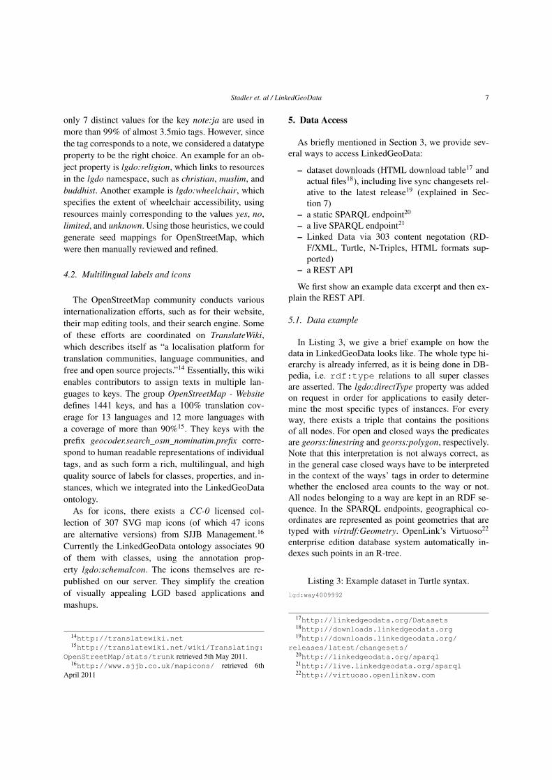
7.4. Algorithm
Our live-sync algorithm is given in Listing 1 and ex-plained as follows. Essentially, for each entity we needto determine its state before and after its modification.By this we can figure out the triples, which need to beadded or removed from the store. Recall that we needto keep track of all node-positions because every cre-ation or modification of a way might introduce a ref-erence to it. Rather than creating triples for more thana billion node positions, we chose to keep the nodes’positions in a separate relational database, which werefer to as the node store. We load node positions intothe triple store as needed. The fetchRDF_Node andfetchRDF_Way functions query the triple store for theprevious state of an entity, whereas the correspondinggenerateRDF functions generate the new state. Notethat in the case of ways this also involves all triplesof the way’s node-list (see Listing 3). The shape tripleis the one stating the polygon or linestring of a way,
Algorithm 1. LinkedGeoData Live-Sync algorithmInput: A changeset COutput: The sets Additions and Removals corresponding to the triples
that need to be added and removed, respectively.1: Let: N ← ∅, O ← ∅2: for all nodes n in C do3: if created(n) then4: Insert (n.id, n.position) into node store5: if relevant(n) then6: N ← N ∪ generateRDF _Node(n)7: end if8: else if modified(n) then9: Update (n.id, n.position) in node store
10: O ← O ∪ fetchRDF _Node(n)11: if relevant(n) then12: N ← N ∪ generateRDF _Node(n)13: end if14: for all ways w where n is a member do15: sto ← fetchShapeTriple(w)16: O ← O ∪ sto17: stn = createNewShapeTripleWithPositionReplaced(sto, n)18: N ← N ∪ stn19: end for20: else if deleted(n) then21: Remove entry for (n.id) from the node store22: O ← O ∪ fetchRDF _Node(n)23: end if24: end for25: for all ways w in C do26: if created(w) then27: if relevant(w) then28: m← fetchNodePositionMap(w.nodeRefs)29: N ← N ∪ generateRDF _Way(w,m)30: end if31: else if modified(w) then32: wo ← fetchRDFW ay(n)33: O ← O ∪ wo
34: if relevant(wo) and not relevant(w) then35: RemoveIrrelevantNodes(wo.nodeRefs)36: end if37: if relevant(w) then38: m← fetchNodePositionMap(w.nodeRefs)39: N ← N ∪ generateRDF _Way(w,m)40: end if41: else if deleted(w) then42: O ← O ∪ fetchRDF _Way(n)43: RemoveIrrelevantNodes(w.nodeList)44: end if45: end for46: procedure REMOVEIRRELEVANTNODES(nodes) .47: for all nodes n in nodes do48: d← fetchRDF _Node(n)49: if not relevant(d) then50: O ← O ∪ d51: end if52: end for53: end procedure54: Additions← N \O55: Removals← O \N
and is updated accordingly on changes. The major op-timizations are based on caching: We keep last re-cently used maps of the node positions and the stateof resources in order to reduce the amount of databaselookups, which speeds up the fetch functions. Thecaches are updated accordingly when changes are writ-ten to the triple store and node store.

14 Stadler et. al / LinkedGeoData
7.5. Filtering
We use a simple filtering system where entities mustpass the following three tag-based filters before theircorresponding RDF data may end up in the dumps andSPARQL endpoints:
– EntityFilter: Rejects entities with at least oneblacklisted tag.
– TagFilter: Removes all blacklisted tags from anentity.
– RelevanceFilter: Only accepts entities with cer-tain white-listed tags.
For instance, in the current release the entity filter re-jects all entities with a tag whose key equals ’rail-way’, unless the corresponding value is ’station’, ’halt’or ’tram_stop’. By this, we rule out more than 160Knodes and 710K ways. As an example for the tag fil-ter, we reject the created_by tag which seems tocarry little information. As a result, just by consider-ing nodes we can already omit approximately 20miotriples for the most frequently used value “JOSM”. Therelevance filter was introduced as it was noticed thatonly blacklisting certain tags still results in a lot ofseemingly non-interesting data to get processed. Thecomplete filter configuration is published together witheach release. As a final filtering step, we reject wayswith more than 20 nodes, since each node referenceof a way results in two triples: one for the node-waymembership and one for the node position.
8. Statistics
In this section we outline statistics about threethings: 1) the usage of the LinkedGeoData service, 2)the LinkedGeoData dataset and 3) performance of theLive-Sync.
For determining the usage of LinkedGeoData, weevaluated the usage of both of our SPARQL-endpoints(static and live) in the time from from Nov 2010until April 2011, i.e. after they were made publiclyavailable. In this timespan, they were queried a totalof 127.000 times from 422 distinct machines23. Thetop ten machines were responsible for 73% of thosequeries. More than 1.000 queries were issued by 19 ofthem. Figure 4 shows the number of queries per day.The diagram indicates that the usage of the LGD ser-vice has been increasing. However, whether the high
23Not counting the queries from our own network.
2010
-11-
25
2010
-12-
11
2010
-12-
31
2011
-01-
18
2011
-02-
03
2011
-02-
20
2011
-03-
09
2011
-03-
26
0
2000
4000
6000
8000
10000
12000
SPARQL Queries Per Day
Fig. 4. Usage of the SPARQL endpoints.
query counts towards the end remains at that level isyet to be evaluated.
The current LGD release dataset contains about65 million triples corresponding to about 6.3 millionnodes and 66 million triples corresponding to 7.1 mil-lion ways. Table 5 gives an overview of selected in-stance counts in the static SPARQL endpoint, and theirincrease in number in LGD live one after processingchangsets corresponding to roughly three weeks.
class #instances (static) #instances (live)
Ways 7 132 373 7 334 925Nodes 6 251 067 7 022 481
Stream 2 377 952 2 419 467Parking 520 901 537 477Village 516 547 522 570Shop 497 820 519 164Hamlet 415 609 424 179School 361 239 366 070PlaceOfWorship 359 563 363 225Restaurant 173 350 177 888FastFood 67 980 69 772Pub 67 279 68 279
Table 5Comparison of the static dump from April 6th with the live data at April 30th.
Regarding LGD live sync performance, we mea-sured the following values: On average, the process-ing time of a single minutely OSM changeset takes 5seconds with our filter configuration. Between April 6and April 30, about 40 000 changesets were processed,each of them corresponding to an average addition of620 and removal of 42 triples affecting 102 distinct re-sources.
In the initial LGD release of 2009, there were 50object properties. However most of them were consid-

Stadler et. al / LinkedGeoData 15
ered to be better suited as classes, resulting in the rel-atively low number of only 9 object properties in thecurrent release.
9. Tools using LinkedGeoData
9.1. LGD Browser
In order to showcase the benefits of revealing thestructured information in OSM, we developed a facet-based browser and editor for LinkedGeoData (see Fig-ure 9)24. It allows to browse the world by using a slippymap. Once a region is selected, the browser analyzesthe descriptions of nodes and ways in that region andgenerates facets for filtering. Once a facet or a specificfacet value has been selected, matching elements aredisplayed as markers on the map and in a list. If theselected region is changed, these are updated accord-ingly.
Performing the facet analysis naively, i.e. count-ing properties and property values for a certain regionbased on longitude and latitude, is extremely slow.This is due to the fact that the database can only useeither the longitude or the latitude index. Combiningboth - longitude and latitude - in one index is also im-possible, since, given a certain latitude region, only el-ements in a relatively small longitude region are soughtfor.
To resolve this problem and compute facets moreefficiently, we established a quadtile (also called z-curve) index over OSM data. Such an index combineslatitude and longitude into a single bitstring, which canthen be efficiently indexed. Once each point can be as-sociated to a tile and indexed by the DBMS, elementslocated on a certain tile can be fairly efficiently re-trieved. If the user browses to a certain area, the appli-cation has to determine all the tiles encircled by thatarea. Since co-located tiles are assigned to adjacenttile numbers, a certain area usually consists of a smallnumber of tile ranges, which can be efficiently pro-cessed by the DBMS.
Even these indexing optimizations were not yet suf-ficient to obtain acceptable response times for thefaceted browser. In order to further increase the query-ing performance, we precomputed the counts for allproperties on all tiles, as well as the counts of all prop-erty values for a set of predefined properties of which
24Available online at: http://browser.linkedgeodata.org
we know that they have only a limited number of val-ues. We did that not only for the highest zoom level,but for each zoom level which users are able to se-lect. The lower the zoom level, the more the number oftiles reduces and the faster corresponding property andproperty value count aggregates can be computed.
Furthermore, there are several new smaller LGDbrowser features compared to its previous version de-scribed in [1]. For instance, an RDF export of the cur-rent map selection including its facets can now be per-formed. This allows to easily extract a relevant frag-ment of LinkedGeoData for use within other tools.For each point on the map, its RDF source can be re-trieved and it can be edited on OpenStreetMap. Thebrowser has been extended by a search function pow-ered by OpenStreetMap Nominatum. The facet supporthas been extended to object properties, i.e. values ofthose properties can now be restricted in the facet se-lection. Finally, the LGD browser now provides a per-manent link feature.
9.2. STEVIE
STEVIE 25 [3] is an application developed by theInstitute for Web Science and Technologies at theUniversity of Koblenz, which uses LinkedGeoData.STEVIE allows to create and edit points of interests(POIs) (see Figure 9.2) and annotate them semanti-cally. The annotations use the LinkedGeoData ontol-ogy and are also interlinked to DBpedia. The annota-tions allow to employ clustering techniques in STE-VIE, which are used to group sets of similar objectswithin the limited screen size of a mobile phone. Theapplication allows the creation of events and, there-fore, combines spatial and temporal information. Anemphasis is put on providing an intuitive user interfacefor navigating those two dimensions. In order to dis-play POIs and classify them, STEVIE uses the Linked-GeoData REST interface, ontology and SPARQL end-point.
9.3. BeAware
BeAware26 is a website, which allows to manageevents and integrates them with geographic informa-tion. It uses its own ontology for events and integratesLinkedGeoData for choosing locations. In particular,the curated ontology of LinkedGeoData provides ben-
25http://tiny.cc/stevie1026http://beaware.at/

16 Stadler et. al / LinkedGeoData
Fig. 5. LinkedGeoData Browser.
Fig. 6. Creation of a point of interest in STEVIE. The application in-cludes a temporal dimension and highlights POIs where events takeplace in the selected time span.
efits for the application27: “First of all, LinkedGeo-
27http://alexidsa-en.blogspot.com/2010/06/rdf-vs-nonrdf-for-geodata-at-beaware.html
Data ontology that connects all OpenStreetMap cate-gories and properties excellently suits our interface ofnew place choosing (in addition, it allows to use infer-ence engine, for example, for retrieving buildings ofall types).” Figure 9.3 shows a screenshot for choosingthe location of an event. An advantage gained by thisassociation is that it facilitates querying for events ata particular location or within a particular city. In ad-dition, in some cases further information about the lo-cation from an interlinked data source is available andcan be presented to the user.
9.4. Layar
Layar28 is an augmented reality browser for mo-bile phones. Within Layar, a LinkedGeoData layer wasdeveloped. This allows to view the surrounding ob-jects of a person via the mobile phone camera. TheLinkedGeoData ontology is used to classify objectsand map them to displayed icons. The layer usesrdfs:label, which is aggregated from several tagsin OpenStreetMap, to display the name of an object.Further triples describing an object are show in a detailview.
28http://www.layar.com

Stadler et. al / LinkedGeoData 17
Fig. 7. Marking the location of an event in BeAware.
Fig. 8. Vicibit is a tool to generate custom views on LinkedGeoDatavia Exhibit. The example shows a faceted view on nearby pubs, bak-eries and shops. The code generated by Vicibit can easy be pastedinto blogs, forums and web pages.
9.5. Vicibit
Vicibit29 (“exhibit your vicinity”) is a tool workingon top of LinkedGeoData Live, which allows to createcustomised views on LinkedGeoData. It allows users
29http://vicibit.linkedgeodata.org
to enter classes in the LinkedGeoData ontology theyare interested in as well as a default map section, whichshould be displayed. The tool then generates HTMLcode, which creates a map displaying all items belong-ing to the selected classes as well as the ability to fil-ter by facets. Technically, this is realised by applyingthe Exhibit framework30 on data in the LinkedGeoDataLive SPARQL endpoint. A typical use case is that awebpage or blog entry describing a particular event canbe enriched with a map of nearby pubs and other shops(see Figure 8).
10. Related Work
We split related work in three parts: First, we de-scribe initiatives for integrating spatial information inthe Web of Data. Afterwards, we summarize work ontechniques for converting relational databases to RDF,which is the task we had to face in LinkedGeoData. Fi-nally, we give pointers to interlinking frameworks andexplain our choice of using SILK and LIMES.
10.1. Spatial RDF Datasets
In the following, we describe spatial data sets, whichare available as RDF and we consider important.
30http://www.simile-widgets.org/exhibit/

18 Stadler et. al / LinkedGeoData
Ordnance Survey31 is the national mapping agency inGreat Britain. Over the past years, they releasedsome of their products as Linked Data32. Ord-nance Survey provides very accurate high-qualitydata and represents a major contribution to thespatial data web. In a comparison between Ord-nance Survey data [9] focused on England andLondon in particular, OSM data was, however,also fairly accurate. A main difference betweenboth efforts is that OpenStreetMap, and therebyLinkedGeoData, are world-wide community-basedapproaches.
GeoNames is a comprehensive global spatial databasecontaining several million entities. This data hasbeen converted to RDF33 and is provided asLinked Data. GeoNames provides RDF prop-erties for navigating spatial hierarchies (paren-t/child), publishes postal codes, labels, popula-tion figures, type information (via feature codes)and other properties of spatial entities. Due tothis wealth of information, we provided a fine-grained interlinking between LinkedGeoData andGeoNames as described in Section 6. A differ-ence between GeoNames and OpenStreetMap isthat OSM allows free tags, which makes it easierto extend. For instance, shops in OSM sometimes(specifically 60 thousand times as of April 2011)contain opening hours. Another example is thewheelchair tag, used 24 thousand times, whichindicates whether or not a spatial entity is acces-sible via a wheel chair. OpenStreetMap also hasa larger community than GeoNames with severalhundred thousand users and more fine-graineddata, which even include traffic lights and trashbins.
The United Nations FAO (Food and Agriculture Or-ganisation) Geopolitical Data [5] provides RDFdescriptions of countries and other political unitsas well as relations between them. While it con-tains only a small number of instances (298 inMay 2011), it provides very detailed informationon those instances. For this reason, we decided toprovide interlinks with UN FAO.
GeoLinkedData.es is an open initiative to provideSpanish geospatial data [2]. It focuses on hydrog-raphy features and integrates several existing datasources.
31http://www.ordnancesurvey.co.uk32http://data.ordnancesurvey.co.uk33http://www.geonames.org/ontology/
NUTS (Nomenclature of Territorial Units for Statis-tics) provides a hierarchical system for describingthe economic territory of the European Union 34.The NUTS hierarchy is established by EuroStat.EU NUTS data has been converted to RDF 35. Itallows to explore the hierarchy via Linked Data,e.g. a possible path along the “partOf” property isInner London East → Inner London → London→ UK.
10.2. Relational Database to RDF Conversion andMapping
Converting relational databases to RDF is a signif-icant area of research with several approaches pub-lished and tools available. In particular, there is a W3CRDB2RDF working group, which aims to standard-ize a database to RDF mapping language [6]. Insteadof providing an in-depth overview, we refer to re-cent surveys [13,14] and overviews36 on this topic.There are various tools available implementing the sur-veyed approaches such as D2R, Triplify, DartGrid,DataMaster, MapOnto, METAmorphoses, ODEMap-ster, RDBToOnto, RDOTE, Virtuoso RDF Views andVisAVis. For LinkedGeoData, we decided to use a cus-tom mapping solution as described in Section 4, de-spite the number of available conversion tools. Thereason for this choice was the particular tag structureof OSM, which allows us to provide a highly flexibleschema as well as handle a very high amount of datavia our approach.
10.3. Interlinking and Ontology Mapping
There have been several decades of research start-ing with the integration of different database schemata.Tools like COMA [7] provide rich support for variousmatching operations between databases as well as be-tween RDF knowledge bases. [4] describes a semanticapproach for matching export schemas of geographi-cal database Web services, based on the use of a smallset of typical instances. The paper also contains an ex-tensive experiment, carried out within the context oftwo gazetteers, GeoNames and the ADL gazetteer, to
34http://epp.eurostat.ec.europa.eu/portal/page/portal/nuts_nomenclature/introduction
35http://rdfdata.eionet.europa.eu/ramon/nuts2008/
36http://esw.w3.org/topic/Rdb2RdfXG/StateOfTheArt
Stadler et. al / LinkedGeoData 19
illustrate the idea. [11] describes an approach integrat-ing geo data from multiple sources, which also incor-porates a temporal dimension. For interlinking Linked-GeoData, we mainly searched for instance matchingtools, since our main goal is to match specific pointsof interests in different knowledge bases. In this area,SILK [16] and LIMES are the most widely used appli-cations. We extended SILK with an appropriate met-ric for matchings based on WGS84 distance betweenpoints, which was later included in the official SILKrelease. A main benefit for SILK as well as LIMES,which we both use, is their ability to handle largevolumes of data and use SPARQL endpoints as inputsource.
11. Conclusions and Future Work
The transformation and publication of the Open-StreetMap data according to the Linked Data prin-ciples adds a new dimension to the Data Web: spa-tial data can be retrieved and interlinked on an un-precedented level of granularity. This enhancement en-ables a variety of new Linked Data applications suchas geo-data syndication or semantic-spatial searches.The dynamic of the OpenStreetMap project will en-sure a steady growth of the dataset. Furthermore, weestablished mappings with DBpedia and GeoNames asthe central interlinking hubs for spatial information onthe Web of Data. Despite the recent advances in RDFdata management, it became clear during our work onLinkedGeoData that spatial data of the size of Open-StreetMap still poses a major challenge wrt. scalabil-ity. Substantial engineering effort was required to op-timize the performance of the querying interfaces, livesynchronisation as well as the interlinking.
In the future, we plan to execute SPARQL queriesdirectly on the relational database by employing anRDB-RDF mapping, which translates incoming SPARQLqueries into SQL queries. Although in this regard sub-stantial progress was made during the last years andimplementations are now more robust, scalability isstill an issue preventing a direct deployment in case ofLinkedGeoData. Another stream of future work is thebetter support for geometries according to the currentNeoGeoVocabulary development37, which we are sup-porting. A semantic misrepresentation currently foundin LinkedGeoData for example is the missing separa-
37http://geovocab.org/doc/neogeo.html
tion of geometry and features. In the future, we planto attach geometries to entities, i.e. points of interest,instead of identifying both.
Acknowledgements
The authors would like to thank OpenLink for pro-viding an enterprise edition of the Virtuoso databasesystem that offers support for spatial SPARQL queries.Furthermore, the authors would like to thank the mem-bers of the LinkedGeoData community and 3rd partyapplication developers for their feedback. In particular,we would like to thank Robert Schulze for his workon Vicibit. This work was supported by a grant fromthe European Union’s 7th Framework Programme pro-vided for the projects LOD2 (GA no. 257943) andLATC (GA no. 256975).
References
[1] S. Auer, J. Lehmann, and S. Hellmann. LinkedGeoData -adding a spatial dimension to the web of data. In Proc. of 8thInternational Semantic Web Conference (ISWC), 2009.
[2] L. M. V. Blázquez, B. Villazón-Terrazas, V. Saquicela,A. de León, Ó. Corcho, and A. Gómez-Pérez. Geolinked dataand INSPIRE through an application case. In D. Agrawal,P. Zhang, A. E. Abbadi, and M. F. Mokbel, editors, GIS, pages446–449. ACM, 2010.
[3] M. Braun, A. Scherp, and S. Staab. Collaborative creationof semantic points of interest as linked data on the mobilephone. In Extended Semantic Web Conference (Demo Session).Springer, 2010.
[4] D. F. Brauner, C. Intrator, J. C. Freitas, and M. A. Casanova.An instance-based approach for matching export schemas ofgeographical database Web services. In Proc. of the IX Brazil-ian Symp. on GeoInformatics (GEOINFO), pages 109–120,2007.
[5] C. Caracciolo, M. I. Sucasas, and J. Keizer. Towards interop-erability of geopolitical information within FAO. Computingand Informatics, 27(1):119–129, 2008.
[6] S. Das, S. Sundara, and R. Cyganiak. R2RML: RDB to RDFmapping language. World Wide Web Consortium, WorkingDraft WD-r2rml-20110324, Mar. 2011.
[7] H. H. Do and E. Rahm. COMA - A system for flexible combi-nation of schema matching approaches. In VLDB, pages 610–621. Morgan Kaufmann, 2002.
[8] M. Goodchild. Citizens as sensors: the world of volunteeredgeography. GeoJournal, 69(4):211–221, Aug. 2007.
[9] M. Haklay. How good is volunteered geographical informa-tion? A comparative study of openstreetmap and ordnance sur-vey datasets. July 2010.
[10] J. Lehmann, C. Bizer, G. Kobilarov, S. Auer, C. Becker, R. Cy-ganiak, and S. Hellmann. DBpedia - a crystallization pointfor the web of data. Journal of Web Semantics, 7(3):154–165,2009.

20 Stadler et. al / LinkedGeoData
[11] H. Manguinhas, B. Martins, and J. L. Borbinha. A geo-temporal web gazetteer integrating data from multiple sources.In ICDIM, pages 146–153. IEEE, 2008.
[12] A.-C. Ngonga Ngomo and S. Auer. Limes - a time-efficientapproach for large-scale link discovery on the web of data. InProceedings of IJCAI, 2011.
[13] S. S. Sahoo, W. Halb, S. Hellmann, K. Idehen, T. T. Jr, S. Auer,J. Sequeda, and A. Ezzat. A survey of current approaches formapping of relational databases to rdf, 01 2009.
[14] D.-E. Spanos, P. Stavrou, and N. Mitrou. Bringing relationaldatabases into the semantic web: A survey. Semantic Web Jour-nal. under review.
[15] C. Stadler, M. Martin, J. Lehmann, and S. Hellmann. UpdateStrategies for DBpedia Live. In 6th Workshop on Scriptingand Development for the Semantic Web Colocated with ESWC2010 30th or 31st May, 2010 Crete, Greece, 2010.
[16] J. Volz, C. Bizer, M. Gaedke, and G. Kobilarov. Silk–a linkdiscovery framework for the web of data. In Proceedings of the2nd Workshop about Linked Data on the Web (LDOW2009),2009.
Appendix
A. Prefixes Used
The following prefixes are used in the paper:
1 lgd: http://linkedgeodata.org/triplify/2 lgdo: http://linkedgeodata.org/ontology/3 wgs84: http://www.w3.org/2003/01/geo/wgs84_pos#4 foa: http://www.fao.org/countryprofiles/geoinfo
/geopolitical/resource/5 dbpedia: http://dbpedia.org/resource/6 rdf: http://www.w3.org/1999/02/22-rdf-syntax-
ns#7 rdfs: http://www.w3.org/2000/01/rdf-schema#8 owl: http://www.w3.org/2002/07/owl#9 xsd: http://www.w3.org/2001/XMLSchema#
10 georss: http://www.georss.org/georss/
Related Documents