Introduction to Dept. of Communications & Computer Engineering (Part 2) Mamoru YAMAMOTO Research Insititute for Sustainable Humanosphere (RISH), Kyoto University (Dept of Communications & Computer Engineering) E-mail: [email protected] Kyoto University Clock Tower Building August 2009

Welcome message from author
This document is posted to help you gain knowledge. Please leave a comment to let me know what you think about it! Share it to your friends and learn new things together.
Transcript

Introduction to Dept. of Communications & Computer Engineering (Part 2)
Mamoru YAMAMOTO
Research Insititute for Sustainable Humanosphere(RISH), Kyoto University
(Dept of Communications & Computer Engineering)
E-mail: [email protected]
Kyoto University Clock Tower Building
August 2009
ICT Technologies
Internet, optical fiber and cellular system have made significant & incredible progress during last a few decades
High performance computing combined withBroadband Networks (optical fiber (backbone) + various wireless access systems) (in terms of coverage) , i.e., from mega-cell to body area network (BAN) or RFID tag.
Remote sensing: another aspect of ICT, used for social safety/security and environmental research. All contributing to the realization of so-called “ubiquitous network society”
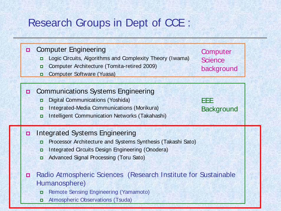
Research Groups in Dept of CCE :
Computer EngineeringLogic Circuits, Algorithms and Complexity Theory (Iwama)Computer Architecture (Tomita-retired 2009)Computer Software (Yuasa)
Communications Systems EngineeringDigital Communications (Yoshida)Integrated-Media Communications (Morikura)Intelligent Communication Networks (Takahashi)
Integrated Systems EngineeringProcessor Architecture and Systems Synthesis (Takashi Sato)Integrated Circuits Design Engineering (Onodera)Advanced Signal Processing (Toru Sato)
Radio Atmospheric Sciences (Research Institute for Sustainable Humanosphere)
Remote Sensing Engineering (Yamamoto)Atmospheric Observations (Tsuda)
Computer Science background
EEE Background
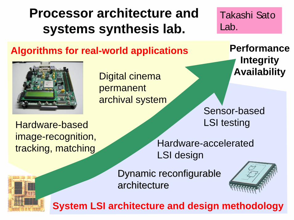
Processor architecture and systems synthesis lab.
PerformanceIntegrity
Availability
Hardware-based image-recognition, tracking, matching
Dynamic reconfigurableDynamic reconfigurablearchitecturearchitecture
Hardware-acceleratedLSI design
System LSI architecture and design methodology
Algorithms for real-world applications
Sensor-basedLSI testing
Digital cinema permanent archival system
Takashi Sato Lab.
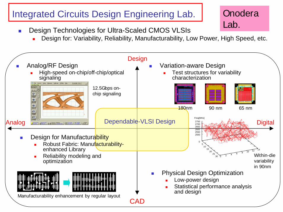
Integrated Circuits Design Engineering Lab.
Analog/RF DesignHigh-speed on-chip/off-chip/optical signaling
Variation-aware DesignTest structures for variability characterization
Design
CAD
Analog DigitalDependable-VLSI Design
Design Technologies for Ultra-Scaled CMOS VLSIsDesign for: Variability, Reliability, Manufacturability, Low Power, High Speed, etc.
Design for ManufacturabilityRobust Fabric: Manufacturability-enhanced LibraryReliability modeling and optimization
Physical Design OptimizationLow-power design Statistical performance analysis and design
180nm 90 nm 65 nm
0 5
10 15
20 25
30 0 2 4 6 8 10 12 14
2500 2550 2600 2650 2700 2750
Freq[MHz]
Within-die variability in 90nm
12.5Gbps on-chip signaling
Manufacturability enhancement by regular layout
Onodera Lab.

High-resolution imaging withUWB (Ultra Wideband) radars• Developing fast imaging algorithms which have a
resolution of the order of 1/100 wavelength• Applications to vehicle collision avoidance and security
areas.
2.22
1.81.61.41.2
10.8
z
y x-2-1 0 1 2-2 -1 0 1 2
Target shape
Image obtained with the proposed algorithm. Axes are in the unit of wavelength at the center frequency.
Toru Sato Lab.
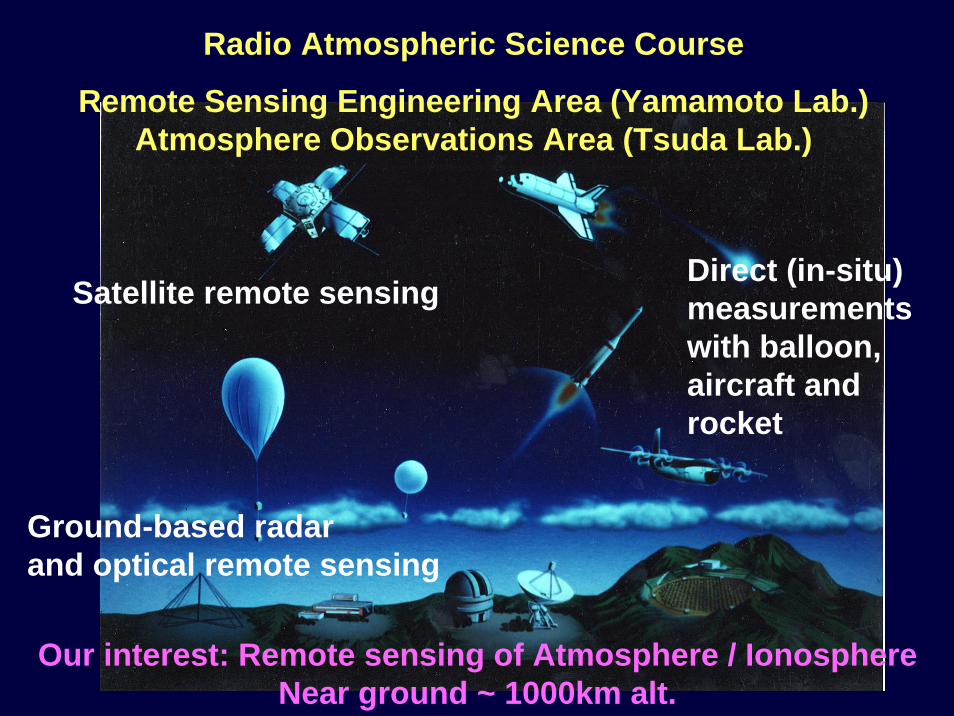
Our interest: Remote sensing of Atmosphere / IonosphereNear ground ~ 1000km alt.
Satellite remote sensingDirect (in-situ) measurements with balloon, aircraft and rocket
Ground-based radar and optical remote sensing
Radio Atmospheric Science Course
Remote Sensing Engineering Area (Yamamoto Lab.)Atmosphere Observations Area (Tsuda Lab.)
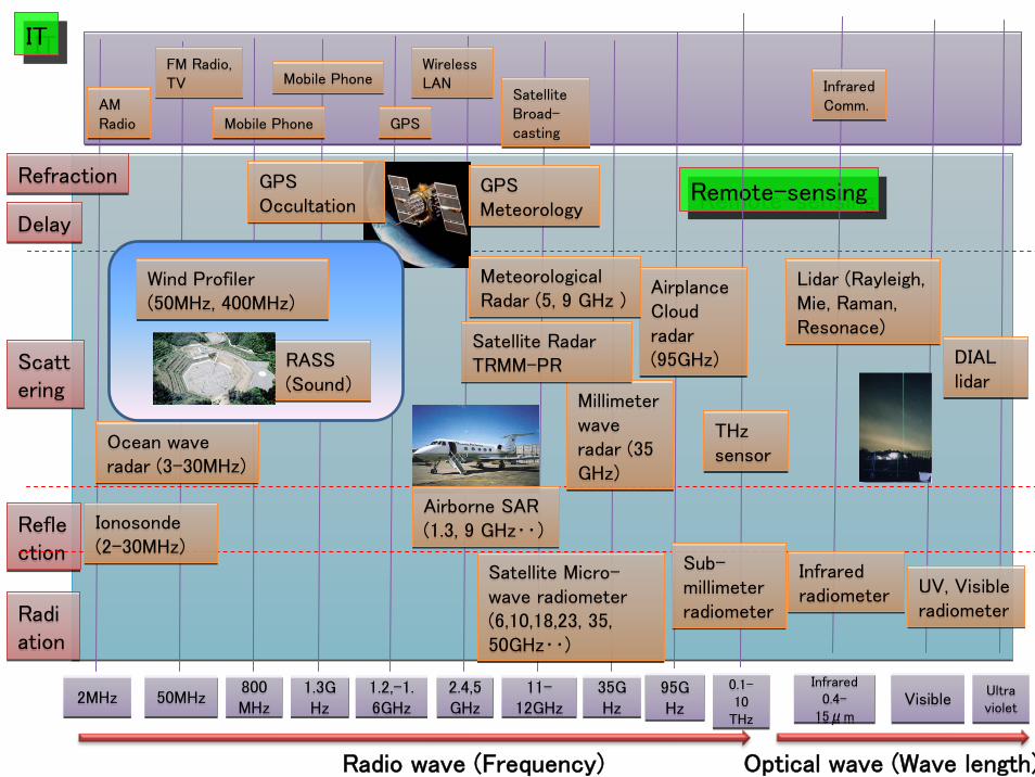
DelayDelay
Scattering
Scattering
Radiation
Radiation
2MHz2MHz 50MHz50MHz 800MHz
800MHz
1.3GHz
1.3GHz
1.2,-1. 6GHz
1.2,-1. 6GHz
11-12GHz
11-12GHz
35GHz
35GHz
Radio wave (Frequency) Optical wave (Wave length)
VisibleVisible
Mobile PhoneMobile Phone
Mobile PhoneMobile PhoneFM Radio,TV
FM Radio,TV
GPSGPS
ITIT
Reflection
Reflection
RefractionRefraction
AM Radio
AM Radio
2.4,5GHz
2.4,5GHz
SatelliteBroad-casting
SatelliteBroad-casting
Wireless LAN
Wireless LAN
GPS Occultation
GPS Occultation
GPS Meteorology
GPS Meteorology
Ionosonde(2-30MHz)
Ionosonde(2-30MHz)
Ocean wave radar (3-30MHz)
Ocean wave radar (3-30MHz)
Airborne SAR(1.3, 9 GHz‥)
Airborne SAR(1.3, 9 GHz‥)
95GHz
95GHz
Millimeter wave radar (35 GHz)
Millimeter wave radar (35 GHz)
Satellite Micro-wave radiometer (6,10,18,23, 35,50GHz‥)
Satellite Micro-wave radiometer (6,10,18,23, 35,50GHz‥)
Remote-sensingRemote-sensing
0.1-10
THz
0.1-10
THz
Ultraviolet
Ultraviolet
Sub-millimeter radiometer
Sub-millimeter radiometer
Infrared 0.4-
15μm
Infrared 0.4-
15μm
Lidar (Rayleigh, Mie, Raman, Resonace)
Lidar (Rayleigh, Mie, Raman, Resonace)
UV, Visible radiometer
UV, Visible radiometer
Infrared Comm.
Infrared Comm.
DIAL lidar
DIAL lidar
Infrared radiometer
Infrared radiometer
THz sensor
THz sensor
RASS (Sound)
RASS (Sound)
Wind Profiler(50MHz, 400MHz)
Wind Profiler(50MHz, 400MHz)
AirplanceCloud radar(95GHz)
AirplanceCloud radar(95GHz)
Meteorological Radar (5, 9 GHz )
Meteorological Radar (5, 9 GHz )
Satellite Radar TRMM-PR
Satellite Radar TRMM-PR
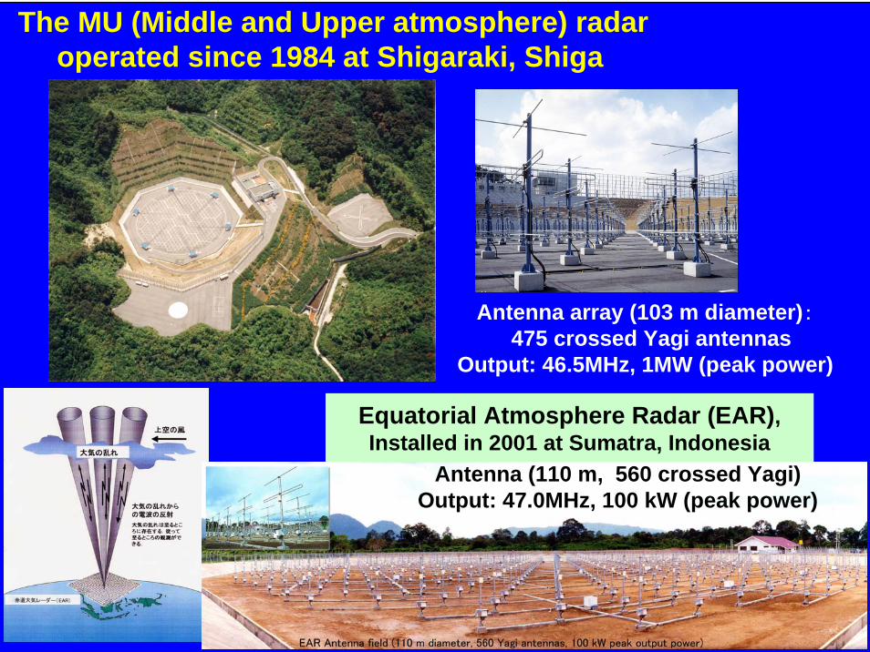
The MU (Middle and Upper atmosphere) radaroperated since 1984 at Shigaraki, Shiga
Antenna array (103 m diameter):475 crossed Yagi antennas
Output: 46.5MHz, 1MW (peak power)
Time-height variations of wind velocity, temperature, humidity and atmospheric turbulence
Equatorial Atmosphere Radar (EAR), Installed in 2001 at Sumatra, Indonesia
Antenna (110 m, 560 crossed Yagi)Output: 47.0MHz, 100 kW (peak power)

0 500km
WIND PROFILER SITES
CONTROL CENTER (JMA HQ)
RADIOSONDE STATIONS
Operational wind profiler network over JapanWINDAS:Wind Profiler Network and Data Acquisition System
Data center
Data center/Weather model
31 LTRs are located and used for everyday weather forecasting.
Lower Troposphere Radar (LTR)
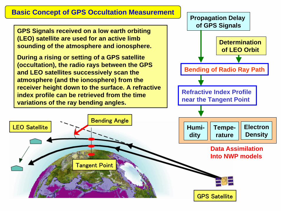
GPS Signals received on a low earth orbiting (LEO) satellite are used for an active limb sounding of the atmosphere and ionosphere.
During a rising or setting of a GPS satellite (occultation), the radio rays between the GPS and LEO satellites successively scan the atmosphere (and the ionosphere) from the receiver height down to the surface. A refractive index profile can be retrieved from the time variations of the ray bending angles.
Bending AngleLEO Satellite
Tangent Point
GPS Satellite
Propagation Delay of GPS Signals
Determination of LEO Orbit
Bending of Radio Ray Path
Refractive Index Profile near the Tangent Point
Humi-dity
Tempe-rature
ElectronDensity
Data Assimilation Into NWP models
Basic Concept of GPS Occultation Measurement
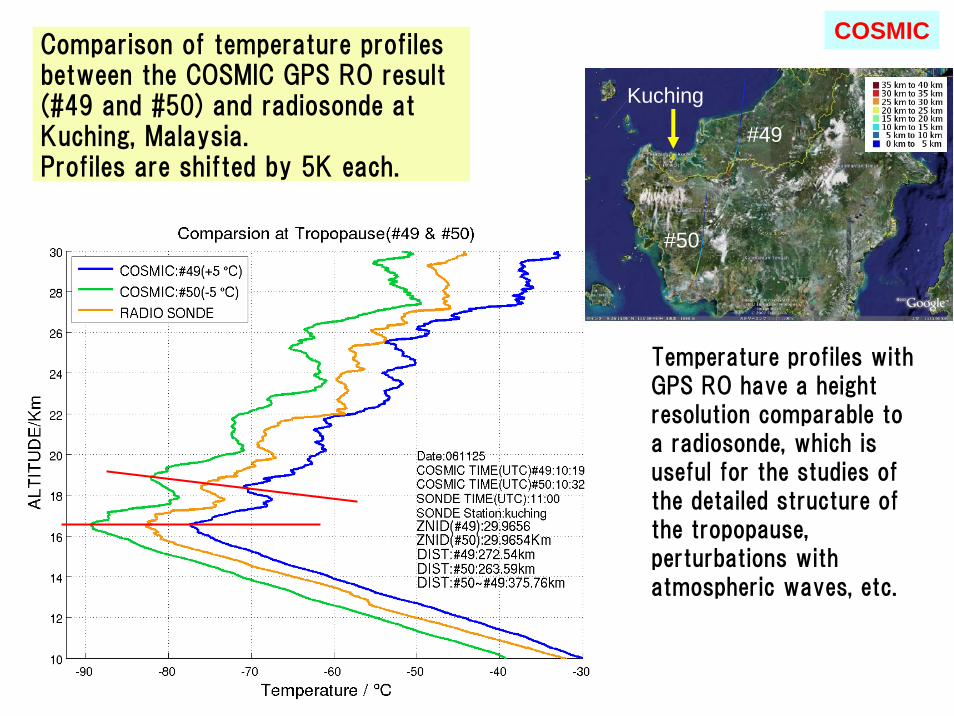
Comparison of temperature profiles between the COSMIC GPS RO result (#49 and #50) and radiosonde at Kuching, Malaysia.Profiles are shifted by 5K each.
Temperature profiles with GPS RO have a height resolution comparable to a radiosonde, which is useful for the studies of the detailed structure of the tropopause, perturbations with atmospheric waves, etc.
#50
#49
Kuching
COSMIC
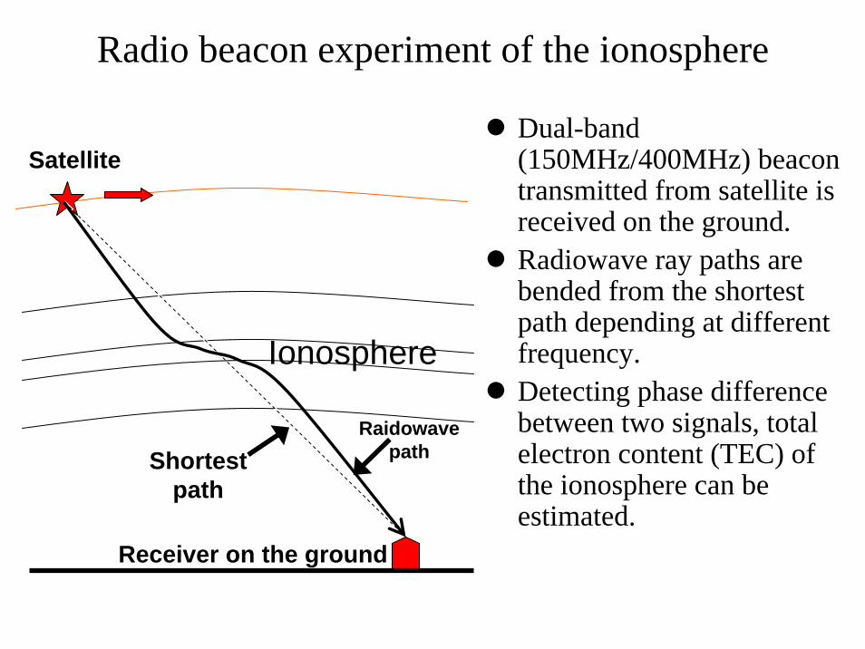
Radio beacon experiment of the ionosphere
Dual-band (150MHz/400MHz) beacon transmitted from satellite is received on the ground.Radiowave ray paths are bended from the shortest path depending at different frequency.Detecting phase difference between two signals, total electron content (TEC) of the ionosphere can be estimated.
RaidowavepathShortest
path
Satellite
Ionosphere
Receiver on the ground

GNU Radio Beacon Receiver
We develop a digital beacon receiver by using the open hardware/software.
・ LINUX PC・ GNU Radio
Software toolkit for SDR (Software Defined Radio), a free software.
・ USRP (Universal Software Radio Peripheral, see picture)A/D + signal processing board well associated with GNU Radio.
Picture of USRPGNU Radio http://gnuradio.org/tracUSRP http://www.ettus.com

MF radar, PontianakWest Kalimantan(1995- ) U. Adelaide
Hemispheric ComparisonThe MU radar (Shigaraki), MF radar (Adelaide-U)
★
★
★
★
MF radar, Pameungpeuk (2004-)
Coordinated Observation of Equatorial Atmosphere Dynamics in Indonesia
Coordinated Observation of Equatorial Atmosphere Dynamics in Indonesia
Regional network in IndonesiaMeteor radar (Jakarta,
Koto Tabang), MF radar (Pontianak,
Pameungpeuk)
Equatorial Network Christmas Island,
Indonesia, India
Meteor radarJakarta (1992-)
MF radar
MF Radar at Tirunelveli, India (1992 - )
EAR: Equatorial Atmosphere Radar (2001 - ) Meteor Radar (2002 - )
SummaryCCE covers studies for designing and physical properties of LSI.(Takashi Sato lab., Onodera lab.)Another important use of ICT technology is remote sensing.(Toru Sato lab. + RISH labs)CCE holds two labs that belong to RISH. They do,
Development of various remote sensing techniques for the atmosphere/ionosphere.
MU radar, and Equatorial Atmosphere Radar (Indonesia)GPS occultation, Satellite beacon, Lidar, etc.
Study atmosphere dynamics by utilizing the instruments.Our studies contribute social safety/security, and
environmental research.Many instruments and observation sites are located in
Southeast Asian countries including Thailand and Vietnam.
Related Documents