Intraseasonal Kelvin waves along the southern coast of Sumatra and Java Iskhaq Iskandar Department of Earth and Planetary Science, Graduate School of Science, University of Tokyo, Tokyo, Japan Wijaya Mardiansyah Department of Physics, Faculty of Mathematics and Natural Science, Sriwijaya University, South Sumatra, Indonesia Yukio Masumoto and Toshio Yamagata Department of Earth and Planetary Science, Graduate School of Science, University of Tokyo, Tokyo, Japan Received 26 May 2004; revised 9 February 2005; accepted 22 February 2005; published 29 April 2005. [1] The intraseasonal sea level variations along the southern coast of Sumatra and Java are investigated using in situ data and the TOPEX/Poseidon satellite altimetry data. The analysis shows that there are two intraseasonal variations of distinct timescale: 20– 40 days during boreal summer (JJA) and 60–90 days during boreal winter (DJF). During boreal summer the shorter time variations of the sea level along the coast of Sumatra and Java are traced back to the eastern equatorial Indian Ocean (EIO); this indicates the importance of the remotely forced equatorial Kelvin waves. During boreal winter, on the other hand, both the remote winds over the EIO and the local alongshore winds are important in explaining the longer time variations of the sea level along the coast. Further analysis indicates that these intraseasonal variations are associated with the coastal Kelvin waves with phase speed ranging from 1.5 to 2.86 m/s. A simple analytical model forced by daily wind stress confirms the above intraseasonal variations along the southern coast of Sumatra and Java. Citation: Iskandar, I., W. Mardiansyah, Y. Masumoto, and T. Yamagata (2005), Intraseasonal Kelvin waves along the southern coast of Sumatra and Java, J. Geophys. Res., 110, C04013, doi:10.1029/2004JC002508. 1. Introduction [2] It is widely accepted that Yoshida-Wyrtki Jet in the Equatorial Indian Ocean (EIO) occurs twice a year during the monsoon transition periods in April/May and October/ November. The jet is confined to the equator within a narrow band of a few degrees and flow eastward across the Indian Ocean with a typical surface zonal velocity of about 80 cm/s or more [Wyrtki, 1973; O’Brien and Hurlburt, 1974]. Once reaching the eastern boundary, the jet bifurcates to the north and south and propagates poleward along the eastern coast of the Indian Ocean as coastal Kelvin waves, but a part of the energy is reflected back into the interior Indian Ocean as Rossby waves [Clarke and Liu, 1993, 1994; Yamagata et al., 1996]. Also, the jet influences the oceanic conditions along the eastern coast [Wyrtki, 1973; Clarke and Liu, 1993], and several authors discussed their possible impact on the Indonesian throughflow [Yamagata et al., 1996; Masumoto and Yamagata, 1996; Arief and Murray, 1996; Sprintall et al., 2000]. They suggested that the seasonal variations of the Lombok throughflow, one of the major passages of the Indonesian throughflow, are partially governed by the incoming energy from the EIO in terms of the coastal Kelvin waves. Moreover, tempe- rature and sea level variability in the eastern Indian Ocean and the Indonesian seas have been examined using long-term repeat expandable bathythermograph (XBT) data [Wijffels and Meyers, 2004]. Their analysis shows that seasonal to interannual variability of the temperature and sea levels in the Indonesian seas is predominantly excited by remote zonal winds along the equator of the Indian and Pacific Oceans. They suggest that some energy from the EIO penetrates into the internal Indone- sian seas with an impact on the internal sea level and thermocline depth variability. [3] Most of the previous studies have been devoted to investigation of the seasonal variability in the EIO using monthly data. Therefore short-term variations from weeks to months are smeared out from the original data. However, our understanding of such short-term variability of the upper EIO has been improved using both direct observations and modeling efforts. Analysis of the obser- vational data showed an energy peak of the zonal flow on the intraseasonal timescale of 30–60 days [Luyten and Roemmich, 1982; McPhaden, 1982; Reppin et al., 1999; Webster et al., 2002]. Measurement using shallow pres- sure gauge array (SPGA) in five outflow straits in the eastern Indonesian archipelago demonstrated that the JOURNAL OF GEOPHYSICAL RESEARCH, VOL. 110, C04013, doi:10.1029/2004JC002508, 2005 Copyright 2005 by the American Geophysical Union. 0148-0227/05/2004JC002508 C04013 1 of 12

Welcome message from author
This document is posted to help you gain knowledge. Please leave a comment to let me know what you think about it! Share it to your friends and learn new things together.
Transcript
Intraseasonal Kelvin waves along the southern coast of Sumatra
and Java
Iskhaq IskandarDepartment of Earth and Planetary Science, Graduate School of Science, University of Tokyo, Tokyo, Japan
Wijaya MardiansyahDepartment of Physics, Faculty of Mathematics and Natural Science, Sriwijaya University, South Sumatra, Indonesia
Yukio Masumoto and Toshio YamagataDepartment of Earth and Planetary Science, Graduate School of Science, University of Tokyo, Tokyo, Japan
Received 26 May 2004; revised 9 February 2005; accepted 22 February 2005; published 29 April 2005.
[1] The intraseasonal sea level variations along the southern coast of Sumatra and Javaare investigated using in situ data and the TOPEX/Poseidon satellite altimetry data. Theanalysis shows that there are two intraseasonal variations of distinct timescale: 20–40 days during boreal summer (JJA) and 60–90 days during boreal winter (DJF). Duringboreal summer the shorter time variations of the sea level along the coast of Sumatra andJava are traced back to the eastern equatorial Indian Ocean (EIO); this indicates theimportance of the remotely forced equatorial Kelvin waves. During boreal winter, on theother hand, both the remote winds over the EIO and the local alongshore winds areimportant in explaining the longer time variations of the sea level along the coast. Furtheranalysis indicates that these intraseasonal variations are associated with the coastalKelvin waves with phase speed ranging from 1.5 to 2.86 m/s. A simple analytical modelforced by daily wind stress confirms the above intraseasonal variations along the southerncoast of Sumatra and Java.
Citation: Iskandar, I., W. Mardiansyah, Y. Masumoto, and T. Yamagata (2005), Intraseasonal Kelvin waves along the southern coast
of Sumatra and Java, J. Geophys. Res., 110, C04013, doi:10.1029/2004JC002508.
1. Introduction
[2] It is widely accepted that Yoshida-Wyrtki Jet in theEquatorial Indian Ocean (EIO) occurs twice a year duringthe monsoon transition periods in April/May and October/November. The jet is confined to the equator within anarrow band of a few degrees and flow eastward acrossthe Indian Ocean with a typical surface zonal velocity ofabout 80 cm/s or more [Wyrtki, 1973; O’Brien andHurlburt, 1974]. Once reaching the eastern boundary,the jet bifurcates to the north and south and propagatespoleward along the eastern coast of the Indian Ocean ascoastal Kelvin waves, but a part of the energy is reflectedback into the interior Indian Ocean as Rossby waves[Clarke and Liu, 1993, 1994; Yamagata et al., 1996].Also, the jet influences the oceanic conditions alongthe eastern coast [Wyrtki, 1973; Clarke and Liu, 1993],and several authors discussed their possible impact onthe Indonesian throughflow [Yamagata et al., 1996;Masumoto and Yamagata, 1996; Arief and Murray,1996; Sprintall et al., 2000]. They suggested that theseasonal variations of the Lombok throughflow, one ofthe major passages of the Indonesian throughflow, are
partially governed by the incoming energy from the EIOin terms of the coastal Kelvin waves. Moreover, tempe-rature and sea level variability in the eastern IndianOcean and the Indonesian seas have been examined usinglong-term repeat expandable bathythermograph (XBT)data [Wijffels and Meyers, 2004]. Their analysis showsthat seasonal to interannual variability of the temperatureand sea levels in the Indonesian seas is predominantlyexcited by remote zonal winds along the equator of theIndian and Pacific Oceans. They suggest that someenergy from the EIO penetrates into the internal Indone-sian seas with an impact on the internal sea level andthermocline depth variability.[3] Most of the previous studies have been devoted to
investigation of the seasonal variability in the EIO usingmonthly data. Therefore short-term variations from weeksto months are smeared out from the original data.However, our understanding of such short-term variabilityof the upper EIO has been improved using both directobservations and modeling efforts. Analysis of the obser-vational data showed an energy peak of the zonal flow onthe intraseasonal timescale of 30–60 days [Luyten andRoemmich, 1982; McPhaden, 1982; Reppin et al., 1999;Webster et al., 2002]. Measurement using shallow pres-sure gauge array (SPGA) in five outflow straits in theeastern Indonesian archipelago demonstrated that the
JOURNAL OF GEOPHYSICAL RESEARCH, VOL. 110, C04013, doi:10.1029/2004JC002508, 2005
Copyright 2005 by the American Geophysical Union.0148-0227/05/2004JC002508
C04013 1 of 12
surface flow fluctuates with period of 30–90 days oscil-lation [Chong et al., 2000]. This intraseasonal variabilityis correlated with the remote winds in the eastern EIOand local winds along the Indonesian archipelago.Potemra et al. [2002], using the extended SPGA dataof Chong et al. [2000], showed that the dominant featureof the outflow variability is on the intraseasonal time-scale. They also showed that the magnitude decreases asthe strait locates further eastward. Furthermore, theyproposed that the semiannual variations in monsoonalwinds and the Madden-Julian Oscillation (MJO) activityover the EIO are potential candidates to produce theintraseasonal variability.[4] On the other hand, Qiu et al. [1999], using a 1.5-layer
reduced gravity model, demonstrated that variations in thesoutheastern Indian Ocean are characterized by oscillationswith periods of 50 and 85 days. Sengupta et al. [2001],using a general circulation model, demonstrated intraseaso-nal variability of surface current in the eastern and centralIndian Ocean with a typical period of 30–50 days. Han etal. [2001] employed nonlinear and linear 4.5-layer oceanmodels and confirmed that such shorter time variability(40–60 days) in the zonal current is mainly excited byintraseasonal winds associated with the MJO. Furthermore,Senan et al. [2003], using an ocean general circulationmodel, showed distinct intraseasonal jets in the easternEIO associated with the intraseasonal oscillation of theboreal summer monsoon.[5] More recently, an ADCP mooring at 90�E right on the
equator clearly shows the existence of intraseasonal equa-
torial jets in the eastern EIO with a typical period of 30–50 days [Masumoto et al., 2005]. The analysis of the zonalwind stress averaged from 80�E to 90�E along the equatorindicates that these intraseasonal jets are forced primarily bythe winds associated with the intraseasonal disturbances inthe atmosphere.[6] In this study, we examine the relationship between the
intraseasonal sea level variations and the intraseasonaldisturbances of the atmospheric winds both over the EIOand along the southern coast of Sumatra and Java. Usingvarious observational data, we discuss intraseasonal Kelvinwaves along the southern coast of Sumatra and Java, andshow that both remote and local winds are responsible forgenerating these waves.[7] This paper is organized as follows. A brief description
of the data set used in this study is presented in the nextsection. In section 3, the wavelet analysis of the observedsea level is used to describe the intraseasonal band. Simplemodel experiments forced by the wind stress are presentedalso in this section to discuss possible generation mecha-nisms of the intraseasonal variability. A summary is given inthe final section.
2. Data
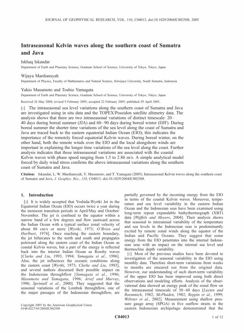
[8] We use hourly sea level data recorded at four tidalstations located along the coast of Sumatra and Java andtwo stations located within the Indonesian seas for theperiod from January 1995 to April 1997 (Figure 1). Thedata are checked for errors and datum shifts. Mean sea
Figure 1. Locations of the tidal stations used in this study. Padang (0�570S, 100�220E), Panjang (5�250S,105�150E), Cilacap (7�340S, 108�590E), Benoa (8�460S, 115�130E), Lembar (8�440S, 116�050E), andBalikpapan (1�170S, 116�480E). The 200 m isobath is shaded. Courtesy of the National CoordinatingAgency for Surveys and Mapping (BAKOSURTANAL), Indonesia.
C04013 ISKANDAR ET AL.: INTRASEASONAL KELVIN WAVES
2 of 12
C04013
level from adjacent time period is used to correct datumshifts when available. Then short gaps of up to 13 daysare filled in by applying linear interpolation, but somemissing periods of more than 13 days are treated as nodata. In order to remove higher-frequency variabilityassociated with semidiurnal and diurnal tides, we appliedlow-pass filter based on a Butterworth filter [Emery andThomson, 2001, p. 540] with the cut-off period of48 hours. The hourly data are then simply averaged toobtain daily sea level data and linear trends are removed.Finally, barometric effects are corrected by subtracting thesea level pressure obtained from European Centre forMedium-Range Weather Forecasts (ECMWF) reanalysisdata.[9] The gridded altimeter sea surface height anomalies
(SSHA) of the TOPEX/Poseidon are used in this study.Here we use the 1.0�, 5 day interpolated version of theWOCE PODAAC-v3 data set, which is available at http://podaac.jpl.nasa.gov/woce/woce3_topex.[10] The wind stress data used in this study are based on
the daily mean ECMWF reanalysis data. The data cover thewhole globe with a spatial resolution of 2.5� in both latitudeand longitude. To show the relation between winds and sealevel variations, we choose 30 points of the wind stress data:22 points along the equatorial Indian Ocean and 8 pointsalong the coast of Sumatra and Java. Only the zonal windsare considered along the EIO and along the coast of Java,whereas both zonal and meridional wind components are
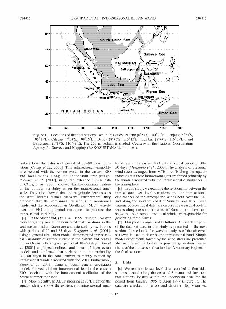
Figure 2. Time series of the sea level anomalies observedby tidal station (solid lines) and TOPEX/Poseidon (dashedlines) after 10–100 days of band-pass filtering.
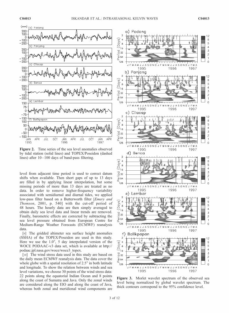
Figure 3. Morlet wavelet spectrum of the observed sealevel being normalized by global wavelet spectrum. Thethick contours correspond to the 95% confidence level.
C04013 ISKANDAR ET AL.: INTRASEASONAL KELVIN WAVES
3 of 12
C04013
considered to calculate the alongshore component along thecoast of Sumatra.
3. Results
3.1. Intraseasonal Variations
[11] Figure 2 compares the time series of sea levelanomalies of the tidal stations and TOPEX/Poseidon altim-eter data from January 1995 to April 1997 after 10–100 daysband-pass filtering. It is evident from the tidal station datathat strong semiannual cycle associated with the classicalYoshida-Wyrtki Jet is observed at all stations along the coastof Sumatra and Java. We note that high-frequency fluctua-tions are remarkable at Balikpapan located within theMakassar Strait. This is consistent with Ffield and Gordon’s[1996] finding that the combination between solar and lunarsemidiurnal tides results in fortnightly tidal signal in theMakassar Strait [see also Susanto et al., 2000]. The sea level
variability observed at Balikpapan may also be influencedby incoming signals from the Sulawesi Sea [cf. Susanto etal., 2000]. We also note that the sea level fluctuationsobserved at Lembar are weaker compare to those observedat Benoa. The location of Lembar facing the Flores Seacould possibly explain this discrepancy. Wijffels and Meyers[2004] proposed that the Pacific wind forcing related toRossby wave energy is more dominant in affecting thermo-cline variability at north of Nusa Tenggara Islands Chain.[12] In addition to semiannual variations, intraseasonal
variations are also remarkable at all stations along the coastof Sumatra and Java. Their amplitude during boreal summer(JJA) is as large as those associated with the classicalYoshida-Wyrtki Jet. We also note that the amplitude of theintraseasonal variations during boreal winter (DJF) increases,as stations are located farther southeastward along the coast.[13] In order to investigate the dominant frequency of the
sea level variations, the wavelet power spectrum analysis
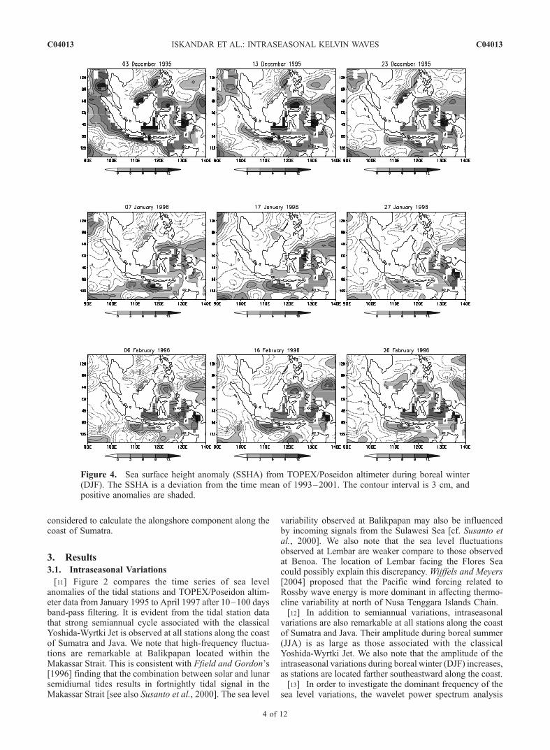
Figure 4. Sea surface height anomaly (SSHA) from TOPEX/Poseidon altimeter during boreal winter(DJF). The SSHA is a deviation from the time mean of 1993–2001. The contour interval is 3 cm, andpositive anomalies are shaded.
C04013 ISKANDAR ET AL.: INTRASEASONAL KELVIN WAVES
4 of 12
C04013
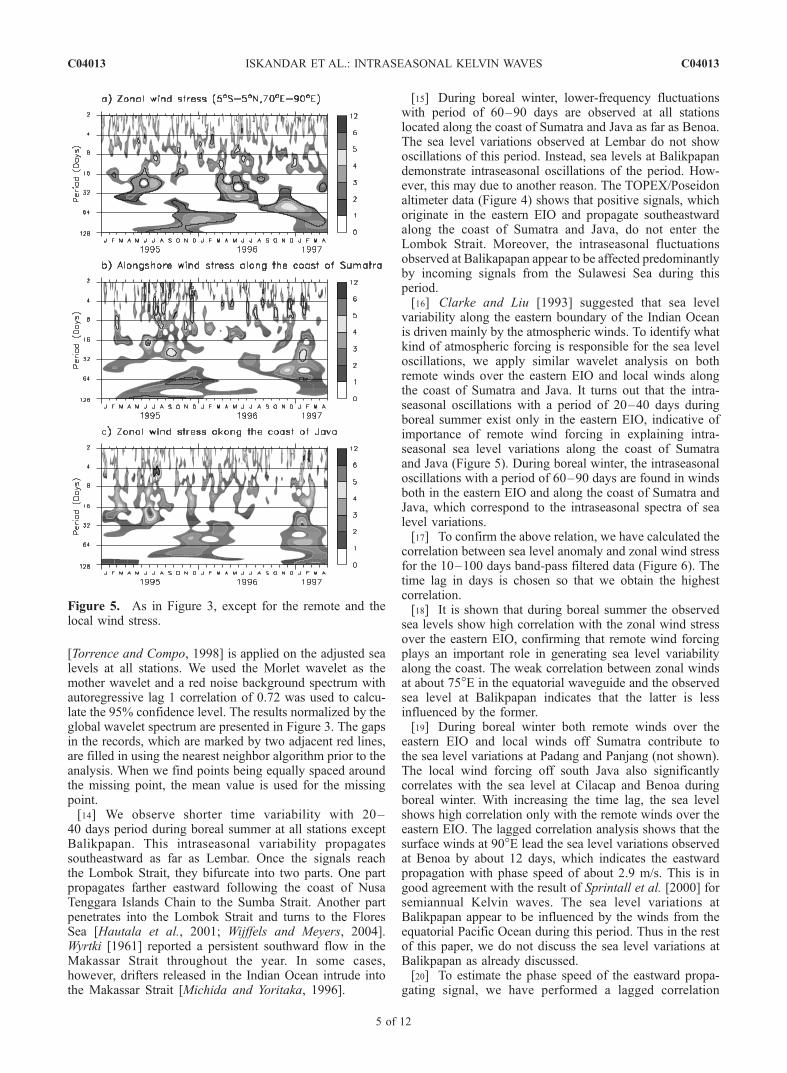
[Torrence and Compo, 1998] is applied on the adjusted sealevels at all stations. We used the Morlet wavelet as themother wavelet and a red noise background spectrum withautoregressive lag 1 correlation of 0.72 was used to calcu-late the 95% confidence level. The results normalized by theglobal wavelet spectrum are presented in Figure 3. The gapsin the records, which are marked by two adjacent red lines,are filled in using the nearest neighbor algorithm prior to theanalysis. When we find points being equally spaced aroundthe missing point, the mean value is used for the missingpoint.[14] We observe shorter time variability with 20–
40 days period during boreal summer at all stations exceptBalikpapan. This intraseasonal variability propagatessoutheastward as far as Lembar. Once the signals reachthe Lombok Strait, they bifurcate into two parts. One partpropagates farther eastward following the coast of NusaTenggara Islands Chain to the Sumba Strait. Another partpenetrates into the Lombok Strait and turns to the FloresSea [Hautala et al., 2001; Wijffels and Meyers, 2004].Wyrtki [1961] reported a persistent southward flow in theMakassar Strait throughout the year. In some cases,however, drifters released in the Indian Ocean intrude intothe Makassar Strait [Michida and Yoritaka, 1996].
[15] During boreal winter, lower-frequency fluctuationswith period of 60–90 days are observed at all stationslocated along the coast of Sumatra and Java as far as Benoa.The sea level variations observed at Lembar do not showoscillations of this period. Instead, sea levels at Balikpapandemonstrate intraseasonal oscillations of the period. How-ever, this may due to another reason. The TOPEX/Poseidonaltimeter data (Figure 4) shows that positive signals, whichoriginate in the eastern EIO and propagate southeastwardalong the coast of Sumatra and Java, do not enter theLombok Strait. Moreover, the intraseasonal fluctuationsobserved at Balikapapan appear to be affected predominantlyby incoming signals from the Sulawesi Sea during thisperiod.[16] Clarke and Liu [1993] suggested that sea level
variability along the eastern boundary of the Indian Oceanis driven mainly by the atmospheric winds. To identify whatkind of atmospheric forcing is responsible for the sea leveloscillations, we apply similar wavelet analysis on bothremote winds over the eastern EIO and local winds alongthe coast of Sumatra and Java. It turns out that the intra-seasonal oscillations with a period of 20–40 days duringboreal summer exist only in the eastern EIO, indicative ofimportance of remote wind forcing in explaining intra-seasonal sea level variations along the coast of Sumatraand Java (Figure 5). During boreal winter, the intraseasonaloscillations with a period of 60–90 days are found in windsboth in the eastern EIO and along the coast of Sumatra andJava, which correspond to the intraseasonal spectra of sealevel variations.[17] To confirm the above relation, we have calculated the
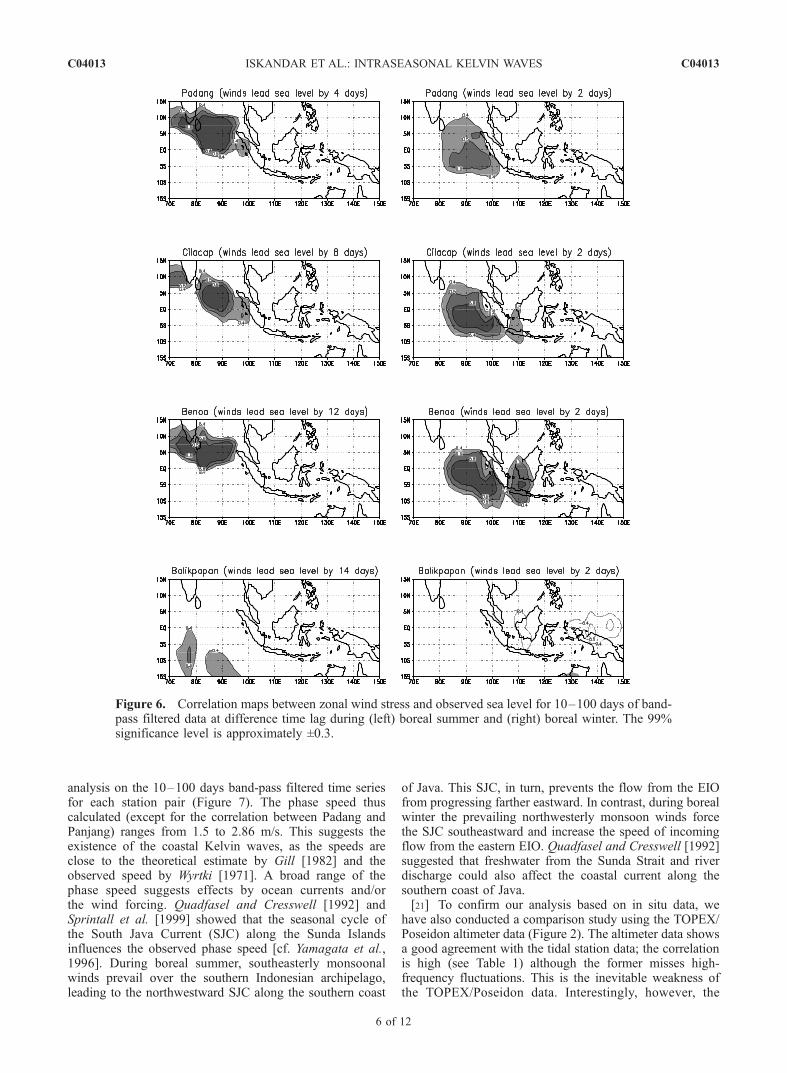
correlation between sea level anomaly and zonal wind stressfor the 10–100 days band-pass filtered data (Figure 6). Thetime lag in days is chosen so that we obtain the highestcorrelation.[18] It is shown that during boreal summer the observed
sea levels show high correlation with the zonal wind stressover the eastern EIO, confirming that remote wind forcingplays an important role in generating sea level variabilityalong the coast. The weak correlation between zonal windsat about 75�E in the equatorial waveguide and the observedsea level at Balikpapan indicates that the latter is lessinfluenced by the former.[19] During boreal winter both remote winds over the
eastern EIO and local winds off Sumatra contribute tothe sea level variations at Padang and Panjang (not shown).The local wind forcing off south Java also significantlycorrelates with the sea level at Cilacap and Benoa duringboreal winter. With increasing the time lag, the sea levelshows high correlation only with the remote winds over theeastern EIO. The lagged correlation analysis shows that thesurface winds at 90�E lead the sea level variations observedat Benoa by about 12 days, which indicates the eastwardpropagation with phase speed of about 2.9 m/s. This is ingood agreement with the result of Sprintall et al. [2000] forsemiannual Kelvin waves. The sea level variations atBalikpapan appear to be influenced by the winds from theequatorial Pacific Ocean during this period. Thus in the restof this paper, we do not discuss the sea level variations atBalikpapan as already discussed.[20] To estimate the phase speed of the eastward propa-
gating signal, we have performed a lagged correlation
Figure 5. As in Figure 3, except for the remote and thelocal wind stress.
C04013 ISKANDAR ET AL.: INTRASEASONAL KELVIN WAVES
5 of 12
C04013
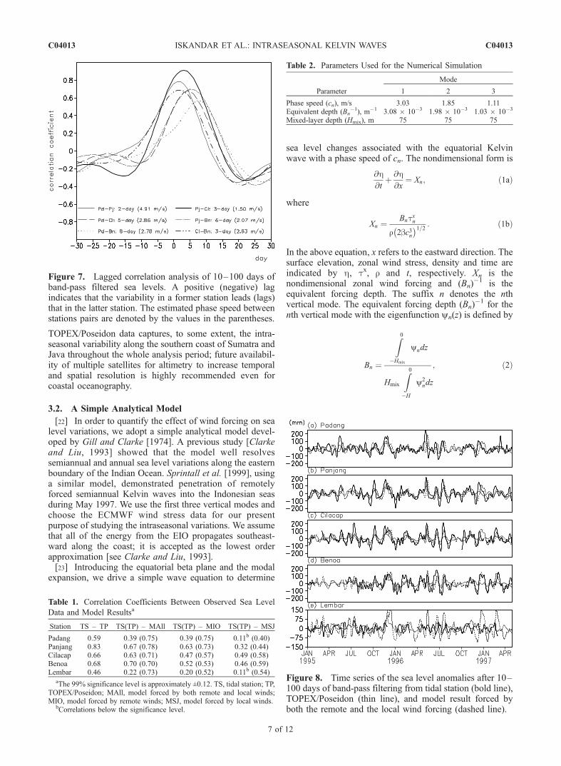
analysis on the 10–100 days band-pass filtered time seriesfor each station pair (Figure 7). The phase speed thuscalculated (except for the correlation between Padang andPanjang) ranges from 1.5 to 2.86 m/s. This suggests theexistence of the coastal Kelvin waves, as the speeds areclose to the theoretical estimate by Gill [1982] and theobserved speed by Wyrtki [1971]. A broad range of thephase speed suggests effects by ocean currents and/orthe wind forcing. Quadfasel and Cresswell [1992] andSprintall et al. [1999] showed that the seasonal cycle ofthe South Java Current (SJC) along the Sunda Islandsinfluences the observed phase speed [cf. Yamagata et al.,1996]. During boreal summer, southeasterly monsoonalwinds prevail over the southern Indonesian archipelago,leading to the northwestward SJC along the southern coast
of Java. This SJC, in turn, prevents the flow from the EIOfrom progressing farther eastward. In contrast, during borealwinter the prevailing northwesterly monsoon winds forcethe SJC southeastward and increase the speed of incomingflow from the eastern EIO. Quadfasel and Cresswell [1992]suggested that freshwater from the Sunda Strait and riverdischarge could also affect the coastal current along thesouthern coast of Java.[21] To confirm our analysis based on in situ data, we
have also conducted a comparison study using the TOPEX/Poseidon altimeter data (Figure 2). The altimeter data showsa good agreement with the tidal station data; the correlationis high (see Table 1) although the former misses high-frequency fluctuations. This is the inevitable weakness ofthe TOPEX/Poseidon data. Interestingly, however, the
Figure 6. Correlation maps between zonal wind stress and observed sea level for 10–100 days of band-pass filtered data at difference time lag during (left) boreal summer and (right) boreal winter. The 99%significance level is approximately ±0.3.
C04013 ISKANDAR ET AL.: INTRASEASONAL KELVIN WAVES
6 of 12
C04013
TOPEX/Poseidon data captures, to some extent, the intra-seasonal variability along the southern coast of Sumatra andJava throughout the whole analysis period; future availabil-ity of multiple satellites for altimetry to increase temporaland spatial resolution is highly recommended even forcoastal oceanography.
3.2. A Simple Analytical Model
[22] In order to quantify the effect of wind forcing on sealevel variations, we adopt a simple analytical model devel-oped by Gill and Clarke [1974]. A previous study [Clarkeand Liu, 1993] showed that the model well resolvessemiannual and annual sea level variations along the easternboundary of the Indian Ocean. Sprintall et al. [1999], usinga similar model, demonstrated penetration of remotelyforced semiannual Kelvin waves into the Indonesian seasduring May 1997. We use the first three vertical modes andchoose the ECMWF wind stress data for our presentpurpose of studying the intraseasonal variations. We assumethat all of the energy from the EIO propagates southeast-ward along the coast; it is accepted as the lowest orderapproximation [see Clarke and Liu, 1993].[23] Introducing the equatorial beta plane and the modal
expansion, we drive a simple wave equation to determine
sea level changes associated with the equatorial Kelvinwave with a phase speed of cn. The nondimensional form is
@h@t
þ @h@x
¼ Xn; ð1aÞ
where
Xn ¼Bntxn
r 2bc3n� �1=2 : ð1bÞ
In the above equation, x refers to the eastward direction. Thesurface elevation, zonal wind stress, density and time areindicated by h, tx, r and t, respectively. Xn is thenondimensional zonal wind forcing and (Bn)
�1 is theequivalent forcing depth. The suffix n denotes the nthvertical mode. The equivalent forcing depth (Bn)
�1 for thenth vertical mode with the eigenfunction yn(z) is defined by
Bn ¼
Z0
�Hmix
yndz
Hmix
Z0
�H
y2ndz
; ð2Þ
Figure 7. Lagged correlation analysis of 10–100 days ofband-pass filtered sea levels. A positive (negative) lagindicates that the variability in a former station leads (lags)that in the latter station. The estimated phase speed betweenstations pairs are denoted by the values in the parentheses.
Table 1. Correlation Coefficients Between Observed Sea Level
Data and Model Resultsa
Station TS – TP TS(TP) – MAll TS(TP) – MIO TS(TP) – MSJ
Padang 0.59 0.39 (0.75) 0.39 (0.75) 0.11b (0.40)Panjang 0.83 0.67 (0.78) 0.63 (0.73) 0.32 (0.44)Cilacap 0.66 0.63 (0.71) 0.47 (0.57) 0.49 (0.58)Benoa 0.68 0.70 (0.70) 0.52 (0.53) 0.46 (0.59)Lembar 0.46 0.22 (0.73) 0.20 (0.52) 0.11b (0.54)
aThe 99% significance level is approximately ±0.12. TS, tidal station; TP,TOPEX/Poseidon; MAll, model forced by both remote and local winds;MIO, model forced by remote winds; MSJ, model forced by local winds.
bCorrelations below the significance level.
Table 2. Parameters Used for the Numerical Simulation
Parameter
Mode
1 2 3
Phase speed (cn), m/s 3.03 1.85 1.11Equivalent depth (Bn
�1), m�1 3.08 � 10�3 1.98 � 10�3 1.03 � 10�3
Mixed-layer depth (Hmix), m 75 75 75
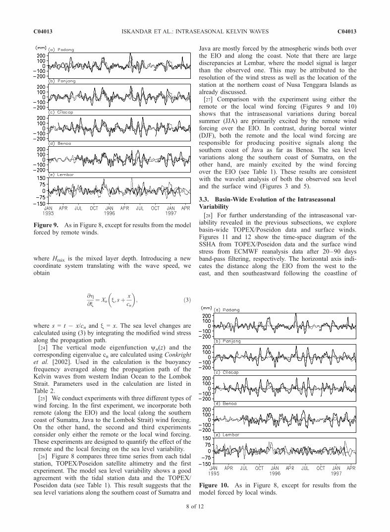
Figure 8. Time series of the sea level anomalies after 10–100 days of band-pass filtering from tidal station (bold line),TOPEX/Poseidon (thin line), and model result forced byboth the remote and the local wind forcing (dashed line).
C04013 ISKANDAR ET AL.: INTRASEASONAL KELVIN WAVES
7 of 12
C04013
where Hmix is the mixed layer depth. Introducing a newcoordinate system translating with the wave speed, weobtain
@h@x
¼ Xn x; sþ x
cn
� �; ð3Þ
where s = t � x/cn and x = x. The sea level changes arecalculated using (3) by integrating the modified wind stressalong the propagation path.[24] The vertical mode eigenfunction yn(z) and the
corresponding eigenvalue cn are calculated using Conkrightet al. [2002]. Used in the calculation is the buoyancyfrequency averaged along the propagation path of theKelvin waves from western Indian Ocean to the LombokStrait. Parameters used in the calculation are listed inTable 2.[25] We conduct experiments with three different types of
wind forcing. In the first experiment, we incorporate bothremote (along the EIO) and the local (along the southerncoast of Sumatra, Java to the Lombok Strait) wind forcing.On the other hand, the second and third experimentsconsider only either the remote or the local wind forcing.These experiments are designed to quantify the effect of theremote and the local forcing on the sea level variability.[26] Figure 8 compares three time series from each tidal
station, TOPEX/Poseidon satellite altimetry and the firstexperiment. The model sea level variability shows a goodagreement with the tidal station data and the TOPEX/Poseidon data (see Table 1). This result suggests that thesea level variations along the southern coast of Sumatra and
Java are mostly forced by the atmospheric winds both overthe EIO and along the coast. Note that there are largediscrepancies at Lembar, where the model signal is largerthan the observed one. This may be attributed to theresolution of the wind stress as well as the location of thestation at the northern coast of Nusa Tenggara Islands asalready discussed.[27] Comparison with the experiment using either the
remote or the local wind forcing (Figures 9 and 10)shows that the intraseasonal variations during borealsummer (JJA) are primarily excited by the remote windforcing over the EIO. In contrast, during boreal winter(DJF), both the remote and the local wind forcing areresponsible for producing positive signals along thesouthern coast of Java as far as Benoa. The sea levelvariations along the southern coast of Sumatra, on theother hand, are mainly excited by the wind forcingover the EIO (see Table 1). These results are consistentwith the wavelet analysis of both the observed sea leveland the surface wind (Figures 3 and 5).
3.3. Basin-Wide Evolution of the IntraseasonalVariability
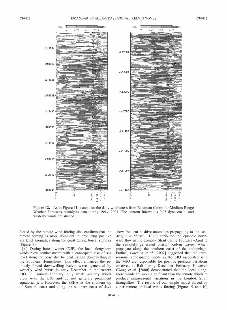
[28] For further understanding of the intraseasonal var-iability revealed in the previous subsections, we explorebasin-wide TOPEX/Poseidon data and surface winds.Figures 11 and 12 show the time-space diagram of theSSHA from TOPEX/Poseidon data and the surface windstress from ECMWF reanalysis data after 20–90 daysband-pass filtering, respectively. The horizontal axis indi-cates the distance along the EIO from the west to theeast, and then southeastward following the coastline of
Figure 9. As in Figure 8, except for results from the modelforced by remote winds.
Figure 10. As in Figure 8, except for results from themodel forced by local winds.
C04013 ISKANDAR ET AL.: INTRASEASONAL KELVIN WAVES
8 of 12
C04013
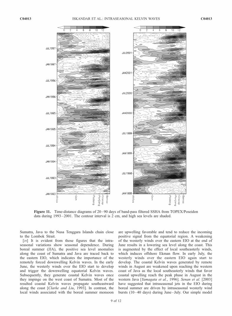
Sumatra, Java to the Nusa Tenggara Islands chain closeto the Lombok Strait.[29] It is evident from those figures that the intra-
seasonal variations show seasonal dependence. Duringboreal summer (JJA), the positive sea level anomaliesalong the coast of Sumatra and Java are traced back tothe eastern EIO, which indicates the importance of theremotely forced downwelling Kelvin waves. In the earlyJune, the westerly winds over the EIO start to developand trigger the downwelling equatorial Kelvin waves.Subsequently, they generate coastal Kelvin waves oncethey impinge on the west coast of Sumatra. Most of theresulted coastal Kelvin waves propagate southeastwardalong the coast [Clarke and Liu, 1993]. In contrast, thelocal winds associated with the boreal summer monsoon
are upwelling favorable and tend to reduce the incomingpositive signal from the equatorial region. A weakeningof the westerly winds over the eastern EIO at the end ofJune results in a lowering sea level along the coast. Thisis augmented by the effect of local southeasterly winds,which induces offshore Ekman flow. In early July, thewesterly winds over the eastern EIO again start todevelop. The coastal Kelvin waves generated by remotewinds in August are weakened upon reaching the westerncoast of Java as the local southeasterly winds that favorcoastal upwelling reach the peak phase in August in thewestern Java [Yamagata et al., 1996]. Senan et al. [2003]have suggested that intraseasonal jets in the EIO duringboreal summer are driven by intraseasonal westerly windbursts (10–40 days) during June–July. Our simple model
Figure 11. Time-distance diagrams of 20–90 days of band-pass filtered SSHA from TOPEX/Poseidondata during 1993–2001. The contour interval is 2 cm, and high sea levels are shaded.
C04013 ISKANDAR ET AL.: INTRASEASONAL KELVIN WAVES
9 of 12
C04013
forced by the remote wind forcing also confirms that theremote forcing is more dominant in producing positivesea level anomalies along the coast during boreal summer(Figure 9).[30] During boreal winter (DJF), the local alongshore
winds blow southeastward with a consequent rise of sealevel along the coast due to local Ekman downwelling inthe Southern Hemisphere. This effect enhances the re-motely forced downwelling Kelvin waves generated bywesterly wind bursts in early December in the easternEIO. In January–February, only weak westerly windsblow over the EIO and do not generate prominentequatorial jets. However, the SSHA at the southern tipof Sumatra coast and along the southern coast of Java
show frequent positive anomalies propagating to the east.Arief and Murray [1996] attributed the episodic north-ward flow in the Lombok Strait during February–April tothe remotely generated coastal Kelvin waves, whichpropagate along the southern coast of the archipelago.Further, Potemra et al. [2002] suggested that the intra-seasonal atmospheric winds in the EIO associated withthe MJO are responsible for positive pressure variationsobserved at Bali during December–February. However,Chong et al. [2000] demonstrated that the local along-shore winds are more significant than the remote winds toproduce intraseasonal variations in the Lombok Straitthroughflow. The results of our simple model forced byeither remote or local winds forcing (Figures 9 and 10)
Figure 12. As in Figure 11, except for the daily wind stress from European Centre for Medium-RangeWeather Forecasts reanalysis data during 1993–2001. The contour interval is 0.05 dyne cm�2, andwesterly winds are shaded.
C04013 ISKANDAR ET AL.: INTRASEASONAL KELVIN WAVES
10 of 12
C04013
show that both remote and local winds are necessary toexplain positive signals along the southern coast of Javaduring boreal winter.[31] In summary, the intraseasonal variations in sea
level during boreal summer (JJA) are remotely forcedby the intraseasonal atmospheric winds over the easternEIO through the generation of coastal Kelvin waves. Thelocal alongshore winds during this period are upwellingfavorable and reduce the incoming signal from theequator. During boreal winter (DJF), on the other hand,both remote and local winds contribute to the sea levelvariations along the southern coast of Indonesian archi-pelago. The local winds are downwelling favorable andtend to strengthen the remotely forced downwellingKelvin waves.
4. Summary
[32] We have investigated the intraseasonal sea levelvariations with a typical period of 20–40 days and 60–90 days using mostly in situ data obtained along thesouthern coast of Sumatra and Java. The analysis indicatesthat the phase speed of the southeastward propagating signalranges from 1.5 to 2.86 m/s except along the coast ofSumatra. This is in accord with the theoretical value givenby Gill [1982] and the observed value for the internalKelvin waves [Wyrtki, 1971], suggesting that this intra-seasonal variability is associated with the Kelvin waves.The TOPEX/Poseidon altimetry data shows that the intra-seasonal variation associated with the downwelling coastalKelvin waves has strong seasonal dependence. Duringboreal summer, intraseasonal atmospheric disturbances onlyover the EIO play a dominant role in exciting the positivesea level anomalies along the observational sites. Duringboreal winter, however, both the remote winds over the EIOand the local alongshore winds are favorable in forcing thepositive fluctuations of the sea level. The simple analyticalmodel result further confirmed our analysis. Therefore wesuggest that both remote and local wind forcings arenecessary to explain the intraseasonal variability along thesouthern coast of Sumatra and Java.[33] In addition, it is quite interesting to clarify possible
mechanism of interaction between the intraseasonal vari-ability and the large-scale climate variability, such as IndianOcean Dipole (IOD). Moreover, there are also unresolvedissues related to the link between the intraseasonal variabil-ity and the annual variations, particularly through interac-tion with the seasonally reversing ocean current systems insouth Java. A detailed study using a high-resolution OGCMrun by the Earth Simulator with a realistic topography isunder progress to further enhance our understanding ofthose interesting issues.
[34] Acknowledgments. The authors would like to thank T. Tozukafor his kind and useful comments during the course of this work. Thanksare extended to Y. Niwa, S.A. Rao, and Y. Miyazawa and also to K. Maiwafor their kind assistance in computations. The wavelet software wasprovided by C. Torrence and G. Compo and is available at http://paos.colorado.edu/research/wavelets. Useful comments provided by two anony-mous reviewers helped us to improve the earlier manuscripts. The sea leveldata are provided by the National Agency for Surveys and Mapping(BAKOSURTANAL), Indonesia. The first author has been supported bythe scholarship for foreign students offered by Ministry of Education,Culture, Sports, Science and Technology, Japan.
ReferencesArief, D., and S. P. Murray (1996), Low-frequency fluctuations in theIndonesian throughflow through Lombok Strait, J. Geophys. Res., 101,12,455–12,464.
Chong, J. C., J. Sprintall, S. Hautala, W. L. Morawitz, N. A. Bray, andW. Pandoe (2000), Shallow throughflow variability in the outflow straitsof Indonesia, Geophys. Res. Lett., 27, 125–128.
Clarke, A. J., and X. Liu (1993), Observations and dynamics of semi-annual and annual sea levels near the eastern equatorial Indian Oceanboundary, J. Phys. Oceanogr., 23, 386–399.
Clarke, A. J., and X. Liu (1994), Interannual sea level in the northern andeastern Indian Ocean, J. Phys. Oceanogr., 24, 1224–1235.
Conkright, M. E., R. A. Locarnini, H. E. Garcia, T. D. O’Brien, T. P. Boyer,C. Stephens, and J. I. Antonov (2002), World Ocean Atlas 2001: Objec-tive Analyses, Data Statistics, and Figures [CD-ROM], Natl. Oceanogr.Data Cent., Silver Spring, Md.
Emery, W. J., and R. E. Thomson (2001), Data Analysis Methods in Phys-ical Oceanography, 2nd ed., 638 pp., Elsevier, New York.
Ffield, A., and A. L. Gordon (1996), Tidal mixing signatures in the Indo-nesian seas, J. Phys. Oceanogr., 26, 1924–1937.
Gill, A. E. (1982), Atmosphere-Ocean Dynamics, Int. Geophys. Ser., vol. 30,662 pp., Elsevier, New York.
Gill, A. E., and A. J. Clarke (1974), Wind-induced upwelling, coastalcurrents and sea-level changes, Deep Sea Res., 21, 325–345.
Han, W., D. M. Lawrence, and P. J. Webster (2001), Dynamical response ofequatorial Indian Ocean to intraseasonal winds: Zonal flow, Geophys.Res. Lett., 28, 4215–4218.
Hautala, S. L., J. Sprintall, J. T. Potemra, J. C. Chong, W. Pandoe, N. Bray,and A. G. Ilahude (2001), Velocity structure and transport of the Indo-nesian Throughflow in the major straits restricting flow into the IndianOcean, J. Geophys. Res., 106, 19,527–19,546.
Luyten, J. R., and D. Roemmich (1982), Equatorial currents at semiannualperiod in the Indian Ocean, J. Phys. Oceanogr., 12, 406–413.
Masumoto, Y., and T. Yamagata (1996), Seasonal variations of the Indone-sian throughflow in a general ocean circulation model, J. Geophys. Res.,101, 12,287–12,293.
Masumoto, Y., H. Hase, Y. Kuroda, H. Matsuura, and K. Takeuchi (2005),Intraseasonal variability in the upper-layer currents observed in the east-ern equatorial Indian Ocean, Geophys. Res. Lett., 32, L02607,doi:10.1029/2004GL021896.
McPhaden, M. J. (1982), Variability in the central equatorial Indian Ocean.Part 1: Ocean dynamics, J. Mar. Res., 40, 157–176.
Michida, Y., and H. Yoritaka (1996), Surface currents in the area of theIndo-Pacific throughflow and in the tropical Indian Ocean observed withsurface drifters, J. Geophys. Res., 101, 12,475–12,482.
O’Brien, J. J., and H. E. Hurlburt (1974), Equatorial jet in the Indian Ocean:Theory, Science, 184, 1075–1077.
Potemra, J. T., S. L. Hautala, J. Sprintall, and W. Pandoe (2002), Interactionbetween the Indonesian seas and the Indian Ocean in observations andnumerical models, J. Phys. Oceanogr., 32, 1838–1854.
Qiu, B., M. Mao, and Y. Kashino (1999), Intraseasonal variability in theIndo-Pacific throughflow and regions surrounding the Indonesian seas,J. Phys. Oceanogr., 29, 1599–1618.
Quadfasel, D. R., and G. Cresswell (1992), A note on the seasonalvariability of the south Java current, J. Geophys. Res., 97, 3685–3688.
Reppin, J., F. A. Schott, J. Fischer, and D. Quadfasel (1999), Equatorialcurrents and transports in the upper central Indian Ocean: Annualcycle and interannual variability, J. Geophys. Res., 104, 15,495–15,514.
Senan, R., D. Sengupta, and B. N. Goswami (2003), Intraseasonal ‘‘mon-soon jets’’ in the equatorial Indian Ocean, Geophys. Res. Lett., 30(14),1750, doi:10.1029/2003GL017583.
Sengupta, D., R. Senan, and B. N. Goswami (2001), Origin of intraseasonalvariability of circulation in the tropical central Indian Ocean, Geophys.Res. Lett., 28, 1267–1270.
Sprintall, J., J. Chong, F. Syamsudin, W. Morawitz, S. Hautala, N. Bray,and S. Wijffels (1999), Dynamics of the South Java Current in the Indo-Australian Basin, Geophys. Res. Lett., 26, 2493–2496.
Sprintall, J., A. L. Gordon, R. Murtugudde, and R. Dwi Susanto(2000), A semiannual Indian Ocean forced Kelvin wave observedin the Indonesian seas in May 1997, J. Geophys. Res., 105,17,217–17,230.
Susanto, R. D., A. L. Gordon, J. Sprintall, and B. Herunadi (2000), Intra-seasonal variability and tides in Makassar Strait, Geophys. Res. Lett., 27,1499–1502.
Torrence, C., and G. P. Compo (1998), A practical guide to wavelet anal-ysis, Bull. Am. Meteorol. Soc., 79, 61–78.
Webster, P. J., et al. (2002), The JASMINE pilot study, Bull. Am. Meteorol.Soc., 11, 1603–1630.
C04013 ISKANDAR ET AL.: INTRASEASONAL KELVIN WAVES
11 of 12
C04013

Wijffels, S., and G. Meyers (2004), An interaction of oceanic waveguides:Variability in the Indonesian throughflow region, J. Phys. Oceanogr., 34,1232–1253.
Wyrtki, K. (1961), Physical oceanographic of the Southeast Asian waters:Scientific results of marine investigations of the South China Sea and theGulf of Thailand 1959–1960, NAGA Rep. 2, 195 pp., Scripps Inst. ofOceanogr., La Jolla, Calif.
Wyrtki, K. (1971), Oceanographic atlas of the international Indian OceanExpedition, Publ. NSF-IDOE-1, 531 pp., Natl. Sci. Found., Washington,D. C.
Wyrtki, K. (1973), An equatorial jet in the Indian Ocean, Science, 181,262–264.
Yamagata, T., K. Mizuno, and Y. Masumoto (1996), Seasonal variations inthe equatorial Indian Ocean and their impact on the Lombok throughflow,J. Geophys. Res., 101, 12,465–12,473.
�����������������������I. Iskandar, Y. Masumoto, and T. Yamagata, Department of Earth and
Planetary Science, Graduate School of Science, University of Tokyo, 7-3-1Hongo, Bunkyo-ku, Tokyo 113-0033, Japan. ([email protected];[email protected]; [email protected])W. Mardiansyah, Department of Physics, Faculty of Mathematics and
Natural Science, Sriwijaya University, Indralaya, OI, South Sumatra 30662,Indonesia. ([email protected])
C04013 ISKANDAR ET AL.: INTRASEASONAL KELVIN WAVES
12 of 12
C04013
Related Documents