ADDIS ABABA UNIVERSITY SCHOOL OF GRADUATE STUDIES MASTER’S PROJECT REPORT Internet-GIS: An application to Real Estate and Housing management in the City Government of Addis Ababa (CGAA) BY AYALEW BELAY Submitted to School of Graduate Studies of Addis Ababa University in partial fulfillment of the requirements for the Degree of Master of Science in Computer Science.

Welcome message from author
This document is posted to help you gain knowledge. Please leave a comment to let me know what you think about it! Share it to your friends and learn new things together.
Transcript

ADDIS ABABA UNIVERSITY SCHOOL OF GRADUATE STUDIES
MASTER’S PROJECT REPORT
Internet-GIS:
An application to Real Estate and Housing management in the City Government of Addis Ababa (CGAA)
BY AYALEW BELAY Submitted to School of Graduate Studies of Addis Ababa University in partial fulfillment of the requirements for the Degree of Master of Science in Computer Science.

1
ACKNOWLEDGEMENT First and for most I deeply thank my advisor Dr.Solomon Atnafu for his commitment,
patience and comments to the progress and completion of my project work. I would like
to thank Zak James who helped me remotely in all of the problems that I face during the
development of the prototype.
My special thanks, with love, goes to my friends Ermias, Yihun, Kebede for their
unreserved help through out my work. I would also like to thank my beloved friend
Andenet Mengesha for her support and encouragement during my study.
I am also grateful to my friends and staff members of the Faculty of Informatics, and
special thanks to my classmates Dejene, Teferie, Wondwossen, Abnet, Fitsum, and all
postgraduate students of computer science department for their unlimited cooperation
whenever I need help.
I would also like to thank Ato Alemayehu Hailu, Housing Agency inspection team
leader, Ato fasil Bekele Arada Kifle-Ketema Infrastructure development manager and all
employees who work at house development offices of Arada, Ledeta and Addis-Ketema
Kifle-Ketemas for their constant support in providing me the necessary documents and
arranging interview sessions with the domain experts.
Above all, Praise be to the Lord, who makes this happen. And great thanks to my
beloved family; especially my mother-she is everything to me.

2
Table of Contents CHAPTER ONE
1. Introduction------------------------------------------------------------------------1
1.1 Overview-------------------------------------------------------------------1
1.2 Statement of the problem----------- -------------------- --------------3
1.3 Objective of the project-------------------------------------------------3
1.4 Significance of the Project------------------------------ ---------------4
CHAPTER TWO 2. Internet –GIS applications -----------------------------------------------------5
2.1 Internet-GIS architecture---------------------------------------------7
2.1.1 Server-side strategy--------------------------------------------7
2.1.2 Client-side strategy---------------------------------------------8
2.2 Experience of others using Internet-GIS Applications for municipality applications --------------------------------------------11
CHAPTER THREE 3. Problem Identification---------------------------------------------------------17
3.1 Overview----------------------------------------------------------------17
3.2 Analysis of the Response --------------------------------------------18
3.3 Recommendations-----------------------------------------------------20
CHAPTER FOUR
4. System Analysis------------------------------------------------------------------21
4.1 The Housing Agency of CGAA--------------------------------------21
4.2 Requirement Analysis----------------------------- -------------------23
3
4.2.1 Use case diagram-------------------------- -------------------25
4.2.2 Dynamic model-------------------------- ----------------------27
4.2.2.1 Sequence Diagram---------------------- --------------27
4.2.2.2 Activity Diagram-------------------- -----------------28
4.2.2.3 State Diagram-----------------------------------------29
4.2.3 Object Model --------------------------------------------------29
4.2.3.1 Class Diagram ------------------------------------------30
4.3 Design of the System --------------------------------------------------31
4.3.1 Hardware/Software mapping-------------------------------31
4.3.2 Deployment diagram-----------------------------------------35
CHAPTER FIVE 5. The Prototype HISAA----------------------------------------------------------36
5.1 Overview-----------------------------------------------------------------36
5.2 The environment and the tools used for the development of HISAA--------------------------------------------------------------------37
5.2.1 CAD Viewer--------------------------------------------------37
5.2.2 CAD to Shape file converter-----------------------------38
5.2.3 Mapserver ----------- ----------------------------------------41
5.2.3.1 Maplab------------------------------------------------43
5.3 Architecture of HISAA------------------------------------------------46
4
5.4 Prototype Implementation--------------------------------------------48
CHAPTER SIX
6. Conclusions and Future work------------------------------------56
6.1 Conclusions--------------------------------------------------------------56
6.2 Future Work ------------------------------------------------------------58
References
Annexes
5
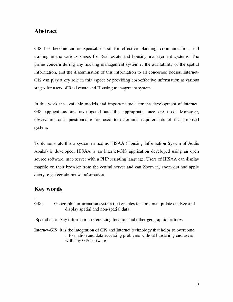
Abstract
GIS has become an indispensable tool for effective planning, communication, and
training in the various stages for Real estate and housing management systems. The
prime concern during any housing management system is the availability of the spatial
information, and the dissemination of this information to all concerned bodies. Internet-
GIS can play a key role in this aspect by providing cost-effective information at various
stages for users of Real estate and Housing management system.
In this work the available models and important tools for the development of Internet-
GIS applications are investigated and the appropriate once are used. Moreover,
observation and questionnaire are used to determine requirements of the proposed
system.
To demonstrate this a system named as HISAA (Housing Information System of Addis
Ababa) is developed. HISAA is an Internet-GIS application developed using an open
source software, map server with a PHP scripting language. Users of HISAA can display
mapfile on their browser from the central server and can Zoom-in, zoom-out and apply
query to get certain house information.
Key words . GIS: Geographic information system that enables to store, manipulate analyze and
display spatial and non-spatial data. Spatial data: Any information referencing location and other geographic features Internet-GIS: It is the integration of GIS and Internet technology that helps to overcome
information and data accessing problems without burdening end users with any GIS software

6
CHAPTER ONE 1. Introduction
1.1. Overview The Internet and Web are tremendously changing every aspect of our lives.
Communication with business partners, commerce transactions, buying and selling goods
and services, sharing and exchanging ideas and information, learning, software
development, business and leisure activities and many others are possible by the use of
Internet and web technology. The most Popularly Known Internet and Web based
information systems include E-business, E-commerce, E-learning, E-medicine, etc.
Internet and Web technologies are applicable in every day human and business activities.
The fundamental characteristics of these technologies include efficient data access,
delivery over the Web, heterogeneity, and interoperability. The primary focus of Internet
or Web use is for mass distribution and presentation of public information and
distribution of software services over a network.[10].
The wave of Internet and Web technology has also reached to the Geographic
Information Systems (GIS) research and development sector. Geographic Information
system (GIS) is an emerging technology encompassing many disciplines namely
geography, cartography, Geometry, remote sensing, surveying, GPS technology, statistics
and other disciplines concerned with handling and analyzing spatially referenced data.
GIS is mainly comprised of data handling tools for storage, retrieval, management and
analysis of spatial data as well as solving complex geographical problems [4].
GIS can also be used for the generation of new information by the user-defined
combination of several existing information. Because of the various distinguishing
features of GIS, it is considered as an indispensable tool for conducting spatial searches
and overlays and association of the spatial data with the non-spatial attribute data to
eventually generate useful information.

7
The integration of GIS and Internet technologies is allowing GIS developers to provide
access to geo-information and processing without burdening end users with complicated
and expensive software and dedicated hardware.
Internet-GIS is a Geographic Information System (GIS) distributed across a computer
network that integrate, disseminate, and communicate geographic information visually on
the World Wide Web [1]. Internet-GIS technology provides dissemination, sharing,
displaying and processing of spatial information over the Internet. Internet based
geographical data services mainly involve sharing and management of spatial and non-
spatial data. With Internet access and a web browser, larger and larger amounts of
information can be made available quickly and conveniently to users.
Internet geographic information system, which can directly run on the Internet, is
developed to transmit the geographic information data on the Internet and for real-time
analysis, to distribute processing and calculating approach on spatial information data. [7]
Internet-GIS provides a much more dynamic tool than a static map display. It enables the
user to access Geo-referenced data and deliver interactive query capabilities such as:
• Searching for specific site locations
• Displaying and viewing multiple data sets
• Conducting queries for specialized analysis
• Retrieving specialized data services
Internet-GIS has a lot of importance in urban information management. One of these is, it
can be used as a tool in real estate and housing management. So, there are a lot of GIS
applications that could be of benefit for a housing management.
Housing Agency of Addis Ababa City Government is responsible in the development of
housing policies and optimized usage of governmentally owned residential houses.
Housing Agency cooperates with governmental offices, private investors and NGOs
working in the alleviation of the public house problem.
8
For better management and coordination the Housing Agency has decentralized the
responsibilities. The agency has branch offices at the Kifle-Ketema and Kebele level,
which are responsible to public and Kebele house management. These branch offices
select a site plan and decide on the areas that need to be considered for activities such as
re-locating people and construction of Condominium houses. To decide on the areas that
needs to be replaced by the new houses and to allow people to stay close to their old
homes query-able spatial data is important.
Even then there is no GIS applications used at the main office as well as on the Kifle-
Ketema offices. They use AutoCAD software as a visualizing application to see the area
where new houses are going to be built. Which makes their activities difficult, as
AutoCAD don’t support spatial query.
1. 2. Statement of the problem The Kifle-Ketemas and the main office of the Housing Agency of CGAA use AutoCAD
for the management of housing and residential areas. The office of Housing Agency of
CGAA does not use GIS system for its applications. The fact that AutoCAD is not query
able, and that the agency does not use GIS, has created a serious problem on the recently
introduced decentralization management and the centralized control of the Housing of the
city. A successful decentralization needs network access to a centrally manage datasets so
that at the different Kifle-Ketemas viewing maps and querying certain information will
be possible from the map server.
In this work we propose a system that will enable the Housing Agency of CGAA to
execute its responsibilities more efficiently.
1.3. Objective of the project
General objective
Internet-GIS is a new technology that is used to display and analyze spatial data on the
Internet. It combines the advantages of both Internet and GIS. It offers the public a new
means to access spatial information without owning expensive GIS software.

9
The main objective of the project is to design and develop an Internet-GIS to the Housing
Agency of CGAA so that branch offices at the Kifle-Ketmas can get an online access to
the Addis Ababa house map.
Specific Objectives
The specific objectives of this project are to:
• Explore the existing Internet-GIS tools and technologies
• Investigate the current situation in Housing management at the
Housing Agency of the CGAA and identify the problems
• Design a model for Internet-GIS solution for the Housing Agency of
CGAA.
• Develop a prototype to demonstrate the recommended tools and
models. 1.4. Significance of the project Internet-GIS helps to maintain, manage, plan and analyze geographically referenced data
on public utilities (water supply, sewerage, electricity) and development planning (town
planning, roads and building, estate and land acquisition)[5].
Real Estate and Housing management is one part of urban management information
system. This project can serve as a ground reference and initiative to develop Internet-
GIS in other governmental and non-governmental offices. It also enables stakeholders of
the Addis Ababa Hosing Agency to have spatial data access and make effective
decisions. The following are some of the domain of applications that can benefit from the
project result.
� For Real Estate and Housing management: An integrated Housing
management at the different Kifle-Ketemas of the city with minimum cost
can be possible to facilitate planning and decision-making.
� Data source for other urban managements systems: The information from
this project can for example be used by Land Administration Authority for
land use, ownership and planning.
� Can also be used by municipalities of other cities in the country.
10
CHAPTER TWO 2. Internet-GIS Applications Internet is a vast collection of different networks that uses some common protocol and
provides certain common services [8]. It is a super network made up of regional, national
and international telecommunication networks that links computers found in educational
institutions, government departments, and military establishments as well as commercial
and non-commercial organizations all over the world [10].
The Internet is a client/server-based system where the client sends a request for service
and the server processes the request and returns information to the client. The Internet,
unlike other Client/Server based networked applications, is constrained by the network
size, speed and administration [8].
Internet can be used for delivering digital files in multiple forms including text, picture,
sound and animation, for exchanging files between computers, for a log-on procedure in
accessing programs on remote computers as though they were local, for a mailing system
to exchange messages among Internet users and for discussion groups which contribute
information to communities of users in a particular area of interest.
Internet also enables to access and transmit data (including GIS data) and makes the user
to use the data in their local machine with stand-alone GIS software installed. This is
useful in the sense that it can facilitate users to obtain data more efficiently [6].
The tremendous growth of Internet use has resulted in an increased demand for the
delivery of geographic data, maps, and applications over the Internet. The integration of
GIS and Internet technologies is named as Internet-GIS, which allows for easy access to
information and data without using any specific GIS software.

11
Internet-GIS focuses on the Internet technology and utilizes a distributed architecture
framework, symbolizes and invisible revolution of GIS - from closed, centralized GIS to
open, distributed GIS Services. Internet-GIS has been widely accepted in governmental
agencies and educational institutions and among Geo-Spatial data producers and users,
GIS vendors, and GIS professionals. GIS products can easily be distributed to every
desktop in an organization through the Web server and to the general public through
World Wide Web communications [11].
The organization can centralize the maintenance of GIS data and decentralize the GIS
applications. Using the Internet, GIS data can easily be updated, and users can gain
access to the applications and information they need for specific tasks.
Internet-GIS opens many new possibilities such as geographically communicating with
other people in presenting ideas and integrating information or making the right decision
in figuring out which is the nearest house to certain road.
Furthermore, interactive maps often let the user query the data in order to derive more
useful information such as what are the spatial features of a parcel or block in comparison
to traditional maps that are static and also for displaying multiple data sets. The question
of data sharing gets more important at the same time as digital data resources are growing
with the expansion of the World Wide Web.
The applications of Internet-GIS according to [4] are growing rapidly due to the services
the user acquires. Some of these are:
• Displaying static maps, which users can pan or zoom.
• Provide data that are kept secure at the server side.
• Provide maps and data across the network or Internet
• Creating user defined maps online.
Due to increased productivity, improved customer satisfaction and reduced cost,
Internet-GIS is gaining more popularity in the GIS users’ choice [3]. In general Internet-
GIS can distribute GIS data and geo-processing tools to a broader range of potential users
that conventional GIS implementation may never reach.
12
2.1. Internet-GIS Architecture The basic approach for deploying Internet-GIS application depends on the user
requirements that have to concern with which Internet-GIS packages are suitable to
accomplish their objectives [1].
Developments of Internet-GIS are changing as fast as Internet and Web technologies.
Because one depends on the other. Internet applications can be built with a variety of
object-oriented languages, such as Visual Basic, Visual C++, JAVA and DELPHI. On the
client side of Internet-GIS more and more people will access geographic information
directly by means of programs like Internet Explorer. According to [9] there are basically
two types of architectures for developing Internet-based GIS applications: client-side, and
server-side.
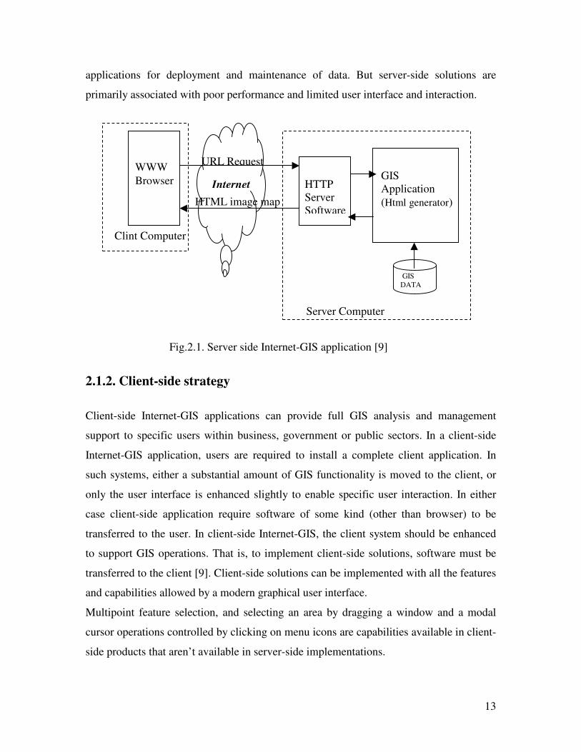
2.1.1. Server-side strategy In a server-side Internet-GIS application, a Web browser is used to generate server
requests and display the results on client-side browser. An Internet-GIS server usually
combines a standard Web (HTTP) server, GIS application server, and the GIS databases
and functionalities that reside completely on the server.
As it is shown in figure.2.1.users interact with the client machine and type the address
they are looking for (the request), which is transferred to the Web server. The Web server
passes the request to the GIS application server, which runs an address matching routine,
generates a map graphic, convert the graphic to Web format, wraps the image in HTML
and sends it back to the Web server, which then returns the response to the client as a
standard Web page.
Map data transmitted to a Web client are in standard HTML formats that can be
accessible through any Web browser, creating significant positive implications for
performance, reliability and size of user base.
Because of the entire complex and proprietary software, as well as the GIS databases
resides on a server, it is easier for simplified application development in Server-side
13
applications for deployment and maintenance of data. But server-side solutions are
primarily associated with poor performance and limited user interface and interaction.
2.1.2. Client-side strategy Client-side Internet-GIS applications can provide full GIS analysis and management
support to specific users within business, government or public sectors. In a client-side
Internet-GIS application, users are required to install a complete client application. In
such systems, either a substantial amount of GIS functionality is moved to the client, or
only the user interface is enhanced slightly to enable specific user interaction. In either
case client-side application require software of some kind (other than browser) to be
transferred to the user. In client-side Internet-GIS, the client system should be enhanced
to support GIS operations. That is, to implement client-side solutions, software must be
transferred to the client [9]. Client-side solutions can be implemented with all the features
and capabilities allowed by a modern graphical user interface.
Multipoint feature selection, and selecting an area by dragging a window and a modal
cursor operations controlled by clicking on menu icons are capabilities available in client-
side products that aren’t available in server-side implementations.
Fig.2.1. Server side Internet-GIS application [9]
WWW Browser HTTP
Server Software
GIS Application (Html generator)
URL Request
HTML image map
Internet
GIS DATA
Server Computer
Clint Computer

14
Core GIS operations like editing, buffering, overlay analysis and route tracing are
examples of operations that are enhanced by exploiting vector data structures on the
client side without re-transmitting a request to the server. In the client-side Internet-GIS
applications, the client and the server process different tasks. This division of the tasks
allows the system to speed up the data transfer between server and clients. [9]
As it is shown in figure.2.2, in client-side Internet-GIS, the main tasks will be processed
in the server, which is basically delivering files. The server receives request from the
client and starts to communicate to the database and retrieves attributes of the map stored
in the database. The GIS application server has also direct access to the map file. The
map file could be SHP, DXF, etc and used to create map files like lines, point, area and
labels. The server provides the client with raw data map and HTML image.
The primary advantages of client-side solutions are the abilities to enhance user
interfaces, improve performance and implement solutions using vector data. It has
significant advantage on the performance. This is because window display changes can
happen without re-transmitting a request to the server.
GIS application
Fig.2.2. Client side Internet GIS application [9]
WebBrowser
Receive Input
Process map Display map GIS software On Client
Client computer
Query command
Raw data
Internet
GIS application HTTP Service File transfer
GIS Data Server computer
Gis software on server

15
The disadvantages associated with client-side solutions are related to distributing
software and data. Distributing software is problematic. Some potential users will be lost
due to platform incompatibilities, some users will undoubtedly have difficulties loading
software, and providing technical support is time consuming and expensive.
To overcome the limitations a hybrid solution can be used [12]. In the hybrid Internet
based Geographic information systems i.e. client /server systems, the server holds data
possibly in relational database management system and desktop clients use standard
browser software to view those data
As it is shown in figure2.3.above the client browser program sends a URL request to the
server and the server processes the map and finally a file is transmitted from the server to
the client. The server side usually consists of many technologies that are working
together such as databases and GIS processing unit.
The Internet map server typically provides functions to allow zooming or panning around
map images. The client requests a map image from a server and the Internet map server
creates a map based on the request from the client as a graphics file GIF, PNG or JPEG
[4]. A map server performs GIS operations and sends the results of the operation to the
client browser, which will be displayed as images or text or a combination of both. The
server and client communicate using a protocol like HTTP [2].
Data, Database management system and GIS processing unit
Map server
client
client
client
Server side Client side
Fig.2.3. Hybrid or Client/Server Internet GIS application [12].

16
2.2. Experience of others using Internet-GIS Applications for
municipality applications
2.2.1. GIS for land use and housing in a district of Hochiminh city of
Vietnam Hochiminh city (HCMC) is the biggest city in Vietnam. It has over 6 million residents,
over 1 million immigrants and 1 million visitors. HCMC consists of 23 dissects including
17 urban and 6 suburban districts as shown in figure2.4.
District 5, which is shown above in figure 2.4, has a lot of schools, hospitals, and
entertainment places. It is 4.14 square kilometers, 4 kilometers long and 1 kilometer
wide. It is surrounded by district 1 on the east side, district 6 on the west side, district 10
and 11 on the north side, and district 8 on the south side. The Tau Hu canal passing
district 5 and separating it with district 8 makes it more beautiful.
The district 5 governmental agencies encounter a lot of difficulty in activities of the urban
management. The processing, analytical and data storage capabilities of computers have
given public agencies that have invested in such systems a great tool for accomplishing
their duties. The ability of GIS to store, manage and manipulate large amounts of spatial
data provides urban managers with a powerful tool. [13]
Fig.2.4. Suburban districts of HCMC [13]

17
This paper focuses on how GIS has been applied to establish, maintain, and analyze
urban and land-use information to support the functions of local government in district 5,
Hochiminh City (HCMC), Vietnam.
The objective was:
• To design and implement GIS database for land use and Housing
management for district 5
• Implementing in a centralized manner to keep it with an existing
official management
GIS model for district 5 of HCMC
In order to be linked with an existing official management, the system should be a
centralized one. This centralized system needs one server computer that stores all of GIS
data in one geo-database while other client computers connect to the server to exchange
data through a backbone network as shown below in figure 2.5.
Hardware and Software Requirements of the system are:
• Pentium II workstation (Client Side Browser)
• Web Server
• Database Server
• Mapping Server
• Network (Intranet/ Internet
Fig.2.5. Internet-GIS network of the district [13]

18
The applications that the users can acquire from the system include:
• Both the district’s staffs and the citizens can use it.
• It supports users to identify, query, and count up data.
• Users can retrieve data from database rather than update data.
• Data to be retrieved can be spatial or attribute data.
• Results produced by these tools are reported on maps or on forms.
• The toolbox is a good tool for people to retrieve land-use and housing
information in a short time
2.2.2. Web-GIS based urban planning and information system for
municipal corporations
Urban Planning and Information System is an Internet -GIS based application system,
which have been used for automating the day-to-day operations of Nashik Municipal
Corporation (NMC).
Nashik or Nasik is a city, and also a district and division, in India's Maharashtra state.
Nashik is in the northwest of Maharashtra, 200 km from Mumbai (Bombay) as well as
Pune. The city, located in the Western Ghats, has become a center of attraction because
of its beautiful surroundings and cool and pleasant climate. Nashik has a personality of its
own due to its mythological, historical, social and cultural importance. The city, vibrant
and active on the industrial, political, social and cultural fronts, has influenced the lives
of many a great personalities. The Godavari River flows through the city from its source
to the northwest of the city.
The city is home to an important thermal power plant (Eklahare) and a National Treasury
Printing Press (India Security Press in Nashik Road). There are 3 'Industrial Estates' in
the metropolitan Nashik area and outskirts (Satpur, Ambad and Sinnar)[5]. Among
various companies that have operations in these industrial estates are Mahindra, MICO
(Bosch), VIP, Crompton Greaves, Glaxo, etc.
19
Nashik is also famous for its grapes, and ongoing efforts are underway to promote the
growth of an export-oriented wine industry in the district.
As it is noted in [5] the paper shows the use of GIS and Internet technology for Municipal
Corporation of India, which has been illustrated with a typical case study where the urban
planning and information system is implemented for use.
There are two indigenously developed Web-GIS solutions namely PUPIS (Public Utility
Planning and Information System), which is useful for utility functionalities like water
supply, sewerage operation and electricity network and DPIS (Development Planning and
Information System), which is useful for town planning and related departmental
activities [5]. The functioning of all the 11 departments of this corporation has been
integrated into a single system using the above two solutions.
The system addresses holistic approaches to solve bunch of Municipal issues based on a
client - server architecture. All the three basic modules under this system, Data Entry,
Reporting, GIS - based Query, can be accessed from the remote client machines located
in corporations’ ward offices using a browser. The only perquisites being that the
terminal nodes (Ward Offices) are connected to the server (Head Office) via Internet or
Intranet. Data Entry screens are used for entering data related to the various entities
related to functional requirements of all the departments.
Reports (maintenance) are generated periodically for each department using the report
generation facility provided within the system. These reports provide department-wise
consolidated information regarding a particular entity for a given period. GIS based
query is the most important module of this system since the visualization of data and
maps are the main criteria for planning and decision-making.
20
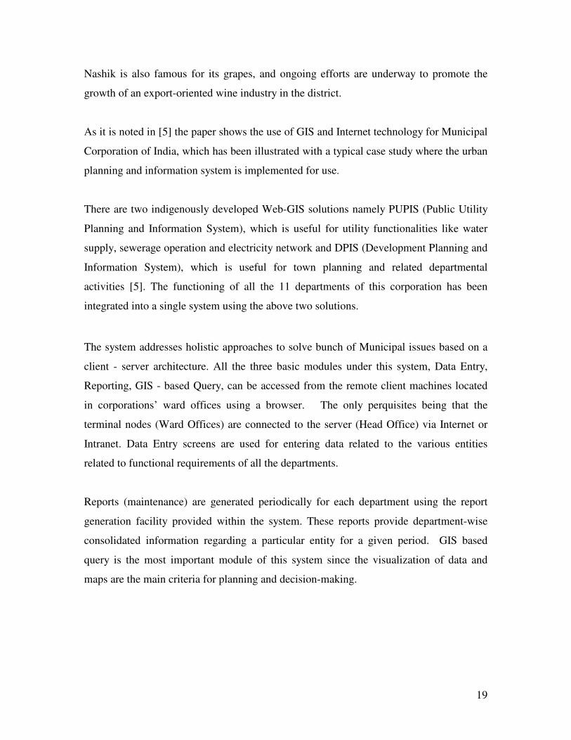
All in all the system helps to maintain, manage, plan and analyze geographically
referenced data on public utilities (water supply, sewerage, electricity) and development
planning (town planning, roads and building, estate and land acquisition, accounts, fire,
health and sanitation, property taxation, encroachment, garden).
Fig.2 .6. Urban planning and information system networking [5]
MapInfo software IIS web server MapXtreme server Application Dev. Server Oracle database server ma
Interet
Client-1 Client-2 Client-3 Client-N --------

21
As it is shown above in figure.2.6, the sysem amalgamates MapInfo’s, MapXtreme
server, Oracle8i database server and Microsoft Internet technologies like Active Server
Pages (ASP) and Component Object Model (COM). This system shows the spatial and
attributes data of map layers.
The map features are stored in the MapXtreme server as layers or geo-sets. These layers
are used with the database attributes for visual display of information that is required for
urban planning and information system. The system requires Microsoft Internet
Information Server (IIS 4.0) Web server to host the system and available to the users via
web browser.
Hardware and Software Requirements of the system as it is noted in [5] are:
• NT Server, 512 MB RAM, 40 GB HDD
• Pentium II workstation (Client Side Browser)
• IIS Web Server
• Database Server
• Application Server
• Mapping Server
• Network (Intranet/ Internet
The functional and technical benefits as it is noted in [5] are:
• Interdepartmental information sharing and communication
• Better planning of public utilities services and Town Planning
• View and presentation of municipal information
• Geographic database (GDB) creation and maintenance
• Perform spatial queries, spatial modeling and analysis like where are
all suitable sites to build new schools, buildings, shopping malls etc.
• Tools to query, analyze, and map data to support decision making
process
• Planning & Management of Utility and Town Planning Database
• Ease in Maintenance and better monitoring of municipal resources
• On-line Decision-Making

22
CHAPTER THREE 3. Problem Identification
3.1. Overview In Addis Ababa there are a lot of governmental and non-governmental offices that give
services to the people in different areas. One of the governmental organizations that
provides and manages houses in the city is the Housing Agency.
The Addis Ababa Housing Agency is institutionalized to organize and manage
governmentally and privately owned houses. The Agency also facilitates and coordinates
organizations that build houses for public use in the city [15].
Housing agency of the City Government of Addis Ababa (CGAA) keeps data of houses
to administer, manage houses of the city, which will help for better use for study and
policy development.
This data according to [15] includes:
• Year of construction
• Addresses (House No, block No, Site name, Kifle-ketema, kebele
etc.)
• Agreement document
• The material by which the house is made of
• Number of rooms
• Income of the Resident
• Plot land area of the House
• Total expense for the construction
In addition to this, the Agency has activities to properly manage the Housing data and
provide information to the users when needed. In order to specify the requirements of the
Agency on how it is providing spatial and non-spatial housing data to other offices, an
interview, a questionnaire and close observations are conducted on the Agency
employees, three selected Kifle-ketema workers and also on customers of the agency.
23
The interview as well as the observation made helps to get information on how the
housing agency is doing its activities, how it keeps records, how the agency communicate
with other offices, the technology used for data management and communication and
problems occurred.
3.2. Analysis of the Responses From the responses of the respondents and also from the observation made, the Housing
Agency exchange information with the Kifle-Ketemas, the NGO’s who are developing
houses to the public and with House development progress office. The technology used
for the exchange of information includes telephone, data CDs and floppy. These
technologies didn’t support them for:
• Quick decision making
• Better resource utilization
• Better communication
• Coordinated performance
Hence the different Kifle-Ketemas of the city didn’t get the necessary information on
time and it is common to perform the same activity repeatedly.
According to the response obtained, there should be better communication system that
helps all stakeholders of the Agency to communicate efficiently and perform their
activities in coordinated way.
The interview and the observation are made on those who are working in related areas on
land and house development offices of ARADA Kifle-Ketema, LEDETA Kifle-Ketema
and ADDIS KETEMA Kifle-Ketema.
24
According to the response of the respondents the duties of the Kifle_Ketemas in relation
to housing management activities include:
• Control and inspect house development in the Kifle-Ketemas
• Putting the orders of the housing agency in to practice
• Site selection and site plan preparation
• Discuss about the selection Site with the Agency
The selected Kifle-Ketemas doesn’t use computerized system to their activities. The
Kifle-Ketemas share information with the Housing Agency to perform activities that
include:
• Supervision of sites in which houses are being developed
• Regarding orders from housing Agency to lower levels
• For Experience sharing with other Kifle-Ketemas
• For Site plan approval by Land administration office
But due to the communication technology they use there are some problems observed.
These include:
• Unable to perform their activity according to the plan designed
• Difficulty to get quick information from other offices of the city
• Performing the same activity repeatedly
• Transport problem for inspection and supervision of sites
25
3.3. Recommendations
From the result of the analysis there is a need for an automated, more organized and
integrated housing information system that include spatial and non- spatial data. I there
fore recommend an Internet-GIS system to the Housing Agency of the CGAA. To realize
this recommended system the needs of the housing agency in general include:
Database system A database management system that will represent detail information on houses i.e.,
residents of the house, type of house, structure of the house, location, economic condition
of the residents, etc The information should include spatial and non-spatial data.
Networked systems
Currently the Agency doesn’t have networked system. To communicate with other office
posts, CDs and telephone are used. These communication technologies will not enable for
reliable exchange of data and quick decision-making. A networked system will allow the
Agency to easily communicate and share information internally and externally with other
offices. It also enable users to access spatial data without installing GIS software.
Use of better GIS software Currently the Housing Agency of the CGAA uses AutoCAD to visualize housing map of
the city. The AutoCAD used is helpful only to provide visualization application. But
there is a need even more than visualization like querying, updating etc. The use of better
GIS software enable workers with better GIS service and also for spatial analysis.

26
CHAPTER FOUR 4. System Analysis
4.1. The Housing Agency of the CGAA The Addis Ababa City government is organized in a decentralized form in various
governmental offices. The administration is organized in to different functionally
authorized agencies and 10 kifle-Ketemas (city blocks). Housing Agency is one of the
agencies institutionalized to facilitate the working of the administration. The different
agencies of the administration will work together for the effectiveness of the whole
system in general. The working flow of the agency is given in figure 4.1 below [15]. As
can be seen from the figure the Housing Agency, for construction permit, works in close
collaboration with the Land Administration. This shows that in addition to the
communication between the different offices with in the Agency, there is a
communication requirement with the Land Administration Authority. The design of the
new system should consider this fact.

27
Housing Agency in Kifle-Ketemas
Prepare site plan
Site selection
Prepare site plan
Store copy
Land development
Housing Agency Head office
Land Administration
Infrastructure Agency
Is Site plan with in size of master plan?
Request for construction permit ion
Construction Permit ion
Yes
No
Proposal to land administration
Agreement on size of land for construction
Send copy Send copy
Fig.4.1. Work flow of Housing agency [15]
Construction permit ion
28
The Housing Agency of CGAA manages governmental renting as well as privately
owned houses in the city. The agency is not organized with respect to human power and
so has problems in proper management and coordination of activities. The agency uses
AutoCAD software for the visualization of the housing dataset. This software does not
support for spatial analysis. Moreover, when a new site is surveyed for construction the
site plan will be drawn on the same location of the master plan and is saved in a separate
file. The master plan is AutoCAD based which is known as Nortech. The Nortech is used
as a base map and identifies parcel and some other feature of the city. The parcel is based
on blocks, zones, kebele and hose numbers.
Currently the Agency decentralizes its responsibilities to Kifle-Ketema level. In each of
the Kifle-Ketemas, there are branch offices that manage and coordinate governmentally
and privetly owned houses. The kifle-Ketemas are also responsible for site selection for
the construction of public houses. These Kifle-Ketemas use the Nortech data, which is on
CD, as a base map for their activities.
4.2. Requirement Analysis
The housing agency of CGAA has responsibilities for efficient service provision in the
city. The following are the weaknesses of the agency on its current practice regarding
housing information management [15].
The agency works closely with Land administration, Land development
Agency,and Kifle-Ketemas,etc. Even if they need to work in harmony
for better performance the current system is not capable for reducing
and avoiding redundant works in the different offices. This results for
the wastage of human resource and utilization of inconsistent
information.

29
The house information is paper based and also the non-spatial data of the clients, i.e.
renters is not integrated with the spatial data.
The Database found in Land Administration is not used by the Housing
Agency. This database is designed with visual foxpro and has full
information of houses in the city like size, material used for
development, owner, location etc. The Land Administration provides
information about the clients to the Agency after the data is imported to
data sheet.
The current system couldn’t help to locate a house in the city given
Kifle-Ketema, kebele and house number though it is very important in
bigger cities like Addis Ababa.
The Agency, even if it is decentralized its activities to Kifle-Ketema
level, it is highly difficult to share housing map. This is because there is
no integrated information system in use and also no local area network
that links the Agency with other Agencies and branch offices. So a client
need to use a separate housing data stored in digital CDs and possibly
there will be inconsistency of information usage.
Although the requirements of the Agency as it is listed above are too much, this project
will try to propose a solution to the communication problems of the agency with Kifle-
Ketema branch offices. This is by using Internet-GIS application. With this regard the use
case diagram that depicts requirements identified are shown in figure 4 .2.

30
4.2.1. Use case diagram
4.2.1.1.Usecase Descriptions Viewmap usecase.
Usecase name Viewmap
Participating
Actors
Client initiates the “viewmap” functionality by typing the URL on
their browser.
Entry condition
Flow of events
1. Client types the URL on the browser to view house map
2. HISAA displays login form
3. The client types the username and password and submits.
4. HISAA authenticates and displays the house map that
contains information like house No, Kifle-Ketema, Kebele
of the house etc.
5. The client zooms or pans the house map.
Exit condition 6. Client closes /logs out from the system.
Fig.4 .2. usecase model for the proposed system.
HISAA
Table 4.1. Viewmap Usecase description

31
Updatemap usecase
Usecase name Updatemap
Participating
Actors
Administrator initiates the “Updatemap” functionality by typing the
URL on their browser.
Entry condition
Flow of events
Exit condition
1. Administrator types the URL on the browser to view house
map
2. HISAA displays login form
3. The Administrator types the username and password and
submits.
4. HISAA authenticates and displays the administrator
website.
5. The administrator makes changes on the house map, like
modifying block size, house No change., Kifle-Ketema
change etc.
6. The administrator commits changes and logs out.
Special condition 7. The system should enforce session expiry after 30 minutes..
Quermap usecase.
Usecase name Quermap
Participating
Actors
Client communicating with Internet-GIS.
Entry condition
Flow of events
1. Uses the “viewmap” usecase, which displays the house map
to the client to view, zoom and pan.
2. The client clicks the query button.
3. HISAA displays the query result.
4. The client views and saves the result
Exit condition 5. Client closes /logs out from the system.
Table 4.2. Updatemap Usecase description
Table 4.3. Quermap Usecase description

32
4.2.2. Dynamic Model
4.2.2.1. Sequence Diagram The sequence diagram represents the sequence of actions that will performed in the
system
Sequence diagram for viewmap usecase.
The sequence of actions for the viewmap usecase is that the client will type the URL of
the HISAA site on the client Browser. The HISAA displays login form for authentication.
The client will type the userID and password and submits it. HISAA displays the
Housing map for authenticated users. The user can then view, pan Zoom or press query
button to see the features of that particularly selected block. The diagrammatic
representation is shown in figure4.3.
Browser login control login form map control map window
Client
writeurl()create()
create()
view()fillcontents()
submit() create()create()
view()
press()
create()view()
querybutton
Fig.4 .3. Sequence diagram for viewmap use case.

33
Sequence diagram for updatemap use case The sequence of actions for the updatemap usecase is that the administrator will type the
URL of the HISAA site on the client Browser. The HISAA displays login form for
authentication. The administrator will type the userID and password and submits it.
HISAA displays the Housing map after the authentication. The administrator can then
modify the colors, contents, extents, add layers, remove layers etc and commits changes.
The diagrammatic representation is shown in figure4.4.
Browser login control login form map control map window
administrator
writeurl()create()
create()
view()
fillcontents()submit() create()
create()
view()
makechange()
viewupdate()commite()
4.2.2.2. Activity Diagram
The activity diagram depicts the activities performed on the House map. These are view
map, update map and archive map as shown in figure4.5.
v ie w m a p u p d a t e m a p a r c h iv e m a p
Fig. 4 .4. Sequence diagram for updatemap use case
Fig.4 .5. Activity diagram for house map
34
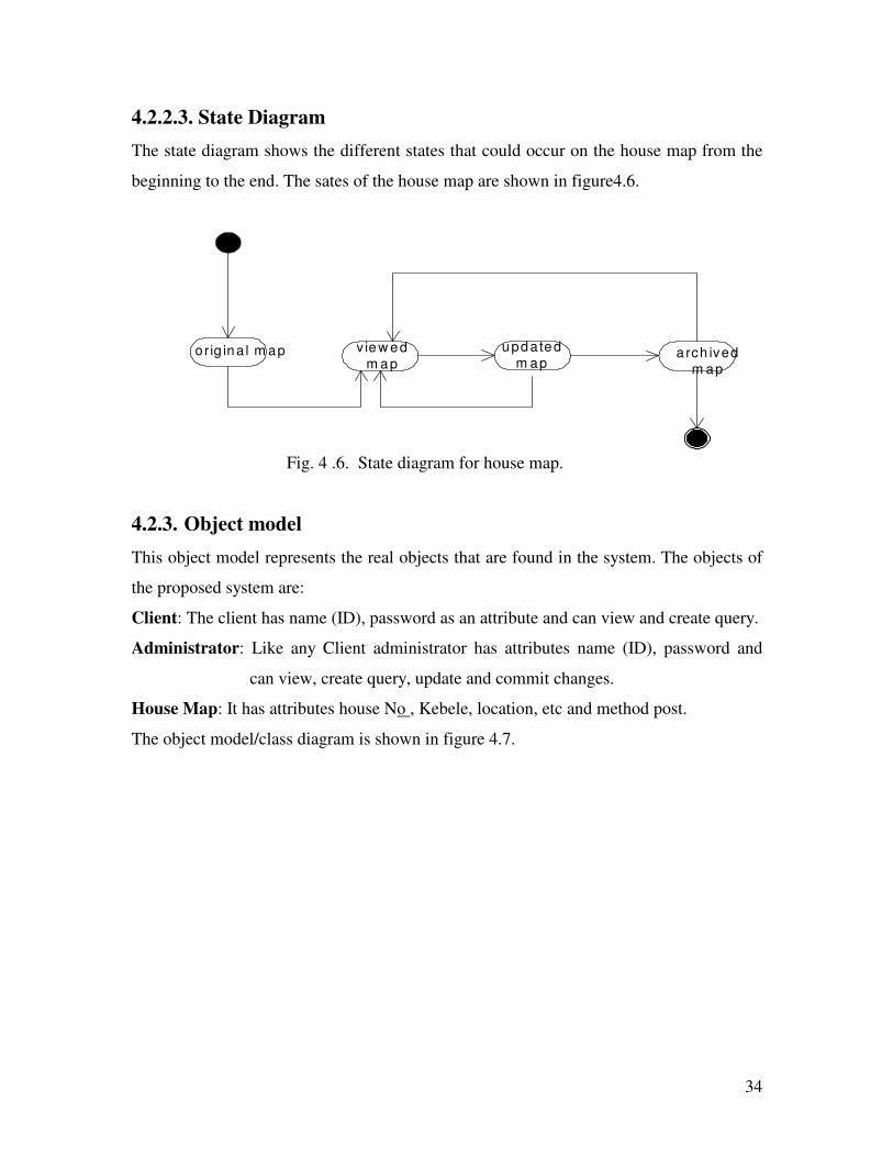
4.2.2.3. State Diagram The state diagram shows the different states that could occur on the house map from the
beginning to the end. The sates of the house map are shown in figure4.6.
v iew edm ap
updatedm ap
arch ivedm ap
orig ina l m ap
4.2.3. Object model This object model represents the real objects that are found in the system. The objects of
the proposed system are:
Client: The client has name (ID), password as an attribute and can view and create query.
Administrator: Like any Client administrator has attributes name (ID), password and
can view, create query, update and commit changes.
House Map: It has attributes house No , Kebele, location, etc and method post.
The object model/class diagram is shown in figure 4.7.
Fig. 4 .6. State diagram for house map.
35
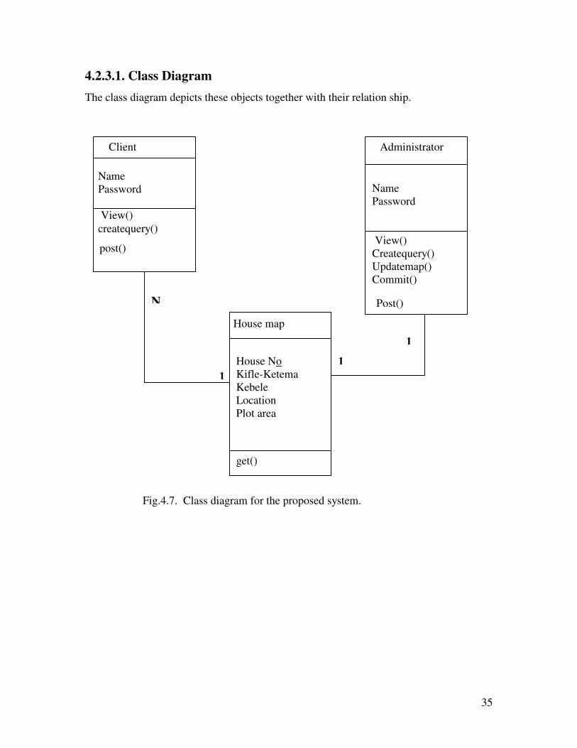
4.2.3.1. Class Diagram The class diagram depicts these objects together with their relation ship.
Client
Name Password View() createquery()
Administrator
Name Password View() Createquery() Updatemap() Commit()
House map
House No Kifle-Ketema Kebele Location Plot area
N
1 1
1
Fig.4.7. Class diagram for the proposed system.
post()
Post()
get()

36
4.3. Design of the System
The system design based on the requirements identified will have a client/server approach
in which the client will have web browser used for the interaction with the server and
display image map to the client. On the server side there will be secured web server with
map server software to convert the shape file format to HTML image generator. The
system design is depicted in figure.4. 8.
4.3.1 Hardware Software mapping
Internet-GIS enables to distribute geographic information in a variety of forms, including
maps, images, datasets, spatial analysis operations, and reports. Since Internet-GIS runs
on top of the Internet, it uses World Wide Web technology. To develop an Internet-GIS a
browser on the client side, secured web server that interacts with the browser and the
database will be integrated as shown in figure.4.9.
Client-computer
WWW Browser
Server computer
HTTP server software
HTML generator GIS software
GIS data
Fig.4.8. System design of the proposed system

37
Browser Web browser is a client program that uses the Hypertext Transfer Protocol (HTTP) to
make requests of Web servers throughout the Internet on behalf of the browser user.
The browser, shown in figure.4.9, enables the client to interact and display house map of
the city. This software requests texts and images from the web server and executes on the
clients machine.
The browser acts as an interface to the web server and represents multimedia information.
These interfaces are used to send map request to the web server and receive response to
view the map.
Web server Web server delivers Web pages to browsers and other files to applications via the HTTP
protocol. The web server processes requests for maps and related information. When a
request is received, the web server performs functions such as creating Cartographic map
image files (e.g. in JPEG or PNG format), streaming map features, searching to query the
database and extracting data to create a subset that can be sent back in shape file format.
Fig. 4.9. Hardware-software mapping for the proposed system.
Browser
Secured webserver
Database

38
Database
The database represents spatial and non-spatial house data together with client and
administration data. The database has an interface with the web server to provide raw
spatial and non-spatial data. The data, which are represented in the database, are shown in
figure.4.10.
The high level database design as it is given in [15] for the Housing agency that
integrates spatial and non-spatial information and which works together with other
systems of the city should full fill the following criteria.
Extensibility: for the system to work with other systems it should extensible.
Utility: the system should simplify the task of the workers, as the housing information is
critical.
Security: housing information is highly related to valuation and costing. So, it needs
higher security.
Based on this the database design should include the following components as it is given
in figure.4.11.
City address City address as a separate entity should be developed and used by other systems. So
standardized city address can be enforced.
Administrator Client
House map
Fig.4 .10.database representation of the Agency

39
Renters database This is with in the scope of housing Agency and is used to manage rental information for
governmentally owned houses. It represents renting agency address, Renter information,
and payment history.
Socioeconomic database This database represents the socioeconomic aspect like owner of the house, number of
residents, detail information of the house.
Other municipal information systems
This refers to any information system that will be developed by the CGAA.
� � � �� � � �� � � �� � � �� � � �� � � �� � � �� � � �� � � �� � � �� � � �� � � �
� �� � � � �� � �� �� � � � �� � �� �� � � � �� � �� �� � � � �� � �
�� � � ��� � � ��� � � ��� � � �
� ������ ��� �� ��� ������ ��� �� ��� ������ ��� �� ��� ������ ��� �� ��
�� � � ��� � � ��� � � ��� � � �
� � �� �
���� �� �
� � � �
� ��� � �� � �� � � ���
��� �� �� � �
Fig. 4 .11.High level database Design [15]

40
4.3.2. Deployment Diagram The deployment diagram for the Internet-GIS as shown in figure4.12, represents the
configuration of the run time processing nodes and other components of the system.
The different clients like Kifle-Ketemas , Land Administration office ,NGO’s etc can
access housing map of the city using the local area network connecting them.
Database
Local area network
Fig.4.12, Deployment diagram for the proposed system.
GIS SERVER
Internet
41
CHAPTER FIVE 5. The Prototype HISAA
5.1. Overview Internet technologies are offering advanced solutions for GIS problems. With Internet-
GIS spatial and non-spatial datasets can be provided to a broad range of users. Internet –
GIS has a lot of applications with different functionalities. Some of them could be Simple
functionalities like interactive mapping (zoom and pan) with spatial queries of the actual
data and a visual overlay of the information and also functionalities like measuring
distances, analysis and intersections of the data etc.
Nevertheless costs are playing an important role. So, a cost-effective Internet-GIS
solution for communities and counties based on Open-Source-software (OSS) is
desirable. Using OSS is advantageous in that it is possible to maintain the source code,
freely available and also will make independent from the sole-source company.
After investigating the problem of the Housing Agency of the CGAA and selecting the
appropriate tools and strategies to solve the problems, I have developed a prototype
called HISAA (housing Information system of Addis Ababa). With HISAA I demonstrate
the validity of the proposals I put forward to solve the problem of the housing Agency.
HISAA is an Internet-GIS based system developed using Map server. Map server is an
open-source-software that enables to publish map files on the web.
42
5.2.The environment and the tools used for the development of HISAA The prototype is developed for Real Estate and Housing management of CGAA. As it is
shown on the questionnaire analysis, the housing Agency doesn’t have an integrated
geographic information system with housing data set. Currently the Agency performs its
activities based on AutoCAD data stored on data CD. The CAD data represents Housing
maps for different Woredas of the city [17]. In this work I have considered only Woreda
01, which is one of the Woredas in the ARADA Kifle-Ketema.
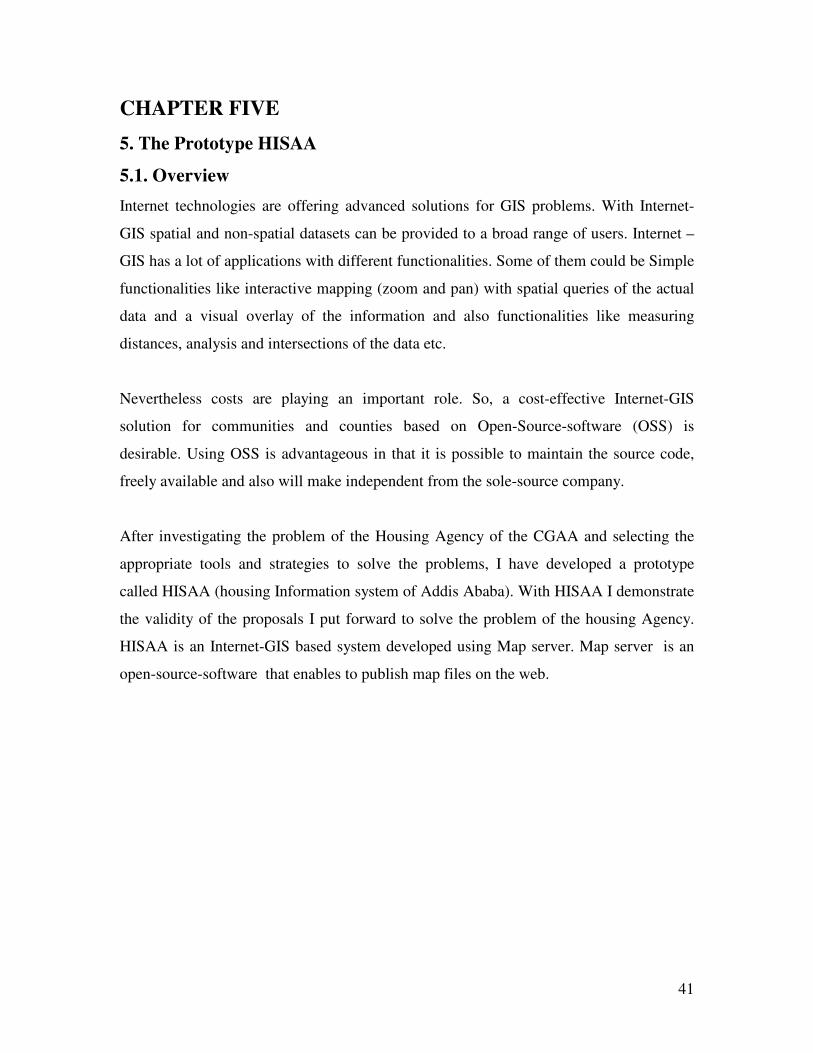
5.2.1. CAD Viewer.
The CAD Viewer allows viewing and printing CAD drawing files. It can be used either
as a stand-alone application, or as a 'Helper Application' for an Internet Browser.
The CAD viewer can be used to display CAD data as well as shape file. I have used this
tool to view the CAD data and compare it with the converted shape file.
The trial version of this software is available freely on www.guthcad.com.The operation
could be using menu or tabs as shown in figure.5.1.
Fig.5.1.Woreda01 House map on CAD Viewer.
Buttons
menu
43
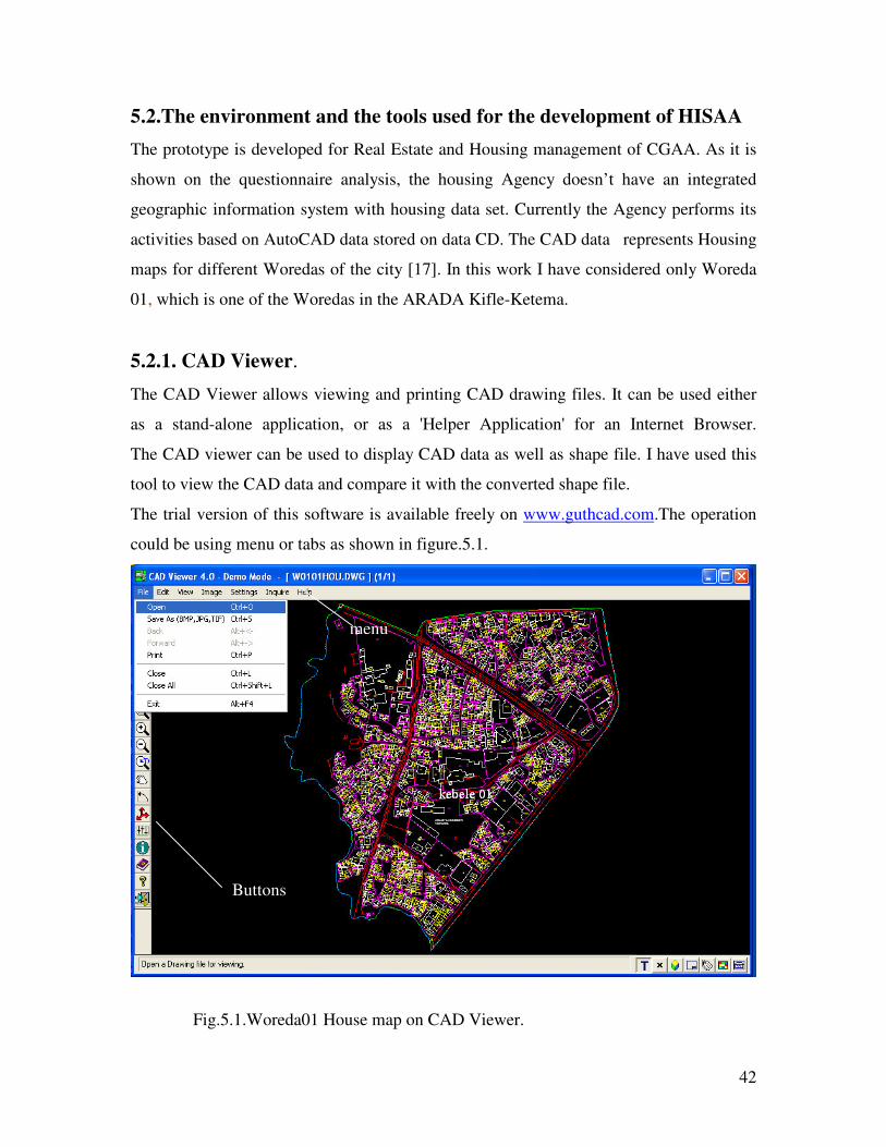
5.2.2. CAD to Shape file converter In order to make the CAD map usable in a GIS environment, the CAD files should be
converted to shape files. A CAD2Shape converter converts AutoCAD DXF or DWG
formats to ESRI / Arc View Shape files. This software is completely stand-alone i.e. does
not require Arc View. The trial version of the software can freely be downloaded from
www.guthcad.com.
I have used CAD2Shape converter to convert CAD data of Wereda01House map to shape
file. To convert CAD to Shape file, CAD2Shape presents a number of dialog boxes as
shown in figure.5.2, from which nearly all of its operations can be performed directly.
Drive &directory File name File type
Fig.5.2 CAD2shape file converter user interface.
Information area
44
As it is shown in figure.5.2, the top left hand corner of the CAD2Shape main dialog
consists of a built in Browse facility for locating the file for conversion. There are 4 list
boxes for selecting the Drive, Directory, File Type, and File name.
Select the DXF/DWG file to be converted by locating the file in the File Name list box.
When a file is selected, details about the file are displayed in the 'Information Area’.
The information that will be displayed are:
Name: The name of the file selected for conversion.
Length: The length in bytes of the file.
Min X,Y, Max X,Y: The minimum and maximum X,Y coordinate pairs of a box that
completely encloses the geometry contained in the CAD file.
Z Min,Max: The minimum and maximum Z coordinate values.
The Minimum and Maximum X, Y, Z values are all obtained from the DXF/DWG file
header EXTMIN, EXTMAX variables.
After this conversion setting will be selected. The Conversion settings are the options
that are going to applied to the conversion, such as which entities in the CAD file to
translate using the various Filter settings or Entity settings, and also the Attributes that
should be produced, and whether the output shape file should be 2D or 3D.
An important consideration when doing a translation from a CAD file to a Shape file is
that a single CAD file will generally contain many different entity types, whereas a shape
file can only contain entities of the same type (e.g. Points, Polylines, Polygons.)
Therefore typically a translation from CAD to Shape may require several separate
conversions, one for each shape file type. This is because when converted to polyline,
point and polygon data will not be considered .
Drawing.DWG Drawing_pt.SHP Translate Point entities
Drawing.DWG Drawing_lin.SHP Translate Polyline entities
Drawing.DWG Drawing_pol.SHP Translate Polygon entities
45
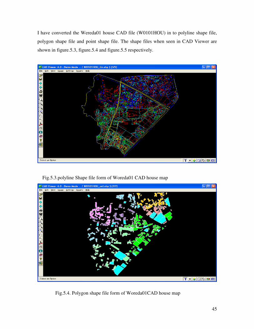
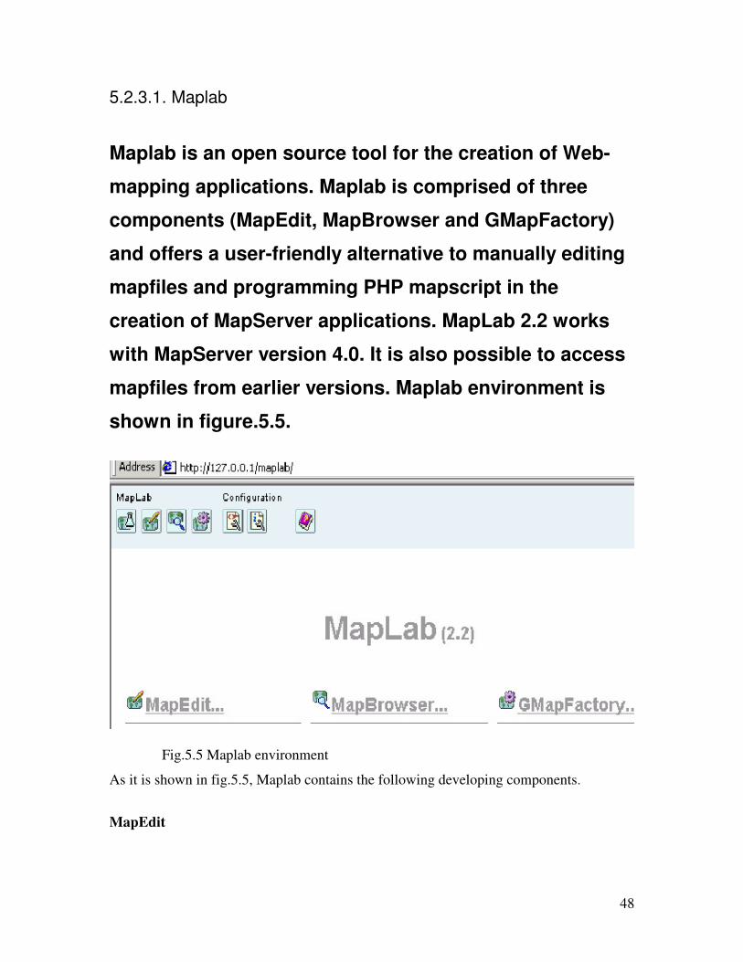
I have converted the Wereda01 house CAD file (W0101HOU) in to polyline shape file,
polygon shape file and point shape file. The shape files when seen in CAD Viewer are
shown in figure.5.3, figure.5.4 and figure.5.5 respectively.
Fig.5.3.polyline Shape file form of Woreda01 CAD house map
Fig.5.4. Polygon shape file form of Woreda01CAD house map

46
When we see the converted shape files, the CAD2Shape software did not include texts
written to the house map like House No, Kebele, etc.
5.2.3. Map server Map Server is an Open Source development environment for constructing spatially
enabled Internet-web applications. The software is build upon other popular Open Source
or freeware systems including Shape library, Free Type, Proj.4, GDAL/OGR
Map Server is known to compile on most versions of UNIX/Linux, Microsoft Windows
and even MacOS. The basic Map Server CGI application provides a significant number
of "out-of-the-box" features. The most important once as shown in [16] include Vector
formats like ESRI shapefiles, PostGIS, ESRI ArcSDE and many others via OGR and
Raster formats like TIFF/GeoTIFF, EPPL7 and many others via GDAL
Map Server supports several Open Geo-spatial Consortium web specifications. The Map
Server system includes Map Script that allows popular scripting languages such as PHP,
Perl, Python, and Java to access the Map Server API. Map Script provides a rich
environment for developing applications that integrate disparate data.
Fig.5.5. Point shape file form of Woreda01CAD house map

47
If the data have a spatial component, then it is possible to get the data via the favorite
scripting environment, and map it with Map Script. For example, using PHP it is possible
to integrate data from MySQL database.
Map Server allows creating geographic image maps. This is possible because it includes
the following utilities.
• Map Server Workbench – It is set of cooperative tools for development of Map
Server web mapping applications.
• Map Lab – It is an Open Source suite of web-based tools that allow for the easy
creation and management of Map Server web mapping applications and map files.
• Chameleon - A highly customizable and adaptable environment for deploying and
managing Web mapping applications. Chameleon incorporates the ability to
quickly set up new applications from a common pool of widgets that can be
placed in an HTML template file.
Map server software includes lots of packages like Apache version 2.0.50, PHP
version 4.3.7, Map Server CGI 4.2.1, 4.4.0, PHP Map Script 4.2.1, 4.4.0, etc.
48
5.2.3.1. Maplab
Maplab is an open source tool for the creation of Web-
mapping applications. Maplab is comprised of three
components (MapEdit, MapBrowser and GMapFactory)
and offers a user-friendly alternative to manually editing
mapfiles and programming PHP mapscript in the
creation of MapServer applications. MapLab 2.2 works
with MapServer version 4.0. It is also possible to access
mapfiles from earlier versions. Maplab environment is
shown in figure.5.5.
As it is shown in fig.5.5, Maplab contains the following developing components.
MapEdit
Fig.5.5 Maplab environment

49
MapEdit is a visual administration tool for the editing and management of map files.
MapEdit gives full control over all aspects of a map file and provides validation to ensure
the map file structure is correct. It also features a form-based interface for modifying
mapfile parameters, a fully navigable map preview, access to the raw mapfile, and
symbol,colour, font, and file selector dialogs.
Fig. 5.6, map edit work area.
As it is shown in figure 5.6,MapEdit is devised of three major parts: the Object Browser, the
Object Properties Frame and the Toolbar. The maplab buttons helps to navigate other components
of maplab. MapEdit works with map files, which are the basic configuration mechanisms for
MapServer.
In developing the mapfile of HISAA, MapEdit is used to represent the extent of the mapfile,
select the type of mapfile, path of the shape file, color of the mapfile, size of the mapfile and
create different layers of the mapfile. It is also possible to modify mapfile and access raw data of
the mapfile.
MapBrowser
Object property Object browser
Toolbar
50
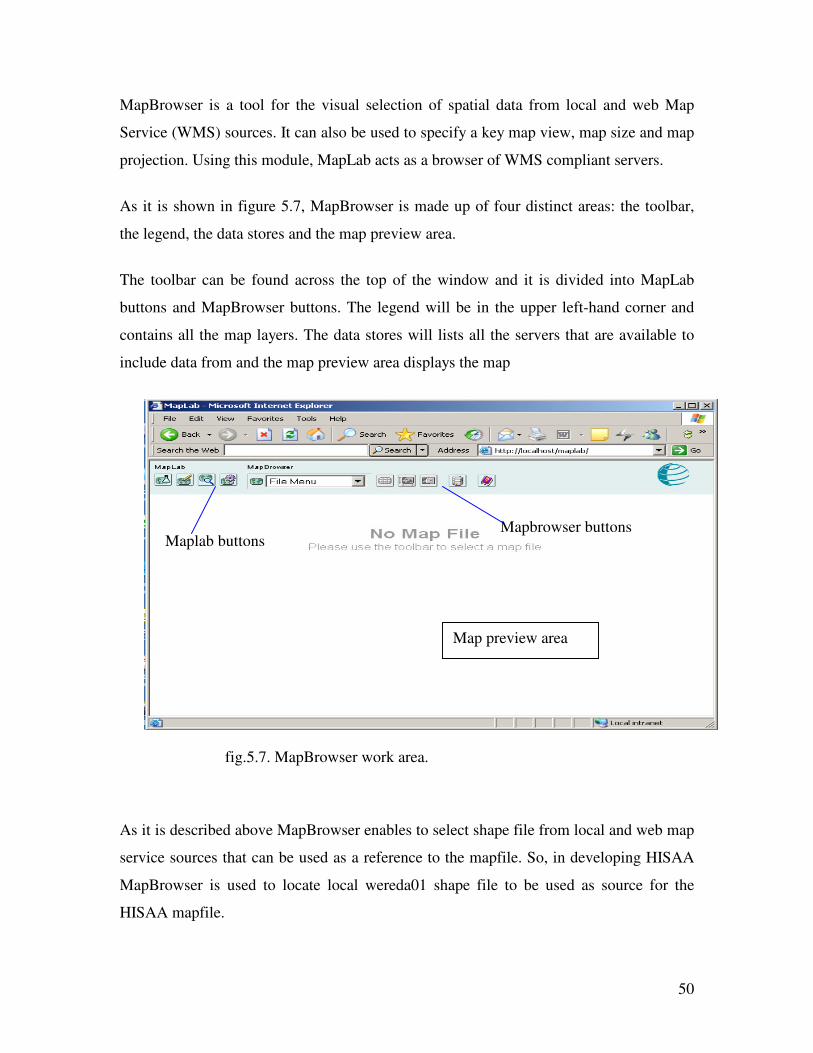
MapBrowser is a tool for the visual selection of spatial data from local and web Map
Service (WMS) sources. It can also be used to specify a key map view, map size and map
projection. Using this module, MapLab acts as a browser of WMS compliant servers.
As it is shown in figure 5.7, MapBrowser is made up of four distinct areas: the toolbar,
the legend, the data stores and the map preview area.
The toolbar can be found across the top of the window and it is divided into MapLab
buttons and MapBrowser buttons. The legend will be in the upper left-hand corner and
contains all the map layers. The data stores will lists all the servers that are available to
include data from and the map preview area displays the map
As it is described above MapBrowser enables to select shape file from local and web map
service sources that can be used as a reference to the mapfile. So, in developing HISAA
MapBrowser is used to locate local wereda01 shape file to be used as source for the
HISAA mapfile.
Mapbrowser buttons Maplab buttons
Map preview area
fig.5.7. MapBrowser work area.

51
GMapFactory
GmapFactory is an intuitive tool for the rapid creation and deployment of mapping applications.
GMapFactory can be used to define the layout of an application and specify which mapping
interface components to include.
To use GmapFactory, the first step is to create a folder to contain the project. There are
two ways to create an application depending on whether or not there is an application
open in MapLab. If the application is opened in mapLab, the path of the application will
be written on the project field of the GmapFactory and then the legend, map title and pan
and Zooming of the map will be adjusted. The other way of creating the application on
GmapFactory is by explicitly writing the path using the Browse button on the
GmapFactory. The work area of GmapFactory is shown in figure.5.8.
The layout of the mapfile for HISAA is created using GmapFactory. The interfaces of the
mapfile of HISAA, the legend, scale, position of the mapfile, buttons are determined
using GmapFactory. This component of the Maplab will result with a URL. Publishing of
the mapfile on the web is possible due to this component.
Fig.5.8. GmapFactory work area

52
5.3. Architecture of HISAA
Internet-GIS architecture is focused on a static environment in which users sit at
workstations to perform spatial analysis. Technologies such as the Internet are changing
the way GIS is being used.
This project is developed using OpenGIS map server software along with the Internet
where Web Mapping Service (WMS) produces maps of geo-referenced data.
The system profile for the development of this project is as follows
Software Function
Apache server 2.0.50 HTTP Web server
MS4W Map server
PHP 4.3.2 Server side scripting language
MYSQL RDBMS
The architecture of the HISAA is Client/server architecture. As it is shown in figure 5. 9,
the client sends URL request to the Web server and the Web server passes the request to
the GIS application server (map server), which runs an address matching routine,
generates a map graphic, convert the graphic to Web format, wraps the image in HTML
and sends it back to the Web server, which then returns the response to the client as a
standard Web page.
WWW Browser
Web sever
PHP
MS4W Map server
MYSQL
Internet
URL request
HTML image map
Request Query
Html pages

53
Fig.5.9, HISAA Architecture
5.4. Prototype Implementation
As it is described above to develop the prototype, the CAD file of Wereda 01is used. One
of the issues that any such system should support is security. So, any user of HISAA
should be authenticated before the housing map is displaying. Hence the user will be
asked for userID and Password depending on the privileges given.
To see as well as modify the map file the user/administrator should visit the Housing
agency website by typing the agency URL on their browser. The page that will be
displayed will require them to choose the privilege to login as it is shown in figure 5.10.
GIS data
Client Computer
Server computer

54
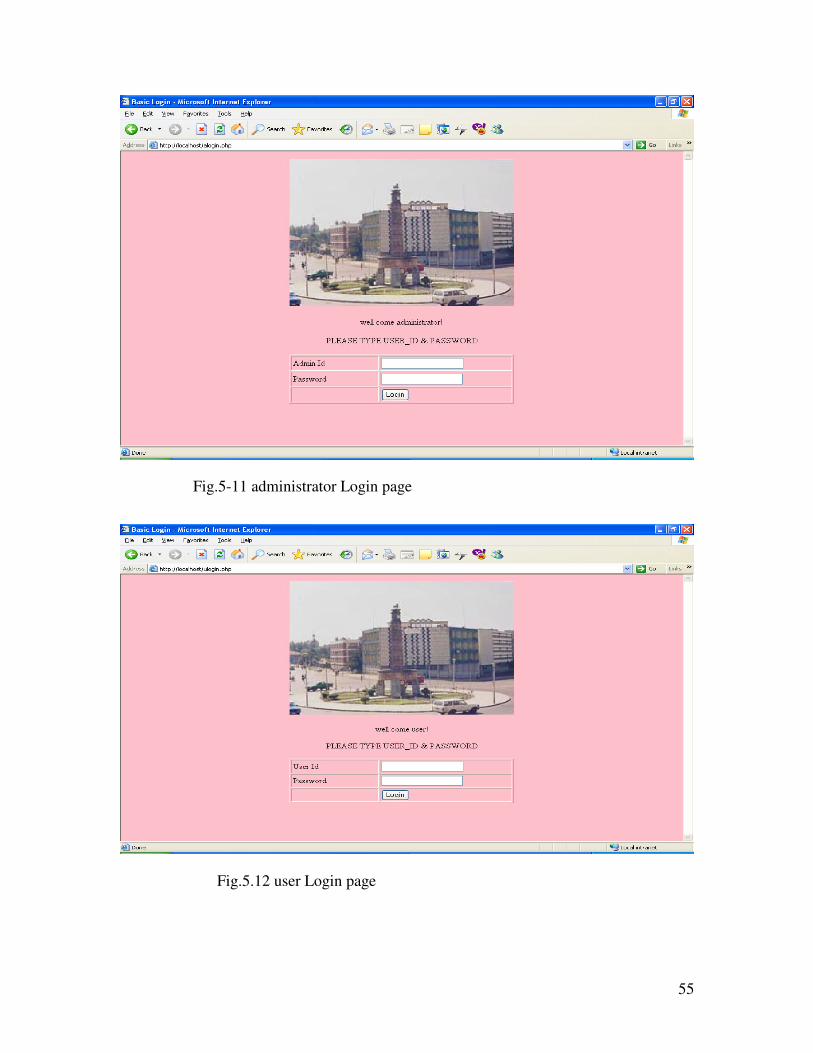
The user visiting the site will select and click either user button or Administrator button..
If the administrator button is clicked the administrator login form will be displayed,
figure 5.11. If the user button is clicked the user login form will be displayed, figure 5.12.
Fig.5.10. A screen shoot of the page that will be displayed to the user/administrator when visiting the Housing agency site.
55
Fig.5.12 user Login page
Fig.5-11 administrator Login page
56
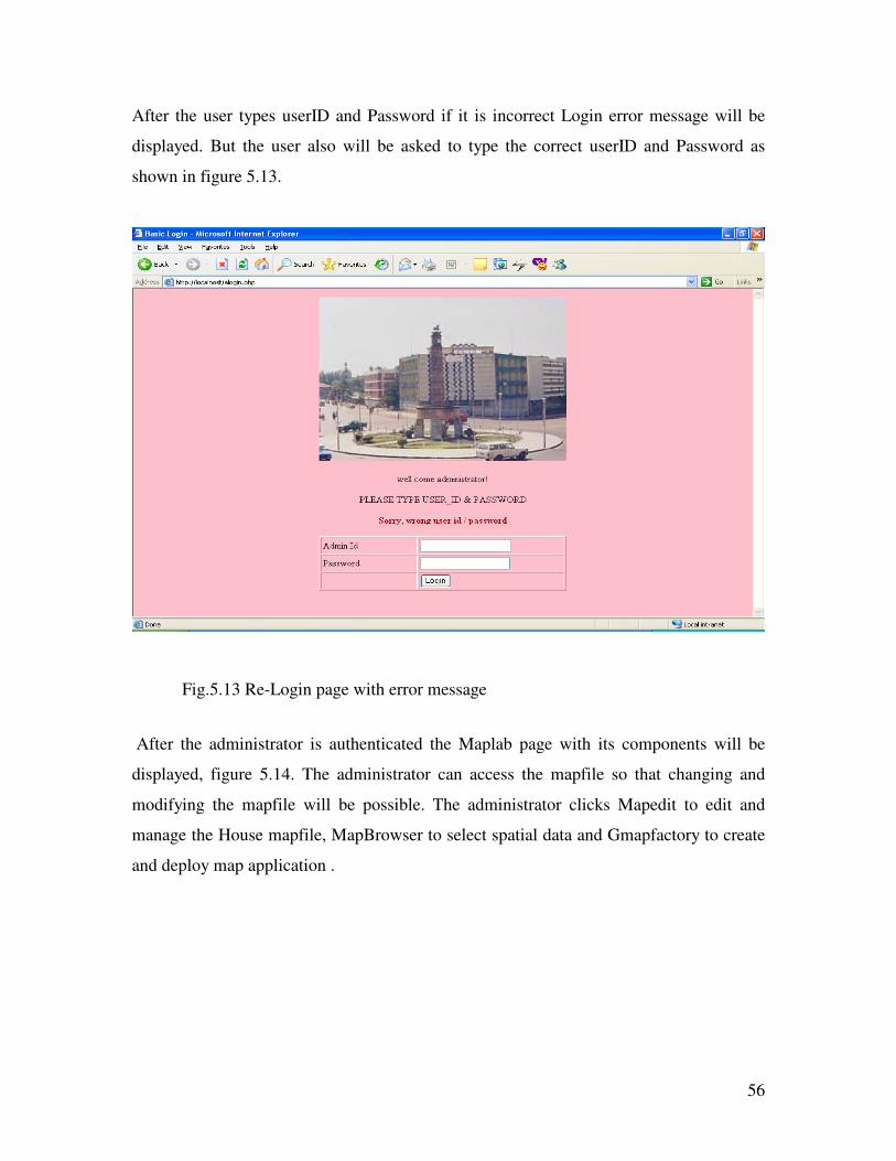
After the user types userID and Password if it is incorrect Login error message will be
displayed. But the user also will be asked to type the correct userID and Password as
shown in figure 5.13.
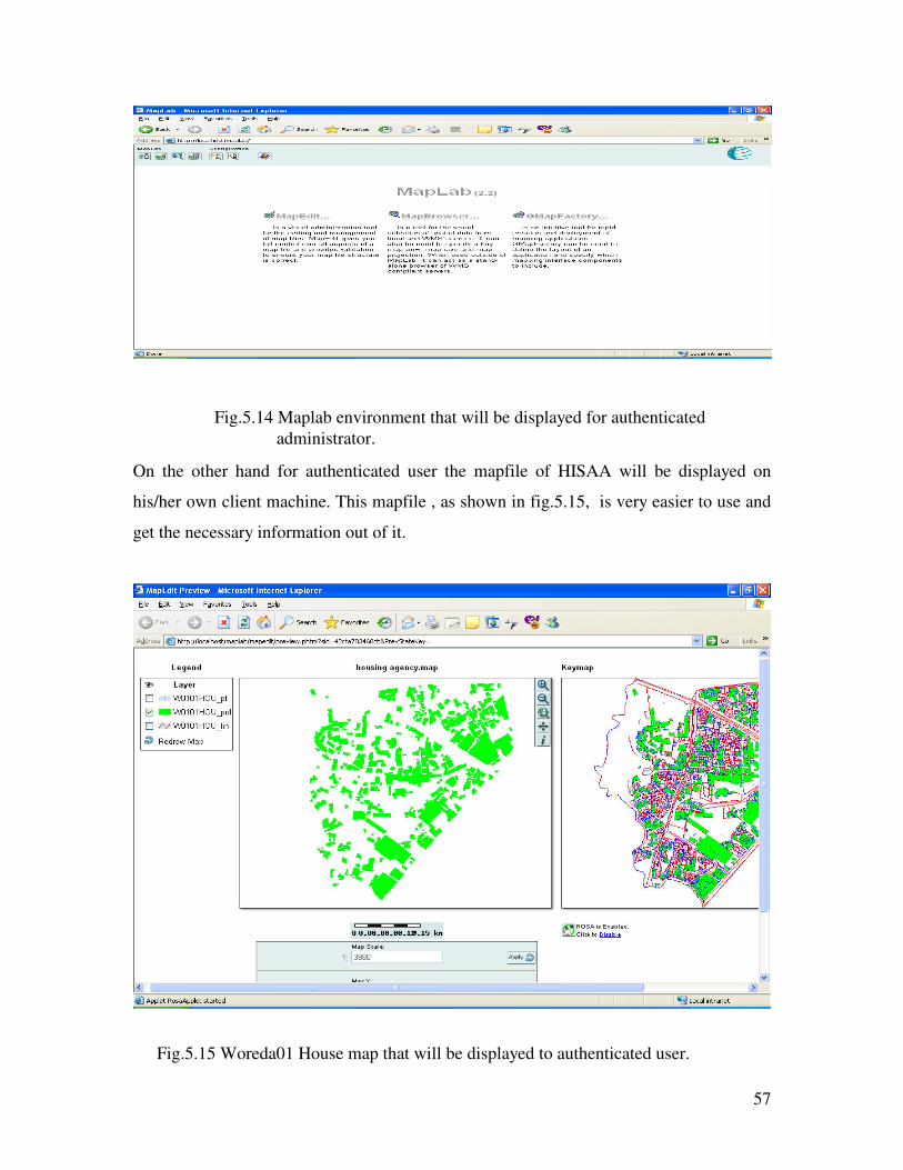
After the administrator is authenticated the Maplab page with its components will be
displayed, figure 5.14. The administrator can access the mapfile so that changing and
modifying the mapfile will be possible. The administrator clicks Mapedit to edit and
manage the House mapfile, MapBrowser to select spatial data and Gmapfactory to create
and deploy map application .
Fig.5.13 Re-Login page with error message
57
On the other hand for authenticated user the mapfile of HISAA will be displayed on
his/her own client machine. This mapfile , as shown in fig.5.15, is very easier to use and
get the necessary information out of it.
Fig.5.14 Maplab environment that will be displayed for authenticated administrator.
Fig.5.15 Woreda01 House map that will be displayed to authenticated user.

58
On the left corner there is a legend using which the user can add /remove layers fond in
it. The map displayed is the active layer on the legend,which is the Wereda01 House-pol
map. If the user adds the Wereda01house_lin map on the legend and clicks the re-draw
map hyperlink on his own machine, the mapfile with two layers will be displayed which
is shown in figure.5.16. And with the three layers together is shown in figure 5.17.
Fig. 5.16. Map file with Wereda01-pol and wereda01-lin layers together.
Fig. 5.17. Map file with Wereda01-pol, wereda01-lin and Wereda01-pt layers t together.
59
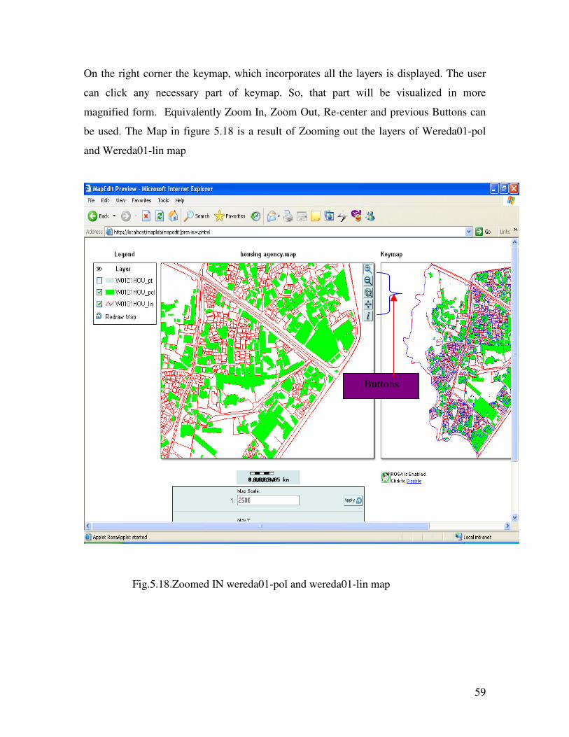
On the right corner the keymap, which incorporates all the layers is displayed. The user
can click any necessary part of keymap. So, that part will be visualized in more
magnified form. Equivalently Zoom In, Zoom Out, Re-center and previous Buttons can
be used. The Map in figure 5.18 is a result of Zooming out the layers of Wereda01-pol
and Wereda01-lin map
Buttons
Fig.5.18.Zoomed IN wereda01-pol and wereda01-lin map
60
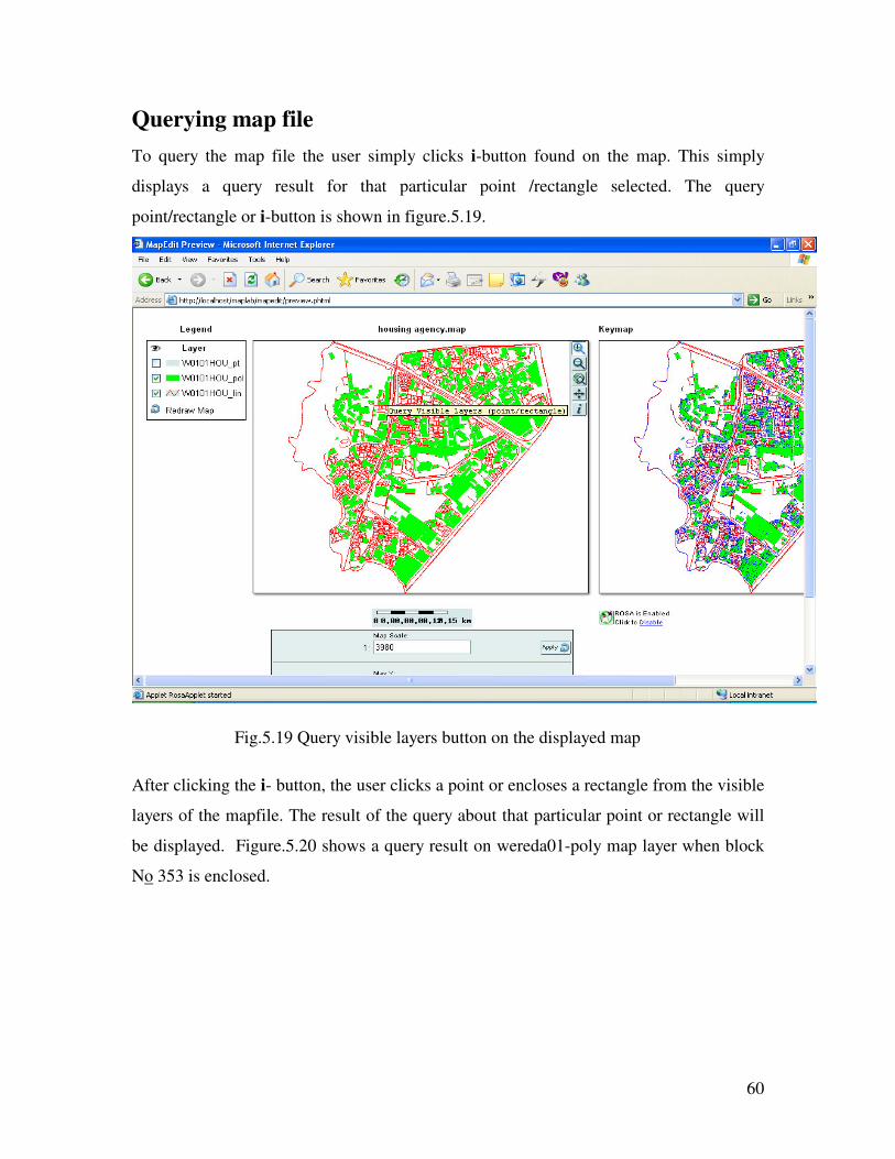
Querying map file To query the map file the user simply clicks i-button found on the map. This simply
displays a query result for that particular point /rectangle selected. The query
point/rectangle or i-button is shown in figure.5.19.
After clicking the i- button, the user clicks a point or encloses a rectangle from the visible
layers of the mapfile. The result of the query about that particular point or rectangle will
be displayed. Figure.5.20 shows a query result on wereda01-poly map layer when block
No 353 is enclosed.
Fig.5.19 Query visible layers button on the displayed map
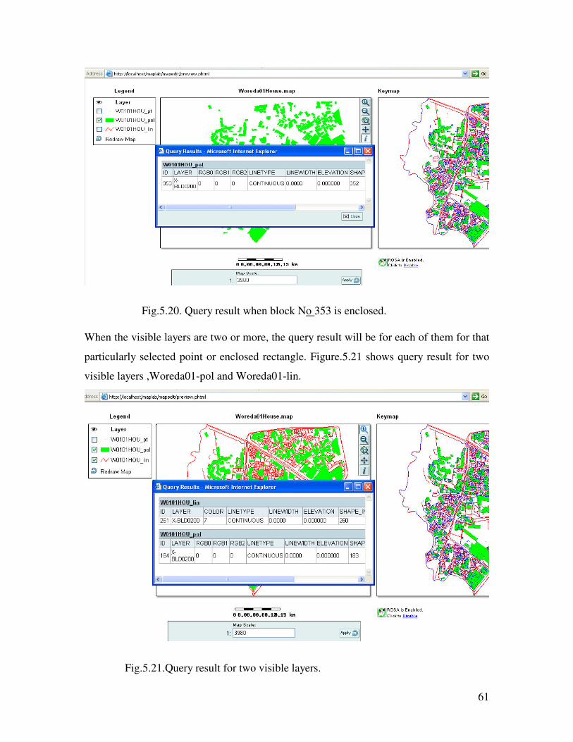
61
When the visible layers are two or more, the query result will be for each of them for that
particularly selected point or enclosed rectangle. Figure.5.21 shows query result for two
visible layers ,Woreda01-pol and Woreda01-lin.
Fig.5.20. Query result when block No 353 is enclosed.
Fig.5.21.Query result for two visible layers.
62
CHAPTER SIX
6. Conclusions and future works
6.1. Conclusion
The Housing Agency of the city government of Addis Ababa is responsible for the
organization and management of governmentally and privately owned houses. The
current administration of the city decided to decentralize its functions into Kifle-Ketema
and Woreda level. This however requires a very high need of communication between the
Kifle-Ketemas, the weredas, the agency and the other Authorities of the city such as Land
Administration Authority.
With the help of questionnaires and close observation, I have identified the major
problems of the Agency related to data management and communication requirement.
The problem analysis shows that the Housing Agency doesn’t use integrated geographic
information system. But the Agency is responsible for the management and policy
development for house ownership and constructions in the city. In order to facilitate this
activities efficiently, the Agency decentralized the responsibilities to Kifle-Ketema level.
But each of the ten Kifle-Ketemas, even if it needs geo-referenced data for proper site
selection and site plan development, uses CAD data only to use it as a visualization
application. Which makes their activities redundant and prone to errors.
Further more a close observation is conducted to investigate the current functioning and
the system that the Agency and the Kifle-Ketemas are using. From this observation, I
have identified that what they are using is a CAD map file for housing and land
management. A CAD file however is not query-able and is difficult to use when it comes
to the current decentralized functioning of the Agency.
The housing Agency of the CGAA as a service provider should be able to develop geo-
spatial database containing interrelated data sets as shown in the database design of the
project. More over all the offices and other stake holders of the Agency should have
network connection to the Agency

63
In this work an appropriate system using Internet-GIS is recommended for Real Estate
and house management of the CGAA. For the realization of the proposed system:
• The necessary tools required for the development of the prototype
are identified.
• The existing models are investigated and the one with better
advantage is selected.
• A general architectural design and detailed database and network
design are presented.
• Considering the importance of existing CAD based map file, the
necessary tools needed to convert this CAD file to proposed
system file is identified.
Most importantly for the proposed system, appropriate open source software is identified.
By using Open Source solutions the opportunities for participation of others at the
development stage exists. The solutions often fit better to the needs of the users, because
users may themselves be developers of system components. Open source software are
cost free, easy for maintenance and users will not be dependent on the source code
developer company.
To demonstrate the validity of my proposal a prototype called HISAA is developed.
HISAA is developed using mapserver, which is open source software. HISAA has user-
friendly interface and incorporates the necessary security mechanisms. A user on a client
machine having connection to the network can display mapfile on his/her standard
browser from HISAA and can zoom, pan or query the map as needed.

64
6. 2. Future Work
HISAA is developed using CAD file of only one Woreda of the ARADA Kifle-Ketema.
So, for the full-fledged development of the system it needs to be done using the house
map of the city.
The other one is that, Mapservcer, an open source software, can support different
languages. So an Internet-GIS application in Ethiopic language can further be developed
based on this project.
Wireless technology now a days is developing rapidly through out the world and also
here in our country too. So, Wireless GIS ensures that it can provide users with more
meaningful and timely information. By empowering field personnel with the
responsibility of data acquisition, uploading, editing and verification, Wireless GIS
applications have the capability of bringing field and office activities into a collaborative
environment that can further improve productivity, reduce costs and minimize project
completion timeframes. So wireless-GIS can be other related application that can be
considered later.
At last it can be an initiative to other cities of the country and if all are networked it could
be possible to have a system for all housing map in country level, which will have
importance in allocating investors that can construct industries and other public service
giving organizations.

65
Reference
1. Phisan Santitamnon., Comparative Assessment of internet GIS server system, 2001, ASIA, GISDevelopment, http://www.gisdevelopment.net/utilities/htm, visited on March 16,2005
2. Andress Muller etal. , Establishment of an urban information and database system of Addis Ababa , 2004, Addis Ababa
3. Arun Gopalan ,Platform for Internet GIS,2001, ASIA, GISDevelopment,http://www.gisdevelopment.net/utilities/htm , visited on march 16,2005
4. Lan Heywood etal , An introduction to Geographical information system, second edition, 2002,USA
5. G.K.Tripathy ,Web-GIS based urban planning and information system for Municipal Corporation, 2001, ASIA, GISDevelopment, http://www.gisdevelopment.net/technology/intgis/techig0007.htm, visited on march 18,2005
6. Zhong-Ren Peng, Internet GIS and its application in transportation,1998,
University of Wisconsin, http://www.uwm.edu/gisproj/intrnetgis.htm, visited on March 18, 2005
7. Li Su-Min and Shi Kun , Feasible Research on the Construction of Web GIS in Greater Mekong Sub-region
Kunming University of Science and Technology, 2002,CHINA, http://www.ait.ac.th/digital_gms/ Proceedings/A13_LI_SHU_MIN.pdf, Visited on April 20,2005
8. Andrew S.Tanenbaum, Computer Network, fourth edition, 2003, USA 9. Dang Van Duc, MapOnline – A Geographical Information Service on
Internet, 2000, ,NCST of Vietnam, http://www.car.busmgt.ulst.ac.uk/papers/duc.pdf ,visited on April 20, 2003
10. Albert K. Yeung, World Wide Web Basics, 2000, Ontario Ministry of Northern Development and Mines, Canada, http://www.ncgia.ucsb.edu/education/curricula/giscc/units/u148/u148.html#top, visited on April 20, 2005
11. Kenneth E. Foote and Anthony P. Kirvan , Web-GIS, University of Texas,1998,U.S.A.,
http://www.ncgia.ucsb.edu/education/curricula/giscc/units/u133/u133.html, visited on April 20, 2005

66
12. Ulrike Weise, Internet-GIS , 2001,
http://www.geog.ubc.ca/courses/geog516/talks_2001/internetgis.htm, visited on April 20, 2005
13. Phuoc Tran Vinh etal, To apply the GIS for Land-Use and Housing Management in a District of Hochiminh City, 2002,Vietnam, GISDevelopment, http://www.gisdevelopment.net/application/urban/overview/ma03068.htm, visited on april 20,2005
14. P. Korduan, Internet-GIS development for municipalities and counties based open source software, 2001,Germany, http://www.isprs.org/istanbul2004/comm4/papers/330.pdf visited on April 20,2005
15. Dawit Bulcha and Fekade Getahun, Manucipal GIS for Housing Agency of CGAA, 2004,Department of computer science Course project work, Addis Ababa.
16. Mapserver, 2003, university of Minnesota, http://mapserver.gis.umn.edu/, visited on May 20, 2005
Wereda 01 CAD file, 2000, ARADA Kifle-Ketema, Addis Ababa

67
This Project work has not been presented for a degree in any other university, and that all
sources of material used for the project have been duly acknowledged.
Name Signature
Ayalew Belay ____________________________
Advisor Confirmation
Name Signature
Dr. Solomon Atnafu ___________________________
Related Documents