19 “Interesting. But I Haven’t Thought of This Before.” – Exploration on Teachers’ Attitude Towards Critical Cartography in Educational Environments Inga GRYL Abstract Critical cartography and Critical GIScience claim that geomedia are powerful construc- tions, and instruments to generate hypotheses and produce geographies. In geographic edu- cational literature, however, up to now most of the rare applications of these theories that should enable learners to exercise a reflexive action with geomedia in everyday life remain simplistic and cover only a minor part of the whole idea. However, educational literature is only one indicator for practical work in schools. There- fore, this work-in-progress study investigates whether teaching in schools is in fact free from ideas coming from Critical Cartography or Critical GIScience. The results may pro- vide concepts how literature for teachers could take up this background theory and how teachers of different target groups could be attracted by teacher training to develop their reflexive geomedia competence. 1 Prologue To begin with, I would like to start with an anecdote that happened during a course for university students who are prospective geography teachers. Please note that this is just one situation taken from the kaleidoscope of everyday teaching and learning at University and is not representative of all our students’ skills but merely serves to illustrate my issue. Therefore, the persons remain anonymous. One day two of my students handed in a work sheet for proof-reading. This work sheet was designed to help pupils to learn how to work with maps. One exercise was about placing a ruler on a world map in order to measure some huge distances and to find out which coun- tries would be passed along the shortest way between two points. First, I was convinced that this was meant as a trick question for the pupils. It was a possible idea to understand and unbundle contradictions and use them as incentives for learning. But when I talked with them about the exercise, I realized that they were serious. They had completely forgotten that projecting the world onto a flat map distorts distances and spaces. A map with a small scale can only be true scale along a few well-defined lines. The example shows that not everybody who presumably knows how „to read“ a map is aware that a map (respectively a geomedium 1 ) cannot display the world, but is a construc- 1 In a concept of reflexive geomedia competence geomedia can be potentially all media that repre- sent spaces (see JEKEL et al. 2010). Geomedia therefore may be maps, globes, digital globes, digital maps, geoinformation systems, pictures with connection to space, and running texts that refer to Jekel, T, Koller, A., Donert, K. & Vogler, R. (Eds.) (2011): Learning with GI 2011. © Herbert Wichmann Verlag, VDE VERLAG GMBH, Berlin/Offenbach. ISBN 978-3-87907-510-2. This article is an open access article distributed under the terms and conditions of the Creative Commons Attribution license (http://creativecommons.org/licenses/by/3.0/).

Welcome message from author
This document is posted to help you gain knowledge. Please leave a comment to let me know what you think about it! Share it to your friends and learn new things together.
Transcript
19
“Interesting. But I Haven’t Thought of This Before.” – Exploration on Teachers’ Attitude Towards Critical
Cartography in Educational Environments
Inga GRYL
Abstract
Critical cartography and Critical GIScience claim that geomedia are powerful construc-tions, and instruments to generate hypotheses and produce geographies. In geographic edu-cational literature, however, up to now most of the rare applications of these theories that should enable learners to exercise a reflexive action with geomedia in everyday life remain simplistic and cover only a minor part of the whole idea.
However, educational literature is only one indicator for practical work in schools. There-fore, this work-in-progress study investigates whether teaching in schools is in fact free from ideas coming from Critical Cartography or Critical GIScience. The results may pro-vide concepts how literature for teachers could take up this background theory and how teachers of different target groups could be attracted by teacher training to develop their reflexive geomedia competence.
1 Prologue
To begin with, I would like to start with an anecdote that happened during a course for university students who are prospective geography teachers. Please note that this is just one situation taken from the kaleidoscope of everyday teaching and learning at University and is not representative of all our students’ skills but merely serves to illustrate my issue. Therefore, the persons remain anonymous.
One day two of my students handed in a work sheet for proof-reading. This work sheet was designed to help pupils to learn how to work with maps. One exercise was about placing a ruler on a world map in order to measure some huge distances and to find out which coun-tries would be passed along the shortest way between two points. First, I was convinced that this was meant as a trick question for the pupils. It was a possible idea to understand and unbundle contradictions and use them as incentives for learning. But when I talked with them about the exercise, I realized that they were serious. They had completely forgotten that projecting the world onto a flat map distorts distances and spaces. A map with a small scale can only be true scale along a few well-defined lines.
The example shows that not everybody who presumably knows how „to read“ a map is aware that a map (respectively a geomedium1) cannot display the world, but is a construc-
1 In a concept of reflexive geomedia competence geomedia can be potentially all media that repre-
sent spaces (see JEKEL et al. 2010). Geomedia therefore may be maps, globes, digital globes, digital maps, geoinformation systems, pictures with connection to space, and running texts that refer to
Jekel, T, Koller, A., Donert, K. & Vogler, R. (Eds.) (2011): Learning with GI 2011. © Herbert Wichmann Verlag, VDE VERLAG GMBH, Berlin/Offenbach. ISBN 978-3-87907-510-2. This article is an open access article distributed under the terms and conditions of the Creative Commons Attribution license (http://creativecommons.org/licenses/by/3.0/).
I. Gryl 20
tion. Knowing about the basic geometric construction and generalization principles in car-tography is just one aspect of what the theory of Critical Cartography provides. Distortion in map geometries may be a good analogy to the whole problem of constructedness of maps and of map reading as well. Turning a map upside-down may show that there is more than one possible perspective on the world and more than one way to represent it. Nevertheless, the variation of perspectives may not be reduced to geometric ones, and also not to those produced by the author’s side. Yet, most of the few educational approaches that proclaim to further a critical attitude towards maps remain either at this rather technical viewpoint, taking the analogy for the problem itself, or reduce the construction to the author’s con-scious intentions, possibly creating dichotomies between ‘false’ and ‘true’ maps, and reality and distortion (see GERSMEHL 2005, HEYDEN 2005, MAREK 2009). Although these exam-ples are practical and valuable introductions at school, they lead to (often simplified) me-dia-critical reflection, but not to reflexive work. They cover only a part of what should be meant when talking about a reflexive geomedia competence, inspired by today’s Critical Cartography and Critical GIScience.
Consequently, the first point to do in this paper is to define a reflexive geomedia compe-tence. Some theoretical basics on teachers’ competence development will follow in section 3, as teachers are the main focus of this study. Studying teachers is a worthwhile enterprise because of their role as disseminators of their students’ competence development (SEITZ 2008). For what teachers do not know is not taught at school, whatever the curriculum says. An overview is given on my explorative studies in section 4. They provide first results to the main question, if there is Critical Cartography at school, and improve the method of the main study, which is presented in section 5. This study is still work in progress, meaning that neither the data collection nor the analysis have been finished yet. Therefore, only a few tentative results can be displayed in the results section 6. Finally, an outlook on upcom-ing and potential research activities on the specific topic will follow in section 7.
2 Towards a Definition of Reflexive Geomedia Competence
For defining a reflexive geomedia competence, first of all, the parts of this term are defined below. Following SCHNEIDER (2010) reflection needs to be distinguished from reflexivity. Reflection means thinking about a thing, reflexivity to think about one’s own action and thought process (GLASERSFELD 1997) and thereby extends the concept of reflection. Both allow for obtaining cognition and require changes in perspectives (RHODE-JÜCHTERN 1996). Based on the idea of multi-perspectivity, constructivism can be seen as adequate theoretical basis for reflection and reflexivity (LUHMANN 1998). Ideas of reflection and reflexivity are also known in pedagogical psychology (AEBLI 1980). With regard to media pedagogy reflection can be seen as the classical media critique (regarding geomedia, see MONMONIER 1996). As reflexivity is an extension of reflection, and therefore includes the latter, I speak of a reflexive geomedia competence, taking the broader term for naming.
places and spaces. I am aware that the “Leitmedium” (RINSCHEDE 2003) of geographical education is often seen in cartographic representations of space. Additionally, schools often lack of the op-portunity to work with digital geomedia. Therefore, in the context of this study the broad definition of geomedia is reduced mainly to analogue maps, plus a few digital applications.
“Interesting. But I Haven’t Thought of This Before.” 21
Both reflection and reflexivity are applied by Critical Cartography and Critical GIScience when working with geomedia. Since their emergence in the middle of the twentieth century these theories developed: It started with the map communication model (ROBINSON 1952), stating a conviction of the existence of a perfect, user-orientated map to communicate in-formation of the world, flanked with ideas of manipulation of maps (see MONMONIER 1996) popular still today and dominating Critical Cartography education (see HEYDEN 2005, MAREK 2009). Seeing geomedia as general constructions, displaying only a certain perspective and revealing others and thereby simplify problems is the main focus of HARLEY’s “Deconstructing the map” (1989). Hereby, not only the author’s intentional “manipulations” or user-orientation are mentioned, but also unconscious, discourse-lead decisions, displaying limited world views. The idea of constructedness is to be found in Critical GIScience as well (see SCHUURMAN 2004), independent from the higher degree of freedom/interactivity the user is given.
HARLEY’s method of deconstruction seems adequate for a reflective and possibly reflexive approach to geomedia. According to constructivist theories of making geographies (PAASI 1986, WERLEN 1995), humans assign meanings to objects of physical space of a diversity of possible meanings. These produced meanings shape their action. In order to naturalize those meanings (which makes them seem as if they were the only possible ones) and share them with others, the meanings need to be communicated by geomedia, using signs. As those signs display a selection of meanings, the geomedia signs themselves have borders of meaning. According to DERRIDA (1974), whom HARLEY refers to, identifying those borders means to deconstruct them. In order to deconstruct geomedia signs we need to change our perspective. To mention an example: A map about “development” might mark “developing countries”. While most people claim to know what a developing country is, the term has many, often unnoticed borders, namely the selection of indicators, threshold values, and homogenization of disparities in states. Taking a perspective beyond the obvious meaning of the term is necessary to identify its borders. Though deconstruction of a map bases on a highly eclectic theoretical background (BELYEA 1992, CRAMPTON 2001), I would hold that it is a promising method for school and everyday map working (GRYL 2010). Following HARLEY (1989) deconstruction can be understood as reflection (see definition above) of conscious and unconscious author’s decisions in a developed tradition of media critique.
The more recent approaches of taking maps as instruments for hypotheses generation (MACEACHREN 1992, CRAMPTON 2001) account for reflexivity, while focusing on the con-sumer. In contrast to the classical map communication model, meanings cannot be trans-ferred directly from the author to the consumer. Because of individual socialization (and being a member of several discourses), interests, and intentions there is a shift of meaning from the author’s to the consumer’s side (following for instance theories from DERRIDA: CLEMENS & LESKAU 2009). The consumer does not read meanings directly, but actively constructs own hypotheses that could be useful for the problem he or she faces. Reflexivity means being aware of the own production process and its conditions (own background and worldview, social discourses, and the geomedium the author has produced). Pushing this idea further, reflexivity is necessary during reflection as well. This could be called „second order reflexivity“. Understanding the own thoughts as construction may lead to an ongoing deconstruction of deconstructions. This brings the idea again nearer to DERRIDA’s original theory of an ongoing dialectic of deconstruction (DÖRFLER 2005). For the school context an adequate amount of reflection and reflexivity must be found.
I. Gryl 22
While the first part of the term reflexive geomedia competence is now defined, the term competence needs further clarification. Following WEINERT’s widely disseminated defini-tion in the German competence debate, a competence “combines those intellectual abilities, content‐specific knowledge, cognitive skills, domain‐specific strategies, routines and sub-routines, motivational tendencies, volitional control systems, personal value orientations, and social behaviors into a complex system” (WEINERT 2001:51). The usage of this well-known definition does not include following the equally widely spread research praxis of measuring competences with quantified standardized tests. A quantified model is hardly possible because especially reflexivity is a complex process, by now only described by an abstract term. Some constituting elements of the competence may become visible through qualitative research on the interface of theory and praxis. For instance, exploration (see section 4) has shown, that in accordance with WEINERT’s definition, not only cognitive, but also emotional and volitional abilities play a specific role. Reflection and reflexivity may distort orientation and securities, deconstructing simplicities and widening complexity. Therefore, reflexive geomedia competence requires additionally a competence to handle uncertainty (RHODE-JÜCHTERN & SCHNEIDER 2009). Following literature and explorative studies, I would like to define three elements of a reflexive geomedia competence: a) an emotional readiness to acknowledge uncertainty, b) knowledge about constructedness of geomedia (and thereby spaces) and geomedia consumption, and c) knowledge of applicable methods of deconstruction and reflexivity while using geomedia.
Normatively (as deducted from theory) and eclectically defined, reflexive geomedia compe-tence consists of the ability for reflection and reflexivity. Defining a reflexive geomedia competence becomes even more complicated when it comes to the competences of those who ideally teach this competence.
3 Teachers as Disseminators of Students’ Competence Development
Teachers need to be competent in that what they teach their students. Additionally they need to know how to convey the subject (pedagogical competence). Teachers develop their scientific and pedagogical competences during their entire learning career, starting from own experiences in school, their teacher training at university, apprenticeship while in school, and learning on the job (HERRMANN & HERTRAMPH 2002). Stimuli outside conven-tional institutions may contribute to both scientific and pedagogical knowledge as well. Schools and most other institutions for teacher education are, in the case of Germany, rela-tively closed systems (OELKERS 2005). Teachers train prospective teachers in a kind of apprenticeship, teachers provide further training for teachers, and educational literature is written by teachers. Sharing ideas while being in the same context is not a bad idea, though working exclusively in this environment, which is not free of hierarchical dependencies (see especially teacher traineeship), may stifle innovations (HERRMANN & HERTRAMPH 2002). Innovations often base on ideas that result from taking new perspectives, leaving everyday discourses.
As approaches for a reflexive geomedia competence and a pedagogical reflexive geomedia competence are hardly to be found in geographic educational literature, they can be regard-ed as innovations as well. My empirical study tries to find out whether these ideas neverthe-
“Interesting. But I Haven’t Thought of This Before.” 23
less play a role for teachers. Additionally, empirical studies can refine the theory-led defini-tions of those competences as well. With regard to teaching theory the influencing factors of this competence could be the following ones: a) teachers’ pedagogical competences regarding the conveyance of reflexive geomedia competence, b) diagnostic competence (HELMKE 2003), as teachers need to know how competent pupils are and how they become competent; c) self-efficacy as teachers (BANDURA 1986), because they need to be con-vinced that they are competent and can teach the competence to their pupils; d) professional identity regarding teaching aims and role of the subject (KANWISCHER et al. 2004), as they need to be sure that that geomedia reflexivity makes sense, and that this competence devel-opment should be part of their (subjective) curriculum.
4 The Explorative Stage – First Insights into the ‘Black Box’ School
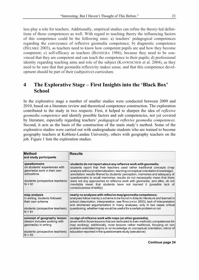
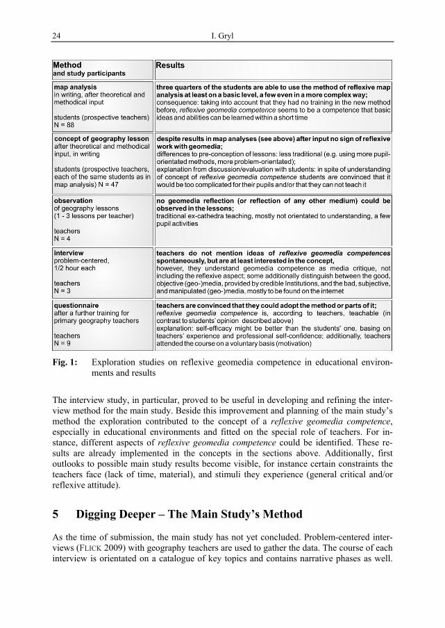
In the explorative stage a number of smaller studies were conducted between 2009 and 2010, based on a literature review and theoretical competence construction. The exploration contributed to the study in two respects: First, it helped to sharpen the idea of reflexive geomedia competence and identify possible factors and sub competencies, not yet covered by literature, especially regarding teachers’ pedagogical reflexive geomedia competences. Second, it acts as the basis of the construction of the main study’s method. Some of the explorative studies were carried out with undergraduate students who are trained to become geography teachers at Koblenz-Landau University, others with geography teachers on the job. Figure 1 lists the exploration studies.
Continue page 24
I. Gryl 24
Fig. 1: Exploration studies on reflexive geomedia competence in educational environ-ments and results
The interview study, in particular, proved to be useful in developing and refining the inter-view method for the main study. Beside this improvement and planning of the main study’s method the exploration contributed to the concept of a reflexive geomedia competence, especially in educational environments and fitted on the special role of teachers. For in-stance, different aspects of reflexive geomedia competence could be identified. These re-sults are already implemented in the concepts in the sections above. Additionally, first outlooks to possible main study results become visible, for instance certain constraints the teachers face (lack of time, material), and stimuli they experience (general critical and/or reflexive attitude).
5 Digging Deeper – The Main Study’s Method
As the time of submission, the main study has not yet concluded. Problem-centered inter-views (FLICK 2009) with geography teachers are used to gather the data. The course of each interview is orientated on a catalogue of key topics and contains narrative phases as well.
“Interesting. But I Haven’t Thought of This Before.” 25
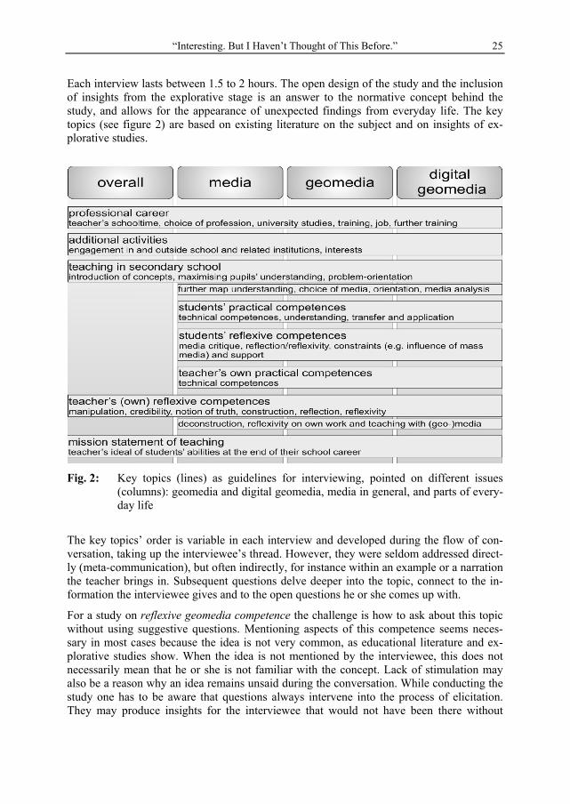
Each interview lasts between 1.5 to 2 hours. The open design of the study and the inclusion of insights from the explorative stage is an answer to the normative concept behind the study, and allows for the appearance of unexpected findings from everyday life. The key topics (see figure 2) are based on existing literature on the subject and on insights of ex-plorative studies.
Fig. 2: Key topics (lines) as guidelines for interviewing, pointed on different issues (columns): geomedia and digital geomedia, media in general, and parts of every-day life
The key topics’ order is variable in each interview and developed during the flow of con-versation, taking up the interviewee’s thread. However, they were seldom addressed direct-ly (meta-communication), but often indirectly, for instance within an example or a narration the teacher brings in. Subsequent questions delve deeper into the topic, connect to the in-formation the interviewee gives and to the open questions he or she comes up with.
For a study on reflexive geomedia competence the challenge is how to ask about this topic without using suggestive questions. Mentioning aspects of this competence seems neces-sary in most cases because the idea is not very common, as educational literature and ex-plorative studies show. When the idea is not mentioned by the interviewee, this does not necessarily mean that he or she is not familiar with the concept. Lack of stimulation may also be a reason why an idea remains unsaid during the conversation. While conducting the study one has to be aware that questions always intervene into the process of elicitation. They may produce insights for the interviewee that would not have been there without

I. Gryl 26
asking. Therefore, one cannot say that results of the study are independent from it. It is a balancing act between stimulation and production of socially accepted behavior. The inter-view strategy regarding the topic of reflection changes individually with each interview partner, depending on a) the previous knowledge of the concept and b) in what way the interviewee reacts to gradual stimulation. Stimulation can vary from remaining at the sur-face (asking for general interest in concept, talking about manipulated maps) to digging deeply into the topic (general reflection/self-reflection).
The main goal of the data analysis is to find a typology of teachers according to their atti-tude and abilities towards reflexive geomedia competence in educational environments. The transcripts of the interviews are categorized following MAYRING (2000). Although catego-ries will be constructed out of the data, key topics (as they directed the data collection) will provide orientation as well. Those categories might be supplemented with sequences of hermeneutic analysis (FLICK 2009). Differing and common characteristics are grouped to types, following KLUGE (1999). Hereby ideal types according to WEBER (cit. in: TIPPELT 2010) are constructed, comprising collections of abstracted characteristics. The typology construction may be systematically validated with the help of an expert panel.
The sampling is orientated on the principles of Grounded Theory (GLASER & STRAUSS 1998). The aim is to develop a widest possible typology. Therefore, teachers (mostly from Germany) were selected from different contexts (e.g. being connected to university or not, engaged within educational projects or not) and with the help of different gate keepers (e.g. headmasters, teacher trainers, former pupils, interviewees themselves). The sample, which is not closed yet, will end, when interviews do not contribute remarkable novel results any more. This point is tried to be estimated with a preliminary typology constructed while data collection is still in progress.
All data sampling and analysis is influenced by the researcher. I am deeply involved. I can not deny that I sympathize with the concept of reflexive geomedia competence and the background theories. Therefore, it is desirable to constantly reflect this study on reflection and reflexivity itself. A critical inquiry will help to make the prospective results useable for practical work with influence on learning and teaching. The bias will be reduced by con-stant self-reflection as a change of perspectives and expert supervision.
6 A Snapshot of The Moment – A Tentative Typology
At the time of writing this paper 20 interviews have been conducted. The preliminary ty-pology presented here is, as mentioned, first of all a fluent, changing instrument to decide when to close the survey according to Grounded Theory. In-depth analysis will follow after ending data collection. Additional citations (translated from German language by the au-thor) from interviews shall serve as examples of data contribution to different types.
The reflexive teacher has reflexive geomedia competences, including reflection of own action, and tries to obtain pedagogical competences in this field as well. Focusing on reflex-ivity as general and everyday praxis means going beyond reflection and geomedia critique. This reflexive attitude is adopted during different phases of socialization, stimulated by multiple impulses.
“Interesting. But I Haven’t Thought of This Before.” 27
„I am thankful, that things developed like this. It influences a lot in my life, having this habit of questioning things, and [the ability] not to overstate this as well (…). This habit is not only a product of geography, it also comes from travelling.”
The reflective and media critical teacher sees geomedia as media like any others. For him or her there is nothing that could be declared as truth or objective information, and therefore each medium has to be handled critically. The teacher is unsure how to teach this competence to his or her students, but tries it. Reflection is reduced to media and infor-mation and does not touch the own action.
“We did not read the books as they were written; we read between the lines. (…) And now I am disappointed that there is a generation that grows up without this ability.”
The truth-seeking teacher believes that geomedia, and particularly new (digital and web-based) geomedia need to be reflected critically, insofar as they are “manipulative”, “subjec-tive” or of “low quality”. He or she is especially skeptical towards collaborative (geograph-ic) media, which may be incorrect or may reveal the truth. “Objective” and “high-quality” media, created by credible institutions and published in print, works as corrective.
“To bring clippings to lessons and compare them with the map in the school atlas: What is different; what is the same; is it correct what they have written in the newspaper, those things. But to be honest, I have never applied such a method yet.”
The reflection-refusing teacher neither sees the possibility nor the necessity to teach re-flexive geomedia competence at school. He or she hardly reflects geomedia critically.
“It is not worth thinking about it, isn’t it? I do not switch on the oven and think about it, I know it simply, unconsciously. (…) This is the aim of teaching, not having to think about [map analysis] anymore, just doing it automatically.”
The reflexive teacher is close to FAUSER’s (2008) concept of a teacher for education orien-tated on comprehension. Likewise SIEBERT’S approach of self-reflection (in this context: reflexivity) has points of contact with this type; SIEBERT’s concept of problem-reflection is closer to the second type, reflecting rather on the object (SIEBERT 1999). The whole typolo-gy shows affiliation to a model on metacognitive competences of teachers by SCHNEIDER & WILDT (2007), ranging from naïve to reflexive understanding of their own work.
7 Going Further – An Outlook
After the conclusion of the sample in-depth-analysis will follow, aiming for a profound typology regarding teachers’ geomedia reflection. As indicated, results will be compared with typologies of teachers from pedagogical literature and theoretical and empirical find-ings on reflection and reflexivity. Connections to existing concepts may provide supple-mentary ideas for application in educational environments.
The results of analysis will give insights on what teachers think about reflexive geomedia competence in school. I am aware that there is a huge gap between teachers’ statements and beliefs and their practical work, as many studies (e.g. KLEINE 1983) and the explorative stage show. Social desirability and teachers’ ideals may make them pay lip-service to re-flexive work, while they do not actually practice it. The least what we can say is that ideas
I. Gryl 28
mentioned by the teachers do not lie outside of discourses they participate in and are there-fore at any rate potentially realizable for them. Additional observation studies in class are recommended, supplementing the teachers’ statements (their view) with insight into their factual work (by external observer). To reduce the dominance of the researcher’s view bringing in additional observers might be a good idea (see KANWISCHER et al. 2004).
The tentative ideal types already show aspects of what inspires and what hinders teachers to develop their own and their pupils’ reflexive geomedia competences. Notable is the close relationship between this and an overall reflexive attitude. Furthering such an attitude dur-ing teacher training at university in multiple contexts might lead to the development of reflexive competences, and a reflexive geomedia competence in particular. The final typol-ogy may provide more detailed suggestions for the improvement of teacher training.
Constraints visible in the typology and lying in the teachers’ own competences could be addressed by target group orientated teacher trainings, differentiated with the help of the typology. I am aware that teachers’ participation in the study is voluntary, and therefore the sample is biased by especially engaged teachers. Despite effects on the results, this might be acceptable insofar, as this clientele will attend those further teacher trainings. One im-portant aspect already notable in the data is the lack of adaptable material for teachers re-garding reflexive geomedia competence. Developing such exercises and worksheets might be an important contribution for teacher training and daily teaching, and will be based on more specific clues from the complete data analysis.
Although data collection and analysis are still in progress, the preliminary results give in-sight in what teachers regard as possible for their geomedia work at school. The study seems to be adaptable for further training and teaching innovations. It may provide answers (in the shape of material and methods, and training for a specialized pedagogical compe-tence) to a statement regarding reflexive geomedia competence I came across frequently during the interviews: “Interesting. But I haven’t thought of this before”.
References
AEBLI, H. (1980), Denken, das Ordnen des Tuns. Stuttgart: Klett-Cotta. BANDURA, A. (1986), Social foundations of thought and action. A social-cognitive theory.
Englewood Cliffs: Prentice-Hall. BELYEA, B. (1992), Images of power. Derrida/Foucault/Harley. Cartographica, 29 (2): 1-9. CLEMENS, O. & LESKAU, L. (2009), Parasitärer Befall. Mauerschau, 1: 120-124. CRAMPTON, J. W. (2001), Maps as social constructions. Power, communication, and visual-
isation. Progress in Human Geography, 25 (2): 235-252. DERRIDA, J. (1967/1998), Of grammatology. Baltimore: JHU Press. DÖRFLER, T. (2005), Geographie und Dekonstruktion. Geographische Revue, 1-2: 67-85. FAUSER, P. (2008), Eule. Entwicklungsprogramm für Unterricht und Lernqualität. <eule-
thueringen.de/konzept/programmstruktur/Poster_EULE_Klagenfurt.pdf> FLICK, U. (2009), Qualitative Sozialforschung. Reinbek bei Hamburg: Rowohlt. GERSMEHL, P. (2005), Teaching Geography. New York: Guilford. GLASER, B. G. & STRAUSS, A. L. (1998), Grounded theory. Bern: Huber. GLASERSFELD, E. v. (1997), Wege des Wissens. Heidelberg: Carl-Auer-Systeme. GRYL, I. (2010), Mündigkeit durch Reflexion. GW-Unterricht, 118: 20-37.
“Interesting. But I Haven’t Thought of This Before.” 29
HARLEY, J. B. (1989), Deconstructing the map. Cartographica, 26 (2): 1-20. HELMKE, A. (2003), Unterrichtsqualität erfassen, bewerten, verbessern. Seelze: Kallmeyer. HERRMANN, U. & HERTRAMPH, H. (2002), Reflektierte Berufserfahrungen und subjektiver
Qualifikationsbedarf. Eine Interview-Pilotstudie mit Lehrerinnen und Lehrern in Ulm. In: HERRMANN, U. (Ed.), Wie lernen Lehrer ihren Beruf? Weinheim: Beltz.
HEYDEN, C. (2005), Karten lügen (nicht). Praxis Geographie, 11: 20-25. JEKEL, T., GRYL, I & DONERT, K. (2010), Beiträge von Geoinformation zu einer mündigen
Raumaneignung. Geographie und Schule, 32 (186): 39-45. KANWISCHER, D., KÖHLER, P., OERTEL, H., RHODE-JÜCHTERN, T. & UHLEMANN, K. (2004),
Der Lehrer ist das Curriculum!? Bad Berka: Thillm. KLEINE, W. (1983), Theoretische Grundlegung und empirische Befunde zur inneren Diffe-
renzierung. In: ENGLER, H. J., KLEINE, W. & OTTO, I. (Eds.), Lehrerfortbildung im Sport. Köln: Strauß, 27-35.
LUHMANN, N. (1998), Die Wissenschaft der Gesellschaft. Frankfurt a. M.: Suhrkamp. MACEACHREN, A. M. (1992), Visualization. In: ABLER, R. F., MARCUS, M. G. & OLSON,
J. M. (Eds.), Geography’s inner worlds. New Brunswick: Rutgers University Pr., 99-137.
MAREK, A. (2009), Kritischer Umgang mit Karten. Praxis Geographie, 11: 21-25. MONMONIER, M. (1996), Eins zu einer Million. Basel: Birkhäuser. OELKERS, J. (2005), Was sollen Bildungsstandards an der Schule. Vortrag. Braunschweig. PAASI, A. (1986), The institutionalisation of regions. Fennia, 164 (1): 105-146. RHODE-JÜCHTERN, T. & SCHNEIDER, A. (2009), La Gomera unter dem Aspekt von...! In:
DICKEL, M. & GLASZE, G. (Eds.), Neue Wege der Exkursions- und Reisedidaktik. Viel-perspektivität und Teilnehmerzentrierung. Berlin: Lit, 141-163.
RINSCHEDE, G. (2003), Geographiedidaktik. Paderborn: Ferdinand Schöningh. ROBINSON, A. H. (1952), The look of maps. Madison: University of Wisconsin Press SCHNEIDER, A. (2010), Der Zweite Blick in einer reflexiven Geographie und Didaktik.
Dissertationsschrift. Jena. SCHNEIDER, R. & WILDT, J. (2007), Forschendes Lernen in Praxisstudien. Journal Hoch-
schuldidaktik, 18 (2): 11-15. SCHUURMAN, N. (2004), GIS. A short introduction. Oxford: Blackwell. SEITZ, S. (2008), Der Lehrer als Innovator von Schule. Hamburg: Dr. Kovač. SIEBERT, H. (1999), Pädagogischer Konstruktivismus. Neuwied: Luchterhand. THE ECONOMIST (2003), When bluff turns deathly. The Economist, 367 (8322): 24-26. TIPPELT, R. (2010), Idealtypen konstruieren und Realtypen verstehen. In: ECARIUS, J. &
SCHÄFFER, B. (Eds.), Typenbildung und Theoriegenerierung. Opladen: Budrich. WEINERT, F. E. (2001), Concept of competence. In: RYCHEN, D. S. & SALGANIK, L. H.
(Eds.), Defining and selecting key competencies. Bern/Göttingen: Hogrefe & Huber, 46‐65.
WERLEN, B. (1995), Sozialgeographie alltäglicher Regionalisierungen. Band 1 – zur Onto-logie von Gesellschaft und Raum. Stuttgart: Franz Steiner.
Related Documents