Intensive Archaeological Investigation of the Zarzamora Creek Hike and Bike Trail Project, San Antonio, Bexar County, Texas Antiquities Permit No. 8295 Principal Investigator: Virginia Moore, M.A.G. Prepared for: San Antonio River Authority 100 East Guenther Street San Antonio, Texas 78204 Report Authors: Virginia A. Moore, M.A.G. Pape-Dawson 10801 North Mopac Expressway Building 3 - Suite 200 Austin, TX 78759 March 2018

Welcome message from author
This document is posted to help you gain knowledge. Please leave a comment to let me know what you think about it! Share it to your friends and learn new things together.
Transcript

Intensive Archaeological Investigation of the Zarzamora Creek Hike and Bike Trail Project,
San Antonio, Bexar County, Texas
Antiquities Permit No. 8295
Principal Investigator: Virginia Moore, M.A.G.
Prepared for: San Antonio River Authority
100 East Guenther Street San Antonio, Texas 78204
Report Authors: Virginia A. Moore, M.A.G.
Pape-Dawson 10801 North Mopac Expressway
Building 3 - Suite 200 Austin, TX 78759
March 2018

ii
Abstract
On behalf of the San Antonio River Authority (SARA), Pape-Dawson conducted an intensive archaeological
survey of the proposed Zarzamora Creek Hike and Bike Trail west of downtown San Antonio, Bexar County,
Texas. The Area of Potential Effects (APE) extends along Zarzamora Creek beginning about 640 feet (ft)
(195 meters [m]) east of General McMullen Drive, and ending 330 ft (101 m) west of 36th Street for a total
distance of 1.4 miles (2.24 kilometers [km]). The purpose of the project is to expand the Westside Creek
Trail at Zarzamora Creek, allowing continuity within existing and other proposed trails, as well as
connectivity to the surrounding neighborhoods. The APE is defined as the 10-foot-wide trail as well as the
footprint of the proposed trail heads, parking areas, picnic areas, viewing areas, and areas of right-of-way
(ROW) acquisition, for a total area of approximately 17.37 acres (7 hectares [ha]). The depth of impact
has not yet been determined, but is assumed to be a maximum of 1 m.
As the project will occur on City of San Antonio- (COSA-) and SARA-owned land, the archaeological survey
was conducted in compliance with the Antiquities Code of Texas (ACT). In addition, this project requires a
Nationwide Permit from the U.S. Army Corps of Engineers (USACE); thus, compliance with Section 106 of
the National Historic Preservation Act (NHPA) (Title 36 Code of Federal Regulations Part 800.4 [36 CFR
800.4]) is required. The investigation was conducted under Texas Antiquities Permit No. 8295.
Prior to fieldwork, Pape-Dawson archaeologists conducted a background study that assessed the potential
for cultural resources to exist within the APE. The background review determined that the APE had not
been previously surveyed, and that no sites were within or adjacent to the APE. However, there is a
cemetery, a local historic landmark, and an Official Texas Historic Marker—all related to Our Lady of the
Lake University—within 0.62 mile (1 km) of the APE. Pape-Dawson archaeologists Virginia Moore, Jacob
Sullivan, and Megan Veltri conducted the field work on February 2, 2018. The entirety of the project area
was subjected to visual inspection augmented by the excavation of 13 shovel tests in order to evaluate
the impact of the proposed project on cultural resources. Overall, most of the project area was found to
have been severely impacted by previous utility installations and the channelization of Zarzamora Creek.
The nature of the disturbances within the project area has reduced the potential for encountering any
intact, significant cultural resources. Three shovel tests were positive for historic-age material. As no
further material was identified in adjacent shovel tests or visible on the surface, these were considered
to be isolated finds. Additionally, all three of these historic-age isolated finds were documented within
disturbed contexts.
iii
No archaeological resources were previously recorded within the APE and none was recorded during the
course of this survey. In accordance with 36 CFR 800.4, Pape-Dawson has made a reasonable and good-
faith effort to identify archaeological historic properties within the APE. As no properties were identified
that meet the criteria for listing in the National Register of Historic Places (NRHP) according to 36 CFR
60.4, or for designation as a State Antiquities Landmark (SAL) according to 13 Texas Administrative Code
26.12 (13 TAC 26.12), Pape-Dawson recommends that no further archaeological work is necessary for the
proposed undertaking as presently designed and that the project be allowed to proceed within the APE.
However, if undiscovered cultural material is encountered during construction, it is recommended that all
work in the vicinity should cease and the THC and COSA archaeologists be contacted to ensure compliance
with the NHPA and the ACT.
Project records and photographs will be curated at the Center for Archaeological Research at The
University of Texas San Antonio (CAR-UTSA).

iv
Table of Contents
Abstract ......................................................................................................................................................... ii
Table of Contents ......................................................................................................................................... iv
List of Figures ................................................................................................................................................ v
Management Summary ................................................................................................................................ 1
Introduction .................................................................................................................................................. 2
Project Setting ............................................................................................................................................... 4
Cultural Chronology ...................................................................................................................................... 7
Paleoindian (11,500 b.p. – 8,800 b.p.) ...................................................................................................... 7
Archaic (8,800 b.p. – 1,200 b.p.) ............................................................................................................... 8
Late Prehistoric (1,200 b.p. – 250 b.p.) ..................................................................................................... 8
Historic (1600s – 1960) ............................................................................................................................. 9
Methods ...................................................................................................................................................... 11
Records Review ....................................................................................................................................... 11
Fieldwork ................................................................................................................................................. 11
Results ......................................................................................................................................................... 12
Records Review ....................................................................................................................................... 12
Historic Map Review ............................................................................................................................... 14
Fieldwork ................................................................................................................................................. 15
Isolated Finds .......................................................................................................................................... 29
Summary and Recommendations ............................................................................................................... 35
References Cited ......................................................................................................................................... 37
Appendix A .................................................................................................................................................. 41
Shovel Test Table .................................................................................................................................... 41

v
List of Figures
Figure 1: Project Area ................................................................................................................................... 3
Figure 2: Project Location ............................................................................................................................. 5
Figure 3: Soils ................................................................................................................................................ 6
Figure 4: Previously recorded archaeological sites within 1 km of the project area. ................................. 13
Figure 5. Overview of APE within the channelized Zarzamora Creek ditch, looking southeast. ................ 15
Figure 6a: Disturbances Map. ..................................................................................................................... 17
Figure 6b: Disturbances Map. ..................................................................................................................... 17
Figure 7. Example of the depth and width of the Zarzamora Creek ditch, looking west-northwest. ........ 19
Figure 8. Overview of large channelized ditch south of N San Gabriel Avenue, looking west. .................. 19
Figure 9. Berm on north side of Zarzamora Creek, east of General McMullen Drive, looking west. ......... 20
Figure 10. Proposed trail connecting to Rosedale Park, looking north. ..................................................... 20
Figure 11. Level area used as parking south of Mayberry Avenue, looking east........................................ 21
Figure 12. Proposed parking area in southeast corner of Alderete Park, looking southwest. ................... 21
Figure 13a: Results Map .............................................................................................................................. 23
Figure 13b: Results Map ............................................................................................................................. 23
Figure 14. APE as it turns northwest after General McMullen Drive, looking east. ................................... 25
Figure 15. Shovel Test VM01 profile. .......................................................................................................... 25
Figure 16. Overview of proposed trail head and buried utilities, looking east........................................... 26
Figure 17. Overview of bend in creek with wooded vacant lot to the north, looking northwest. ............. 27
Figure 18. Level area between the ditch and Mayberry Avenue, looking west-northwest. ..................... 27
Figure 19. Proposed trailhead west of NW 36th street, looking west. ........................................................ 28
Figure 20. Shovel Test VM04 profile. .......................................................................................................... 29
Figure 21. Overview of IF01 located next to the heavy machinery, looking northwest. ............................ 30
Figure 22.Artifacts from MV01 level 1 (0-10 cm) below the ground surface. ............................................ 31
Figure 23. Artifacts from MV01 Level 2 (10-20 cm) below the ground surface. ........................................ 31
Figure 24.Artifacts from MV01, Level 3 (20-30 cm) below the ground surface. ........................................ 32
Figure 25. Overview of IF02 within vacant lot, looking northwest. ............................................................ 33
Figure 26. Artifacts from JS03, Level 1 (0-10 cm). ...................................................................................... 33
Figure 27. Artifacts from JS03 Level 5 (40-50 cm). ..................................................................................... 34
Figure 28. Overview of IF03 location, looking west. ................................................................................... 35

1
Management Summary
Pape-Dawson conducted an intensive archaeological survey of a 1.4-mile (2.24-km) segment of the
proposed Zarzamora Creek Hike and Bike Trail in San Antonio, Bexar County, Texas. The APE extends along
Zarzamora Creek from about 640 ft (195 m) east of General McMullen Drive to 330 ft (101 m) west of 36th
Street. The APE includes a 10-foot-wide trail, trail heads, parking areas, picnic areas, viewing areas, and
areas of ROW acquisition. As the project requires a USACE permit and will occur on COSA- and SARA-
owned land, the archaeological survey was conducted in compliance with Section 106 of the NHPA (36
CFR 800.4) and under Texas Antiquities Permit No. 8295, in accordance with the ACT.
Prior to fieldwork, Pape-Dawson archaeologists conducted a background study of the APE that
determined it had not been previously surveyed, no sites were within or adjacent to the APE, and that a
cemetery, a local historic landmark, and an Official Texas Historic Marker—all related to Our Lady of the
Lake University—are within 1 km of the APE. As no properties were identified that meet the criteria for
listing in the NRHP according to 36 CFR 60.4, or for designation as an SAL according to 13 TAC 26.12, Pape-
Dawson recommends that no further archaeological work is necessary for the proposed undertaking as
presently designed and that the project be allowed to proceed within the APE. However, if undiscovered
cultural material is encountered during construction, it is recommended that all work in the vicinity should
cease and the THC and COSA archaeologists be contacted to ensure compliance with the NHPA and ACT.
No artifacts were collected, but all project records and photographs will be curated at CAR-UTSA.

2
Introduction
On behalf of the San Antonio River Authority (SARA), Pape-Dawson conducted an intensive archaeological
survey of a 1.4-mile (2.24-km) segment of the proposed Zarzamora Creek Hike and Bike Trail west of
downtown San Antonio, Bexar County, Texas (Figure 1). The Area of Potential Effects (APE) extends along
Zarzamora Creek beginning about 640 feet (ft) (195 meters [m]) east of General McMullen Drive, and
ending 330 ft (101 m) west of 36th Street for a total distance of 1.4 miles (2.24 kilometers [km]). The
purpose of the project is to expand the Westside Creek Trail at Zarzamora Creek, allowing continuity
within existing and other proposed trails, as well as connectivity to the surrounding neighborhoods. The
APE is defined as the 10-foot-wide trail as well as the footprint of the proposed trail heads, parking areas,
picnic areas, viewing areas, and areas of right-of-way (ROW) acquisition, for a total area of approximately
17.37 acres (7 hectares [ha]). The depth of impact has not yet been determined, but is assumed to be a
maximum of 1 m.
As the APE is on both City of San Antonio (COSA)- and SARA-owned land, both political subdivisions of the
State of Texas, compliance with the Antiquities Code of Texas (ACT) was necessary. In addition, this project
requires a Nationwide Permit from the U.S. Army Corps of Engineers (USACE); thus, compliance with
Section 106 of the National Historic Preservation Act (NHPA) (Title 36 Code of Federal Regulations Part
800.4 [36 CFR 800.4]) was required. This work was conducted under Texas Antiquities Permit No. 8295.
Pape-Dawson’s investigations of the 17.37-acre (7-ha) APE included an extensive background records and
literature review, followed by an intensive pedestrian survey with shovel testing. Fieldwork took place on
February 2, 2018. Pape-Dawson archaeologist Virginia Moore served as Principal Investigator and was
assisted in the field by Jacob Sullivan and Megan Veltri. The goals of the investigation were to (1) locate
all prehistoric and historic archaeological sites, if present, within the APE; (2) establish vertical and
horizontal site boundaries, as appropriate with respect to the APE; (3) evaluate the significance of
recorded sites and structures with regard to eligibility for inclusion to the National Register of Historic
Places (NRHP) (36 CFR 60.4) and for designation as a State Antiquities Landmark (SAL), in accordance with
13 Texas Administrative Code 26.10 (13 TAC 26.10).

Date:
Jan 2
2, 20
18 1
:32:14
PM
Use
r: VM
oore
File:
H:\p
rojec
ts\En
viron
menta
l Proj
ects\
San A
ntonio
\Wes
tside
Cree
k\GIS
\MXD
\Zarza
mora\
1-Proj
ect L
ocati
on.m
xd
4 0 0.2 0.4 0.6 0.80.1Miles
COORDINATE SYSTEM: NAD83 UTM ZONE 14N, METERBASEMAP: USGS 7.5' TOPOGRAPH, SAN ANTONIO WEST QUADRANGLEINSET BASEMAP: ESRI AND IT'S DATA SUPPLIERS
Figure 1. Project Location
Westside Creek Trails PN: 11275-00Bexar County, TexasCultural Resources Background StudyJanuary 2018
2000 NW LOOP 410 SAN ANTONIO, TX 78213 210.375.9000
TBPE FIRM REGISTRATION #470 TBPLS FIRM REGISTRATION #10028800
SAN ANTONIO AUSTIN HOUSTON FORT W ORTH DALLAS
0 0.4 0.8 1.2 1.60.2Kilometers
!(
Project Location
LegendZarzamora APE (17.37-acres)
NGe
nera l
McMu
llen D
r
W Commerce St
Project Limit
Project Limit

4
Project Setting
The APE is situated approximately 3 miles (4.8 km) west of downtown San Antonio, beginning at Rosedale
Park, continuing west along Zarzamora Creek, and ending at Alderete Park (Figure 2). Situated near the
border between the Blackland Prairies and the Interior Coastal Plains natural regions of Texas (Wermund
1996), the 17.37-acre (7-ha) APE is adjacent to and within the floodplain of Zarzamora Creek. The area is
geologically mapped as Pleistocene-age Fluviatile terrace deposits (Qt) with a small portion consisting of
Late Cretaceous age Navarro Group and Marlbrook Marl, undivided (Knb) (Bureau of Economic Geology
[BEG] 1983). These terrace deposits are adjacent to the Zarzamora Creek channel.
The soils that formed within the APE are mapped as the Tinn and Frio (Tf) series and Branyon (HtA, and
HtB) soils (United States Department of Agriculture, Natural Resources Conservation Service [USDA-NRCS]
2017) (Figure 3). Frequently flooded Tinn and Frio soils with 0 to 1 percent slopes represent 95 percent of
the APE. Tinn and Frio soils are classified as Vertisols and Mollisols, respectively, and are formed in
calcareous clayey alluvium. These soils are located on floodplains of streams that drain the Blackland
Prairies. Tinn soils are characterized by a black clay (A-horizon) overlying a black clay (B-horizon) at an
average depth of 18 inches (46 centimeters [cm]) below the ground surface. Frio soils consist of a dark
grayish brown silty clay (A-horizon) yielding to a grayish brown silty clay (B-horizon) at depths of
approximately 40 inches (102 cm) below the ground surface (USDA-NRCS 2017).
Two small portions of the APE are mapped as Branyon clay (0 to 1 percent slopes [HtA], and 1 to 3 percent
slopes [HtB]) and comprise 5 percent of the APE (USDA-NRCS 2017). The Branyon soils are taxonomically
classified as Vertisols and formed by Pleistocene-aged calcareous clayey alluvium derived from mudstone.
They are located along stream terraces and are characterized by a dark grayish clay (A-horizon) overlying
a black clay (B-horizon) at approximately 12 inches (30.5 cm) below the ground surface. (USDA-NRCS
2017).
Branyon and Tinn and Frio soils are soils that have developed within alluvial sediments, and therefore,
have the potential to contain buried archaeological material. However, as the Branyon soils consist of
ancient alluvium, cultural deposits within these soils are likely to be shallowly buried. Conversely, cultural
deposits within the Tinn and Frio soils have the potential to be deeply buried.

Date:
Jan 2
2, 20
18 1
:33:54
PM
Use
r: VM
oore
File:
H:\p
rojec
ts\En
viron
menta
l Proj
ects\
San A
ntonio
\Wes
tside
Cree
k\GIS
\MXD
\Zarza
mora\
2-Proj
ect A
rea.m
xd
4 0 0.15 0.3 0.45 0.60.075Miles
Westside Creek Trails PN: 11275-00Bexar County, TexasCultural Resources Background StudyJanuary 2018
2000 NW LOOP 410 SAN ANTONIO, TX 78213 210.375.9000
TBPE FIRM REGISTRATION #470 TBPLS FIRM REGISTRATION #10028800
SAN ANTONIO AUSTIN HOUSTON FORT W ORTH DALLAS
0 0.25 0.5 0.75 10.125Kilometers
LegendZarzamora Hike and Bike TrailZarzamora APE (17.37-acres)
NGe
neral
McMu
llen D
r
W Commerce St
COORDINATE SYSTEM: NAD83 UTM ZONE 14N, METERBASEMAP: GOOGLE©
Figure 2. Project Area
Esme
ra lda
Drive

Date:
Jan 2
2, 20
18 1
1:33:0
7 AM
Use
r: VM
oore
File:
H:\p
rojec
ts\En
viron
menta
l Proj
ects\
San A
ntonio
\Wes
tside
Cree
k\GIS
\MXD
\Zarza
mora\
3-Soil
s.mxd
4 0 0.15 0.3 0.45 0.60.075Miles
Westside Creek Trails PN: 11275-00Bexar County, TexasCultural Resources Background StudyJanuary 2018
2000 NW LOOP 410 SAN ANTONIO, TX 78213 210.375.9000
TBPE FIRM REGISTRATION #470 TBPLS FIRM REGISTRATION #10028800
SAN ANTONIO AUSTIN HOUSTON FORT W ORTH DALLAS
0 0.25 0.5 0.75 10.125Kilometers
LegendBranyon clay, 0 to 1 percent slopes (HtA)Branyon clay, 1 to 3 percent slopes (HtB)Tinn and Frio soils, 0 to 1 percent slopes, frequently flooded (Tf)
COORDINATE SYSTEM: NAD83 UTM ZONE 14N, METERBASEMAP: GOOGLE©
Figure 3. Soils
Tf
HtA
HtB

7
Cultural Chronology
Bexar County falls within the Central Texas archaeological region of the Central and Southern Planning
Region as delineated by the Texas Historical Commission (THC) (Mercado-Allinger et al. 1996). Cultural
developments in this region are typically classified by archaeologists according to four primary
chronological time periods: Paleoindian, Archaic, Late Prehistoric, and Historic. These classifications have
been defined primarily by changes in material culture and subsistence strategies over time as evidenced
through information and artifacts recovered from archaeological sites. This cultural chronology provides
a brief summary of each major cultural period with reference to significant archaeological work that has
occurred within the region.
PALEOINDIAN (11,500 B.P. – 8,800 B.P.)
Although there is some debate about whether pre-Clovis Paleoindian peoples lived in Texas, there is
evidence of Paleoindian occupation within Texas by 11,500 B.P. Collins (1995:376, 381) has proposed
dividing this period into early and late phases, with Dalton, San Patrice, and Plainview projectile points
possibly providing the transition between them. Research has shown Paleoindians were gathering wild
plants and hunting large mammals (mammoth, bison, etc.), as well as smaller terrestrial and aquatic
animals (Collins 1995: 381; Bousman et al. 2004: 75). Projectile points characteristic of the Paleoindian
period in Central Texas are lanceolate-shaped and include Clovis, Plainview, and Folsom (Turner and
Hester 1999). In Texas, most Paleoindian sites are classified as procurement or consumption sites
(Bousman et al. 2004: 76-78), but a few, such as the Wilson-Leonard site in Williamson County (Collins
1995) and the Pavo Real site in Bexar County (Collins et al. 2003; Figueroa and Frederick 2008), have
produced in situ human burials (Collins 1995: 383). Other Paleoindian sites discovered within Bexar
County include site 41BX47 on Leon Creek (Tennis 1996), the Richard Beene site (41BX831) (Thoms et al.
2005; Thoms and Mandel 2007), and the St. Mary’s Hall site (41BX229), which has provided insight into a
more diverse diet for Paleoindian groups (Hester 1978). Recent excavations have documented a
Paleoindian component in Zilker Park in Austin (Nickels et al. 2010).
As the climate warmed, the Paleoindian people began to shift away from hunting large animals. The
changing environment, which led to extinction of the megafauna, likely influenced their decision to focus
more on hunting small game animals, including deer and rabbit, as well as gathering edible roots, nuts,
and fruits (Black 1989). This change in food supply, as well as a different set of stone tools, marks the
transition into the Archaic Period.

8
ARCHAIC (8,800 B.P. – 1,200 B.P.)
Usually divided into early, middle, late, and sometimes transitional sub-periods, the Archaic marks a
gradual shift from hunting Megafauna and some smaller animals supplemented with wild plants to a focus
on hunting and gathering medium and small animals and wild plants, and an eventual transition to
agriculture. Beginning with Clear Fork gouges and Guadalupe bifaces in the Early Archaic (8500 B.P. – 6000
B.P.) (Turner and Hester 1999; Collins 1995), Early Archaic people produced a variety of point types. The
variety of points and their scattered distribution over a large area in the Early Archaic may indicate smaller
groups of people moving over larger territories (Prewitt 1981). Point types transition to Bell-Andice-Calf
Creek, Taylor, and Nolan-Travis points in the Middle Archaic (6000 B.P. – 4000 B.P.) (Turner and Hester
1999; Collins 1995), and burned rock middens become an important characteristic. The Middle Archaic
focus on constructing burned rock ovens to cook a diverse array of plant food (Black 1989) suggests a
slightly more sedentary focus. The Bulverde, Pedernales, Ensor, Frio, and Marcos points in the Late Archaic
(4000 B.P. – 1300 B.P.) (Turner and Hester 1999; Collins 1995) mirror the diversity of point types found in
the Early Archaic. During the Late Archaic, cemeteries, especially associated with rock shelters, become
common in central Texas (Dockall et al. 2006). In Bexar County, sites with Early Archaic components
include the Housman Road site (41BX47), the Richard Beene site (41BX831) (Thoms et al. 2005; Thoms
and Mandel 2007), the Higgins site (41BX184) (Black et al. 1998), and the Panther Springs site (41BX228)
(Black and McGraw 1985). While the Elm Waterhole site (41BX300) is representative of a Middle Archaic
site within Bexar County (McNatt et al. 2000), the Granberg site (41BX17\41BX271) in San Antonio is a
multi-component site with occupations from both the Middle and Late Archaic sub-periods.
LATE PREHISTORIC (1,200 B.P. – 250 B.P.)
As the Archaic transitioned into the Late Prehistoric period, several technological changes become
apparent. The most notable change is the use of the bow and arrow rather than the spear and atlatl,
evidenced by smaller dart points. Another significant innovation is the creation and use of ceramic vessels.
Some groups began to practice consistent agriculture during this time as well; there is some evidence that
peoples in Central Texas may have incorporated agriculture into their lives, but primarily remained hunter
gatherers (Collins 1995). Also during this period, there are possible indications of major population
movements, changes in settlement patterns and perhaps lower population densities (Black 1989).
Archaeologists divide the Late Prehistoric into two phases: the Austin phase, followed by the Toyah phase.

9
HISTORIC (1600S – 1960)
Bexar County was the site of many occupations by prehistoric peoples, and there is an overlap between
the prehistoric and historic periods (sometimes called the protohistoric), but Europeans did not explore
the area until the seventeenth century. Alonso de León’s 1689 and 1690 expeditions and Domingo Terán
de los Ríos’ 1691 expedition were likely some of the first interactions between Europeans and Native
groups (de la Teja 1995:6). According to historical accounts of the expeditions, these early Spanish
explorers encountered numerous indigenous groups residing in and near Central Texas (Mercado-Allinger
et al, 1996). These indigenous groups likely included the Payaya and the Pamaya who resided in the
southern plains of Texas as well as the Tonkawa, Karankawa, Lipan Apache, and Comanche, who entered
the area from the northern plains in pursuit of food and stopped at the areas springs (Long 2017). In 1691,
Spanish explorers traveling through nearby Bexar County began creating what would become the El
Camino Real de los Tejas (The King’s Highway, also known as the Old San Antonio Road in portions) (U. S.
Department of the Interior 2011). This network of roadways at least in part likely followed existing trails
already well established by the numerous highly mobile indigenous groups within the area.
These explorations helped the Spanish choose locations to establish five missions in and around what
would later become San Antonio. Don Martín de Alarcón established the first mission, San Antonio de
Valero, in 1718, on the west bank of the San Pedro Creek, followed by the Presidio San Antonio de Béxar
and the Villa de Béxar (de la Teja 1995). However, by 1722 the Marqués de San Miguel de Aguayo had
moved the presidio and villa downstream to a second location along San Pedro Creek. Other missions,
including Mission San José y San Miguel de Aguayo, Nuestra Señora de la Purísma Concepción, San Juan
Capistrano, and San Francisco de la Espada were established in the area from 1720 to 1731 (Clark et al.
1975). Most of the Native American people recruited to live at these missions comprised many different
groups (Campbell 1977), but it is difficult to know all the groups that were present due to the variations
in spelling and phonetic complexity. The missions used this Native labor force to construct acequias, or
irrigation ditches, which helped them to develop self-sustaining communities bordered by farmland (Long
2017).
In 1731, Spain sent 16 families from the Canary Islands to the villa de Bexar to establish the secular village.
With the arrival of these families, surveyors set out the city’s main plaza, or Plaza de las Islas, next to the
church, designated a spot for the Casas Reales, and began to establish residential lots (Spell 1962). This
began San Antonio’s gradual secularization. In 1773, San Antonio de Bexar Presidio was named the capital

10
of Spanish Texas, and the settlement including mission Indians had a population of about 2,000 by 1778
(Fehrenbach 2017).
During this period of early settlement, water was an essential component for successful settlement and
survival. The acequia system, begun with the arrival of the missionaries, continued to expand to serve
irrigation and drinking water needs. The acequia system influenced the street layout in the city (Cox
2005:20) and played an integral part in contact between the Spanish, who brought the engineering
concepts for the system, and the indigenous groups forced to provide the construction labor.
During the 1820s and early 1830s, American settlers began moving to San Antonio in increasing numbers,
though the population remained predominately Mexican. In 1824, Texas and Coahuila were united into a
single state with the capital at Saltillo. San Antonio fought for Mexican Independence in 1813, then for its
own sovereignty during the Texas Revolution. The Siege of Bexar and the Battle of the Alamo, in 1835 and
1836, were both located within San Antonio, showing its importance in the region. After Texas gained its
independence from Mexico in 1836, Bexar County was created and San Antonio was chartered as its seat
(Long 2017). However, this was not the end of conflict in the city; a dispute with Comanche Indians
resulted in the Council House Fight in 1840, and Woll’s invasion in 1842 precipitated Texas’ entrance into
the United States as the 28th state. By 1846, San Antonio’s population had decreased to approximately
800 people (Fehrenbach 2017).
On March 2, 1861, Texas seceded from the Union about a month before the Civil War began. San Antonio
became a Confederate storage area as well as a location where military units could be organized; however,
the city kept its distance from most of the actual fighting (Fehrenbach 2017). After the Civil War, San
Antonio continued to grow larger, spurred on by the arrival of the railroad in 1877 (Fehrenbach 2017).
Industries such as cattle, distribution, ranching, mercantile, gas, oil, and military centers in San Antonio
prospered. The city served as the distribution point for the Mexico-United States border as well as the
rest of the southwest.
Modernization increased dramatically between the 1880s and the 1890s, compared to the rest of the
United States. Civic government, utilities, electric lights and street railways, street paving and
maintenance, water supply, telephones, hospitals, and a city power plant were all built or planned around
this time (Fehrenbach 2017). At the turn of the twentieth century, San Antonio was the largest city in
Texas with a population of more than 53,000. Much of the city’s growth after the Civil War was a result of
an influx of southerners fleeing the decimated, Reconstruction-era south. An additional population

11
increase came after 1910, when large numbers of Mexicans began moving into Texas to escape the
Mexican Revolution (Fehrenbach 2017). The First U.S. Volunteer Cavalry was organized in San Antonio
during the Spanish-American War, and San Antonio was an important military center for the army and air
forces during both world wars. Its five military bases provided an important economic base and
contributed to the evolution of the city’s medical research industry.
In 1921, a disastrous flood engulfed downtown San Antonio with up to 12 ft (3.7 m) of water. The Olmos
Dam was built in response to this event to prevent further flooding. Sections of the San Antonio River
were straightened and widened in areas to control the water flow. Another recommendation was to
construct an underground channel in downtown San Antonio and to cover portions of the river with
concrete. This last idea was controversial, but a compromise was eventually agreed upon to create a
Riverwalk with shops and restaurants along the water channel, which was completed by the WPA in 1941
(Fisher 2018).
Methods
RECORDS REVIEW Prior to fieldwork, Pape-Dawson archaeologists conducted a thorough background literature and records
search of the proposed APE. This research included reviewing the San Antonio West (2998-244) U.S.
Geological Survey (USGS) 7.5-minute topographic quadrangle map at the Texas Archeological Research
Laboratory (TARL) and searching the THC’s Archeological Sites Atlas online database for any previously
recorded surveys and historic or prehistoric archaeological sites located within a 0.62-mile (1-km) radius
of the project area. The review also included information on the following types of cultural resources:
NRHP-listed properties, sites, and districts, SALs, Official Texas Historical Markers (OTHM), Recorded Texas
Historic Landmarks (RTHL), National Historic Trails, and cemeteries. In addition, archaeologists consulted
the COSA Historic Landmark Sites and Historic Geodatabases to locate any local historic landmarks and
districts. The archaeologists also examined the U.S. Department of Agriculture Soil Survey of Bexar County
(Taylor et al. 1991), NRCS Web Soil Survey, the Geologic Atlas of Texas-San Antonio Sheet (BEG 1983), and
historic maps and aerials that depict the project area (National Environmental Title Research Online [NETR
Online] 2018).
FIELDWORK Pape-Dawson archaeologists conducted an intensive archaeological survey of the proposed 17.37-acre (7-
ha) APE. This investigation consisted of an intensive pedestrian survey along the 100 ft (30 m)-wide APE
with inspection of the ground surface, augmented by shovel testing in areas with the perceived potential

12
for buried cultural deposits and with less than 30 percent ground surface visibility. As soils in the project
area are clayey alluvial deposits, it was anticipated that archaeological deposits, if present, would be
deeply buried. However, the anticipated maximum depths of impact are 39.4 inches (100 cm), thus
reachable with a shovel test. Survey methods followed the Council of Texas Archeologists (CTA)
Archeological Survey Standards for Texas.
A total of 13 shovel tests was excavated to investigate the 1.4 mile (2.24 km) long APE. Shovel tests were
approximately 12 inches (30 cm) in diameter and were excavated to sterile substrate, bedrock, or to a
maximum of 39.4 inches (100 cm) below the ground surface when intact soils were encountered. Soils
were screened through ¼-inch (0.64-cm) hardware mesh unless they were dominated by clay. Clay soils
were finely divided and hand sorted. Shovel tests were visually described, mapped using a handheld
Trimble GPS unit, and backfilled upon completion. All project records and photographs will be curated at
the Center for Archaeological Research at the University of Texas at San Antonio (CAR-UTSA) following
their specific standards of preparation.
Results
RECORDS REVIEW The cultural resources background review determined that the APE has not been previously surveyed, and
no previously recorded archaeological sites are within or adjacent to the APE, or within 0.62 mile (1 km)
of it (Figure 4). However, there is one cemetery (Our Lady of the Lake Convent), one local historic landmark
(a commercial building associated with the University) and one OTHM (Our Lady of the Lake University)
within the study radius. There are no NRHP-listed properties or districts, SALs, RTHLs, or local historic
districts located within the study area.
Our Lady of the Lake University moved to its current location in 1895 (Callahan 2010). Opening its doors
in 1896, it began as a girl’s academy offering classes from kindergarten to high school. As the college grew,
more buildings were added to the 16-acre site. The first college courses were offered in 1911 as a two-
year curriculum for women. In 1919, the school was admitted to the Texas Association of College and
began to offer 4-year degrees. In 1975, the programs became coeducational (Callahan 2010). Our Lady of
the Lake Convent Cemetery is associated with Our Lady of the Lake University and Convent.

Date:
Jan 2
2, 20
18 1
:30:03
PM
Use
r: VM
oore
File:
H:\p
rojec
ts\En
viron
menta
l Proj
ects\
San A
ntonio
\Wes
tside
Cree
k\GIS
\MXD
\Zarza
mora\
4-Prev
iously
Rec
orded
Cult
ural R
esou
rces.m
xd
4 0 0.3 0.6 0.9 1.20.15Miles
Westside Creek Trails PN: 11275-00Bexar County, TexasCultural Resources Background StudyJanuary 2018
!(
Commercial Building at4318 Commerce St W
Our Lady of the Lake Convent
2000 NW LOOP 410 SAN ANTONIO, TX 78213 210.375.9000
TBPE FIRM REGISTRATION #470 TBPLS FIRM REGISTRATION #10028800
SAN ANTONIO AUSTIN HOUSTON FORT W ORTH DALLAS
0 0.5 1 1.5 20.25Kilometers
Legend!( Historical Marker
COSA Historic LandmarkCemeteryZarzamora APE (17.37-acres)1 km Buffer
Figure 4. Previously Recorded Cultural Resources within 1 km of the Project Area
COORDINATE SYSTEM: NAD83 UTM ZONE 14N, METERBASEMAP: USGS 7.5' TOPOGRAPH, SAN ANTONIO WEST QUADRANGLE
Our Lady of the Lake University

14
HISTORIC MAP REVIEW In addition to the Atlas file review, Pape-Dawson archaeologists conducted a limited amount of additional
research including a review of modern and historic aerial photographs and topographic maps (NETR
Online 2018). Recent and historic age aerial images (1955, 1963, 1966, 1973, 1986, 1995, 2004, 2008,
2010, 2012 [NETR Online 2018]) (1995, 2002, 2003, 2004, 2005, 2006, 2008, 2010, 2012, 2013, 2014, 2015,
2016, 2017, 2018 [Google Earth 2018]) and topographic maps (1959, 1970, 1975, 1985, and 1993 [NETR
Online 2018]) were examined for information about the current APE. This research was undertaken to
identify historic-age structures that may be extant within the project area, previous impacts that may
have occurred at the project location, and areas that have a high potential to contain historic-age
archaeological deposits. In 1955 the areas around the APE were still largely farmland with a few houses
north of the creek. An un-channelized Zarzamora Creek was depicted through Alderete Park just south of
Aurora Avenue before turning southeast to cross N.W. 36th Street and paralleling the south side of
Mayberry Avenue. Seven houses are visible on the north side of Mayberry Avenue to either side of what
is now Tesla Avenue. At 34th Street the Creek bends slightly to the north before turning back to the
southeast. Four houses are visible on the east side of N. San Joaquin Avenue north of the creek. Along San
Felipe Avenue, houses line either side of the road to the north and south of Zarzamora Creek, though only
one is adjacent to the APE. East of General McMullen Avenue, the creek turns to the north crossing under
Martin Street and into Rosedale Park. Houses are depicted lining the southern side of Martin Street along
both sides of the creek. From here the creek meanders until joining Upper Apache Creek east of the APE.
On the 1963 aerial, more houses have been constructed within the previously open farm land, though
none extend into the APE. In 1973, a few more houses line the north side of Mayberry Avenue, and the
east side of San Joaquin Avenue. A house is visible within the APE north of the intersection of N. San
Gabriel Avenue and N. San Horacio Avenue. To the south is another house at the northwest corner of N.
San Horacio Avenue and Dartmouth Street. East of N. San Horacio Avenue, Zarzamora Creek has been
channelized and the N. San Felipe Avenue bridge has been constructed. At the location of a proposed trail
head along the east side of this bridge, the land appears to have been cleared.
By 1986, the remainder of Zarzamora Creek within the APE has been channelized with multiple drainage
culverts (outfalls) visible along the entire length. Esmeralda Drive has been widened and extended across
the creek, becoming N.W. 36th Street. Mayberry Avenue extends another block east to Memorial Street,
adding roughly five more houses to the north side of the street. The house at the corner of N. San Horacio
Avenue and Dartmouth Street was removed during the channelization process. By 1995, the house at the

15
corner of N. San Gabriel Avenue and N. San Horacio Avenue is gone. In 2012, in the vicinity of the proposed
trail head abutting the east side of N. San Felipe Avenue, is a gravel-covered parking area.
The APE is considered to have a high potential for containing prehistoric archaeological sites based on its
close proximity to Zarzamora Creek. However, portions of the APE fall in areas that have been graded
historically in order to channelize the creek. Any archaeological deposits located at the surface or
shallowly buried within these areas may have been disturbed as a result of these previous flood control
improvements.
FIELDWORK Pape-Dawson archaeologists conducted an intensive archaeological survey of the 1.4-mile (2.24-km)-long
project area on February 2, 2018. Archaeologists walked the project area along a single transect, visually
inspecting the ground surface for artifacts and features. Shovel tests were placed in areas with the
perceived potential for intact soils and with low ground surface visibility. The APE extends along
Zarzamora Creek beginning about 640 feet (ft) (195 m) east of the General McMullen Drive, and ending
330 ft (101 m) west of 36th Street. The vegetation encountered within and along the banks of Zarzamora
Creek were generally maintained short grasses with the occasional large oak. Due to the dense grasses,
ground surface visibility averaged 10 percent (Figure 5).
Figure 5. Overview of APE within the channelized Zarzamora Creek ditch, looking southeast.

16
The survey found a large portion of the APE to be extensively disturbed. Previous impacts to the APE were
photographed and noted as part of the survey effort. Disturbances within the project area resulted from
both natural and artificial impacts. Natural impacts primarily consist of erosion from flood events. Artificial
impacts included the installation of an overhead power-line, multiple buried utility lines, construction of
bridges across the creek, sidewalks, and the extensive channelization of Zarzamora Creek. The buried
utility lines documented along the entire length of the APE include water mains, sewer mains, gas lines,
storm water drainage and outfalls, overhead powerlines, and buried cables (Figure 6a and 6b).
Zarzamora Creek runs along the bottom of a large ditch roughly 15 ft (5 m) below the bank edge which is
between 18 and 23 ft (60 and 75 m) wide within the APE (Figure 7 and 8). Extending along the north side
of Zarzamora Creek east of General McMullen Drive, is a large berm higher than the surrounding surface
(Figure 9). A small proposed trail head leading to Rosedale Park at the eastern end of the APE crosses an
asphalt-covered driveway between a home and a church (Figure 10). To the south, a pedestrian bridge
crosses Zarzamora Creek to connect with an existing hike and bike trail along the southern side of the
creek. South of Mayberry Avenue, the proposed hike and bike trail includes a narrow, level grassy area
currently used as auxiliary parking for the neighborhood (Figure 11). Archaeologists observed pea gravels
below the grasses in the area. A small proposed parking area in the southeast corner of Alderete Park was
extensively disturbed as evidenced by the elevation difference between the area and the adjacent front
yards. In addition, three large electrical transformer boxes sat between the proposed parking area and
the road (Figure 12).

Date:
Mar
01, 2
018
3:23
:58 P
M U
ser:
VMoo
re Fi
le: H
:\proj
ects\
Envir
onme
ntal P
rojec
ts\Sa
n Anto
nio\W
estsi
de C
reek\G
IS\P
DF\Za
rzamo
ra\5-D
istur
banc
es.m
xd
Westside Creek Trails: Zarzamora Creek PN: 11275-00Bexar County, TexasCultural Resources ReportMarch 2018
!P
!P
!A!P!P!.!.!.!.
!P
!P!A!.
!P
INEZ AVEINEZ AVE
AURORA AVEAURORA AVE
RUIZRUIZSTST
NW 36
TH ST
NW 36
TH ST
FLAGLEFLAGLE
VILLA
VILLA
LINDA
LINDA
NW 34
TH ST
NW 34
TH ST
LALAHACIENDAHACIENDA
VILLA CORTAVILLA CORTA VILLA ROSAVILLA ROSA
DARTMOUTH STDARTMOUTH ST
FORTUNA STFORTUNA ST
NW 36
TH ST
NW 36
TH ST
NW 36
TH ST
NW 36
TH ST
TESL
A DR
TESL
A DR
MINIPARK LNMINIPARK LN
COYOL STCOYOL ST
AMIRES PLACEAMIRES PLACE
MEMO
RIAL
STME
MORI
AL ST
AZUCENA STAZUCENA ST
GROFFGROFF
ESME
RALD
A DR
ESME
RALD
A DR
ALLS
UPAL
LSUP
LA G
LORI
ALA
GLO
RIA
MAYBERRY AVEMAYBERRY AVE
ROSA
BELL
ROSA
BELL ELSON AVEELSON AVE
PARK
PLAZ
APA
RK PL
AZA
PARK
SIDE
DR
PARK
SIDE
DR
N SA
N JO
AQUI
NN
SAN
JOAQ
UIN
PREC
IOUS
DR
PREC
IOUS
DR
4 70 140 210 280Meters
0Figure 6a : Disturbance Map
COORDINATE SYSTEM: NAD83 UTM ZONE 14N, METERBASEMAP: GOOGLE IMAGERY0 0.045 0.09 0.135 0.18
Miles20 0 0 N W L O O P 41 0 S A N A N T O N IO , T X 78 2 13 2 1 0 .3 7 5 .9 0 0 0TB P E F IR M R E G IS T R A TIO N # 47 0 TB P L S F IR M R E G IS T R A T IO N #1 00 2 88 00
S A N A N T O N IO A U S T IN H O U S T O N F O R T W O R T H D A L L A S
Legend!A Buried Cable Marker!. Gas Line Marker!P Sanitary Sewer Manhole
Channel and OutfallWater Main
Storm DrainSewer MainOverhead Power LineGas LineHike and Bike Trail
APE

Date:
Mar
01, 2
018
3:24
:45 P
M U
ser:
VMoo
re Fi
le: H
:\proj
ects\
Envir
onme
ntal P
rojec
ts\Sa
n Anto
nio\W
estsi
de C
reek\G
IS\P
DF\Za
rzamo
ra\5-D
istur
banc
es.m
xd
Westside Creek Trails: Zarzamora Creek PN: 11275-00Bexar County, TexasCultural Resources ReportMarch 2018
!.
!P
N GE
NERA
L MCM
ULLE
NN
GENE
RAL M
CMUL
LEN
CALLE SURCALLE SUR
FORTUNAFORTUNASTST
W MARTIN STW MARTIN ST
KNOK
EKN
OKE
KNOK
EKN
OKE
BOWDOINBOWDOINSTST
SAN
PABL
O PL
ACE
SAN
PABL
O PL
ACE
DARTMOUTH STDARTMOUTH ST
N SA
N JO
AQUI
NN
SAN
JOAQ
UIN
MUNIZMUNIZ
N SA
N IG
NACI
ON
SAN
IGNA
CIO
DARTMOUTH STDARTMOUTH ST
N SA
N HO
RACI
ON
SAN
HORA
CIO
N SA
N GA
BRIEL
N SA
N GA
BRIEL
N SA
N FE
LIPE
N SA
N FE
LIPE
N SA
N GA
BRIEL
N SA
N GA
BRIEL
RUIZ STRUIZ ST
N SA
N HO
RACI
ON
SAN
HORA
CIO
N SA
N IG
NACI
ON
SAN
IGNA
CIO
LANDA AVELANDA AVE
SAN JUDASSAN JUDAS
4 70 140 210 280Meters
0Figure 6b : Disturbance Map
COORDINATE SYSTEM: NAD83 UTM ZONE 14N, METERBASEMAP: GOOGLE IMAGERY0 0.045 0.09 0.135 0.18
Miles20 0 0 N W L O O P 41 0 S A N A N T O N IO , T X 78 2 13 2 1 0 .3 7 5 .9 0 0 0TB P E F IR M R E G IS T R A TIO N # 47 0 TB P L S F IR M R E G IS T R A T IO N #1 00 2 88 00
S A N A N T O N IO A U S T IN H O U S T O N F O R T W O R T H D A L L A S
Legend!A Buried Cable Marker!. Gas Line Marker!P Sanitary Sewer Manhole
Channel and OutfallWater Main
Storm DrainSewer MainOverhead Power LineGas LineHike and Bike Trail
APE

19
Figure 7. Example of the depth and width of the Zarzamora Creek ditch, looking west-northwest.
Figure 8. Overview of large channelized ditch south of N San Gabriel Avenue, looking west.

20
Figure 9. Berm on north side of Zarzamora Creek, east of General McMullen Drive, looking west.
Figure 10. Proposed trail connecting to Rosedale Park, looking north.

21
Figure 11. Level area used as parking south of Mayberry Avenue, looking east.
Figure 12. Proposed parking area in southeast corner of Alderete Park, looking southwest.

22
During the survey effort, a total of 13 shovel tests was excavated resulting in the recordation of three
isolated finds (IFs) (Figure 13a, 13b, and Appendix A). The previous channelization within the proposed
APE left only a few areas along the entire 1.4-mile (2.24-km) APE that fell outside of the man-made ditch.
Targeting these areas for shovel testing, archaeologists began at the eastern end of the APE. Along the
north side of Zarzamora Creek east of General McMullen Drive, the proposed trail rises out of the ditch in
order to tie in with the trail heading north to Rosedale Park and south to an existing trail. An artificial berm
and asphalt-covered driveways are situated between Martin Street and the berm, no shovel tests were
excavated in this portion of the APE (see Figure 9 and 9). Following the creek westward, the proposed APE
stays within the ditch. (Figure 14). One shovel test was placed at the edge of the ditch within the APE,
however it encountered light gray clay mottled with very dark gray, yellowish brown, and white clays
throughout (Figure 15). A trail head located east of N. San Felipe Avenue extends out of the ditch on the
south bank. Just west of N. San Felipe Street and along Dartmouth Street, one proposed trail head and
two concrete covered sidewalks occupy on the south bank. The three shovel tests excavated in these
proposed trail heads encountered mottled, very gravely compact clays indicative of extensive
disturbances (Figure 16).

This page has been redacted as it contains restricted
information

This page has been redacted as it contains restricted
information

25
Figure 14. APE as it turns northwest after General McMullen Drive, looking east.
Figure 15. Shovel Test VM01 profile.

26
Figure 16. Overview of proposed trail head and buried utilities, looking east.
Crossing to the north side of Zarzamora Creek, the proposed trail continues to stay within the large ditch.
Archaeologists targeted a proposed parking area and two trail heads extending out of the ditch in this
location (see Figure 13a and 13b). Four shovel tests were excavated along this 558-ft (170-m) segment,
all of which encountered mottled gravely clay. Continuing west past N. San Joaquin Avenue, the creek
makes a slight dogleg to the north. Along this bend near a vacant wooded lot, the APE extends out of the
ditch to follow the top of the bank for roughly 230 ft (70 m) (Figure 17). One shovel test (VM03) excavated
in this area encountered cobbly sticky black clay to a depth of 26 inches (70 cm) below the ground surface.
A long-time landowner from an adjacent residence, informed the Principal Investigator that the location
had been repeatedly disturbed by the installation of multiple utilities. No artifacts were encountered
within the shovel test.
South of Mayberry Avenue, the proposed trail generally stays on the north bank of the channelized ditch
only dipping down into the ditch to go under bridges. Between Mayberry Avenue and the ditch is a 3.3-ft
(15-m)-wide swath of level field currently used as an impromptu parking lot for the adjacent
neighborhood (Figure 18). One shovel test (JS04) was placed between the main trail and a trail head south
of Mayberry and east of N.W. 34th Street. Another shovel test (VM05) was excavated southwest of the
intersection of Tesla Drive and

27
Figure 17. Overview of bend in creek with wooded vacant lot to the north, looking northwest.
Figure 18. Level area between the ditch and Mayberry Avenue, looking west-northwest.

28
Mayberry Avenue. One glass shard was observed in JS04, while no cultural material was encountered
within VM05. Both shovel tests encountered very dark, grayish brown to very dark brown clay with
brownish yellow mottles.
West of N.W. 36th Street, the APE consists of two trail heads and a parking area located in Alderete Park.
In the vicinity of the proposed trail heads, archaeologists documented multiple buried utilities extending
in unknown directions. These included sewer, water, storm water, gas, and buried cables (Figure 19). Two
shovel tests were placed in the proposed parking lot (see Figure 12). Shovel test MV04 encountered
mottled cobbly clay mixed with concrete before encountering an impassable asphalt layer at 12 inches
(30 cm) below the ground surface. Shovel test VM04 encountered very dark brown, cobbly clay to a depth
of 24 inches (58 cm) below the ground surface before hitting impassable cobbles (Figure 20).
Figure 19. Proposed trailhead west of NW 36th street, looking west.

29
Figure 20. Shovel Test VM04 profile.
ISOLATED FINDS Three isolated finds were identified in three shovel tests within the APE (see Figure 13). Each of these
contained a few historic-age artifacts documented within a disturbed context. IF01 is located in a trail
head just east of N. San Felipe Avenue (Figure 21). Shovel test MV01 contained cultural material in four
levels extending to a depth of 24 inches (60 cm) below surface. Soils encountered in the shovel test
consisted of very dark brown, gravely clay down to 12 inches (30 cm) below surface. This was followed by
black gravely clay with yellow mottles to 24 inches (60 cm) below surface. Level 1 from 0 to 4 inches (0 to
10 cm) below the ground surface contained four pieces of brown hard plastic, two indeterminate colorless
glass shards, one threaded bottle finish fragment, and one amber bottle glass shard (Figure 22). Level 2
from 4 to 8 inches (10 to 20 cm) contained one heavily patinated, indeterminate colorless bottle finish
fragment, one patinated amber bottle glass shard, a colorless glass body fragment with a visible side seem,
and one unidentifiable metal fragment (Figure 23). Between 8 and 12 inches (20-30 cm), the archaeologist
documented three colorless glass shards, one colorless glass bottle base, one amber body fragment, one
amber beer bottle base, the top of a crushed Schlitz pull top can, and two rubber tire pieces (Figure 24).
Level 6 from 20 to 24 inches (50-60 cm) contained one colorless bottle glass fragment. Chunks of concrete,

30
along with gravel and cobbles were documented throughout. An additional shovel test was excavated
along the top of the bank 82 ft (25 m) to the east of MV01. Soils encountered were heavily disturbed with
very dense gravels throughout. No artifacts were identified within this shovel test. Based on the historic
maps review, this area has been modified in the past during the channelization of the creek, construction
of the bridge, and possibly during the installation of at least three different utility lines documented in the
area.
Figure 21. Overview of IF01 located next to the heavy machinery, looking northwest.

31
Figure 22.Artifacts from MV01 level 1 (0-10 cm) below the ground surface.
Figure 23. Artifacts from MV01 Level 2 (10-20 cm) below the ground surface.
Plasitc
Plasitc
Glass
Plasitc Glass

32
Figure 24.Artifacts from MV01, Level 3 (20-30 cm) below the ground surface.
IF02 is located in a vacant lot between N. San Horacio Avenue and N. San Ignacio Avenue, in a proposed
parking area (Figure 25). Shovel test JS03 was excavated in the vicinity of a former residence identified
during the historic map review that is no longer extant. Soils observed within the shovel test consisted of
10 inches (25 cm) of dark grayish brown, gravelly silty clay followed by brownish yellow gravely clay with
many gray and very dark gray, clay mottles down to 24 inches (60 cm) below the ground surface. Three
artifacts were documented in the upper 4 inches (10 cm) of the shovel test within very gravely and silty
clays. One oyster shell fragment, an amber glass shard, and one whiteware rim sherd decorated with two
blue lines of varying thickness paralleling the rim on its interior (Figure 26). At roughly 20 inches (50 cm)
below the ground surface a single amber glass shard with stippling (indicative of a post-1940 beer bottle)
and a colorless glass shard were recorded (Figure 27). Roughly 98 ft (30 m) east in what would have been
the front yard, shovel test MV02 terminated at 4 inches (10 cm) due to very dense and compacted cobbles.
The western half of the lot contained a grass-covered pile of concrete and gravel. Another shovel test,
VM02, was excavated just west of N. San Ignacio Avenue. Soils consisted of very dark brown, gravely clay
with chalky mottles to a depth of 22 inches (55 cm) below the ground surface. No artifacts were observed
within this shovel test. Review of existing utility lines show two sewer mains running through the vacant
lot. Shovel test JS03 appears to have been excavated at the
Glass Rubber
Metal

33
Figure 25. Overview of IF02 within vacant lot, looking northwest.
Figure 26. Artifacts from JS03, Level 1 (0-10 cm).
IF02

34
Figure 27. Artifacts from JS03 Level 5 (40-50 cm).
intersection of these buried utilities. Additionally, shovel tests MV02 and VM02 both seem to be located
in or near the same sewer mains (see Figures 6a and 6b).
IF03 was identified in shovel test JS04, which was situated 26 ft (8 m) south of Mayberry Avenue and
roughly 335 ft (102 m) east of N.W. 34th Street (Figure 28). This area has been used as additional parking
for the neighborhood to the north. A number of utility lines were observed traversing the area with a
manhole mapped in 66 ft (20 m) to southeast and another about 295 ft (90 m) west of JS04. In addition,
numerous utilities (sewer, gas, and buried telecommunication lines) and spray-painted utility locations,
were observed in the vicinity of IF03. Soils encountered in the shovel test consisted of 16 inches (40 cm)
of very dark, grayish brown clay followed by very dark grayish clay with brownish yellow mottles down to
24 inches (60 cm) below the ground surface. One colorless glass shard was documented at roughly 12
inches (30 cm) below the ground surface before the shovel test was terminated at very compact clay.

35
Figure 28. Overview of IF03 location, looking west.
Summary and Recommendations
On behalf of SARA, Pape-Dawson conducted an intensive archaeological survey of the proposed
Zarzamora Creek Hike and Bike Trail west of downtown San Antonio, Bexar County, Texas. The APE
extends along Zarzamora Creek beginning about 640 ft (195 m) east of General McMullen Drive, and
ending 330 ft (101 m) west of 36th Street for a total distance of 1.4 miles (2.24 km). The purpose of the
project is to expand the Westside Creek Trail at Zarzamora Creek, allowing continuity within existing and
other proposed trails, as well as connectivity to the surrounding neighborhoods. The APE is defined as the
10-foot-wide trail as well as the footprint of the proposed trail heads, parking areas, picnic areas, viewing
areas, and areas of ROW acquisition, for a total area of approximately 17.37 acres (7 ha). The depth of
impact has not yet been determined, but is assumed to be a maximum of 1 m.
As the project will occur on COSA- and SARA-owned land, the archaeological survey was conducted in
compliance with the ACT. In addition, this project requires a Nationwide Permit from the USACE; thus,
compliance with Section 106 of the NHPA (36 CFR 800.4) is required. The investigation was conducted
under Texas Antiquities Permit No. 8295 with Virginia Moore serving as Principal Investigator.

36
Pape-Dawson archaeologists conducted a background study prior to fieldwork, determining that the APE
had not been previously surveyed, and that no sites were within or adjacent to the APE. However, within
0.62 mile (1 km) of the APE there is a cemetery, a local historic landmark, and an OTHM—all related to
Our Lady of the Lake University. Pape-Dawson archaeologists conducted the field work on February 2,
2018. The entirety of the project area was subjected to visual inspection augmented by the excavation of
13 shovel tests in order to evaluate the impact of the proposed project on cultural resources. Overall,
most of the project area was found to have been severely impacted by previous utility installations and
the channelization of Zarzamora Creek. The nature of the disturbances within the project area reduced
the potential for encountering any intact, significant cultural resources. Three shovel tests were positive
for historic-age material. As no further material was identified in adjacent shovel tests or visible on the
surface, these were considered to be isolated finds. Additionally, all three of these historic-age isolated
finds were documented within disturbed contexts.
No archaeological resources were previously recorded within the APE and none was recorded during the
course of this survey. In accordance with 36 CFR 800.4, Pape-Dawson has made a reasonable and good-
faith effort to identify archaeological historic properties within the APE. As no properties were identified
that meet the criteria for listing in the NRHP according to 36 CFR 60.4, or for designation as an SAL
according to 13 TAC 26.12, Pape-Dawson recommends that no further archaeological work is necessary
for the proposed undertaking as presently designed and that the project be allowed to proceed within the
APE. However, if undiscovered cultural material is encountered during construction, it is recommended
that all work in the vicinity should cease and that the discovery be evaluated by a qualified archaeologist
who can provide guidance on how to proceed in accordance with federal and state regulations. No
artifacts were collected, but all project records and photographs will be curated at CAR-UTSA.

37
References Cited
Black, S.L. 1989 South Texas Plains. In from the Gulf to the Rio Grande: Human Adaptation in Central, South, and
Lower Pecos Texas, edited by T.R. Hester, S.L. Black, D.G. Steele, B.W. Olive, A.A. Fox, K.J. Reinhard, and L.C. Bement, pp. 38-62. Center for Archeological Research, The University of Texas at San Antonio and the Arkansas Archeological Survey, Fayetteville.
Black, Steve and Al J. McGraw
1985 Panther Springs Creek Site: Cultural Change and Continuity Within the Upper Salado Creek Watershed, South-Central Texas. Archaeological Survey Report, No. 100. Center for Archeological Research, The University of Texas at San Antonio.
Black, Steve, Kevin Jolly, Charles D. Frederick, Jason R. Lucas, James W. Karbula, Paul T. Takac, and Daniel
R. Potter 1998 Archeology Along the Wurzbach Parkway, Module 3: Investigation and Experimentation at the
Higgins Site (41BX184). Vol 2. Studies in Archeology 27. Texas Archeological Research Laboratory, The University of Texas at Austin.
Bousman, C.B., B.W. Baker, and A.C. Kerr
2004 Paleoindian Archeology in Texas. In The Prehistory of Texas, edited by T.K. Perttula, pp 15-99. Texas A&M University Press, College Station.
Bureau of Economic Geology (BEG)
1983 Geological Atlas of Texas, San Antonio Sheet. Robert Hamilton Cuyler Memorial Edition. Bureau of Economic Geology, The University of Texas at Austin.
Callahan, Sister Mary Generosa, C.D.P 2010 Our Lady of the Lake University, Handbook of Texas Online. accessed October 16, 2017,
http://www.tshaonline.org/handbook/online/articles/kbo02. Uploaded on June 15, 2010. Published by the Texas State Historical Association.
Campbell, T.N.
1977 Ethnic Identities of Extinct Coahuiltecan Populations: Case of the Juanca Indians. The Pearce-Sellards Series 26. Texas Memorial Museum, Austin.
Clark, John, Adan Benavides, Dan Scurlock, and Dana Isham
1975 National Register of Historic Places Inventory Nomination Form, Mission Parkway. Prepared by Texas Historical Commission, State Archeologist’s Office.
Collins, Michael B. 1995 Forty Years of Archeology in Central Texas. In Bulletin of the Texas Archeological Society 66:361-
400.
Collins, Michael B., Dale B. Hudler, and Stephen L. Black 2003 Pavo Real: A Paleoindian and Archaic Camp and Workshop on the Balcones Escarpment, South-
Central Texas. Antiquities Permit No. 249. TxDOT Archeological Studies Program, Texas Archeological Research Laboratory, The University of Texas, Austin.
38
de la Teja, J.F. 1995 San Antonio De Bexar: A Community on New Spain’s Northern Frontier. University of
New Mexico Press. Dockall, J.E., D.K. Boyd, and L.E. Kittrell
2006 Geoarcheological and Historical Investigations in the Comal Springs Area, LCRA Clear Springs Autotransformer Project, Comal County, Texas. Investigation No. 149. Antiquities Permit No. 3850. Prewitt & Associates, Inc., Austin.

39
Fehrenbach, T.R. 2017 San Antonio, TX. Handbook of Texas Online, accessed January 17, 2018.
https://www.tshaonline.org/handbook/online/articles/hds02. Uploaded on June 15, 2010. Modified on March 30, 2017. Published by the Texas State Historical Association.
Figueroa, Antonia L., and Charles D. Frederick
2008 Archeological Testing of the Pavo Real Site (41BX52), San Antonio, Bexar County, Texas. Archaeological Report No. 382. Antiquities Permit No. 4092. Center for Archaeological Research, The University of Texas, San Antonio.
Fisher, Lewis F.
2018 San Antonio River Walk [Paseo Del Rio], Handbook of Texas Online, accessed March 7, 2018, http://www.tshaonline.org/handbook/online/articles/hps02. Uploaded on June 15, 2010. Modified on March 4, 2018. Published by the Texas State Historical Association.
Google Earth
2018 Various aerial images, accessed January 17, 2018.
Hester, T.R. 1978 Early Human Occupation in South Central and Southwestern Texas: Preliminary Papers on the
Baker Cave and St. Mary’s Hall sites. Center for Archaeological Research, The University of Texas at San Antonio.
Long, Christopher
2017 Bexar County. Handbook of Texas Online, accessed January 17, 2018. http://www.tshaonline.org/handbook/online/articles/hcb07. Uploaded on June 12, 2010. Modified on March 30, 2017. Published by the Texas State Historical Association.
McNatt, L., C. Beceiro, M.D. Freeman, S.A. Tomka, P. Schuchert, and C.G. Ward
2000 Archeological Survey and History of Government Canyon State Natural Area, Bexar County, Texas. Antiquities Permit No. 1669. Cultural Resources Program, Texas Parks and Wildlife, Austin.
Mercado-Allinger, P.A., N.A. Kenmotsu, and T.K. Perttulla
1996 Archeology in the Central and Southern Planning Region, Texas: A Planning Document. Office of the State Archeologist, Special Report 35 and the Department of Antiquities Protection Cultural Resource Management Report 7. Texas Historical Commission, Austin.
Nationwide Environmental Title Research Online (NETR Online)
2018 Aerial Imagery of San Antonio, Texas. http://www.historicaerials.com/ (accessed January 17, 2018).
Pertulla, T.K. (editor)
2004 The Prehistory of Texas. Texas A&M University Press, College Station.

40
Prewitt, E.R. 1981 Cultural Chronology in Central Texas. Bulletin of the Texas Archeological Society 52:65-89.
Spell, Lota M. (translation) 1962 The Grant and First Survey of the City of San Antonio. The Southwestern Historical Quarterly,
Vol. LXVI, No. 1. Taylor, F. B., R. Hailey, and D. L. Richmond
1991 Soil Survey of Bexar County, Texas. U. S. Department of Agriculture, Soil Conservation Service, in cooperation with the Texas Agricultural Experiment Station, Washington, D.C.
Tennis, C. L.
1996 Archaic land use of upper Leon Creek terraces: Archeological testing in northern Bexar County, Texas. Archeological Survey Report No. 234. Center for Archaeological Research, The University of Texas at San Antonio.
Texas Historical Commission (THC)
2017 Archeological Sites Atlas. Restricted-access database. http://nueces.thc.state.tx.us/ (Accessed January 17, 2018).
Thoms, A.V., and R. D. Mandel (editors)
2007 Archaeological and Paleoecological Investigations at the Richard Beene Site, South-Central Texas. Technical Report Series No. 8. 2 Vols. Center for Ecological Archaeology, Texas A&M University, College Station.
Thoms, A.V., P.A. Claybaugh, S. Thomas, and M. Kamiya
2005 Archaeological Survey and Monitoring in 2005 at the Richard Beene Site, South-Central Texas. Technical Report Series No. 7. Antiquities Permit No. 3836. Texas A&M
Turner, E. S. and T. R. Hester 1999 A Field Guide to Stone Artifacts of Texas Indians. Gulf Publishing Co., Lanham, MD.
U.S. Department of Agriculture Natural Resources Conservation Service (USDA-NRCS) 2017 Web Soil Survey. U.S. Department of Agriculture, Washington, D.C. Available online at
http://websoilsurvey.nrcs.usda.gov/, accessed October 13, 2017.
U.S. Geological Survey (USGS) 2005 Texas Geologic Map Data. USGS Mineral Resources On-Line Spatial Data. Web. (accessed
January 17, 2018).
Wermund, E.G. 1996 Physiographic Map of Texas. Bureau of Economic Geology. The University of Texas at Austin.

41
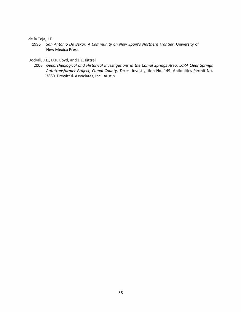
Appendix A
SHOVEL TEST TABLE

Table A-1. Shovel Test Data
ST # Site Level Depth Positive/Negative Munsell Soil Color Soil Texture Cultural
Material Comments/Reason for Termination
MV01
1 0-10
P
10YR2/2 very darkbrown cobbly clay
4 plastic, 2clear glass, 1brown glass
Between two large CAT excavators. Near creek. ASV=80%. Many cobbles
and gravels and a few concrete chuncks throughout test. Test
disturbed. Terminated at compact clay.
2 10-20 10YR2/2 very darkbrown cobbly clay
Metal, 1 aquaglass, 1 brownglass, 1 clear
glass
3 20-30 10YR2/2 very darkbrown cobbly clay
1 metal can, 2brown glass, 3clear glass, 1aqua glass, 2black plastic/
rubber
4-6 30-6010YR2/1
mottled with10YR7/8
black mottledwith yellow cobbly clay
Clear glasssherd at 60
cmbs
MV02 1 0-10 N 10YR2/2 very darkbrown
90% cobbleswith 10% silt none
100% cobbles and gravels. Disturbed. 1brown glass sherd. Terminated at
impassable cobbles.

Table A-1. Shovel Test Data
MV03
1 0-15
N
10YR2/1 black
clay none
Disturbed. ASV=90%. Near bridge atSan Joaquin street. 50% angular, blocky,
and round cobbles. Very sticky, darkclay. 1 brick fragment at 30-40 cmbs.
Terminated at compact clay.2 15-6010YR2/1
mottled with10YR7/8
black mottledwith yellow
MV04 1 0-30 N 10YR2/2 very darkbrown cobbly clay none
Disturbed. ASV=90%. Many cobbles.Terminated at a large chunk of concrete
and asphalt at 30 cmbs.
VM01 1-6 0-60 N
10YR7/1mottled with
10YR5/8,10YR8/1, and
10YR4/1
light graymottled with
yellowishbrown, white,and dark gray
Clay withpebbles and
cobbles(~10%)
noneAt edge of creek bank on artificial
terrace. Mowed grass. North bank. 0%ASV. Fill from creek.
VM02 1-6 0-55 N10YR2/2
mottled with10YR8/1
very darkbrown
mottled withwhite
clay with~80% gravels
and chalkinclusions
none
On west side of San Ignacio avenue on west side of the creek. Disturbed.
Terminated at chalk and dense gravels; possible utility.
VM03 1-7 0-70 N 10YR2/2 very darkbrown
clay with 50%gravels none On edge of creek bank near open area.
Terminated at compact clay.
VM04 1-6 0-58 N 10YR2/2 very darkbrown
clay with 50%gravels none
In field north of creek and west of roadin park. Disturbed. Concrete pipe
fragments in upper 20 cm. Terminatedat impassable cobbles.
ST # Site Level Depth Positive/Negative Munsell Soil Color Soil Texture Cultural
Material Comments/Reason for Termination
Table A-1. Shovel Test Data
VM05 1-5 0-48 N 10YR2/2 with10YR6/1
very darkbrown withbrownish
yellow
clay none ~ 5 cm of dense gravels (parking lot). Terminated at very compact clay.
JS01
1-3 0-30
N
10YR3/1 with10YR6/6 clay
mottles
very darkgrayish brownwith brownish
yellow
clay
none
Empty plot adjacent to creek. Somegrass. Very compact because of heavymachinery. ASV=80%. Common roundto subround limestone cobbles, graveland cobbles throughout both zones.
Terminated at very compact clay.4-6 30-60 10YR3/1 very darkgrayish brown clay loam
ST # Site Level Depth Positive/Negative Munsell Soil Color Soil Texture Cultural
Material Comments/Reason for Termination

Table A-1. Shovel Test Data
JS02
1-2 0-20
N
10YR3/1 with10YR6/6 clay
mottles
very darkgrayish brown
withclay loam
noneGrassy area between creek channel and
the yard of a house. ASV=0%.Terminated at very compact clay.
3-5 20-50 10YR3/1 very darkgrayish brown clay
JS03
1-3 0-25
P
10YR3/1 very darkgrayish brown silty clay
1 oyster fossil,1 ceramic
fragment withblue rings onedge, and 1amber glass
fragment fromlevel 1 Grassy area adjacent to creek. ASV=0%.
Terminated at impenetrable cobbles.
3-6 25-60
10YR6/6 with10YR6/1 and10YR3/1 withclay mottles(common)
brownishyellow with
gray and verydark gray
clay1 colorless
glass fragment~30 cmbs
ST # Site Level Depth Positive/Negative Munsell Soil Color Soil Texture Cultural
Material Comments/Reason for Termination

Table A-1. Shovel Test Data
JS04
1-4 0-40
P10YR3/1
mottled with10YR6/6
very darkgrayish brownmottled with
brownishyellow
clay
1 colorlessglass fragment
~30 cmbs
Grassy area adjacent to creek, justsouth of Mulberry and Memorial.Terminated at very compact clay.
5-6 40-60 none
ST # Site Level Depth Positive/Negative Munsell Soil Color Soil Texture Cultural
Material Comments/Reason for Termination
Related Documents