Journal of Geomatics Vol 8 No. 1 April 2014 © Indian Society of Geomatics Integration of geology, drainage and lineament on suitable landfill sites selection and environmental appraisal around Mysore city, Karnataka, India through remote sensing and GIS H.T. Basavarajappa 1 , Tazdari Parviz 2 , M.C. Manjunatha 1 and A. Balasubramanian 1 1 Dept. of Studies in Earth Science, University of Mysore, Manasagangothri, Mysore – 570 006, India 2 Khak Azma Oil Company, End of Shahre Ziba, 1487932571, Tehran, Iran Email: [email protected] ; [email protected] (Received: Mar 25, 2013; in final form 25 Sep 2013) Abstract: Urban environmental appraisal is a complex process involving the interplay of geological, hydrological and several other environmental parameters including geospatial data. Mysore urban exhibits flat to gently undulating topography with the elevation varying from 700-725 m above MSL with a gentle slope towards the South. The perennial river, Cauvery flows from west to east in the northern parts of the study area. The spectral signature of satellite images (7 bands) of IRS-1D, PAN+LISS-III and geospatial data from SoI toposheet (scale-1:50,000) were processed by GIS analysis, to classify the study area into two zones i.e., buffer zone and core zone. Mysore is one of the major cities in Karnataka producing nearly 600 tons of solid wastes everyday that need more landfill sites. The existing landfill site in the study area is operating within the core zone above a major lineament and affecting the groundwater, human health and surrounding environment. This study aims to delineate the safe disposal sites of municipal & industrial wastes in the city of Mysore, Karnataka, India through Remote Sensing (RS) and Geographical Information System (GIS) along with ground level data. The integration of RS, GIS analysis, GPS survey including Ground Truth Check (GTC), demarcates seven alternative safe locations to the existing landfill site, considering the environmental, biophysical and socio-economical factors.ail.com) Keywords: Geology, Drainage, Lineament, Environmental appraisal, Mysore city, RS & GIS 1. Introduction The rapid growth of population in a city demands for an increase in waste disposal and also larger area for disposal of effluent and toxic waste from different sources (Allen et al., 2002; Azadhe and Basavarajappa, 2010, 2011, 2013 and Parviz et al., 2013). This becomes a major environmental issue posing threats to the existence of human being and surrounding environment (Kontos et al., 2005). Applications of RS and GIS provide the alternative method of minimizing operational costs (Ogra, 2003; Kyessi and Mwakalinga, 2009) and digital data bank for long-term monitoring in selection of safe sites and fast evaluation (Miles et al., 1999). Buffering is a spatial (proximity) analysis that generates a polygon around a point, line or polygon theme by locating boundaries at a specified distance (Adeofun and Nwagu, 2006 and Sani et al., 2010). Using spatial analysis, a buffer zone of 25km radius was created around the study area from the city centre (Krishna-Raja circle) for extensive study. Drainage and lineament form the basic geological structures which are easily identifiable in the satellite imagery and helps in understanding the nature of lithology, demarcating the groundwater potential zones and in landfill sitting. The main factors considered to keep away the disposal sites are indicated as lakes, ponds, rivers, groundwater table, air quality index, geology, fault line, elevation, land use, habitation, highways and sensitive sites (Sumathi, 2006; Siddique et al., 1996; Basavarajappa et al, 2012). Mysore city is declared as second cleanest city in India in 2010 by Nationwide Union Urban Development Ministry (NUUDM). However only 200 tons of solid waste is treated at the sewage farm (Excel plant) daily to produce compost, remaining nearly 400 tons of garbage dumped as untreated (Akolkar, 2005). There will be a need to create a new landfill site every few years due to increase in waste generation. The currently operating landfill in the study area is located within the core zone and is rapidly running out of space. Hence, new landfill sites are needed urgently in the outskirt of core zone to avoid its effects on groundwater, human health and other environmental parameters. The landfill sites should have sufficient capacity to meet the current and projected waste to be deposited within the next 10years. Figure 1: Location map of the study area 2. Study area The study area is located between 12 0 18’ 31” N and 76 0 39’ 11” E with 25km radius from the centre of the 119 119

Welcome message from author
This document is posted to help you gain knowledge. Please leave a comment to let me know what you think about it! Share it to your friends and learn new things together.
Transcript

Journal of Geomatics Vol 8 No. 1 April 2014
© Indian Society of Geomatics
Integration of geology, drainage and lineament on suitable landfill sites selection andenvironmental appraisal around Mysore city, Karnataka, India through remote sensing and
GIS
H.T. Basavarajappa1, Tazdari Parviz2, M.C. Manjunatha1 and A. Balasubramanian1
1Dept. of Studies in Earth Science, University of Mysore, Manasagangothri, Mysore – 570 006, India2Khak Azma Oil Company, End of Shahre Ziba, 1487932571, Tehran, Iran
Email: [email protected]; [email protected]
(Received: Mar 25, 2013; in final form 25 Sep 2013)
Abstract: Urban environmental appraisal is a complex process involving the interplay of geological, hydrological andseveral other environmental parameters including geospatial data. Mysore urban exhibits flat to gently undulatingtopography with the elevation varying from 700-725 m above MSL with a gentle slope towards the South. Theperennial river, Cauvery flows from west to east in the northern parts of the study area. The spectral signature ofsatellite images (7 bands) of IRS-1D, PAN+LISS-III and geospatial data from SoI toposheet (scale-1:50,000) wereprocessed by GIS analysis, to classify the study area into two zones i.e., buffer zone and core zone. Mysore is one ofthe major cities in Karnataka producing nearly 600 tons of solid wastes everyday that need more landfill sites. Theexisting landfill site in the study area is operating within the core zone above a major lineament and affecting thegroundwater, human health and surrounding environment. This study aims to delineate the safe disposal sites ofmunicipal & industrial wastes in the city of Mysore, Karnataka, India through Remote Sensing (RS) and GeographicalInformation System (GIS) along with ground level data. The integration of RS, GIS analysis, GPS survey includingGround Truth Check (GTC), demarcates seven alternative safe locations to the existing landfill site, considering theenvironmental, biophysical and socio-economical factors.ail.com)
Keywords: Geology, Drainage, Lineament, Environmental appraisal, Mysore city, RS & GIS
1. Introduction
The rapid growth of population in a city demands foran increase in waste disposal and also larger area fordisposal of effluent and toxic waste from differentsources (Allen et al., 2002; Azadhe and Basavarajappa,2010, 2011, 2013 and Parviz et al., 2013). Thisbecomes a major environmental issue posing threats tothe existence of human being and surroundingenvironment (Kontos et al., 2005). Applications of RSand GIS provide the alternative method of minimizingoperational costs (Ogra, 2003; Kyessi andMwakalinga, 2009) and digital data bank for long-termmonitoring in selection of safe sites and fast evaluation(Miles et al., 1999). Buffering is a spatial (proximity)analysis that generates a polygon around a point, lineor polygon theme by locating boundaries at a specifieddistance (Adeofun and Nwagu, 2006 and Sani et al.,2010). Using spatial analysis, a buffer zone of 25kmradius was created around the study area from the citycentre (Krishna-Raja circle) for extensive study.Drainage and lineament form the basic geologicalstructures which are easily identifiable in the satelliteimagery and helps in understanding the nature oflithology,
demarcating the groundwater potential zones and inlandfill sitting. The main factors considered to keepaway the disposal sites are indicated as lakes, ponds,rivers, groundwater table, air quality index, geology,fault line, elevation, land use, habitation, highways andsensitive sites (Sumathi, 2006; Siddique et al., 1996;Basavarajappa et al, 2012). Mysore city is declared as
second cleanest city in India in 2010 by NationwideUnion Urban Development Ministry (NUUDM).However only 200 tons of solid waste is treated at thesewage farm (Excel plant) daily to produce compost,remaining nearly 400 tons of garbage dumped asuntreated (Akolkar, 2005). There will be a need tocreate a new landfill site every few years due toincrease in waste generation. The currently operatinglandfill in the study area is located within the core zoneand is rapidly running out of space. Hence, newlandfill sites are needed urgently in the outskirt of corezone to avoid its effects on groundwater, human healthand other environmental parameters. The landfill sitesshould have sufficient capacity to meet the current andprojected waste to be deposited within the next10years.
Figure 1: Location map of the study area
2. Study area
The study area is located between 120 18’ 31” N and760 39’ 11” E with 25km radius from the centre of the
119119

city (fig.1). The total area extent is 83.21 km2. Thestudy area is classified into two zones viz., buffer zoneand core zone for environmental appraisal and suitablelandfill site selection. The extensive study was carriedout in buffer zone (20.51 km2) while core zone (13.42km2) for intensive study using visual imageinterpretation and thematic layers. Buffer zone alsocovers a small part of Mandya district in the northernpart of the study area. The majority of the area iscovered by agricultural fields with moderateplantations. The main crops grown are sugarcane,maize, ragi, paddy, jowar, vegetables and floweringplants etc.
Table 1: Climatological parameters of Mysore cityMonth Relative Humidity (%) Temperature (0C) Rainfall (mm)
17:30 8:30 Min. Max. Avg. no. of Rainy days NormalJanuary 30 75 16.4 28.3 0.4 4.3February 25 69 18.2 31.2 0.4 6.6March 21 71 20.2 33.5 0.9 13.2April 34 75 21.4 34.0 4.6 63.5May 51 79 21.2 32.6 8.1 151.1June 66 81 20.2 28.9 5.5 60.5July 70 84 19.7 27.3 7.5 69.1
August 67 84 19.6 27.3 7.5 87.1September 61 83 19.3 28.7 7.8 117.1October 61 85 19.6 28.4 9.0 153.7
November 54 80 18.3 27.4 4.6 71.6December 43 78 16.5 27 0.9 11.9
Source: Department of Mines & Geology, Mysore(2005-10)
4. Methods & Materials
Factors considered for suitable landfill sites aregeological structure, bedrock & overburden lithology.Hydrological parameters including infiltration,percolation rates, pathways of rainwater passingthrough subsurfaces and hydrogeologicalcharacteristics. Topographic height above MSL, assurface slopes, exposure to the elements, particularlyrain and wind were considered. Economic distancesfrom waste sources, road networks, site access,management costs arising from the physicalcharacteristics of the site etc (Allen and McCarthy,1991).
Satellite Imagery – IRS-1D, PAN+LISS-III, TM& ETM+ (year-2000), Path-144 & Row-51 with52m resolution (USGS).
Toposheets - TIFF Images of 57D/11, 57D/12,57D/15, 57D/16 (scale - 1:50,000)
GIS Tools - ERDAS IMAGINE 9.2 & ArcGIS9.2.
GPS - A field survey using GPS (Garmin-12)was conducted to check the conditions of thesuggested alternative sites and exact locations.
5. Geology
The study area is composed of gneissic terrainbelonging to Dharwar Craton (fig.2) representing fourmajor formations as:
Younger pink & grey granite (CH-Chamundi hill). Amphibolites & Metasedimentary BIF’s. Ultramafic-mafic rocks and Older Peninsular Gneisses (Srikantappa et al.,
1992).
The rocks should be impermeable to ensure protectionof ground water resources. The parameters consideredfor suitable landfill sites are lithological characters likebedrock lithology, rock type, structure, fractures, grainsize, texture, thickness, homogeneity unconsolidatedoverburden, bedding characteristics etc. Hydrologicalproperties like porosity, permeability, hydraulicconductivity, attenuation potential of both bedrock andoverburden, conditions/depth and their effect ongroundwater table around Mysore city were alsoconsidered (Allen and MacCarthy, 1991).
Figure 2: Geology map of the study area
6. Drainage and tanks
Deep ground water table (atleast 50m) region issuitable to avoid contact between leachate and water.Groundwater levels, distribution of aquifers,aquicludes, groundwater flow patterns, size anddischarge of streams are controlled by topography ofthe site. Water bodies like tanks, ponds, streams, lakesand river were identified and digitized (fig.3). Alandfill sites should be kept 100m away from drainagechannels (Lunkapis et al., 2010; Agnes 1997;Despotakis and Economopoulos, 2007). The total areaon basin extent of Cauvery river in the buffer zone isabout 1,509.84 ha. The total water bodies cover an areaof 293.3 ha in the core zone. Most of the drains are ofdendritic type and converging into the river along N-Eand S-E direction. The total length of drainages is11.02 km2 representing the excellent and moderateground water potential zones in the study area.Unscientific way of waste disposal affectssurface/ground water, change in soil PH and blocks thedrainage systems nearby (Basavarajappa et al., 2012).
120
Journal of Geomatics Vol 8 No.1 April 2014
120
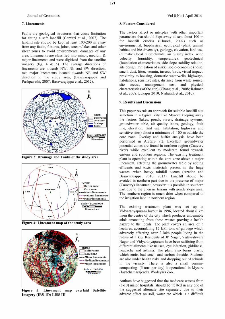
7. Lineaments
Faults are geological structures that cause limitationfor sitting a safe landfill (Gemitzi et al., 2007). Thelandfill site should be kept at least 100-200 m awayfrom any faults, fissures, joints, stream/lakes and othershear zones to avoid environmental damages of anyarea. Lineaments are classified into minor, medium &major lineaments and were digitized from the satelliteimagery (fig. 4 & 5). The average directions oflineaments are towards NW, NE and SW direction;two major lineaments located towards NE and SWdirection in the study area, (Basavarajappa andPushpavathi, 2007; Basavarajappa et al., 2012).
Figure 3: Drainage and Tanks of the study area
Figure 4: Lineament map of the study area
Figure 5: Lineament map overlaid SatelliteImagery (IRS-1D) LISS III
8. Factors Considered
The factors affect or interplay with other importantparameters that should kept away atleast about 100 mfor landfill criteria (Church, 2002) such asenvironmental, biophysical, ecological (plant, animalhabitat and bio-diversity), geology, elevation, land use,(climatic (local microclimate, air quality index, windvelocity, humidity, temperature), geotechnical(foundation characteristics, side slope stability relation,site design, mitigation of risks), socio-economic (noise,smell, dust, litter, vermin, insects, birds, visual impact,proximity to housing, domestic waterwells, highways,habitations, sensitive sites, distance from waste source,site access, management cost and physicalcharacteristics of the site) (Chang et al., 2008; Rahmanet al., 2008; Lukapis 2010; Nishanth et al., 2010).
9. Results and Discussions
This paper reveals an approach for suitable landfill siteselection in a typical city like Mysore keeping awaythe factors (lakes, ponds, rivers, drainage systems,groundwater table, air quality index, geology, faultline, elevation, land use, habitation, highways andsensitive sites) about a minimum of 100 m outside thecore zone. Overlay and buffer analysis have beenperformed in ArcGIS 9.2. Excellent groundwaterpotential zones are found in northern region (Cauveryriver) while excellent to moderate found towardseastern and southern regions. The existing treatmentplant is operating within the core zone above a majorlineament, affecting the groundwater table by addingeffluents and toxic materials present in the hugewastes, when heavy rainfall occurs (Azadhe andBasavarajappa, 2010, 2013). Landfill should beavoided in northern part due to the presence of major(Cauvery) lineament, however it is possible in southernpart due to the gneissic terrain with gentle slope area.The southern region is much drier when compared tothe irrigation land in northern region.
The existing treatment plant was set up atVidyaranyapuram layout in 1996, located about 6 kmfrom the centre of the city which produces unbearablestink emanating from these wastes proving a healthhazard to the locals. The plant covers an area of 5hectares, accumulating 12 lakh tons of garbage whichadversely affecting over 2 lakh people living in theradius of 3 km. Residents of JP Nagar, VishveshwaraNagar and Vidyaranyapuram have been suffering fromdifferent ailments like nausea, eye infection, giddiness,headache and asthma. The plant also burns plasticwhich emits bad smell and carbon dioxide. Studentsare also under health risks and dropping out of schoolsin the vicinity. There is also a small vermin-composting (5 tons per day) is operational in Mysore(Jayachamarajendra Wodeyar) Zoo.
Authors have suggested that the medicare wastes from(8-10) major hospitals, should be treated in any one ofthe suggested alternate site separately due to theiradverse effect on soil, water etc which is a difficult
121
Journal of Geomatics Vol 8 No.1 April 2014
121

task to prevent. Environmental appraisal on wastedisposal is more appropriate, based on geological,geotechnical, Remote Sensing, GIS and GPS surveystudy for rocky soil of gneissic terrains like Mysorecity.
NEWLY SELECTED LANDFILL POINTSSiteno’s Latitude Longitude
1. 760 35’ 26’’ 120 12’ 12’’2. 760 37’ 09’’ 120 11’ 53’’3. 760 38’ 40’’ 120 10’ 43’’4. 760 40’ 16’’ 120 13’ 00’’5. 760 39’ 41’’ 120 11’ 08’’6. 760 41’ 55’’ 120 12’ 11’’7. 760 47’ 16’’ 120 17’ 49’’
Applications of advent high-tech tool of RemoteSensing, GIS and GPS survey with ground truth check(GTC) by detailed field investigations, demarcatesseven sites (fig.6) to avoid most of the water bodiesand seepage areas through the fractures and lineamentzones around Mysore city (Basavarajappa et al., 2012).
10. Conclusions
Integration of thematic map prepared by collateral datayields more accurate and effective results. Thesouthern land is much drier when compared to theirrigation in northern part. Landfill should be avoidedin northern part due to the presence of major (Cauvery)lineament; however the waste disposal is possible insouthern part due to the gneissic with gentle slope area.Excellent groundwater potential zones are found innorthern region (Cauvery river) while excellent tomoderate are found towards eastern and southernregions (Kabini river). There is also a small vermin-composting is operational in Mysore zoo.
A set of seven most suitable sites were identified in thestudy area (Fig.6) which are more or less equallysignificant/potential for landfill construction and theyalso fulfills all the landfill criteria.
Figure 6: Integration of Geology, Drainage &Lineament layers for environmental appraisal
Solid wastes consist of everyday items such as productpackaging, furniture, clothing, bottles, food scarps,newspapers, appliances, paint and batteries, burningthese can generate energy reducing the volume ofwaste by up to 87%. At least 4 MW of electricity canbe generated daily from 100 tonnes of solid wasteswith 5 acres of land in any one of the newly selectedsite, by adopting an advanced version of pyrolysistechnology which is an eco-friendly and cost-effectivetechnology. All the suggested sites were clay-richenvironment and bare lands, based on the presentinvestigation data. The city waste should go from opendump to recycling at the source directly. Sorting ofwastes from city at the source level, allows theincineration of residuals minimizing the environmentalburden.
Implementation of recycling scheme where the papersare collected separately improves the material recoveryof eco-friendly. Majority of the solid waste fromconstruction and demolition of old buildings should besorted, crushed using machines and these may used asgood quality construction bricks by recycling methods.The best benefits of landfill is to dig a basin shapedepression at certain depth depositing the huge solidwastes which generates electricity and should be sealedat all directions except providing a pipe to generateGAS, BOOM energy and compost in low cost andother benefit to prevents greenhouse gases beingemitted into the atmosphere.
Acknowledgement
The Authors are indepthly acknowledged to Prof. S.Sathyanarayan & Prof. B. Basavalingu, Chairman,DOS in Earth Science, University of Mysore, Mysore;Prof. R. Nagendra, Anna University, Chennai; UGC,New Delhi for their financial assistance of MRP andAmith Pujari, Oneness InfraTech, Infrastructure & GISCompany, Bangalore for their support in preparing thethematic layers.
References:
Adeofun, C.O. and C.J. Nwagu (2006). Selection ofsolid waste landfill site using remote sensing and GIStechniques. Asset Series A (2006) 6 (2), Pp: 301-310.
Agnes, N. and P.J, Ogao., (1997). A spatial decisionsupport tool for landfill site selection: Case formunicipal solid waste management. Proc. of 3thAnnual International Conference on Computing andICT Research - SREC 07, pp 170 - 182.
Akolkar, A.B. (2005). Status of solid wastemanagement in India, Implementation status ofmunicipal solid wastes. Management and HandlingRules 2000, Central Pollution Control Board, NewDelhi.
Allen, A., G. Brito, P. Caetano, C. Costa, V. Cummins,J. Donelly, C. Fernades, S. Kukupas, V. O_Donell, C.
122
Journal of Geomatics Vol 8 No.1 April 2014
122

Robalo and D. Vendas (2002). Procedure for thelocation of landfill sites using a GIS model. In: 9thCongress of the International Association ofEngineering Geology and the Environment, Durban,South Africa, Pp: 100.
Allen, A.R. and I.A.J. MacCarthy (1991). Geologicalaspects of waste disposal site selection. In:Proceedings 1st Irish Environmental EngineeringConference, Kiely, G.K., McKeogh, E.J., O'Kane,P.J.P. (Eds.), Cork. Pp: 233-239.
Azadhe, T. Hejabhi and H.T. Basavarajappa (2010).Heavy metal pollution in Kabini river sediments.International Journal of Environmental Research (ijer)Vol.4, No.4 Automn, ISSN: 1735-6865. Pp: 629-636.
Azadhe, T. Hejabhi and H.T. Basavarajappa (2011).Heavy metal pollution in water and sediments in theKabini River, Karnataka, India. EnvironmentalMonitoring and Assessment, 185:1273-1283, SpringerScience +Business media, DOI.10.1007/s10661-010-1854-0. Pp: 01-11.
Azadhe, T. Hejabhi and H.T. Basavarajappa (2013).Heavy metal partitioning in sediments of the KabiniRiver in south India. Environmental Monitoring andAssessment, Apr-22nd, 185:1273-1283, SpringerScience +Business media, DOI.10.1007/s10661-012-2631-z. Pp: 1273-1283.
Basavarajappa, H.T. and K.N. Pushpavathi (2007).Mapping of ground water potential zones through RSand GIS in Yelandur taluk. Remote Sensing and GISApplications - Edited Volume, University of Mysore,Pp: 168-178.
Basavarajappa, H.T., K.N. Pushpavathi, M.C.Manjunatha and A. Balasubramanian (2012). Mappingand integration of geology and geomorphologicallandforms of Mysore district, Karnataka, India usingremote sensing and GIS techniques. Frontiers ofGeosciences. Edited Vol.1, Pp: 64-75.
Basavarajappa, H.T., K.N. Pushpavathi, M.C.Manjunatha and A. Balasubramanian (2012). Mappingand integration of geology, geomorphologicallandforms of Yelandur taluk, Chamarajanagara district,Karnataka, India using remote sensing and GIS. Papersubmitted to Journal of Environmental Geochemistry,Hyderabad. (ISSN 0972-0383), 15(2), 37-41).
Chang, N. B., G. Parvathinathan and J.B. Breeden(2008). Combining GIS with fuzzy multicriteriadecision-making for landfill sitting in a fast-growingurban region. Journal of Environmental Management,87, 139-153.
Church, R.L. (2002). Geographic information systemand location science. Computers and OperationResearch 29, Pp: 541–562.
Despotakis, V.K. and A.P. Economopoulos (2007). AGIS model for landfill sitting. GIS Consultant, 4Mastracha Street, Heraklion 71202 Greece.Environmental Engineering Dept.Technical Universityof Crete, Greece. Technical University of Crete,Greece, publisher, Global NEST Journal, 9, (1), 29-34.
Gemitzi, A., V.A. Tsihrintzis, E. Voudrias, C. Petalasand G. Stravodimos (2007). Combining geographicinformation system, multicriteria evaluation techniquesand fuzzy logic in sitting MSW landfills. EnvironGeol, 51, Pp: 797-811.
Kontos, T.D., D.P. Komilis and C.P. Halvadakis(2005). Sitting MSW landfills with a spatial multiplecriteria analysis methodology. Waste Management 25,Pp: 818–832.
Kyessi, A. and V. Mwakalinga (2009). GIS applicationin coordinating solid waste collection: The case ofSinza neighbourhood in Kinondoni municipality, Dares Salaam city, Tanzania. TS 4B – SDI in Municipalityand Natural Resources Management, Pp: 19.
Lunkapis, G.J., N. Ahmad, A.R.M. Shariff, S.Mansorand and M.R. Mispan (2010). GIS as decisionsupport tool for landfills sitting.http://www.gisdevelopment.net/application/urban/products/ma04133pf.html
Nishanth, T., M.N. Prakash and H. Vijith (2010).Suitable site determination for urban solid wastedisposal using GIS and remote sensing techniques inKottayam municipality, India. International Journal ofGeomatics & Geosciences, 1(2).
Ogra, A. (2003). Logistic management and spatialplanning for solid waste management systems usinggeographical information system. In: Map Asia 2003India.
Parviz Tazdari, H.T. Basavarajappa, M.C. Manjunathaand A. Balasubramanian (2013). Integration of soiland lineament on landfill site selection andenvironmental appraisal using remote sensing and GISaround Mysore city, Karnataka, India. XIII MSI-Convention & “Current Trends of Research inPrecambrian Geology and Vision-2020” AbstractVolume, March, Pp:124.
Rahman, M. M., K.R. Sultana and M.A. Hoque (2008).Suitable sites for urban solid waste disposal using GISapproach in Khulna city, Bangladesh. Proc. PakistanAcad..Sci., 45(1), Pp: 11-22.
Sani, Y., I. Christopher, W. Shittu and E. Jibril (2010).Land fill site selection for municipal solid wastemanagement using geographic information system andmulticriteria evaluation. American Journal of ScientificResearch 10, Pp: 34-49.
Siddiqui, M.Z., J.W. Everett and B.E. Vieux (1996).Landfill sitting using geographic information systems:
123
Journal of Geomatics Vol 8 No.1 April 2014
123

A demonstration. Journal of EnvironmentalEngineering 122, 515–523.
Srikantappa, C, K.N. Prakash Narasimha and H.T.Basavarajappa (1992). Highly saline fluid inclusions inChamundi granite, South India. In Current Science, 62,307-309.
Sumathi, V.R. (2006). Perspective development planfor solid waste management in Pondicherry. Ph.D.Thesis, Centre for Environmental Studies, AnnaUniversity, Chennai, India.
124
Journal of Geomatics Vol 8 No.1 April 2014
124
Related Documents


![Pal_et_al[1] SAR FFT Lineament IJRS](https://static.cupdf.com/doc/110x72/577d205d1a28ab4e1e92a9c1/paletal1-sar-fft-lineament-ijrs.jpg)


