CITY LEVEL PROJECTS INTEGRATING THE METRO STATION WITH THE NEIGHBOURHOOD Mandi House Metro Station

Welcome message from author
This document is posted to help you gain knowledge. Please leave a comment to let me know what you think about it! Share it to your friends and learn new things together.
Transcript

CITY LEVEL PROJECTS
INTEGRATING THE METRO STATION WITH THE NEIGHBOURHOODMandi House Metro Station

Delhi Urban Art Commission
The Delhi Urban Art Commission was set up by an Act of Parliament in 1973
to “advise the Government of India in the matter of preserving, developing
and maintaining the aesthetic quality of urban and environmental design within
Delhi and to provide advice and guidance to any local body in respect of any
project of building operations or engineering operations or any development
proposal which affects or is like to affect the skyline or the aesthetic quality of
the surroundings or any public amenity provided therein”.
(An ISO 9001 : 2008 Certified Organisation)

(An ISO 9001 : 2008 Certified Organisation)
DELHI URBAN ART COMMISSION with gratitude duly acknowledges the valuable contributions
of the following in making this report:
Organisations / Others
Ministry of Urban Development
Delhi Development Authority
Government of National Capital Territory of Delhi
North Delhi Municipal Corporation
East Delhi Municipal Corporation
South Delhi Municipal Corporation
New Delhi Municipal Council
Geospatial Delhi Limited
Delhi Metro Rail Corporation
Delhi Urban Shelter Improvement Board
BSES Rajdhani Power Limited
BSES Yamuna Power Limited
RWA’s and Area Councillors
Google Earth
Senior ConsultantRahoul B. Singh
ConsultantsKirti KawaleNikhil Pandey (3D Visualizer)
Delhi Urban Art Commission
Prof. Dr. P.S.N. Rao Chairman
Sonali Bhagwati Member (Upto 5 October, 2017)Samir Mathur MemberSonali Rastogi MemberDurga Shanker Mishra Member & Addl. Secretary, Ministry of Housing and Urban Affairs
(Upto 10 August, 2017) Manoj Kumar Member & Addl. Secretary, Ministry of Housing and Urban Affairs
(From 11 August, 2017)
Vinod Kumar Secretary
DUAC StaffRajeev Kumar Gaur, Raghvendra Singh, Indu Rawat, Amit Mukherji, Uma Bhati, Manju Anjali, Siddharth Sagar,Nihal Chand

*DISCLAIMER*
This report is for academic purposes only and has been prepared on the basis
of information gathered from various sources, in cases without any independent
verification. The report can be adopted and utilized by any Government Authority/
Local Body in the Country and is provided free of cost. The report is not meant to
derive any kind of gain, monetary or otherwise.
Though all efforts have been made to ensure the accuracy of the information in this
report, the same should not be construed as a statement of law or used for any legal
purposes. Delhi Urban Art Commission (DUAC) accepts no responsibility in relation
to the accuracy, completeness, usefulness or otherwise, of the information contained
in the publication. Stakeholders are advised to verify/check any information with
the relevant Government Department(s) and/or other source(s), and to obtain any
appropriate advice before acting on the information provided in the report.
While adequate measures have been taken to acknowledge the source of the
information used in the report, the nature of the process and the diverse sources
from which information is collected makes it difficult for the Commission to ascertain
whether each piece of information/data impinges upon any third party intellectual
property rights. DUAC shall consequently not be responsible for any inadvertent and
/ or bonafide omission of acknowledgement of source of information.
In no event will the DUAC be liable for any expense, loss or damage including,
without limitation, indirect or consequential loss or damage, or any expense, loss or
damage whatsoever arising out of any person/ stakeholder using or implementing or
relying on any information in this report.
(An ISO 9001 : 2008 Certified Organisation)
Preface
The city of Delhi, capital of this vast land of diversities, is a city laden with layers of history,
a place where civilizations have lived, prospered and perished over centuries. The modern
city today, built over and around a rich tapestry of heritage, presents an opportunity
at every turn, to allow for co-existence of the past, present and the future. In order to
understand this multidimensional urban spectrum and attempt to plan the future, various
city level studies have been initiated by the DUAC. I hope that these studies will help
the planners of modern day Delhi to carefully articulate urban space, structure, form and
environment and sensitively address future requirements.
I convey my thanks to all the Consultants and Members of the Commission who have
tirelessly worked on this research project to bring out this document. I also take this
opportunity to place on record my sincere appreciation of the efforts of Secretary and
other staff of DUAC for providing the necessary administrative support to make this
happen.
I fondly hope that the authorities of the local, state and national government take these
studies seriously and implement, in right earnest, the suggestions given herein.
October, 2017 Prof. Dr. P.S.N. Rao Chairman, DUAC
Sd/-

Contents1 Introduction 8
2 Historical Significance 10 2.1 Early and Late Mughal Period 10 2.2 Early 19th Century, Delhi 1914 11
3 Context 12 3.1 Zonal Plan D 12 3.2 Ward Boundaries, Location and Connectivity 13
4 Mapping and Site Analysis 14 4.1 Site 14 4.2 Movement around the Site 15 4.3 Open Space System 22 4.4 Development around the Site 26 4.5 Heritage Monuments 28 4.6 Architectural Heritage 29 4.7 Mandi House Metro Station 30 4.8 Urban Design Analysis 32 4.9 Cultural Hub 42 4.10 Conclusion 46
5 Design Proposal 48 5.1 Proposal I 48 5.2 Proposal II 50 5.3 Proposal III 52 5.4 Proposal III: Site Proposal 58
6 Annexure 72 6.1 Physical Characteristics of Pedestrian 72 6.2 Spatial Standards 74
Summary
Mandi house area is popularly known as the cultural hub of Delhi. The presence of many
significant cultural institutions and government offices along with the transit node gives an
opportunity to strengthen and enhance the pedestrian system along with bicycle loops to
connect different districts.
The site demonstrates how isolated cultural districts and surrounding developments can
be part of a pedestrian and bicycle system with the provision of proper pedestrian spaces,
open green spaces and abutting transport interchanges. Provision for pedestrian and
biking lanes with appropriate widths, auxiliary amenities for pedestrian walks – the design
proposal authenticates these essential urban spaces as anchors, making them vibrant, useful
and attractive to people.

Intr
oD
uC
tIo
n
8 9CITY LEVEL ProjECT INTEGrATING THE METro STATIoN WITH THE NEIGHBoUrHooD
Intr
oD
uC
tIo
n
1. Introduction
Design Intent:
1. To create of an Art District by bringing together cultural facilities.
2. Enhance urban connectivity at the local and city level along with the local pedestrian
network and traffic, at an urban scale; bicycle routes, autos, taxis, Metro, pedestrian
connections.
3. Provide safe pedestrianization and ease of parking in the city’s cultural district.
Methodology:
Site Surveys
Mapping and Site Analysis
Approach:
The study demonstrates three proposal with respect to the context and significance of the
cultural district of the city, which are discussed briefly:
1. Proposal I – Minimum Intervention: Existing Infrastructure with enhanced efficiency.
2. Proposal II – Institutional consolidation and creation of soft boundaries
3. Proposal III – Exploring potentials: A consolidated art district

HIS
torI
CA
l SI
gn
IfIC
An
Ce
HIS
torI
CA
l SI
gn
IfIC
An
Ce
10 11CITY LEVEL ProjECT INTEGrATING THE METro STATIoN WITH THE NEIGHBoUrHooD
Late Mughal PeriodThe city of Shahjahanabad was not limited to the area enclosed by the great wall. It was not the only hub of the urban complex, but extended to the north, south and west and along the opposite bank of the river to the east. According to Joseph Tieffenthaler, the suburbs extended eight miles beyond the Arab Gate to the south. (Blake 1991)
Delhi 1914In 1911, the British Government decided to shift the capital of India from Calcutta to Delhi. Edwin Lutyens, Herbert Baker and others created the present New Delhi. The layout was structured on a geometric grid with the seat of power at the apex of the layout, two ceremonial avenues intersecting each other at the central point, with roads placed at thirty or sixty degree angles where they crossed each other, interspersed with roundabouts and open spaces. The important elements of the Viceregal Estate included a dramatic vista along the Imperial Avenue, or Kingsway.The North and South Blocks on the either side led down the gradient to the Great Place with the Council House on the left and on to the War Memorial (now India Gate). Along the hexagon lay the palaces of some of the maharajas of India. (Singh M., Mukherjee R., Kapoor P., .2009)
2.1 Early and Late Mughal Period 2.2 Early 19th Century, Delhi 1914
Early 19th CenturyThe area south of Shahjahanabad, near the village of Jaisinghpura, belonged to the Raja of Jaipur. It consisted of a few villages, some gardens and brick kilns. It had ruins of buildings from past eras, and was therefore called ‘Khandraat Kalaan’ (the great ruins)(Singh M., Mukherjee R., Kapoor P., .2009)
Early Mughal PeriodIt is said that Shah Jahan shifted his capital from Agra to Delhi because of the extreme heat of the summer months which he felt was unfit for a monarch (Gupta, 1981).The Royal Palace was built between 1638 and 1648. The city walls, the Jama Masjid, and palaces for nobles and some public buildings were erected by members of the family of Emperor Shah Jahan. The Palace was inhabited for nearly five to six years after it was established.
The study area lies to the south of the walled city which was sparsely inhabited.
HIS
torI
CA
l SI
gn
IfIC
An
Ce

Co
nte
Xt
Co
nte
Xt
12 13CITY LEVEL ProjECT INTEGrATING THE METro STATIoN WITH THE NEIGHBoUrHooD
3.1 Zonal Plan D
This zone consists of many large parks and recreational facilities which include the Delhi Flying Club, National Stadium, Delhi Polo Club, Race Course, Jawahar Lal Nehru Stadium, Pragati Maidan (Trade Fair Grounds), Central Vista, Zoological Gardens, etc.
Towards the north of Rajpath, Connaught Place, the metropolitan city centre (D-1) is the hub of the city. Major public and semi-public facilities near the Ramlila Grounds (D-2) and sociocultural institutions located near Mandi House (D-3), serve the entire city.
Prominent medical colleges and hospitals such as the Maulana Azad Medical College, Ram Manohar Lohia Hospital, etc., and important educational institutes like the School of Planning and Architecture, Mata Sundri College, Dayal Singh College, College of Jesus and Mary and Lady Irwin College are a part of this zone.
Parliament House, Supreme Court, Central Government Ministries, Delhi High Court, Central Government offices, DDA, Delhi Administration offices, etc. are also located in this zone.
Major residential areas, include plots with large bungalows, Foreign Missions, State Guest Houses, Government colonies, private colonies and rehabilitation colonies.
Co
nte
Xt
IntroductionZone ‘D’ mainly comprises Lutyens’ Garden City and its extensions. This zone is situated between River Yamuna on one side and the ridge on the other. The zone inncludes some important areas of Central Delhi.
New Delhi was planned by Sir Edwin Lutyens in a geometric pattern, based on a triangle, which had three major functions at its apex., viz. commercial, governmental and recreational: Connaught Place, the Government Complex (Viceroy’s Palace and the Secretariat) and the India Gate are the respective centres of these major activities.
LocationThe Luytens Bungalow Zone forms a central part of the city with government accommodation. The area of study – Mandi House Metro station and its precincts – holds important cultural and art institutions along with government institutes as well as some residential components.
Ward BoundariesOn 15th February, 1931, the new capital was officially inaugurated. In the year 1932, the New Delhi Municipal Committee became a 1st class municipality. It was entrusted with supervisory powers to look after all services and activities it was called upon to undertake. The study area falls under the New Delhi Municipal Council.
ConnectivityPhase III extension of the Delhi Metro consists of Mandi House as an interchange station in order to reduce the pressure on Rajiv Chowk Station. This new corridor of 6.8 km connects the Central Secretariat to Kashmere Gate. Mandi House Circle is an intermediate node connecting the central business district, Connaught Place which connects with the western part of the city. It is well connected by bus routes to different parts of the city as well.
3.2 Ward Boundaries, Location and Connectivity
Ward Map of Delhi
Mandi House Circle
Mandi House Circle
Zonal Development Plan: Zone ‘D’Source: DDA
Google image of the site
Connaught Place
Lady Irwin College, Sikandra Road
Map showing Metro and Road Netwok
Co
nte
Xt
Special Characteristics of the Zone:
Source: https://walksonbarefoot.files.wordpress.com/2017/01/456578274.jpg?w=660
Source: http://www.ladyirwin.edu.in/index.aspx
Source: https://www.ndmc.gov.in/ndmc/history.aspx

MA
PPIn
g A
nD
SIt
e A
nA
lYSI
S
MA
PPIn
g A
nD
SIt
e A
nA
lYSI
S
14 15CITY LEVEL ProjECT INTEGrATING THE METro STATIoN WITH THE NEIGHBoUrHooD
Feroz Shah Road
Sikandra Road
Safda
r Hash
mi Roa
d
Bhagwandas Road
Cop
erni
cus
Mar
gTa
nsen
Mar
g
Barakhamba Road
4.1 Site 4.2 Movement around the Site
Copernicus Marg towards Mandi House Circle
Feroz Shah Road towards Rashtrapati Bhawan
The area is significant in terms of connectivity within the city – a major link connecting the eastern and western part of the city. The Mandi House Circle is a vital node connecting to Connaught Place. The new interchange Metro station has added to the footfall. Art and cultural institutes, government institutions, significant auditoriums and markets attract high traffic volumes and create traffic congestion along certain stretches of the study area.
Site SelectionThe area chosen for this study falls under the Lutyens Bungalow Zone which has a historic significance with respect to the making of New Delhi. Major components include the transit node of Mandi House Metro station and cultural institutions around the Mandi House Circle. The significance of the area with respect to the history of the place, as well as its interface with the newer developments like the new Metro station and its integration with surroundings is the major thrust of the study.
Map of Lutyens Bungalow Zone showing location of the site
Map of showing the extent of the site
Map of Delhi showing the location of the site
Barakhamba Road,.
MA
PPIn
g A
nD
SIt
e A
nA
lYSI
S
MA
PPIn
g A
nD
SIt
e A
nA
lYSI
S
1
2
1
2
3
1
2
33
2
1
3

MA
PPIn
g A
nD
SIt
e A
nA
lYSI
S
MA
PPIn
g A
nD
SIt
e A
nA
lYSI
S
16 17CITY LEVEL ProjECT INTEGrATING THE METro STATIoN WITH THE NEIGHBoUrHooD
4.2.1 Movement Issues
The new Mandi House interchange Metro station, with its influx of people, has added facilities like para-transit modes to link further to different parts of the area. Due to many significant functions in the area, the volume of vehicles and parking becomes critical during peak hours. Para-transit modes like auto-rickshaws have dedicated stands on certain important roads like Copernicus Marg, which has auditoriums, to facilitate them. During the hours when auditoriums are in use, four-wheelers are parked in the lanes of residential areas, creating chaos and traffic congestion in these areas.
Though Kamani Auditorium and Doordarshan Bhawan have a few NDMC authorised parking facilities for two and four-wheelers, which are operated and managed by DIMTS Ltd., these are not sufficient for the parking requirements of the area. Tilak Bridge Railway Station, a part of Delhi Suburban Railway, is also located in a residential and commercial neighbourhood of the New Delhi district of Delhi. It lacks proper accessibility.
Para-transit transport outside the Mandi House Metro station
Access through Residential Lanes for Tilak Bridge railway station.
Pedestrian entrance to Tilak Bridge Railway Station
Para-transits outside Ravindra Bhawan, Feroz Shah Road
Cars parked in residential lanes near Copernicus Lane
Taxi stand next to the Little Theatre Group auditorium, Copernicus Lane
Parking along Bengali Market
Parking in front of Kamani Auditorium, Copernicus Marg
Parking, FICCI, Tansen Marg
Bus stop and para-transit outside the Mandi House Metro station
Provision for bicycle sharing at Mandi House Metro station
Parking along Doordarshan Bhawan, Copernicus Marg
1
2
3
4
6
5
MA
PPIn
g A
nD
SIt
e A
nA
lYSI
S
6
5
9
11
1
12
42
3
10
7
8
7
8
9
10
11
12
MA
PPIn
g A
nD
SIt
e A
nA
lYSI
S

MA
PPIn
g A
nD
SIt
e A
nA
lYSI
S
MA
PPIn
g A
nD
SIt
e A
nA
lYSI
S
18 19CITY LEVEL ProjECT INTEGrATING THE METro STATIoN WITH THE NEIGHBoUrHooD
Pathway along Bhagwandas Road
Key Plan
Pathway along Feroz Shah Road
Pathway along a residential area, Safdar Hashmi Marg
Pathway along Copernicus Marg
Pedestrians crossing along Mandi House Circle Pathway along Metro Station, Sikandra Road
The volume of pedestrians is considerably high due to various educational institutions in the vicinity of Mandi House Metro station. Well-maintained pedestrian walkways exist along most stretches with facilities such as kiosks on certain stretches. The residential areas are well-equipped with pedestrian infrastructure .
3
2
5 6
1
4
4.2.2 Pedestrian Movement
6
51
4
2
3
MA
PPIn
g A
nD
SIt
e A
nA
lYSI
S

MA
PPIn
g A
nD
SIt
e A
nA
lYSI
S
20 21CITY LEVEL ProjECT INTEGrATING THE METro STATIoN WITH THE NEIGHBoUrHooD
MA
PPIn
g A
nD
SIt
e A
nA
lYSI
S
Mandi House Circle is an important connection point for people commuting to trans-Yamuna, the western part of the city and to the areas like Karol Bagh and further west..The circle also connects significant cultural centres of the city and has an established pedestrian network with green pockets which form a recreational space for the people working in the area.
People use the open spaces along the roads and most predominantly the central open green space of the Mandi House circle. One of the prime concerns here is that, for using this green space, they have to cross the busy vehicular road which is risky for the user. One of the thrust area of design intervention is to ensure pedestrian safety and connectivity to different cultural districts. The green spaces have some defunct water fountains along with seating spaces for pedestrians along the way.
4.2.3 Pedestrian Movement around Mandi House Circle
Pathway along the Embassy of Nepal
Greens in front of the Embassy of Nepal
Pathway along Ravindra Bhawan
Greens in front of Ravindra Bhawan
Pedestrian crossing, Copernicus Marg
Greens in front of The National School of Drama
Greens in front of Himachal Bhawan with a defunct water fountain.
Mandi House Metro station with a bus stop and parking bay for intermediate para-transit
Pedestrian walkway and kiosks in front of The National Museum of Natural History
Pathway along Sangeet Bharti Pathway along Mandi House Metro station, Sikandara Road
Pathway along the National Museum of Natural History
Feroz Shah Road
Sikandra Road
Safda
r Hash
mi Marg
Bhagwandas Road
Cop
erni
cus
Mar
g
Tans
en M
arg
Barakhamba Road
MA
PPIn
g A
nD
SIt
e A
nA
lYSI
S
3
4 6 8
5 7 119
12102
1
1
2
3
4
5
6
7
8
9
11
12
1
9
8
7
11
5
6
12
2
3
4
10

MA
PPIn
g A
nD
SIt
e A
nA
lYSI
S
MA
PPIn
g A
nD
SIt
e A
nA
lYSI
S
22 23CITY LEVEL ProjECT INTEGrATING THE METro STATIoN WITH THE NEIGHBoUrHooD
MA
PPIn
g A
nD
SIt
e A
nA
lYSI
S 4.3 Open Space System 4.3.1 Tree Avenues
Behada Tree, Barakhamba RoadNeighbourhood park
Green spaces along Sikandara Road
Residences, Lutyens Bungalow Zone Residences, Lutyens Bungalow ZoneSource: https://www.wmf.org/project/lutyens-bungalow-zone
Source: https://badabingbadabambadaboom.wordpress.com/2012/04/27/my-life/
Barakhamba RoadWide green zones with pedestrian tracks
Green spaces along Feroz Shah Road
Copernicus MargSausage Tree, Copernicus Marg
Jamun/ Rai Jamun Tree, Feroz Shah Road Feroz Shah Road
The new city was planned as a ‘garden city’, based on a geometric grid with avenues and axial vistas that terminate at hexagons.
The avenue trees chosen were based on the fact that the vistas were mostly flat and uninterrupted. These avenues highlighted significant architectural monuments such as Purana Qila, the Lodi Tombs and Safdarjung’s Mausoleum. The size of the special trees selected determined the width of the avenues in which they were planted. The Town Planning Committee (1913) picked 13 types of avenue trees out of very large number that grew in Delhi. (Krishen, 2006)
The erstwhile Maharajas were granted large plots in the study area to build their palaces in the new capital. The officer’s bungalows were designed with small and compact quarters for gardeners and clerks. The size of the bungalows for different levels of gazetted officers were planned according to their official hierarchy. Senior civil servants lived in large houses that were set in spacious, walled-in gardens. (Singh M., Mukherjee R., Kapoor P., .2009)
Institutions are a large part of the study area which form a substantial portion of open spaces and contribute to the open green space system.
Source: Krishen, 2006, Trees of Delhi.

MA
PPIn
g A
nD
SIt
e A
nA
lYSI
S
MA
PPIn
g A
nD
SIt
e A
nA
lYSI
S
24 25CITY LEVEL ProjECT INTEGrATING THE METro STATIoN WITH THE NEIGHBoUrHooD
MA
PPIn
g A
nD
SIt
e A
nA
lYSI
S
Source: http://www.thehindu.com
Aerial view of Lutyens Bungalow Zone
4.3.2 Existing VegetationThe green areas in the area of study are the result of British planning of the new capital with spacious plots and open spaces. Avenues and vistas were a distinct part of the planning process which remains a legacy of colonial rule. This peculiar character of the Lutyens Bungalow Zone differentiates it from the rest of Delhi and forms a green lung in central Delhi.

MA
PPIn
g A
nD
SIt
e A
nA
lYSI
S
Ben
gA
lI M
Ark
et, t
An
Sen
MA
rg
26 27CITY LEVEL ProjECT INTEGrATING THE METro STATIoN WITH THE NEIGHBoUrHooD
4.4 Development around the Site
National School of Drama, Bhagwandas Road
Mandi House Metro station, Sikandra Road
Sangeet Bharti, Tansen Marg
National Museum for Natural History and FICCI Auditorium, Tansen Marg
Embassy of Nepal, Barakhamba Road
Little Theatre Group, Copernicus Marg
Kamani Theatre, Copernicus Marg
Bengali Market, Tansen Marg Doordarshan Bhawan, Copernicus Marg
Himachal Bhawan, Sikandra Road
Ravindra Bhawan, Copernicus Marg
The Lutyens Bungalow Zone has typical characteristics such as large plot sizes and a pleasant environment. In fact, the area is unique in its low density character in the heart of the city. The area is flanked by government institutions, government housing, educational institutions and is the cultural hub of the city, with many renowned art and literary institutes of the country.
The area is rich with heritage and has also accorded with the newer development like the Mass Rapid Transit System (MRTS), which has improved its connectivity to the rest of the city
10
9
8
7
3
4
6
5
1
2
11
5
6
7
4
3
11
8
9
10
1
2
MA
PPIn
g A
nD
SIt
e A
nA
lYSI
S

MA
PPIn
g A
nD
SIt
e A
nA
lYSI
S
MA
PPIn
g A
nD
SIt
e A
nA
lYSI
S
28 29CITY LEVEL ProjECT INTEGrATING THE METro STATIoN WITH THE NEIGHBoUrHooD
22
HeritageThe area is rich in architecture from the Colonial era. A few palatial residences were later converted for different uses. Residential palaces like Bahawalpur House, now the National School of Drama and Malerkotla House, now the Embassy of Nepal, are a few examples. Lady Irwin College is an example of Colonial Architecture.
Legacy of ArchitectureThe area is enriched by the work of significant and renowned architects of the country from the British era to the present day. Different architectural styles from different eras can be seen here.
Lady Irwin College (1930)Architect: Walter George.
Ravindra Bhawan (1957-63)Architect: Habib Rahman
Shri Ram Centre (1966-1969)Architect: Shivnath Prasad
Triveni Kala Sangam (1957-63)Architect: Joseph Allen Stein
Doordarshan Bhawan (1957-63)Architect: Raj Rewal
Himachal Bhawan(1982)Architect: Satish Grover
4.5 Heritage Monuments 4.6 Architectural Heritage
National School of Drama, Bhagwandas Road
Modern School, Barakhamba RoadSource: https://en.wikipedia.org/wiki/File:Modern_School,_Delhi.jpg
Ravindra Bhawan, Copernicus Marg
Residence, Sikandra Road
Doordarshan Bhawan, Copernicus Marg
Embassy of Nepal, Feroz Shah Road
Embassy of Nepal, Feroz Shah RoadLady Irwin College, Sikandra Road
Lady Irwin College, Sikandra Road
Tehri Garhwal House, Bhagwandas Road Triveni Kala Sangam, Tansen Marg
1 1 3
4
6
5
4
5
3
1
4
35
6
2
1
4
35
24
53
6
2
1
4
5
3
2
1
MA
PPIn
g A
nD
SIt
e A
nA
lYSI
S
MA
PPIn
g A
nD
SIt
e A
nA
lYSI
S

MA
PPIn
g A
nD
SIt
e A
nA
lYSI
S
MA
PPIn
g A
nD
SIt
e A
nA
lYSI
S
30 31CITY LEVEL ProjECT INTEGrATING THE METro STATIoN WITH THE NEIGHBoUrHooD
A
A
Sikandra Road
Section - AA
Key Plan
Site Plan: Mandi Metro Station
Mandi Metro Station, concourse level
Pedestrian Plaza in front of metro exit
Entrance plaza, Mandi House Metro station
Entrance plaza, Mandi House Metro station Metro Entry/ Exit
Concourse Level Plan
Source: Delhi Metro Rail Corporation Ltd.
345
21
3
1
53
4
12
4
2
5
The Mandi House Metro Station is located on the Blue and Violet Lines of the Delhi Metro. It serves the cultural hub of Delhi – Mandi House area – which has the National School of Drama, Ravindra Bhawan, Sangeet Natak Akademi, Sahitya Akademi, Feroz Shah Kotla, Shri Ram Centre for Performing Arts and the Triveni Kala Sangam, besides Bengali Market and the nearby residential areas.
As part of Phase III of the extension of Delhi Metro, Mandi House has been expanded into an interchange station in order to reduce pressure on Rajiv Chowk station. The new line has integrated with the Badarpur corridor.
4.7 Mandi House Metro Station
MA
PPIn
g A
nD
SIt
e A
nA
lYSI
S
MA
PPIn
g A
nD
SIt
e A
nA
lYSI
S

MA
PPIn
g A
nD
SIt
e A
nA
lYSI
S
MA
PPIn
g A
nD
SIt
e A
nA
lYSI
S
32 33CITY LEVEL ProjECT INTEGrATING THE METro STATIoN WITH THE NEIGHBoUrHooD
4.8 Urban Design Analysis 4.8.1 Urban Node
NodesPaths
Districts
Edges Triveni Kala SangamShriram Centre for Performing Arts
Himachal Bhawan
Doordarshan Bhawan
Ravindra Bhawan
Wide Pedestrian walkways, Avenues
Triveni Kala SangamShri Ram Centre for Performing Arts
Himachal Bhawan
Doordarshan Bhawan
FICCI Auditorium
Bengali Market
Kamani Auditorium,Little Theatre Group
Nepalese Embassy
Landmarks
PathsLutyens Bungalow Zone predominantly consists of wide avenues, pathways along roads with greenery around.
EdgesThe edges in this area are not continuous due to the large plots designed as a part of its planning. DistrictsThe art and cultural districts in the area form a significant zone for people visiting these places.
NodesMandi House Circle forms an important junction, with transit interchanges and many districts in vicinity. It is a vital place locator for individuals to perceive nearby places.
LandmarksMany institutions and auditoriums around the area, serve as landmarks to visitors. These landmarks help in orientation and make places easily identifiable.
Pathway along Feroz Shah road Mandi House Circle
Doordarshan Bhawan
Ravindra Bhawan
Pathway along Copernicus Marg Green spaces along FICCI auditorium
Triveni Kala Sangam
National School of Drama
Triveni Kala Sangam
National School of Drama
MA
PPIn
g A
nD
SIt
e A
nA
lYSI
S
MA
PPIn
g A
nD
SIt
e A
nA
lYSI
S
MA
PPIn
g A
nD
SIt
e A
nA
lYSI
S
MA
PPIn
g A
nD
SIt
e A
nA
lYSI
S
34 35CITY LEVEL ProjECT INTEGrATING THE METro STATIoN WITH THE NEIGHBoUrHooD
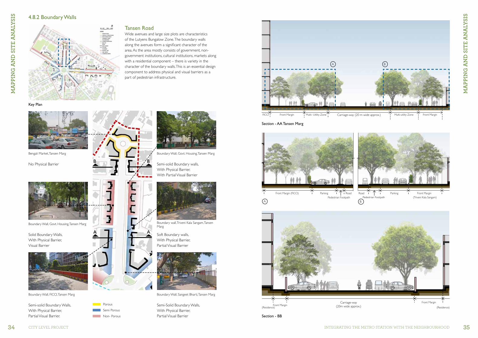
Semi-solid Boundary Walls,With Physical Barrier, Partial Visual Barrier.
Semi-Solid Boundary Walls,With Physical Barrier, Partial Visual Barrier
Soft Boundary walls,With Physical Barrier, Partial Visual Barrier
Solid Boundary Walls,With Physical Barrier, Visual Barrier
No Physical Barrier Semi-solid Boundary walls,With Physical Barrier, With Partial Visual Barrier
Tansen RoadWide avenues and large size plots are characteristics of the Lutyens Bungalow Zone. The boundary walls along the avenues form a significant character of the area. As the area mostly consists of government, non-government institutions, cultural institutions, markets along with a residential component – there is variety in the character of the boundary walls. This is an essential design component to address physical and visual barriers as a part of pedestrian infrastructure.
Boundary Wall, FICCI, Tansen Marg Boundary Wall, Sangeet Bharti, Tansen Marg
Boundary Wall, Govt. Housing, Tansen Marg
Bengali Market, Tansen Marg
Boundary wall, Triveni Kala Sangam, Tansen Marg
Boundary Wall, Govt. Housing, Tansen Marg
Front Margin
Front Margin
Section - AA Tansen Marg
Section - BB
FICCI
(Residence) (Residence)
Multi- Utility Zone Carriage-way (20 m wide approx.)
Carriage-way(20m wide approx.)
Multi-utility Zone Front Margin
Front MarginPorous
Semi Porous
Non- Porous
A
B
A
B
Key Plan
A
A
B
B
4.8.2 Boundary Walls
MA
PPIn
g A
nD
SIt
e A
nA
lYSI
S
Front Margin (FICCI) Front MarginParking
(Triveni Kala Sangam)
Parking
Pedestrian Footpath Pedestrian FootpathRoad Road
MA
PPIn
g A
nD
SIt
e A
nA
lYSI
S

MA
PPIn
g A
nD
SIt
e A
nA
lYSI
S
MA
PPIn
g A
nD
SIt
e A
nA
lYSI
S
36 37CITY LEVEL ProjECT INTEGrATING THE METro STATIoN WITH THE NEIGHBoUrHooD
Section AA
Semi-solid Boundary Walls,With Physical Barrier, Partial Visual Barrier.
Solid Boundary walls,With Physical Barrier, Partial Visual Barrier
Semi-solid Boundary Walls,With Physical Barrier, Partial Visual Barrier.
Solid Boundary Walls,With Physical Barrier, Visual Barrier
Solid Boundary walls,With Physical Barrier, With Visual Barrier
Solid Boundary Walls,With Physical Barrier, With Visual Barrier
A wide pedestrian pathway with seating along the pathway and ancillary facilities like eating kiosks along Sangeet Bharti makes the path attractive and usable.Parking of two-wheelers hinders pedestrian movement.
Parked buses occupy the space along the wide pedestrian pathway outside Himachal Bhawan, which breaks pedestrian continuity.
Boundary Wall, Sangeet Bharti, Safdar Hashmi Marg
Boundary Wall, adjacent to Himachal Bhawan, Safdar Hashmi Marg
Boundary Wall, Shri Ram Centre for Performing Arts, Safdar Hashmi Marg
Boundary Wall, Sangeet Bharti, Safdar Hashmi Marg
Boundary Wall, Himachal Bhawan, Safdar Hashmi Marg
Boundary Wall, Govt. Housing, Safdar Hashmi Marg
Side Margin (Sangeet Bharti)
Side Margin HimachalBhawan
RoadMulti-utility Zone
Multi-utility ZoneRoad
A
B
B
A
A
A
Key Plan
Safdar Hashmi RoadWide roads with varied land uses have boundary walls depending upon the building typology. A variety of boundary wall are seen on Safdar Hashmi Marg, as a majority of these buildings are public in nature.
Porous
Semi Porous
Non- Porous
MA
PPIn
g A
nD
SIt
e A
nA
lYSI
S 4.8.2 Boundary Walls
Multi-Utility ZoneMulti-utility Zone Carriage-way Front Margin Himachal BhawanSide MarginSangeet Bharti
MA
PPIn
g A
nD
SIt
e A
nA
lYSI
S
A A
38 39CITY LEVEL ProjECT INTEGrATING THE METro STATIoN WITH THE NEIGHBoUrHooD
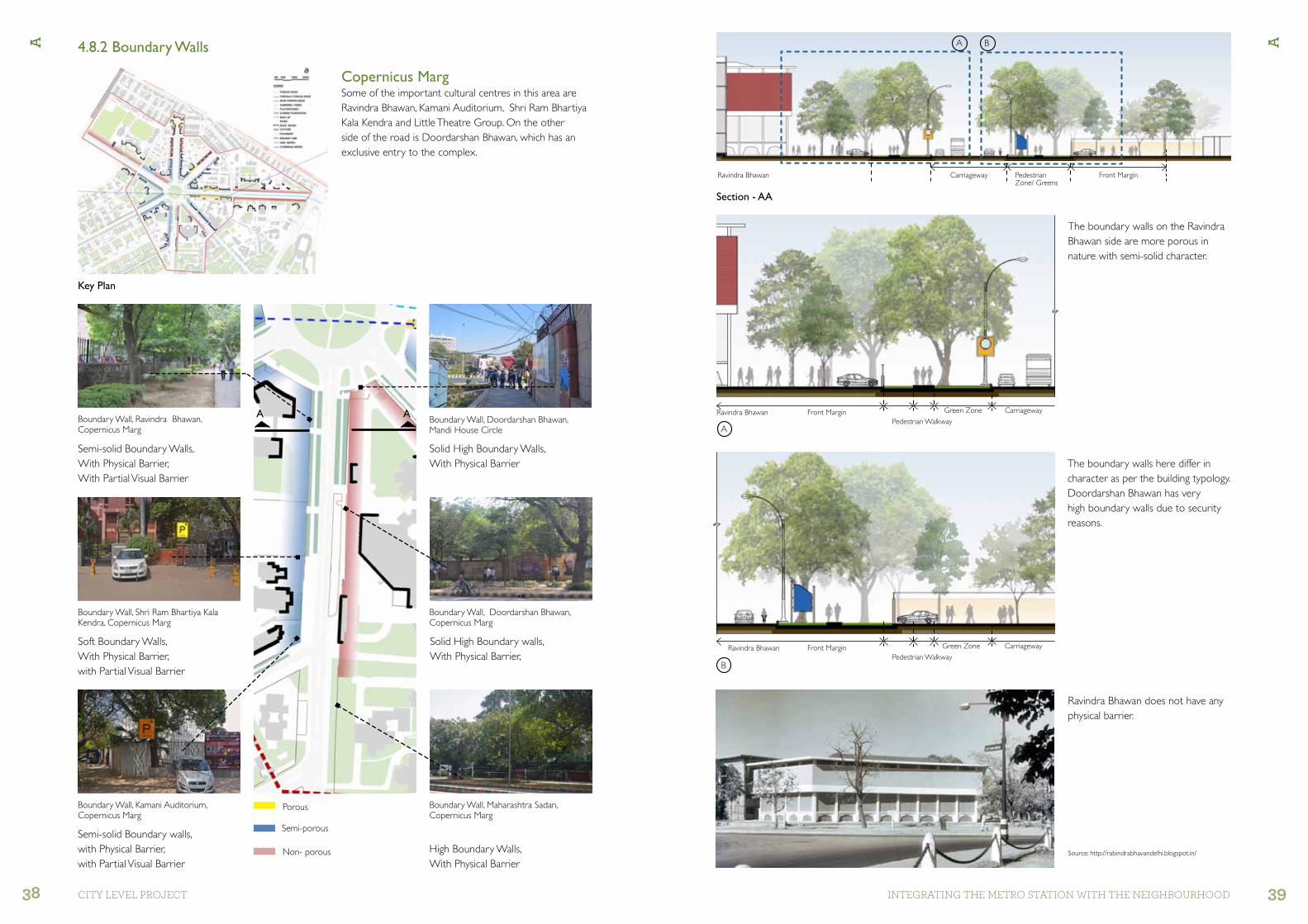
Semi-solid Boundary walls,with Physical Barrier, with Partial Visual Barrier
High Boundary Walls,With Physical Barrier
Ravindra Bhawan does not have any physical barrier.
Soft Boundary Walls,With Physical Barrier, with Partial Visual Barrier
Semi-solid Boundary Walls,With Physical Barrier, With Partial Visual Barrier
Solid High Boundary Walls,With Physical Barrier
Solid High Boundary walls,With Physical Barrier,
Boundary Wall, Kamani Auditorium, Copernicus Marg
Boundary Wall, Shri Ram Bhartiya Kala Kendra, Copernicus Marg
Boundary Wall, Doordarshan Bhawan, Copernicus Marg
Boundary Wall, Maharashtra Sadan, Copernicus Marg
Source: http://rabindrabhavandelhi.blogspot.in/
Boundary Wall, Ravindra Bhawan, Copernicus Marg
Boundary Wall, Doordarshan Bhawan, Mandi House Circle
A A
Ravindra Bhawan
Ravindra Bhawan
Ravindra Bhawan
Carriageway Pedestrian Zone/ Greens
Green Zone
Green Zone
Carriageway
Carriageway
Front Margin
Front Margin
Pedestrian Walkway
Pedestrian Walkway
Front Margin
Non- porous
Semi-porous
Porous
A B
A
B
Section - AA
Key Plan
Copernicus MargSome of the important cultural centres in this area are Ravindra Bhawan, Kamani Auditorium, Shri Ram Bhartiya Kala Kendra and Little Theatre Group. On the other side of the road is Doordarshan Bhawan, which has an exclusive entry to the complex.
The boundary walls here differ in character as per the building typology. Doordarshan Bhawan has very high boundary walls due to security reasons.
The boundary walls on the Ravindra Bhawan side are more porous in nature with semi-solid character.
4.8.2 Boundary Walls

A A
40 41CITY LEVEL ProjECT INTEGrATING THE METro STATIoN WITH THE NEIGHBoUrHooD
4.8.4 Urban Districts/Node4.8.3 Activity Node: Sociocultural
The cultural hub of the city is well-connected by all transport modes. Mandi House Metro station is significant in terms of people commuting to and from varied places. The area is well-connected by para-transit modes, bus stops and bus-shelters forming an essential element of the transport system. Important sociocultural institutions such as Ravindra Bhawan, National School of Drama, Sangeet Bharti, Triveni Kala Sangam, Shri Ram Centre for Performing Arts, etc.,fall within walking radius of the Metro station. The walking radius in the map above indicates the vicinity of institutions, offices, market places and residential areas. Mandi House Circle is a concentration of pedestrian activity, and is therefore a significant design element in which a central core of pedestrian related facilities, connects the concourse level of the Metro without conflicting with the thoroughfare.
Natonal School of Drama, Bhagwandas Road
Triveni Kala Sangam, Tansen Marg
The city’s cultural hub are important urban nodes of the city which attract many visitors from all over the city. Each of the cultural districts are a hub of multi-disciplinary activities, but are disconnected by means of accesibility. Spaces where people walk, bicycle, drive, park, shop need essential design considerations for efficient use of space.
Ravindra Bhawan, Copernicus MargSource: https://www.flickr.com/photos/sreenivasan/13215522474
Shriram Centre for Performing Arts, Safdar Hashmi Marg

A A
42 43CITY LEVEL ProjECT INTEGrATING THE METro STATIoN WITH THE NEIGHBoUrHooD
Key Plan
Tans
en M
arg
Barakhamba Road
Tans
en M
arg
Safda
r Hash
mi Marg
FICCI KK Birla Auditorium: FICCI KK BIRLA AUDITORUM has a capacity of 626 and boasts of a large open ground which can be used as a venue for exhibitions, lunches, dinners and team activities.
Shriram Centre for Performing ArtsShri Ram Centre for Performing Arts was originally known as the Indian National Theatre in 1948. It promotes arts and culture as well as nurture talents in the field of performing arts and preserve Hindi theatre along with other forms of globally recognized performing arts. It includes a theatre for the performing arts, a theatre repertory company and an acting school.
Bengali MarketBengali Market (its actual name is Mal Market) is among the oldest and most popular markets in New Delhi. A cultural hub, only a few kilometres away from Connaught Place, it was built by a Bengali, Mal Lohia, in 1930. It is a relatively small market, comprising several stores situated in a circular manner around a traffic roundabout. Today, it is famous for its North Indian street food, and shops selling sweetmeats, such as Nathu’s Sweets (specializes in channa-bhature) and Bengali Sweet House.
Triveni Kala SangamTriveni Kala Sangam is an important cultural and arts complex and education centre founded in 1950, by Sundari K. Shridharani, who was also its founding director. Triveni, as it is commonly known, contains four art galleries, a chamber theatre, an outdoor theatre, an open air sculpture gallery, besides this it runs its various art, music and dance classes.
Sangeet BhartiSangeet Bharti is another significant institution which forms a part of the cultural hub. It is one of the oldest institutions which started in 1955. It promotes dance and music. Dance forms such as Kathak and Bharatnatyam form part of the courses offered by the institution.
Mandi House Circle and its vicinity is renowned as the cultural hub of the city. The area has many art and cultural institutions as well as the city’s important auditoriums. Some of the institutions were founded just after Independence and are still thriving with the same vigour with which they were started.
FICCI Auditorium
Source: https://en.wikipedia.org/wiki/Bengali_Market
Bengali Market
Shri Ram Centre for Performing Arts
Triveni Kala Sangam
Sangeet Bharti
Tans
en M
arg
4.9 Cultural Hub
Source: http://ficciauditorium.com/
Source: https://en.wikipedia.org/wiki/Triveni_Kala_Sangam
Source: http://shriramcentre.org

A A
44 45CITY LEVEL ProjECT INTEGrATING THE METro STATIoN WITH THE NEIGHBoUrHooD
Ravindra BhawanRabindra Bhawan Houses: Sangeet Kala Akademi, Sahitya Akademi, Lalit Kala Akademi
S. No. Auditoriums/ theatre Seating Capacity Parking
1. Little Theatre Group 327 seatsOn-road parking – Parking along Copernicus Lane and neighbouring streetsneighbouring streets
2. Kamani Auditorium 632 seats
3.Meghdoot TheatreTheatre 1Theatre 2
327150100
4.
National School of Drama
Abhimanch AuditoriumSammuk AuditoriumBahumukh Auditorium
3509675-100
On-road parkingParking along Bhagwandas Road and on neighbourhood streets
5. Shri ram Centre for Performing Arts 556 Along Safdar Hashmi Marg
6. FICCI 626 Surface parking in the premises
Key Plan
Feroz Shah Road
Cop
erni
cus
Mar
g
Bhagwandas Road
Sikandara Road
Sangeet Natak AkademiThe Sangeet Natak Akademi, India’s first national academy for music, dance and drama, was set up by the Republic of India, which was created on 31st of May 1952. It is the apex body of the performing arts in the country which preserves and promotes the vast intangible heritage of India’s diverse culture, expressed in the form of music, dance and drama. The Akademi coordinates and collaborates with the governments and art academies of different States and Territories of the Union of India as also with major cultural institutions in the country.
Shri Ram Bhartiya Kala KendraThe Shri Ram Bharatiya Kala Kendra’s beginnings can be traced to a small but exclusive sponsoring body called ‘Jhankar’ which was set up in 1947. The Kendra formally came into existence in 1952, since then it has grown and blossomed over the years, as one of the premier cultural institutions of India.
Ever since its inception, the preservation of the country’s cultural heritage and the promotion of performing arts has been the active concern of the Kendra. The Kendra maintains a permanent dance-drama group.
National School of DramaThe National School of Drama is one of the foremost theatre training institutions in the world. It was set up by the Sangeet Natak Akademi as one of its constituent units in 1959. In 1975, it became an independent entity and was registered as an autonomous organization under the Societies Registration Act XXI of 1860, fully financed by the Ministry of Culture, Government of India. Training in the School is highly intensive and is based on a thorough, comprehensive, carefully planned syllabus which covers every aspect of theatre and in which theory is related to practice. As a part of their training, students are required to produce plays which are then performed before the public.
Sahitya AkademiThe Sahitya Akademi was formally inaugurated by the Government of India on 12 March 1954. The Government of India Resolution, which set forth the constitution of the Akademi, described it as a national organization to work actively for the development of Indian letters and to set high literary standards, to foster and coordinate literary activities in all the Indian languages and to promote through them the cultural unity of the country. Though set up by the Government, the Akademi functions as an autonomous organization. Sahitya Akademi, India’s National Academy of Letters, is the central institution for literary dialogue, publication and promotion in the country and the only institution that undertakes literary activities in 24 Indian languages, including English.
Lalit Kala AkademiLalit Kala Akademi, the National Academy of Art, was set up by the Government of India on 5 August, 1954, and was registered under the Societies Registration Act 1860, on 11 March, 1957. In pursuance of the objectives set out in the constitution, the organization functions through its General Council, Executive Board and other Committees. Lalit Kala Akademi is the Government’s apex cultural body in the field of visual arts in India. It is an autonomous body, which is fully funded by the Ministry of Culture. The Akademi is an independent organization and functions at arm’s length from the Government.
Source: http://sahitya-akademi.gov.in/sahitya-akademi/aboutus/about.jsp
Source: https://www.thekendra.com/
Source: http://nsd.gov.in/delhi/
Since most of the auditoriums are located in this area, parking is one of the prime concerns of the place. The following table shows the seating capacities of the auditoriums and the parking conditions:

A A
46 47CITY LEVEL ProjECT INTEGrATING THE METro STATIoN WITH THE NEIGHBoUrHooD
ConclusionThe area is mostly surrounded by sociocultural institutions, government offices, markets as well as residential areas. The cultural hub of the city attracts many people from distant parts of the city. Transit nodes like the Mandi House Metro station, which also is an interchange station, connects this area with distant parts of the city. Many renowned auditoriums of the city are located in vicinity of the Metro station. The opportunity to connect different cultural districts with a safe pedestrian network is one of the essential design parameters.
4.10 Conclusion
Tans
en M
arg
Safda
r Hash
mi Marg
Sikandara Road
Cop
erni
cus
Mar
g
Ferozshah Road
Barakhamba Road
Aims
To connect the isolated cultural districts, enhance
pedestrian routes and develop bicycle routes.
Programming the central core (open green space)
with people-friendly activities and activities related to
art and culture.
Objectives
• Pedestrian mobility with biking facility across all
institutions and adjacent area without interfering
with vehicular traffic.
• Softening edges of institutions, visual connectivity
across radials to enhance pedestrian movement.
• Parking provisions for auditoriums with options
of shared parking for surrounding developments.
• Proposed schemes to be energy sustainable with
water conservation and tree conservation.

DeS
Ign
Pro
PoSA
l
DeS
Ign
Pro
PoSA
l
48 49CITY LEVEL ProjECT INTEGrATING THE METro STATIoN WITH THE NEIGHBoUrHooD
Proposal I
Minimum Intervention: Existing infrastructure with enhanced efficiency
•Useofsurroundingroadsforparking–MechanisedParking
•On-gradepedestriancrossingswithprogrammedsignalization
•Enhancedpedestrianization
The design strategy focuses on the optimization of available parking in front of the institutions and making provisions for mechanised parking. This will improve the efficient width of the roads which are currently choked due to the on-street parking.
5.1 Proposal I
In front of DOORDARSHAN BHAWANSurface Car Parking = 35 Nos.
In front of KAMANI and LTG Surface Car Parking = 19 Nos.
Parking Requirement
Proposed Stack Car Parking (2 tier)behind Kamani audi/ LTG = 73 X2 = 146 Nos..
Total car parking achieved =A+B+C+D= 222 Nos.
Next to Central Administrative Tribunal = 22 Nos.
Site Plan
Carriage way Little Theatre Group Auditorium
Residential Pedestrian Pathway
Proposed Mechanised parking
A
Carriage-way
Carriage-way
Little Theatre Group AuditoriumResi-dential
Pedestrian Pathway
Pedestrian Pathway Pedestrian Pathway
Proposed Mechanised parking
Parking Parking
A B
Section - AA
A
A
Carriageway
B
Surface Parking1.8 m wide Pedestrian Pathway
A
B
C
D
E
A
B
C
D
DeS
Ign
Pro
PoSA
l

DeS
Ign
Pro
PoSA
l
DeS
Ign
Pro
PoSA
l
50 51CITY LEVEL ProjECT INTEGrATING THE METro STATIoN WITH THE NEIGHBoUrHooD
Proposal II
Precinct Plan: Institutional consolidation and creation of soft boundaries
• Surrounding surface parking including shared parking with all the institutions around.
•Soft boundaries for visual access•Enhanced pedestrianization
One of the key issues here is to address the parking for the auditoriums which create congestion on the roads and abutting streets. In this proposal, parking (inside the premises) of the surrounding institutions likeDoordarshan Bhawan, Ravindra Bhawan is used with the available surface parking, along these institutions. The strategy is also to open up the boundaries which are solid and visually obstruct pedestrian view.
5.2 Proposal II
RAVINDRA BHAWAN:Shared Parking : Total car parking space available : 445 Sq. m.Car Parks = 16 Nos.
Parking Requirement
DOORDARSHAN BHAWAN:Surface Car Parking = 117 Nos.
In front of KAMANI and LTG Surface Car Parking = 19 Nos.
In front of DOORDARSHAN BHAWANSurface Car Parking = 35 Nos.
Surface Car Parking behind LTG and Kamani Auditorium = 51 Nos.
Total car parking spaces A+B+C+D+E = 260 Nos.
A
B
D
C
E
Site Plan
Porous Boundary wall
Greens/ Furniture Zone
Greens/ Furniture Zone
Greens/ Furniture Zone
Greens/ Furniture Zone
Parking Carriage-way
Carriage-way Surface Parking
2M WidePedestrian Pathway
2M WidePedestrianPathway
Carriage-way Surface Parking (Doordarshan Bhawan)
Surface Parking for Admin
Ravindra Bhawan
Pedestrian Zone Pedestrian Zone
Greens GreensGreens Greens
Section - AA
A
A
B
B
A
B
D
E
C
AA
Proposed Boundary Wall for Doordarshan Bhawan

DeS
Ign
Pro
PoSA
l
DeS
Ign
Pro
PoSA
l
52 53CITY LEVEL ProjECT INTEGrATING THE METro STATIoN WITH THE NEIGHBoUrHooD
5.3 Proposal III
METRO POTENTIAL CONNECTION TO DISTANT DISTRICTS
MARKET POTENTIAL AS AN ANCHOR FOR VARIETY OF USERS, ACTIVE NODE
EARTH BERMA GREEN BUFFER TO CURB SOUND FROM AUTO MOBILES
COMMERCIALPOTENTIAL ANCHOR FOR PEDESTRIANS
SUNKEN COURTPOTENTIAL AS RECREATIONAL SPACE, STAIRCASE TO ACCESS THE SEATING AREA ABOVE
LIFT/ RAMPSACCESS TO THE SEATING AREA AT UPPER LEVEL AND CONNECTING THE CONCOURSE LEVEL.
MANDI HOUSE CIRCLE POTENTIAL OF DEVELOPING VIBRANT GREEN WITH ALLIED ACTIVITIES FOR PEDESTRIANS
TREE AVENUESACT AS VIBRANT GREEN SPACE, ENHANCED WITH PEDESTRIAN AMENITIES
5.3.1 Schematic Plan: Potentials

DeS
Ign
Pro
PoSA
l
DeS
Ign
Pro
PoSA
l
54 55CITY LEVEL ProjECT INTEGrATING THE METro STATIoN WITH THE NEIGHBoUrHooD
Metro Entrance PlazaEntrance Plaza with shade and waiting areas
Tree Avenue
Tree Avenue
Entry to Basement
Auditorium Entrance Plaza
Sunken Court
Pedestrian WalkwayA walkway with resting and seating places
Tree AvenueA physical and a visual connector to the plaza
KiosksAnchor pedestrian movement
ExitsThe lifts and ramp exits to be in correlation with the urban context
Kiosks along pedestrian pathway, ITO, New Delhi
Khan Market Metro station exit.
Pedestrian walkway, School of Planning and Architecture, New Delhi
BUILT-UP GARDENS/ PARKS PLAyGROUND SOCIOCULTURAL INSTI. GOVERNMENT INSTI.
UNDER GROUND COMMERCIAL BASEMENT PARKING ROADS PEDESTRIAN NET. SITE DEMARCATION
Garden of Five Senses, New DelhiMandi House Metro station
Cheonho Station exit. 7, on the Seoul Subway Line 5 and Line 8
Pedestrian walkway, Police Headquarters, New Delhi
Metro Entrance Plaza
5.3.2 Design Strategy

DeS
Ign
Pro
PoSA
l
DeS
Ign
Pro
PoSA
l
56 57CITY LEVEL ProjECT INTEGrATING THE METro STATIoN WITH THE NEIGHBoUrHooD
ENTRy /EXIT POINTSRamps/ Lifts
ENTRy /EXIT POINTSRamps/ Lifts
ENTRy /EXIT POINTSRamps/ Lifts
ENTRy /EXIT POINTSRamps/ Lifts
ENTRy /EXIT POINTSRamps/ Lifts
ENTRY /EXIT POINTSStaircase/ Lift
ENTRY /EXIT POINTSStaircase/ Lift
Cop
erni
cus
Mar
g
Copernicus Lane
GREENSStaircase/ Lift
ENTRY TO LITTLE THEATRE GROUP
PEDESTRIAN TRACKBICYCLE TRACK
PERFORMING SPACESTheatres, Exhibition Spaces
Pedestrian Pathways
Bicycle Tracks
Proposed connection to Concourse Level of Mandi House Metro Station
Pedestrian Pathways
Pedestrian Crossing
ExistingPedestrian Walkway
ExistingPedestrian Walkway
Central Performance Area
N
Pedestrian Pathways
Bicycle Tracks
Seating for viewing
Green Buffer
Staircase
Safda
r Hash
mi Marg
Barakhamba Road
Tans
en M
arg
Cop
erni
cus
Mar
g
Bhagwaandas Road
Ferozshah Road
Sikandara Road
Green buffer
Existing Lawns
Lawn Below
Bicycle Tracks
COMMERCIALShops, Restaurants
LAWN
ENTRY TO MEGHDOOT THEATRE
ENTRY TO RAVINDRA BHAWAN
ENTRY TO DOORDARSHAN BHAWAN
ENTRY TO DOORDARSHAN BHAWAN
ENTRY TO DOORDARSHAN BHAWAN
ENTRY RAMP TO THE BASEMENT
ENTRY RAMP TO THE BASEMENT
CommerCiAL
Basement Level Plan PLAZA AND BASEMENT PARKING
Site Plan
5.3.3 Design Development

DeS
Ign
Pro
PoSA
l
DeS
Ign
Pro
PoSA
l
58 59CITY LEVEL ProjECT INTEGrATING THE METro STATIoN WITH THE NEIGHBoUrHooD
5.4 Proposal III: Site Proposal
Site Plan
Sunken Court
Auditorium Entrance Plaza
Tree Avenue-I
Tree Avenue-II
Entry to Basement
Metro Plaza1
2
3
4
5
6
Proposal III: Neighbourhood and Institutional Integration Plan
•Underground parking•Plazas, precinct connectivity,•Recreational facilities with amenities like restaurants
and kiosks for pedestrian utility
2
1
4 3
5
6

DeS
Ign
Pro
PoSA
l
DeS
Ign
Pro
PoSA
l
60 61CITY LEVEL ProjECT INTEGrATING THE METro STATIoN WITH THE NEIGHBoUrHooD
Key Plan Key PlanView 1
5.4.1 Metro PlazaPlazas and pedestrian walkways are planned to provide greater visibility, safety and convenient access to the stations. Apart from providing a continuous pedestrian movement, plazas also act as a space of congregation for people. These also provide opportunity for transit information, identification of a place, and locating the user. Well-paved surfaces, sufficient lighting and signage strengthen pedestrian plazas and corridors making them safe and usable.
The Sunken Court and the recreational activities provided on the upper level give pedestrians the opportunity to use the open space without crossing the thoroughfare. It connects the concourse level of the Metro station and further connects the art district giving pedestrians unhindered movement. Provision of bicycles further strengthens the network. Recreational facilities and ancillary activities like kiosks and restaurants anchors pedestrian movement.
TowardsSunken Court
Sikandra Road
Safda
r Hash
mi Marg
Feroz Shah Road
Bhagwandas Road
Tans
en M
arg
Cop
erni
cus
Mar
g
Barakhamba RoadA
A
5.4.2 Sunken Court
Design Exploration
Design Exploration
View 1
TowardsMetro

DeS
Ign
Pro
PoSA
l
DeS
Ign
Pro
PoSA
l
62 63CITY LEVEL ProjECT INTEGrATING THE METro STATIoN WITH THE NEIGHBoUrHooD
Key Plan
The recreational spaces provided on the upper level are separated with green buffer in the form of earth berms. These provide a barrier against noise created by passing traffic.
Section - AA
View of the Restaurants, bicycle track and pedestrian pathway at concourse level
View of the Restaurants, Bicycle track and Pedestrian pathway at concourse levelView of the Ramps and Bicycle booth
View from Seating area at upper level overlooking the central performing Space.
5.4.2 Sunken CourtThe concourse level of the metro is connected to the upper level by means of lifts and ramps to facilitate movement of differently abled, pedestrians and the bicycle users. The bicycle booth are provided to issue the bicycles for further connectivity to different places.
Commercial spaces are provided in the form of retail shops. Recreational facilities like restaurants are provided as an anchor to pedestrian movement. The central green space in the lawn has a performance stage with provision for seating at the upper level of the roundabout. The scheme also takes into consideration water conservation and harvesting methods to make it sustainable.
Proposed Rain Water Harvesting below central performing space
Earth Berm along circle, with shops below
A
A
A B
A B

DeS
Ign
Pro
PoSA
l
DeS
Ign
Pro
PoSA
l
64 65CITY LEVEL ProjECT INTEGrATING THE METro STATIoN WITH THE NEIGHBoUrHooD
Tree Avenue -I and II, The Sunken Court connects the tree avenues with ramps and lifts. These open onto each of the respective radials. The existing tree cover shades the pathway. The service cores which connect the basement below opens up into the green space further connecting the pedestrian network on the upper level.
Entry to BasementThe entry to the basement on the side of Doordarshan Bhawan gives unobstructed access to the parking provided just below Copernicus Marg.
Auditorium Entrance PlazaKamani Auditorium, Little theatre Group, Shriram Bhartiya Kala Kendra, Meghdoot Theatre, Ravindra Bhawan form a large art and cultural district. Thus, this offers a potential to connect these hubs to a common entrance plaza which also connects to the basement via staircases and lifts.
Section - AA
5.4.3 Tree Avenues, Entry to Basement, Auditorium Entrance Plaza
Design Exploration
Cop
erni
cus
Mar
g
Entry to Basement
AA
View showing entry to Proposed Basement in front of Doordarshan Bhawan.
View showing Proposed Entry/ Exit Lifts and ramps on Copernicus Marg

DeS
Ign
Pro
PoSA
l
DeS
Ign
Pro
PoSA
l
66 67CITY LEVEL ProjECT INTEGrATING THE METro STATIoN WITH THE NEIGHBoUrHooD
A
D D
B
B
A
F
A
B
B
D
C
E
A
C
C
5.4.4 Basement I and II
Basement Level Plan
B ECA D FDisplay Areas Commercial Performing Spaces
Service Core RestaurantsEntry/Exit Ramps and Staircase
Mandi House Metro Station
Basement I and IIBasement I connects the concourse level to the art and cultural districts. The sunken court forms a vital green space at the lower level. The Metro potentially generates pedestrian traffic, therefore the extended concourse level is provided with wide pedestrian and bicycle tracks which connects different districts. To anchor this pedestrian movement, commercial and recreational spaces are provided. As many art and cultural institutes are in the vicinity, the performing spaces form part of the design proposal where pop-up practices could be performed. For effective working of the spaces below, service cores in alternate blocks strengthen the design. The proposed basement parking provided below Copernicus Marg connects Plazas above and the Sunken Court further. Two levels of basement parking accommodate parking for surrounding cultural institutes, and auditoriums.

DeS
Ign
Pro
PoSA
l
DeS
Ign
Pro
PoSA
l
68 69CITY LEVEL ProjECT INTEGrATING THE METro STATIoN WITH THE NEIGHBoUrHooD
Down to Basement -II
From UpperLevel
UP
Basement I and IIBasement I and Basement -II are provided with 2 tier, four wheeler parking. Each basement has 302 car parking spaces, making a total of 604 car parking spaces. The entry/ exit staircase and lifts are provided at regular intervals to facilitate easy movement and access to the auditoriums above. The study area is rich with green cover, mostly full grown trees, therefore tree conservation forms a significant aspect of design proposal.
Section - AA
Section - BB
Section - CC
5.4.5 Basement I and II
View showing Stack Parking in the Basement

DeS
Ign
Pro
PoSA
l
70 71CITY LEVEL ProjECT INTEGrATING THE METro STATIoN WITH THE NEIGHBoUrHooD
DeS
Ign
Pro
PoSA
l 5.4.6 Aerial View

An
neX
ure
An
neX
ure
72 73CITY LEVEL ProjECT INTEGrATING THE METro STATIoN WITH THE NEIGHBoUrHooD
Dimensional Criteria
Human Dimensions and ActivitySpatial requirements differ in various regions and between different cultures as a function of accustomed densities of people, heritage and social and environmental values.
Forward Spatial BubblesForward spatial bubbles refer to the extent of unobstructed forward vision held to be psychologically comfortable for the average pedestrian under various circumstances.
The spatial requirements for psychological comfort will differ across regions and cultures.
Movement Criteria
Walking RatesTable-1 shows average walking rates of adult pedestrians. The average walking pedestrian will decrease as pedestrian density on a walkway increases and/ or the clear space ahead of the pedestrian becomes less than approximately 4,500 mm (15 ft). Pedestrian walking rates are not significantly affected by grade changes of 6% or less, but intersections, stairways, escalators and turnstiles will slow down movement
Acceptable Walking DistancesAverage range of walking distances will vary depending on the purpose of the trip, cultural differences, climatic conditions, etc.
Visual Criteria
Eye Levels and Cone of VisionThe eye-level of an average adult in a standing position as well as sitting position is illustrated on the left.
Pedestrians will focus most of their attention at eye level and below during normal perception of their surroundings.
The human cone of vision (i.e., the fixed eye) is approximately 30 degrees vertically and 60 degrees horizontally, with angles of acute vision somewhat less than this, as illustrated on the left.
Eye levels and cone of vision are especially important in terms of the placement and orientation of pedestrian signage.
Visual Perception
Sense of Spatial Enclosure:An external enclosure is most comfortable when its vertical planes are one-half to one-third as high as the width of the space enclosed.
If the ratio falls below one-fourth, the space begins to lack a sense of enclosure.
Social CommunicationFor a variety of reasons, the scale and form of a space will influence pedestrian behaviour and the type of social communication that may occur within that space.
Physical distances that bring people into close proximity, or separate them, are important design considerations.
Settings are meant to be conducive to active social communication, or those meant to allow a certain degree of eye contact possible, and probable, within the scale and layout of the setting.
Source: Excerpts from Time Savers Standards Landscape Architecture.
6.1 Physical Characteristics of Pedestrian
Table-I
An
neX
ure
Type mm/min. ft/min km/hr.
Average adult 78000 260 4.3
Elderly (75yrs) 64500 215 4
Bunching 60000 200 3.7
stairways (going down) 45600 152 2.8
stairways (going up) 33900 113 2
An
neX
ure
An
neX
ure
An
neX
ure
74 75CITY LEVEL ProjECT INTEGrATING THE METro STATIoN WITH THE NEIGHBoUrHooD
Tread-Riser RatiosTread-riser ratios are always constant within any particular stairway or set of stairways, for ease of ascent or descent, and for safety reasons.
On rare occasion, riser heights in stairways will vary (e.g., stairways built obliquely into a slope), but these are hazardous and should be avoided whenever possible.
On very gentle slopes of 0.5 to 2.0 %, a stairway can be built to slope with the grade rather than remain level, in order to keep the bottom riser at a constant dimension.
The bottom of stairway grade (B.S) can be wrapped to maintain a constant along the edge of the bottom tread.
Tread widths also vary for aesthetic reasons, as in the case of terraced plazas, when these are used as informal gathering places rather than as purely utilitarian transitional spaces.
Additional ConsiderationsOutdoor stairways should be made easier to ascend than interior stairways. People tend to move at greater rates outdoors than they do indoors.
Single steps in walkways are dangerous and should never be specified. At least two steps, but preferably three, should be specified, and their presence should be announced conspicuously with railings, plantings or lighting.
Risers for outdoor stairways should be a minimum of 115 mm (4.5 in.) and a maximum of 150 mm (6 in.). A 175 (7 in.) riser may be considered for utilitarian purposes.
Tread should be pitched downgrade 2 % for drainage.
Pathway Width and Slope CriteriaWidths of pedestrian pathways vary depending on the purpose and the existing or expected intensity of use. In general, a 600 mm (24 in) width for each pedestrian is necessary, which suggests a minimum pathway width of 1,200 mm (4 ft) for public walkways.
Pedestrians as a group usually do not use the entire width of most of the pathways.
The edge of the walkway adjacent to a curbed roadway, i.e. 750 mm (30 in.) from the street edge, is avoided by pedestrians, as is the edge of the building façade, i.e 450 to 750 mm (18 to 30 in.).
These edges are used only under conditions of high pedestrian density.
The presence of street furniture and features, such as fire hydrants, trees, parking meters, telephones, trash receptacles, fountains, sculpture and kiosks, also reduce the effective width of a pathway.
Walkway Longitudinal slope criteria are based on user abilities and design objectives, and cross-slope criteria are based on the need for positive drainage, depending on paving material.
Porous paving material thus won’t require as much of a cross-slope for drainage as would non-porous paving material.
Stairways
Widths•Minimumwidthforpublicstairways
should be 1,500 mm (60 in.).•Minimumwidthforprivate
stairways should be 1,050 mm (42 in.)
6.2 Spatial Standards
Longitudinal Slope
0% to 3% slopes Preferred5% slopes Maximum5% to 10% slopes Possible if Climatic Conditions permit5% to 8% slopes are Consideredramps
Cross Slope
1% cross-slope Minimum (Depending on material).2% cross-slope Typical.3% cross-slope Maximum

An
neX
ure
An
neX
ure
76 77CITY LEVEL ProjECT INTEGrATING THE METro STATIoN WITH THE NEIGHBoUrHooD
Height Between LandingsThe height between landings is an important criteria for psychological reasons as well as for human endurance.
Abrupt changes in ground levels, even as little as 300 to 500 mm (1-11/2 ft), can decrease incentive to proceed.
Changes of 1,800 mm (6ft) or more are found to be strongly discouraging.
Thus, heights between stairway landings are best designed so that an adult of average height standing on one landing can see the ground plane of the next, higher one, ie 1,500 mm (5 ft) or less.
RampsWidthsRamp widths are determined according to the type and intensity of use.
One-way travel requires a clear minimum width of 900 mm (3 ft), whereas two-way travel requires a clear minimum width of 1,500 mm (5 ft).
If turns occur at landings, adequate space for manoeuvring wheelchairs must be provided.
Slope CriteriaRamp slopes must not be greater than 1:12 or 8.33%. Curb cuts are an exception: 1:8 or 12% being acceptable if the running distance is less than 900 (3 ft)
Distance between Landing:•Landingsshouldbeprovidedwithin
every 9,000 mm (30 ft) or less of ramp length.
Seating CriteriaBenches should be designed to ensure greatest comfort for the individual.
Seat walls are typically 400 to 450 mm (16 to 18 in) wide and between 400 to 450 mm (14 and 18 in), in height, with 400 mm (16 in) being most preferred.
Hand railingsHand railings are important on all stairways and ramps, and should allow a secure and comfortable grip for maximum support.
Handrailing heights for outdoor stairways and ramps typically range from 750 to 850 mm (30 to 34 in).
The ends of the railings should extend beyond the top and bottom step by 300 to 450 mm (12 to 18 in.) and should be rounded off or turned under for safety reasons.
This detail is important for individuals with impaired vision.
Additional considerationsHand railings on both sides of a stairway or ramp are important because some people have strength only on one side.
Extra wide stairways should have centre railings for greater convenience. Hand railings should not be 6,000 mm (20 ft) apart.
Railings should continue across intermediate landings.
Hand railings for children, at a height lower than that specified for adults, are sometimes advisable and are also useful on ramps for individuals who use wheelchairs.
Pedestrian SignageDesign and placement of signs for use by pedestrians involves consideration of visual field, scale of letters, proportions of letters and background.
A minimum of two steps should be provided.
Three steps are preferred to ensure clear legibility of the grade change
Landings should be long enough to allow an easy cadence with a minimum of three strides on the landing.
A 1500 mm (5 ft) length landing is a typical Minimum.
Longer landings are typically multiples of 1500 mm (5 ft) i.e. 1500 (5 ft), 3000 (10 ft), 4500 (15 ft) etc.
The Height between landings should be kept to a maximum of 1500 mm (5 ft) to allow a view of the next higher landing.
Height Greater than 1500 mm (5 ft) are psychologically less inviting.
Where this is not possible, a minimum of one (1) landing for every twenty (20) treads is recommended to minimize fatigue.
Note that the “Multiple of Five” rule for Stairway Landings Allows an alteration between left and right foot when stepping onto and then off a landing.

Reference List
H.C. Fanshawe, 1902, ‘Delhi Past and Present’, New Delhi, Asian Educational Services reprint (1998), . Malvika Singh, Rudranshu Mukherjee, 2009, ‘New Delhi Making of a Capital’, New Delhi, Roli Books.
Narayani Gupta, 1981, ‘Delhi Between Two Empires 1803-1931, Society, Government and Urban Growth’, New Delhi, Oxford University Press,
Krishen Pradip, 2006, ‘Trees of Delhi A Feild Guide’, Dorling Kindersley (India).
Stephen P. Blake, 199i, ‘Shahajahanabad The Soverign City in Mughal India 1639-1739’, Cambridge, The Press Syndicate of the University of Cambridge
Zonal Development Plan, Zone (Division - ‘D’ New Delhi) approved, Excluding LBZ Area As ContainedIn This Ministry’s Guidelines Dated 8.2.1988 And The Amendments Issued By Govt. Of India


Secretary
Delhi Urban Art CommissionCore-6A, Upper Ground Floor, India Habitat Centre, Lodhi Road, New Delhi-110003
Tel: +91-11-24618607, +91-11-24619593Email: [email protected], [email protected] Website: www.duac.org
Related Documents