TS 6D – Engineering Application of GNSS Gethin Wyn Roberts, Lukasz Kosma Bonenberg and Craig M Hancock, United Kingdom Integrating Locatalites And GNSS For Engineering Works 7 th FIG Regional Conference Spatial Data Serving People: Land Governance and the Environment – Building the Capacity Hanoi, Vietnam, 19-22 October 2009 1/13 Integrating Locatalites and GNSS For Engineering Works Gethin Wyn ROBERTS, Lukasz Kosma BONENBERG and Craig M HANCOCK, United Kingdom Key words: LocataLite, Pseudolite, Positioning, High-Precision, GNSS, Integration SUMMARY One of the major drawbacks of a GNSS is the requirement of a clear view of the sky. Dependency on the geometric distribution of the satellites, leads to varying accuracy throughout the day. Locata is a terrestrial positioning technology, addressing those issues by removing the need for a clear view of the sky. Current research at the University of Nottingham focuses on the integration of GPS with Locata. The main goal is to maintain centimetre accuracy, especially in the areas traditionally regarded as “difficult” for GNSS. With existing research at the University of Nottingham focusing on various aspects of engineering works (namely bridge monitoring and deformation works) such integrated system is expected to support those applications.

Welcome message from author
This document is posted to help you gain knowledge. Please leave a comment to let me know what you think about it! Share it to your friends and learn new things together.
Transcript
TS 6D – Engineering Application of GNSS Gethin Wyn Roberts, Lukasz Kosma Bonenberg and Craig M Hancock, United Kingdom Integrating Locatalites And GNSS For Engineering Works 7th FIG Regional Conference Spatial Data Serving People: Land Governance and the Environment – Building the Capacity Hanoi, Vietnam, 19-22 October 2009
1/13
Integrating Locatalites and GNSS For Engineering Works
Gethin Wyn ROBERTS, Lukasz Kosma BONENBERG and Craig M HANCOCK, United Kingdom
Key words: LocataLite, Pseudolite, Positioning, High-Precision, GNSS, Integration SUMMARY One of the major drawbacks of a GNSS is the requirement of a clear view of the sky. Dependency on the geometric distribution of the satellites, leads to varying accuracy throughout the day. Locata is a terrestrial positioning technology, addressing those issues by removing the need for a clear view of the sky. Current research at the University of Nottingham focuses on the integration of GPS with Locata. The main goal is to maintain centimetre accuracy, especially in the areas traditionally regarded as “difficult” for GNSS. With existing research at the University of Nottingham focusing on various aspects of engineering works (namely bridge monitoring and deformation works) such integrated system is expected to support those applications.
TS 6D – Engineering Application of GNSS Gethin Wyn Roberts, Lukasz Kosma Bonenberg and Craig M Hancock, United Kingdom Integrating Locatalites And GNSS For Engineering Works 7th FIG Regional Conference Spatial Data Serving People: Land Governance and the Environment – Building the Capacity Hanoi, Vietnam, 19-22 October 2009
2/13
Integrating Locatalites and GNSS For Engineering Works
Gethin Wyn ROBERTS, Lukasz Kosma BONENBERG and Craig M HANCOCK, United Kingdom
1. INTRODUCTION The University of Nottingham has been involved in work on pseudolites for nearly a decade. The main utilisation of this technology was augmentation of GNSS geometry. The research results during bridge monitoring studies [Meng and et al. 2003] suggested their usefulness for this purpose. Despite those promising results, the system was suffering from a few fundamental problems, making it difficult to use. Most important were near-far effect, multipath and lack of time synchronisation with GPS. On top of that the pseudolite signal was prone to cross-correlation with GPS, leading to GPS jamming. In order to overcome this obstacle the University of Nottingham decided to investigate and then invest in a new technology; Locata. 1.1 Overview of the Locata system Locatalites, created by Locata Corp, are a terrestrial positioning technology, operating in the 2.4 GHz license free frequency band. Transmitters (Locatalites) are sometimes described as intelligent pseudolite transceivers, as the network is synchronised to the nanosecond level, using a novel procedure known as the TimeLoc. The system is based on a master slave concept. The master unit oversees time for the network and using the TimeLoc procedure maintains the time frame of the slave units. A network of Locatalites is referred to as a LocataNet. The concept is very similar to that deployed in a GNSS or pseudolite system. As with them, the rover needs to solve for time correction, therefore requiring visibility of at least four Locatalites for successful triangulation of its 3D position. In order to avoid interference with GPS and any future restrictions the system works on the 2.4 GHz Industrial Scientific Medical (ISM) license free frequency band. Since multipath was expected to be a large problem with a terrestrial based navigation system, a spatial separation of transmitting two transmitting antennas was introduced. Because of that the rover (or slave’s receiver) should be able to recognise direct and indirect signals.
TS 6D – Engineering Application of GNSS Gethin Wyn Roberts, Lukasz Kosma Bonenberg and Craig M Hancock, United Kingdom Integrating Locatalites And GNSS For Engineering Works 7th FIG Regional Conference Spatial Data Serving People: Land Governance and the Environment – Building the Capacity Hanoi, Vietnam, 19-22 October 2009
3/13
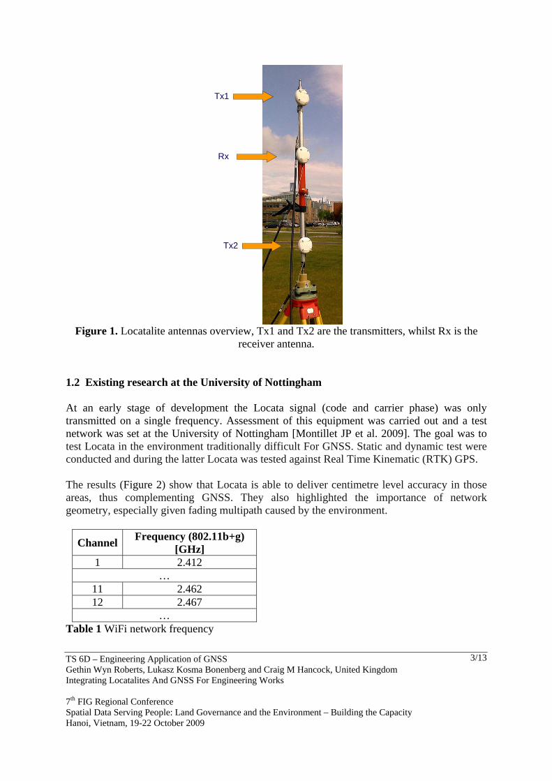
Figure 1. Locatalite antennas overview, Tx1 and Tx2 are the transmitters, whilst Rx is the
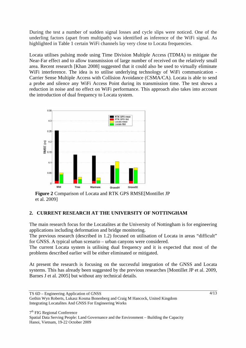
receiver antenna. 1.2 Existing research at the University of Nottingham At an early stage of development the Locata signal (code and carrier phase) was only transmitted on a single frequency. Assessment of this equipment was carried out and a test network was set at the University of Nottingham [Montillet JP et al. 2009]. The goal was to test Locata in the environment traditionally difficult For GNSS. Static and dynamic test were conducted and during the latter Locata was tested against Real Time Kinematic (RTK) GPS. The results (Figure 2) show that Locata is able to deliver centimetre level accuracy in those areas, thus complementing GNSS. They also highlighted the importance of network geometry, especially given fading multipath caused by the environment.
Channel Frequency (802.11b+g) [GHz]
1 2.412 …
11 2.462 12 2.467
… Table 1 WiFi network frequency
Tx1
Tx2
Rx
TS 6D – Engineering Application of GNSS Gethin Wyn Roberts, Lukasz Kosma Bonenberg and Craig M Hancock, United Kingdom Integrating Locatalites And GNSS For Engineering Works 7th FIG Regional Conference Spatial Data Serving People: Land Governance and the Environment – Building the Capacity Hanoi, Vietnam, 19-22 October 2009
4/13
During the test a number of sudden signal losses and cycle slips were noticed. One of the underling factors (apart from multipath) was identified as inference of the WiFi signal. As highlighted in Table 1 certain WiFi channels lay very close to Locata frequencies. Locata utilises pulsing mode using Time Division Multiple Access (TDMA) to mitigate the Near-Far effect and to allow transmission of large number of received on the relatively small area. Recent research [Khan 2008] suggested that it could also be used to virtually eliminate WiFi interference. The idea is to utilise underlying technology of WiFi communication - Carrier Sense Multiple Access with Collision Avoidance (CSMA/CA). Locata is able to send a probe and silence any WiFi Access Point during its transmission time. The test shows a reduction in noise and no effect on WiFi performance. This approach also takes into account the introduction of dual frequency to Locata system.
2. CURRENT RESEARCH AT THE UNIVERSITY OF NOTTINGHAM The main research focus for the Locatalites at the University of Nottingham is for engineering applications including deformation and bridge monitoring. The previous research (described in 1.2) focused on utilisation of Locata in areas “difficult” for GNSS. A typical urban scenario – urban canyons were considered. The current Locata system is utilising dual frequency and it is expected that most of the problems described earlier will be either eliminated or mitigated. At present the research is focusing on the successful integration of the GNSS and Locata systems. This has already been suggested by the previous researches [Montillet JP et al. 2009, Barnes J et al. 2005] but without any technical details.
Figure 2 Comparison of Locata and RTK GPS RMSE[Montillet JP et al. 2009]
TS 6D – Engineering Application of GNSS Gethin Wyn Roberts, Lukasz Kosma Bonenberg and Craig M Hancock, United Kingdom Integrating Locatalites And GNSS For Engineering Works 7th FIG Regional Conference Spatial Data Serving People: Land Governance and the Environment – Building the Capacity Hanoi, Vietnam, 19-22 October 2009
5/13
2.1 Integration GNSS has become one of the most widespread measurement technologies, allowing the achievement of cm-level positioning accuracy, especially with the use of differential techniques. The accuracy of the position solutions is heavily dependent on the number and geometric distribution of the available satellites. This and the requirement of an open view of the sky, makes GNSS ineffective in dense city areas. While in the United Kingdom this situation is only relevant 30% of the time, this value is especially high amongst large structures of Asian and American cities. Locata is a terrestrial positioning technology, operating in the 2.4 GHz license free frequency band. This removes the need for a clear view of the sky, but having similar characteristics to GNSS makes it prone to a weak vertical component. This resemblance echoes expectations for Locata to be the supplementary system to GNSS. The research has identified the accuracy of the system to be at the cm level, similar to GNSS [Barnes et al. 2007]. The main goal of the research is to maintain accuracy of continuous measurements at the centimetre level, especially in the areas traditionally regarded as “difficult” or impossible for GNSS – such as urban canyons, indoor and semi-indoors areas. The vertical component is a particular interest. [Amt et al. 2006] speculates that increased accuracy of this component, will increase other components’ accuracies as well. The following factors have been identified, as most important to achieve this goal:
– Time integration – Geometry – Multipath and Noise – Cycle Slips
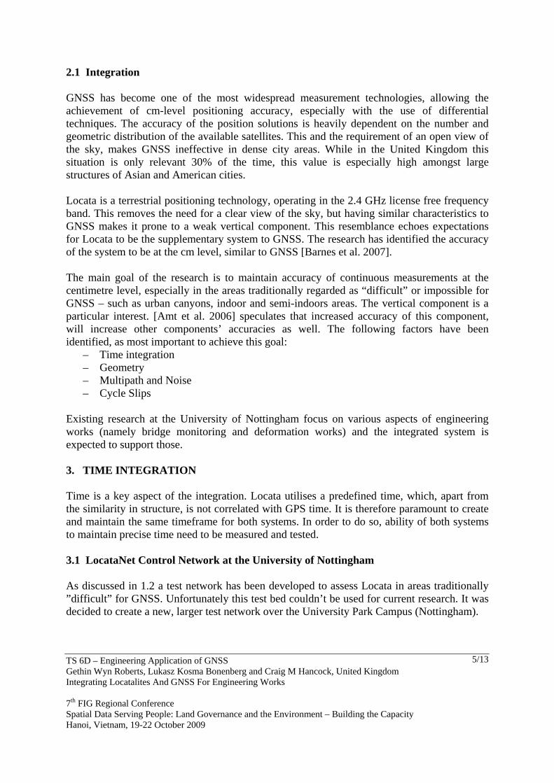
Existing research at the University of Nottingham focus on various aspects of engineering works (namely bridge monitoring and deformation works) and the integrated system is expected to support those. 3. TIME INTEGRATION Time is a key aspect of the integration. Locata utilises a predefined time, which, apart from the similarity in structure, is not correlated with GPS time. It is therefore paramount to create and maintain the same timeframe for both systems. In order to do so, ability of both systems to maintain precise time need to be measured and tested. 3.1 LocataNet Control Network at the University of Nottingham As discussed in 1.2 a test network has been developed to assess Locata in areas traditionally ”difficult” for GNSS. Unfortunately this test bed couldn’t be used for current research. It was decided to create a new, larger test network over the University Park Campus (Nottingham).
TS 6D – Engineering Application of GNSS Gethin Wyn Roberts, Lukasz Kosma Bonenberg and Craig M Hancock, United Kingdom Integrating Locatalites And GNSS For Engineering Works 7th FIG Regional Conference Spatial Data Serving People: Land Governance and the Environment – Building the Capacity Hanoi, Vietnam, 19-22 October 2009
6/13
This test bed network is intended for long periods of Locata testing and point location allows coherent deployment of both Locata and GPS systems. Placement was selected in order to vary effects of the described factors on both systems. This should allow further investigation into integration.
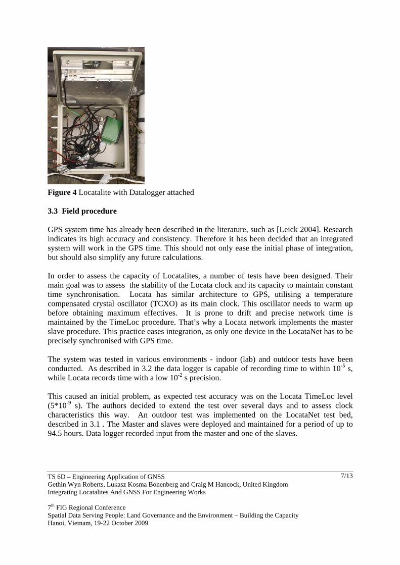
3.2 GRC Precise Time Data Logger PTDL1 The data logger (Figure 4) is a device developed at the Geospatial Research Centre in New Zealand. It time stamps any data input with precise GPS time. According to the specifications [GRC 2008] equipment is capable of time stamping data to a resolution of 10-5 s. This allowed to test Locata clock stability. Software was also developed to easen workflow and provisionaly check data.
Figure 3 Test Network at the University Park Campus
TS 6D – Engineering Application of GNSS Gethin Wyn Roberts, Lukasz Kosma Bonenberg and Craig M Hancock, United Kingdom Integrating Locatalites And GNSS For Engineering Works 7th FIG Regional Conference Spatial Data Serving People: Land Governance and the Environment – Building the Capacity Hanoi, Vietnam, 19-22 October 2009
7/13
3.3 Field procedure GPS system time has already been described in the literature, such as [Leick 2004]. Research indicates its high accuracy and consistency. Therefore it has been decided that an integrated system will work in the GPS time. This should not only ease the initial phase of integration, but should also simplify any future calculations. In order to assess the capacity of Locatalites, a number of tests have been designed. Their main goal was to assess the stability of the Locata clock and its capacity to maintain constant time synchronisation. Locata has similar architecture to GPS, utilising a temperature compensated crystal oscillator (TCXO) as its main clock. This oscillator needs to warm up before obtaining maximum effectives. It is prone to drift and precise network time is maintained by the TimeLoc procedure. That’s why a Locata network implements the master slave procedure. This practice eases integration, as only one device in the LocataNet has to be precisely synchronised with GPS time. The system was tested in various environments - indoor (lab) and outdoor tests have been conducted. As described in 3.2 the data logger is capable of recording time to within 10-5 s, while Locata records time with a low 10-2 s precision. This caused an initial problem, as expected test accuracy was on the Locata TimeLoc level (5*10-9 s). The authors decided to extend the test over several days and to assess clock characteristics this way. An outdoor test was implemented on the LocataNet test bed, described in 3.1 . The Master and slaves were deployed and maintained for a period of up to 94.5 hours. Data logger recorded input from the master and one of the slaves.
Figure 4 Locatalite with Datalogger attached
TS 6D – Engineering Application of GNSS Gethin Wyn Roberts, Lukasz Kosma Bonenberg and Craig M Hancock, United Kingdom Integrating Locatalites And GNSS For Engineering Works 7th FIG Regional Conference Spatial Data Serving People: Land Governance and the Environment – Building the Capacity Hanoi, Vietnam, 19-22 October 2009
8/13
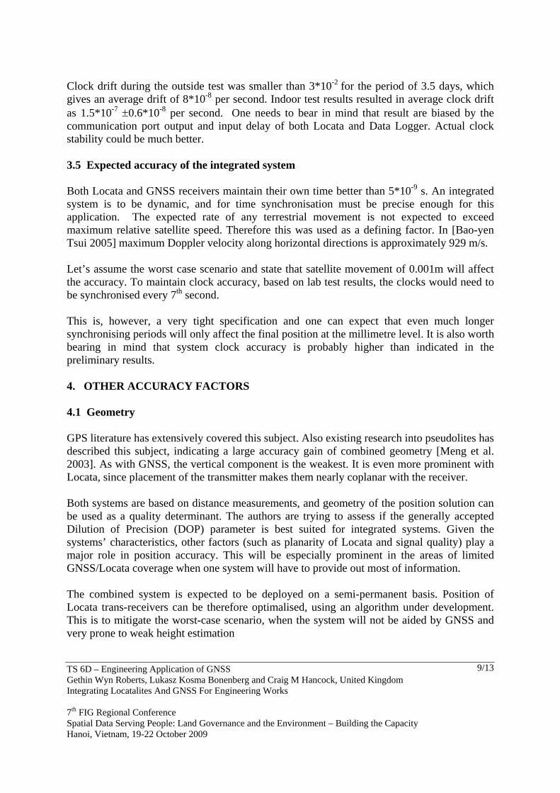
Laboratory test were conducted on various combinations of firmware and existing devices, set as master. They were paired up, based on existing performance, to test them against each other. An output was time stamped by the Data Logger.
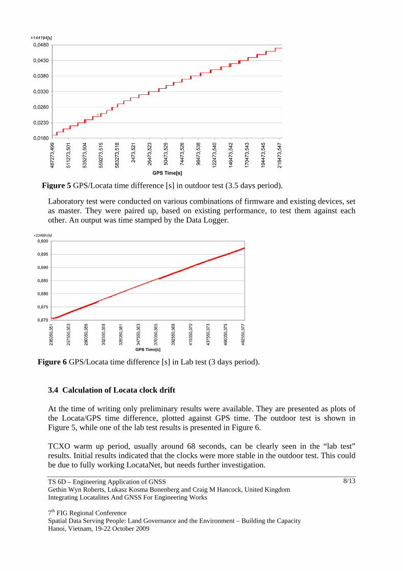
3.4 Calculation of Locata clock drift At the time of writing only preliminary results were available. They are presented as plots of the Locata/GPS time difference, plotted against GPS time. The outdoor test is shown in Figure 5, while one of the lab test results is presented in Figure 6. TCXO warm up period, usually around 68 seconds, can be clearly seen in the “lab test” results. Initial results indicated that the clocks were more stable in the outdoor test. This could be due to fully working LocataNet, but needs further investigation.
Figure 6 GPS/Locata time difference [s] in Lab test (3 days period).
Figure 5 GPS/Locata time difference [s] in outdoor test (3.5 days period).
TS 6D – Engineering Application of GNSS Gethin Wyn Roberts, Lukasz Kosma Bonenberg and Craig M Hancock, United Kingdom Integrating Locatalites And GNSS For Engineering Works 7th FIG Regional Conference Spatial Data Serving People: Land Governance and the Environment – Building the Capacity Hanoi, Vietnam, 19-22 October 2009
9/13
Clock drift during the outside test was smaller than 3*10-2 for the period of 3.5 days, which gives an average drift of 8*10-8 per second. Indoor test results resulted in average clock drift as 1.5*10-7 ±0.6*10-8 per second. One needs to bear in mind that result are biased by the communication port output and input delay of both Locata and Data Logger. Actual clock stability could be much better. 3.5 Expected accuracy of the integrated system Both Locata and GNSS receivers maintain their own time better than 5*10-9 s. An integrated system is to be dynamic, and for time synchronisation must be precise enough for this application. The expected rate of any terrestrial movement is not expected to exceed maximum relative satellite speed. Therefore this was used as a defining factor. In [Bao-yen Tsui 2005] maximum Doppler velocity along horizontal directions is approximately 929 m/s. Let’s assume the worst case scenario and state that satellite movement of 0.001m will affect the accuracy. To maintain clock accuracy, based on lab test results, the clocks would need to be synchronised every 7th second. This is, however, a very tight specification and one can expect that even much longer synchronising periods will only affect the final position at the millimetre level. It is also worth bearing in mind that system clock accuracy is probably higher than indicated in the preliminary results. 4. OTHER ACCURACY FACTORS 4.1 Geometry GPS literature has extensively covered this subject. Also existing research into pseudolites has described this subject, indicating a large accuracy gain of combined geometry [Meng et al. 2003]. As with GNSS, the vertical component is the weakest. It is even more prominent with Locata, since placement of the transmitter makes them nearly coplanar with the receiver. Both systems are based on distance measurements, and geometry of the position solution can be used as a quality determinant. The authors are trying to assess if the generally accepted Dilution of Precision (DOP) parameter is best suited for integrated systems. Given the systems’ characteristics, other factors (such as planarity of Locata and signal quality) play a major role in position accuracy. This will be especially prominent in the areas of limited GNSS/Locata coverage when one system will have to provide out most of information. The combined system is expected to be deployed on a semi-permanent basis. Position of Locata trans-receivers can be therefore optimalised, using an algorithm under development. This is to mitigate the worst-case scenario, when the system will not be aided by GNSS and very prone to weak height estimation
TS 6D – Engineering Application of GNSS Gethin Wyn Roberts, Lukasz Kosma Bonenberg and Craig M Hancock, United Kingdom Integrating Locatalites And GNSS For Engineering Works 7th FIG Regional Conference Spatial Data Serving People: Land Governance and the Environment – Building the Capacity Hanoi, Vietnam, 19-22 October 2009
10/13
4.2 Multipath and Noise As mentioned before, both systems share a large similarity in design and concept of working. The Locata terrestrial signal is much stronger than the GNSS one – devices at the University produce up to 23dBm, and this is not a limit for a system. In order to avoid problems such as the near-far effect and interference from other devices the system utilises a digital signal in a pulsing mode. Semi-indoor areas intended for combined systems are notorious for multipath and noise. In terrestrial based receivers the signal arrives at a very low (less than 10°) or even a negative elevation angle becoming subject to signal fading (surface glance). Manifested as severe signal power fluctuations, (constructive and destructive multipath) and usually leads to signal loss. The Locata system is trying to partly compensate for this by using spatial separation of the antennas. It also utilises pulse signal and double frequency to battle any environment generated noise. Certain solutions to this problem have been described in [Barnes J et al. 2005, Amt JH et al. 2007]. The test bed network (described in 3.1) is also intended to research into the relationship between GNSS and Locata multipath. Locations have been selected in order to increase or decrease these factors. The authors are currently investigating the possibility of mitigating those inferences using variable antenna parameters and thus reducing floor noise level for terrestrial receivers. 4.3 Cycle slips Problems described in 4.2 usually identify themselves in the form of a cycle slip. The Locata wave is only 12 cm long with narrowlane of 6 cm and widelane of 5m. This makes cycle slip detection problematic. Research papers [Amt JH et al. 2007, Montillet et al. 2009] identify cycle slips as one of the main accuracy factors in kinematic use of Locata system. Undetected can generate position biases at the decimetre level. The same research found a very strong relationship between cycle slips and signal to noise ratio (SNR), used as a signal quality assessment by the Locata receivers. Locata, as every modern navigation system, develops “black box” encapsulation. Most of the parameters and characteristics of the system cannot be altered directly. However, it is expected that, by addressing issues described in 4.1-4.3, those problems can be largely mitigated. Also a combined system should be capable of delivering an additional observables, allowing better detection and elimination of cycle slips.
TS 6D – Engineering Application of GNSS Gethin Wyn Roberts, Lukasz Kosma Bonenberg and Craig M Hancock, United Kingdom Integrating Locatalites And GNSS For Engineering Works 7th FIG Regional Conference Spatial Data Serving People: Land Governance and the Environment – Building the Capacity Hanoi, Vietnam, 19-22 October 2009
11/13
5. CONCLUSIONS The main goal of research is to create functional integration of GNSS and Locata systems. Its main requirement is the capability of maintaining centimetre level accuracy, especially in the areas traditionally regarded as “difficult” or impossible for GNSS – such as urban canyons, indoor and semi-indoors areas. The authors are trying to prove that by assessing factors such as time, geometry, cycle slips and multipath the final position quality can be improved. It has been shown that Locata is capable of maintaining the precise time to support integrated system. The research also shows that neither GPS time fold (at the Sunday midnight) nor the similar occurrence in Locata time affects clock accuracy. This indicates that even a very frequent synchronisation should be possible with the current system. Locata is still a young system lacking sophistication of his older brother – GNSS. The described similarities between both systems allow the assumption that many of the solutions used in GPS can be transferred with minor changes. Researchers [Politi et al.2009] have already drawn attention to this by using LAMBDA technique in calculating signal ambiguity. Terrestrial based system, such as Locata, can also be draw on the large knowledge pool of the electromagnetic distance measurements (EDM). A similar factor and concept of work offer large possibility of reusing existing research in this area. With the ultimate goal of precise continuous measurements by eliminating or at least mitigating the problem of weak verticals, we open ourselves to much larger number of engineering applications than before. Geometry is very important here. Authors are currently researching into the concept of using a different mathematical geometry model to enhance combined geometry solution.
TS 6D – Engineering Application of GNSS Gethin Wyn Roberts, Lukasz Kosma Bonenberg and Craig M Hancock, United Kingdom Integrating Locatalites And GNSS For Engineering Works 7th FIG Regional Conference Spatial Data Serving People: Land Governance and the Environment – Building the Capacity Hanoi, Vietnam, 19-22 October 2009
12/13
REFERENCES Amt John H. R. and Raquet John F. (2007) Flight Testing of a Pseudolite Navigation System on a UAV, ION Conference, Jan 2007.
Bao-yen Tsui James (2005) Fundamental of Global Positioning System Receivers 2nd ed,Willey.
Barnes Joel, Rizos C., M. Kanli, A. Pahwa (2005) A Positioning Technology for Classically Difficult GNSS Environments from Locata, IEEE San Diego.
Barnes Joel, van Cranenbroeck Joël, Rizos Chris, Pahwa Anuj, Politi Nonie (2007) Long term performance analysis of a new ground-transceiver positioning network (LocataNet) for structural deformation monitoring applications.
GRC Precise Time Data Logger User Manual (2008) , Geospacial Research Centre.
Khan Faisal A.,Rizos Chris,Dempster Andrew G. (2008) Novel Time-Sharing Scheme for Virtual Elimination of Locata-WiFi Interference Effects.
Leick A. (2004) GPS Satellite Surveying, Third Edition, Wiley.
Meng X., Roberts G.W., Dodson A. H., Cosser E., Barnes J., Rizos C. (2003) Impact of GPS satellite and pseudolite geometry on structural deformation monitoring: analytical and empirical studies, Journal of Geodesy (2204) 77: 809-822.
Montillet JP, Roberts GW, Meng X, Taha A, Hancock C, Ogundipe O, Barnes J (2009) Deploying a Locata network to enable precise positioning in urban canyons . J Geod (2009) 83:91–103.
Politi Nonie, Li Yong ,Khan Faisal, Choudhury Mazher, Bertsch Jonas,Cheong Joon Wayn,Dempster Andrew, Rizos Chris (2009) Locata: A New Technology for High Precision Positioning.
TS 6D – Engineering Application of GNSS Gethin Wyn Roberts, Lukasz Kosma Bonenberg and Craig M Hancock, United Kingdom Integrating Locatalites And GNSS For Engineering Works 7th FIG Regional Conference Spatial Data Serving People: Land Governance and the Environment – Building the Capacity Hanoi, Vietnam, 19-22 October 2009
13/13
BIOGRAPHICAL NOTES Dr Gethin Wyn Roberts is an Associate Professor and Reader in Geospatial Engineering at the University of Nottingham. He is also Chair of the FIG’s Working Group 6.4 “Engineering Surveys for Construction Works and Structural Engineering” as well as chair of the FIG Task Force “Measurement and Analysis of Cyclic Deformations and Structural Vibrations”. He is chair elect of Commission 6, and Vice President of the UK’s Institution of Civil Engineering Surveyors. Lukasz Kosma Bonenberg is a PhD student at the University of Nottingham and the Corporate Member of Institution of Civil Engineering Surveyors. His current project deals with integration of Locatalites and GNSS. His current interest are structural monitoring and precise positioning. Craig M Hancock is a researcher at the University of Nottingham and is currently studying for a PhD is Geodesy. His current interests include Engineering Surveying and positioning in difficult environments. CONTACTS Dr Gethin Wyn Roberts IESSG The University of Nottingham University Park Nottingham NG7 2RD UNITED KINGDOM Tel +44 115 9513933 Fax +44 115 9513881 Email [email protected] Web Site: www.nottingham.ac.uk/iessg
Related Documents