Copyright © 2013 by the author(s). Published here under license by the Resilience Alliance. Caves, J. K., G. S. Bodner, K. Simms, L. A. Fisher, and T. Robertson. 2013. Integrating collaboration, adaptive management, and scenario-planning: experiences at Las Cienegas National Conservation Area. Ecology and Society 18(3): 43. http://dx.doi.org/10.5751/ES-05749-180343 Research, part of a Special Feature on Exploring Opportunities for Advancing Collaborative Adaptive Management (CAM): Integrating Experience and Practice Integrating Collaboration, Adaptive Management, and Scenario- Planning: Experiences at Las Cienegas National Conservation Area Jeremy K. Caves 1 , Gitanjali S. Bodner 2 , Karen Simms 3 , Larry A. Fisher 4 and Tahnee Robertson 5 ABSTRACT. There is growing recognition that public lands cannot be managed as islands; rather, land management must address the ecological, social, and temporal complexity that often spans jurisdictions and traditional planning horizons. Collaborative decision making and adaptive management (CAM) have been promoted as methods to reconcile competing societal demands and respond to complex ecosystem dynamics. We detail the experiences of land managers and stakeholders in using CAM at Las Cienegas National Conservation Area (LCNCA), a highly valued site under the jurisdiction of the Bureau of Land Management (BLM). The CAM process at Las Cienegas is marked by strong stakeholder engagement, with four core elements: (1) shared watershed goals with measurable resource objectives; (2) relevant and reliable scientific information; (3) mechanisms to incorporate new information into decision making; and (4) shared learning to improve both the process and management actions. The combination of stakeholder engagement and adaptive management has led to agreement on contentious issues, more innovative solutions, and more effective land management. However, the region is now experiencing rapid changes outside managers’ control, including climate change, human population growth, and reduced federal budgets, with large but unpredictable impacts on natural resources. Although the CAM experience provides a strong foundation for making the difficult and contentious management decisions that such changes are likely to require, neither collaboration nor adaptive management provides a sufficient structure for addressing the externalities that drive uncontrollable and unpredictable change. As a result, LCNCA is exploring two specific modifications to CAM that may better address emerging challenges, including: (1) creating nested resource objectives to distinguish between those objectives that may be crucial to maintaining ecological resilience from those that may hinder a flexible response to climate change, and (2) incorporating scenario planning into CAM to explore how climate change may interact with other drivers and alter options for the future, to identify robust management actions, and to prioritize ecological monitoring efforts. The experiences at LCNCA demonstrate how collaboration and adaptive management can be used to improve social and environmental outcomes and, with modifications, may help address the full range of complexity and change that threatens to overwhelm even the best efforts to sustain public lands. Key Words: biological planning; Bureau of Land Management; climate adaptation; collaboration; desert Southwest; ecological monitoring; implementing adaptive management; nested objectives; public lands management; scenario planning; INTRODUCTION Federal public lands comprise nearly 650 million acres and almost 30% of the U.S. This number nearly doubles when including lands under state or local jurisdictions. The core challenge for public land managers is to sustain in perpetuity the public benefits these lands provide, from resource harvest to biodiversity protection, watershed function to recreational opportunities. This mandate often places public land managers in the middle of political and legal battles between various interests (local/national, corporate/private, motorized recreation/ wilderness advocates, extractive uses/preservationists) who perceive themselves to benefit differentially from alternate management priorities. Because ecosystem management involves decision making within extremely complex natural and social dynamics, the outcomes of management actions are highly unpredictable. Federal land managers must attempt to meet this mandate with declining annual budgets that currently range from US$3.79 per acre (Bureau of Land Management 2009, U.S. Senate 2009a) to US$32.73 per acre (National Park Service 2012). A handful of staff trained in natural resources are often responsible for a thousand square miles or more. Traditional management paradigms that expect agency staff to single-handedly produce optimal outcomes for all people over all time spans are poorly suited to the reality of these challenges, yet these approaches continue to dominate agency cultures (Shindler and Cheek 1999). In contrast, collaborative decision-making approaches are being increasingly promoted by agencies and stakeholders as a way to navigate competing demands (Johnson 1999, U.S. Government 2004, Bureau of Land Management 2009, U.S. Senate 2009b). Similarly, adaptive management approaches that recognize uncertainty of outcomes and provide mechanisms for responding to changes observed on the ground have begun to be applied more broadly as an effective way of working with ecological complexity (Holling 1978, Walters and Holling 1990, Gunderson 1999, Johnson 1999, Folke et al. 2005, Williams et al. 2009). Many practitioners have attempted to combine 1 Department of Environmental Earth System Science, Stanford University, 2 The Nature Conservancy, Tucson, Arizona, 3 Tucson Field Office, Bureau of Land Management, 4 School of Natural Resources and the Environment, University of Arizona, 5 Southwest Decision Resources

Welcome message from author
This document is posted to help you gain knowledge. Please leave a comment to let me know what you think about it! Share it to your friends and learn new things together.
Transcript
Copyright © 2013 by the author(s). Published here under license by the Resilience Alliance.Caves, J. K., G. S. Bodner, K. Simms, L. A. Fisher, and T. Robertson. 2013. Integrating collaboration,adaptive management, and scenario-planning: experiences at Las Cienegas National Conservation Area.Ecology and Society 18(3): 43. http://dx.doi.org/10.5751/ES-05749-180343
Research, part of a Special Feature on Exploring Opportunities for Advancing Collaborative Adaptive Management (CAM):Integrating Experience and Practice
Integrating Collaboration, Adaptive Management, and Scenario-Planning: Experiences at Las Cienegas National Conservation AreaJeremy K. Caves 1, Gitanjali S. Bodner 2, Karen Simms 3, Larry A. Fisher 4 and Tahnee Robertson 5
ABSTRACT. There is growing recognition that public lands cannot be managed as islands; rather, land management mustaddress the ecological, social, and temporal complexity that often spans jurisdictions and traditional planning horizons.Collaborative decision making and adaptive management (CAM) have been promoted as methods to reconcile competing societaldemands and respond to complex ecosystem dynamics. We detail the experiences of land managers and stakeholders in usingCAM at Las Cienegas National Conservation Area (LCNCA), a highly valued site under the jurisdiction of the Bureau of LandManagement (BLM). The CAM process at Las Cienegas is marked by strong stakeholder engagement, with four core elements:(1) shared watershed goals with measurable resource objectives; (2) relevant and reliable scientific information; (3) mechanismsto incorporate new information into decision making; and (4) shared learning to improve both the process and managementactions. The combination of stakeholder engagement and adaptive management has led to agreement on contentious issues,more innovative solutions, and more effective land management. However, the region is now experiencing rapid changes outsidemanagers’ control, including climate change, human population growth, and reduced federal budgets, with large but unpredictableimpacts on natural resources. Although the CAM experience provides a strong foundation for making the difficult and contentiousmanagement decisions that such changes are likely to require, neither collaboration nor adaptive management provides a sufficientstructure for addressing the externalities that drive uncontrollable and unpredictable change. As a result, LCNCA is exploringtwo specific modifications to CAM that may better address emerging challenges, including: (1) creating nested resource objectivesto distinguish between those objectives that may be crucial to maintaining ecological resilience from those that may hinder aflexible response to climate change, and (2) incorporating scenario planning into CAM to explore how climate change mayinteract with other drivers and alter options for the future, to identify robust management actions, and to prioritize ecologicalmonitoring efforts. The experiences at LCNCA demonstrate how collaboration and adaptive management can be used to improvesocial and environmental outcomes and, with modifications, may help address the full range of complexity and change thatthreatens to overwhelm even the best efforts to sustain public lands.
Key Words: biological planning; Bureau of Land Management; climate adaptation; collaboration; desert Southwest; ecologicalmonitoring; implementing adaptive management; nested objectives; public lands management; scenario planning;
INTRODUCTIONFederal public lands comprise nearly 650 million acres andalmost 30% of the U.S. This number nearly doubles whenincluding lands under state or local jurisdictions. The corechallenge for public land managers is to sustain in perpetuitythe public benefits these lands provide, from resource harvestto biodiversity protection, watershed function to recreationalopportunities. This mandate often places public land managersin the middle of political and legal battles between variousinterests (local/national, corporate/private, motorized recreation/wilderness advocates, extractive uses/preservationists) whoperceive themselves to benefit differentially from alternatemanagement priorities. Because ecosystem managementinvolves decision making within extremely complex naturaland social dynamics, the outcomes of management actions arehighly unpredictable. Federal land managers must attempt tomeet this mandate with declining annual budgets that currentlyrange from US$3.79 per acre (Bureau of Land Management2009, U.S. Senate 2009a) to US$32.73 per acre (National Park
Service 2012). A handful of staff trained in natural resourcesare often responsible for a thousand square miles or more.
Traditional management paradigms that expect agency staffto single-handedly produce optimal outcomes for all peopleover all time spans are poorly suited to the reality of thesechallenges, yet these approaches continue to dominate agencycultures (Shindler and Cheek 1999). In contrast, collaborativedecision-making approaches are being increasingly promotedby agencies and stakeholders as a way to navigate competingdemands (Johnson 1999, U.S. Government 2004, Bureau ofLand Management 2009, U.S. Senate 2009b). Similarly,adaptive management approaches that recognize uncertaintyof outcomes and provide mechanisms for responding tochanges observed on the ground have begun to be applied morebroadly as an effective way of working with ecologicalcomplexity (Holling 1978, Walters and Holling 1990,Gunderson 1999, Johnson 1999, Folke et al. 2005, Williamset al. 2009). Many practitioners have attempted to combine
1Department of Environmental Earth System Science, Stanford University, 2The Nature Conservancy, Tucson, Arizona, 3Tucson Field Office, Bureau ofLand Management, 4School of Natural Resources and the Environment, University of Arizona, 5Southwest Decision Resources
Ecology and Society 18(3): 43http://www.ecologyandsociety.org/vol18/iss3/art43/
these approaches, with various branches of policy and researchnow trying to promote principles of both and understand whatattributes make them work well together (Gunderson andHolling 2002, Armitage et al. 2007, 2009, Pomeroy 2007,Plummer 2009, Williams et al. 2009). Combiningcollaboration and adaptive management is viewed as a way ofbroadening the scope of information and options consideredin decision cycles, instilling accountability into the inherentlyflexible processes of adaptive management, promoting sharedlearning, and generating “social license” for managers to trybold solutions to seemingly intractable problems (Schindlerand Cheek 1999, Pahl-wostl et al. 2007, Williams et al. 2009,Polasky et al. 2011, Childs et al. 2013).
We describe the experiences of managers and stakeholderswho are working to sustain a broad range of natural and culturalresources and associated public benefits in one high-profilesouthern Arizona valley. Our paper is composed of two parts:we describe the history, evolution, and philosophy of CAM atLas Cienegas, and show that a practical, user-oriented versionof CAM has yielded many positive environmental and societalresults. We highlight four core elements that have provenessential to implementing CAM and enabled participants torespond to changing conditions on the ground: (1) sharedwatershed goals with measurable resource objectives; (2)efforts to gather increasingly relevant and reliable scientificinformation; (3) mechanisms to incorporate new informationinto decision making; and (4) shared learning to improve boththe process and management actions. We discuss externalchallenges, including climate shifts and other potentially rapidchanges that are outside the control of local managers, thatmay affect ecosystem resiliency and even the collaborativeeffort itself. We describe efforts being undertaken to modifyCAM to anticipate these externalities, including adding newtools such as scenario planning and developing an innovative“nested objective” structure that reconciles adaptivemanagement’s need for measurable objectives with therecognition that climate shifts may be creating ecosystemconditions with no analog in the site’s history. We also discussthe theoretical lessons from our experiences at Las Cienegasand propose that a combination of collaboration, adaptivemanagement, and scenario planning can more fully addressthe range of ecological, societal, and temporal complexity thatface public lands.
BACKGROUND
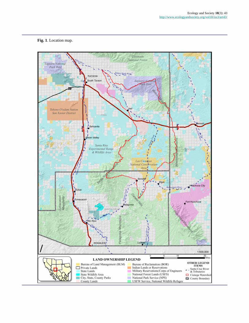
LocationFifty miles southeast of the metropolitan area of Tucson,Arizona (population: one million), lies the 300,000-acreCienega watershed, a broad, 4000 ft. high grassland valleysuspended between four forested “sky island” mountainranges (Fig. 1). Much of the upper watershed is under thejurisdiction of BLM and designated as a NationalConservation Area. Las Cienegas National Conservation Area
(LCNCA) includes some 50,000 acres of public landadministered by BLM plus an additional 50,000 acres of StateTrust Land on which BLM holds the state grazing leases.Management of LCNCA therefore influences land healthacross much of the upper watershed, which is vital to theTucson metropolitan area for flood control and aquiferrecharge (Keith 1981, Knight 1996, Fonseca 2008).
Cienega Creek flows north along the bottom of the valley intothe Tucson basin. At the south end of the watershed, in an areacommonly called the Sonoita Valley, a low divide separatessurface water flow between Cienega Creek and the upperwatersheds of Sonoita Creek (tributaries of the Santa CruzRiver) and the Babocomari River (a tributary of the San PedroRiver). All three creeks have sections that flow year-round,rare sources of perennial surface water in a semiarid landscape(Pima County Board of Supervisors 1999, Pima Associationof Governments 2000) and an indicator of both near-surfacegroundwater and a relatively healthy watershed that is able tocapture and slowly release rainfall (Bota 1997, Fonseca 2008).
LCNCA supports several threatened and endangered speciesand five of the rarest plant communities in the Southwest:cienega wetlands, cottonwood-willow riparian forests,sacaton grasslands, mesquite bosques, and semidesertgrasslands. In conjunction with lands managed by the U.S.Forest Service, Pima County, the Department of Defense, andnumerous private landowners with conservation easements,the LCNCA’s grasslands and woodlands maintainconnectivity among several of the region’s sky islandmountain ranges and play a vital role in regional wildlifelinkages (Beier et al. 2006). The Cienega Watershed and theSonoita Valley are also renowned for their archaeological andmore recent western cultural heritage (Swanson 1951, Dowell1978, Eddy and Cooley 1983, Majewski 2004). Thelandscape’s natural resources continue to support a thrivingrural community concentrated around the town of Sonoita andscattered in pockets of private land throughout the valley.Management of the LCNCA is multiuse and includes activelivestock grazing as well as a variety of recreational activities.
History of collaborative adaptive management atLCNCAThe Sonoita Valley has a long history of public engagement.Local residents advocated for the land exchange thateventually brought private lands into public ownership as theBLM Empire-Cienega Resource Conservation Area in 1988.Prior to this, the lands faced an uncertain future that most likelyincluded development for housing or water extraction formining. Following the 1988 land acquisition, BLM initiateda traditional planning process to develop the required land useplan. The process stalled after several years because of acombination of changing agency priorities, limited publicparticipation opportunities, and increasing polarization and
Ecology and Society 18(3): 43http://www.ecologyandsociety.org/vol18/iss3/art43/
Fig. 1. Location map.

Ecology and Society 18(3): 43http://www.ecologyandsociety.org/vol18/iss3/art43/
Fig. 2. A timeline of important milestones and the evolution of collaborative adaptive management (CAM) at LasCienegas National Conservation Area. BLM = Bureau of Land Management; SVPP = Sonoita Valley PlanningPartnership; CAMNet = Collaborative Adaptive Management Network.
divisiveness over issues such as mining, livestock grazing,recreation use, and wildlife management.
Because this initial planning effort frustrated stakeholders whofelt they were unable to meaningfully participate, in 1995 theBLM Field Manager decided to initiate a collaborative processfor developing the site’s resource management plan (RMP),encouraging more extensive public engagement, guided bythe principles of ecosystem management (Grumbine 1994,Kaufmann et al. 1994, Christensen et al. 1996, Szaro et al.1998). BLM employed a neutral facilitator and workeddirectly with participants to design the planning process,which included a series of open public meetings. Initialmeetings led to the formation of the Sonoita Valley PlanningPartnership (SVPP), an ad hoc group with participants frommore than a dozen communities in southeastern Arizona andrepresentatives of conservation organizations, grazinginterests, recreational user groups, and federal, state, and localagencies. SVPP participants embraced the collaborativeapproach, regularly attending monthly SVPP meetings andmore frequent working group meetings. Many SVPP memberswere part of a successful public campaign that resulted inCongressional designation of National Conservation Areastatus for the area in 2000.
Later in the planning process, the collaborative group optedto incorporate an adaptive management approach to build in
management flexibility and address uncertain outcomes ofmanagement actions. The jointly developed RMP (Bureau ofLand Management 2003) incorporates this collaborativeadaptive management (CAM) approach. This science-basedadaptive management program is designed to provide decisionmakers with reliable and timely information on resourceconditions and trends.
The general structure of the LCNCA CAM process, developedincrementally by participants based on evolving needs at thesite (timeline summarized in Fig. 2), closely parallelsdescriptions in theoretical literature (Williams et al. 2009; Fig.3). LCNCA uses shared goals and measurable objectives toguide management actions, an ecological monitoring programto gather information about key resources and to measureprogress in meeting RMP objectives, and a biological planningprocess to incorporate new information into decision makingand provide a forum for regular stakeholder engagement.Twice a year, stakeholders meet at LCNCA to discuss resultsof the monitoring and proposed management actions, as wellas research results that might inform these actions.Implementing management actions is largely theresponsibility of BLM and the grazing permittee, but otherstakeholders contribute substantially with staff and volunteertime as well as grant-funded projects.

Ecology and Society 18(3): 43http://www.ecologyandsociety.org/vol18/iss3/art43/
Fig. 3. The collaborative adaptive management process atLas Cienegas National Conservation Area. At most stagesof the cycle, stakeholders are actively involved throughparticipation in the semiannual biological planningmeetings, volunteering, or participation on a technical team(TT). The four core elements are essential for implementingthis loop. We propose incorporating scenario planning aspart of the CAM cycle, drawing upon the nested objectivesto further refine the design of proposed actions. BLM =Bureau of Land Management; SH = Stakeholder. Note: thePermittee is considered a stakeholder and member of theTTs.
CORE ELEMENTS OF CAM AT LCNCAThe combination of stakeholder involvement and adaptivemanagement has yielded many benefits at this site, benefitsthat could not have been attained by either approach inisolation. Each of the following four core elements reflects thephilosophy, lessons, and evolution of CAM at LCNCA andinvolve both stakeholder participation and learning aboutecological dynamics.
Developing shared goals and measurable objectivesHaving shared goals and measurable objectives has helpedparticipants move beyond entrenched positions, to problemsolve together, and use science as the arbiter of what works.Initially, stakeholders involved in the SVPP planning processfocused on their values and concerns about the Sonoita Valley,just as BLM focused on what uses were allowable. Resulting
discussions about appropriate land use and resourceallocations frequently dominated meetings and at times werequite contentious, as participants advocated for theirindividual, or their organization’s, interests. It soon becameapparent that the focus needed to shift from allowable uses tothe desired conditions of resources that supported these uses.
Leadership from BLM staff played a large role in this shift,and represents a departure from the agency’s traditional focuson permitted uses toward a primary focus on resourceconditions. Through a delegated system of authority, BLMline officer decision making has traditionally been organizedaround approving permitted uses. Las Cienegas planning staffrecognized that the agency and stakeholders were unlikely toovercome stalemates unless both sides could bring theircommon goals to the forefront, and that this meant consideringresource conditions ahead of permitted uses. Support from aField Office Manager who valued creative problem solvingendorsed the shift to emphasizing resource condition, whichquickly became the foundation upon which both collaborationand adaptive management could grow.
This shift in focus led participants to craft a shared vision,followed by a negotiated agreement on the primary resourcegoals: maintenance of healthy riparian areas and nativegrassland systems, and associated water, vegetation, wildlife,and cultural resources. These broad goals support manyrecreational opportunities, livestock grazing, and other publicland uses. The agreement to give priority to resources overuses was pivotal because it allowed the group to move forwardin developing specific objectives for the Sonoita Valley andLCNCA, and to ultimately reach agreement on a preferred setof alternative management strategies for resolving issues andachieving those objectives.
Moving from broad shared goals to the development of morespecific and quantifiable resource objectives included severalsteps. SVPP invited technical experts to give a series ofeducational presentations on the resources and managementactivities within the area, which helped participants developa common understanding about these resources. For example,presentations on semidesert grasslands function providedunderstanding about how to achieve a healthy and diversevegetation community. Following these educationalpresentations, working groups drafted objectives for each ofthe goals using best available science, e.g., data on baselineresource conditions, current state of knowledge on resourceand system dynamics, and in some cases ecological models.The group conducted additional field assessments andgathered data to support the development of objectives.
Ultimately, the SVPP revised and finally agreed on thespecific, ecologically based, and measurable resourceobjectives that became the foundation for the CAM process,and for the legislation that created Las Cienegas National
Ecology and Society 18(3): 43http://www.ecologyandsociety.org/vol18/iss3/art43/
Conservation Area and Sonoita Valley Acquisition PlanningDistrict in 2000 (U.S. Senate 2000). In accordance with theLas Cienegas National Conservation Area Establishment Act,the Las Cienegas RMP included the SVPP’s desired futureconditions and management strategies as the agency’spreferred alternative.
Solid science: gathering relevant and reliableinformationHaving reliable information on status and trends of importantnatural resources has both enhanced stakeholder confidenceand improved the link between monitoring and managementdecisions. BLM began collecting baseline information andestablishing monitoring soon after acquiring the lands nowwithin LCNCA, but the program lacked objectives, a plan toguide it, and actual use of the data. In 2000, BLM andstakeholders held an ecological monitoring workshop thatgenerated numerous suggestions (summarized in Bureau ofLand Management 2003) but no clear direction forward. TheRMP calls for an ecological monitoring program, but BLMinitially had trouble adequately resourcing the program toeffectively inform adaptive management efforts. In 2004,BLM and stakeholders asked The Nature Conservancy (TNC)to help the group evaluate and refine monitoring targets,protocols, and implementation. Evaluations of monitoringprogram areas have addressed four main questions:
● Can existing monitoring show whether resourceobjectives are being met?
● Are results usable by decision makers? ● Do monitoring protocols have adequate power to detect
change around critical ecological thresholds? ● Is the proposed monitoring feasible and can it be
consistently applied?
LCNCA’s upland monitoring protocols provide the mostdeveloped examples of how evaluations have refinedmonitoring (Gori and Schussman 2005, Gori et al. 2010). Areview of data being collected on range conditions showedthat some measurements were not tied to RMP objectives;other measurements did track objectives but had insufficientsampling intensity to detect important changes around levelsbelieved to be important ecological thresholds (Bestelmeyer2006, Groffman et al. 2006); and some key ecosystem driverswere not being measured at all. In response, the monitoringprotocols were changed to increase sample size for keyparameters, decrease effort spent on parameters not tied toobjectives, and add periodic tracking of drivers, all whilepreserving comparability with previous data (Gori et al. 2010).Some modifications took time to be accepted by all parties,but field visits demonstrating that data was capturingimportant changes boosted acceptance.
Evaluating how managers and stakeholders used monitoringdata proved to be as important as evaluating data content.
Mismatches between decision making and informationaccessibility prompted changes in when data was gathered andhow it was shared. For example, the rancher typically madedecisions on how many cattle to buy and sell in late October.Making sure that the biological planning group receivedmonitoring results well before these shipping dates improvedthe group’s ability to respond quickly to conditions on theground. However, even when received in advance of decisions,unanalyzed, minimally summarized data inspired littledialogue. Summarizing and analyzing monitoring results inways that highlighted changes in key parameters, such aspercent bare ground, encouraged the group to discuss areas ofconcern and suggest options for addressing those concerns(Simms et al. 2006). Such analyses showed, for instance, thatareas with high shrub cover often failed to meet perennial grasscover objectives. Visiting such sites in the field and discussingthis data in the context of ecological models prompted thegroup to advocate for implementing more prescribed fire andother vegetation treatment actions proposed in the RMP.
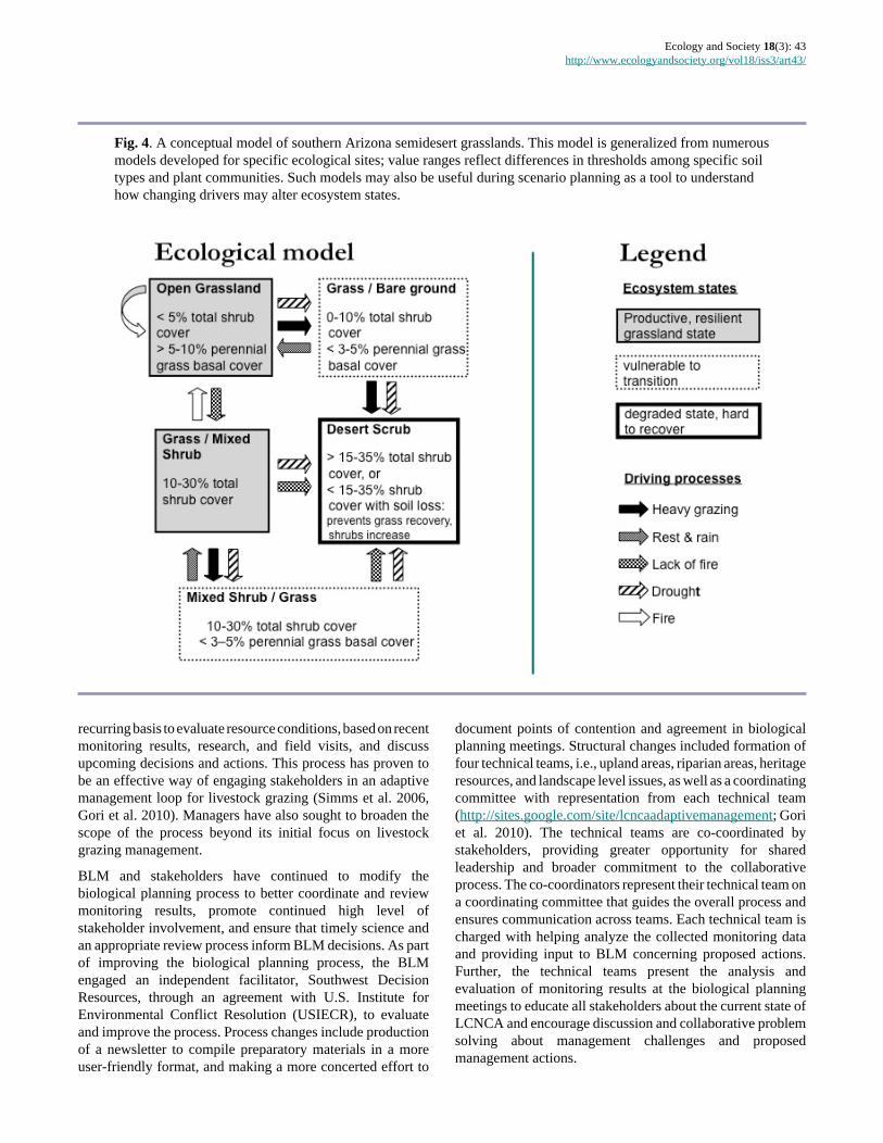
Ecological models (Fig. 4) have been very important in theseefforts to refine monitoring, revise objectives, and interpretresults with stakeholders. State-and-transition modelsdeveloped by the Natural Resources Conservation Service(Bestelmeyer et al. 2009) have been especially useful at thissite for enhancing communication among stakeholders withvarying backgrounds. These models have helped identifyecological thresholds and drivers of change, such as the pointat which loss of ground cover tends to dramatically increasesoil erosion rates or the role of fire in maintaining opengrasslands. Models have occasionally been modified to bettermeet needs at this site (Tiller et al. 2012). The generalizedstate-and-transition model has also prompted manydiscussions about causes and uncertainties in grasslanddynamics observed at the site, a shared learning result that hasalso been observed elsewhere (Knapp et al. 2011a, 2011b).
By modifying measurement methods and timing, the grouphas been able to tie monitoring more closely to resourceobjectives, key ecological drivers and thresholds, and agencydecision-making cycles. Improved usability of data has, inturn, boosted support for monitoring. Biological planningparticipants now expect to have and discuss monitoring resultsat meetings. This serves as an accountability mechanism toensure consistent data collection and analysis, and furthersolidify the site’s shift in emphasis from allowable uses tomaintaining desired resource conditions. As demonstratedelsewhere (e.g., Serrat-Capdevila et al. 2009), putting relevantand reliable science at the table benefits both social dynamicsand ecological problem solving.
Incorporating new information into decision makingBy bringing managers and stakeholders together to evaluatenew information, the biological planning process provides acrucial mechanism for exploring and responding to changeson the ground. This process convenes participants on a
Ecology and Society 18(3): 43http://www.ecologyandsociety.org/vol18/iss3/art43/
Fig. 4. A conceptual model of southern Arizona semidesert grasslands. This model is generalized from numerousmodels developed for specific ecological sites; value ranges reflect differences in thresholds among specific soiltypes and plant communities. Such models may also be useful during scenario planning as a tool to understandhow changing drivers may alter ecosystem states.
recurring basis to evaluate resource conditions, based on recentmonitoring results, research, and field visits, and discussupcoming decisions and actions. This process has proven tobe an effective way of engaging stakeholders in an adaptivemanagement loop for livestock grazing (Simms et al. 2006,Gori et al. 2010). Managers have also sought to broaden thescope of the process beyond its initial focus on livestockgrazing management.
BLM and stakeholders have continued to modify thebiological planning process to better coordinate and reviewmonitoring results, promote continued high level ofstakeholder involvement, and ensure that timely science andan appropriate review process inform BLM decisions. As partof improving the biological planning process, the BLMengaged an independent facilitator, Southwest DecisionResources, through an agreement with U.S. Institute forEnvironmental Conflict Resolution (USIECR), to evaluateand improve the process. Process changes include productionof a newsletter to compile preparatory materials in a moreuser-friendly format, and making a more concerted effort to
document points of contention and agreement in biologicalplanning meetings. Structural changes included formation offour technical teams, i.e., upland areas, riparian areas, heritageresources, and landscape level issues, as well as a coordinatingcommittee with representation from each technical team(http://sites.google.com/site/lcncaadaptivemanagement; Goriet al. 2010). The technical teams are co-coordinated bystakeholders, providing greater opportunity for sharedleadership and broader commitment to the collaborativeprocess. The co-coordinators represent their technical team ona coordinating committee that guides the overall process andensures communication across teams. Each technical team ischarged with helping analyze the collected monitoring dataand providing input to BLM concerning proposed actions.Further, the technical teams present the analysis andevaluation of monitoring results at the biological planningmeetings to educate all stakeholders about the current state ofLCNCA and encourage discussion and collaborative problemsolving about management challenges and proposedmanagement actions.
Ecology and Society 18(3): 43http://www.ecologyandsociety.org/vol18/iss3/art43/
As a result of this progress, discussion at the semiannualmeetings has progressively expanded to address othermanagement strategies, such as ecological restoration,endangered species protection, and non-native species control.Discussions and suggestions from biological planningmeetings are increasingly being considered in agencydecisions. For example, monitoring and field visits ofprescribed burn areas culminated in a discussion at onebiological planning meeting about when to light prescribedburns. Suggestions from this meeting resulted in an agencydecision to not light prescribed fires after particularly drywinters, when fire can kill perennial grasses rather thanrejuvenate them. The biological planning process hasimproved many LCNCA management actions: it has provenan effective forum for stakeholder learning and debate, amechanism for sharing ideas or concerns regardingimplementation, and, most importantly, has helped close thegap between information gathering and decision making.
Embracing shared learning to improve the process andactionsStakeholders’ desire for more comprehensive understandingof ecosystem and societal dynamics has expanded learningbeyond the site’s formal monitoring program and biologicalplanning meetings. Meeting notes reveal recurring requestsfor information that is both broader and more detailed thanthat provided by the LCNCA monitoring program. Thisreveals frustration with restricted monitoring budgets as wellas stakeholder interest in exploring new information.
To address these concerns, the coordinating committee hasinvited experts in natural resource fields to brief stakeholderson various technical issues, organized field trips to theLCNCA, and encouraged stakeholders to offer their ownexpertise through participation in technical teams andworkshops. Several State of the Watershed workshops havefocused on LCNCA and the Cienega Watershed/SonoitaValley; technical training has been offered on topics such asarroyo restoration and oral history. Since 2009, an annual“Science on the Sonoita Plain” symposium has provided aforum for researchers to share their work with stakeholdersand the interested public (Bodner et al. 2012; summariesavailable at http://researchranch.audubon.org/Library.html).Organizers have used this event to examine issues that theBiological Planning technical teams are facing, such asappropriate management of ephemeral washes or managementand decision-making tools that might be useful to the LCNCACAM process, and to simply share and celebrate insights intothe area’s rich natural and cultural heritage.
Such shared learning has helped build agreement on solutionsto contentious issues and has better prepared the group torespond to emerging challenges by educating participantsabout regional trends and dynamics. For instance, when theSVPP first began meeting, some stakeholders were adamantly
opposed to a continuation of grazing at LCNCA, whileparticipating ranchers wanted to continue their livelihoods andmanagers were required to consider multiple use regulations.Through field trips, joint fact-finding, meetings, consultationwith subject matter specialists, and a discussion of concerns,those in opposition to grazing recognized that this use couldbe compatible with RMP objectives for ecosystem health ifmanaged responsibly. Monitoring of range conditionscontinues and has more recently documented episodic grasscover declines coinciding with prolonged drought conditions.Discussions on field trips with outside resource experts andamong stakeholders have revealed similar declines across theregion and spurred efforts to test methods for quantifying grassmortality. Including the grazing permittee in these field tripsrevealed that earlier discussions of drought impacts had alertedhim to watch for grass mortality, and he had already adjustedhis livestock rotation to avoid areas of higher mortality topromote their recovery.
Although tension remains around participants’ desire to knowas much as possible about ecological dynamics and thelimitations on resources to conduct monitoring and research(Cienega Watershed Partnership, State of the Watershed,unpublished report 2011), participants continue to look fornew ways to encourage shared learning among participants,learn more from the work of others, and increase resourcesavailable for monitoring and research on the LCNCA.
Accomplishments and ongoing challengesMore than 15 years of sustained commitment at LCNCA hasprogressively improved the processes that bring stakeholderstogether to pursue shared goals, learn more about systemdynamics and effects of these actions, and work effectivelytogether to respond to conditions on the ground. Ongoinginvestments made by both agencies and stakeholder groupstestify to the benefits of both good relationships and tangibleoutcomes on the ground. Many groups have contributed tofunding and implementing grassland and riparian restorationprojects, developing educational programs, preservinghistoric sites, and recovering endangered species (Hughes2010; Cienega Watershed Partnership, State of the Watershed,unpublished report 2011). To date, contentious issues haveeither been resolved or accepted without legal challenges.Progress made at LCNCA clearly meets the U.S. Departmentof Interior’s criteria for successful adaptive management:“stakeholders are involved and committed to the process;progress is made toward achieving management objectives;results from monitoring and assessment are used to adjustmanagement decisions; and implementation is consistent withapplicable laws” (Williams et al. 2009:57).
Others have noted the benefits of this approach. In 2011,managers at the Agua Fria National Monument (AFNM) andtwo partner agencies (U.S. Forest Service Tonto NationalForest and Arizona Game and Fish Department) asked BLM
Ecology and Society 18(3): 43http://www.ecologyandsociety.org/vol18/iss3/art43/
staff, stakeholders, and the facilitator from Las Cienegas tohelp them apply CAM tools to a new management challengeat their own site. Work with the AFNM aims to fosterdevelopment of the same four core elements at this new site,while allowing the site’s stakeholders and managers to tailorboth the process and the results to their own needs. Earlyprogress suggests that learning from LCNCA experience ishelping this site more quickly solidify agreement on sharedgoals. Testing new monitoring approaches and coordinatedplanning mechanisms at AFNM may benefit Las Cienegas aswell, developing shared learning opportunities at higherinstitutional and spatial scales.
In addition to the four core elements described above, a fewother enabling factors are important: leadership from a fewkey participants and ongoing commitment from many others;BLM institutional support and flexibility; and willingness ofall parties to vest authority in people dedicated to groupproblem solving. Although most participants have contributedtheir time without direct financial compensation, theavailability of funding to partners has also catalyzed muchprogress. Cost-share funding from BLM to partners hasprovided seed money and/or stop-gap funding forimplementation of many projects, including design,collection, and analysis of monitoring data; installation oferosion control structures; habitat improvements forendangered species; and creation of youth stewardship groups.Because partners can carry funding over from one fiscal yearto another, and because they invest additional money into theseprojects, often raising considerable sums from outside sources,funding project work through partners is one of the agency’smost effective mechanisms for sustaining implementation ofan ambitious management plan despite fluctuations in agencybudgets. Nevertheless, having sufficient BLM staff time isalso crucial to making use of all this partner investmentbecause agency participation and approval are required atmany stages in these projects.
Stakeholder expectations have helped sustain the shift inagency emphasis toward desired resource conditions throughstaff turnovers in which managers with more traditional useemphasis came and went. Continuity in, and leadership from,key resource staff also buffered the CAM process from suchinternal changes. Although the agency retains officialdecision-making authority, instances in which its role has beenas a convener more than a decider has actually strengthenedthose agency decisions by boosting confidence in them. BLMand stakeholders continue to work to guarantee sustainedinvestment of time and funding, quantify the financial,ecological, and social benefits of CAM, and reconcile differentmandates among land agencies (Meridian Institute 2010;Cienega Watershed Partnership, State of the Watershed,unpublished report 2010).
Additional challenges, however, remain. Many of these areconsistent with critiques of adaptive management in the
literature (Walters 1997, Moir and Block 2001, Stankey et al.2003). Some agency decisions and programs are better suitedto stakeholder feedback and the biological planning cycle thanothers. It is not always clear or well documented how decisionmakers balance new ecological information with other factors.Limited monitoring resources make it impossible to track allrelevant aspects of ecological dynamics, and multiple usemanagement complicates design of experimental research.Like many practitioner sites, LCNCA does not always reachthe bar set by adaptive management theory of conductingrigorous experimental testing of multiple hypotheses at thesame time (Walters and Holling 1990). However, the LCNCAexperience shows that practical, user-created versions of CAMcan provide ecological and social benefits even if they do notmeet the strict definition laid out in theory, as long asparticipants continue to strive for improvement.
Beyond these ongoing challenges, stakeholders haverecognized future challenges that are largely external toLCNCA, including an uncertain political and budgetarylandscape, climate change, and other regional developments.These externalities will challenge the current CAM framework(York and Schoon 2011), which is designed to address issuesthat are internal to the LCNCA system and controllablethrough various actions and tools at the manager’s disposal.To maintain ecosystem resilience and ensure that thiscollaborative institution can survive future political, social,and environmental changes and more effectively addressexternalities will require innovative and flexible responses,new tools, and an evolution of the CAM process, all whileretaining the four core elements that have made the processwork thus far.
THE CHALLENGE POSED BY CLIMATE CHANGEOver the past decade, there has been growing awareness thatclimate change may significantly alter ecological functioningacross the desert Southwest, including sites like LCNCA.Numerous models robustly predict that over the comingcentury this region will become increasingly warm and dry,with winter-time precipitation falling dramatically andtemperatures rising 3-5°C (Christensen et al. 2007,Diffenbaugh et al. 2008, Seager and Vecchi 2010).Temperatures across the desert Southwest have already risenby more than 1°C over the past several decades, and much ofthe region has been mired in a decade-long drought, perhapsindicative of future precipitation regimes (Seager et al. 2007).
This anticipated shift in temperature-precipitation regimes hasbeen coupled with a number of more rapid changes, includingincreasing development, intensifying water-use, and thespread of non-native species. Population growth in theAmerican Southwest has been staggering, rising from 3million in 1900 to over 50 million people in 2000 (MacDonald2010). Water usage from 1950 to 2000 has nearly doubled(Koniecski and Heilman 2004), and hydrologic changes have

Ecology and Society 18(3): 43http://www.ecologyandsociety.org/vol18/iss3/art43/
Table 1. Numerous changes observed in the Sonoita Valley are categorized by the amount of control local managers andstakeholders have over these changes. As control of their causes and consequences decreases, nested management objectivesand scenario planning become increasingly important. Changes marked with † represent changes that stakeholders have indicatedshould be considered components of any scenario planning exercise.
ControllabilityModerate Low NoneGrazing intensity, rotation Border infrastructure Climate change†Implementation of land agency policy Land agency resources/policy† Interannual climate variabilityRecreation Housing development Population growthHabitat fragmentation Local economic activity Regional/national economic activityInvasive Species (bullfrogs) Invasive species (Lehmann's Lovegrass) National/international policyRestoration Projects Alternative energy infrastructureWater quality Water quantity
Sale of State Trust Land
been profound (Barnett et al. 2008). The combination of thesechanges with a changing climate will tax the already stressedecosystems across the Southwest (Serrat-Capdevila et al.2007, Marshall et al. 2010, Powell 2010).
As a result, the desert Southwest is becoming a focal point fordiscussions on preparing for and responding to climate changein a way that reduces impacts to natural and humancommunities. The exact trajectory that climate change willfollow is unknown even on the global scale, and on a regionalor local scale is still poorly understood. How species andresources respond to changing climatic conditions is anexpanding area of research (Parmesan 2006, Allen et al. 2010,McDowell et al. 2011). Despite many recent discoveries,however, surprises abound (Williams and Jackson 2007), andit remains difficult for managers to apply this growing bodyof knowledge at individual sites. How societies will respondto a changing climate is also unknown, and any response islikely to significantly impact ecological systems. Otherthreats, such as urban sprawl, energy development, andmineral extraction, often occur with limited long-termplanning considerations; these threats are tied to fluctuationsin the national economy, making predictions on the local-scaledifficult. Land management agencies face increasing politicaland financial uncertainty because of political gridlock.Preparing for and responding to climate change will thereforebe complicated by vast uncertainties (Peterson et al. 2003,Millar et al. 2007, Julius and West 2008, Baron et al. 2009,Lawler et al. 2010). Such uncertainties will make it difficultfor managers to succeed at sustaining, in perpetuity, thebenefits of public lands. Others have noted the constraintsthese externalities place upon collaborative institutions thatare often geared to respond to issues that are largely internalto an ecosystem (York and Schoon 2011).
Increased awareness among LCNCA stakeholders andmanagers about the potential impacts of climate change hasgrown out of conversations with climate experts and modelers,
communications with other public land managers, resourcescientists, and conservation organizations, monitoringestablished by the CAM process, and direct observation ofchanges within the Sonoita Valley and the surrounding region.The increased awareness about potential climate changeimpacts, coupled with other unpredictable and largelyuncontrollable changes occurring in the region has resulted inthe acknowledgement at LCNCA of the need to consider howto anticipate and respond to these changes (Table 1). Somedecisions are likely to be exceedingly difficult (Craig 2010),not only because they will be contentious, but also becausethe impact of these changes, and how these changes will mergeand affect each other, is highly uncertain.
Many authors have advocated adaptive management andcollaboration as key tools for providing the flexibility,learning, and public support needed to prepare for and respondto climate change and other rapid changes (Baron et al. 2009,Heller and Zavaletta 2009, Lawler et al. 2010). The experiencewith CAM at LCNCA gives the site a head start in addressingthese emerging challenges. Focused ecological monitoringand adaptive response loops enable participants to observechanges as they occur and provide a mechanism for discussingimplications of these changes on management decisions.Stakeholder involvement, broad expertise, and a tradition ofshared learning enhance the group’s ability to contemplatefuture changes. Having cultivated shared goals, trustingrelationships, and developed essential problem-solving skills,the CAM process provides a foundation for making thedifficult and contentious management decisions that uncertainchanges are likely to require.
BUILDING ON CAMDespite the evident benefits of CAM elements outlined above,stakeholders recognize that additional tools may be requiredto address these emerging challenges. Further, makingadjustments to existing activities may not be enough to bufferecosystems and the services and benefits they provide to
Ecology and Society 18(3): 43http://www.ecologyandsociety.org/vol18/iss3/art43/
human communities from the effects of these changes. Forthese reasons, LCNCA stakeholders engaged experts at the2010 Collaborative Adaptive Management Network(CAMNet) conference to help think through both the benefitsand limitations of CAM processes in preparing for andresponding to rapid and uncontrollable change.
CAMNet discussions, and a subsequent report for LCNCAabout how to address climate change uncertainty incollaborative decision-cycles (J. Caves 2010 ScenarioPlanning at Las Cienegas: Decision Support Tools and FuturesPlanning, unpublished manuscript), generated two main ideasthat participants have continued to explore at LCNCA since2010: re-evaluating management objectives through a climatechange lens, and using scenario planning tools to exploreadditional types of uncertainty created by these rapid changes.The report’s recommendations and the ideas generated atCAMNet continue to be discussed at biological planningmeetings. These discussions raised questions about whetherexisting objectives will be adequate, achievable, or evendesirable in the future. However, few managers orstakeholders were ready to simply abandon existingobjectives. Participants wanted tools that would help themrigorously and transparently explore which objectives mightbe especially important in the future, and which might onlypromote inflexible attempts to recapture a bygone past.Similarly, the observation that so many of these changesappear to be beyond local manager and stakeholders’ controlhas prompted ongoing discussions about the inherentlimitations of conventional adaptive management. Discussionsof scenario planning as a tool for addressing how suchuncontrollable drivers may interact to impact the landscapehave resonated with participants, and they have begunblending these tools into the CAM approach.
Nested objectives: from core to conditionalMeasuring progress toward specific, ecologically-basedtargets for desired resource conditions has been a cornerstoneof LCNCA CAM; yet, this creates a surprising conflict whenfaced with a changing climate. The LCNCA RMP objectiveswere derived from shared goals using best available sciencethat captured collective understanding of the functions,processes, and compositions of current and historicalecosystems. However, with changes in temperature andprecipitation already being observed, ecosystem processes andcomposition cannot be assumed to remain stationary (Milly etal. 2008), nor are they likely to only change within historicrange of variation (Williams and Jackson 2007). Given theuncertainty of future changes, the existing specific,numerically driven RMP objectives may become obsoletedespite the best efforts of BLM and stakeholders. Others haverecognized this shortcoming; an analysis of management plansacross BLM special management units rated LCNCA low onbeing prepared to deal with climate change, precisely becausethe RMP has such specific resource objectives (Koopman
2010). Despite the drawbacks of managing toward objectivesthat specify ecosystem parameters based upon historicalconditions, discarding these measurable objectives overallwould leave the LCNCA CAM process without essentialbenchmarks.
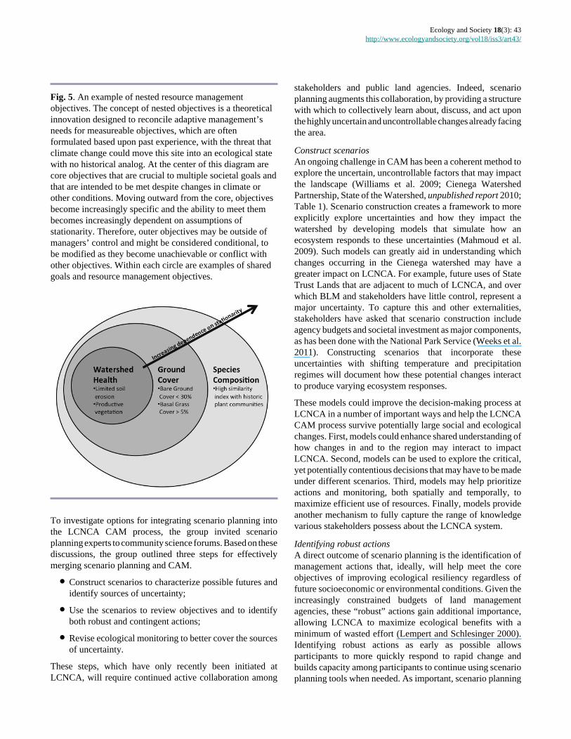
Evaluating existing RMP objectives from a climate changeperspective may help resolve this dilemma. Under a shiftingclimate, some RMP objectives may be more achievable thanothers, and some may contribute more to overall shared goalsof healthy watersheds and communities in the future. Toaccommodate both specific, historically based objectives andobjectives aimed at maintaining ecosystem resilience into thefuture, RMP objectives can be organized in a nested structure(Fig. 5): core objectives that emphasize long-term watershedfunctioning, for example, would be surrounded by specificobjectives based upon historical indicators of watershed healthcomponents such as erosion thresholds, and subsequently, bydesired conditions for individual species or assemblages. Inthis example, the outer objectives are seen as being moredependent on assumptions of stationarity and therefore lesscontrollable, while the core objectives represent thosecomponents necessary to maintain ecological resilience in thewatershed. This nested structure suggests that as climate shiftsand ecosystems respond, some conditional objectives couldbe discarded and others retained, while the core objectives areintended to be achieved under any future scenario.
The process of employing this nested objective structure, andany subsequent decision to discard conditional objectives, willneed to continue the LCNCA tradition of stakeholderengagement. Such an effort may be contentious, butencouraging open participation should continue to be viewedas an opportunity to educate one another about therelationships among objectives, to generate objectives thatencompass an array of environmental and social factors, andto improve support for whatever core objectives are ultimatelychosen. The scenario planning approach described belowcould guide such open discussions of what constitutes coreobjectives, and could add rigor to evaluations of conditionalobjectives.
Incorporating scenario planningScenario planning is designed to consider a variety of possibleand plausible futures rather than decide upon a particular,accurate future prediction (Mahmoud et al. 2009). Using thesevarious scenarios, stakeholders can determine whichdecisions, objectives, and monitoring targets are most relevantunder a range of future conditions. Further, scenario planningcan specifically address surprises and unanticipated threats byproviding a structure to make decisions based upon thesescenarios (Peterson et al. 2003, see their Fig. 1). As a result,climate change can be explicitly considered with other,unrelated impacts, such as mineral extraction, recreation, anddevelopment to understand linkages between these changesand produce a web of future trajectories.
Ecology and Society 18(3): 43http://www.ecologyandsociety.org/vol18/iss3/art43/
Fig. 5. An example of nested resource managementobjectives. The concept of nested objectives is a theoreticalinnovation designed to reconcile adaptive management’sneeds for measureable objectives, which are oftenformulated based upon past experience, with the threat thatclimate change could move this site into an ecological statewith no historical analog. At the center of this diagram arecore objectives that are crucial to multiple societal goals andthat are intended to be met despite changes in climate orother conditions. Moving outward from the core, objectivesbecome increasingly specific and the ability to meet thembecomes increasingly dependent on assumptions ofstationarity. Therefore, outer objectives may be outside ofmanagers’ control and might be considered conditional, tobe modified as they become unachievable or conflict withother objectives. Within each circle are examples of sharedgoals and resource management objectives.
To investigate options for integrating scenario planning intothe LCNCA CAM process, the group invited scenarioplanning experts to community science forums. Based on thesediscussions, the group outlined three steps for effectivelymerging scenario planning and CAM.
● Construct scenarios to characterize possible futures andidentify sources of uncertainty;
● Use the scenarios to review objectives and to identifyboth robust and contingent actions;
● Revise ecological monitoring to better cover the sourcesof uncertainty.
These steps, which have only recently been initiated atLCNCA, will require continued active collaboration among
stakeholders and public land agencies. Indeed, scenarioplanning augments this collaboration, by providing a structurewith which to collectively learn about, discuss, and act uponthe highly uncertain and uncontrollable changes already facingthe area.
Construct scenariosAn ongoing challenge in CAM has been a coherent method toexplore the uncertain, uncontrollable factors that may impactthe landscape (Williams et al. 2009; Cienega WatershedPartnership, State of the Watershed, unpublished report 2010;Table 1). Scenario construction creates a framework to moreexplicitly explore uncertainties and how they impact thewatershed by developing models that simulate how anecosystem responds to these uncertainties (Mahmoud et al.2009). Such models can greatly aid in understanding whichchanges occurring in the Cienega watershed may have agreater impact on LCNCA. For example, future uses of StateTrust Lands that are adjacent to much of LCNCA, and overwhich BLM and stakeholders have little control, represent amajor uncertainty. To capture this and other externalities,stakeholders have asked that scenario construction includeagency budgets and societal investment as major components,as has been done with the National Park Service (Weeks et al.2011). Constructing scenarios that incorporate theseuncertainties with shifting temperature and precipitationregimes will document how these potential changes interactto produce varying ecosystem responses.
These models could improve the decision-making process atLCNCA in a number of important ways and help the LCNCACAM process survive potentially large social and ecologicalchanges. First, models could enhance shared understanding ofhow changes in and to the region may interact to impactLCNCA. Second, models can be used to explore the critical,yet potentially contentious decisions that may have to be madeunder different scenarios. Third, models may help prioritizeactions and monitoring, both spatially and temporally, tomaximize efficient use of resources. Finally, models provideanother mechanism to fully capture the range of knowledgevarious stakeholders possess about the LCNCA system.
Identifying robust actionsA direct outcome of scenario planning is the identification ofmanagement actions that, ideally, will help meet the coreobjectives of improving ecological resiliency regardless offuture socioeconomic or environmental conditions. Given theincreasingly constrained budgets of land managementagencies, these “robust” actions gain additional importance,allowing LCNCA to maximize ecological benefits with aminimum of wasted effort (Lempert and Schlesinger 2000).Identifying robust actions as early as possible allowsparticipants to more quickly respond to rapid change andbuilds capacity among participants to continue using scenarioplanning tools when needed. As important, scenario planning

Ecology and Society 18(3): 43http://www.ecologyandsociety.org/vol18/iss3/art43/
should identify actions already occurring or planned to occurthat only meet core objectives under certain scenarios and,therefore, are considered contingent rather than robust.Additionally, these scenario planning exercises could be usedto evaluate the utility of the nested objective structure andinform when conditional objectives might be dropped ormodified.
LCNCA has already begun focusing on some robust actionsbased upon knowledge generated through the CAM process:(1) building resilience into floodplains through restoration andenhancement activities, including restoring riparian sacatongrasslands and reducing erosion in arroyos; and (2) workingwith partners to continue protecting landscape connectivity,particularly along elevational and latitudinal gradients throughpurchases of land and easements of target areas that protectkey water resources. Protection efforts by BLM and partnershave already secured east-west connectivity between “skyisland” mountain ranges (Pima County Board of Supervisors2011). Some landscape connectivity initiatives have made useof the unique and forward-thinking provision in the LCNCAEstablishment Act that created the Sonoita Valley AcquisitionPlanning District. This provision provides for futureacquisitions of lands or easements by BLM within the Districtand for their addition to LCNCA without further legislativeaction. Additional investments are gradually securing north-south connectivity between two more ranges. These connectedlands include terrain managed by BLM, U.S. Forest Service,National Park Service, Pima County, Fort Huachuca, ArizonaState Parks Department, TNC, and private landowners. Theseactions improve ecological resilience by simultaneouslyaddressing many of the changes and challenges (see Table 1)facing the Cienega Watershed.
Prioritizing ecological monitoring effortsAlthough evaluations described above are improving howLCNCA monitoring tracks ecosystem change relative toexisting objectives and previously recognized thresholds,these reviews have not yet addressed possible novel ecosystemdynamics or shifting thresholds. Scenario planning mayidentify critical aspects of the ecosystem that will be sensitiveto threshold-level changes that monitoring could examine todetermine if the system is moving into realms described byone scenario or another. This evidence could, in turn, promptthe group to shift management direction as they deem someobjectives no longer achievable or appropriate, moving frommanaging for resilience to managing for change (Craig 2010,Lawler et al. 2010).
Some monitoring protocols are already being modified tobetter track climate-related parameters. For example, theLCNCA recently installed an array of more accurate raingauges to help understand drought impacts across thelandscape and to document the magnitude of storm events thatmay be increasing in intensity and variability (Christensen et
al. 2007). Stakeholders are working to integrate existingclimate stations into monitoring efforts and determine whatadditional information needs to be collected across the site.TNC and BLM staff have also begun monitoring groundwaterchanges to detect impacts of drought and human activities, aswell as improve modeling of the basin’s dynamic waterresources.
THEORETICAL LESSONSIn addition to highlighting key practical lessons forimplementing and modifying CAM, the experiences at LasCienegas provide insight into a theoretical framework foraddressing the full range of complexity that faces naturalresource systems. We suggest that such complexity can bebroken into ecological, social, and temporal elements (Fig. 6),and illustrate how this trio of complementary tools, i.e.,collaboration, adaptive management, and scenario planning,are each suited to addressing particular aspects of thiscomplexity.
Fig. 6. Three types of complexity face land managers:temporal, ecological, and social. Each of these complexitiescan be addressed using complementary tools: adaptivemanagement, collaboration, and scenario planning.Adaptive management is well suited to responding to slow-moderate changes and to using the scientific process toaddress ecological questions. Collaboration addressesecological complexity by increasing the breadth ofknowledge available to land managers and stakeholders,while also improving outcomes where there are local and/orinternal conflicts. Scenario planning provides a structure toaid land managers and stakeholders in anticipating morerapid, external, or large-scale changes that may impact thenatural-resource system.
Ecology and Society 18(3): 43http://www.ecologyandsociety.org/vol18/iss3/art43/
Adaptive management is designed to harness the scientificprocess to understand and work with ecological complexity.Its ability to address temporal complexity in an ecosystem, i.e., unpredictable changes through time, is largely responsivebecause participants monitor results and modify subsequentactions. Collaboration brings in the ecological knowledge ofstakeholders to augment land managers’ expertise.Collaboration also folds societal dynamics, includingeconomics, into decision making; as stakeholders addresslocal and internal conflicts, their participation can yieldincreased support for contentious decisions. Scenario planningfills a critical gap by providing a structure with which tounderstand and anticipate externalities that are beyond thecontrol of land managers or stakeholders. Such externalitiesinclude societal issues at the state and national levels,including changes in policy or budgets, as well as rapid globaland regional ecological externalities such as climate shifts. Inthis sense, scenario planning allows participants to anticipateand plan for the effects of such externalities rather than simplyrespond to external forcings as they occur.
In applying this combination of tools, we have also proposedan innovative structure to “nest” descriptions of desiredresource conditions in a way that reconciles adaptivemanagement’s needs for measurable objectives, which areoften based on past conditions, with the recognition thatclimatic changes can create novel ecosystems. Allowing forflexibility in objectives creates a need for additional rigor toensure that the objectives being used continue to track andpromote progress toward agreed-upon goals. Scenarioplanning can provide that rigor by helping participantsexplicitly identify the conditions under which each set ofobjectives would continue to support ecosystem resilienceversus where they may hinder responses to inevitable change.
Finally, we return to the concept of using the four core elementsto implement CAM. Our experience at Las Cienegas hasdemonstrated that these elements can create a structure andphilosophy that emphasize continued improvement of theCAM process. These observations suggest that using thesecore elements will be as valuable for designing and applyingmodifications to CAM as for developing such inclusive,responsive processes to begin with.
CONCLUSIONSYears of experience at this site confirm the value and relevanceof collaborative adaptive management approaches. The fourcore elements that have emerged from experience have servedthe site well, allowing for flexible management actions thatstrive to achieve shared goals, ensuring that monitoringinforms actions, creating mechanisms for collaboration, andencouraging continued shared learning. As a result, managersand stakeholders have achieved several important milestones,including: the adoption of a resource management plan with
broad community support; a suite of partners that are investedin implementing the plan; a regular and effective ecologicalmonitoring program that tracks changes on the ground; andthe ability to work collaboratively to adapt managementdecisions to suit changing conditions. Managers andstakeholders at other BLM sites such as the Agua Fria NationalMonument have noted the benefits of this approach, and arelooking to our CAM process as an example that they can adaptand use at their own sites.
This foundation will be crucial for adapting to global climatechange, the effects of which are already being seen across thedesert Southwest. Managers and stakeholders in thiswatershed have long attempted to work across multiplejurisdictions within the broader landscape, addressingemerging stressors by emphasizing landscape connectivityand resilience. More recently, BLM and stakeholders atLCNCA have begun to enhance CAM by incorporatingflexibility into the RMP objectives through nesting objectivesand adding scenario planning. These modifications willexplicitly prepare managers and stakeholders to understandhow multiple external drivers may interact with ecosystemresponses, and identify robust actions and monitoring effortsneeded to respond to and detect the rapid and uncontrollablechanges facing the Cienega Watershed.
The evolution of CAM at this site parallels a growingrecognition nationwide that public lands can no longer bemanaged as isolated parcels; rather, protection of these criticallands and resources must address ecological, social, andtemporal complexity that often spans land boundaries andtraditional planning horizons. Public lands across the countryface similar pressures that will require new planning tools tosustain the benefits of these lands. The LCNCA experiencedemonstrates that collaborative adaptive management canprepare managers and stakeholders to face these challenges,but that additional tools, currently being implemented at thissite, may be necessary to fully address the range of complexityand change faced by public lands. Fortunately, these tools areall broadly applicable. Such an approach promises to helpmanagers and stakeholders effectively navigate thecomplexity and change that threatens to overwhelm even thebest efforts to sustain public land resources.
Responses to this article can be read online at: http://www.ecologyandsociety.org/issues/responses.php/5749
Acknowledgments:
This project is an outgrowth of 20 years of hand-wringing,stumbling, celebration, and joy. On behalf of the many peoplewho have a vested interest in the health of this landscape, the
Ecology and Society 18(3): 43http://www.ecologyandsociety.org/vol18/iss3/art43/
authors are grateful for all the camaraderie and hard work ofthe participants of SVPP and the Biological Planning Team,without whom this work would not have been possible. Theauthors wish to thank Carolyn Enquist, Greg Garfin, DaveGori, Holly Hartmann, Rob Marshall, Maggie McCaffrey,Brian Powell, Marcos Robles, Ed Smith, Christine Turner, andJeff Williamson for ongoing discussions about the intersectionof climate adaptation, adaptive management, and scenarioplanning. We also thank Steve Cohn and Michael Schoon forproviding thoughtful comments that significantly improvedthis manuscript. Thanks is also due to the U.S. Institute forEnvironmental Conflict Resolution for supporting JKC whileworking with the BLM and stakeholders on a paper aboutintegrating climate change uncertainty into decision-cycles.Funding for this paper came from The Nature Conservancy,the Bureau of Land Management, and a NSF GraduateResearch Fellowship to JKC.
LITERATURE CITEDAllen, C. D., A. K. Macalady, H. Chenchouni, D. Bachelet,N. McDowell, M. Vennetier, T. Kitzberger, A. Rigling, D. D.Breshears, E. H. T. Hogg, P. Gonzalez, R. Fensham, Z. Zhang,J. Castro, N. Demidova, J.-H. Lim, G. Allard, S. W. Running,A. Semerci, and N. Cobb. 2010. A global overview of droughtand heat-induced tree mortality reveals emerging climatechange risks for forests. Forest Ecology and Management 259(4):660-684.
Armitage, D. R., F. Berkes, and N. C. Doubleday. 2007.Introduction: moving beyond co-management. Pages 1-18 in D. Armitage, F. Berkes, and N. C. Doubleday, editors.Adaptive co-management: collaboration, learning, and multi-level governance. University of British Columbia Press,Vancouver, British Columbia, Canada.
Armitage, D. R., R. Plummer, F. Berkes, R. I. Arthur, A. T.Charles, I. J. Davidson-Hunt, A. P. Diduck, N. C. Doubleday,D. S. Johnson, M. Marschke, P. McConney, E. W. Pinkerton,and E. K. Wollenberg. 2009. Adaptive co-management forsocial-ecological complexity. Frontiers in Ecology and theEnvironment 7:95-102. http://dx.doi.org/10.1890/070089
Barnett, T. P., D. W. Pierce, H. G. Hidalgo, C. Bonfils, B. D.Santer, T. Das, G. Bala, A. W. Wood, T. Nozawa, A. A. Mirin,D. R. Cayan, and M. D. Dettinger. 2008. Human-inducedchanges in the hydrology of the western United States. Science 319(5866):1080-1083. http://dx.doi.org/10.1126/science.1152538
Baron, J. S., L. Gunderson, C. D. Allen, E. Fleishman, D.McKenzie, L. Meyerson, J. Oropeza, and N. Stephenson.2009. Options for national parks and reserves for adapting toclimate change. Environmental Management 44:1033-1042.http://dx.doi.org/10.1007/s00267-009-9296-6
Beier, P., D. Majka, and T. Bayless. 2006. Arizona missinglinkages: Rincon – Santa Rita – Whetstone Linkage Design.
Report to Arizona Game and Fish Department. School ofForestry, Northern Arizona University, Flagstaff, Arizona,USA. [online] URL: http://corridordesign.org/dl/linkages/reports/Rincon-SantaRita-Whetstone_LinkageDesign.pdf
Bestelmeyer, B. T. 2006. Threshold concepts and their use inrangeland management and restoration: the good, the bad, andthe insidious. Restoration Ecology 14(3):325-329. http://dx.doi.org/10.1111/j.1526-100X.2006.00140.x
Bestelmeyer, B. T., A. J. Tugel, G. L. Peacock, D. G. Robinett,P. L. Shaver, J. R. Brown, J. E. Herrick, H. Sanchez, and K.M. Havstad. 2009. State-and-transition models forheterogeneous landscapes: a strategy for development andapplication. Rangeland Ecology & Management 62(1):1-15.http://dx.doi.org/10.2111/08-146
Bodner, G., L. Kennedy, K. Simms, and J. Williamson. 2012.Science on the Sonoita Plain. Page 24 in Merging Science andManagement in a Rapidly Changing World. Biodiversity andManagement of the Madrean Archipelago III and 7thConference on Research and Resource Management in theSouthwestern Deserts. U.S. Forest Service Rocky MountainResearch Station, Fort Collins, Colorado, USA.
Bota, L. 1997. Modeling groundwater flow and surface/groundwater interaction for upper Cienega Creek basin.Thesis. University of Arizona, Tucson, Arizona, USA.
Bureau of Land Management. 2003. Approved Las Cienegasresource management plan and record of decision. U.S.Department of the Interior, Bureau of Land Management,Tucson Field Office, Arizona, USA. [online] URL: http://www.blm.gov/pgdata/etc/medialib/blm/az/pdfs/nepa/library/resource_management.Par.73866.File.dat/LCROD-WEB.pdf
Bureau of Land Management. 2009. Bureau of LandManagement National Natural Resources Policy forCollaborative Stakeholder Engagement and AppropriateDispute Resolution: what BLM, communities, and the publicneed to know for preventing conflict and resolving disputesinvolving public lands and resources. U.S. Department of theInterior, Bureau of Land Management, Washington, D.C.,USA. [online] URL: http://www.blm.gov/pgdata/etc/medialib/blm/wo/Planning_and_Renewable_Resources/adr_conflict_prevention.Par.44228.File.dat/ADR.pdf
Childs, C., A. M. York, D. White, M. L. Schoon, and G. S.Bodner. 2013. Navigating a murky adaptive comanagementgovernance network: Agua Fria Watershed, Arizona, USA.Ecology and Society 18(4): in press.
Christensen, N. L., A. M. Bartuska, J. H. Brown, S. Carpenter,C. D’Antonio, R. Francis, J. F. Franklin, J. A. MacMahon, R.F. Noss, D. J. Parsons, C. H. Peterson, M. G. Turner, and R.G. Woodmansee. 1996. The report of the Ecological Societyof America Committee on the Scientific Basis for Ecosystem
Ecology and Society 18(3): 43http://www.ecologyandsociety.org/vol18/iss3/art43/
Management. Ecological Applications 6:665-691. http://dx.doi.org/10.2307/2269460
Christensen, J. H., B. Hewitson, A. Busuioc, A. Chen, X. Gao,I. Held, R. Jones, R. K. Kolli, W.-T. Kwon, R. Laprise, V.Magaña Rueda, L. Mearns, C. G. Menéndez, J. Räisänen, A.Rinke, A. Sarr, and P. Whetton. 2007. Regional climateprojections. Chapter 11 in S. Solomon, D. Qin, M. Manning,Z. Chen, M. Marquis, K. B. Averyt, M. Tignor, and H. L.Miller, editors. Climate change 2007: the physical sciencebasis. Contribution of Working Group I to the FourthAssessment Report of the Intergovernmental Panel on ClimateChange. Cambridge University Press, New York, New York,USA.
Craig, R. K. 2010. “Stationarity is dead”—long livetransformation: five principles for climate change adaptationlaw. Harvard Environmental Law Review 573(2008):9-74.
Diffenbaugh, N. S., F. Giorgi, and J. S. Pal. 2008. Climatechange hotspots in the United States. Geophysical ResearchLetters 35(16):1-5. http://dx.doi.org/10.1029/2008GL035075
Dowell, G. P. 1978. History of the Empire Ranch. Thesis.University of Arizona, Tucson, Arizona, USA.
Eddy, F. W., and M. E. Cooley. 1983. Cultural andenvironmental history of Cienega Valley, southeasternArizona. University of Arizona Press, Tucson, Arizona, USA.
Folke, C., T. Hahn, P. Olsson, and J. Norberg. 2005. Adaptivegovernance of social-ecological systems. Annual Review ofEnvironment and Resources 30:441-473. http://dx.doi.org/10.1146/annurev.energy.30.050504.144511
Fonseca, J. 2008. Aquifer monitoring for groundwater-dependent ecosystems, Pima County, Arizona. Report to thePima County Board of Supervisors. Pima County, Tucson,Arizona, USA. [online] URL: http://www.pima.gov/cmo/sdcp/Monitoring/PDF/Fonseca_2008_Groundwater_Monitoring.pdf
Gori, D., and H. Schussman. 2005. State of the Las CienegasNational Conservation Area. Part I. Condition and trend ofthe desert grassland and watershed. The Nature Conservancyof Arizona, Phoenix, Arizona, USA. [online] URL: http://azconservation.org/dl/TNCAZ_LasCienegas_StateOf_Part_1.pdf
Gori, D., K. Simms, M. Donaldson, G. S. Bodner, and H.Schussman. 2010. Adaptive management of the grassland-watershed at Las Cienegas National Conservation Area: therole of monitoring, rancher engagement, and multi-stakeholder advisory teams. Pages 131-142 in W. Halverson,C. Shwalbe, and C. van Riper III, editors. Southwestern desertresources. University of Arizona Press, Tucson, Arizona,USA.
Groffman, P. M., J. S. Baron, T. Blett, A. J. Gold, I. Goodman,L. H. Gunderson, B. M. Levinson, M. A. Palmer, H. W. Paerl,G. D. Peterson, N. LeRoy Poff, D. W. Rejeski, J. F. Reynolds,M. G. Turner, K. C. Weathers, and J. Wiens. 2006. Ecologicalthresholds: the key to successful environmental managementor an important concept with no practical application?Ecosystems 9(1):1-13. http://dx.doi.org/10.1007/s10021-003-0142-z
Grumbine, R. E. 1994. What is ecosystem management?Conservation Biology 8(1):27-38. http://dx.doi.org/10.1046/j.1523-1739.1994.08010027.x
Gunderson, L. 1999. Resilience, flexibility and adaptivemanagement - antidotes for spurious certitude? ConservationEcology 3(1): 7. [online] URL: http://www.consecol.org/vol3/iss1/art7/
Gunderson, L. H., and C. S. Holling. 2002. Panarchy:understanding transformations in human and natural systems.Island Press, Washington, D.C., USA.
Heller, N. E., and E. S. Zavaleta. 2009. Biodiversitymanagement in the face of climate change: a review of 22years of recommendations. Biological Conservation 142(1):14-32. http://dx.doi.org/10.1016/j.biocon.2008.10.006
Holling, C. S., editor. 1978. Adaptive environmentalassessment and management. Wiley, New York, New York,USA.
Hughes, K. 2010. National Landscape Conservation SystemFY 2010 annual manager’s report: Las Cienegas NationalConservation Area. Bureau of Land Management, U.S.Department of the Interior, Washington, D.C., USA. [online]URL: http://www.blm.gov/pgdata/etc/medialib/blm/az/pdfs/nlcs.Par.80614.File.dat/Las-Cienegas-NCA-2010-Annual.pdf
Johnson, B. L. 1999. The role of adaptive management as anoperational approach for resource management agencies.Conservation Ecology 3(2): 8. [online] URL: http://www.ecologyandsociety.org/vol3/iss2/art8/
Julius, S. H., and J. M. West, editors. 2008. Preliminary reviewof adaptation options for climate-sensitive ecosystems andresources. Final Report, Synthesis and Assessment Product4.4. Report by the U.S. Climate Change Science Program andthe Subcommittee on Global Change Research. U.S.Environmental Protection Agency, Washington, D.C., USA.[online] URL: http://www.climatescience.gov/Library/sap/sap4-4/final-report/#finalreport
Kaufmann, M. R., R. T. Graham, D. A. Boyce Jr., W. H. Moir,L. Perry, R. T. Reynolds, R. L. Bassett, P. Mehlhop, C. B.Edminster, W. M. Block, and P. S. Corn. 1994. An ecologicalbasis for ecosystem management. General Technical ReportRM 246. U.S. Department of Agriculture, Forest Service,
Ecology and Society 18(3): 43http://www.ecologyandsociety.org/vol18/iss3/art43/
Rocky Mountain Forest and Range Experiment Station, FortCollins, Colorado, USA. [online] URL: http://library.eri.nau.edu/gsdl/collect/erilibra/import/KaufmannEtal.1994.AnEcologicalBasisForEcosystem.pdf
Keith, S. J. 1981. Stream channel recharge in the Tucson Basinand its implications for ground-water management.Dissertation. University of Arizona, Tucson, Arizona, USA.
Knapp, C. N., M. E. Fernandez-Gimenez, D. D. Briske, B. T.Bestelmeyer, and X. B. Wu. 2011a. An assessment of state-and-transition models: perceptions following two decades ofdevelopment and implementation. Rangeland Ecology andManagement 64(6):598-606. http://dx.doi.org/10.2111/REM-D-10-00188.1
Knapp, C. N., M. Fernandez-Gimenez, E. Kachergis, and A.Rudeen. 2011b. Using participatory workshops to integratestate-and-transition models created with local knowledge andecological data. Rangeland Ecology and Management 64(2):158-170. http://dx.doi.org/10.2111/REM-D-10-00047.1
Knight, E. L. 1996. A water budget and land managementrecommendations for Upper Cienega Creek Basin.Dissertation. University of Arizona, Tucson, Arizona, USA.
Konieczki, A. D., and J. A. Heilman. 2004. Water-use trendsin the desert Southwest—1950-2000. USGS ScientificInvestigations Report 2004-5148, U.S. Geological Survey,Reston, Virginia, USA.
Koopman, M. E. 2010. Climate change preparation planningon national landscape conservation system lands:recommendations for direction and approach. National Centerfor Conservation Science and Policy, Ashland, Oregon, USA.[online] URL: http://www.geosinstitute.org/images/stories/pdfs/climatechange_nlcs_smallfinal.pdf
Lawler, J. J., T. H. Tear, C. Pyke, M. R. Shaw, P. Gonzalez,P. Kareiva, L. Hansen, L. Hannah, K. Klausmeyer, A. Aldous,C. Bienz, and S. Pearsall. 2010. Resource management in achanging and uncertain climate. Frontiers in Ecology and theEnvironment 8(1):35-43. http://dx.doi.org/10.1890/070146
Lempert, R. J., and M. E. Schlesinger. 2000. Robust strategiesfor abating climate change. Climatic Change 45(3-4):387-401. http://dx.doi.org/10.1023/A:1005698407365
MacDonald, G. M. 2010. Water, climate change, andsustainability in the southwest. Proceedings of the NationalAcademy of Sciences of the United States of America 107(50):21256-21262. http://dx.doi.org/10.1073/pnas.0909651107
Mahmoud, M., Y. Liu, H. Hartmann, S. Stewart, T. Wagener,D. Semmens, R. Stewart, H. Gupta, D. Dominguez, F.Dominguez, D. Hulse, R. Letcher, B. Rashleigh, C. Smith, R.Street, J. Ticehurst, M. Twery, H. van Delden, R. Waldick, D.White, and L. Winter. 2009. A formal framework for scenariodevelopment in support of environmental decision-making.
Environmental Modelling and Software 24(7):798-808. http://dx.doi.org/10.1016/j.envsoft.2008.11.010
Majewski, T., S. O'Mack, E. J. Meane, M. A. Sterner, withcontributions by M. Green and B. Vint. 2004. Adaptive reuseplan for the Empire Ranch headquarters. Prepared for EmpireRanch Foundation, Sonoita, Arizona. SRI Technical Report03-64. Statistical Research, Inc., Tucson, Arizona, USA.
Marshall, R. M., M. D. Robles, D. R. Majka, and J. A. Haney.2010. Sustainable water management in the southwesternUnited States: reality or rhetoric? PloS ONE 5(7):e11687.http://dx.doi.org/10.1371/journal.pone.0011687
McDowell, N. G., D. J. Beerling, D. D. Breshears, R. A. Fisher,K. F. Raffa, and M. Stitt. 2011. The interdependence ofmechanisms underlying climate-driven vegetation mortality.Trends in Ecology & Evolution 26(10):523-532. http://dx.doi.org/10.1016/j.tree.2011.06.003
Meridian Institute. 2010. CAMNet annual rendezvous:summary. Collaborative Adaptive Management Network,Tucson, Arizona, USA. [online] URL: http://www.adaptivemanagement.net/sites/default/files/2010%20CAMNet%20Summary%20for%20posting.pdf
Millar, C. I., N. L. Stephenson, and S. L. Stephens. 2007.Climate change and forests of the future: managing in the faceof uncertainty. Ecological Applications 17(8):2145-2151.http://dx.doi.org/10.1890/06-1715.1
Milly, P. C. D., J. Betancourt, M. Falkenmark, R. M. Hirsch,Z. W. Kundzewicz, D. P. Lettenmaier, and R. J. Stouffer. 2008.Stationarity is dead: whither water management? Science 319:573-574. http://dx.doi.org/10.1126/science.1151915
Moir, W. H., and W. M. Block. 2001. Adaptive managementon public lands in the United States: commitment or rhetoric?Environmental Management 28(2):141-148. http://dx.doi.org/10.1007/s002670010213
National Park Service. 2012. About us. National Park Service,U.S. Department of the Interior, Washington, D.C., USA.[online] URL: http://www.nps.gov/aboutus/index.htm
Pahl-wostl, C., M. Craps, A. Dewulf, E. Mostert, D. Tabara,and T. Taillieu. 2007. Social learning and water resourcesmanagement. Ecology and Society 12(2): 5. [online] URL:http://www.ecologyandsociety.org/vol12/iss2/art5/
Parmesan, C. 2006. Ecological and evolutionary responses torecent climate change. Annual Review of Ecology, Evolution,and Systematics 37:637-669. http://dx.doi.org/10.1146/annurev.ecolsys.37.091305.110100
Peterson, G. D., G. S. Cumming, and S. R. Carpenter. 2003.Scenario planning: a tool for conservation in an uncertainworld. Conservation Biology 17(2):358-366. http://dx.doi.org/10.1046/j.1523-1739.2003.01491.x
Ecology and Society 18(3): 43http://www.ecologyandsociety.org/vol18/iss3/art43/
Pima Association of Governments. 2000. Sonoran DesertConservation Plan: GIS coverage of perennial andintermittent streams, and shallow groundwater. PimaAssociation of Governments, Tucson, Arizona, USA. [online]URL: http://rfcd.pima.gov/reports/pdfs/pima_streams.pdf
Pima County Board of Supervisors. 1999. Water resources andthe Sonoran Desert Conservation Plan: a discussion paper onthe regional policy necessary to achieve meaningful riparianrestoration. Pima County, Tucson, Arizona, USA. [online]URL: http://www.pima.gov/cmo/sdcp/reports/d7/001WAT.PDF.
Pima County Board of Supervisors. 2011. Protecting our land,water and heritage: Pima County’s voter-supportedconservation efforts. Report produced for the Sonoran DesertConservation Plan. Pima County, Tucson, Arizona, USA.[online] URL: http://www.pima.gov/cmo/admin/Reports/ConservationReport/
Plummer, R. 2009. The adaptive co-management process: aninitial synthesis of representative models and influentialvariables. Ecology and Society 14(2): 24. [online] URL: http://www.ecologyandsociety.org/vol14/iss2/art24/
Polasky, S., S. R. Carpenter, C. Folke, and B. Keeler. 2011.Decision-making under great uncertainty: environmentalmanagement in an era of global change. Trends in Ecology &Evolution 26(8):398-404. http://dx.doi.org/10.1016/j.tree.2011.04.007
Pomeroy, R. 2007. Conditions for successful fisheries andcoastal resources co-management: lessons learned in Asia,Africa, and the wider Caribbean. Pages 173-187 in D.Armitage, F. Berkes, and N. C. Doubleday, editors. Adaptiveco-management: collaboration, learning, and multi-levelgovernance. University of British Columbia Press,Vancouver, British Columbia, Canada.
Powell, B. F. 2010. Climate change and natural resources inPima County: anticipated impacts and managementchallenges. Pima County, Tucson, Arizona, USA. [online]URL: http://www.pima.gov/cmo/sdcp/reports/d52/Ecological_Impacts.pdf
Seager, R., M. Ting, I. Held, Y. Kushnir, J. Lu, G. Vecchi, H.Huang, N. Harnik, A. Leetmaa, N. Lau, C. Li, J. Velez, andN. Naik. 2007. Model projections of an imminent transitionto a more arid climate in southwestern North America. Science 316:1181-1184. http://dx.doi.org/10.1126/science.1139601
Seager, R., and G. A. Vecchi. 2010. Greenhouse warming andthe 21st century hydroclimate of southwestern North America.Proceedings of the National Academy of Sciences of the UnitedStates of America 107(50):21277-21282. http://dx.doi.org/10.1073/pnas.0910856107
Serrat-Capdevila, A., A. Browning-Aiken, K. Lansey, T.Finan, and J. B. Valdés. 2009. Increasing social-ecologicalresilience by placing science at the decision table: the role ofthe San Pedro Basin (Arizona) decision-support system model.Ecology and Society 14(1): 37. [online] URL: http://www.ecologyandsociety.org/vol14/iss1/art37/
Serrat-Capdevila, A., J. B. Valdés, K. González-Pérez, K.Baird, L. J. Mata, and T. Maddock III. 2007. Modeling climatechange impacts—and uncertainty—on the hydrology of ariparian system: the San Pedro basin (Arizona/Sonora).Journal of Hydrology 347(1-2):48-66. http://dx.doi.org/10.1016/j.jhydrol.2007.08.028
Shindler, B., and K. Aldred Cheek. 1999. Integrating citizensin adaptive management: a propositional analysis.Conservation Ecology 3(1): 9. [online] URL: http://www.consecol.org/vol3/iss1/art9/
Simms, K., G. Drennen, B. Cooper, G. S. Bodner, and D. Gori.2006. Report on the biological planning process for livestockmanagement at Las Cienegas NCA. The Nature Conservancy,Tucson, Arizona, USA. [online] URL: http://azconservation.org/dl/TNCAZ_LasCienegas_Biological_Planning_Process_2005.pdf
Stankey, G. H., B. T. Bormann, C. Ryan, B. Shindler, V.Sturtevant, R. N. Clark, and C. Philpot. 2003. Adaptivemanagement and the northwest forest plan: rhetoric andreality. Journal of Forestry 101(1):40-46.
Swanson, E. H. 1951. An archaeological survey of the EmpireValley, Arizona. Thesis. University of Arizona, Tucson,Arizona, USA.
Szaro, R. C., W. T. Sexton, and C. R. Malone. 1998. Theemergence of ecosystem management as a tool for meetingpeople’s needs and sustaining ecosystems. Landscape andUrban Planning 40(1-3):1-7. http://dx.doi.org/10.1016/S0169-2046(97)00093-5
Tiller, R. L., M. Hughes, and G. S. Bodner. 2012. Sacatonriparian grasslands: mapping distribution and ecologicalcondition using state-and-transition models in Upper CienegaCreek Watershed. The Nature Conservancy, Tucson, Arizona,USA. [online] URL: http://azconservation.org/dl/Sacaton_Grasslands_finalreport_mod10302012.pdf
U.S. Government. 2004. Executive Order 13,352. FederalRegister 69(167). Government Printing Office, Washington,D.C., USA.
U.S. Senate. 2000. Public Law 106-538. An Act to establishthe Las Cienegas National Conservation Area in the State ofArizona. U.S. Senate, Washington, D.C., USA. [online] URL:http://www.blm.gov/pgdata/etc/medialib/blm/az/images/cuenegas.Par.14910.File.dat/legislation_PL.pdf
Ecology and Society 18(3): 43http://www.ecologyandsociety.org/vol18/iss3/art43/
U.S. Senate. 2009a. Public Law 111-88. Interior Departmentand further continuing appropriations, Fiscal Year 2010. U.S. Senate, Washington, D.C., USA. [online] URL: http://www.gpo.gov/fdsys/pkg/PLAW-111publ88/pdf/PLAW-111publ88.pdf
U.S. Senate. 2009b. Public Law 111-11. To designate certainland as components of the National Wilderness PreservationSystem, to authorize certain programs and activities in theDepartment of the Interior and the Department of Agriculture,and for other purposes. U.S. Senate, Washington, D.C., USA.[online] URL: http://www.gpo.gov/fdsys/pkg/PLAW-111publ11/pdf/PLAW-111publ11.pdf
Walters, C. J. 1997. Challenges in adaptive management ofriparian and coastal ecosystems. Conservation Ecology 1(2):1. [online] URL: http://www.consecol.org/vol1/iss2/art1/
Walters, C. J., and C. S. Holling. 1990. Large-scalemanagement experiments and learning by doing. Ecology 71:2060-2068. http://dx.doi.org/10.2307/1938620
Weeks, D., P. Malone, and L. Welling. 2011. Climate changescenario planning: a tool for managing parks into uncertainfutures. ParkScience 28(1):26-33. [online] URL: http://www.nature.nps.gov/ParkScience/index.cfm?ArticleID=475
Williams, B. K., R. C. Szaro, and C. D. Shapiro. 2009. Adaptivemanagement: the U.S. Department of the Interior technicalguide. Adaptive Management Working Group, U.S.Department of the Interior, Washington, D.C., USA.
Williams, J. W., and S. T. Jackson. 2007. Novel climates, no-analog communities, and ecological surprises. Frontiers inEcology and the Environment 5:475-482. http://dx.doi.org/10.1890/070037
York, A. M., and M. L. Schoon. 2011. Collective action onthe western range: coping with external and internal threats.International Journal of the Commons 5:388-409.
Related Documents