Integrated analysis of structures and landforms of an intermontane longitudinal valley (Pinjaur dun) and its associated mountain fronts in the NW Himalaya Vimal Singh 1 , S.K. Tandon ⁎ Department of Geology, University of Delhi, Delhi – 110007, India abstract article info Article history: Received 7 February 2009 Received in revised form 31 August 2009 Accepted 1 September 2009 Available online 18 September 2009 Keywords: Intermontane valley Pinjaur dun Himalayan mountain front Landscape evolution Kangra recess Frontal regions of the Himalaya associated with topographic recesses are commonly marked by the development of intermontane valleys, locally referred to as “duns.” The relationship between structural evolution and landform development of an intermontane longitudinal valley (Pinjaur dun) is explored to understand the role of tectonic processes on landform development. The Pinjaur dun has a length of ~180 km; it is divisible into a wider (~20 km) northwestern and a narrower (~6–8 km) southeastern segment. The Barsar thrust, the Nalagarh thrust, and the Himalayan frontal thrust form the mountain fronts in the area. The proposed structural model integrates the transverse structures (for e.g., Ghaggar tear fault) with the sequential development of imbricates in front of the Main Boundary thrust. The Pinjaur dun formed as a consequence of the fold–thrust-related uplift that formed the outermost Siwalik hills. Most of the geomorphic units formed within the dun are the result of interactions between the imbricates, such as the Pinjaur thrust, Jhajara thrust, and Pinjaur Garden fault. These interactions also resulted in the development of a significant and prominent drainage divide between the Jhajjara and the Sirsa Rivers of the Pinjaur dun. Landform development and landscape evolution in this frontal region of the Himalaya are a consequence of the interaction of thrust–fold and transverse fault zone tectonics; and constitute a record of transient (10 2 –<10 5 years) landscapes in association with deforming orogenic fronts. © 2009 Elsevier B.V. All rights reserved. 1. Introduction Following the early Cenozoic collision of India and Asia, deforma- tion progressed in the Himalaya from north to south, resulting in the development of an evolving foreland basin (Burbank et al., 1996). As a corollary, mountain fronts of the Himalaya related to orogen-scale structures are considered to have migrated toward the south. Three major structures of the Himalayas from north to south are the Main Central thrust (MCT), the Main Boundary thrust (MBT), and the Himalayan frontal thrust (HFT) (Fig. 1A,B) and are related to past and present mountain fronts. Major topographic breaks are associated with these thrusts (Gansser, 1964; Seeber and Gornitz, 1983). The MBT in the NW Himalaya displays prominent sinuosity; this has given rise to the Kangra recess and the Dehra dun recess, the two being separated by the Nahan salient (Fig. 1B). The frontal regions associated with recesses in the NW Himalaya are commonly char- acterized by the occurrence of an intermontane valley (locally called dun), while the salients lack such intermontane valleys (Fig. 1B). Several intermontane valleys such as Pinjaur dun and Dehra dun are present along the front of the NW Himalaya (Fig. 1A,B). In the past, several studies on geomorphic, structural, and seis- mological aspects have been carried out on the frontal Himalayas (e.g. Nakata, 1972; Mukerji, 1976, 1990; Srivastava and John, 1999; Lavé and Avouac, 2000; Kumar et al., 2001, 2006; Malik and Nakata, 2003; Malik et al., 2003; Mukhopadhyay and Mishra, 2004; Delcaillau et al., 2006; Philip and Virdi, 2006, 2007; Malik and Mohanty, 2007; Singh and Tandon, 2008). In tectonically formed Himalayan valleys such as the duns, landform development closely follows structural evolution of tectonic features, most of which are active. Therefore, the recognition of active and neotectonic structures and understanding of their role on landform development aid the modeling of morphotectonic evolution of duns. This study explores the links between structures and landforms in the active tectonic setting associated with the “Pinjaur dun” related segment of the frontal deformation zone of the Himalaya. 2. Regional setting, study area and methods 2.1. Tectonic setting and previous studies The study area is a part of the Himalayan front demarcated by the alluvial plains associated with the HFT in the south and the Barsar thrust (an imbricate in front of the MBT) in the north. The HFT and Geomorphology 114 (2010) 573–589 ⁎ Corresponding author. Tel.: +91 11 27667899, +91 11 27667696. E-mail addresses: [email protected] (V. Singh), [email protected] (S.K. Tandon). 1 Presently at Rajiv Gandhi Institute of Petroleum Technology, Ratapur Chowk, Rae Bareli – 229316, India. 0169-555X/$ – see front matter © 2009 Elsevier B.V. All rights reserved. doi:10.1016/j.geomorph.2009.09.019 Contents lists available at ScienceDirect Geomorphology journal homepage: www.elsevier.com/locate/geomorph

Welcome message from author
This document is posted to help you gain knowledge. Please leave a comment to let me know what you think about it! Share it to your friends and learn new things together.
Transcript
Geomorphology 114 (2010) 573–589
Contents lists available at ScienceDirect
Geomorphology
j ourna l homepage: www.e lsev ie r.com/ locate /geomorph
Integrated analysis of structures and landforms of an intermontane longitudinalvalley (Pinjaur dun) and its associated mountain fronts in the NW Himalaya
Vimal Singh 1, S.K. Tandon ⁎Department of Geology, University of Delhi, Delhi – 110007, India
⁎ Corresponding author. Tel.: +91 11 27667899, +91E-mail addresses: [email protected] (V. Singh), s
(S.K. Tandon).1 Presently at Rajiv Gandhi Institute of Petroleum Te
Bareli – 229316, India.
0169-555X/$ – see front matter © 2009 Elsevier B.V. Adoi:10.1016/j.geomorph.2009.09.019
a b s t r a c t
a r t i c l e i n f oArticle history:Received 7 February 2009Received in revised form 31 August 2009Accepted 1 September 2009Available online 18 September 2009
Keywords:Intermontane valleyPinjaur dunHimalayan mountain frontLandscape evolutionKangra recess
Frontal regions of the Himalaya associated with topographic recesses are commonly marked by thedevelopment of intermontane valleys, locally referred to as “duns.” The relationship between structuralevolution and landform development of an intermontane longitudinal valley (Pinjaur dun) is explored tounderstand the role of tectonic processes on landform development. The Pinjaur dun has a length of~180 km; it is divisible into a wider (~20 km) northwestern and a narrower (~6–8 km) southeasternsegment. The Barsar thrust, the Nalagarh thrust, and the Himalayan frontal thrust form the mountain frontsin the area. The proposed structural model integrates the transverse structures (for e.g., Ghaggar tear fault)with the sequential development of imbricates in front of the Main Boundary thrust. The Pinjaur dun formedas a consequence of the fold–thrust-related uplift that formed the outermost Siwalik hills.Most of the geomorphic units formed within the dun are the result of interactions between the imbricates,such as the Pinjaur thrust, Jhajara thrust, and Pinjaur Garden fault. These interactions also resulted in thedevelopment of a significant and prominent drainage divide between the Jhajjara and the Sirsa Rivers of thePinjaur dun. Landform development and landscape evolution in this frontal region of the Himalaya are aconsequence of the interaction of thrust–fold and transverse fault zone tectonics; and constitute a record oftransient (102–<105years) landscapes in association with deforming orogenic fronts.
chnology, Ratapur Chowk, Rae
ll rights reserved.
© 2009 Elsevier B.V. All rights reserved.
1. Introduction
Following the early Cenozoic collision of India and Asia, deforma-tion progressed in the Himalaya from north to south, resulting in thedevelopment of an evolving foreland basin (Burbank et al., 1996). As acorollary, mountain fronts of the Himalaya related to orogen-scalestructures are considered to have migrated toward the south. Threemajor structures of the Himalayas from north to south are the MainCentral thrust (MCT), the Main Boundary thrust (MBT), and theHimalayan frontal thrust (HFT) (Fig. 1A,B) and are related to past andpresent mountain fronts. Major topographic breaks are associatedwith these thrusts (Gansser, 1964; Seeber and Gornitz, 1983).
The MBT in the NW Himalaya displays prominent sinuosity; thishas given rise to the Kangra recess and the Dehra dun recess, the twobeing separated by the Nahan salient (Fig. 1B). The frontal regionsassociated with recesses in the NW Himalaya are commonly char-acterized by the occurrence of an intermontane valley (locally calleddun), while the salients lack such intermontane valleys (Fig. 1B).
Several intermontane valleys such as Pinjaur dun and Dehra dun arepresent along the front of the NW Himalaya (Fig. 1A,B).
In the past, several studies on geomorphic, structural, and seis-mological aspects have been carried out on the frontal Himalayas (e.g.Nakata, 1972; Mukerji, 1976, 1990; Srivastava and John, 1999; Lavéand Avouac, 2000; Kumar et al., 2001, 2006; Malik and Nakata, 2003;Malik et al., 2003; Mukhopadhyay and Mishra, 2004; Delcaillau et al.,2006; Philip and Virdi, 2006, 2007; Malik and Mohanty, 2007; Singhand Tandon, 2008).
In tectonically formed Himalayan valleys such as the duns,landform development closely follows structural evolution of tectonicfeatures, most of which are active. Therefore, the recognition of activeand neotectonic structures and understanding of their role onlandform development aid the modeling of morphotectonic evolutionof duns. This study explores the links between structures andlandforms in the active tectonic setting associated with the “Pinjaurdun” related segment of the frontal deformation zone of the Himalaya.
2. Regional setting, study area and methods
2.1. Tectonic setting and previous studies
The study area is a part of the Himalayan front demarcated by thealluvial plains associated with the HFT in the south and the Barsarthrust (an imbricate in front of the MBT) in the north. The HFT and

Fig. 1. (A) Google Image showing context of the duns along the Himalayan arc. (B) Map showing the occurrence of the duns in the Himalayan foothills. Note the development of the duns in the context of the Kangra Recess, Nahan Salient, andthe Dehradun Recess, MBT, and HFT (after Powers et al., 1998). Dashed lines mark the extent of the study area. 1: Sutlej River exit and 2: Ghaggar River exit. (C) Map showing themajor topographic units of the area. The outermost Siwalik hillsare divided into three segments; the Pinjaur dun has a distinct wider northwestern intermontane valley and a narrower southeastern valley domain.
574V.Singh,S.K
.Tandon/Geom
orphology114
(2010)573
–589

575V. Singh, S.K. Tandon / Geomorphology 114 (2010) 573–589
MBT and their splays show evidence of active tectonics (e.g., Valdiya,1992; Kumar et al., 2001, 2006; Singh and Tandon, 2007, 2008).
Analysis of the existing data (Sahni and Khan, 1963, 1964; Khan,1970; Nakata, 1972, 1989; Raiverman et al., 1993; Dubey et al., 2001;Suresh et al., 2002, 2007; Malik and Nakata, 2003; Malik et al., 2003;Mukhopadhyay and Mishra, 2004, 2005; Malik and Mathew, 2005;Kumar et al., 2006; Malik and Mohanty, 2007; Philip and Virdi, 2007)reveals the lack of an integrated structural and geomorphic understand-ing of the evolution of drainage and landforms associated with activedeformational fronts in theHimalaya. However, in the past fewdecades,drainage evolution models for some segments of the Himalayan frontwere presented (Gupta, 1997; Friend et al., 1999; Delcaillau et al., 2006;Singh and Tandon, 2008). These drainage evolution models areimportant as they explain how the southward migration of the newstructures influenced the course of transverse rivers from the Higherand the Lesser Himalayas.
2.2. Study area and methods
The study area is located in the frontal part of the NW Himalaya(Fig. 1A,B). An intermontane valley known as Pinjaur dun is associatedwith the Himalayan front in this part. Previous studies (Suresh et al.,2007; Singh et al., 2008) suggested that this dun is filled with LatePleistocene and Holocene sediments. The Pinjaur dun occurs on thesouthernmost margin of the Kangra recess and lies on the transitionzone of the Nahan salient and the Kangra recess (Fig. 1B). Threemountain fronts, namely MF1, MF2, and MF3, are present in the studyarea (Fig. 1C). Twomajor river exits cutting acrossMF1 on the NWandSE are present in the study area, namely, the Sutlej River exit and theGhaggar River exit (Fig. 1C).
Fig. 2. (A) Geomorphological map of the narrower part of the intermontane valley of Pinjaurare present in the southeastern part. Note that the Sirsa River flows toward the NW,whereasthe southeastern part. (B) DTM of the broader part of the intermontane valley showing its
The methodology employed in this study included structural andgeomorphological mapping. To prepare the geomorphic map of thestudy area, topographic maps as well as satellite imageries were used.Representative areas (Figs. 1C, 2–6) were selected, and detaileddescriptions of the geomorphic units were made from representativegeomorphic settings based on IRS LISS-III image and Survey of Indiatopographicmaps (1:50,000). Field investigations were carried out forthe collection of geological, structural, and geomorphic data fromexposed outcrops and landforms.
3. Geomorphic mapping and geologic setting
3.1. Geomorphic mapping
Four major geomorphic units (Fig. 1C) are mapped, namely (i) Ter-tiary sub-Himalayan mountains, (ii) intermontane valley (dun)(Figs. 2,3), (iii) outermost Siwalik hills (Figs. 4–6), and (iv) Indo-Gangetic plains (IGP) (Fig. 6).
3.1.1. Tertiary sub-Himalayan mountainsThe mountains are composed of Tertiary rocks of the Subathu
Formation, the Dagshai Formation, the Kasauli Formation, and theLower Siwalik Subgroup. The elevation of the structural mountainsvaries from 600 to 1500 m in the area adjacent to the Pinjaur dunand the topographic break between the Pinjaur dun and the mountaindefines the MF3 (Fig. 1C,2). The slope of the mountains varies bet-ween 10° and 60°. Several drainages originate from these mountainranges and have resulted in a ridge and valley topography (Fig. 2A,B).The streams originating in these mountains are seasonal and carrywater only during the monsoons. Sirsa and Koshallia Rivers andmajor
dun. The Kiratpur fan is present in this part of the valley. Three well-developed surfacesthe Jhajjara stream flows toward the SE. The hills extend into the intermontane valley inrelationship to the sub-Himalayan mountains and the outermost Siwalik hills.
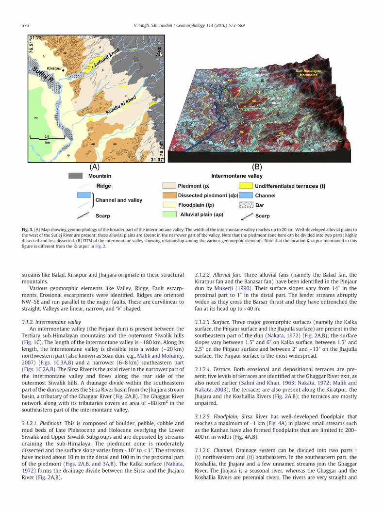
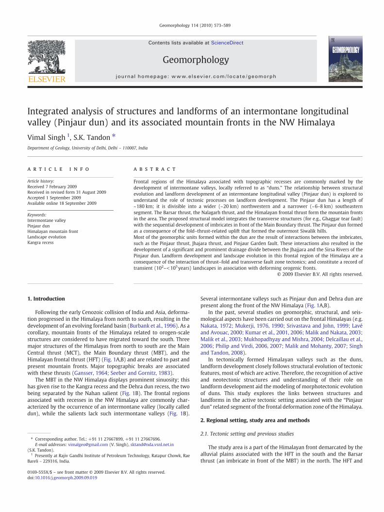
Fig. 3. (A) Map showing geomorphology of the broader part of the intermontane valley. The width of the intermontane valley reaches up to 20 km.Well-developed alluvial plains tothe west of the Sutlej River are present; these alluvial plains are absent in the narrower part of the valley. Note that the piedmont zone here can be divided into two parts: highlydissected and less dissected. (B) DTM of the intermontane valley showing relationship among the various geomorphic elements. Note that the location Kiratpur mentioned in thisfigure is different from the Kiratpur in Fig. 2.
576 V. Singh, S.K. Tandon / Geomorphology 114 (2010) 573–589
streams like Balad, Kiratpur and Jhajjara originate in these structuralmountains.
Various geomorphic elements like Valley, Ridge, Fault escarp-ments, Erosional escarpments were identified. Ridges are orientedNW–SE and run parallel to the major faults. These are curvilinear tostraight. Valleys are linear, narrow, and ‘V’ shaped.
3.1.2. Intermontane valleyAn intermontane valley (the Pinjaur dun) is present between the
Tertiary sub-Himalayan mountains and the outermost Siwalik hills(Fig. 1C). The length of the intermontane valley is ~180 km. Along itslength, the intermontane valley is divisible into a wider (~20 km)northwestern part (also known as Soan dun; e.g., Malik and Mohanty,2007) (Figs. 1C,3A,B) and a narrower (6–8 km) southeastern part(Figs. 1C,2A,B). The Sirsa River is the axial river in the narrower part ofthe intermontane valley and flows along the rear side of theoutermost Siwalik hills. A drainage divide within the southeasternpart of the dun separates the Sirsa River basin from the Jhajjara streambasin, a tributary of the Ghaggar River (Fig. 2A,B). The Ghaggar Rivernetwork along with its tributaries covers an area of ~80 km2 in thesoutheastern part of the intermontane valley.
3.1.2.1. Piedmont. This is composed of boulder, pebble, cobble andmud beds of Late Pleistocene and Holocene overlying the LowerSiwalik and Upper Siwalik Subgroups and are deposited by streamsdraining the sub-Himalaya. The piedmont zone is moderatelydissected and the surface slope varies from ~10° to <1°. The streamshave incised about 10 m in the distal and 100 m in the proximal partof the piedmont (Figs. 2A,B, and 3A,B). The Kalka surface (Nakata,1972) forms the drainage divide between the Sirsa and the JhajaraRiver (Fig. 2A,B).
3.1.2.2. Alluvial fan. Three alluvial fans (namely the Balad fan, theKiratpur fan and the Banasar fan) have been identified in the Pinjaurdun by Mukerji (1990). Their surface slopes vary from 14° in theproximal part to 1° in the distal part. The feeder streams abruptlywiden as they cross the Barsar thrust and they have entrenched thefan at its head up to ~40 m.
3.1.2.3. Surface. Three major geomorphic surfaces (namely the Kalkasurface, the Pinjaur surface and the Jhajulla surface) are present in thesoutheastern part of the dun (Nakata, 1972) (Fig. 2A,B); the surfaceslopes vary between 1.5° and 6° on Kalka surface, between 1.5° and2.5° on the Pinjaur surface and between 2° and ~13° on the Jhajullasurface. The Pinjaur surface is the most widespread.
3.1.2.4. Terrace. Both erosional and depositional terraces are pre-sent; five levels of terraces are identified at the Ghaggar River exit, asalso noted earlier (Sahni and Khan, 1963; Nakata, 1972; Malik andNakata, 2003); the terraces are also present along the Kiratpur, theJhajara and the Koshallia Rivers (Fig. 2A,B); the terraces are mostlyunpaired.
3.1.2.5. Floodplain. Sirsa River has well-developed floodplain thatreaches a maximum of ~1 km (Fig. 4A) in places; small streams suchas the Kanhan have also formed floodplains that are limited to 200–400 m in width (Fig. 4A,B).
3.1.2.6. Channel. Drainage system can be divided into two parts :(i) northwestern and (ii) southeastern. In the southeastern part, theKoshallia, the Jhajara and a few unnamed streams join the GhaggarRiver. The Jhajara is a seasonal river, whereas the Ghaggar and theKoshallia Rivers are perennial rivers. The rivers are very straight and

Fig. 4. (A) Map showing geomorphology of the Sutlej River exit. Note the sharp bends of the Sutlej River. The hills just adjacent to the southeastern bank of the Sutlej River trend NE–SW; elevation of these hills is comparatively low. The width of the outermost Siwalik hills on the northern bank tapers near the exit. The streams draining the outermost Siwalik hillson the southeastern bank flow toward the NW to join the Sutlej River. SR: Sirsa River and KS: Kanhan stream. (B) DTM showing relationship of intermontane valley, outermostSiwalik hills, and Indo-Gangetic plains in the region of the Sutlej River exit.
577V. Singh, S.K. Tandon / Geomorphology 114 (2010) 573–589
their width is not constant. The northwestern drainage system consistsof the Kiratpur River, the Ramnagar River, the Surajpur Choe, and theBalad River all of which eventually join the Sirsa River, which is the axialriver of the southeastern part of the dun. One of the most prominentfeatures is the high comparative length of the first order streams
originating on the fan surfaces, longer than that of the second and thirdorder streams (Mukerji, 1990) (Fig. 2A). Streams also originate in theinterfan areas and these streams are not incised. In the northwesternpart of the intermontane valley, a prominent feature of the Sutlej Rivernear its exit is that it takes two almost perpendicular bends before

578 V. Singh, S.K. Tandon / Geomorphology 114 (2010) 573–589

579V. Singh, S.K. Tandon / Geomorphology 114 (2010) 573–589
leaving the intermontane valley. The Sutlej River follows a straightchannel course between these two bends (Fig. 4A,B).
3.1.3. Outermost Siwalik hillsThe outermost Siwalik hills occur in the southwestern side of the
intermontane valley (Fig. 1C). These hills are divided into threesegments: (i) segment I represents the hills on the NW bank of theSutlej River, (ii) segment II represents the hills between the Sutlej andthe Ghaggar River exits, and (iii) segment III represents the hills onthe SE bank of the Ghaggar River (Fig. 1C). The average elevation ofthe three segments is ~480, ~490, and ~740 m; whereas the width is~7, ~8.5, and ~7.5 km respectively. Segment III merges with theTertiary sub-Himalayan mountains to the east near the closure of thePinjaur dun. The outermost Siwalik hills are highly dissected and arefurther divided into ridges, valleys, terraces, and scarps (Figs. 4–6).The outermost Siwalik hills between the Sutlej and the Ghaggar Riversare asymmetric (Fig. 6C).
3.1.3.1. Ridge. Elevation of the ridges varies from 400 m near the SutlejRiver exit to 600 m toward the Ghaggar River exit; the ridges arelinear with the same trend on both the banks of the Sutlej Riverbut they do not join each other (Fig. 4A,B); major orientation of theridges is NW–SE. A part of the low-lying ridges (360 m elevation)on the southeastern bank of the Sutlej River show an E–W orienta-tion (Fig. 4A). The ridges are linear to curvilinear (Fig. 5A,B) attain amaximum height of 615 m and trend NNW on the northwestern sideof the Ghaggar River, whereas on the southeastern side the maximumelevation is 788 m and the orientation is WNW (Figs. 5A,B).
3.1.3.2. Valley. Width of the valley varies from a few meters up to400 m (Fig. 6A,B) and in rare cases it is 1 km (in the Kanhan nadi inFig. 4A). In some places, a third order basin with a catchment area ofabout 2.3 km2 has a valley width of 300 m in a distance of 2 km fromits head, whereas in other places even a higher order stream of muchhigher catchment area is very narrow even though they lie on similarlithology.
3.1.3.3. Channel. The channels originating in the Siwalik hills areseasonal streams with monsoonal flow. Siwalik hills of segment-II areasymmetric and consequently channels on the SW slope are longerthan those on the NE slope.
3.1.3.4. Terrace. Terraces within the hills have a width of 50–200 m(Fig. 6A) and occur at a height of 3 to 4 m from the river bed. Theyare rectangular, circular, semicircular, cuspate and irregular in form(Mukerji, 1976) and occur both near the exits of the major streamsand at the confluences of the tributaries and the main stream. Nearthe stream exits, terraces are large as compared with the terracesoccurring at other places within the hills (Fig. 6A,B). These are mostlyunpaired. Four levels of unpaired terraces on the northwestern bankof the Ghaggar River were identified by the previous workers (Nakata,1972; Sahni and Khan, 1963) (Fig. 5A,B); the highest terrace is presentat a height of 60 m from the riverbed, whereas the youngest is presentat a height of 10 m from the riverbed.
3.1.4. Indo-Gangetic plainsOn the southwestern side of the outermost Siwalik hills, a flat
surface, 280–340 masl is present (Fig. 1C). This geomorphic unit isunder cultivation and shows variable amounts of dissection. Theplains have a slope of <0.2°. Rivers flowing in the plains are mostlyfoothills- and plains-fed, except for themajor rivers like the Sutlej that
Fig. 5. (A) Map showing geomorphology of the Ghaggar River exit. Five terrace levels are prelevels are not separated, and hence are marked as undifferentiated terrace (Ut). This river(B) DTM of the Ghaggar River exit showing a relationship between the geomorphic elementsGhaggar River exit.
are mountain-fed (Sinha and Friend, 1994). Floodplain, paleochan-nels, piedmont, terraces, bars and channels are present in the plains(Fig. 6A,B).
3.1.4.1. Piedmont. A zone showing undulations (Fig. 6D) and gentleslopes between 0.5° and 4° along the outermost Siwalik hills is markedas piedmont; width varies between 1.5 and 5 km (Fig. 6A,B). Com-paratively higher dissection is noted on the southeastern side than thenorthwestern side (Fig. 6A,B). At present there is no deposition on thesurface of the piedmont zone as the rivers have incised; incision bythe river varies from few meters to 10 m.
3.1.4.2. Terrace. Mostly unpaired terraces with varying shapes andsizes are developed near the mountain front; the largest terrace is1.8 km in length and 0.9 km in width.
3.1.4.3. Channel. Mostly straight but braided in some reaches; thewidth of the channels originating in Siwalik hills varies from 50 m to350 m (Fig. 6A). The width of the Sutlej River is up to 700 m (Fig. 4A)and that of the Ghaggar River is 350 m (Fig. 5A) in the plains near theriver exit. One striking feature of the channels between the Sutlej andthe Ghaggar Rivers and also the channels in the southwestern regionof the Ghaggar River is a sudden change in the flow directions of thechannels. At several places, the flow direction of the channels changesfrom the southwest to the northwest with right angle bends (Fig. 6A).
3.1.4.4. Floodplain. Two types of floodplains are identified (i) activeand (ii) older or inactive (Fig. 6A,B). The active floodplains areassociated with the rivers and the older or inactive floodplains are notattached to any major river; the Sutlej River shows a well-developedfloodplain; the width of the floodplain of the Sutlej River is high(10 km) on its southern bank, whereas it is only 2 km on its northernbank (Fig. 4A,B).
3.1.4.5. Interfluve. The active fluvial belts of large or even smaller riversare separated by an area that is not flooded by these rivers; such areasare termed as interfluves (e.g. Gibling et al., 2005). These are alsoreferred to as Doab (literal meaning two rivers) (e.g. Mukerji, 1963).Here, these are referred to as alluvial plain (Fig. 6A,B). These are nearlyflat and their slope is <0.2°. Several streams also originate on theseinterfluves but they carry water only during the monsoons and showminor dissection.
3.1.4.6. Paleochannel. The width of the paleochannels varies from 1 to2.5 km and the length is from a few kilometers to 15 km in some cases(Fig. 6A); some of the paleochannels show the flow direction of therivers towards the SW, whereas in some cases the flow direction istoward the NW (Fig. 6A); in the field, it is difficult to identify thesepaleochannels because of anthropogenic overprints.
3.2. Geologic setting
Following major thrusts are recognized from NE to SW (Fig. 7A):
(i) Barsar thrust(ii) Nalagarh thrust(iii) Pinjaur thrust(iv) Himalayan frontal thrust
There are several other smaller thrusts and faults. A generaldescription of the faults in the area is given in Table 1. These majorthrusts are described below.
sent on the northwestern bank of the Ghaggar River; in places, two of the lower terraceexit is comparatively narrower than the Sutlej River exit. DNT: Dangri nadi tributary.of the intermontane valley to the north and Indo-Gangetic plains to the south with the

Fig. 6. (A) Map showing geomorphology of the Indo-Gangetic plains and the outermost Siwalik hills. Note that the streams draining the outermost Siwalik hills flow toward the NW after initially flowing to the SW. (B) DTM of the same area inwhich drainage deflection of the streams of the outermost Siwalik hills is observed. (C) Cross section showing change in elevation from the plains to the hills along the A–B transect (cf. A). A sharp increase in elevation and the asymmetricnature of the hills is reflected in the profile. (D) Cross section profile (along P–Q in A) parallel to the trend of hills showing undulations in the piedmont zone.
580V.Singh,S.K
.Tandon/Geom
orphology114
(2010)573
–589

581V. Singh, S.K. Tandon / Geomorphology 114 (2010) 573–589
3.2.1. Barsar thrustTheBarsar thrust strikingNNWtoNWisexposedon thenorthern and
southern banks of the Koshallia River and the Kiratpur and Ramnagarstreams (Fig. 7A,B). The thrust dips toward the NE and is defined by azone of highly fractured Middle/Lower Siwalik rocks (Fig. 7B), and faultgouge/breccia. The rocks in the hanging wall of the fault zone dip 60°toward the NE (Table 1). The bedrocks in the Barsar thrust show a gentle
fold with its limbs dipping toward NE and SW (Table 1). The dun gravelsnear the thrust dip at 10°–12°duewest suggesting amovement along thefault after their deposition.
3.2.2. Nalagarh thrustThe Nalagarh thrust trends NNW–SSE and its hanging wall are
composedof Lower Siwalik andMiddle Siwalik Subgroups. TheNalagarh

Fig. 7. (A) SRTM image showing the regional extent of the major structures. 1) Sirsa River; 2) Kiratpur River; and 3) Ramnagar River. Strike continuity of Pinjaur thrust shows that itmerges with the fault zone identified in the Sirsa River bed in the north and with the splay of the Barsar thrust in the south. The Batinan fault merges with the Pinjaur thrust in theNW and the Barsar thrust in the SE, whereas the Jaital thrust merges with the Barsar thrust in the NW and the Batinan fault in the SE. The Barsar thrust, the Pinjaur thrust, the Jaitalthrust, the Batinan fault, and the Pinjaur Garden fault have all cut the dun gravels (that are possibly≤20 ka; on the basis of extrapolation of dates suggested by Suresh et al., 2002 forthe cessation of deposition over the topmost surface), indicating that they have been active at least once in the last 20 ka. Structures marked with white colours are inferred from thefield and satellite imagery analysis. HFT: Himalayan Frontal Thrust, ST: Surajpur fault, PGF: Pinjaur Garden fault, PT: Pinjaur thrust, JLT: Jaital thrust, BNF: Batinan fault, JT: Jhajarathrust, and DF: Damdama fault. Location of the photographs of the structures in B–F is shown on the map with corresponding small alphabets adopted from Singh and Tandon(2008). (B) Field exposure of Barsar thrust zone on the northwestern bank of the Kiratpur stream. Dashed lines show folded strata near the thrust zone, and the sketch of the fieldexposure show, different observed fault elements. The hanging wall of the Barsar thrust is composed of rocks of Subathu, Dagshai, and Kasauli Formations and the Lower SiwalikSubgroup. The footwall of the Barsar thrust is composed of lower Siwalik rocks that are overlain by dun gravels. (C) Jaital thrust (JLT) exposed on the northern bank of the KoshalliaRiver. Dashed lines show minor E–W trending faults associated with the thrust. Toward the NW, the Jaital thrust merges with the fault zone observed in the Ramnagar stream(Fig. 7A), whereas towards the SE it merges with the Pinjaur thrust. T: Terrace deposit. (D) Fault zone exposed in the Sirsa River bed. The bedrocks dip toward the WSW (Top). Dipand strike data of the bed suggests the presence of a fold, and close view of the bedrock shows iron leaching through the fractures of the rock (bottom). (E) Folded bedrocks in thefault zone observed in the Ramnagar stream; the fold axis is nearly transverse to the strike of the thrusts suggesting presence of some transverse faults. (F) Damdama fault (abackthrust) exposed in the southern bank of the Koshallia River. The arrow marks the flow direction of the Koshallia River.
582 V. Singh, S.K. Tandon / Geomorphology 114 (2010) 573–589
thrust joins the Barsar thrust in the SE, and southwesterly dippingBhakra thrust in the NW. The rocks in this thrust sheet predominantlydip towards NE and are locally folded (Table 1). Like the Barsar thrust,the bedrocks of the Nalagarh thrust also dip toward NE (Khan, 1970).
3.2.3. Pinjaur thrustThe dip of the thrust is 60° toward N 30° E., and it brings into contact
the Lower Siwalik rocks with the Upper Siwalik rocks. The extension ofthe thrust along its strike shows that it merges with the Barsar thrust(Fig. 7A) in the north and with the Bilaspur thrust in the south. A-25-mwide fault zone was observed in the Sirsa River (Fig. 7D). The Pinjaur
thrust, on being extended along its strike, matches with this fault zone.This fault dips 60° toward the NE.
3.2.4. Himalayan frontal thrustThe Himalayan frontal thrust (HFT) is the youngest of all the major
thrusts (Nakata, 1972). The HFT transports Upper Pliocene–LowerPleistocene Siwalik succession over the Middle Pleistocene–Holocenesediments of the Indo-Gangetic plain. Mukhopadhyay and Mishra(2004) concluded that the HFT in the present study area is blind.However, active fault traces have been identified along the Himalayanfrontwith the aid of trench studies near Chandigarh and are suggested

Table 1Faults in the study area and their characteristics.
Name ofthe fault
Hanging wall Footwall Dip and dipdirection
Remarks
Barsar thrust Lower Siwalik Dun gravelsoverlying LowerSiwalik
60° toward NE The Lower Siwalik rocks are involved in the faulting (Fig. 7A,B) and have uplifted someparts of the proximal fan surface.
Nalagarh thrust Lower Siwalik Dun gravels Toward NE This thrust was not observed in the field, and description of this thrust is on the basisof previous works (e.g., Khan, 1970).
Jaital thrust Lower Siwalik Lower Siwalik 40° toward NE The Jaital thrust is a splay of the Barsar thrust. It carries the Lower Siwalik rocks both inits hanging wall and footwall (Fig. 7A,C). Some minor faults trending E–W are alsopresent near the exposure of the Jaital thrust (Fig. 7A,C). This thrust zone is 10 m wideand is identified on the basis of highly fractured sandstone and mudstone of the LowerSiwalik Subgroup (Fig. 7C). This fault does not show any topographic expression andthe Pinjaur surface over this fault shows a gentle slope toward the WSW.
Batinan fault Lower Siwalik Lower Siwalik 82° toward NE The Batinan fault shows steep (nearly vertical ~82°) dip on the surface and is probablyan imbricate in front of the Barsar thrust (Fig. 7A). The Batinan fault also consists of theLower Siwalik rocks in its hanging wall and in its footwall. It shows a prominent surfaceexpression of uplifted rocks forming isolated hillocks on the banks of the Koshallia River;and the rocks show fractures, developed from the movement along the thrust.
Pinjaur thrust Lower Siwalik Upper Siwalik 60° toward NE The Lower Siwalik rocks are involved in the faulting. When extended along its strike itmatches with the fault zone rocks exposed in the Sirsa River (Fig. 7A,D). Upper Siwalikrocks constitute the footwall.
Jhajara thrust Lower Siwalik Dun gravels 45° toward NE An exposure of a thrust that carries the Lower Siwalik rocks to the SW over the youngerdun gravels is present on both the banks of the Jhajara River (Fig. 7A). The fault zone hasa width of around 520 m and is defined by highly fractured and brecciated rocks of theLower Siwalik Subgroup on the hanging wall (Fig. 7A). The fault zone is defined by thedevelopment of fault gouge. The footwall near the fault shows warping and dips towardthe SW, which again becomes horizontal after a few meters. The fault dips 45° towardN 75°.Strike and dip data of the bedrocks on both banks of the Jhajara River show differentorientation. The dip direction of the bedrocks on the right bank varies from ENE to NE,whereas the dip direction of the bedrocks on the left bank varies from NNW to NE(Singh et al., 2008). A fold was hence interpreted where the Jhajara River flows throughthe axial plane of the fold. The fold shows a gentle plunge toward the NW (Singh et al.,2008). The Jhajara thrust when extended toward the NW merges with a fault zoneexposed in the Ramnagar River (Fig. 7A,E).The fault exposure in Ramnagar River is ~10 m wide. This fault trends 300°, and nearthe surface, its dip is as high as 60°–80° (Fig. 7E). The Lower Siwalik sandstones formthe hanging wall and are faulted in this zone. The hanging wall rocks also showfolding (Fig. 7E).
Damdama fault Upper Siwalik Upper Siwalik 40° toward SW It is a minor fault observed on the southern bank of the Koshallia River showing adisplacement of ~1 m. The Damdama fault trends 330° and unlike other faults, this faultdips 40° toward the SW (Fig. 7F), thus it is a backthrust. This fault cuts through the UpperSiwalik mudstone and conglomerates. The topography of the hanging wall also suggestsmovement along the fault that is northeastward.
Pinjaur Gardenfault
Dun gravel (basalrocks not exposed)
Dun gravel (basalrocks not exposed)
Dippingtoward NE
The fault is not exposed in the field, and the dip of the fault is suggested by Nakata (1972)on the basis of the geomorphology.
Sirsa fault Upper Siwalik Dun gravels Dippingtoward SW
Dip of the fault was inferred from the topography.
HimalayanFrontal thrust
Upper Siwalik Indo-Gangeticplains sediment
Dippingtoward NE
The HFT is blind in the area and is inferred from the topographic break.
583V. Singh, S.K. Tandon / Geomorphology 114 (2010) 573–589
to be branches of the HFT system (Malik et al., 2003; Kumar et al.,2006). Several structures within the HFT sheet have been identified byprevious workers (Sahni and Khan, 1963; Rao, 1993; Mukhopadhyayand Mishra, 2004) and are given below:
(i) Tandi anticline (Rao, 1993; Mukhopadhyay and Mishra, 2004),(ii) Prempur syncline (Rao, 1993),(iii) Masol anticline (Sahni and Khan, 1964), and(iv) Kohra anticline (Rao, 1993).
The dip data suggest that two anticlines are present in the outermostSiwalik hills, namely, the Tandi anticline and the Masol anticline(Fig. 10A). The Kohra anticline identified by Rao (1993) is possibly theextensionof theMasol anticline, and the Prempur syncline is possibly anequivalent of the Tandi syncline. The lateral extension of the Tandianticline is marked on the basis of geomorphological characteristicssuch as river deflection and valley widening and narrowing.
The NNW–SSE trending HFT is intersected by two transverse faultsin the study area. One transverse fault is present at the Ghaggar River
exit near Chandigarh and the other at the Sutlej River exit near Ropar(Figs. 1B,7A).
3.2.5. Evidence of a transverse faultThe occurrence of an uplifted lower Siwalik succession on the
southern bank of the Koshallia River and deposition of dun gravels onthe lower Siwalik on the northwestern bank suggest either (i) theirerosion by the Koshallia River that was probably flowing toward theW or NW, or (ii) presence of a transverse (or lateral) structure thatresulted in the uplift of the southern bank. The possibility of erosionof the lower Siwalik succession by the Koshallia River cannot beeliminated as the dun gravels overlie the lower Siwalik rocks andshow an erosional contact. The trend of the transverse fault mappedby Raiverman et al. (1990) when extended toward the NE matcheswith the course of the Koshallia River (Fig. 8). The other evidence ofthe presence of transverse structures is the NE–SW trending Surajpurfault of Sahni and Khan (1963). On extension of the fault toward theNE, it coincides with the southern limit of the Kalka surface, which
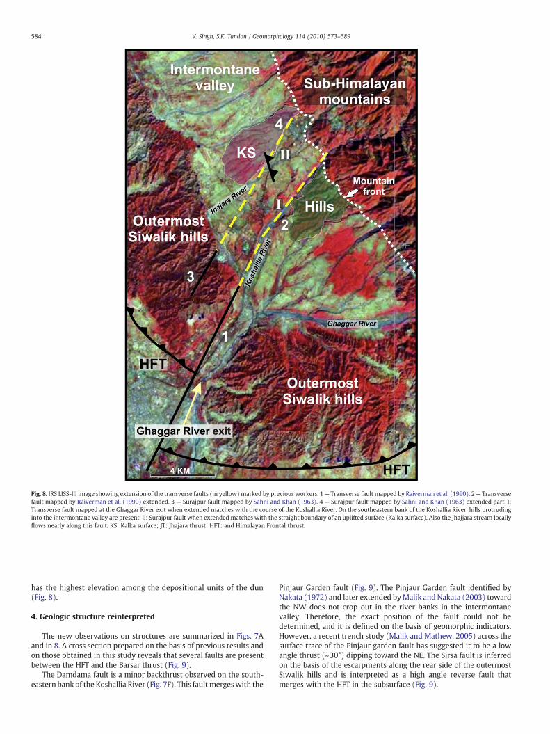
Fig. 8. IRS LISS-III image showing extension of the transverse faults (in yellow) marked by previous workers. 1— Transverse fault mapped by Raiverman et al. (1990). 2— Transversefault mapped by Raiverman et al. (1990) extended. 3 — Surajpur fault mapped by Sahni and Khan (1963). 4 — Surajpur fault mapped by Sahni and Khan (1963) extended part. I:Transverse fault mapped at the Ghaggar River exit when extended matches with the course of the Koshallia River. On the southeastern bank of the Koshallia River, hills protrudinginto the intermontane valley are present. II: Surajpur fault when extended matches with the straight boundary of an uplifted surface (Kalka surface). Also the Jhajjara stream locallyflows nearly along this fault. KS: Kalka surface; JT: Jhajara thrust; HFT: and Himalayan Frontal thrust.
584 V. Singh, S.K. Tandon / Geomorphology 114 (2010) 573–589
has the highest elevation among the depositional units of the dun(Fig. 8).
4. Geologic structure reinterpreted
The new observations on structures are summarized in Figs. 7Aand in 8. A cross section prepared on the basis of previous results andon those obtained in this study reveals that several faults are presentbetween the HFT and the Barsar thrust (Fig. 9).
The Damdama fault is a minor backthrust observed on the south-eastern bank of the Koshallia River (Fig. 7F). This fault mergeswith the
Pinjaur Garden fault (Fig. 9). The Pinjaur Garden fault identified byNakata (1972) and later extended byMalik and Nakata (2003) towardthe NW does not crop out in the river banks in the intermontanevalley. Therefore, the exact position of the fault could not bedetermined, and it is defined on the basis of geomorphic indicators.However, a recent trench study (Malik and Mathew, 2005) across thesurface trace of the Pinjaur garden fault has suggested it to be a lowangle thrust (~30°) dipping toward the NE. The Sirsa fault is inferredon the basis of the escarpments along the rear side of the outermostSiwalik hills and is interpreted as a high angle reverse fault thatmerges with the HFT in the subsurface (Fig. 9).
Fig. 9. The blue line shows the topographic profile along A–B (Fig. 7A, V.E=10×). In the schematic cross section, the subsurface behavior of the faults is shown. All the faults aredipping toward the NE except Damdama fault that dips toward the SW. The Pinjaur thrust merges with the Barsar thrust in the subsurface. The dip of Jaital thrust and Batinan faultsuggests that they merge in the subsurface with the Barsar and the Pinjaur thrusts, respectively. The Jhajara thrust is probably a splay of the Pinjaur thrust; when the Jhajara thrust isprojected into the subsurface it merges with the Pinjaur thrust.
585V. Singh, S.K. Tandon / Geomorphology 114 (2010) 573–589
A large number of faults are identified between the Barsar thrust andthe Pinjaur thrust. Movement along these faults is evident from therupturing of Late Pleistocene–Holocene sediments. Deformed youngersediments suggest that even after the formation of the Himalayanfrontal thrust, deformation continued in the Pinjaur thrust. Movementalong the Barsar thrust during the Late Pleistocene and the Holocene issuggested by westward dipping dun gravels associated with the Barsarthrust. These geomorphic lines of evidence imply that all three majorfaults, namely the HFT, the Pinjaur thrust, and the Barsar thrust wereactive during the Late Pleistocene and the Holocene.
5. Discussion
5.1. Model of structural development
An evolutionary sequence for the development of structures infront of the Barsar thrust is given in Fig. 10. The relative stage of theorigin of the structures is inferred on the basis of strata exposed in thehanging wall of the thrusts.
(i) Prior to the development of imbricates in front of the splay oftheMBT, a transverse fault formed; the presence of a lineament(Figs. 8,10) that coincides with the transverse Ghaggar tear
fault, mapped earlier by Raiverman et al. (1990), supports thisobservation. The Ghaggar tear fault is considered to be theextension of this fault. There are two possibilities regarding thistransverse structure:
(a) either the structure has formed from the migration of thetwo segments (segments II and III in Fig. 1C) of the HFTtoward each other thus forming a link between the twofaults and a possible movement in the later phase mayhave displaced the HFT, or;
(b) the transverse structure existed before the formation of theHFT and there was episodic movement along this fault.
The possibility at (a) has a few drawbacks: (i) it does not explainthe lineament running across the Barsar and other thrusts toward thehinterland without affecting these thrust zones, (ii) a later develop-ment of this fault would require symmetry of the outermost Siwalikhills that is not observed (as they show large variation in elevation),and (iii) in the intermontane valley, the southeastern bank of theKoshallia River is flanked by the hills composed of the lower Siwaliksuccession, whereas the right bank shows hills composed of post-Siwalik gravels overlying the lower Siwalik succession. If the structurehad developed after the formation of the HFT, then the asymmetry
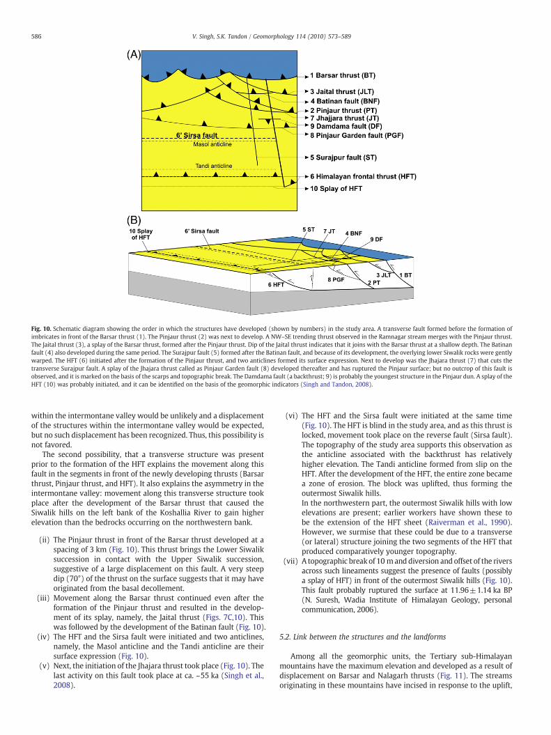
Fig. 10. Schematic diagram showing the order in which the structures have developed (shown by numbers) in the study area. A transverse fault formed before the formation ofimbricates in front of the Barsar thrust (1). The Pinjaur thrust (2) was next to develop. A NW–SE trending thrust observed in the Ramnagar stream merges with the Pinjaur thrust.The Jaital thrust (3), a splay of the Barsar thrust, formed after the Pinjaur thrust. Dip of the Jaital thrust indicates that it joins with the Barsar thrust at a shallow depth. The Batinanfault (4) also developed during the same period. The Surajpur fault (5) formed after the Batinan fault, and because of its development, the overlying lower Siwalik rocks were gentlywarped. The HFT (6) initiated after the formation of the Pinjaur thrust, and two anticlines formed its surface expression. Next to develop was the Jhajara thrust (7) that cuts thetransverse Surajpur fault. A splay of the Jhajara thrust called as Pinjaur Garden fault (8) developed thereafter and has ruptured the Pinjaur surface; but no outcrop of this fault isobserved, and it is marked on the basis of the scarps and topographic break. The Damdama fault (a backthrust; 9) is probably the youngest structure in the Pinjaur dun. A splay of theHFT (10) was probably initiated, and it can be identified on the basis of the geomorphic indicators (Singh and Tandon, 2008).
586 V. Singh, S.K. Tandon / Geomorphology 114 (2010) 573–589
within the intermontane valley would be unlikely and a displacementof the structures within the intermontane valley would be expected,but no such displacement has been recognized. Thus, this possibility isnot favored.
The second possibility, that a transverse structure was presentprior to the formation of the HFT explains the movement along thisfault in the segments in front of the newly developing thrusts (Barsarthrust, Pinjaur thrust, and HFT). It also explains the asymmetry in theintermontane valley: movement along this transverse structure tookplace after the development of the Barsar thrust that caused theSiwalik hills on the left bank of the Koshallia River to gain higherelevation than the bedrocks occurring on the northwestern bank.
(ii) The Pinjaur thrust in front of the Barsar thrust developed at aspacing of 3 km (Fig. 10). This thrust brings the Lower Siwaliksuccession in contact with the Upper Siwalik succession,suggestive of a large displacement on this fault. A very steepdip (70°) of the thrust on the surface suggests that it may haveoriginated from the basal decollement.
(iii) Movement along the Barsar thrust continued even after theformation of the Pinjaur thrust and resulted in the develop-ment of its splay, namely, the Jaital thrust (Figs. 7C,10). Thiswas followed by the development of the Batinan fault (Fig. 10).
(iv) The HFT and the Sirsa fault were initiated and two anticlines,namely, the Masol anticline and the Tandi anticline are theirsurface expression (Fig. 10).
(v) Next, the initiation of the Jhajara thrust took place (Fig. 10). Thelast activity on this fault took place at ca. ~55 ka (Singh et al.,2008).
(vi) The HFT and the Sirsa fault were initiated at the same time(Fig. 10). The HFT is blind in the study area, and as this thrust islocked, movement took place on the reverse fault (Sirsa fault).The topography of the study area supports this observation asthe anticline associated with the backthrust has relativelyhigher elevation. The Tandi anticline formed from slip on theHFT. After the development of the HFT, the entire zone becamea zone of erosion. The block was uplifted, thus forming theoutermost Siwalik hills.In the northwestern part, the outermost Siwalik hills with lowelevations are present; earlier workers have shown these tobe the extension of the HFT sheet (Raiverman et al., 1990).However, we surmise that these could be due to a transverse(or lateral) structure joining the two segments of the HFT thatproduced comparatively younger topography.
(vii) A topographic break of 10 manddiversion and offset of the riversacross such lineaments suggest the presence of faults (possiblya splay of HFT) in front of the outermost Siwalik hills (Fig. 10).This fault probably ruptured the surface at 11.96±1.14 ka BP(N. Suresh, Wadia Institute of Himalayan Geology, personalcommunication, 2006).
5.2. Link between the structures and the landforms
Among all the geomorphic units, the Tertiary sub-Himalayanmountains have the maximum elevation and developed as a result ofdisplacement on Barsar and Nalagarh thrusts (Fig. 11). The streamsoriginating in these mountains have incised in response to the uplift,

Fig. 11.Morphotectonic map of the study area. The Tertiary sub-Himalayan mountains are limited by the Barsar thrust and the Nalagarh thrust, whereas the outermost Siwalik hillsare bounded by the HFT in the south and the Sirsa fault in the north. The outermost Siwalik hills on the SE bank of the Ghaggar River are bounded only by the HFT to the south. Theintermontane valley is traversed by several structures. However, none of these structures have significantly deformed geomorphic units, such as fans, piedmont and terraces on thenorthwestern part, but they have ruptured the Pinjaur surface (marked by scarps). The Surajpur fault marks the SE boundary of the Kalka surface. Ghaggar River has formed terracesin response to the uplift of the outermost Siwalik hills.
587V. Singh, S.K. Tandon / Geomorphology 114 (2010) 573–589
resulting in rugged valley and ridge topography. The increasedelevation and relief of the mountains aids the generation of largeamounts of sediments at the thrust zones. Increased power of thestreams originating in these mountains resulted in transport anddeposition of the sediments in the adjacent intermontane valley (i.e.,Pinjaur dun).
The intermontane valley formed from the emergence of foldstructures in front of the sub-Himalayan mountains (Fig. 11). Thewidth of the intermontane valley depends on the spacing between thetwo thrusts, i.e., the Barsar/Nalagarh and the Himalayan Frontal thrusts.The spacing between these two thrust varies from ~20 km in thenorthwestern part to ~14km in the southeastern part (Fig. 1C). Ingeneral, spacing between the thrusts depends mainly on the basalfriction, basal slope, bed thickness, and magnitude of stress (Marshaket al., 1992;Mandal et al., 1997). In this segment of theHimalayan front,the narrow width of the intermontane valley in the southeastern partmay be a consequence of its proximity to the transition zone of theKangra recess and the Nahan salient (Fig. 1B).
The mountain front MF3 (Singh and Tandon, 2008) bounding thenortheastern boundary of the Pinjaur dun shows along-strikevariability in its characteristics (Fig. 11). Relatively lower elevationof the northwestern part of the mountains means smaller displace-
ment along the Nalagarh thrust (Figs. 2B,11). The higher elevation ofthe sub-Himalayan mountain toward the SE implies higher relief and,as a result, high stream power of the streams flowing toward the SE.
The presence of well-developed fans in the intermontane valleyis governed by the spacing of the streams originating in the sub-Himalayan mountains apart from other parameters. The Koshallia andthe Balad Rivers originating in these mountains have the maximumcatchment area but at present only the Balad River is attached to its fan,whereas Koshallia River has entrenched ~100 m into gravel andbedrock. The sedimentary succession associated with the Kalka andthePinjaur surfaces are probably depositedby theKoshallia River beforeit entrenched into the bedrock and confined its channel course; arelatively large drainage system would be required to deposit thesediments associated with these surfaces. The Kiratpur fan is anotherwell-preserved fan. The area between the Balad and the Kiratpur fansdoes not show any well-developed fan because the streams exiting thesub-Himalayan mountains are very closely spaced, limiting the pos-sibility for downstream expansion of the channel flows. To the SE of theKoshallia River, the streams are relatively closely spaced, and hence, thefans deposited by them coalesce to form a piedmont zone (Fig. 11).Streams with relatively low catchment area (e.g., Sirsa River in itsupstream, Ramnagar River, Nanakpur stream, and Surajpur stream)

588 V. Singh, S.K. Tandon / Geomorphology 114 (2010) 573–589
flowat themargin of the fans and are relatively less incised and form thesediment shadow zones (Fig. 11).
The streams draining the northeastern slope of the outermostSiwalik hills also contribute sediments in the intermontane valley, butthe Sirsa River (axial river) redistributes most of these sediments;hence no major depositional landform is developed along thesouthwestern margin of the Pinjaur dun (Fig. 11) (Singh and Tandon,2008). Episodic uplift of the sub-Himalayan mountains and relativelyhigh stream power of the streams originating in the sub-Himalayanmountains forces the sub-Himalayan streams toward the SW suchthat the streams flow along the northeastern margin of the outermostSiwalik hills. Similarly, on the southeastern side of the drainage dividein the intermontane valley, Jhajjara stream redistributes the sedi-ments brought down by the streams from the outermost Siwalik hills(Singh and Tandon, 2008).
As noted earlier, various geomorphic surfaces occur in the Pinjaurdun. The distribution of these surfaces is controlled by the devel-opment of structures, with the Pinjaur thrust, Jhajara thrust, and thePinjaur Garden fault playing the most important role (Fig. 11) (Singhet al., 2008). Abandonment of the Kalka surface took place because ofuplift along the Pinjaur thrust and its interaction with the Surajpurfault. The movements along the Pinjaur Garden fault, the Pinjaurthrust, and the Batinan fault have ruptured the Pinjaur surface. Thesemovements probably caused the cessation of deposition over thePinjaur surface.
The interaction of the Pinjaur thrustwith the Jhajara thrust resultedin the development of the isolated Siwalik hills on the northwesternbank of the Koshallia River (Fig. 11). Similarly, interaction of theBatinan fault with the Pinjaur thrust and the Jaital thrust produced theSiwalik hills on the banks of the Koshallia River. Transverse structureshave also played an important role in shaping the landforms. Thesoutheastern bank of the Koshallia River has a relatively higherelevation than its northwestern bank in the Pinjaur dun; this suggeststhe uplift of the southeastern block of the Ghaggar tear fault. Assuggested earlier (Singh and Tandon, 2008), movement along theSurajpur fault has also contributed to the formation of the drainagedivide in the Pinjaur dun. The possibility that rupture along theSurajpur fault uplifted the northwestern block forming the Kalkasurface is strengthened by the observation that when the Surajpurfault trace is extended toward theNE, itmatcheswith the southeasternmargin of the Kalka surface (Singh et al., 2008).
The outermost Siwalik hills include the southernmost mountainfront of the Himalaya formed frommovement along the HFT (Fig. 11).The geometry of structures of the outermost Siwalik hills controls thegeomorphology of the hills. These hills between the Sutlej andGhaggarRivers are asymmetric because of the presence of a high angle reversefault (Sirsa fault) associated with the HFT. Comparatively largerdisplacement over the reverse fault than the HFT uplifted the rear partof these hills to a higher elevation than the frontal part. This hasresulted in the development of a drainage divide between the SW andthe NE slopes of the hills.
5.3. Landforms and timescale
The MBT and related structures are considered to have evolvedover the past 10 Ma (Meigs et al., 1995). This implies that themountainous topography associated with these structures has existedover Late Neogene timescales. No ages are available for thedevelopment of the existing valleys of the sub-Himalayan mountainsassociated with the MBT and its splays, for example, the Barsar thrust.A minimum estimate of the age of valleys can be obtained by datingthe oldest deposits of the fans occurring in the intermontane valley.These deposits have yielded ages varying from >68 to ~1.5ka basedon the data given in Suresh et al. (2007), Kumar et al. (2006), and ourunpublished data. Also, older deposits of the intermontane valley aredated in the range of ~100ka (Suresh et al., 2007). This suggests that
the present valleys and drainages feeding the intermontane valleyfrom the north are at least 100 ka old, and perhaps much older.
As the deposits of the intermontane valley date back to ~100 ka, itis inferred that the anticlinal growth structures constituting theoutermost Siwalik hills are older. Elsewhere in the western part of thebelt, estimates of ~500 ka are available for the growth of similaranticlinal structures (Pabbi hills: Keller et al., 1977; Jammu hills:Ranga Rao et al., 1988). Through this analysis, it has emerged thatmost of the topography south of the MF3 (Barsar thrust-relatedmountain front), including those in the intermontane valley and theoutermost Siwalik Hills, represents a transient landscape of approx-imately the past 100ka and perhaps a little older.
South of theHFT, elevated surfaces associatedwith scarps/scarpletshave formed in the past 20 ka (Singh and Tandon, 2008). Thesestructures together with the river deflections that have been notedearlier (Singh and Tandon, 2008) represent a relatively early stage inthe evolutionary history of deformation of the proximal part of the IGPflanking the outermost Siwalik hills.
6. Conclusions
Structural and geomorphicmapping alongwithfield studies indicatethat both longitudinal and transverse structures exercise a strongcontrol on the landforms of the Pinjaur dun, outermost Siwalik hills, andthe sub-Himalayan mountains. This study helps to link the structureswith the landforms. The following conclusions are drawn:
(i) Continued displacement on the Barsar and the Nalagarh thrustsresulted in the development of the Tertiary sub-Himalayanmountains. These sub-Himalayan mountains (hanging walluplifts) provided sediments that were eroded and transportedby the streams originating in these mountains and deposited inthe adjoining intermontane valley.
(ii) The intermontane valley, formed as a consequence of the upliftof the outermost Siwalik hills, contains geomorphic units thatinclude alluvial fans, piedmonts, surfaces, and terraces.
(iii) The major elevated surfaces formed as a result of episodic upliftthat caused incision by the rivers, thereby resulting in narrowingof their respective valleys.
(iv) The asymmetry of the outermost Siwalik hills is the result ofdifferential movements related to the HFT and the Sirsa faultthat mark, respectively the northern and southern mountainfronts of these hills.
(v) The available chronological data suggest that the frontal regionof the Himalaya represents a transient landscape of approxi-mately the last 100ka associated with active mountain frontsand their structures.
Acknowledgements
VS is thankful to the University Grants Commission for providinghim a Senior Research Fellowship. We also acknowledge the Depart-ment of Geology, University of Delhi, for providing the facilities andhelpin carrying out the research work. We thank three anonymous refereesfor their constructive comments. We also thank Professor D. C.Srivastava (IIT Roorkee, India) who read the manuscript and madeuseful suggestions for its improvement.
References
Burbank, D.W., Beck, R.A., Mulder, T., 1996. The Himalayan foreland basin. In: Yin,A., Harrison, T.M. (Eds.), The Tectonics of Asia. Cambridge University Press, NY,pp. 149–188.
Delcaillau, B., Carozza, J.-M., Laville, E., 2006. Recent fold growth and drainagedevelopment: the Janauri and Chandigarh anticlines in the Siwalik foothills,northwest India. Geomorphology 76, 241–256.

589V. Singh, S.K. Tandon / Geomorphology 114 (2010) 573–589
Dubey, A.K., Misra, R., Bhakuni, S.S., 2001. Erratic shortening from balanced cross-sections of thewestern Himalayan foreland basin: causes and implications for basinevolution. Journal of Asian Earth Sciences 19, 765–775.
Friend, P.F., Jones, N.E., Vincent, S.J., 1999. Drainage evolution in active mountain belts:extrapolation backwards from present-day Himalayan river patterns. InternationalAssociation of Sedimentologists Special Publication 28, 305–313.
Gansser, A., 1964. The Geology of the Himalayas. Wiley Interscience, NY. 289 pp.Gibling, M.R., Tandon, S.K., Sinha, R., Jain, M., 2005. Discontinuity-bounded alluvial
sequences of the southern Gangetic Plains, India: aggradation and degradation inresponse to monsoonal strength. Journal of Sedimentary Research 75, 369–385.
Gupta, S., 1997. Himalayan drainage patterns and the origin of fluvial megafans in theGanges foreland basin. Geology 25, 11–14.
Keller, H.M., Tahirkheli, R.A.K., Mirza, M.A., Johnson, G.D., Johnson, N.M., Opdyke, N.D.,1977. Magnetic polarity stratigraphy of the upper Siwalik deposits, Pabbi Hills,Pakistan. Earth and Planetary Science Letters 36, 187–201.
Khan, E., 1970. The geology of the area between Chandigarh and Subathu. Journal ofPaleontological Society of India 14, 47–65.
Kumar, S., Wesnousky, S.G., Rockwell, T.K., Ragona, D., Thakur, V.C., Seitz, G.G., 2001.Earthquake reoccurrence and rupture dynamics of Himalayan Frontal fault, India.Science 294, 2328–2331.
Kumar, S., Wesnousky, S.G., Rockwell, T.K., Briggs, R.W., Thakur, V.C., Jayangondaper-umal, R., 2006. Paleoseismic evidence of great surface rupture earthquakes alongthe Indian Himalaya. Journal of Geophysical Research 111, B03304. doi:10.1029/2004JB003309.
Lavé, J., Avouac, J.P., 2000. Active folding of fluvial terraces across the Siwalik hills,Himalayas of central Nepal. Journal of Geophysical Research 105, 5735–5770.
Malik, J.N., Mathew, G., 2005. Evidence of paleoearthquakes from trench investigationsacross Pinjore Garden fault in Pinjore dun, NW Himalaya. Journal of Earth SystemScience 114 (4), 387–400.
Malik, J.N., Mohanty, C., 2007. Active tectonic influence on the evolution of drainage andlandscape: geomorphic signatures from frontal and hinterland areas along thenorthwestern Himalaya, India. Journal of Asian Earth Sciences 29, 604–618.
Malik, J.N., Nakata, T., 2003. Active faults and related Late Quaternary deformationalong the northwestern Himalayan Frontal zone, India. Annals of Geophysics 46(5), 917–936.
Malik, J.N., Nakata, T., Philip, G., Virdi, N.S., 2003. Preliminary observations from a trenchnear Chandigarh, NW Himalaya and their bearing on active faulting. CurrentScience 85 (12), 1793–1798.
Mandal, N., Chattopadhyay, A., Bose, S., 1997. Imbricate thrust spacing: experimentaland theoretical analyses. In: Sengupta, S. (Ed.), Evolution of Geological Structures inMicro- to Macro-scales. Chapman and Hall, London, pp. 143–165.
Marshak, S., Wilkerson, M.S., Hsui, A.T., 1992. Generation of curved fold–thrust belts:insight from simple physical and analytical models. In: McClay, K.R. (Ed.), ThrustTectonics. Chapman and Hall, London, pp. 83–92.
Meigs, A.J., Burbank, D.W., Beck, R.A., 1995. Middle–Late Miocene (>10 Ma) formationof the Main Boundary thrust in the western Himalaya. Geology 23, 423–426.
Mukerji, A.B., 1963. Alluvial morphology of the upper Ganga–Yamuna Doab. The DeccanGeographer 2, 1–36.
Mukerji, A.B., 1976. Choe terraces of the Chandigarh Siwalik hills, India: a morphoge-netic analysis. Revue de Geomorphologie Dynamique 25, 1–19.
Mukerji, A.B., 1990. The Chandigarh alluvial fans: an analysis of the process formrelationship. In: Rachocki, A.H., Church, M. (Eds.), Alluvial Fans: A Field Approach.John Wiley & Sons, Chichester, U.K, pp. 131–149.
Mukhopadhyay, D.K., Mishra, P., 2004. The Main Frontal fault (MFT), northwesternHimalayas: thrust trajectory and hangingwall fold geometry from balanced crosssections. Journal of Geological Society of India 64, 739–746.
Mukhopadhyay, D.K., Mishra, P., 2005. A balanced cross section across the Himalayanfrontal fold–thrust belt, Subathu area, Himachal Pradesh, India: thrust sequence,structural evolution and shortening. Journal of Asian Earth Science 25, 735–746.
Nakata, T., 1972. Geomorphic history and crustal movement of the foothills of theHimalaya. Report of Tohoku University, Japan: 7th series (Geography), 2.
Nakata, T., 1989. Active faults of the Himalaya of India and Nepal. In: Malinconico Jr.,L.L., Lillie, R.J. (Eds.), Tectonics of the western Himalayas: Geological Society ofAmerica Special Paper, 232, pp. 243–264. Boulder, Colorado.
Philip, G., Virdi, N.S., 2006. Co-existing compressional and extensional regimes alongthe Himalayan front vis-à-vis active faults near Singhauli, Haryana, India. CurrentScience 90 (9), 1267–1271.
Philip, G., Virdi, N.S., 2007. Active faults and neotectonic activity in the Pinjaur dun,northwestern Frontal Himalaya. Current Science 92 (4), 532–542.
Powers, P.M., Lillie, R.J., Yeats, R.S., 1998. Structure and shortening of the Kangra andDehra dun reentrants, sub-Himalaya, India. Geological Society of America Bulletin110, 1010–1027.
Raiverman, V., Ganju, J.L., Ram, J., Misra, V., 1990. Geological map of Himalayan foothillsbetween Ravi and Yamuna Rivers. Oil and Natural Gas Commission, Dehradun,India.
Raiverman, V., Srivastava, A.K., Prasad, D.N., 1993. On the foothill thrust of northwesternHimalaya. Journal of Himalayan Geology 4, 237–256.
Ranga Rao, A., Agarwal, R.P., Sharma, U.N., Bhalla, M.S., Nanda, A.C., 1988. Magneticpolarity stratigraphy and vertebrate palaeontology of the upper Siwalik subgroupof Jammu hills, India. Journal of the Geological Society of India 31, 361–385.
Rao, A.R., 1993. Magnetic-polarity stratigraphy of upper Siwalik of northwesternHimalayan foothills. Current Science 64 (11 & 12), 863–873.
Sahni, M.R., Khan, E., 1963. Tectonic features of the area around Pinjaur. Current Science32 (2), 77–79.
Sahni, M.R., Khan, E., 1964. Stratigraphy, structure and correlation of the upperShivaliks east of Chandigarh. Journal of Paleontological Society of India 4, 61–74.
Seeber, L., Gornitz, V., 1983. River profiles along the Himalayan arc as indicators ofactive tectonics. Tectonophysics 92, 335–367.
Singh, V., Tandon, S.K., 2007. Evidence and consequences of tilting of two alluvial fans inthe Pinjaur dun, northwestern Himalayan foothills. Quaternary International 159,21–31.
Singh, V., Tandon, S.K., 2008. The Pinjaur dun (intermontane longitudinal valley) andassociated active mountain fronts, NW Himalaya: tectonic geomorphology andmorphotectonic evolution. Geomorphology 102, 376–394.
Singh, V., Tandon, S.K., Singh, V., Mukul, M., Thamó-Bozsó, E., 2008. Characterizationand development of the Jhajara thrust: an example of neotectonic activity in thePinjaur dun. Current Science 94 (5), 623–628.
Sinha, R., Friend, P., 1994. River systems and their sediment flux, Indo-Gangetic plains,Northern Bihar, India. Sedimentology 41, 825–845.
Srivastava, D.C., John, G., 1999. Deformation in the Himalayan frontal fault zone:evidence from small-scale structures in Mohand–Khara area, NW Himalaya.Memoir Gondwana Research Group 6, 273–284.
Suresh, N., Bagati, T.N., Thakur, V.C., Kumar, R., Sangode, S.J., 2002. Optically stimulatedluminescence dating of alluvial fan deposits of Pinjaur dun, NW sub Himalaya.Current Science 82 (10), 1267–1274.
Suresh, N., Bagati, T.N., Kumar, R., Thakur, V.C., 2007. Evolution of Quaternary alluvialfans and terraces in the intramontane Pinjaur dun, sub-Himalaya, NW India:interaction between tectonics and climate change. Sedimentology 54 (4), 809–833.doi:10.1111/j.1365-3091.2007.00861.x.
Valdiya, K.S., 1992. The main boundary thrust of Himalaya, India. Annales Tectonica 6,54–84.
Related Documents