Welcome message from author
This document is posted to help you gain knowledge. Please leave a comment to let me know what you think about it! Share it to your friends and learn new things together.
Transcript

--------------------------------------------------------------- 3
Step: 1 Install ArcGIS Desktop 10.1 ------------------------------------------------------------------------ 3
Step: 2 Install License Manager ArcGIS 10.1 ------------------------------------------------------------- 6
Step: 3 Activator KeyGen ArcGIS for Deasktop --------------------------------------------------------- 8
What’s GIS? ------------------------------------------------------------------------------------------------ 10
What’s TOC? ---------------------------------------------------------------------------------------------- 10
What’s GDB? ---------------------------------------------------------------------------------------------- 10
.shp? --------------------------------------------------------------------------------------------------------- 10
----------------------------------------------------------- 11
Step:1 ----------------------------------------------------------------------------------------------------------- 11
Step: 2 ---------------------------------------------------------------------------------------------------------- 13
By: Rath Phanna (Facebook Rath Phanna) Page 3 Tel: (+855)70 97 50 08/979 666 425
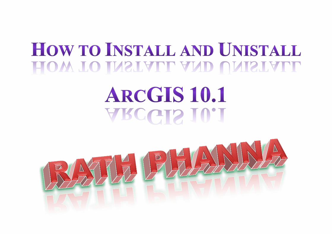
To install ArcGIS Desktop 10.1 on your computer for your use only, choose the
first installation option, Install ArcGIS Desktop.
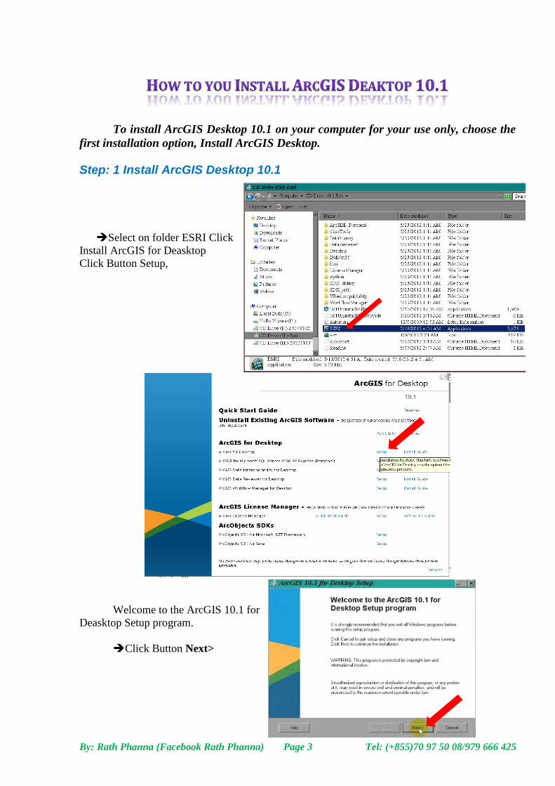
Step: 1 Install ArcGIS Desktop 10.1
Select on folder ESRI Click
Install ArcGIS for Deasktop
Click Button Setup,
Welcome to the ArcGIS 10.1 for
Deasktop Setup program.
Click Button Next>
By: Rath Phanna (Facebook Rath Phanna) Page 4 Tel: (+855)70 97 50 08/979 666 425
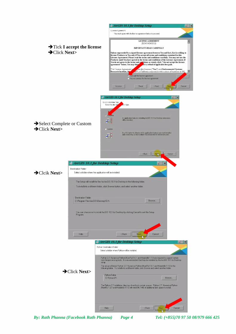
Tick I accept the license
Click Next>
Select Complete or Custom
Click Next>
Clcik Next>
Click Next>
By: Rath Phanna (Facebook Rath Phanna) Page 5 Tel: (+855)70 97 50 08/979 666 425
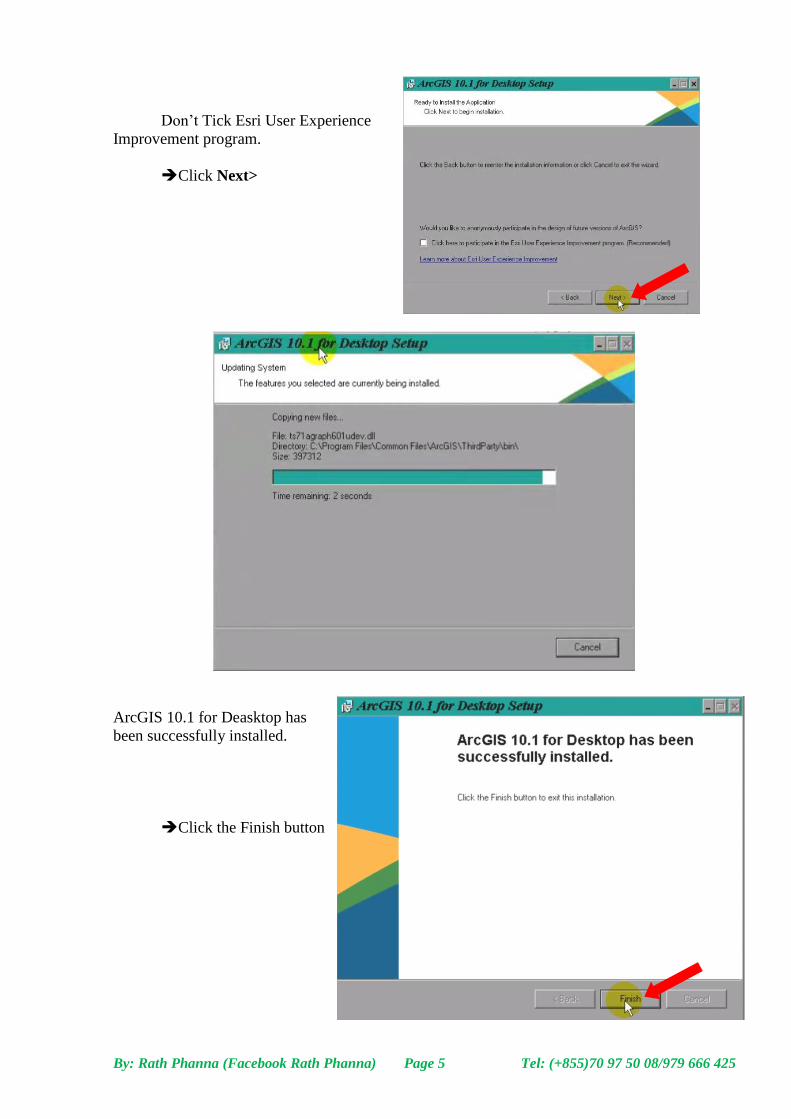
Don’t Tick Esri User Experience
Improvement program.
Click Next>
ArcGIS 10.1 for Deasktop has
been successfully installed.
Click the Finish button
By: Rath Phanna (Facebook Rath Phanna) Page 6 Tel: (+855)70 97 50 08/979 666 425
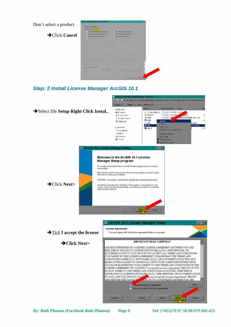
Don’t select a product
Click Cancel
Step: 2 Install License Manager ArcGIS 10.1
Select file Setup Right Click Instal..
Click Next>
Tick I accept the license
Click Next>
By: Rath Phanna (Facebook Rath Phanna) Page 7 Tel: (+855)70 97 50 08/979 666 425
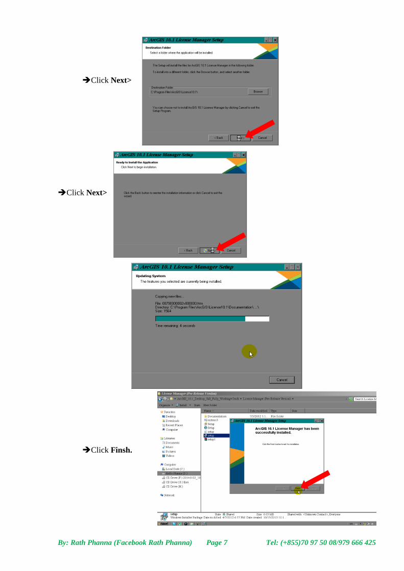
Click Next>
Click Next>
Click Finsh.
By: Rath Phanna (Facebook Rath Phanna) Page 8 Tel: (+855)70 97 50 08/979 666 425
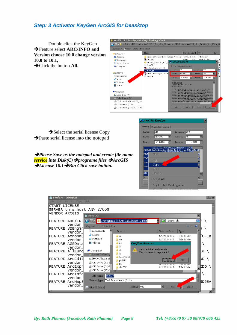
Step: 3 Activator KeyGen ArcGIS for Deasktop
Double click the KeyGen
Feature select ARC/INFO and
Version choose 10.0 change version
10.0 to 10.1, Click the button All.
Select the serial license Copy
Paste serial license into the notepad
Please Save as the notepad and create file name
service into Disk(C)programe files ArcGIS
License 10.1Bin Click save button.
By: Rath Phanna (Facebook Rath Phanna) Page 9 Tel: (+855)70 97 50 08/979 666 425
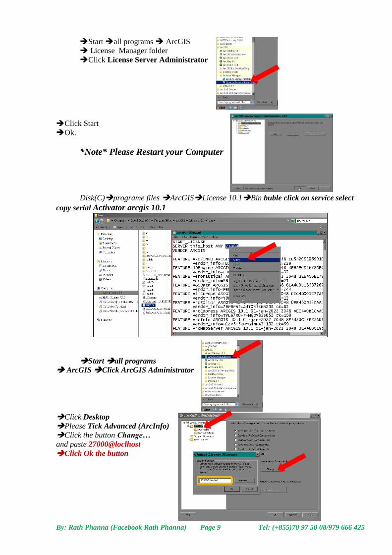
Start all programs ArcGIS
License Manager folder
Click License Server Administrator
Click Start
Ok.
*Note* Please Restart your Computer
Disk(C)programe files ArcGISLicense 10.1Bin buble click on service select
copy serial Activator arcgis 10.1
Start all programs
ArcGIS Click ArcGIS Administrator
Click Desktop
Please Tick Advanced (ArcInfo)
Click the button Change…
and paste 27000@loclhost
Click Ok the button
By: Rath Phanna (Facebook Rath Phanna) Page 10 Tel: (+855)70 97 50 08/979 666 425
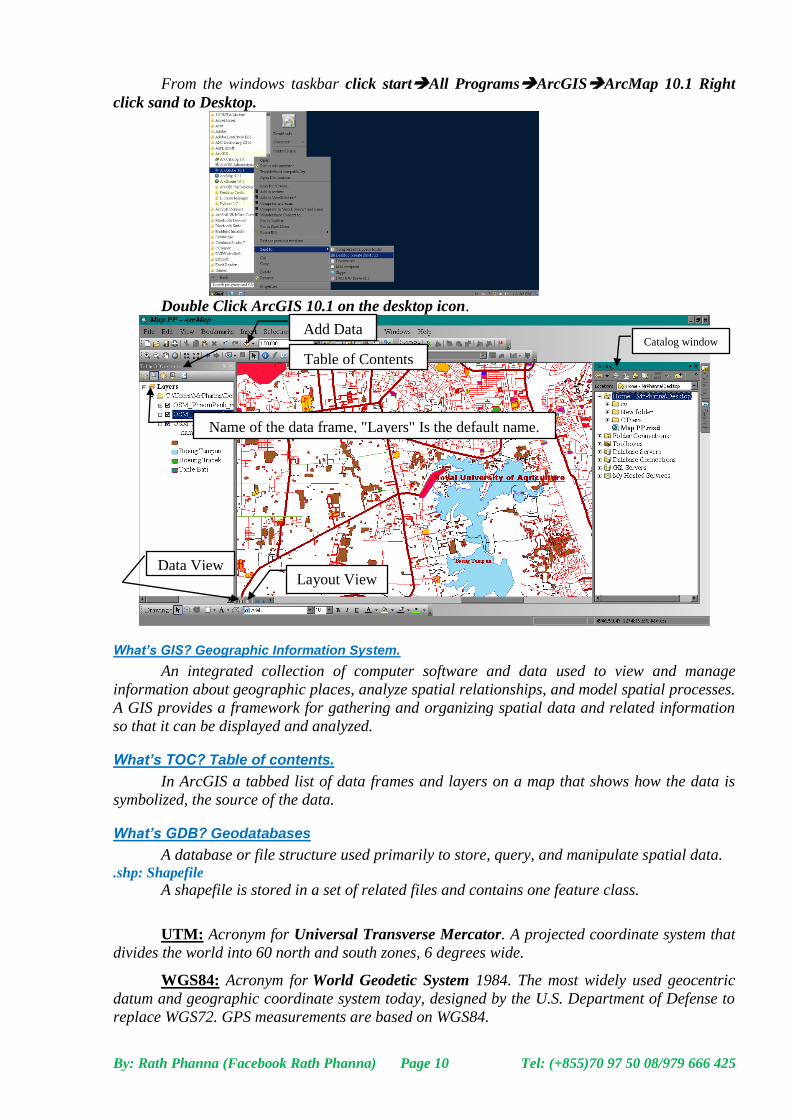
From the windows taskbar click startAll ProgramsArcGISArcMap 10.1 Right
click sand to Desktop.
Double Click ArcGIS 10.1 on the desktop icon.
What’s GIS? Geographic Information System.
An integrated collection of computer software and data used to view and manage
information about geographic places, analyze spatial relationships, and model spatial processes.
A GIS provides a framework for gathering and organizing spatial data and related information
so that it can be displayed and analyzed.
What’s TOC? Table of contents.
In ArcGIS a tabbed list of data frames and layers on a map that shows how the data is
symbolized, the source of the data.
What’s GDB? Geodatabases
A database or file structure used primarily to store, query, and manipulate spatial data. .shp: Shapefile
A shapefile is stored in a set of related files and contains one feature class.
UTM: Acronym for Universal Transverse Mercator. A projected coordinate system that
divides the world into 60 north and south zones, 6 degrees wide.
WGS84: Acronym for World Geodetic System 1984. The most widely used geocentric
datum and geographic coordinate system today, designed by the U.S. Department of Defense to
replace WGS72. GPS measurements are based on WGS84.
Table of Contents
Data View Layout View
Add Data
Name of the data frame, "Layers" Is the default name.
Catalog window
By: Rath Phanna (Facebook Rath Phanna) Page 11 Tel: (+855)70 97 50 08/979 666 425
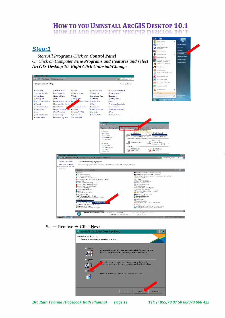
Step:1 Start All Programs Click on Control Panel
Or Click on Computer Fine Programs and Features and select
ArcGIS Desktop 10 Right Click Uninstall/Change..
Select Remove Click Next

By: Rath Phanna (Facebook Rath Phanna) Page 12 Tel: (+855)70 97 50 08/979 666 425
Click Next>
Click the Finish button
By: Rath Phanna (Facebook Rath Phanna) Page 13 Tel: (+855)70 97 50 08/979 666 425
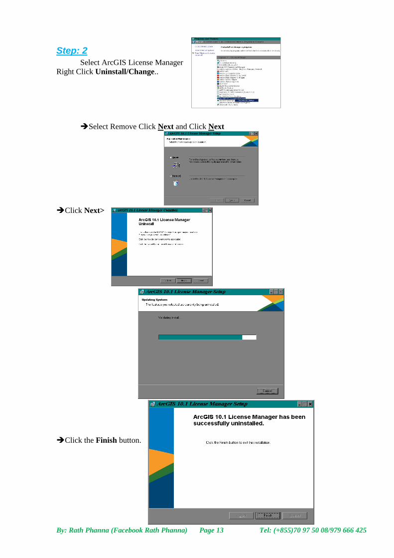
Step: 2
Select ArcGIS License Manager
Right Click Uninstall/Change..
Select Remove Click Next and Click Next
Click Next>
Click the Finish button.
Related Documents