Insights into the Prehistory of the Lower Mackenzie Valley, Anderson Plain Region, Northwest Territories Jean-Luc Pilon NOGAP Archaeologist ArchaeoIogical Survey of Canada Canadian Museum of Civilization Hull, Qu6bec ABSTRACT During the first four years of the NOGAP Archaeology Project, 104 new archaeological sites were found in the southwest Anderson Plain. These sites are generally characterized by thin lithic scatters comprised mainly of undiagnostic debitage. In spite of the frustrating nature of the region's archaeology, elements of a local culture-history are emerging. Many of the sites attest to the Late Prehistoric Gwich'in occupation of the region. Earlier cultural remains have been found which relate to the use of the area by the Arctic Small Tool tradition, and a second, non-ASTt, microblade manufacturing group. Although external relationships can be drawn, at present, it appears more fruitful to identify and define local culture-his- torical parameters. RÉSUMÉ Les travaux effectués au cours des quatre premières années du projet archéologique PIPGN ont conduit à la découverte de 104 nouveaux gisements archéologiques dans la partie sud-ouest de la plaine d 'A nderson. Ces sites sont le plus souvent caractérisés par des ensembles lithiques épars contenant peu d'objets diagnostiques. Malgr é les dificult é s inhérentes à la pratique archéologique en ces régions, nous commençons à pouvoir en dégager quelques grandes lignes de l 'histoire culturelle. Plusieurs de ces sites indiquent une occupation des ces territoires par des groupes athapaskans Gwich 'in au cours de la période préhistorique tardive. Certains gisements ont fourni des vestiges attribuables à l a tradition microlithique de 1 'Arctique, tandis que d'autres ont produit des vestiges représentatifs d'un autre type d'industrie à microlames. Bien qu 'il soit déjà possible de discuter de relations inter-régiona les, nous croyons plus profitable, pour l 'instant, de mieux cerner les éléments de l'histoire culturelle locale. INTRODUCTION The Archaeological Survey of Canada, Canadian Museum of Civilization has now com- pleted four field seasons of intensive archaeologi- cal survey and site testing in the lower Mackenzie Valley under the auspices of the Northern Oil and Gas Action Plan (NOGAP). Following the com- pletion of four field seasons of activities, a substan- tial amount of field data is now available (Pilon 1986, 1987, 1988, 1989) which can provided in- sights into the region's prehistory and directions for future research. This article will describe the work that has been undertaken in the Mackenzie Valley, and will attempt to detail some of the preliminary results obtained. RESEARCH AREA For the purposes of this discussion, the Mackenzie Valley is defined as that portion of the Mackenzie River lying below Norman Wells and the lands draining into it (Figure 1). It includes most of the Mackenzie Delta, although the outer Delta belongs more properly in the Beaufort Sea region. Since we could not expect to cover the entire region, we chose to concentrate on the uplands which form the headwaters of a number of streams draining the southwestern portion of the Anderson Plain (Bostock 1964: 19). However, we also conducted surveys in the Peel Plain Uplands to the south and in the Inuvik area to the west (Figure 2).

Welcome message from author
This document is posted to help you gain knowledge. Please leave a comment to let me know what you think about it! Share it to your friends and learn new things together.
Transcript
Insights into the Prehistory of the Lower Mackenzie Valley, Anderson Plain Region, Northwest Territories
Jean-Luc Pilon NOGAP Archaeologist ArchaeoIogical Survey of Canada Canadian Museum of Civilization Hull, Qu6bec
ABSTRACT During the first four years of the NOGAP Archaeology Project, 104 new archaeological sites were found in the southwest Anderson Plain. These sites are generally characterized by thin lithic scatters comprised mainly of undiagnostic debitage. In spite of the frustrating nature of the region's archaeology, elements of a local culture-history are emerging. Many of the sites attest to the Late Prehistoric Gwich'in occupation of the region. Earlier cultural remains have been found which relate to the use of the area by the Arctic Small Tool tradition, and a second, non-ASTt, microblade manufacturing group. Although external relationships can be drawn, at present, it appears more fruitful to identify and define local culture-his- torical parameters.
RÉSUMÉLes travaux effectués au cours des quatre premières années du projet archéologique PIPGN ont conduit à la découverte de 104 nouveaux gisements archéologiques dans la partiesud-ouest de la plaine d'Anderson. Ces sites sont le plus souvent caractérisés par des ensembles lithiques épars contenant peu d'objets diagnostiques. Malgré les dificultés inhérentes à la pratique archéologique en ces régions, nous commençons à pouvoir en dégager quelques grandes lignes de l 'histoire culturelle. Plusieurs de ces sites indiquent une occupation des ces territoires par des groupes athapaskans Gwich 'in au cours de la période préhistorique tardive. Certains gisements ont fourni des vestiges attribuables à l a tradition microlithique de 1 'Arctique, tandis que d'autres ont produit des vestiges représentatifs d'un autre type d'industrie à microlames. Bien qu 'il soit déjà possible de discuter de relationsinter-régiona les, nous croyons plus profitable, pour l 'instant, de mieux cerner les élémentsde l'histoire culturelle locale.
INTRODUCTION The Archaeological Survey of Canada,
Canadian Museum of Civilization has now com- pleted four field seasons of intensive archaeologi- cal survey and site testing in the lower Mackenzie Valley under the auspices of the Northern Oil and Gas Action Plan (NOGAP). Following the com- pletion of four field seasons of activities, a substan- tial amount of field data is now available (Pilon 1986, 1987, 1988, 1989) which can provided in- sights into the region's prehistory and directions for future research. This article will describe the work that has been undertaken in the Mackenzie Valley, and will attempt to detail some of the preliminary results obtained.
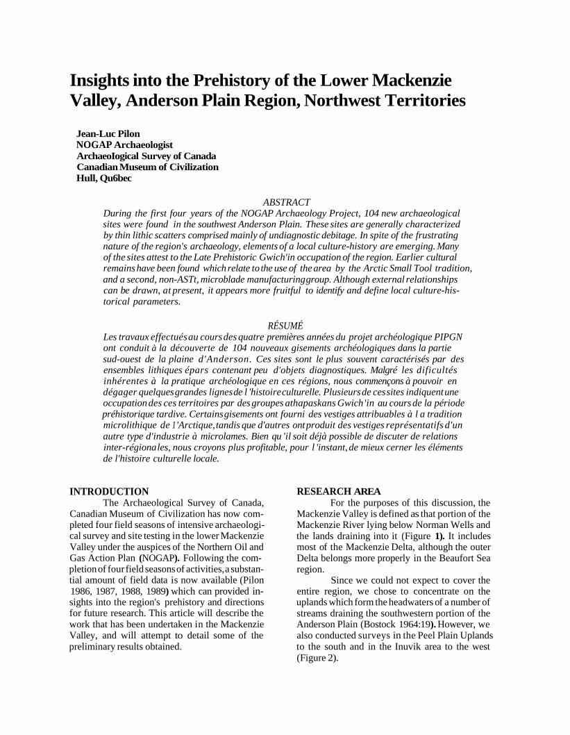
RESEARCH AREA For the purposes of this discussion, the
Mackenzie Valley is defined as that portion of the Mackenzie River lying below Norman Wells and the lands draining into it (Figure 1). It includes most of the Mackenzie Delta, although the outer Delta belongs more properly in the Beaufort Sea region.
Since we could not expect to cover the entire region, we chose to concentrate on the uplands which form the headwaters of a number of streams draining the southwestern portion of the Anderson Plain (Bostock 1964: 19). However, we also conducted surveys in the Peel Plain Uplands to the south and in the Inuvik area to the west (Figure 2).
90 NOGA P Archaeology Project
Figure 1 Map of the lower Mackenzie Valley, N.W.T.
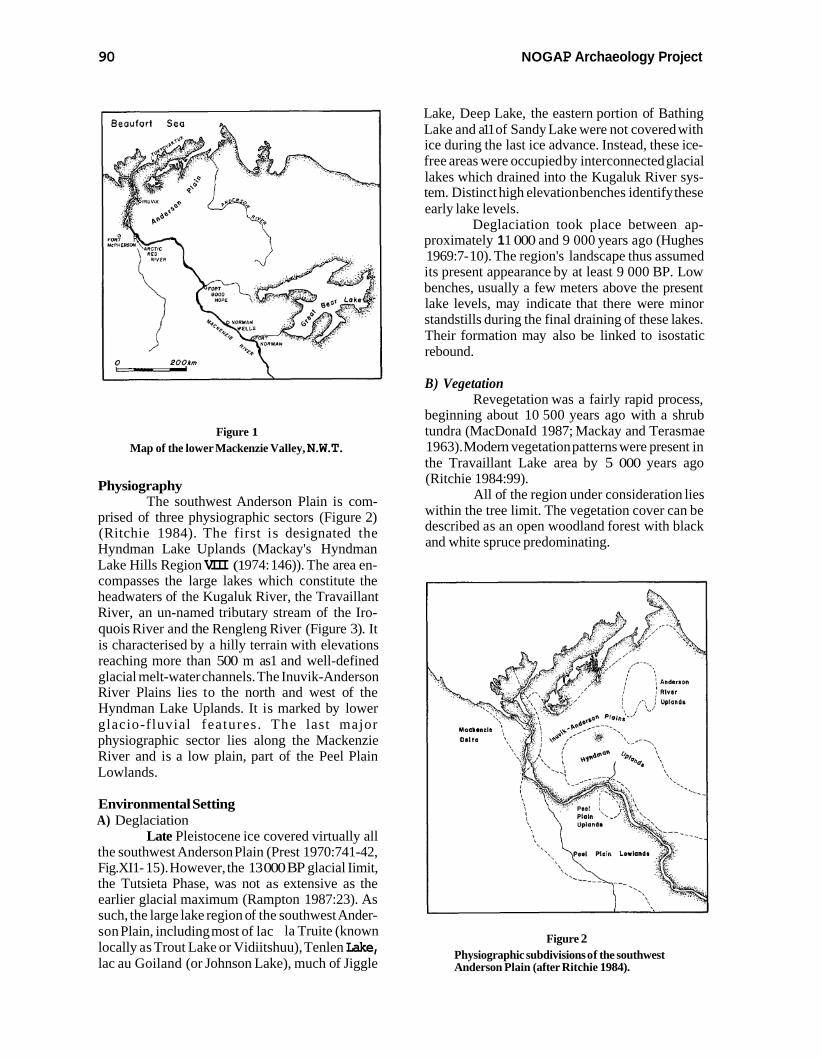
Physiography The southwest Anderson Plain is com-
prised of three physiographic sectors (Figure 2) (Ritchie 1984). The first is designated the Hyndman Lake Uplands (Mackay's Hyndman Lake Hills Region VIII (1 974: 146)). The area en- compasses the large lakes which constitute the headwaters of the Kugaluk River, the Travaillant River, an un-named tributary stream of the Iro- quois River and the Rengleng River (Figure 3). It is characterised by a hilly terrain with elevations reaching more than 500 m as1 and well-defined glacial melt-water channels. The Inuvik-Anderson River Plains lies to the north and west of the Hyndman Lake Uplands. It is marked by lower glacio-fluvial features. The last major physiographic sector lies along the Mackenzie River and is a low plain, part of the Peel Plain Lowlands.
Environmental Setting A) Deglaciation
Late Pleistocene ice covered virtually all the southwest Anderson Plain (Prest 1970:741-42, Fig.XI1- 15). However, the 13 000 BP glacial Iimit, the Tutsieta Phase, was not as extensive as the earlier glacial maximum (Rampton 1987:23). As such, the large lake region of the southwest Ander- son Plain, including most of lac la Truite (known locally as Trout Lake or Vidiitshuu), Tenlen Lake, lac au Goiland (or Johnson Lake), much of Jiggle
Lake, Deep Lake, the eastern portion of Bathing Lake and a11 of Sandy Lake were not covered with ice during the last ice advance. Instead, these ice- free areas were occupied by interconnected glacial lakes which drained into the Kugaluk River sys- tem. Distinct high elevation benches identify these early lake levels.
Deglaciation took place between ap- proximately 1 1 000 and 9 000 years ago (Hughes 1969:7- 10). The region's landscape thus assumed its present appearance by at least 9 000 BP. Low benches, usually a few meters above the present lake levels, may indicate that there were minor standstills during the final draining of these lakes. Their formation may also be linked to isostatic rebound.
B) Vegetation Revegetation was a fairly rapid process,
beginning about 10 500 years ago with a shrub tundra (MacDonaId 1987; Mackay and Terasmae 1963). Modern vegetation patterns were present in the Travaillant Lake area by 5 000 years ago (Ritchie 1984:99).
All of the region under consideration lies within the tree limit. The vegetation cover can be described as an open woodland forest with black and white spruce predominating.
Figure 2 Physiographic subdivisions of the southwest Anderson Plain (after Ritchie 1984).
Pilon: Anderson Plain Region 91
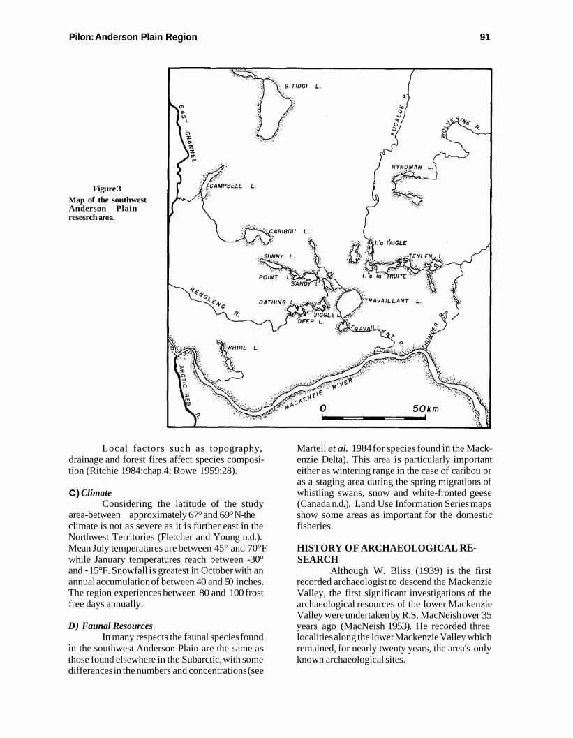
Figure 3 Map of the southwest Anderson Plain resesrch area.
Local factors such as topography, drainage and forest fires affect species composi- tion (Ritchie 1984:chap.4; Rowe 1959:28).
C) Climate Considering the latitude of the study
area-between approximately 67° and 69° N-the climate is not as severe as it is further east in the Northwest Territories (Fletcher and Young n.d.). Mean July temperatures are between 45° and 70°Fwhile January temperatures reach between -30° and - 15°F. Snowfall is greatest in October with an annual accumulation of between 40 and 5 0 inches. The region experiences between 80 and 100 frost free days annually.
D) Faunal ResourcesIn many respects the faunal species found
in the southwest Anderson Plain are the same as those found elsewhere in the Subarctic, with some differences in the numbers and concentrations (see
Martell et al. 1984 for species found in the Mack- enzie Delta). This area is particularly important either as wintering range in the case of caribou or as a staging area during the spring migrations of whistling swans, snow and white-fronted geese (Canada n.d.). Land Use Information Series maps show some areas as important for the domestic fisheries.
HISTORY OF ARCHAEOLOGICAL RE- SEARCH
Although W. Bliss (1939) is the first recorded archaeologist to descend the Mackenzie Valley, the first significant investigations of the archaeological resources of the lower Mackenzie Valley were undertaken by R.S. MacNeish over 35 years ago (MacNeish 1953). He recorded three localities along the lower Mackenzie Valley which remained, for nearly twenty years, the area's only known archaeological sites.
NOGA P Archaeology Project
Those collections consist, to a large ex- tent, of objects given to him or purchased from inhabitants of the villages he visited; Fort Good Hope, Arctic Red River and Fort McPherson (per- sonal communications from Gabriel Andre of Arctic Red River and Walter Firth of Fort Mc- Pherson). For the most part the bone and antler implements that MacNeish collected have ready analogues in the ethnographically documented tool kits of the historic inhabitants of the region; the Dene known as Gwich'in (Loucheux) and Hare (Krech 1976; Osgood 1933, 1934, 1936; Petitot 1876, 1889; Savishinsky and Hara 1981).
D.W. Clark worked briefly in the Fort Good Hope region during a 1969 survey (Clark 1975:12). He examined some localities near the Upper Ramparts of the Mackenzie River, and found evidence of a hearth feature, lying under a very thick mantle of silt overburden. Clark deter- mined that "it was considered too laborious to attempt test pitting at the fish camps" (Clark 1975: 12). This conclusion appears intimately linked with the assessment by a Fort Good Hope resident, Gabriel Kakfwi, of the Mackenzie River's importance before the establishment of permanent Euro-Canadian trading centres. In es- sence he felt that "the whole Mackenzie valley was vacant" (Kakfwi quoted in Clark 1975: 11).
In 1970 and 1972 B.C. Gordon inves- tigated a site on Whirl Lake, 24km northeast of Arctic Red River (Gordon 1971:3). The site had been accidentally discovered by Department of Public Works employees (Gordon and Savage 1973). There, Gordon documented the eighteenth century use by Athapaskan people (whom he sug- gested may have been "Mackenzie Flats Kutchin") of semi-subterranean dwellings.
These proto-historic inhabitants had un- wittingly disturbed the remains of an earlier oc- cupation of the locality. The latter left behind good evidence for the production of microblades and the manufacture of finely retouched projectile points. Gordon perceived a relationship between his microblade component at Whirl Lake and material found by MacNeish at sites on Great Bear Lake to the southeast. By analogy with MacNeish's N.T. Docks/Franklin Tanks Complex, he estimated the older Whirl Lake component to date to 3 500 B.P.
The early part of the 1970s saw a resur- gence of interest in the lower Mackenzie Valley for a number of reasons. These were ultimately linked to the eventual discovery and exploitation of im- portant oil and gas reserves in the Mackenzie Val- ley and especially in the Beaufort Sea region. The
prospect of highway and pipeline construction im- pacting upon this vast unknown and potentially important area, served as the impetus for major archaeological surveys in the Mackenzie Valley by J. Cinq-Mars, J.V.F. Millar and T.C. Losey .
Surveys were undertaken in the lower Mackenzie Valley during the summer of 1973 by Cinq-Mars and Losey as part of the field activities of the Trans-Canadian Pipeline Archaeological Salvage Project (Cinq-Mars 1973). Cinq-Mars briefly examined Sunny, Sandy, Jiggle and Travaillant Lakes, thereby locating eight prehis- toric sites (Cinq-Mars 1974a). The collections con- sist for the most part of faunal remains, and lithic debitage. Implements were very few and limited to marginally used/retouched flakes, and very rarely, undiagnostic formed implements such as bifaces.
Over ten years later D.A. Morrison returned to the same region, revisiting all of Cinq- Mars' sites, excepting those on Travaillant Lake, and adding six of his own. He concluded that many of the previously discovered sites had been ex- hausted by initial testing and surface collecting (Morrison 1984).
Losey conducted surveys between Fort Simpson and Fort Good Hope (Losey 1973,1974). Only two sites were recorded in the Fort Good Hope region, and these appear to relate to the post-contact period, although some prehistoric materials were encountered.
During the summer of 1973, surveys along the proposed corridor of the Mackenzie Val- ley Highway were conducted by Millar and Fedir- chuk (Millar and Fedirchuk 1973,1975; Fedirchuk and Millar 1981). More than 60 sites where as- signed Borden site designations, but the collec- tions from most of these were extremely small and in some cases their identification as sites has also been questioned (Dale 198 8).
Nonetheless, three of the Millar and Fedirchuk sites are of particular interest. The first (MiTi-1) is located at the mouth of the Thunder River where a large collection of lithic debitage and implements was recovered. Unfortunately, the only available data relating to the collection are two artifact plates (Plates 177 and 178) in their 1975 report.
Two other sites located south of the Thunder River and east of the Mackenzie River were comprised of depressions. In one case (MfTf- 7) the feature may be the remains of a semi-subter- ranean dwelling judging from its diameter of three metres and depth of at least one metre (Millar and Fedirchuk 1973:73). The second site (MfTg-1) is
Pilon: Anderson Plain Region
comprised of 80 "pits", whose dimensions unfor- tunately are not provided. Testing in some of these produced calcined faunal remains and lithic detritus (ibid. :72).
T h e most recent pre-NOGAP ar- chaeological work was conducted by the Prince of Wales Northern Heritage Centre. The 1982 Mack- enzie Valley Cabin Survey (Hanks and Winter 1984) adopted the direct historic approach for un- derstanding traditional land use patterns.
Further work by Hanks and Winter (1983, 1986; Hanks 1985), showed continuity between traditional land use and older patterns.
EXISTING CULTURE-HISTORICAL SCHEME FOR THE LOWER MACKEN- ZIE VALLEY
Clark (1987) has recently reviewed the various culture-historical sequences worked out for northwestern North America by MacNeish, for the Central District of Mackenzie by W. Noble and finally for the Central Barrenlands by Gordon. His own scheme for the Great Bear Lake region sug- gests that the prehistoric sequence began prior to 5000 B.C. with cultural manifestations believed to be derived from the south (Northern Plano, Acasta Lake). The thread of prehistory is lost for a period of about 2 500 years. However, the great paucity of dated components is undoubtedly the reason for this apparent gap rather than the abandonment of the region. Beginning about 2500 B.C. the Northwest Microblade tradition is documented at a number of localities on and around Great Bear Lake. It was apparently replaced by bearers of the Arctic Small Tool tradition about 1400 B.C. This northern-derived culture was short-lived (until no later than 800 or 700 B.C.) in the western Subarctic and was replaced by "a late or derivative Northwest Microblade people" (ibid.:153) or groups related to the Taltheilei tradition which exhibits an unbroken developmental sequence to the historic occupants of the area, the Bear Lake Dene or Satudene (Osgood 1933).
SURVEY STRATEGY AND RESULTS As detailed earlier, my research was
primarily carried out in the southwest Anderson Plain. Because secondary drainage systems permit access to areas in all four cardinal directions it was expected that cultural influences from these markedly differing quarters could be expected in the archaeological record. Palaeo-environmental reconstructions suggested a potentially lengthy
Table 1 Summary of survey results.
record of human occupation spanning up to 9 000 years.
Our survey strategy was predicated on a number of types of information. On the one hand, in the absence of a specific ethnographic model for the region, general considerations relating to boreal forest adaptive strategies were invoked as models to guide us through the initial phases of field survey. They included settlement patterns based on the exploitation of a wide range of sub- sistence resources known to exist in the region. This information was coupled with an assessment of the changes which could have occurred in the f andscape following deglaciation and prior to the establishment of present conditions. These data were derived principally from existing geomor- phological studies and preliminary air photo inter- pretation.
In practical terms, we examined a wide variety of localities whose physiographic and geomorphological characteristics differed markedly. Our sampling strategy attempted to be both practical (one cannot look everywhere) and relatively unbiased. Consequently, a number of localities were examined which were considered to possess low archaeological potentials.
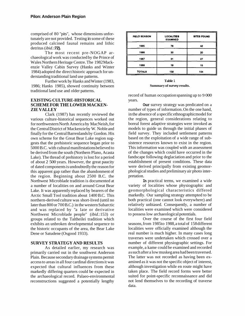
Over the course of the first four field seasons, from 1985 to 1988, a total of 158 different localities were officially examined although the real number is much higher. In many cases long traverses were undertaken which crossed over a number of different physiographic settings. For example, a kame could be examined and recorded as such after a low muskeg area had been traversed. The latter was not recorded as having been ex- amined as it was not the specific object of interest, although investigation while en route might have taken place. The field record forms were better suited for point-specific reconnaissance and did not lend themselves to the recording of traverse data.
NOGA P Archaeology Project
It should also be noted that in subsequent years (1986- 1988), emphasis shifted from site sur- vey to site testing. It is evident from Table 1 that the search for new sites was not abandoned entire- ly, but our strategy tended towards a more rational use of survey time based on the fmdings of the first summer.
TESTING AND EXCAVATION RESULTS Excavations were directed towards the
acquisition of representative artifact samples which could permit the formulation of a prelimi- nary culture-historical scheme for the region and provide information relating to former land use patterns. In addition, excavations were also planned so as to provide solution to two general problems.
The first was concerned with archaeologi- cal visibility and significance. A large number of sites with thin veneers of faunal remains and lithic debitage in association with hearth features had been located on low benches near the shores of lakes and streams. Many investigators would very quickly chose to ignore most of these sites and describe them as insignificant. However, as survey progressed in the first summer, it became quite clear that such sites constituted the rule rather than the exception. Since they are the only remains attesting to centuries, if not millenia of human occupation, we required means of assessing their importance.
To this end, excavations were undertaken at two such sites (MlTj-3 and the Edge Test Area of MlTk-2). At both localities, initial testing had revealed evidence of hearth features over wide areas, but failed to suggest the presence of any significant artifact concentrations. Subsequent ex- cavations focussed on the apparent hearth features and the areas adjacent to them. They showed that significant artifact and faunal samples as well as informative distributions could be obtained by ex- cavating reasonably large controlled test units, on the order of ten square metres. It is not so much the "thinness" of the deposits which pose a problem as it is the uneven distribution of the remains. By opening a larger area, it is more likely that these artifact concentrations will be encountered. Con- versely, shovel testing can easily miss inherently important yet unevenly distributed deposits.
The second question which needed to be addressed through excavations involved the nature of the semi-subterranean features which we had discovered. Although initially interpreted as ground caches, certain characteristics of the fea-
tures themselves or their locations did not conform to our understanding of such storage structures.
Controlled testing of two semi-subter- ranean features (MlTk-3, and Structure No.1 of MlTk-2) was undertaken in 1986. Our findings indicated that very substantial volumes of earth had been combined with poles in the construction of these structures. In 1987, two structures were completely excavated (MlTj-2 and Structure No.2 of MlTk-2), or virtually so, and another two were extensively tested (MlTk-3 and Structure No. 1 of NbTj-8). Finally, additional excavations of Struc- ture No. 1 of NbTj-8 were carried out in 1988. The results of these investigations will be detailed in the following sections.
GENERAL CHARACTERIZATION OF SITES IN THE SOUTHWEST ANDERSON PLAIN
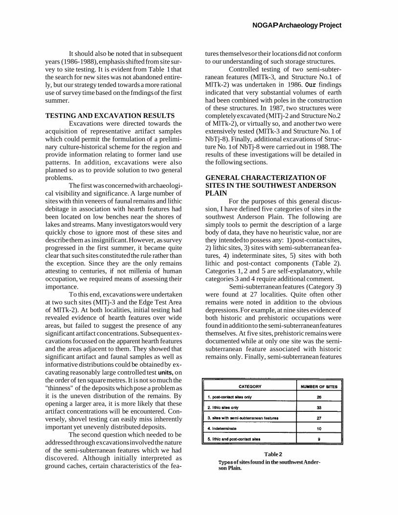
For the purposes of this general discus- sion, I have defined five categories of sites in the southwest Anderson Plain. The following are simply tools to permit the description of a large body of data, they have no heuristic value, nor are they intended to possess any: 1) post-contact sites, 2) lithic sites, 3) sites with semi-subterranean fea- tures, 4) indeterminate sites, 5) sites with both lithic and post-contact components (Table 2). Categories 1, 2 and 5 are self-explanatory, while categories 3 and 4 require additional comment.
Semi-subterranean features (Category 3) were found at 27 localities. Quite often other remains were noted in addition to the obvious depressions. For exampIe, at nine sites evidence of both historic and prehistoric occupations were found in addition to the semi-subterranean features themselves. At five sites, prehistoric remains were documented while at only one site was the serni- subterranean feature associated with historic remains only. Finally, semi-subterranean features
Table 2 Types of sites found in the southwest Ander- son Plain.
r
CATEGORY
1. postcontact sites only
2. lithic sites only
3. sites with semi-subterranean features
4. Indeterminate
5. lithic and post-contad sites
i
NUMBER OF SITES
26
33
27
10
9
Pilon: Anderson Plain Region
constituted the only evidence of human activity at 12 localities.
The ten indeterminate sites (Category 4) mostly consist of hearth features with associated fire-cracked rock and faunal remains. The use of boiling stones in the preparation of certain foods prior to the introduction of metal containers, al- though by no means the only method available to bring a liquid to boil, is a relatively fast and effi- cient technique. Although indirect contact with Europeans in the protohistoric period may have occasionally brought metal containers into the area, these must have been extremely rare. Instead, it is difficult to conceive of such a radical change in local culinary practices until well after direct contact with the Euro-Canadian traders who had established themselves on the Mackenzie and Peel Rivers in the first half of the nineteenth century- Fort Good Hope (North West Company) in 1804 (Voorhis 1930:75) and Fort McPhersorr (Hudson's Bay Company) in 1840 (ibid. : 107). In light of this consideration, it is quite likely that a number of Category 4 sites may be prehistoric or early his- toric in age. However, the limited testing at most sites precludes definitive statements in this regard.
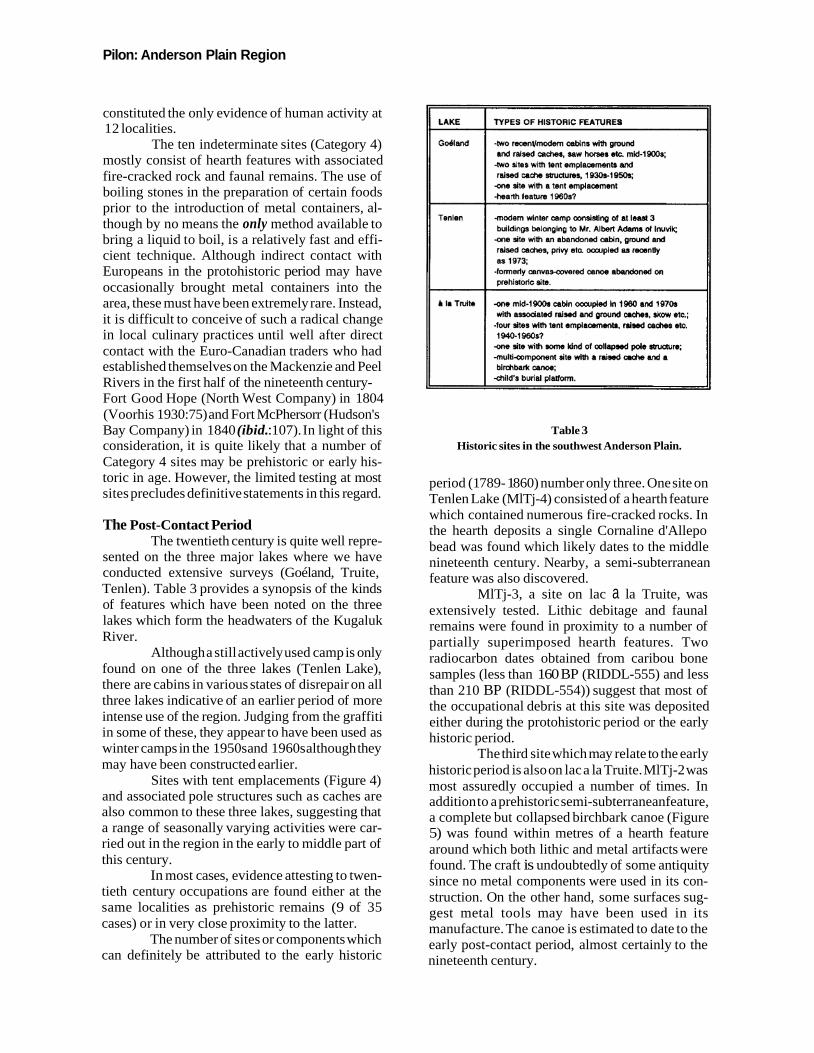
The Post-Contact Period The twentieth century is quite well repre-
sented on the three major lakes where we have conducted extensive surveys (Goéland, Truite, Tenlen). Table 3 provides a synopsis of the kinds of features which have been noted on the three lakes which form the headwaters of the Kugaluk River.
Although a still actively used camp is only found on one of the three lakes (Tenlen Lake), there are cabins in various states of disrepair on all three lakes indicative of an earlier period of more intense use of the region. Judging from the graffiti in some of these, they appear to have been used as winter camps in the 1950s and 1960s although they may have been constructed earlier.
Sites with tent emplacements (Figure 4) and associated pole structures such as caches are also common to these three lakes, suggesting that a range of seasonally varying activities were car- ried out in the region in the early to middle part of this century.
In most cases, evidence attesting to twen- tieth century occupations are found either at the same localities as prehistoric remains (9 of 35 cases) or in very close proximity to the latter.
The number of sites or components which can definitely be attributed to the early historic
1) LAKE I TlPES OF HISTORIC FEATURES
Gdland
Tenlen
-two recenvmodem cabins with ground and raised caches, saw horses etc. mid-1900s;
-two sites with tent emplacements and raised cache sbydures, 1930s-l95(h; one site with a tent emplacement -hearth feature 1 9 6 0 ~ 1
-modem winter camp consisting of at least 3 buildings belonging to Mr. Albert Adam8 of Inuvik
-one site with an abandoned cabin, ground and raised caches, privy etc. occupied as recently as 1973;
-formerly canvascovered canoe abandoned on prehistoric site.
one mid-19009 cabin ompied In 1960 and 1970s with assodated raised and ~mund caches, skow etc.;
-four sites with tent smplammentn, raised caohes etc. 1940-1 9Ms? one site with some kind of mllapsed pole struoture; -multi-mmponent site wlth a r a i d ache and a birchbark canoe;
child's burial platform.
Table 3 Historic sites in the southwest Anderson Plain.
period (1 789- 1 860) number only three. One site on Tenlen Lake (MlTj-4) consisted of a hearth feature which contained numerous fire-cracked rocks. In the hearth deposits a single Cornaline d'Allepo bead was found which likely dates to the middle nineteenth century. Nearby, a semi-subterranean feature was also discovered.
MlTj-3, a site on lac a la Truite, was extensively tested. Lithic debitage and faunal remains were found in proximity to a number of partially superimposed hearth features. Two radiocarbon dates obtained from caribou bone samples (less than 160 BP (RIDDL-555) and less than 210 BP (RIDDL-554)) suggest that most of the occupational debris at this site was deposited either during the protohistoric period or the early historic period.
The third site which may relate to the early historic period is also on lac a la Truite. MlTj-2 was most assuredly occupied a number of times. In addition to a prehistoric semi-subterranean feature, a complete but collapsed birchbark canoe (Figure 5) was found within metres of a hearth feature around which both lithic and metal artifacts were found. The craft is undoubtedly of some antiquity since no metal components were used in its con- struction. On the other hand, some surfaces sug- gest metal tools may have been used in its manufacture. The canoe is estimated to date to the early post-contact period, almost certainly to the nineteenth century.

96 NOGA P Archaeology Project
The Late Prehistoric Period A) Dating
Although an interesting suite of radiocar- bon age determinations is now available for the southwest Anderson Plain, only a small proportion of the existing sites have in fact been dated by this means (Table 4). Rather we have had to combine chronological indicators from a number of dif- ferent sources to arrive at age estimates for many of the sites. These are detailed below. The result is that the majority of the sites so far discovered have been attributed to the Late Prehistoric period whose beginning has elsewhere in interior northwestern North America been set at ap- proximately 1 000 BP (Holmes 1986; Le Blanc 1984; Morlan 1973; Shinkwin 1979).
i) Faunal Preservation The results of the dating of faunal bone
confirm their expected young age. Although the thin boreal forest soils are cursed by archaeologists as highly acidic, such that bone preservation is not
to be expected beyond a few centuries, it was necessary to verify this proposition for the south- west Anderson Plain since we can expect sig- nificant variations in soil pH according to local conditions (Pettapiece 1975). We are now in a position to state that faunal bone, which has not been altered by heat (i.e. calcined or charred), can be up to 600 years of age; at least this is the oldest age for a site with preserved faunal remains.
ii) Tree Ring Dating Live black spruce trees were found grow-
ing on the earth ridges or berms of many of the semi-subterranean features. In 1986, five of these were cut down and sections of their trunks were brought back in order to determine their ages by counting the number of annual growth rings. A sixth trunk section was recovered in 1988.
The youngest of the tree ring dates is 93 years while the oldest is 230 years. Comparison of tree ring ages and 14C age determinations of struc-tural wood in two instances (MlTk-3 and NbTj-8)
Figure 4 Recent tent emplacement, MkTi-7, lac au Goéland.
Piion: Anderson Plain Region
Table 4 Age determinations for sites in the southwest Anderson Plain. Calibrations according to Klein et al. 1982.
lac B la Truite wood from floor
Arctic Red River
heatth feature near
demonstrate that the former should only be used as minimum ages for the semi-subterranean feature's construction.
iii) Association with Adze-Cut Stumps Another important indicator of the age of
a semi-subterranean structure can be arrived at by considering the fact that many of these features occur within clusters of adze-cut stumps. These highly distinctive stumps (Figure 6) are easily
distinguished from the stumps of trees felled with steel implements (Leechman 1950). Long slivers were removed from the entire circumference of the trunks in order to reduce the diameter to such a point as they could be pushed over. In this manner they resemble sharpened pencils.
The coincidence between adze-cut stump clusters and semi-subterranean structures is quite high such that it is entirely reasonable to associate the tree stumps with the construction of the struc-
97
NOGA P Archaeology Project
Figure 5 Birchbark canoe, MlTj-2, lac à la Truite.
tures. That these stumps still remain standing must, once again, indicate that most of these are no more than a few centuries old. In fact, examples of semi-subterranean structures in areas lacking numerous adze-cut stumps are quite few. As a cultural phenomenon, semi-subterranean features, such as discovered in the southwest Anderson Plain, appear to be the products of the last mil- lenium.
B) Lithic and Faunal Scatters The majority of sites attributable to the
Late Prehistoric period are comprised of lithic debitage and/or faunal remains usually scattered about obvious points of combustion. Doubtless, many of these sites consist of the debris left behind by people who had lived under tents or some other form of temporary, portable shelter. It is equally likely that some of the sites represent outdoor activity areas such as fish and meat drying and smoking facilities, hide tanning fires or simply refuse areas.
There is a marked tendency for sites lack- ing semi-subterranean features to have predominant orientations toward the sources of
prevailing winds, i.e. toward the north and west (see Table 5). In contrast, when semi-subterranean features are found, the predominant exposure from these localities is in a southerly direction. Further, sites with semi-subterranean features are found at greater distances and elevations from the water's edge than sites lacking such features. If indeed these two types of sites represent living areas, then the above-described locational tendencies would seem to relate to the season of occupation and the seasonally differing requirements of site locations.
Leslie Still has understaken the analysis of the faunal collections from the southwest Anderson Plain and the details of that study are available elsewhere in this volume. However, it is apparent that caribou constituted a very important subsistence resource during Late Prehistoric times.
The lithic collections which have been gathered to date for sites attributable to the Late Prehistoric period are characterized by relatively small quantities of unspecialized black siliceous argillite debitage. It appears that the blocky cores and cobbles of this raw material were mainly reduced by hard-hammer percussion in order to produce flakes suitable for use with only minimal modification of the working edges. The most com- mon implement is therefore the usedJretouched flake and occasional scrapers. In one case how-
Figure 6 Adze-cut stump, MlTk-2, lac à la Truite.
Pilon: Anderson Plain Region 99
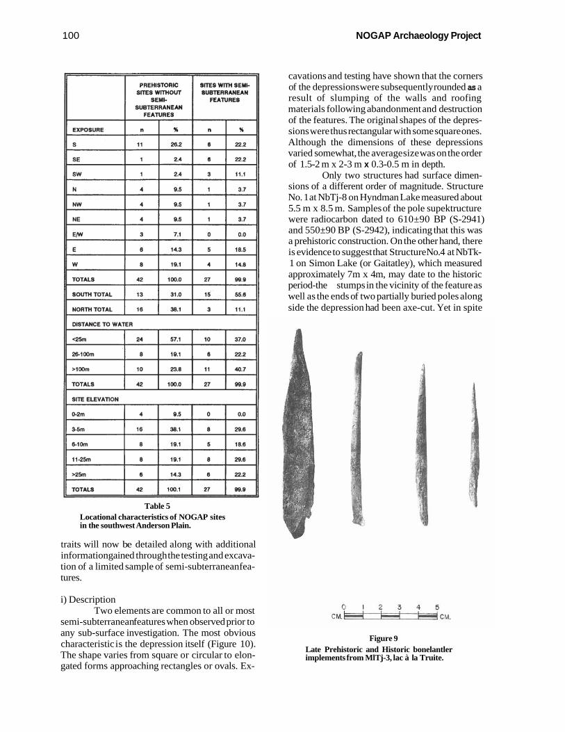
C) Semi-Subterranean Features 4 n Of the 27 sites where semi-subterranean t-,;.: :
( features have been discovered, two have four /iI. structures, five sites have two structures each and
, i *Y
the remainder (20) have only one such feature. There is at present no basis for assuming contem- poraneity between structures at localities where more than one was discovered.
Among the 38 semi-subterranean features which we have discovered to date, only two were questionable. Both of these examples were found on fairly steep slopes where frost cracks could be
-1 confused with man-made depressions. However, the regularity of form and the occurrence of adze-
I I cut stumps in the vicinities of these features argued
for their retention as cultural features. I The remaining 36 semi-subterranean fea-
I
f tures share a number of distinct characteristics ,' which must relate to their mode of construction,
their general appearance and their function. These
0 1 2 3 4 5 CM. k I & CM.
Figure 7 Late Prehistoric implements, MITj-2, lac à la Truite: top row, l. to r., scraper, projectile point, biface tip; bottom, l. to r., uniface, split incisor, bipointed antler tool.
ever, a small tapering stem point, similar to Kavik points (Morlan's type IA) of the Yukon and Alaska (Morlan 1973:484), was found (Figure 7).
Implements manufactured from coarse- grained raw materials and presumably intended as scraping tools have been found at a number of sites. Similar tools are still made today by local Gwich'in people. Referred to as chi-da-tho they are used as hide scraping tools (Figure 8). The archaeological examples we have found consist of two types: those employing a tabular raw material which usually requires intentional retouch of the working edge and those made on large cobble spalls requiring minimal modification of the work- ing edge, if any at all.
Bone or antler implements and at least one antler tool blank have been recovered although these are not numerous (Figure 9). They are prin- cipally long, slender, pointed tools which can readily be described as awls or leister prongs in the absence of any detailed studies of manufacture and wear.
Figure 8 Tabular and cobble spall chi-da-tho: top left, NbTp-l , Campbell Lake; bottom left, MkTi-9, lac au Goéland; top right, MiTr-1, Arctic Red River; middle right, MjTp-3, Whirl Lake; bottom right, MITj-3, lac à la Truite.
100 NOGAP Archaeology Project
II PREHISTORK: I SITES WITH SEMI- SITES WITHOUT SUBTERRANEAN I SEMI- FEANRES
DISTANCE TO WATER
Table 5 Locational characteristics of NOGAP sites in the southwest Anderson Plain.
<25m
2&1 00m
>loom
TOTALS
0-2m
95m
6-1 Om
I I -25m
>25m
TOTALS
traits will now be detailed along with additional information gained through the testing and excava- tion of a limited sample of semi-subterranean fea- tures.
i) Description Two elements are common to all or most
semi-subterranean features when observed prior to any sub-surface investigation. The most obvious characteristic is the depression itself (Figure 10). The shape varies from square or circular to elon- gated forms approaching rectangles or ovals. Ex-
SITE ELEVATION
24
8
10
42
4
16
8
8
6
42
cavations and testing have shown that the corners of the depressions were subsequently rounded as a result of slumping of the walls and roofing materials following abandonment and destruction of the features. The original shapes of the depres- sions were thus rectangular with some square ones. Although the dimensions of these depressions varied somewhat, the average size was on the order of 1.5-2 m x 2-3 m x 0.3-0.5 m in depth.
Only two structures had surface dimen- sions of a different order of magnitude. Structure No. 1 at NbTj-8 on Hyndman Lake measured about 5.5 m x 8.5 m. Samples of the pole supektructure were radiocarbon dated to 610±90 BP (S-2941) and 550±90 BP (S-2942), indicating that this was a prehistoric construction. On the other hand, there is evidence to suggest that Structure No.4 at NbTk- 1 on Simon Lake (or Gaitatley), which measured approximately 7m x 4m, may date to the historic period-the stumps in the vicinity of the feature as well as the ends of two partially buried poles along side the depression had been axe-cut. Yet in spite
0 1 2 3 4 CM. . -- 1 CM.
57.1
19.1
23.8
100.0
9.5
38.1
19.1
19.1
14.3
100.1
Figure 9 Late Prehistoric and Historic bonelantler implements from MlTj-3, lac à la Truite.
10
6
11
27
0
6
5
8
6
27
37.0
22.2
40.7
99.9
0.0
29.6
18.6
29.6
22.2
99.9
Pilon: Anderson Plain Region
of their inordinately large surface dimensions, these semi-subterranean features otherwise con- form to the same basic characteristics.
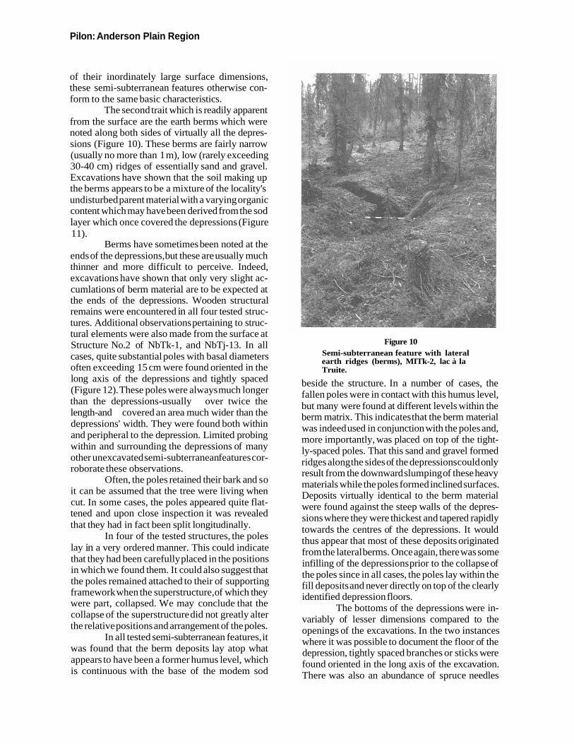
The second trait which is readily apparent from the surface are the earth berms which were noted along both sides of virtually all the depres- sions (Figure 10). These berms are fairly narrow (usually no more than 1 m), low (rarely exceeding 30-40 cm) ridges of essentially sand and gravel. Excavations have shown that the soil making up the berms appears to be a mixture of the locality's undisturbed parent material with a varying organic content which may have been derived from the sod layer which once covered the depressions (Figure 11).
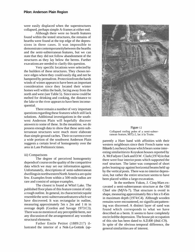
Berms have sometimes been noted at the ends of the depressions, but these are usually much thinner and more difficult to perceive. Indeed, excavations have shown that only very slight ac- cumlations of berm material are to be expected at the ends of the depressions. Wooden structural remains were encountered in all four tested struc- tures. Additional observations pertaining to struc- tural elements were also made from the surface at Structure No.2 of NbTk-1, and NbTj-13. In all cases, quite substantial poles with basal diameters often exceeding 15 cm were found oriented in the long axis of the depressions and tightly spaced (Figure 12). These poles were always much longer than the depressions-usually over twice the length-and covered an area much wider than the depressions' width. They were found both within and peripheral to the depression. Limited probing within and surrounding the depressions of many other unexcavated semi-subterranean features cor- roborate these observations.
Often, the poles retained their bark and so it can be assumed that the tree were living when cut. In some cases, the poles appeared quite flat- tened and upon close inspection it was revealed that they had in fact been split longitudinally.
In four of the tested structures, the poles lay in a very ordered manner. This could indicate that they had been carefully placed in the positions in which we found them. It could also suggest that the poles remained attached to their of supporting framework when the superstructure, of which they were part, collapsed. We may conclude that the collapse of the superstructure did not greatly alter the relative positions and arrangement of the poles.
In all tested semi-subterranean features, it was found that the berm deposits lay atop what appears to have been a former humus level, which is continuous with the base of the modem sod
Figure 10 Semi-subterranean feature with lateral earth ridges (berms), MITk-2, lac à la Truite.
beside the structure. In a number of cases, the fallen poles were in contact with this humus level, but many were found at different levels within the berm matrix. This indicates that the berm material was indeed used in conjunction with the poles and, more importantly, was placed on top of the tight- ly-spaced poles. That this sand and gravel formed ridges along the sides of the depressions could only result from the downward slumping of these heavy materials while the poles formed inclined surfaces. Deposits virtually identical to the berm material were found against the steep walls of the depres- sions where they were thickest and tapered rapidly towards the centres of the depressions. It would thus appear that most of these deposits originated from the lateral berms. Once again, there was some infilling of the depressions prior to the collapse of the poles since in all cases, the poles lay within the fill deposits and never directly on top of the clearly identified depression floors.
The bottoms of the depressions were in- variably of lesser dimensions compared to the openings of the excavations. In the two instances where it was possible to document the floor of the depression, tightly spaced branches or sticks were found oriented in the long axis of the excavation. There was also an abundance of spruce needles
102 NOGA P Archaeology Project
among these branches as well as the quite meagre collections of faunal remains and artifacts.
In summary, the tested semi-subterranean features show quite clearly that the berms which occur along either side of the depressions result from the gradual collapsed and slumping of a superstructure consisting essentially of poles covered with the depression's original matrix. This superstructure was apparently gabled and sym- metrical.
ii) Interpretation It now remains to determine the nature of
these semi-subterranean features. Two likely pos- sibilities present themselves. These depressions may be nothing more than cache pits. Such storage facilities are still made today by the local Gwich'in people of Arctic Red River and good examples were found beside just about every recent cabin we visited in the area. Those cache pits however, are of much more modest dimensions, rarely exceed- ing 1.5m x 1.5m. In addition, those which we observed did in no way incorporate the depression fill as an element in the covering of the cache. The coverings which we did see consisted of big sticks and branches which covered the holes and little
more, or pieces of plywood, again just barely ex- ceeding the dimensions of the excavations. The only common feature between what are clearly ground caches and the semi-subterranean features described above is that both consist of depressions excavated into the ground.
The second interpretation, which is the one favoured here, is that most, if not all of these features are the remains of dwelling structures. Simply cutting all the required trees with stone implements represents a very considerable invest- ment of time and energy, much more than is in- volved in building historic ground caches. In the extreme examples represented by Structure No.4 of NbTk-1 and Structure No.1 of NbTj-8, large numbers of very sizeable trees were cut.
Structural and stratigraphic evidence, coupled with the systematic occurrence of lateral berms clearly indicate that the depressions were only one component of the features. The universal occurrence of lateral berms, coupled with the stratigraphic and horizontal positions of the poles clearly indicate that the poles and the soil formed gabled roofs which covered a much greater area than the depression. The absence of easily iden- tified supports for these roofs suggests that they
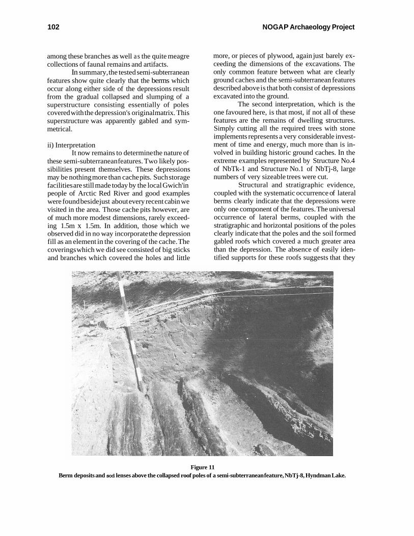
Figure 11 Berm deposits and sod lenses above the collapsed roof poles of a semi-subterranean feature, NbTj-8, Hyndman Lake.
Pilon: Anderson Plain Region
were easily displaced when the superstructures collapsed, perhaps simple A-frames at either end.
Although there were no hearth features found within the tested structures, the remains of hearths were found at the top edge of the depres- sions in three cases. It was impossible to demonstrate contemporaneity between the hearths and the semi-subterranean features, but we can state that they did not follow abandonment of the structures as they lay below the berms. Further exavations are needed to clarify this question.
Very specific locations were selected by the builders of these structures. They choses ter- race edges where they could easily dig and not be hampered by permafrost. Protection from the harsh winds of winter appears to have been an important consideration since they located their winter homes well within the bush, facing away from the north and west (see Table 5). Since snow could be melted for drinking and cooking, the distance to the lake or the river appears to have been inconse- quential.
There remain a number of very important questions regarding these features which still lack solutions. Additional investigations in the south- west Anderson Plain will hopefully discover answers to some of these. In the meantime, we do possess enough data to show that these semi-sub- terranean structures were much more elaborate than simple ground caches. Their occurrence over a wide portion of the southwest Anderson Plain suggests a certain level of homogeneity over the area in Late Prehistoric times.
iii) Comparisons The degree of perceived homogeneity
depends of course on the quality of the comparitive data which we may set our information against. Unfortunately, descriptions of semi-subterranean dwellings in northwestern North America are quite few. Examples from within a 500-mile radius are rare and consist of unique examples.
The closest is found at Whirl Lake. The published floor plans of this feature consist of only a rough outline. In general, its characteristics quite resemble the semi-subterranean features which we have discovered. It was rectangular in outline, measuring approximately 5m x 2m and 1 m in average depth (Gordon and Savage 1973:C3). There was no mention of any perceptible berm, nor any discussion of the arrangement of any wooden structural elements.
Father Emile Petitot (1889:217) il- lustrated the interior of a Nnk-La-Gottink (ap-
Figure 12 Collapsed roofing poles of a semi-subter- ranean feature, MlTj-2, lac à la Truite.
parently a Hare band with affinities with their western neighbours since their French name was Bâtards Loucheux) house which bears some inter- esting similarities to Koyukon houses reported by A. McFadyen Clark and D.W. Clark (1974) in that there were four interior posts which supported the roof structure. The latter was composed of short poles leaning up against horizontal beams held up by the vertical posts. There was no interior depres- sion, but rather the entire structure seems to have been placed within a large excavation.
In the northern Yukon, J. Cinq-Mars ex- cavated a semi-subterranean structure at the Old Chief site (MjVk-7). That structure is ovoid in shape, measuring approximately 8m x 6m x 0.45m in maximum depth (1974:C4). Although wooden remains were encountered, no significant pattern- ing was discerned. A distinct layer of sand was found which corresponds to what we have described as a berm. It seems to have completely encircled the depression. The house pit occupation of this site has been dated to A.D.l00 (ibid.:C9). In spite of the obvious temporal difference, the general similarities are of interest.
NOGA P Archaeology Project
Figure 13 Burial platform for a newborn or infant, MITk-14, lac à la Truite.
D) Other Features Additional features have been discovered
which relate to the pre-contact period; a roasting pit or faunal remain disposal pit at MlTj-3 (see Still, this volume for a discussion of this feature), a birchbark canoe at MlTj-2, an adult's burial platform at MjTp-7 (near Whirl Lake) a child's burial platform (Figure 13) at lac à la Truite (MlTk- 14). Although these undoubtedly date to the post- contact period, they lack any evidence of European conceptual influence and as such we may legitimately consider them as having antecedents in the Late Prehistoric period.
E) Summary It is essential to point out that not all sites
which could be attributed to the Late Prehistoric period contained diagnostic information allowing the determination of their cultural affiliation. How- ever, information is available for a broad range of culturally-specific practices which include lithic and bone technology, semi-subterranean dwelling construction, faunal bone disposal, and burial practices. Taken individually and collectively, these key elements point to generalized Athapas- kan roots. In particular, there are strong indications of western relationships (Yukon and Alaska) rather than any particularly obvious link with east- ern manifestations.
Earlier Sites and Components The previous section has emphasised the
great visibility of the Late Prehistoric period. It is represented by a large number of sites presenting a variety of particular situations. However, as pointed out earlier, the reconstruction of the region's post-glacial history indicates that the potential exists for a much longer record of human occupation, somewhere on the order of several millenia. Although many gaps in the region's cul- ture-history remain to be filled, evidence for the presence of man prior to the late Prehistoric period is now available. The following section describes three sites where such data have been identified.
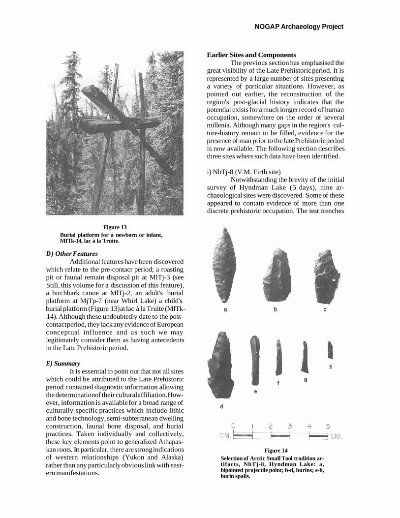
i) NbTj-8 (V.M. Firth site) Notwithstanding the brevity of the initial
survey of Hyndman Lake (5 days), nine ar- chaeological sites were discovered. Some of these appeared to contain evidence of more than one discrete prehistoric occupation. The test trenches
Figure 14 Selection of Arctic Small Tool tradition ar- tifacts, NbTj-8, Hyndman Lake: a, bipointed projectile point; b-d, burins; e-h, burin spalls.
Pilon: Anderson Plain Region 105
Lake region (Clark 1987) and further east in the Keewatin (Gordon 1975). There is good agreement
__- - between the technology and the 14C age. We must b now consider whether this occupation was part of
..., the southern shift in ASTt range which is so well a
-----a - documented in the Barrenlands or whether this site c represents a particular component in the seasonal
round of a group which also exploited marine mammal resources along the Beaufort Sea littoral. Formulated in a somewhat different manner, future research should attempt to determine whether the
e I I
, - - 7 ASTt group represented at NbTj-8 was fully
d adapted to an inland existence or whether they
< . spent part of the year in the coastal regions.
* ,
; ' ' ,r- T 1 'I , I
ii) MlTk-2 > Another component which can easily be
. - - - ascribed to an occupation pre-dating the Late
C. 0t,-5c5CM - / Prehistoric period was discovered during the sum-
f mer of 1987 at MlTk-2 on lac à la Truite (Pilon 1988:77-79). Although evidence of occupation oc- curred over a very wide area and included both
Figure 15 semi-subterranean features, hearths, lithic and faunal scatters, and a recent cabin with its as-
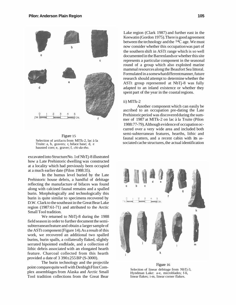
Selection of artifacts from MlTk-2, lac à la Truite: a, b, gravers; c, biface base; d, e sociated cache structures, the actual identification hausted core; e, graver; f, chi-da-tho.
excavated into Structure No. 1 of NbTj-8 illustrated how a Late Prehistoric dwelling was constructed at a locality which had previously been occupied at a much earlier date (Pilon 1988:35).
In the humus level buried by the Late Prehistoric house debris, a handful of debitage reflecting the manufacture of bifaces was found along with calcined faunal remains and a spalled burin. Morphologically and technologically this burin is quite similar to specimens recovered by D.W. Clark to the southeast in the Great Bear Lake region (1987:61-71) and attributed to the Arctic Small Tool tradition. h
We returned to NbTj-8 during the 1988 field season in order to further document the semi- subterranean feature and obtain a larger sample of I
* L r the ASTt component (Figure 14). As a result of this r . ' ~ t .
i work, we recovered an additional two spalled burins, burin spalls, a collaterally flaked, slightly serrated bipointed endblade, and a collection of I J' I rn
lithic debris associated with an elongated hearth I
feature. Charcoal collected from this hearth k I
provided a date of 3 390±255 BP (S-3000). The burin technology and the projectile Figure 16
point compare quite well with Denbigh Flint Com- Selection of linear debitage from NbTj-3,
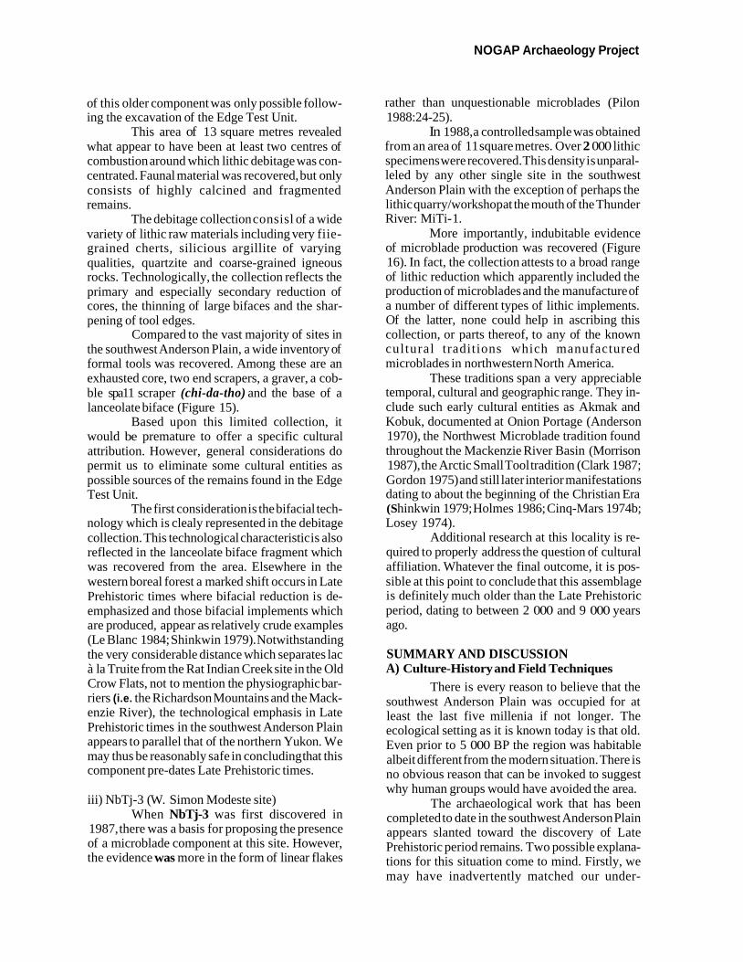
plex assemblages from Alaska and Arctic Small Hyndman Lake: a-e, microblades; f-h, Tool tradition collections from the Great Bear linear flakes; i-m, linear corner flakes.
NOGA P Archaeology Project
of this older component was only possible follow- ing the excavation of the Edge Test Unit.
This area of 13 square metres revealed what appear to have been at least two centres of combustion around which lithic debitage was con- centrated. Faunal material was recovered, but only consists of highly calcined and fragmented remains.
The debitage collection consisl of a wide variety of lithic raw materials including very fiie- grained cherts, silicious argillite of varying qualities, quartzite and coarse-grained igneous rocks. Technologically, the collection reflects the primary and especially secondary reduction of cores, the thinning of large bifaces and the shar- pening of tool edges.
Compared to the vast majority of sites in the southwest Anderson Plain, a wide inventory of formal tools was recovered. Among these are an exhausted core, two end scrapers, a graver, a cob- ble spa11 scraper (chi-da-tho) and the base of a lanceolate biface (Figure 15).
Based upon this limited collection, it would be premature to offer a specific cultural attribution. However, general considerations do permit us to eliminate some cultural entities as possible sources of the remains found in the Edge Test Unit.
The first consideration is the bifacial tech- nology which is clealy represented in the debitage collection. This technological characteristic is also reflected in the lanceolate biface fragment which was recovered from the area. Elsewhere in the western boreal forest a marked shift occurs in Late Prehistoric times where bifacial reduction is de- emphasized and those bifacial implements which are produced, appear as relatively crude examples (Le Blanc 1984; Shinkwin 1979). Notwithstanding the very considerable distance which separates lac à la Truite from the Rat Indian Creek site in the Old Crow Flats, not to mention the physiographic bar- riers (i.e. the Richardson Mountains and the Mack- enzie River), the technological emphasis in Late Prehistoric times in the southwest Anderson Plain appears to parallel that of the northern Yukon. We may thus be reasonably safe in concluding that this component pre-dates Late Prehistoric times.
iii) NbTj-3 (W. Simon Modeste site) When NbTj-3 was first discovered in
1987, there was a basis for proposing the presence of a microblade component at this site. However, the evidence was more in the form of linear flakes
rather than unquestionable microblades (Pilon 1988:24-25).
In 1988, a controlled sample was obtained from an area of 1 1 square metres. Over 2 000 lithic specimens were recovered. This density is unparal- leled by any other single site in the southwest Anderson Plain with the exception of perhaps the lithic quarry/workshop at the mouth of the Thunder River: MiTi- 1.
More importantly, indubitable evidence of microblade production was recovered (Figure 16). In fact, the collection attests to a broad range of lithic reduction which apparently included the production of microblades and the manufacture of a number of different types of lithic implements. Of the latter, none could heIp in ascribing this collection, or parts thereof, to any of the known cultural traditions which manufactured microblades in northwestern North America.
These traditions span a very appreciable temporal, cultural and geographic range. They in- clude such early cultural entities as Akmak and Kobuk, documented at Onion Portage (Anderson 1970), the Northwest Microblade tradition found throughout the Mackenzie River Basin (Morrison 1987), the Arctic Small Tool tradition (Clark 1987; Gordon 1975) and still later interior manifestations dating to about the beginning of the Christian Era (S hinkwin 1979; Holmes 1986; Cinq-Mars 1974b; Losey 1974).
Additional research at this locality is re- quired to properly address the question of cultural affiliation. Whatever the final outcome, it is pos- sible at this point to conclude that this assemblage is definitely much older than the Late Prehistoric period, dating to between 2 000 and 9 000 years ago.
SUMMARY AND DISCUSSION A) Culture-History and Field Techniques
There is every reason to believe that the southwest Anderson Plain was occupied for at least the last five millenia if not longer. The ecological setting as it is known today is that old. Even prior to 5 000 BP the region was habitable albeit different from the modern situation. There is no obvious reason that can be invoked to suggest why human groups would have avoided the area.
The archaeological work that has been completed to date in the southwest Anderson Plain appears slanted toward the discovery of Late Prehistoric period remains. Two possible explana- tions for this situation come to mind. Firstly, we may have inadvertently matched our under-
Pilon: Anderson Plain Region
standing of the land and its resources with that of the Late Prehistoric period inhabitants of the area. A significant corollary to this hypothesis is that the settlement pattern differed markedly before and following the Late Prehistoric period; these older and younger sites remain to be discovered. A second way of explaining the predominance of Late Prehistoric period sites in our sample is to simply state that the region was unoccupied prior to that period and was abandoned shortly after contact with Europeans.
We now have indubitable evidence of ear- lier occupations at NbTj-8, MlTk-2 and NbTj-3. It is reasonable to expect that more older sites will be discovered with additional work. An important factor to consider in this respect lies in the nature of the archaeological sites themselves and espe- cially in the heterogeneity of the artifact distribu- tions. It is more than likely, in fact it is highly probable, that we have already visited, and perhaps even sampled, localities which were occupied well before the Late Prehistoric period. We may simply not have recognized them yet. We must modify our field techniques and be prepared to invest more time and energy in our initial testing procedures.
B) The Effects of Contact with Euro- Canadians
The apparent reduction in the number of sites in the early historic period poses a different kind of problem. It is of course possible that we have failed to recognize such sites or components. If anything, such sites, which would combine Late prehistoric artifacts with European trade items, should have a visibility equal to that of the Late Prehistoric period.
However, there seems to be a marked reduction in sites attributable to this period, fol- lowed by an increase in the number of components and sites dating to the early twentieth century. Keeping in mind the nature of our data base and the constraints under which this information was gathered, the following provisional interpretation is offered.
Shepard Krech has shown quite clearly that the nineteenth century was a dark period in the lower Mackenzie Valley:
The Kutchin population fell to its nadir in the 1860s, when there was an estimated total of 850 to 900 Gwich'in. This appears to indicate a loss of over 80 percent of the aboriginal population in approximately 100 years. In the 1860s, one Kutchin was alive where six had been aboriginally (1978:99) (emphasis mine).
When Father Petitot lived in the lower Mackenzie Valley during the latter half of the nineteenth century, the Kwitcha Gwich'in seemed clearly distinguished from those Gwich'in living along the Mackenzie River and up the Arctic Red River, the Nakotcho Gwich'in. Although it is dif- ficult to gauge the extent of depopulation because of disease in the area between the Anderson and Mackenzie Rivers-the land of the Kwitcha Gwich'in-it is reasonable to assume that they too had been seriously affected, although their relative isolation may have stemmed the tide felt in areas closer to the trading establishments. In fact, ac- cording to Petitot (1876:28), in the 1860s they were still fairly distinct groups.
When Osgood wrote on the Gwich'in in the early part of this century (1934, 1936), he recorded only one group as occupying the area attributed by Petitot to two distinct regional bands. Krech (1979) critically evaluates the evidence for and against the existence of Petitot's two named groups and argues that as a result of very serious population reduction, there was a need to amal- gamate the two groups in order to maintain a biologically viable population. The result was the virtual disappearance of the name and traditions of the Nakotcho Gwich'in.
There appear to be far fewer sites or com- ponents attributable to the early historic period than we expected. When again the area appears significantly used, the sites are characterized by the presence of either cabins or the use of canvas tents. The semi-subterranean features which are prevalent in Late Prehistoric times and into at least the beginning of the historic period apparently cease to be made prior to the beginning of the twentieth century. As it is, the causes for theap- parent population reduction, which we seem to be faced with, may find an explanation in Krech's ethnohistoric work.
CONCLUSION Archaeological investigations along the
lower Mackenzie Valley as well as the lands ad- jacent to it have been limited and poorly reported. As a result, accessible comparative material is wanting. Hopefully the present article has shown that in spite of certain very serious practical dif- ficulties inherent in the archaeological record of this area, critical questions can be addressed by modifying our expectations, field methods and interpretive frameworks. Were this not under- taken, virtually the entire region under considera- tion would remain a terra incognita.
NOGAP Archaeology Project
In attempting to present the results of four field seasons of archaeological survey, testing and excavations, the primary objective was to relate the various sites to each other before establishing ex- ternal connections. These external relationships often appear as a basis to legitimize the otherwise lack-luster remains from millenia of human oc- cupation. The lower Mackenzie Valley is just such a region where there have been relatively few attempts to understand the local adaptive strategies through time. Instead, very broad similarities which ultimately are based on very little concrete data have been stressed. If anything, there is a need to move away from such attempts and to strengthen the basis for higher level abstractions by conduct- ing fieldwork and analyses which accept the essen- tial nature of the region's prehistoric record as a given rather than as an impediment to knowledge.
ACKNOWLEDGEMENTS The first half of the NOGAP Archaeology
Project was very much a learning experience for me. Although a number of parallels could be drawn between the eastern Subarctic and the lower Mack- enzie Valley, some very important differences remained. However, with the help of my col- leagues Jacques Cinq-Mars, Raymond J. Le Blanc and R.Jane Dale, the initial phase of discovery was made less difficult. I would like to thank the various individuals who have participated in one way or another with my field work: Gabe Andre, Arianne Burke, Virna Mae Firth, Bruce Jamieson, Deanna Ludowicz, Willy Simon-Modeste, Ken Stark, Phil Woodley and Cathy Yasui. Equally critical to the success of field activities has been the help of Jane Henson of the Mackenzie Valley Tribal Council, Grace Blake, chief of the Arctic Red River Band Council, John Ostrick, chief tech- nician of the Inuvik Research Laboratory, Fred and Miki Carmichael of Antler Aviation, Cece and Carol filling of Inuvik Air Charter, and Walter Firth of CBC-Inuvik. I would also like to thank the personnel of the Archaeological Survey of Canada for providing a stimulating environment in which to work. Finally, I must recognize the contribution that my wife Abbie has played in the archaeologi- cal endeavour detailed in this article. She has had to bear the responsibility of caring for our son during the long weeks of my absence. This is a task whose importance should not be underestimated.
REFERENCES CITED Anderson, D.D.
1970 Akmak: An Early Archaeological As- s e m b l a g e From Orziorz Por tage , Northwest Alaska. Acta Arctica Fasc.XV1.
Bliss, W.L. 1939 An archaeological and geological
reconnaissance of Alberta, Mackenzie Valley, and Upper Yukon. American Philosophical Society, Year Book 1938: 136- 139. Philadelphia.
Bostock, H.S. 1964 A Provisional Physiographic Map of
Canada. Paper 64-35. Geological Sur- vey of Canada, Department of Mines and Technical Surveys. Ottawa.
Canada, Department of Indian and Northern Af- fairs
n.d. Land Use Information Series, Maps 106-N, 106-0, 107-A.
Cinq-Mars, J. 1973 Trans-Canadian Pipeline Archaeologi-
cal Salvage Project, Interim Report. Submitted to the Department of Indian Affairs and Northern Development. Manuscript No.1015, on file in the Ar- chives of the Archaeological Survey of Canada, Canadian Museum of Civiliza- tion. Hull.
1974a Summary of the activities of the Mack- enzie Corridor Archaeological Feasibility Study (1973- 1974). Sub- mitted to the Department of Indian and Northern Affairs. Manuscript No.990, on file in the Archives of the Ar- chaeological Survey of Canada, Canadian Museum of Civilization. Hull.
1974b Appendix C. Old Chief (MjVk-7): An Evaluation. In Prel iminary Ar- chaeological Study, Mackenzie Cor- ridor (second report). J . Cinq-Mars. Environmental-Social Committee, Northern Pipelines Task Force on Northern Oil Development. Report N0.74- 1 1.
Pilon: Anderson Plain Region
Clark, D.W. 1975 Archaeological Reconnaissance in
Northern Interior District of Macken- zie: 1969, 1970 and 1972. National Museum of Man Mercury Series, Ar- chaeological Survey of Canada Paper 27. Ottawa.
1987 Archaeological Reconnaissance at Great Bear Lake. National Museum of Man Mercury Series, Archaeological Survey of Canada Paper 136. Ottawa.
Dale, R,J. 1988 Lower Mackenzie Valley Site Re-
Evaluation. Manuscript No.30 19, on file in the Archives of the Archaeologi- cal Survey of Canada, Canadian Museum of Civilization. Hull.
Fedirchuk, G. and J.F.V. Millar 198 1 Heritage resource ovewiew, Transpor-
tation Corridor, Beaufort Sea-Macken- zie Valley Development Project, Volume I1 A. Manuscript No.2232, on file in the Archives of the Archaeologi- cal Survey of Canada, Canadian Museum of Civilization, Hull.
Fletcher, R.J. and G.S. Young n.d. Climate of Arctic Canada in Maps. Oc-
casional Publication Number 1 3. Boreal Institute for Northern Studies. Edmon- ton.
Gordon B.C. 1971 The Whirl Lake site. An early fishing
station on the Lower Mackenzie, N.W.T. Manuscript No.202, on file in Archaeological Survey of Canada, Canadian Museum of Civilization. Hull,
1975 Of Men and Herds in Barrenland Prehistory. National Museum of Man Mercury Series, Archaeological Survey of Canada Paper 28. Ottawa.
Gordon, B.C. and H. Savage 1973 Appendix C: MjTp-1, the Whirl Lake
site, northwestern District of Macken- zie, Northwest Territories, Canada. In Preliminary Archaeological Study, Mackenzie Corridor, by J-Cinq-Mars. Environmental-Social Committee, Northern Pipelines, Task Force on Northern Oil No.73-1O:Cl-C43.
Hanks, C. 1985 A preliminary archaeological survey of
the Upper Ramparts. Manuscript No.2648, on file in the Archives of the Archaeological Survey of Canada, Canadian Museum of Civilization. Hull.
Hanks, C. and B. Winter 1983 Dene names as an organising principle
in ethnoarchaeological research. Musk- Ox 33:49-55.
1984 The 1982 Mackenzie River cabin sur- vey. Manuscript No.2361, on file in the Archives of the Archaeological Suwey of Canada. Hull.
1986 Local knowledge and ethnoarchaeol- ogy: an approach to Dene settlement systems. Current Anthropology 27(3):272-275.
Holmes, C.E. 1986 Luke Minchumina Prehistory, An Ar-
chaeological Analysis. Alaska Anthropological Association Mono- graph Series #2.
Hughes, O.L. 1969 Surficial Geology of Northern Yukon
Territory and Northwestern District of Mackenzie, Northwest Territories. Paper 69-36. Geological Survey of Canada, Department of Energy, Mines and Resources. Ottawa.
Klein, J., Lerrnan, J.C., Damon, P.E. and E.K. Ralph
1982 Calibration of radiocarbon dates: tables based on the consensus data of the Workshop on Calibrating the Radiocar- bon Time Scale. Radiocarbon 24(2): 103- 150.
Krech, S. 1976 The Eastern Kutchin and the fur trade,
1800-1 860.Ethno h is tory 23(3):213- 235.
1978 On the aboriginal population of the Kutchin. Arctic Anthropology XV(1):89-104.
1979 The Nakotcho Kutchin: a tenth aboriginal Kutchin band? Journal of Anthropological Research 35(1): 109- 121.
NOGA P Archaeology Project
Le Blanc, R.J. 1984 The Rat Indian Creek Site and the Lute
Prehistoric Period in the Interior Northern Yukon. National Museum of Man Mercury Series, Archaeological Survey of Canada Paper 120. National Museum of Man. Ottawa.
Leechman, D. 1950 Aboriginal Tree-Felling. In National
Museum of Canada Bulletin No.118, Annual Report of the National Museum for the Fiscal Year 1948-1 949:44-49.
Losey, T.C. 1973 Mackenzie Pipeline Archaeological
Project. Manuscript No.914, on file in the Archives of the Archaeological Sur- vey of Canada, Canadian Museum of Civilization. Hull.
1974 Appendix B. Mackenzie River: Fort Simpson to Fort Good Hope. In Prelimi- nary Archaeological Study, Mackenzie Corridor (Second Report). by J.Cinq- Mars. Environmental-Social Commit- tee, Northern Pipelines, Task Forced on Northern Oil Development Report 74- 11:Bl-B78.
MacDonald, G.M. 1987 Postglacial vegetation history of the
Mackenzie River Basin. Quaternary Research 28:245-262.
Mackay, J.R. 1974 The Mackenzie Delta Area, N. W. T. First
published in 1963 as Geographical Branch, Memoir 8. Geological Survey of Canada, Miscellaneous Report 23. Department of Energy, Mines and Resources. Ottawa.
Mackay, J.R. and J. Terasmae 1963 Pollen diagrams in the Mackenzie Delta
area, N.W.T. Arctic 16:229-238.
MacNeish, R.S. 1953 Archaeological Reconnaissance in the
Mackenzie River Drainage. National Museum of Canada Bulletin No.128, Annual Report of the National Museum of Canada for the Fiscal Year 1951- 52:23-39.
McFadyen Clark, A. and D.W. Clark 1974 Koyukon Athapaskan houses as seen
through oral tradition and through ar- chaeology. Arctic Anthropology XI- Suppl. :29-38.
Martell, A.M., D.M. Dickson and L.M. Cassel- man
1984 Wildlife of the Mackenzie Delta Region. Boreal Institute for Northern Studies, Occasional Papers No. 15. Edmonton.
Millar, J.F.V. and G. Fedirchuk 1973 Report on 1973 Program-Archaeologi-
cal Impact Study-Mackenzie Highway System. Manuscript No. 153 1, on file in the Archives of the Archaeological Sur- vey of Canada, Canadian Museum of Civilization. Hull.
1975 Report on Investigations: Mackenzie River Archaeological Survey. Environ- mental-Social Committee, Northern Pipelines Task Force on Northern Oil Development Report No.74-47.
Morlan, R.E. 1 973 The Later Prehistory of the Middle Por-
cupine Drainage, Northern Yukon Ter- ritory. National Museum of Man Mercury Series, Archaeological Survey of Canada Paper 1 1. Ottawa.
Morrison, D.A. 1984a Archaeological survey in the Macken-
zie District, 1984. Manuscript No.2420, on file in the Archives of the Ar- chaeological Survey of Canada, Canadian Museum of Civilization. Hull.
1984b The Late Prehistoric Period in the Mackenzie Valley. Arctic 37(3): 195- 209.
1987 The Middle Prehistoric Period and the Archaic concept in the Middle Macken- zie Valley. Canadian Journal of Ar- chaeology 1 1 :49-74.
Osgood, C. 1933 The Ethnography of the Great Bear
Lake Indians. In Annual Report, 193 1, National Museum of Canada:3 1-97.
1934 Kutchin Tribal Distribution and Synonymy. American Anthropologist 36: 168-179.
Pilon: Anderson Plain Region
1936 Contributions to the Ethnography of the Kutchin. Yale University Publications in Anthropology, No. 14.
Petitot, E. 1876 Monographie des DBn2-Dindji4 edited
by E. Leroux. Paris.
1889 Quinze Ans Sous le Cercle Polaire, edited by E. Dentu. Paris.
Pettapiece, W. W. 1975 Soils of the Subarctic in the Lower
Mackenzie Basin. Arctic 28:35-53.
Pilon, J,-L, 1986 Mackenzie Valley Archaeological Sur-
vey field report. Manuscript No.2521, on file in the Archives of the Ar- chaeological Survey of Canada, Canadian Museum of Civilization. Hull.
1987 Reconnaissance archkologique dam le sud-ouest de la plaine d'Anderson et dans la vallie du fleuve Mackenzie. Manuscript No.2700, on file in the Ar- chives of the Archaeological Survey of Canada, Canadian Museum of Civiliza- tion. Hull.
1988 Report of the 1987 NOGAP ar- chaeological field activities in the Southwest Anderson Plain, District of Mackenzie, Northwest Territories. Manuscript No.2912, on file in the Ar- chives of the Archaeological Survey of Canada, Canadian Museum of Civiliza- tion. Hull.
1989 Report of the 1988 NOGAP ar- chaeological field activities in the Southwest Anderson Plain and in the Mackenzie Valley, District of Macken- zie, Northwest Territories. Manuscript No.3039, on file in the Archives of the Archaeological Survey of Canada, Canadian Museum of Civilization. Hull.
Prest, V.K. 1970 Quaternary Geology. In Geology and
Economic Minerals of Canada, edited b y R.J.W.Douglas, pp. 675-764.
Economic Geology Report No. 1. Geological Survey of Canada, Depart- ment of Energy, Mines and Resources. Ottawa.
Rampton, V.N. 1987 Assessment of landscape archaeologi-
cal potential in Tenlen, Sandy and Jiggle Lake NOGAP Areas. Report submitted to the Archaeological Survey of Canada NOGAP project. Manuscript No.2899, on fife in the Archives of the Ar- chaeological Survey of Canada, Canadian Museum of Civilization. Hull.
Ritchie, J.C. 1984 Past and Present Vegetation of the Far
Northwest of Canada. University of Toronto Press. Toronto.
Rowe, J.S. 1959 Forest Regions of Canada. Bulletin
123. Forestry Branch, Department of Northern Affairs and National Resour- ces. Ottawa.
Shinkwin, A.D. 1975 The Dixthada site, results of 1971 ex-
cavations. Western Canadian Journal of Anthropology V(3-4): 148- 158.
1979 Dakah De'nin's Village and the Dix- thada Site; A Contribution to Northern Athapaskan Prehistory. National Museum of Man Mercury Series, Ar- chaeological Survey of Canada Paper 91. Ottawa.
Savishinsky, J. and H.S. Hara 1981 Hare. In Handbook of North American
Indians Vol.6. Subarctic, edited by J . Helm, pp.3 14-325. Smithsonian Institu- tion. Washington.
Voorhis, E. 1930 Historic Forts and Trading Posts of the
French Regime and the English Fur Trading Companies. Department of the Interior. Ottawa.
Related Documents