São Francisco de Assis Church Ball Room Pampulha Art Museum Yacht Tennis Club n.2 | 2017 OCTOBER 2016 - DECEMBER 2017 CHAIR UNESCO WORKING PAPER #2 NEW PARADIGMS AND INSTRUMENTS FOR BIO-CULTURAL LANDSCAPE MANAGEMENT UNESCO Chair in New Paradigms and Instruments for Bio-Cultural Landscape Management United Nations Educational, Scientific and Cultural Organization METHODS AND APPROACHES TO RESEARCH ON MANAGEMENT MODELS FOR CULTURAL LANDSCAPES Research EXPERIENCES OF INTERNSHIP AND THESIS HELD WITHIN THE EDUCATIONAL PROGRAMME Training EVENTS, CONFERENCES AND STUDY DAYS WITH THE PARTICIPATION OF THE UNESCO CHAIR OF SITI Exchange

Welcome message from author
This document is posted to help you gain knowledge. Please leave a comment to let me know what you think about it! Share it to your friends and learn new things together.
Transcript
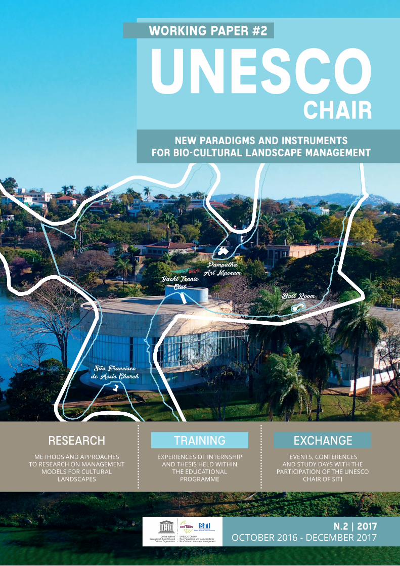
São Francisco de Assis Church
Ball Room
Pampulha Art Museum
Yacht Tennis Club
n.2 | 2017OCTOBER 2016 - DECEMBER 2017
CHAIRUNESCOWORKING PAPER #2
NEW PARADIGMS AND INSTRUMENTS FOR BIO-CULTURAL LANDSCAPE MANAGEMENT
UNESCO Chair inNew Paradigms and Instruments for Bio-Cultural Landscape Management
United NationsEducational, Scientific and
Cultural Organization
METHODS AND APPROACHES TO RESEARCH ON MANAGEMENT
MODELS FOR CULTURAL LANDSCAPES
ResearchEXPERIENCES OF INTERNSHIP
AND THESIS HELD WITHIN THE EDUCATIONAL
PROGRAMME
Training EVENTS, CONFERENCES
AND STUDY DAYS WITH THE PARTICIPATION OF THE UNESCO
CHAIR OF SITI
Exchange
Printed on October 2018
Working paper edited by UNESCO Chair in “New paradigms and instruments for the management of Cultural Landscape” at SiTI - Higher Institute on Territorial Systems for Innovation.
ContactMARCO [email protected] [email protected]
Graphic and DesignSARA [email protected]
Contributes:MONICA ABBIATI | Regione LombardiaSALVATORE AIELLOPATRIZIA BORLIZZIVANESSA BORGES BRASILEIRO | Universidade Federal de Minas Gerais
ELISABETTA CIMNAGHIDAVIDE COLMOANDRÈ GUILHERME DORNELLES | Universidade Federal de Minas GeraisANDREA DI MAGGIOARIANNA DONGIOVANNISTEFANO FRAIREANDREA FUMEROELISA GANDINO | Associazione per il Patrimonio dei Paesaggi Vitivinicoli di Langhe-Roero e MonferratoFRANCESCA MATRONEGIULIO MONDINIANA CLARA MOURÃO | Universidade Federal de Minas GeraisROGERIO PALHARES ARAUJO | Universidade Federal de Minas GeraisMARTINA RAMELLA GALSILVIA SOLDANOLUCA STEFENELLIRAFFAELLA TITTONE | Regione PiemonteMARCO VALLE
ROBERTO CERRATO | Associazione per il Patrimonio dei Paesaggi Vitivinicoli di Langhe-Roero e Monferrato
Picture on the cover: Pampulha Art Museum, by Danilo Magalhães (Universidade Federal de Minas Gerais)
Images from in-house database, Pixabay.com, and Pexels.com
Printed by PixartPrinting.it
editing
n.2 | 2017OCTOBER 2016 - SEPTEMBER 2017
CHAIRUNESCOWORKING PAPER #2
NEW PARADIGMS AND INSTRUMENTS FOR BIO-CULTURAL LANDSCAPE MANAGEMENT
UNESCO Chair inNew Paradigms and Instruments for Bio-Cultural Landscape Management
United NationsEducational, Scientific and
Cultural Organization
5 • unesco chair • q#24 • UNESCO chair • q#2
Working paper #2
INDEXRe
sea
rch
Edu
cat
ion
Exc
ha
ng
e
UNESCO DISTRICT, TORINO
26TH OCTOBER 2016
THE HERITAGE DAY, CASTELNUOVO CALCEA
27TH OCTOBER 2016
UNESCO NATIONAL OBSERVATORY, ROMA
8TH |10TH NOVEMBER 2016
TOURISM FOR EVERYONE, STRESA
16TH DECEMBER 2016
L77/2006: IMPLEMENTATION PROCEDURES, ROMA
7TH FEBRUARY 2017
ARCHITECTURAL RESTORATION SEMINAR, TORINO
9TH FEBRUARY 2017
UNESCO MAB PROGRAMME FOR PROTECTED
AREAS, PAFOS24TH FEBRUARY 2017
WORKSHOP, TORINO
9TH |10TH MARCH 2017
BASIN BIOSPHERE RESERVE, SARLAT
4TH |7TH APRIL 2017
UNESCO CHAIR MEETING, ROMA
23RD MAY 2017
RUINS PROJECT KICK-OFF MEETING, LUBLIN
14TH JUNE 2017
16TH JUNE 2017
THE CARNIVALS IN CAMPANIA AND IN THE SOUTH
ITALY, STUDY DAY, NAPOLI
41ST WHC, KRACOW
2ND |12TH JULIE 2017
COORDINATION GROUP OF UNESCO CHAIRS,
BOLOGNA15TH SEPTEMBER 2017
NATURAL AND CULTURAL HERITAGE
INTERNATIONAL CONFERENCE, CETINJE
25TH SEPTEMBER 2017
MEETING WITH THE UNESCO SITES OF THE
LOMBARDY REGION, BERGAMO
3RD OCTOBER 2017
NATIONAL MEETING LAND(E)SCAPE THE DISABILITIES,
NIZZA MONFERRATO19TH OCTOBER 2017
CONFERENCE, VALLE CAMONICA
26TH |27TH OCTOBER 2017
L77/2006, TOURISM AND UNESCO SITES, ROMA
6TH NOVEMBER 2017
WELCOME UNESCO WHL: VENETIAN WORK OF
DEFENCE, BERGAMO14TH NOVEMBER 2017
WORKSHOP OF MANAGEMENT OF CULTURAL
LANDSCAPE, BELO HORIZONTE
4TH |6TH DECEMBER 2017
34 UNESCO AS A MODEL FOR MANAGING COMPLEX SYSTEMS OF CULTURAL HERITAGE
edited by M. VALLE
From management to governance
42 WORLD HERITAGE PROPERTIES IN LOMBARDY
edited by M. ABBIATI, S. SOLDANOGovernance and management systems
18edited by V. BORGES BRASILEIRO, A. DANGELO
Structuring elements for a management plan methodology
AESTHETIC CONSTRUCTION OF THE CULTURAL LANDSCAPE
12
edited by A.C.M. MOURÃO
Support to decision-making process based on characterization, management and studies of alternative futures
GEOPROCESSING TECHNOLOGIES FOR CULTURAL LANDSCAPE MANAGEMENT
06edited by P. BORLIZZI, M. VALLE
The exchange with Universidade Federal de Minas Gerais in Belo Horizonte, Brazil
NETWORKING AND SHARING EXPERIENCES
26 THE PAMPULHA MODERN ENSEMBLE CASE
edited by R. PALHARES ARAUJO
The Management Plan as an integrating strategy for heritage protection actions
52 LAND(E)SCAPE THE DISABILITIES
edited by R. CERRATO, E. GANDINO
A project to improve accessibility for all
66 TOURISM CARRYING CAPACITY
edited by E. CIMNAGHI, F. BRUNO
A tool to manage tourism in Italian Cultural Heritage sites
80 ECRR: EUROPEAN CULTURAL ROUTES OF REFORMATION
edited by P. BORLIZZI
A project to establish a Reformation-themed Cultural Route recognized by CoE
74 THE SUSTAINABILITY REPORT OF THE RESERVE MAB“COLLINAPO”
edited by S. FRAIRE, A. FUMERO, D. COLMO
A tool to identify the economic, environmental and social impacts of the MaB Reserve
58 STRATEGIC PLANNING FOR DESTINATIONS DEVELOPMENT IN ALBANIA
edited by A. DONGIOVANNI, A. DI MAGGIOEcoturism in Tushemisht and Drilon Region
86 TRAINING COURSE FOR EMPLOYEES OF THE PIEDMONT REGION
90 THESIS AND INTERNSHIP IN THE UNESCO CHAIR PROGRAM
102 UNESCO CHAIR EVENTS
O4 edited by G. MONDINI, M. VALLE
OUR 2017 IN A NUTSHELL
7 • unesco chair • q#26•unesco chair•q#2
hose in the right are some of the starting points on which the working group engaged in the activities of the UNESCO
Chair in “New Paradigms and Instruments for the Management of Bio-Cultural Landscape” reflected during the second year of activity.
Some are ideas of colleagues we met; others are sparks given by great architects of the past whose work we had the opportunity and the chance to meet during 2017.
To create knowledge from experiences, that is what in the Chair we call “exchanges”, was the main activity in the second year of our experience as UNESCO Chair. Two seminars that we organized with the Federal University of Minas Gerais in Torino and Belo Horizonte in March and December were the pillar of the development of our works.
At the same time, we began different research projects that can help us to understand what can be the new models of governance for complex heritage sites and how those complexities can be integrated in a UNESCO District. We have worked in Piedmont and Lombardy with the ambition to help to fulfil some intentions that often have stayed only on paper; we organized a training course for the employers of public administration with a goal of explaining UNESCO lists and programs, and why they create an opportunity for the territory. Different stages, degree thesis, and dissertations have been developed within this issue.
We talk about all of this in our second volume describing the work we did during the year that was for SiTI a year of transition. To talk about results first of all means to talk about those persons that have worked for this project, that have developed
researches also if sometimes they have had difficulties or no clear guidance.
We believe so that addressing the outside, often outside Italy, directing research starting from real needs - are those of the favelas of Ouro Preto, rather than the difficulties of accessibility of cultural heritage between the vineyards of the Langhe or of the communities living on the Ocrid Lake - it was a wise choice. If the UNESCO Chairs must be antennas, concrete occasions for reflection on the institutions and territories, in 2017 it was more productive to listen than to speak.
That is why we want to share some of our interventions with those who in 2017 have been not only our “customers” but precious partners of our researching activities.
We believe 2018 may be the year in which the skills of SiTI - Higher Institute on Territorial Systems for Innovation, will become a Foundation called LINKS - Leading Innovation and Knowledge for the Society. With the hope for everyone that it would be an opportunity to explore the links between technological innovation and conservation of heritage, to create new links with other UNESCO Chairs (moving towards the UNITWIN network) and, above all to, continue to create links between people.
The natural environment could not therefore be omitted from programme of the ECoC, since the environment in man’s living space for survive, spiritual development and creation; all integral parts of the concept of civilization in a perpetual and dynamic relationship.Akamas Project, PAFOS 2017, European Capital of Culture.
There are some great artworks, some churches, some buildings that now are used in different ways; they still exist also if their functions were changed. We use them today, we frequent them. It happens because the only thing that remains is not usefulness but beauty; beauty and poetry that survive all the time.Oscar Niemeyer, Brazilian architect (Il mondo è ingiusto, Milano, 2012).
On the one hand sustainable development seems to be an inevitable necessity, on the other hand there are theoretical and practical difficulties that show its limits and paradoxes. […]. So, the transformation not only of the world view but also of culturally and socially “crystallized” behaviours. Dario Padoan, Chairholder of UNESCO Chair in Sustainable Development and Territory Management, Università di Torino.
T
OU
R 2
017
IN A
NU
TSH
ELL
New
pa
ra
dig
ms
an
d in
stru
men
ts f
or m
an
agem
ent
Edited by Giulio mondini, marco valleO
f Bi
o-C
ult
ura
l La
nd
sca
pe
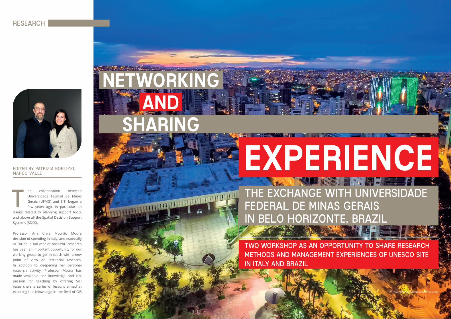
he collaboration between Universidade Federal de Minas Gerais (UFMG) and SiTI began a few years ago, in particular on
issues related to planning support tools, and above all the Spatial Decision Support Systems (SDSS).
Professor Ana Clara Mourão Moura decision of spending in Italy, and especially in Torino, a full year of post-PhD research has been an important opportunity for our working group to get in touch with a new point of view on territorial research. In addition to deepening her personal research activity, Professor Moura has made available her knowledge and her passion for teaching by offering SiTI researchers a series of lessons aimed at exposing her knowledge in the field of GIS
Edited by Patrizia Borlizzi, marco valle
T
NETWORKINGAND
SHARING
EXPERIENCETHE EXCHANGE WITH UNIVERSIDADEFEDERAL DE MINAS GERAIS IN BELO HORIZONTE, BRAZIL
©Universidade Federal de Minas Gerais
Research
Two workshop as an opportunity to share research methods and management experiences of UNESCO site in Italy and Brazil
10 • unesco chair • q#2 11 • unesco chair • q#2
mapping systems of phenomena on a territorial scale, the so-called “geoprocessing”. During this training cycle, Ana Clara Moura showed the state of the art of her research in some areas of Belo Horizonte province, providing an overview of possible applications in many fields (preliminary studies for mining areas reclaim, feasibility studies for new urban sprawls,...) and of the outcomes that can be visualized and mapped. Moreover, Professor Moura has experimented with possible applications in the Piedmont area, and in particular on the UNESCO site of Langhe, Roero and Monferrato. In this same period, the students of the School of Specialization in Cultural Heritage and Landscape of the Politecnico di Torino were also involved and were able to attend a lecture by Professor Moura.
The experience of the UFMG and Ana Clara herself in the UNESCO sites of Pampulha and Ouro Preto - both in the province of Minas Gerais - as well as her contacts with colleagues from the Federal University who were also in Europe for carry out their post-PhD stages, suggested to the UNESCO Chair group the idea of a possible cooperation.
In this context, we arise the idea of deepening, through a double workshop to be held in Italy and in Brazil, the approach to the management of the cultural, urban and bio-cultural landscape, comparing ideas, projects and experiences from the two parts of the world.
The two days workshop was conceived to allow the members of the working group to know each other, to present their own point of view on the research topic and to get to know the UNESCO site of the “Vineyard Landscape of Piedmont: Langhe-Roero and Monferrato”.
The meeting on March 9th was dedicated to a round table that involved some professors of the School of Architecture of the UFMG and the Politecnico di Torino, the SiTI UNESCO Chair research group, some officials of the administrative local institution (Piedmont Region) and the managing body of the Piedmontese UNESCO site. The workshop focused essentially on the management and monitoring of cultural landscapes, with particular attention to those territories recognized as UNESCO sites. The interventions have dealt with the role of the Management Plan for the sites included in the World Heritage List (WHL) and its relations with the binding planning tools at regional and national level. Particularly appreciated was the contribution of the Piedmont Region, which proposed an in-depth analysis of regional government instruments, in particular the Landscape Plan, focusing on the process of defining the areas under protection, and on strategic programs identified in it. Furthermore, the work carried out within the definition of the guidelines for the adaptation of the regulatory plans and the building regulations to the indications of protection for the UNESCO site was illustrated.
An important part of the conference focused on the theme of monitoring, seen as the complex evaluation system through appropriate indicators of the transformations taking place on the landscape and its implications on the Outstanding Universal Value (OUV) of the site and its conservation.
Finally, a study about economic, social, environmental and cultural impacts of UNESCO recognition has been addressed, focusing on the research activities developed by SiTI.
The second day, March 10th, was entirely dedicated to seeing the site of Langhe, Roero and Monferrato, and to the meeting with some of the main stakeholders in the area.
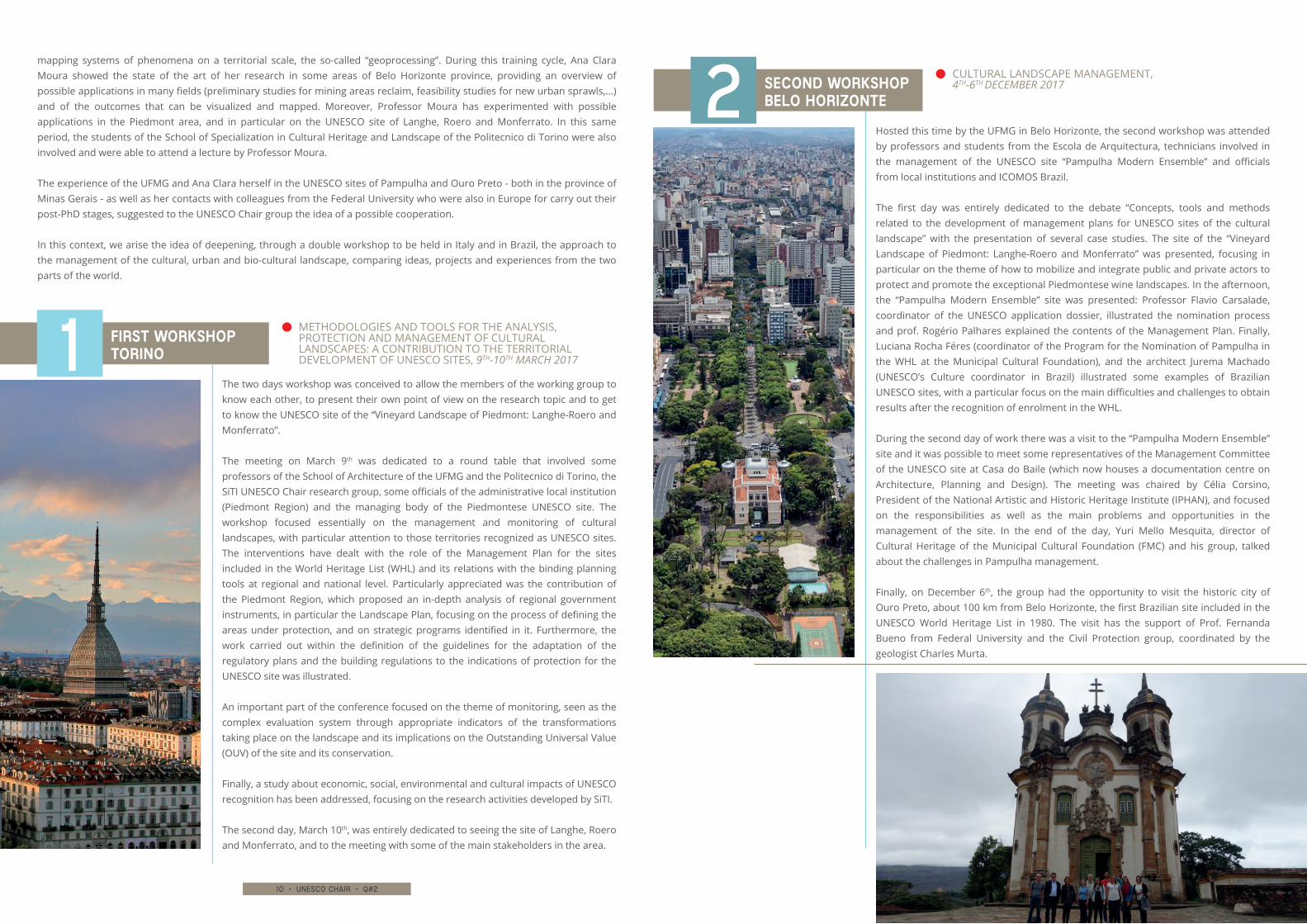
Hosted this time by the UFMG in Belo Horizonte, the second workshop was attended by professors and students from the Escola de Arquitectura, technicians involved in the management of the UNESCO site “Pampulha Modern Ensemble” and officials from local institutions and ICOMOS Brazil.
The first day was entirely dedicated to the debate “Concepts, tools and methods related to the development of management plans for UNESCO sites of the cultural landscape” with the presentation of several case studies. The site of the “Vineyard Landscape of Piedmont: Langhe-Roero and Monferrato” was presented, focusing in particular on the theme of how to mobilize and integrate public and private actors to protect and promote the exceptional Piedmontese wine landscapes. In the afternoon, the “Pampulha Modern Ensemble” site was presented: Professor Flavio Carsalade, coordinator of the UNESCO application dossier, illustrated the nomination process and prof. Rogério Palhares explained the contents of the Management Plan. Finally, Luciana Rocha Féres (coordinator of the Program for the Nomination of Pampulha in the WHL at the Municipal Cultural Foundation), and the architect Jurema Machado (UNESCO’s Culture coordinator in Brazil) illustrated some examples of Brazilian UNESCO sites, with a particular focus on the main difficulties and challenges to obtain results after the recognition of enrolment in the WHL.
During the second day of work there was a visit to the “Pampulha Modern Ensemble” site and it was possible to meet some representatives of the Management Committee of the UNESCO site at Casa do Baile (which now houses a documentation centre on Architecture, Planning and Design). The meeting was chaired by Célia Corsino, President of the National Artistic and Historic Heritage Institute (IPHAN), and focused on the responsibilities as well as the main problems and opportunities in the management of the site. In the end of the day, Yuri Mello Mesquita, director of Cultural Heritage of the Municipal Cultural Foundation (FMC) and his group, talked about the challenges in Pampulha management.
Finally, on December 6th, the group had the opportunity to visit the historic city of Ouro Preto, about 100 km from Belo Horizonte, the first Brazilian site included in the UNESCO World Heritage List in 1980. The visit has the support of Prof. Fernanda Bueno from Federal University and the Civil Protection group, coordinated by the geologist Charles Murta.
FIRST WORKSHOPTORINO
SECOND WORKSHOPBELO HORIZONTE
1
2
METHODOLOGIES AND TOOLS FOR THE ANALYSIS, PROTECTION AND MANAGEMENT OF CULTURAL LANDSCAPES: A CONTRIBUTION TO THE TERRITORIAL DEVELOPMENT OF UNESCO SITES, 9TH-10TH MARCH 2017
CULTURAL LANDSCAPE MANAGEMENT,4TH-6TH DECEMBER 2017
12 • unesco chair • q#2 13 • unesco chair • q#2
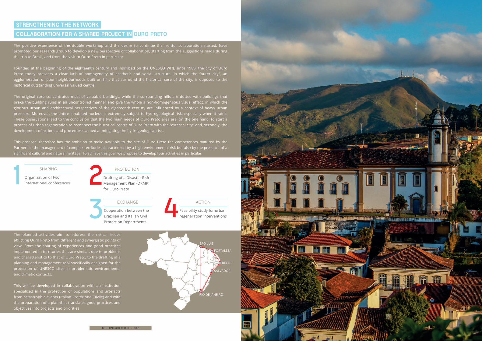
The positive experience of the double workshop and the desire to continue the fruitful collaboration started, have prompted our research group to develop a new perspective of collaboration, starting from the suggestions made during the trip to Brazil, and from the visit to Ouro Preto in particular.
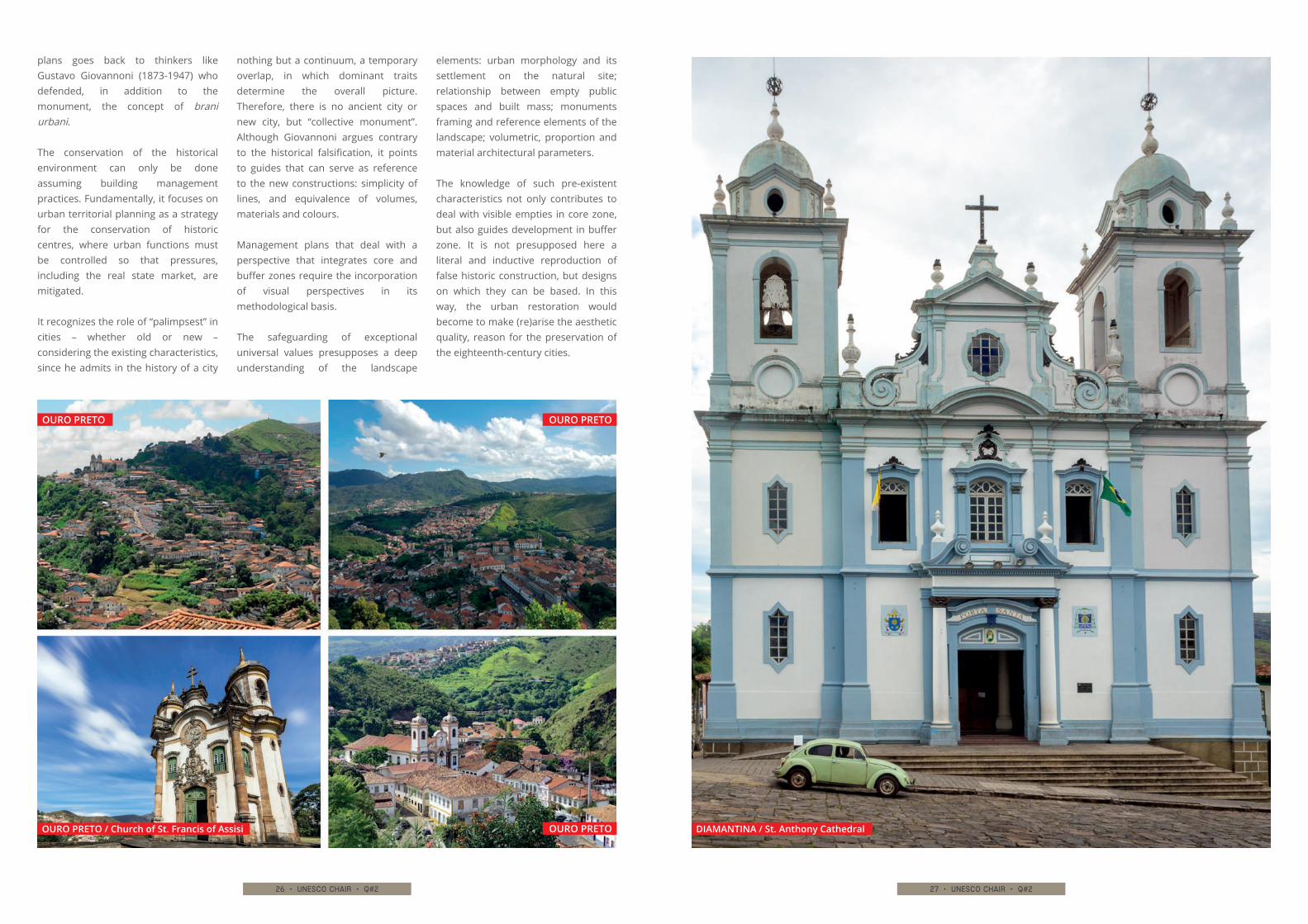
Founded at the beginning of the eighteenth century and inscribed on the UNESCO WHL since 1980, the city of Ouro Preto today presents a clear lack of homogeneity of aesthetic and social structure, in which the “outer city”, an agglomeration of poor neighbourhoods built on hills that surround the historical core of the city, is opposed to the historical outstanding universal valued centre.
The original core concentrates most of valuable buildings, while the surrounding hills are dotted with buildings that brake the building rules in an uncontrolled manner and give the whole a non-homogeneous visual effect, in which the glorious urban and architectural perspectives of the eighteenth century are influenced by a context of heavy urban pressure. Moreover, the entire inhabited nucleus is extremely subject to hydrogeological risk, especially when it rains. These observations lead to the conclusion that the two main needs of Ouro Preto area are, on the one hand, to start a process of urban regeneration to reconnect the historical centre of Ouro Preto with the “external city” and, secondly, the development of actions and procedures aimed at mitigating the hydrogeological risk.
This proposal therefore has the ambition to make available to the site of Ouro Preto the competences matured by the Partners in the management of complex territories characterized by a high environmental risk but also by the presence of a significant cultural and natural heritage. To achieve this goal, we propose to develop four activities in particular:
The planned activities aim to address the critical issues afflicting Ouro Preto from different and synergistic points of view. From the sharing of experiences and good practices implemented in territories that are similar, due to problems and characteristics to that of Ouro Preto, to the drafting of a planning and management tool specifically designed for the protection of UNESCO sites in problematic environmental and climatic contexts.
This will be developed in collaboration with an institution specialized in the protection of populations and artefacts from catastrophic events (Italian Protezione Ciivile) and with the preparation of a plan that translates good practices and objectives into projects and priorities.
STRENGTHENING THE NETWORK
COLLABORATION FOR A SHARED PROJECT IN OURO PRETO
Drafting of a Disaster Risk Management Plan (DRMP) for Ouro Preto
PROTECTION
Feasibility study for urban regeneration interventions
ACTION
Organization of two international conferences
SHARING
Cooperation between the Brazilian and Italian Civil Protection Departments
EXCHANGE
RIO DE JANEIRO
SALVADOR
RECIFE
FORTALEZA
SAO LUIS
14 • unesco chair • q#2 15 • unesco chair • q#2
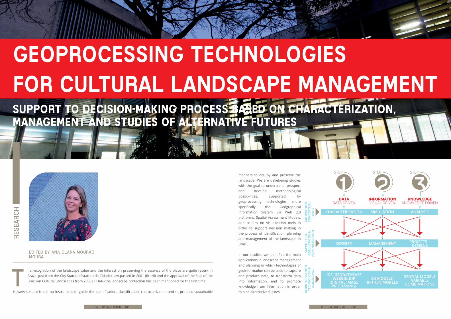
manners to occupy and preserve the landscape. We are developing studies with the goal to understand, prospect and develop methodological possibilities, supported by geoprocessing technologies, more specifically the Geographical Information System via Web 2.0 platforms, Spatial Assessment Models, and studies on visualization tools in order to support decision making in the process of identification, planning and management of the landscape in Brazil.
In our studies, we identified the main applications in landscape management and planning in which technologies of geoinformation can be used to capture and produce data, to transform data into information, and to promote knowledge from information in order to plan alternative futures.
he recognition of the landscape value and the interest on preserving the essence of the place are quite recent in Brazil. Just from the City Statute (Estatuto da Cidade), law passed in 2001 (Brazil) and the approval of the Seal of the Brazilian Cultural Landscapes from 2009 (IPHAN) the landscape protection has been mentioned for the first time.
However, there is still no instrument to guide the identification, classification, characterization and to propose sustainable
Edited by Ana Clara Mourão Moura
T
Rese
arc
h
GEOPROCESSING TECHNOLOGIES FOR CULTURAL LANDSCAPE MANAGEMENTSUPPORT TO DECISION-MAKING PROCESS BASED ON CHARACTERIZATION, MANAGEMENT AND STUDIES OF ALTERNATIVE FUTURES
STEP
DATA
MO
TIVA
TIO
NCO
NCE
PTU
AL
BASI
S
SUPP
ORT
TO
RE
GU
LATI
ON
S &
A
DM
INIS
TRA
TIO
N
GEO
INFO
RMAT
ION
TE
CHN
OLO
GY
&
MO
DEL
LIN
G
DATA DRIVEN
CHARACTERIZATION
DOSSIER
GIS, GEODATABASEWEBGIS, DIP
(DIGITAL IMAGE PROCESSING)
SIMULATION
MANAGEMENT
3D MODELS, IF-THEN MODELS
ANALYSIS
PROJECTS | DESIGNS
SPATIAL MODELSVARIABLE
COMBINATIONS
STEP
INFORMATIONVISUAL DRIVEN
STEP
KNOWLEDGEKNOWLEDGE DRIVEN
16 • unesco chair • q#2 17 • unesco chair • q#2
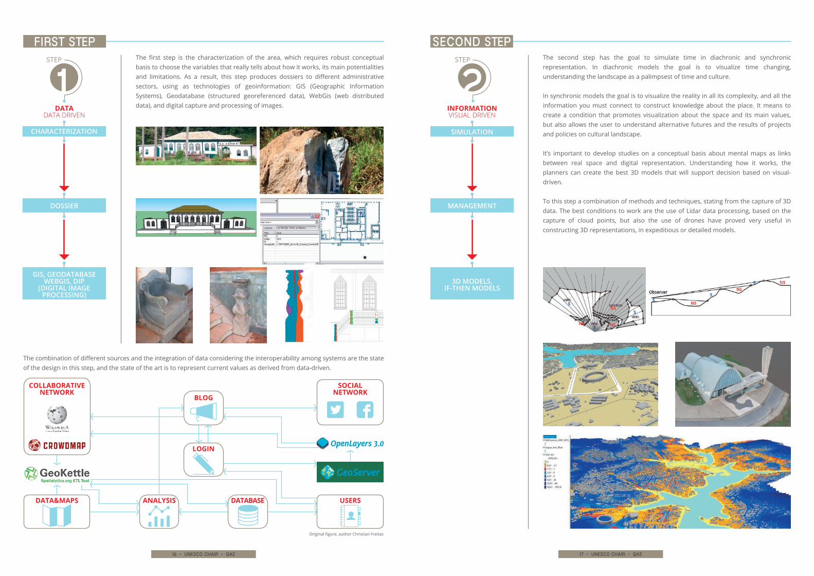
The second step has the goal to simulate time in diachronic and synchronic representation. In diachronic models the goal is to visualize time changing, understanding the landscape as a palimpsest of time and culture.
In synchronic models the goal is to visualize the reality in all its complexity, and all the information you must connect to construct knowledge about the place. It means to create a condition that promotes visualization about the space and its main values, but also allows the user to understand alternative futures and the results of projects and policies on cultural landscape.
It’s important to develop studies on a conceptual basis about mental maps as links between real space and digital representation. Understanding how it works, the planners can create the best 3D models that will support decision based on visual-driven.
To this step a combination of methods and techniques, stating from the capture of 3D data. The best conditions to work are the use of Lidar data processing, based on the capture of cloud points, but also the use of drones have proved very useful in constructing 3D representations, in expeditious or detailed models.
The first step is the characterization of the area, which requires robust conceptual basis to choose the variables that really tells about how it works, its main potentialities and limitations. As a result, this step produces dossiers to different administrative sectors, using as technologies of geoinformation: GIS (Geographic Information Systems), Geodatabase (structured georeferenced data), WebGis (web distributed data), and digital capture and processing of images.
First step SECOND step
The combination of different sources and the integration of data considering the interoperability among systems are the state of the design in this step, and the state of the art is to represent current values as derived from data-driven.
Original figure, author Christian Freitas
STEP
DATA
COLLABORATIVE NETWORK
SOCIAL NETWORK
DATA DRIVEN
CHARACTERIZATION
GIS, GEODATABASEWEBGIS, DIP
(DIGITAL IMAGE PROCESSING)
DOSSIER
SIMULATION
3D MODELS, IF-THEN MODELS
STEP
INFORMATIONVISUAL DRIVEN
MANAGEMENT
BLOG
LOGIN
DATABASEANALYSIS USERSDATA&MAPS
18 • unesco chair • q#2 19 • unesco chair • q#2
It shall be highlighted that geoprocessing technologies based on spatial analysis aims, allow participation of the different actors in opinion-making and decision-making process. In order to make the decisions, it is required firstly to know the main characteristics of the land of study, the related dynamics and the needs. Once the problem is known, the group of different representatives of society take part in the experiences of preparing proposals, based on policies and projects.
The impacts of proposals are calculated and analysed according to the limits of acceptable carrying capacity for the land transformation. The expectation is to promote a co-design of the common landscape, as results of the maximization of common consensus, baring in mind that there is no absolute consensus, but it is possible to manage a collective decision.
The main characteristics of the methodology based on geoprocessing techniques are interoperability, collective revisions and shared decisions. It is a requirement that the actors involved understand the process, which justifies investments in clear visualization of the information to support the decisions. The steps are based on data-driven, visual-driven and knowledge-driven as support for opinion and decision making. The goal is to make people understand and take part of the planning, understanding landscape as a cultural value, and constructing a common future.
Geoprocessing technologies are used to make the co-design of a place possible, that is the co-creation of alternative futures, based on shared decisions. These shared decisions require the use of a common
language, which requires the search for protocols.
The protocols are important for the interface between people, but also for the interface between machines, human and digital interfaces. Regarding the interface between people, it is related as the construction of strong connections through reality (the landscape – “what it is”), mental maps (the way people think about the landscape – “tell me about it”) and the representation of reality, especially the digital models (as simplifications of reality – “possible different representations according to different points of view”).
The stronger these connections are, the better the models will represent reality and will give support to projects and policies. Machines interface, computers and network between computers, using local networks or the cloud, are possible due to interoperability. Interoperability is the condition to make all the parts dealing with each other, in connected and integrated chain.
This is the present and the future on geoprocessing applied to cultural landscape management and planning.
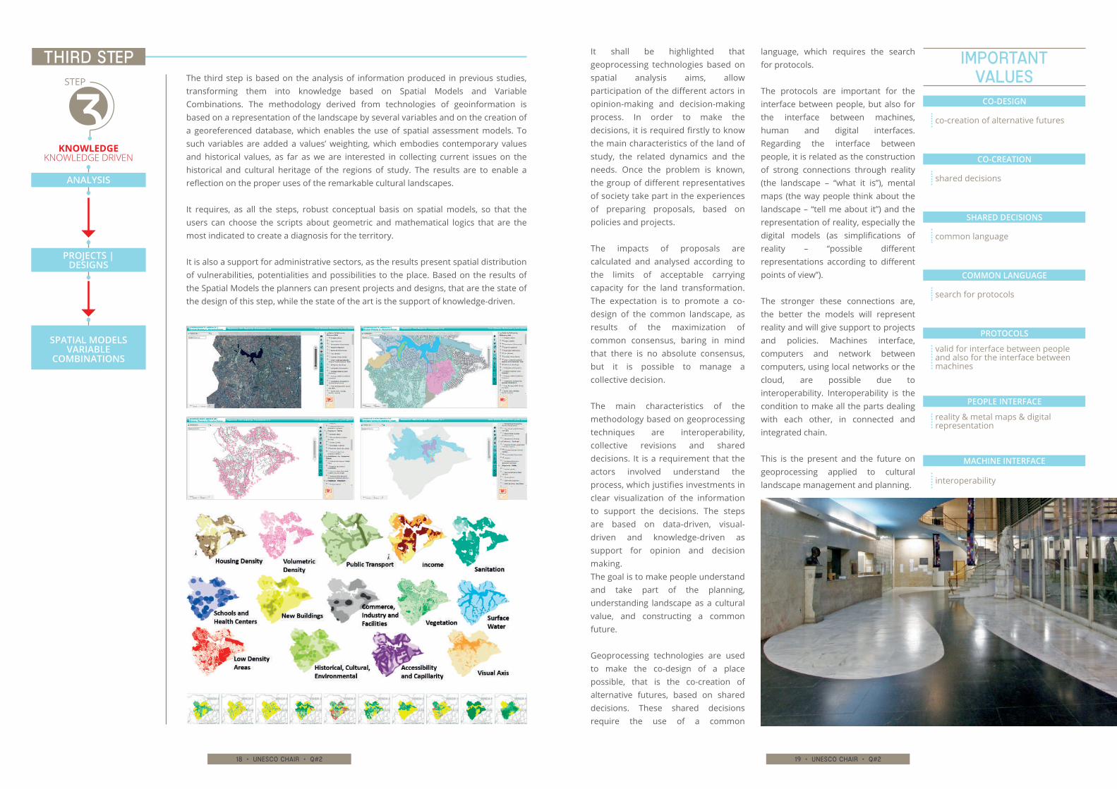
The third step is based on the analysis of information produced in previous studies, transforming them into knowledge based on Spatial Models and Variable Combinations. The methodology derived from technologies of geoinformation is based on a representation of the landscape by several variables and on the creation of a georeferenced database, which enables the use of spatial assessment models. To such variables are added a values’ weighting, which embodies contemporary values and historical values, as far as we are interested in collecting current issues on the historical and cultural heritage of the regions of study. The results are to enable a reflection on the proper uses of the remarkable cultural landscapes.
It requires, as all the steps, robust conceptual basis on spatial models, so that the users can choose the scripts about geometric and mathematical logics that are the most indicated to create a diagnosis for the territory.
It is also a support for administrative sectors, as the results present spatial distribution of vulnerabilities, potentialities and possibilities to the place. Based on the results of the Spatial Models the planners can present projects and designs, that are the state of the design of this step, while the state of the art is the support of knowledge-driven.
THIRD step
ANALYSIS
PROJECTS | DESIGNS
SPATIAL MODELSVARIABLE
COMBINATIONS
STEP
KNOWLEDGEKNOWLEDGE DRIVEN
CO-DESIGN
co-creation of alternative futures
CO-CREATION
shared decisions
SHARED DECISIONS
common language
COMMON LANGUAGE
search for protocols
PROTOCOLS
valid for interface between people and also for the interface between machines
PEOPLE INTERFACE
reality & metal maps & digital representation
MACHINE INTERFACE
interoperability
Important values
20 • unesco chair • q#2 21 • unesco chair • q#2
AESTHETIC
STRUCTURING ELEMENTS FOR A MANAGEMENT PLAN METHODOLOGY
CONSTRUCTION OF THE CULTURAL LANDSCAPE he purpose of this essay goes beyond a brief
historiography about the process of preservation in Brazil over almost 80 years, focusing on the cities of Minas Gerais listed in 1938. It is intended to think over
the need of establishing management plans based on the cultural landscape concept and its elements, always considering an aesthetic point of view.
The hypotheses that guide our concerns are:1. An institutionalized vision has been consolidated, supported by
IPHAN’s action, with no physical or territorial application by local public bodies.
2. There is a lack of a methodology for understanding/reading local characteristics that demonstrate the structuring landscape elements as a basis for preservation plans.
3. Local urban plans do not lead to a balanced relationship between permanence and urban development, being promoters of sequential transformations.
4. A new theoretical-conceptual guidance becomes a requirement, in order to include an aesthetic perspective in the management plans, allowing to establish a new paradigm for the preservation.
edited by Vanessa BORGES BRASILEIRO, Andrè dangelo
T
Research
22 • unesco chair • q#2 23 • unesco chair • q#2
a dangerous process of material damage of the heritage that was initially targeted for preservation.
Since the decision of the Advisory Board is based on technical dossiers, there can be no judgment on the merits of classifying. This mechanism has discouraged the debate on the nature of cultural assets and has contributed to establish the autocratic image exercised by the institution’s technicians. It should be noted that, in those days, the country faced significant political instability, which culminated in a coup d’état few days
after the publication of the classifying enactment. It is no coincidence that the political regime and the institutionalization of protection are characterized by the autocratic way of dealing with the issue, contributing to a little participative and quite punitive perspective that has been consolidated over the years.
This confirms our first hypothesis: the practice of conservation in Brazil, at its
origins, was based on an institutionalized vision, supported exclusively by IPHAN’s action. Only in
the 1970s the provinces have begun to organize regional institutes, always under the same model. The overlapping of institutional technical knowledge has delayed the participation of communities in the process of preserving their heritage, rendering weak the application of conservation principles (defined by federal and state entities) in the physical-territorial realm. In other words, with rare exceptions, the municipalities did not structure their laws in order to co-operate with the preservation of their patrimony.
The enactment is based on the exceptionality of the patrimony, whether by its historical or artistic character. This principle has established a hierarchy, protecting only those examples that matched the monumental perspective, submitting simpler objects to a second category
condition. As a consequence, much of the authentic samples, present in smaller communities was ruined, replaced by new architecture of questionable quality, or even demolished.
This situation has also contributed to
establish an image of heritage as a mirror of upper class culture, an expression that has been used in recent decades. Strictly speaking, this would not be a problem, but rather a natural consequence of democracy; however, there is a predisposition to displace “what” to preserve, leading to
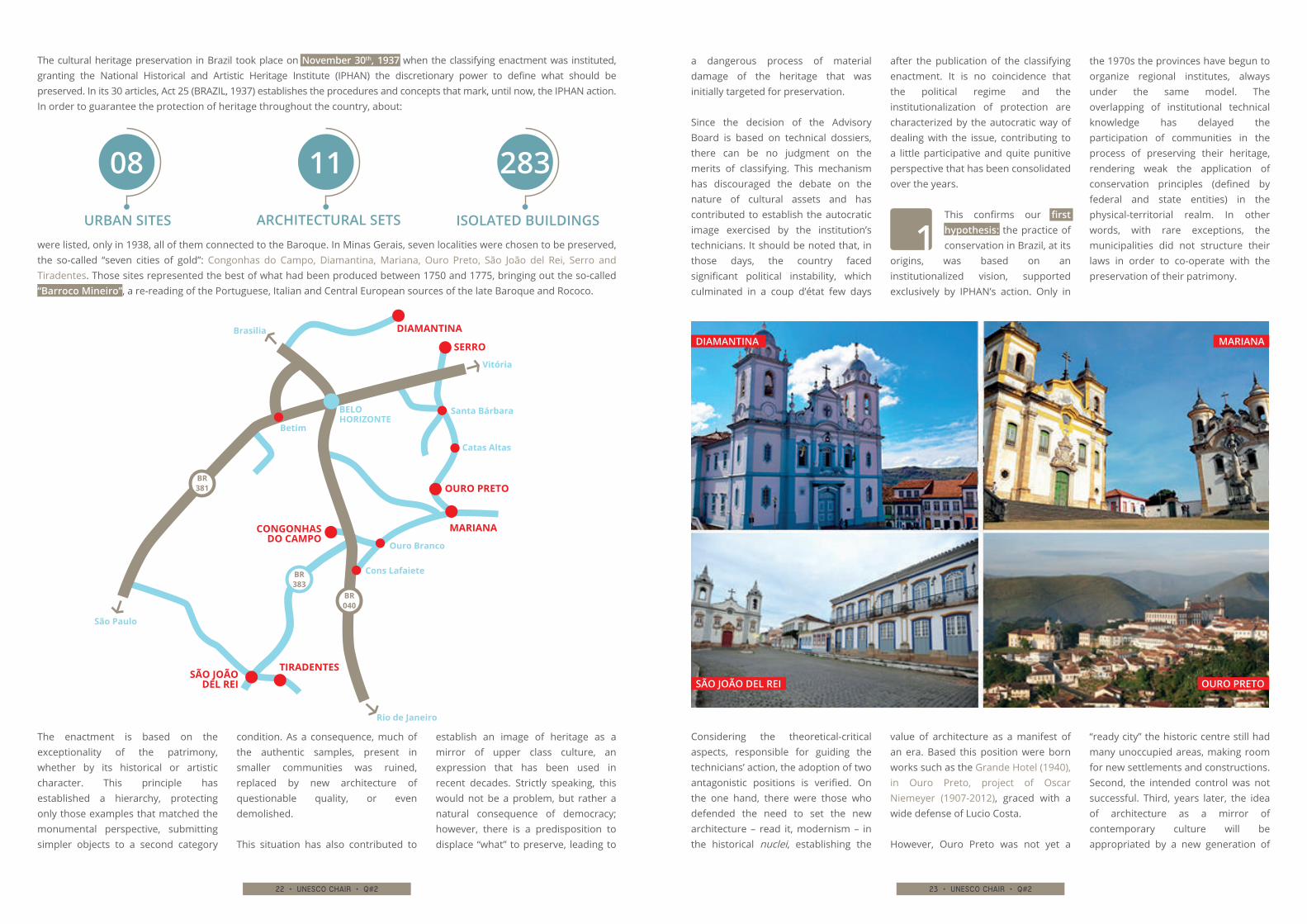
The cultural heritage preservation in Brazil took place on November 30th, 1937 when the classifying enactment was instituted, granting the National Historical and Artistic Heritage Institute (IPHAN) the discretionary power to define what should be preserved. In its 30 articles, Act 25 (BRAZIL, 1937) establishes the procedures and concepts that mark, until now, the IPHAN action. In order to guarantee the protection of heritage throughout the country, about:
were listed, only in 1938, all of them connected to the Baroque. In Minas Gerais, seven localities were chosen to be preserved, the so-called “seven cities of gold”: Congonhas do Campo, Diamantina, Mariana, Ouro Preto, São João del Rei, Serro and Tiradentes. Those sites represented the best of what had been produced between 1750 and 1775, bringing out the so-called “Barroco Mineiro”, a re-reading of the Portuguese, Italian and Central European sources of the late Baroque and Rococo.
URBAN SITES
08
ARCHITECTURAL SETS
11
ISOLATED BUILDINGS
283
MARIANA
OURO PRETO
DIAMANTINA
SÃO JOÃO DEL REI
Considering the theoretical-critical aspects, responsible for guiding the technicians’ action, the adoption of two antagonistic positions is verified. On the one hand, there were those who defended the need to set the new architecture – read it, modernism – in the historical nuclei, establishing the
value of architecture as a manifest of an era. Based this position were born works such as the Grande Hotel (1940), in Ouro Preto, project of Oscar Niemeyer (1907-2012), graced with a wide defense of Lucio Costa.
However, Ouro Preto was not yet a
“ready city” the historic centre still had many unoccupied areas, making room for new settlements and constructions. Second, the intended control was not successful. Third, years later, the idea of architecture as a mirror of contemporary culture will be appropriated by a new generation of
MARIANA
BELO HORIZONTE
Catas Altas
Betim
Santa Bárbara
Ouro Branco
Cons Lafaiete
Rio de Janeiro
Vitória
São Paulo
Brasilia
TIRADENTESSÃO JOÃO
DEL REI
OURO PRETO
DIAMANTINA
SERRO
CONGONHAS DO CAMPO
BR 381
BR 040
BR 383
24 • unesco chair • q#2 25 • unesco chair • q#2
TYPOLOGY OF SETTLEMENTS
URBAN MORPHOLOGY
REFERENCE POINTS
BUILT ENVIRONMENT
technicians who, without the intellectual and projective brilliance of Costa and Niemeyer, will stand up for it. The “monument-city” of the pioneers becomes the “document-city” (SANT’ANNA, 2015), where each object in space is worthy of preservation since it is a registration of a culture – regardless of its aesthetic quality or positive integration with preexistence.On the other hand, once again under the effects of a weak theoretical-critical thinking, technicians developed, from the 1960s on, a dangerous affection for the new construction “in style.”
In the last twenty years, Brazilian federal government has financially supported several programs for the preservation of listed sites: Urbis, Monumenta, PACH are examples that federal resources have been directed towards safeguarding the national patrimony. However, those programs have not achieved the intended effects for the preservation of environmental quality. Rather, they focused their attention on the monuments, promoting the necessary restoration in many of them, but obliterating the researches on landscape.
Finally, it is noticed an unilateral adoption of Brandi’s theory by IPHAN technicians, heirs of the modernists. The concepts elaborated by Cesare Brandi distinguish, but clearly associate, the aesthetic instance and historical instance in the recognition of the work of art – which, at first, presupposes that it is a unique object.
However, this tenuous but necessary balance has not been incorporated, and architecture as a manifest of an era became hegemonic. After the process of redemocratization in the 1980s, the historical aspect gains breath and surpasses the aesthetic instance. More affectionate to the Marxist view, which considered the preservation hitherto undertaken as
authoritarian and elitist acts, and condemned styles as evils of the world, concepts such as “document-city”, mentioned above, could arise as an integral part of this new posture.
The second hypothesis of our discussion is though demonstrated: the action
of the preservation institutes lacks the basis for an understanding methodology/reading of the local characteristics that shows the structuring elements of the landscape:
as a basis for management plans.
We can consider the portrait of heritage preservation in Brazil as very recent; as a consequence, the technical, methodological and, above all, theoretical conditions for the conservation and preservation of listed sites have not been sufficiently consolidated.
Although the classifying enactment has reached the maintenance of the built settlement, it proved insufficient to deal with the urban growth and densification imposed by the development mentality implemented from 1950s on. In other words, the surrounding landscape became an agglomerate deprived of quality, proving to be precarious for the constitution of a qualified buffer zone.
This situation is magnified if we consider that local urban policies have not cooperated to preserve neither the legally protected site nor the quality of the landscape. Instead, they have
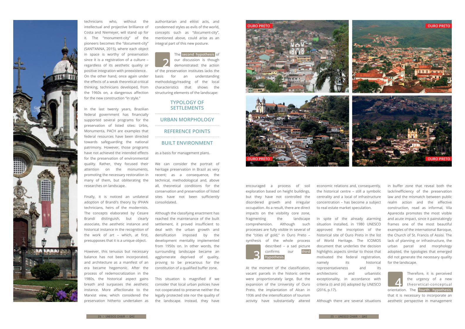
encouraged a process of soil exploration based on height buildings, but they have not controlled the disordered growth and irregular occupation. As a result, there are direct impacts on the visibility core zone, fragmenting the landscape comprehension. Although such processes are fully visible in several of the “cities of gold,” in Ouro Preto – synthesis of the whole process
described – a sad picture confirms our third hypothesis.
At the moment of the classification, vacant parcels in the historic centre were proportionately large. But the expansion of the University of Ouro Preto, the implantation of Alcan in 1936 and the intensification of tourism activity have substantially altered
economic relations and, consequently, the historical centre – still a symbolic centrality and a local of infrastructure concentration – has become a subject to real estate market speculation.
In spite of the already alarming situation installed, in 1980 UNESCO approved the inscription of the historical site of Ouro Preto in the list of World Heritage. The ICOMOS document that underlies the decision highlights aspects similar to those that motivated the federal registration, namely its historical representativeness and its architectonic and urbanistic exceptionality, in accordance with criteria (i) and (iii) adopted by UNESCO (2016, p.17).
Although there are several situations
in buffer zone that reveal both the lack/inefficiency of the preservation law and the mismatch between public realm action and the effective construction, read as informal, Vila Aparecida promotes the most visible and acute impact, since it painstakingly frames one of the most beautiful examples of the international Baroque, the Church of St. Francis of Assisi. The lack of planning or infrastructure, the urban parcel and morphology adopted, the typologies that emerged did not generate the necessary quality for the landscape.
Therefore, it is perceived the urgency of a new theoret ical -conceptual
orientation. The fourth hypothesis, that it is necessary to incorporate an aesthetic perspective in management
OURO PRETO
OURO PRETO
OURO PRETO
OURO PRETO
26 • unesco chair • q#2 27 • unesco chair • q#2
OURO PRETO / Church of St. Francis of Assisi
plans goes back to thinkers like Gustavo Giovannoni (1873-1947) who defended, in addition to the monument, the concept of brani urbani.
The conservation of the historical environment can only be done assuming building management practices. Fundamentally, it focuses on urban territorial planning as a strategy for the conservation of historic centres, where urban functions must be controlled so that pressures, including the real state market, are mitigated.
It recognizes the role of “palimpsest” in cities – whether old or new – considering the existing characteristics, since he admits in the history of a city
nothing but a continuum, a temporary overlap, in which dominant traits determine the overall picture. Therefore, there is no ancient city or new city, but “collective monument”. Although Giovannoni argues contrary to the historical falsification, it points to guides that can serve as reference to the new constructions: simplicity of lines, and equivalence of volumes, materials and colours.
Management plans that deal with a perspective that integrates core and buffer zones require the incorporation of visual perspectives in its methodological basis.
The safeguarding of exceptional universal values presupposes a deep understanding of the landscape
elements: urban morphology and its settlement on the natural site; relationship between empty public spaces and built mass; monuments framing and reference elements of the landscape; volumetric, proportion and material architectural parameters.
The knowledge of such pre-existent characteristics not only contributes to deal with visible empties in core zone, but also guides development in buffer zone. It is not presupposed here a literal and inductive reproduction of false historic construction, but designs on which they can be based. In this way, the urban restoration would become to make (re)arise the aesthetic quality, reason for the preservation of the eighteenth-century cities.
OURO PRETO OURO PRETO
OURO PRETO DIAMANTINA / St. Anthony Cathedral
28 • unesco chair • q#2 29 • unesco chair • q#2
environmental planning tools and strategies. Milton Santos, the important Brazilian geographer, back in the late nighties, already called our attention to understanding landscape as a cumulative process: a set of shapes and functions in permanent transformation, according to
socioeconomic dynamics and social demands that give them meaning and life1.
Also coming from Geography, TUAN (1983) introduces the concept of place, as an attribute of space, that adds different symbolic values, resulting
from different perceptions which are dependent on individual’s perceptions and social groups’ experiences2. This argument emphasizes the need to understand the Pampulha site today, its evolution in terms of use but also as an urban environmental asset, so that its protection as a cultural site may be
1SANTOS, Milton. A Natureza do Espaço, São Paulo: Editora da Universidade de São Paulo, 2002 2TUAN, Yi Fu. Espaço e Lugar: a perspectiva da experiência, São Paulo: DIFEL, 1983
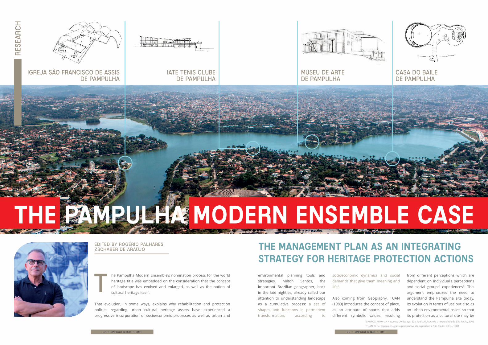
he Pampulha Modern Ensemble’s nomination process for the world heritage title was embedded on the consideration that the concept of landscape has evolved and enlarged, as well as the notion of cultural heritage itself.
That evolution, in some ways, explains why rehabilitation and protection policies regarding urban cultural heritage assets have experienced a progressive incorporation of socioeconomic processes as well as urban and
MUSEU DE ARTE DE PAMPULHA
IGREJA SÃO FRANCISCO DE ASSISDE PAMPULHA
IATE TENIS CLUBEDE PAMPULHA
CASA DO BAILEDE PAMPULHA
THE PAMPULHA MODERN ENSEMBLE CASETHE MANAGEMENT PLAN AS AN INTEGRATING STRATEGY FOR HERITAGE PROTECTION ACTIONS
Edited by Rogério Palhares Zschaber de Araújo
T
Rese
arc
h
30 • unesco chair • q#2 31 • unesco chair • q#2
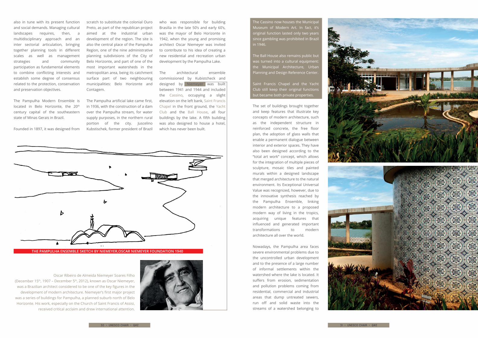
The Cassino now houses the Municipal Museum of Modern Art. In fact, it’s original function lasted only two years since gambling was prohibited in Brazil in 1946.
The Ball House also remains public but was turned into a cultural equipment: the Municipal Architecture, Urban Planning and Design Reference Center.
Saint Francis Chapel and the Yacht Club still keep their original functions but became both private properties.
The set of buildings brought together and keep features that illustrate key concepts of modern architecture, such as the independent structure in reinforced concrete, the free floor plan, the adoption of glass walls that enable a permanent dialogue between interior and exterior spaces. They have also been designed according to the “total art work” concept, which allows for the integration of multiple pieces of sculpture, mosaic tiles and painted murals within a designed landscape that merged architecture to the natural environment. Its Exceptional Universal Value was recognized, however, due to the innovative synthesis reached by the Pampulha Ensemble, linking modern architecture to a proposed modern way of living in the tropics, acquiring unique features that influenced and generated important transformations to modern architecture all over the world.
Nowadays, the Pampulha area faces severe environmental problems due to the uncontrolled urban development and to the presence of a large number of informal settlements within the watershed where the lake is located. It suffers from erosion, sedimentation and pollution problems coming from residential, commercial and industrial areas that dump untreated sewers, run off and solid waste into the streams of a watershed belonging to
Oscar Ribeiro de Almeida Niemeyer Soares Filho (December 15th, 1907 – December 5th, 2012), known as Oscar Niemeyer,
was a Brazilian architect considered to be one of the key figures in the development of modern architecture. Niemeyer’s first major project
was a series of buildings for Pampulha, a planned suburb north of Belo Horizonte. His work, especially on the Church of Saint Francis of Assisi,
received critical acclaim and drew international attention.
also in tune with its present function and social demands. Managing cultural landscapes requires, then, a multidisciplinary approach and an inter sectorial articulation, bringing together planning tools in different scales as well as management strategies and community participation as fundamental elements to combine conflicting interests and establish some degree of consensus related to the protection, conservation and preservation objectives.
The Pampulha Modern Ensemble is located in Belo Horizonte, the 20th century capital of the southeastern state of Minas Gerais in Brazil.
Founded in 1897, it was designed from
scratch to substitute the colonial Ouro Preto, as part of the republican project aimed at the industrial urban development of the region. The site is also the central place of the Pampulha Region, one of the nine administrative planning subdivisions of the City of Belo Horizonte, and part of one of the most important watersheds in the metropolitan area, being its catchment surface part of two neighbouring municipalities: Belo Horizonte and Contagem.
The Pampulha artificial lake came first, in 1936, with the construction of a dam over the Pampulha stream, for water supply purposes, in the northern rural portion of the city. Juscelino Kubstischek, former president of Brazil
who was responsible for building Brasilia in the late 50’s and early 60’s, was the mayor of Belo Horizonte in 1942, when the young and promising architect Oscar Niemeyer was invited to contribute to his idea of creating a new residential and recreation urban development by the Pampulha Lake.
The architectural ensemble commissioned by Kubistcheck and designed by Niemeyer was built between 1941 and 1944 and included the Cassino, occupying a slight elevation on the left bank, Saint Francis Chapel in the front ground, the Yacht Club and the Ball House, all four buildings by the lake. A fifth building was also designed to house a hotel, which has never been built.
THE PAMPULHA ENSEMBLE SKETCH BY NIEMEYER,OSCAR NIEMEYER FOUNDATION 1940
32 • unesco chair • q#2 33 • unesco chair • q#2
As a recognition of these complex problems urban landscape assets to face, UNESCO has required World Heritage candidates to present a consistent Management Plan as part of the nomination dossier.
This requirement has added a strategic feature as well as a public participation component to the nomination process. According to UNESCO guidelines (2013), this plan is supposed to:
▶▶ (i) identify property owners and responsibilities for its management
▶▶ (ii) present a brief review of existing legislation, plans and projects affecting the nominated asset
▶▶ (iii) present an institutional framework to carry out short and long term as well as permanent actions to take care of the identified problems and opportunities
▶▶ (iv) present the existing and proposed infrastructure and services aimed at tourism development.
It is not meant to be an urban marketing piece of work but a tool to guarantee feasibility, sustainability and the effective rehabilitation of the nominated asset.
The Pampulha Modern Ensemble Management plan has three dimensions as recommended by UNESCO directives:
▶▶ (i) a normative one, related to all command and control instruments and enforcement strategies put in place
▶▶ (ii) a strategic and operational one, related to the proposed actions and priorities translated into plans, programs and projects to be implemented, as well as the necessary funds and responsibilities, involving which actors according to which institutional framework
▶▶ (iii) an evaluative dimension, that has to do with the permanent monitoring of out comes.
Along the years, since the late 40’s, Pampulha has been increasingly listed and protected as a cultural site, first by heritage protection instruments at state level in 1984 and then, at federal level, in 1997.
The protected area was restricted, though, to the architectural monuments, gardens, lake and waterfront. At the local level, protection was extended to the surrounding neighbourhoods through zoning design criteria in 1996 and finally, as an urban environmental asset, encompassing the whole watershed by two municipalities only in 2005. This poses a challenge to the plan’s normative dimension: the need to integrate a series of land use control norms and planning permit procedures at different governmental levels and jurisdictions.
To integrate all these instruments and procedures, an institutional body, named the Pampulha Management Committee, has been created, involving all three governmental levels: Federal, State and local, engaging efforts and resources to implement a series of actions listed in a responsibility matrix.
These actions have been consolidated into an intervention plan that has indicated the emergency actions, as well as mid and long term projects. They have all been supported by a communication strategy to involve the area’s residents, citizens in general and other stakeholders. The Management Plan has functioned, then, as an agreement between the state, the parties at stake and the international community to carry out the necessary protection actions.
Controlling height, bulk and color of buildings as well as uses within the buffer zone, implementing sewer systems in slums within the Pampulha
two the two municipalities. This has made the adoption and enforcement of land use control to face environmental impacts, densification, verticalization and all sorts of real estate pressures in the region politically very sensitive.
In the last decade, the northern development vector of Belo Horizonte, where Pampulha is located, was the one with the highest population growth (over 2% a year). That means the regions population doubled in ten years reaching 250 thousands inhabitants nowadays. It is also important to mention that the Pampulha Region that encompasses the architectural site, the lake and the surrounding neighbourhoods
have become the main recreation and amenity centrality in Belo Horizonte Metropolitan area. I houses the largest soccer stadium, Mineirão, one of the largest arena for shows and mass events, Mineirinho, and the City Zoo, besides having a high concentration of private country clubs, the main UFMG University Campus and other important green areas. As a touristic and recreation pole, it also houses a great number of restaurants, bars and party venues. This gives an idea of how complex and diverse the area is, having not only the already mentioned environmental problems but also traffic and land use conflicts that directly threatens the integrity of the heritage asset.
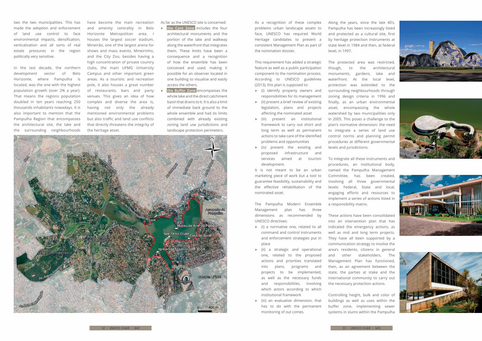
As far as the UNESCO site is concerned: ▶▶ the Core Zone includes the four
architectural monuments and the portion of the lake and walkway along the waterfront that integrates them. These limits have been a consequence and a recognition of how the ensemble has been conceived and used, making it possible for an observer located in one building to visualize and easily access the others.
▶▶ the Buffer Zone encompasses the whole lake and the direct catchment basin that drains to it. It is also a limit of immediate back ground to the whole ensemble and had its limits combined with already existing zoning land use jurisdictions and landscape protection perimeters.
34 • unesco chair • q#2 35 • unesco chair • q#2
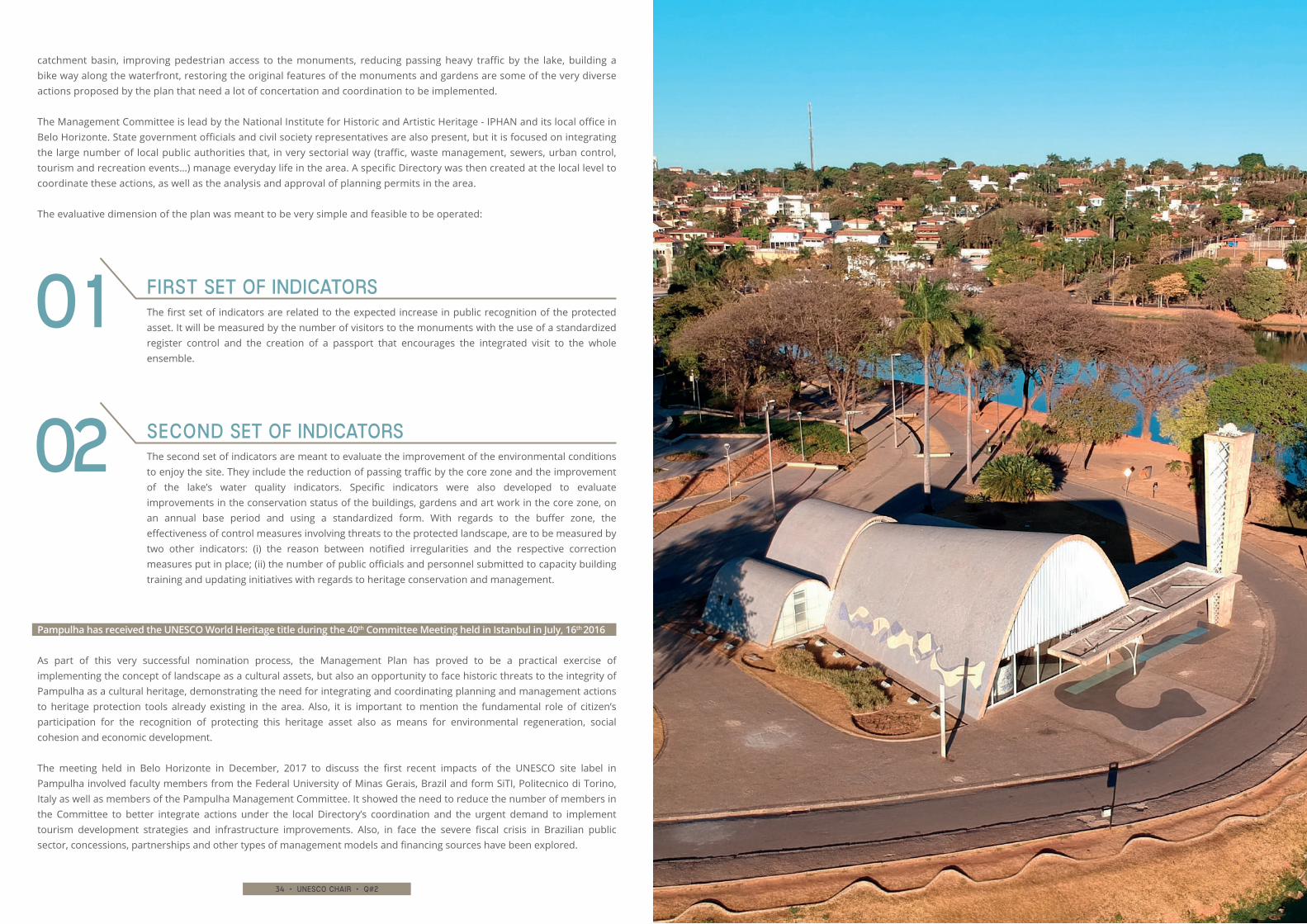
catchment basin, improving pedestrian access to the monuments, reducing passing heavy traffic by the lake, building a bike way along the waterfront, restoring the original features of the monuments and gardens are some of the very diverse actions proposed by the plan that need a lot of concertation and coordination to be implemented.
The Management Committee is lead by the National Institute for Historic and Artistic Heritage - IPHAN and its local office in Belo Horizonte. State government officials and civil society representatives are also present, but it is focused on integrating the large number of local public authorities that, in very sectorial way (traffic, waste management, sewers, urban control, tourism and recreation events…) manage everyday life in the area. A specific Directory was then created at the local level to coordinate these actions, as well as the analysis and approval of planning permits in the area.
The evaluative dimension of the plan was meant to be very simple and feasible to be operated:
Pampulha has received the UNESCO World Heritage title during the 40th Committee Meeting held in Istanbul in July, 16th 2016
As part of this very successful nomination process, the Management Plan has proved to be a practical exercise of implementing the concept of landscape as a cultural assets, but also an opportunity to face historic threats to the integrity of Pampulha as a cultural heritage, demonstrating the need for integrating and coordinating planning and management actions to heritage protection tools already existing in the area. Also, it is important to mention the fundamental role of citizen’s participation for the recognition of protecting this heritage asset also as means for environmental regeneration, social cohesion and economic development.
The meeting held in Belo Horizonte in December, 2017 to discuss the first recent impacts of the UNESCO site label in Pampulha involved faculty members from the Federal University of Minas Gerais, Brazil and form SiTI, Politecnico di Torino, Italy as well as members of the Pampulha Management Committee. It showed the need to reduce the number of members in the Committee to better integrate actions under the local Directory’s coordination and the urgent demand to implement tourism development strategies and infrastructure improvements. Also, in face the severe fiscal crisis in Brazilian public sector, concessions, partnerships and other types of management models and financing sources have been explored.
The first set of indicators are related to the expected increase in public recognition of the protected asset. It will be measured by the number of visitors to the monuments with the use of a standardized register control and the creation of a passport that encourages the integrated visit to the whole ensemble.
First set of indicators01
The second set of indicators are meant to evaluate the improvement of the environmental conditions to enjoy the site. They include the reduction of passing traffic by the core zone and the improvement of the lake’s water quality indicators. Specific indicators were also developed to evaluate improvements in the conservation status of the buildings, gardens and art work in the core zone, on an annual base period and using a standardized form. With regards to the buffer zone, the effectiveness of control measures involving threats to the protected landscape, are to be measured by two other indicators: (i) the reason between notified irregularities and the respective correction measures put in place; (ii) the number of public officials and personnel submitted to capacity building training and updating initiatives with regards to heritage conservation and management.
Second set of indicators02
36 • unesco chair • q#2 37 • unesco chair • q#2
Research
AS A MODEL FOR MANAGING COMPLEX SYSTEMS OF CULTURAL HERITAGE
he meaning of “governance” is related to “government”, both from the ancient Greek verb κυβερνάω (kubernao), used to
indicate the action of driving a vessel or a cart. Plato was the first to use the word, in a metaphoric sense, to indicate government by the people. This idea is very important in order to manage cultural assets.
Management and governance are not synonymous, when there is a ownership on asset under managing we talking about management, otherwise the action is governance. Governance plays a key role in UNESCO’s field given that an increasing number of territorial sites are dealing with complex systems (serial sites and cultural landscapes).
Edited by marco valle
From management To governance
T
38 • unesco chair • q#2 39 • unesco chair • q#2
In fact, it is now internationally agreed that effective and lasting conservation of a cultural or natural asset must be supported and conveyed by an equally effective management model.
For that reason the Outstanding Universal Value declaration of UNESCO’s World Heritage sites requires a description of the management system, in order to ensure protection of the asset’s value over time. One of the aims of management structure is implementing a management plan. That is, an operating and supporting tool for governance and providing goals, strategies, knowledge planning, conservation and enhancing of the UNESCO site.
The UNESCO document published in 1972, the well-known “Convention Concerning the Protection of the World Cultural and Natural Heritage”, was the first reference for sites that have been placed on the World Heritage List, but it doesn’t speak explicitly about
management and governance. In particular, the “Operational Guidelines for the Implementation of the World Heritage Convention” are intended to give direction about management and governance. In the protection and management part of the newest guideline (2017), there is the indication of developing a management system in accordance with safeguarding and preservation principles of the UNESCO. This document provides powerfully principles.
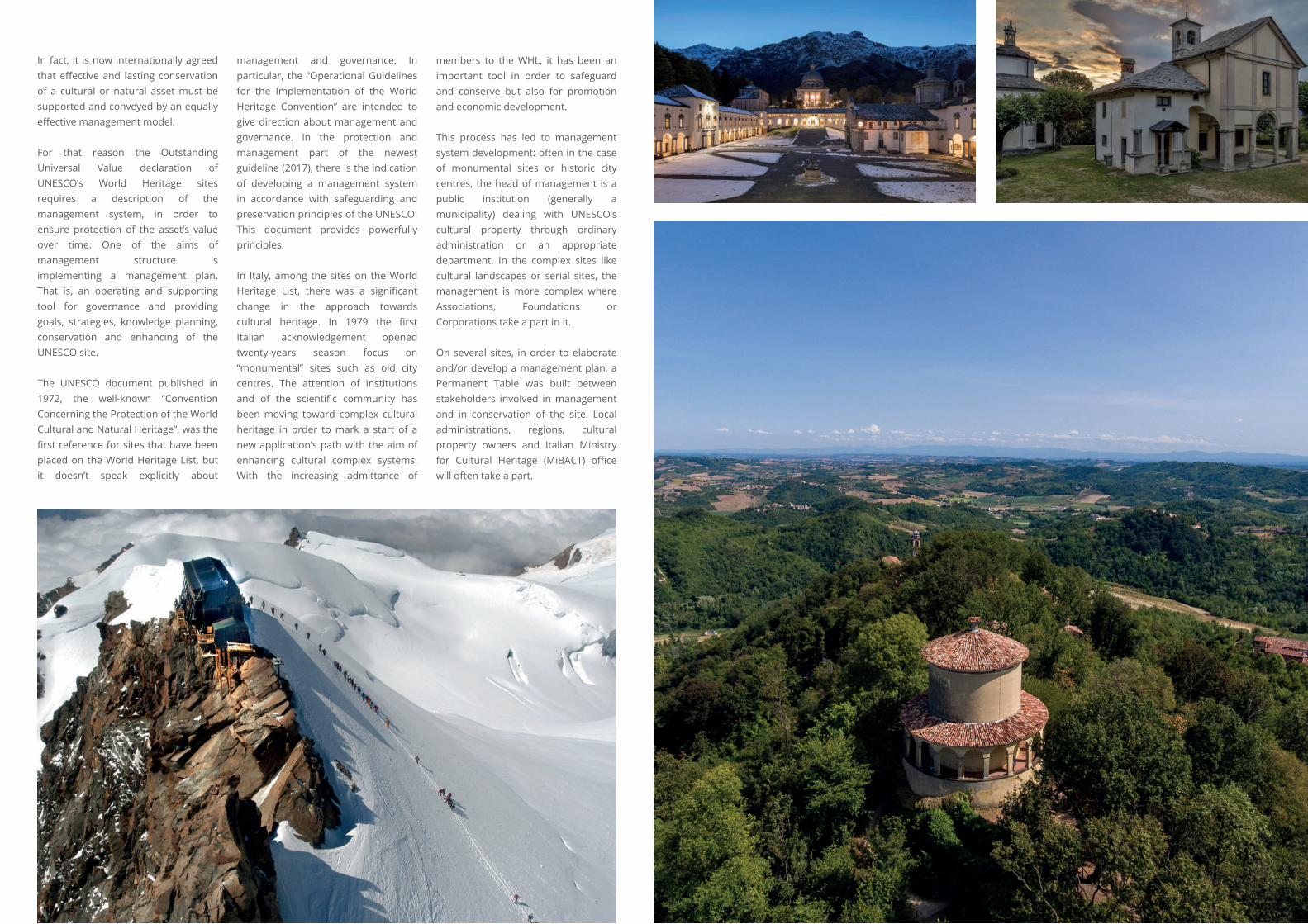
In Italy, among the sites on the World Heritage List, there was a significant change in the approach towards cultural heritage. In 1979 the first Italian acknowledgement opened twenty-years season focus on “monumental” sites such as old city centres. The attention of institutions and of the scientific community has been moving toward complex cultural heritage in order to mark a start of a new application’s path with the aim of enhancing cultural complex systems. With the increasing admittance of
members to the WHL, it has been an important tool in order to safeguard and conserve but also for promotion and economic development.
This process has led to management system development: often in the case of monumental sites or historic city centres, the head of management is a public institution (generally a municipality) dealing with UNESCO’s cultural property through ordinary administration or an appropriate department. In the complex sites like cultural landscapes or serial sites, the management is more complex where Associations, Foundations or Corporations take a part in it.
On several sites, in order to elaborate and/or develop a management plan, a Permanent Table was built between stakeholders involved in management and in conservation of the site. Local administrations, regions, cultural property owners and Italian Ministry for Cultural Heritage (MiBACT) office will often take a part.
40 • unesco chair • q#2 41 • unesco chair • q#2
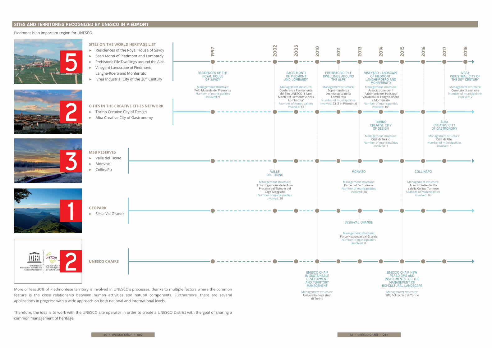
Piedmont is an important region for UNESCO.
More or less 30% of Piedmontese territory is involved in UNESCO’s processes, thanks to multiple factors where the common feature is the close relationship between human activities and natural components. Furthermore, there are several applications in progress with a wide approach on both national and international levels.
Therefore, the idea is to work with the UNESCO site operator in order to create a UNESCO District with the goal of sharing a common management of heritage.
sites and territories recognized by UNESCO in Piedmont
Residences of the Royal House
of Savoy
UNESCO Chair in Sustainable Development and Territory Management
UNESCO Chair New paradigms and
instruments for the management of
Bio-Cultural Landscape
Vineyard Landscape of Piedmont:
Langhe-Roero and Monferrato
IVREA INDUSTRIAL CITY of THe 20th century
Torino Creative City
of Design
alba Creative City
of Gastronomy
Sacri Monti of Piedmont
and Lombardy
VallE del Ticino
Monviso
Sesia-Val Grande
CollinaPo
Prehistoric Pile Dwellings around
the Alps
1997
200
2
200
3
2010
2011
2013
2014
2015
2016
2017
2018
GEOPARK▶▶ Sesia Val Grande1
UNESCO Chair inNew Paradigms and Instruments for Bio-Cultural Landscape Management
United NationsEducational, Scientific and
Cultural Organization
UNESCO CHAIRS2
SITES ON THE WORLD HERITAGE LIST▶▶ Residences of the Royal House of Savoy▶▶ Sacri Monti of Piedmont and Lombardy▶▶ Prehistoric Pile Dwellings around the Alps▶▶ Vineyard Landscape of Piedmont:
Langhe-Roero and Monferrato ▶▶ Ivrea Industrial City of the 20th Century
Management structure: Polo Museale del PiemonteNumber of municipalities
involved: 9
Management structure: Università degli studi
di Torino
Management structure: SiTI, Politecnico di Torino
Management structure: Associazione per il
Patrimonio dei Paesaggi Vitivinicoli di Langhe-Roero
e MonferratoNumber of municipalities
involved: 101
Management structure: Comitato di gestione
Number of municipalities involved: 2
Management structure: Città di Torino
Number of municipalities involved: 1
Management structure: Città di Alba
Number of municipalities involved: 1
Management structure: Conferenza Permanente del Sito UNESCO “I Sacri
Monti del Piemonte e della Lombardia”
Number of municipalities involved: 13
Management structure: Ente di gestione delle Aree
Protette del Ticino e del Lago Maggiore
Number of municipalities involved: 80
Management structure: Parco del Po Cuneese
Number of municipalities involved: 88
Management structure: Parco Nazionale Val Grande
Number of municipalities involved: 0
Management structure: Aree Protette del Po
e della Collina TorineseNumber of municipalities
involved: 85
Management structure: Soprintendenza
Archeologica della Lombardia
Number of municipalities involved: 23 (3 in Piemonte)
5
MaB RESERVES▶▶ Valle del Ticino▶▶ Monviso▶▶ CollinaPo3
CITIES IN THE CREATIVE CITIES NETWORK▶▶ Torino Creative City of Design▶▶ Alba Creative City of Gastronomy2
42 • unesco chair • q#2 43 • unesco chair • q#2
In Italy, in 2018 with more than 50 sites in WHL we believe we have an answer to the question about why it is important to take a place in WHL or UNESCO’s programmes.
Nowadays the attention has been moved from cultural property to cultural heritage, rooted in a social, environmental and landscape context. The calls linked to sustainable development, in a context of the crisis, are more urgent because economical resources to be devoted to territories are not enough. These problems require a thorough revision of the development model that until now was characterized by national and international management’s policies. Poverty, inequality and conflict are still more and more relevant.
From this point of view, the new UNESCO sites must become a sustainability workshop and a place where natural conservation, socio-
economic development and innovation can be linked. These issues can change areas to having a high value, and are a recipe for potential, which can start the development of processes that involve economic, social, cultural and environmental sectors.
These observations were developed on 27th October, 2005, at the “Council of Europe Framework Convention on the Value of Cultural Heritage for Society” in Faro, Portugal. This convention renewed the meaning of cultural heritage. Italy signed the convention in 2013, but the Italian Parliament has not ratify it yet. The Convention still has a good prospective. The second article introduces the term “Conserving Cultural Heritage” like a “group of resources inherited from the past with which people identify, independently of ownership, as a reflection and expression of their constantly evolving values, beliefs, knowledge and traditions. It includes all aspects of the
environment resulting from the interaction between people and places through time”.
The term “heritage community” consists of “people who value specific aspects of cultural heritage which they wish, within the framework of public action, to sustain and transmit to future generations”.
In conclusion, we believe that being part of UNESCO is not a financial question or bureaucratic reasons, but can be a moment for driving territory development. The cultural heritage is the privileged framework where “the ideals, principles and values, derived from the experience gained through progress and past conflicts, which foster the development of a peaceful and stable society, founded on respect for human rights, democracy and the rule of law.” (Faro Convention, art. 3).
UNESCO’s Piedmont sites are like a “sustainability workshop” and answer in a good way to the UNESCO Convention in term of sustainable development, education, community involvement and safeguarding of natural and cultural resources.
A UNESCO District becomes an important tool for protection and enhancement values of territory promoted by UNESCO, also through local community participation like “sustainability users”, namely, actors involved in the research of balance between human and nature, in the fight against climate change, equal society and for dissemination of culture. The goals for this District, in the short term, are improving the coordination capacity of all relevant institutional actors involved in management of the UNESCO site and enhancing through the construction of a cultural heritage network that will be recognized by UNESCO.
This target found concrete implementation during 2017 in different activities:
The shared space of the Piedmontese District is a cultural space with the aim to grow a common identity and a global strategic vision: the idea is to develop around the connection between human, nature and culture, also trace a strategic line for the project and for integrated initiatives.
A MATRIX▶▶ was made with common elements in order to share experiences
DATA COLLECTION▶▶ was set up to gather information about the management structure of
the different sites, the presence of project planning on a large scale and the identification of strategic objectives with the purpose to know Piedmont UNESCO Heritage
MEETINGS▶▶ were organised between managers from different sites
in order to define the vision of the District
THE CONSTRUCTION OF A GOVERNANCE MODEL▶▶ was started for the District, a paper of intent and also a monitoring
programme were proposed
TRAINING COURSE▶▶ during 9th |10th October, 2017 a training course coordinated by SiTI was
organised for regional employees with divulgation and training aims
UNESCO today
44 • unesco chair • q#2 45 • unesco chair • q#2
WO
RLD
HER
ITAG
E PR
OPE
RTIE
S IN
LO
MBA
RD
YG
OV
ERN
AN
CE
AN
D M
AN
AGEM
ENT
SYST
EMS
Research
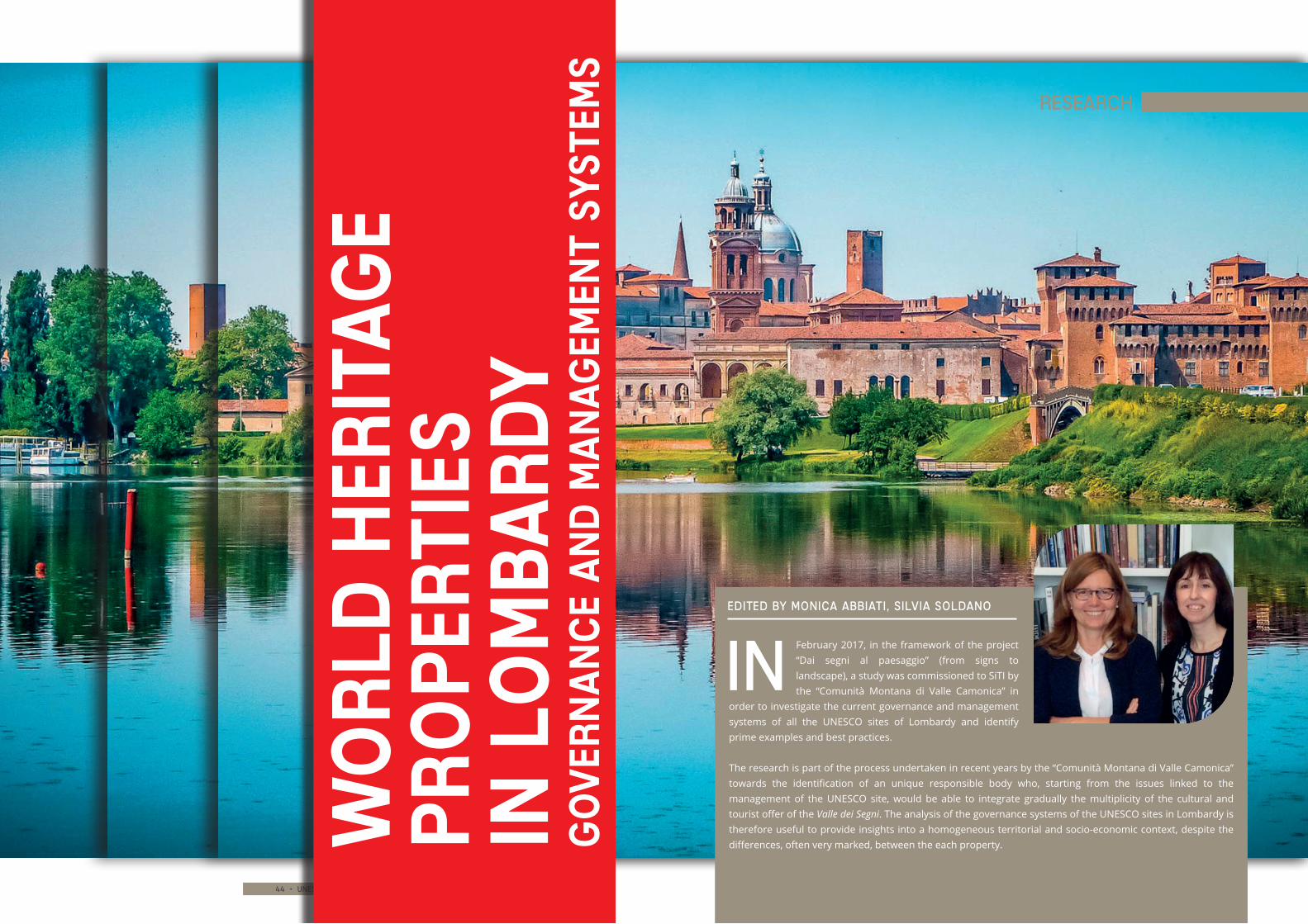
Edited by Monica abbiati, silvia soldano
February 2017, in the framework of the project “Dai segni al paesaggio” (from signs to landscape), a study was commissioned to SiTI by the “Comunità Montana di Valle Camonica” in
order to investigate the current governance and management systems of all the UNESCO sites of Lombardy and identify prime examples and best practices.
The research is part of the process undertaken in recent years by the “Comunità Montana di Valle Camonica” towards the identification of an unique responsible body who, starting from the issues linked to the management of the UNESCO site, would be able to integrate gradually the multiplicity of the cultural and tourist offer of the Valle dei Segni. The analysis of the governance systems of the UNESCO sites in Lombardy is therefore useful to provide insights into a homogeneous territorial and socio-economic context, despite the differences, often very marked, between the each property.
In
46 • unesco chair • q#2 47 • unesco chair • q#2
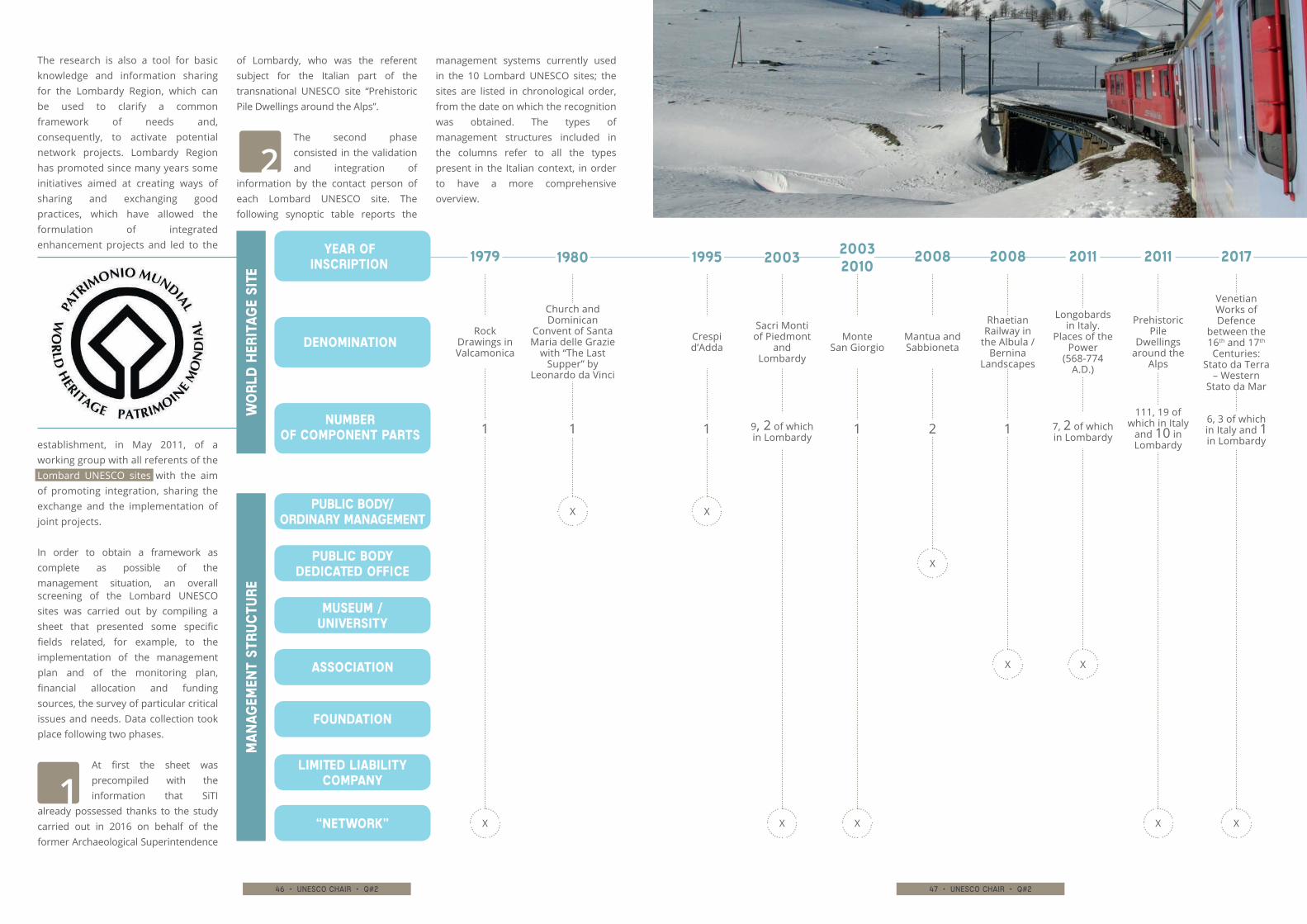
The research is also a tool for basic knowledge and information sharing for the Lombardy Region, which can be used to clarify a common framework of needs and, consequently, to activate potential network projects. Lombardy Region has promoted since many years some initiatives aimed at creating ways of sharing and exchanging good practices, which have allowed the formulation of integrated enhancement projects and led to the
establishment, in May 2011, of a working group with all referents of the Lombard UNESCO sites with the aim of promoting integration, sharing the exchange and the implementation of joint projects.
In order to obtain a framework as complete as possible of the management situation, an overall screening of the Lombard UNESCO sites was carried out by compiling a sheet that presented some specific fields related, for example, to the implementation of the management plan and of the monitoring plan, financial allocation and funding sources, the survey of particular critical issues and needs. Data collection took place following two phases.
At first the sheet was precompiled with the information that SiTI
already possessed thanks to the study carried out in 2016 on behalf of the former Archaeological Superintendence
of Lombardy, who was the referent subject for the Italian part of the transnational UNESCO site “Prehistoric Pile Dwellings around the Alps”.
The second phase consisted in the validation and integration of
information by the contact person of each Lombard UNESCO site. The following synoptic table reports the
management systems currently used in the 10 Lombard UNESCO sites; the sites are listed in chronological order, from the date on which the recognition was obtained. The types of management structures included in the columns refer to all the types present in the Italian context, in order to have a more comprehensive overview.
Wo
rld
her
itag
e si
teM
an
agem
ent
stru
ctu
re
YEAR of inscription
Denomination
Number of component parts
Public body/ ordinary management
Public body dedicated office
Museum / University
Association
Foundation
Limited Liability Company
“Network”
1979
Rock Drawings in Valcamonica
1
X
2003
9, 2 of which in Lombardy
Sacri Monti of Piedmont
and Lombardy
X
2011
111, 19 of which in Italy
and 10 in Lombardy
Prehistoric Pile
Dwellings around the
Alps
X
2003 2010
1
Monte San Giorgio
X
2017
6, 3 of which in Italy and 1 in Lombardy
Venetian Works of Defence
between the 16th and 17th Centuries:
Stato da Terra – Western
Stato da Mar
X
1980
1
Church and Dominican
Convent of Santa Maria delle Grazie
with “The Last Supper” by
Leonardo da Vinci
X
1995
1
Crespi d’Adda
X
2008
2
Mantua and Sabbioneta
X
2008
1
Rhaetian Railway in
the Albula / Bernina
Landscapes
X
2011
7, 2 of which in Lombardy
Longobards in Italy.
Places of the Power
(568-774 A.D.)
X
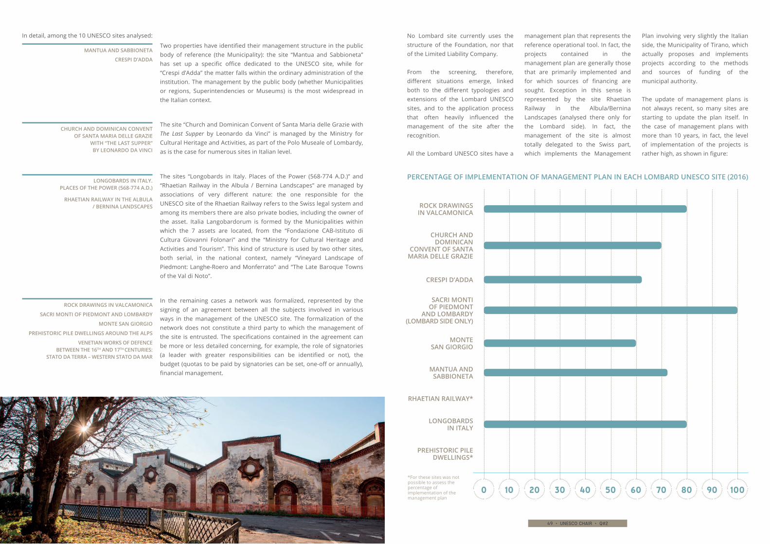
48 • unesco chair • q#2 49 • unesco chair • q#2
No Lombard site currently uses the structure of the Foundation, nor that of the Limited Liability Company.
From the screening, therefore, different situations emerge, linked both to the different typologies and extensions of the Lombard UNESCO sites, and to the application process that often heavily influenced the management of the site after the recognition.
All the Lombard UNESCO sites have a
management plan that represents the reference operational tool. In fact, the projects contained in the management plan are generally those that are primarily implemented and for which sources of financing are sought. Exception in this sense is represented by the site Rhaetian Railway in the Albula/Bernina Landscapes (analysed there only for the Lombard side). In fact, the management of the site is almost totally delegated to the Swiss part, which implements the Management
Plan involving very slightly the Italian side, the Municipality of Tirano, which actually proposes and implements projects according to the methods and sources of funding of the municipal authority.
The update of management plans is not always recent, so many sites are starting to update the plan itself. In the case of management plans with more than 10 years, in fact, the level of implementation of the projects is rather high, as shown in figure:
In detail, among the 10 UNESCO sites analysed:
Two properties have identified their management structure in the public body of reference (the Municipality): the site “Mantua and Sabbioneta” has set up a specific office dedicated to the UNESCO site, while for “Crespi d’Adda” the matter falls within the ordinary administration of the institution. The management by the public body (whether Municipalities or regions, Superintendencies or Museums) is the most widespread in the Italian context.
MANTUA AND SABBIONETA
PERCENTAGE OF IMPLEMENTATION OF MANAGEMENT PLAN IN EACH LOMBARD UNESCO SITE (2016)
CRESPI D’ADDA
The site “Church and Dominican Convent of Santa Maria delle Grazie with The Last Supper by Leonardo da Vinci” is managed by the Ministry for Cultural Heritage and Activities, as part of the Polo Museale of Lombardy, as is the case for numerous sites in Italian level.
CHURCH AND DOMINICAN CONVENT OF SANTA MARIA DELLE GRAZIE
WITH “THE LAST SUPPER” BY LEONARDO DA VINCI
The sites “Longobards in Italy. Places of the Power (568-774 A.D.)” and “Rhaetian Railway in the Albula / Bernina Landscapes” are managed by associations of very different nature: the one responsible for the UNESCO site of the Rhaetian Railway refers to the Swiss legal system and among its members there are also private bodies, including the owner of the asset. Italia Langobardorum is formed by the Municipalities within which the 7 assets are located, from the “Fondazione CAB-Istituto di Cultura Giovanni Folonari” and the “Ministry for Cultural Heritage and Activities and Tourism”. This kind of structure is used by two other sites, both serial, in the national context, namely “Vineyard Landscape of Piedmont: Langhe-Roero and Monferrato” and “The Late Baroque Towns of the Val di Noto”.
LONGOBARDS IN ITALY. PLACES OF THE POWER (568-774 A.D.)
In the remaining cases a network was formalized, represented by the signing of an agreement between all the subjects involved in various ways in the management of the UNESCO site. The formalization of the network does not constitute a third party to which the management of the site is entrusted. The specifications contained in the agreement can be more or less detailed concerning, for example, the role of signatories (a leader with greater responsibilities can be identified or not), the budget (quotas to be paid by signatories can be set, one-off or annually), financial management.
*For these sites was not possible to assess the percentage of implementation of the management plan
ROCK DRAWINGS IN VALCAMONICA
SACRI MONTI OF PIEDMONT AND LOMBARDY
RHAETIAN RAILWAY IN THE ALBULA / BERNINA LANDSCAPES
PREHISTORIC PILE DWELLINGS AROUND THE ALPS
VENETIAN WORKS OF DEFENCE BETWEEN THE 16TH AND 17TH CENTURIES:
STATO DA TERRA – WESTERN STATO DA MAR
MONTE SAN GIORGIO
RHAETIAN RAILWAY*
PREHISTORIC PILE DWELLINGS*
100 20 30 40 50 60 70 80 90 100
ROCK DRAWINGS IN VALCAMONICA
LONGOBARDS IN ITALY
CHURCH AND DOMINICAN
CONVENT OF SANTA MARIA DELLE GRAZIE
MANTUA AND SABBIONETA
MONTE SAN GIORGIO
CRESPI D’ADDA
SACRI MONTI OF PIEDMONT
AND LOMBARDY (LOMBARD SIDE ONLY)
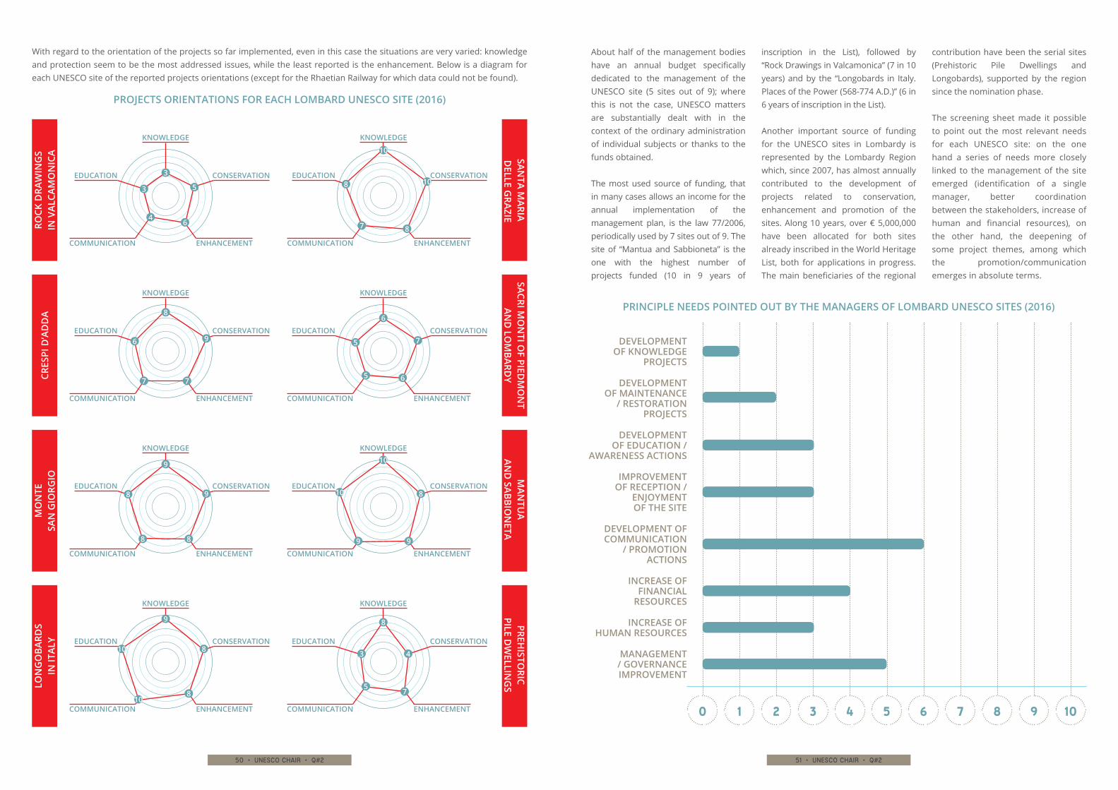
50 • unesco chair • q#2 51 • unesco chair • q#2
About half of the management bodies have an annual budget specifically dedicated to the management of the UNESCO site (5 sites out of 9); where this is not the case, UNESCO matters are substantially dealt with in the context of the ordinary administration of individual subjects or thanks to the funds obtained.
The most used source of funding, that in many cases allows an income for the annual implementation of the management plan, is the law 77/2006, periodically used by 7 sites out of 9. The site of “Mantua and Sabbioneta” is the one with the highest number of projects funded (10 in 9 years of
inscription in the List), followed by “Rock Drawings in Valcamonica” (7 in 10 years) and by the “Longobards in Italy. Places of the Power (568-774 A.D.)” (6 in 6 years of inscription in the List).
Another important source of funding for the UNESCO sites in Lombardy is represented by the Lombardy Region which, since 2007, has almost annually contributed to the development of projects related to conservation, enhancement and promotion of the sites. Along 10 years, over € 5,000,000 have been allocated for both sites already inscribed in the World Heritage List, both for applications in progress. The main beneficiaries of the regional
contribution have been the serial sites (Prehistoric Pile Dwellings and Longobards), supported by the region since the nomination phase.
The screening sheet made it possible to point out the most relevant needs for each UNESCO site: on the one hand a series of needs more closely linked to the management of the site emerged (identification of a single manager, better coordination between the stakeholders, increase of human and financial resources), on the other hand, the deepening of some project themes, among which the promotion/communication emerges in absolute terms.
With regard to the orientation of the projects so far implemented, even in this case the situations are very varied: knowledge and protection seem to be the most addressed issues, while the least reported is the enhancement. Below is a diagram for each UNESCO site of the reported projects orientations (except for the Rhaetian Railway for which data could not be found).
PRINCIPLE NEEDS POINTED OUT BY THE MANAGERS OF LOMBARD UNESCO SITES (2016)
PROJECTS ORIENTATIONS FOR EACH LOMBARD UNESCO SITE (2016)
10 2 3 4 5 6 7 8 9 10
INCREASE OF FINANCIAL
RESOURCES
MANAGEMENT / GOVERNANCE IMPROVEMENT
INCREASE OF HUMAN RESOURCES
DEVELOPMENT OF KNOWLEDGE
PROJECTS
DEVELOPMENT OF COMMUNICATION
/ PROMOTION ACTIONS
IMPROVEMENT OF RECEPTION /
ENJOYMENT OF THE SITE
DEVELOPMENT OF MAINTENANCE
/ RESTORATION PROJECTS
DEVELOPMENT OF EDUCATION /
AWARENESS ACTIONS
ROCK
DRA
WIN
GS
IN V
ALCA
MO
NIC
A
KNOWLEDGE
CONSERVATION
ENHANCEMENT
EDUCATION
COMMUNICATION
3
5
64
3
MAN
TUA
AND
SABBION
ETA
KNOWLEDGE
CONSERVATION
ENHANCEMENT
EDUCATION
COMMUNICATION
10
8
99
10
LON
GO
BARD
S IN
ITAL
Y
KNOWLEDGE
CONSERVATION
ENHANCEMENT
EDUCATION
COMMUNICATION
9
8
810
10
PREHISTO
RIC PILE D
WELLIN
GS
KNOWLEDGE
CONSERVATION
ENHANCEMENT
EDUCATION
COMMUNICATION
8
4
75
3
CRES
PI D
’AD
DA
KNOWLEDGE
CONSERVATION
ENHANCEMENT
EDUCATION
COMMUNICATION
8
9
77
6
SANTA M
ARIA D
ELLE GRAZIE
KNOWLEDGE
CONSERVATION
ENHANCEMENT
EDUCATION
COMMUNICATION
10
10
87
8
SACRI MO
NTI O
F PIEDM
ON
T AN
D LO
MBARD
Y
KNOWLEDGE
CONSERVATION
ENHANCEMENT
EDUCATION
COMMUNICATION
6
7
65
5
MO
NTE
SA
N G
IORG
IO
KNOWLEDGE
CONSERVATION
ENHANCEMENT
EDUCATION
COMMUNICATION
9
9
88
8

52 • unesco chair • q#2 53 • unesco chair • q#2
The survey of specific needs leads to some more general considerations related to the governance models adopted by the UNESCO sites in Lombardy and their efficiency.
The screening reveals two particularly virtuous situations:
▶▶ the Associazione Italia Langobardorum
▶▶ the UNESCO Office of “Mantua and Sabbioneta”.
In both cases, the fact of having identified, in different forms, a reference management structure dedicated to the UNESCO site, with staff and fixed annual budget, is undoubtedly a solid basis thanks to which it is possible to set a comprehensive projects specifications.
If a single entity responsible for management has not been identified, there are greater difficulties, both from the point of view of the coordination of the various stakeholders, and for the financial aspect. In this sense, the case of the site “Prehistoric Pile Dwellings around the Alps” emerges which, exactly for this reason, is trying to identify an unique body responsible for the overall management.
The Valle Camonica, although in the difficulties repeatedly reported on the coordination and integration of services, is a site attentive to the specificity of the assets and proactive: this is proved by the numerous funding obtained over the years from various sources.
Also the fact that, in the framework of a “light” governance modality such as that of the network, an annual budget available for the UNESCO site has been foreseen, shows a good managerial and planning capacity. The form of the network, in fact, often presents the weakness of not
identifying dedicated human and financial resources and therefore making the realization of even small-scale projects very difficult.
Generally speaking, it is possible to state that UNESCO sites, often of large extensions, that are configured as a set of distant and separate contexts, merged during the nomination, and therefore not used to think as a single entity, have more difficulties to realize common projects.
On the other hand, sites that are more confined or already managed in a unitary and coordinated way before the recognition, continue to be managed effectively and UNESCO represents in some way an added value.
55 • unesco chair • q#2
L( (A
ND A PROJECT TO IMPROVE
ACCESSIBILITY FOR ALL
ESCAPE THE DISABILITIES
Research
Edited by Elisa Gandino, Roberto Cerrato
iTI and the Association for the Wine Landscapes of Langhe-Roero and Monferrato Heritage started their collaboration during the nomination of the “Vineyard Landscape of Piedmont: Langhe-Roero
and Monferrato” for the UNESCO World Heritage List. Since the inscription of the site on the List, SiTI worked as scientific consultant for management and enhancement activities of the property.
S
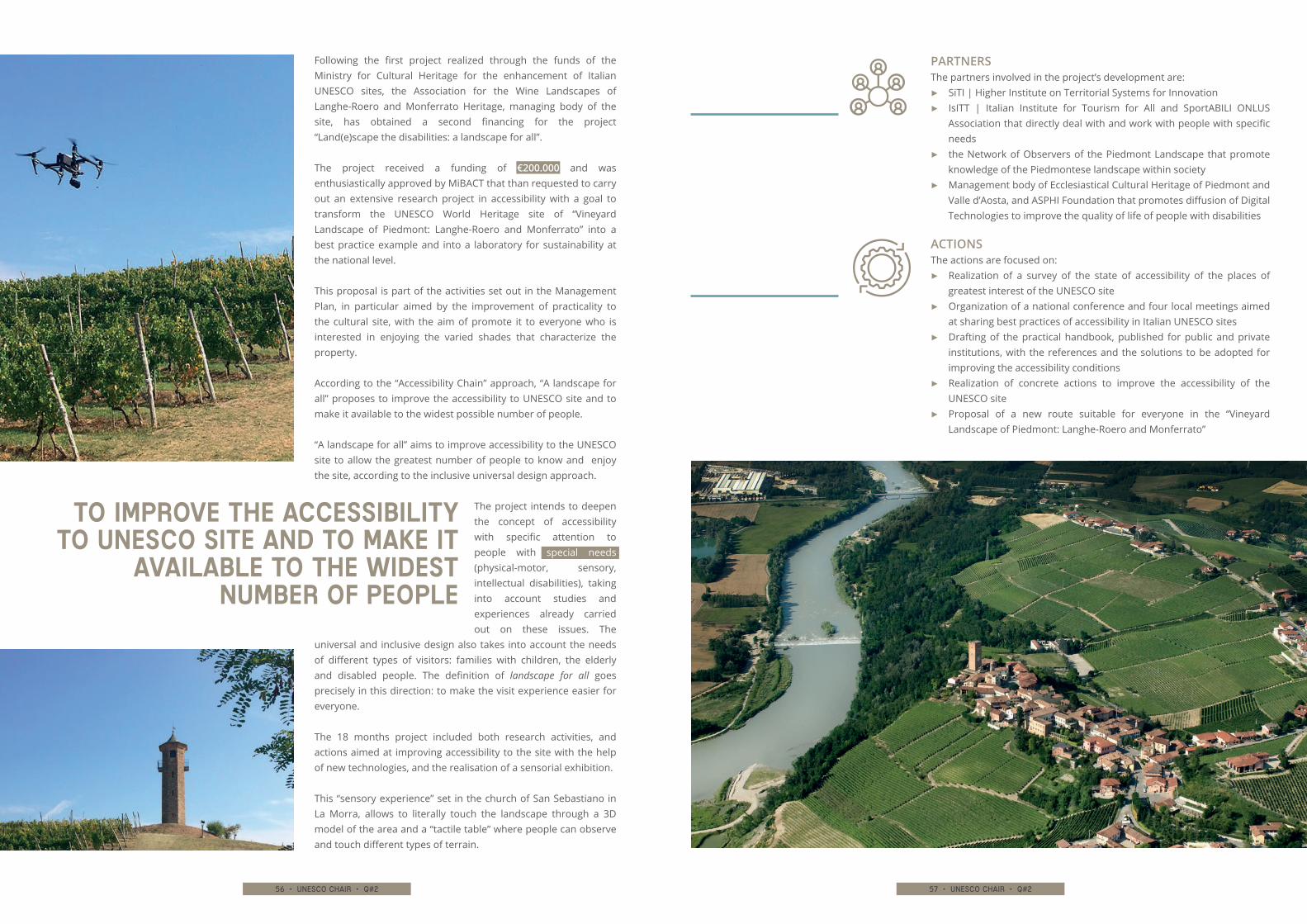
56 • unesco chair • q#2 57 • unesco chair • q#2
The partners involved in the project’s development are:▶▶ SiTI | Higher Institute on Territorial Systems for Innovation▶▶ IsITT | Italian Institute for Tourism for All and SportABILI ONLUS
Association that directly deal with and work with people with specific needs
▶▶ the Network of Observers of the Piedmont Landscape that promote knowledge of the Piedmontese landscape within society
▶▶ Management body of Ecclesiastical Cultural Heritage of Piedmont and Valle d’Aosta, and ASPHI Foundation that promotes diffusion of Digital Technologies to improve the quality of life of people with disabilities
The actions are focused on:▶▶ Realization of a survey of the state of accessibility of the places of
greatest interest of the UNESCO site▶▶ Organization of a national conference and four local meetings aimed
at sharing best practices of accessibility in Italian UNESCO sites▶▶ Drafting of the practical handbook, published for public and private
institutions, with the references and the solutions to be adopted for improving the accessibility conditions
▶▶ Realization of concrete actions to improve the accessibility of the UNESCO site
▶▶ Proposal of a new route suitable for everyone in the “Vineyard Landscape of Piedmont: Langhe-Roero and Monferrato”
Following the first project realized through the funds of the Ministry for Cultural Heritage for the enhancement of Italian UNESCO sites, the Association for the Wine Landscapes of Langhe-Roero and Monferrato Heritage, managing body of the site, has obtained a second financing for the project “Land(e)scape the disabilities: a landscape for all”.
The project received a funding of €200.000 and was enthusiastically approved by MiBACT that than requested to carry out an extensive research project in accessibility with a goal to transform the UNESCO World Heritage site of “Vineyard Landscape of Piedmont: Langhe-Roero and Monferrato” into a best practice example and into a laboratory for sustainability at the national level.
This proposal is part of the activities set out in the Management Plan, in particular aimed by the improvement of practicality to the cultural site, with the aim of promote it to everyone who is interested in enjoying the varied shades that characterize the property.
According to the “Accessibility Chain” approach, “A landscape for all” proposes to improve the accessibility to UNESCO site and to make it available to the widest possible number of people.
“A landscape for all” aims to improve accessibility to the UNESCO site to allow the greatest number of people to know and enjoy the site, according to the inclusive universal design approach.
The project intends to deepen the concept of accessibility with specific attention to people with special needs (physical-motor, sensory, intellectual disabilities), taking into account studies and experiences already carried out on these issues. The
universal and inclusive design also takes into account the needs of different types of visitors: families with children, the elderly and disabled people. The definition of landscape for all goes precisely in this direction: to make the visit experience easier for everyone.
The 18 months project included both research activities, and actions aimed at improving accessibility to the site with the help of new technologies, and the realisation of a sensorial exhibition.
This “sensory experience” set in the church of San Sebastiano in La Morra, allows to literally touch the landscape through a 3D model of the area and a “tactile table” where people can observe and touch different types of terrain.
TO IMPROVE THE ACCESSIBILITY TO UNESCO SITE AND TO MAKE IT
AVAILABLE TO THE WIDEST NUMBER OF PEOPLE
PARTNERS
ACTIONS
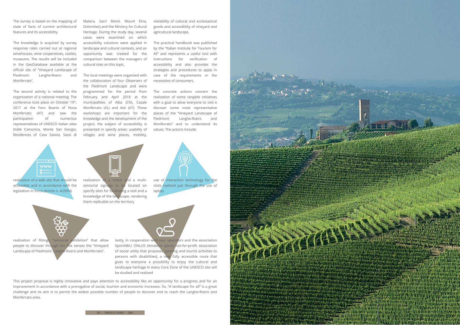
58 • unesco chair • q#2 59 • unesco chair • q#2
The survey is based on the mapping of state of facts of current architectural features and its accessibility.
The knowledge is acquired by survey response rates carried out at regional winehouses, wine cooperatives, castles, museums. The results will be included in the GeoDatabase available at the official site of “Vineyard Landscape of Piedmont: Langhe-Roero and Monferrato”.
The second activity is related to the organization of a national meeting. The conference took place on October 19th, 2017 at the Foro Boario of Nizza Monferrato (AT) and saw the participation of numerous representatives of UNESCO Italian sites (Valle Camonica, Monte San Giorgio, Residences of Casa Savoia, Sassi di
Matera, Sacri Monti, Mount Etna, Dolomites) and the Ministry for Cultural Heritage. During the study day, several cases were examined on which accessibility solutions were applied in landscape and cultural contexts, and an opportunity was created for the comparison between the managers of cultural sites on this topic.
The local meetings were organized with the collaboration of four Observers of the Piedmont Landscape and were programmed for the period from February and April 2018 at the municipalities of Alba (CN), Casale Monferrato (AL) and Asti (AT). Those workshops are important for the knowledge and the development of the project, the subject of accessibility is presented in specify areas: usability of villages and wine places, mobility,
visitability of cultural and ecclesiastical goods and accessibility of vineyard and agricultural landscape.
The practical handbook was published by the “Italian Institute for Tourism for All” and represents a useful tool with instructions for verification of accessibility and also provides the strategies and procedures to apply in case of the requirements or the necessities of consumers.
The concrete actions concern the realization of some tangible initiatives with a goal to allow everyone to visit e discover some most representative places of the “Vineyard Landscape of Piedmont: Langhe-Roero and Monferrato” and to understand its values. The actions include:
realization of a web site that should be accessible and in accordance with the legislation in force (Article n. 4/2004)
lastly, in cooperation with tour operators and the association SportABILI ONLUS (Amateur sports not-for-profit association of social utility that proposes sporting and tourist activities to persons with disabilities), a new fully accessible route that gives to everyone a possibility to enjoy the cultural and landscape heritage in every Core Zone of the UNESCO site will be studied and realized
realization of fittings “sensorial exhibition” that allow people to discover through the five senses the “Vineyard Landscape of Piedmont: Langhe-Roero and Monferrato”.
use of interaction technology for the visits realized just through the use of laptop
realization of a totem and a multi-sensorial signage to be located on specify sites for facilitating a visit and a knowledge of the landscape, rendering them replicable on the territory
This project proposal is highly innovative and pays attention to accessibility like an opportunity for a progress and for an improvement in accordance with a prerogative of social, tourism and economic increases. So, “A landscape for all” is a great challenge and its aim is to permit the widest possible number of people to discover and to reach the Langhe-Roero and Monferrato area.
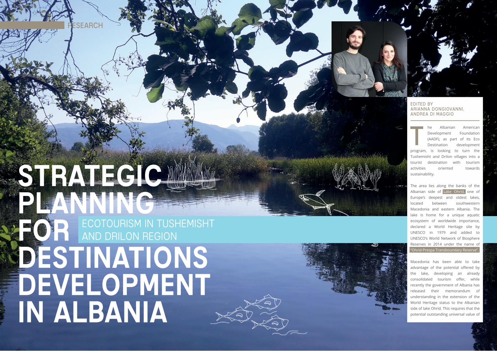
60 • unesco chair • q#2 61 • unesco chair • q#2
DEVELOPMENTIN ALBANIA
DESTINATIONS
PLANNINGSTRATEGIC
FOR ECOTOURISM IN TUSHEMISHT AND DRILON REGION
Edited by Arianna Dongiovanni, Andrea Di Maggio
t
Research
he Albanian American Development Foundation (AADF), as part of its Eco Destination development
program, is looking to turn the Tushemisht and Drilon villages into a tourist destination with tourism activities oriented towards sustainability.
The area lies along the banks of the Albanian side of Lake Ohrid, one of Europe’s deepest and oldest lakes, located between southwestern Macedonia and eastern Albania. The lake is home for a unique aquatic ecosystem of worldwide importance, declared a World Heritage site by UNESCO in 1979 and added to UNESCO’s World Network of Biosphere Reserves in 2014 under the name of “Ohrid-Prespa Transboundary Reserve”.
Macedonia has been able to take advantage of the potential offered by the lake, developing an already consolidated tourism offer, while recently the government of Albania has released their memorandum of understanding in the extension of the World Heritage status to the Albanian side of lake Ohrid. This requires that the potential outstanding universal value of
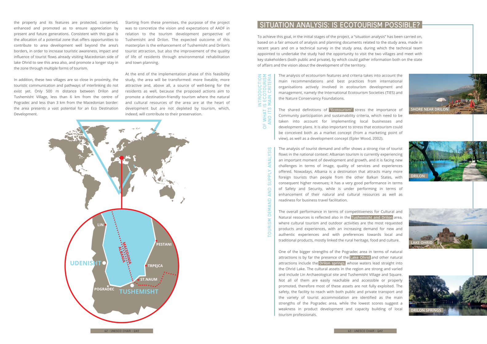
62 • unesco chair • q#2
the property and its features are protected, conserved, enhanced and promoted as to ensure appreciation by present and future generations. Consistent with this goal is the allocation of a potential zone that offers opportunities to contribute to area development well beyond the area’s borders, in order to increase touristic awareness, impact and influence of tourist flows already visiting Macedonian side of lake Ohrid to see this area also, and promote a longer stay in the zone through multiple forms of tourism.
In addition, these two villages are so close in proximity, the touristic communication and pathways of interlinking do not exist yet. Only 500 m distance between Drilon and Tushemisht Village, less than 6 km from the centre of Pogradec and less than 3 km from the Macedonian border: the area presents a vast potential for an Eco Destination Development.
Starting from these premises, the purpose of the project was to concretize the vision and expectations of AADF in relation to the tourism development perspective of Tushemisht and Drilon. The expected outcome of this masterplan is the enhancement of Tushemisht and Drilon’s tourist attraction, but also the improvement of the quality of life of residents through environmental rehabilitation and town planning.
At the end of the implementation phase of this feasibility study, the area will be transformed: more liveable, more attractive and, above all, a source of well-being for the residents as well, because the proposed actions aim to promote a destination-friendly tourism where the natural and cultural resources of the area are at the heart of development but are not depleted by tourism, which, indeed, will contribute to their preservation.
63 • unesco chair • q#2
To achieve this goal, in the initial stages of the project, a “situation analysis” has been carried on, based on a fair amount of analysis and planning documents related to the study area, made in recent years and on a technical survey in the study area, during which the technical team appointed to undertake the study had the opportunity to visit the two villages and meet with key stakeholders (both public and private), by which could gather information both on the state of affairs and the vision about the development of the territory.
SITUATION ANALYSIS: IS ECOTOURISM POSSIBLE?
The analysis of ecotourism features and criteria takes into account the main recommendations and best practices from international organisations actively involved in ecotourism development and management, namely the International Ecotourism Societies (TIES) and the Nature Conservancy Foundations.
The shared definitions of “Ecotourism” stress the importance of Community participation and sustainability criteria, which need to be taken into account for implementing local businesses and development plans. It is also important to stress that ecotourism could be conceived both as a market concept (from a marketing point of view), as well as a development concept (Epler Wood, 2002).
Int
ro
du
ct
ion
o
f w
hat
is
ec
oto
ur
ism
a
nd
it
s m
ain
cr
iter
ia
The analysis of tourist demand and offer shows a strong rise of tourist flows in the national context: Albanian tourism is currently experiencing an important moment of development and growth, and it is facing new challenges in terms of image, quality of services and experiences offered. Nowadays, Albania is a destination that attracts many more foreign tourists than people from the other Balkan States, with consequent higher revenues; it has a very good performance in terms of Safety and Security, while is under performing in terms of enhancement of their natural and cultural resources as well as readiness for business travel facilitation.
The overall performance in terms of competitiveness for Cultural and Natural resources is reflected also in the Tushemisht and Drilon area, where cultural tourism and outdoor activities are the most requested products and experiences, with an increasing demand for new and authentic experiences and with preferences towards local and traditional products, mostly linked the rural heritage, food and culture.
One of the bigger strengths of the Pogradec area in terms of natural attractions is by far the presence of the Lake Ohrid and other natural attractions include the Drilon springs, whose waters lead straight into the Ohrid Lake. The cultural assets in the region are strong and varied and include Lin Archaeological site and Tushemisht Village and Square. Not all of them are easily reachable and accessible or properly promoted, therefore most of these assets are not fully exploited. The safety, the facility to reach with both public and private transport and the variety of tourist accommodation are identified as the main strengths of the Pogradec area, while the lowest scores suggest a weakness in product development and capacity building of local tourism professionals.
Tou
ris
m d
ema
nd
an
d s
up
ply
an
aly
sis
UDENISHT
TUSHEMISHT
LIN
POGRADEC
MACED
ON
IA
ALBANIA
PESTANI
TRPEJCA
ST.NAUM
SHORE NEAR DRILON
DRILON
LAKE OHRID
DRILON SPRINGS
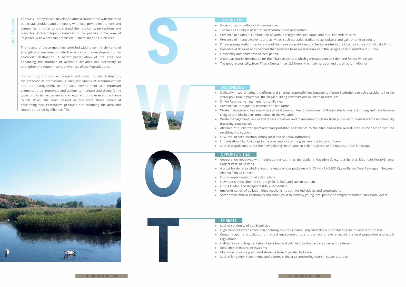
64 • unesco chair • q#2 65 • unesco chair • q#2
The SWOT Analysis was developed after a round table with the main public stakeholders and a meeting with local private institutions and companies, in order to understand their concerns, perceptions and plans for different topics related to public policies in the area of Pogradec, with a particular focus on Tushemisht and Drilon area.
The results of these meetings were indications on the elements of strength and weakness on which to work for the development of an ecotourist destination. A better preservation of the area and enhancing the number of available activities are necessary to strengthen the tourism competitiveness of the Pogradec area.
Furthermore, the facilities to reach and move into the destination, the presence of professional guides, the quality of accommodation and the management of the local environment are important elements to be improved, and actions to increase and diversify the types of tourism experiences are required to increase and enhance tourist flows; the most valued actions were those aimed at developing new ecotourism products and including the area into round tours sold by Albanian TOs.
SWO
T A
na
lys
is
▶▶ Social cohesion within local communities ▶▶ The lake as a unique asset for local communities and visitors▶▶ Presence of a unique combination of various ecosystems, rich fauna and rare, endemic species ▶▶ Presence of intangible events and activities, such as: crafts, traditions, agricultural and gastronomic products▶▶ Drilon springs wetlands area is one of the more accessible natural heritage sites in the locality to the south of Lake Ohrid▶▶ Presence of streams and channels that emanate from several sources in the villages of Tushemisht and Gurras▶▶ Hospitality and politeness of local people▶▶ A popular tourist destination for the Albanian visitors, which generates constant demand for the whole year ▶▶ The good accessibility from Tirana-Durres (max. 2,5 hours) the main harbour and the airport in Albania
▶▶ Difficulty in coordinating the efforts and sharing responsibilities between different institutions to solve problems like the water pollution in Pogradec, the illegal building constructions in Drilon Reserve, etc.
▶▶ Drilon Reserve management not totally clear▶▶ Presence of unregulated fisheries and fish farms▶▶ Waste management: low awareness of local communities. Streams are not flowing due to waste dumping and have become
clogged and blocked in some points of the wetlands▶▶ Waste management: lack of awareness initiatives and management policies from public institutions towards sustainability
(recycling, reusing, etc.)▶▶ Absence of public transport and transportation possibilities to the sites and in the overall area in connection with the
neighbouring country▶▶ Low level of collaboration among local and national authorities▶▶ Urbanisation: high buildings in the area and loss of the greenery due to the concrete▶▶ Lack of a guidelines about the new buildings in the area in order to preserve the natural/urban landscape
▶▶ Cooperation initiatives with neighbouring countries (particularly Macedonia): e.g. Via Egnatia, Mountain Korab/Shama, Project Pearl of Balkans
▶▶ A cross border area which allows the regional tour packages with Ohrid – UNESCO City or Balkan Tour Packages in between Albania-FYROM-Greece
▶▶ Future implementation of action plans▶▶ New tourism development strategy 2017-2022 and law on tourism▶▶ UNESCO Man And Biosphere (MaB) recognition▶▶ Implementation of pollution fines mechanisms both for individuals and corporations▶▶ Some small familiar economies and start-ups in tourism by young local people or emigrants turned back from Greece
▶▶ Lack of continuity of public policies ▶▶ High competitiveness from neighbouring countries, particularly Macedonia in capitalizing on the assets of the lake▶▶ Contamination and pollution of natural environment, due to the lack of awareness of the local population and public
regulations▶▶ Habitat loss and fragmentation, fauna loss and wildlife disturbance, rare species threatened▶▶ Reduction of natural ecosystems▶▶ Migration of young graduated students from Pogradec to Tirana ▶▶ Lack of long-term investments and donors in the area concerning tourism sector approach
STRENGTHS
WEAKNESSES
OPPORTUNITIES
THREATS
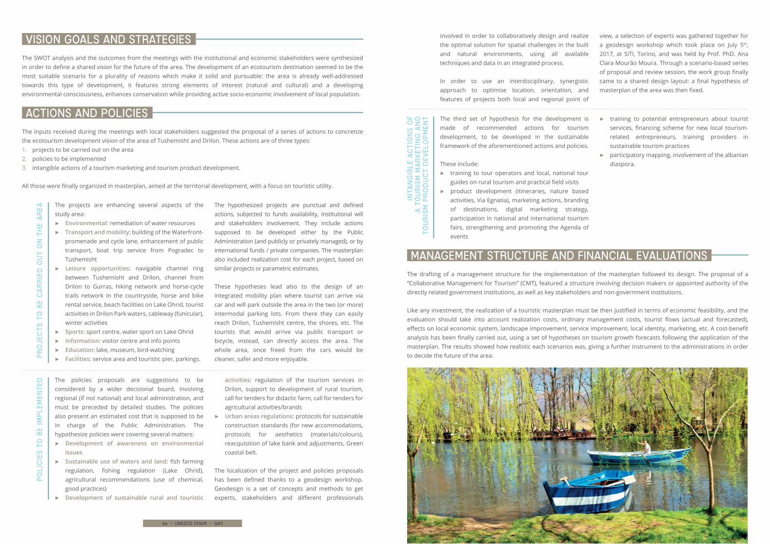
66 • unesco chair • q#2 67 • unesco chair • q#2
involved in order to collaboratively design and realize the optimal solution for spatial challenges in the built and natural environments, using all available techniques and data in an integrated process.
In order to use an interdisciplinary, synergistic approach to optimise location, orientation, and features of projects both local and regional point of
view, a selection of experts was gathered together for a geodesign workshop which took place on July 5th, 2017, at SiTI, Torino, and was held by Prof. PhD. Ana Clara Mourão Moura. Through a scenario-based series of proposal and review session, the work group finally came to a shared design layout: a final hypothesis of masterplan of the area was then fixed.
The SWOT analysis and the outcomes from the meetings with the institutional and economic stakeholders were synthesized in order to define a shared vision for the future of the area. The development of an ecotourism destination seemed to be the most suitable scenario for a plurality of reasons which make it solid and pursuable: the area is already well-addressed towards this type of development, it features strong elements of interest (natural and cultural) and a developing environmental consciousness, enhances conservation while providing active socio-economic involvement of local population.
The drafting of a management structure for the implementation of the masterplan followed its design. The proposal of a “Collaborative Management for Tourism” (CMT), featured a structure involving decision makers or appointed authority of the directly related government institutions, as well as key stakeholders and non-government institutions.
Like any investment, the realization of a touristic masterplan must be then justified in terms of economic feasibility, and the evaluation should take into account realization costs, ordinary management costs, tourist flows (actual and forecasted), effects on local economic system, landscape improvement, service improvement, local identity, marketing, etc. A cost-benefit analysis has been finally carried out, using a set of hypotheses on tourism growth forecasts following the application of the masterplan. The results showed how realistic each scenarios was, giving a further instrument to the administrations in order to decide the future of the area.
The inputs received during the meetings with local stakeholders suggested the proposal of a series of actions to concretize the ecotourism development vision of the area of Tushemisht and Drilon. These actions are of three types:1. projects to be carried out on the area2. policies to be implemented3. intangible actions of a tourism marketing and tourism product development.
All those were finally organized in masterplan, aimed at the territorial development, with a focus on touristic utility.
VISION GOALS AND STRATEGIES
MANAGEMENT STRUCTURE AND FINANCIAL EVALUATIONS
ACTIONS AND POLICIES
The policies proposals are suggestions to be considered by a wider decisional board, involving regional (if not national) and local administration, and must be preceded by detailed studies. The policies also present an estimated cost that is supposed to be in charge of the Public Administration. The hypothesize policies were covering several matters:
▶▶ Development of awareness on environmental issues
▶▶ Sustainable use of waters and land: fish farming regulation, fishing regulation (Lake Ohrid), agricultural recommendations (use of chemical, good practices)
▶▶ Development of sustainable rural and touristic
activities: regulation of the tourism services in Drilon, support to development of rural tourism, call for tenders for didactic farm, call for tenders for agricultural activities/brands
▶▶ Urban areas regulations: protocols for sustainable construction standards (for new accommodations, protocols for aesthetics (materials/colours), reacquisition of lake bank and adjustments, Green coastal belt.
The localization of the project and policies proposals has been defined thanks to a geodesign workshop. Geodesign is a set of concepts and methods to get experts, stakeholders and different professionals
The projects are enhancing several aspects of the study area:
▶▶ Environmental: remediation of water resources▶▶ Transport and mobility: building of the Waterfront-
promenade and cycle lane, enhancement of public transport, boat trip service from Pogradec to Tushemisht
▶▶ Leisure opportunities: navigable channel ring between Tushemisht and Drilon, channel from Drilon to Gurras, hiking network and horse-cycle trails network in the countryside, horse and bike rental service, beach facilities on Lake Ohrid, tourist activities in Drilon Park waters, cableway (funicular), winter activities
▶▶ Sports: sport centre, water sport on Lake Ohrid ▶▶ Information: visitor centre and info points ▶▶ Education: lake, museum, bird-watching ▶▶ Facilities: service area and touristic pier, parkings.
The hypothesized projects are punctual and defined actions, subjected to funds availability, institutional will and stakeholders involvement. They include actions supposed to be developed either by the Public Administration (and publicly or privately managed), or by international funds / private companies. The masterplan also included realization cost for each project, based on similar projects or parametric estimates.
These hypotheses lead also to the design of an integrated mobility plan where tourist can arrive via car and will park outside the area in the two (or more) intermodal parking lots. From there they can easily reach Drilon, Tushemisht centre, the shores, etc. The tourists that would arrive via public transport or bicycle, instead, can directly access the area. The whole area, once freed from the cars would be cleaner, safer and more enjoyable.P
ro
jec
ts
to
be
ca
rr
ied
ou
t o
n t
he
ar
ea
The third set of hypothesis for the development is made of recommended actions for tourism development, to be developed in the sustainable framework of the aforementioned actions and policies.
These include:▶▶ training to tour operators and local, national tour
guides on rural tourism and practical field visits▶▶ product development (itineraries, nature based
activities, Via Egnatia), marketing actions, branding of destinations, digital marketing strategy, participation in national and international tourism fairs, strengthening and promoting the Agenda of events
▶▶ training to potential entrepreneurs about tourist services, financing scheme for new local tourism-related entrepreneurs, training providers in sustainable tourism practices
▶▶ participatory mapping, involvement of the albanian diaspora.
Inta
ng
ible
ac
tio
ns
of
a t
ou
ris
m m
ar
ket
ing
an
d
tou
ris
m p
ro
du
ct
dev
elo
pm
ent
Po
lic
ies
to
be
imp
lem
ente
d
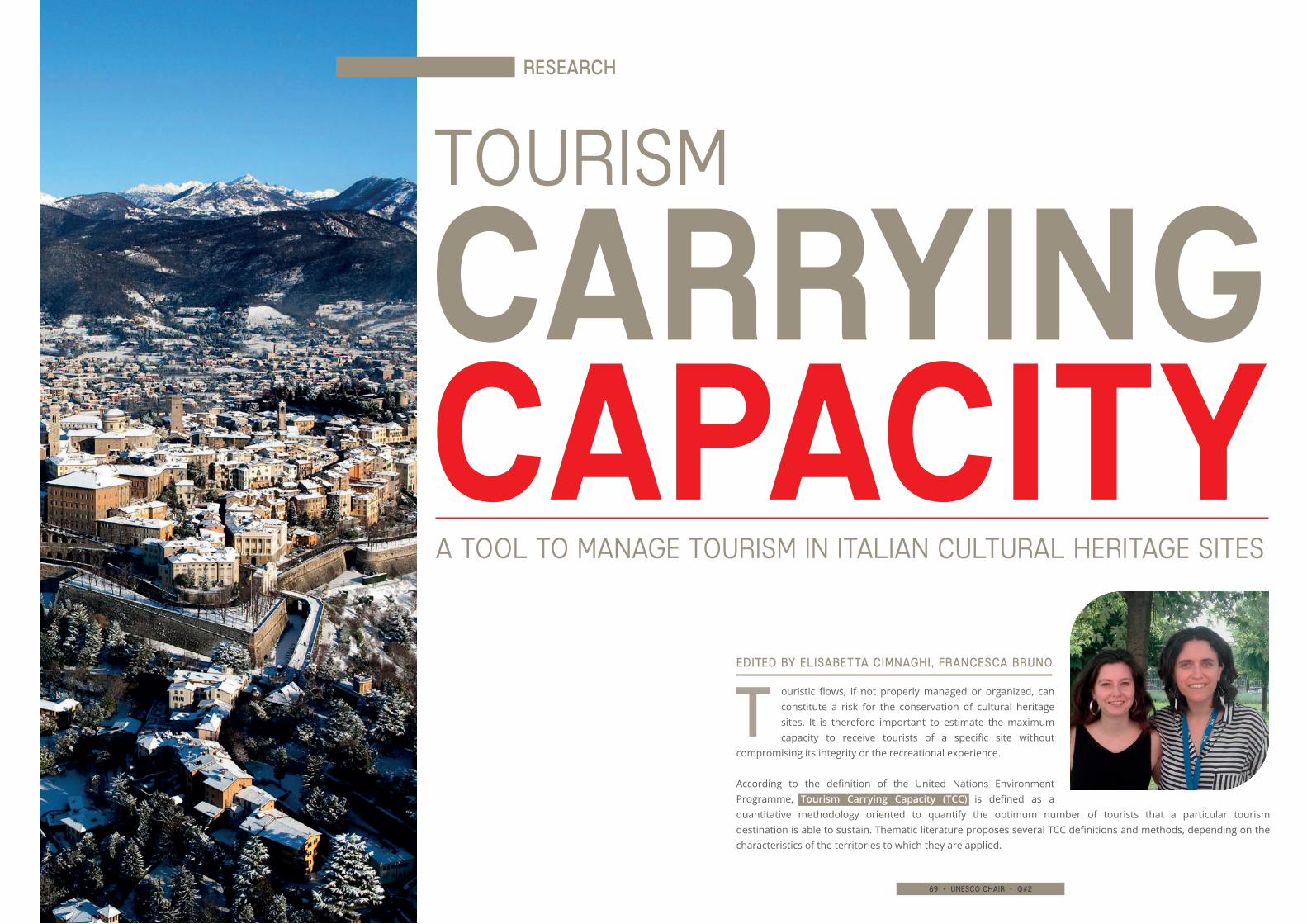
68 • unesco chair • q#2 69 • unesco chair • q#2
ouristic flows, if not properly managed or organized, can constitute a risk for the conservation of cultural heritage sites. It is therefore important to estimate the maximum capacity to receive tourists of a specific site without
compromising its integrity or the recreational experience.
According to the definition of the United Nations Environment Programme, Tourism Carrying Capacity (TCC) is defined as a quantitative methodology oriented to quantify the optimum number of tourists that a particular tourism destination is able to sustain. Thematic literature proposes several TCC definitions and methods, depending on the characteristics of the territories to which they are applied.
TOURISM
CARRYINGCAPACITY A TOOL TO MANAGE TOURISM IN ITALIAN CULTURAL HERITAGE SITES
Research
Edited by Elisabetta Cimnaghi, Francesca Bruno
t
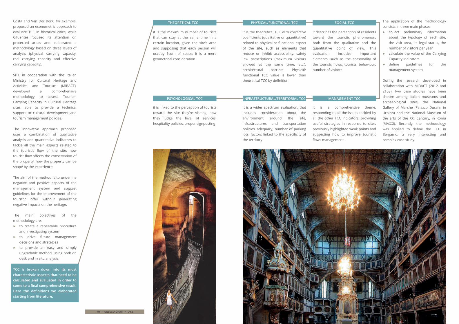
70 • unesco chair • q#2 71 • unesco chair • q#2
Costa and Van Der Borg, for example, proposed an econometric approach to evaluate TCC in historical cities, while Cifuentes focused its attention on protected areas and elaborated a methodology based on three levels of analysis (physical carrying capacity, real carrying capacity and effective carrying capacity).
SiTI, in cooperation with the Italian Ministry for Cultural Heritage and Activities and Tourism (MiBACT), developed a comprehensive methodology to assess Tourism Carrying Capacity in Cultural Heritage sites, able to provide a technical support to cultural development and tourism management policies.
The innovative approach proposed uses a combination of qualitative analysis and quantitative indicators to tackle all the main aspects related to the touristic flow of the site: how tourist flow affects the conservation of the property, how the property can be shape by the experience.
The aim of the method is to underline negative and positive aspects of the management system and suggest guidelines for the improvement of the touristic offer without generating negative impacts on the heritage.
The main objectives of the methodology are:
▶▶ to create a repeatable procedure and investigating system
▶▶ to drive future management decisions and strategies
▶▶ to provide an easy and simply upgradable method, using both on desk and in situ analysis.
The application of the methodology consists in three main phases:
▶▶ collect preliminary information about the typology of each site, the visit area, its legal status, the number of visitors per year
▶▶ calculate the value of the Carrying Capacity Indicators
▶▶ define guidelines for the management system.
During the research developed in collaboration with MiBACT (2012 and 2103), two case studies have been chosen among Italian museums and archaeological sites, the National Gallery of Marche (Palazzo Ducale, in Urbino) and the National Museum of the arts of the XXI Century, in Roma (MAXXI). Recently, the methodology was applied to define the TCC in Bergamo, a very interesting and complex case study.
it is the maximum number of tourists that can stay at the same time in a certain location, given the site’s area and supposing that each person will occupy 1sqm of space; it is a mere geometrical consideration
THEORETICAL TCC
it is the theoretical TCC with corrective coefficients (qualitative or quantitative) related to physical or functional aspect of the site, such as elements that reduce or inhibit accessibility, safety law prescriptions (maximum visitors allowed at the same time, etc.), architectural barriers. Physical/functional TCC value is lower than theoretical TCC by definition
PHYSICAL/FUNCTIONAL TCC
it describes the perception of residents toward the touristic phenomenon, both from the qualitative and the quantitative point of view. This evaluation includes important elements, such as the seasonality of the tourists flows, tourists’ behaviour, number of visitors
SOCIAL TCC
it is linked to the perception of tourists toward the site they’re visiting, how they judge the level of services, hospitality policies, proper signposting
PSYCHOLOGICAL TCC
it is a wider spectrum evaluation, that includes consideration about the environment around the site, infrastructures and transportation policies’ adequacy, number of parking lots, factors linked to the specificity of the territory
INFRASTRUCTURAL/TERRITORIAL TCC
it is a comprehensive theme, responding to all the issues tackled by all the other TCC indicators, providing useful strategies in response to site’s previously highlighted weak points and suggesting how to improve touristic flows management
MANAGEMENT TCC
TCC is broken down into its most characteristic aspects that need to be calculated and evaluated in order to come to a final comprehensive result. Here the definitions we elaborated starting from literature:

72 • unesco chair • q#2 73 • unesco chair • q#2
The first application of the above described methodology was carried out in a museum, Galleria Nazionale delle Marche, located in the historical Palazzo Ducale in Urbino. It hosts a collection of important masterpieces gathered from churches and convents around the region during XIX century and exposed in a visiting area of 27 rooms, including the basement (with stables, kitchens, laundry and other service rooms), an archaeological and a pottery museum.
This famous palace has outstanding cultural, historical and architectural value. It’s part of UNESCO heritage site (Historic Centre of Urbino), and is one of the most beautiful Renaissance residences. In March 2012, after data collection phase it was organized a survey on site in order to assess the effective touristic flow, impacts and potentialities of the Museum. Therefore, these aspects are linked to the high cultural value of the palace and to the outstanding artistic quality artworks used and conserved in the museum.
It is also the main attraction of the city of Urbino and therefore it is reasonable to conjecture that every tourist going to Urbino is also interested in visiting Palazzo Ducale.
The evaluation of TCC highlighted some important weak points:
▶▶ the flow of tourists is definitely lower than the maximum capacity: it’s therefore necessary to plan strategies to attract a higher number of visitors (such as partnerships with hotels and other cultural sites)
▶▶ the signposting system to the museum is adequate but there are no dedicated means of transport, so accessibility is uneasy: policies to increase this aspect must be put in place
▶▶ indoor climate comfort is very low (too cold in winter and too hot in summer)
▶▶ some parts of the museum cannot be accessed by disabled visitors (i.e. staircases to second and underground floors have no ramps and there is no elevator to the second floor)
▶▶ at present there is no system to collect tourists’ opinion/observations.
The
ca
se s
tud
y o
f N
atio
na
l G
all
ery
of
Ma
rch
eU
rbin
o
The MAXXI – National Museum of the Arts of the XXI Century is a national museum dedicated to contemporary creativity, located in Roma.
It is managed by a foundation created by the Italian Ministry of Cultural Heritage and it consists of two museums: “MAXXI art” and “MAXXI architecture”. In addition to them, the MAXXI also features an auditorium, a library and media library specialized in art and architecture, a bookshop, a cafeteria, a bar/restaurant, galleries for temporary exhibitions, performances, educational activities. The large public square designed in front of the museum is planned to host art works and live events.
It was designed as a multidisciplinary space by Zaha Hadid and committed to experimentation and innovation in the arts and architecture.
According to the TCC evaluation proposed method, two different data collection phases were organized: an on desk analysis and an in situ inspection, in order to assess impacts of tourism and potentialities of management.
The most relevant results are:
▶▶ the relationship between the number of tourist observed and the calculated TCC points out that the museum is under-utilized by more than an order of magnitude (it could be increased more than 10 times)
▶▶ the museum has strong potential, especially in relation to the large exhibition halls and meeting places, as well as the ability to host temporary exhibitions
▶▶ in order to increase the touristic flows, it is necessary to find new advertisement strategies (agreements with hotels, networking with other places of culture etc.)
▶▶ the road signs is very poor: it is fundamental to implement the number and the quality of signs in the vicinity of the museum and at strategic places of the city of Roma.
The c
ase stu
dy o
f MA
XXI (Mu
seum
of th
e Arts o
f the XXI C
entu
ry)Ro
ma
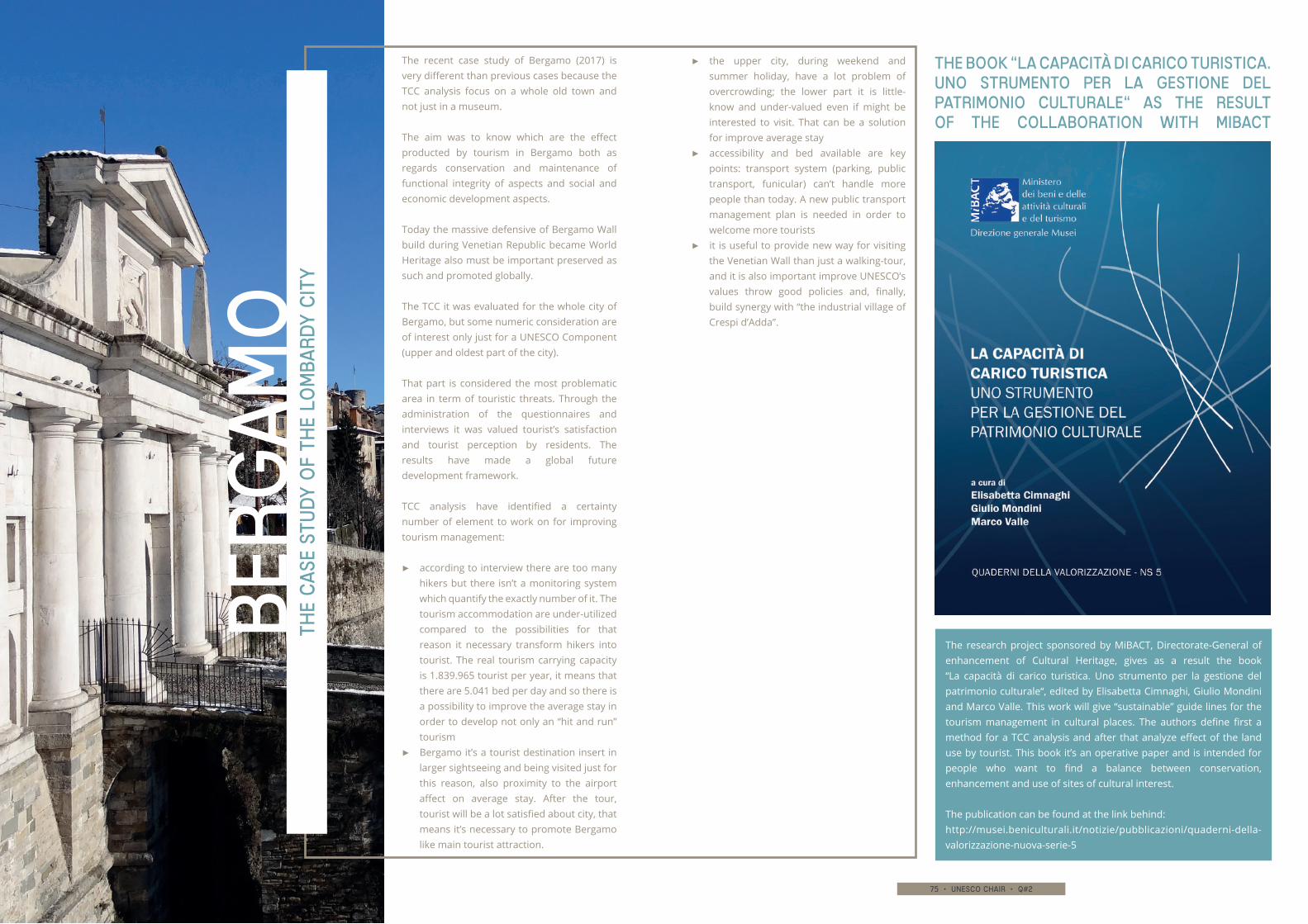
74 • unesco chair • q#2 75 • unesco chair • q#2
The
ca
se s
tud
y o
f th
e lo
mba
rdy
cit
y
The book “La capacità di carico turistica. Uno strumento per la gestione del patrimonio culturale“ as the result of the collaboration with MiBACT
Berg
am
o
The research project sponsored by MiBACT, Directorate-General of enhancement of Cultural Heritage, gives as a result the book “La capacità di carico turistica. Uno strumento per la gestione del patrimonio culturale“, edited by Elisabetta Cimnaghi, Giulio Mondini and Marco Valle. This work will give “sustainable” guide lines for the tourism management in cultural places. The authors define first a method for a TCC analysis and after that analyze effect of the land use by tourist. This book it’s an operative paper and is intended for people who want to find a balance between conservation, enhancement and use of sites of cultural interest.
The publication can be found at the link behind:http://musei.beniculturali.it/notizie/pubblicazioni/quaderni-della-valorizzazione-nuova-serie-5
▶▶ the upper city, during weekend and summer holiday, have a lot problem of overcrowding; the lower part it is little-know and under-valued even if might be interested to visit. That can be a solution for improve average stay
▶▶ accessibility and bed available are key points: transport system (parking, public transport, funicular) can’t handle more people than today. A new public transport management plan is needed in order to welcome more tourists
▶▶ it is useful to provide new way for visiting the Venetian Wall than just a walking-tour, and it is also important improve UNESCO’s values throw good policies and, finally, build synergy with “the industrial village of Crespi d’Adda”.
The recent case study of Bergamo (2017) is very different than previous cases because the TCC analysis focus on a whole old town and not just in a museum.
The aim was to know which are the effect producted by tourism in Bergamo both as regards conservation and maintenance of functional integrity of aspects and social and economic development aspects.
Today the massive defensive of Bergamo Wall build during Venetian Republic became World Heritage also must be important preserved as such and promoted globally.
The TCC it was evaluated for the whole city of Bergamo, but some numeric consideration are of interest only just for a UNESCO Component (upper and oldest part of the city).
That part is considered the most problematic area in term of touristic threats. Through the administration of the questionnaires and interviews it was valued tourist’s satisfaction and tourist perception by residents. The results have made a global future development framework.
TCC analysis have identified a certainty number of element to work on for improving tourism management:
▶▶ according to interview there are too many hikers but there isn’t a monitoring system which quantify the exactly number of it. The tourism accommodation are under-utilized compared to the possibilities for that reason it necessary transform hikers into tourist. The real tourism carrying capacity is 1.839.965 tourist per year, it means that there are 5.041 bed per day and so there is a possibility to improve the average stay in order to develop not only an “hit and run” tourism
▶▶ Bergamo it’s a tourist destination insert in larger sightseeing and being visited just for this reason, also proximity to the airport affect on average stay. After the tour, tourist will be a lot satisfied about city, that means it’s necessary to promote Bergamo like main tourist attraction.
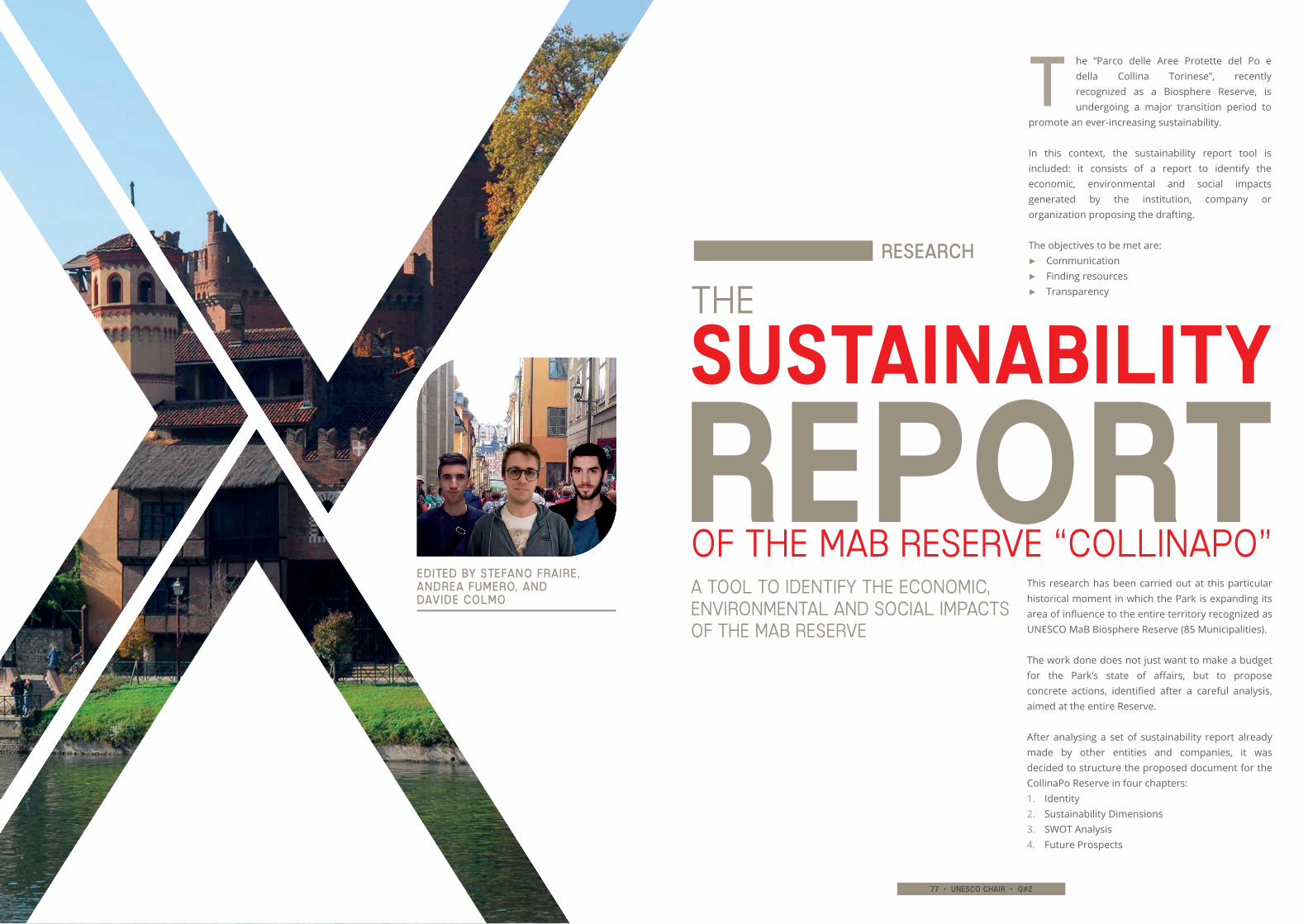
76 • unesco chair • q#2 77 • unesco chair • q#2
he “Parco delle Aree Protette del Po e della Collina Torinese”, recently recognized as a Biosphere Reserve, is undergoing a major transition period to
promote an ever-increasing sustainability.
In this context, the sustainability report tool is included: it consists of a report to identify the economic, environmental and social impacts generated by the institution, company or organization proposing the drafting.
The objectives to be met are:▶▶ Communication▶▶ Finding resources▶▶ Transparency
This research has been carried out at this particular historical moment in which the Park is expanding its area of influence to the entire territory recognized as UNESCO MaB Biosphere Reserve (85 Municipalities).
The work done does not just want to make a budget for the Park’s state of affairs, but to propose concrete actions, identified after a careful analysis, aimed at the entire Reserve.
After analysing a set of sustainability report already made by other entities and companies, it was decided to structure the proposed document for the CollinaPo Reserve in four chapters:1. Identity2. Sustainability Dimensions3. SWOT Analysis4. Future Prospects
THE
OF THE MaB RESERVE “COLLINAPO”REPORT SUSTAINABILITY
Edited by stefano fraire, Andrea fumero, and davide colmo
t
Research
A TOOL TO IDENTIFY THE ECONOMIC, ENVIRONMENTAL AND SOCIAL IMPACTS OF THE MAB RESERVE
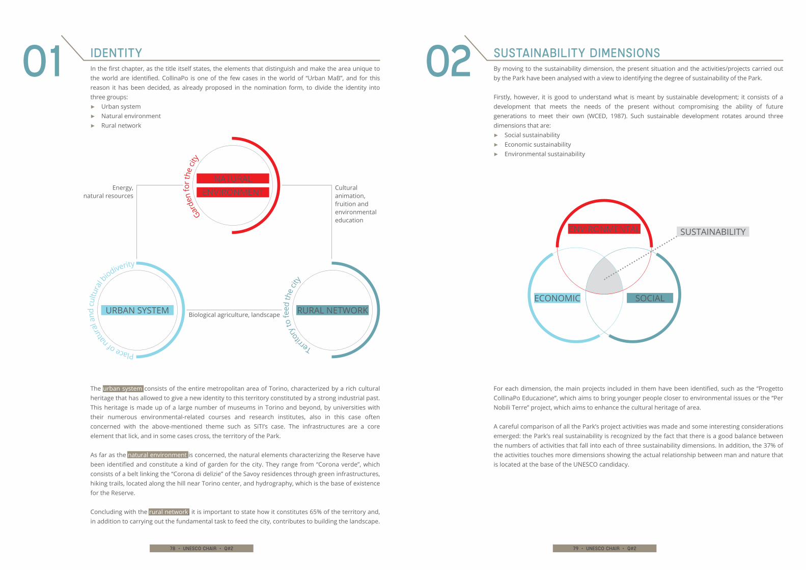
78 • unesco chair • q#2 79 • unesco chair • q#2
In the first chapter, as the title itself states, the elements that distinguish and make the area unique to the world are identified. CollinaPo is one of the few cases in the world of “Urban MaB”, and for this reason it has been decided, as already proposed in the nomination form, to divide the identity into three groups:
▶▶ Urban system▶▶ Natural environment▶▶ Rural network
By moving to the sustainability dimension, the present situation and the activities/projects carried out by the Park have been analysed with a view to identifying the degree of sustainability of the Park.
Firstly, however, it is good to understand what is meant by sustainable development; it consists of a development that meets the needs of the present without compromising the ability of future generations to meet their own (WCED, 1987). Such sustainable development rotates around three dimensions that are:
▶▶ Social sustainability▶▶ Economic sustainability▶▶ Environmental sustainability
The urban system consists of the entire metropolitan area of Torino, characterized by a rich cultural heritage that has allowed to give a new identity to this territory constituted by a strong industrial past. This heritage is made up of a large number of museums in Torino and beyond, by universities with their numerous environmental-related courses and research institutes, also in this case often concerned with the above-mentioned theme such as SiTI’s case. The infrastructures are a core element that lick, and in some cases cross, the territory of the Park.
As far as the natural environment is concerned, the natural elements characterizing the Reserve have been identified and constitute a kind of garden for the city. They range from “Corona verde”, which consists of a belt linking the “Corona di delizie” of the Savoy residences through green infrastructures, hiking trails, located along the hill near Torino center, and hydrography, which is the base of existence for the Reserve.
Concluding with the rural network, it is important to state how it constitutes 65% of the territory and, in addition to carrying out the fundamental task to feed the city, contributes to building the landscape.
For each dimension, the main projects included in them have been identified, such as the “Progetto CollinaPo Educazione”, which aims to bring younger people closer to environmental issues or the “Per Nobili Terre” project, which aims to enhance the cultural heritage of area.
A careful comparison of all the Park’s project activities was made and some interesting considerations emerged: the Park’s real sustainability is recognized by the fact that there is a good balance between the numbers of activities that fall into each of three sustainability dimensions. In addition, the 37% of the activities touches more dimensions showing the actual relationship between man and nature that is located at the base of the UNESCO candidacy.
Identity Sustainability Dimensions01 02
Biological agriculture, landscape
Cultural animation, fruition and environmental education
Energy,natural resources
URBAN SYSTEM
Place of n
atur
al a
nd c
ultu
ral b
iodiverity
RURAL NETWORK
Territo
ry to
feed
the
city
NATURAL ENVIRONMENT
Garde
n fo
r the
city
ENVIRONMENTAL
ECONOMIC SOCIAL
SUSTAINABILITY
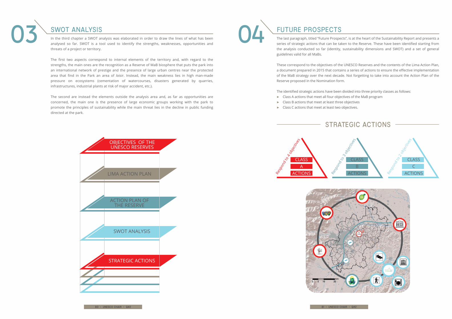
80 • unesco chair • q#2 81 • unesco chair • q#2
In the third chapter a SWOT analysis was elaborated in order to draw the lines of what has been analysed so far. SWOT is a tool used to identify the strengths, weaknesses, opportunities and threats of a project or territory.
The first two aspects correspond to internal elements of the territory and, with regard to the strengths, the main ones are the recognition as a Reserve of MaB biosphere that puts the park into an international network of prestige and the presence of large urban centres near the protected area that find in the Park an area of loisir. Instead, the main weakness lies in high man-made pressure on ecosystems (cementation of watercourses, disasters generated by quarries, infrastructures, industrial plants at risk of major accident, etc.).
The second are instead the elements outside the analysis area and, as far as opportunities are concerned, the main one is the presence of large economic groups working with the park to promote the principles of sustainability while the main threat lies in the decline in public funding directed at the park.
SWOT Analysis03 The last paragraph, titled “Future Prospects”, is at the heart of the Sustainability Report and presents a series of strategic actions that can be taken to the Reserve. These have been identified starting from the analysis conducted so far (identity, sustainability dimensions and SWOT) and a set of general guidelines valid for all MaBs.
These correspond to the objectives of the UNESCO Reserves and the contents of the Lima Action Plan, a document prepared in 2015 that contains a series of actions to ensure the effective implementation of the MaB strategy over the next decade. Not forgetting to take into account the Action Plan of the Reserve proposed in the Nomination form. The identified strategic actions have been divided into three priority classes as follows:
▶▶ Class A actions that meet all four objectives of the MaB program▶▶ Class B actions that meet at least three objectives▶▶ Class C actions that meet at least two objectives.
Future Prospects04
SWOT ANALYSIS
ACTION PLAN OF THE RESERVE
OBJECTIVES OF THE UNESCO RESERVES
LIMA ACTION PLAN
STRATEGIC ACTIONS
Resp
ond
to 3
obj
ectiv
es
CLASS B
ACTIONS Resp
ond
to 2
obj
ectiv
es
CLASS C
ACTIONSResp
ond
to 4
obj
ectiv
es
CLASS A
ACTIONS
strategic actions
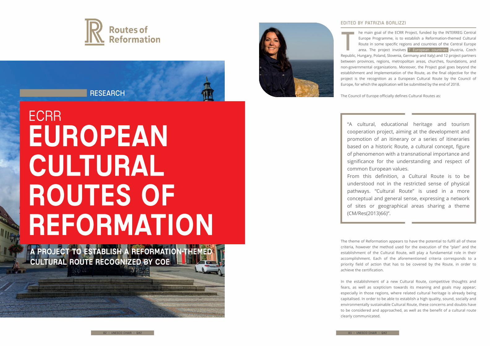
82 • unesco chair • q#2 83 • unesco chair • q#2
The theme of Reformation appears to have the potential to fulfil all of these criteria, however the method used for the execution of the “plan” and the establishment of the Cultural Route, will play a fundamental role in their accomplishment. Each of the aforementioned criteria corresponds to a priority field of action that has to be covered by the Route, in order to achieve the certification.
In the establishment of a new Cultural Route, competitive thoughts and fears, as well as scepticism towards its meaning and goals may appear; especially in those regions, where related cultural heritage is already being capitalised. In order to be able to establish a high quality, sound, socially and environmentally sustainable Cultural Route, these concerns and doubts have to be considered and approached, as well as the benefit of a cultural route clearly communicated.
ECRR
EUROPEAN CULTURAL ROUTES OF REFORMATION
“A cultural, educational heritage and tourism cooperation project, aiming at the development and promotion of an itinerary or a series of itineraries based on a historic Route, a cultural concept, figure of phenomenon with a transnational importance and significance for the understanding and respect of common European values.From this definition, a Cultural Route is to be understood not in the restricted sense of physical pathways. “Cultural Route” is used in a more conceptual and general sense, expressing a network of sites or geographical areas sharing a theme (CM/Res(2013)66)”.
Research
he main goal of the ECRR Project, funded by the INTERREG Central Europe Programme, is to establish a Reformation-themed Cultural Route in some specific regions and countries of the Central Europe area. The project involves 7 European countries (Austria, Czech
Republic, Hungary, Poland, Slovenia, Germany and Italy) and 12 project partners between provinces, regions, metropolitan areas, churches, foundations, and non-governmental organizations. Moreover, the Project goal goes beyond the establishment and implementation of the Route, as the final objective for the project is the recognition as a European Cultural Route by the Council of Europe, for which the application will be submitted by the end of 2018.
The Council of Europe officially defines Cultural Routes as:
tEDITED by patrizia borlizzi
A PROJECT TO ESTABLISH A REFORMATION-THEMED CULTURAL ROUTE RECOGNIZED BY COE
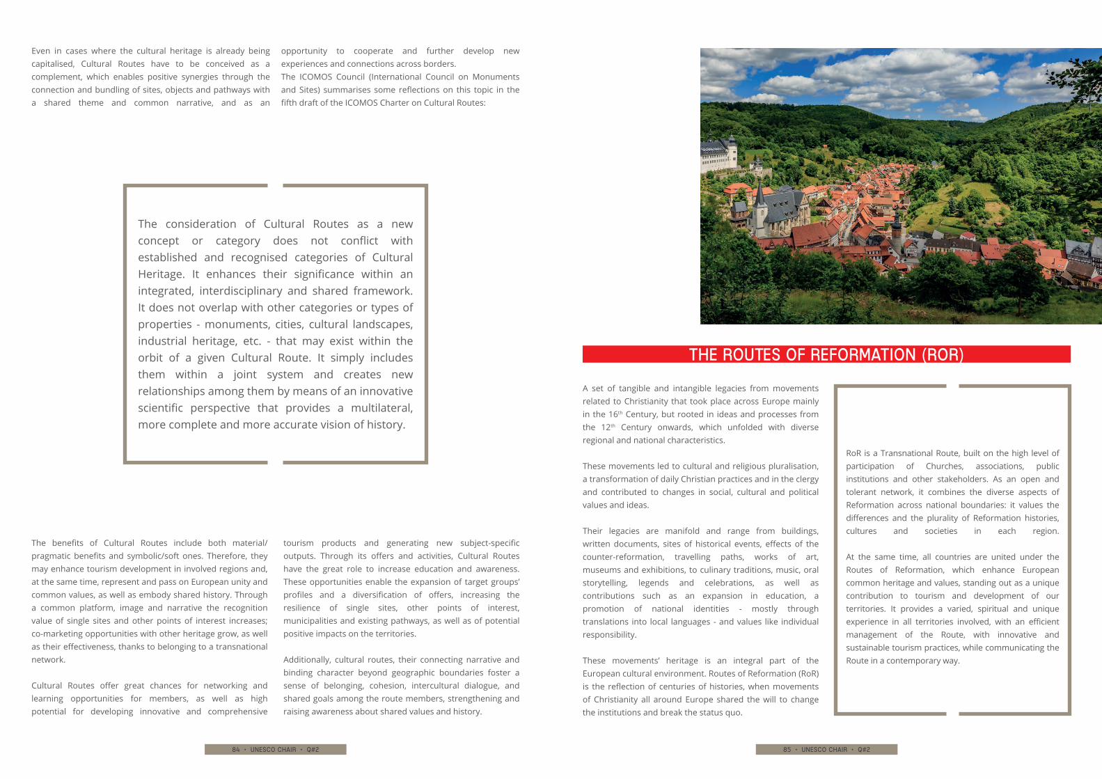
84 • unesco chair • q#2 85 • unesco chair • q#2
The benefits of Cultural Routes include both material/pragmatic benefits and symbolic/soft ones. Therefore, they may enhance tourism development in involved regions and, at the same time, represent and pass on European unity and common values, as well as embody shared history. Through a common platform, image and narrative the recognition value of single sites and other points of interest increases; co-marketing opportunities with other heritage grow, as well as their effectiveness, thanks to belonging to a transnational network.
Cultural Routes offer great chances for networking and learning opportunities for members, as well as high potential for developing innovative and comprehensive
tourism products and generating new subject-specific outputs. Through its offers and activities, Cultural Routes have the great role to increase education and awareness. These opportunities enable the expansion of target groups’ profiles and a diversification of offers, increasing the resilience of single sites, other points of interest, municipalities and existing pathways, as well as of potential positive impacts on the territories.
Additionally, cultural routes, their connecting narrative and binding character beyond geographic boundaries foster a sense of belonging, cohesion, intercultural dialogue, and shared goals among the route members, strengthening and raising awareness about shared values and history.
A set of tangible and intangible legacies from movements related to Christianity that took place across Europe mainly in the 16th Century, but rooted in ideas and processes from the 12th Century onwards, which unfolded with diverse regional and national characteristics.
These movements led to cultural and religious pluralisation, a transformation of daily Christian practices and in the clergy and contributed to changes in social, cultural and political values and ideas.
Their legacies are manifold and range from buildings, written documents, sites of historical events, effects of the counter-reformation, travelling paths, works of art, museums and exhibitions, to culinary traditions, music, oral storytelling, legends and celebrations, as well as contributions such as an expansion in education, a promotion of national identities - mostly through translations into local languages - and values like individual responsibility.
These movements’ heritage is an integral part of the European cultural environment. Routes of Reformation (RoR) is the reflection of centuries of histories, when movements of Christianity all around Europe shared the will to change the institutions and break the status quo.
the routes of reformation (RoR)
RoR is a Transnational Route, built on the high level of participation of Churches, associations, public institutions and other stakeholders. As an open and tolerant network, it combines the diverse aspects of Reformation across national boundaries: it values the differences and the plurality of Reformation histories, cultures and societies in each region.
At the same time, all countries are united under the Routes of Reformation, which enhance European common heritage and values, standing out as a unique contribution to tourism and development of our territories. It provides a varied, spiritual and unique experience in all territories involved, with an efficient management of the Route, with innovative and sustainable tourism practices, while communicating the Route in a contemporary way.
Even in cases where the cultural heritage is already being capitalised, Cultural Routes have to be conceived as a complement, which enables positive synergies through the connection and bundling of sites, objects and pathways with a shared theme and common narrative, and as an
opportunity to cooperate and further develop new experiences and connections across borders. The ICOMOS Council (International Council on Monuments and Sites) summarises some reflections on this topic in the fifth draft of the ICOMOS Charter on Cultural Routes:
The consideration of Cultural Routes as a new concept or category does not conflict with established and recognised categories of Cultural Heritage. It enhances their significance within an integrated, interdisciplinary and shared framework. It does not overlap with other categories or types of properties - monuments, cities, cultural landscapes, industrial heritage, etc. - that may exist within the orbit of a given Cultural Route. It simply includes them within a joint system and creates new relationships among them by means of an innovative scientific perspective that provides a multilateral, more complete and more accurate vision of history.
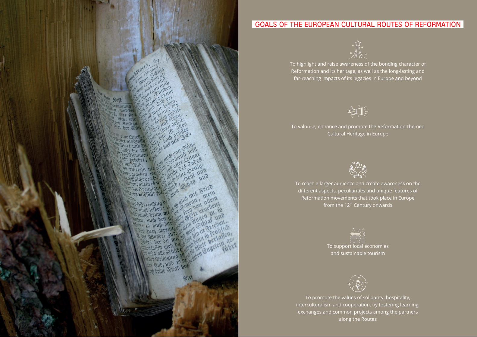
86 • unesco chair • q#2 87 • unesco chair • q#2
GOALS of the european cultural routes of reformation
To highlight and raise awareness of the bonding character of Reformation and its heritage, as well as the long-lasting and
far-reaching impacts of its legacies in Europe and beyond
To promote the values of solidarity, hospitality, interculturalism and cooperation, by fostering learning, exchanges and common projects among the partners
along the Routes
To support local economies and sustainable tourism
To reach a larger audience and create awareness on the different aspects, peculiarities and unique features of
Reformation movements that took place in Europe from the 12th Century onwards
To valorise, enhance and promote the Reformation-themed Cultural Heritage in Europe
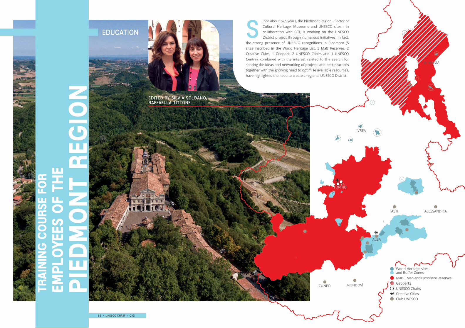
88 • UNESCO chair • q#2 89 • UNESCO chair • q#2
ince about two years, the Piedmont Region - Sector of Cultural Heritage, Museums and UNESCO sites - in collaboration with SiTI, is working on the UNESCO District project through numerous initiatives. In fact,
the strong presence of UNESCO recognitions in Piedmont (5 sites inscribed in the World Heritage List, 3 MaB Reserves, 2 Creative Cities, 1 Geopark, 2 UNESCO Chairs and 1 UNESCO Centre), combined with the interest related to the search for sharing the ideas and networking of projects and best practices together with the growing need to optimise available resources, have highlighted the need to create a regional UNESCO District.
VERBANIA
IVREA
ASTI
ALBA
CUNEO MONDOVÌ
ALESSANDRIA
TORINO
Education s
Pie
dm
on
t reg
ion
Empl
oye
es o
f th
eTr
ain
ing
co
urs
e fo
r
MaB | Man and Biosphere Reserves
Club UNESCO
UNESCO Chairs
World Heritage sites and Buffer Zones
EDITED BY Silvia soldano, raffaella tittone
Geoparks
Creative Cities
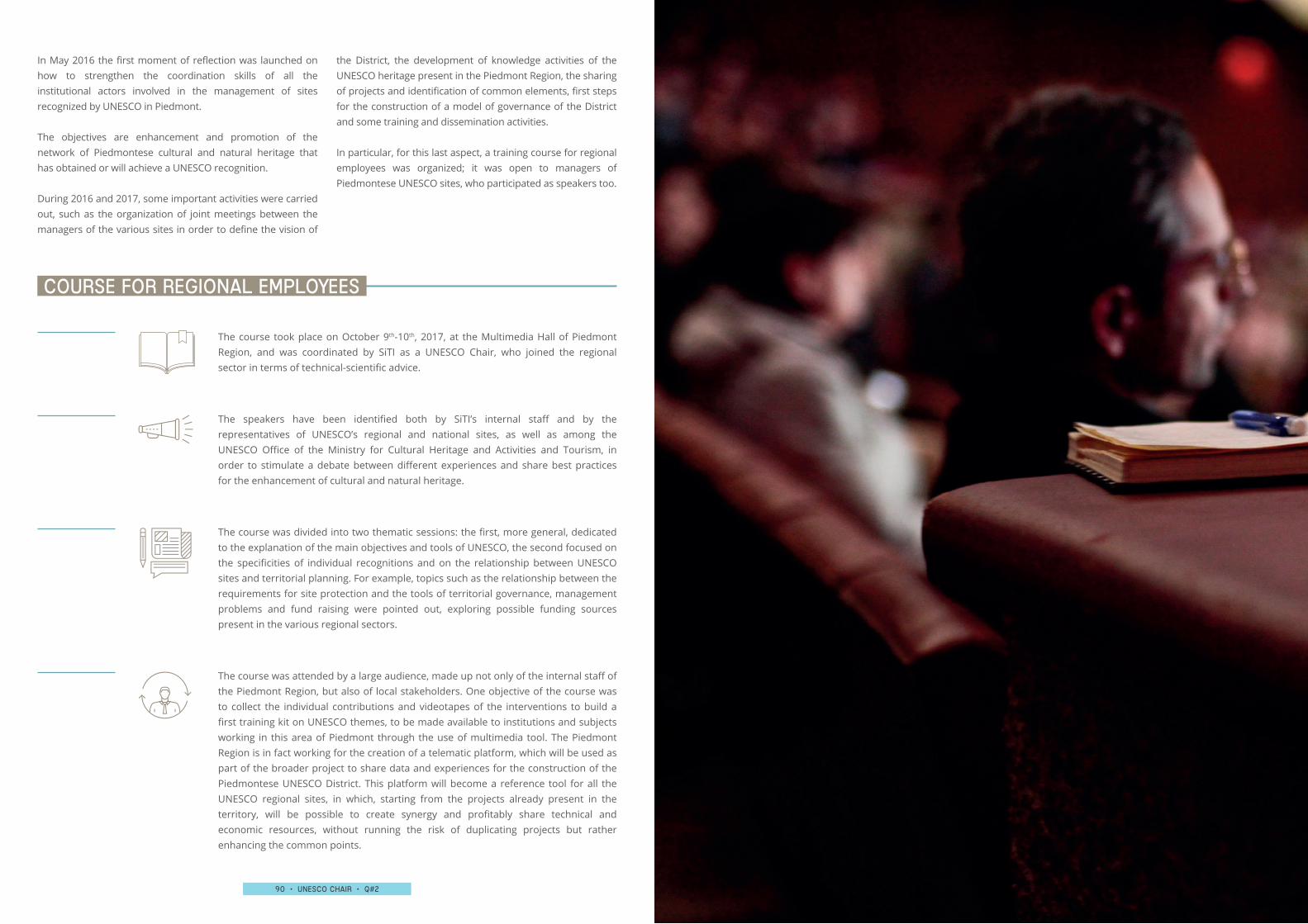
90 • UNESCO chair • q#2 91 • UNESCO chair • q#2
In May 2016 the first moment of reflection was launched on how to strengthen the coordination skills of all the institutional actors involved in the management of sites recognized by UNESCO in Piedmont.
The objectives are enhancement and promotion of the network of Piedmontese cultural and natural heritage that has obtained or will achieve a UNESCO recognition.
During 2016 and 2017, some important activities were carried out, such as the organization of joint meetings between the managers of the various sites in order to define the vision of
the District, the development of knowledge activities of the UNESCO heritage present in the Piedmont Region, the sharing of projects and identification of common elements, first steps for the construction of a model of governance of the District and some training and dissemination activities.
In particular, for this last aspect, a training course for regional employees was organized; it was open to managers of Piedmontese UNESCO sites, who participated as speakers too.
The course took place on October 9th-10th, 2017, at the Multimedia Hall of Piedmont Region, and was coordinated by SiTI as a UNESCO Chair, who joined the regional sector in terms of technical-scientific advice.
The speakers have been identified both by SiTI’s internal staff and by the representatives of UNESCO’s regional and national sites, as well as among the UNESCO Office of the Ministry for Cultural Heritage and Activities and Tourism, in order to stimulate a debate between different experiences and share best practices for the enhancement of cultural and natural heritage.
The course was divided into two thematic sessions: the first, more general, dedicated to the explanation of the main objectives and tools of UNESCO, the second focused on the specificities of individual recognitions and on the relationship between UNESCO sites and territorial planning. For example, topics such as the relationship between the requirements for site protection and the tools of territorial governance, management problems and fund raising were pointed out, exploring possible funding sources present in the various regional sectors.
The course was attended by a large audience, made up not only of the internal staff of the Piedmont Region, but also of local stakeholders. One objective of the course was to collect the individual contributions and videotapes of the interventions to build a first training kit on UNESCO themes, to be made available to institutions and subjects working in this area of Piedmont through the use of multimedia tool. The Piedmont Region is in fact working for the creation of a telematic platform, which will be used as part of the broader project to share data and experiences for the construction of the Piedmontese UNESCO District. This platform will become a reference tool for all the UNESCO regional sites, in which, starting from the projects already present in the territory, will be possible to create synergy and profitably share technical and economic resources, without running the risk of duplicating projects but rather enhancing the common points.
COURSE for regional employees
92 • UNESCO chair • q#2 93 • UNESCO chair • q#2
Un
esc
o c
ha
irTh
esis
an
d in
tern
ship
EDUCATION
The itinerary of Piedmont area’s medieval testaments is extremely interesting, particularly the Alba area, which results to be wide and rich of medieval elements that altogether represent an inestimable heritage. The holy buildings are the key elements in this research: churches, monasteries, parishes and chapels constitute a territorial mesh to be retraced from a diachronic point of view.
The Romanesque is the reference period, having the majority of the buildings in issue been made during that period. Building techniques, materials, decorative apparatus and, where possible, the clients and the employees have been examined.
First of all, it is an appreciated area visited for the landscape beauty, for enogastronomic richness and for the millenary culture of wine, all elements that have determined the declaration of part of these territories a World Heritage site.
The presence of a UNESCO “brand” therefore appears to be particularly lucky for the territory, but at the same time, there is the risk that it could lead the attention to restricted cultural heritage types.
The objective of this thesis is therefore to highlight the so-called minor cultural heritages too. They are not the destinations of the great tourism flows (rather directed towards the great attractors such as the Castle of Grinzane Cavour or the Barolo one, the Brunate Chapel or the Barbaresco Tower), but they can be considered as equally representative places of the history of the territory, able to attract more the attention on those who are interested in slow, contemplative cultural tourism. Several initiatives and projects of cultural and touristic valorisation have begun to converge towards the rediscovery of this type of good, as much as has been considered the basis for this study.
On a documentary level, we chose to refer to precise sources that allow us to identify different pictures according to the centuries: if the Middle Ages conventionally began in 476 (deposition of the Western
Roman Emperor) and ends in 1492 (discovery of America), the documents investigated belong to a period between X and XV century. The first ones are the Ottonian diplomas of the years 998, 999 and 1014, then the Isnardi Institutions of 1325 and finally the Registrum of the Albese diocese of 1438.
The decision to study religious architecture derives from the awareness of the fundamental value of Christianity for the Medieval people, and religiousness itself guides most of its choices, and consequently strongly influences the formation of the territorial mesh.
In fact, having created a general framework, we proceeded to retrace this plot, to relate most of the buildings identified. In particular, these studies and the hypotheses of a medieval territorial plot were returned through the use of the GIS that allowed the interaction between the collected data and the cards produced. In this way, it was possible not only to represent the positioning of the buildings, but also the changing of the presence of religious heritage on the territory over the centuries, representing the boundaries and transformations of the Alba diocese, the new achievements, the abandonments, as well as the historical territorial matrix: the sacred streets that led the peasants to move to the nearest parish church for the celebration of baptism, those travelled to reach the bishop’s residence, those of crossing that led from Liguria to France.
Some important model are basilar for this study, such as the punctual catalogation realized by the “Soprintendenza per i beni ambientali e architettonici del Piemonte” for the area of Asti but also in Liguria, Toscana, and Lazio.
Because of the area’s vocation, that is agricultural, productive, but also place of transit, the decision was taken of studying a vast and enlarged territory. It has permitted to compare with the neighbouring areas, finding similarities in some cases (such as the Liguria’s zone), but also totally different elements with others
Ph.d
th
esis
The Medieval religious heritage in the diocese of Alba
Martina Ramella Gal Supervisor: Prof. Carlo Mario Tosco
94 • UNESCO chair • q#2 95 • UNESCO chair • q#2
Giacomo PettenatiSupervisors: Prof. Egidio Dansero | Attilia Peano | Francesca Governa
(such as for Acqui, Asti and Mondovì dioceses), all areas with which, without any doubts, the Alba’s territory had politics, economical, institutional and relationships connections.
Operatively the project provided, in addition to an accurate analysis of the detailed studies on the Episcopal See of Alba, a precise cataloguing of the other buildings in the area (parish churches, subjected churches and exempt churches) from those in ruins to those in excellent condition. Each realized schedule highlights the architectural aspects (materials and construction techniques), the decorative apparatus, the construction phases, all completed by architectural and photographic surveys, as well as by bibliography and register of documents.
Thanks to the comparison of the about 30 schedules it is possible to draw interesting conclusions regarding the state of conservation, the properties, the presence of recurring elements or common relationships.
The examination of the masonry had particular importance in the project. It was preceded by an advanced bibliographic survey from which the methodology of analysis was
deduced. Specified wall reliefs were created to carry out a comparative study using a building abacus that allows, as far as possible, to hypothesis dating for that kind of architectures that have not existing documentary sources.
The creation of masonry techniques’ atlas, based on a comprehensive census of the surviving elements, would constitute an absolutely effective and privileged tool. It should be useful and necessary for the conservation of cultural heritage, precisely because the carried out studies have highlighted how performed interventions on the assets have been very often incongruous and incompatible.
In conclusion, this is an overall and complete analysis of a vast heritage that, architecture by architecture, wants to demonstrate, also through the comparison with the neighbouring areas, the exceptional nature of the territory in question. Actually, despite the external influences, it presents itself as a territorial unicum to be restored, conserved, valorized.
The Ph.D research here summarized originates from the collaboration between SiTI and Interuniversity Department of Regional And Urban Studies And Planning (DIST) of the Politecnico di Torino, with the aim of exploring the relationships between the UNESCO World Heritage List and the territories it links to, through the process of nomination and inscription of a WHL site.
The research focused on the category of cultural landscapes, considered of particular interest for many reasons, including the conceptual difficulties in its definition, its territorial scale, its close link with policies, its possible role in local development strategies.
The main hypothesis that guided the research is that the process of inscription of a WHL site should be considered not only as a recognition of the value of existing heritage, but as a territorial project, carried out by specific networks of actors who, mobilizing the heritage as resource, intend to affirm their strategies and objectives.
According to this perspective, in order to understand the relationships between the WHL and the places where sites are located, it may be useful to investigate how the global intangible system of the WHL has been territorialized at the local scale, attributing an active role to the territory.
This territorialization can be articulated in terms of:1. relations between the actors involved in the process2. representations of places, heritage and landscape
produced through the process of inscription of WHL sites
3. rules for protection and management of the OUV heritage and their integration with other planning and governance tools
4. resources that are identified and mobilized in the territorial actions related to the protection and management of a WHL site.
The first part of the dissertation explores the history and functioning of UNESCO, its approach to heritage
identification, conservation and management, its role as an actor of the international political arena and its position in the debate about the landscape. The evolution of the mechanisms of selection of the sites, more and more based on an anthropological and territorial vision of heritage, is the object of a specific focus.
The category of “cultural landscapes” is critically explored, highlighting its relations with other international instruments of landscape protection, such as the European Convention and the landscape approach to protected areas promoted by the International Union for Conservation of Nature (IUCN).
The second part of the thesis contains a critical analysis of the debate about the relationship between WHL and territory and also the description of the research methodology. Starting from a reflection on the main motivations of the nominations and on the expectations that accompany them, the work highlighted the main areas in which territorial effects of the WHL status are identified, in terms of international fame, local economy, heritage conservation, local communities and decision-making processes. As already mentioned, a relational approach focused on the analysis of the territorialization of the process of nomination, inscription and management of a WHL site, was favourited an investigation of possible territorial impacts of the recognition.
The third part of the work presents the results of the fieldwork research on case studies.
After an overview of the history and characteristics of landscape protection policies in our country and of the Italian WHL sites, the dissertation presents the results of the fieldwork research on four cultural landscapes: Cinque Terre, Costiera Amalfitana, Cilento and Val d’Orcia. For each of them, the following elements have been investigated: the characteristics of the landscape, the perimeters of the WHL site, the management systems and the rules and strategies of landscape protection, comparing them with landscape policies of
Ph.d
th
esis
Building Heritage. Places, processes, actors and policies of the “territorialisation” of World Heritage cultural landscapes in Italy
96 • UNESCO chair • q#2 97 • UNESCO chair • q#2
different scale in force in the same areas.
The last chapter contains the analysis of a “territorialization in progress”: the nomination process of the site “Vineyard Landscape of Piedmont: Langhe-Roero and Monferrato“. The chapter starts with a summary of the history and the evolution of the nomination process, followed by an in-depth reconstruction of the territoriality produced by the application, based on the approach described above.
In conclusion, the recognition of a World Heritage site seems to be strongly territorialized when it helps to legitimize and reinforce a wider landscape and territory project, even modifying the sense and principles of WHL, through their local implementation. In this case, it cannot be considered
just a label attributed to existing heritage, but a mean for the production of an imagined heritage and for the implementation of a territorial project.
The research confirmed the importance of a bottom-up interpretation of WHL, starting from the investigation of the local happening of the nomination and inscription process of WHL sites. From this perspective, the WHL status is not understood just as the global recognition of local excellence, but rather as the use of a global label by a local network of actors, going beyond the narratives about it and making its concrete meaning clearer, through its local implementation.
In a country like Italy, where the cultural assets listed by MiBACT are more than 33 every 100 square kilometres and in which there are 54 World Heritage sites, more than any other country in the world, it is essential to focus on some relevant aspects such as the documentation of this type of heritage and provide tools that allow their conservation.
Based on these premises, one of the objectives of the thesis was to understand whether the integrated survey and the Historical Building Information Modelling (HBIM) could be considered a valuable tool for the knowledge, conservation and maintenance of architectural assets and evaluating not only the potentialities, but also the limitations of the BIM methodology applied to the existing building heritage.
The case study was the Sacro Monte of Varallo, a devotional complex declared World Heritage site in 2003 and, more specifically, the study focused on the Pilato Palace, a seventeenth-century building containing eight votive chapels.
This specialization thesis consists of three main parts:1. the first concerning geomatics, with the acquisition
and processing of laser scanner data and aerial photogrammetry using Unmanned Aerial Vehicle (UAVs)
2. the second one on the HBIM modelling and the application of this process to the architectural assets
3. the third related to the creation of a database for the planned maintenance of this heritage.
Furthermore, within these three areas, research ideas have been included, such as: the comparison between the photogrammetric point cloud with the one acquired through the LiDAR technique; evaluation of some plug-ins for semi-automatic recognition of architectural elements from point cloud; the study of various methods for the realization of the complex geometries of the model, such as vaults or roofing, with the use of interoperable software; the use of Revit applications for the formulation of scripts that allow an automatic survey of the decay starting from the point cloud and,
finally, the structuring of a data mask for an easier consultation of the created database.
At the end of the whole process of survey and digital modelling, both the criticalities and the potentialities emerged were highlighted.
Among all the criticalities observed are to highlight:▶▶ an inconsistency between the final survey scale
(previously established at 1:50 and then changed to 1:100) and the level of detail of the information acquired
▶▶ a considerable difficulty in the modelling of the built heritage within the Revit environment, where the millimetre accuracy maintained during the whole data processing phases was lost
▶▶ the presence of “rigid” elements, not fully modifiable like the stairs, has meant that the model, in some of its components, diverges more from reality
▶▶ the difficulty in modelling curved and complex details such as capitals
▶▶ the impossibility of standardizing and systematizing the HBIM methodology for the representation of architectural assets due to the lack of suitable Family libraries and tools for recognizing automatically architectural elements.
Despite these issues, however, numerous potentialities of this new method have also come to light:
▶▶ the creation, starting from the survey through UAVs, of a Digital Elevation Model that can provide information also on a territorial scale
▶▶ the realization of a model that is not a simple 3D representation, but which contains also “multi-source” data useful for future restoration or conservation projects
▶▶ the reliable and rapid reconstruction of the building geometry through the latest plug-ins on the market
▶▶ the possibility to work simultaneously in the same project, with exchange of skills and competences, as well as speeding up the process (this point is of considerable importance especially in the field of restoration, a multidisciplinary and complex matter)
▶▶ the setting up of a digital model able to provide a
Post
gra
dua
te t
hes
is a
t Be
ni A
rch
itet
ton
ici e
del
Pae
sag
gio
sc
ho
ol
3D Metric detection amd bim modelling for the planned maintenance of architectural heritage. the case study of sacro monte of varallo
Francesca Matrone Supervisor: Prof. Marco Zerbinatti | Andrea Maria Lingua | Anna Osello
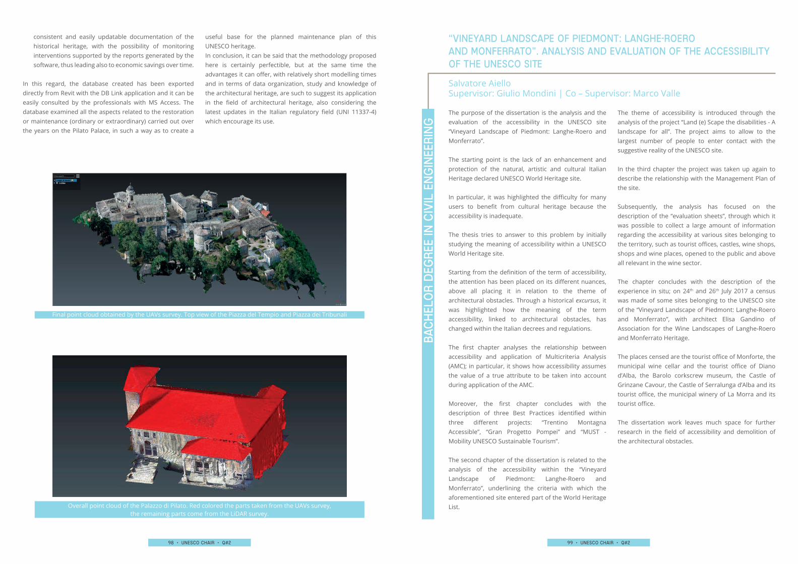
98 • UNESCO chair • q#2 99 • UNESCO chair • q#2
Final point cloud obtained by the UAVs survey. Top view of the Piazza del Tempio and Piazza dei Tribunali
Overall point cloud of the Palazzo di Pilato. Red colored the parts taken from the UAVs survey, the remaining parts come from the LiDAR survey.
The purpose of the dissertation is the analysis and the evaluation of the accessibility in the UNESCO site “Vineyard Landscape of Piedmont: Langhe-Roero and Monferrato”.
The starting point is the lack of an enhancement and protection of the natural, artistic and cultural Italian Heritage declared UNESCO World Heritage site.
In particular, it was highlighted the difficulty for many users to benefit from cultural heritage because the accessibility is inadequate.
The thesis tries to answer to this problem by initially studying the meaning of accessibility within a UNESCO World Heritage site.
Starting from the definition of the term of accessibility, the attention has been placed on its different nuances, above all placing it in relation to the theme of architectural obstacles. Through a historical excursus, it was highlighted how the meaning of the term accessibility, linked to architectural obstacles, has changed within the Italian decrees and regulations.
The first chapter analyses the relationship between accessibility and application of Multicriteria Analysis (AMC); in particular, it shows how accessibility assumes the value of a true attribute to be taken into account during application of the AMC.
Moreover, the first chapter concludes with the description of three Best Practices identified within three different projects: “Trentino Montagna Accessible”, “Gran Progetto Pompei” and “MUST - Mobility UNESCO Sustainable Tourism”.
The second chapter of the dissertation is related to the analysis of the accessibility within the “Vineyard Landscape of Piedmont: Langhe-Roero and Monferrato”, underlining the criteria with which the aforementioned site entered part of the World Heritage List.
The theme of accessibility is introduced through the analysis of the project “Land (e) Scape the disabilities - A landscape for all”. The project aims to allow to the largest number of people to enter contact with the suggestive reality of the UNESCO site.
In the third chapter the project was taken up again to describe the relationship with the Management Plan of the site.
Subsequently, the analysis has focused on the description of the “evaluation sheets”, through which it was possible to collect a large amount of information regarding the accessibility at various sites belonging to the territory, such as tourist offices, castles, wine shops, shops and wine places, opened to the public and above all relevant in the wine sector.
The chapter concludes with the description of the experience in situ; on 24th and 26th July 2017 a census was made of some sites belonging to the UNESCO site of the “Vineyard Landscape of Piedmont: Langhe-Roero and Monferrato”, with architect Elisa Gandino of Association for the Wine Landscapes of Langhe-Roero and Monferrato Heritage.
The places censed are the tourist office of Monforte, the municipal wine cellar and the tourist office of Diano d’Alba, the Barolo corkscrew museum, the Castle of Grinzane Cavour, the Castle of Serralunga d’Alba and its tourist office, the municipal winery of La Morra and its tourist office.
The dissertation work leaves much space for further research in the field of accessibility and demolition of the architectural obstacles.
Bac
hel
or
Deg
ree
in C
ivil
en
gin
eeri
ng
“Vineyard Landscape of Piedmont: Langhe-Roero and Monferrato”. Analysis and evaluation of the accessibility of the UNESCO site
Salvatore AielloSupervisor: Giulio Mondini | Co – Supervisor: Marco Valle
consistent and easily updatable documentation of the historical heritage, with the possibility of monitoring interventions supported by the reports generated by the software, thus leading also to economic savings over time.
In this regard, the database created has been exported directly from Revit with the DB Link application and it can be easily consulted by the professionals with MS Access. The database examined all the aspects related to the restoration or maintenance (ordinary or extraordinary) carried out over the years on the Pilato Palace, in such a way as to create a
useful base for the planned maintenance plan of this UNESCO heritage.In conclusion, it can be said that the methodology proposed here is certainly perfectible, but at the same time the advantages it can offer, with relatively short modelling times and in terms of data organization, study and knowledge of the architectural heritage, are such to suggest its application in the field of architectural heritage, also considering the latest updates in the Italian regulatory field (UNI 11337-4) which encourage its use.
100 • UNESCO chair • q#2 101 • UNESCO chair • q#2
Eight students from the fourth class of Scientific High School “E. Ferrari” of Susa, during 2016-2017 has undergone a two weeks internship in SiTI. They attended on three different projects about:
▶▶ MaB Reserve UNESCO Collina Po▶▶ UNESCO World Heritage site of “Vineyard Landscape
of Piedmont: Langhe-Roero and Monferrato” ▶▶ Energy consumption trial in the municipality of Trino
Vercellese
One of the aims of the internship was to transfer knowledge and to support the development of students’ skill about the enhancement of environmental and Cultural Heritage, energy consumption and spatial analysis.
The project, was firstly discussed in several meeting were teachers of Ferrari’s High School and researchers of SiTI decided to divide the experience into two-step one in the SiTI’s premises and one on field.
The students were given an opportunity to know working life, to compare their own abilities with university skill or research’s world. Tutors and teachers have been able to understand skill’s students and involve them in an innovative project. This project concerns all Piedmontese territory and help to understand how the socio-cultural-environmental frame can offer to the cultural and environmental development.
This experience developed social and interdisciplinary expertise: autonomy, responsibility, cooperation and collaboration, respect for the environment, working in a team or alone. Furthermore, the use of new technologies, developed important skills to use in the student’s future.
The first part was about UNESCO World Heritage List “Vineyard Landscape of Piedmont: Langhe-Roero and Monferrato”. The students worked on a thematic map through Geographic Information System (GIS). They set up a geo-localised map with all local and traditional
winery (called “Infernot”) located in UNESCO’s buffer zone.Moreover, the project was the opportunity to use innovative technologies in the cultural property field.
The second project was a chance for the students to study and analyze different protected area with proper analysis tools: thematic maps, sustainability budged and spatial data. In this step, students compared MaB Reserves in Piedmont with the one in Cipro’s Island.
The last project was in Trino Vercellese. The students through spatial analysis by GIS software, had the opportunity to learn about energy consumption and public lighting.
At the end of the internship, the students presented the results of this experience (by a presentation on PowerPoint) to the tutors of SiTI, teachers and classmate. The main goal of the presentation was an excellent opportunity of confrontation with professional profiles who work in the field of research and development.
sch
ola
stic
inte
rnsh
iptraining-work experience internship with the scientific high school “ferrari” in susa, torino
Giuliana Giai
The internship was part of a greater experience named ReStartAlp, a start-up business incubator aimed at promoting sustainable development for Alpine territories, sponsored by Fondazione Garrone and Fondazione Cariplo.
The goal of the incubator is to spread a real culture of development of the Italian highlands and to offer a concrete support to the young mountain enterprises of the national territory.
To realize and strengthen a new “Italian mountain economy”, to stimulate synergies and exchange of good practices between the Alps and the Apennines, to focus on the development of territorial excellence while enhancing the identity of the “made in Italy” that unites the various local production activities, always offer greater impulse to green jobs: these are the main purposes of ReStartAlp.
This research project is focused on sustaining people with disabilities to access to mountain territories in order to reduce physical and social barriers and promoting an equal and fair social development in our societies.
During the internship in SiTI the student had the opportunity to collaborate to a project financed by the Italian Ministry for Cultural Heritage.
The project, managed by the Association for the Wine Landscapes of Langhe-Roero and Monferrato Heritage, in collaboration with SiTI, aimed at promoting equal access to people with disabilities in the territory of the Piedmontese UNESCO site.
The participation of the student in the project was good, both in the office and in the field, contributing with acquired skills in monitoring accessibility in the most important touristic places of UNESCO World Heritage site “Vineyard Landscape of Piedmont: Langhe-Roero and Monferrato”.
It was also an important occasion for him to increase
contact network and to know different stakeholders engaged in the larger field of accessible tourism.
inte
rnsh
ip r
esta
rta
lp
INTERNSHIP within the restartalp incubator
Luca Stefenelli
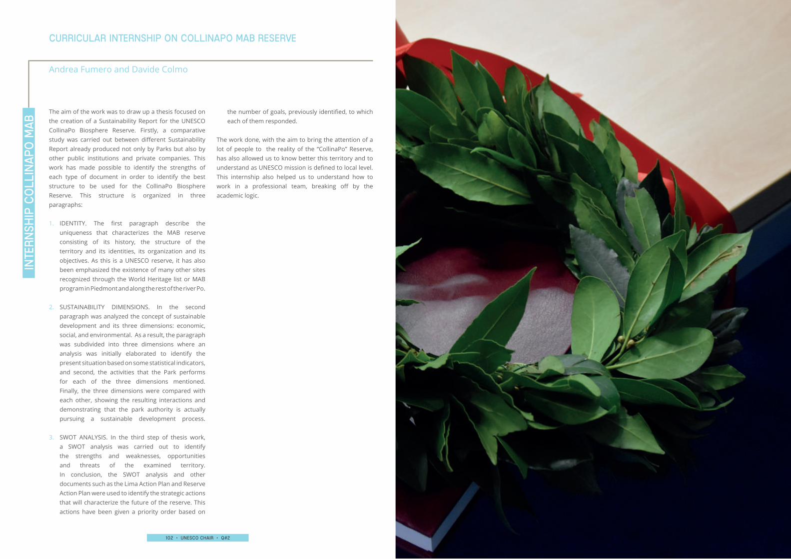
102 • UNESCO chair • q#2 103 • UNESCO chair • q#2
The aim of the work was to draw up a thesis focused on the creation of a Sustainability Report for the UNESCO CollinaPo Biosphere Reserve. Firstly, a comparative study was carried out between different Sustainability Report already produced not only by Parks but also by other public institutions and private companies. This work has made possible to identify the strengths of each type of document in order to identify the best structure to be used for the CollinaPo Biosphere Reserve. This structure is organized in three paragraphs:
1. IDENTITY. The first paragraph describe the uniqueness that characterizes the MAB reserve consisting of its history, the structure of the territory and its identities, its organization and its objectives. As this is a UNESCO reserve, it has also been emphasized the existence of many other sites recognized through the World Heritage list or MAB program in Piedmont and along the rest of the river Po.
2. SUSTAINABILITY DIMENSIONS. In the second paragraph was analyzed the concept of sustainable development and its three dimensions: economic, social, and environmental. As a result, the paragraph was subdivided into three dimensions where an analysis was initially elaborated to identify the present situation based on some statistical indicators, and second, the activities that the Park performs for each of the three dimensions mentioned. Finally, the three dimensions were compared with each other, showing the resulting interactions and demonstrating that the park authority is actually pursuing a sustainable development process.
3. SWOT ANALYSIS. In the third step of thesis work, a SWOT analysis was carried out to identify the strengths and weaknesses, opportunities and threats of the examined territory. In conclusion, the SWOT analysis and other documents such as the Lima Action Plan and Reserve Action Plan were used to identify the strategic actions that will characterize the future of the reserve. This actions have been given a priority order based on
the number of goals, previously identified, to which each of them responded.
The work done, with the aim to bring the attention of a lot of people to the reality of the “CollinaPo” Reserve, has also allowed us to know better this territory and to understand as UNESCO mission is defined to local level. This internship also helped us to understand how to work in a professional team, breaking off by the academic logic.
inte
rnsh
ip C
oll
ina
po m
ab
Curricular internshiP on collinapo mab reserve
Andrea Fumero and Davide Colmo
104 • UNESCO chair • q#2 105 • UNESCO chair • q#2
The round table dedicated to the UNESCO District of Piedmont was held in the “Salone degli Svizzeri” of Palazzo Chiablese in Torino, and was an opportunity to reflect on the strategic lines that are related to it and on the implementation of integrated projects and initiatives. The works, opened by the Regional Secretary of MiBACT for Piedmont Gennaro Miccio, were attended by the Head of the UNESCO sector of the Piedmont Region Raffaella Tittone, the manager of the UNESCO Office of MiBACT Maria Grazia Bellisario, together with the representatives of the UNESCO Piedmontese sites. The SiTI UNESCO Chair group presented the drafting of the first part of the unit management plan for the Piedmontese UNESCO sites, aimed at highlighting the existing networks, the mapping and the planning and territorial intersections. The results of this coordination process were also presented during the Seventh Conference of the Italian sites registered in the UNESCO World Heritage List which was held in Roma, 8-10|11|2016.
The presentation of the results of the project and of the book dedicated to the valorization of wine architecture through cataloging, education and use activities (project financed with the funds of Law 77/2006 for UNECO sites) took place during the “Heritage Day”, organized at the Orme Art Park on La Court in Castelnuovo Calcea (AT). At the conference, which was attended by over 80 people, were disseminated the various actions activated during the project, both in the context of training with schools, and in the census of cultural heritage, promoted by the Association for the Wine Landscapes of Langhe-Roero and Monferrato Heritage, of which SiTI is a scientific partner.
The meeting aimed to illustrate the procedures related to the implementation of the law 77/2006 and in particular the procedures for reporting the financed projects. In 2006, Italy issued Law 77 to provide regulatory feedback to UNESCO’s recommendations on the need to develop tools to ensure the conservation, enhancement and participatory and sustainable management of the sites included in the World Heritage List. To date, the
The initiative is organized as part of the new series of meetings “Dialogues around the landscape”, by the School of specialization in Architectural Heritage and Landscape of Politecnico di Torino, Università di Torino and the master’s degree
The Organisation of the European Capital of Culture PAFOS2017, in the context of the Akamas Project, organised an open conference entitled: UNESCO MaB Programme (Man and Biosphere) for Protected Areas. Benefits and Perspectives “Humans and Nature Together for Sustainable Development”. The conference provided an opportunity for information regarding the important program of UNESCO MaB, and raised the concern and challenge for communities of Akamas as the
International Day of People with Disabilities 2016. The speeches offered some insights to tackle the theme of “Tourism for all”, both from a political point of view and from an economic point of view. SiTI proposed a reflection on the accessibility project to the UNESCO site of Langhe-Roero and Monferrato, promoted by the Association for the Vineyard Landscape of Piedmont: Langhe-Roero and Monferrato.
Law has funded 291 projects, for a total amount of € 23,191,244.24.The activities of management of the Law, entrusted to the UNESCO office which operates at Service I of the General Secretariat, concern the procedures for the selection of proposals prepared by the “referents” of UNESCO sites for the allocation of funding, the provision of funds following the technical-administrative monitoring of the projects and the technical-administrative support to the sites to give greater effectiveness to the interventions financed according to the Law.
course in “Green areas design and of the landscape” between Università di Torino, Politecnico di Torino, Università di Genova and Università di Milano.The Chair of SiTI has moderated the round table on the theme “Role and importance of the landscape in the conservation and restoration of architectural heritage”.
Heritage List was held in Roma, and saw professionals, institutions, representatives of MiBACT, and scholars discussing about the management of heritage and the establishment of the Observatory on Italian World Heritage sites, which the Ministry intends to build alongside and to support the activities of the current UNESCO office which operates at the General Secretariat. From the sessions of works and the round tables, in which SiTI participated as a speaker, the need arose for an observatory on the UNESCO site that serves as a multidisciplinary recomposition site, which functions as an open data platform to find and exchange data, information, materials, in which to build paths for protection and enhancement, sharing experiences and training.
The VII National Conference of Italian sites registered in the UNESCO World
The conference was held at the Regina Palace Hotel in Stresa, on the
UNESCO CHAIR EVENTS26TH OCTOBER 2016 27TH OCTOBER 2016
7TH FEBRUARY 2017
9TH FEBRUARY 2017
24TH FEBRUARY 2017
8TH-10TH NOVEMBER 2016
16TH DECEMBER 2016
TOWARDS A UNESCO TERRITORIAL DISTRICT, TORINO
THE HERITAGE DAY CASTELNUOVO CALCEA
LAW 77/2006: IMPLEMENTATION PROCEDURES, ROMA
ARCHITECTURAL RESTORATION: PRINCIPLES AND METHODS BETWEEN TRADITION AND INNOVATION, TORINO
UNESCO MAB PROGRAMME FOR PROTECTED AREAS. BENEFITS AND PERSPECTIVES, PAFOS
FOR A NATIONAL OBSERVATORY OF UNESCO SITES, ROMA
TOURISM FOR ALL: FROM SOCIAL TO BUSINESS. AN ECONOMIC OPPORTUNITY FOR THE TERRITORY, STRESA
Exchange
104 • UNESCO chair • q#2 105 • UNESCO chair • q#2
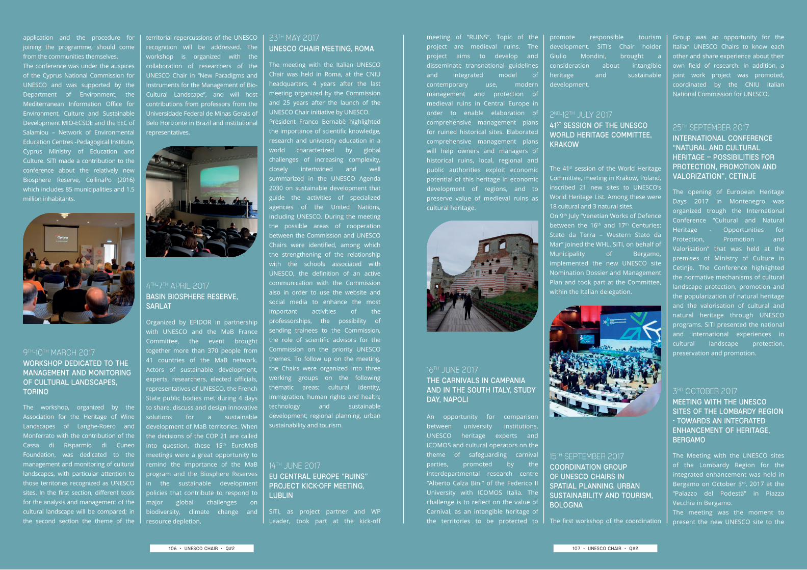
106 • UNESCO chair • q#2 107 • UNESCO chair • q#2
application and the procedure for joining the programme, should come from the communities themselves.The conference was under the auspices of the Cyprus National Commission for UNESCO and was supported by the Department of Environment, the Mediterranean Information Office for Environment, Culture and Sustainable Development MIO-ECSDE and the EEC of Salamiou – Network of Environmental Education Centres -Pedagogical Institute, Cyprus Ministry of Education and Culture. SiTI made a contribution to the conference about the relatively new Biosphere Reserve, CollinaPo (2016) which includes 85 municipalities and 1.5 million inhabitants.
territorial repercussions of the UNESCO recognition will be addressed. The workshop is organized with the collaboration of researchers of the UNESCO Chair in “New Paradigms and Instruments for the Management of Bio-Cultural Landscape”, and will host contributions from professors from the Universidade Federal de Minas Gerais of Belo Horizonte in Brazil and institutional representatives.
The workshop, organized by the Association for the Heritage of Wine Landscapes of Langhe-Roero and Monferrato with the contribution of the Cassa di Risparmio di Cuneo Foundation, was dedicated to the management and monitoring of cultural landscapes, with particular attention to those territories recognized as UNESCO sites. In the first section, different tools for the analysis and management of the cultural landscape will be compared; in the second section the theme of the
Organized by EPIDOR in partnership with UNESCO and the MaB France Committee, the event brought together more than 370 people from 41 countries of the MaB network. Actors of sustainable development, experts, researchers, elected officials, representatives of UNESCO, the French State public bodies met during 4 days to share, discuss and design innovative solutions for a sustainable development of MaB territories. When the decisions of the COP 21 are called into question, these 15th EuroMaB meetings were a great opportunity to remind the importance of the MaB program and the Biosphere Reserves in the sustainable development policies that contribute to respond to major global challenges on biodiversity, climate change and resource depletion.
SiTI, as project partner and WP Leader, took part at the kick-off
An opportunity for comparison between university institutions, UNESCO heritage experts and ICOMOS and cultural operators on the theme of safeguarding carnival parties, promoted by the interdepartmental research centre “Alberto Calza Bini” of the Federico II University with ICOMOS Italia. The challenge is to reflect on the value of Carnival, as an intangible heritage of the territories to be protected to The first workshop of the coordination
The 41st session of the World Heritage Committee, meeting in Krakow, Poland, inscribed 21 new sites to UNESCO’s World Heritage List. Among these were 18 cultural and 3 natural sites. On 9th July “Venetian Works of Defence between the 16th and 17th Centuries: Stato da Terra – Western Stato da Mar” joined the WHL. SiTI, on behalf of Municipality of Bergamo, implemented the new UNESCO site Nomination Dossier and Management Plan and took part at the Committee, within the Italian delegation.
The opening of European Heritage Days 2017 in Montenegro was organized trough the International Conference “Cultural and Natural Heritage - Opportunities for Protection, Promotion and Valorisation” that was held at the premises of Ministry of Culture in Cetinje. The Conference highlighted the normative mechanisms of cultural landscape protection, promotion and the popularization of natural heritage and the valorisation of cultural and natural heritage through UNESCO programs. SiTI presented the national and international experiences in cultural landscape protection, preservation and promotion.
The Meeting with the UNESCO sites of the Lombardy Region for the integrated enhancement was held in Bergamo on October 3rd, 2017 at the “Palazzo del Podestà” in Piazza Vecchia in Bergamo. The meeting was the moment to present the new UNESCO site to the
meeting of “RUINS”. Topic of the project are medieval ruins. The project aims to develop and disseminate transnational guidelines and integrated model of contemporary use, modern management and protection of medieval ruins in Central Europe in order to enable elaboration of comprehensive management plans for ruined historical sites. Elaborated comprehensive management plans will help owners and managers of historical ruins, local, regional and public authorities exploit economic potential of this heritage in economic development of regions, and to preserve value of medieval ruins as cultural heritage.
promote responsible tourism development. SiTI’s Chair holder Giulio Mondini, brought a consideration about intangible heritage and sustainable development.
Group was an opportunity for the Italian UNESCO Chairs to know each other and share experience about their own field of research. In addition, a joint work project was promoted, coordinated by the CNIU Italian National Commission for UNESCO.
The meeting with the Italian UNESCO Chair was held in Roma, at the CNIU headquarters, 4 years after the last meeting organized by the Commission and 25 years after the launch of the UNESCO Chair initiative by UNESCO.President Franco Bernabè highlighted the importance of scientific knowledge, research and university education in a world characterized by global challenges of increasing complexity, closely intertwined and well summarized in the UNESCO Agenda 2030 on sustainable development that guide the activities of specialized agencies of the United Nations, including UNESCO. During the meeting the possible areas of cooperation between the Commission and UNESCO Chairs were identified, among which the strengthening of the relationship with the schools associated with UNESCO, the definition of an active communication with the Commission also in order to use the website and social media to enhance the most important activities of the professorships, the possibility of sending trainees to the Commission, the role of scientific advisors for the Commission on the priority UNESCO themes. To follow up on the meeting, the Chairs were organized into three working groups on the following thematic areas: cultural identity, immigration, human rights and health; technology and sustainable development; regional planning, urban sustainability and tourism.
9TH-10TH MARCH 2017
4TH-7TH APRIL 2017
14TH JUNE 2017
23TH MAY 2017
16TH JUNE 2017
15TH SEPTEMBER 2017
2ND-12TH JULY 2017
25TH SEPTEMBER 2017
3RD OCTOBER 2017
WORKSHOP DEDICATED TO THE MANAGEMENT AND MONITORING OF CULTURAL LANDSCAPES, TORINO
BASIN BIOSPHERE RESERVE, SARLAT
EU CENTRAL EUROPE “RUINS” PROJECT KICK-OFF MEETING, LUBLIN
UNESCO CHAIR MEETING, ROMA
THE CARNIVALS IN CAMPANIA AND IN THE SOUTH ITALY, STUDY DAY, NAPOLI
COORDINATION GROUP OF UNESCO CHAIRS IN SPATIAL PLANNING, URBAN SUSTAINABILITY AND TOURISM,BOLOGNA
41ST SESSION OF THE UNESCO WORLD HERITAGE COMMITTEE, KRAKOW
INTERNATIONAL CONFERENCE “NATURAL AND CULTURAL HERITAGE – POSSIBILITIES FOR PROTECTION, PROMOTION AND VALORIZATION”, CETINJE
MEETING WITH THE UNESCO SITES OF THE LOMBARDY REGION - TOWARDS AN INTEGRATED ENHANCEMENT OF HERITAGE, BERGAMO
106 • UNESCO chair • q#2 107 • UNESCO chair • q#2
108 • UNESCO chair • q#2 109 • UNESCO chair • q#2
Lombard network, just a few months after the official recognition in Krakow in July 2017, and to start contacts with representatives of other sites, to become an integral part of the network and develop coordinated actions.The meeting was attended by representatives of all the UNESCO Lombard sites in a round table, coordinated by the Lombardy Region, with the technical advice of SiTI.
The conference was held at the Foro Boario of Nizza Monferrato (AT) with the participation of numerous representatives of Italian UNESCO sites (Valle Camonica, Monte San Giorgio, Residences of the House of Savoy, Sassi of Matera, Sacri Monti, Mount Etna, Dolomites) and the Ministry for Cultural Heritage and Activities. During the study day, several cases were examined on which accessibility solutions were applied in landscape and cultural contexts, and was created an opportunity for the comparison between the managers of cultural sites on this topic.
The International Happening dedicated to the UNESCO site took place at Palazzo Frizzoni, in Bergamo. The event was part of the project “The defenses of peace” funded by the Lombardy Region and promoted by the association “Terra di San Marco” in collaboration with the Secretariat of the UNESCO site. The event saw the participation of the Italian Minister of Cultural Heritage Dario Franceschini, the Ministers of
The second part of the exchange programme between SiTI and the Federal University of Minas Gerais in Belo Horizonte took place in a 3 days meeting, with a workshop and two study visits. This workshop intends to make possible the exchange of experiences on concepts, methods and strategies for the management of national and international urban and landscape projects protected by UNESCO as world heritage. Discussion on management achievements and challenges through the case studies of the Langhe Roero Monferrato Valley Wine Region in Italy and the Pampulha Modern Group in Brazil. The study visits were focused on the UNESCO sites of Pampulha and Ouro Preto.
SiTI participated in the conference “The subject is responsible? Models and management paths for the development of UNESCO sites” held in Capo di Ponte at the Museo Nazionale della Preistoria of Valle Camonica.The aim was to open an institutional comparison on how to govern the UNESCO sites, to respond to the central theme of identifying a person responsible for the site able to face management challenges while respecting the territorial specificities. During the conference, SiTI presented the analysis on the governance systems of the Italian UNESCO sites, promoted by the site of the Rock Drawings in Valcamonica.
Cultural Heritage of Croatia and Montenegro, the UNESCO Ambassadors appointed by the three States Parties. The mayors and representatives of the Italian and foreign Municipalities involved as well as the officials and experts, who have been the protagonists of the application process for various reasons, were present as well.
“Tourism and UNESCO sites”, organized by the General Secretariat - Service I - Coordination - UNESCO Office. The meeting was aimed at a comparison on the issues of tourism in UNESCO sites, with particular regard to the experience of projects funded under the funds of law 77/2006. The Director of Service I - Directorate General of Tourism presented the Strategic Plan of Tourism.SiTI participated in the first session of work on the management of tourist flows and studies on the carrying capacity of UNESCO sites.
Administrators, institutions, operators and technicians working in the UNESCO World Heritage site met in Roma at the headquarters of MiBACT for the workshop Law 77/2006
19TH OCTOBER 2017
14TH NOVEMBER 2017
4TH-6TH DECEMBER 2017
26H-27TH OCTOBER 2017
6TH NOVEMBER 2017
NATIONAL MEETING “LAND(E)SCAPE THE DISABILITIES”, NIZZA MONFERRATO
VENETIAN WORKS OF DEFENCE BETWEEN THE 16TH AND 17TH CENTURIES: STATO DA TERRA – WESTERN STATO DA MAR, BERGAMO
WORKSHOP ON MANAGEMENT OF CULTURAL LANDSCAPE, BELO HORIZONTE
“THE SUBJECT IS RESPONSIBLE? MODELS AND MANAGEMENT PATHS FOR THE DEVELOPMENT OF UNESCO SITES” CONFERENCE, CAPO DI PONTE
WORKSHOP LAW 77/2006 “TOURISM AND UNESCO SITES”, ROMA
108 • UNESCO chair • q#2 109 • UNESCO chair • q#2
No
tes
No
tes
No
tes
No
tes
No
tes
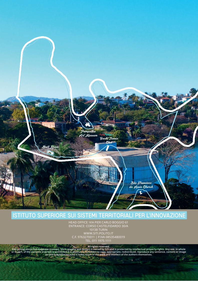
São Francisco de Assis Church
Ball Room
Pampulha Art Museum
Yacht Tennis Club
All rights reserved.Everything about this magazine (content, texts, graphic and design) is owned by SiTI and is protected by intellectual property rights. Any use, in whole
or in part, of the contents inserted is prohibited.It is absolutely forbidden to copy, appropriate, redistribute, reproduce any sentence, content or image on this magazine because it is the result of the work and intellect of the authors themselves.
ISTITUTO SUPERIORE SUI SISTEMI TERRITORIALI PER L’INNOVAZIONEHEAD OFFICE: VIA PIER CARLO BOGGIO 61 ENTRANCE: CORSO CASTELFIDARDO 30/A
10138 TURIN WWW.SITI.POLITO.IT
C.F. 9763270011 | P.IVA 08535480019 TEL. 011 1975 1111
Related Documents