IN'j) 1 g

Welcome message from author
This document is posted to help you gain knowledge. Please leave a comment to let me know what you think about it! Share it to your friends and learn new things together.
Transcript

IN'j)
1
g
VOLUME 1

Government of EthiopiaWater Resources Development AuthorityUNDP/FAO
Development of Irrigated AgricultureContract No. DP/ETH/82/008-1/AGOE
KESEM 2RIGAY:ON r i0JECFEASIBIL1 STUDY
FINAL REPORT
Volume 1: Main Report
Sir M MacDonald & Partners LimitedDemeter House, Station Road, Cambricge CB1 2RS, England
August 1987

1
VOLUME 1
Main Report
Arrangement of Report
VOLUME 2
Annex A Soil and Land Suitability
Annex B Agriculture
Annex C Sociology and Livestock
Annex D Environmental Aspects
Annex E Health
VOLUME 3
Annex F Institutions
Annex G Geology
Annex H Hydrogeology and Groundwater
Annex I Hydrology and Sediment
VOLUME 4
Annex L Irrigation, Drainage andFlood Protection
Annex M Infrastructure and Services
VOLUME 5
Annex J Dams and Hydropower e
Annex K Implementation
Annex N Economics and Finance
Appendices A
Appendices I
Supplementary Drawings for Annex A
ALBUM 1 (1 000 x 690 mm format)
VOLUME 6 (A4 format)
Drawings for:
*Annex A (except those folded in Volume 6)
Annex I
nnex L
ALBUM 2 (630 x 297 mm format)
Drawings for:
Annex G
Annex J

CONTENTS
Page Nr
(i)
ABBREVIATIONS
CHAPTER 1 INTRODUCTION
(iv)
1.1 Background 11.2 Objectives 21.3 Arrangement of the Report 21.4 Acknowledgements 3
CHAPTER 2 PREVIOUS STUDIES AND REPORTS 4
2.1 General 42.2 The 1965 SOGREAH/FAO Report 52.3 Other Reports about the Kesem-Kebena Plain 52.4 Other Middle Awash Reports 6
CHAPTER 3 THE RESOURCES AND THE PRESENT SITUATION 8
3.1 Land Resources 83.2 Water Resources 11
3.2.1 Groundwater 113.2.2 Surface Water 12
3.3 Human Resources 133.4 Existing Agriculture 143.5 Infrastructure and Services 153.6 The Environment 163.7 Institutions 17
CHAPTER 4 OPTIONS AND CHOICES 19
4.1 General 194.2 Crops and Farming Systems 204.3 The Pastoralists and the Environment 254.4 Irrigation, Drainage and Flood Protection 27
4.4.1 Irrigation System 274.4.2 Drainage and Reclamation 294.4.3 Flood Protection 30
4.5 Dam and Hydropower 314.5.1 Dam Location, Type and Design 314.5.2 Energy and Hydropower 33
4.6 Services and Infrastructure 344.7 Institutions 364.8 Project Size 37

CONTENTS (cont.)
Page Nr
CHAPTER 5 THE PROJECT 39
5.1 General 395.2 Irrigation Scheme 39
5.2.1 Layout and Cropped Areas 395.2.2 Irrigation System 435.2.3 Drainage and Flood Protection 445.2.4 In-field Works 45
5.3 Dam and Hydropower Station 465.4 Pastorelists, Livestock and the
Environment 475.5 Infrastructure and Services 495.6 Institutions 525.7 Implementation 525.8 Estimated Costs 54
CHAPTER 6 EVALUATION 58
6.1 Methodology 586.2 Economic Bene fits and Costs 586.3 Results of Economic Analysis 606.4 Other Benefits 626.5 Finance 63
CHAPTER 7 CONCLUSIONS AND RECOMMENDATIONS 64
REFERENCES 66
APPENDIX 1 FINANCIAL COST DETAILS
TableNr
3.1
LIST OF TABLES
Title Page Nr
Summary of Areas Suitable for Irrigation by LandUtilisation Type 10
4.1 Summary of Crops Considered 214.2 Summary of Gross Margins for State Farms 234.3 Summary of Gross Margins for Settlement Areas 23
5.1 Net Irrigated Areas 405.2 Farming Systems and Net Cropped Areas, Large Project 415.3 Farming Systems and Net Cropped Areas, Medium Project 425.4 Land Drainage Treatments 445.5 Numbers of Buildings, Large Project 505.6 Staff Numbers, Large Project 535.7 Staged Development of Irrigated Areas 535.8 Summary of Initial Costs, Large Project 555.9 Summary of Initial Costs, Medium Project 565.10 Summary of Recurrent Costs 57
6.1 Summary of Economic Crop Gross Margins 586.2 Summary of Economic Analysis Results 61
LIST OF FIGURES
Figure Title FollowingNr Page Nr
3.1 The Project Area 72
4.1 Cropping Calendar for Non-perennial Crops 23
5.1 Project Layout, Large Project 725.2 Project Layout, Medium Project 725.3 Tentative Project Development Programmes 52
PLATES
Plate 1 Satellite Image of the Project Area 7Plate 2 Awara Melka from the West 14
DRAWING
(bound in Album 1)
Drawing Nr 1 Project Area Map
(Other drawings are listed in the appropriate annexes)
ABBREVIATIONS
(Annex A has another list, with specialised abbreviations related to soils)
AADC Awash Agricultural Development CorporationAIMC Agricultural Inputs Marketing CorporationAMC Agricultural Marketing CorporationARC Agricultural Research Centre at MeIke WarerAVA Awash Valley AuthorityAVSA Awash Valley Settlement Agency
CottonCIF Carriage Insurance FreightDFC Direct Foreign CurrencyDM Dry matterDPSA Development Projects Study AgencyEBJV Ethio-Bulgarian Agricultural Joint Venture of Kesem KebenaEELPA Ethiopian Electric Light and Power AuthorityEIRR Economic Internal Rate of Returnel. Elevation (above sea level)ELACO Ethio-Libyan Joint Agricultural CompanyEOPEC Ethiopian Oilseeds and Pulses Export CorporationESTC Ethiopian Science and Technology CommissionETMC Ethiopian Tobacco and Matches CorporationFAO Food and Agriculture Organization of the United NationsFOB Free on Board
GurmileHorticulture
HDC Horticultural Development CorporationIAR Institute of Agricultural ResearchIBRD International Bank for Reconstruction and DevelopmentID and FP Irrigation, drainage and flood protectionIFC Indirect Foreign CurrencyILCA International Livestock Centre for AfricaKIP Kesem Irrigation ProjectKSFO Kesem State Farm OfficeKSO Kesem Settlement OfficeKWRO Kesem Water Resources OfficeLC Local CurrencyLLU/LSU Livestock UnitMAADE Middle Awash Agricultural Development EnterpriseMADC Middle Awash Development CorporationMAP Mean annual precipitationMAR Mean annual runoffMCH Maternal and Child HealthMMP Sir M. MacDonald & Partners Limited (the Consultant)MOA Ministry of AgricultureMOH Ministry of HealthMSFD Ministry of State Farm DevelopmentMWRC MeIke Warer Research CentreN NorthNEADE Nura-Era Agricultural Development EnterpriseNERDU North-East Rangelands Development ProjectNOMADEP A French-financed programme of aid to the Afar, now discontinuedNWRC National Water Resources CommissionO&M Operation and maintenance
(iv)

ABBREVIATIONS (cont.)
PCC Project Control CentrePMF Probable maximum floodPMP Probable maximum precipitationPV Present valueRAM Readily available moistureRDP Rangelands Development ProjectRRC Relief and Rehabilitation CommissionS SouthSCF Standard conversion factorSCS Soil Conservation Service - (USA)SD Standard deviationSDU Staged Development UnitSF State farmSST Sea surface temperatureSTD Sexually transmitted diseases
TobaccoTOR Terms of ReferenceUNDP United Nations Development ProgrammeUSBR United States Bureau of ReclamationVADA Valleys Agricultural Development AuthorityWRDA Water Resources Development Authority4WD Four-wheel drive2WD Two-wheel drive
UNITS
All units and their abbreviations are SI (Systeme Internationale), which areusually equivalent to metric units, except the following:
qt quintal (100 kg)yr year
daymd man-dayMM man-months
The specialised abbreviation list at the beginning of Annex A mentions manyunits, and includes a note on the units for electrical conductivity.
CURRENCY
Unless stated otherwise all financial and economic calculations are made in theEthiopian currency unit, the Birr, at 1986 prices. The exchange rate used is theofficial rate, namely Birr 2.07 to US$ 1.
(v)

CHAPTER 1
INTRODUCTION
1.1 Background
In the early 1960s a major river basin study was undertaken for the Awash river(Ref. 1). Among the areas identified for potential irrigation development wasthe Kesem-Kebena plain, a relatively flat area of some 20 000 ha on the leftbank of the Awash in its middle course, intersected by the tributary rivers,Kesem and Kebena, flowing off the western escarpment of the Great Rift valley.The report on this basin study, issued by FAO in 1965, recommended:
in Stage 1 of the development of the upper and middle valleys, theuse of run-of-river water supplies in the Kesem and Kebena toirrigate, at most, 2 000 ha;
in Stage 3, after developments on the right bank of the Awash, theconstruction of a major dam and reservoir on the Kesem and thedevelopment of a large irrigation scheme on the plain.
The 1965 report, using a reconnaissance-level soil survey, concluded that agross area of 17 550 ha on the Kesem-Kebena plain could be irrigated throughoutthe year by gravity from the Kesem, although this included a 'micro-relief' areaof 1 600 ha (Ref. 1, Vol. V, p.15).
During the 1970s and early 1980s the right bank developments of the Amibarasystem, representing Stage 2 of the 1965 report's programme, were constructed.The completion of the Bolhamo scheme and its linking to the Amibara canalsreached final design stage in 1986. (The location of these schemes relative tothe Kesem-Kebena plain is shown on Drawing Nr 1 in Album 1.) In the early 1970ssome fragmentary basin-wide studies threw doubt on the size of the irrigablearea on the Kesem-Kebena plain, indicating that it might be less than 10 000 hagross.
No further field studies were undertaken until this study, but a 1984 report bythe Bulgarian organisation Agrocomplect proposed a run-of-river development forthe Kesem and Kebena, irrigating 1 350 ha gross in the dry season and 6 500 hain the rainy season (Ref. 7, p.65).
In 1985 the Ethiopian Water Resources Development Authority (WRDA) issued termsof reference for this comprehensive feasibility study of the Kesem IrrigationProject (KIP). In January 1986 the work was entrusted to Sir M. MacDonald &Partners Ltd. (MMP), under a contract with FAO, which in turn is acting forUNDP. Work began in January 1986 and field investigations, including geologicaland hydrogeological subsurface drilling and testing carried out by theGovernment of Ethiopia, continued until February 1987. An Interim Report wasdiscussed in December 1986 and the Draft Final Report was submitted fordiscussion in July 1987. This document is the Final Report.
Some changes have been made to the scope and timetable of the study during thecourse of the work. Firstly, the area covered by the soil survey was raised from17 550 ha (a figure derived from the 1965 report's proposed gross irrigationarea) to nearly 22 000 ha so as to cover the whole plain, the observationdensity being maintained at eight observation sites per square kilometre.Secondly, the geological drilling programme was extended in duration and was
1

complemented by geophysical investigations using a hired seismograph. Thirdly,extra mapping was undertaken, to extend the 1985 mapping in certain places. Theoverall duration of the study was extended by about seven months because of theextension of the field work.
1.2 Objectives
The objectives of the project are to use all resources to maximise agriculturalpotential under a balanced environmental and ecological system, producing cashand industrial crops for export and/or import substitution, plus food crops atleast for local self-sufficiency (Ref. 14). This emphasis on maximisation ratherthan optimisation is significant and will be discussed in later chapters: somecompromises are needed in planning the joint use of the resources of land,water, human potential and capital.
The objective of this study is to enable WRDA to determine the relative priorityof the Kesem Project within the overall development of the Awash valley (Ref.15). The study is therefore intended primarily for comparison with otherrelevant studies, rather than for isolated appraisal against national orinternational criteria, which is significant for the interpretation of theeconomic analysis. It will be useful at this point to explain the use of theword "settlement". Except for very occasional use to mean a place where peoplelive, like a village, it is used in this report to indicate all aspects relatedto the present indigenous occupants of the project area. For historical andinstitutional reasons, this usage is retained despite the fact that the semi-nomad people are not expected to settle in the forseeable future.
An initiative which is closely linked to the Kesem Irrigation Project is theEthio-Bulgarian Agricultural Joint Venture of Kesem Kebena (EBJV), which isdescribed in Section F1.5 in Annex F. Formed in late 1984, it aims to developparts of the KIP area by run-of-river irrigation, without a dam. Towards the endof the study period of this report, the EBJV took over the existing state farmin the area, and has plans to extend it. The Joint Venture can become analternative project if KIP is not implemented, or a management and financepackage for KIP's first stage if it is: in either case the new field datacontained in this report will be valuable for the EBJV's planning and designprocess. The link which has been established through EBJV's recent involvementin KIP's Steering Committee should be actively maintained.
1.3 Arrangement of the Report
This report's detailed technical information is contained in the 14 annexes ofthe report, which are bound in Volumes 2 to 5 and in two albums of drawings.Many of the annexes have their own appendices; the particularly bulky ones ofAnnexes A and I are bound separately in Volume 6, but otherwise the appendicesare bound with their annexes. The arrangement of the report is illustrated by adiagram at the beginning of each volume.
Within this Main Report there is a separation between the description of theproposed project, in Chapter 5, and the discussion of the reasoning behind itwhich is in Chapter 4. These are preceded by a summary of the resources and thepresent situation in Chapter 3, and followed by the project evaluation inChapter 6. Brief conclusions are set out in Chapter 7 and references are listedat the back of this volume as well as in most of the annexes.
2
1.4 Acknowledgements
Although the Consultant takes final responsibility for this report, the studyhas been a cooperative effort by many people. For the fieldwork in 1986 anintegrated team was formed by WRDA and MMP, consisting of about 40 professionalsand a larger number of assistants, technicians and administrators.
Many and varied practical problems, particularly in matters of logistics, wereovercome in a spirit of teamwork and flexibility. Much assistance was given bythe Project Control Centre at Amibara, and by other Ministries.
The completion of the analysis and reporting stages of the study was marked bysimilar cooperation. Three WRDA engineers worked in the Consultant's offices fora while. Two major reports and several progress and supplementary reports weresystematically reviewed by WRDA, other concerned Ministries, FAO and MMP, inreview meetings lasting several days, and the review of the Draft Final Reportwas particularly fruitful because of the use of six technical sub-committees.These formal meetings were supplemented by innumerable specialist meetings anddiscussions.
The Consultant therefore acknowledges with gratitude the assistance, throughoutthe study, of many people in Ethiopia and Rome, from department heads todrivers. To name them all would require a fifteenth annex, so it must suffice tomention in particular Ato Mekuria Tafesse, Ato Tesf aye Gizaw, Ato TelahounEshetu, Ato Tefera Woudeneh, Dr Kandiah, and Mr Mather. Some of the annexes ofthis report contain further acknowledgements related to particular disciplines.
3

CHAPTER 2
PREVIOUS STUDIES AND REPORTS
2.1 General
Previous reports which refer to the Kesem-Kebena plain are:
the 1965 report on the 'Survey of the Awash River Basin', by SOGREAHfor FAO (Ref. 1);
the series of technical reports and assignment notes prepared byAustralian specialists from 1972 to 1974 under the overall title'Development of the Awash Valley' (Ref. 3);
a prefeasibility study of 1980 for a proposed Ethio-Yemeni jointventure (Ref. 5);
a report dated 1984 on a proposed Ethio-Bulgarian Joint Venture(Ref. 7);
an updated profile on KIP prepared internally by the WRDA/FAO team in1985 (Ref. 11).
The first two of these reports give the results of field investigations, whilethe other three consist mainly of the re-presentation of selected field datafrom the first two, plus updated cost and benefit estimates and some newproposals for action.
A series of reports relating to the Amibara, Angelele and Bolhamo schemes(irrigated from the Awash river and located to the north-east of KIP) are veryrelevant to this study. The main ones are:
the 1969 feasibility study report for Melka Sadi-Amibara, byItalconsult (Ref. 2);
the 1975 feasibility study report on the extension of the Amibarasystem to include the Angelele and Bolhamo areas, by Sir WilliamHalcrow & Partners (Ref. 4);
a reappraisal and updating of the Angele-Bolhamo study in 1982,followed by final designs in 1986, by NEDECO (Refs. 6 and 12);
three reports dated 1985 relating to drainage problems on the Amibarasystem (Refs. 8, 9 and 10), particularly the Master Drainage Plan bySir William Halcrow & Partners.
Many of the annexes of this report contain references to, and comments on, theseand other earlier reports. The rest of this chapter is devoted to a briefgeneral review of the more relevant reports.
4

2.2 The 1965 FAO/SOGREAH Report
The 1965 SOGREAH report (Ref. 1) covered the KIP area only as one part of thewhole Awash basin, but gave considerable attention to the Kesem dam as one oftwo suggested major storages (the other being Tendaho on the Lower Awash). Thesoil survey of the Kesem-Kebena plain had an observation density of about oneper 200 to 300 ha (compared with one per 12.3 ha for this study), and wasplotted at the relatively large scale of 1 : 100 000 using air photographs at1 : 40 000. Soils were classified by suitability for irrigation using US Bureauof Reclamation criteria, and some 18 700 ha on the Kesem-Kebena plain wereclassified as Class II, leading to the proposal for irrigation of 17 550 hagross. This now turns out to have been an over-estimate of the area of suitableland by a ratio of around 1 : 1.4. The reasons are complex, but one significantfactor is that the extent of highly saline and sodic soils is much greater thanwas recognised in the low-density soil survey for the 1965 report.
For regulation of the flow of the Kesem, the 1965 report identified a potentialreservoir volume of 370 hm3, but this study has shown that the maps used in 1965were inaccurate and a volume of 500 hm3 can in fact be stored. This was howeveroffset, in the 1965 report, by a relatively low estimate of the sedimentationrate (2 to 3 hm3/yr compared with this study's estimate of 5.7 hm3/yr), and ahigh estimate of the catchment's water yield (600 hm3/yr compared with thisstudy's 500 hm3/yr). The reservoir was seen as a seasonal rather than an over-year storage (initial live storage 48% of average annual yield instead of 100%in this study), so its regulated output was seen as unrealistically reliable.The 1965 report accordingly estimated that the reservoir could irrigate 22 500ha and provide firm power of 4.8 MW, both of which now appear too high. Beforecompletion of the dam there was to be a run-of-river phase irrigating "at most2 000 ha of land."
The SOGREAH study identified two damsites within the 1 km long gorge on theKesem river. Either site would use the same reservoir. That study included somedrilling and permeability testing at the downstream site, which was preferred tothe upstream site because of the supposed better shape of the gorge. This nowturns out to be due mainly to inaccurate mapping. High permeabilities weremeasured at the downstream site (probably related to a nearby fault) and werecountered by proposals for a very extensive, probably excessive, grout curtainrather than by closer consideration of the upstream site. Both rockfill andhollow gravity concrete dam types were proposed and the report left the choiceto be determined by later studies, though stating the expectation that rockfillwould probably be favoured.
In summary, the 1965 report identified the Kesem Irrigation Project and gave aninitial estimate of its extent and merits which, though qualitatively correct,were quantitatively somewhat optimistic. The area of suitable soils and theregulated yield of the reservoir were the crucial parameters which appear tohave been over-estimated. These comments should not, however, be interpreted ascriticism of the SOGREAH study; the database, especially topographic maps andsoil surveys, was very limited, and KIP was only one part of the 1965 report'ssubject matter.
2.3 Other Reports about the Kesem-Kebena Plain
The series of 32 monographs produced between 1972 and 1974 by Australian expertsfor FAO (Ref. 3) also covered the whole Awash basin, but they gave considerableattention to the Kesem-Kebena area because the 1965 report had identified its
5

potential. Their usefulness is however very varied. One particularly significantone was Informal Technical Report 23, by H.E. Voelkner, on the Afar pastoralistsand the problems of settling them on irrigation schemes (Annex C, p.C-47).Voelkner's demographic work was especially valuable. On the subject of soils andland suitability, Informal Technical Report 14 by D.T. Currey questioned the1965 estimate of suitable land area, suggesting that the true figure was only9 150 ha, little more than half of that estimate. The reasoning behind thisassertion was not well founded, however, and Currey did not carry out or haveaccess to data from any significant new soil survey. The report dealing withorganisational structure (Nr 6, by Donohoe; Annex F pp. F-3 and F-37)recommended a single organisation dealing with agriculture and engineering,which was the practice at the time.
Perhaps because of the weak basis of Currey's challenge to the 1965 estimate ofirrigated area, or because of the fragmented nature of the Australian reports,the three desk studies of the early 1980s tended to go back to the 1965 reportfor their base data. In the matter of soil suitability this is unfortunate,since the time-honoured figure of 17 550 ha for the irrigation area appearsagain and again.
Because of its connection with forthcoming action, the Bulgarian report ofJanuary 1984 is the most significant of the three. For the first phase of thejoint venture's operations it proposed run-of-river development using both theKesem and Kebena rivers. A much larger total area was proposed (6 500 ha) thancan be irrigated in the dry season (nominally 1 350 ha), but the nominal wetseason irrigation period was assumed long enough to irrigate cotton as well asrelatively small areas of citrus, bananas and vegetables. The Kebena river wasestimated to have a much higher dry season flow than the Kesem, which iscontrary to the present Consultant's field observations and is probably due togauging errors at low flows. This led to estimates of cropping intensity of 114%on a total area of 6 500 ha, which is considered unrealistically high and isalso incompatible with the 1984 report's own summary of 1 350 ha in the 'dryseason'. The proposed cropping pattern was dominated by cotton (63.5%) andtobacco (9.1% but double-cropped). This January 1984 report formed the basis forthe joint venture agreement of December 1984, which mentions the total area of6 800 ha but not the intensity (see Annex F, p.F-5). In early 1987, with designimminent, the management was envisaging irrigation of 3 500 ha in the dryseason. The 1984 report also proposed an intensive dairy unit using irrigatedalfalfa, and this too is part of the joint venture's intended development. Ingeneral, the 1984 study suffers from its lack of new field data, particularly onsoils and on Kebena river hydrology. It treats the presence of the Afar as asocial problem to be solved in advance by the Ethiopian authorities, rather thanas an existing fact which the project must deal with.
2.4 Other Middle Awash Reports
Large-scale development of the Amibara area, on the other side of the Awashriver to the north-east of the Kesem-Kebena plain, began in the 1970s and isstill continuing. To the north of Dofan volcano, which bounds that plain on itsnorthern edge and has caused an eastward loop of the Awash river, there isfurther irrigable land in the Bolhamo area (see the map in Drawing 1, Album 1).Some of this is already irrigated by pumping from the Awash, but proposals arewell advanced, in the Angelele-Bolhamo scheme, to extend the irrigated area andsupply most of it by gravity from the Amibara main canal. This takes water froma weir and right bank headworks on the Awash just upstream of the Kesemconfluence.
6

The earlier-developed parts of the Amibara complex, particularly the Melka Sadiarea, have suffered groundwater and salinisation problems within a few yearsafter the start of large-scale irrigation. This has led to a pilot drainagescheme and a master drainage plan, and further investment in drainage works isexpected during the late 1980s.
Feasibility study and design reports on these schemes appeared from 1969 to 1986(Refs. 2, 4, 6 and 12), while the drainage problems and their proposed solutionswere covered by three reports in 1985 (Refs. 8, 9 and 10). These have all beenused in the course of this study, and have produced valuable information on theAwash river, construction costs, and some other aspects. There is however onefundamental difference between the Amibara system and KIP which limits thetransferability of experience between them. The soils in the Amibara system aremostly basin clays and levee soils related to the Awash, whereas on the Kesem-Kebena plain the predominant soils are those developed on alluvial fan depositsrelated to the rivers and wadis flowing eastward from the rift valleyescarpment. For this reason, most of the conclusions reached in this report onmatters related to soils, particularly land suitability, drainage, and cropyields, are based on the present Consultant's fieldwork and wider experience andowe little to the previous reports.
Many other and more specialised reports have been used in the course of thisstudy and are mentioned in the relevant annexes. Material from the NOMADEPproject, which promoted development among the Afar on the Kesem-Kebena plain,has been valuable, as have documents of the Ministry of Agriculture's ThirdLivestock project and of the International Livestock Centre for Africa(Annex C). Various government statistical publications, and also the reports andbudgets of the Ministry of State Farm Development and its branches, have beenvaluable for agricultural and economic data (Annexes B and N). Agriculturalinformation was also of course gained from many reports of the Institute ofAgricultural Research. On organisation and management, a Halcrow - ULG report of1982 was useful (Annex F). Specialist reports on seismology and power planningare mentioned in Annex J.
In addition to all the reports and documents specific to the Awash valley or toEthiopia, a number of international publications have been used, notably theSoils Bulletins and the Irrigation and Drainage Papers produced by the FAO.
Finally, the written sources have been supplemented by many interviews andconversations with people having relevant experience, both in governmentdepartments such as WRDA, MOA and MSFD and also in independent or United Nationsagencies such as FAO, NOMADEP and ILCA.
7
CHAPTER 3
THE RESOURCES AND THE PRESENT SITUATION
3.1 Land Resources
The Kesem-Kebena plain covers an area of about 22 000 ha. It is part of thefloor of the Great Rift Valley, which in this area is oriented roughly north-south and drained by the Awash river flowing northward. The plain lies on thewest bank of the Awash and is about 12 km wide, bounded on the west by thedissected foothills of the rift valley's western escarpment. Figure 3.1, whichis bound at the back of this volume, shows the main features, and the widersurroundings are seen on Drawing 1 in Album 1. To the north the plain is boundedby Mount Dof an, a small volcano joined to the escarpment by a ridge runningeast-west: this volcano pushed itself up right on the line of the Awash, causingthe river to deposit sediment upstream of the blockage and eventually to form anew course round the volcano on its east side. The north-east corner of theplain is formed of these deposits, characterised by very flat topography andheavy soils, and tends to resemble the Melka Sadi area, part of the AmibaraIrrigation Project, on the other side of the Awash. The rest of the plain is,however, mostly made up of alluvial deposits brought down from the escarpment tothe west by various watercourses, notably the Kesem and Kebena rivers and WadiT'unfeta. These two rivers are wide and braided where they enter the plain,becoming narrower between their own levees, and eventually showing a tendency tomeander in the last few kilometres before joining the Awash. The wadis thatdrain the foothills immediately to the west, which tend to have catchmentsextending only 5 to 30 km westward, only flow briefly after storms and do notreach the Awash at all. Wadi T'unfeta ends in a pronounced conical fan in thenorth-east, while several wadis, end in an ill-defined basin south-west ofGurmile Hill, separated from the Kesem by that river's left levee. To the south,some 25 km south of Dof an, the plain is bounded by higher ground that extendseastwards from the large Fantale Volcano to the Awash and, in the south-easterncorner, by the Filweha stream at its foot. This stream is unlike any otherwatercourse in the area because it rises in a group of hot springs related tothe area's widespread volcanicity, and carries a remarkably steady flow (1 to2 m3/s) of sediment-free, warm and slightly saline water. In the middle of theplain is a group of volcanic craters and their side slopes, collectively calledGurmile Hill. This feature is about 2 km in diameter.
This study included a semi-detailed soil survey and a land suitability classifi-cation which are described in Annex A and mapped at 1 : 20 000 in Drawings Alto A4 in Album 1. The fieldwork, done from February to June 1986, covered some21 820 ha with a total of 1 768 auger holes and pits, and also involved numerousinfiltration and hydraulic conductivity tests. The overall observation densitythus exceeded 8 per km2, and the auger holes were mostly 3 m deep, some 4.5 m.Use of the 1 : 20 000 air photographs taken in advance of the study (1984)enabled the large volume of data from these field investigations to be plottedas soil maps (Drawings Al and A2) which record the very fragmented soils in somedetail.
This soil survey shows that the soils of the plain are very variable, bothlaterally and within individual profiles, and that large areas are affected byproblems of salinity and/or sodicity. Most of the soils in the area are
6

developed on a complex pattern of intercalating alluvial fans. Along the banksof the major watercourses, particularly the Awash and Kesem rivers, a narrowtrip of levee soils may be found. Relict levee soils may also be found along olddry watercourses throughout the area, but their extent is very limited.
Soil textures vary considerably, reflecting the very complex recent geomor-phological and hydrological history of the area. Alluvial fans continue to bedeveloped, as meandering watercourses repeatedly alter their courses. Airphotographs taken over the last 20 years indicate, for instance, that theoutwash fan from the Wadi T'unfeta has gradually moved south away from DofanMountain. Extreme spatial variation in soil textures indicate that thisphenomenon has been common throughout the area for some time. Most of the soilsare predominantly medium textured: typically silty loams, silty clay loam, veryfine sandy loam and very fine sandy clay loams, with potentially moderate tohigh water holding capacities. Although some of these soils are well ormoderately well drained, many are imperfectly to very poorly drained. In somecases this is due to the presence of underlying heavier textured material, butmore often because of the massive nature and inherently poor physicalcharacteristics of the silty material itself.
The soil classification scheme uses 13 soil types, subdivided according tosalinity and sodicity, and 6 miscellaneous land categories, resulting in some74 mapping units which are described in Chapter A4 of Annex A. Silty soilspredominate, comprising 49% of the surveyed area as compared with 13% for thesandy and coarser soils and 20% for the clays (these figures éxclude themiscellaneous land categories, some of which are also silty soils but unusablebecause of extreme topography, salinity or sodicity).
The land suitability classification, unlike those in previous studies which usedUSBR methods, is based on FAO guidelines published in 1984. The new approachdefines land suitability for irrigation in a manner specific to particular landuses rather than in a general sense, as well as taking into account non-soilfactors like water resources, social constraints, and economic aspects. Thismeans that several classifications have been made, one for each of six potentialland uses (details in Annex A, Chapter A5). Since it would be impracticable tomap all six, and to use such maps for designing an irrigation layout, ageneralised classification has also been developed and this is mapped inDrawings A3 and A4 in the Album. Its seven classes or 'mapping units', weredesigned specifically for this project and are not related to any standard orother classification scheme.
The results of the survey indicate that some 17 200 ha (79% of the areasurveyed and mapped) are at least marginally suitable for some form of irrigateddevelopment, though some of this cannot be commanded for gravity irrigation.However, for many of the land utilisation types under consideration the areas ofsuitable land are significantly smaller, as shown in Table 3.1. It can be seenthat for cotton, the main cash crop and not a particularly demanding one as faras soils are concerned, only 62% of the gross area, or 13 400 ha, is suitable. Afurther 3 BOO ha can be used for irrigated pasture or woodlots but not for high-value or annual crops, and even this only brings the total gross suitable areato 17 200 which is considerably less than the 1965 reportes estimate forundifferentiated irrigable land (18 700 ha).
9

TABLE 3.1
Summary of Areas Suitable for Irrigation by Land Utilisation Type
Total surveyed and mapped 21 823 ha (100%).
Source: Table A7.1.
Practical constraints of topography and layout, which is difficult because ofthe fragmentation of the soils, bring the effective gross usable area down toabout 15 700 ha, including pasture and woodlots, of which only about 12 000 canbe used for cotton or other annual or high-value crops. These areas can only bedeveloped by reclaiming about 1 800 gross ha of the saline and sodic areas,mostly for cotton, which will delay the start of profitable farming on thoselands by about one year.
Adoption of skilled soil and water management practices will be crucial to thesuccess of irrigation development in the area. In addition to the practicesnecessary to combat and prevent excessive sodicity and salinity, measures willalso be needed to overcome the poor physical properties of many of the soils.Potentially the most serious of these include the tendency of the siltiertextures to form surface crusts (thereby reducing the rates of infiltration); ageneral lack of good soil structure, and the inherently low soil permeability ofthe heavier textures which are widespread as depositional bands or major soillayers. These inherent deficiencies would be aggravated by poor soil management,notably by inopportune timing of field operations, especially those using heavyfarm machinery which is liable to cause compaction and surface smearing in thesilty soils. Significant improvement of soils by good agricultural management isnot possible.
To summarise the position with regard to land resources, the soils of the Kesem-Kebena plain have been found to be less good than was indicated by the 1965study. The main problems are:
widespread salinity and sodicity;
high variability of soils, horizontally and vertically;
high silt contents leading to poor soil structure and a danger offurther deterioration of structure under mechanised cultivation;
low permeabilities and widespread occurrence of layers of heavy soilwithin coarser textures, which restrict drainage.
10
Land utilisation type Most suitable landClasses Si and S2
Total suitable landClasses Si to 53
(ha) (%) (ha) (%)
Irrigated pasture 13 536 62 17 195 79Woodlots 14 222 65 17 135 79Cotton (state farm) 11 408 52 13 422 62Smallholders 7 004 32 12 822 59Citrus (state farm) 3 872 18 8 087 37Tobacco (state farm) 3 682 17 6 878 32

The soils are generally unlike those of the Amibara system, and crop yieldscannot be expected to match those of the Amibara farms. Nevertheless, there ispotential for irrigation, with appropriate cropping patterns and some recla-mation, of the order of 12 000 to 16 000 gross ha on the plain.
3.2 Water Resources
3.2.1 Groundwater
This study included a programme of drilling and testing of eight boreholes,together with observations of surface features and existing wells and springs,so as to investigate the groundwater under the Kesem-Kebena plain in relationboth to its interaction with any future irrigation scheme and to its use as awater source. This programme and its results are described in Annex H.
The plain's surface soils are underlain by sedimentary deposits over volcanicbedrock which is extensively faulted. In places, particularly in the north-west,the sedimentary deposits are underlain by and partly interbedded withconglomeratic formations and layers of basalt, ignimbrite and associatedvolcanic strata. The depth of alluvium increases from zero in the west to 150 mor more in the east, probably in a series of steps corresponding to faults inthe bedrock. Permeability in the upper layers, usually 20 to 50 m thick, is low,generally less than 1 m/day and with effective vertical permeability often muchlower, typically 0.005 m/day, because of occasional relatively impermeablelayers within the complex sequence. In lower layers of the alluvium, and in theunderlying volcanics, transmissivity and permeability are higher.
The watertable generally slopes eastward, like the ground surface, but lesssteeply so that depth to watertable decreases from around 20 m along the plain'swestern edge to around 3 m over large areas in the east: piezometric level alsotends to vary with depth, since there are appreciable vertical hydraulicgradients between strata. One bo-rehole encountered artesian conditions, but thisis not typical of much of the plain.
The general flow of groundwater is from west to east, mostly within the lowerstrata. The Filweha springs, with a flow of warm water measured as 1 850 1/s,tap the volcanic aquifer to the south and do not have much relevance to thegroundwater balance of the plain: nor do the smaller springs in the north thatare associated with Dof an volcano. The main sources of recharge for the aquiferunder the plain are:
subsurface flow from the volcanic bedrock in the west and south andfrom underlying bedrock aquifers;
infiltration in the beds of the rivers and wadis that cross the plainfrom the west;
infiltration over wide areas after floods;
deep percolation from the existing irrigation areas at Awara Melka andYalo.
Groundwater outflow is to the east, to and under the Awash river. It isestimated (see Annex H, p. H-9), that the aquifer receives recharge at anaverage rate of about 80 000 m3/d (930 1/s): 80% of this occurs in the westernthird of the plain and nearly 90% of it is then lost to evapotranspiration inthe eastern two-thirds, where the watertable is shallow. The wadis and riverscontribute only 15% of the recharge, while more than 70% comes from bedrockaquifers .
11

Chemically, the higher groundwater has fairly high levels of sodium andpotassium relative to calcium and magnesium, and also high and variable fluoridelevels. In places the water is hot, locally exceeding 50°C, which gives rise tothe localised high soil temperatures noted in the soil maps (see Drawing A2).All these properties reflect the influence of vulcanism. In the deeper aquiferhowever, at depths down to 100 m, water quality is quite good: total dissolvedsolids range from 250 to 1 000 mg/I and fluoride is generally below 1 mg/l. Fordrinking water supply, wells should be situated near,the Kesem and Kebena riversto ensure acceptable fluoride levels. For irrigation, the deep aquifer's wateris usable, with medium to high salinity hazard and low to medium sodium.
There is thus good potential for the use of groundwater as a source of domesticwater, and yields of around 20 1/s can be expected from wells 100 m deep and200 mm or 250 mm diameter. Use of groundwater for irrigation is also feasible,but the quantity would only be of the order of 20 hm3 per year. This can ofcourse be pumped in particular months, to complement run-of-river surfacesupplies, and the practicalities of this are discussed in Chapter 5 and inAnnex L in connection with the 'Small Project' development scenario.
3.2.2 Surface Water
The only significant surface water source for large-scale irrigation is theKesem river. The Kebena has a smaller catchment, lower dry-season flow, and nosuitable site for a seasonal or overyear storage reservoir, so it is only ofinterest for medium-scale irrigation in conjunction with groundwater, as isenvisaged for the 'Small Project' scenario described elsewhere in this report.
The hydrology and sediment transport of the Kesem have been studied in somedetail, as is described in Annex I. There are now over 20 years of flowmeasurements at the Awara Melka gorge, whose catchment is very little differentfrom that of the dam sites. After detailed study and revision of rating curvesas part of this study, they indicate a mean annual flow volume of 500 hm3 forthis period, which includes a sequence of particularly dry years since the mid-1970s. For the regulated yield of a reservoir, the low flows and the shape ofthe recessions are more significant than the mean annual yield, because in wetyears much of the water will spill anyway. Studies of the dam sites in the Kesemgorge (Annex J) show that it is feasible to build a dam there to form areservoir of volume up to 500 hm3.
The 22-year sequence of monthly flows, derived from the Awara Melka gaugerecords, was used to simulate the operation of the Kesem Reservoir under32 different combinations of target draw-off and reservoir sedimentation (seeChapter 17, Annex I). These showed that, with a 500 hm3 reservoir containing nosediment, the drawoff could reach about 450 hm3 in most years. It was assumedthat the relative monthly distribution of drawoff volumes would follow thepattern of the proposed KIP cropping systems, but the absolute volumes would bemaximised. Exploitation to this relatively high level (90% of mean annual yield)would involve occasional water shortages, some restrictions in about one year infour, and a severe shortage about once a decade. The impact of shortages wouldbe easy to minimise because they would be predictable several months in advanceand crop plantings could be modified. Reducing the target drawoff to350 hm3/year would increase the reliability so much that a water shortage wouldbe very rare - one in 20 years or less, but average agricultural productionwould be much reduced.
The reservoir would, however, not remain free of sediment for long. Estimationof future sedimentation rates is very difficult, but for this study a thoroughinvestigation has been made, involving sampling and photograhic analysis at many
12

points in the catchment, with access by helicopter. An intense suspendedsediment sampling programme was carried out by a resident WRDA team at AwaraMeIke during the 1986 wet season, and data from other reservoirs such as Kokawere also used. Because no one method is reliable, nine new estimates were madeand compared with three from previous studies. They gave widely differingresults (0.6 to 11 million tons per year), but the methods are not all of equalrelevance. Taking the average of the four estimates most likely to be correctfor the Kesem, this study arrives at a working estimate of 8.3 million tons,equivalent to about 5.7 hm3 per year. The proportion made up by bed-load isrelatively high, 30% to 40% according to the estimates that make specificforecasts for bed-load. These figures compare with the apparent estimate of the1965 report (Ref. 1) of 5.4 million tons per year.
The effect of sedimentation on the useful regulated yield of the Kesem Reservoirhas been estimated from the 32 cases for which its operation was simulated for22 years. The simulation covered silting of up to 60% of the reservoir volume,which would reduce the achievable target regulated yield, at constant relia-bility level; from 450 hm3 to 300 hm3 per year. If the forecast siltation rateof 5.7 hm-qyr is correct, this condition would be reached in about 50 years.With the overall cropping pattern and irrigation efficiency of the proposed KIPthis means that the new reservoir could irrigate around 17 000 ha, whilesedimentation would reduce this to about 13 000 ha in the first 50 years.
The simulation of reservoir operation shows that sequences of dry years are verysignificant: unless the reservoir was being worked excessively hard, the 1982 to1985 dry sequence would have been more severe in its effects than the isolatedvery dry year 1972. The reservoir would therefore normally be used as anoveryear rather than merely a seasonal storage, having a live storageapproaching the mean annual flow.
3.3 Human Resources
The area's traditional inhabitants are mostly pastoralists. Members of the Afargroup of tribes, they are transhumants who own and live off large quantities oflivestock: camels, cattle, sheep and goats. The Kesem-Kebena plain serves about12 000 of them as dry-season pasture: they graze their herds there during thedry months, making use of the vegetation resulting from seasonal flooding of theflat land. During the rainy season they take most of their livestock into thehilly country to the north, west and south, as described in Annex C(particularly Figure 01.1). But they maintain permanent settlements in theplain, where children and aged or sick people and animals stay even in the wetseason. They are traditionally not much interested in agriculture, but under thepressure of recent difficult years some of them have begun practising irrigatedagriculture using water from the Kesem and Kebena rivers. Some of these smallschemes are linked to the existing state farm, while some are spontaneous. TheAfar sell some of their animal produce and buy grain and other commodities.
In the reservoir area there live about 200 people, called Soudanis, who arepastoralists and who also practice irrigated and rainfed agriculture. Many ofthe men also take paid employment.
For the purposes of a large irrigation project, these present inhabitants do notrepresent the relevant human resources for the development. The human resources,at least in the short term, are the highlanders who would come down into therift valley, as permanent workers with families or as migrant labour, in the waythat they already come to the existing state farms on both sides of the Awashriver.
13

Although they do not usually have a long tradition of irrigation behind them,they do come from a very well-established agricultural tradition and are wellsuited to the work. The population of the highlands is large and expanding fast,so there is in effect an adequately large source of workers for Middle Awashprojects. But it is not easy for farms in the Middle Awash area to attractsuitably motivated people, either as managers, technical staff or labourers. Atpresent, on existing state farms in the region, the standard rate of pay forlabourers is Birr 2.00 (about US$ 1) per day, and housing for migrant labourersis of low standard. Mobilisation of large numbers of labourers for KIP willrequire an improvement in one or both of these factors.
3.4 Existing Agriculture
In the Kesem-Kebena plain at the present time there are three forms ofagricultural enterprise, all irrigated, which use only a fraction of theavailable land. The first is the Awara Melka State Farm, which has three unitsat Awara Melka, irrigated by run-of-river abstractions from the Kesem, and afourth unit called Yalo some 15 km to the north-east, on the Kebena. The secondis official "settlement schemes" for Afar, attached to the state farm units anddrawing water from them. The third is a number of very small spontaneous schemesstarted by some of the Afar pastoralists, mainly in response to the recentsequence of hungry years.
The main part of the state farm, at Awara Melka itself, is an old scheme thathas been extended over the decades. It was started in 1905 by a Frenchman whosename, Saboret, is now borne by the village that overlooks the farm and is almostsynonymous with Awara Melka. For a while it was under private Italian owner-ship, and in the mid-1970s it was taken over by the government as a state farm.
The farm is described in Annex L (Section L2.4). It draws water from a rudimen-tary gated headworks structure and partly collapsed weir in the small gorge atAwara MeIke, from which the flow passes through a short feeder canal to thescheme's north-west corner and thence eastward in a main canal along the Kesem'sright bank levee. The scheme once covered 1 400 ha, but the effective area isnow less than 800 ha because of salinisation and abandonment of some areas, andbecause of water shortages. The rubble bank that is built each year in the gorgecannot divert all the Kesem's low flow into the intake, and distribution is poorbecause there are few gates and no measuring structures. The main crops arefruit trees (270 ha) and tobacco (300 ha), the latter being planted continuouslyon the same land which implies a risk of disease buildup. There is no drainagesystem and, over most of the scheme, no watertable problem.
The Yalo unit of the same state farm is much younger, having been started in1963 and having a present effective area of about 400 ha: over 600 ha wasdeveloped, but some has been abandoned because of salinity and flooding. Thecrop is cotton and the yield is low at about 1.5 t/ha. Pumping from the Awashwas considered but never done, and the Kebena's flow dwindles to nothing, orvery little, in most dry seasons.
The main official "settlement scheme" is at Doho, on the eastern end of theAwara MeIke farm and receiving water from its main canal. It dates back to thedrought of the early 1970s, when a relief settlement was set up at Doho,involving distribution of food rations. Self-help irrigation was introduced withthe help of NOMADEP, the French aid project serving the Afar, based on familysmallholdings. This was then taken under the control of the government'ssettlement and famine relief organisation (RRC) and converted into a collectivefarm. The area cultivated, once 356 ha, is now between 60 ha and 80 ha, and the
14

PLATE 1
Satellite Imageof the Project Area
. (January1976:false colour)#

Background
Centre right
Centre left
Foreground
(Photo : December 1986)
Southern block of KesemKebena plain, withAwara Melka State Farm
Saboret village on the ridge
Awara Melka gorge, diversion weir site
Kesem river cutting through heavily faultedescarpment foothills between dam and diversionweir sites
PLATE 2
Awara Melka fromthe West

collective farm's membership has declined from 300 families to about 170. Thisfarm suffers from the fact that its irrigation water source is the tail of theAwara Melka State Farm's canal, which is naturally very variable and unreliable.Other problems are crop losses to wild animals, and the management of thecollective farm. Morale of both staff and farmers is low. The main crops arecotton and maize.
At Yalo there was also a small NOMADEP-assisted attempt at irrigated agricultureby Afar, which in this case became a co-operative. It cultivates only 5 ha andonly about ten people work on the fields, though in its other role as a supplyorganisation the co-operative has some 200 members. Despite its size, this farmis significant as the home of one legacy of the now-terminated NOMADEP project,namely a camel trained for ploughing, together with the necessary equipment andknowledge.
The third form of irrigated agriculture is the spontaneous schemes set up by theAfar. Annex C contains details of five such schemes on the plain, all near theplaces where the Kesem and Kebena emerge from the hills (and mostly just outsidethe proposed KIP scheme). They are very small, and are significant mainly forthe precedent that they represent for irrigated farming by the Afar. Theirhydraulic arrangements are extremely crude and vulnerable to floods, but withperiodic repair the water usually reaches the fields and cropping is fairlysuccessful. Most produce is food, especially maize, but some cash crops aregrown. Cultivation is entirely by hand, except where the Soudanis bring in ox-ploughing.
These Soudanis, 200 of whom live in the proposed reservoir area in an isolatedand ethnically distinct community, practise both rainfed and irrigatedagriculture as well as keeping livestock. They are generally enterprisingpeople, and have become involved to some extent in Afar irrigation down on theplain. In one place the Afar pay the Soudanis in cash to plough their land withoxen. In another (on the Kebena) some 16 Soudani households are farming on Afarland in co-operation with 7 Afar households, the Afars having, invited theSoudanis to join the venture because they themselves lack most of the necessaryskills. This is the only, but not the first, such scheme and appears successfulafter 2 years. The Soudanis are willing to join it because they are short ofgood irrigable land in their own area, where they irrigate 15 ha to 20 ha fromthe Kesem, growing maize and other food crops.
In summary, the existing agriculture of the area is characterised by deficientinfrastructure and declining cropped areas, apart from a few recent tinyschemes. The total cropped area is around 1 300 ha, less than a tenth of theavailable land on the plain.
The state farm has recently become part of the Ethio-Bulgarian Joint Venturedescribed in Annex F (Section F1.5). It proposes to increase the run-of-riverarea to 6 800 ha (which implies low cropping intensity) and to prepare foreventual development of the whole plain, but work has not yet started.
3.5 Infrastructure and Services
Almost all of the existing infrastructure and services on the Kesem-Kebena plainare associated with the Awara Melka State Farm. There is an all-weather roadsome 32 km long linking the farm's headquarters at Saboret with the AddisAbaba/Assab highway. Passing round the north and west sides of Fantale volcano,it is gravelled and usable in all seasons, although it occasionally suffersslightly from flows in small watercourses coming off the volcano. Beyond Saboret
15

to the north there are no all-season tracks, so that Yalo farm tends to be cutoff at times during the rainy season. There is a ford across the Kesem atSaboret and another one 15 km downstream, not far from the confluence with theAwash, but both are impassable for days at a time during or after floods. Thedownstream ford links with a track from Awash town, which becomes very muddy inthe rains. There is also a third track to the highway, south-eastwards fromSaboret via the Filweha springs, but it passes through the National Park and isseldom used. As a result of this study there are several rough tracks to andaround the dam site, on both banks.
The main settlement on the plain is Saboret (or Awara Melka), which is on theslopes of the easternmost ridge of the rift valley escarpment and just south ofthe Kesem river. There is an old fort-like structure, some more recent offices,and a few hundred houses of traditional construction. Further out on the plainthere are the state farm's staff houses, built of blockwork and with corrugatedroofs. The only other modern-style buildings are the few sheds and offices ofthe settlement authorities at Doho. Yalo is a small settlement of traditionalhouses strung out along the right levee of the lower Kebena river. The Afar havemobile dwellings of sticks, grass and animal skins.
Public services are almost entirely absent from the area. There is no postoffice or telephone. Some of the state farm houses have a simple water supplybut most inhabitants of Saboret take domestic water from the canals, while theAfar use rivers and a few dug wells. The state farm management, in the absenceof other civil authorities or police, is the effective representative of thestate.
Relative to other services, the provision of health care is slightly better thanone might expect. Detailed studies for this report are described in Annex E. Thestate farm runs two clinics (at Saboret and Yalo), while the Ministry of Healthruns two ex-NOMADEP clinics at the same places and a smaller clinic at Doho -these Ministry clinics are however not open every day. The main diseases treatedare malaria, respiratory infections and dysentery. Maternal and child health islargely neglected, and the clinics are understaffed. The Afar have traditionalmidwives who provide not only services related to childbirth but also generalmedical help: some of them were trained by NOMADEP and their skills represent abase on which part of any future medical service to the Afar can be built.
3.6 The Environment
A brief account of the area's surroundings and environment is given in Annex D,and more detail is given for the Kesem-Kebena plain itself in Chapter A2 ofAnnex A.
The vegetation of the plain, which is mapped on Drawings A7 and A8 in Album 1,is mostly deciduous bushland. Towards the Awash river on the east there are somepatches of thick bush and forest, but elsewhere there is generally a mixture ofperennial and annual grasses. Westward of the plain are the hills and valleys ofthe lower escarpment, including the reservoir area, dominated by thorn trees andgrass. The Awash National Park, a game reserve to the south of the plain,includes deciduous bushland and extensive grassy plains. Topographically thearea is dominated by the obvious volcanoes Fantale, Dof an and Gurmile, shown onDrawing 1 in the Album and already mentioned in Section 3.1 above, and by thenorth-south faulting associated with the rift valley. In the area traversed bythe Kesem river between the dam sites and the plain, a number of dramaticfaults, some with the downthrow side on the west contrary to the overall trend,have made a series of sharp-edged tectonic ridges and trenches (horsts and
16

grabens), which the river breaks through in a series of gorges (and whichincidentally make east-west road building impracticable). Further north, in thecatchments of the wadis that disgorge onto the plain, the landscape is dominatedby more normal dendritic watercourse patterns between branching ridges. Thewestern edge of the plain is interrupted at many places by north-south scarpsand intrusive ridges.
These surrounding areas are important for the project not only as the source ofstorm runoff and sediment but also as the wet-season grazing lands of the Afarand Soudanis, who use some 1 500 km2 to 2 000 km2 for this purpose. To thesouth-west their grazing areas meet those of the more aggressive Kerayu tribe.All these pastoralists take their animals to the wet-season grazing lands assoon as new grass begins to grow there each year, leaving some people and a fewanimals on the plain. They tend to return after the rains in response toshortage of drinking water for livestock, rather than staying longer andexhausting the grazing completely.
The Awash National Park, some 20 years old, aims to conserve the fauna and floraof a sample of the semi-arid environment. It succeeds in doing this in itscentral and south-eastern parts, on both sides of the railway and highway thatrun from Awash town to Metahara. Parts of its nominal area, which extends north-west to Fantale volcano and north almost to Saboret, are however not under thepark authorities' effective control. In the west, particularly, the Kerayu bothlive and graze their animals within the park's boundaries. In the north the Afarof the Kesem-Kebena plain tend to bring their animals into the park occasion-ally, but their dwellings remain outside it.
These incursions reduce the effective area of the National Park, but thepastoralists' livestock are using grazing that would otherwise mostly go towaste, as does much of the grass in the effective part of the park.
3.7 Institutions
Government departments already involved in the Kesem-Kebena plain are theMinistry of State Farm Development (MSFD) as operators (until very recently) ofthe state farm, the Ministry of Agriculture (MOA) as successors to RRC in takingresponsibility for the settlement farms, and the Water Resources DevelopmentAuthority (WRDA) which operates river gauges and organised this study. Existinglarge-scale irrigation schemes on the other side of the Awash bring together thesame three departments (WRDA is part of the Water Resources Commission, whichdoes not come under any ministry and reports directly to the Council ofMinisters, so that for many practical purposes it is like a ministry). The threeare independent of each other and each has its own local offices, MSFD and MOAoperating these through intermediate regional offices. The situation isdescribed in Annex F and illustrated diagrammatically there by Figure F1.1.
Until 1981 the water resources, agricultural and settlement functions were allexercised by a single integrated authority in the Awash valley, but then thepresent vertically separated structure was introduced. This present structurehas advantages in that the different objectives of the various functions areclearly identifiable at all levels and choices on priorities and emphasis can bemade at national level. It also has disadvantages at local level, particularly afrequent lack of communication, co-ordination and co-operation among the localoffices of the three organisations. These disadvantages can be counteracted, forinstance by the setting-up of a non-executive project-level co-ordinatingcommittee, and on the Amibara scheme changes are in hand to improve co-ordination.
17

Towards the end of the information-gathering phase of this study, in late 1986,the Awara Melka State Farm was handed over formally by MSFD to the Ethio-Bulgarian Joint Venture. This undertaking, formed in 1984, is described inSection F1.5 of Annex F. Its objective is to develop the Kesem-Kebena plain forirrigated agriculture, starting with run-of-river schemes, based on the existingfarms but larger. By the time of writing this report the institutional changehad not yet had practical consequences in the field.
18

CHAPTER 4
OPTIONS AND CHOICES
4.1 General
This chapter discusses the options that have been analysed in the course of thestudy, describing the choices that have been made and the reasons behind them.It is left to Chapter 5 to describe the project.
In accordance with the Terms of Reference and with the objectives of theEthiopian Government, the starting point for the formulation of the project wasthe maximisation of the use of the resources described in the previous chapter.The area covered by the soil survey was extended by almost 25% to take in all ofthe Kesem-Kebena plain, some 21 800 ha. The topographic mapping was alsoextended to cover the whole reservoir area and the whole plain. The soil surveyand land suitability classification showed that only about 17 000 ha of theplain is suitable for irrigation, and some of this is out of command. Themaximum practicable net irrigated area is about 14 000 ha, of which only about10 000 ha is suitable for cash crops. The project was initially formulated touse all of this. The reservoir formed by the highest practicable Kesem dam wasfound able to provide more than enough regulated flow for 14 000 ha of irrigatedland, at least at the beginning of its life before its effectiveness is reducedby sedimentation. This led to the formulation of the so-called 'Large Project',which is the development to which most of this report refers.
The maximisation of use of resources does not, however, necessarily lead tooptimum development. Reductions in the size of the dam do not offer usefuleconomies, but it was found worthwhile to investigate the merits of irrigatingless than the maximum area of land on the Kesem-Kebena plain. This was done byformulating an alternative scenario involving the irrigation of only the betterlands on the plain, about 9 000 ha. This scenario is referred to as the 'MediumProject', and is of course only one of any number of intermediate cases thatcould be formulated. To investigate the possibility of developing irrigation onthe plain without a dam, a third scenario called the 'Small Project' was alsoroughly formulated, but this was outside the scope of the data collection workof this study so that the formulation is less precise than the other two. Allthree were considered in the economic analysis (Annex N).
When the Kesem Reservoir can provide more regulated flow than is needed by theKesem Irrigation Project (KIP), it can be used to increase the area irrigated bygravity or pumping from the Awash river, into which the Kesem and also all KIP'sdrainage flows discharge. Although the details of such downstream irrigation areoutside the scope of this study, it is considered in the evaluation of KIP.
The main components of KIP, arising from the approach outlined here, are:
a dam, in a gorge some 10 km west of the plain, for seasonal and over-year storage of the flow of the Kesem;
an irrigation system leading water from a simple diversion weir on theKesem to all the usable land on the plain;
a drainage system to remove excess rain and irrigation water, tocontrol groundwater levels, and to enable saline and sodic soils to beleached;
19

flood control works to protect the irrigated lands from the largerivers and also from the wadis that enter the plain from the foothillsof the rift valley escarpment;
provision for replacement of the Afar pastoralists' dry-season grazingthat will be taken for other uses;
a range and environmental management programme for the surroundingarea;
provision of services needed by the people involved in these activi-ties, including health services, schools and civil administration;
provision of the necessary infrastructure to support all these activi-ties;
a small hydropower station at the dam, if worthwhile, to exploit theenergy potential there;
appropriate institutional arrangements for the establishment andoperation of the project.
The studies relating to these components are described in the appropriateannexes of this report. In this Main Report the discussion of options andchoices for all components is brought together in this chapter, separate fromthe summaries of the resources in Chapter 3 and the proposals in Chapter 5.
4.2 Crops and Farming Systems
The choice of crops was guided by the Government's objective of increasingproduction of cash and industrial crops for export and for import substitution,and of ensuring at least local self-sufficiency in food production (Ref. 15).Selection was also of course conditioned by the soils of the plain, which arenot good: they permit a fairly wide range of crops but have properties,particularly their high silt content, which will always restrict yields.
The objectives give rise to a fundamental distinction between two types ofenterprise within the irrigation scheme: those devoted primarily to cash andIndustrial crops and those intended to provide for the pastoralists. Themanagement aims of these two land uses are so different that they need to bephysically distinct and also separately managed. In accordance with governmentpolicy the cash and industrial crop enterprises are assumed to be state farms,although in principle any type of large-scale farming operation could be used.The areas devoted to the needs of the pastoralists are called settlement areas,although the Afar are not expected to settle immediately, as discussed in thenext section. Table 4.1 lists the crops covered by the detailed discussion inChapter B2 in Annex B, distinguishing between the two farming systems.
20

TABLE 4.1
Summary of Crops Considered
Crops for Crops for Crops consideredstate farms settlement areas but found unsuitable
Citrus Pasture MangoesTobacco Cowpea BananasCotton Groundnuts SugarWheat Sesame RiceMaize Wheat KenafWoodlots Maize Safflower
TeffHaricot beansTomatoes
Citrus is already being grown in the area and shows the highest returns, of theorder of Birr 10 000 per hectare per year. Oranges and grapefruit are the besttypes. Market considerations limit the area to about 400 or 450 ha, and thereare sufficient suitable soils for this: export is not a practicable propositionbecause of quality problems and heavy competition on the world market.
The next most attractive crop in terms of gross margin is Virginia tobacco,which can serve as a substitute for imports from Zimbabwe and Malawi. A smallarea is already being grown at Awara Melka, but not on the most suitable soilsand with a continuous farming system which in the long run would be susceptibleto disease problems. On the plain as a whole there are enough soils usable fortobacco to crop nearly 2 000 ha every year on a 2-year rotation, but they arefragmented in a way that makes it difficult to design a manageable irrigationlayout for more than 3 000 ha net, i.e. 1 500 ha cropped each year. The marketis also limited, and the estimated long-term maximum marketable from KIP is alsoabout the production from 1 500 ha annually, Thus, for this crop, the soil andmarket constraints coincide and result in the selection of an area of a littleover 3 000 ha, with a 2-year rotation and therefore about 1 500 ha in productionevery year. For good utilisation of curing barns and other facilities it isproposed that planting and harvesting should proceed continuously throughout theyear: with the crop in the ground for 4 months out of the 24, only one-sixth ofthe tobacco land would be occupied by tobacco at any one time.
The project's main potential export crop is cotton. It is already grownextensively in the region, particularly on the other side of the Awash river,and the market for high-quality hand-picked cotton is effectively unlimited. Itcan be grown on the same land every year, and is reasonably tolerant to salineand sodic conditions. This enables it to be grown on all the area suitable forannuals that is not chosen for one of the priority crops, citrus or tobacco.Land preparation and cultivation can and should be extensively mechanised,because labour in the area is scarce and the cropping calendar leaves limitedtime for the preparation. Mechanical picking is possible and has beenexperimented with in the area, but it suffers from several disadvantages. Itdoes not allow the picking to be spread in time, so that early and late-openingbolls are lost. It requires different varieties which are not available for thearea, and different cropping techniques including the use of defoliants. Ginningcosts tend to be higher due to the unclean seed cotton. Finally it results inlower quality than hand-picking, and it is the high quality of hand-pickedEthiopian cotton which the export market particularly values. It is thereforerecommended that cotton should be picked by hand, even though this requireslarge numbers of labourers to be brought from other parts of the country.
21

The tobacco crop occupies the land for only 4 months in 24, and the cotton cropfor 6 or 7 months out of 12, although there is also a period needed for landpreparation outside these months. There is therefore scope for growing breakcrops within the cropping systems dominated by the two main crops. Figure 4.1shows the crops chosen and the proposed cropping calendars, which have beenchosen for the reasons set out in the next two paragraphs.
In the case of the cotton system, the time is limited but it is possible to growwheat between November and February. Because of the time constraint this will belimited to half the area, so each field within the cotton-wheat system can growtwo crops of cotton and one of wheat in every two years. Wheat is chosen becauseit can grow in the cool season, is valuable as a food crop, and can use the samesoils as cotton.
In the areas devoted primarily to Virginia tobacco there is time for more thanone break crop. The first choice is cotton, because of its high return, itsvalue as an export crop, and its suitability to all the soils likely to bechosen for tobacco. It would be grown at its optimum time, that is mid-April toDecember, using all the land vacated by tobacco in the 12 months ending eachApril: with a 2-year rotation for the tobacco this means half the area everyyear. This leaves gaps of several months between tobacco and cotton crops, butthe timing varies. Land vacated by tobacco between May and October inclusive hasa winter gap of 7 to 111 months which is suitable for growing wheat, and thiscrop is chosen for the same reasons as in the cotton-wheat system. Land vacatedby tobacco between November and April inclusive would then have a cotton crop,as stated above, leaving a gap of 81- to 12 months before the next tobacco crop.Although some of the cotton would be off the land by mid-October, some of itwould only be harvested in December: in theory a part of the land could beplanted to wheat, with the same quick turn-round as is proposed for the cotton-wheat system, but this would be very difficult to manage in an alreadycomplicated rotation, so the whole of this area is proposed for another crop.The one chosen is maize, which is a valuable food crop and can be grown betweenDecember and May, leaving enough time to prepare the land for the followingtobacco crop.
The cropping intensity for each of these two cropping systems, which areproposed for state farms, is 150%. The cotton-wheat lands have two cottonand one wheat crop per 2 years, and the tobacco system lands have either atobacco-wheat-cotton or a tobacco-cotton-maize rotation, thus also three cropsin 2 years. The existing irrigated state farms have not as yet practisedmultiple cropping on a large scale, but the Ministry of State Farm Development(MSFD) recognises that such farming will be necessary in the future and isready to begin developing the appropriate management and agricultural skills.An intensity of 150% is considered to be near the limit for practicableapplication, and even this level will not be easy to achieve. The calendars onFigure 4.1 show that all lands would have a fallow period of 4 months or more inalternate years, which should be sufficient for maintenance of irrigation anddrainage systems.
Table 4.2, taken from Annex B, summarises the estimated financial crop grossmargins of these state farm crops. The state farm areas will inevitably, becauseof the fragmentation of soils, include a proportion of land that is not suitablefor any of these crops: mapping unit 4 in the KIF general suitability classifi-cation. Where they occur in large areas, such soils will not be devoted to statefarms at all, but to settlement areas. The small areas surrounded by bettersoils cannot be used in that way. Such patches of land would be bordered bycanals and drains anyway, even if unused, so in accordance with the objective ofmaximum use of land resources it is proposed to plant woodlots on them. Thesewould normally be irrigated, but because the trees would be fairly tolerant of
22

TABLE 4.2
Summary of Gross Margins for State Farms(Ethiopian Birr at 1986 financial prices)
TABLE 4.3
Summary of Gross Margins for Settlement Areas(Ethiopian Birr at 1986 financial prices)
Crop Gross margin per Gross margin perhectare labour day
Initial Final Initial Final
Wheat -38 660 -0.2 16.5
Maize -170 340 -0.8 5.3
Groundnuts 560 1 680 2.6 22.4
Cowpeas 660 920 10.9 14.0
Sesame 190 810 1.6 14.0
23
Crop Situation Gross margin perhectare
Initial Final
Tobacco better soils 2 870 4 630poorer soils 2 000 3 350
Cotton cotton/wheat system 1 200 2 220tobacco system 1 160 2 230
Wheat both systems 260 710
Maize tobacco system 140 580
Oranges horticulture -1 170 9 720 to 15 640
Grapefruit horticulture -910 8 620 to 12 580

water shortage, and of relatively low value, their irrigation can be stoppedduring times of peak requirements or in seasons of water shortage. Theirinclusion in the scheme therefore increases the scope for flexibility inmanagement. The fuelwood they produce will play an important role in preservingthe environment in the surrounding areas, by satisfying the demand for fuel fordomestic cooking and also, potentially, for tobacco curing barns. Several treespecies have been identified, including some, like Acacia nilotica, which arealready growing in the area.
Gross margins for the crops considered suitable for settlement areas are givenin Table 4.3. For settlers and part-time pastoralists the return to labour willbe of more interest than the return per unit of land, and crop choice will alsobe governed by tastes and habits and by the local market. Cowpea is popularbecause of its relatively low labour requirement, ability to grow in almost anyseason, and versatility as a food and fodder crop at a range of growth stages.Groundnuts are favoured in the diet and are presently considered too labour-intensive, but with higher yields this might be seen as worthwhile. Sesame issuitable for cultivation for its edible seed. Wheat would probably be grown on apart of the settlement arable area, but maize, though grown to a small extent bysettlers now, is not attractive in terms either of return to land nor return tolabour. The Afar should begin to use animal power for most land preparation andcultivation; there is already one camel trained for draft work, and oxen can beused in the usual way. This will require a small input of training anddevelopment work by outsiders. Some Afar elsewhere are already using tractors,but until the KIP Afar learn mechanical skills this is not recommended becauseof the resulting dependence.
Among the crops not recommended, bananas and mangoes are being grown now on theAwara Melka State Farm. The area of bananas is however quite small, yields arenot good, and the relevant ministry had already decided to centralise the AwashValley's banana production elsewhere. It is however possible that recent changesin development plans for the Lower Awash will cause a reversal of this decision,in which case a small area of bananas would be included in KIP. Mangoes on theother hand may well have some long-term potential in the KIP area, whensufficient research has been done and markets identified.
Sugar is grown not far to the south on the Ethiopian Sugar Corporation'sMetehara estate. Agronomically, sugar could be grown on KIP, but the distance tothe Metehara factory (35 km and more) is too high for processing there, whilethe area of really suitable soils at KIP, and the likely yields, do not justifya new estate and factory. The world market price is relatively low, and at thenational level a further development at Finchaa, under more suitable conditions,is planned.
Rice could grow well at KIP, and could use considerable areas of low-lying landwith heavy soils that are not suitable for other annuals. It is excluded fromconsideration for this project because of the lack of research information onrice culture in the Middle Awash region, and the lack of a large internal marketbecause of dietary habits. The areas it would use can also be used for pasture.Kenaf could, in principle, be grown as a substitute for imported jute but it isnot included because of the lack of experience of its production and processing.Teff, the staple food of highland Ethiopians who grow it as a rainfed crop athigher altitudes, cannot be recommended unless or until a variety is found ordeveloped which can do well at KIP's altitude and under irrigation. Haricotbeans and tomatoes both show some promise, but research and variety trials areneeded before they can be recommended for large-scale production: the beans canbe exported but the tomatoes might face market limitations. All these crops
24

100%
75%
50 °/0
25%
100%
75%
50%
25%
00/0
Figure 4.1
Cropping Calendar .for N r -
ROTATION: COTTON /WHEAT
ROTATION: COTTON / TOBACCO/ WHEAT/MAIZE
NOTE: S SowP First pick of cotton
F M A M J J A SONO J F M AIM J J A S OHIO114
I-
-
-,":/,WHEAT
tts
1
.
.
. .
. .
............
.
. .
.
.
.
.
.
.. .
s...... . . .. .
.
.
. --
t
, ... .. . .. -. . ..
. ... .
- ...
1. : - ..
. .
. . . ...
%410,
S,
WHEAT,
:Ito
- . - .. .... . -. . 4
1.sP41,
itAt0.. #*Stt, IA.*
:4,40,
10%. 'WHEAT t
4.0
444*044.ttm.s 4%A
*v .4 . 440:*?SSA .4402,4Vii
.4°14 44444Ptr 4K,41Ps," k.tat' Zbrattedkab,
..44
J I F M A M J J A S O N O J. F M A M J J A S 0e 00-loo
00o
(TOBACO.°0.o-,
° - .o
04- -
-
.
COTTON:"-.
.
.
I -
. .... .
,
,-, , ..,.../-\'(....\--
.,\--;.---.`,\../..,../.\,./..\./.
...\, Y,\,--,I,--.',\-s --_,,-I(- MA ZE ,
---;\ ;.(::1-..,-s%/" \=', i
,,A7\-r`i
,
.
o
-
° °
o -
0
- o
o
o
-,0... .. .
\ \Ì\ -'\I .o
0 o my?WHEAT
° .00: :.00
0. . oe
00e¡PT,
. 41 : .. : .. .. : . t . o oo000 oa41/7 o o o .4..40,
:*4"40 V''. .
. .
. .
. ..COTTON. .
-.
.. . ".'- . . -. .
'". "." o o°00 00
o0. : 0000:
o o"4P
4411.siko V - . .. .. - . -. , ..
* .0 0* ' * *0 * °° ' 1 .4141:1OP 4 1
.
.
. ..-. .
..- .. . '-
. l .
. -
.
.
.
,. 0
°TOBACCO:0,. o
o ,., o
0-0°
0. o°
^
0WHEAT
,',</ s
o'oci0-°.; 0°0 " -. .
.... :" % '7/ \ 7/ \ ,N, 7\ '., . o o o 0 o.o ,\' \:,\:,.........\;;:\/,........ ,,:: . .0* eo 10.° 0 o°1*
\--\ s''.7:v7-%`;7'\/,',J.,/,,,
MA.ZEN,, ;\,,- %.
0 o
00 e o0 *0
o
: 0.°
000 0,:),, o0 1 , C 0 TT
- -
ON
- -
i -:-
I . . .*/..\/......\-,.. --.:-.\-.1-\\- 0 0 000
. 00 . .. .
.. . . . t . .. . . . . . . . . .
...,\E.\/i 1/..\<r i'''/..\ 1' ....` o ° 0 * 0*
* 0* *
, o. .
. .
. .
. . . .
......
: : :
,..,/:' /" .'{* \ Z.... ' 0 o 0* 0 0
' *e
°* 00
° . .... . .. *0. .
* Th * 0 *0 O.0 0
0 PPRIVP,4""*% o 0
°V.".
. - . . . . . -. . .
o...: °
000 o 444ftt r,tio4 WHEAT 4 I - COTTON /:
-'
-
*A,*WV* 4. ' '. . . . . .
P 400"/ 4tp, " 4A. A*. 4, iMts..satioliss-4'
. .
-
. .
". .
. . -
-

might be introduced into the project later, when and if the relevant researchand development are successful, but their inclusion at the start would be riskyand would complicate the farming systems, which already represent a considerableincrease in complexity compared with existing experience on both state farms andsettlement schemes. Safflower is, however, never likely to be favoured.
For irrigated pastures (whose place in the project is explained in the nextsection), several fodder species could be used, but the choice is limited tosome extent by the fact that the irrigated fodder would be grazed rather thancut. It is recommended that Cenchrus ciliaris should be used, possibly withChloris guyana (Rhodes grass) as well, while the present research shouldcontinue and field trials should be made of other species. Trees should be leftstanding at intervals in the irrigated grazing areas, to provide shade andfuelwood, and more should be planted to replace those that die.
4.3 The Pastoralists and the Environment
The two hundred Soudanis who live in the potential reservoir area are bothpastoralists and farmers, with some experience of rainfed and irrigated croppingand an enterprising approach to the future. They will need to be provided withland to replace what they lose to the reservoir, but in view of their traditionsand their small number this is no problem either for the project or for them.The Afar on the other hand are about 12 000 in number and are traditionallypastoralists, transhumants, and little interested in manual work or agriculture.Many of them are not well disposed towards any change in their lifestyle, butothers, a significant number, have already begun to practise irrigatedagriculture on a small scale. In accordance with government policy the projectis to provide compensation for any grazing land which is removed from their use,and to encourage them gradually to settle and become less dependent on livestockalone.
This situation has arisen on several other irrigation schpmes in the region inthe past. It is natural that the very tracts of land favoured for such schemestend also to be the seasonally flooded lands that the Afar use for dry-seasongrazing, which is a vital part of their livestock system. Starting at Tendaho in1961, a succession of irrigation schemes has taken over such land, as isdescribed in Chapter C2 of Annex C. In that first case no provision was made forthe Afar and, particularly in dry years since 1968, they have suffered losses asa consequence. This experience made the Afar suspicious of irrigationdevelopments, and subsequent experience has not entirely allayed their worries.At Amibara a special settlement scheme was started for them, but this has notbeen a success as a settlement initiative: significant production of cotton hasbeen achieved in some years but the farming has mainly been done by thesettlement authorities, not the Afar. The further development of the Amibarasystem has been accompanied by some conflict and by alienation of the Afar fromthe scheme intended to help them. In the 1980s the idea of settling the Afar inone step has been replaced by a policy of replacing the dry-season grazing thatthey lose but also letting them continue to use the surrounding countryside forwet-season grazing in a continuation of their transhumant pattern of life. Thischange of policy is currently culminating in the Third Livestock Project's so-called '3 000 hectare project' for 9 000 displaced Afar in the Amibara area.Cattle are to be grazed on the irrigated pasture (camels and goats beingdiscouraged), and the scheme's management proposals stress the importance offull and voluntary cooperation by the Afar, and their gradual taking overresponsibility for the scheme.
25

The 12 000 Afar in the KIP area are well aware of this history and are stillsuspicious of large-scale irrigation development. However, they have theexperience of some very dry years in the recent past which have convinced manyof them that they cannot continue indefinitely to rely entirely on livestock,and they have the example of the small initiatives which a few of them haveundertaken in irrigated agriculture, supported by an outside organisation(NOMADEP) in the 1970s and to some extent by the existing small state farm inthe area. They have in one place called on the Soudanis to help and advise them,and they are also receiving significant assistance from a few individuals at theagricultural research station.
For the Kesem project, therefore, it is proposed to follow a similar policy tothat of the 3 000-hectare scheme, and also to precede the main development withan advance programme. This would aim to build on the Afar's existing insightsand experience of irrigated agriculture, limited though they are, and preparethe Afar to take advantage of what KIP will eventually offer them. The programmewill also enable the project authorities to build up a working relationship withthe Afar and to overcome their suspicions, which will take time. The scaleshould be small and the pace should be sensitively matched to the Afars' ownchanging attitudes. Training should be included, and visits to other Afarprojects will be useful. The programme must include the use of animal tractionfor cultivation.
When and if the large-scale irrigation project is eventually developed,provision must be made for an adequate area of irrigated pasture for the Afar.If the whole of the available area on the Kesem-Kebena plain is developed forthe irrigation scheme, it is estimated that about one-third of a hectare perhead of the Afar population (as on the 3 000-hectare scheme at Amibara) will besuitable, or 4 000 ha replacing 17 000 ha of existing dry-season grazing. Ifonly part of the plain is developed, so that some of the present dry-seasonarea remains usable by the Afar, the area of irrigated pasture needed will beconsiderably less. The order of development must provide adequate grazing duringthe construction period. The pasture areas should be located on the periphery ofthe project area on the north, west and south sides, so that the Afar cancontinue to have direct access from and to the surrounding wet-season grazingareas and so that they can live outside the scheme boundaries but near thepastures. The areas can consist mainly of soils that are not suitable for statefarm crops, but there needs to be a proportion of better soils so that as theAfar gradually take up the growing of food and cash crops they can develop theseon parts of the allocated areas. Not more than 20% of the area is expected to beused in this way in the long run, and it does not matter if the patches ofbetter soils are fragmented, since the farming will be fragmented anyway. Thismeans that there is little difficulty in finding land to allocate to the Afarwhich is not much use for state farms.
The project will also need to concern itself with the wider area used by theAfar for grazingz which, though not precisely bounded, is estimated to extend toroughly 2 000 kmL. A range and environment management programme will be needed,to improve grass species, resist tendencies to deforestation, and protect theenvironment from other pressures of increasing population. Simple measures toimprove the retention of rainwater should be used, in conjunction with theefforts to improve pasture.
26

4.4 Irrigation, Drainage and Flood Protection
4.4.1 Irrigation System
The main factors governing the choices of irrigation method, layout and designare:
the fact that water is relatively plentiful in comparison with land;
the proposed crops;
the nature and distribution of the soils;
the land slopes and microtopography;
the institutional arrangements;
the need to limit the number of places where irrigationwater is conveyed across the eastward-flowing rivers.
The detailed discussion of the choices proposed for this project, and thereasoning behind them, is in Annex L. After consideration of sprinkler, trickle,sub-irrigation and five types of surface irrigation, it is proposed that theannual crops should be irrigated by sloping furrows. Level furrows or basinswould require too much land levelling, sprinkler or trickle would requirepumping which would increase cost and complexity, and soils are not suitable forcorrugations. Border strips could be used, but furrows are well-proven in thearea and familiar to managers. For citrus it is recommended that furrows shouldbe used, the trees being grown on beds between widely-spaced furrows. This willrequire less labour than the present small-basin method, and will also improveaccess and help to avoid diseases associated with standing water in contact withtree-trunks. For irrigated pasture, to keep capital costs low, a simplecontrolled flooding system is proposed: water would be released from smallcontour canals and would flow down the slope, any tendency to concentrate canalsbeing countered by short, level spreader furrows. These will be periodicallyrenewed or added to in the light of the local behaviour of water flows.
The operation method of an irrigation scheme needs to be well matched to thedesign of the physical works, although the latter should wherever possible beadaptable to different operating methods if future changes make them desirable.For this project it is proposed that the operation should be as simple as isconsistent with good efficiency. It is proposed to base the layout and theoperation on a basic land unit of standard size 22.5 ha net (25 ha gross), whichwill make the rotation of irrigation water supplies relatively simple. Thelarger canals will flow continuously and the smaller ones be rotated, so as toavoid operating canals with very low discharges relative to their designcondition.
Most cross-regulators will be long weirs, which operate automatically withoutany complex control gear and thus need no adjustment and little maintenance.Only the larger cross-regulators will have gates and need to be monitored andadjusted. Where a smaller canal draws water off a larger one, the head regulatorof the smaller one will be a movable weir, which provides for adjustment andmeasurement of flow according to need. This is considered preferable to the useof constant-head orifice gates. Head regulators of field canals are simple gatedstructures, since they only need to pass about 100 1/s.
27

The use of lined canals has been carefully considered, but soil permeabilitiesare relatively low and water loss by seepage is not a serious problem becausedrains are provided anyway and water will often need to be passed to the Awashriver for downstream schemes, so that drainage water will be re-used. In someplaces, canals will need lining over short distances through sandy patches, andthis can best be done with clay imported from drain excavations in suitablesoils. Concrete is used for the first stretch of the North Primary Canal, whereit passes out of the Awara MeIke gorge and on to the plain.
The layout of the irrigation system has involved some compromises, as discussedin Chapter L3 of Annex L and shown on the drawings. The fragmentation of thesoils results in a very patchy map of suitable land. The horticulture area issmall for market reasons, and the first effective priority was to find about3 000 ha suitable for tobacco, so as to harvest about 1 500 ha of tobacco eachyear in a 2-year rotation with other crops, this being the estimated marketlimit. This proved just possible, with three tobacco-system farms of which twodraw water from the main canal system in only one place each. The third tobaccofarm will have to draw water in two places. The remainder of the land suitablefor annual crops was nearly all allocated to cotton and its break crop wheat,while large blocks of land of suitability mapping unit 4 (good only for pastureor woodlots) were allocated to the so-called settlement areas for the Afar andSoudanis: the extent of such areas matches well with the estimates of areasneeded for irrigated pastures and small gardens. Because of the fragmentation ofsoils, there are small patches of mapping unit 4 land enclosed within the statefarm areas, and small patches of better land enclosed within the settlementareas. As mentioned above, the former are assumed to be used for irrigatedwoodlots, since they will be adjacent to canals and drains anyway and can thusbe served at minimal cost; fuelwood will be needed for domestic and cropprocessing purposes, although partially replaceable by hydro-electric energyfrom the dam, and a plentiful supply will be a valuable factor in combattingdeforestation of the surrounding country by the increased population. The latterareas are expected to be used for the gradual adoption of irrigated agricultureby the Afar, for whose purposes the fragmentation of the soils will not be asserious a disadvantage as it would be for the state farms' large-scaleoperation.
One objective of the layout design was to permit handover of water to each userorganisation, such as a state farm or one of three settlement offices, at fewplaces, preferably only one. This is valuable for the establishment of clear-cutdivisions of responsibility, and for measurement of water and collection ofpayments. Another objective was to place the settlement areas on the peripheryof the scheme along the north, west and south sides, so that the Afar can moveto and from the surrounding hills without crossing the state farms; this provedquite easy to achieve.
It is debatable whether it is worthwhile to take a canal across the WadiTiunfeta in the north of the plain: the soils north of it are generally poor andthe north-eastern corner is also subject to flooding and cannot economically beprovided with deep drainage. In the area-maximising scenario, the Large Project,this northern area of 1 460 ha is used entirely as a settlement area, and isgood for this purpose because it is on the periphery and has a natural border tothe state farm area in the form of the wadi itself and a floodway. When theobjective is selective land use, as in the Medium Project, it is consideredbetter to terminate the canal system on the south side of the T'unfeta and savethe cost of the inverted siphon. This still leaves the land on the north sidefor the Afar, but without formal irrigation. The primary canal must howeverterminate in an escape structure, and it would be easy and advantageous todischarge some water, except at times of water shortage, into the wadi to beused by local informal canals on its north bank.
28

To the south of the irrigation area is the Filweha Spring, which produces aremarkably steady flow. The possibility of using this for irrigation wasconsidered but rejected. The water, though hot, is probably just usable forirrigation from a chemical point of view, provided care were taken. But thelocation of the spring is too low for gravity irrigation of any but a very smallarea. Since KIP will normally be passing water into the Awash river anyway, itis considered better to leave the Filweha Spring water to flow into the Awashand be diluted by normal surface water, as is already happening, after which itcan be used for downstream irrigation. This will avoid any possibility ofproblems caused by any long-term changes in the chemical composition of thespring water.
This report assumes seven state farms for the Large Project. In practice thesecould be separate units of one or two state farms, with negligible difference instaffing costs.
4.4.2 Drainage and Reclamation
A considerable proportion of the usable soil on the Kesem-Kebena plain is salineor sodic and needs reclamation before it can produce good crops. An even largerproportion needs artificial drainage. Though mostly dominated by silt ratherthan clay particles, these soils have fairly low permeabilities, indeed theirpermeability may be lower than that of many clay soils because of their lack ofstructure.The watertable is now fairly deep in the western parts of the plain,but shallower than 10 m in the eastern half, and as shallow as 3 to 5 m in manyplaces. Vertical drainage using pumped wells has been considered, but in theabsence of a thick and permeable aquifer it offers no advantages, andconventional horizontal drainage by perforated pipe drains at around 2 m depthis proposed. Buried pipe collector drains are preferred over open collectors,which would lose considerable areas of land and increase maintenance problems.The necessary spacing of field drain pipes has been estimated by an economicoptimisation procedure balancing the initial cost of closely-spaced drainsagainst the slight loss of crop yield associated with drainage that is less thancomplete over all the area all the time. The result of this calculation is thatthe returns to cotton justify quite closely-spaced drains, and large areas withdrains at 20 m spacing are proposed. Some soils, because of relativelyimpermeable layers above drain depth but too deep to be broken up by ripping,will benefit by treatment to penetrate these layers: it is proposed that theproject should, after the construction is over, retain one or two trench-typedrain-laying machines and use them, without drain pipes, to excavate andbackfill trenches almost down to field drain depth and transversely at rightangles to the field drains. This can be done during fallow periods at any time,in fields that show signs of inadequate drainage, but for some areas it isproposed as part of the initial construction process.
The extent of piped drainage works has been determined from the soil investi-gations by means of a specially developed drainability classification (describedin Annex A) and a matching set of drainage treatments (Annex L). The treatmentof each 25-ha unit of land was decided separately on the basis of its drain-ability class, proposed crop, and location. This last consideration is importantin some low-lying areas, where deep drainage might appear worthwhile but in factis not because it would make a large main drain considerably deeper for the sakeof a small land area. If necessary the crop was changed on small areas.
29

Water drained from the eastern parts of the plain will need to be pumped up intothe Awash or its tributaries at times of high water levels in the Awash, whichpersist for days or weeks in most years. The pumping head is minimised byavoiding deep drainage in some low areas, as just mentioned, and the volumepumped is minimised by separating the whole drainage network into gravity-drained networks for the higher western areas and pumped networks for the lowereastern ones. The higher areas can drain into the Kesem, Kebena or T'unfetaexcept briefly during flash floods. The lower areas will not require pumping allthe time, since flap-gated bypasses will allow the water to drain by gravitywhenever the Awash is low enough. The recurrent costs of pumping are thereforenot very great, but the pumpstations add both to the initial cost and theoperational complexity of the project. In the Medium Project case, therefore,low-lying areas are excluded from the scheme so that no pumped drainage isneeded. The same measure reduces flood protection costs, and it happens that theareas affected are generally not those with the best soils.
Most areas will either need drainage within the first 5 years, because of lowpermeabilities or shallow watertables now, or they will never need deep drainageat all because of adequate permeabilities and a high or sloping location.Permeability in the top 3 m is much more important than watertable rise indetermining drainage requirements, in contrast in the Amibara case. The scopefor improving economic indicators by delaying the installation of field drainsuntil watertables rise is therefore very limited. Nor is there significant scopefor improving permeability by agricultural management. Only in the existingstate farm at Awara Melka is it proposed to provide for possible future draininstallation. That area has good natural drainage: .the Frenchman Saboret musthave been either clever or lucky in his selection of a place for his farm.
Once deep drainage and controlled irrigation have been provided for, thereclamation of the saline and sodic lands will proceed in the usual way, mainlyby leaching. Some soils will also require the application of gypsum.
4.4.3 Flood Protection
The irrigable area is threatened by flooding in three ways: from the Awash fordays or weeks at a time, from the Kesem and Kebena rivers for hours or a day ortwo, and from the wadis on the west for even briefer periods. Protection fromall three needs to be built into the project.
Along the eastern edge of the Large Project, flood banks are proposed, toprotect against floods to about the 1-in-20 year probability level. They are setquite far back from the river and leave most of the floodplain for the passageof floods. The floodplain is already slightly restricted on the other bank bythe Amibara Project's flood bank, but it is heavily forested and has very lowhydraulic conveyance anyway. For the Kesem and the Kebena, and also for theT'unfeta where relevant, flood banks are provided, but they are generally notvery high except in the east where the rivers back up from the Awash. They alsoare designed for the 20-year floods. The Kesem will be regulated by thereservoir and will not have large flood peaks except in very rare floods whosevolume is large compared with that of the reservoir.
Protection against the wadis that now discharge on to the plain from the hillsto the west presented considerable problems for the design of the project. Thechosen solution is to provide crossings over the northbound primary canal forthe two largest wadis, and to divert most of the flow of the smaller wadis intothose two or the rivers, well upslope of the canal. Special measures areproposed (Chapter L9 of Annex L) to deal with sediment in the wadis, and the
30

slopes of the diversion channels need to be carefully chosen. Wadi A is to beled across a small part of the irrigation scheme and into the Kesem river, butWadi F is larger and less conveniently located. After comparative studies ofvarious options, it is proposed to let it cross the main canal and then spreadout into a large area of useless soils, as it already does. The floodwaterflowing on down the slope will then be collected by a drain and led into theKesem by gravity, except for large floods which will be temporarily stored anddischarged into the Kesem later through a flap gate.
4.5 Dam and Hydropower
4.5.1 Dam Location, Type and Design
Section 3.2.2 above has mentioned the presence of dam sites in the Kesem gorge.These are located about 10 km upstream of Awara Melka and the diversion weirsite, where the Kesem river breaks eastwards through a sequence of predominantlyvolcanic rocks that are extensively faulted north-south as part of the riftvalley escarpment. The reservoir basin is shown on Drawing Il in Album 1 and thetopography and geology of the gorge are described in Annex G and illustrated inAlbum 2. Dams and hydropower are covered by Annex J.
There are two potential dam sites in the gorge, about 900 m apart and bothcapable of creating the same reservoir, which is in a wide basin immediatelywest of the gorge. The strata through which the gorge has been cut dip upstream(west) at less than 10° and there is a major transverse fault with a 50 to 60 mdownthrow on the east side, just east of the upstream site, which has the resultthat the same sequence of strata appears at more or less the same levels in eachof the two sites.
The sequence consists of thick ignimbrite layers at the top and bottom,separated by two thinner (15 to 20 m thick) ignimbrite layers and a varyingnumber of layers of basalt (see Drawing G4 in Album 2). The tops of some ofthese volcanic layers have been extensively weathered before being covered bythe next layer, resulting in tuffs (red bole) and there also tends to be a layerof pumice tuff above a layer of red bole and at the bottom of a superimposedlayer of ignimbrite. The above-mentioned large fault just downstream of theupstream site, which can be seen on Drawing G4, is matched by another largenorth-south fault just downstream of the downstream site. In both cases there issome increase of jointing and shattering near the large fault, but it is moresevere at the downstream site. This downstream site is the one that wasinvestigated for the SOGREAH report of 1965 (see Section 2.2 above).
Geologically the two sites are similar, though the rock at the downstream site,as well as having more of the fault-related fracturing, is generally morejointed. Its red bole layers are slightly thicker. It is also much nearer to anactive fault so that seismic problems would be more severe. In all, thegeological differences between the sites are differences of degree, but they allfavour the upstream site.
Topography also shows little difference between the two sites. Comparative coststudies for similar embankment dams at the two sites show the upstream sitemarginally cheaper for a low dam and equal for a high dam. The upstream site isslightly wider, but the bed level is also a few metres higher so dam volumes arevery similar for any particular crest level. Conditions for location ofappurtenant works, particularly a separate spillway, are also similar at the twosites.
31

Leakage through abutments would need to be restricted by a grout curtain ateither site, but the downstream site, because of the topography and the jointingon the right abutment particularly, is slightly more likely to show unexpectedleakage. Leakage that does not endanger the structure can be tolerated anyway,because the drawoff for irrigation is 10 km downstream.
With the geology of the two sites so similar, the choice of site is in effectseparate from the choice of dam type. Although the differences are not drastic,the upstream site is preferred on grounds of geology, seismicity, topography andleakage. It is therefore recommended for the dam.
The two dam types most likely to be best are:
rockfill embankment with clay core;
hollow mass concrete gravity dam.
Others were considered, including the arch type, but rejected. Some of the rocklayers, especially the red bole, are not strong enough for an arch dam, andlarge-scale replacement of these layers with concrete would not be economic.
Suitable materials are available locally for both rockfill and hollow massconcrete dams. The rockfil dam is definitely feasible, but the design of aconcrete dam would probably encounter difficulties because of a fracture zonerunning along the gorge. Relative cost estimates show the rockfill type cheaperby a small margin (10 to 15%), so it is recommended. The rockfill embankment isaccordingly assumed for estimation and project evaluation and is shown in thedrawings in Album 2, while both are discussed and illustrated in Annex N. Thechoice of type should be reviewed, after further site investigation, at finaldesign stage.
The design of ancillary works, particularly the spillway, is bound up with thechoice of dam type because a concrete dam can have an integral spillway in thedam wall while an embankment must have a separate spillway, and similarly withdiversion, drawoff, bottom outlet and hydropower works. These have thereforebeen included in the cost comparison. The use of one or more emergency spillwayson saddles has been considered and rejected because of ground conditions, theeffects on side valleys, and the economies of scale. With a rockfill dam thepreference is for a single ungated overflow weir spillway discharging into thegorge via a concrete chute and flip bucket. The small hydropower station, withbypass for irrigation releases, can conveniently and economically beaccommodated in part of the foundations of the flip bucket. The bottom outletcan be constructed in the diversion tunnel after the diversion phase is over.
For any useful reservoir level, a saddle dam will be needed in a valley 2.5 kmnorth of the main dam. By locating it slightly away from the watershed it hasbeen found possible to keep its length down to about 350 m, and a semi-homogeneous embankment about 25 m high is appropriate.
For reservoir storage levels in the region of 930 m above sea level, a number oflow bunds would be needed to prevent spillage of water over saddles at levels of936 to 940 m. They would however be very low (up to 5 m) and only wetted brieflyduring major floods. A main dam crest level of 941 m would require six suchbunds totalling 3 km in length but making up only 3% of dam costs. Higher levelswould begin to involve bunds to a much greater extent, and they would be higherand more critical, while lower levels would lose active storage at the rate ofover 30 hm3 per metre for relatively small cost savings, so the proposed crestlevel is 941 m above sea level. With due allowance for freeboard (taking into
32

account spillway optimisation), this corresponds to a regulated storage level of930 m above sea level and a total storage volume of 500 hm3. This makes the maindam about 90 m high.
Another choice involved in the dam design at this stage is the type and heightof cofferdam and size of diversion. Economic optimisation shows a preference fora high cofferdam and small tunnel and the choice also involves practicalconsiderations like access, timing, and inundation of a borrow area. Theproposed cofferdam is about 30 m high and is subsequently to be incorporatedinto the upstream shell of the rockfill dam; the proposed diversion tunneldiameter is 5 m.
The possibility of a very small dam in the gorge, of the order of 25 m high, hasbeen very briefly considered. It would fill up with sediment in five or tenyears unless a way were found to flush nearly all the river's sediment loadthrough the dam, retaining water only after the end of the flood season. In viewof the reservoir shape and the relatively high proportion of coarse bed load,this is not considered practicable, and such a dam is not recommended.
4.5.2 Energy and Hydropower
The project and its population will need energy for:
domestic cooking and water-heating;pumping for domestic water supply;lighting;workshops (and light industry, if any);agricultural processing, mainly tobacco curing;pumping of drainage water when river levels are high(a few weeks per year).
Of these, the tobacco barns and the domestic purposes can use either electricenergy or fuelwood, while the others need electricity.
The proposed darn and reservoir would be operated primarily for irrigation,there being nothing to be gained by supplying energy from Kesem into thenational grid. This means that the reservoir would sometimes be drawn down verylow so that the head would be too little for hydropower operation. The reliableor firm power potential is therefore effectively nil. At other times the sitecould produce fairly cheap electrical energy up to about 6 MW continuous(50 GWhiyear), seldom falling below 2 MW continuous (18 GWh/year). This matchesquite well with the project's estimated demand of about 20 GV/h/year, assumingall the above uses are supplied by electricity. It is therefore proposed thatthe project should include a 6 MW power station at the dam and that most of theconsiderable quantities of fuelwood produced by the state farms should be usedelsewhere. In dry years when the reservoir level was low, energy would be boughtin from the national grid via a transmission link that would be needed in theconstruction phase anyway, and some substitution by firewood would take place. Acost-benefit analysis (reported in Section 39.5 of Annex 3) shows the inclusionof the hydropower component to be just economic (EIRR 11% at the presentnational economic energy value) and financially attractive. But it representsonly 2% of the project and could be included or excluded later without affectingdecisions on the project as a whole. Future national tariff policy may turn outto be the deciding factor. In any case the selling of power from KIP to the gridis not feasible, since KIP has no firm energy to offer and since the grid willalways have plenty of cheap secondary energy from other and much biggerhydropower plants.
33

4.6 Services and Infrastructure
Because there are now no public services and very little infrastructure in theproject area, the project package will have to include these. Without them itwould not be possible to build, staff and operate a large irrigation project, sothey are prerequisites or essential components rather than optional extras addedfor social reasons.
The components involved, all of which are treated as parts of the project atleast for cost estimating purposes, include the following:
roads;power supplies;housing;domestic water supply;offices and workshops;clinics and health services;schools and education;police and civil administration;recreational facilities.
There is already a reasonable all-weather road from the Addis Ababa/Assabhighway to Awara Melka at the south-west corner of the scheme. The project wouldimprove and maintain it but not replace it. It is recommended that the trackfrom Awash town to the south-east corner should not be developed as an accessroad, and the track through the National Park via Filweha Springs should beclosed at its northern end and not used at all for the project: the purpose ofthese measures is to avoid damage to the ecological balance of the NationalPark. At the north of the scheme a connecting road should be built to link theproject with the extended Bolhamo irrigation scheme, north of Dofan mountain,which is expected to be in operation by that time and to have a bridge over theAwash to the Amibara area. This will provide a second outlet on to the Assabhighway and will facilitate contact with the Amibara system and the researchstation that it contains. With the access thus provided at the north end of theplain and at its south-west corner, the project needs a main spine road fromwhich feeder roads can branch. The best route for this north-south road is alongthe western side of the irrigation scheme, uphill of the main canal. Thislocation keeps it on well-drained and hard soils, gives the road designerfreedom to choose a good alignment without constraints from numerous canals anddrains, avoids having to cross these, and separates long-distance from localtraffic. Major project roads will branch from this spine road and serve theirrigation areas and settlements, giving traffic access to the roads that areproposed alongside all canals and drains. These major roads, and the north-southspine road, will be raised to avoid wetness and also surfaced with selectedgravel, which is plentiful near the western edge of the plain.
Electric power supplies will be needed during construction and can be providedfrom the national interconnected system by installing a 15 kV power line fromthe existing substation at Awash Town, which connects both to the existing132 kV line and to the proposed 220 kV line. It is proposed to extend the 15 kVline to the dam site for power supply during construction, and also so that itcan afterwards bring power in the other direction, from the Kesem hydropowerplant to the rest of the project area. This plant will not be able to supplypower to the national grid because of its small size and low reliability, but itcan provide cheap local energy for domestic, pumping and crop processing withinthe project.
34
Because of the unwillingness of the Afar to undertake manual work in agricul-ture, and the size of the project's labour demand, large numbers of labourers aswell as staff and managers will have to come from elsewhere. The project there-therefore needs to provide housing for large numbers of immigrants, generallyfrom the highlands. The number of employed persons is estimated at slightly lessthan one per net irrigated hectare, and with dependants this can mean animmigrant population of up to 60 000 people. This compares with the present Afarpopulation of about 12 000. The choices to be made in project planning concernwhat sort of housing will be provided for the various categories of immigrants,it being assumed that the Afar will continue to build and use their traditionalmobile houses.
For senior and intermediate staff it is assumed that permanent houses will bebuilt by the project of sand-cement blockwork with asbestos-cement or similarroofs, to the normal standard for government employees, i.e. Type C or Type Dhouses according to seniority. The more difficult choice is the type of housingfor agricultural labourers, who are of course much more numerous, constituting85% of the immigrant employees. It also has to be decided how many of them areto be permanent residents and have housing for their families. In recent yearsthe state farms in the Middle Awash have experienced increasing difficulty inattracting enough labourers for the cotton harvest, which is seasonal workrelying mainly on migrant ('casual') labourers. For KIP there is a slightly lessseasonal demand for labour because of the break crops, but the cotton-wheatsystem still needs 1.2 labourers per ha in September, less than 0.2 in March,and about 0.7 on average. The patterns for all cropping systems have beenanalysed (Chapter FS in Annex 5), and the proposal for purposes of analysis inthis study is that the proportions of permanent and casual labour should be suchthat the permanent labourers are occupied for 90% of the time, the remaining10%, or five weeks per year, being left for holidays and sickness. Thisassumption results in a pattern where casual labourers do about 10% of the workon the tobacco system and 22% on the cotton-wheat system, but make up 30%and 44% respectively of the September workforce. For the project as a whole theywould represent 35% of the peak number. This proportion is important forestimating housing requirements because a permanent labourer, having his familywith him, needs about four times as much housing space as a migrant casuallabourer. The casual labourers would stay in the area, on average, 3 to4 months. The proposed proportion of permanent labourers is higher than onexisting monocrop state farms in the area but, as stated above, state farms arefinding it difficult to attract enough labour and improved provision of housingfor families is a factor in easing this problem.
The housing for agricultural labour is a major cost component for the wholeproject (15% to 30% depending on housing type), so it is important what standardof house is chosen. It could be the government standard Type G housing, whichcosts about Birr 23 000 (US$ 11 000) per labourer with family. This is more thanthe project can possibly afford. At the other extreme it could be a 'site-and-services' approach whereby the labourers were allocated space to build their ownhouses, perhaps being provided with some free materials. As a reasonablecompromise, the assumption for analysis in this study is that a housing type,or a choice of options, would be developed so as to keep the average cost toBirr 6 000 per labourer with family, only a quarter of the Type G cost. Thedetails would be worked out on site, using local materials and some degree ofoccupant participation, but this amount could cover a minimal structure ofconcrete floor, blockwork walls and metal or asbestos-cement roof, oralternatively a more extensive dwelling of cheaper materials. On a project ofthis size it will be worthwhile to set up an experimental programme to developthe most economic solution locally by trials and experimentation. It is assumedthat the relatively small number of non-agricultural labourers and junior staffwill have Type G housing.
35

The project package will of course include offices and workshops for theagricultural, engineering and social services involved, as well as the necessaryvehicles and equipment.
Water supply for the large population will need to be provided, but this is nota problem since groundwater conditions are quite favourable: proposals aredescribed in Annex M. Sanitation is also necessary, and is accounted for in thecost estimates. The Afar will be provided with simple water supplies and stockwatering points to improve health and living standards and to help keep thelivestock away from irrigation canals.
The large new population will require the usual range of state services,particularly health, education and civil administration (including police, tele-communications, etc.). Since there are no facilities in the area now, all theseare costed as part of the project for economic analysis, though the costs arenot very high in comparison with the agricultural sector. The project will placeconsiderable emphasis on preventive health care and on health education. Primaryschools and basic clinics will be distributed throughout the area, normally twoof each per state farm plus three clinics for the Afar, while a single secondaryschool will be built at the Project Centre. This central township is proposed tobe built on a presently vacant site half-way along the north-south road and justto the west of the irrigated area, where there is a patch of good soils that aretoo high to be included in the gravity irrigation scheme. Other buildings willgenerally be located within the scheme boundaries but on land that is not usablefor agricultural purposes: each state farm will have a headquarters area and oneother housing area ('villaget), both including labour housing with a school andclinic. Recreational facilities, such as sports fields, will be provided, thoughthey have not been detailed at this feasibility study stage.
4.7 Institutions
There are decisions to be made about the project's institutional arrangementswhich will be important for its performance and success but which do not needto be made at feasibility-study stage. Annex F contains a discussion of theoptions, particularly the choice between integration and separation offunctions, and the choice between national-level centralisation and project-level autonomy. The two choices are linked and two combinations are singled outfor serious consideration, namely the centralised and functionally separatedstructure which operates at comparable projects now (called Model A), and apossible integrated project structure with a degree of local autonomy (Model C).Both models have disadvantages, and in each case there are measures that can betaken to minimise those disadvantages. In an absolute sense and for the longterm, the Consultant would recommend Model C, and it may be worthwhile for theauthorities to consider changing to such a structure for all large irrigationprojects at some future date when there are more of them than at present. But itis unlikely that a change from the present national policy would be made justfor Kesem, so the proposal on which this study bases its estimates and furtheranalysis is a modified form of Model A, called Model AX in Annex F. Themodifications, some of which have already been proposed or are in the course ofbeing introduced on other projects, concern coordination at project and nationallevel between the main functions (agriculture, water resource control, andsettlement services). These modifications would go a long way towards removingthe disadvantages of the centralised-separated structure.
36
not be regarded as decisive. The Small Project in any case represents a muchsmaller undertaking and the regulation of the Kesem's flow has wide implicationsfor the whole Awash basin.
All three of these EIRR values are far below the levels usually considered forfinancing by organisations with a commercial or banking outlook, so that anydecision on project implementation will be made on wider criteria: similarly thedecision on project size cannot be made on economic grounds alone. In keepingwith the underlying policy to maximise the use of all resources, the LargeProject is the subject of most of this report, the Medium Project being analysedalongside it in relevant places. The rest of the economic evaluation, and therecommendations, are the subjects of later chapters of this tvlain Report. Thenext chapter describes the proposed project, with the dam and reservoir,distinguishing between the Large Project and the Medium Project where necessary.Whenever the distinction is not mentioned, the Large Project is described.Further consideration of a small project, with conjunctive use of groundwaterbut no dam, is outside the scope of this study but should receive attention,beginning with new data collection. The concept is close to that of the Ethio-Bulgarian joint venture.
38

CHAPTER 5
THE PROJECT
5.1 General
The purpose of this chapter is to describe the proposed project in summary form.Details can be found in the relevant annexes in Volumes 2 to 5, and in thedrawings in Album 1 (irrigation, drainage and flood protection) and Album 2(dam). The reasoning behind these feasibility-study-stage designs has beendiscussed in the previous chapter, so this one is generally confined to aconcise and quantitative description of the proposed project.
As explained at the beginning of Chapter 4, the project has initially beendesigned to make maximum use of the land resources of the Kesem-Kebena plain, inaccordance with government policy. This concept is called the Large Project todistinguish it from alternative scenarios called the Medium and the SmallProjects, which are based on the alternative strategy of selective land use.Because much of the land on the plain is of poor quality, the selective approachturns out to be economically more attractive, so the Medium Project must betaken seriously. The scheme of that name which is described here, irrigating8 920 ha net, is one representative of a range of possible schemes that could beformulated. Depending on the criteria used, the best size might be anywherebetween about 7 000 and 11 000 ha. The Small Project represents the potentialfor a scheme with no dam for seasonal storage of river flow, relying only on thenatural flows of the Kesem and the Kebena plus supplementary pumping fromgroundwater in the dry season: at 4 315 ha it is probably near the upper sizelimit for such a run-of-river scheme with normal cropping intensities.
The dam and hydropower station would be the same for the Large or MediumProject. Many other project elements would differ little between those twocases. Unless stated otherwise this report refers to the Large Project, but thedifferences are mentioned when they are significant.
5.2 Irrigation Scheme
5.2.1 Layout and Cropped Areas
The extent of the Kesem-Kebena plain which can be commanded by a gravity offtakefrom the Kesem river at the Aware Melka gorge is about 21 000 ha. The quality ofmuch of the land is, however, significantly worse than was thought at the timeof the 1965 report (Ref. 1), which estimated a gross irrigable area of17 550 ha. The much more detailed soil survey and suitability classificationdone as part of this study indicates that, when topographic limitations are alsotaken into account, only about 15 700 ha gross can be usefully irrigated, and ofthat only about 10 000 ha gross are suitable for annual cash crops. The bettersoils are also fragmented, so compromises must be made whereby some cash cropunits contain patches of poor soil while some small patches of good soil may notbe fully used. The maximum practicable extent of irrigation is illustrated byFigure 5.1, which shows the Large Project layout. A more selective and moreeconomic use of land is illustrated by the Medium Project in Figure 5.2. Boththese figures are bound at the back of this volume.
39

The net and gross irrigated areas achieved by these two layouts are set out andcompared in Table 5.1. The areas devoted to the higher-value state farm crops,citrus and tobacco, are limited by market considerations to about 450 ha and3 000 ha respectively. The rest of the land of mapping units 1 to 3, in thesuitability classification of Annex A, is allocated to the cotton-wheat farmingsystem, which is the next highest in gross returns and has no effectivemarketing limit. In the Large Project most of the land of unit 4, which issuitable only for irrigated pasture woodlots, is allocated to the 'settlementareas', i.e. to irrigated pasture and gardens for the Afar and Soudanipopulations. Exceptions to this target allocation include considerable areas ofunit 4 land in small patches surrounded by state farm lands, and patches ofbetter soils within the settlement areas. The former are used for woodlotswithin the state farms and the latter are suitable for the gradual adoption ofirrigated agriculture, on up to 20% of the settlement land, by the Afar. Thedetailed layout for the Large Project is shown on Drawings Ll and L2 in Album 1.
TABLE 5.1
Net Irrigated Areas
Cropping system Medium Project Large Project(ha) (%) (ha) (%)
Horticulture (citrus) 430 5 430 3Tobacco and break crops 3 160 35 3 120 22Cotton and wheat 3 410 38 5 340 38Woodlots 660 7 1 020 7
(Sub-total, state farms: 7 660 86 9 910 70)
Settlement(pasture and food crops) 1 260 14 4 180 30
TOTAL 8 920 100 14 090 100
(Cross areas) (10 030 gross) (15 660 gross)
It can be seen that the differences in cropped area between the Large and MediumProjects are almost entirely in the cotton/wheat area and the settlement area.This is because the citrus and tobacco system areas, being limited by markets,can and should be maintained near the market limits.
The tobacco and cotton/wheat areas have a cropping intensity of 150% in eachcase, with the cropping patterns of Figure 4.1. This results in the annualcropped areas set out in Tables 5.2 and 5.3. A comparison between the two tablesshows that the exclusion of the poorer eastern areas from the Medium Project hasdrastically reduced the proportion of woodlots in the cotton/wheat state farms.In fact, when planning for selective rather than maximum land use one coulddecide to omit woodlots altogether leaving unused patches in the state farms.The Medium Project as formulated here, however, keeps about two-thirds of theLarge Project's woodlot area.
40

Settlement System
Pastures withgradualintroductionof arablefarming 4 180 4 180
Total 14 090 1 560 6 900 3 450 780 430 1 020 4 180
Notes: (1) Includes 268 ha of existing plantations.(2) Gross areas are 11 260 ha for state farms and 4 400 ha for settlement,
totalling 15 660 ha.
TABLE 5.2
Farming Systems and Net Cropped Areas - Large Project
Total Annual area cropped, net hanet
area Tobacco Cotton Wheat Maize Citrus Woodlots Pasture
41
(2)
State Farm Systems
Tobacco/break crops 3 120
Associatedwoodlots 690
Cotton/wheat 5 340
Associatedwoodlots 330
Citrus 430(1)
Sub-total, SF 9 910
1
1
560
560
1
5
6
560
340
900
2
3
780
670
450
780
780
430
430 1
690
330
020

Settlement System
Pastures withgradualintroductionof arablefarming 1 260 1 260
Total 8 920 1 580 4 990 2 495 790 430 660 1 260
Notes: (1) Includes 268 ha of existing plantations.(2) Gross areas are 8 700 ha for state farms and 1 330 ha for settlement,
totalling 10 030 ha.
TABLE 5.3
Farming Systems and Net Cropped Areas - tvledium Project
Total Annual area cropped, net hanet
area Tobacco Cotton Wheat Maize Citrus Woodlots Pasture(2)
State Farm Systems
42
Tobacco/break crops 3 160 1 580 1 580 790 790
Associatedwoodlots 600 600
Cotton/wheat 3 410 3 410 1 705
Associatedwoodlots 60 60
Citrus 430(1) 430
Sub-total, SF 7 660 1 580 4 990 2 495 790 430 660

5.2.2 Irrigation System
Irrigation water will be extracted from the Kesem river by a gravity headworksstructure in the Awara MeIke gorge, approximately at the site of the existingand partially broken weir. The intakes can be combined with the weir abutments,and it will probably be convenient to combine the necessary road bridge with thesame structure. A simple mass concrete ogee weir Is proposed, as shown onDrawing L7 in Album 1. For the Large Project the offtakes will be designed for12 m3/s on the north bank and 6 m3/s on the south bank. They will skim the waterlaterally from the river just upstream of the main weir, then pass it throughtrash screens and gates and out of the gorge in rectangular concrete flumes.Some way downstream, when any coarse sediment in the flow has concentrated nearthe bottom of the flume, a horizontal slab will skim off the relatively cleanirrigation water and the water from the bottom of the flume will be returned tothe river through a gated scour sluice, except at times of water shortage whenthe river water will be carrying little sediment anyway. Once the dam isoperating the river's sediment load will be small, but during the run-of-riverphase it will carry its full load and there will always be some sediment fromthe river bed and tributary catchments downstream of the dam.
From the headworks the water will be conveyed by two primary canals, as shown onDrawings Ll and L2. The north one, 16.4 km long, will begin with a piped reachto take the water round the corner from the gorge as far as the flood bund, andthereafter there will be a short concrete-lined reach. Otherwise the canals willall be unlined, except locally where passing through sandy patches, where animported clay lining, using material from drain excavation, will be used. TheNorth Primary Canal will be aligned across the land slope, crossing two largewadis (A and F) and the Kebena river, by means of reinforced concrete invertedsiphons (Drawing L9 in Album 1). The southern primary, only 5.5 km long, will godown the slope close to the right bank of the Kesem, generally following theroute of the existing scheme's main canal: that canal will, however, needextensive remodelling for the larger discharge, and new drop structures.
Distribution of water to the field units and pasture areas will be by a systemof secondary and tertiary canals with discharges from 0.2 to 2.6 m3/s. Theirtotal length is 175 km. For state farm areas, they will supply water to fieldcanals each of which will irrigate an area of about 22.5 ha net. Furrowirrigation will be used on these field units. The irrigated pasture areas forthe Afar will also be supplied by field canals (not shown on Drawings Ll andL2), but they will not serve a standard area and will be curved, following thetopography at minimal slope. Water will be released at intervals from thesefield canals and will flow across the natural ground surface, being repeatedly'distributed laterally by contour -furrows or 'spreader ditches', which can becheaply added to when necessary. This provides a cheap distribution system forthe low-value land.
Canal cross-regulators will be gated on the primary canals, but secondaries andtertiaries will have long weirs of duckbill shape to maintain near-constantupstream water levels with a minimum of operation input. Head regulators onsecondaries and tertiaries will be movable weirs provided with flow measuringfacilities. All primary, secondary and tertiary canals will have escapestructures.
The Large Project layout is such that the central water resources authority willhand over measured quantities of water to the state farms and settlement officesat only eleven places in the northern primary's system and ten in the south.This is the result of careful adaptation of the layout to the soils. No statefarm or settlement unit will have to convey water through its area and hand iton to another party, and most of them will receive water at only one or twoplaces.
43

In the area of the existing farms, some of the canals can be retained: at AwareMeIke the eastward-flowing canals will be used as field canals but newtertiaries will be built along the lines of the former southbound canals whichare now generally out of use. At Yalo it is not worth while to retain the canalsbecause the layout can be improved to bring in more of the unit 1 land andexclude poor land from a tobacco farm.
5.23 Drainage and Flood Protection
Most of the land will need subsurface drainage installed at the time of initialconstruction. The drainage treatments are shown in Drawings Ll and L2 by thedesignations D1 to D6, whose meanings are set out in Table 5.4. The table alsogives the net areas in each category. The intense drainage, i.e. treatments D4to D6, covers 7 900 ha or 56% of the Large Project area, entirely on statefarms. The low-intensity drainage (D2 and D3) totals 14% of the project and ismostly on settlement areas. On the 1 860 ha of land classified 'L', the costestimates include the provision of open drains deep enough to take field drainslater, but no field drains or collectors: these are not expected to be needed atall, since permeabilities are relatively high and the deep open drains willprobably be sufficient to intercept any rising groundwater.
TABLE 5.4
Treatmentdesignation
Land Drainage Treatments
Description
D1 No buried drains; open drains 1.0 to 1.5 m deep 2 290
02 Buried field drains about 1.0 m deep, 40 m spacing 120
D3 Buried field drains about 2.0 m deep, 80 m spacing 1 910
04 Buried field drains about 2.0 m deep, 40 m spacing 820
D5 Buried field drains about 2.0 m deep, 20 m spacing 3 330
D6 As D5 and with transverse trenching above draindepth to break up impermeable layers 3 760
No field drainage now, but open drains designed toallow its later installation 1 860
The field drains will be perforated plastic pipes with filter surrounds, laid bytrenching at a depth of about 2.0 m below the surface, the total length of pipebeing about 3 600 km. They will discharge into 240 km of buried plastic pipecollectors with buried manholes at the junctions (most of the buried collectorswill serve two field units, one on each side). They in turn will discharge intoopen drains totalling 182 km.
44
Net areadrained
(ha)

In the Large Project (Figure 5.1) all the drains of the South Block, and theeastern parts of the other blocks, will lead to drainage pumpstations. For mostof the time the water will discharge by gravity, bypassing the pumps throughflap gates, but for a few weeks each wet season the Awash river's water levelwill be too high and the drain water will be pumped, usually against heads ofaround 3 to 4 m. The more westerly parts of the Gurmile and North Blocks will,however, be drained directly into the rivers or the T'unfeta floodway, withoutpumping. In the north-east corner the pasture land is low but its value does notjustify a fourth pumpstation so some flooding will be accepted.
In the case of the the Medium Project (Figure 5.2), pumping of drainage water isavoided altogether. The open drains discharge either into the rivers or onto thelow-lying eastern parts of the plain, where the drainage water will bebeneficial in promoting growth of grass in the dry season for the Afarlivestock.
To protect the irrigated land from floods in the Awash, Kesem and Kebena riversand the Wadi Tiunfeta, earthern flood bunds totalling 85 km in the Large Projectcase are proposed. The average height is about 2.5 m and the maximum 5 m,allowing a 0.5 m freeboard over the estimated 1-in-20 year flood levels. Nearlyall of this is avoided in the Medium Project, since the flood banks along thetributary rivers in the western part of the plain do not need to be high.
About ten ephemeral wadis discharge floodwater onto the plain from theescarpment foothills to the west. The proposed protection involves sixinterceptor channels totalling 19 km and designed for discharges of up to110 m'is to divert flood flows into the rivers. Their alignments are designedfor adequate slope, and storm runof f from the land between them and the maincanal will be picked up by another drain just west of the main canal. On eachwadi, upstream of the point where it is diverted into an interceptor, there willbe a flow dispersion structure designed to promote deposition of part of thesediment load. All these works will be designed on the best availableinformation and then constructed and watched carefully, modifications andimprovements being made after each major flood in the light of the newinformation it provides. This approach is more economic than an attempt todesign against any flow and sediment behaviour from the start, which wouldinevitably lead to overdesign.
5.2.4 In-field Works
Preparation of the land for irrigated agriculture will involve bush-clearing,land levelling and land planing. The present vegetation cover (see Drawings A7and A8 in Album 1) varies from almost nothing to thick riverine forest. For mostof the bush-clearing the recommended method is raking and root ploughing byheavy crawler tractors, the woody vegetation being then used for firewoodwherever possible. The approximate areas involved are 3 000 ha of dense bush,3 300 ha of medium bush, and 6 400 ha light bush. In the irrigated pasture areassome large trees, up to about 10 per hectare, should be left standing to provideshade.
The term land levelling means the movement of soil to produce uniform slopeswithin ranges required for particular irrigation methods, rather than productionof level surfaces. In the state farm areas land levelling will be done in plotsof area about 1 to 5 ha, limiting cut and fill depths to 0.5 m. The estimatedtotal areas are:
45

46
light levelling requirement (up to 200 m3/ha): 1 600 ha
medium levelling requirement (200 to 500 m3/ha): 4 200 ha
high levelling requirement (500 to 1 000 m3/ha): 4 000 ha
Laser-controlled elevating scrapers and motor graders are recommended for theland levelling. The land preparation will be completed by land planing to giveuniform land slopes within about + 5 cm. Settlement areas require no land_levelling nor planing.
Cost estimates include the provision of 16 400 siphon pipes for furrowirrigation, and 1 200 groundwater observation pipes so that the movements of thewatertable can be monitored.
5.3 Dam and Hydropower Station
These works are described in Annex J, and the reasoning behind their design hasalready been discussed in Section 4.5 above.
The proposed main dam is a rock fill embankment some 90 m high. With its 10 mhigh wing embankment along the left abutment it is about 440 m long, but thecrest of the effective high dam is only about 225 m long. With side slopes of1 in 1.95 upstream and 1 in 1.6 downstream, plus a 10 m wide crest and someberms, its dimension from toe to toe along the river bed is about 500 m. Theretention level is 930 m above sea level, the forecast extreme flood level940 m, and the nominal crest level 941 m.
Watertightness is provided by a central clay core tapering in thickness fromover 60 m at the base to about 6 m at the crest, protected by fine and coarsefilters in the usual way. An adequate quantity of material, generally aninorganic silty clay of intermediate plasticity, has been identified on thewatershed just west of the saddle dam site and only 3 to 4 km from the main dam.
The rockfill material of the embankments, of which over 1 000 000 m3 isrequired, will be the stronger grades of ignimbrite, which are available 3 kmfrom the dam site on the south side. This is preferred to the basalt becausemost of that is too vesicular, and to conglomerate which would be usable butexpensive to prepare. Material for concrete aggegates, filters and rip-rap arealso locally available.
The saddle dam, also with a crest level of 941 m, will be a semi-homogeneousembankment some 25 m high and 350 m long. Proposed side slopes are 1 in 3.0upstream and 1 in 2.5 downstream, and the material will be selected from thenearby borrow area for the main dam's core. The ten small bunds closing saddlesat levels over 936 m, with a combined length of 3 km and heights up to 5 m, willbe of homogeneous earthfill.
The bottom outlet will make use of the 5 m diameter concrete-lined diversiontunnel in the left abutment. After diversion is over the low-level intake willbe blocked and replaced by a drop-inlet shaft. Just downstream of the dam axis agate chamber will be installed, with a 2.35 m wide by 3.50 m high gate and aslightly smaller guard gate, both hydraulically operated from a cavern above.Acess to the cavern will be by an almost horizontal adit. The pressure tunnelupstream of the gates will be circular and the free-flow tunnel downstream willhave a horseshoe section. The latter will terminate in a simple stilling basin12 m wide.

The spillway will be an ungated concrete structure passing through the leftabutment, well clear of the main dam, though intersecting its low wingembankment. The ogee crest at level 930 m will be 100 m long, slightly curved inplan, and accompanied by a road bridge. Downstream of the weir the chute floorwill drop immediately by about 5 m, then remain near horizontal for a length ofabout 60 m while tapering to 70 m wide, then turn down to a steep chuteterminating in a flip bucket at level 866 m. Rock anchors and underdrains willbe provided to prevent uplift problems, and the flip bucket will be located justshort of the fault zone to avoid foundation problems. Much of the rock excavatedto form the spillway will be used in the dam.
The 6 MW hydropower system will incorporate a bypass so that its tunnel can passirrigation water even when the turbines are not running. A separate intake onthe left abutment will control the flow of water into a horizontal concrete-lined low-pressure tunnel at about level 930 m. A little downstream of the damaxis this will join with a sloping tunnel containing steel penstocks leading totwo horizontal-axis Francis turbines in a small powerhouse located under thespillway's flip bucket and thus sharing its foundations. The draft tube belowwill lead laterally and discharge into the bottom outlet's stilling basin.
Two generators will pass power at 6.6 kV to transformers supplying the 15 kVtransmission line. This line will initially, during the dam construction period,bring power from the national grid's substation at Awash Town, and will thentake power in the other direction, from the new station to the project. The linkto the grid will remain, being used during dry years when the reservoir is drawndown too low for hydropower operation.
5.4 Pastoralists, Livestock and the Environment
Provision for the Afar and Soudanis is closely linked with the project'senvironmental impact and the environment-related elements of the projectpackage. The relevant aspects are:
irrigated pasture to replace lost dry-season grazing;
gradual adoption by the Afar of the growing of annual crops underirrigation;
an advance programme of assistance to the Afar before the project is infull operation;
a range management programme for the surrounding wet season grazingarea;
design criteria to protect the National Park.
As stated in Section 5.2, the Large Project proposals include provision of4 180 ha net as so-called 'settlement area'. Figure 5.1 (bound at the back ofthis volume) shows how this area, which will be mainly irrigated pasture, ismade up of five patches arranged on the northern, western and southern edges ofthe irrigation scheme.
47

About 80% of the land is suitable only for pasture or woodlots (generalsuitability unit 4), so the loss of potential cash crop land is not large. Theremainder, about 800 ha, consists of better soils in small patches which can beused for growing food and cash crops.
As mentioned in Section 5.2, the pasture areas will be provided with secondaryand tertiary canals supplying water to field canals aligned almost along thecontours rather than parallel and straight. Water will be released from these bygaps in their banks and will flow downslope, being spread by short contourfurrows. The naturally occurring grasses will be complemented, and partiallyreplaced, by improved grasses such as Cenchrus ciliaris and possibly Rhodesgrass. The Afar and Soudanis are expected gradually to take up the growing offood crops such as cowpea, groundnuts, sesame, maize and wheat plus perhaps somecash crops. Land will be allocated to clans and lineages within the existingtribal structure, and the involvement of the Afar both in the allocation and thewater management will be maximised.
The Afar will live outside the irrigated area but close to their irrigatedpastures, and will never need to cross the state farms. In the Gurmile Blocktheir pastures lie to the north and south of the ,vedge of very poor land whereWadi F now discharges, and this area will provide both access and living spacefor the Afar.
In the case of the Medium Project, as can be seen in Figure 5.2, a strip of low-lying land 2 to 4 km wide and 14 m long, along the eastern edge of the plain,will be left unused by the formal irrigation scheme but will be watered locallyby the drain outfalls. This is also the area which is naturally flooded by therivers, and is thus an important part of the Afar's dry-season grazing area atpresent. With this land still available for the Afars, and its dry-season grassproduction slightly enhanced by drain discharges, it is considered that theirrigation scheme, covering about 11 000 ha gross, will only need to includeabout 1 300 ha net of irrigated pasture and gardens. The provision in the SouthBlock is the same as for the Large Project because the state farm area in thatblock is hardly reduced at all, but in the other blocks there are only smallareas of irrigated pasture. As well as the eastern strip, the whole of the areanorth of Wadi T'unfeta is left for the Afar, without formal irrigation. Otherarrangements concerning the Afar will be the same in the Medium and LargeProjects.
Once the project is in full operation, the overall supervision of the settlementareas will be from three field offices located near the Afar villages, and aheadquarters office in the project centre. Each field office will include ahealth centre. Before and during the construction period there will be anadvance programme to prepare the Afar for the changes brought by the project.This will begin with the existing spontaneous irrigation schemes operated bysmall groups of Afar and Soudanis, and will foster development of irrigatedagriculture, animal power, local participation and responsibility, and improvedhealth for people and livestock. A modest 8-year programme of outside inputs isproposed (Annex C), costing about Birr 655 000 which is only about 0.1% of LargeProject costs.
For the surrounding areas, which will continue to be used by the Afar for wet-season grazing, a small range and environment management programme is proposed.Its main elements will be water harvesting and improvement of the mix of grassspecies, and details will be progressively adapted in the light of experience.The cost, for the initial 6 years, is estimated at only Birr 600 000 and thecontinuation thereafter will be part of the settlement authority's work.
48

The project's south-western and main access road will pass through the AwashNational Park, but near its edge and following the route of the existing road.That part of the park is not completely effective anyway, so the increase inroad traffic will not represent a serious loss in the conservation work of thepark authorities. The present track from Awash Town to the south-east corner ofthe Kesem-Kebena plain will not be developed as a major access road, so as tominimise effects on the park on that side. The central track, through the mosteffective part of the park south of Saboret and Doho, will be closed at thenorthern end to prevent project traffic from disturbing the wildlife. Theproject's provision of irrigated pasture and woodlots should reduce theincursions of pastoralists and fuelwood seekers into the fringes of the park.
With all these provisions built into the project, its environmental impact willbe slight and generally positive (a more detailed statement is in Annex D,Section D3.6). The project will provide on-going monitoring of the environment.
5.5 Infrastructure and Services
Since the area is now almost entirely without infrastructure and socialservices, the project will provide most of these, in particular:
roads and airstrips;
power supplies;
housing;
domestic water supply and sanitation;
offices, stores and workshops;
clinics and health services;
schools and education;
police and civil administration;
recreational facilities.
Apart from the details of health services, which are described in Annex E, allthese project elements are described in Annex M. The reasoning underlying theproject provisions has been discussed in Section 4.6 above.
The project will upgrade the existing 32 km long access road between Awara Melkaand the Addis Ababa/Assab highway, and then extend it northward with a 21 kmlong main road, 8 m wide and gravelled, along the western side of the irrigationscheme. From the north-western corner of the scheme there will be a link roadabout 16 km long, 4.5 m wide and gravelled, passing over the western flank ofMount Dof an to link with the roads in the Bolhamo scheme and thus with thatscheme's proposed bridge over the Awash to Amibara. The north-south road willcross the Kesem by a high-level bridge and the other watercourses by causewayswith culvert pipes (Irish bridges). Within the irrigated area there will be aminimum network of gravelled through roads with one more crossing of each of the
49

two rivers: these total 56.5 km and will be 7 m wide. They will give access tothe roadways beside all secondary and tertiary canals and drains, so thatwheeled access will be provided to every field unit. They will also link all thesettlements. New access roads will be provided to the dam site on both banks.Airstrips will be provided, for light aircraft from other parts of the countryand for crop-spraying.
Electricity supplies will be provided to all the settlements. In the earlystages of project development a power line will be built from the grid'sexisting major substation at Awash town. This will be at 15 kV, passing northfrom Awash along the eastern edge of the National Park, then west to Saboret andthe dam site with a branch to the Project Centre: a total distance of 50 km. Ifand when a hydropower station is built at the dam, it will provide power to thewhole project area most of the time, using the same network, but the connectionto the grid will be retained for use when the reservoir water level is too lowto drive the turbines.
Housing is a major cost element. With the assumptions discussed in Section 4.6above, the numbers of buildings required is as given in Table 5.5. Senior staff,in accordance with national policy, will have Type C houses (about 58 m2 gross),intermediate staff Type D (47 m4) and junior staff Type G (40 m2 with separatecommunal shower and toilet blocks). To keep costs down, Types C and D units arebuilt in pairs and Type G units in blocks of four. For agricultural labourersthe non-standard low-cost housing described in Section 4.6 will be used, inblocks which each accommodate 4 permanent labourers and their families, or16 'casual' (migrant) labourers without families.
TABLE 5.5
Numbers of Buildings, Large Project
50
Type Project StateCentre farmsand
dam site
Settlementauthorityoutstations
Total
Type C housing (2 units) 19 53 3 75
Type D housing (2 units) 49 191 17 257
Type G housing (4 units) 44 273 28 345
Type Z housing (4 units) 2 088 - 2 088
Office 8 7 3 18
Workshop 2 7 9
School 2 14 16
Clinic 1 14 3 18
Note: (ivlore detailed breakdown in Annex F, p. F-32).

The locations of the settlements are shown on Drawings Ll and L2. The ProjectCentre contains the whole water resources staff and the central, project-leveloffices of the state farms and settlement authorities, as well as offices andhousing relating to the other services. Each state farm has a headquarters andone outlying village, each of these sites having a primary school, a clinic, andabout half the housing. These settlements, as well as the three outstations ofthe settlement authority, will be on land that cannot be used for irrigation,while the Project Centre site is on land with good soils but out of command fromthe North Primary Canal. The central workshops of the Water Resources Authority,located at the Project Centre, will maintain the vehicles of the SettlementAuthority and the various service offices, which are not big enough to justifytheir own workshops.
Domestic water supply, which is discussed in Chapter M4 of Annex M, could comefrom the rivers or groundwater. The most attractive arrangement, and the oneassumed for costing purposes, involves two separate systems distributing waterfrom wellfields near the Kesem and Kebena rivers respectively. Treatment bychlorination will be simple and recharge from the rivers will keep fluoridelevels down. Trunk mains will be of ductile iron and distribution pipework ofuPVC, leading water to every office, workshop, school, clinic or Type C or Dhouse. For the housing of Types G and Z there will be one standpipe and oneshower unit for each 4-family block. For the Afar, standpipes for domestic waterand animal watering will be provided from the piped system, where convenient,and by wells elsewhere.
Sanitation will be by improved ventilated pit latrines for housing of Types Gand Z and waterborne sewerage for other buildings. This will lead to individualor group septic tanks except at the Project Centre, where a small centralisedsewerage system will be provided.
The proposed health services within the project are described in some detail inAnnex E. Up to 18 clinics are to be provided, mostly on the state farms.Emphasis is to be placed on health education, maternal and child health andpreventive health care, both for immigrant workers on the state 'farms and forthe Afar, whose traditional midwives will receive training and medical supplies.The proposed housing, water supply and sanitation facilities are obviouslyimportant for the improvement of health, and the reduction of the proportion ofseasonal migrant labourers will help to reduce the incidence of sexuallytransmitted diseases. The use of agricultural chemicals will be carefullycontrolled and monitored.
The list of buildings given above includes provision for all the servicesmentioned, including civil administration. Apart from the primary schools andthe clinics, the relevant offices and housing will all be concentrated at theProject Centre. Recreational facilities have not been specifically designed atthis stage but will be covered by the cost allowance for 'miscellaneous items',which, in relation to buildings alone, amounts to Birr 15 million.
The project also provides for the purchase, maintenance and periodic replacementof about 130 personnel-carrying vehicles, in addition to plant and machinery.
It is estimated that the total population served by this infrastructure will beover 70 000, more than 80% of these people being immigrants to the area, mainlyhi ghlanders .
Si

5.6 Institutions
As explained in Section 4.7 above, it is assumed for the purposes of this studythat the present policy will be maintained and the main functions will beexercised by separate project-level offices of the relevant national bodies,rather than by an integrated project organisation. To avoid the potentialdisadvantages of a separated system while retaining its advantages, a project-level non-executive coordinating committee is proposed (Annex F, p. F-15).
The three main functions would be exercised by the following organisations:
the Kesem Water Resources Office (KWRO), operating the dam and powerstation, the larger canals and drains, drainage pumpstations and majorroads;
the Kesem State Farm Office (KSFO), supervising the individual statefarms and liaising with regional and national offices of MSFD;
the Kesem Settlement Office, responsible for the welfare of the Afarand Soudani populations and operating through three outstations.
Estimated staffing numbers are set out in Annex F (Chapter F5) and used for costestimating. Table 5.6 summarises the totals, assuming that all teachers live atthe Project Centre (which they might not). The table excludes the 7 352 perman-ent and 3 984 casual agricultural labourers.
The project formulation includes provision for a permanent monitoring andreporting programme. Although this will cover all aspects of the project and itsenvironmental interactions, it is suggested that it should be coordinated by theKWRO. The programme, which is also mentioned in Section 03.7 will coveroperation and maintenance work, the state of the canals, drains, floodprotection works, structures and buildings, the wider environment and itsvegetation cover, soil chemistry, water quality, livestock, environmental healthand social conditions.
5.7 Implementation
The implementation programme for KIP is discussed in Annex K, from which the barcharts are reproduced here in Figure 5.3. These represent the quickest practica-ble programmes and the start dates may be postponed, for instance due to theneed to await completion of other studies before deciding on implementation ofKIP.
The critical path runs through the arrangement of finance, the design ofpriority works and the construction of the dam. With a four-year dam construc-tion period this means that the regulated irrigation water supply will not beavailable earlier than six years hence, in 1993. In the mean time an advancephase of irrigation development can take place, using run-of-river supplies fromthe new Kesem diversion weir and a cheap temporary Kebena offtake combined withthe road crossing. The proposed phasing of irrigation development is sumrnarisedin Table 5.7, from which it can be seen that the advance package is the same forthe two scenarios: the figure shows a two-year construction period so that theadvance areas only precede the rest by two years, though any delay in startingor completing dam construction would stretch this gap. The next phase is timedto come into production the year after the dam's completion, and in view of theneed to set up camps and infrastructure a three-year construction programme isassumed, so that work overlaps with the advance phase's completion. In theMedium Project the area after the advance phase is commissioned in threesuccessive years, the second and third phases being built in only two yearsbecause a momentum would by this time have been established. For the Large
52
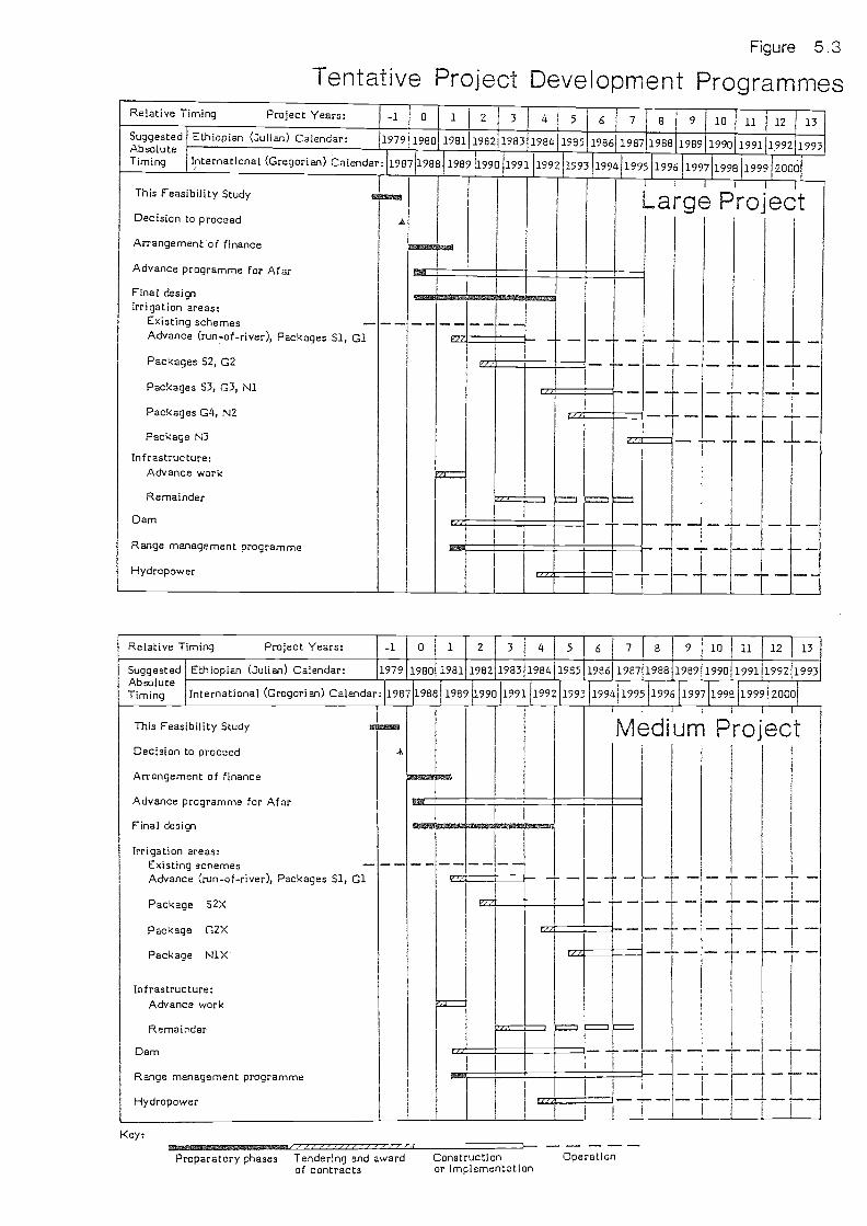
Key:
Figure 5.3
Tentative Project Development Programmes
Preparatory phases Tendering and awardof contracts
Constructionor implementation
Operation
Relative Timing Project Years: -1 0 1 2 3 4 5 6 7 8 9 10 11 12 13SuggestedAbsoluteTiming
Ethiopian (Julian) Calendar: 1979 1980 1981 1962 1983 1984 1985 1986 1987 1988 1989 1990 1991 1292 1993
International (Gregorian) Calendar: 1987 1988 1989 1990 1991 1992 1993 1994 1995 1996 1997 1998 1999 2000
This Feasibility Study
Decision to proceed
Arrangement of finance
Advance programme for Afar
Final designIrrigation areas:
Existing schemesAdvance (run-of-river), Packages 51, Cl
Packages S2, 02
Packages S3, G3, N1
Packages G4, N2
Package N3
Infrastructure:Advance work
Remainder
Dam
Range management programme
Hydropower
I
LagLarge Project1
I-
r,
-..:
gIMIIIIMAINIMIN....mi...MNt MINIM
ry
Relative Timirig Project Years: -1 0 1 2 3 4 5 6 7 8 9 10 11 12 13
SuggestedAbsoluteTiming
Ethiopian (Julian) Calendar: 1979 1980 1981 1982 1983 1984 1985 1986 1987 1988 1989 1990 199111992 1993
International (Gregorian) Calendar: 1987 1968 1989 1990J1991 1992 1993 1994 1995 1996 1997 1998119991
2000
This Feasibility Study
Decision to proceed
Arrangement of finance
Advance programme for Afar
Final design
Irrigation areas:Existing schemesAdvance (run-of-river), Packages 51, Cl
Package 52X
Package G2X
Package N1X
Infrastructure:Advance work
Remainder
Dam
Range management programme
Hydropower
aminomano.
Medium Project
1--
r
L/F,
r

TABLE 5.6
Staff Numbers, Large Project
Senior Intermediate Junior Total
KWRO 8 43 85 136
KSFO (Central) 5 13 12 307 state farms 99 379 1 085 1 563
Sub-total, state farms (104) (392) (1 097) (1 593)
KSFO (Central) 3 3 4 103 outstations 3 36 114 153
Sub-total, settlement (6) (39) (118) (163)
Services (Central) 22 39 75 136
Sub-total at Project Centre 38 98 176 312
Sub-total outside Project Centre 102 415 1 199 1 716
Total 140 513 1 375 2 028
Note: Details and breakdowns are in Tables F5.3 to F5.8 in Annex F.
TABLE 5.7
Staged Development of Irrigated Areas
53
Large ProjectYear of first State farms Settlementproduction (net ha) (net ha)
Run-of-river (advance' Phae):
Medium ProjectState farms Settlement(net ha) (net ha)
4 1 520 400 1 520 400
Using Reservoir:
6 2 500 1 360 2 670 2807 2 400 960 1 770 3808 3 060 800 1 700 2009 430 660
Total 9 910 4 180 7 660 1260
Note: Further breakdowns in Tables L3.3 and L11.2 in Annex L.

Project the pattern is similar except that a relatively small amount of work isheld back until Year 8 and commissioned for Year 9: this comprises the low-lyingnorth-east corner of the project and is delayed to reduce the pressure ofconstruction, particularly large-scale earthworks for drains and flood protec-tion, in Years 6 and 7. Thus the bulk of the construction is concentrated intofive years.
Other elements of the programme are self-explanatory. The advance programme ofassistance to the Afar, and the range management programme, start relativelyearly and the on-going work in those fields is to be handed over to thesettlement office after the project is fully operational. Some of the infra-structure is needed early eadvance work°, such as access roads, some housing,basic water and power supplies; the rest is built progressively in step with theirrigation areas that it serves. The design process is shown spread over fouryears, although it could be done more quickly, because it is advantageous to dothe detailed design for irrigation and drainage works during the constructionperiod (much topographic survey is involved, for land levelling particularly).
The Ethio-Bulgarian Joint Venture (EBJV) has now formally taken over the AwaraMelka State Farm and was preparing to start design work during 1987. It shouldbe regarded as a financing and implementation package rather than as analternative project, and it has the great advantage of being already in place,while any project arising out of this report will take some time to set up. TheEBJV had not, at the time of completion of this study, issued any detailedimplementation programme, so the project planning in this study has not takenspecial account of it. It may prove possible and advantageous for the EBJV toundertake the advance (run-of-river) phase of the KIP proposed here, but twodifficulties can be foreseen: firstly, the land blocks suitable for run-of-riverirrigation will later be separated by other blocks and will not form a coherentunit in the long term, and secondly the EBJV is not at present organised ormotivated to include significant provision for the Afars. With close cooperationit should be possible to overcome these difficulties and integrate the twoinitiatives. It might be conv-enient to allocate the whole South Block (4 600 hanet) to the EBJV, since this is a distinct unit with its own primary canal andcontains most of the existing state farm. No use could then be made of theKebena river as a water source, but its dry season flow is anyway much less thanthe Kesem (contrary to EBJV estimates).
5.8 Estimated Costs
The initial and recurrent costs of all the proposed project elements have beenestimated, in both financial and economic terms. These are 'best estimates' or,in statistical terms, expected values: they therefore do not include acontingency allowance in the sense of a safety margin against underestimation.Such bias in cost estimating is considered appropriate for budgeting but not foreconomic analysis. For budgeting purposes it would be prudent to add acontingency allowance of 10% or 15% to the financial figures given here. Theestimates do, however, include allowances for miscellaneous or unbilled items,as well as for design, supervision and administration.
An abstract of the estimates of initial costs is presented here in Tables 5.8and 5.9, and the Appendix to this volume gives per hectare costs and thebreakdown by years. In this context 'initial' costs include the procurement ofagricultural machinery in the first ten years, although the subdivision in AnnexN is slightly different. Details are in the annexes and a key to their locationis given in Chapter N5 of Annex N, which also summarises all costs.
The relative sizes of the different cost elements, expressed by the percentageson the right hand side of Tables 5.8 and 5.9, are of particular interest, as isthe distribution of costs between state farms and settlement functions (common
54

TABLE 5.8
Summary of Initial Costs, Large Project
(Million Ethiopian Birr at 1986 financial prices)
55
Notes: (1) Minor roads are included in irrigation system costs.Agricultural machinery costs in years 1 to 9, see Table N5.5.'Initial costs' in this table includes not only the costs thusnamed in Section N5.1 of Annex N, but also the initialagricultural machinery costs of Section N5.4.Exchange rate Ethiopian Birr 2.07 to USS 1.
Sub-total 195.1 40.9 236.0 39
Major roads(1) 17.2 7.4 24.6 4
Dam and associated structures 76.0 32.6 108.5 18
Hydropower station 8.9 3.5 11.8 2
Buildings and services:housing 114.8 8.0other buildings 9.1 1.1water supply and sanitation 16.4 2.0electricity supply 1.5 0.7
Sub-total 141.8 11.8 153.6 25
Afar, range and environmental 0 1.2 1.2 0.2
Vehicles and equipment:agricultural(L) 29.8non-agricultural 9.1 1.9
Sub-total 38.9 1.9 40.7 7
Design and engineering 4.2 1.8 6.0 1
Supervision and administration 22.8 5.8 28.6 5
Total Initial Costs(3) 504.1 106.9 611.0
Relative Initial Costs 83% 17% 100%
Category State Farms Settlement Total
Irrigated area:irrigation system and landpreparation 92.1 27.3drainage system 82.8 8.4flood protection 20.2 5.2

Category
Irrigated area:- irrigation system and land
preparationdrainage systemflood protection
Sub-total
Major roads(1)
Dam and associated structures
Hydropower station
Buildings and services:housingother buildingswater supply and sanitationelectricity supply
Sub-total
TABLE 5.9
Summary of Initial Costs, Medium Project
(Million Ethiopian Birr at 1986 financial prices)
State Farms Settlement Total %
Afar, range and environmental
Vehicles and equipment:agricultural(4)non-agricultural
Sub-total
Design and engineering
Supervision and administration
Total Initial Costs(3)
Relative Initial Costs
Notes: (1) Minor roads are included in irrigation system costs.Agricultural machinery costs in years 1 to 9, see Table N5.5.'Initial costs' in this table includes not only the costs thusnamed in Section N5.1 of Annex N, but also the initialagricultural machinery costs of Section N5.4.Exchange rate Ethiopian Birr 2.07 to US$ 1.
56
78.854.1
8.0
8.53.90.8
140.9 13.2 154.0 32
19.2 3.1 22.3 5
93.3 15.2 108.5 22
10.1 1.7 11.8 2
95.2 6.28.4 0.9
14.6 1.31.9 0.3
120.0 8.8 128.9 26
0 1.2 1.9 0.3
24.5 07.7 0.9
32.2 0.9 33.2 7
3.6 0.6 4.2 0.9
20.3 2.4 22.6 5
439.6 47.1 486.7 100
90% 10% 100%

costs have been divided in the ratio of the water volumes used). The settlementfunction represents only 17% of initial costs for the Large Project and 10% forthe Medium Project. Buildings make up a quarter of the initial costs in eithercase, which is more than the cost of the dam and hydropower station.
Within the irrigation area, which at 30 to 40% is the largest cost category,deep drainage accounts for more than a third. A more detailed breakdown ofirrigation, drainage and flood protection costs is given in Annex L. The totalof these categories amounts to some Birr 16 000 per hectare, equivalent to aboutUS$ 8 000 per hectare which is, by international standards, not unreasonable ina situation with quite heavy drainage needs and fairly awkward topography.
The distinction between 'design and engineering' and 'supervision and adminis-tration' is an arbitrary one, and the estimate for the former may be too low,depending on the arrangements adopted. Some elements (like irrigation systems)have relatively higher design costs than others (like buildings).
In the annexes, all costs are broken down into local currency, direct foreigncurrency, and indirect foreign currency components. Direct foreign currencyaccounts for some 53% of initial costs, distributed as detailed in Appendix 1.
The estimates of recurrent costs are summarised in Table 5.10 and breakdowns bycategory and function are given in the last two tables of the Appendix. Toenable their significance, relative to initial costs, to be assessed, Table 5.10gives the discounted Present Values of the total estimated recurrent costs, fora nominal 50-year period and for different discounting rates. It must beremembered that these figures for recurrent costs are at full development, i.e.from year 20 onwards (costs are less in some earlier years), and also thatagricultural inputs and labour wages are excluded (being accounted for in cropgross margins). The settlement function accounts for only 5 to 8% of recurrentcosts, with common services' costs being divided in the proportion of water use.
TABLE 5.10
Summary of Recurrent Costs
(million Ethiopian Birr at 1986 Financial Prices)
These tables exclude the Small Project, the costs of which have been estimatedin less detail and only in economic terms. Most of the discussion of thisscenario is in Section L11.3 of Annex L. The total economic initial cost is Birr160 million (without agricultural machinery), compared with Birr 477 million forthe Large Project and Birr 380 million for the Medium Project.
57
LargeProject
MediumProject
Annual recurrent cost 19.85 15.78
Present value over 50 years:at 5% discount rate 362 288
10% discount rate 197 156

CHAPTER 6
EVALUATION
6.1 Methodology
The evaluation of the project has been carried out by an economic cost-benefitanalysis using border pricing. The methodology follows the relevant guidelinespublished by the Ethiopian Government in 1981 (Ref. 13). It has been discussedwith the responsible department (DPSA, authors of the guidelines) and with theWRDA/FAO economists: the guidelines are under review in 1987 but no changes hadbeen issued at the time this analysis was done. The treatment of foreignexchange is that it is not itself shadow-priced, but all local currency elementsare multiplied by a Standard Conversion Factor of 0,75, which is equivalent to a1.33 factor on foreign exchange. Unskilled labour is shadow priced by applying afactor of 0.67 relative to other local costs, giving a Specific ConversionFactor of 0.50 to convert unskilled labour wages to border prices. The borderprices of traded inputs and outputs have been calculated by allowing for freightand insurance in the usual way. Details are given in Annex N, particularlyChapter N4.
To give adequate weight to the dam and other civil engineering works \,vhich havelong economic lives, the analysis was calculated over a period of 75 years, i.e.for the first 70 years of the dam's operation.
6.2 Economic Benefits and Costs
Application of the above factors to the estimated input and output costs for therelevant crops gives the economic crop gross margins listed in Table 6.1 anddetailed in Annex N. These margins are the returns from crop production less thedirect agricultural production costs, which for the more significant crops varybetween 15% and 26% of the returns. Agricultural labour costs are only a part ofthese direct costs, amounting to about 7% of returns for cotton, 4% for tobaccoand wheat and below 3% for maize.
TABLE 6.1
Summary of Economic Crop Gross Margins
Note: (1) Ranges of values are given where differentvarieties or cropping systems or soil types havebeen analysed.
(2) Details in Annex N, Table N4.3 and Appendix N2: valuesat full development are given here, rounded to the nearest100 Birr.
58
Range of economicgross margins(1)
(Birr/ha)State farm crops:
citrus 6 400 to 11 700tobacco 5 400 to 7 000cotton 2 200maize 2 200
- wheat 1 700Smallholder food crops 600 to 1 300

The higher value crops, citrus and tobacco, face marketing constraints whichhave been taken into account in planning the proposed project. The others haveeffectively unlimited markets. The total gross margin grows by about year 20, toaround Birr 31 million per year for the Large Project, or Birr 30 million forthe Medium Project.
For convenience the Medium and Small Project cases have been evaluated with thesame weighted average yields as the Large Project. Since their selective landuse would enable more of the poorer soils to be avoided, their average yieldswould in fact be slightly higher, so this represents a slight bias against themin the analysis.
The economic costs have been calculated in parallel with the financial coststhroughout this study. Most of the initial costs are broken down into fourtypes:
unskilled labour;
skilled labour;
imported materials;
imported equipment.
The sub-totals for these types have then been subdivided into direct andindirect foreign exchange and local currency, and converted to economic costs byfactors laid down by the government's Development Projects Study Agency (DPSA).Unskilled labour costs are 100% local currency and are converted to economiccosts by the Specific Conversion Factor of 0.50. Skilled labour is also 100%local currency but subject to the Standard Conversion Factor of 0.75. Importedmaterials are estimated to include, on average, 40% direct foreign currency, 31%indirect foreign currency and 29% local currency, with a weighted averageconversion factor of 0.78 (these costs include cement, which though nowpartially imported will in future be locally made, and this is allowed forhere). The corresponding percentages for imported equipment, allowing for localhandling and transport, are 90%, 2% and 8%, and the factor is 0.98. Engineeringrecurrent costs were subject to a weighted mean factor of 0.78. With theexception of fuel costs, all the financial costs exclude taxes, because aclearly-defined project like KIP can obtain tax exemption. Direct foreigncurrency accounts for 51% of initial financial costs (excluding agriculturalmachinery).
The economic costs are summarised along with the financial ones in Chapter N5 ofAnnex N: for the initial costs they turn out, in total, to be numerically justover 82% of the financial costs which have been summarised at the end of thepreceding chapter.
A deduction is made in the economic analysis for the expected future returns toagriculture in the area without the project. The 'without-project' situation isdefined, for this analysis, as comprising the continuation of the existing statefarm with foreseeable changes due to the age of the standing fruit trees. Thecropped areas are 210 net ha of citrus, 300 net ha of tobacco and 410 net ha ofcotton, giving a total economic gross margin of Birr 3.75 million per year inthe long term (details in Annex N, Table N4.8).
59

The classification of costs used in these tables, for instance into initial andrecurrent costs or into agricultural and non-agricultural, is arbitrary andthere are some items, like workshops used to maintain agricultural machines,which could be classified in different ways. For detailed breakdowns the readeris referred to the annexes. One matter, however, goes beyond mere classifica-tion details, namely, the cost of attracting adequate labour to the area. Inthis analysis the wages (which are low) appear under crop gross margins and thehousing costs (which are high) appear under initial costs, but in fact there isa potential trade-off between these two. It might be possible and advantageousto provide less housing and pay the labourers more, perhaps assisting them tobuild their own houses. This would change the balance between the figures inthis analysis, even if there were no net change.
6.3 Results of Economic Analysis
The results of the cost-benefit analysis, which are given in full in Annex N,are summarised here in Table 6.2. They are presented in terms of the economicinternal rate of return (EIRR) and the other columns of the table serve toindicate the relative sizes of dif ferent scenarios.
Part A of the table gives the base case results for all three scenarios, thoughthe cost and benefit estimates for the 'Small Project' are considerably lessprecise than for the others. The Large Project's EIRR is only 0.55%, a veryunfavourable result. The Medium Project shows a rate of 2.11%, indicating that aselective rather than a maximising approach to land use is preferred by economiccriteria, but this is still very low. The Small Project's rate is a littlebetter, at 2.5%, but in view of the imprecision of this scenario's analysis this0.4% difference is not of great significance.
Sections B and C of Table 6.2 give the results of sensitivity tests on the LargeProject and, more significantly in view of its better Base Case indicator, theMedium Project. The first sensitivity test places a value on the excess capacityof Kesem Reservoir to produce regulated flows, in its first few decades untilsedimentation brings its yield down to the level appropriate to KIP alone. Thisis done by assuming 'downstream benefits' from other irrigation schemes furtherdown the Awash which could use the extra dry season flow resulting fromregulation of the Kesem. The initial and recurrent costs have been fully takeninto account, but although it is known that suitable areas are available theircharacteristics are of course unknown and the estimates are correspondinglyapproximate. The same applies to crop yields and margins, although it is quitelikely that soils on such schemes would be better than the average KIP soils.The results of this slightly conservative sensitivity test show that thevaluation of extra reservoir capacity in this way does not make much differenceto the economic analysis, indeed it depresses the EIRR slightly because of thebalance of crops. This should, however, not be thought to throw doubt on theappropriateness of a dam of the proposed size, since a lower dam would morequickly silt up and become unable even to serve the KIP area. A more preciseanalysis of downstream irrigation using water storage on the Kesem must await abasin-wide study.
The remaining sensitivity tests investigate the relative economic importance ofsuch project features as the social and infrastructure costs, the provision forthe Afar, the break crops and also the importance of estimates of costs, yieldsand labour valuation. The tests show that the EIRR cannot realistically beexpected to rise above about 4% under any reasonably likely set of circum-stances. The social and infrastructure costs, which make up about 30% of the
60

TABLE 6.2
Summary of Economic Analysis Results
Notes: (1) These initial costs exclude agricultural machinery costs, whichamount to Birr 29 million for the Large Project and Birr 24million for the Medium Project.
(2) Economic internal rate of return.
61
A. Base Case
Net hairrigated
Initialeconomic
cost, M Birr(1)
EIRR(2)
Large Project 14 090 477 0.55
Medium Project 8 920 380 2.11
Small Project 4 315 160 2.5
B. Sensitivity Tests on Large Project
Base case 14 090 477 0.55
Downstream benefits valued 16 000 535 0.9
Omit most initial social andinfrastructure costs 14 090 342 1.5
Omit provision for Afar 9 910 435 0.9
C. Sensitivity Tests on Medium Project
Base case 8 920 380 2.1
Downstream benefits valued 16 000 596 1.4
Omit most initial social andinfrastructure costs 8 920 262 3.3
Omit maize and wheat 8 920 380 0.3
Cotton yields up 30% 8 920 380 3.0
Tobacco yields up 30% 8 920 380 2.9
Cotton and tobacco yields up 30% 8 920 380 3.7
All net benefits up 30% 8 920 380 3.8
Double cost of agricultural labour 8 920 380 1.6
Initial cost up 30% 8 920 494 1.0
Initial cost down 30% 8 920 266 3.6
Engineering recurrent cost down 50% 8 920 380 2.65

project costs, are moderately significant and contribute a differential of about1% to the EIRR. Provision for the Afar, representing only about 9% of initialcosts, contributes about 0.3% to the Large Project's low EIRR. It must be keptin mind that the irrigated pasture uses low-value land suitable for little else,and has low development costs per hectare, so the areas, if compared with thoseof the state farms, tend to give an exaggerated impression of importance.
The growing of break crops, maize and wheat, contributes nearly 2% to the EIRRand is thus of considerable economic significance as well as being decisive forlocal and regional self-sufficiency in food production. The EIRR is moderatelysensitive to estimates of crop yields and to cost estimates.
According to DPSA criteria, the minimum EIRR for favourable consideration innational planning and financing is about 10%. It is however not necessarilyright to apply such a criterion uniformly to all kinds of project. This projectdevelops an area \,vhich is currently almost completely without infrastructure andservices, and these have been fully costed as a prerequisite of the developmentand thus a necessary part of the project. This study has taken account ofdrainage and salinity problems in the irrigated areas, which has not always beendone in the feasibility studies of other projects. KIP's economic result shouldtherefore be compared not primarily with a hypothetical, nation-wide and multi-sector target like 10%, but rather with the results of appraisals of other ruralprojects that provide their own infrastructure, carried out in a comparable way.In the light of criteria beyond the purely economic, it might be found desirableto implement the project despite its forecast EIRR in the range 1 to 4%.
6.4 Other Benefits
There are a number of benefits of the KIP which have not been taken intoconsideration in the numerical economic analysis. The more notable ones are:
Employment: the project would provide employment for up to about7 000 people permanently and a further 4 000 intermittently,depending on the scenario chosen, together with housing for up to55 000 people.
Welfare of pastoralists: KIP would, if the measures to integrateand benefit the Afar were successful, improve living conditionsfor about 12 000 Afar. Their average-year conditions would bebetter with more scope for growing food crops and more employmentopportunities, but the bigger difference would be in their vulner-ability to droughts, which would be very drastically reduced.Health could also be expected to improve.
Environment: the project includes components that would safeguardthe surrounding woodlands, firstly by the range managementprogramme and secondly by growing fuelwood in excess of its ownrequirements, thus reducing pressure towards deforestation in thewhole region.
The Awash valley: the reservoir's regulation of Kesem floods anddry season flows would slightly improve conditions in the down-stream parts of the Awash valley.
62

6.5 Finance
This study includes, in Annex N, a financial analysis for the project and forits two productive subdivisions, the state farms and the settlement authority.Not surprisingly in view of the results of the economic analysis, the financialinternal rate of return is negative. With the hypothetical assumption of a'soft' loan of 476 million Birr (of which 14 million is for working capital)with a grace period of 15 years and interest rate of 2%, the project still hasan accumulated deficit of over 500 million Birr after 30 years. Such a loanpackage might be approached by separating the 'settlement' element, whichrepresents just over 10% of the total initial costs for the Medium Project, fromthe state farm element. All these figures are at 1986 prices assuming a foreignexchange rate of 2.07 Birr per US dollar: with 5% annual inflation the 'pricecontingencies' would add 40% to the nominal financial cost.
63

CHAPTER 7
CONCLUSIONS AND RECOMMENDATIONS
This chapter brings together the main conclusions of the whole study. To enablethe reader to obtain an overview of what is a very complex study, the chapter iskept extremely brief and details must be sought elsewhere in this volume or inthe annexes.
The Kesem Irrigation Project (KIP) is found to be technically feasible. On theKesem-Kebena plain a gravity irrigation scheme can extend to about 14 000 hanet, though the soils are variable and generally fairly poor and it ispreferable to restrict the formal irrigation to the better areas, the optimumbeing probably between 8 000 and 10 000 ha net.
Preferred main crops are tobacco and citrus, which attain good returns but facelimited markets, plus cotton, wheat and maize. Soils usable for these crops aresufficient for 7 000 to 10 000 ha net, and further areas can be used forwoodlots to produce fuelwood and for irrigated pasture to compensate the 12 000Afar pastoralists for the loss of their present dry-season grazing area. Maximumuse of the land resources implies the inclusion of about 4 000 ha of suchpasture, but selective land use could leave much of the present grazing area tothe Afar and thus reduce the need for formally irrigated pasture.
The project requires regulation of the Kesem river's highly seasonal flow bymeans of a dam about 90 m high, for which a suitable site and materials exist.The reservoir formed by the dam would be filled with sediment, probably in lessthan 100 years, but would provide water for KIP for around 70 years. In earlierdecades, before sediment deposits build up, it could provide regulated flow forother schemes in the Awash Valley, and later these schemes could be providedfor by other reservoirs, either new or re-allocated.
Use of less than the maximum technically feasible area on the Kesem-Kebena plainrepresents a modification to the project's objectives, which have been definedas aiming to maximise agricultural potential under a balanced environmental andecological system. The maximisation should however be viewed for the Awash basinas a whole, and since there are better soils further down the valley it would beinappropriate to irrigate KIP's poorest soils. It is therefore recommended thatthe plain should be used selectively, irrigating 9 000 to 10 000 ha net as inthe 'Ivledium F.)rojeot.' scenario of this study. At the same time the question ofdeveloping a much smaller area, such as 4 000 ha, with no dam, should beinvestigated.
The area now has little infrastructure and the project would open up some22 000 ha on the plain and a much larger area in the foothills of the escarp-ment. It would link with the proposed extended Bolhamo scheme to the north.KIP would bring up to 60 000 people, mostly highlanders, into the area and wouldprovide housing for these immigrants and work for up to 13 000 of them, as wellas health and education facilities. The environmental impact is small butpositive.
This project is not economically attractive. A careful economic analysis, whichtakes account of all the relevant costs including social and infrastructurecomponents and the need for drainage and reclamation of unfavourable soils,shows an economic internal rate of return of just over 2%. Under somecircumstances it might rise to 4%. Financing would be difficult and wouldprobably require separate packaging of the components dealing with the Afar.
64

The Consultant's recommendation is that this project should be compared withother projects in the same sector, preferably after they also have been studiedin a compatible manner. Projects that can take advantage of pre-existinginfrastructure and services may appear economically preferable to KIP, but theeconomic criteria are not the only ones, and in the development of a countrylike Ethiopia the opening-up of new areas may be a target in itself. Theprovision of housing and livelihood for some 60 000 people from the highlands isalso a factor, the valuation of which is beyond the scope of this study. Such acomparison might show KIP to be one of the better rural development projectsavailable.
In the mean time, the Ethio-Bulgarian Joint Venture is already active in theproject area, with aims that are more limited than those of KIP but notincompatible with them. It is not an alternative or competing project, but afinancing and execution package. As such it has the advantage of being alreadyin place, whereas any project springing from this report will take at least twoyears to reach the stage of action in the field. Integration of the twoinitiatives should be pursued as soon as possible, using this report to helpplan the EBJV's first phase as part of a larger project. In particular, new datashould be gathered on relevant matters which were outside the scope of thisproject, such as the low flows of the Kebena river.
65

SOGREAH
ITALCONSULT
Australian StateRivers and WaterSupply Commission
Halcrow
Ministry ofState FarmsDevelopment
NEDECO
Agrocomplect
Halcrow
Ha'crow
Winger, R.J.
WRDA/FAO
NEDECO
13, DPSA
REFERENCES FOR MAIN REPORT
1965 Survey of the Awash River Basin (Report on)for FAO. (FAO/SF: 10/ETH)
1969 MeIke Sadi-Amibara Proposed Irrigation Pro-ject, Feasibility Study.
1972-74 [Development of the Awash Valley. Numerousseparate Informal Technical Reports andAssignment Notes (for FAO)
1975 Angelele and Bolhamo Feasibility Study Report.
1980 Ethio-PDRY Joint Agricultural Project -prefeasibility study, Part II.
1982 Angelele-Bolhamo Irrigation Expansion Project:Re-appraisal and up-dating of previous feasi-bility studies.
1984 Report on the Economic Profitability from theEstablishment of 'Kesem-Kebena' AgriculturalFarm on an area of about 6 800 ha on the Basisof a Joint Venture.
1985 Master Drainage Plan for Melka Sadi andAmibara Areas (Draft Final Report of March1985 and Final Report of July 1985).
1985 Amibara Irrigation Project II, Draft FinalReport, MeIka Sadi Pilot Drainage Scheme.
1985 P,eview Report on the Master Drainage Plan forMeIka Sadi and Amibara Areas. \AlorId BankReview Report.
1985 An updated profile on Kesem IrrigationProject.
1986 Annelele-Bolhamo Irrigation Project, Consul-ting services for Final Project Design.
1981 Guidelines for Project Planning in Ethiopia.
66
Study,on the
Study,
WRDA 1986 Kesem Irrigation Project, FeasibilityComments of the Steering CommitteeInception Report, Section 4.2.
1/VRIDA 1875 Kesem Irrigation Project, FeasibilityTerms of Reference, Clause 1.1(c).

APPENDIX 1 TO MAIN REPORT
FINANCIAL COST DETAILS
Table Title Page NrNr
1/1 Initial Costs per Hectare in US Dollars 68
1/2 Breakdown of Initial Costs Over Time, Large Project 69
1/3 Breakdown of Initial Costs Over Time, Medium Project 70
1/4 Recurrent Costs, Large Project 71
1/5 Recurrent Costs, Medium Project 72
67

TABLE 1/1
Initial Costs per Hectare, in US Dollars
(Thousand US$ per ha, at 1986 financial prices)
Category Large project Medium project
Irrigated area:- irrigation system and land
preparation 4.09 4.73drainage system 3.13 3.14flood protection 0.87 0.47
Notes: (1) Exchange rate Ethiopian Birr 2.07 to US$ 1.
(2) For explanation of categories see Table 5.8.
68
Sub-total 8.09 8.34
Major roads 0.84 1.21
Dam and associated structures 3.72 5.88
Hydropower station 0.40 0.64
Buildings and services:housing 4.21 5.49other buildings 0.35 0.50water supply and sanitation 0.63 0.86electricity supply 0.08 0.12
Sub-total 5.27 6.97
Afar, range and environmental 0.04 0.06
Vehicles and equipment:agricultural 1.02 1.33non-agricultural 0.38 0.46
Sub-total 1.40 1.79
Design and engineering 0.21 0.23
Supervision and administration 0.98 1.23
Total Initial Costs 20.95 26.35

Yea
r3
13.0
810
.70
6.61
3.27
1.87
35.5
3
0.44
0.80
0.29
3.77
5.30
21.7
1
12.7
41.
102.
200.
44
16.4
0
84.2
6
14%
Yea
rY
ear
Yua
rY
ear
Yea
rT
otal
Dire
ct4
56
78
fore
ign
exch
ange
(%)
7.12
20.4
224
.35
13.4
36.
4890
.83
516.
1618
.00
20.6
210
.82
3.37
74.2
249
3.07
6.26
4.74
2.06
-28
.60
432.
135.
283.
521.
070.
5316
.94
591.
554.
825.
122.
359.
3425
.37
63
20.0
354
.78
58.3
529
.73
19.7
223
5.96
51
0.22
--
2.20
630.
40-
-4.
0160
0.14
--
-1.
4360
1.21
1.62
2.25
2.25
13.6
662
-1.
671.
67-
3.34
57
1.97
3.29
3.92
2.25
-24
.64
61
32.5
632
.56
-10
8.53
59
5.89
5.89
11.7
783
18.1
929
.54
29.5
429
.54
-12
2.80
341.
492.
362.
362.
3610
.23
362.
573.
673.
673.
67-
18.3
651
0.22
--
2.20
52
22.4
735
.57
35.5
735
.57
153.
5937
0.15
0.15
0.15
0.15
1.18
59
3.32
-8.
216.
3811
.86*
29.7
790
1.10
2.60
2.60
3.13
1.04
10.9
790
4.42
2.60
10.8
19.
5112
.90
40.7
490
0.60
--
6.03
45
5.57
7.34
4.00
2.22
0.62
28.5
852
87.7
714
2.18
118.
6979
.43
33.2
461
1.02
53
14%
23%
19%
13%
5%10
0%
E/u
scrip
tion
Yea
r0
Yea
r1
Yea
r2
Irrig
ated
are
a:-
irrig
atio
n sy
stem
and
land
prep
arat
ion
-5.
96-
deep
dra
inag
e4.
54-
maj
or c
anal
s an
d di
vers
ion
wei
r1.
564.
32la
rge
drai
ns a
nd p
umpi
ng s
tatio
ns-
-1.
15-
flood
pro
tect
ion
vvor
ks0.
32
Sub
-tot
al1.
5616
.29
Maj
or r
oads
:ac
cess
to A
war
a Iv
Ielk
a0.
880.
66-
Am
ara
Ivie
lka
to p
roje
ct c
entr
e1.
601.
20-
acce
ss to
dar
n si
te-
0.57
0.43
-gr
avel
led
road
s-
2.56
othe
r In
ajor
roa
ds-
-
Sub
-tot
al3.
054.
85
Dam
and
ass
ocia
ted
stru
ctur
es21
.71
Hyd
ropo
wer
sta
tion
-
Bui
ldin
gs a
nd s
ervi
ces:
-ho
usin
g-
1.86
1.39
-ot
her
build
ings
0.30
0.23
-w
ater
sup
ply
and
sani
tatio
n1.
471.
10-
elec
tric
ity s
uppl
y0.
880.
66
Sub
-tot
al-
4.51
3.38
Afa
r, r
ange
and
env
ironm
enta
l0.
120.
120.
20
Veh
icle
s an
d eq
uipm
ent:
agric
ultu
ral
non-
agric
ultu
ral
0.22
0.16
Sub
-tot
al0.
220.
16
Des
ign
and
engi
neer
ing
2.41
1.81
Sup
ervi
sion
and
adm
inis
trat
ion
1.34
3.70
Tot
al in
itial
cos
ts0.
1213
.21
52.1
0
Rel
ativ
e in
itial
cos
ts2%
9%
Not
e:In
clud
e.s
cost
s fo
r Y
ear
9.

Des
crip
tion
Yea
rY
ear
Yea
rY
ear
Yea
rY
ear
Yea
rY
ear
Yea
rT
otal
Dire
ct0
12
34
56
7a
fore
ign
exch
ange
Irrig
ated
are
a:%
-irr
igat
ion
syst
em a
nd la
ndpr
epar
atio
n5.
9612
.30
6.34
15.2
414
.99
8.20
63.0
252
-de
ep d
rain
age
4.54
11.4
06.
8616
.03
10.7
33.
0453
.41
49
-m
ajor
can
als
and
dive
rsio
n w
eir
1.56
4.32
4.20
0.67
3.65
4.62
1.34
20.3
642
-la
rge
drai
ns1.
151.
870.
722.
881.
928.
5356
flood
pro
tect
ion
wor
ks0.
320.
400.
073.
253.
910.
768.
7257
Sub
-tot
al1.
5616
.29
30.1
714
.66
41.0
536
.17
14.1
415
4.04
50
Maj
or r
oads
:-
acce
ss to
Aw
ara
Mel
ka-
0.88
0.66
0.44
0.22
-2.
2063
-A
war
a M
elka
to P
roje
ct C
entr
e-
1.60
1.20
0.80
0.40
--
4.01
60
-ac
cess
to d
am s
ite0.
570.
430.
290.
14-
__
1.43
60
-gr
avel
led
road
s-
-2.
562.
562.
024.
272.
25-
13.6
662
-ot
her
maj
or r
oads
--
-0.
500.
50-
1.00
57
Sub
-tot
al3.
064.
854.
090.
762.
024.
772.
75-
22.3
161
Dam
and
ass
ocia
ted
stru
ctur
es21
.71
21.7
132
.56
32.5
610
8.53
59
Hyd
ropo
wer
sta
tion
5.89
5.89
11.7
783
Bui
ldin
gs a
nd s
ervi
ces:
hous
ing
-1.
361.
0220
.27
19.9
329
.39
29.3
910
1.35
35
-ot
her
build
ings
-0.
310.
231.
871.
792.
572.
57-
9.35
36
-w
ater
sup
ply
and
sani
tatio
n-
1.48
1.11
3.19
2.82
3.68
3.68
-15
.97
51
-el
ectr
icity
sup
ply
-0.
880.
660.
440.
22-
-2.
2052
Sub
-tot
al4.
033.
0225
.77
24.7
635
.64
35.6
412
8.87
37
Ata
r, r
ange
and
env
ironm
enta
l0.
120.
120.
200.
150.
150.
150.
150.
151.
1059
Veh
icle
s an
d eq
uipm
ent:
agric
ultu
ral
-3.
320
8.06
6.23
6.89
*24
.50
90-
non-
agric
ultu
ral
-0.
220.
160.
111.
682.
432.
431.
628.
6690
Sub
-tot
al-
0.22
0.16
0.11
5.00
2.43
10.4
97.
056.
8933
.16
90
Des
ign
and
engi
neer
ing
1.69
1.27
0.84
0.42
-4.
2245
Sup
ervi
sion
and
adm
inis
trat
ion
0.64
2.85
4.26
3.74
6.04
3.96
1.07
22.5
752
Tot
al In
itial
Cos
ts0.
1211
.32
50.3
587
.10
82.0
512
5.78
97.0
725
.96
6.89
486.
6553
Rel
ativ
e In
itial
Cos
ts2%
10%
18%
17%
26"k
20"/
05%
1%10
0%
Not
e:In
clud
es c
osts
for
Yea
r 9.

TABLE 1/4
Recurrent Costs, Large Project
(Million Ethiopian Birr per year at 1986 financial prices,at full development, excluding agricultural inputs and labour)
Notes: (1) Details in Annex N, Section N5.3 and Appendix N4.
Details in Annex N, Section N5.4 and Appendix N5.
Details in Annex L, Section L12.4; excludes staffing.
71
Category State Farms Settlement Total
Staffing:(1)state farms 2.85 0.00 2.85settlement 0.00 0.26 0.26water resources 0.18 0.08 0.26
- other services 0.29 0.12 0.41
Sub-total 3.33 0.46 3.79
Agricultural machinery:(2)- replacement 4.04 4.04
operation 5.22 5.22
Sub-total 9.26 9.26
Engineering O&M:(3)- plant and vehicles 2.73 0.57 3.30
building maintenance 0.92 0.08 1.00ID and FP 1.32 0.28 1.60
- miscellaneous 0.63 0.27 0.90
Sub-total 5.60 1.20 6.80
Total Recurrent Costs 18.19 1.66 19.85
Relative Recurrent Costs 92% 8% 100%

TABLE 1/5
Recurrent Costs, Medium Project
(Million Ethiopian Birr per year at 1986 financial prices,at full development excluding agricultural inputs and labour)
Notes: (1) Details in Annex N, Section N5.3 and Appendix N4.
Details in Annex N, Section N5.4 and Appendix N5.
Details in Annex L, Section L12.4; excludes staffing.
72
Category State Farms Settlement Total
Staffing:(1)- state farms 2.36 0.00 2.36
settlement 0.00 0.11 0.11water resources 0.22 0.04 0.26
- other services 0.35 0.06 0.41
Sub-total 2.94 0.21 3.15
Agricultural machinery:(2)- replacement 3.13 3.13
operation 4.10 4.10
Sub-total 7.23 7.23
Engineering O&M:(3)plant and vehicles 2.32 0.28 2.60
- building maintenance 0.79 0.06 0.85ID and FP 1.10 0.10 1.20miscellaneous 0.64 0.11 0.75
Sub-total 4.85 0.55 5.40
Total Recurrent Costs 15.02 0.76 15.78
Relative Recurrent Costs 95% 5% 100%

f
Road or track
.38tic,n rchcmc 1
8
I -
tA
e
rs
Springs
o
- -11 -7 0
Gurmile Hill
DOH
1
The
tri o-f"-Thì
Figu. 3.1
SAD!
1
i
' t i-- - "in2oóooN I
..Nj
i

SSDDLE DAf 1
iv DAr1
YALO21
5 /, -
12GURPAILE
11 Gurmile Hil BLOCK /17 20
e
Filwehas
Springs
1514
SOUTHDOC-10 BLOCK
- o8
BLOCK PART OFAMIBARA
k IRRIGATION\ PROJECT
Mt Dotan
1010000,,
LEGEND
Canal
Drain
North-South access road
Alternative dam access routes
Drainage pump station
Staged development unit (SDU) 16Contour
FARMING SYSTEMS
Citrus
Tabacco etc.
Cotton/ Wheat
Pasture
SCALE1 o 1 2 3 4 5 km.
Figure 5.1
Project Layout (Large Project)

LEGEND
Canal
Drain
North-South access road
Alternative dam access routes
Drainage pump station
Staged development unit (SDU) 16Contour
FARMING SYSTEMS
Citrus
Tobacco etc
Cotton/ Wheat
Pasture
SCALE1 0 1 2 3 4 5 km.
_J L
-
SADDLE DAM
ULM DM
lc-6g s e /27
RESEP,VOIn
wadi
=
River_ ,/SPBORET ,
,
2
kg,/
// 17x
20x r
15x j_
15x14
1
C0x SOUTH""-'"
.1)01-10 BLOCK- 9
7 8
FilwehaSprings
Figure 5.2
Project Layout (Medium Project)
e
,INoi.31:-: sLockir,' ' PART OF/1( AM1BARA
,,.., g i --ig- IRRIGAT,CX,
'I -,=-:' 22 ,/ / 1-: '. PROJECT4), ,/ 23 / Y \ ,....,,,,4".
-18 'tf.`-_-'-- ,-,--=,- 11, 24x - _.- d?,-;
,..----
'(ALOE'21x
1
___ r 21x,5 \ 1
-.., ': ..!=i i12x i
' (URM iL4-E, i,
Gin-mile Hi S L_ 0 C/1,-: /-k Ç= /I16x---- ,
red
)1A( Doran
vog_igigig g
1 f/cc
Related Documents


