Ayman M. Ismail, Initiating the Infrastructure for PPGIS in Developing Countries - Simpler Tools Proceedings URISA 4th Annual Public Participation GIS Conference, Cleveland, OH USA – Aug.2005 – Ed: M. J. Salling - 1 Initiating the Infrastructure for PPGIS in Developing Countries Simpler Tools Ayman M. Ismail, PhD. AICP Fayoum University – Egypt [email protected] Abstract: It is assumed that the primary objective of using PPGIS is to stimulate more public or community involvement with decision-making. The application of these tools in the US has focused on high-tech applications to engage the masses in the process. However, in the context of developing countries, and precisely when dealing with the problems of the urban poor, will the rise of new technological fixes help solve traditional participation problems? This paper reviews the advent and application of these new technologies in the US and in Egypt, how they may be used to solve some issues relating to traditional public participation and whether a high-tech or a low-tech approach should be emphasized. It concludes with a comparison between the theory and application of public participation in both the US and Egypt. Introduction Much of the attention in the field of GIS has focused on the technical advancement of the systems. The more multifarious applications that draw on its computational and analytical tools, the better the system was. When it was noted that much less attention has been given to the wider societal implications and relations, a largely academic debate began in the early 1990s under the umbrella term of GIS and Society (Harris and Weiner 2003). An important outcome of this discussion was a focus on how public participation might be incorporated into GIS production and use. The abstract concept arose out of the broader social theoretic critique of the GIS and Society debate initiated in 1994 by the U.S. National Center for Geographic Information and Analysis (NCGIA). Variations to the term Public Participation GIS (PPGIS) include Community - integrated GIS (CiGIS), and more recently participatory GIS (PGIS), arise from the fact that the definition of the 'pubic' and its 'participation' remain a debatable issue. However, the essence PPGIS seems to seek beyond theoretical discussion and provide an alternative form of GIS to address issues of differential public access to data, hardware, software and expertise; redress the structural distortion of knowledge in GIS databases and the perceived exclusion of community knowledge; and to broaden issues of democratic GIS-based decision-making (Mitchell 1997). PPGIS situates GIS within participatory research, with a focus on the incorporation and merging of local knowledge with 'expert' information in GIS production and use. Methodology The methodology is based on an analysis of the historical and technological factors that lead to the merging of the two elements of e-Participatory Planning, namely; the community participation approach and Information Communication Technologies (ICT). The tools of community participation have been used for over half a century and have shown their own limitations. The analysis of the limitations of community participation will then be compared to the opportunities of the new technology. Given that both the community participation theory and the advancements in ICT were the result of western thinking, their underlying assumptions and motivations need to be considered both at their original birth-place and in Egypt. For that reason, the methodology reviews the case studies and application in both the western countries and in Egypt. A schematic of the methodology is shown in Figure 1.

Welcome message from author
This document is posted to help you gain knowledge. Please leave a comment to let me know what you think about it! Share it to your friends and learn new things together.
Transcript
Ayman M. Ismail, Initiating the Infrastructure for PPGIS in Developing Countries - Simpler Tools
Proceedings URISA 4th Annual Public Participation GIS Conference, Cleveland, OH USA – Aug.2005 – Ed: M. J. Salling - 1
Initiating the Infrastructure for PPGIS in Developing Countries Simpler Tools
Ayman M. Ismail, PhD. AICP Fayoum University – Egypt
Abstract: It is assumed that the primary objective of using PPGIS is to stimulate more public or community involvement with decision-making. The application of these tools in the US has focused on high-tech applications to engage the masses in the process. However, in the context of developing countries, and precisely when dealing with the problems of the urban poor, will the rise of new technological fixes help solve traditional participation problems? This paper reviews the advent and application of these new technologies in the US and in Egypt, how they may be used to solve some issues relating to traditional public participation and whether a high-tech or a low-tech approach should be emphasized. It concludes with a comparison between the theory and application of public participation in both the US and Egypt.
Introduction Much of the attention in the field of GIS has focused on the technical advancement of the systems. The more multifarious applications that draw on its computational and analytical tools, the better the system was. When it was noted that much less attention has been given to the wider societal implications and relations, a largely academic debate began in the early 1990s under the umbrella term of GIS and Society (Harris and Weiner 2003). An important outcome of this discussion was a focus on how public participation might be incorporated into GIS production and use. The abstract concept arose out of the broader social theoretic critique of the GIS and Society debate initiated in 1994 by the U.S. National Center for Geographic Information and Analysis (NCGIA). Variations to the term Public Participation GIS (PPGIS) include Community - integrated GIS (CiGIS), and more recently participatory GIS (PGIS), arise from the fact that the definition of the 'pubic' and its 'participation' remain a debatable issue. However, the essence PPGIS seems to seek beyond theoretical discussion and provide an alternative form of GIS to address issues of differential public access to data, hardware, software and expertise; redress the structural distortion of knowledge in GIS databases and the perceived exclusion of community knowledge; and to broaden issues of democratic GIS-based decision-making (Mitchell 1997). PPGIS situates GIS within participatory research, with a focus on the incorporation and merging of local knowledge with 'expert' information in GIS production and use. Methodology The methodology is based on an analysis of the historical and technological factors that lead to the merging of the two elements of e-Participatory Planning, namely; the community participation approach and Information Communication Technologies (ICT). The tools of community participation have been used for over half a century and have shown their own limitations. The analysis of the limitations of community participation will then be compared to the opportunities of the new technology. Given that both the community participation theory and the advancements in ICT were the result of western thinking, their underlying assumptions and motivations need to be considered both at their original birth-place and in Egypt. For that reason, the methodology reviews the case studies and application in both the western countries and in Egypt. A schematic of the methodology is shown in Figure 1.
Ayman M. Ismail, Initiating the Infrastructure for PPGIS in Developing Countries - Simpler Tools
Proceedings URISA 4th Annual Public Participation GIS Conference, Cleveland, OH USA – Aug.2005 – Ed: M. J. Salling - 2
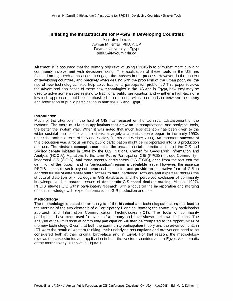
FIGURE 1
BASIC COMPONENTS OF A PPGIS PPGIS systems require three physical components. The first is a community or pubic (however one may define that) that shall benefit from that tool; and the second is a spatial tool (GIS of some form); and the third is a medium of delivery (the communication technology used). These three physical components are easy to identify. However, less attention is given to the process and the theory of effectively invoking community participation. The concept of the "public" or 'community" is problematic alone, not to mention the limitations of 'participating' it. We shall leave the concept undefined since we need to focus on participation. Traditional public participation, just like traditional GIS has had its critics. The structure for organizing communities has always revolved around three main questions and three principal actors:
1. Who participates? 2. In what do they participate in? 3. How do they participate?
Who is an issue of representation. It is the first element of designing the tool, based on which the agenda is set. The "who" question may also be asked about for the initiative-taker. The what question decides the level at which participation takes place, be it at the needs-assessment stage or the policy decision-making. Finally, the "how" question relates to the tools in which they are engaged in, the techniques used. The following lists the issues with these tools:
1. Limitations of physical presence: Until now, the barrier to citizen participation in planning decisions has been high, and consequently the rate of participation has been low. Being physically present at a public hearing, a neighborhood association meeting, or a planning workshop is a requirement for citizens to participate in planning decisions, then participation will be limited to those with spare time, a small and diminishing segment of society. As a result, planning decisions tend to be skewed toward the demands of a vocal minority, and important voices in the community are not heard.
2. Chaotic Nature of Public Meetings in Third World Countries: Decisions are frequently made in the context of emotional confrontation between the sponsors of development proposals and their opponents, with public officials caught haplessly in the middle. Confrontations are often fueled by misinformation and misunderstanding on both
Geographical
Information
Systems
ICT Tools
(Internet)
PPGIS
Process/Theory
Public /
Community
Ayman M. Ismail, Initiating the Infrastructure for PPGIS in Developing Countries - Simpler Tools
Proceedings URISA 4th Annual Public Participation GIS Conference, Cleveland, OH USA – Aug.2005 – Ed: M. J. Salling - 3
sides. As a result, planning decisions tend to be skewed toward the demands of a vocal minority, and important voices in the community are not heard.
3. The Psychological Factor: There are certain social and psychological factors to self expression in public. People could have security concerns about being prosecuted if they become too critical. Officials usually try to dominate meetings and speak with over-self confidence. They are sometimes obsessed by the notion that they know what's best.
4. Inadequate Access to Information: Public participation is hampered by inadequate access to information about proposed projects. People are not sure they understand all what's behind the project .
5. Delay Time between Proposal Development and Public Reaction: Uncertainty about public reaction to development proposals creates a major element of risk for their sponsors, who must invest time and money without knowing if their proposals will be approved. It is clearly in a project sponsor’s interest to hear from everyone who might have an interest in a project and to know early on what issues might influence the approvals process.
The second component is the spatial tool. GIS as a geographic representation tool has been empowered with tools such as threaded chatting, discussion forums, map-aided chats, mental mapping exercises, spatial multimedia, geovisualization, and more recently virtual GIS. The reliance on maps in communicating issues has reached such an extent that there have been calls to change the term to "Community Mapping Systems". GPS transect walks have been used to locate community resources and access. Sketch mapping and mental maps have proven valuable in enabling communities to express their perceptions of landscape, community spatial needs and aspirations, and to collect socially differentiated local community knowledge for incorporation into a GIS. Participatory 3-D modeling is also proving to be a very effective PGIS method. These methods are a platform for individual and community "spatial story telling." However, to date, very little GIS functionality for providing spatial analysis has been used in such projects; most of them comprise a digital mapping component and a community interface. However, it is interactive Web-based GIS that is of special value to converting traditional public participation tools. This is the third component of our model. These tools build on the development of GIS internet mapping servers that allow two-way interaction based on a client-server architecture. In addition to other multimedia devices employed such as audio-visual and free-hand sketching, these features allow a wider array of potentials and access. "Multimedia GIS are becoming more common, though it is the Internet that provides perhaps the most powerful technology for underpinning GIS with participatory methods" (Kingston et. Al 2000). It is likely that the access and functionality provided by Internet mapping systems will play a dominant role in future PPGIS initiatives. Participatory planning systems are decision-support systems geared towards input from the community in the planning process. The planning issue may range from a simple pedestrian cross-pass, to a full-blown regional plan. The structure of the system is made up of four-tiers, a database server, an application, a web-server, and a user-interface. Planners, decisions-makers and community at large may interact with the system anytime to allow a communication cycle of designs, feedbacks and modifications. While web-based applications of these systems are still experimental, few examples may be found.
PPGIS Applications in the West Among the best example reviewed that deal with the issues of public participation include the experiments by UIC (1), Oxpen Initiative (2) and Webpolis (3). In the University of Illinois case, community participation was based on using home computers. Leaders in the Pilsen community, Chicago expressed an interest in a participatory, collaborative approach to the planning and design of their neighborhood. They approached the University of Illinois for help and the staff at
Ayman M. Ismail, Initiating the Infrastructure for PPGIS in Developing Countries - Simpler Tools
Proceedings URISA 4th Annual Public Participation GIS Conference, Cleveland, OH USA – Aug.2005 – Ed: M. J. Salling - 4
the Planning department embarked upon a project that involved decision-makers to approve of their plans using simple sketching tools to delineate areas of concern and comment on proposals. (Al-Kodmany, 1999).
The Oxpens Quarter Initiative (Oxford, UK)– is a pioneer in web based community planning. Most public debate of proposed projects pits the project sponsors on one side against the neighborhood activists on the other. The process is reactive rather than proactive, and sometimes it is downright destructive. The problem for planners has been to involve the public in creating shared visions, rather than reacting to someone else’s. Oxpens, in the southwestern corner of the city, had been victimized since late 1960s haphazard developed characterized by low-density, automobile-related sprawl. Oxpens had no cohesive identity, and it provided a notoriously bleak environment for pedestrians. Everyone felt that something was missing in this part of town, but when specific remedies were proposed, the ensuing debate tended to become confrontational, leaving developers and residents equally frustrated.
To reach the broadest cross section of the population, they offered several venues for participation among which was the multimedia Web site. The Web site includes on-line discussions of various topics and specific locations within the study area, allowing residents to learn more about the area’s history, provide comment to the project sponsors, and talk to each other about the issues. Hosted by the Resource for Urban Design Information (RUDI), it has become a worldwide model for how to implement a PDSS.
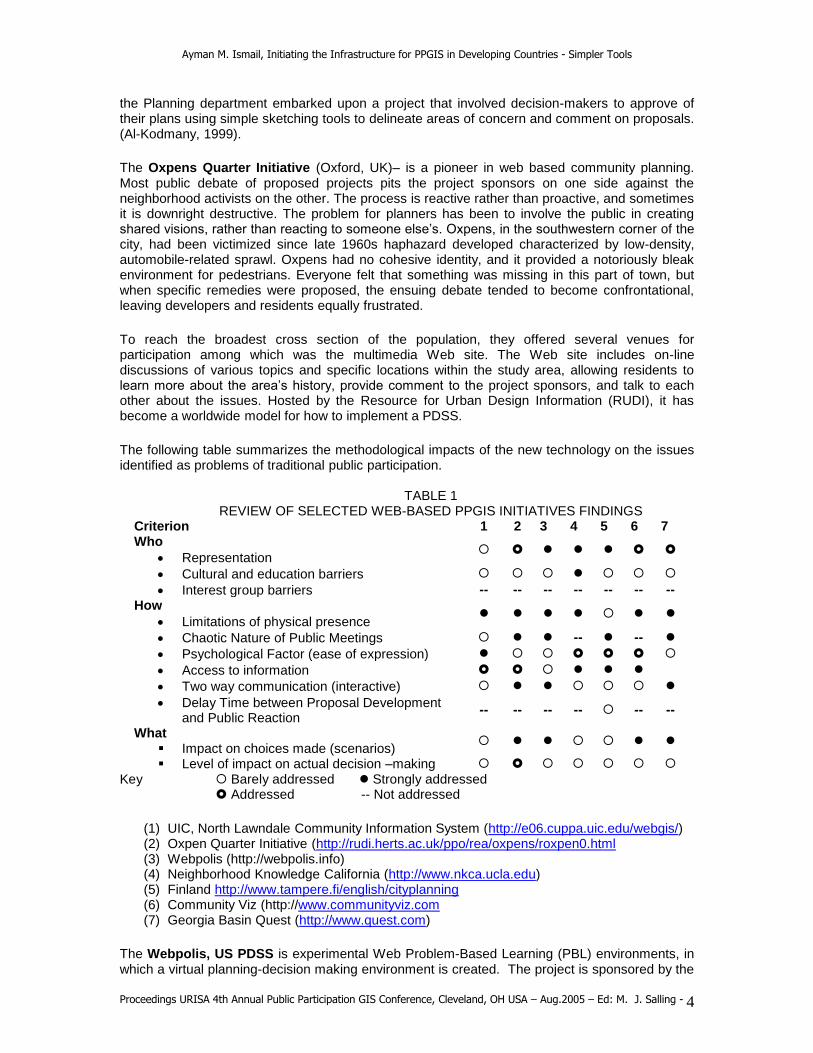
The following table summarizes the methodological impacts of the new technology on the issues identified as problems of traditional public participation.
TABLE 1 REVIEW OF SELECTED WEB-BASED PPGIS INITIATIVES FINDINGS
Criterion 1 2 3 4 5 6 7 Who
Representation
Cultural and education barriers
Interest group barriers -- -- -- -- -- -- --
How
Limitations of physical presence
Chaotic Nature of Public Meetings -- --
Psychological Factor (ease of expression)
Access to information
Two way communication (interactive)
Delay Time between Proposal Development and Public Reaction
-- -- -- -- -- --
What Impact on choices made (scenarios)
Level of impact on actual decision –making
Key Barely addressed Strongly addressed Addressed -- Not addressed
(1) UIC, North Lawndale Community Information System (http://e06.cuppa.uic.edu/webgis/) (2) Oxpen Quarter Initiative (http://rudi.herts.ac.uk/ppo/rea/oxpens/roxpen0.html (3) Webpolis (http://webpolis.info) (4) Neighborhood Knowledge California (http://www.nkca.ucla.edu) (5) Finland http://www.tampere.fi/english/cityplanning (6) Community Viz (http://www.communityviz.com (7) Georgia Basin Quest (http://www.quest.com)
The Webpolis, US PDSS is experimental Web Problem-Based Learning (PBL) environments, in which a virtual planning-decision making environment is created. The project is sponsored by the

Ayman M. Ismail, Initiating the Infrastructure for PPGIS in Developing Countries - Simpler Tools
Proceedings URISA 4th Annual Public Participation GIS Conference, Cleveland, OH USA – Aug.2005 – Ed: M. J. Salling - 5
US Department of Commerce. The site includes participatory involvement in almost all of the planning stages. Starting with the problem identification, the alternative strategies, evaluation and even financing. Students act as professionals and confront problems as they occur - with fuzzy edges, insufficient information, and a need to determine the best solution possible by a given date. This is the manner in which engineers, doctors, and, even teachers, approach problem solving, unlike many classrooms where teachers are the "sage on the stage."
Participation and E-Participation in Egypt Egypt's Social and Economic Five Year-Plan (2002-2007) provides for the first time policy guidelines for the participatory improvement of living conditions in urban and poor local communities. The Egyptian Human Development Report 2003 (Institute of National Planning/UNDP) focuses on participatory local development. Egypt probably has the longest and most established GIS and internet presence in the Arab world that dates back to the late 1980s. There are over 200 GIS agencies working in Egypt and it began its transition into the electronic society initiative in 2001. Two years after the establishment of the new Ministry of Communications and information Technology, published documents indicate a significant proliferation of information technology through a plan that states the following aims and principles (MCIT, 2002):
Fast, efficient and advanced service provision Allowing public participation in decision-making Providing a communication environment Accessible accurate and updated information to support decision-making.
FIGURE 2 INFORMATION PROLIFERATION INDICATORS (MICT 2005)
Information proliferation indicators show promising trends towards increased public access to the internet (figure 2). In eighteen months internet access has gone up by 63%. However, it is worth noting that telephone lines have gone up by only 12.5 % while mobile (cellular) lines have gone up by 62%. Internet access is no more than 6% in relation to the total population. This indicates that mass public access to a Web Based PPGIS in poor neighborhoods the style envisioned by western models will not be feasible in the near future. Compare this with surveys indicating that 68 million American adults have used a government agency website, 41% of those surveyed accessed their local government website and 30% of government website users who have
0
1
2
3
4
5
6
7
8
9
10
internet access tel lines mobile
2.7
8.8
5.8
4.4
9.9 9.4
subsc
ribers (m
illion)
Dec '03
Jun '05
Ayman M. Ismail, Initiating the Infrastructure for PPGIS in Developing Countries - Simpler Tools
Proceedings URISA 4th Annual Public Participation GIS Conference, Cleveland, OH USA – Aug.2005 – Ed: M. J. Salling - 6
reported that the Internet has improved the way they interact with local government (Kaylor 2004).
Review of government based web sites indicates a focus on a one-way communication model. While there is a clear mention of the intention to include public participation in decision-making, the subsequent program does not refer to that aim in any of its activities or plans. Two years after the initiative began; great improvements have been made in the delivery of internet-based services through the government portal. Beyond that, and the site of the Information and Decision Support Center web site, there is not a single interactive site that could be found on the web that has an element of community participation beyond some feed-back and opinion polls.
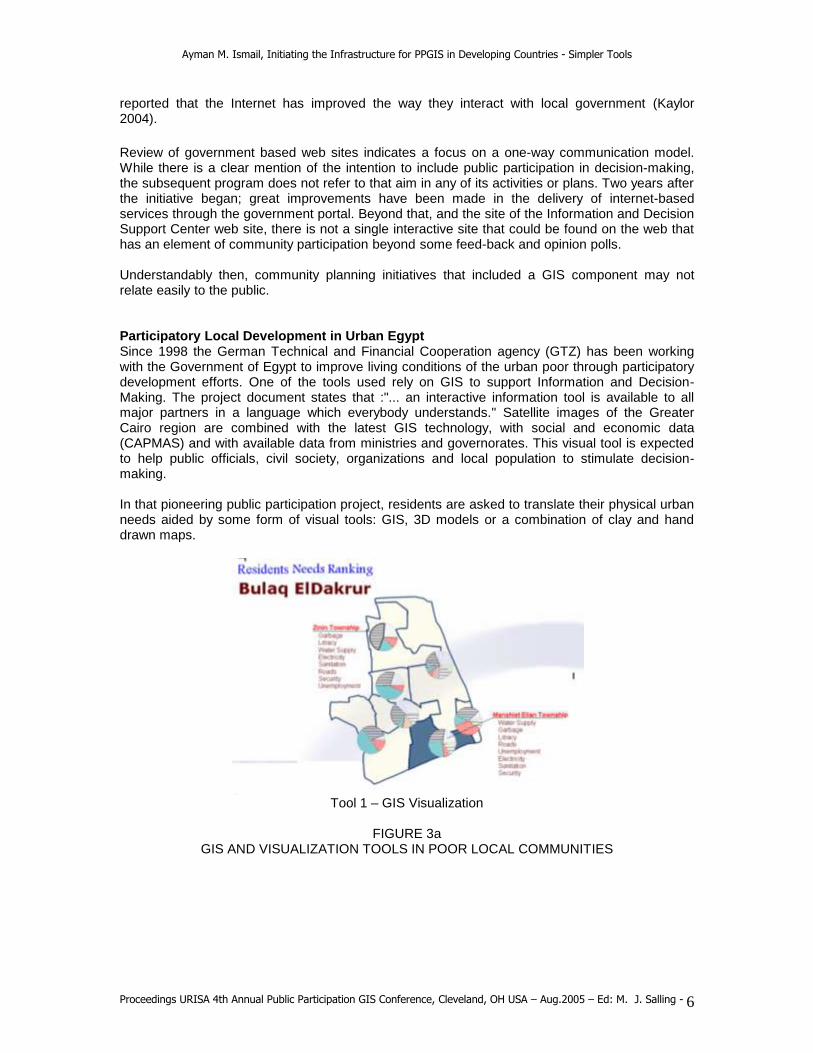
Understandably then, community planning initiatives that included a GIS component may not relate easily to the public. Participatory Local Development in Urban Egypt Since 1998 the German Technical and Financial Cooperation agency (GTZ) has been working with the Government of Egypt to improve living conditions of the urban poor through participatory development efforts. One of the tools used rely on GIS to support Information and Decision-Making. The project document states that :"... an interactive information tool is available to all major partners in a language which everybody understands." Satellite images of the Greater Cairo region are combined with the latest GIS technology, with social and economic data (CAPMAS) and with available data from ministries and governorates. This visual tool is expected to help public officials, civil society, organizations and local population to stimulate decision-making. In that pioneering public participation project, residents are asked to translate their physical urban needs aided by some form of visual tools: GIS, 3D models or a combination of clay and hand drawn maps.
Tool 1 – GIS Visualization
FIGURE 3a
GIS AND VISUALIZATION TOOLS IN POOR LOCAL COMMUNITIES

Ayman M. Ismail, Initiating the Infrastructure for PPGIS in Developing Countries - Simpler Tools
Proceedings URISA 4th Annual Public Participation GIS Conference, Cleveland, OH USA – Aug.2005 – Ed: M. J. Salling - 7
Tool 2 – 3D Model Visualization
FIGURE 3b GIS AND VISUALIZATION TOOLS IN POOR LOCAL COMMUNITIES
The GIS tool relied on typical topographic maps onto which field surveys of user needs were graphically displayed using chart tools. The 3D model was used to help residents relate to their physical location and envision the surroundings (Figure 3). However, it was the third tool that had the most impact. Women were asked to "play" with clay to model what they wanted to do in a vacant plot of land. First, they decided the landuse – a children playground, and then collectively they designed the plot. First clay models were used then hand coloring and rendering was done. The process generated not only very creative solutions, but was very engaging and satisfying to the women involved (Figure 4).
FIGURE 4a
COMBINATION OF CLAY AND HAND DRAWN MAP STEPS TO VISULAIZE PLANS

Ayman M. Ismail, Initiating the Infrastructure for PPGIS in Developing Countries - Simpler Tools
Proceedings URISA 4th Annual Public Participation GIS Conference, Cleveland, OH USA – Aug.2005 – Ed: M. J. Salling - 8
Tool 3 – Combination of Clay and Hand Drawn Maps
FIGURE 4b
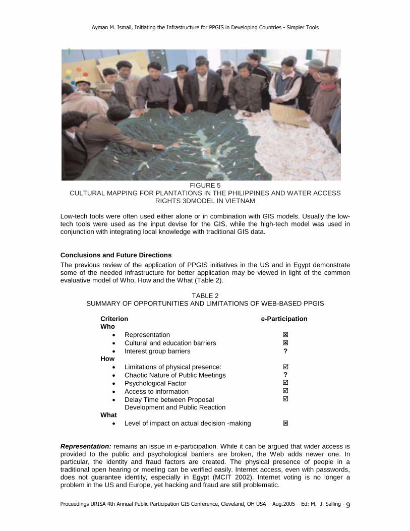
FINAL STAGE OF CLAY AND HAND DRAWN MAPS TOOLS It is hard to draw conclusions for PPGIS based solely on this experiment. However, it provides useful insight on the appropriateness of high-end technology for poor urban contexts of developing countries. Similar examples may be found in the literature all the way from Philippines, Indonesia to Vietnam (Figure 5).
Ayman M. Ismail, Initiating the Infrastructure for PPGIS in Developing Countries - Simpler Tools
Proceedings URISA 4th Annual Public Participation GIS Conference, Cleveland, OH USA – Aug.2005 – Ed: M. J. Salling - 9
FIGURE 5
CULTURAL MAPPING FOR PLANTATIONS IN THE PHILIPPINES AND WATER ACCESS RIGHTS 3DMODEL IN VIETNAM
Low-tech tools were often used either alone or in combination with GIS models. Usually the low-tech tools were used as the input devise for the GIS, while the high-tech model was used in conjunction with integrating local knowledge with traditional GIS data.
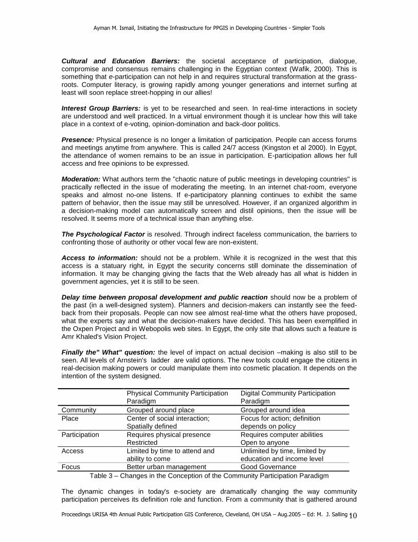
Conclusions and Future Directions
The previous review of the application of PPGIS initiatives in the US and in Egypt demonstrate some of the needed infrastructure for better application may be viewed in light of the common evaluative model of Who, How and the What (Table 2).
TABLE 2 SUMMARY OF OPPORTUNITIES AND LIMITATIONS OF WEB-BASED PPGIS
Criterion e-Participation Who
Representation
Cultural and education barriers
Interest group barriers ? How
Limitations of physical presence:
Chaotic Nature of Public Meetings ?
Psychological Factor
Access to information
Delay Time between Proposal Development and Public Reaction
What
Level of impact on actual decision -making Representation: remains an issue in e-participation. While it can be argued that wider access is provided to the public and psychological barriers are broken, the Web adds newer one. In particular, the identity and fraud factors are created. The physical presence of people in a traditional open hearing or meeting can be verified easily. Internet access, even with passwords, does not guarantee identity, especially in Egypt (MCIT 2002). Internet voting is no longer a problem in the US and Europe, yet hacking and fraud are still problematic.
Ayman M. Ismail, Initiating the Infrastructure for PPGIS in Developing Countries - Simpler Tools
Proceedings URISA 4th Annual Public Participation GIS Conference, Cleveland, OH USA – Aug.2005 – Ed: M. J. Salling - 10
Cultural and Education Barriers: the societal acceptance of participation, dialogue, compromise and consensus remains challenging in the Egyptian context (Wafik, 2000). This is something that e-participation can not help in and requires structural transformation at the grass-roots. Computer literacy, is growing rapidly among younger generations and internet surfing at least will soon replace street-hopping in our allies! Interest Group Barriers: is yet to be researched and seen. In real-time interactions in society are understood and well practiced. In a virtual environment though it is unclear how this will take place in a context of e-voting, opinion-domination and back-door politics. Presence: Physical presence is no longer a limitation of participation. People can access forums and meetings anytime from anywhere. This is called 24/7 access (Kingston et al 2000). In Egypt, the attendance of women remains to be an issue in participation. E-participation allows her full access and free opinions to be expressed. Moderation: What authors term the "chaotic nature of public meetings in developing countries" is practically reflected in the issue of moderating the meeting. In an internet chat-room, everyone speaks and almost no-one listens. If e-participatory planning continues to exhibit the same pattern of behavior, then the issue may still be unresolved. However, if an organized algorithm in a decision-making model can automatically screen and distil opinions, then the issue will be resolved. It seems more of a technical issue than anything else. The Psychological Factor is resolved. Through indirect faceless communication, the barriers to confronting those of authority or other vocal few are non-existent. Access to information: should not be a problem. While it is recognized in the west that this access is a statuary right, in Egypt the security concerns still dominate the dissemination of information. It may be changing giving the facts that the Web already has all what is hidden in government agencies, yet it is still to be seen. Delay time between proposal development and public reaction should now be a problem of the past (in a well-designed system). Planners and decision-makers can instantly see the feed-back from their proposals. People can now see almost real-time what the others have proposed, what the experts say and what the decision-makers have decided. This has been exemplified in the Oxpen Project and in Webopolis web sites. In Egypt, the only site that allows such a feature is Amr Khaled's Vision Project. Finally the" What" question: the level of impact on actual decision –making is also still to be seen. All levels of Arnstein's ladder are valid options. The new tools could engage the citizens in real-decision making powers or could manipulate them into cosmetic placation. It depends on the intention of the system designed.
Table 3 – Changes in the Conception of the Community Participation Paradigm The dynamic changes in today's e-society are dramatically changing the way community participation perceives its definition role and function. From a community that is gathered around
Physical Community Participation Paradigm
Digital Community Participation Paradigm
Community Grouped around place Grouped around idea
Place Center of social interaction; Spatially defined
Focus for action; definition depends on policy
Participation Requires physical presence Restricted
Requires computer abilities Open to anyone
Access Limited by time to attend and ability to come
Unlimited by time, limited by education and income level
Focus Better urban management Good Governance
Ayman M. Ismail, Initiating the Infrastructure for PPGIS in Developing Countries - Simpler Tools
Proceedings URISA 4th Annual Public Participation GIS Conference, Cleveland, OH USA – Aug.2005 – Ed: M. J. Salling - 11
a neighborhood or a district to one which is gathered also around a theme or way of thinking; from the physical interaction in a square or a plaza to the chatting of a virtual community; from the limitation of map, book and reports to the visual manipulation of real-time animation and 3D modeling; and finally from a focus of better management of urban project to better city, region and nation-wide government (Table 3). Planners' role is also changing; from an instrument of the State (in the 1960s) to deliver professional plans to a consultant by NGO's and other aid agencies. Today's urban planners are more facilitators and organizers of systems in the e-participatory approach.
REFERENCES
Abbott, J. (1996) Sharing the City. Community participation in urban management, London: Earthscan.
Al-Kodmany, Kheir (2004) "Engaging Citizens in Public Affairs : Online Applications" in proceedings of E-governance:Creating On-line Citizen Participation Tools " Columbus, OH March 3-5, 2004
Arnstien, S R. (1969) " A Ladder of Citizen Participation " APA Journal 35, 216
ASR (1995) Arab Strategic Report
Castells, M. (1983) The City and the Grassroots. Berkeley : U of California Press
Checkoway, B. (1994) "Paul Davidoff and Advocacy Planning in Retrospect" APA Journal 60, 2:139-142
Choguill, M. G. (1996). "A Ladder of Community Participation for Underdeveloped Countries" Habitat Intl. 20, 3: 431-444
Davidson, F. and Peltenburg, N. (1993) Government and NGOs/CBOs Working together for better cities. Institute for Housing and Urban Development Studies (HIS), Rotterdam, Netherlands, 1993.
Dichter, T. (1995) Building participation into Urban Upgrading projects: Lessons in Implementation in Open Cities: Building Community Participation in Urban Environmental Projects. USAID – Cairo.
Electoral Commission (2003). The shape of Elections to Come, an evaluation of the 2003 Programme of Voting pilots. http://www.electoralcommission. gov.uk/about-us/may2003pilots.cfm
Goetz, Anne Marie; and John Gaventa with others (2001) Governance: Bringing Citizen Voice and Client Focus into Service Delivery. Brighton: University of Sussex, IDS Working Paper No. 138. (65p.)
Gronlund, A. (2003) " e-Democracy: in Search of Tools and Methods for Effective Participation" Journal Of Multi-Criteria Decision Analysis 12: 93–100, Wiley InterScience.
Harris, T and Weiner, D (2003) " Linking community participation to geospatial technologies" Arid Lands Newsletter, No. 53, May/June 2003
Kaufman, M (1997) Community Power & Grassroots Democracy: The Transformation of Social Life Paperback / June 1997
Kaufman, M. and Alfonso, H. D. (eds.) (1997) Community Power and Grassroots Democracy. The transformation of social life, London: Zed Books.
Kaylor, Charles (2004). The State of Local E-Democracy, Presented at Planning Education at a Distance Conference. The Ohio State University March 3-5, 2004.

Ayman M. Ismail, Initiating the Infrastructure for PPGIS in Developing Countries - Simpler Tools
Proceedings URISA 4th Annual Public Participation GIS Conference, Cleveland, OH USA – Aug.2005 – Ed: M. J. Salling - 12
Kingston, R, Carver, S, Evans, A and Turton, I (2000) "Web-based public participation geographical information systems: an aid to local environmental decision-making. Computers, Environment and Urban Systems 24 (2000). Pergamon Press pp. 109±125
Lukensmeyer, C. and Brigham, S. (2002). "Taking Democracy to Scale: Creating a Town Hall Meeting for the Twenty-First Century" National Civic Review 91:4 pp 351-366
Mayo, M. (1994) Communities and Caring. The mixed economy of welfare, London: Macmillan.
McCall, Michael K.; & Peter Akong Minang (2003) "Participatory -GIS for Community-Based NRM in Development – does it support ‘Good Governance’?" Paper at URISA PPGIS Conference, Portland OR, July 2003.
Midgley, J. with Hall, A., Hardiman, M. and Narine, D. (1986) Community Participation, Social Development and the State, London: Methuen.
Mikkonen, Kari and Alppi, Samuli (undated) Web-based GIS to support citizen interaction in land use planning. http://www.tampere.fi/english/cityplanning
Mitchell, A. 1997. Zeroing in: Geographic Information Systems at work in the community. Redlands, California: ESRI.
Moore, C. N. and D. Davis (1997) Participation Tools for Better Land-Use Planning: Techniques and Case Studies. 2
nd ed. Sacramento: Center for Livable Communities.
Sanoff, H. (2000). Community Participation Methods in Design and Planning. New York : John Wiley and Sons
Shabaka, S. (1991) An Approach to Users Responsive Housing in the Egyptian Context . Unpublished Ph.D. Dissertation, Cairo University.
Sliuzas, R. (2003) " Governance 3and the use of GIS in developing countries" Habitat International 27 (2003) 495–499
Slocom, R. et al (1995) Power, Process and Participation - tools for change, London: Intermediate Technology Publications.
Spiegel, H. B. C. (ed.) (1968) Citizen Participation in Urban Development. Volume 1: Concepts and issues, Washington: Institute for Applied Behavioral Science.
Steifel, M. and Wolfe, M. (1997) A Voice for the Excluded. Popular participation in development - utopia or necessity?, London: Zed Books.
Strachan, P. with Peters, C. (1997) Empowering Communities. A casebook from West Sudan, Oxford: Oxfam.
UNDP (1997) Defining Core Characteristics of Good Governance. New York, NY: United Nations Development Programme.
United Nations (1955) Social Progress through Community Development, New York: United Nations.
United Nations (1981) Popular Participation as a Strategy for Planning Community Level Action and National Development, New York: United Nations
(un-authored) Wow, what a view! Geographic information systems and democracy. In Spore 109.
Related Documents