Michael J. Johnson, AICP Agency Director E. J. Ivaldi, Coordinator 3091 County Center Drive, Suite 190 ● Auburn ● California 95603 ● 530-745-3132 ● fax 530-745-3080 ● www.placer.ca.gov Alpine Sierra Subdivision 1 Initial Study April 2014 ENVIRONMENTAL COORDINATION SERVICES COUNTY OF PLACER Community Development Resource Agency INITIAL STUDY & CHECKLIST This Initial Study has been prepared to identify and assess the anticipated environmental impacts of the following described project application. The document may rely on previous environmental documents (see Section C) and site-specific studies (see Section I) prepared to address in detail the effects or impacts associated with the project. This document has been prepared to satisfy the California Environmental Quality Act (CEQA) (Public Resources Code, Section 21000 et seq.) and the State CEQA Guidelines (14 CCR 15000 et seq.) CEQA requires that all state and local government agencies consider the environmental consequences of projects over which they have discretionary authority before acting on those projects. The Initial Study is a public document used by the decision-making lead agency to determine whether a project may have a significant effect on the environment. If the lead agency finds substantial evidence that any aspect of the project, either individually or cumulatively, may have a significant effect on the environment, regardless of whether the overall effect of the project is adverse or beneficial, the lead agency is required to prepare an EIR, use a previously-prepared EIR and supplement that EIR, or prepare a Subsequent EIR to analyze the project at hand. If the agency finds no substantial evidence that the project or any of its aspects may cause a significant effect on the environment, a Negative Declaration shall be prepared. If in the course of analysis, the agency recognizes that the project may have a significant impact on the environment, but that by incorporating specific mitigation measures the impact will be reduced to a less than significant effect, a Mitigated Negative Declaration shall be prepared. A. BACKGROUND: Project Site and Location: The property is an irregularly shaped site located one-fourth mile north of the Alpine Meadows Ski Resort. The project site is located within the Alpine Meadows General Plan area, which encompasses approximately 3,600 acres south of Squaw Valley and west of the Truckee River, about 12 miles south of the Town of Truckee and 5 miles northwest of Tahoe City. Specifically, the ±47.2-acre project site is located in the Bear Creek Valley and consists of five parcels: Two parcels (APN 095-280-022 and 095-280-023) located on the east side of Alpine Meadows Road, approximately 2.7 miles west of State Route 89. These two parcels, totaling approximately 45.5 acres, would support all of the proposed development and infrastructure. Project Title: Alpine Sierra Subdivision Plus# 20130004 Entitlement(s): Tentative Map, Conditional Use Permit, General Plan Amendment and Rezoning Site Area: 47.2 total acres - 45.5 proposed development site APN: 095-280-022, 095-280- 023, 095-280-011, 095-280- 021, and 095-450-006 Location: East side of Alpine Meadows Road, approximately 2.7 miles west of State Route 89

Welcome message from author
This document is posted to help you gain knowledge. Please leave a comment to let me know what you think about it! Share it to your friends and learn new things together.
Transcript

Michael J. Johnson, AICP Agency Director E. J. Ivaldi, Coordinator
3091 County Center Drive, Suite 190 ● Auburn ● California 95603 ● 530-745-3132 ● fax 530-745-3080 ● www.placer.ca.gov
Alpine Sierra Subdivision 1 Initial Study April 2014
ENVIRONMENTAL COORDINATION
SERVICES
COUNTY OF PLACER Community Development Resource Agency
INITIAL STUDY & CHECKLIST
This Initial Study has been prepared to identify and assess the anticipated environmental impacts of the following described project application. The document may rely on previous environmental documents (see Section C) and site-specific studies (see Section I) prepared to address in detail the effects or impacts associated with the project. This document has been prepared to satisfy the California Environmental Quality Act (CEQA) (Public Resources Code, Section 21000 et seq.) and the State CEQA Guidelines (14 CCR 15000 et seq.) CEQA requires that all state and local government agencies consider the environmental consequences of projects over which they have discretionary authority before acting on those projects. The Initial Study is a public document used by the decision-making lead agency to determine whether a project may have a significant effect on the environment. If the lead agency finds substantial evidence that any aspect of the project, either individually or cumulatively, may have a significant effect on the environment, regardless of whether the overall effect of the project is adverse or beneficial, the lead agency is required to prepare an EIR, use a previously-prepared EIR and supplement that EIR, or prepare a Subsequent EIR to analyze the project at hand. If the agency finds no substantial evidence that the project or any of its aspects may cause a significant effect on the environment, a Negative Declaration shall be prepared. If in the course of analysis, the agency recognizes that the project may have a significant impact on the environment, but that by incorporating specific mitigation measures the impact will be reduced to a less than significant effect, a Mitigated Negative Declaration shall be prepared.
A. BACKGROUND: Project Site and Location: The property is an irregularly shaped site located one-fourth mile north of the Alpine Meadows Ski Resort. The project site is located within the Alpine Meadows General Plan area, which encompasses approximately 3,600 acres south of Squaw Valley and west of the Truckee River, about 12 miles south of the Town of Truckee and 5 miles northwest of Tahoe City. Specifically, the ±47.2-acre project site is located in the Bear Creek Valley and consists of five parcels:
Two parcels (APN 095-280-022 and 095-280-023) located on the east side of Alpine Meadows Road, approximately 2.7 miles west of State Route 89. These two parcels, totaling approximately 45.5 acres, would support all of the proposed development and infrastructure.
Project Title: Alpine Sierra Subdivision Plus# 20130004
Entitlement(s): Tentative Map, Conditional Use Permit, General Plan Amendment and Rezoning
Site Area: 47.2 total acres - 45.5 proposed development site APN: 095-280-022, 095-280-023, 095-280-011, 095-280-021, and 095-450-006
Location: East side of Alpine Meadows Road, approximately 2.7 miles west of State Route 89
Initial Study & Checklist continued
Alpine Sierra Subdivision 2 Initial Study April 2014
Three additional parcels (APN 095-280-011, -021, and 095-450-006) totaling approximately 1.7 acres, physically separate from the proposed development site, located north of the northwest corner of the main two parcels. These parcels would remain in open space but are part of the proposed subdivision.
Figures provided with the Notice of Preparation (NOP) of an EIR for this project identify the project site’s regional location (Figure 1) and the project vicinity (Figure 2). NOP Figure 3 provides an aerial photograph of the project vicinity. As shown on Figures 2 and 3, the ±45.5-acre proposed development site is bound on the west by Alpine Meadows Road, on the north by John Scott Trail and single-family residences in the Bear Creek Association (BCA) neighborhood, and on the south and east by Ginzton Access Road and Chalet Road, the Stanford Alpine Chalet (visitor lodging), single family residences, and the Alpine Meadows Ski Resort. Bear Creek bisects the narrow corridor that comprises the westernmost extent of the project site. The project site is situated in Section 5 of Township 15 North and Range 16 East on the 7.5 minute Tahoe City USGS topographic quadrangle.
Project Description: As shown in NOP Figure 4 Site Plan, the project proposes approval of a subdivision for the development of 47 residential units on the ±45.5-acre proposed development site. The eastern portion of the site would support 27 lots ranging in size from 0.39 acres to 1.17 acres, averaging 0.72 acres. The 20 lots on the western portion of the proposed development site range in size from 0.08 acres to 0.38 acres, averaging 0.16 acres. Fourteen of the lots on the western end would be configured as halfplex units. The project would also create commonly held open space throughout the proposed development site and build project serving utilities, a small Homeowners Association (HOA) residence, meeting room and equipment storage facility, an amenities lot with hot tub, picnic area, and small support structures, and an onsite sewer lift station. A total of 14.1 acres of the site is proposed to be zoned Open Space (O). This includes an existing 9.8 acres already designated Open Space and the proposal to rezone 5.7 acres to Open Space from Residential Single-Family (RS). The project also proposes to rezone 1.33 acres currently designated Open Space to Residential Single-Family. The proposed rezoning is shown in NOP Figure 5. The project would result in residential development of 27 acres of the site, not including subdivision roadways. The remaining 20 acres would support project roadways or be left in open space. A public trail would also be constructed and dedicated to Placer County. The trail would connect to the existing USFS and partly realigned trail that crosses the eastern portion of the proposed development site. The existing trail also extends to the additional three parcels that are included in the proposed subdivision.
Circulation. The project is proposed to be served by a single private roadway access off of Alpine Meadows Road on the western side of the proposed development site. Circulation through the site would be provided by this single main road extending east from the entrance and terminating in a cul-de-sac. Secondary roads (cul-de-sacs) would intersect the main road to provide access to proposed lots. Roads are proposed to be privately owned and maintained by the HOA. A bridge over Bear Creek and four bridges or culverts over a seasonal stream and two ephemeral drainages are proposed.
Utilities. The proposed project would require construction of onsite and offsite infrastructure to provide water, wastewater, electricity, telephone, and cable television services to the site. Underground utilities would run in easements along roadways within the development. Domestic water would be supplied from Alpine Springs County Water District (ASCWD). Wastewater disposal would also be provided by ASCWD. Most of the homes would use gravity sewer but a few would require individual sewage pumps to access the gravity sewer. One sewer lift station would be required and would be constructed in the northeastern corner of the proposed development site. Solid waste would be collected by the Tahoe Truckee Sierra Disposal and processed at the Eastern Regional Materials Recovery Facility. Electric utilities would be supplied by Liberty Energy. Individual propane tanks would be provided. Offsite improvements to ASCWD’s facilities and infrastructure would be necessary to ensure adequate service is available to the project and to increase water supply reliability and pressure throughout the ASCWD service area. As identified by ASCWD the offsite improvements that may be necessary to ensure adequate water supply and pressure to serve the proposed project and to increase water supply reliability and pressure throughout the ASCWD service area include:

Initial Study & Checklist continued
Alpine Sierra Subdivision 3 Initial Study April 2014
Mitigate zonal supply deficiencies with the installation of three booster pump stations (pump stations B, C and D) that will convey excess supply from Zone 4 to Zones 3, 2 and 1.
Zone 1 to 2 Pressure Reducing Valve (PRV) Upgrade: Replace existing 2-inch and 3-inch PRVs with 3-inch and 6-inch PRVs. This will provide fire flows from Zone 1 storage during emergencies and reduce maintenance issues by the installation of a 3-inch anti-cavitation valve to address the high differential operating pressure at this site.
Zone 1 to 2, 8-inch diameter secondary supply main: Install 500 linear feet of 8-inch diameter main along Alpine Meadows Road between White Wolf and John Scott Trail. This improvement provides an increase in service pressures and a significant increase in available fire flows and redundancy throughout Zone 2 and proposed Zone 2A, and provides a needed second connection to Zone 1.
6-inch PRV upgrade: Install a 6-inch PRV at Booster Station B2 site. Improves fire flow in Deer Park area and in proposed Pressure Zone 2A.
John Scott Trail 8-inch Main Upgrade & PRV: Install 820 linear feet of 8-inch diameter main along John Scott Trail between Upper Bench and Mineral Springs and new 3-inch/6-inch PRV vault. This allows for the creation of pressure Zone 2A and allows the upper portions of Juniper Mountain to meet fire flows and service pressures without a dedicated booster pump.
Rebuild Pump Station A: Rebuild will increase capacity to supply pressure Zone 1 Maximum Day Demand (MDD) with water from Zone 2.
Additional Capacity to proposed Pump Stations C and D: Added capacity will allow the ASCWD to supply the water system from the bottom during MDD if horizontal wells are out of service.
Additional Capacity to proposed Pump Station B: Added capacity will allow the ASCWD to supply the water system from the bottom during MDD if horizontal wells are out of service.
Additional fire flow and redundancy improvement: Install 920 linear feet of 6-inch diameter main connecting the NE portion of Alpine Sierra Development (ASD) to the Bear Creek Subdivision (BCS). This improvement would provide a third point of connection between Zones 1 and 2 with improvements in fire flow along portions of John Scott Trail in the BCS and Alpine Estates Subdivision (AES). This option cannot be a substitute for other improvements.
Placer County and the ASCWD will coordinate to determine which of these improvements are necessary to serve the project. The impacts to construct and operate those improvements will be analyzed in the EIR.
Grading and Drainage. Development of the proposed project would require grading for the residences, HOA maintenance building and residence, roadways, driveways, bridges, retaining walls, utilities, and project amenities. Due to the steepness of the site, future homes and the project infrastructure would require extensive cuts and the use of retaining walls. Because the subdivision is proposed for custom homes, the project applicant would grade for and construct all roadways, utilities (including a sewer lift station) and the proposed HOA residence, while grading for homes would be undertaken by individual lot owners. The Preliminary Grading Plan indicates that while substantial grading is necessary, cuts and fills across the site are expected to balance, but may involve significant export and import of materials due to the lack of suitability of the excavated material to be used as structural fill due to rocky nature of the site.
Low Impact Development (LID) systems to treat site runoff are included in the project plans. Drainage systems proposed include the use of cut-off ditches, cross culverts and level spreaders to capture and disburse runoff from undeveloped areas. As described above, the proposed development site contains two primary drainage systems; Bear Creek at the western end of the property and an unnamed seasonal stream in the eastern area of the site that flows north-south into Bear Creek. Runoff from the site flows to the northwest towards Bear Creek.
Initial Study & Checklist continued
Alpine Sierra Subdivision 4 Initial Study April 2014
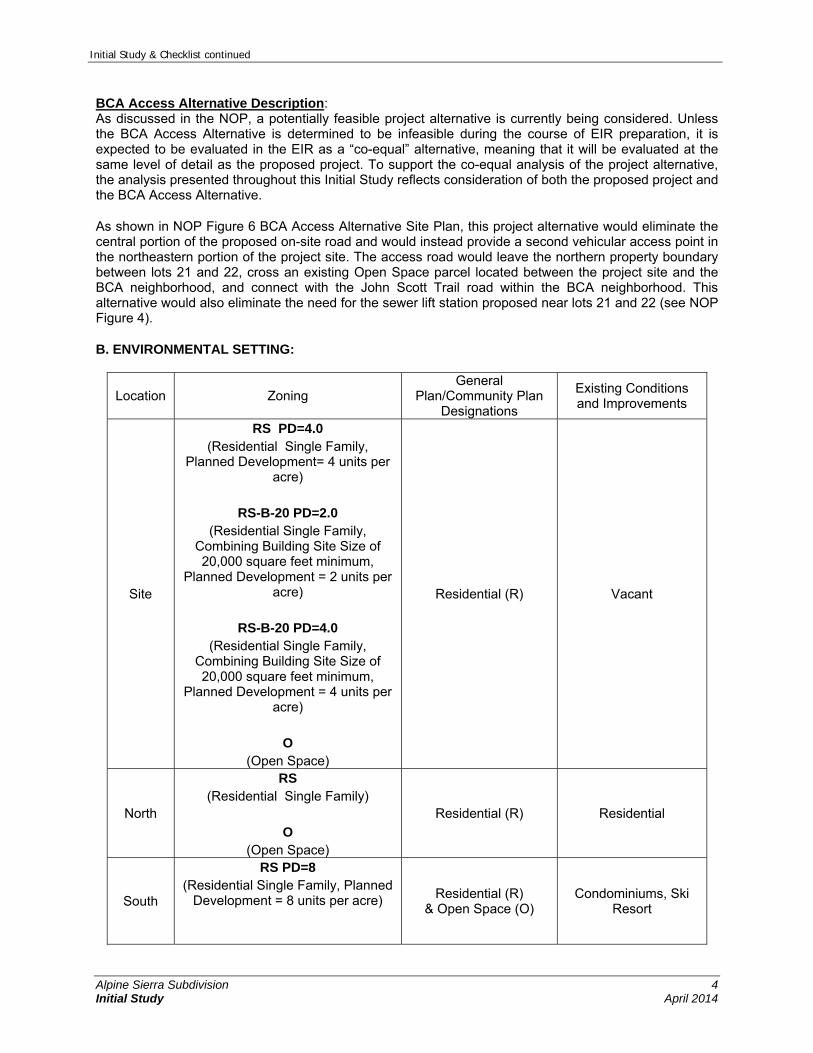
BCA Access Alternative Description: As discussed in the NOP, a potentially feasible project alternative is currently being considered. Unless the BCA Access Alternative is determined to be infeasible during the course of EIR preparation, it is expected to be evaluated in the EIR as a “co-equal” alternative, meaning that it will be evaluated at the same level of detail as the proposed project. To support the co-equal analysis of the project alternative, the analysis presented throughout this Initial Study reflects consideration of both the proposed project and the BCA Access Alternative.
As shown in NOP Figure 6 BCA Access Alternative Site Plan, this project alternative would eliminate the central portion of the proposed on-site road and would instead provide a second vehicular access point in the northeastern portion of the project site. The access road would leave the northern property boundary between lots 21 and 22, cross an existing Open Space parcel located between the project site and the BCA neighborhood, and connect with the John Scott Trail road within the BCA neighborhood. This alternative would also eliminate the need for the sewer lift station proposed near lots 21 and 22 (see NOP Figure 4).
B. ENVIRONMENTAL SETTING:
Location Zoning General
Plan/Community Plan Designations
Existing Conditions and Improvements
Site
RS PD=4.0 (Residential Single Family,
Planned Development= 4 units per acre)
RS-B-20 PD=2.0
(Residential Single Family, Combining Building Site Size of 20,000 square feet minimum,
Planned Development = 2 units per acre)
RS-B-20 PD=4.0
(Residential Single Family, Combining Building Site Size of 20,000 square feet minimum,
Planned Development = 4 units per acre)
O
(Open Space)
Residential (R) Vacant
North
RS (Residential Single Family)
O
(Open Space)
Residential (R) Residential
South
RS PD=8 (Residential Single Family, Planned
Development = 8 units per acre)
Residential (R) & Open Space (O)
Condominiums, Ski Resort

Initial Study & Checklist continued
Alpine Sierra Subdivision 5 Initial Study April 2014
O (Open Space)
East
RS-B-20 PD=2.0 (Residential Single Family,
Combining Building Site Size of 20,000 square feet minimum,
Planned Development = 2 units per acre)
RS PD=3 (Residential Single Family, Planned
Development = 3 units per acre) O
(Open Space)
Residential (R) & Open Space (O)
Vacant and Open
Space
West
RS-B-20 PD=2.0 (Residential Single Family,
Combining Building Site Size of 20,000 square feet minimum,
Planned Development = 2 units per acre) RS
(Residential Single Family) RS PD=3
(Residential Single Family, Planned Development = 3 units per acre)
O (Open Space)
Residential (R) Residential & Open Space
C. PREVIOUS ENVIRONMENTAL DOCUMENT: The County has determined that an Initial Study shall be prepared in order to determine whether the potential exists for unmitigatable impacts resulting from the proposed project. Relevant analysis from the County-wide General Plan Certified EIR and other project-specific studies and reports were used to provide background information for this Initial Study. The decision to prepare the Initial Study utilizing the analysis contained in the General Plan Certified EIR, and project-specific analysis summarized herein, is sustained by Sections 15168 and 15183 of the CEQA Guidelines.
Section 15168 relating to Program EIRs indicates that where subsequent activities involve site-specific operations, the agency would use a written checklist or similar device to document the evaluation of the site and the activity, to determine whether the environmental effects of the operation were covered in the earlier Program EIR. A Program EIR is intended to provide the basis in an Initial Study for determining whether the later activity may have any significant effects. It will also be incorporated by reference to address regional influences, secondary effects, cumulative impacts, broad alternatives, and other factors that apply to the program as a whole.
The following program-level EIR is hereby incorporated by reference in this Initial Study. Where applicable throughout this Initial Study analysis, the relevant information from the EIR is summarized
Placer County General Plan EIR
Section 15183 states that “projects which are consistent with the development density established by existing zoning, community plan or general plan policies for which an EIR was certified shall not require additional environmental review, except as may be necessary to examine whether there are project-specific significant effects which are peculiar to the project or site.” Thus, if an impact is not peculiar to the
Initial Study & Checklist continued
Alpine Sierra Subdivision 6 Initial Study April 2014
project or site, and it has been addressed as a significant effect in the prior EIR, or will be substantially mitigated by the imposition of uniformly applied development policies or standards, then additional environmental documentation need not be prepared for the project solely on the basis of that impact.
The Placer County General Plan EIR is available for review Monday through Friday, 8am to 5pm, at the Placer County Community Development Resource Agency, 3091 County Center Drive, Auburn, CA 95603 and in the Tahoe Division Office, 565 West Lake Blvd., Tahoe City, CA 96145. D. EVALUATION OF ENVIRONMENTAL IMPACTS: The Initial Study checklist recommended by the CEQA Guidelines is used to determine potential impacts of the proposed project on the physical environment. The checklist provides a list of questions concerning a comprehensive array of environmental issue areas potentially affected by the project (see CEQA Guidelines, Appendix G). Explanations to answers are provided in a discussion for each section of questions as follows:
a) A brief explanation is required for all answers including “No Impact” answers. b) “Less Than Significant Impact” applies where the project’s impacts are insubstantial and do not
require any mitigation to reduce impacts. c) "Less Than Significant with Mitigation Measures" applies where the incorporation of mitigation measures
has reduced an effect from “Potentially Significant Impact" to a "Less than Significant Impact." The County, as lead agency, must describe the mitigation measures, and briefly explain how they reduce the effect to a less-than-significant level (mitigation measures from earlier analyses may be cross-referenced).
d) "Potentially Significant Impact" is appropriate if there is substantial evidence that an effect may be significant. If there are one or more "Potentially Significant Impact" entries when the determination is made, an EIR is required.
e) All answers must take account of the entire action involved, including off-site as well as on-site, cumulative as well as project-level, indirect as well as direct, and construction as well as operational impacts [CEQA Guidelines, Section 15063(a)(1)].
f) Earlier analyses may be used where, pursuant to the tiering, Program EIR, or other CEQA process, an effect has been adequately analyzed in an earlier EIR or Negative Declaration [CEQA Guidelines, Section 15063(c)(3)(D)]. A brief discussion should be attached addressing the following: Earlier analyses used – Identify earlier analyses and state where they are available for review. Impacts adequately addressed – Identify which effects from the above checklist were within the
scope of, and adequately analyzed in, an earlier document pursuant to applicable legal standards. Also, state whether such effects were addressed by mitigation measures based on the earlier analysis.
Mitigation measures – For effects that are checked as “Less Than Significant with Mitigation Measures,” describe the mitigation measures which were incorporated or refined from the earlier document and the extent to which they address site-specific conditions for the project.
g) References to information sources for potential impacts (i.e. General Plans/Community Plans, zoning ordinances) should be incorporated into the checklist. Reference to a previously-prepared or outside document should include a reference to the pages or chapters where the statement is substantiated. A source list should be attached and other sources used, or individuals contacted, should be cited in the discussion.

Initial Study & Checklist continued
Alpine Sierra Subdivision 7 Initial Study April 2014
I. AESTHETICS – Would the project:
Environmental Issue Potentially Significant
Impact
Less Than Significant
with Mitigation Measures
Less Than Significant
Impact
No Impact
1. Have a substantial adverse effect on a scenic vista? (PLN)
X
2. Substantially damage scenic resources, including, but not limited to, trees, rock outcroppings, and historic buildings, within a state scenic highway? (PLN)
X
3. Substantially degrade the existing visual character or quality of the site and its surroundings? (PLN)
X
4. Create a new source of substantial light or glare, which would adversely affect day or nighttime views in the area? (PLN)
X
Discussion- Items I-1, 3: The project site is located in northeastern Placer County, within the community of Alpine Meadows and set against the backdrop of the northeastern Sierra Nevada Mountains. The surrounding mountainous terrain and landscape include open fir and pine forests, rock outcroppings, perennial streams, seasonal streams and ephemeral drainages, which provide substantial scenic resources. Scenic vistas are generally available from the mountains surrounding the valley as well as from various locations within the valley, such as at rock outcroppings and meadows where openings in the trees allow for broad and expansive views.
The proposed development site, which is generally the same under the proposed project and the BCA Access Alternative, is visible from surrounding slopes and ridgelines, nearby land uses and local roadways. For example, expansive views of the Alpine Meadows valley, including the proposed development site and surrounding residential development, are available from the mountains surrounding the area to the north, west, and south. More specifically, the site may be visible from locations along the Five Lakes Trail; several residents of the Bear Creek Association neighborhood to the north as well as residents of the condominium development to the south along Chalet Road and visitors to the Stanford Alpine Chalet are afforded views of portions of the project site; and motorists on Alpine Meadows Road and smaller roads in the project vicinity may be afforded views of the proposed development site.
The EIR will evaluate the degree to which the project or the BCA Access Alternative would affect scenic vistas and degrade the existing visual character or quality of the project site and its surroundings. Visual simulations from critical viewpoints surrounding the project site will be prepared to demonstrate the project’s effects to the existing visual character or quality of site and will characterize any adverse impacts to the site and its surroundings.
Discussion- Items I-2: Although not an Officially Designated State Scenic Highway, State Route (SR) 89 is identified by the California Department of Transportation (Caltrans) as an Eligible State Scenic Highway (Caltrans 2013). SR 89 is located approximately 2.7 miles east of the project site and due to tall, intervening vegetation (i.e., pine and fir trees) and mountainous terrain, the project site is not visible from SR 89 and therefore, no impacts to scenic resources within a state scenic highway are anticipated under either the proposed project or the BCA Access Alternative.

Initial Study & Checklist continued
Alpine Sierra Subdivision 8 Initial Study April 2014
Discussion- Item I-4: Project infrastructure and new residential buildings have the potential to increase daytime glare and to introduce substantial amounts of new lighting that would impact nighttime views in the area. Metal guard rails and other roadway safety railings have the potential to increase daytime glare. Residential finish materials such as windows, metallic siding, and safety or decorative railing may create new sources of glare that could be visible to viewers in the immediate area. If not properly shielded and directed downward, outdoor residential lighting has the potential to adversely affect nighttime views by introducing a substantial amount of new lighting to the project area that could be visible from adjacent residential neighborhoods, community roadways, and public trails. The homesites are in generally the same location and configuration under both the proposed project and the BCA Access Alternative. The EIR will evaluate the degree to which the project or the BCA Access Alternative would increase light or glare to the project site and its surroundings and will propose mitigation measures to address any impacts that would occur.
II. AGRICULTURAL & FOREST RESOURCES – Would the project:
Environmental Issue Potentially Significant
Impact
Less Than Significant
with Mitigation Measures
Less Than Significant
Impact
No Impact
1. Convert Prime Farmland, Unique Farmland, or Farmland of Statewide or Local Importance (Farmland), as shown on the maps prepared pursuant to the Farmland Mapping and Monitoring Program of the California Resources Agency, to non-agricultural use? (PLN)
X
2. Conflict with General Plan or other policies regarding land use buffers for agricultural operations? (PLN)
X
3. Conflict with existing zoning for agricultural use, a Williamson Act contract or a Right-to-Farm Policy? (PLN)
X
4. Conflict with existing zoning for, or cause rezoning of, forest land (as defined in Public Resources Code section 12220(g)), timberland (as defined by Public Resources Code section 4526), or timberland zoned Timberland Production (as defined by Government Code section 51104(g))? (PLN)
X
5. Involve other changes in the existing environment which, due to their location or nature, could result in the loss or conversion of Farmland (including livestock grazing) or forest land to non-agricultural or non-forest use? (PLN)
X
Discussion- Item II-1: The project site is not designated as Prime Farmland, Unique Farmland, or Farmland of Statewide or Local Importance (Farmland). There would be no impact to these farmland resources under either the proposed project or the BCA Access Alternative. Discussion- Items II-2, 3, 5: The project site is not adjacent to any agricultural land and does not conflict with the General Plan or other policies regarding land use buffers for agricultural operations. The site does not conflict with any existing agricultural zoning, Williamson Act contract, or Right-to-Farm Policy. It would not result in the loss or conversion of Farmland for other purposes. While the site supports forest, it is not used or designated for any forestry use. Further, the project would not remove the forest habitat from large portions of the site. Neither the proposed project nor the BCA Access Alternative would result in the loss or conversion of forest land to non-forest uses.

Initial Study & Checklist continued
Alpine Sierra Subdivision 9 Initial Study April 2014
Discussion- Item II-4: The project site and adjacent parcels are not designated for or used for timberland production. The proposed project does not conflict with existing zoning of the site or in the vicinity. The majority of subject property is zoned under three residential single-family zoning districts with varying minimum parcel sizes and a portion of the site is zoned Open Space. These residential zoning designations do not allow timber harvesting or production. The Open Space zoning designation does allow for timber harvesting and production; however the project site has not historically supported any timber harvest or forestry activities. There would be no impact to forest land or timberland as defined in the Public Resources Code or Government Code under either the proposed project or the BCA Access Alternative. III. AIR QUALITY – Would the project:
Environmental Issue Potentially Significant
Impact
Less Than Significant
with Mitigation Measures
Less Than Significant
Impact
No Impact
1. Conflict with or obstruct implementation of the applicable air quality plan? (PLN, Air Quality)
X
2. Violate any air quality standard or contribute substantially to an existing or projected air quality violation? (PLN, Air Quality)
X
3. Result in a cumulatively considerable net increase of any criteria for which the project region is non-attainment under an applicable federal or state ambient air quality standard (including releasing emissions which exceed quantitative thresholds for ozone precursors)? (PLN, Air Quality)
X
4. Expose sensitive receptors to substantial pollutant concentrations? (PLN, Air Quality)
X
5. Create objectionable odors affecting a substantial number of people? (PLN, Air Quality)
X
Discussion- Items III-1-4: The project site is located in the Mountain Counties Air Basin. The Placer County portion of this basin is designated non-attainment for the following air quality standards:
State and federal standards for Ozone State standards for coarse particulate matter (PM10) Federal standards for fine particulate matter (PM2.5)
For the state standards for PM2.5 and carbon monoxide, the basin is unclassified (meaning there is not enough data to determine if the state standards have been attained).
The proposed project and the BCA Access Alternative would have similar construction and operational characteristics with respect to air pollution emissions. Construction and operation of either the proposed project or the BCA Access Alternative could generate air pollutant emissions associated with the use of motor vehicles, dust emissions during grading activities, particulate matter emissions from use of wood-burning stoves and fireplaces, new/increased use of utilities and use of consumer products (cleaning supplies and personal care products) and landscaping equipment. New emissions associated with the project or project alternative could result in a significant impact to regional air quality.
The EIR will utilize the most recent version of the California Emissions Estimator Model (CalEEMod) program to estimate air pollutant emissions associated with construction and operation. The EIR air quality chapter will discuss the modeling and evaluate these emissions in relation to standards adopted

Initial Study & Checklist continued
Alpine Sierra Subdivision 10 Initial Study April 2014
by the Placer County Air Pollution Control District. Mitigation measures, if necessary, will be consistent with PCAPCD Rules and Regulations.
Discussion- Item III-5: Under both the proposed project and the BCA Access Alternative, the project would construct a new residential development. Residential land uses do not generate substantial objectionable odors that could affect other residences nearby. IV. BIOLOGICAL RESOURCES – Would the project:
Environmental Issue Potentially Significant
Impact
Less Than Significant
with Mitigation Measures
Less Than Significant
Impact
No Impact
1. Have a substantial adverse effect, either directly or through habitat modifications, on any species identified as a candidate, sensitive, or special status species in local or regional plans, policies or regulations, or by the California Department of Fish & Game, U.S. Fish & Wildlife Service or National Oceanic and Atmospheric Administration Fisheries? (PLN)
X
2. Substantially reduce the habitat of a fish or wildlife species, cause a fish or wildlife population to drop below self-sustaining levels, threaten to eliminate a plant or animal community, substantially reduce the number of restrict the range of an endangered, rare, or threatened species? (PLN)
X
3. Have a substantial adverse effect on the environment by converting oak woodlands? (PLN)
X
4. Have a substantial adverse effect on any riparian habitat or other sensitive natural community, including oak woodlands, identified in local or regional plans, policies or regulations, or by the California Department of Fish & Game, U.S. Fish & Wildlife Service, U.S. Army Corps of Engineers or National Oceanic and Atmospheric Administration Fisheries? (PLN)
X
5. Have a substantial adverse effect on federal or state protected wetlands as defined by Section 404 of the Clean Water Act (including, but not limited to, marsh, vernal pool, coastal, etc.) or as defined by state statute, through direct removal, filling, hydrological interruption, or other means? (PLN)
X
6. Interfere substantially with the movement of any native resident or migratory wildlife species or with established native resident or migratory wildlife corridors, or impede the use of native wildlife nesting or breeding sites? (PLN)
X
7. Conflict with any local policies or ordinances that protect biological resources, including oak woodland resources? (PLN)
X

Initial Study & Checklist continued
Alpine Sierra Subdivision 11 Initial Study April 2014
Environmental Issue Potentially Significant
Impact
Less Than Significant
with Mitigation Measures
Less Than Significant
Impact
No Impact
8. Conflict with the provisions of an adopted Habitat Conservation Plan, Natural Community Conservation Plan, or other approved local, regional, or state habitat conservation plan? (PLN)
X
Discussion- Item IV-1, 2: EcoSynthesis Scientific & Regulator Services, Incorporated, prepared a Biological Survey Report for the proposed project site in 2012. As detailed in the Biological Survey Report, onsite habitat consists primarily of White Fir forest with lesser acreages of Montane Chaparral, Montane Riparian, and rocky forb-subshrub vegetation. While the site is dominated by white fir, numerous Jeffrey pine trees occur on the steep slopes of the project site and lodgepole pine trees were identified near the Bear Creek drainage. Montane Riparian habitat is generally associated with drainage ravines traversing the site with the largest areas of riparian habitat occurring along Bear Creek in the narrow corridor comprising the western extent of the proposed development site and along a riverine feature located in the east-central portion of the site. Four pockets of riparian habitat that are not immediately adjacent to drainages also occur in the northeastern portion of the site. Dominant species identified in riparian areas include mountain alder, red-osier dogwood, and Scouler’s willow. In addition to vegetation mapping, the Biological Survey Report includes a record of plants and animals observed onsite and an assessment of the potential for onsite habitat to support special-status plant and wildlife species. The project area was found to provide suitable habitat for two special-status plant species including Donner Pass buckwheat and Munro’s desert mallow. A third special-status plant species, Northern meadow sedge, was determined to have marginal potential to occur onsite. The proposed development site was also found to provide suitable habitat for four special-status wildlife species including Sierra marten, Sierra Nevada snowshoe hare, Cooper’s hawk, and yellow warbler. Long-legged myotis and willow flycatcher were determined to have marginal potential to occur onsite due to low foraging value of habitat and lack of willow thickets. The existing studies did not evaluate habitats, species, or other biological resources that may be supported in the off-site parcel that would support the access road contemplated under the BCA Access Alternative. While it is expected that biological resources in that area would be similar to those found on—site, additional site-specific resource evaluation will be conducted. The EIR will evaluate existing data and information from the biological resource survey prepared for the proposed project as well as the new resource evaluation for the BCA Access Alternative. All potentially significant direct and indirect impacts to special-status plant and wildlife species and habitat will be identified and discussed in the EIR. Mitigation measures for all identified impacts will be developed in consultation with Placer County and representatives of applicable regulatory agencies. Discussion- Item IV-3: The proposed development site does not contain oak woodlands, and would therefore not have an adverse effect on any oak woodlands environment under either the proposed project or the BCA Access Alternative. Discussion- Items IV-4, 5: Montane riparian habitat and riverine areas occur on the proposed development site. Construction of roadways, installation of utility infrastructure, development of building pads and construction of residential structures could result in the direct removal of riparian habitat. In addition, road development would require crossing riparian habitat and jurisdictional waters of the U.S. Depending on engineering of project infrastructure, direct impacts (e.g., fill) within federally jurisdictional or non-jurisdictional wetlands or other
Initial Study & Checklist continued
Alpine Sierra Subdivision 12 Initial Study April 2014
waters may occur and may be considered significant. Even if fills were avoided, project construction or operation (e.g., stormwater management and/or discharge) could result in the discharge of sediment or in modification of surface runoff amounts or concentration so as to result in erosion and consequent contribution of sediment to the Truckee River watershed. Since sediment impairment is already recognized within the watershed, this would likely be regarded as a significant impact. The EIR will evaluate existing data and information from the biological resource survey prepared for the proposed project as well as the new resource evaluation for the BCA Access Alternative. All potentially significant direct and indirect impacts to riparian habitat, other sensitive natural communities and federal and state waters and wetland will be identified and discussed in the EIR. Mitigation measures for all identified impacts will be developed in consultation with Placer County and representatives of applicable regulatory agencies. Discussion- Item IV-6: While the proposed development site supports various upland habitat types, there are no known native resident or migratory wildlife corridors within the project area. However, the site is located between existing development to the north and south, and while narrow in width in some areas, wildlife may use the site to access undeveloped lands to the east. The BCA Open Space parcel is also narrow but could support wildlife movement. Within the site boundaries montane riparian habitat occurs along drainage ravines. However, use of the drainages by special-status aquatic vertebrates including Lahontan cutthroat trout (LCT) is not anticipated because Bear Creek includes non-native trout species, and the stream reach located within the project boundary does not include spawning substrate for LCT. The proposed development site is primarily populated with white fir with lesser occurrences of Jeffrey pine and lodgepole pine also occurring onsite. Raptors and smaller migratory birds may potentially use onsite habitat for nesting and breeding sites, and vegetation removal or ground disturbance may result in direct and indirect impacts to species subject to the Migratory Bird Treaty Act. The EIR will evaluate existing data and information from the project biological resource survey as well as the new resource evaluation for the BCA Access Alternative pertaining to wildlife corridors and use of onsite habitat as potential breeding and nesting sites. All potentially significant direct and indirect impacts will be identified and discussed in the EIR and mitigation measures will be developed in consultation with Placer County and representatives of applicable regulatory agencies. Discussion- Item IV-7: Due to the presence of perennial streams, seasonal streams, ephemeral drainages, wetlands and montane riparian habitat, development of the site under either the proposed project or the BCA Access Alternative would be subject to policies established in the Placer County General Plan Natural Resources Element for the protection of the County’s rivers, streams, creeks and wetland and riparian areas. Applicable policies include the establishment of sensitive habitat buffers around perennial and intermittent streams and sensitive habitats to be protected. Additional policies regarding stream encroachment, “no net loss” for wetland areas, suitable habitat for indigenous wildlife species, and the use of native and compatible non-native drought-resistant species in landscape plans may also be applicable to the proposed project. The EIR will evaluate the potential for the proposed project or the BCA Access Alternative to conflict with local policies established for the preservation of biological resources. All potential inconsistencies with applicable policies and ordinances will be identified and discussed in the EIR and mitigation measures will be developed in consultation with Placer County. Discussion- Item IV-8: Placer County has not adopted a Habitat Conservation Plan or Natural Communities Conservation Plan and the Placer County Conservation Plan (PCCP) program currently being developed would not apply to the project region. In addition, there are no other approved local, regional, or state habitat conservation plans that are applicable to the project area. Therefore, there would be no impacts related to conflicts with adopted conservation plans resulting from either the proposed project or the BCA Access Alternative.

Initial Study & Checklist continued
Alpine Sierra Subdivision 13 Initial Study April 2014
V. CULTURAL RESOURCES – Would the project:
Environmental Issue Potentially Significant
Impact
Less Than Significant
with Mitigation Measures
Less Than Significant
Impact
No Impact
1. Substantially cause adverse change in the significance of a historical resource as defined in CEQA Guidelines, Section 15064.5? (PLN)
X
2. Substantially cause adverse change in the significance of a unique archaeological resource pursuant to CEQA Guidelines, Section 15064.5? (PLN)
X
3. Directly or indirectly destroy a unique paleontological resource or site or unique geologic feature? (PLN)
X
4. Have the potential to cause a physical change, which would affect unique ethnic cultural values? (PLN)
X
5. Restrict existing religious or sacred uses within the potential impact area? (PLN)
X
6. Disturb any human remains, including these interred outside of formal cemeteries? (PLN)
X
Discussion- Items V-1, 2: Some of the oldest archaeological resources in the Tahoe Region have been found in the Truckee River Canyon near the proposed project site, suggesting occupation as long as 9,000 years ago. The project site falls within historic Native American Washoe territory, a tribe that is still active and present in the Lake Tahoe area today. In addition, the greater region of the project area played a historical role in the transportation, logging and herding industries throughout the 19th and 20th centuries. Over 20 cultural sites have been recorded in a 2600-acre study of the nearby Alpine Meadows Ski Resort uncovering heritage and historic themes such as: prehistoric hunting, plant food processing, tool stone acquisition and habitation, historic logging, Basque sheep herding and recreational skiing. In 2001, archaeologist Susan Lindström, PhD, conducted a comprehensive literature review and archaeological reconnaissance of the project site and found no significant prehistoric or historic artifacts, features or sites. Dr. Lindström updated the study in 2012 and found there have been no changes in the presence of cultural resources within the project site since her initial report. Dr. Lindström concluded that no further pre-construction considerations were warranted. The archaeological investigation consisted of a literature review of prehistoric and historical themes for the project area, a records search at the North Central Information Center (NCIC) at California State University Sacramento, and archaeological reconnaissance of the site in November of 2001. The report documents that while the project area falls within the center of the Washoe territory with primary use attributed to the northern Washoe or Wa She Shu, the closest Washoe ethnographic encampments in the region are noted in west Truckee, around Donner Lake and at Tahoe City. The updated to the analysis completed in 2012 included a supplemental records search at the NCIC, updated consultation with the Washoe Tribe of Nevada and California, and review of the proposed project plans. The updated report found that there have been no changes in the presence of cultural resources within the project site. While no significant archaeological resources were identified within the proposed development site, the archaeological report indicated that buried or concealed resources could potentially be present and could be unearthed during construction or ground disturbance activities. The following standard construction

Initial Study & Checklist continued
Alpine Sierra Subdivision 14 Initial Study April 2014
condition will apply to this project or the BCA Access Alternative, which will ensure that any buried or concealed resources unearthed during construction would be appropriately handled to avoid significant impacts:
If any archaeological artifacts, exotic rock (non-native), or unusual amounts of shell or bone are uncovered during any on-site construction activities, all work must stop immediately in the area and a SOPA-certified (Society of Professional Archaeologists) archaeologist retained to evaluate the deposit. The Placer County Planning Services Division and Department of Museums must also be contacted for review of the archaeological find(s). If the discovery consists of human remains, the Placer County Coroner and Native American Heritage Commission must also be contacted. Work in the area may only proceed after authorization is granted by the Placer County Planning Services Division. A note to this effect shall be provided on the Improvement Plans for the project. Following a review of the new find and consultation with appropriate experts, if necessary, the authority to proceed may be accompanied by the addition of development requirements which provide protection of the site and/or additional mitigation measures necessary to address the unique or sensitive nature of the site.
Discussion- Item V-3: The project site is not located in an area of high sensitivity for paleontological resources and therefore, impacts are not anticipated. The following standard construction condition will apply to this project or to the BCA Access Alternative, which will ensure that any paleontological resources unearthed during construction would be appropriately handled to avoid significant impacts:
A note shall be placed on the Improvement Plans that if paleontological resources are discovered on-site, the applicant shall retain a qualified paleontologist to observe grading activities and salvage fossils as necessary. The paleontologist shall establish procedures for paleontological resource surveillance and shall establish, in cooperation with the project developer, procedures for temporarily halting or redirecting work to permit sampling, identification, and evaluation of fossils. If major paleontological resources are discovered, which require temporarily halting or redirecting of grading, the paleontologist shall report such findings to the project developer, and to the Placer County Department of Museums and Planning Services Division. The paleontologist shall determine appropriate actions, in cooperation with the project developer, which ensure proper exploration and/or salvage. Excavated finds shall be offered to a State-designated repository such as Museum of Paleontology, U.C. Berkeley, the California Academy of Sciences, or any other State-designated repository. Otherwise, the finds shall be offered to the Placer County Department of Museums for purposes of public education and interpretive displays. These actions, as well as final mitigation and disposition of the resources shall be subject to approval by the Department of Museums. The paleontologist shall submit a follow-up report to the Department of Museums and Planning Services Division which shall include the period of inspection, an analysis of the fossils found, and present repository of fossils.
Discussion- Items V-4, 5: The 2001 archaeological study and 2012 study update did not identify unique ethnic cultural values or religious/sacred uses within the project site. Therefore, construction and operation of the proposed project or the BCA Access Alternative is not anticipated to have potential to cause a physical change that would affect unique ethnic cultural values or restrict existing religious or sacred uses of the site. Discussion- Item V-6: The project site was not identified as a formal or informal burial ground in the archaeological studies prepared for the proposed project and therefore, human remains are not anticipated to be impacted during construction activities. However, similar to the buried or concealed historical and archaeological resources, grading and other ground disturbing activities may encounter buried, previously unknown remains on the site. In the event that human remains are encountered during construction of the
Initial Study & Checklist continued
Alpine Sierra Subdivision 15 Initial Study April 2014
proposed project or the BCA Access Alternative, all construction activities would be stopped immediately and the County Coroner’s Office would be contacted pursuant to Public Resources Code (PRC) Section 7050.5. Further, as required by PRC Section 5097.94, 5097.98 and 5097.99, if the remains are determined to be of Native American origin, the Native American Heritage Commission (NAHC) should be notified within 24 hours of determination and the NAHC should notify designated Most Likely Descendants (in this case the Washoe Tribe), who should provide recommendations for the treatment of the remains within 24 hours. Therefore, while human remains are not anticipated to occur onsite, compliance with existing regulations would ensure that impacts to human remains during construction are less than significant. VI. GEOLOGY & SOILS – Would the project:
Environmental Issue Potentially Significant
Impact
Less Than Significant
with Mitigation Measures
Less Than Significant
Impact
No Impact
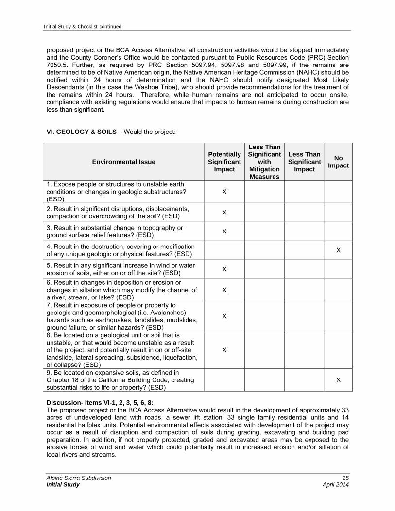
1. Expose people or structures to unstable earth conditions or changes in geologic substructures? (ESD)
X
2. Result in significant disruptions, displacements, compaction or overcrowding of the soil? (ESD)
X
3. Result in substantial change in topography or ground surface relief features? (ESD)
X
4. Result in the destruction, covering or modification of any unique geologic or physical features? (ESD)
X
5. Result in any significant increase in wind or water erosion of soils, either on or off the site? (ESD)
X
6. Result in changes in deposition or erosion or changes in siltation which may modify the channel of a river, stream, or lake? (ESD)
X
7. Result in exposure of people or property to geologic and geomorphological (i.e. Avalanches) hazards such as earthquakes, landslides, mudslides, ground failure, or similar hazards? (ESD)
X
8. Be located on a geological unit or soil that is unstable, or that would become unstable as a result of the project, and potentially result in on or off-site landslide, lateral spreading, subsidence, liquefaction, or collapse? (ESD)
X
9. Be located on expansive soils, as defined in Chapter 18 of the California Building Code, creating substantial risks to life or property? (ESD)
X
Discussion- Items VI-1, 2, 3, 5, 6, 8: The proposed project or the BCA Access Alternative would result in the development of approximately 33 acres of undeveloped land with roads, a sewer lift station, 33 single family residential units and 14 residential halfplex units. Potential environmental effects associated with development of the project may occur as a result of disruption and compaction of soils during grading, excavating and building pad preparation. In addition, if not properly protected, graded and excavated areas may be exposed to the erosive forces of wind and water which could potentially result in increased erosion and/or siltation of local rivers and streams.
Initial Study & Checklist continued
Alpine Sierra Subdivision 16 Initial Study April 2014
According to the Geotechnical Study prepared for the project, near surface soils on the site consist of approximately 4 to 18 inches of silty sand containing organic material (i.e., topsoil) over a majority of the site. The topsoil is anticipated to be underlain by medium dense to very dense silty sand with gravel and silty gravel with sand accompanied by cobbles and boulders up to approximately 4 feet in diameter (Holdrege & Kull 2013). Depth to rock is anticipated to be variable across the site. The project site and the surrounding Alpine Meadows Valley are located in a potentially active seismic area. Potentially active faults in the area include the Dog Valley Fault (approximately 12 miles northwest of the site), a group of unnamed faults southeast of Truckee (approximately 8 and 10 miles northeast of the site), the Polaris Fault (approximately 12 miles to the northeast) and the North Tahoe and Dollar Point Faults (approximately 8 miles to the southeast) (Holdrege & Kull 2013). The EIR will include an analysis of the potential effects of the proposed project and the BCA Access Alternative associated with geology and soils and if warranted, will provide mitigation measures to address any impacts associated with construction and/or operation of the proposed project. Discussion – Item VI-4: Based on the result of the Geotechnical Report prepared for the proposed project, no unique geologic or physical features occur on or underlay the project site. Therefore, no impacts to unique geologic or physical features would occur as a result of development of the project site under the proposed project or the BCA Access Alternative. Discussion- Item VI-7: An Avalanche Hazard Study for the proposed development site was prepared by Larry Heywood in July 2013. Lands subject to avalanches are referred to as Potential Avalanche Hazard Areas (PAHAs). The Placer County Code establishes construction requirements including certification from California licensed architect or engineer experienced in snow design (in conjunction with a recognized avalanche expert or team of experts) that the structure will be safe under the anticipated loads and conditions of an avalanche for projects within any designated PAHAs (Heywood 2013). Three PAHAs are located within the proposed development site. The EIR will include an analysis of potential risks associated with avalanches, PAHAs and development of the project site under the proposed project and the BCA Access Alternative. If warranted, the EIR will provide mitigation measures to address any impacts associated with construction and/or operation of the proposed project and exposure of existing or future residents to risks associated with avalanches. Discussion – ItemVI-9: According to the Geotechnical Report prepared for the proposed project, expansive soils do not occur on the proposed development site (Holdrege & Kull 2013). Therefore, development of the site under the proposed project or the BCA Access Alternative would not create substantial risks to life or property and as such, no impacts are anticipated to occur. VII. GREENHOUSE GAS EMISSIONS – Would the project:
Environmental Issue Potentially Significant
Impact
Less Than Significant
with Mitigation Measures
Less Than Significant
Impact
No Impact
1. Generate greenhouse gas emissions, either directly or indirectly, that may have a significant and/or cumulative impact on the environment? (PLN, Air Quality)
X
2. Conflict with an applicable plan, policy or regulation adopted for the purpose of reducing the emissions of greenhouse gases? (PLN, Air Quality)
X

Initial Study & Checklist continued
Alpine Sierra Subdivision 17 Initial Study April 2014
Discussion- Items VII-1 & 2: Climate change, which involves significant changes in global climate patterns, has been associated with an increase in the average temperature of the atmosphere near the Earth’s surface. This warming has been attributed to an accumulation of greenhouse gases (GHGs) in the atmosphere. GHGs trap heat in the atmosphere, which in turn heats the surface of the Earth. Although GHGs have historically been generated by natural factors, increasingly, human activity is contributing to a measurable change in the temperature of the earth’s surface and the resultant changes in global climate patterns. In 2006, the State of California enacted Assembly Bill (AB) 32, the Global Warming Solutions Act. AB 32 requires a reduction in human-generated statewide greenhouse gas (GHG) emissions to 1990 levels by 2020. The state’s plan for meeting these reduction targets is outlined in the California Air Resource Board’s (CARB) Climate Change Scoping Plan (CARB 2008). The CARB-approved CalEEMod program will be used to estimate GHG emissions associated with project construction and operation. Characteristics of the proposed project construction and operation related to GHG emissions are expected to be similar to the characteristics of the BCA Access Alternative. The operational analysis will include consideration of GHG emissions generated onsite, from vehicle use associated with the project, and generated offsite as related to energy consumption, solid waste disposal, water usage, and wastewater treatment. The EIR will evaluate the GHG emissions estimates in relation to regional and statewide goals for GHG emission reductions to find whether the project may have a direct or indirect impact on the environment. In particular, the EIR will determine consistency of the project and the BCA Access Alternative with AB32 goals, and whether or not the project would conflict attainment of those goals.
Mitigation measures will be developed in consultation with the Planning Services Division and the Placer County Air Pollution Control District.
VIII. HAZARDS & HAZARDOUS MATERIALS – Would the project:
Environmental Issue Potentially Significant
Impact
Less Than Significant
with Mitigation Measures
Less Than Significant
Impact
No Impact
1. Create a significant hazard to the public or the environment through the routine handling, transport, use, or disposal of hazardous or acutely hazardous materials? (EHS)
X
2. Create a significant hazard to the public or the environment through reasonably foreseeable upset and accident conditions involving the release of hazardous materials into the environment? (EHS)
X
3. Emit hazardous emissions, substances, or waste within one-quarter mile of an existing or proposed school? (PLN, Air Quality)
X
4. Be located on a site which is included on a list of hazardous materials sites compiled pursuant to Government Code Section 65962.5 and, as a result, would it create a significant hazard to the public or the environment? (EHS)
X

Initial Study & Checklist continued
Alpine Sierra Subdivision 18 Initial Study April 2014
Environmental Issue Potentially Significant
Impact
Less Than Significant
with Mitigation Measures
Less Than Significant
Impact
No Impact
5. For a project located within an airport land use plan or, where such a plan has not been adopted, within two miles of a public airport or public use airport, would the project result in a safety hazard for people residing or working in the project area? (PLN)
X
6. For a project within the vicinity of a private airstrip, would the project result in a safety hazard for people residing in the project area? (PLN)
X
7. Expose people or structures to a significant risk of loss, injury or death involving wildland fires, including where wildlands are adjacent to urbanized areas or where residences are intermixed with wildlands? (PLN)
X
8. Create any health hazard or potential health hazard? (EHS)
X
9. Expose people to existing sources of potential health hazards? (EHS)
X
Discussion- Item VIII-1, 2: During construction under either the proposed project or the BCA Access Alternative, there is the potential for the use, storage, and transportation of hazardous substances and wastes on and/or to and from the proposed development site. These may include fuels for machinery and vehicles, new and used motor oils, cleaning solvents, paints, storage containers and applicators containing such materials. Accidental spills, leaks, fires, explosions, or pressure releases involving hazardous materials represent a potential threat to human health and the environment if not properly treated. Accident prevention and containment are the responsibility of the construction contractors, and provisions to properly manage hazardous substances and wastes are typically included in construction specifications. All contractors are required to comply with applicable laws and regulations regarding hazardous materials and hazardous waste management and disposal. In addition, the project or the BCA Access Alternative would be required to comply with the statewide Construction General Permit (part of the National Pollutant Discharge Elimination System). This requires preparation and implementation of a stormwater pollution prevention plan (SWPPP) and development of best management practices (BMPs) for all phases of construction to control potential pollutants generated by the construction activities. Compliance with existing regulations and implementation of required plans and BMPs will minimize the potential for impacts associated with the use, transport and handling of typically hazardous materials associated with construction activities. Therefore, impacts are anticipated to be less than significant under either the proposed project or the BCA Access Alternative. Discussion- Item VIII-3: The project site is not located within one-quarter mile of an existing or proposed school. The nearest existing school, Squaw Valley Academy, is located approximately 3 miles north of the site in Squaw Valley. The closest schools in the Tahoe-Truckee Unified School District, Tahoe Lake Elementary and North Tahoe High School, are located approximately 5 miles southeast and 7 miles east of the site, respectively. Therefore, no impacts to schools with one-quarter mile of the project site would occur under the proposed project or the BCA Access Alternative. Discussion- Item VIII-4: An Environmental Data Resource, Incorporated (EDR) Radius Map Report was prepared in May 2013 to evaluate known risks in the area surrounding the proposed development site. Development of the report consisted of a search of available environmental records in order to fulfill the search requirements

Initial Study & Checklist continued
Alpine Sierra Subdivision 19 Initial Study April 2014
developed for the evaluation of environmental risks associated with the project site (EDR 2013). According to the EDR Report, a total of 10 sites and 17 listings (several sites were identified on more than one database) within an approximate one-quarter mile radius of the proposed development site were identified on federal, state, and/or tribal environmental databases (EDR 2013). The project site was not listed on any of the databases searched by EDR. Because the project site was not included on a list of hazardous materials sites compiled pursuant to Government Code Section 65962.5, development under either the proposed project or the BCA Access Alternative would not create a significant hazard to the public or the environment. As such, no impacts are anticipated to occur. Discussion- Item VIII-5, 6: The project site is not located within the boundaries of an airport land use plan and is not located within two miles of a public/public use airport. The nearest airport to the project site, the Truckee Tahoe Airport, is located approximately 11 miles northeast of the site in the town of Truckee. In addition, there are no private airstrips in the Alpine Meadows Valley/Bear Creek Valley or Squaw Valley. Therefore, development of the project site with residential structures would not create a safety hazard for people residing in the area. No impacts to public or private airports or airstrips are anticipated to occur under either the proposed project or the BCA Access Alternative. Discussion- Item VIII-7: Existing residential development interspersed with fir and pine forests are located north and south of the proposed development site. While the proposed development would not impair implementation of or physically interfere with an adopted emergency response plan or emergency evacuation plan, the introduction of additional residential structures to the area under either the proposed project or the BCA Access Alternative could present an increased potential for wildland fires associated with human error, utilities, and automobiles. Therefore, the EIR will evaluate the potential for increased wildland fire risks associated with development of the proposed project and the project alternative. Both the project and the alternative will be analyzed for consistency with the requirements of SB 1241 pertaining to requirements for fire hazard mitigation, emergency response and evacuation in very high fire hazard severity zones. All potential significant impacts will be identified and discussed in the EIR and mitigation measures will be developed in consultation with Placer County and the serving fire agency. Discussion- Item VIII-8, 9: The project site was not listed on any of the databases searched by EDR and therefore, development is not anticipated to expose people to existing sources of health hazards under either the proposed project or the BCA Access Alternative.
Initial Study & Checklist continued
Alpine Sierra Subdivision 20 Initial Study April 2014
IX. HYDROLOGY & WATER QUALITY – Would the project:
Environmental Issue Potentially Significant
Impact
Less Than Significant
with Mitigation Measures
Less Than Significant
Impact
No Impact
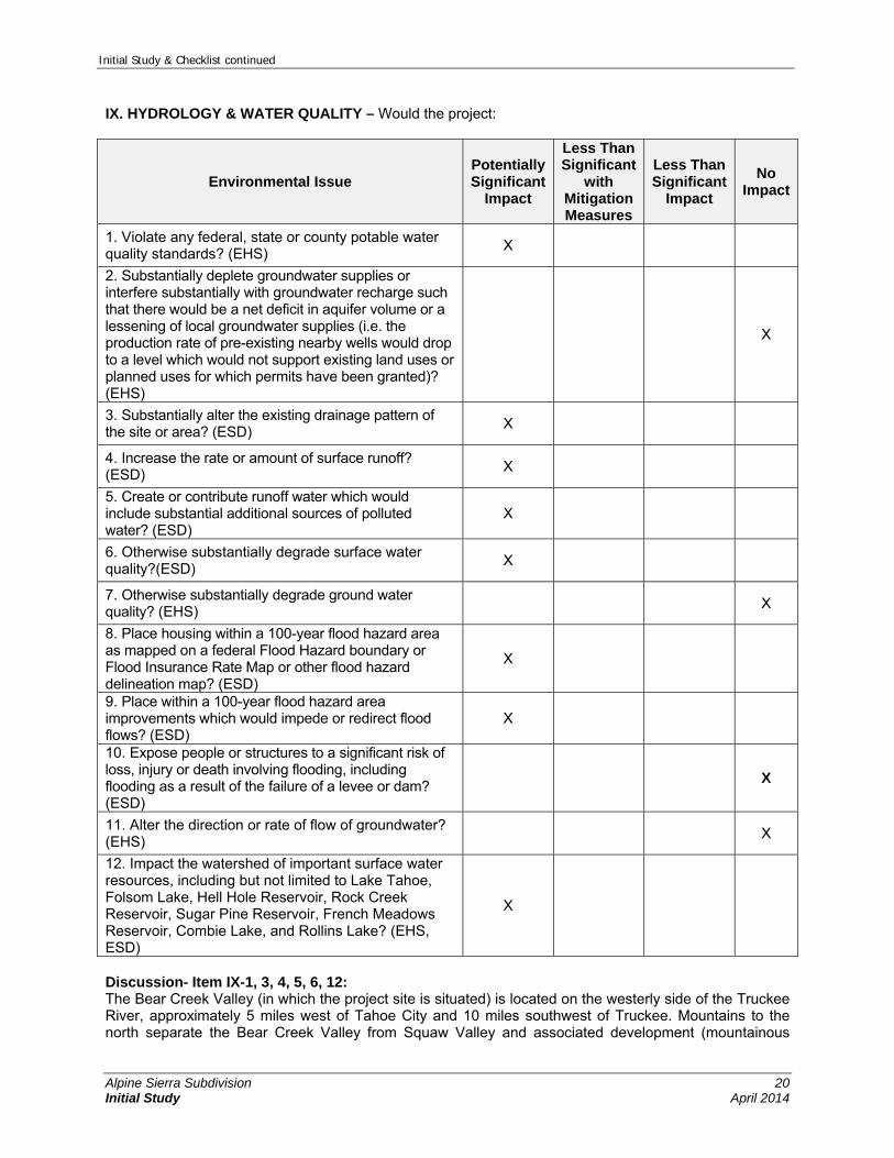
1. Violate any federal, state or county potable water quality standards? (EHS)
X
2. Substantially deplete groundwater supplies or interfere substantially with groundwater recharge such that there would be a net deficit in aquifer volume or a lessening of local groundwater supplies (i.e. the production rate of pre-existing nearby wells would drop to a level which would not support existing land uses or planned uses for which permits have been granted)? (EHS)
X
3. Substantially alter the existing drainage pattern of the site or area? (ESD)
X
4. Increase the rate or amount of surface runoff? (ESD)
X
5. Create or contribute runoff water which would include substantial additional sources of polluted water? (ESD)
X
6. Otherwise substantially degrade surface water quality?(ESD)
X
7. Otherwise substantially degrade ground water quality? (EHS)
X
8. Place housing within a 100-year flood hazard area as mapped on a federal Flood Hazard boundary or Flood Insurance Rate Map or other flood hazard delineation map? (ESD)
X
9. Place within a 100-year flood hazard area improvements which would impede or redirect flood flows? (ESD)
X
10. Expose people or structures to a significant risk of loss, injury or death involving flooding, including flooding as a result of the failure of a levee or dam? (ESD)
X
11. Alter the direction or rate of flow of groundwater? (EHS)
X
12. Impact the watershed of important surface water resources, including but not limited to Lake Tahoe, Folsom Lake, Hell Hole Reservoir, Rock Creek Reservoir, Sugar Pine Reservoir, French Meadows Reservoir, Combie Lake, and Rollins Lake? (EHS, ESD)
X
Discussion- Item IX-1, 3, 4, 5, 6, 12: The Bear Creek Valley (in which the project site is situated) is located on the westerly side of the Truckee River, approximately 5 miles west of Tahoe City and 10 miles southwest of Truckee. Mountains to the north separate the Bear Creek Valley from Squaw Valley and associated development (mountainous
Initial Study & Checklist continued
Alpine Sierra Subdivision 21 Initial Study April 2014
terrain to the east and south also surround Bear Creek Valley). According to the Alpine Meadows General Plan, the Bear Creek Valley consists of a 3,600-acre watershed that drains to Bear Creek and ultimately feeds into the Truckee River (Placer County 1968). The general topography of the valley is somewhat steep and most of the valley is covered with alpine forests and large granite boulders. The proposed development site is bound by Alpine Meadows Road to the west, Ginzton Access Road and Chalet Road to the south, and John Scott Trail to the north. The majority of the site is situated on north-facing slopes and elevations range from about 6,600 feet above sea level along the north-central site boundary to about 7,080 feet at the southeast corner. Bear Creek bisects the narrow corridor of the site near Alpine Meadows Road and the property is drained through two primary systems: Bear Creek and an unnamed seasonal stream in the eastern portion of the property. The seasonal stream traverses the site from south to north and flows into Bear Creek north of the site. The site is also drained by other minor ephemeral drainages in the northeast end of the property. Runoff from the site generally flows to the northwest towards Bear Creek. During construction of either the proposed project or the BCA Access Alternative, vegetation removal, grading and other ground disturbing activities, material stockpiling and the presence of construction vehicles and hazardous materials on the proposed development site could potentially result in short-term impacts to local water quality. Vegetation removal and grading operations would alter existing onsite drainage patterns and flow velocities and if not properly managed, erosion and sedimentation of on- and off-site water resources could result. Sedimentation could also result from poor stockpile management and more specifically, from a lack of appropriate containment measures/barriers on the construction site. Other potential impacts to water quality during construction could result from the improper handling and disposal of construction waste materials and oil and grease leakage from vehicles and equipment. After construction there is the potential for the proposed project operations to affect water quality, under either the proposed project or the BCA Access Alternative. For example, runoff from post-construction areas left exposed could result in downstream sedimentation and fertilizer-derived nutrients from landscaped areas could enter runoff and affect local waters. In addition, alteration of existing drainage patterns due to development and construction of residential structures, roads, and associated parking areas (e.g., driveways) would increase the amount of impervious area on the proposed development site which would increase the rate and/or amount of surface runoff and increase the potential for erosion and sedimentation in local waters. Depending on the severity of these effects, impacts to water resources resulting from development of the project or the BCA Access Alternative could be potentially significant. A site-specific drainage study will be prepared and will identify local and regional water resources, characterize existing drainage patterns and improvements, quantify changes to storm water runoff rates attributed to project development and recommend appropriate BMPs to address potential impacts to water resources that may occur during construction. If potential impacts are determined to be significant, the drainage study may also include mitigation measures to address identified impacts. Through an independent review of the drainage study, the EIR will evaluate the potential for construction and operational impacts to hydrology and water quality including potential impacts concerning violations of potable water standards, alteration of drainage patterns, and increased rate and amount of surface runoff resulting from surface disturbance and development. All potential impacts under either the proposed project or the BCA Access Alternative will be identified and discussed in the EIR and if necessary additional mitigation measures beyond those included in the drainage study may be included. All mitigation measures will be developed in consultation with Placer County and appropriate regulatory agencies. Discussion- Item IX-2, 7, 11: No groundwater usage is proposed during construction or operation of the proposed project or the BCA Access Alternative. In addition, according to the Geotechnical Report prepared for the proposed project, the project site is generally underlain 4 to 18 inches of silty sand likely underlain by medium dense to very dense silty sand with gravel containing varying amounts of cobbles and boulders (Holdrege & Kull 2013). Gravel soils, cobbles, and boulders suggest a limited ability of site soils to support groundwater recharge via percolation of surface water. Further, groundwater was not encountered in test pits excavated during the onsite investigation conducted for the geotechnical report. Therefore, no impacts to groundwater
Initial Study & Checklist continued
Alpine Sierra Subdivision 22 Initial Study April 2014
resources or groundwater recharge are anticipated to occur as a result of the proposed project or the BCA Access Alternative. Discussion- Item IX-8, 9: The project site is not located within the boundary of a 100-year flood hazard area as mapped by the Federal Emergency Management Agency (FEMA) or Placer County. The project site is displayed on two FEMA flood insurance rate maps: Map Number 06061C0200 F and 06061C0182 F. The boundaries of a delineated 100-year flood hazard map do not extend to the project site (FEMA 1998a, 1998b). In addition, the project site does not appear to be located within the boundaries of a FEMA floodplain as displayed in the Placer County Multi-Hazard Mitigation Plan (Placer County 2005), While the site is not located within a 100-year flood hazard area as mapped by FEMA, two drainageways (Bear Creek and an unnamed seasonal stream) traverse the proposed development site and support a tributary of more than 20 acres. Local 100-year floodplains associated with each drainageway will be mapped and the EIR will evaluate the potential for flood hazards associated with development of the project site under either the proposed project or the BCA Access Alternative. All potential impacts will be identified and discussed in the EIR and if necessary, additional mitigation measures developed in consultation with Placer County and appropriate regulatory agencies will be included. Discussion- Item IX-10: The project site and the surrounding Alpine Meadows area are not located within the boundaries of a County delineated levee or dam inundation zone. Three small impoundments occur south of the project site, within the Alpine Meadows Ski Resort. These impoundments are adjacent to Bear Creek, but due to their small size are not mapped in the County inundation zone. The nearest dam in the project vicinity, the Lake Tahoe Dam, is located maintained by the Bureau of Reclamation and is located approximately 5 miles south of the project site at the confluence of the Truckee River and Lake Tahoe in Tahoe City (Bureau of Reclamation 2013). Due to distance and because the project site is situated approximately 600 feet greater in elevation than the Truckee River at SR-89, failure of the Lake Tahoe Dam is not anticipated to pose a substantial inundation risk to the project site under either the proposed project or the BCA Access Alternative. X. LAND USE & PLANNING – Would the project:
Environmental Issue Potentially Significant
Impact
Less Than Significant
with Mitigation Measures
Less Than Significant
Impact
No Impact
1. Physically divide an established community? (PLN) X
2. Conflict with General Plan/Community Plan/Specific Plan designations or zoning, or Plan policies adopted for the purpose of avoiding or mitigating an environmental effect? (EHS, ESD, PLN)
X
3. Conflict with any applicable habitat conservation plan or natural community conservation plan or other County policies, plans, or regulations adopted for purposes of avoiding or mitigating environmental effects? (PLN)
X
4. Result in the development of incompatible uses and/or the creation of land use conflicts? (PLN)
X
5. Affect agricultural and timber resources or operations (i.e. impacts to soils or farmlands and timber harvest plans, or impacts from incompatible land uses)? (PLN)
X

Initial Study & Checklist continued
Alpine Sierra Subdivision 23 Initial Study April 2014
Environmental Issue Potentially Significant
Impact
Less Than Significant
with Mitigation Measures
Less Than Significant
Impact
No Impact
6. Disrupt or divide the physical arrangement of an established community (including a low-income or minority community)? (PLN)
X
7. Result in a substantial alteration of the present or planned land use of an area? (PLN)
X
8. Cause economic or social changes that would result in significant adverse physical changes to the environment such as urban decay or deterioration? (PLN)
X
Discussion- Items X-1 & 6: The project site is currently undeveloped. The proposed development site is bounded by existing residential development on the north and south. The project site is zoned for single-family residential and open space uses, and the density of the proposed project is consistent with the current zoning and with adjacent residential development. Development of new residential uses on the proposed development site under either the proposed project or the BCA Access Alternative would not divide or disrupt any existing communities. Discussion- Items X-2, 3: The project site is not subject to any applicable habitat conservation plan or natural community conservation plan. The EIR will evaluate the project and the BCA Access Alternative for consistency with existing County policies and ordinances adopted for the purpose of avoiding or mitigating environmental effects as well as land use and development standards of the General Plan and Zoning Ordinance. Existing County policies and ordinances that will be analyzed for the project and the project alternative include, but are not necessarily limited to, policies pertaining to establishment of buffers for protection of perennial and seasonal streams or other sensitive biological resources, restrictions on development on slopes in excess of 30 percent, consistency with allowances and limitations to develop new land uses in Potential Avalanche Hazard Areas, and policies regarding the protection of scenic resources and limitations on the effects of nighttime lighting associated with new development. All potentially significant impacts will be identified and mitigation measures will be developed in consultation with Placer County. The EIR will present detailed consideration of the project’s and BCA Access Alternative’s consistency with General Plan policies adopted for the purpose of avoiding or mitigating environmental effects as well as land use and development standards of the General Plan and Zoning Ordinance. It will also evaluate the compatibility of the proposed project and BCA Access Alternative with the existing land uses in the project vicinity and consider the degree to which the project or BCA Access Alternative could alter the community character. Discussion- Items X-4, 7: Existing development in the Alpine Meadows General Plan area generally consists of single family and some multi-family residences along Alpine Meadows Road, limited commercial development near SR 89 and at the ski resort, and occasional public service facilities such as the local fire station and ASCWD facilities. The majority of the proposed development site is zoned for residential use and a smaller portion of the site is zoned for open space. The site is currently undeveloped and is located between the single-family residential Bear Creek neighborhood to the north and existing residential and lodging development to the south. Because the project and the BCA Access Alternative propose residential uses on land zoned
Initial Study & Checklist continued
Alpine Sierra Subdivision 24 Initial Study April 2014
Residential and designated by the General Plan for residential use, the majority of the proposed project and BCA Access Alternative are not anticipated to conflict with land use policies of the Placer County General Plan or the Alpine Meadows General Plan pertaining to land use compatibility. The EIR will analyze the effects of the proposed rezone of a portion of the property from Open Space to Residential Single-Family land use and will evaluate the compatibility of the project and the BCA Access Alternative with the existing land uses in the project vicinity and consider the degree to which the project could alter the community character. All potentially significant impacts will be identified and mitigation measures developed in consultation with Placer County. Discussion- Item X-5: The proposed development site is not designated or used for timberland production. The majority of the proposed development site is zoned for Residential use and a smaller area is zoned Open Space; in addition the three isolated parcels that are part of the subdivision are zoned Open Space. Residential Single-Family zoning does not allow timber harvesting or production. The Open Space zoning designation does allow for timber harvesting and production. However the project site has not historically supported any timber harvest or forestry activities. Therefore, development of the project site would not displace or affect agricultural or timber resource operations. As such, no impacts to these resources are anticipated under either the proposed project or the BCA Access Alternative. Discussion- Item X-8: The proposed project and the BCA Access Alternative include the subdivision of a 45.5-acre proposed development site to allow construction of single family residences and residential halfplex units as well as associated infrastructure. The Bear Creek Association neighborhood to the north consists of relatively large-lot single family residences. Existing single- and multiple-family development and visitor lodging facilities are located south of the site. Because similar uses and similar housing products are located in the immediate vicinity of the project site, development of the site for residential uses at densities consistent with the existing zoning is not anticipated to cause economic or social change that could result in urban decay or deterioration under either the proposed project or the BCA Access Alternative. XI. MINERAL RESOURCES – Would the project result in:
Environmental Issue Potentially Significant
Impact
Less Than Significant
with Mitigation Measures
Less Than Significant
Impact
No Impact
1. The loss of availability of a known mineral resource that would be of value to the region and the residents of the state? (PLN)
X
2. The loss of availability of a locally-important mineral resource recovery site delineated on a local general plan, specific plan or other land use plan? (PLN)
X
Discussion- Items XI-1 & 2: There are no known mineral resources within the project site, and no mineral recovery activities have been known to occur onsite. The addition of the proposed residential development under the proposed project or the BCA Access Alternative would not adversely affect any mineral resources of value to the state or region.
Initial Study & Checklist continued
Alpine Sierra Subdivision 25 Initial Study April 2014
XII. NOISE – Would the project result in:
Environmental Issue Potentially Significant
Impact
Less Than Significant
with Mitigation Measures
Less Than Significant
Impact
No Impact
1. Exposure of persons to or generation of noise levels in excess of standards established in the local General Plan, Community Plan or noise ordinance, or applicable standards of other agencies? (PLN)
X
2. A substantial permanent increase in ambient noise levels in the project vicinity above levels existing without the project? (PLN)
X
3. A substantial temporary or periodic increase in ambient noise levels in the project vicinity above levels existing without the project? (PLN)
X
4. For a project located within an airport land use plan or, where such a plan has not been adopted, within two miles of a public airport or public use airport, would the project expose people residing or working in the project area to excessive noise levels? (PLN)
X
5. For a project within the vicinity of a private airstrip, would the project expose people residing or working in the project area to excessive noise levels? (PLN)
X
Discussion- Item XII-1, 2, 3: Noise associated with traffic on Alpine Meadows Road and smaller residential access roads are anticipated to be the primary generators of noise in the project area. Existing residential development is located north and south of the proposed development site. The Alpine Meadows Lodge and parking lot are located to the southwest and undeveloped terrain is located to the west and east. Given the development pattern in the surrounding area, existing ambient noise levels are anticipated to be relatively low and consistent with that of a rural residential neighborhood. Sound level limits for sensitive receptors are established in the Placer County General Plan and Chapter 9 of the Placer County Code (Public Peace, Safety and Welfare). Construction activities of the project (which would be similar to those of the BCA Access Alternative), including equipment and vehicle use onsite and transport of construction equipment and materials to the site, would generate noise throughout the duration of the construction schedule. In addition, operation of the residential development under either the proposed project or the BCA Access Alternative would generally result in an increase in the existing ambient noise levels through the introduction of 33 single-family residences and 14 residential halfplex units and associated traffic to the project area. The EIR will include an analysis of potential noise impacts associated with construction and operation of the proposed project and the BCA Access Alternative. If noise generated by the proposed project or BCA Access Alternative exceeds standards established in the Placer County Code for sensitive receptors or represents a substantial permanent or temporary increase above existing ambient noise levels, the EIR will provide mitigation measures to address the identified impact(s). Discussion – Item XII-4, 5: The project site is not located within the boundaries of an airport land use plan and is not located within two miles of a public/public use airport. In addition, the project site in not located in the vicinity of a private airstrip. See response to Hazards and Hazardous Materials, Discussion – Item VIII-5 and -6. The project site is not affected by noise from aircraft overflights.

Initial Study & Checklist continued
Alpine Sierra Subdivision 26 Initial Study April 2014
XIII. POPULATION & HOUSING – Would the project:
Environmental Issue Potentially Significant
Impact
Less Than Significant
with Mitigation Measures
Less Than Significant
Impact
No Impact
1. Induce substantial population growth in an area, either directly (i.e. by proposing new homes and businesses) or indirectly (i.e. through extension of roads or other infrastructure)? (PLN)
X
2. Displace substantial numbers of existing housing, necessitating the construction of replacement housing elsewhere? (PLN)
X
Discussion- Item XIII-1: Development of the project site with single-family residential uses would be consistent with the underlying zoning and densities established for the site. Both the proposed project and the BCA Access Alternative would result in the development of a 45.5-acre site with 33 single family residences and 14 residential halfplex units. With an average per household population of 2.59 people, the project or the BCA Access Alternative could provide housing for approximately 123 new residents. Because the proposed residential development is consistent with the underlying zoning applicable to the proposed development site, the population growth supported by the project or the BCA Access Alternative in the Alpine Meadows area would be consistent with the county’s population projections. Furthermore, the 123 residents of the project site would not substantially increase population in the project area and impacts would be less than significant. Discussion- Item XIII-2: The 45.5-acre proposed development site is currently undeveloped and therefore, development would not displace existing housing. As such, no impacts would occur under either the proposed project or the BCA Access Alternative. XIV. PUBLIC SERVICES – Would the project result in substantial adverse physical impacts associated with the provision of new or physically altered governmental services and/or facilities, the construction of which could cause significant environmental impacts, in order to maintain acceptable service ratios, response times or other performance objectives for any of the public services?
Environmental Issue Potentially Significant
Impact
Less Than Significant
with Mitigation Measures
Less Than Significant
Impact
No Impact
1. Fire protection? (ESD, PLN) X
2. Sheriff protection? (ESD, PLN) X
3. Schools? (ESD, PLN) X
4. Maintenance of public facilities, including roads? (ESD, PLN) X
5. Other governmental services? (ESD, PLN) X
Initial Study & Checklist continued
Alpine Sierra Subdivision 27 Initial Study April 2014
Discussion- Items XIV-1 through 5: Under either the proposed project or the BCA Access Alternative, development of the proposed single family residences and residential halfplex units would create additional demand for public services in the Alpine Meadows area. Services in the area include the following:
The North Tahoe Fire Protection District provides fire protection and emergency services to the project area. The nearest station to the project site (Alpine Meadows Fire Station 56) is located approximately 2.5 miles east of the project site at 270 Alpine Meadows Road.
Placer County Sheriff’s Department provides police protection services in the project area. The nearest Sheriff’s facility (the Tahoe Substation) is located approximately 7 miles of the project site at 2501 North Lake Boulevard, Tahoe City.
Placer County Public Works Department maintains public facilities, including roads and provides snow removal services
The Tahoe-Truckee Unified School District (TTUSD) is the designated school district for the Alpine Meadows area. The district school located closest to the Alpine Meadows area, Tahoe Lake Elementary and North Tahoe High School, are located approximately 5 miles southeast and 7 miles east of the project site in Tahoe City. Squaw Valley Academy, an international college-prep boarding school, is located approximately 3 miles north of the project site in Squaw Valley.
Fire Protection: The project and the BCA Access Alternative propose 47 new single-family residences, which would increase the demand for fire protection and emergency services. The project applicant may be required to contribute to the acquisition or construction of capital facilities as a condition of the serving fire agency’s agreement to serve the project. Should the serving fire agency notify the County that new facilities or alterations to existing facilities are required to serve the proposed project or the BCA Access Alternative, those requirements will be disclosed and potential impacts of meeting those requirements will be evaluated in the EIR. As the proposed project and the BCA Access Alternative would develop the same number of residences in generally the same location, impacts related to fire protection are expected to be similar for both scenarios. Sherriff Protection: The Placer County General Plan (Policy 4.H.1) requires that, within the County’s overall budgetary constraints, the Placer County Sheriff’s Department shall strive to maintain a staffing ratio of one officer per 1,000 residents in unincorporated Placer County. The proposed project or the BCA Access Alternative could increase the demand for additional Sherriff’s officers or equipment. If the Sherriff’s Department submits comments stating that additional officers or equipment are required to serve the proposed project or the BCA Access Alternative, those requirements will be disclosed and potential impacts of meeting those requirements will be evaluated in the EIR. As the proposed project and the BCA Access Alternative would develop the same number of residences at the project site, impacts related to sheriff protection are expected to be similar for both scenarios. Schools: The project would generate new students that would attend TTUSD schools. If the TTUSD notifies the County that the addition of new students generated by the project would result in shortages to staffing or impacts to existing facilities, those shortages and associated impacts will be evaluated in the EIR. If TTUSD identifies a need for increased staffing or expanded facilities, those requirements will be disclosed and potential impacts of meeting those requirements will be evaluated in the EIR. However, under the provisions of Senate Bill 50 school districts negotiate directly with developers of residential projects to establish terms and conditions of service to new projects, including payment of capital facilities fees for new or altered school district facilities. As the proposed project and the BCA Access Alternative would develop the same number of residences, impacts related to schools are expected to be similar for both scenarios.
County Facilities and Roads: New or altered county government facilities, including significant expansion of existing public roads, are not anticipated to be required as a result of the proposed project or the BCA Access Alternative, although the project or the alternative would result in an incremental increase in demand for county facilities.

Initial Study & Checklist continued
Alpine Sierra Subdivision 28 Initial Study April 2014
Development of new county facilities and incremental improvement to existing county facilities are primarily funded by payment of one-time capital improvement fees, such as Traffic Impact Fees, which are collected at the time of Building Permit approval. Other county government facilities and services, such as library services, assessor services and the courts are funded by payment of property taxes, user fees, and collection of fines. The incremental expansion and funding of these types of county facilities and services as needed to support the proposed project or the BCA Access Alternative will be addressed in the EIR. XV. RECREATION – Would the project result in:
Environmental Issue Potentially Significant
Impact
Less Than Significant
with Mitigation Measures
Less Than Significant
Impact
No Impact
1. Would the project increase the use of existing neighborhood and regional parks or other recreational facilities such that substantial physical deterioration of the facility would occur or be accelerated? (PLN)
X
2. Does the project include recreational facilities or require the construction or expansion of recreational facilities which might have an adverse physical effect on the environment? (PLN)
X
Discussion- Items XV-1 & 2: Development under the proposed project or the BCA Access Alternative would increase the residential population of the project area which would increase the demand for recreational facilities. Development under either the proposed project or the BCA Access Alternative would include construction of an on-site trail connecting to existing USFS trails located on-site and extending off-site. The EIR will evaluate the demand for use of existing recreational facilities associated with the project as well as the environmental effects associated with construction and/or relocation of the onsite trails and identify mitigation measures if warranted. As the proposed project and the BCA Access Alternative would develop the same number of residences in generally the same location, impacts related to recreation are expected to be similar for both scenarios. XVI. TRANSPORTATION & TRAFFIC – Would the project result in:
Environmental Issue Potentially Significant
Impact
Less Than Significant
with Mitigation Measures
Less Than Significant
Impact
No Impact
1. An increase in traffic which may be substantial in relation to the existing and/or planned future year traffic load and capacity of the roadway system (i.e. result in a substantial increase in either the number of vehicle trips, the volume to capacity ratio on roads, or congestion at intersections)? (ESD)
X
2. Exceeding, either individually or cumulatively, a level of service standard established by the County General Plan and/or Community Plan for roads affected by project traffic? (ESD)
X

Initial Study & Checklist continued
Alpine Sierra Subdivision 29 Initial Study April 2014
Environmental Issue Potentially Significant
Impact
Less Than Significant
with Mitigation Measures
Less Than Significant
Impact
No Impact
3. Increased impacts to vehicle safety due to roadway design features (i.e. sharp curves or dangerous intersections) or incompatible uses (e.g., farm equipment)? (ESD)
X
4. Inadequate emergency access or access to nearby uses? (ESD)
X
5. Insufficient parking capacity on-site or off-site? (ESD, PLN)
X
6. Hazards or barriers for pedestrians or bicyclists? (ESD)
X
7. Conflicts with adopted policies, plans, or programs supporting alternative transportation (i.e. bus turnouts, bicycle lanes, bicycle racks, public transit, pedestrian facilities, etc.) or otherwise decrease the performance or safety of such facilities? (ESD)
X
8. Change in air traffic patterns, including either an increase in traffic levels or a change in location that results in substantial safety risks? (PLN)
X
Discussion- Items XVI-1, 2, 3, 4, 5, 6, 7: Regional access to the project site and Alpine Meadows area is provided by State Route (SR) 89, a two-lane undivided state route with shoulders and a posted speed limit of 45 miles per hour at its intersection with Alpine Meadows Road. SR 89 connects Truckee and the Interstate 80 corridor to the north with Squaw Valley, Alpine Meadows, and Tahoe City to the south. Traffic on SR 89 varies by season, with congestion occurring during winter peak demand periods due to adverse weather and ski area activity. According to Caltrans, peak month Average Daily Traffic (ADT) on SR 89 in the project vicinity is 14,800 vehicles per day (LSC Transportation Consultants, Inc., 2012). Alpine Meadows Road, a small, two-lane undivided roadway with a posted speed limit of 35 miles per hour, provides local access from SR 89 to the Alpine Meadows residential and recreational areas, as well as the project site. Near the project site and throughout the Alpine Meadows area, narrow roadways are constructed off of Alpine Meadows Road and provide access to residences. Buses run on SR 89 and a seasonal shuttle service runs on Alpine Meadows Road providing service to Alpine Meadows Lodge and Squaw Valley. Additional traffic would be generated in the project area as a result of construction activities and as a result of project operations. Separate bicycle and pedestrian facilities are not generally constructed adjacent to roadways in the Alpine Meadows area, requiring bicyclists and pedestrians to share the right of way with vehicles. The increase in local traffic associated with the project could increase hazards for bicyclists and pedestrians. The EIR will evaluate the potential for traffic and transportation impacts during construction and operation of the proposed project and the BCA Access Alternative. Specific analysis will be provided to evaluate the effects of each scenario’s provisions for vehicular access to the project site. All significant impacts will be identified and if determined to be necessary, mitigation measures developed in consultation with Placer County will be included in the EIR. Discussion- Item XVI-8: No changes to air traffic patterns would occur as a result of construction or operation of the project or the BCA Access Alternative. The project site is not located within 2 miles of a public or private airport or airstrip and the project proposes the construction of residential building products on undeveloped vacant

Initial Study & Checklist continued
Alpine Sierra Subdivision 30 Initial Study April 2014
land. The height of proposed structures would comply with the building standards established for the underlying zoning and therefore, no impacts with air traffic patterns would occur.
XVII. UTILITIES & SERVICE SYSTEMS – Would the project:
Environmental Issue Potentially Significant
Impact
Less Than Significant
with Mitigation Measures
Less Than Significant
Impact
No Impact
1. Exceed wastewater treatment requirements of the applicable Regional Water Quality Control Board? (ESD)
X
2. Require or result in the construction of new water or wastewater delivery, collection or treatment facilities or expansion of existing facilities, the construction of which could cause significant environmental effects? (EHS, ESD)
X
3. Require or result in the construction of new on-site sewage systems? (EHS)
X
4. Require or result in the construction of new storm water drainage facilities or expansion of existing facilities, the construction of which could cause significant environmental effects? (ESD)
X
5. Have sufficient water supplies available to serve the project from existing entitlements and resources, or are new or expanded entitlements needed? (EHS)
X
6. Require sewer service that may not be available by the area’s waste water treatment provider? (EHS, ESD)
X
7. Be served by a landfill with sufficient permitted capacity to accommodate the project’s solid waste disposal needs in compliance with all applicable laws? (EHS)
X
Discussion- Items XVII-1, 2, 3, 4, 5, 6, 7: The proposed project would require placement of infrastructure to provide water, wastewater, electricity, telephone, and cable television services to the site. Underground utilities would run in easements along roadways within the development. Domestic water would be supplied from Alpine Springs County Water District (ASCWD) and wastewater disposal services would be also be provided by ASCWD. Most of the homes would use gravity sewer but a few would require individual sewage pumps to access the gravity sewer. One sewer lift station would be required under the proposed project; it is proposed to be constructed in the northeastern corner of the proposed development site. This lift station would not be required under the BCA Access Alternative as all residential lots would have access to gravity sewer lines. As noted in the Project Description summary above and in the NOP, off-site improvements to ASCWD facilities may also be necessary to ensure adequate service provision to the project and to existing ASCWD customers. Solid waste would be collected by the Tahoe Truckee Sierra Disposal and processed at the Eastern Regional Materials Recovery Facility. Electric utilities would be supplied by Liberty Energy; individual propane tanks would also be provided. Telephone services would be provided by AT&T and Comcast, Charter, and Suddenlink would provide cable services. The EIR will evaluate potential impacts to utilities and services systems associated with the proposed project, including environmental effects associated with construction of offsite improvements to ASCWD facilities. All significant impacts will be identified and if determined to be necessary, mitigation measures developed in consultation with Placer County and applicable service providers will be included in the EIR.
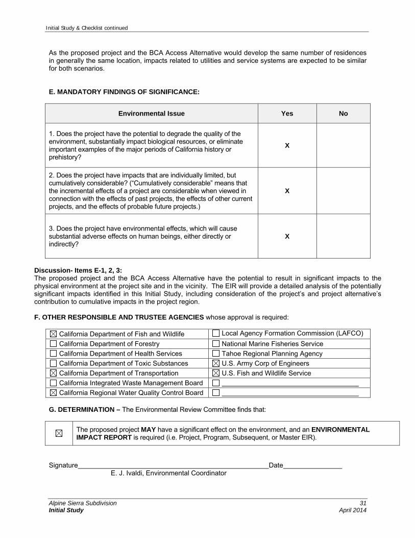
Initial Study & Checklist continued
Alpine Sierra Subdivision 31 Initial Study April 2014
As the proposed project and the BCA Access Alternative would develop the same number of residences in generally the same location, impacts related to utilities and service systems are expected to be similar for both scenarios. E. MANDATORY FINDINGS OF SIGNIFICANCE:
Environmental Issue Yes No
1. Does the project have the potential to degrade the quality of the environment, substantially impact biological resources, or eliminate important examples of the major periods of California history or prehistory?
X
2. Does the project have impacts that are individually limited, but cumulatively considerable? (“Cumulatively considerable” means that the incremental effects of a project are considerable when viewed in connection with the effects of past projects, the effects of other current projects, and the effects of probable future projects.)
X
3. Does the project have environmental effects, which will cause substantial adverse effects on human beings, either directly or indirectly?
X
Discussion- Items E-1, 2, 3: The proposed project and the BCA Access Alternative have the potential to result in significant impacts to the physical environment at the project site and in the vicinity. The EIR will provide a detailed analysis of the potentially significant impacts identified in this Initial Study, including consideration of the project’s and project alternative’s contribution to cumulative impacts in the project region. F. OTHER RESPONSIBLE AND TRUSTEE AGENCIES whose approval is required:
California Department of Fish and Wildlife Local Agency Formation Commission (LAFCO)
California Department of Forestry National Marine Fisheries Service
California Department of Health Services Tahoe Regional Planning Agency
California Department of Toxic Substances U.S. Army Corp of Engineers
California Department of Transportation U.S. Fish and Wildlife Service
California Integrated Waste Management Board
California Regional Water Quality Control Board G. DETERMINATION – The Environmental Review Committee finds that:
The proposed project MAY have a significant effect on the environment, and an ENVIRONMENTAL IMPACT REPORT is required (i.e. Project, Program, Subsequent, or Master EIR).
Signature Date E. J. Ivaldi, Environmental Coordinator

Initial Study & Checklist continued
Alpine Sierra Subdivision 32 Initial Study April 2014
I. SUPPORTING INFORMATION SOURCES: The following public documents were utilized and site-specific studies prepared to evaluate in detail the effects or impacts associated with the project. This information is available for public review, Monday through Friday, 8am to 5pm, at the Placer County Community Development Resource Agency, Environmental Coordination Services, 3091 County Center Drive, Auburn, CA 95603. For Tahoe projects, the document will also be available in our Tahoe Division office, 775 North Lake Blvd., Tahoe City, CA 96145.
County Documents
Air Pollution Control District Rules & Regulations
Community Plan
Environmental Review Ordinance
General Plan
Grading Ordinance
Land Development Manual
Land Division Ordinance
Stormwater Management Manual
Tree Ordinance
Trustee Agency Documents
Department of Toxic Substances Control
Site-Specific
Studies
Planning Services Division
Biological Study
Cultural Resources Pedestrian Survey
Cultural Resources Records Search
Lighting & Photometric Plan
Paleontological Survey
Tree Survey & Arborist Report
Visual Impact Analysis
Wetland Delineation
Acoustical Analysis
Avalanche Hazard Study
Engineering & Surveying Division,
Flood Control District
Phasing Plan
Preliminary Grading Plan
Preliminary Geotechnical Report
Preliminary Drainage Report
Stormwater & Surface Water Quality BMP Plan
Traffic Study
Sewer Pipeline Capacity Analysis Placer County Commercial/Industrial Waste Survey (where
public sewer is available) Sewer Master Plan
Utility Plan
Tentative Map
Environmental Health
Services
Groundwater Contamination Report
Hydro-Geological Study
Phase I Environmental Site Assessment

Initial Study & Checklist continued
Alpine Sierra Subdivision 33 Initial Study April 2014
Soils Screening
Preliminary Endangerment Assessment
Planning Services
Division, Air Quality
CALINE4 Carbon Monoxide Analysis
Construction Emission & Dust Control Plan
Geotechnical Report (for naturally occurring asbestos)
Health Risk Assessment
CalEEMod Model Output
Fire Department
Emergency Response and/or Evacuation Plan
Traffic & Circulation Plan
Mosquito Abatement
District
Guidelines and Standards for Vector Prevention in Proposed Developments
References Bureau of Reclamation. 2013. Lake Tahoe Dam.
http://www.usbr.gov/projects/Facility.jsp?fac_Name=Lake+Tahoe+Dam&groupName=General. Website accessed September 27, 2013.
Caltrans (California Department of Transportation). California Scenic Highway Mapping System, Placer County. http://www.dot.ca.gov/hq/LandArch/scenic_highways/index.htm. Website accessed September 27, 2013.
EcoSynthesis Scientific & Regulatory Services, Inc. 2012. Alpine Sierra Subdivision Biological Survey Report. December 18, 2012.
EDR. 2013. The EDR Radius Map Report for the Alpine Sierra (Alpine Meadows Roads at Ginzton Road). Inquiry Number 3621309.1s. May 30, 2013.
FEMA (Federal Emergency Management Agency). 1998a. FIRM (Flood Insurance Rate Map), Map Number 06061C0200 F. June 8, 1998.
FEMA (Federal Emergency Management Agency). 1998b. FIRM (Flood Insurance Rate Map), Map Number 06061C0182 F. June 8, 1998.
Heywood, Larry. 2012. Alpine Sierra Subdivision Avalanche Hazard Study. July 2013.
Holdrege & Kull. 2013. Geotechnical Engineering Report Update for the Alpine Sierra Development. September 20, 2013.
Lindström, Susan, 2001. Alpine Meadows Subdivision Project Heritage Resource Inventory. December 2001.
Lindström, Susan. 2012. Alpine Sierra Subdivision Heritage Resources Study Update (Letter Report). October 31, 2012.
LSC Transportation Consultants, Inc. 2012. Alpine Sierra Subdivision Traffic Impact Analysis. October 31, 2012.
Placer County. 1968. Alpine Meadows General Plan.
Placer County. 2005. Multi-Hazard Mitigation Plan. January 2005.
Placer County. 2013. Placer County General Plan. May 2013.

Initial Study & Checklist continued
Alpine Sierra Subdivision 34 Initial Study April 2014
This page intentionally left blank.
Related Documents