Influence of substrate tectonic heritage on the evolution of composite volcanoes: Predicting sites of flank eruption, lateral collapse, and erosion Alessandro Tibaldi a, ⁎ , Claudia Corazzato a , Andrey Kozhurin b , Alfredo F.M. Lagmay c , Federico A. Pasquarè d , Vera V. Ponomareva b , Derek Rust e , Daniel Tormey f , Luigina Vezzoli d a Università degli Studi di Milano-Bicocca, Dipartimento di Scienze Geologiche e Geotecnologie, Milan, Italy b Institute of Volcanology and Seismology, Petropavlovsk-Kamchatsky, Russia c National Institute of Geological Sciences, Quezon City, Philippines d Università degli Studi dell'Insubria, Dipartimento di Scienze Chimiche e Ambientali, Como, Italy e School of Earth and Environmental Sciences, University of Portsmouth, UK f ENTRIX Inc., Ventura, California, USA Received 30 January 2007; accepted 23 August 2007 Available online 9 October 2007 Abstract This paper aims to aid understanding of the complicated interplay between construction and destruction of volcanoes, with an emphasis on the role of substrate tectonic heritage in controlling magma conduit geometry, lateral collapse, landslides, and preferential erosion pathways. The influence of basement structure on the development of six composite volcanoes located in different geodynamic/geological environments is described: Stromboli (Italy), in an island arc extensional tectonic setting, Ollagüe (Bolivia–Chile) in a cordilleran extensional setting, Kizimen (Russia) in a transtensional setting, Pinatubo (Philippines) in a transcurrent setting, Planchon (Chile) in a compressional cordilleran setting, and Mt. Etna (Italy) in a complex tectonic boundary setting. Analogue and numerical modelling results are used to enhance understanding of processes exemplified by these volcanic centres. We provide a comprehensive overview of this topic by considering a great deal of relevant, recently published studies and combine these with the presentation of new results, in order to contribute to the discussion on substrate tectonics and its control on volcano evolution. The results show that magma conduits in volcanic rift zones can be geometrically controlled by the regional tectonic stress field. Rift zones produce a lateral magma push that controls the direction of lateral collapse and can also trigger collapse. Once lateral collapse occurs, the resulting debuttressing produces a reorganization of the shallow-level magma migration pathways towards the collapse depression. Subsequent landslides and erosion tend to localize along rift zones. If a zone of weakness underlies a volcano, long-term creep can occur, deforming a large sector of the cone. This deformation can trigger landslides that propagate along the destabilized flank axis. In the absence of a rift zone, normal and transcurrent faults propagating from the substrate through the volcano can induce flank instability in directions respectively perpendicular and oblique to fault strike. This destabilization can evolve to lateral collapse with triggering mechanisms such as seismic activity or magmatic intrusion. © 2007 Elsevier B.V. All rights reserved. Keywords: volcano; basement; eruption; lateral collapse; erosion 1. Introduction Volcanoes have the highest accumulation rates of surficial geological features. Edifices as high as 2 km can be emplaced within time spans on the order of 10 ka (Braitseva et al., 1995). Volcanic landscapes can change at dramatically higher rates than other geological environments, due both to constructional processes and destructional ones such as lateral collapses and landslides. Volcanic debris avalanches resulting from lateral collapse are the largest landslide events on Earth (McGuire, 1996), yielding deposits ranging from 1 km 3 to 30 km 3 . Recent findings show that at single large volcanoes, the occurrence of multiple debris avalanches seems to be a common feature with 2 to 14 events during their lifetime (10–500 ka) (Beget and Kienle, 1992; Tibaldi et al., 2005). In areas of high magma Available online at www.sciencedirect.com Global and Planetary Change 61 (2008) 151 – 174 www.elsevier.com/locate/gloplacha ⁎ Corresponding author. E-mail address: [email protected] (A. Tibaldi). 0921-8181/$ - see front matter © 2007 Elsevier B.V. All rights reserved. doi:10.1016/j.gloplacha.2007.08.014

Influence of Substrate Tectonic Heritage on the Evolution of Composite Volcanoes Predicting Sites of Flank Eruption, Lateral Collapse, And Erosion
Jan 27, 2016
role of substrate tectonic heritage in controlling magma conduit geometry, lateral collapse, landslides, and preferential erosion pathways. The
influence of basement structure on the development of six composite volcanoes located in different geodynamic/geological environments is
described: Stromboli (Italy), in an island arc extensional tectonic setting, Ollagüe (Bolivia–Chile) in a cordilleran extensional setting, Kizimen
(Russia) in a transtensional setting, Pinatubo (Philippines) in a transcurrent setting, Planchon (Chile) in a compressional cordilleran setting, and
Mt. Etna (Italy) in a complex tectonic boundary setting. Analogue and numerical modelling results are used to enhance understanding of processes
exemplified by these volcanic centres. We provide a comprehensive overview of this topic by considering a great deal of relevant, recently
published studies and combine these with the presentation of new results, in order to contribute to the discussion on substrate tectonics and its
control on volcano evolution. The results show that magma conduits in volcanic rift zones can be geometrically controlled by the regional tectonic
stress field. Rift zones produce a lateral magma push that controls the direction of lateral collapse and can also trigger collapse. Once lateral
collapse occurs, the resulting debuttressing produces a reorganization of the shallow-level magma migration pathways towards the collapse
depression. Subsequent landslides and erosion tend to localize along rift zones. If a zone of weakness underlies a volcano, long-term creep can
occur, deforming a large sector of the cone. This deformation can trigger landslides that propagate along the destabilized flank axis. In the absence
of a rift zone, normal and transcurrent faults propagating from the substrate through the volcano can induce flank instability in directions
respectively perpendicular and oblique to fault strike. This destabilization can evolve to lateral collapse with triggering mechanisms such as
seismic activity or magmatic intrusion.
Welcome message from author
This document is posted to help you gain knowledge. Please leave a comment to let me know what you think about it! Share it to your friends and learn new things together.
Transcript

Available online at www.sciencedirect.com
e 61 (2008) 151–174www.elsevier.com/locate/gloplacha
Global and Planetary Chang
Influence of substrate tectonic heritage on the evolution of compositevolcanoes: Predicting sites of flank eruption, lateral collapse, and erosion
Alessandro Tibaldi a,⁎, Claudia Corazzato a, Andrey Kozhurin b, Alfredo F.M. Lagmay c,Federico A. Pasquarè d, Vera V. Ponomareva b, Derek Rust e, Daniel Tormey f, Luigina Vezzoli d
a Università degli Studi di Milano-Bicocca, Dipartimento di Scienze Geologiche e Geotecnologie, Milan, Italyb Institute of Volcanology and Seismology, Petropavlovsk-Kamchatsky, Russia
c National Institute of Geological Sciences, Quezon City, Philippinesd Università degli Studi dell'Insubria, Dipartimento di Scienze Chimiche e Ambientali, Como, Italy
e School of Earth and Environmental Sciences, University of Portsmouth, UKf ENTRIX Inc., Ventura, California, USA
Received 30 January 2007; accepted 23 August 2007Available online 9 October 2007
Abstract
This paper aims to aid understanding of the complicated interplay between construction and destruction of volcanoes, with an emphasis on therole of substrate tectonic heritage in controlling magma conduit geometry, lateral collapse, landslides, and preferential erosion pathways. Theinfluence of basement structure on the development of six composite volcanoes located in different geodynamic/geological environments isdescribed: Stromboli (Italy), in an island arc extensional tectonic setting, Ollagüe (Bolivia–Chile) in a cordilleran extensional setting, Kizimen(Russia) in a transtensional setting, Pinatubo (Philippines) in a transcurrent setting, Planchon (Chile) in a compressional cordilleran setting, andMt. Etna (Italy) in a complex tectonic boundary setting. Analogue and numerical modelling results are used to enhance understanding of processesexemplified by these volcanic centres. We provide a comprehensive overview of this topic by considering a great deal of relevant, recentlypublished studies and combine these with the presentation of new results, in order to contribute to the discussion on substrate tectonics and itscontrol on volcano evolution. The results show that magma conduits in volcanic rift zones can be geometrically controlled by the regional tectonicstress field. Rift zones produce a lateral magma push that controls the direction of lateral collapse and can also trigger collapse. Once lateralcollapse occurs, the resulting debuttressing produces a reorganization of the shallow-level magma migration pathways towards the collapsedepression. Subsequent landslides and erosion tend to localize along rift zones. If a zone of weakness underlies a volcano, long-term creep canoccur, deforming a large sector of the cone. This deformation can trigger landslides that propagate along the destabilized flank axis. In the absenceof a rift zone, normal and transcurrent faults propagating from the substrate through the volcano can induce flank instability in directionsrespectively perpendicular and oblique to fault strike. This destabilization can evolve to lateral collapse with triggering mechanisms such asseismic activity or magmatic intrusion.© 2007 Elsevier B.V. All rights reserved.
Keywords: volcano; basement; eruption; lateral collapse; erosion
1. Introduction
Volcanoes have the highest accumulation rates of surficialgeological features. Edifices as high as 2 km can be emplacedwithin time spans on the order of 10 ka (Braitseva et al., 1995).Volcanic landscapes can change at dramatically higher rates
⁎ Corresponding author.E-mail address: [email protected] (A. Tibaldi).
0921-8181/$ - see front matter © 2007 Elsevier B.V. All rights reserved.doi:10.1016/j.gloplacha.2007.08.014
than other geological environments, due both to constructionalprocesses and destructional ones such as lateral collapses andlandslides. Volcanic debris avalanches resulting from lateralcollapse are the largest landslide events on Earth (McGuire,1996), yielding deposits ranging from 1 km3 to 30 km3. Recentfindings show that at single large volcanoes, the occurrence ofmultiple debris avalanches seems to be a common feature with 2to 14 events during their lifetime (10–500 ka) (Beget andKienle, 1992; Tibaldi et al., 2005). In areas of high magma

152 A. Tibaldi et al. / Global and Planetary Change 61 (2008) 151–174
production, recurrence intervals of lateral collapse in a volcaniccomplex can be on the order of 30 to a few hundred years(Tibaldi et al., 2005). The occurrence of lateral collapses alsostrongly influences the local geomorphology; for example,damming of rivers with subsequent formation of lacustrineenvironments, followed by periods of high sediment transportalong river segments, as observed after the 1980 eruption ofMount St. Helens (Voight et al., 1981). Volcanic debrisavalanches can also cause the destruction of natural environ-ments and urban areas, while destructive tsunamis caused byvolcanic debris avalanches from coastal and island volcanoesare responsible for the majority of fatalities from thisphenomenon (Siebert, 1996). Increasingly intense rainfall andmelting of summit glaciers due to global climate change mayproduce a greater incidence of such events, through increasedfluid circulation, loss of substrate cohesion, increased edificemass and destabilization of oversteepened slopes.
Lateral collapse is shown to occur in a direction perpendi-cular to the trend of preferential dyking within a volcano, asdemonstrated by field studies, and numerical and analoguemodelling (Lipman et al., 1981; Moore and Albee, 1981;Siebert et al., 1987; Tibaldi, 1996, 2001; Voight and Elsworth,1997; Voight, 2000; Donnadieu et al., 2001; Tibaldi et al.,2006). The orientation of a dyking zone, commonly defined as avolcanic rift zone, is usually attributed to basement structure(Nakamura et al., 1977; Walker, 1999). Other authors attributerift zones in large volcanoes to shallow-level volcano stressdistribution rather than basement structure (Fiske and Jackson,1972). In the special case of a mechanically weak area of thevolcano basement, gravity sliding or volcanic spreading havebeen proposed to control the formation of rift zones and thesubsequent structural evolution of the volcano (Borgia et al.,2000a,b).
Depressurization caused by lateral collapse can in turn alter theshallow magma feeder system, controlling the location andconfiguration of new craters and dyke paths (Tibaldi, 1996, 2004;Walter and Troll, 2003; Acocella and Tibaldi, 2005). Therefore,magma injection and lateral collapse appear to be intimatelyconnected, both in terms of orientation and triggeringmechanism.
This paper aims to decipher the complicated interplaybetween volcanic construction and destruction, with emphasison the role of substrate tectonic heritage in controlling thegeometry of magma pathways, lateral collapse, and preferentialerosion pathways. Recent published field and modelling studiesare combined with our new results, to provide a comprehensivediscussion. We would like to point out that wherever in thepresent text data and observations are presented but nobibliographic reference is provided, it is implied that thesedata were collected by the present authors and are herepublished for the first time. Large volcanic landslides pose asignificant risk to human settlements and other ecosystems, andtheir incidence can be altered as a result of climate change. Thefindings summarized in this paper will therefore supportassessment of volcanic hazards to human society and environ-mental resources. Six volcanoes studied in the framework of anInternational Lithosphere Program project, encompassingdifferent geodynamic, geological and natural environments,
provide data leading to our findings: Stromboli (Italy), locatedin an island arc extensional tectonic setting, Ollagüe (Bolivia–Chile) in a cordilleran extensional setting, Kizimen (Russia) in atranstensional setting, Pinatubo (Philippines) in a transcurrentsetting, Planchon (Chile) in a compressional cordilleran setting,and Mt. Etna (Italy) in a complex tectonic boundary setting.Analogue and numerical modelling results simulating theseprocesses are used to enhance the field studies.
2. Field data on key volcanoes
2.1. Stromboli (Italy)
Stromboli is the northernmost volcano of the Aeolian Arc(Fig. 1A) in the southern Tyrrhenian Sea. Stromboli Islandrepresents the emerged part of an active composite volcano, withan elevation of about 2.6 km above the sea floor (Gabbianelliet al., 1993), and located on a 20-km thick continental crustalsector where NW–SE-directed extension occurs (Tibaldi, 2004;Billi et al., 2006). The rock composition spans basaltic andesite toshoshonite and to latite-trachyte (Hornig-Kjiarsgaard et al., 1993),with the oldest exposed products dating back to about 100 ka(Gillot and Keller, 1993) (Fig. 1B). Volcano growth wasrepeatedly interrupted by three caldera collapses and five lateralcollapse events, followed by reorganizations of eruptive centres(Pasquarè et al., 1993; Tibaldi et al., 1994) (Fig. 1C). Between 85and 64 ka an initial summit caldera collapse was caused byexplosive eruptions. After a phase of cone growth, the SE flank ofthe edifice was affected by a relatively small lateral collapse datedbetween 35 and 26 ka. In the same time interval, a second summitcaldera collapse was caused by an explosive eruption thatproduced extensive pyroclastic deposits; this was followed byanother phase of cone growth. The third summit caldera collapsetook place between 26 and 21 ka and a new cone grew from thistime until 13 ka, marking an important transition in volcanic andcollapse characteristics. From this time onwards, lateral collapsesonly developed on the NW side of the volcano, alternating withphases of cone growth. The collapses formed nested horseshoe-shaped amphitheatres open to the northwest; the present-daySciara del Fuoco depression is the most recent one.
The deformation style accompanying the various growthphases was primarily fracturing and intrusive dyke sheetingalong a NE-trending rift zone crossing the Stromboli volcanosummit (Fig. 1C). This orientation coincides with the strike ofregional faulting close to or beneath the edifice (Gabbianelliet al., 1993; Billi et al., 2006). Within this rift zone, single sheetsstrike between NNE and ENE. Relationships between theunconformity surfaces of the various growth phases and thesesheets indicate that the NE-trending rift zone endured for thevolcano's entire history, with a migration of intrusive activitynortheast-wards along the rift. Only two growth phases wereaccompanied by intrusions with a different geometry. The firstoccurred before the oldest caldera collapse and was charac-terised by formation of a N–S sheet swarm (64–36 ka). Thesecond different sheet geometry occurred after the oldest (13 ka)lateral collapse towards the NW and was characterised bysheeting parallel to the amphitheatre scarps of this lateral

Fig. 1. A. Location of Stromboli in the regional context of the southern Tyrrhenian sea and the Aeolian Archipelago. B. Simplified geologic map of Stromboli based ongeological surveys by A. Tibaldi. C. Structural sketch map. The volcano growth was repeatedly interrupted by caldera collapses in the time span 85.3–21 ka. Between35 and 26 ka, a relatively small flank collapse developed towards SE. After 13 ka, four lateral collapses developed towards NW, alternated by cone growth phases. Thedeformation system accompanying the various growth/collapse phases was primarily fracturing and intrusive sheeting along a NE-trending rift zone crossing thevolcano summit, but after 13 ka dykes mostly intruded along and within the NW lateral collapse zone and in the northeastern part of the NE–SW rift zone.
153A. Tibaldi et al. / Global and Planetary Change 61 (2008) 151–174
collapse and along the NE-trending weakness zone. The samegeometry characterises the fracture systems.
A shifting of the intrusive/eruptive activity towards thenorth-western volcano flank is another important change that
occurred after the development of the first lateral collapsetowards the NW at 13 ka. This shift is expressed by: 1) thepresence of eruptive centres and dykes younger than 13 kaalong the NE rift zone and in the north-western half of the

154 A. Tibaldi et al. / Global and Planetary Change 61 (2008) 151–174
volcano, and centres/dykes older than 13 ka in the southeasternhalf of the volcano, and 2) a northwest shift, by some hundredmetres, of the main summit crater zone during Pleistocene toHolocene times (Tibaldi, 2001).
2.2. Ollagüe (Bolivia–Chile)
Ollagüe is an active composite volcano located in the CentralAndes (21°18'S, 68°11'W, Fig. 2) at the boundary between theWestern Cordillera (Quaternary–Present magmatic arc; de Silvaand Francis, 1991) and the Altiplano–Puna plateau (crustalthickness∼70 km; Schmitz et al., 1999). The substrate structure ischaracterized by a series of NW-striking faults belonging to thePastosGrandes–Lipez–Coranzuli system. These structures consistof left-lateral strike–slip faults, often reactivated with extensionalmotions (Riller et al., 2001; Acocella et al., 2007). These tectonicfeatures are well expressed in the dominant NW-trendingalignment of andesite–dacite composite volcanoes, rhyolite–dacite ignimbrite-forming calderas and voluminous monogeneticlava flows and domes (de Silva, 1989; de Silva et al., 1994), andsmall basalt monogenetic scoria cones and lava flows (Davidsonand de Silva, 1992; Kay et al., 1994; Mattioli et al., 2006).
The long-lived (1.2 Ma — Present) Ollagüe volcano(5868 m a.s.l.) has products ranging from few basaltic andesitesto mainly andesites and dacites, defining a high-K calc-alkalinesuite (Feeley et al., 1993; Feeley and Davidson, 1994; Wörneret al., 1992; 2000). Investigation undertaken by the presentauthors (Tibaldi et al., 2006) pointed out stratigraphic andstructural relationships, with new petrographic, geochemicaland 40Ar–39Ar geochronological data. The data outline theevolution of Ollagüe, define multiple lateral collapse events,and demonstrate a strict control by the substrate structures onvolcanic slope failures and the shallow magmatic system.Ollagüe's' geological history is characterized by four stages ofvolcano construction separated by three main events of conedeformation and failure (Fig. 2) controlled by the regional NW-striking extensional fault system underlying the edifice. Thedeformation progresses from: a) downthrow of the SW sector ofthe volcano (∼750 ka) along the NW-striking normal faultpropagating from the substrate; b) development of lateralnarrow collapses along the fault strike (∼450 ka), along whichfracturing and deformation focused and lateral and parasiticeruptive vents concentrated; c) final catastrophic failure(∼200 ka) of the SW sector. Two of these collapse events canbe correlated with debris avalanche emplacement: At the distal(western) base of Ollagüe, two debris avalanche deposits cropout with typical hummocky topography, a minimum area of80 km2, an extent of 20 km from the volcano summit crater, andan estimated volume of 1 km3 for the younger deposit (Francisand Wells, 1988; Feeley et al., 1993; Clavero et al., 2004).
During the four stages of Ollagüe's growth, central ventsshifted SW, that is perpendicular to the NW-striking substratefault and along the axis of the older lateral collapse. At the end ofthe second lateral collapse (∼450 ka), several lateral vents,including the parasitic dacite lava domes/flows of La Celosa andChaska Orkho, developed on the lower slopes of the cone along aNW-trending belt, sub-parallel to the NW-striking normal
fault and collapse scarps. Finally, the active Ollagüe edifice(200 ka–Present) is characterized by lateral lava flows extrudedalong the axis of the lateral collapse amphitheatre, and a range ofNW-aligned and SE-wards younging sub-terminal lava domes.This NW-alignment of lateral vents suggests the presence of aNW-trending feeder dyke beneath the volcano, intruded along thesubstrate fault, which may have served as a principal conduit formagma ascent and surface eruptions. In addition, the unbuttres-sing due to the development of lateral collapses focused thepropagation of the dyke and the shifting of magmatic activitywithin and around Ollagüe's collapse amphitheatre.
2.3. Planchon (Chile)
The active volcanic complex of Azufre–Planchon–Peteroa islocated in remote, steeply glaciated terrain on the crest of theChilean Andes along the active volcanic front at 35°15'S.Dissection by glaciers and lateral collapse provide spectacularexposure of this still-active volcanic system, and allows study ofstratigraphic sections and collection of samples with knownrelative age (Tormey et al., 1989, 1995; Naranjo and Haller,2002). From 35°S to 37°S, the Andeanmagmatic arc consists of aNNE-trending volcanic front, a N-trending series of largerhyolitic calderas and dome complexes extending approximately30 km to the east (Hildreth et al., 1999), and a zone of extension-related alkali basalt fields 50 to 100 km to the east of the volcanicfront (Bermùdez and Delpino, 1989). The volcanic front wasdeveloped in a compressional stress regime as part of theMallargue fold and thrust belt from Miocene to Pliocene (Ramoset al., 1996; Hildreth et al., 1999). The basement structures aredominated by reverse faults striking approximately N–S.Folguera et al. (2006a) have identified a series of Pliocene toQuaternary back-arc extensional basins that, in the vicinity ofAzufre–Planchon–Peteroa, consist of the Las Loicas trough. Thisfeature intersects the volcanic front and appears to be partiallyfilled by eruptive products from the active volcanic complex. Assuch, much of the development of the volcanic complex is likelyto have been in a compressional cordilleran setting (Hildreth et al.,1999; Kay et al., 2005; Folguera et al., 2006a).
The volcanic complex is less than 0.55 Ma old and consistsof the long-lived polycyclic basaltic andesite to dacite VolcanAzufre (69 km3), followed by the relatively short-lived basalt tobasaltic andesite Volcan Planchon (43 km3) and the more recentVolcan Peteroa (Tormey et al., 1995; Fig. 3). Planchon is 6 kmnorth of Azufre, and its lavas are sheet-like and do not fillobvious topographic features; there are also no intercalations ofsediment within the flow succession. It appears, therefore, thatflows were not channelized, the growth of the volcano was notinterrupted by glaciation, and the construction of Planchon wasrapid enough to prevent deep erosion during growth.
Approximately 9 ka ago (MacPhail, 1973), a 30° sector ofPlanchon and part of Azufre collapsed to form a debris avalanchethat travelled 75 km west forming a hummocky depositapproximately 10 km3 in volume known as the Rio Teno DebrisAvalanche (MacPhail, 1973; Davidson, 1974; Scott et al., 2001).The lateral collapse depression is open to the west, perpendicularto the major substrate tectonic structures in the region. The debris

Fig. 2. A. Geologic sketch map of the Central Andes, showing the main N–S-trending structural units intersected by the NW-striking Pastos Grandes–Lipez–Coranzuli fault system. The Ollagüe volcano rose at theintersection between the active magmatic arc of the Western Cordillera and this transversal structural lineament. B. Geological map of the Ollagüe volcano, showing the four phases of volcano activity and the multiplelateral collapses. Alignment of the volcanic structures and vents are either parallel with, or perpendicular to, the NW-striking normal fault that bisects the cone.
155A.Tibaldi
etal.
/Global
andPlanetary
Change
61(2008)
151–174

156 A. Tibaldi et al. / Global and Planetary Change 61 (2008) 151–174
avalanche deposit appears to preserve at least two distinct pulsesof flow, and shows grain-size gradation both laterally andlongitudinally. Based on the area excavated by the lateral collapse,approximately 3 to 4 km3 of material was derived from thevolcanic edifice while the remainder appears to have been alluvialdeposits entrained during flow by bulking, greatly increasing thevolume and mobility of the debris avalanche.
In a geochemical study of this volcanic centre, Tormey et al.(1995) documented that most basalt and basaltic andesite lavaserupted from Planchon evolved at mid-crustal depths ofapproximately 12 to 18 km. Just prior to the collapse, however,a series of mafic lava flows indicate shallow-level fractionalcrystallization and assimilation of shallow crustal wall rocks.Although the depth cannot be constrainedwith certainty because alower water pressure would give a similar compositional trend, itis likely to be within the upper 3 km of the crust (Tormey et al.,1995). Although the development of a shallow magma body mayhave led to lateral collapse and debris avalanche byweakening themechanical properties of the edifice, either through enhancedhydrothermal activity ormelting of the summit ice cap, the data donot prove this relationship.
After the collapse, a new edifice, Planchon II, developedwithin the collapse amphitheatre, 1 km south of Planchon(Fig. 3). The compositional variation of Planchon II basalt andbasaltic andesite lavas reverted to those indicative of mid-
Fig. 3. Geological sketchmap of the active volcanic complex ofAzufre–Planchon–Peteropolycyclic basaltic andesite to dacite Volcan Azufre (69 km3), followed by the relatively svolcano. Note the shifting of the main volcanic centre of Planchon towards the south to f
crustal (12 to 18 km depth) evolution; these lavas arecompositionally indistinguishable from the early lavas ofPlanchon. It is not clear whether the collapse caused thecessation of shallow-level magma storage, but the post-collapselavas clearly erupted without the imprint of shallow-levelcrystallization and assimilation.
The Planchon II edifice was rapidly dissected by landslidesand erosion, which mostly developed perpendicular to thetectonically controlled N–S axis. Presently, the Planchon IIedifice is only preserved as ramparts of radially-dipping lavas.Planchon II has a larger proportion of near-vent pyroclasticdeposits than Planchon; this structural weakness may havecontributed to the rapid destruction of the cone, in a similar wayto Stromboli (Tibaldi, 2001; Apuani et al., 2005a).
The most recent activity of the volcanic complex producedVolcan Peteroa, which encompasses several scattered ventsalong the north–south axis of Azufre and Planchon that haveerupted calc-alkaline andesites, dacites, and rhyodacites.
2.4. Kizimen (Russia)
Kizimen is a composite volcano (Shantser et al., 1991) locatedin the Central Kamchatka depression (Russia) between the easternvolcanic front and the northern volcanic zone (Fig. 4A). It is onthe edge of the southeastern flank of the Shchapinskiy graben, a
a, fromTormey et al., 1995. The volcanic complex is less than 0.55Ma and consists ofhort-lived basalt to basaltic andesite Volcan Planchon (43 km3) and the active Peteroaorm Planchon II, towards the summit amphitheatre formed by the lateral collapse.

Fig. 4. A. Location of Kizimen composite volcano within the Central Kamchatka Depression, Russia (CKD). Thick black lines are active faults of the East Kamchatkafault zone, white circles are active volcanoes. B. Geological sketch of the volcano and main faults. At the centre, extrusive domes and lava flows of cycle 4 of thevolcano growth are shown. Black thick lines with bars are active normal faults (bars on downthrown side). Topographic contour interval is 50 m. Thick dashed linesborder the upper parts of large flat bottomed valleys, likely of glacial nature, dammed by the volcanic cone. C. Schematic section showing the possible geometry of thesubstrate offset by the main fault.
157A. Tibaldi et al. / Global and Planetary Change 61 (2008) 151–174
NNE-striking tectonic depression bordered to the east by WNW-dippingmaster normal faults which belong to the East Kamchatkafault zone and have a minor component of transcurrent motion(Kozhurin, 2004). The footwall fault block, which constitutes thegraben shoulder and also the substrate of the volcano, is com-posed of volcanic and volcano-derived sedimentary rocks of theUpper Miocene Shchapinsky succession and of volcanic rocks ofLate Pliocene–Pleistocene age (Shantser et al., 1969).
New field data reveal a sequence of tectonic, erosion andvolcanic events that characterised the evolution of the area. Theareal distribution of the older rocks and their relationship to thegraben faults indicate that the formation and development of thegraben started in the Middle Quaternary. Widespread “roches
moutonnées”, glacial abrasion surfaces and deposits, and relatedmorphologic features along the fault scarps indicate thaterosional modification of the uplifted blocks took place pri-marily during Late Pleistocene glaciations. These were followedby the onset of volcanic activity in the Late Pleistocene thatformed Kizimen volcano. Since the entire volcano is crossed bya fault aligned with the main fault bordering the grabendepression, it must be concluded that fault activity rejuvenatedafter or during the volcano emplacement (Fig. 4).
Radiocarbon dating of paleosoils interlayered with explosivedeposits erupted from this volcano indicate that four maincycles of volcanic activity occurred, each 2 to 3.5 ka in duration.The onset of the first of these dates back to 11–12 ka ago. Each

158 A. Tibaldi et al. / Global and Planetary Change 61 (2008) 151–174
of the cycles started with high activity followed by decreasingactivity and then a generally quiet period. The duration of thesecycles corresponds to recurrence intervals of up to 3.5 kabetween faulting events on one of the main faults of the EastKamchatka fault zone located north of this volcano (Kozhurin etal., 2006).
The fault scarp passing through the volcano flank is 50 m (inthe northeast) to 200 m (in the southwest) high. These values arelower than those measured along the fault in the substratesurrounding the volcano, indicating that normal faulting herestarted before volcano construction and then increments offaulting occurred during the various growth stages. Although
Fig. 5. Map of Pinatubo volcano showing the present (inner hatched curve) and ancienThe Maraunot Fault intersects the northwest rim of the present caldera lake (From L
the fault tips on the volcano correspond to the zone where thegraben fault passes beneath the volcano edifice (Fig. 4B,C), it isnoteworthy that the fault trace on the volcano is curved in planview, with the concave side facing towards the NW. This faultcuts lava flows from the initial stage of the fourth (last) cycle,which lasted from about 3 ka to 1.9 ka. Younger lava flows ofthe second stage of this cycle have been dated to about 1.1 ka;since these flows did not reach the fault, it is difficult todetermine if the last tectonic motion along this fault post-datesor pre-dates these very young lava flows.
Although part of the normal faulting appears to haveaccompanied the volcano construction, no debris avalanche
t caldera (outer hatched curve) rims and major structural features of the volcano.agmay et al., 2007).

159A. Tibaldi et al. / Global and Planetary Change 61 (2008) 151–174
deposits have been found around this cone, indicating thatno lateral collapse has occurred in the history of the volcano.The Kizimen case study demonstrates that: i) basementfaults can propagate through an entire volcanic edifice, andhence basement-generated tectonic stresses do affect volca-noes; ii) active faulting, even when associated with strongearthquakes such as in the Kizimen area, is not sufficient totrigger lateral collapse, unless a large enough magma intru-sion is produced within the volcano (Tibaldi et al., 2006).This will be further documented in the section devoted toanalogue modelling.
2.5. Pinatubo (Philippines)
Pinatubo is an active volcano located in the Philippines arc,Luzon island. The basement is affected by a series of faults witha dominant NW–SE strike. The younger fault movements,Quaternary in age, are left-lateral strike–slip and localized alongthe Philippines fault system (Aurelio, 2000; Pasquarè andTibaldi, 2003). The Quaternary tectonic state of stress, coevalwith the development of Pinatubo, has been characterized byhorizontal σ1 and σ3, consistent with a transcurrent setting(Bautista et al., 1996). The 1991 Pinatubo eruption deposited 5–
Fig. 6. A. Geologic map of the Maraunot Notch area, Pinatubo Volcano, Philippinesbetween the lacustrine deposits and fault breccia. B. Northwestward view from withiN35°–40°W and dips steeply, separating the intra-caldera sedimentary deposits (leftman, 1.53 m tall, standing near the trace of the Maraunot fault at the centre-right portioevent, the traces of the Riedel shears (dotted lines) of the Maraunot Fault (solid heashows scouring of the river channel, coincident with the trace of the Riedel shears i
6 km3 of debris and pyroclastic deposits (Wolfe and Hoblitt,1996) on the volcano slopes, much of which has beenremobilized into large lahars in the following rainy seasons. Avertical collapse of the eruption column, localized in part alongpre-existing faults, occurred on the volcano summit and left acaldera 2.5 km in diameter that almost immediately began toaccumulate a 1.6×10⁸ m3 lake (Lagmay et al., 2007 andreferences therein). In this section, we will describe thegeomorphological and structural conditions that accompaniedthe discharge of water from this lake and the erosion processeswhich took place along the volcano flank.
By 2001, the water level inside the summit caldera had risento the Maraunot Notch, the lowest, northwestern portion of thecaldera rim. That year, a narrow artificial canal, dug into an oldvolcanic breccia underlying the outlet channel of the MaraunotNotch, failed to induce a deliberate lake breakout. In July 2002,heavy rains caused the water to overflow naturally at theMaraunot Notch. This discharge produced erosion of this part ofthe caldera rim deepening the notch by 23 m, and as aconsequence releasing an estimated 6.5×10⁷ m3 of lake water.This water bulked up into lahars with a volume well in excess of1.6×108 m3 that were the largest lahars ever to be generated byPinatubo since its eruption in 1991 (Lagmay et al., 2007).
. The Maraunot Fault zone strikes N40°W and is shown shaded over the contactn the Maraunot Notch of a major slip plane of the Maraunot Fault, which strikesblock) from the brecciated andesitic unit (right block). For scale, encircled is an of the image. C. Aerial views of the Maraunot Notch before the 2002 breachingvy lines) are evident in the Ikonos and aerial photos. D. The post-breach imagen the pre-breach image (adopted from Lagmay et al., 2007).

Fig. 7. Simplified geological map of Mt. Etna (Italy) showing the main structural features, including the three principal rift zones (NE, S and W) on the volcano andhighlighting the unstable eastern and southern flanks. The southern and eastern fronts of the spreading are evident from deformation of sediments on the southern margin ofEtna (Borgia et al., 1992, 2000a, b) and inferred from bathymetric data in the Ionian Sea (Borgia et al., 1992). RFS=Ragalna fault, MTFS=Mascalucia–Trecastagni faultsystem, PFS=Pernicana fault system, TFS=Timpe fault system, VB=Valle del Bove. Inset map: AI=Aeolian Islands, HP=Hyblean Plateau, ME=Malta Escarpment,MF=Messina fault system, ST=Sole thrust of the Appenine–Maghrebian Chain (rocks within the Chain are shown as Pre-Quaternary sedimentary rocks on the mainmap).
160 A. Tibaldi et al. / Global and Planetary Change 61 (2008) 151–174
From a geological–structural perspective, the MaraunotNotch is controlled by the presence of the Maraunot Fault,an active, northwest-striking, left-lateral basement fault(Fig. 5). The fault's role in controlling erosion at the notchis manifested in several important physiographic features. TheMaraunot Notch and the closest downstream channel intowhich lake water drains coincide with the site of a pre-1991channel, carved because rocks were rendered less resistant toerosion by ancient tectonic movements along the MaraunotFault. The breccia that was eroded away by the 2002 breakoutis probably a landslide deposit that filled an ancestral
Maraunot valley, also carved in rocks weakened by faulting.Thus, the Maraunot Notch is a relatively late physiogra-phic expression that owes its existence to movements alongthe Maraunot Fault (Fig. 6A,B). Pre-breaching images ofPinatubo's northwest flank display lineaments that are“Riedel” shears of a major left-lateral fault (Fig. 6C). Theselineaments helped to control the path taken by the waterreleased during the breaching. After the deep scouring, thecontrol of the Maraunot Fault on the morphology andstructural character of the northwest flank was exposedeven more clearly (Fig. 6D).

161A. Tibaldi et al. / Global and Planetary Change 61 (2008) 151–174
The volume of the lake remaining perched 1 km above sealevel in the Pinatubo caldera is about 108 m3, and is thusregarded as a flash flood and lahar hazard. The control of the
Fig. 8. A. Idealization of the system (substrate and volcanic edifice) for the key StroFig. 1). Material properties from Apuani et al. (2005a). Boundary conditions and appvolcano and a flat water table coincident with sea level were considered. The conduitmagma pressure is applied in terms of both magmastatic and overpressure componenmagmastatic component along the feeding system. (1) and (2) indicate the areas at yieevidence: (1) vertical deformation above 500 m with the development of a summit act(3) a passive zone, indicating the possible emergence of a sliding surface at about −overpressure component along the feeding system. (1) The NW slope shows retrogrsubject to tension; (3) submarine shallow instabilities develop.
Maraunot Fault on the morphostructure of the notch still hasmajor implications for such hazards. The notch and outletchannel owe their existence to weakness caused by past activity
mboli site along a NW–SE cross-section, orthogonal to the main rift axis (cfr.lied external forces are represented. Dry conditions for the subaerial part of thetrace is the bi-dimensional evidence of the NE-trending main rift zone, to whichts. B. Plasticity indicators developed as a consequence of the application of theld. C. Displacement vectors due to the application of the magmastatic componentive wedge with a vertical shear zone, (2) an outward horizontal deformation, and500 m. D. Plasticity indicators consequent on the additional application of anessive development of plasticization in the upper part, and (2) the Pizzo area is

Table 1Material properties used in the numerical model (from Corazzato, 2004 and Apuani et al., 2005b)
DOMAIN Constitutivemodel ⁎
Cohesion c(Pa)
Frictionangle ϕ(°)
Dilationangle(°)
Bulk volume γ(kg/m3)
Tensilestrength(Pa)
Modulus ofdeformation Em
(Pa)
Poisson'sratio ν
Bulk modulus K(Pa)
Shear modulus G(Pa)
Volcanic edifice MC 1.00E+06 35 0 1900 1.10E+04 2.00E+09 0.28 1.51E+09 7.81E+08Basement E – – – 3000 – 6.00E+11 0.30 5.00E+11 2.31E+11
⁎ E=elastic; MC=Mohr–Coulomb equivalents from Hoek–Brown.
162 A. Tibaldi et al. / Global and Planetary Change 61 (2008) 151–174
along the fault. The plane of the Maraunot Fault, like those ofother strike–slip faults, is steeply dipping. Governed by thattectonic fabric and accompanying structural weakness, theslopes of the outlet channel are steep and, along with many
Fig. 9. Results of finite difference numerical modeling for the key Stromboli site, folateral collapse, e.g. that of the Fossetta edifice (cfr. Fig. 2). On the left, NW–SE andare presented (location in the upper right inset). For each of these, pre- and post-cocontours and principal stress tensors (negative values indicate compression). A strongorientation. A closer view (lower right) particularly demonstrates the marked reorcompressive stress normal to the collapse surface. This local configuration favourstowards the depression, and is consistent with field evidence.
subvertical fractures, extend far above the channel floor, wherelateral scour by stream flow is also a concern. This situationenhances the likelihood of channel-blocking landslides, lakerises, and breakouts.
cusing on the reorganization in the stress distribution within the edifice after aNE–SW cross-sections, respectively parallel and orthogonal to the collapse scar,llapse stress configuration has been computed, in terms of both vertical stressreorganization in the stress distribution occurs, both in terms of magnitude and
ientation of the stress tensors close to the collapse scarps, with the minimumthe intrusion of dykes parallel to the collapse scarps and dipping at high angles

163A. Tibaldi et al. / Global and Planetary Change 61 (2008) 151–174
2.6. Mt. Etna (Italy)
Mt. Etna is situated above the African–European plateboundary on the eastern margin of the Sicilian continental crust,a tectonic setting that imparts both structurally and lithologi-cally complex discontinuities to the edifice substrate (Fig. 7).The volcano, Europe's largest (rising to about 3350 a.s.l.) andone of the most active, has arisen rapidly from a succession ofoverlapping central vents and associated flank eruptions inapproximately the last 200 ka (Romano, 1982; Calvari et al.,1994; Coltelli et al., 1994; Corsaro et al., 2002; Branca et al.,2004). According to Lanzafame et al. (1997a), Barberi et al.(2000) and Patanè and Privitera (2001) the stress and strain fieldat Mt. Etna are homogeneous in the western sector at depthsgreater than 10 km; in particular, the main compressive stressand strain axes are almost horizontal and trending about N–S.The complexity of Etna's tectonic setting is enhanced by thefact that this N–S compressive regime in the lower crustcoexists with an about ESE–WNW extensional regime(Monaco et al., 2005). The northern and western parts of thevolcano overlie and are buttressed against a pre-existingtopography developed in metamorphic and sedimentary rockswithin a southward-verging system of thrusted nappes, theApennine–Maghrebian Chain, at the southern margin of theEurasian plate. By contrast, the southern and eastern flanks ofthe edifice overlie marine early Quaternary plastic clays thataccumulated in the foredeep created on the tectonicallydepressed northern margin of the northward-dipping down-going African plate (Lentini, 1982; Fig. 7). Field relationshipsbetween the Apennine–Maghrebian Chain rocks and the earlyQuaternary sub-Etnean clays indicate that thrusting continueduntil at least mid-Pleistocene times (Lanzafame et al., 1997b).Active regional uplift is indicated by outcrops of the earlyQuaternary marine clays that occur up to several hundred metresabove sea level on the volcano flanks, and by Holocene reefsthat are being uplifted at a rate of about 2 mm/yr along theEtnean coast (Firth et al., 1996; Rust and Kershaw, 2000).
From a structural perspective, the volcanic edifice of Etna ischaracterised by the presence of the NE, N–S and W rift zones,located in the upper part of the volcano slopes. These rifts arecharacterised by a concentration of eruptive fissures, pyroclasticcones, and main fracture systems. The more recent dykes andhistorical fissure eruptions and fractures mostly occurred alongan arcuate zone, in plan view, passing through the volcanosummit and open eastwards. Along the eastern lower volcanoflank, the Timpe and Messina fault systems are of regionalimportance.
Numerous studies have proposed large scale sliding of theeastern and southern flanks of the volcano (Borgia et al., 1992;Lo Giudice and Rasà 1992; Rust and Neri, 1996; Garduño et al.,1997; Groppelli and Tibaldi, 1999; Borgia et al., 2000a,b;Froger et al., 2001; Tibaldi and Groppelli, 2002; Acocella et al.,2003; Neri et al., 2004; Rust et al., 2005; Corazzato and Tibaldi,2006). The emerging picture is that the geological backgroundoutlined above sets the scene for complex edifice instabilityphenomena that are essentially unrecognised elsewhere. Mostnotable is the long record of relatively slow and steady sliding,
albeit with limited accelerations associated with magmapressure, particularly from flank eruptions (Acocella et al.,2003; Rust et al., 2005). Movement on the northern boundary ofthe unstable mass, the Pernicana fault, averages up to about2 cm/yr (Tibaldi and Groppelli, 2002), while the south-westernboundary, the Ragalna fault, averages about 25% of this slip rate(Neri et al., 2007). The variability in these rates reflects theinhomogeneous nature of the instability, which presents anested pattern of movement in both map and cross sectionviews, with a series of basal detachments extending to a depthof at least 5 km (Rust et al., 2005). The position and strike of theRagalna fault suggest that it is controlled by the rheologicalcontrast between the juxtaposed rocks of the Chain and the sub-Etnean clays (Borgia et al., 1992; Rust and Neri, 1996; Fig. 7).
Finally, the Valle del Bove is a very large amphitheatre on theeastern flank of the volcano. This feature is generally regardedas being produced by a series of landslides feeding into debrisflows now preserved as the late-Pleistocene to HoloceneChiancone sequence exposed on the coast east of Etna (Calvariet al., 1998; Fig. 7). The Valle del Bove lies close to the junctionbetween the Timpe and Messina fault systems. The extent of thedownfaulting is suggested by the depth of the Chiancone fault-bounded basin; this has been estimated as reaching 600 m on thebasis of gravity surveys (Rollin, 1996).
3. Numerical modelling
In recent years, numerical modelling has been applied tovolcano slope stability analyses, although this approach is stillless common than in non-volcanic environments. Depending onthe purpose, numerical modelling by finite difference codes(Kelfoun, 1999; Hurlimann, 1999; Hurlimann et al., 2000b;Apuani et al., 2005b), by distinct element codes (Zimbelmanet al., 2003) or by finite element codes (Sousa and Voight, 1995;Russo et al., 1996; Hurlimann, 1999) have been applied. Theseanalyses were often coupled with limit equilibrium methods(Voight et al., 1983; Iverson, 1995; Elsworth and Voight, 1996;Voight and Elsworth, 1997; Elsworth and Day, 1999; Voight,2000; Hurlimann et al., 2000a,b; Donnadieu et al., 2001; Okubo,2004; Apuani et al., 2005b).
In this paper, numerical modelling has been applied toenhance the understanding of general processes demonstrated byfield data. Stromboli is investigated here, with the followinggoals. (1) Evaluate the control of substrate tectonics on the strainfield and instability by modelling the role of magma pressureacting along a dyke swarm (whose surface expression is the riftzone) consistent with the NW–SE tectonic direction ofextension. The geometry of this process guides the preferentialmagma intrusion path and formation of rift-zones, as well ascontrolling flank deformation and large-scale instability. (2)Investigate and quantify the changes in the stress field within thevolcanic edifice once a lateral collapse has occurred, includingthe implications for new magma intrusion paths. A finitedifference code (FLAC 4.0, Itasca) was used in our analysis.Physical and mechanical rock mass properties, includingMohr–Coulomb equivalent parameters (cohesion and friction angle)and rock mass elastic parameters, were based on in-situ and

164 A. Tibaldi et al. / Global and Planetary Change 61 (2008) 151–174
laboratory tests summarized in Apuani et al. (2005a,b). We alsorefer to these authors for the modelling procedures.
The model and the outcomes concerning goal (1) of thisstudy are presented in Fig. 8. The Stromboli system wasrepresented with a finite difference grid (Fig. 8A) encompassing
two main lithotechnical domains (substrate and volcanicedifice). The analysis is carried out along a NW–SE crosssection passing through the Sciara del Fuoco depression and thevolcano summit, orthogonal to the main rift axis (Fig. 1).Material properties have been used as reported in Table 1,
165A. Tibaldi et al. / Global and Planetary Change 61 (2008) 151–174
choosing the intermediate “Lava-Breccia lithotechnical unit”(Apuani et al., 2005a,b) to characterize the entire “volcanicedifice”, with a Mohr–Coulomb constitutive model, while thesubstrate was assumed to be a rigid body for which an elasticconstitutive model was chosen. Boundary conditions have beenintroduced, fixing element freedom of movement equal to zeroat the base and side boundaries (black and white triangles). Theextent of the section was chosen so that boundary conditions donot compromise the resulting stress–strain field in the area ofinterest (box). External forces on the submerged slope of thevolcano, such as gravity and sea water load, have been applied.Dry conditions for the subaerial part of the volcano, and a flatwater table coincident with sea level, were also modelled.
The trace of the conduit within the edifice, with a length of2470 m, is the two-dimensional expression of the NE-trendingmain rift zone. Magma pressure was applied in terms of bothmagmastatic and overpressure components. The magmastaticcomponent, defined as the static component due to the meanmagma unit weight and the height of the dyke (Iverson, 1995),has a triangular distribution. A maximum value of 3.15E7 Pawas assumed for magmastatic pressure, based on considerationsof both magma unit weight (Barberi et al., 1993), its variationand rock bridges (Corazzato, 2004). For the overpressurecomponent, ranges suggested for the overpressure componentby Rubin and Pollard (1987), Iverson (1995) and Delaney andDenlinger (1999) were used to select a value of 2.5E6 Pa.
Fig. 8B presents plasticity indicators developed as aconsequence of the application of the magmastatic componentalong the feeding system, with the development of areas at yieldstress. The displacement vectors (Fig. 8C) evidence: (1) verticaldeformation above 500 m with the development of an activesummit wedge with a vertical shear zone, (2) outward horizontaldeformation, and (3) a passive zone, indicating the possibleemergence of a sliding surface at approximately 500 m. Fig. 8Dshows the plasticity indicators resulting from the additionalapplication of an overpressure component along the feedingsystem. The NW slope shows retrogressive development ofplasticization in the upper part (1), and the Pizzo area is subjectto tension (2). Shallow submarine instabilities also develop (3).
The results concerning the second goal of numericalsimulations are summarized in Fig. 9. NW–SE and NE–SWcross-sections were analyzed, respectively parallel and ortho-gonal to the collapse scar. For each section, the pre- and post-collapse stress configuration has been computed, in terms ofboth vertical stress contours and principal stress tensors(negative values indicate compression). It is evident that afterlateral collapse, a strong reorganization in the stress distributionoccurs within the edifice, both in terms of magnitude andorientation, on the order of several hundred metres from the
Fig. 10. Analogue modelling: A. Development of two opposing faults and sudden colfaults in the volcano's basement (modified after Vidal and Merle, 2000). B. Photograpdisplacement. Sketch (lower frame) of surface features developed after 20 mm disobtained after a 2-cm displacement; map view (modified after Tibaldi et al., 2006). D.with converging dip (modified after Tibaldi et al., 2006). E. Experiment using field paintermediate to acidic magmas of Ollagüe. The appearance of the cone after lateral coedifice itself followed destabilization of the cone flank and further magma inflation ideformation on the flank along strike from the upwelling dyke (modified after Tiba
collapse zone. In fact, an inflection in the contour lines (and thusa decrease in vertical stress) is observed below the collapse zoneafter the collapse event, following the debuttressing due to theremoval of large rock masses. A closer view (to the right inFig. 9) particularly illustrates the marked reorientation of thestress tensors close to the collapse depression, with σ3 assuminga position perpendicular to the collapse escarpments. This localconfiguration favours the intrusion of dykes parallel to thecollapse depression and dipping at high angles towards it. Thisresult is consistent with field evidence, including those alongthe NE-rift of Stromboli controlled by substrate structures.
4. Analogue modelling
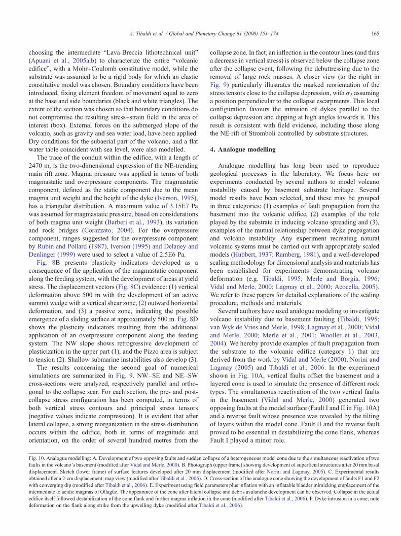
Analogue modelling has long been used to reproducegeological processes in the laboratory. We focus here onexperiments conducted by several authors to model volcanoinstability caused by basement substrate heritage. Severalmodel results have been selected, and these may be groupedin three categories: (1) examples of fault propagation from thebasement into the volcanic edifice, (2) examples of the roleplayed by the substrate in inducing volcano spreading and (3),examples of the mutual relationship between dyke propagationand volcano instability. Any experiment recreating naturalvolcanic systems must be carried out with appropriately scaledmodels (Hubbert, 1937; Ramberg, 1981), and a well-developedscaling methodology for dimensional analysis and materials hasbeen established for experiments demonstrating volcanodeformation (e.g. Tibaldi, 1995; Merle and Borgia, 1996;Vidal and Merle, 2000; Lagmay et al., 2000; Acocella, 2005).We refer to these papers for detailed explanations of the scalingprocedure, methods and materials.
Several authors have used analogue modeling to investigatevolcano instability due to basement faulting (Tibaldi, 1995;van Wyk de Vries and Merle, 1998; Lagmay et al., 2000; Vidaland Merle, 2000; Merle et al., 2001; Wooller et al., 2003,2004). We hereby provide examples of fault propagation fromthe substrate to the volcanic edifice (category 1) that arederived from the work by Vidal and Merle (2000), Norini andLagmay (2005) and Tibaldi et al., 2006. In the experimentshown in Fig. 10A, vertical faults offset the basement and alayered cone is used to simulate the presence of different rocktypes. The simultaneous reactivation of the two vertical faultsin the basement (Vidal and Merle, 2000) generated twoopposing faults at the model surface (Fault I and II in Fig. 10A)and a reverse fault whose presence was revealed by the tiltingof layers within the model cone. Fault II and the reverse faultproved to be essential in destabilizing the cone flank, whereasFault I played a minor role.
lapse of a heterogeneous model cone due to the simultaneous reactivation of twoh (upper frame) showing development of superficial structures after 20 mm basalplacement (modified after Norini and Lagmay, 2005). C. Experimental resultsCross-section of the analogue cone showing the development of faults F1 and F2rameters plus inflation with an inflatable bladder mimicking emplacement of thellapse and debris avalanche development can be observed. Collapse in the actualn the cone (modified after Tibaldi et al., 2006). F. Dyke intrusion in a cone; noteldi et al., 2006).

166 A. Tibaldi et al. / Global and Planetary Change 61 (2008) 151–174
Another instance, that of basement transcurrent faultingcutting across a modelled volcano (Fig. 10B), can yield well-developed fractures in the cone interior, although outwardly theedifice appears as a symmetrical cone, exhibiting concentriccontours when viewed on a topographic map (Norini andLagmay, 2005). Slight changes in the basal shape of the coneinduced by strike–slip movements can be restored by therelatively faster resurfacing and reshaping processes from thedeposition of younger eruptive products. This may be of keyimportance in terms of volcanic hazard assessment, sinceconcealed deformation could induce instability in volcanoesand act as slip planes during lateral collapse events. Finally,lateral collapses can occur in a direction slightly oblique to thetranscurrent fault strike.
When modelling (Tibaldi et al., 2006) deformation inducedin a volcano by basement inclined normal faults, magmainflation and multiple flank deformation, experiments resultedin the development of a main fault (F1) cutting across the upperpart of the cone below the summit crater and departing from thesubstrate fault with the same dip (Fig. 10C,D). A secondcurvilinear fault (F2) did develop from the substrate fault, butwith opposite sense of dip. Significant deformation of the coneflank was recorded but no collapse occurred.
The effect of a shallow intrusion in the volcano's flank wasthen simulated by intruding the cone with an inflatable bladder.The case of no-previous structural destabilization, and the caseof previous structural destabilization due to single substratefaulting, or repeated faulting alternating with cone growth, wereboth modelled. As shown in Fig. 10E, upon initial inflation ofthe bladder, a bulge (criptodome) formed in the central portionof the flank. The response of the analogue cone to this intrusionwas the development of a catastrophic lateral collapse with adebris avalanche. Lateral collapse of the model cone occurredonly when a shallow magmatic intrusion within the volcano wasintroduced. Fig. 10F shows a dyke intrusion across a volcanowith consequent deformation along the fault strike, where thefissure eruption should occur at the stage of interception of thedyke with the topographic surface. A further outcome of theseanalogue experiments is that volcano flank deformation isenhanced if a previous flank destabilization occurred, inter-spersed with new cone growth.
Examples of the role played by the substrate structure ininducing volcano spreading (category 2), are taken from theworks of Wooller et al. (2004) and Walter et al. (2006). Theanalogue basement, made of both ductile and brittle layers(Fig. 11A) was raised on one edge to introduce a substrate dip,above which the model cone was built. The resultingdeformation and spreading were then analyzed as dips wereincreased. Another key role in triggering failure in downslopespreading volcanoes is played by basal thrusting, producedwhere a lateral constraint on ductile layers occurs (Fig. 11A).Walter et al. (2006) investigated the deformation of largevolcanic edifices built by the coalescence of adjacent cones, byreproducing the spreading of an edifice composed of over-lapping volcanoes. The results illustrate the following two mainrelationships between the spreading of overlapping volcanoesand the geometry (Fig. 11B) of new rift zones: (a) Spreading
edifices of similar age that partially overlap tend to develop arift zone approximately perpendicular to the boundary of bothvolcanoes, and this causes the two edifices to grow together anddevelop an elongated topographic ridge. (b) Partially over-lapping volcanoes of different ages that spread at different ratesform a rift zone that is parallel to their boundary, causing the twoedifices to structurally separate from each other.
Examples of mutual relationships between dyke propagationand volcano instability (category 3), are taken from the works ofAcocella and Tibaldi (2005) and Walter and Troll (2003).Acocella and Tibaldi (2005) used analogue experiments toinvestigate how dykes propagate across a volcano with a lateralcollapse depression. The injections formed dykes that, awayfrom the collapse depression, became radial (Fig. 11C).However, the dykes propagating near the collapse focusedtowards the collapse sides, becoming sub-parallel to them,indicating that the stress reorientation is due to unbuttressing.Only the dykes formed along the collapse axis (passing throughthe mid-line of the collapse in map view) were able to propagateradially within the collapse area.
Walter and Troll (2003) studied how a creeping volcanicflank may influence the evolution of rift zones. Their conclusionis that three main types of rift zone configuration may developfrom an initially radial volcanic cone (Fig. 11D). Loweccentricity of the creeping sector (Fig. 11E) produces dykeintrusions along two curved axes tangential to the stable/unstable interface. In contrast, strong eccentricity of thecreeping sector results in only one main tangential rift(Fig. 11F), while other rifts remain poorly developed orstrike–slip faults develop. A diffuse dyke swarm is encouraged(Fig. 11G) in the sliding direction if edifice deformation isalmost entirely by creep.
5. Discussion
Volcanologists have traditionally deciphered volcanic evolu-tion by studying the physicochemical characteristics of theeruptive products, which are tightly linked with the physico-chemical evolution of the magma feeding systems (e.g. Tanguyet al., 1997; Hobden et al., 2002). The volume of ascendingmagma, intruded/erupted ratio, explosive/effusive ratio, andlava rheology, are all parameters dependent on magma proper-ties. More recently, it has been recognized that the geological,geomorphological and structural evolution of a volcano can alsodepend upon a series of feedback mechanisms occurring in theuppermost crust, i.e. in the volcano substrate or volcanic edifice(vanWyk de Vries and Borgia, 1996; Thouret, 1999; Borgia andvan Wyk de Vries, 2003; Tibaldi et al., 2006). The followingseeks to elucidate these feedback phenomena.
5.1. Substrate tectonics, rift zones and location of flank eruptions
In extensional regimes, it is widely accepted that magmaflow paths are linked to the regional tectonic stress field. Thistype of stress regime produces brittle discontinuities perpendi-cular to the least principal stress (σ3) through which magma istransferred to the surface.

Fig. 11. A. Sketch of one of the possible slope-spreading processes, resulting from the introduction of a substrata slope to the analogue model. The downslope spreading ofvolcano and substrata is illustrated: Deformation occurs downslope until lateral discontinuity of weak substratum, where a thrust fault develops. Deformation and thrustingare confined to downslope sector (light shading), generating conditions for future lateral collapse (modified after Wooller et al., 2004). B. Sketch illustrating the two maintrends of rift zones on overlapping volcanic edifices. Left: perpendicular to the boundary of both volcanoes. Right: parallel to the boundary of both volcanoes (Modified afterWalter et al., 2006). C.Map view of an ideal cone with a collapse scar, showing the paths of dykes related to the distribution of stresses and the location of the collapse scar(modified after Acocella and Tibaldi, 2005). D–G. Main types of rift zone configurations that may develop from an initially radial volcanic cone. See text for details(modified from Walter and Troll, 2003).
167A. Tibaldi et al. / Global and Planetary Change 61 (2008) 151–174
Both Stromboli and Ollagüe volcanoes are characterized by apre-lateral collapse stage during which a rectilinear volcanic riftzone crosscuts the cone. At Stromboli regional extension isNW–SE (Ferrari and Manetti, 1993; Tibaldi et al., 2003) and therift zone trends NE–SW, whereas at Ollagüe regional extensionis NE–SW (Feeley et al., 1993) and the rift trends NW–SE. Inboth cases, thus, the rift zone trends parallel to regional normal
faults and perpendicular to the regional tectonic σ3. These datasuggest that the regional stress field can cause a preferredorientation in rift zones channelling magma up to the summitzone of the cone and feeder dyke swarms. In extensionalregimes, the regional stress field can control the structure of theentire volcanic edifice. The analogue experiment with a dykeintruding into a volcano offset by a normal fault (Fig. 10F),

168 A. Tibaldi et al. / Global and Planetary Change 61 (2008) 151–174
demonstrates that flank eruptions are expected at the intersec-tion between the dyke and topography. Similar results weresuggested on a theoretical basis from Nakamura et al. (1977),who showed that in many arc volcanoes island elongation andrifts are parallel with the trajectory of motion of the plate onwhich they are situated, suggesting that these rift zones aretectonically controlled. Detailed study of the Azores and Samoaalso show the positions and orientations of rift zones to bemainly tectonic in origin (Walker, 1999); more examples ofvolcanic rift zones parallel to basement normal faults have beenfound in Cappadocia, Turkey (Toprak, 1988), in the centralMexican Volcanic Belt (Pasquarè et al., 1988) and in Iceland(Takada, 1994). Seamounts aligned with basement faults alsoimply some effect of tectonic features on eruption geometry(Batiza and Vanko, 1983; Fornari, 1987). Our data thus,integrated with these literature examples, suggest that inextensional tectonic settings, inception and geometry of volca-nic rift zones might be mostly controlled by substrate regionaltectonics.
In the other studied volcanoes located in transcurrent tectonicsettings (Pinatubo) or compressional cordilleran settings(Planchon), rift zones have not been recognized before thelateral collapse occurrence. In these cases, the regional tectonicstate of stress has been characterised by a horizontal greatestprincipal stress (σ1). Similar situations are present, for example,also at the Reventador (Tibaldi, 2005a) and Cotopaxi (Tibaldi,2005b) volcanoes in Ecuador, at Galeras Volcano in Colombia(Tibaldi and Romero-Leon, 2000) and at the Trohunco and theLos Cardos–Centinela volcanic complexes in Argentina(Folguera et al., 2006b; Miranda et al., 2006). These datasuggest that the lack of a clear rift zone might be due to aregional tectonic σ1 acting in the horizontal plane, inhibiting theformation of a volcanic rift. Hence, we believe that in trans-current/compressional tectonic settings more studies arenecessary in order to understand the controls on the locationof flank eruptions.
Finally, in case of large volcanoes resting above a ductilesubstrate, such as Mt. Etna which grew above clay sediments,rift formation can be related to the build-up of a localextensional stress field within the volcano by its weight (Borgiaet al., 1992). In fact, in the general case of a zone of weaknessunderlying a volcano, gravity sliding or volcanic spreading havebeen proposed to control volcanic rifting and structuralevolution (e.g. Borgia et al., 2000a,b); Fiske and Jackson(1972) suggested that rift zones in volcanoes such as theHawaiian Islands do not generally coincide with basementstructures; in the latter case, volcano loading and related stressdistribution govern shallow rift formation.
5.2. Lateral collapses
The destructive power of volcanic lateral collapses wasdramatically demonstrated by the 1980 lateral collapse ofMount St. Helens, in which 2.8 km3 of debris travelling at aspeed of 35 m/s (was spread over an area of 60 km2 (Voightet al., 1981). Although collapse of volcanic cones is mostcommonly associated with composite volcanoes (Ui, 1983),
catastrophic slope failure is not limited to steep-sided volcanoes(Siebert, 1996). Massive slumps and debris avalanches are nowwidely recognised on gently-inclined subaerial and submarinevolcano slopes in many basaltic volcanic islands. Examplesinclude the Hawaiian, Reunion, Tristan de Cunha, Canary,Marquesas, and Galapagos islands (Lenat et al., 1989;Chadwick et al., 1991; Holcomb and Searle, 1991; Mooreet al., 1994). Debris avalanches entering the sea can generatedestructive tsunamis, which cause most of the fatalitiesassociated with volcanic lateral collapse (Siebert, 1996).These hazards emphasize the importance of understanding theparameters governing the geometry and triggering of lateralcollapses, as discussed in this section.
5.2.1. The role of the volcanic substrateData from Mt. Etna illustrate the importance of the inherited
recent and currently active tectonic structures and substrategeology in guiding collapse geometry. The generally south-eastwards sliding direction and the steady-state sliding characterof the movement appear to be determined by a combination of:1) the lithologic boundary between the flysch sequencebelonging to the Apennine–Maghrebian Chain and theQuaternary marine clay deposits, and the resulting rheologicalcontrast, being orientated approximately normal to the slidingdirection, and 2) the unbuttressing of the eastern flank of thevolcano, where the Sicilian continental crust is truncated by theMalta Escarpment and related structures. In outcrop the sub-Etnean clays are pervasively affected by a network ofapparently conjugate fractures whose surfaces exhibit slick-ensiding. Whether this is related to the sliding, or to latethrusting of the Apennine–Maghrebian Chain rocks, or acombination of both, is difficult to determine. However, thesesmall-scale structures do indicate that deformation in the claystends to be distributed, rather than localized along discreetstructures, a characteristic that can be expected to apply to agreater extent in the subsurface where confining pressures andwater content promote distributed plastic deformation Thisinterpretation suggests that the distinctive stable sliding of Etnaarises from cohesion and frictional drag in the clays underlyingthe unstable sector. By contrast, all the other cases studied inthis paper suggest that instability occurring entirely within thevolcanic edifice is likely to produce sudden and potentiallycatastrophic movement as the elastic limit of the rocks isexceeded, particularly since these relatively competent volcaniclithologies are unlikely to exert a sliding effect on the movingmass in the same way as the Etnean clays. If this analysis iscorrect, it suggests that Etna may not be prone to the hazards ofdeep-seated lateral collapse, although shallower failures withinthe volcanics remain a threat.
At Stromboli and Ollagüe, the collapse direction is perpendi-cular to the trend of dykes and of regional structures. In fact,lateral collapses developed perpendicularly to the rift zones,towards the NW and SE at Stromboli and towards the SW atOllagüe. The development of major lateral collapses in thesedirections at Stromboli and Ollagüe can be interpreted as due tothe effect of dip of the substrate in those directions. Also, at Mt.Etna, the Valle del Bove depression, as well as the sliding

169A. Tibaldi et al. / Global and Planetary Change 61 (2008) 151–174
direction of the whole eastern flank, developed eastwards,perpendicular to the main N–S orientation of the summit riftzone. This is consistent with the results of previous studiesregarding extensional settings, where flank instability occurs onthe hanging wall after propagation of basement normal faultsacross the cone, as here demonstrated by analogue modelling andfield data at Ollagüe. Along these extensional structures, intrusivesheets can propagate exerting a lateral push on the volcano flank.This magma push has been widely accepted to destabilize thevolcano flank (Siebert et al., 1987; Tibaldi, 1996, 2001; Voightand Elsworth, 1997; Voight, 2000; Donnadieu et al., 2001). In thecase of transcurrent basement tectonics, analogue modelling alsoindicates that collapse direction is mainly controlled by theorientation of the fault, being slightly oblique to the fault strike(Fig. 8B). With a compressional cordilleran setting (Planchon),the lateral collapse direction is perpendicular to the dominantN–Sstructural grain of the basement.
All these data suggest that in volcanoes where gravitationalspreading is absent, collapse geometry is controlled by base-ment topography (i.e. the dip of the basement) and tectonics,both directly in the case of normal or transcurrent faulting, orindirectly through the formation of a tectonically-controlled riftzone. As a consequence, active basement faulting can be used topredict the volcano flanks prone to lateral instability, and thedirection of possible failure. In the case of spreading volcanoes,analogue modelling suggests that rift zone formation andinstability leading to lateral collapse are primarily controlled bythe distribution of the weak substrate and the topographicgradient (Walter and Troll, 2003). Consequently, the locationand orientation of potential lateral collapse can also be assessedfor these volcanic edifices.
5.2.2. The role of climateLateral collapses at extinct volcanoes are believed to be
triggered by seismic shaking and/or heavy rains with con-sequent increase of water pore pressure (Tibaldi et al., 1995;McGuire, 1996; Voight and Elsworth, 1997; Kerle et al., 2003).Since most volcanic regions are located in humid environments(e.g. Central America, Northern Andes, Alaska–Aleutian–Kamchatka–Kurile belt, Indonesia, Philippines, New Zealand,and most oceanic island volcanoes), the combination of rain andseismic events can create the conditions for widespreadlandsliding, as was observed during the 1987 Ms 6.1–6.9earthquakes in Ecuador, when more than 2000 landslides weretriggered in the Reventador volcanic area (Tibaldi et al., 1995).Therefore, the combination of endogenous and exogenousprocesses can produce very hazardous conditions.
The sensitivity of landslide formation to water content andground saturation suggests that climate change is also likelyto affect the stability of volcanic environments in the future. Itis likely that those areas where climate change scenariospredict more intense rainfall will be subject to a greaterincidence of volcanic landsliding. The sensitivity of moretemperate volcanic regions (e.g. Mediterranean area, Japan) tothis factor also suggests a potential climate-induced increasein landslide hazard in these areas. Capra (2006) notes thatduring the last 30,000 years, major lateral collapses have
occurred during periods of rapid deglaciation. Volcanoes withexisting summit glaciers may also be subject to a greaterincidence of landsliding and lahars as a result of globalwarming. Melting of a stabilizing glacial cover increases thewater pressure in the summit deposits, and destabilizes over-steepened slopes.
5.2.3. The role of magma pathwaysMagma pressure strongly contributes to triggering lateral
collapse in active volcanic areas (e.g. Apuani et al., 2005b).Several large lateral collapses have been triggered by magmainflation in the cone (Elsworth and Voight, 1995; Iverson, 1995;Elsworth and Voight, 1996; McGuire, 1996). Since magmainflation occurs along dyke swarms (whose surface expressionare the rift zones) that can be geometrically guided by regionaltectonic fractures and/or stress fields, it follows that regionaltectonics might also control collapse triggering. At Planchon,the development of a shallow magma chamber preceded thelateral collapse, although it cannot be shown that the two werecausally linked.
Pathways of magma flow to the surface can change after alateral collapse. All the field examples considered here, as wellas analogue and numerical modelling, indicate that a migrationof dykes and eruptive centres can occur after lateral collapse. Atboth Stromboli and Ollagüe, a rectilinear zone of magmaupwelling developed before the lateral collapse. Subsequently,at Stromboli, dykes became re-orientated to align with theSciara del Fuoco collapse depression. The location of post-collapse volcanic activity also concentrated along and withinthe collapse depression at Ollagüe and Planchon. Thisphenomenon was first described by Tibaldi (1996) as a generalprocess, whereas re-orientation of single intrusions was alsonoticed at Mt. Etna by McGuire et al. (1990). Analoguemodelling experiments (Acocella and Tibaldi, 2005) suggestthat, if the intrusion starts within the depression, dyking willpropagate throughout it. On the other hand, if dyking startsclose to the depression but outside it, dyking will propagatealong the collapse scarps. Numerical modelling presented hereexplains this pattern as both a rotation and a magnitude changeof stress tensors after a lateral collapse. Vertical stressesdecrease and rotate, with σ3 assuming a position perpendicularto the collapse escarpments. This reorganization can thereforebe ascribed to unbuttressing of the collapse zone followingremoval of the large mass of rock. Unbuttressing resulting fromthe collapse depression itself can also affect the stressdistribution, and thus magma paths, on the order of a fewhundred metres from the active centre. Other authors demon-strate that rift zones in volcanoes re-align following lateralcollapses and gravitational spreading (Tibaldi, 2001; Walter andTroll, 2003; Tibaldi, 2004; Acocella and Tibaldi, 2005; Walteret al., 2006; Münn et al., 2006). Since rift zones are structuralfeatures where dykes preferentially intrude and eruptions takeplace, it follows that lateral collapses and the location oferuption centres are intimately linked.
If, instead of being distributed along a dyke swarm, magmaupwelling concentrates in one main conduit, a new cone cangrow within the collapse depression. This possibility is

170 A. Tibaldi et al. / Global and Planetary Change 61 (2008) 151–174
confirmed at Stromboli and Planchon, where the main centralcrater zone migrated a few hundred metres after the lateralcollapse developed.
5.2.4. The role of volcano heightFinally, among the factors determining the likelihood of a
lateral collapse, we must also consider volcano height. AtStromboli, each main collapse occurred when the cone reacheda similar altitude, on the order of 800–1100 m a.s.l. (3300–3600above the sea floor). Ollagüe collapsed when it reached about2000 m in height above the substrate, and Planchon when atleast 1600 m above the substrate. St. Augustine volcano, inAlaska, collapsed laterally several times as it reached about thesame altitude (Beget and Kienle, 1992). If a critical height is notreached, then only rare conditions, such as very large magmaintrusions, can induce collapse. This height control may explainwhy Kizimen has not yet collapsed, since it has only veryrecently reached an altitude of 1500 m. Kizimen does have asubstrate with a strong gravity gradient, due to offset along thegraben faults, but this has apparently not yet been sufficient toinduce lateral collapse. Notably, this is despite a series of large-magnitude earthquakes following major faulting in the area(Kozhurin et al., 2006). Kizimen does not show evidence ofdyking, since there are no flank eruptive centres or eruptivefractures; suggesting that magma upwelling probably occurredalong a stable central conduit. Moreover, the mass of thevolcano itself has not been enough to impede vertical magmaupwelling, i.e. horizontal migration or internal segregation ofmagma has not been favoured up to now. The role of substratetectonics in this situation could be important in triggeringeruptions, given the likely correlation between duration ofvolcanic cycles and return period of fault movements.
5.3. Landslides and erosion
Volcanic regions are prone not only to hazards derived fromcatastrophic lateral collapse events, but also to smallerlandslides, volcanic mudflows (lahars), and debris flows.Considering the timescales of these phenomena, lateralcollapses can occur with a frequency on the order of 30 to afew hundred years in a volcanic group with a high magmaproduction rate (Tibaldi et al., 2005), whereas landslides, lahars,and debris flows have a much higher frequency. Except forpyroclastic flows, lahars are the most devastating volcanicprocesses on active volcanoes (Thouret, 1999).
Scott et al. (2001) note that, in general, catastrophic volcanicdebris flow avalanches and landslides are fundamentally relatedto the presence of large volumes of structurally weak andpotentially water-saturated material underlying steep slopes athigh altitudes in tectonically active zones. All the volcanoesdescribed here are deeply dissected, even though they are allyoung and active. Erosion processes at Stromboli, which is only100 ka old, have exhumed the inner magma feeding system anddeeply dissected the flanks of the cone which have not beenaffected by lateral collapses. The role of substrate tectonics in thiscase could be important in triggering eruptions along Stromboli'ssouthern flank, where most rock mass removal has occurred
through surface landsliding and slow erosion. It is noteworthy thatthese processes occur along the older NE–SW-trending rift zoneon Stromboli. At Ollagüe, deep, wide canyons have beenexcavated by slow erosion processes along the northwesternand southeastern cone flanks, that is, along the old NW–SE-trending rift zone. At Planchon, lateral collapse and landslideshave exposed the inner core of the volcanic system while, atPinatubo, erosion as a result of water escape from the summitcaldera lake was guided through the Maraunot Notch, that is,along a first order fault crossing the volcano. At Mt. Etna, large-scale deformation at the lower eastern flank is linked withmovements produced along the rift zone. The formation of theValle del Bove, through a series of landslides and debris flows(Calvari et al., 1998) could have been triggered by tectonicmovements along the Timpe and Messina fault systems. Relativedownfaulting by some 600 m on the easternmost flank of thevolcano, taking place on these structures, increases the potentialfor gravity-driven collapses; as does periodic inflation andoversteepening on the summit slopes of the volcano. Conse-quently, the denudation processes that took place at Mt. Etnaappear to be characterised as a series of rapid debris flowsconcentrated in a relatively short time span. In contrast, presenterosion in the Valle del Bove occurs at a very slow rate.
Finally, hydrothermal alteration of volcanoes can play afundamental role in guiding exogenous erosion processes; suchis the case for example at Ollagüe and Planchon. However,hydrothermal activity is also controlled by the structures alongwhich fluids propagate. These structures can be tectonic inorigin, and thus linked to the substrate tectonic heritage, or theycan derive from the structural reorganization of a volcanofollowing a lateral collapse; events that are themselves typicallyguided by substrate tectonics and/or subsurface rheology.
All the studied examples indicate that volcanic–tectonicfeatures such as rift zones, and tectonic structures such as faults,directly control the extent, location and geometry of the zonesprone to landslides and slower erosion processes. Knowledge ofa volcano's structural history and that of its substrate allowsprediction of the locus of specific erosion processes.
6. Conclusions
The field examples given in this paper show that in com-posite volcanoes not subject to gravity spreading, substratetectonic structures control pre-lateral collapse magma path-ways, large lateral collapses, smaller landslide events, andpreferential erosion. The tectonic crustal stress state or thepresence of substrate fractures can determine the geometry ofvolcanic rift zones, which in turn guide the direction of largelateral collapse. In zones of active extension, tectonically-controlled rift zones preferentially develop, as shown in thecase of Stromboli and Ollagüe. Also in a compressional cor-dilleran setting like at Planchon volcano, the orientation oflateral collapse can be controlled by the dominant substratefaults. In all these cases, the orientation of the collapse isnormal to fault strike, and in turn depends on the general dip ofthe substrate. Analogue and numerical modelling confirmthese data and interpretations.

171A. Tibaldi et al. / Global and Planetary Change 61 (2008) 151–174
The field data presented here also show that erosion andsurface landslides can follow the strike of faults affectingvolcanic edifices or rift zones, giving rise to preferential zonesof degradation on the cone flanks and summit. In the case ofsummit crater lakes, tectonics can guide the erosional breachingof the crater rim with consequent production of lahars, as seen atPinatubo.
Once a lateral collapse occurs, the related debuttressingproduces a reorganization of the rift zone to produce a horseshoe-shaped arrangement in plan view. This theory is confirmed byanalogue and numerical modelling, and by the field data atStromboli, Ollagüe and Mt. Etna. Migration of the main magmaconduit towards the collapse depression can occur after a lateralcollapse, as demonstrated at Stromboli, Ollagüe and Planchon.
When a weak substrate is present under a volcano, as at Mt.Etna, long-lasting, deeply-rooted creeping phenomena canoccur, deforming a large sector of the cone. This deformation,in turn, can induce more surficial landslides that propagate alongthe destabilized flank axis.
In the absence of a rift zone, as seen in the Pinatubo areaaffected by transcurrent faults, the propagation of the fault fromthe substrate across a volcano can induce flank destabilizationoblique to fault strike. This destabilization likely evolves intolateral collapse if other mechanisms are involved, such as strongseismic motion or shallow magmatic intrusion.
The data presented here demonstrate clear relationships betweensubstrate tectonics and flank eruption, lateral collapse, and erosion.Accordingly, detailed analysis of substrate and edifice structureprovides a fundamental component of volcanic hazard assessment.
Acknowledgments
This study was performed in the framework of the ILP project“New tectonic causes of volcano failure and possible premonitorysignals”. This work benefits of grants by the Istituto Nazionale diGeofisica e Vulcanologia–Gruppo Nazionale per la Vulcanologia;ItalianMinistry of Instruction,University andResearch; PhilippineCouncil for Advanced Science and Technology Research;National Geographic Society (USA); Russian Foundation forBasic Research. Exchange visits of Italian and Russian scientistspromoting cooperative research were funded by NATO—RussiaCollaborative Linkage grant JSTC.RCLG.978989.
References
Acocella, V., 2005. Modes of sector collapse of volcanic cones: insights fromanalogue experiments. J. Geophys. Res. 110, B02205. doi:10.1029/2004JB003166.
Acocella, V., Tibaldi, A., 2005. Dyke propagation driven by volcano collapse: ageneral model tested at Stromboli, Italy. Geophys. Res. Lett. 32, L08308.doi:10.1029/2004GL022248.
Acocella, V., Behncke, B., Neri, M., D'Amico, S., 2003. Link between majorflank slip and eruptions at Mt. Etna (Italy). J. Geophys. Res. 30, 2286.doi:10.1029/2003GL018642.
Acocella, V., Vezzoli, L., Omarini, R., Matteini, M., Mazzuoli, M., 2007.Kinematic variations across Eastern Cordillera at 24°S (Central Andes):tectonic and magmatic implications. Tectonophysics 434, 81–92.
Apuani, T., Corazzato, C., Cancelli, A., Tibaldi, A., 2005a. Physical andmechanical properties of rock masses at Stromboli: a dataset for flank
instability evaluation. Bull. Eng. Geol. Environ. 64, 419–431. doi:10.1007/s10064-005-0007-0.
Apuani, T., Corazzato, C., Cancelli, A., Tibaldi, A., 2005b. Stability of a collapsingvolcano (Stromboli–Italy): limit equilibrium analysis and numerical model-ling. In: Gudmundsson, A., Acocella, V. (Eds.), The Tectonics and Physics ofVolcanoes. J. Volcanol. Geotherm. Res., vol. 144, pp. 191–210. 1–4.
Aurelio, M.A., 2000. Shear partitioning in the Philippines: constraints fromPhilippine Fault and global positioning system data. The Island Arc 9 (4),584–597.
Barberi, F., Rosi, M., Sodi, A., 1993. Volcanic hazard assessment at Strombolibased on review of historical data. Acta Vulcanol. 3, 173–187.
Barberi, G., Cocina, O., Neri, G., Privitera, E., Spampinato, S., 2000.Volcanological inferences from seismic-strain tensor computations at Mt.Etna Volcano, Sicily. Bull. Volcanol. 62, 318–330.
Batiza, R., Vanko, D., 1983. Volcanic development of small oceanic centralvolcanoes on the flanks of the East Pacific Rise inferred from narrow-beamecho-sounder surveys. Mar. Geol. 54, 53–90.
Bautista, B.C., Bautista, M., Stein, R., Barcelona, E., Punongbayan, R.,Laguerta, E., Rassdas, A., Ambubuyog, G., Amin, E., 1996. Relationship ofregional and local structures to Mount Pinatubo activity. In: Newhall, C.G.,Punongbayan, R.S. (Eds.), Fire and Mud: Eruptions and Lahars of MountPinatubo, Philippines. PHIVOLCS, Quezon City. University of WashingtonPress, Seattle, WA, pp. 351–370.
Beget, J.E., Kienle, J., 1992. Cyclic formation of debris avalanches at mount StAugustine volcano. Nature 356, 701–704.
Bermúdez, A., Delpino, D., 1989. La Provincia Basáltica Andino Cuyana.Asociación Geológica Argentina, Revista 44, 35–55.
Billi, A., Barberi, G., Faccenna, C., Neri, G., Pepe, F., Sulli, A., 2006. Tectonicsand seismicity of the Tindari Fault System, southern Italy: crustaldeformations at the transition between ongoing contractional and exten-sional domains located above the edge of a subducting slab. Tectonics 25,TC2006. doi:10.1029/2004TC001763.
Borgia, A., van Wyk de Vries, B., 2003. The volcano-tectonic evolution ofConcepciòn, Nicaragua. Bull. Volcanol. 65 (4), 248–266.
Borgia, A., Ferrari, L., Pasquarè, G., 1992. Importance of gravitationalspreading in the tectonic and volcanic evolution of Mount Etna. Nature357, 231–235.
Borgia, A., Delaney, P.T., Denlinger, R.P., 2000a. Spreading volcanoes. Ann.Rev. Earth Planet. Sci. 28, 539–570.
Borgia, A., Lanari, R., Sansosti, E., Tesauro, M., Berardino, P., Fornaro, G.,Neri, M., Murray, J.B., 2000b. Actively growing anticlines beneath Cataniafrom the distal motion of Mount Etna's decollment measured by SARinterferometry and GPS. Geophys. Res. Lett. 27, 3409–3412.
Braitseva, O.A., Melekestsev, I.V., Ponomareva, V.V., Sulerzhitsky, L.D., 1995.The ages of calderas, large explosive craters and active volcanoes in theKuril–Kamchatka region, Russia. Bull. Volcanol. 57 (6), 383–402.
Branca, S., Coltelli, M., Groppelli, G., 2004. Geological Evolution of EtnaVolcano. In: Bonaccorso, A., Calvari, S., Coltelli, M., Del Negro, C.,Falsaperla, S. (Eds.), Etna Volcano Laboratory, AGU (Geophysicalmonograph series), pp. 49–63.
Capra, L., 2006. Abrupt climactic changes as triggering mechanisms of massivevolcanic collapses. J. Volcanol. Geotherm. Res. 155, 329–333.
Calvari, S., Groppelli, G., Pasquarè, G., 1994. Preliminary geological data on thesouth-western walls of Valle del Bove, Mt. Etna (Sicily). Acta Vulcanol. 5,15–30.
Calvari, S., Tanner, L.H., Groppelli, G., 1998. Debris–avalanche deposits of theMilo Lahar sequence and the opening of the Valle del Bove on Etna volcano(Italy). J. Volcanol. Geotherm. Res. 87 (1–4), 193–209.
Chadwick Jr., W.W., De Roy, T., Carrasco, A., 1991. The September 1988intracaldera avalanche and eruption at Fernandina volcano, GalapagosIslands. Bull. Volcanol. 53, 276–286.
Clavero, J., Sparks, R.S.J., Aguilar, G., van Wyk de Vries, B., 2004. Substratainfluence in the origin, transport and emplacement of Ollagüe debrisavalanche, Central Andes of northern Chile. Acta Vulcanol. 16 (1–2),59–76.
Coltelli, M., Garduño, V.H., Neri, M., Pasquarè, G., Pompilio, M., 1994.Geology of northern wall of Valle del Bove, Etna (Sicily). Acta Vulcanol. 5,55–68.

172 A. Tibaldi et al. / Global and Planetary Change 61 (2008) 151–174
Corazzato, C., 2004. A quantitative study of volcano lateral collapses: theexample of Stromboli (Italy). PhD thesis, Università di Milano–Bicocca,Italy, 154 pp.
Corazzato, C., Tibaldi, A., 2006. Fracture control on type, morphology anddistribution of parasitic volcanic cones: an example from Mt. Etna, Italy.J. Volcanol. Geotherm. Res. 158, 177–194.
Corsaro, R., Neri, M., Pompilio, M., 2002. Paleo-environmental and volcano-tectonic evolution of the south-eastern flank of Mt. Etna during the last225 ka inferred from volcanic succession of the «Timpe», Acireale, Sicily.J. Volcanol. Geotherm. Res. 72, 1–19.
Davidson, J., 1974. A Quaternary volcanic mudflow (lahar) down the Claro andTeno valleys from Planchon Volcano. International Symposium onVolcanology, Santiago, Abstracts of papers, pp. 14–15.
Davidson, J., de Silva, S.L., 1992. Volcanic rocks from the Bolivian Altiplano:insights into crustal structure, contamination, and magma genesis in thecentral Andes. Geology 20, 1127–1130.
de Silva, S.L., 1989. Altiplano–Puna volcanic complex of the Central Andes.Geology 17, 1102–1106.
de Silva, S.L., Francis, P.W., 1991. Volcanoes of the Central Andes. Springer–Verlag, Berlin, p. 216.
de Silva, S.L., Self, S., Francis, P.W., Drake, R.E., Ramirez, R.C., 1994. Effusivesilicic volcanism in the Central Andes the Chao dacite and other young lavasof the Altiplano–Puna Volcanic Complex. J. Geophys. Res. 99 (B9),17805–17825.
Delaney, P.T., Denlinger, R.P., 1999. Stabilization of volcanic flanks by dykeintrusion: an example from Kilauea. Bull. Volcanol. 61, 356–362.
Donnadieu, F., Merle, O., Besson, J.-C., 2001. Volcanic edifice stability duringcryptodome intrusion. Bull. Volcanol. 63, 61–72.
Elsworth, D., Day, S., 1999. Flank collapse triggered by intrusion: the Canarianand Cape Verde Archipelagoes J. Volcanol. Geotherm. Res. 94 (1–4),323–340.
Elsworth, D., Voight, B., 1995. Dike intrusion as a trigger for large earthquakesand the failure of volcano flanks. J. Geophys. Res. 100, 6005–6024.
Elsworth, D., Voight, B., 1996. Evaluation of volcano flank instability triggeredby dyke intrusion. In: McGuire, W.J., Jones, A.P., Neuberg, J. (Eds.),Volcano instability on the Earth and other planets. Geol. Soc. London Spec.Publ., vol. 110, pp. 45–53.
Feeley, T.C., Davidson, J.P., 1994. Petrology of calc-alkaline lavas at VolcanOllagüe and the origin of compositional diversity of central Andeanstratovolcanoes. J. Petrol. 35, 1295–1340.
Feeley, T.C., Davidson, J.P., Armendia, A., 1993. The volcanic and magmaticevolution of Volcan Ollagüe, a high-K, late Quaternary stratovolcano in theAndean Central Volcanic Zone. J Volcanol. Geotherm. Res. 54, 221–245.
Ferrari, L., Manetti, P., 1993. Geodynamic framework of the Tyrrhenianvolcanism: a review. Acta Vulcanol. 3, 1–9.
Firth, C., Stewart, I., McGuire, W.M., Kershaw, S., Vita-Finzi, C., 1996. Coastalelevation changes in eastern Sicily: implications for volcano instability atMount Etna. In: McGuire, W.M., Jones, A.P., Neuberg, J. (Eds.), VolcanoInstability on the Earth and Other Planets. Geol. Soc. London Spec. Publ.,vol. 110, pp. 153–167.
Fiske, R.F., Jackson, E.D., 1972. Orientation and growth of Hawaiian volcanicrifts: the effect of regional structure and gravitational stresses. Proc. R. Soc.London 329, 299–326.
Folguera, A., Zapata, T., Ramos, V., 2006a. Late Cenezoic extension and theevolution of the Neuquen Andes. In: Kay, S.M., Ramos, V.A. (Eds.),Evolution of an Andean margin: A tectonic and magmatic view from theAndes to the Neuquén Basin (35°–39°S lat). Geol. Soc. Am. Spec. Paper,vol. 407, pp. 267–285.
Folguera, A., Ramos, V.A., Gonzalez Diaz, E.F., Hermanns, R., 2006b. Mioceneto Quaternary deformation of the Guanacos fold-and-thrust belt in theNeuquén Andes between 37°S and 37°30′S. In: Kay, S.M., Ramos, V.A.(Eds.), Evolution of an Andean margin: A tectonic and magmatic view fromthe Andes to the Neuquén Basin (35°–39°S lat). Geol. Soc. Am. Spec.Paper, vol. 407, pp. 247–266.
Fornari, D.J., 1987. The geomorphic and structural development ofHawaiian submarine rift zones. In: Decker, R.W., Wright, T.L., Stauffer,P.H. (Eds.), Volcanism in Hawai`i. U.S. Geol. Surv. Prof. Pap., vol. 1350,pp. 125–132.
Francis, P.W., Wells, G.L., 1988. Landsat Thematic Mapper observations of debrisavalanche deposits in the Central Andes. Bull. Volcanol. 50, 258–278.
Froger, J., Merle, O., Briole, P., 2001. Active spreading and regional extension atMount Etna imaged by SAR interferometry. Earth Planet. Sci. Lett. 187,245–258.
Gabbianelli, G., Romagnoli, C., Rossi, P.L., Calanchi, N., 1993. Marine geologyof the Panarea–Stromboli area (Aeolian Archipelago, southeastern Tyr-rhenian Sea). Acta Vulcanol. 3, 11–20.
Garduño, V.H., Neri, M., Pasquarè, G., Borgia, A., Tibaldi, A., 1997. Geology ofthe NE-rift of Mount Etna (Sicily, Italy). Acta Vulcanol. 9 (1/2), 91–100.
Gillot, P.-Y., Keller, J., 1993. Radiochronological dating of Stromboli. ActaVulcanol. 3, 69–77.
Groppelli, G., Tibaldi, A., 1999. Control of rock rheology on deformation styleand slip-rate along the active Pernicana fault, Mt. Etna, Italy. Tectonophysics305, 521–537.
Hildreth, W., Fierstein, J., Godoy, E., Drake, R., Singer, B., 1999. The Puelchevolcanic field: Extensive Pleistocene rhyolite lava flows in the Andes ofcentral Chile. Rev. Geol. de Chile 26, 275–309.
Hobden, B.J., Houghton, B.F., Nairn, I.A., 2002. Growth of a young, frequentlyactive composite cone: Ngauruhoe volcano, New Zealand. Bull. Volcanol.64 (6), 392–409.
Holcomb, R.T., Searle, R.C., 1991. Large landslides from oceanic volcanoes.Mar. Geotech. 10, 19–32.
Hornig-Kjarsgaard, I., Keller, J., Koberski, U., Stadlbauer, E., Francalanci, L.,Lenhart, R., 1993. Geology, stratigraphy, and volcanological evolution ofthe island of Stromboli, Aeolian Arc, Italy. Acta Vulcanol. 3, 21–68.
Hubbert, M.K., 1937. Theory of scale models as applied to the study of geologicstructures. Geol. Soc. Am. Bull. 48, 1459–1519.
Hurlimann, M., 1999. Geotechnical analysis of large volcanic landslides: the LaOrotava events on Tenerife, Canary Islands. PhD thesis, TechnicalUniversity of Catalonia, 217 pp.
Hurlimann, M., Garcia-Piera, J.O., Ledesma, A., 2000a. Causes and mobility oflarge volcanic landslides: application to Tenerife, Canary Islands.J. Volcanol. Geotherm. Res. 103 (1–4), 121–134.
Hurlimann, M., Martì, J., Ledesma, A., 2000b. Mechanical relationship betweencatastrophic volcanic landslides and caldera collapse. Geophys. Res. Lett.27, 2393–2396.
ITASCA, 2000. FLAC (Fast Lagrangian Analysis of Continua). User's guide.ITASCA Consulting Group, Minneapolis, MN.
Iverson, R.M., 1995. Can magma injection and groundwater forces causemassive landslides on Hawaiian volcanoes? J. Volcanol Geotherm. Res. 66(1–4), 295–308.
Kay, S., Coira, B., Viramonte, J., 1994. Young mafic back arc volcanic rocks asindicators of continental lithospheric delamination beneath the ArgentinaPuna Plateau, Central Andes. J. Geophys. Res. 99 (B12), 24323–24339.
Kay, S., Godoy, E., Kurtz, A., 2005. Episodic arc migration, crustal thickening,subduction erosion, and magmatism in the south-central Andes. Geol. Soc.Amer. Bull. 117, 67–88.
Kelfoun, K., 1999. Lava dome growth and destabilization processes of Merapivolcano (Central Java, Indonesia). Numerical modelling of the domes,dynamics of associated pyroclastic flows and photogrammetric monitoring(In French). Ph.D Thesis, Univ. Clermond-Ferrand, 270 pp.
Kerle, N., van Wyk de Vries, B., Oppenheimer, C., 2003. New insight into thefactors leading to the 1998 flank collapse and lahar disaster at Casitavolcano, Nicaragua. Bull. Volcanol. 65 (5), 331–345.
Kozhurin, A.I., 2004. Active faulting at the Eurasian, North American andPacific plates junction. Tectonophysics 380, 273–285.
Kozhurin, A., Acocella, V., Kyle, P.R., Lagmay, F.M., Melekestsev, I.V.,Ponomareva, V., Rust, D., Tibaldi, A., Tunesi, A., Corazzato, C., Rovida, A.,Sakharov, A., Tengonciang, A., Uy, H., 2006. Trenching studies of activefaults in Kamchatka, eastern Russia: palaeoseismic, tectonic and hazardimplications. Tectonophysics 417, 285–304.
Lagmay, A.M.F., van Wyk de Vries, B., Kerle, N., Pyle, D.M., 2000. Volcanoinstability induced by strike–slip faulting. Bull. Volcanol. 62, 331–346.
Lagmay, A.M.F., Rodolfo, K.S., Siringan, F.P., Uy, H., Remotigue, C., Zamora,P., Lapus, M., Rodolfo, R., Ong, J., 2007. Geology and hazard implicationsof the Maraunot Notch in the Pinatubo caldera, Philippines. Bull. Volcanol.69 (7), 797–810.

173A. Tibaldi et al. / Global and Planetary Change 61 (2008) 151–174
Lanzafame, G., Neri, M., Coltelli, M., Lodato, L., Rust, D., 1997a. North–Southcompression in the Mt. Etna region (Sicily): spatial and temporaldistribution. Acta Vulcanol. 9, 121–133.
Lanzafame, G., Leonardi, A., Neri, M., Rust, D., 1997b. Late overthrust of theAppenine–Maghrebian Chain at the NE periphery of Mt. Etna, Italy. C.R.Acad. Sc. Paris 324 (IIa), 325–332.
Lenat, J.F., Vincent, P., Bachelery, P., 1989. The offshore continuation of anactive basaltic volcano: Piton de la Fournaise (Reunion Islands IndianOcean). J. Volcanol. Geotherm. Res. 36, 1–36.
Lentini, F., 1982. The geology of the Mt. Etna basement. Mem. Soc. Geol. It. 23,7–25.
Lipman, P.W., Moore, J.G., Swanson, D.A., 1981. Bulging of the north flankbefore the May 18 eruption— geodetic data. In: Lipman, P.W., Mullineaux,D.R. (Eds.), The 1980 eruptions of Mount St. Helens, Washington. U.S.Geol. Surv. Prof. Pap., vol. 1250, pp. 143–155.
Lo Giudice, E., Rasà, A., 1992. Very shallow earthquakes and brittledeformation in active volcanic areas: the Etnean region as an example.Tectonophysics 202, 257–268.
MacPhail, D., 1973. The geomorphology of the Rio Teno Lahar, Central Chile.Geographical Review 63, 517–532.
Mattioli, M., Renzulli, A., Menna, M., Holm, P.M., 2006. Rapid ascent andcontamination of magmas through the thick crust of the CVZ (Andes,Ollagüe Region): evidence from a nearly aphyric high-K andesite withskeletal olivines. In: Tibaldi, A., Lagmay, A.F.M. (Eds.), Interaction betweenVolcanoes and their Basement. J. Volcanol. Geotherm. Res., pp. 87–105.
McGuire, W.J., 1996. Volcano instability: a review of contemporary themes. In:McGuire, W.J., Jones, A.P., Neuberg, J. (Eds.), Volcano instability on theEarth and other Planets. Geol. Soc. London Spec. Publ., vol. 110, pp. 1–23.
McGuire, W.J., Pullen, A.D., Saunders, S.J., 1990. Recent dyke-induced large-scaleblock movement at Mt. Etna and potential slope failure. Nature 343, 357–359.
Merle, O., Borgia, A., 1996. Scaled experiments of volcanic spreading.J. Geophys. Res. 101, 13805–13817.
Merle,O., Vidal, N., vanWykdeVries, B., 2001. Experiments on vertical basementfault reactivation below volcanoes. J. Geophys. Res. 106, 2153–2162.
Miranda, F., Folguera, A., Leal, P.L., Naranjo, J.A., Pesce, A., 2006. UpperPliocene to Lower Pleistocene volcanic complexes and Upper Neogenedeformation in the south-central Andes (36° 30′–38°S). In: Kay, S.M.,Ramos, V.A. (Eds.), Evolution of an Andean margin: A tectonic andmagmatic view from the Andes to the Neuquén Basin (35°–39°S lat). Geol.Soc. Am. Spec. Paper, pp. 287–298.
Monaco, C., Catalano, S., Cocina, O., De Guidi, G., Ferlito, C., Gresta, S.,Musumeci, C., Tortorici, L., 2005. Tectonic control on the eruptivedynamics at Mt. Etna volcano (eastern Sicily) during the 2001 and 2002–2003 eruptions. J. Volcanol. Geotherm. Res. 144, 221–233.
Moore, J.G., Albee, W.C., 1981. Topographic and structural changes, March–July 1980–Photogrammetric data. In: Lipman, P.W., Mullineaux, D.R.(Eds.), The 1980 eruptions of Mount St. Helens, Washington. U.S. Geol.Surv. Prof. Pap., vol. 1250, pp. 123–134.
Moore, J.G., Normark, W.R., Holcomb, R.T., 1994. Giant Hawaiian landslides.Annu. Rev. Earth Planet. Sci. 22, 119–144.
Münn, S., Walter, T.R., Klügel, A., 2006. Gravitational spreading controls riftzones and flank instability on El Hierro, Canary Islands. Geol. Mag. 143 (3),257–268.
Nakamura, K., Jacob, K., Davies, J., 1977. Volcanoes as possible indicators oftectonic stress orientation – The Aleutians and Alaska. Pure Appl. Geophys.115, 87–112.
Naranjo, J.A., Haller, M.J., 2002. Erupciones holocenas principalmenteexplosivas del Volcan Planchon, Andes del Sur (35 deg 15 min S). Rev.Geol. de Chile 29, 93–113.
Neri, M., Acocella, V., Behncke, B., 2004. The role of the Pernicana fault systemin the spreading of Mt. Etna (Italy) during the 2002–2003 eruption. Bull.Volcanol. 66, 417–430.
Neri, M., Guglielmino, F., Rust, D., 2007. Flank instability on Mount Etna: radon,radar interferometry and geodetic data from the southern boundaryof the unstable sector. J. Geophys. Res. 112, B04410. doi:10.1029/2006JB004756.
Norini, G., Lagmay, A.M.F., 2005. Deformed symmetrical volcanoes. Geology33 (7), 605–608.
Okubo, C.H., 2004. Rock mass strength and slope stability of the Hilina slump,Kılauea volcano, Hawaii. J. Volcanol. Geotherm. Res. 138 (1–2), 43–76.
Pasquarè, G., Tibaldi, A., Attolini, C., Cecconi, G., 1988. Morphometry, spatialdistribution and tectonic control of Quaternary volcanoes in northernMichoacan, Mexico. Rend. Soc. It. Min. Petr. 43 (4), 1215–1225.
Pasquarè, G., Francalanci, L., Garduno, V.H., Tibaldi, A., 1993. Structure andgeological evolution of the Stromboli volcano, Aeolian islands, Italy. ActaVulcanol. 3, 79–89.
Pasquarè, F., Tibaldi, A., 2003. Do transcurrent faults guide volcano growth?The case of NW Bicol Volcanic Arc, Luzon, Philippines. Terra Nova 15,204–212.
Patanè, D., Privitera, E., 2001. Seismicity related to 1989 and 1991–93 Mt. Etna(Italy) eruptions: kinematic constraints by fault solution analysis.J. Volcanol. Geotherm. Res. 109, 77–98.
Ramberg, H., 1981. Gravity, Deformation and the Earth's Crust, 2nd ed.Academic Press, London.
Ramos, V., Cegarra, M., Cristallini, E., 1996. Cenozoic tectonics of the highAndes of west-central Argentina (30°–36.5°S). Tectonophysics 259,185–200.
Riller, U., Petrinovic, I.A., Ramelow, J., Strecker, M.R., Oncken, O., 2001. Latecenozoic tectonism, collapse caldera and plateau formation in the CentralAndes. Earth Planet. Sci. Lett. 188, 299–311.
Rollin, P., 1996. Geophysical models of Mount Etna, Sicily: its structuralevolution and implications for slope stability. Unpubl. Doctoral dissertation,Open University. Author no. M7135588, BLDSC no. DXN11438.
Romano, R., 1982. Succession of the volcanic activity in the Etnean area. Mem.Soc. Geol. It. 23, 27–48.
Rubin, A.M., Pollard, D.D., 1987. Origin of blade-like dykes in volcanic riftzones. In: Decker, R.W., Wright, T.L., Stauffer, P.H. (Eds.), Volcanism inHawaii. U.S. Geol. Surv. Prof. Pap., vol. 1350, pp. 1449–1470.
Russo, G., Giberti, G., Sartoris, G., 1996. The influence of regional stresses onthe mechanical stability of volcanoes: Stromboli (Italy). In: McGuire, W.,Jones, A.P., Neuberg, J. (Eds.), Volcano Instability on the Earth and OtherPlanets. Geol. Soc. London Spec. Publ., vol. 110, pp. 65–75.
Rust, D., Neri, M., 1996. The boundaries of large-scale collapse on the flanks ofMount Etna, Sicily. In: McGuire, W.C., Jones, A.P., Neuberg, J. (Eds.),Volcano Instability on the Earth and Other Planets. Geol. Soc. London Spec.Publ., vol. 110, pp. 193–208.
Rust, D., Kershaw, S., 2000. Holocene tectonic uplift patterns in northeasternSicily: evidence from marine notches in coastal outcrops. Mar. Geol. 167,105–126.
Rust, D., Behncke, B., Neri, M., Ciocanel, A., 2005. Nested zones of instabilityin the Mount Etna volcanic edifice, Sicily. J. Volcanol. Geotherm. Res. 155,137–153.
Schmitz, M., Lessel, K., Giese, F., Wigger, F., Araneda, M., Bribach, J., Graeber,F., Grunewald, S., Haberland, C., Lüth, S., Röber, F., Ryberg, T., Schulze,A., 1999. The crustal structure beneath the Central Andean forearc andmagmatic arc as derived from seismic studies — the PISCO 94 experimentin northern Chile (21°–23° S). J. South Am. Earth Sci. 12, 237–260.
Scott, K., Macias, J., Naranjo, J., Rodriguez, S., McGeehin, J., 2001.Catastrophic debris flows transformed from landslides in volcanic terrains:mobility, hazard assessment, and mitigation strategies. USGS Prof. Pap.1630.
Shantser, A.E., Geptner, A.R., Egorova, I.A., Lupikina, E.G., Pevzner, M.A.,Chelebaeva, L.I., 1969. Volcanologic strata of the Tumrok ridge, theirpaleomagnetic characteristics and age. Izv. AN SSSR. ser. geol. 9, 72–82 (inRussian).
Shantser, A.Ye., Kutyev, F.Sh., Petrov, V.S., Zubin, M.I., 1991. Kizimenvolcano. Active volcanoes of Kamchatka, V.2. Nauka Publishers, Moscow,pp. 16–p.29.
Siebert, L., 1996. Hazards of large volcanic debris avalanches and associatederuptive phenomena. In: Scarpa, R., Tilling, R.I. (Eds.), Monitoring andMitigation of Volcanic Hazards. Springer, New York, pp. 541–572.
Siebert, L., Glicken, H., Ui, T., 1987. Volcanic hazards from Bezymianny- andBanda-type eruptions. Bull. Volcanol. 49, 435–459.
Sousa, J., Voight, B., 1995. Multiple pulsed debris avalanche emplacement atMount St. Helens in 1980: evidence from numerical continuum flowsimulation. J. Volcanol. Geotherm. Res. 66, 227–250.

174 A. Tibaldi et al. / Global and Planetary Change 61 (2008) 151–174
Takada, A., 1994. Development of a subvolcanic structure by the interaction ofliquid-filled cracks. J. Volcanol. Geotherm. Res. 61, 207–224.
Tanguy, J.-C., Condomines, M., Kieffer, G., 1997. Evolution of the Mount Etnamagma: constraints on the present feeding system and eruptive mechanisms.J. Volcanol. Geotherm. Res. 75 (3), 221–250.
Thouret, J.-C., 1999. Volcanic geomorphology—an overview. Earth-Sci. Rev.47, 95–131.
Tibaldi, A., 1995. Morphology of pyroclastic cones and tectonics. J. Geophys.Res. 100 (24), 521–24,535.
Tibaldi, A., 1996. Mutual influence of diking and collapses at Strombolivolcano, Aeolian Arc, Italy. In: McGuire, W.C., Jones, A.P., Neuberg, J.(Eds.), Volcano Instability on the Earth and Other Planets. Geol. Soc.London Spec. Publ., pp. 55–63.
Tibaldi, A., 2001. Multiple sector collapses at Stromboli volcano, Italy: howthey work. Bull. Volcanol. 63 (2/3), 112–125.
Tibaldi, A., 2004. Major changes in volcano behaviour after a sector collapse:insights from Stromboli, Italy. Terra Nova 16, 2–8.
Tibaldi, A., 2005a. Volcanism in compressional settings: is it possible?Geophys. Res. Lett. 32, L06309. doi:10.1029/2004GL021798.
Tibaldi, A., 2005b. Quaternary compressional deformation around the CotopaxiVolcano, Ecuador. AGU Chapman conference on “The Effects of Basement,Structure, and Stratigraphic Heritages on Volcano Behaviour”, 16–20novembre 2005, Taal volcano, Tagaytay City, Philippines. abstract.
Tibaldi, A., Romero-Leon, J., 2000. Morphometry of Late Pleistocene-Holocenefaulting in the southern Andes of Colombia and volcano-tectonic relation-ships. Tectonics 19 (2), 358–377.
Tibaldi, A., Groppelli, G., 2002. Volcano-tectonic activity along the structures ofthe unstableNE flank ofMt. Etna, Italy. J. Volcanol. Geotherm. Res. 115 (3–4),277–302.
Tibaldi, A., Pasquaré, G., Francalanci, L., Garduño, V.H., 1994. Collapse typeand recurrence at Stromboli volcano, associated volcanic activity, and sealevel changes. Accademia dei Lincei, Atti dei Convegni Lincei, Roma 112,143–151.
Tibaldi, A., Ferrari, L., Pasquarè, G., 1995. Landslide triggered by earthquakesand their relationships with faults and mountain slope geometry: an examplefrom Ecuador. Geomorphology 11, 215–226.
Tibaldi, A., Corazzato, C., Apuani, T., Cancelli, A., 2003. Deformation atStromboli volcano (Italy) revealed by rock mechanics and structuralgeology. Tectonophysics 361, 187–204.
Tibaldi, A., Lagmay, A.M.F., Ponomareva, V.V., 2005. Effects of basementstructural and stratigraphic heritages on volcano behaviour and implicationsfor human activities. Episodes 28 (3), 158–170.
Tibaldi, A., Bistacchi, A., Pasquarè, F., Vezzoli, L., 2006. Extensional tectonicsand volcano lateral collapses: insights from Ollagüe volcano (Chile) andanalogue modelling. TerraNova 18, 282–289.
Toprak, V., 1988. Neotectonic characteristics of the North Anatolian Fault Zonebetween Koyulhisar and Susehri (NE Turkey). METU J. Pure Appl. Sci. 21,155–166.
Tormey, D., Frey, F., Lopez-Escobar, L., 1989. Geologic history of the activeAzufre-Planchon-Peteroa volcanic center (35°15'S), with implications forthe origin of compositional gaps. Revista de la asociacion GeologicaArgentina XLIV, 420–430.
Tormey, D., Frey, F., Lopez-Escobar, L., 1995. Geochemistry of the activeAzufre–Planchon–Peteroa volcanic complex, Chile (35°15'S): evidence formultiple sources and processes in a cordilleran arc magmatic system.J. Petrol. 36, 265–298.
Ui, T., 1983. Volcanic dry avalanche deposits—identification and comparisonwith non-volcanic stream deposits. J. Volc. Geoth. Res. 18, 135–150.
van Wyk de Vries, B., Borgia, A., 1996. The role of basement in volcanodeformation. In: McGuire, W.C., Jones, A.P., Neuberg, J. (Eds.), Volcanoinstability on the earth and other planets. Geol. Soc. London Spec. Publ.,pp. 95–110.
van Wyk de Vries, B., Merle, O., 1998. Extension induced by volcanic loadingin regional strike–slip zones. Geology 26, 983–986.
Vidal, N., Merle, O., 2000. Reactivation of basement fault beneath volcanoes: anew model of flank collapse. J. Volcanol. Geotherm. Res. 99, 9–26.
Voight, B., 2000. Structural stability of andesite volcanoes and lava domes. Phil.Trans. R. Soc. Lond. 358, 1663–1703.
Voight, B., Elsworth, D., 1997. Failure of volcano slopes. Geotechnique 47 (1),1–31.
Voight, B., Glicken, H., Janda, R.J., Douglass, P.M., 1981. Catastrophicrockslide avalanche of May 18. In: Lipman, P.W., Mullineaux, D.R. (Eds.),The 1980 eruptions of Mount St. Helens, Washington. U.S. Geol. Surv. Prof.Pap., vol. 1250, pp. 347–377.
Voight, B., Janda, R.J., Glicken, H., Douglass, P.M., 1983. Nature andmechanics of the Mount St Helens rockslide–avalanche of 18 may 1980.Geotéchnique 33, 243–273.
Walker, G.P.L., 1999. Volcanic rift zones and their intrusion swarms.J. Volcanol. Geotherm. Res. 94, 21–34.
Walter, T.R., Troll, V., 2003. Experiments on rift zone evolution in unstablevolcanic edifices. J. Volcanol. Geotherm. Res. 127, 107–120.
Walter, T.R., Klügel, A., Münn, S., 2006. Gravitational spreading and formationof new rift zones on overlapping volcanoes. Terra Nova 18, 26–33.
Wolfe, E.W., Hoblitt, R.P., 1996. Overview of the eruptions. In: Newhall, C.G.,Punongbayan, R.S. (Eds.), Fire and Mud: Eruptions and Lahars of MountPinatubo, Philippines. PHIVOLCS, Quezon City. University of WashingtonPress, Seattle, WA, pp. 3–20.
Wooller, L.K., Murray, J.B., Rymer, H., van Wyk de Vries, B., 2003. Volcanoinstability and collapse from basement faulting. AGU–EUG–EGS, Nice,France. Geophys. Res. Abstr. 5, 00304.
Wooller, L.K., van Wyk de Vries, B., Murray, J.B., Rymer, H., Meyer, S., 2004.Volcano spreading controlled by dipping substrata. Geology 32, 573–576.
Wörner, G., López Escobar, L., Moorbath, S., Horn, S., Entenmann, J., Harmon,R.S., Davidson, J.D., 1992. Variaciones geoquímicas, locales, yregionales,en el arco volcánico Andino del Norte de Chile (17°30'S–22°00'S). Rev.Geol. de Chile 19, 37–56.
Wörner, G., Hammerschmidt, K., Henjes-Kunst, F., Lezaun, J., Wilke, H., 2000.Geochronology (40Ar/39Ar, K-Ar and He-exposure ages) of cenozoicmagmatic rocks from Northern Chile (18–22°S): implications for magma-tism and tectonic evolution of the central Andes. Rev. Geol. de Chile 27,205–240.
Zimbelman, D.R., Watters, R.J., Firth, I.R., Breit, G.N., Carrasco-Nuñez, G.,2003. Stratovolcano stability assessment methods and results fromCitlaltépetl, Mexico. Bull. Volcanol. 66 (1), 66–79.
Related Documents