16TH INTERNATIONAL CONGRESS FOR MINE SURVEYING, BRISBANE, AUSTRALIA, 12-16 SEPT 2016 299 New water management tasks dealing with the development of areas shaped by mining Emanuel Grün and Hans-Willi Jakobs * Emschergenossenschaft und Lippeverband, Essen * Contact: [email protected] Abstract: As the operational phase of mining in North Rhine- Westphalia's industrial Ruhr area draws to a close, attention is increasingly focused on sustainable development in the region. Water plays a major role in dealing with the after-effects of mining, with regard to both risks and yet-to-be-discovered opportunities and potential benefits. Challenges facing the region, and in particular the water boards responsible for its water management, arise from the end of the mining industry, the restructuring and management of bodies of water, necessary flood protection, groundwater management and, above all, the initiatives and collaboration that are essential in order to achieve these things. At the interface between mining and water management, expertise in mine surveying is indispensable for issues ranging from dealing with the after-effects of mining and implementing state-of-the-art surveying and information technology through to the regulatory compliance, environmental sustainability and financing of planned measures. I. INTRODUCTION In North Rhine-Westphalia's industrial Ruhr area, the transition from an environment dominated by the steel and coal industry and other heavy industry to an environment adapting to new circumstances presents both problems and opportunities, arising from the impact of mining and from the land's future potential. Fig.1 shows the location of the catchment area managed by the Emschergenossenschaft and Lippeverband, Germany. Fig. 1. Area managed by the Emschergenossenschaft and Lippeverband water boards, Germany In this context the way we manage water plays a huge role, whether in regard to controlling run-off capability before and after subsidence, solutions for dealing with the impact of climate change or the potential to be derived from converting bodies of water or from new forms of stormwater management. Water makes its mark on cities and on the lives of their inhabitants. II. WATER MANAGEMENT IN THE TRANSFORMATION OF NORTH RHINE WESTPHALIA'S INDUSTRIAL REGION A. The impact of the mining industry At the end of the 18th century today's Ruhr area resembled the flood plains of the North German lowlands. In the first half of the 19th century the landscape of the central Emscher region was still dominated by wetlands and wooded moorland. Individual cities, villages and agricultural market towns shaped the region. Although people began extracting coal as early as the 13th century, industrial mining did not get underway until the start of the 19th century. Over two hundred mines were established in just a few decades, and by 1850 there were nearly three hundred. The recruitment of the new workforce needed for this led to a population explosion. Underground extraction of coal caused massive ground subsidence, causing considerable disruption to wastewater drainage and the run-off capability of bodies of water. This resulted in the formation of large pools and backwaters, particularly along the Emscher, creating disastrous hygienic conditions that led to epidemics of cholera, typhus and malaria at the end of the 19th century. The Emschergenossenschaft (EG) was founded in 1899 to deal with this water management disaster, joined by the Lippeverband (LV), which was formed in 1926 due to the progressive northward expansion of the mining industry. The responsibilities of these water boards as set out in legislation are, in particular, wastewater treatment, groundwater control and assuring run-off capability. Since the start of mining activities, approx. 95% of the 865 km² Emscher catchment area has been affected by mining subsidence. Approximately 38% of the affected area has become non-draining polder land (approx. 330 km²); see Fig. 2. In the early years the main focus was on gaining control of the massive quantities of wastewater and resulting floods. As it wasn't possible to build underground channels because of the mining, a network of open watercourses for untreated wastewater was built along the Emscher. This system was

Welcome message from author
This document is posted to help you gain knowledge. Please leave a comment to let me know what you think about it! Share it to your friends and learn new things together.
Transcript

16TH INTERNATIONAL CONGRESS FOR MINE SURVEYING, BRISBANE, AUSTRALIA, 12-16 SEPT 2016
299
New water management tasks dealing with the development of areas shaped by mining
Emanuel Grün and Hans-Willi Jakobs*
Emschergenossenschaft und Lippeverband, Essen *Contact: [email protected]
Abstract: As the operational phase of mining in North Rhine-Westphalia's industrial Ruhr area draws to a close, attention is increasingly focused on sustainable development in the region. Water plays a major role in dealing with the after-effects of mining, with regard to both risks and yet-to-be-discovered opportunities and potential benefits. Challenges facing the region, and in particular the water boards responsible for its water management, arise from the end of the mining industry, the restructuring and management of bodies of water, necessary flood protection, groundwater management and, above all, the initiatives and collaboration that are essential in order to achieve these things. At the interface between mining and water management, expertise in mine surveying is indispensable for issues ranging from dealing with the after-effects of mining and implementing state-of-the-art surveying and information technology through to the regulatory compliance, environmental sustainability and financing of planned measures.
I. INTRODUCTION In North Rhine-Westphalia's industrial Ruhr area, the
transition from an environment dominated by the steel and coal industry and other heavy industry to an environment adapting to new circumstances presents both problems and opportunities, arising from the impact of mining and from the land's future potential. Fig.1 shows the location of the catchment area managed by the Emschergenossenschaft and Lippeverband, Germany.
Fig. 1. Area managed by the Emschergenossenschaft and Lippeverband water boards, Germany
In this context the way we manage water plays a huge role, whether in regard to controlling run-off capability before and after subsidence, solutions for dealing with the impact of climate change or the potential to be derived from converting bodies of water or from new forms of stormwater management. Water makes its mark on cities and on the lives of their inhabitants.
II. WATER MANAGEMENT IN THE TRANSFORMATION OF NORTH RHINE WESTPHALIA'S INDUSTRIAL REGION
A. The impact of the mining industry At the end of the 18th century today's Ruhr area
resembled the flood plains of the North German lowlands. In the first half of the 19th century the landscape of the central Emscher region was still dominated by wetlands and wooded moorland. Individual cities, villages and agricultural market towns shaped the region.
Although people began extracting coal as early as the 13th century, industrial mining did not get underway until the start of the 19th century. Over two hundred mines were established in just a few decades, and by 1850 there were nearly three hundred. The recruitment of the new workforce needed for this led to a population explosion.
Underground extraction of coal caused massive ground subsidence, causing considerable disruption to wastewater drainage and the run-off capability of bodies of water. This resulted in the formation of large pools and backwaters, particularly along the Emscher, creating disastrous hygienic conditions that led to epidemics of cholera, typhus and malaria at the end of the 19th century.
The Emschergenossenschaft (EG) was founded in 1899 to deal with this water management disaster, joined by the Lippeverband (LV), which was formed in 1926 due to the progressive northward expansion of the mining industry. The responsibilities of these water boards as set out in legislation are, in particular, wastewater treatment, groundwater control and assuring run-off capability.
Since the start of mining activities, approx. 95% of the 865 km² Emscher catchment area has been affected by mining subsidence. Approximately 38% of the affected area has become non-draining polder land (approx. 330 km²); see Fig. 2.
In the early years the main focus was on gaining control of the massive quantities of wastewater and resulting floods. As it wasn't possible to build underground channels because of the mining, a network of open watercourses for untreated wastewater was built along the Emscher. This system was

16TH INTERNATIONAL CONGRESS FOR MINE SURVEYING, BRISBANE, AUSTRALIA, 12-16 SEPT 2016
300
able to be adapted to accommodate further ground subsidence of up to 27 m in individual areas.
The decline of the mining industry has prompted new impulses for structural change. In facing the challenges ahead, we need to find solutions which are acceptable to all parties involved. This requires specialist knowledge and expertise in both mining and water management. The water boards have long experience and in-depth knowledge of these matters.
Fig. 2. Polder land
B. The impact of structural change While over a hundred years ago the main focus was on
technical engineering issues, today modern water management is faced with a multitude of challenges which go far beyond mere technical implementation. For example the extreme weather events brought by climate change, such as storms and intense rainfall, have shown how important it is to inspect all vulnerable points of the water management system and implement concrete measures. It is predicted that by 2050 Europe will experience a massive increase in the risk of floods and flash floods.
So as to avoid considering proposed measures in isolation, an interdisciplinary working party called "Water in the city of tomorrow" has been set up in the Emscher region. This offers new perspectives for the future through a marked increase in interdisciplinary collaboration. The cities of the Emscher region signed an initial joint declaration of intent in May 2015.
In this statement the partners set themselves the goal, based on pertinent resolutions, of taking responsibility for the sustainable future development of the Emscher region, for creating synergies and for consistently implementing planning which takes water issues into account in the context of designing tomorrow's cities. In connection with this, the municipalities and the Emschergenossenschaft also plan to address issues of communication and public relations, exchange of knowledge and experience, financing and cost-efficiency.
Many of the measures initiated in the past years have already opened up the prospects for this future initiative in that, in addition to purely urban aspects of water management such as balancing the levels of bodies of water, they also enhance city areas, focus on biodiversity and the quality of life of urban dwellers, and facilitate or improve adaptation to climate change.
Experience in the areas mentioned has shown that the end of coal mining, now in sight, entails a restructuring of society, workplaces, cityscapes, perspectives, etc., not least
to compensate for the drawbacks resulting from the loss of production centres and jobs.
The implementation of holistic water management concepts, including ecological reshaping and restoration of bodies of water, constitutes an important part of the structural change; this includes massive projects such as the conversion of the Emscher system, see Fig.3, currently Germany's largest infrastructure project with a budget of € 4.5 billion.
Fig. 3. The Emscher conversion
III. THE EMSCHER CONVERSION
C. Preliminary requirements and technical execution As a result of mining, for over 100 years all water flows,
from polder groundwater to wastewater from the urban sewer systems, have been directed into the rivers and waterways of the Emscher region. This now outdated drainage system is to be converted, with the construction of new large-scale wastewater treatment plants, wastewater drainage into large, deep main sewers and subsequent ecological improvement of all bodies of water.
The concept for an environmentally friendly conversion of the Emscher system consists essentially of three elements:
Four large biological wastewater treatment plants clean the wastewater before it is fed into the bodies of water, approximately 400 km of wastewater canals will be built parallel to the bodies of water as central water collectors for the municipal sewer systems, and a body of water approx. 340 km will then be remodelled in a way that is in keeping with its natural setting.
The work will be completed by 2020. This project places the highest demands on urban water
management, the stabilisation of the groundwater situation, the development of water bodies, and long-term flood protection. The success of this project depends on interdisciplinary teamwork combining water management, city and landscape planning, science and technology. This process involves the constant use of new and innovative techniques, e.g. for monitoring and contact-free geological preliminary exploration, underground channel-digging and remote surveillance.
Implementation of the Emscher conversion project would simply not be possible without the co-operation of a wide range of participants: the Emschergenossenschaft, the mining industry, the state government, the cities, numerous research facilities, and, last but not least, the inhabitants of the region.

16TH INTERNATIONAL CONGRESS FOR MINE SURVEYING, BRISBANE, AUSTRALIA, 12-16 SEPT 2016
301
The main artery of the new technical infrastructure for wastewater is the Emscher sewer; see Fig.4. It crosses through the catchment area parallel to the Emscher River, over a length of 51 km. The canals from all of the neighbouring catchment areas flow into it. This main collector transports the wastewater that requires mandatory treatment to the new wastewater treatment plants.
Fig. 4. The Emscher sewer
The design of the sewer, including its three major pumping stations, had in particular to take into consideration the difficult ground in which it is to be built. The subsidence is very irregular in places, resulting in a variety of different subsidence depressions. Over time these areas have been repeatedly refilled, and the quality and origins of the soil are very heterogeneous. Structures, and in particular their foundations that had slumped when the ground subsided, were often removed and used along with the mining waste from coal extraction to fill in many areas affected by subsidence. When deciding where to lay the stretches of the canal, the considerations were based on a comprehensive analysis of the old mines, together with the existing tectonics and earth layer situation.
The wide variety of industrial uses of the area covered all forms of coal treatment, e.g. coking plants, as well as large chemical and petrochemical industrial facilities. Because of these plants, many areas in the region are now suspected to have contaminated soil.
Due to its many industrial facilities, the Emscher region was a major target for aerial bombardment at the end of World War II. Consequently, all construction work today is accompanied by intensive explosive ordnance disposal surveying.
These special circumstances place high demands on the planning and execution of the canal system construction work. The main stretch of the Emscher sewage canal alone was surveyed in sections averaging around 50 m. In this process approx. 1,500 boreholes were sunk, representing a total of approx. 56,000 metres of drilling.
In an area with over 100 manholes and three major pump station locations, the surveying grid was narrowed even further. Constructing the foundations for the pumping station structures represented a particularly tough civil engineering challenge. With diameters of approx. 50 m and a depth of 40 m, the demands placed on the foundations were exceptional. The installed conveying capacity for the flow of wastewater at this point is up to 16.5 m³/sec.
Large sections of the Emscher sewer will be constructed using underground pipe-driving processes. The excavation is
carried out in solid clay at depths of between 10 and 40 m. In the western section, where the Emscher clay disappears, the wastewater canal is being constructed using precast segments, while a western subsection of approx. 4 km will be constructed with a double wall box profile using the open-cut method.
Due to the high investment required for this central wastewater canal, a service life of at least 100 years is planned. Because the canal is subject to both external corrosion from contamination in the soil and internal corrosion from hydrogen sulphide produced by the wastewater, a high performance concrete is being used in its construction.
The incline and pipe diameter calculated during the planning process will only achieve full operational effectiveness if the height and positioning of the wastewater canal are exact to the nearest centimetre. In order that this can be achieved with pipe diameters of up to DN 2,800 and advance distances of up to 1,000 m including curves, the Emschergenossenschaft has introduced a comprehensive quality assurance system. The compressive forces of the pipe advance systems are controlled by means of pressure measurement on the pipe, and this is done in such a way that the material cannot be subjected to excessive stresses.
One of the last major projects of the Emscher conversion, begun in Summer 2014, is changing the confluence of the Emscher and the Rhine; see Fig.5. This involves shifting the mouth of the Emscher around 500 metres to the north. The particular focus is on constructing flood protection installations, excavating the river mouth floodplain, extending the new riverbed and opening up the existing guide dikes that direct the water flow into the Rhine. To achieve this, several hundred thousand cubic metres of earth will be shifted over the next few years.
Fig. 5. The Emscher mouth
Rigorous project management, value engineering and continuous controlling have ensured that this mammoth project remains on track in terms of time and budget to the present day, despite VAT hikes, increasingly stringent legal requirements and general inflation. Clear organisational and decision-making structures have enabled the Emschergenossenschaft to keep hold of the reins and manage the project effectively right from the outset.
So far 320 km of the planned 429 km of sewers have been built, and over 59 km of piping for the main Emscher sewer, with a design length of 76 km, have already been laid. 120

16TH INTERNATIONAL CONGRESS FOR MINE SURVEYING, BRISBANE, AUSTRALIA, 12-16 SEPT 2016
302
km of the 341 km body of water have been ecologically regenerated and over 3.0 million m³ of flood control storage capacity have been created, along with 335,000 m³ of rainwater storage. And, of course, we mustn't forget the new wastewater treatment plants installed in the 90s.
Stormwater is now managed in a decentralised and natural way by simply and cost-effectively redirecting it to the appropriate channels − away from the sewer system where possible and into the nearest restored body of water, or into the ground or groundwater.
The significance of the new Emscher valley, created as a result, for the development of the city and region is outlined in programmes that go far beyond the core water management tasks.
D. Significance of the Emscher conversion Analogous to the 1901 plan for expanding the Emscher,
which was instrumental in the initial transformation of water management in the region, in the current conversion process the Emscher Future masterplan provides a concrete vision for water management in the Emscher region, as well as an implementation strategy.
The masterplan is, however, more comprehensive than the 1901 expansion plan. It shows that the water management infrastructure that is indispensable for the survival of an urban agglomeration can have an impact that reaches far beyond the banks of the rivers − through the accompanying reforms in town planning, through development of open spaces and green corridors along bodies of water and through attractive design of city and river landscapes it can make a fundamental contribution to the creation of a new Ruhr area.
The places where water from underground pipes re-emerges to create new bodies of water above ground are a source of positive inspiration, both on a small scale, with local residents renovating their houses, and on a large scale − for example the Phönixsee, see Fig.6, an artificial lake which has become the site of attractive new housing developments reaching previously unheard of property prices.
Fig. 6. Phoenixsee
That water enhances cityscapes and neighbourhoods can be seen in many examples of the diverse ways in which it contributes to the rejuvenation of run-down, problematic areas, including through gastronomic offerings, art and culture.
One of the major aspects that makes the Emscher project economically sustainable is the fact that the massive investment of over 400 million Euros per year creates employment for over 5,000 people. The effects for productivity and tax revenue lead to value creation of over 14 billion Euro, as demonstrated in a study by the RWI (North Rhine-Westphalian Institute for Economic Research). This means that from an economic perspective alone, the investment sum of 4.5 billion Euros brings major added value.
The project's ecological sustainability is also clear to see − every kilometre of canal that is completed means not only the decontamination of watercourses that formerly carried untreated wastewater, but also the creation of new, attractive bodies of water through ecological improvements that respect nature. These quickly become part of the natural environment and are embraced by the people who live there.
Another result is the considerable contribution to the recovery of urban biodiversity. The diversity of species in the Emscher region has more than tripled over the last 20 years. These include many rare or endangered flora and fauna.
But the conversion of bodies of water means much more than just the return of biodiversity. The new waters are a real asset for the urban environment – as temperatures rise, they provide a breath of fresh air to urban microclimates. They absorb large quantities of harmful greenhouse gases.
IV. NEW CHALLENGES
A. The end of the coal mining industry Throughout history the people and institutions of the
North Rhine-Westphalian industrial region have had to contend with constantly changing conditions affecting their lives and the environment. The complete cessation of coal mining, scheduled for the end of 2018, represents the new main challenge. It can also be seen as the most important fundamental post-mining issue.
An important goal is to definitively identify and highlight the remaining dangers and negative impacts, and to consider them carefully so as to determine the next steps to take in the ongoing development process.
The old mine workings represent a major source of potential danger, including widely varied forms of contamination as well as the danger posed by abandoned pits close to the surface. When assessing the overall situation at the site of a construction project, it is therefore always necessary to identify the dismantling work that has been performed, any ground subsidence, damage, risks, cavities and any residual contamination.
Preventing harmful substances from leaching into the groundwater is an essential prerequisite for maintaining or restoring an intact water eco system.
Salt concentrations, especially those from mine water, play a major role with regard to the options available for shaping and managing bodies of water.
In order to achieve the main objectives of the EU Water Framework Directive aimed at assuring good ecological and chemical conditions for bodies of water, chloride levels, which have been increased dramatically due to the inflow of mine water, need to be extensively lowered.
Although concentrations have been reduced considerably over the last 100 years due to the decline of the mining industry and to compensated inflows of mine water, at the

16TH INTERNATIONAL CONGRESS FOR MINE SURVEYING, BRISBANE, AUSTRALIA, 12-16 SEPT 2016
303
end of the day, realising an environmentally friendly conversion of the Emscher system requires the complete removal of mine water from the waterways. The restoration of the Lippe is also strongly assisted by a clear reduction in chloride levels.
RAG Aktiengesellschaft's new plan for managing mine water; see Fig.7, involves directing large quantities of accumulating water directly into the Rhine. Because of its high discharge rate, the Rhine is able to assure adequate dilution of the highly mineralised mine water.
Fig.7. RAG AG`s mine water management plan
This requires on the one hand the use of underground channels to transport the water to the central drainage facility of the decommissioned Lohberg mine located close to the Rhine, and on the other hand it requires the mine water to rise to a sufficient level to enable it to be transferred into the mine workings intended to serve as transport routes.
In fact, to reduce pumping costs and energy consumption, the plan is to allow the mine water to rise as much as possible. In this process, it must be kept at the required safe distance from usable sources of drinking water.
As well as these measures for preventing contamination, the advent of significant and potentially harmful ground movement needs to be counteracted by preventing the collapse of the overburden. Experiences from the Aachen region have taught us that uplift in the order of several decimetres can be achieved through lifting forces or through the welling up of clay minerals following accumulation of mine water. Volatile movement in the area of rib-sides or outcrops caused by major tectonic dislocation have caused considerable subsidence damage.
For this reason the Emschergenossenschaft has estimated the amount of uplift to be expected in the routes of the canals that form part of the Emscher conversion, and will perform appropriate monitoring. Working in co-operation with the mining and water authorities, RAG AG is already monitoring ground movement in the flooded post-mining goafs.
In order to meet their responsibilities, uncertainties with regard to the implementation of existing plans require the water boards themselves to pay close attention to the consequences arising from changes to planning or planning requirements and changes in mine water management.
B. Shaping and managing the bodies of water With the revision of the legislation governing water
boards, their original tasks of wastewater disposal,
groundwater control and assuring run-off capability have been expanded to include the additional important task of expanding the flowing waters under their responsibility in a way that respects nature.
In particular, the adoption of the EU Water Framework Directive in 2000 has lent a new dimension and a new dynamic to the task of expanding bodies of water in a way that is in keeping with nature. The Water Framework Directive provides for a sustainable and integrated approach to water management in Europe.
By 2027 all bodies of water managed in accordance with the European standards should meet the requirements stipulated in the Directive, i.e. they should be in good ecological condition with good ecological potential. Accordingly, both the goals themselves and the timeframes in which they are to be met have been clearly defined. Similarly, expanding bodies of water in a natural way is no longer merely a question of hydromorphology and continuity, but of maintaining good chemical and ecological conditions which can be precisely measured.
A programme comprising a whole raft of measures, such as freeing up the riverbanks and constructing fish ladders and bypass channels, has been drawn up for the restoration of the Lippe, one of the central tasks of the Lippeverband.
In 2015, just one year after its completion, the completely remodelled Lippe mouth; see Fig.8, was found to be home to 130 species of birds and fish and 200 species of plants.
Fig. 8.The Lippe mouth
The Emschergenossenschaft performs regular monitoring using standardised methods to check the success of the measures undertaken as part of the conversion project. In addition to internal monitoring, biological and chemical/physical data are also used to evaluate the project measures. This enables us to identify disturbances that might restrict future development, as well as the need for more comprehensive measures or the advantages and disadvantages of various construction methods.
Although the value of a remodelled system of waterways goes far beyond the purely ecological aspect − it also represents the creation of a beneficial environment for the people who live there, and especially for future generations.
C. Groundwater management During the phase of active mining operations, in many
areas of the Emscher and Lippe catchment areas emphasis was placed on the task of preventing negative impact from a relative increase in groundwater. For several decades areas
16TH INTERNATIONAL CONGRESS FOR MINE SURVEYING, BRISBANE, AUSTRALIA, 12-16 SEPT 2016
304
have been artificially drained by pumping stations and turned into polder land. This is not going to change in the future.
For example, as a legacy of mining, complex control and regulation systems continue to be installed in the Lower Rhine. Their functions include maintaining good water balance by draining and irrigating land using a large number of different pumping stations.
Groundwater management can also be understood as a shared responsibility within the wider European context. For example, based on the European Water Framework Directive, feeding captured groundwater into bodies of water is an essential requirement for strengthening low water discharge, and is an important step towards developing good ecological potential.
Consideration must be given to the possible impact of climate change on municipal drainage, and thereby on groundwater levels and groundwater recharge.
And as well as the possible effects of these measures on groundwater, the effects of stormwater infiltration are also important to consider. Only an intensive and integrated approach to working through these complex sets of issues can ensure that the conversion of the bodies of water does not give rise to any conflicts through increased volumes of groundwater.
To this end we are using groundwater flow models as planning instruments which enable us to determine the effects from rising water levels. As a rule, the groundwater modelling tells us that once they have been converted the water levels of bodies of water will have to be increased progressively and in small increments.
At the end of the day, an integrated approach which takes into account developments in water management leads to the construction of supplementary clean water systems, the strengthening of low water discharge from bodies of water, synergies through reduced stormwater runoff, improvement of the urban environment through bodies of water and water-conveying trenches, and, last but not least, better protection for people and their homes.
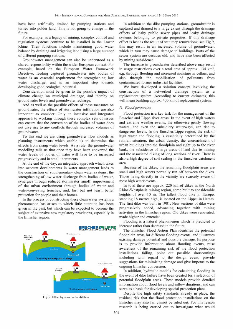
In the process of constructing these clean water systems a phenomenon has arisen to which little attention has been given in the past, but which can be expected to become the subject of extensive new regulatory provisions, especially in the Emscher region.
Fig. 9. Effect by sewer rehabilitation
In addition to the dike pumping stations, groundwater is captured and drained to a large extent through the drainage effects of leaky public sewer pipes and leaky drainage systems belonging to private properties. If this drainage effect is lost as the result of statutory renovations; see Fig.9, this may result in an increased volume of groundwater, which in turn may cause damage to buildings. Parts of the sewer system are decades old, and have also been affected by mining subsidence.
The increase in groundwater described above may result in usage restrictions over a total area of approx. 134 km², e.g. through flooding and increased moisture in cellars, and also through the mobilisation of pollutants from contaminated former industrial facilities.
We have developed a solution concept involving the construction of a networked drainage system as a replacement system. According to current estimates, this will mean building approx. 400 km of replacement system.
D. Flood protection Flood protection is a key task for the management of the
Emscher and Lippe river areas. In the event of high waters and extreme weather events, the otherwise gently flowing waters, and even the subsidiary waterways, can rise to dangerous levels. In the Emscher/Lippe region, the risk of high water and flooding is essentially determined by the rainfall situation, the urban density, the encroachment of urban buildings into the floodplain and right up to the river bank, the subsidence of large areas of land due to mining and the associated diking of long sections of river. There is also a high degree of soil sealing in the Emscher catchment area.
Because of the dikes, the remaining floodplain areas are small and high waters normally run off between the dikes. Those living directly in the vicinity are scarcely aware of most high water events.
In total there are approx. 220 km of dikes in the North Rhine-Westphalia mining region, some built to considerable heights of over 10 m. The tallest flood dike in Europe, standing 18 metres high, is located on the Lippe, in Hamm. The first dike was built in 1901. New sections of dike were progressively added, advancing together with mining activities in the Emscher region. Old dikes were renovated, made higher and extended.
Flooding is a natural phenomenon which is predicted to increase rather than decrease in the future.
The Emscher Flood Action Plan identifies the potential floodplain areas for different flooding events, and illustrates existing damage potential and possible damage. Its purpose is to provide information about flooding events, raise awareness of the remaining risk of the flood protection installations failing, point out possible shortcomings including with regard to the design event, provide suggestions for minimising damage and give impetus to the ongoing Emscher conversion.
In addition, hydraulic models for calculating flooding in the event of dike failure have been created for a selection of potential floodplain areas. These models provide detailed information about flood levels and inflow durations, and can serve as a basis for developing special protection plans.
Despite the high safety standards already in place, the residual risk that the flood protection installations on the Emscher may also fail cannot be ruled out. For this reason research is being carried out to investigate what would

16TH INTERNATIONAL CONGRESS FOR MINE SURVEYING, BRISBANE, AUSTRALIA, 12-16 SEPT 2016
305
happen if the system were overloaded − both with and without the dikes failing. The system becomes overloaded in the event of a flood that exceeds the respective design flood.
If for example we want to minimise the impact from a polder becoming flooded due to dike failure in an extreme flooding event, the dike must be designed to be overflow-proof at the overload point. This measure reduces flooding in polders, but it also leads to an increased overflow risk further downstream. Overflow protection therefore leads to additional floodplain areas. However, it results in less overall damage than would be caused by dike failure.
The High Water Danger and Flood Risk Maps are an important basic resource for all stakeholders and individuals, as they enable each person to assess their individual risk position and take preventive steps to minimise damage.
E. Collaboration and initiatives The water boards have already been working with a wide
range of people who have a stake in water management issues, including members, residents, politicians, authorities, etc. for over a hundred years. Despite this they constantly face new challenges, because the circumstances that dictate the necessary collaborations are subject to rapid development in a rapidly evolving environment.
For example, demographic changes mean that by 2030 the region's population will have shrunk by up to 10%. At the same time life expectancy is increasing, which means that more medicinal products are consumed, leading to an increase of trace elements in the wastewater.
The Emschergenossenschaft is taking part in a large number of EU projects in which it works with its project partners to share and promote knowledge and to create awareness about sustainable water management, which unites all aspects of the water cycle, making an important contribution to life in tomorrow's cities. Water management, urban design, design of outdoor spaces, adapting to climate change, road construction, education, art and culture are growing ever closer to each other.
Already in 2005 the cities of the Emscher region, the Environment Department of North Rhine-Westphalia and the Emschergenossenschaft signed an initial agreement, the "Future Stormwater Agreement", committing to an ambitious water management target. It was agreed that wherever possible clean stormwater was to be returned to benefit the natural water cycle; see Fig.10, instead of being directed into the sewer system and into the wastewater treatment plants.
The inhabitants of the region have embraced both the planned measures and those already implemented. There is consistently high acceptance of the measures planned for the Emscher and Lippe regions. Image analyses show that the work done by the water boards is highly valued.
Fig. 10. Storm water infiltration
F. The contribution provided by mine surveying Right from the outset the mine surveyors, who often
occupy elevated positions as members of the boards of management or supervisory boards, have assisted water management companies in accomplishing their wide range of tasks.
This situation has its origin in the significance of specific mine surveying issues at the interface between mining and water management. From a very early stage mine surveyors in the service of the water boards started to tackle the issues surrounding the effects of mining on water management, in particular the expected subsidence and the resulting disturbance to run-off capability.
One of the first practically feasible methods for the advance calculation of subsidence was developed by a mine surveyor named Keinhorst, one of the first heads of the department dealing with mining-related issues at the Emschergenossenschaft and Lippeverband. Preventive flood protection and preventive control of groundwater and run-off capability always requires the implementation and analysis of dismantling plans, advance calculation of subsidence, and the development of subsidence scenarios and measures to prevent damage from mining.
In order to be compliant and environmentally sustainable, planning measures relating to mining and water construction need to obtain ecological and water management approval, provide a geotechnical and hydrological basis, and establish a consensus between the various interest groups.
In an urban agglomeration dominated by the steel and coal industry and other heavy industries, construction measures always require risk analyses and assessments of routing, e.g. with regard to the danger posed by the dismantling of old mine workings close to the surface. A distribution of the costs of water management measures necessitated by mining which fairly takes into account allocation of responsibility is only possible with a background of technical expertise in mining and mine surveying.
Working through issues relating to mine water and water quality and developing plans for dealing with mine water contributes to the conversion of our flowing water systems.
In addition to standard measurement procedures such as tacheometry and GPS measurement, comprehensive construction projects and the monitoring of successful outcomes, as well as the documentation of measures

16TH INTERNATIONAL CONGRESS FOR MINE SURVEYING, BRISBANE, AUSTRALIA, 12-16 SEPT 2016
306
undertaken, require the use of modern techniques such as satellite or terrestrial radar interferometry; see Fig.11, quadcopters or autonomously functioning measuring robots, and airborne and terrestrial laser scanning. Testing new, alternative technologies from disciplines such as fibre optics or geophysics for their applicability in water management forms part of our regular work.
In our daily work we use state of the art IT tools to provide geodata, we process data in a wide variety of ways and we develop and use intelligent geoinformation systems (GIS) to enable wide-ranging connectivity of different data and systems, e.g. Echolot and aerial data, GIS systems and non-GIS systems, etc.
Fig.11. Radar interferometry
V. CONCLUSION – OUTLOOK For over 100 years, the Emschergenossenschaft and the
Lippeverband have been performing water management as a public service. The significant influence of coal mining has continuously altered the water management systems in the Emscher and Lippe in such a way as to enable industrial and commercial development in the region. The proper functioning of wastewater drainage and treatment, as well as flood protection, has been constantly assured.
With the northwards migration of mining, it has been possible to undertake the ecological restructuring of the entire system. This will be completed by the year 2020. By taking a holistic, interdisciplinary approach, we can also achieve structural change in the mining region. This system also takes social changes into consideration from the perspective of sustainability.
Our approach to the generational Emscher conversion project of considering the water cycle as a whole, the implementation of technical innovations and ground-breaking collaborations, and our established management structures appropriate to a modern company can all be taken as an example and extended to other large-scale issues relating to mining and water management, even on a global scale.
Collaboration always brings rewards − in this context, the co-operative company is synonymous with co-operation. The idea of the co-operative as a public service provider is very current. For water management this means finding joint solutions to common problems and tasks, considering and managing water catchment areas in a holistic manner, getting both public and private companies to engage in dialogue, viewing water management as a public service duty and acting in the interests of public good.
All participants in similar projects must aim to exploit opportunities relating to all dimensions of sustainability for economic, ecological and social purposes, deriving maximum benefit for the regions in question. The potential benefits are often uncommonly large.
Related Documents