Industry Engagement Forum Stephen Volz, Ph.D., Assistant Administrator National Environmental Satellite, Data, and Information Service IEF #5 - June 24, 2021

Welcome message from author
This document is posted to help you gain knowledge. Please leave a comment to let me know what you think about it! Share it to your friends and learn new things together.
Transcript
Industry Engagement Forum
Stephen Volz, Ph.D., Assistant Administrator
National Environmental Satellite, Data, and Information ServiceIEF #5 - June 24, 2021
Agenda
2NOAA National Environmental Satellite, Data, and Information
▪ Administration Priorities
▪ Accomplishments
▪ Budget Overview
▪ Why Now Matters
▪ Global Satellite Earth Observation Environment
▪ Four Pillars of NESDIS
▪ Scoping the Resources Required
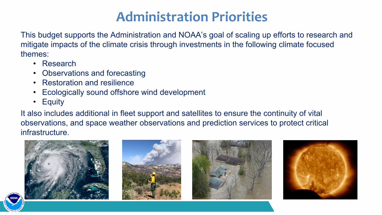
Administration PrioritiesThis budget supports the Administration and NOAA’s goal of scaling up efforts to research and mitigate impacts of the climate crisis through investments in the following climate focused themes:
• Research• Observations and forecasting • Restoration and resilience • Ecologically sound offshore wind development • Equity
It also includes additional in fleet support and satellites to ensure the continuity of vital observations, and space weather observations and prediction services to protect critical infrastructure.
Administration Priorities
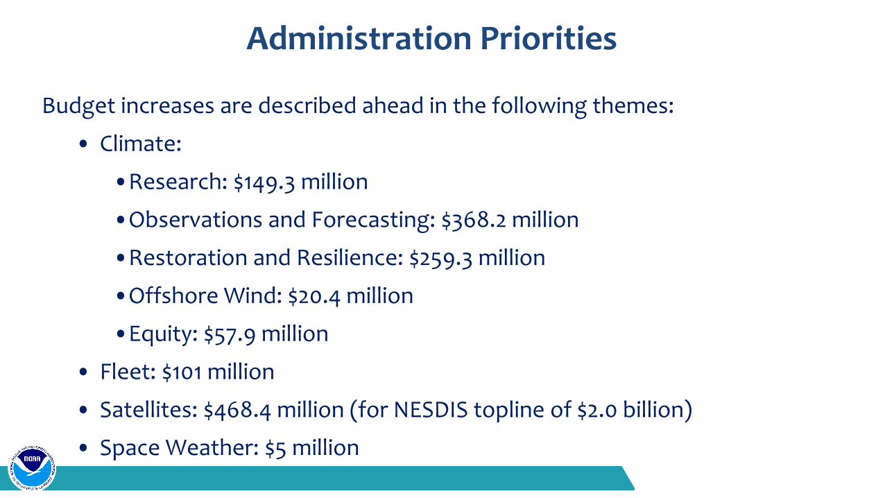
Budget increases are described ahead in the following themes:
• Climate:
•Research: $149.3 million
•Observations and Forecasting: $368.2 million
•Restoration and Resilience: $259.3 million
•Offshore Wind: $20.4 million
•Equity: $57.9 million
• Fleet: $101 million
• Satellites: $468.4 million (for NESDIS topline of $2.0 billion)
• Space Weather: $5 million
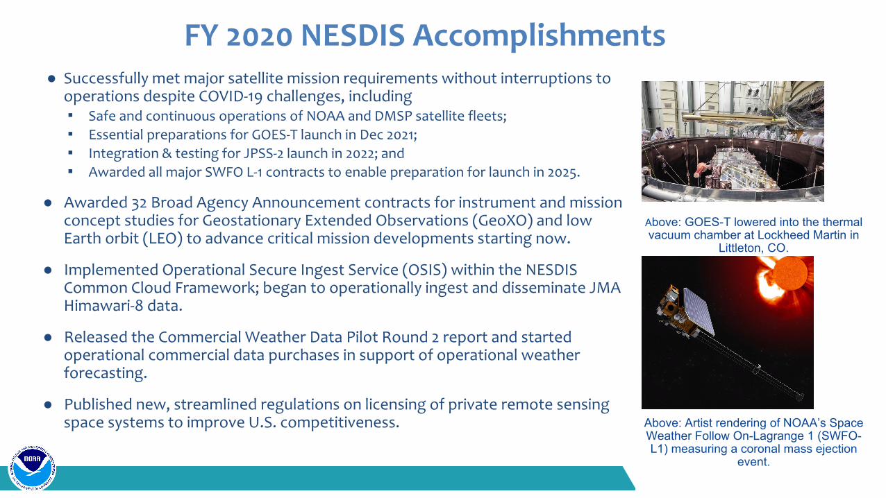
● Successfully met major satellite mission requirements without interruptions to operations despite COVID-19 challenges, including ▪ Safe and continuous operations of NOAA and DMSP satellite fleets;▪ Essential preparations for GOES-T launch in Dec 2021;▪ Integration & testing for JPSS-2 launch in 2022; and▪ Awarded all major SWFO L-1 contracts to enable preparation for launch in 2025.
● Awarded 32 Broad Agency Announcement contracts for instrument and mission concept studies for Geostationary Extended Observations (GeoXO) and low Earth orbit (LEO) to advance critical mission developments starting now.
● Implemented Operational Secure Ingest Service (OSIS) within the NESDIS Common Cloud Framework; began to operationally ingest and disseminate JMA Himawari-8 data.
● Released the Commercial Weather Data Pilot Round 2 report and started operational commercial data purchases in support of operational weather forecasting.
● Published new, streamlined regulations on licensing of private remote sensing space systems to improve U.S. competitiveness.
FY 2020 NESDIS Accomplishments
Above: GOES-T lowered into the thermal vacuum chamber at Lockheed Martin in
Littleton, CO.
Above: Artist rendering of NOAA’s Space Weather Follow On-Lagrange 1 (SWFO-L1) measuring a coronal mass ejection
event.
FY 2022 NESDIS Budget Overview● FY 2022 President’s Budget requests a total of $2,029.0 million and 800 FTE/ 844 positions for the National Environmental Satellite,
Data, and Information Service (NESDIS); reflecting a net increase of $515.2 million from FY 2021 Enacted:○ -$0.6 million for Technical Adjustments○ +$8.2 million for Calculated Inflationary Adjustments○ +$2.6 million to restore funds reprogrammed in FY 2021 to support WCOSS and G550○ +$504.9 million in Narrative Program Changes from FY 2021 PB
● With this request, NESDIS proposes to:○ Support NOAA’s current satellite constellation and enable time critical program development for the next generation of
satellite observing and ground systems that will deliver assets in 2030 to 2050;○ Transition to an integrated and adaptable portfolio observing system and program management structure for major systems
development.○ Accelerate product service delivery to meet established customer needs, and to develop enhanced products to meet climate
service needs.○ Enable NOAA to better understand and forecast across weather, seasonal, and climatic timescales to deliver products and
services for decision-makers, as described in Weather Act Weather Research and Forecasting Innovation Act of 2017 (P.L.115-25) and National Integrated Drought Information System Reauthorization Act of 2018 (P.L.115-423).
○ Leverage and foster interagency, commercial, and international partnerships for observations and critical technology development, particularly in low Earth orbit.
○ Exploit information technology, such as cloud and artificial intelligence to enable expansion of the size and diversity of NOAA’s user community.
○ Conduct essential system cost vs performance trades to define the NOAA observing system that can fit within a flat $2.0 billion budget starting in FY 2022 with no outyear increases other than government-wide inflation assumptions.
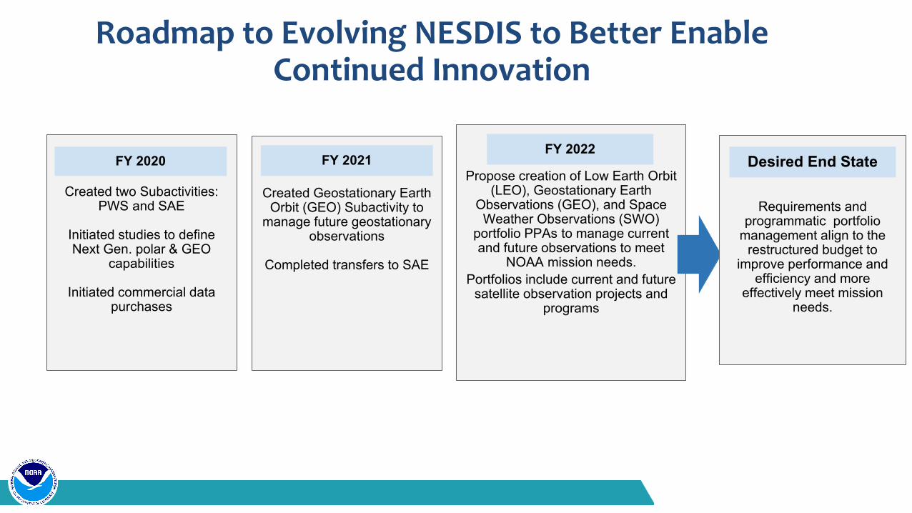
Roadmap to Evolving NESDIS to Better Enable Continued Innovation
Created Geostationary Earth Orbit (GEO) Subactivity to
manage future geostationary observations
Completed transfers to SAE
Created two Subactivities:PWS and SAE
Initiated studies to define Next Gen. polar & GEO
capabilities
Initiated commercial data purchases
Propose creation of Low Earth Orbit (LEO), Geostationary Earth
Observations (GEO), and Space Weather Observations (SWO)
portfolio PPAs to manage current and future observations to meet
NOAA mission needs. Portfolios include current and future
satellite observation projects and programs
FY 2020 FY 2021FY 2022
Requirements and programmatic portfolio
management align to the restructured budget to
improve performance and efficiency and more
effectively meet mission needs.
Desired End State
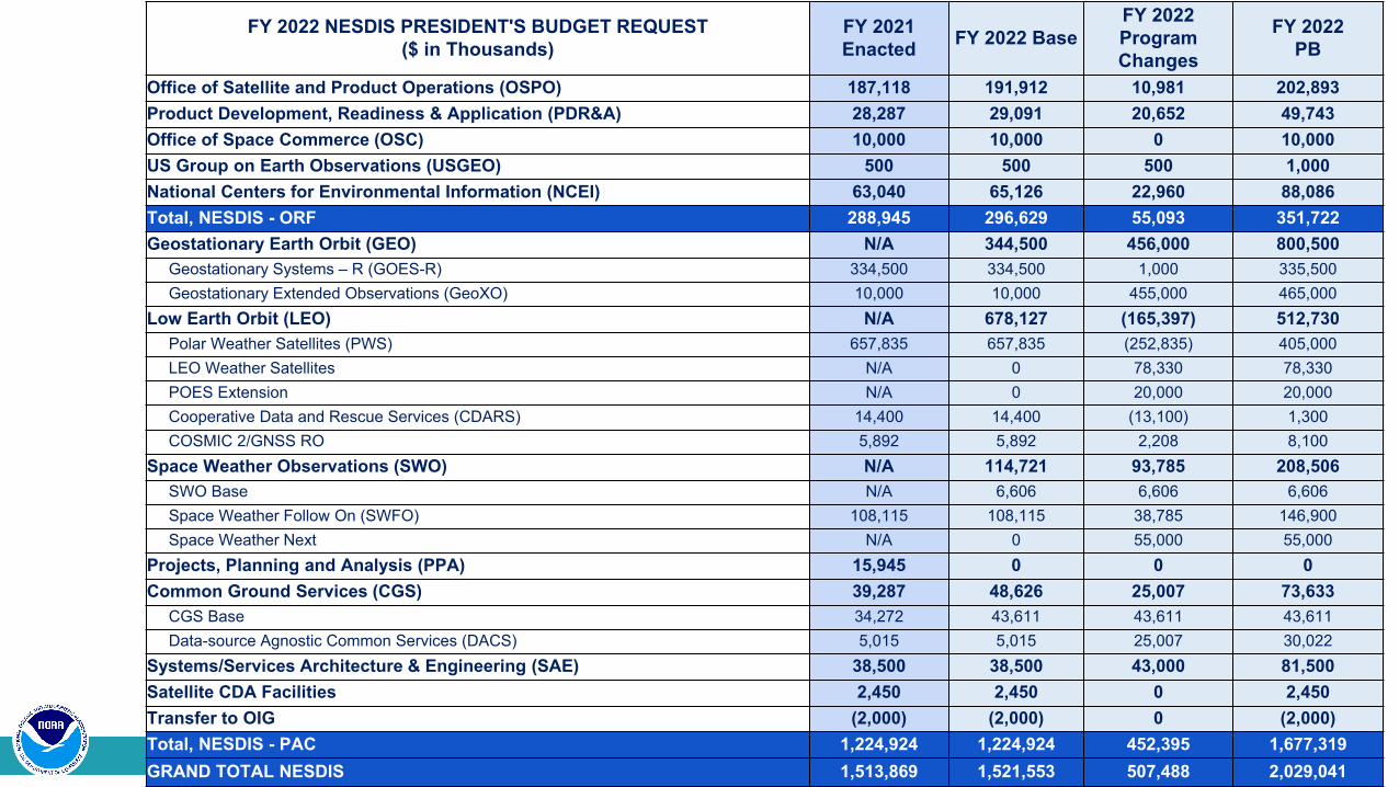
FY 2022 NESDIS PRESIDENT'S BUDGET REQUEST($ in Thousands)
FY 2021 Enacted FY 2022 Base
FY 2022 Program Changes
FY 2022 PB
Office of Satellite and Product Operations (OSPO) 187,118 191,912 10,981 202,893Product Development, Readiness & Application (PDR&A) 28,287 29,091 20,652 49,743Office of Space Commerce (OSC) 10,000 10,000 0 10,000US Group on Earth Observations (USGEO) 500 500 500 1,000National Centers for Environmental Information (NCEI) 63,040 65,126 22,960 88,086Total, NESDIS - ORF 288,945 296,629 55,093 351,722Geostationary Earth Orbit (GEO) N/A 344,500 456,000 800,500
Geostationary Systems – R (GOES-R) 334,500 334,500 1,000 335,500Geostationary Extended Observations (GeoXO) 10,000 10,000 455,000 465,000
Low Earth Orbit (LEO) N/A 678,127 (165,397) 512,730Polar Weather Satellites (PWS) 657,835 657,835 (252,835) 405,000LEO Weather Satellites N/A 0 78,330 78,330POES Extension N/A 0 20,000 20,000Cooperative Data and Rescue Services (CDARS) 14,400 14,400 (13,100) 1,300COSMIC 2/GNSS RO 5,892 5,892 2,208 8,100
Space Weather Observations (SWO) N/A 114,721 93,785 208,506SWO Base N/A 6,606 6,606 6,606Space Weather Follow On (SWFO) 108,115 108,115 38,785 146,900Space Weather Next N/A 0 55,000 55,000
Projects, Planning and Analysis (PPA) 15,945 0 0 0Common Ground Services (CGS) 39,287 48,626 25,007 73,633
CGS Base 34,272 43,611 43,611 43,611Data-source Agnostic Common Services (DACS) 5,015 5,015 25,007 30,022
Systems/Services Architecture & Engineering (SAE) 38,500 38,500 43,000 81,500Satellite CDA Facilities 2,450 2,450 0 2,450Transfer to OIG (2,000) (2,000) 0 (2,000)Total, NESDIS - PAC 1,224,924 1,224,924 452,395 1,677,319GRAND TOTAL NESDIS 1,513,869 1,521,553 507,488 2,029,041
FY 2022 Budget RestructureIn FY 2022, NOAA proposes to restructure the NESDIS budget to:
• Execute major satellite programs cost effectively and efficiently by conducting technical and procurement risk management across multiple projects within a observing system portfolio
– Enables NESDIS to manage impacts to individual programs collectively, avoiding multiple program corrections at DOC, OMB, and Congressional level
– For example, NESDIS would manage COVID-19 impacts for GOES-R (~$60M) and SWFO (~$30M) within portfolio budgets without additional funds
• Collect and manage requirements at the observations level, rather than at the instrument or platform level• Enable management of LEO, GEO, and Space Weather observations as portfolios, allowing for more effective
rapid development and deployment for high mission value observations while maintaining transparency• Leverage new public and private sector science, technical, and information sciences innovation through more
sustained observing system developmentChallenges the restructured budget will help NESDIS overcome are:
• Resources, products, and offices are bound to specific satellite missions with limited timelines, rather than to sustained observational requirements
• Higher acquisition costs due to an inability to balance risks across observation sets• Information products tied to individual satellite platforms, making it more difficult to support enterprise
products, regardless of the data source.• Missed opportunities to exploit partnerships and technology innovation, and to influence partner investments

NESDIS Budget Profile (FY 2016 to 2026)
*The FY 2023-2026 outyear profile holds NESDIS at the FY 2022 requested funding level of $2,029.0 million plus inflation.
FY 2022 NOAA Satellites○ Transition to an integrated and adaptable portfolio observing system and program management
structure ○ Initiate time critical program development for next generation geostationary and space weather satellite
observations■ Support Geostationary Extended Observations (GeoXO) development to ensure these critical assets
are in place by the early 2030s■ Initiate Space Weather Next (SWNext) to sustain, improve, extend and mitigate potential gaps in
observations to support NOAA space weather forecast operations ○ Leverage and foster interagency, commercial, and international partnerships for observations and critical
technology development, particularly in low Earth Orbit (LEO) domain
○ Exploit information technology, such as cloud and artificial intelligence via Common Ground Services to enable expansion of NOAA’s user community. ■ Continue leveraging non-NOAA partner and commercial
data sources and to provide the IT infrastructure to securely ingest, generate science products, distribute, and archive data.
○ Accelerate enhanced product service delivery to meet customer and today’s climate service needs.
FY 2022 NESDIS SummaryFY 2022 President’s Budget request provides $2,029.0 million for NESDIS, which will: ● Evolve to a more integrated and adaptable portfolio budget structure;● Support investments toward the next generation of satellite observing and ground
systems that will deliver space assets in 2030 to 2050;● Leverage and foster interagency, commercial, and international partnerships to
continue to deliver and evolve a resilient and high-performing observing system;● Continue operations and sustainment, data management, and systems acquisition for
current satellite programs to meet NOAA’s mission; ● Support EO 14008, Tackling the Climate Crisis at Home and Abroad, to help NOAA
better understand climate change-related trends and patterns, and deliver products, information, and climate services to inform decision makers;
● Exploit information technology trends, such as cloud and artificial intelligence; and,● Provide a NESDIS observing system that accommodates a flat line budget with no
outyear increases other than government-wide inflation assumptions.
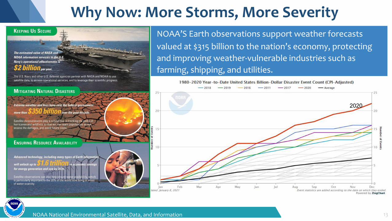
Why Now: More Storms, More Severity
13NOAA National Environmental Satellite, Data, and Information Service
NOAA’S Earth observations support weather forecastsvalued at $315 billion to the nation’s economy, protecting and improving weather-vulnerable industries such as farming, shipping, and utilities.
2020
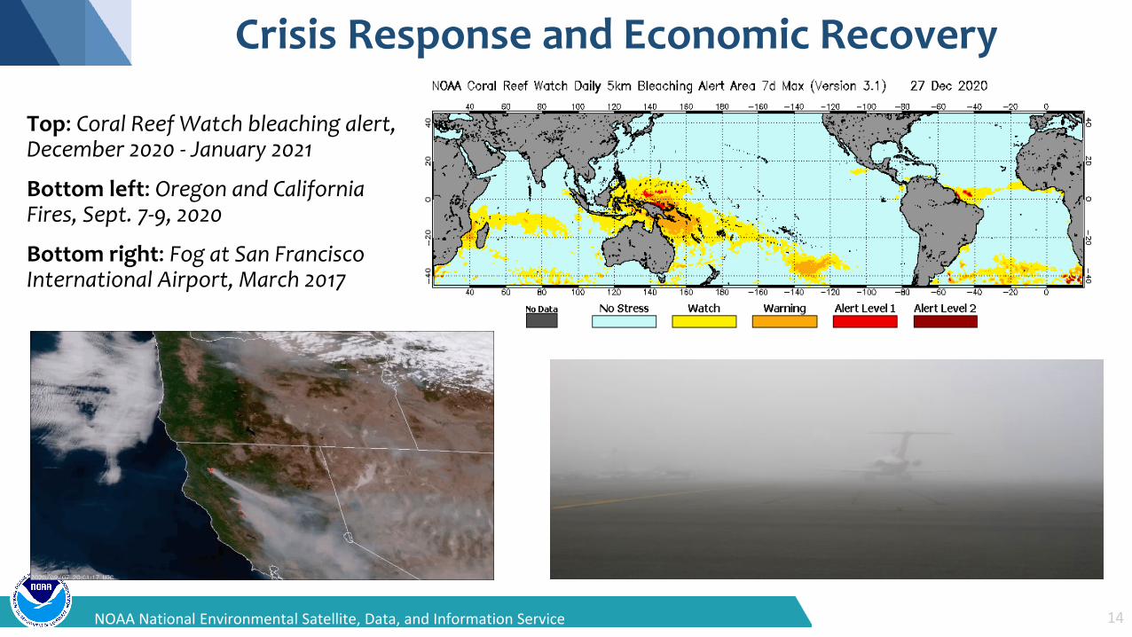
Crisis Response and Economic Recovery
14NOAA National Environmental Satellite, Data, and Information Service
Top: Coral Reef Watch bleaching alert, December 2020 - January 2021
Bottom left: Oregon and California Fires, Sept. 7-9, 2020
Bottom right: Fog at San Francisco International Airport, March 2017
NESDIS
15NOAA National Environmental Satellite, Data, and Information Service
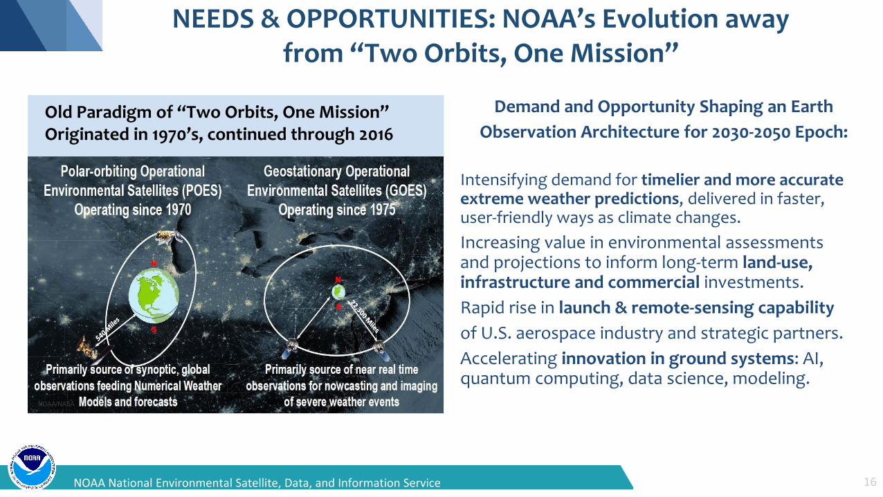
NEEDS & OPPORTUNITIES: NOAA’s Evolution away from “Two Orbits, One Mission”
Demand and Opportunity Shaping an EarthObservation Architecture for 2030-2050 Epoch:
Intensifying demand for timelier and more accurate extreme weather predictions, delivered in faster, user-friendly ways as climate changes.Increasing value in environmental assessments and projections to inform long-term land-use, infrastructure and commercial investments.Rapid rise in launch & remote-sensing capabilityof U.S. aerospace industry and strategic partners.Accelerating innovation in ground systems: AI, quantum computing, data science, modeling.
Old Paradigm of “Two Orbits, One Mission” Originated in 1970’s, continued through 2016
16NOAA National Environmental Satellite, Data, and Information Service
FY 2025
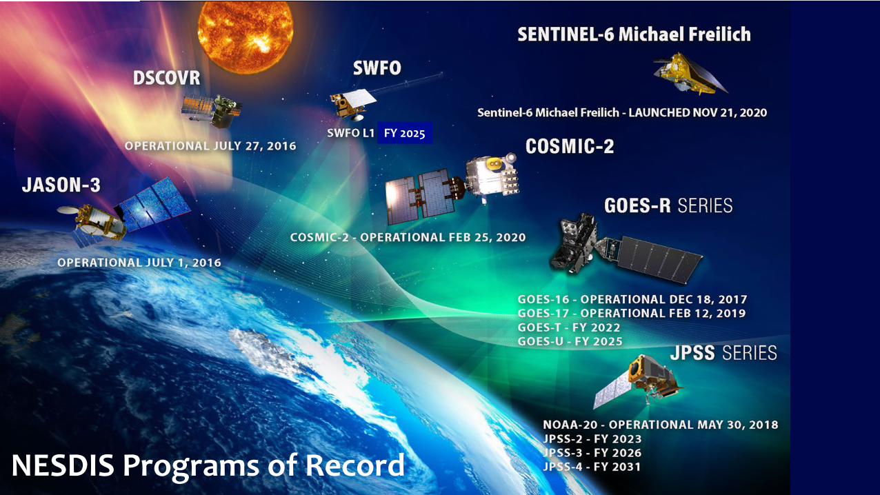
NESDIS Programs of Record
NOAA National Environmental Satellite, Data, and Information Service
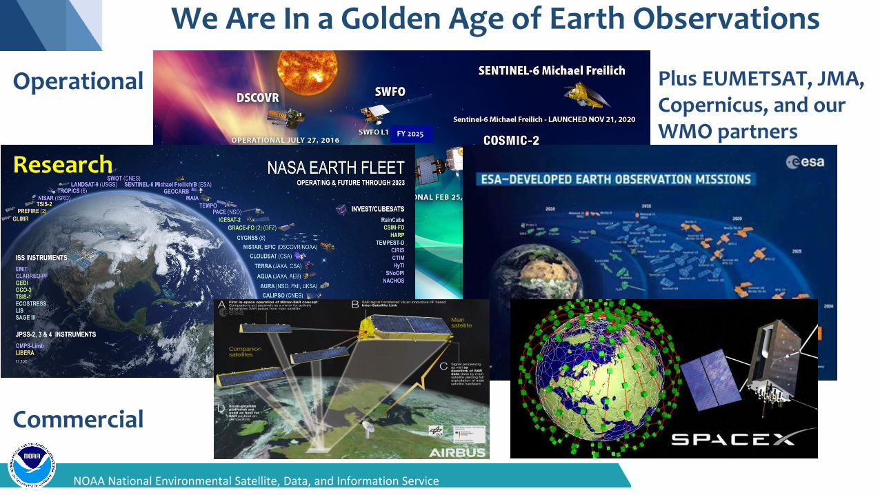
We Are In a Golden Age of Earth Observations
FY 2025
Operational
Research
Commercial
Plus EUMETSAT, JMA, Copernicus, and our WMO partners
NOAA’s Next-Gen Earth Observation Strategy
Continuous real-time observations supporting warnings and watches
of severe weather and hour-by-hour changes. High-inclination
orbits to observe northern latitude & polar regions.
Miniaturized instruments on small, lower cost, and proliferated satellites and partner data improving forecasts through better and additional data. Better precipitation forecasts, wave height predictions, ocean currents,
and more.
Secure ingest of data in different formats from different partners requires a flexible, scalable platform. Common Services approach integrates cloud, AI, and machine-learning capabilities to verify, calibrate, and fuse data into
new and better products and services.
Reliably monitoring coronal mass ejections from L1, GEO, and LEO
can protect the nation’s valuable, vulnerable infrastructure. New capabilities at L5 and high earth
orbit can provide additional insight and improve forecasts.
LEO GEO
Common Ground Services
Space Weather
Integrated, Adaptable, and Affordable: Orbits, Instruments & Systems
19NOAA National Environmental Satellite, Data, and Information Service

20NOAA National Satellite, Data, and Information Service
Geostationary (GEO) Portfolio
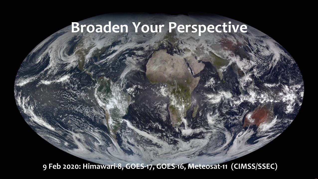
9 Feb 2020: Himawari-8, GOES-17, GOES-16, Meteosat-11 (CIMSS/SSEC)
Broaden Your Perspective
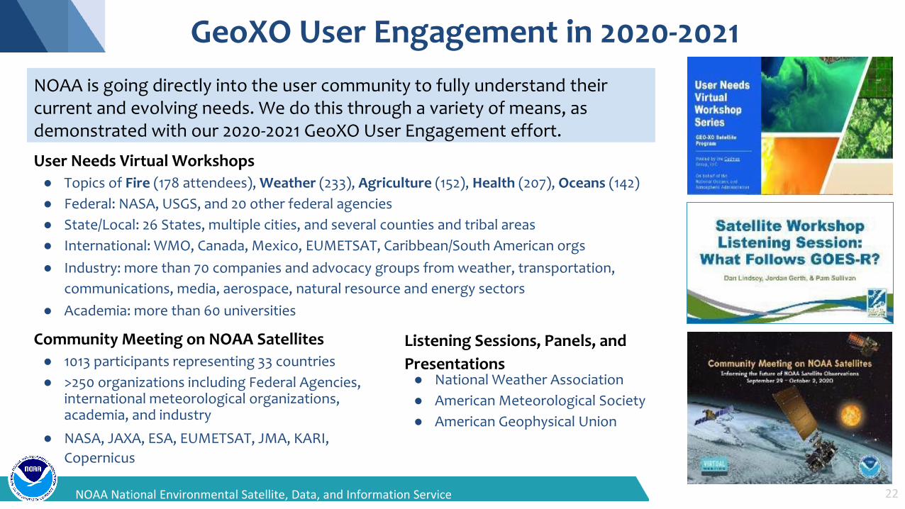
GeoXO User Engagement in 2020-2021
User Needs Virtual Workshops● Topics of Fire (178 attendees), Weather (233), Agriculture (152), Health (207), Oceans (142)● Federal: NASA, USGS, and 20 other federal agencies● State/Local: 26 States, multiple cities, and several counties and tribal areas● International: WMO, Canada, Mexico, EUMETSAT, Caribbean/South American orgs● Industry: more than 70 companies and advocacy groups from weather, transportation,
communications, media, aerospace, natural resource and energy sectors● Academia: more than 60 universities
22NOAA National Environmental Satellite, Data, and Information Service
Community Meeting on NOAA Satellites● 1013 participants representing 33 countries● >250 organizations including Federal Agencies,
international meteorological organizations, academia, and industry
● NASA, JAXA, ESA, EUMETSAT, JMA, KARI, Copernicus
Listening Sessions, Panels, andPresentations● National Weather Association● American Meteorological Society● American Geophysical Union
NOAA is going directly into the user community to fully understand their current and evolving needs. We do this through a variety of means, as demonstrated with our 2020-2021 GeoXO User Engagement effort.
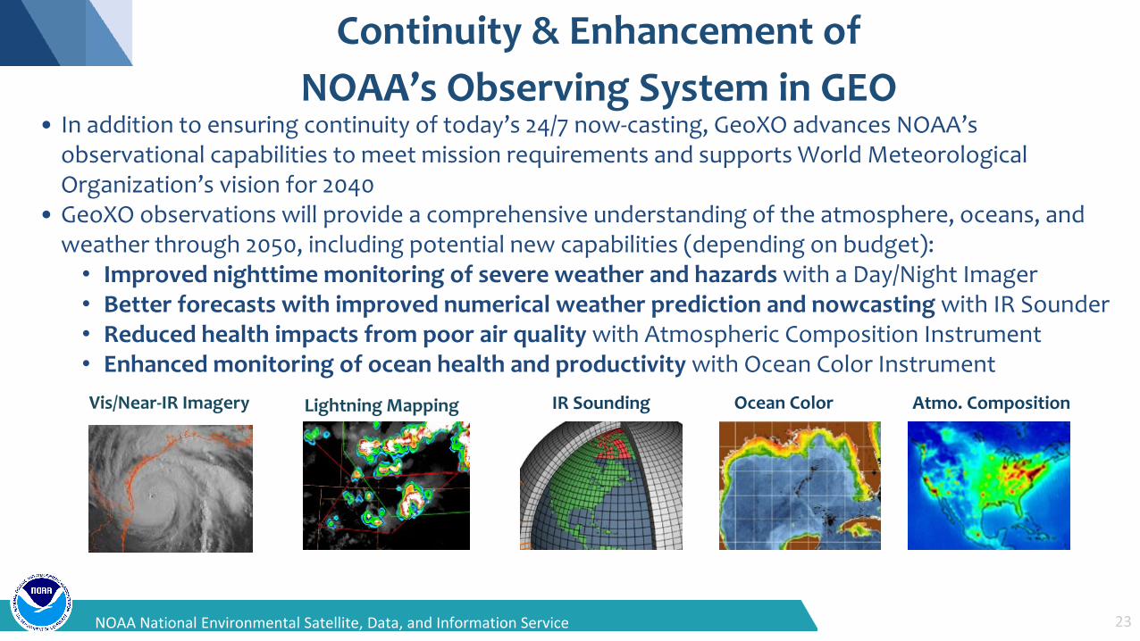
Continuity & Enhancement ofNOAA’s Observing System in GEO
• In addition to ensuring continuity of today’s 24/7 now-casting, GeoXO advances NOAA’s observational capabilities to meet mission requirements and supports World Meteorological Organization’s vision for 2040
• GeoXO observations will provide a comprehensive understanding of the atmosphere, oceans, andweather through 2050, including potential new capabilities (depending on budget):
• Improved nighttime monitoring of severe weather and hazards with a Day/Night Imager• Better forecasts with improved numerical weather prediction and nowcasting with IR Sounder• Reduced health impacts from poor air quality with Atmospheric Composition Instrument• Enhanced monitoring of ocean health and productivity with Ocean Color Instrument
23NOAA National Environmental Satellite, Data, and Information Service
Vis/Near-IR Imagery Lightning Mapping IR Sounding Atmo. CompositionOcean Color
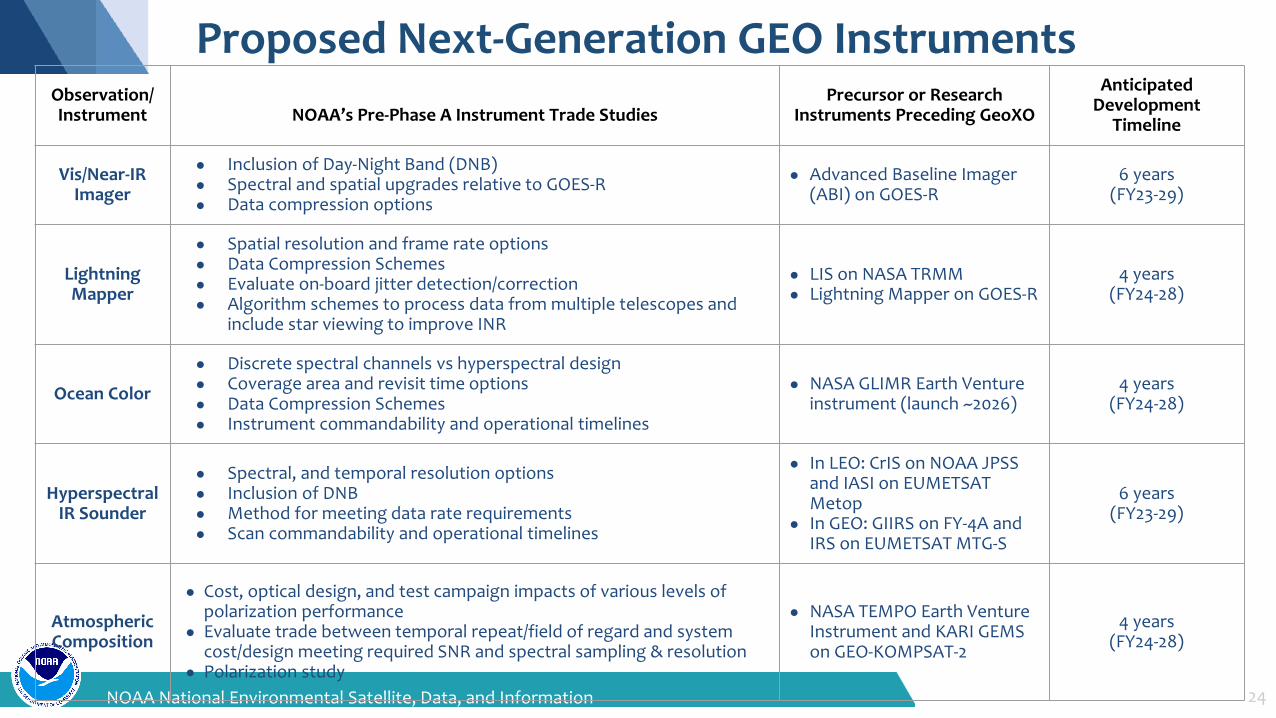
Proposed Next-Generation GEO Instruments
24NOAA National Environmental Satellite, Data, and Information Service
Observation/Instrument NOAA’s Pre-Phase A Instrument Trade Studies
Precursor or Research Instruments Preceding GeoXO
Anticipated Development
Timeline
Vis/Near-IR Imager
● Inclusion of Day-Night Band (DNB)● Spectral and spatial upgrades relative to GOES-R● Data compression options
● Advanced Baseline Imager (ABI) on GOES-R
6 years(FY23-29)
Lightning Mapper
● Spatial resolution and frame rate options● Data Compression Schemes● Evaluate on-board jitter detection/correction● Algorithm schemes to process data from multiple telescopes and
include star viewing to improve INR
● LIS on NASA TRMM ● Lightning Mapper on GOES-R
4 years(FY24-28)
Ocean Color
● Discrete spectral channels vs hyperspectral design● Coverage area and revisit time options ● Data Compression Schemes● Instrument commandability and operational timelines
● NASA GLIMR Earth Venture instrument (launch ~2026)
4 years(FY24-28)
Hyperspectral IR Sounder
● Spectral, and temporal resolution options● Inclusion of DNB● Method for meeting data rate requirements● Scan commandability and operational timelines
● In LEO: CrIS on NOAA JPSS and IASI on EUMETSAT Metop
● In GEO: GIIRS on FY-4A and IRS on EUMETSAT MTG-S
6 years(FY23-29)
Atmospheric Composition
● Cost, optical design, and test campaign impacts of various levels of polarization performance
● Evaluate trade between temporal repeat/field of regard and system cost/design meeting required SNR and spectral sampling & resolution
● Polarization study
● NASA TEMPO Earth Venture Instrument and KARI GEMS on GEO-KOMPSAT-2
4 years(FY24-28)
25NOAA National Satellite, Data, and Information Service
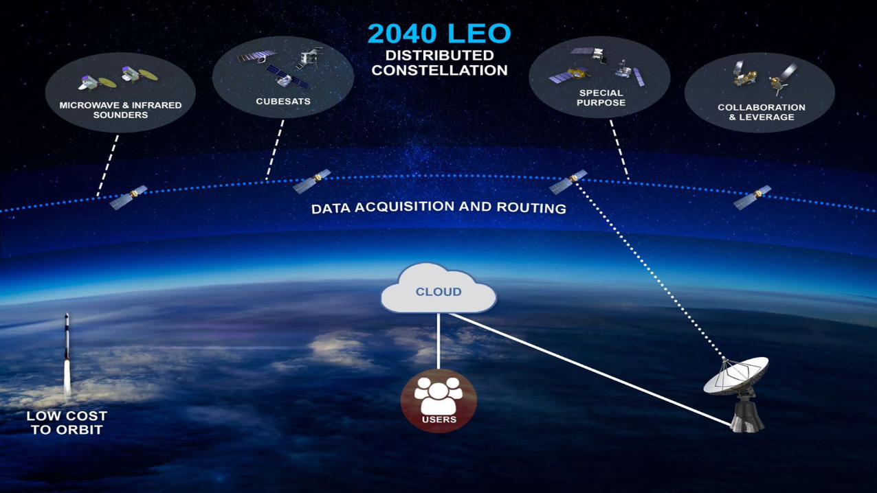
Low Earth Orbit (LEO) Portfolio
Highly Diverse LEO Observations
Multipurpose VIS/NIR/IR Imagery
Soundings from IR/MW/RO
MW ImageryScatterometry
Altimetry
RADAR Imagery
Foundational Products: Satellite Radiances and Satellite Imagery
LIDAR
UV Imagery
NESDIS Level Requirements – Geophysical Products
Atmosphere Cryosphere Land Ocean, Fresh Water & Coasts
AnalyticalClimate & Weather
Ocean, Fresh Water & Coasts
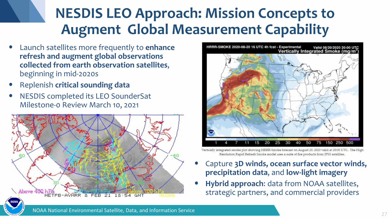
• Capture 3D winds, ocean surface vector winds,precipitation data, and low-light imagery
• Hybrid approach: data from NOAA satellites, strategic partners, and commercial providers
27NOAA National Environmental Satellite, Data, and Information Service
• Launch satellites more frequently to enhance refresh and augment global observations collected from earth observation satellites, beginning in mid-2020s
• Replenish critical sounding data• NESDIS completed its LEO SounderSat
Milestone-0 Review March 10, 2021
NESDIS LEO Approach: Mission Concepts to Augment Global Measurement Capability
Near Term Focus in LEO is on Innovation
In FY 2022, LEO will:• Complete a Commercial Ground Services Demonstration
(JPSS)• Continue the detailed concept development of the SounderSat
Project and the LEO program, including:▪ Milestone 1 for the LEO Program▪ The Mission Concept Review for the SounderSat project▪ The Mission Concept Review for the LEO program
30NOAA National Satellite, Data, and Information Service
Space Weather (SWO) Portfolio
31NOAA National Satellite, Data, and Information Service
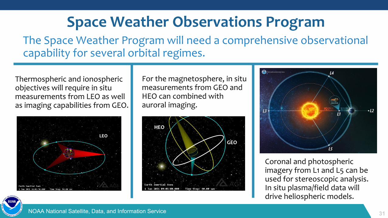
The Space Weather Program will need a comprehensive observational capability for several orbital regimes.
Space Weather Observations Program
LEO
Thermospheric and ionospheric objectives will require in situ measurements from LEO as well as imaging capabilities from GEO.
For the magnetosphere, in situ measurements from GEO and HEO can combined with auroral imaging.
Coronal and photospheric imagery from L1 and L5 can be used for stereoscopic analysis. In situ plasma/field data will drive heliospheric models.
GEO
HEO
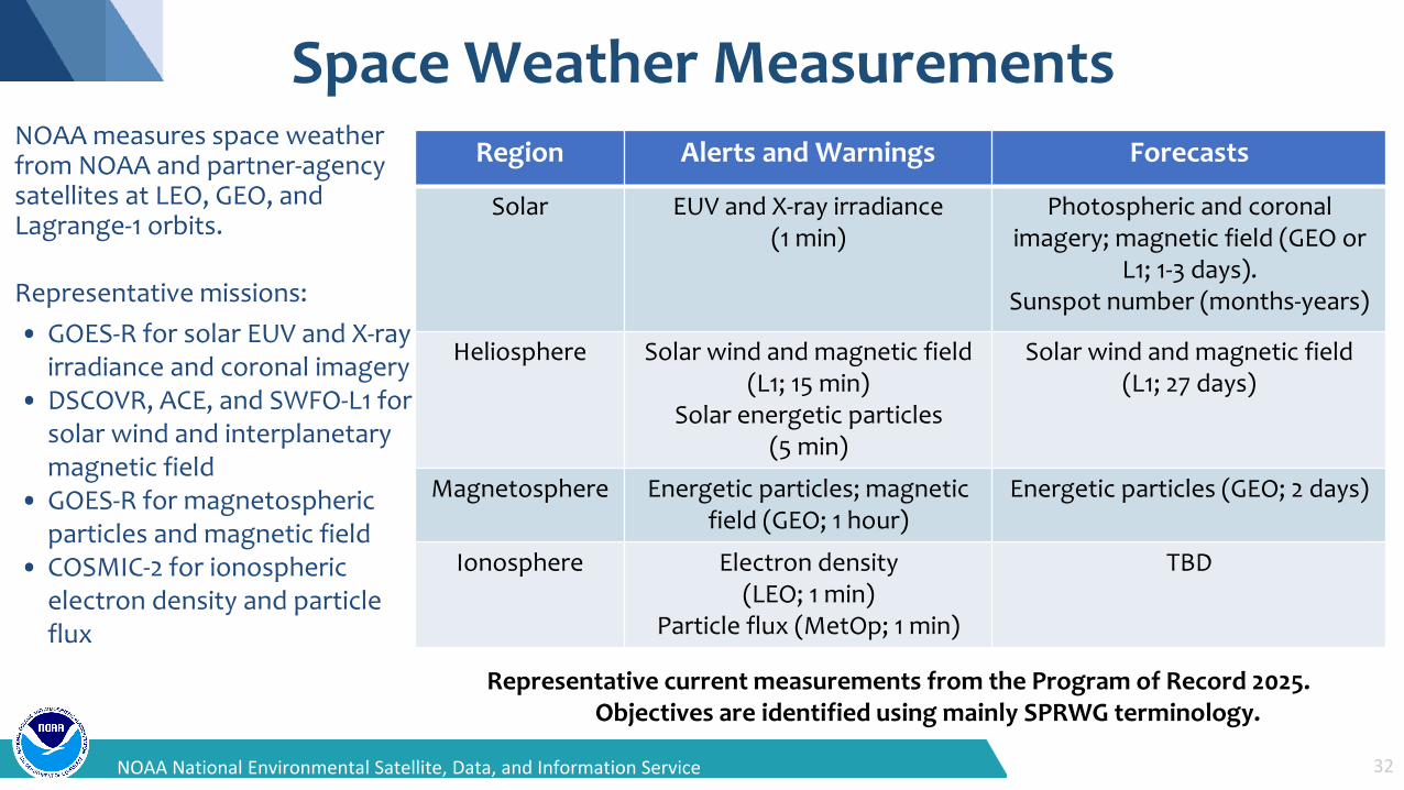
Space Weather Measurements
32NOAA National Environmental Satellite, Data, and Information Service
Region Alerts and Warnings Forecasts
Solar EUV and X-ray irradiance (1 min)
Photospheric and coronal imagery; magnetic field (GEO or
L1; 1-3 days).Sunspot number (months-years)
Heliosphere Solar wind and magnetic field(L1; 15 min)
Solar energetic particles (5 min)
Solar wind and magnetic field(L1; 27 days)
Magnetosphere Energetic particles; magnetic field (GEO; 1 hour)
Energetic particles (GEO; 2 days)
Ionosphere Electron density (LEO; 1 min)
Particle flux (MetOp; 1 min)
TBD
NOAA measures space weather from NOAA and partner-agency satellites at LEO, GEO, and Lagrange-1 orbits.
Representative missions:• GOES-R for solar EUV and X-ray
irradiance and coronal imagery• DSCOVR, ACE, and SWFO-L1 for
solar wind and interplanetary magnetic field
• GOES-R for magnetospheric particles and magnetic field
• COSMIC-2 for ionospheric electron density and particle flux
Representative current measurements from the Program of Record 2025.Objectives are identified using mainly SPRWG terminology.
33NOAA National Satellite, Data, and Information Service
Common Services & Product Development
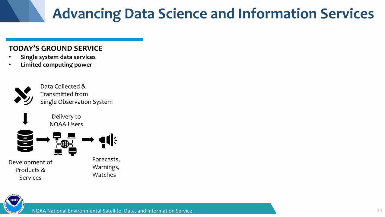
Advancing Data Science and Information Services
TODAY’S GROUND SERVICE• Single system data services• Limited computing power
Data Collected &Transmitted fromSingle Observation System
Delivery to NOAA Users
Development of Products &
Services
Forecasts,Warnings,Watches
34NOAA National Environmental Satellite, Data, and Information Service
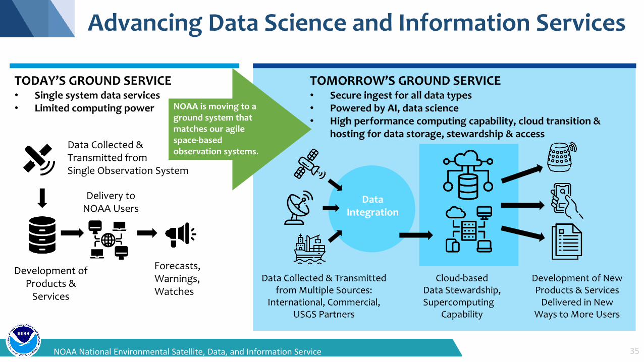
Advancing Data Science and Information Services
TODAY’S GROUND SERVICE• Single system data services• Limited computing power
Data Collected &Transmitted fromSingle Observation System
Development of Products &
Services
Delivery to NOAA Users
Forecasts,Warnings,Watches
TOMORROW’S GROUND SERVICE• Secure ingest for all data types• Powered by AI, data science• High performance computing capability, cloud transition &
hosting for data storage, stewardship & access
Data Collected & Transmitted from Multiple Sources:
International, Commercial, USGS Partners
Cloud-based Data Stewardship, Supercomputing
Capability
Development of New Products & Services
Delivered in New Ways to More Users
Data Integration
NOAA is moving to a
35NOAA National Environmental Satellite, Data, and Information Service
ground system that matches our agile space-basedobservation systems.
19NOAA National Environmental Satellite, Data, and Information Service
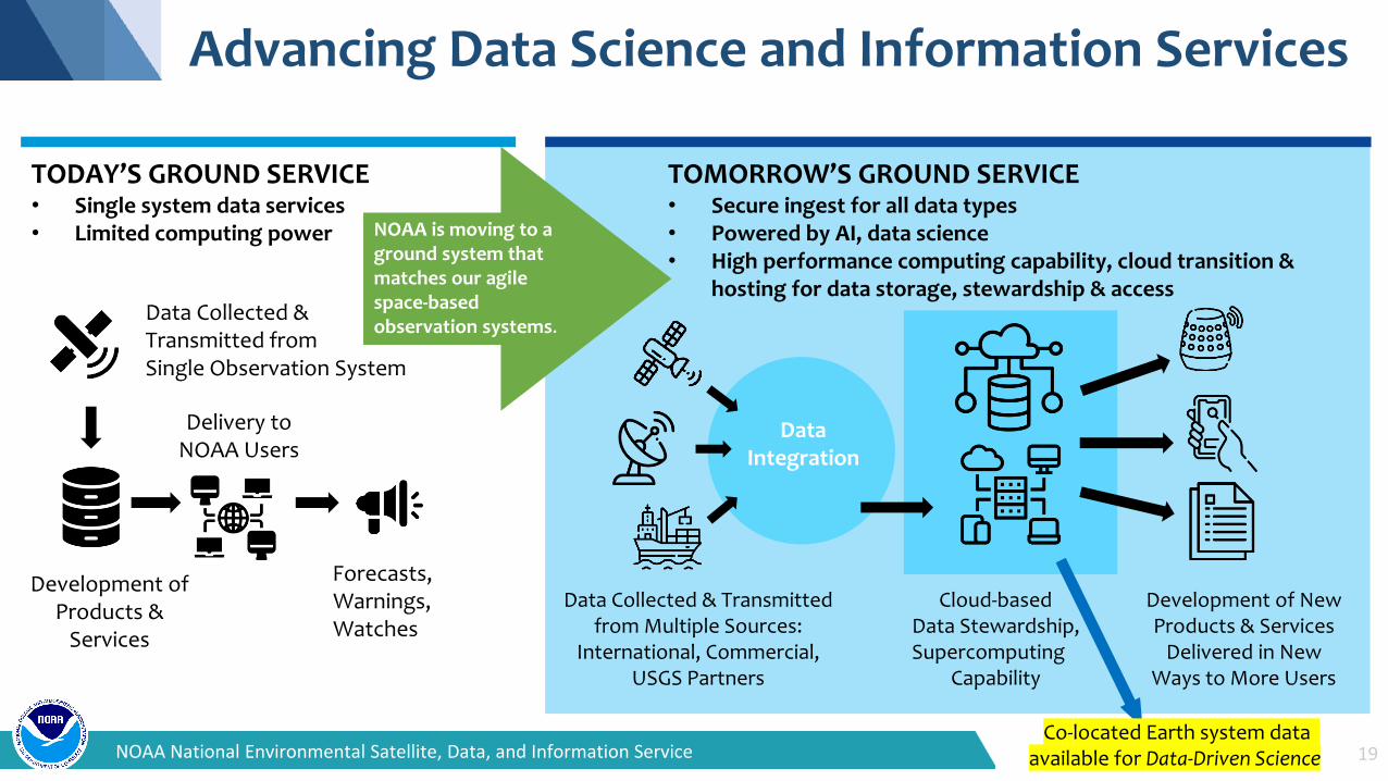
Advancing Data Science and Information Services
TODAY’S GROUND SERVICE• Single system data services• Limited computing power
Data Collected &Transmitted fromSingle Observation System
Development of Products &
Services
Delivery to NOAA Users
Forecasts,Warnings,Watches
TOMORROW’S GROUND SERVICE• Secure ingest for all data types• Powered by AI, data science• High performance computing capability, cloud transition &
hosting for data storage, stewardship & access
Data Collected & Transmitted from Multiple Sources:
International, Commercial, USGS Partners
Cloud-based Data Stewardship, Supercomputing
Capability
Development of New Products & Services
Delivered in New Ways to More Users
Data Integration
NOAA is moving to aground system that matches our agile space-basedobservation systems.
Co-located Earth system data available for Data-Driven Science
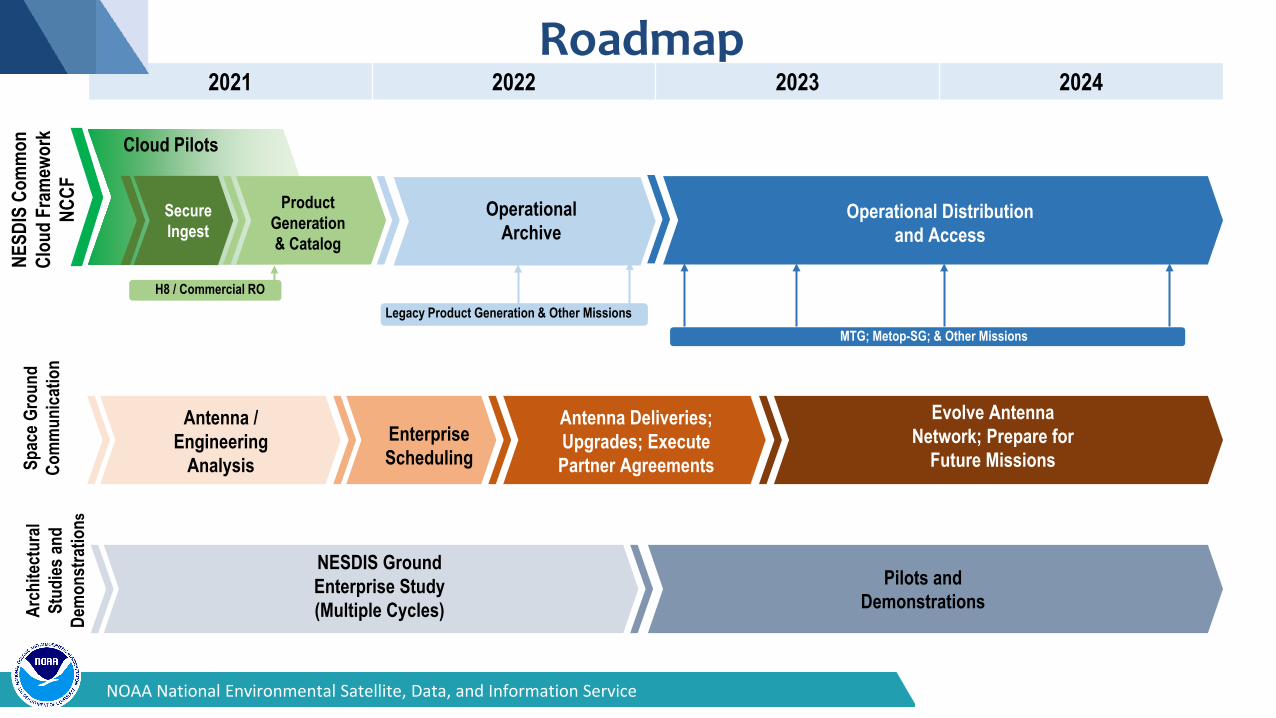
Roadmap2021 2022 2023 2024
Cloud Pilots
Secure Ingest
Product Generation & Catalog
Operational Archive
Operational Distribution and Access
Antenna / Engineering
AnalysisEnterprise Scheduling
Antenna Deliveries; Upgrades; Execute Partner Agreements
H8 / Commercial ROLegacy Product Generation & Other Missions
MTG; Metop-SG; & Other Missions
Evolve Antenna Network; Prepare for
Future Missions
NESDIS Ground Enterprise Study (Multiple Cycles)
Pilots and Demonstrations
NESD
IS C
omm
on
Clou
d Fr
amew
ork
NCCF
Spac
e Gro
und
Com
mun
icatio
nAr
chite
ctur
al St
udies
and
Dem
onst
ratio
ns
NOAA National Environmental Satellite, Data, and Information Service
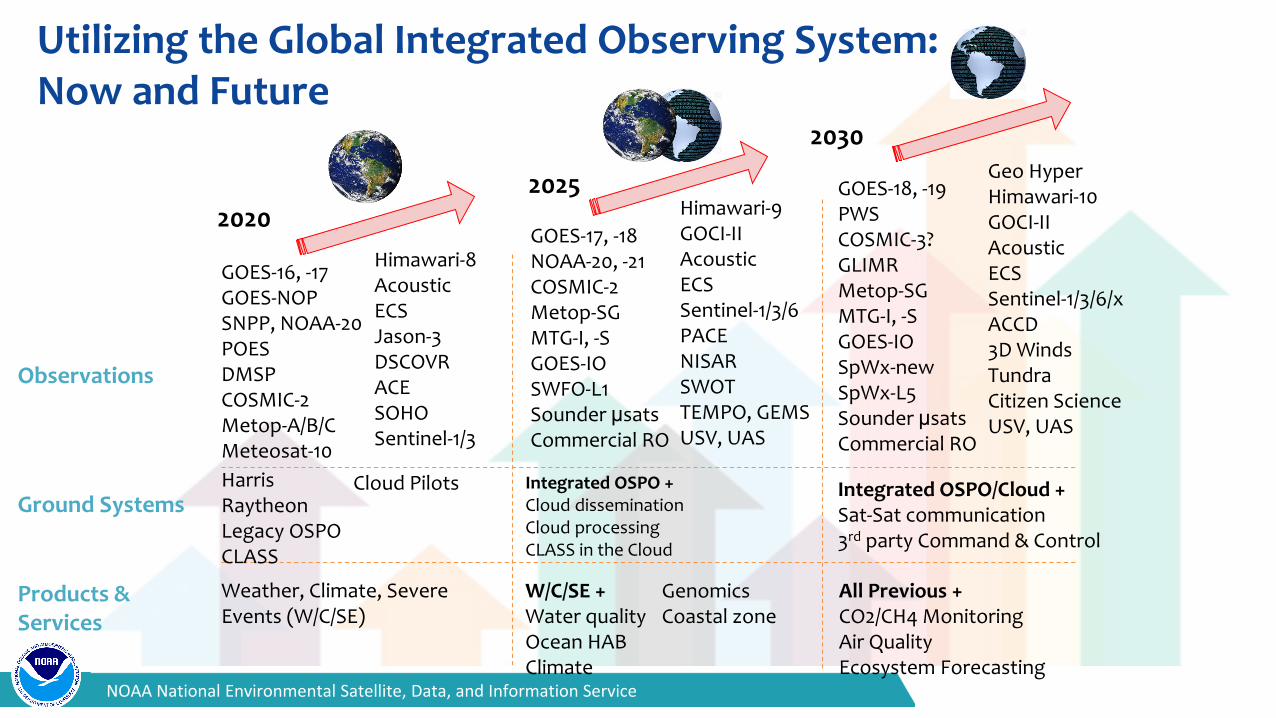
Utilizing the Global Integrated Observing System: Now and Future
2030
GOES-18, -19PWSCOSMIC-3?GLIMRMetop-SGMTG-I, -SGOES-IOSpWx-newSpWx-L5Sounder μsatsCommercial RO
All Previous +CO2/CH4 MonitoringAir QualityEcosystem Forecasting
Integrated OSPO/Cloud +Sat-Sat communication3rd party Command & Control
Geo HyperHimawari-10GOCI-IIAcousticECSSentinel-1/3/6/xACCD3D WindsTundraCitizen ScienceUSV, UAS
2025
GOES-17, -18NOAA-20, -21COSMIC-2Metop-SGMTG-I, -SGOES-IOSWFO-L1Sounder μsatsCommercial RO
W/C/SE +Water qualityOcean HABClimate
Integrated OSPO +Cloud disseminationCloud processingCLASS in the Cloud
Himawari-9GOCI-IIAcousticECS Sentinel-1/3/6PACENISARSWOTTEMPO, GEMSUSV, UAS
GenomicsCoastal zone
2020
GOES-16, -17GOES-NOPSNPP, NOAA-20POESDMSPCOSMIC-2Metop-A/B/CMeteosat-10
Weather, Climate, Severe Events (W/C/SE)
HarrisRaytheonLegacy OSPOCLASS
Himawari-8AcousticECSJason-3DSCOVRACESOHOSentinel-1/3
Observations
Ground Systems
Products & Services
Cloud Pilots
NOAA National Environmental Satellite, Data, and Information Service
39NOAA National Satellite, Data, and Information Service
Meeting the Challenge of Service Delivery
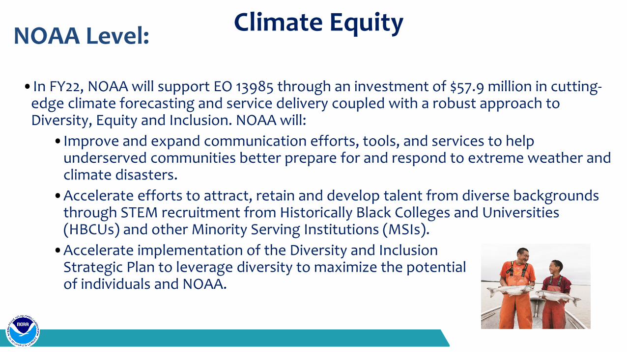
Climate Equity
•In FY22, NOAA will support EO 13985 through an investment of $57.9 million in cutting-edge climate forecasting and service delivery coupled with a robust approach to Diversity, Equity and Inclusion. NOAA will:
•Improve and expand communication efforts, tools, and services to help underserved communities better prepare for and respond to extreme weather and climate disasters.
•Accelerate efforts to attract, retain and develop talent from diverse backgrounds through STEM recruitment from Historically Black Colleges and Universities (HBCUs) and other Minority Serving Institutions (MSIs).
•Accelerate implementation of the Diversity and Inclusion Strategic Plan to leverage diversity to maximize the potential of individuals and NOAA.
NOAA Level:
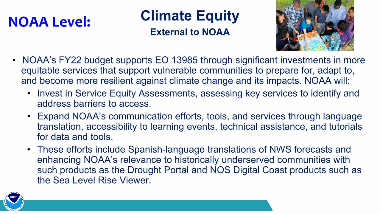
Climate EquityExternal to NOAA
• NOAA’s FY22 budget supports EO 13985 through significant investments in more equitable services that support vulnerable communities to prepare for, adapt to, and become more resilient against climate change and its impacts. NOAA will:
• Invest in Service Equity Assessments, assessing key services to identify and address barriers to access.
• Expand NOAA’s communication efforts, tools, and services through language translation, accessibility to learning events, technical assistance, and tutorials for data and tools.
• These efforts include Spanish-language translations of NWS forecasts and enhancing NOAA’s relevance to historically underserved communities with such products as the Drought Portal and NOS Digital Coast products such as the Sea Level Rise Viewer.
NOAA Level:
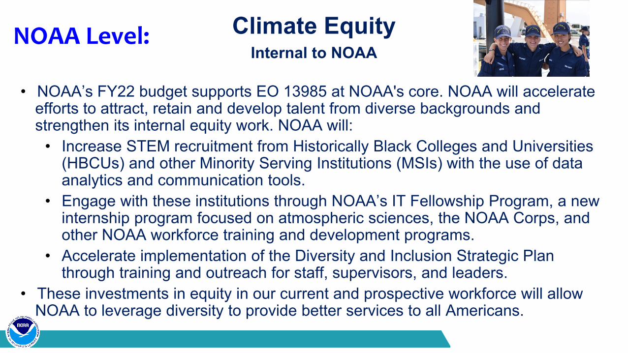
Climate EquityInternal to NOAA
• NOAA’s FY22 budget supports EO 13985 at NOAA's core. NOAA will accelerate efforts to attract, retain and develop talent from diverse backgrounds and strengthen its internal equity work. NOAA will:
• Increase STEM recruitment from Historically Black Colleges and Universities (HBCUs) and other Minority Serving Institutions (MSIs) with the use of data analytics and communication tools.
• Engage with these institutions through NOAA’s IT Fellowship Program, a new internship program focused on atmospheric sciences, the NOAA Corps, and other NOAA workforce training and development programs.
• Accelerate implementation of the Diversity and Inclusion Strategic Plan through training and outreach for staff, supervisors, and leaders.
• These investments in equity in our current and prospective workforce will allow NOAA to leverage diversity to provide better services to all Americans.
NOAA Level:
43NOAA National Satellite, Data, and Information Service
Budget & Implementation
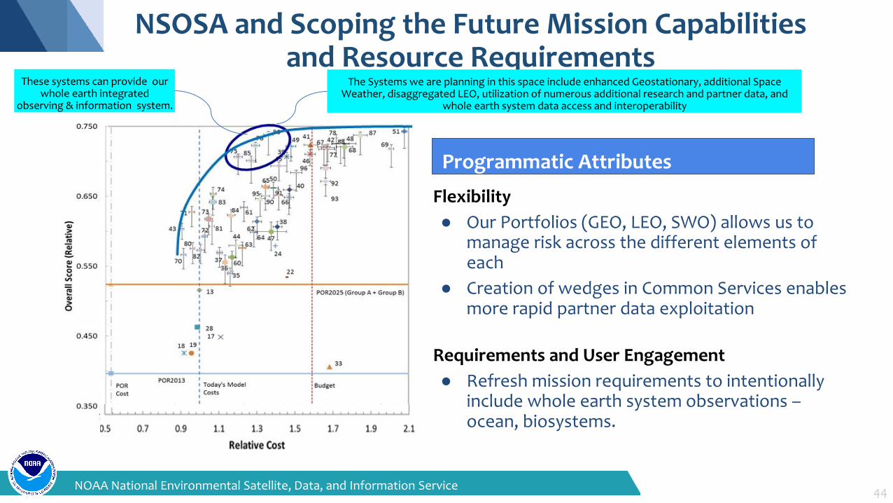
NSOSA and Scoping the Future Mission Capabilities and Resource Requirements
Flexibility● Our Portfolios (GEO, LEO, SWO) allows us to
manage risk across the different elements of each
● Creation of wedges in Common Services enables more rapid partner data exploitation
Requirements and User Engagement● Refresh mission requirements to intentionally
include whole earth system observations –ocean, biosystems.
Programmatic Attributes
These systems can provide our whole earth integrated
observing & information system.
44NOAA National Environmental Satellite, Data, and Information Service
The Systems we are planning in this space include enhanced Geostationary, additional Space Weather, disaggregated LEO, utilization of numerous additional research and partner data, and
whole earth system data access and interoperability
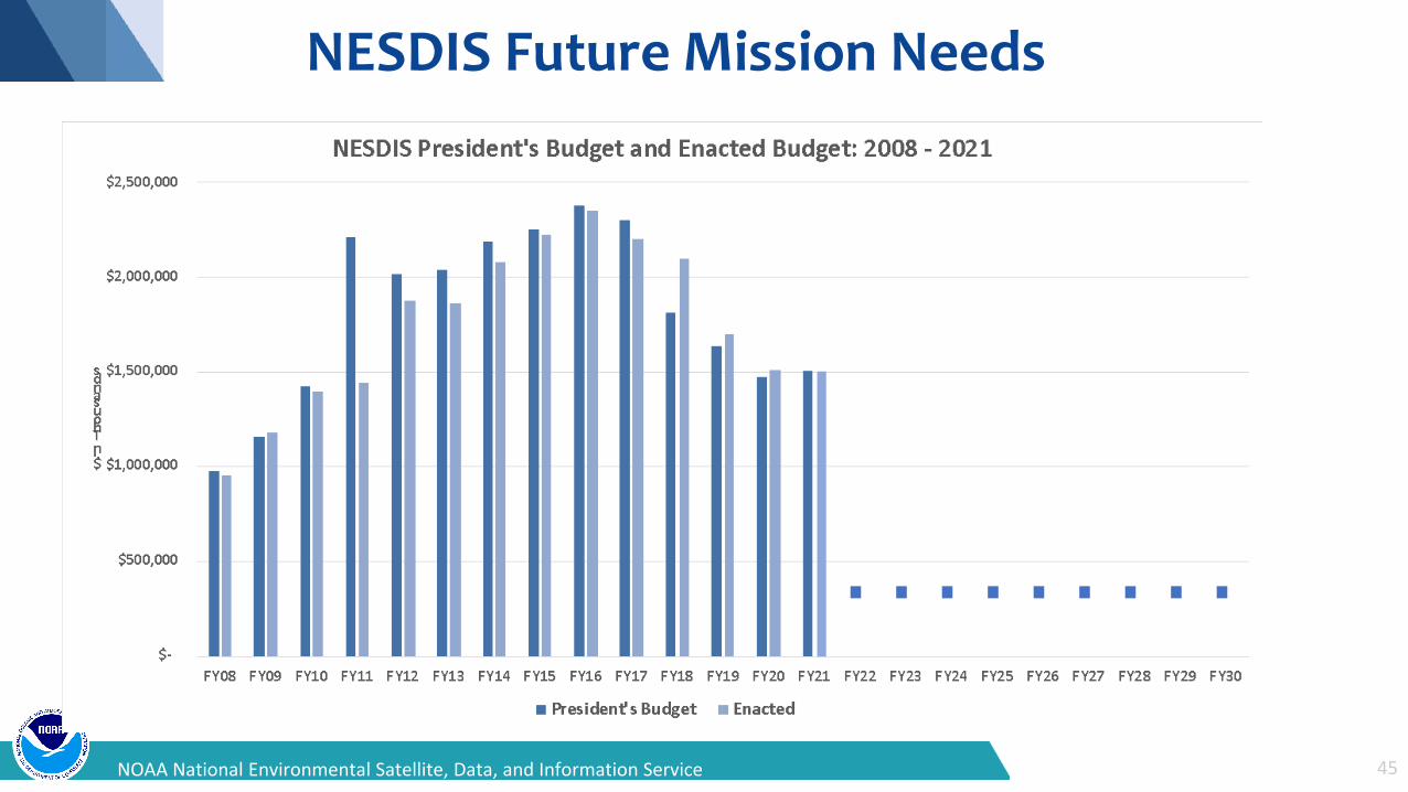
NESDIS Future Mission Needs
45NOAA National Environmental Satellite, Data, and Information Service
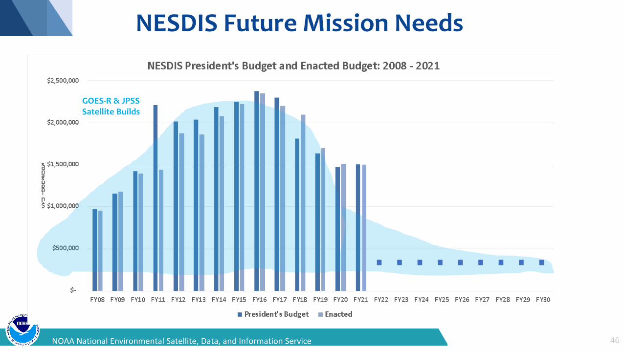
NESDIS Future Mission Needs
GOES-R & JPSSSatellite Builds
46NOAA National Environmental Satellite, Data, and Information Service
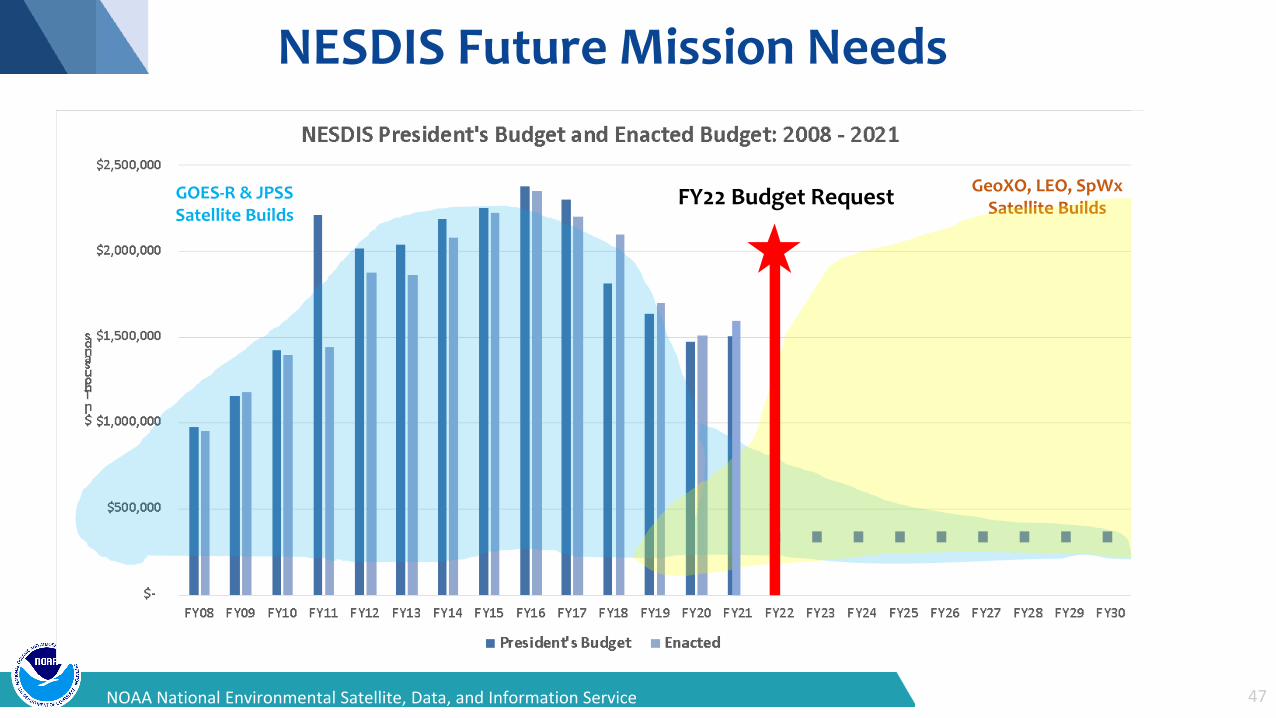
NESDIS Future Mission Needs
GOES-R & JPSSSatellite Builds
GeoXO, LEO, SpWxSatellite Builds
47NOAA National Environmental Satellite, Data, and Information Service
FY22 Budget Request
48NOAA National Satellite, Data, and Information Service
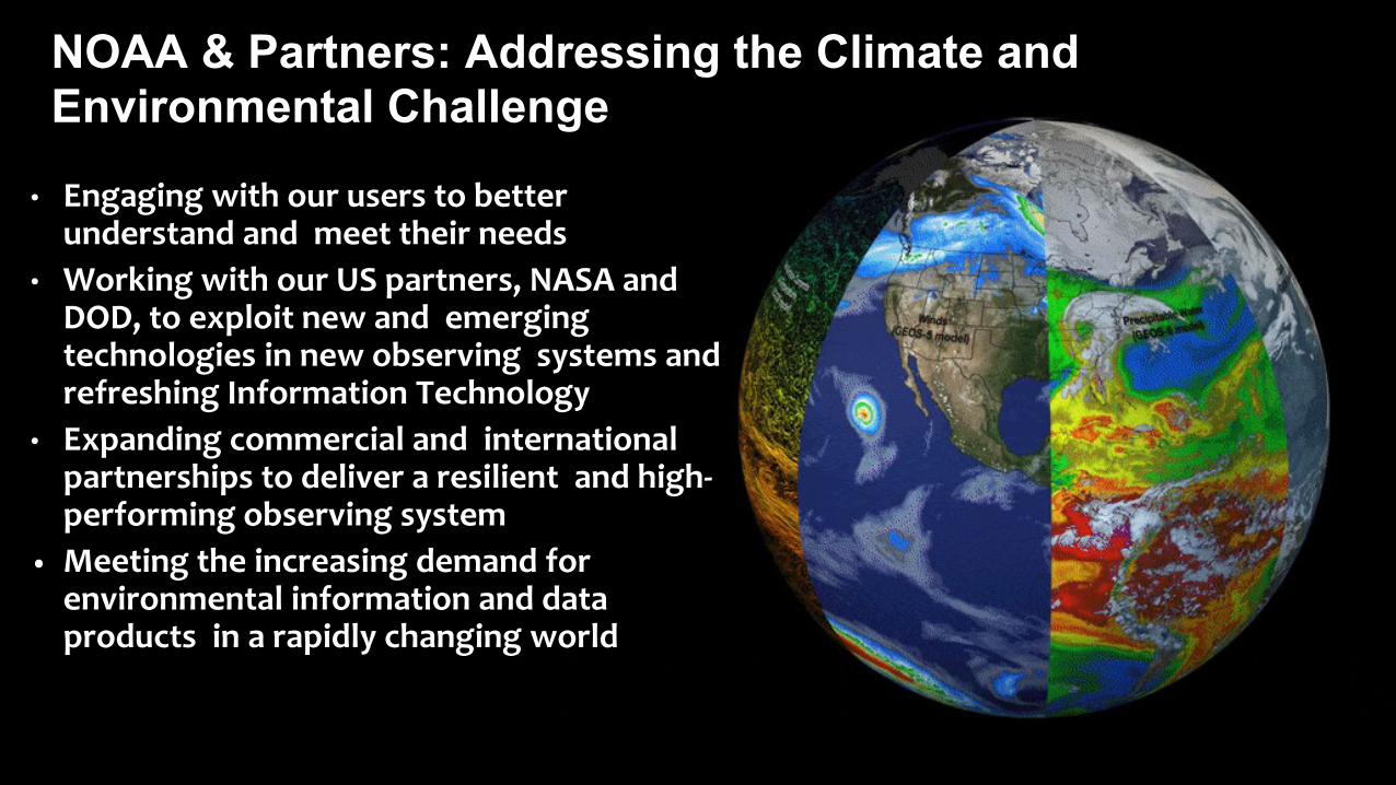
NOAA & Partners: Addressing the Climate and Environmental Challenge
• Engaging with our users to better understand and meet their needs
• Working with our US partners, NASA and DOD, to exploit new and emerging technologies in new observing systems and refreshing Information Technology
• Expanding commercial and international partnerships to deliver a resilient and high-performing observing system
• Meeting the increasing demand for environmental information and data products in a rapidly changing world
24NOAA National Environmental Satellite, Data, and Information Service
THANK YOU!
Related Documents


