Agus Wibowo Centre of Data, Information and Public Relations - BNPB Indonesia Scenario Assessment For Emergencies (InaSAFE)

Welcome message from author
This document is posted to help you gain knowledge. Please leave a comment to let me know what you think about it! Share it to your friends and learn new things together.
Transcript
Agus Wibowo Centre of Data, Information and Public Relations - BNPB
Indonesia Scenario Assessment
For Emergencies (InaSAFE)
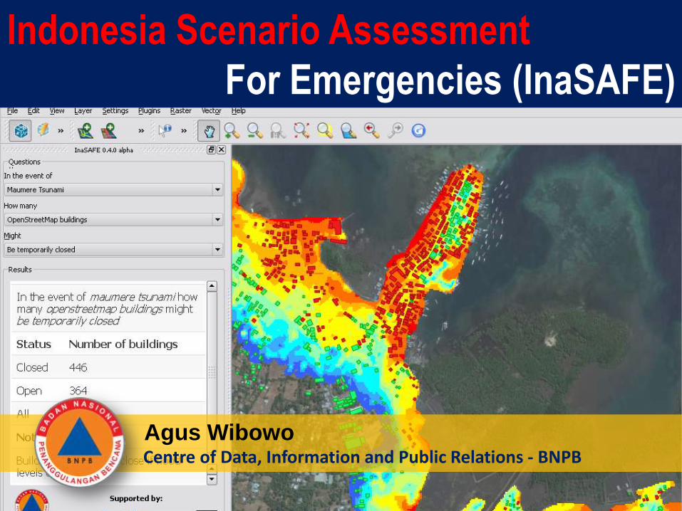
INDONESIA …… between blessing and disasters
1. Landslide: 229.6 millions 5. Flood : 60.9 millions
2. Earthquake : 227.4 millions 6. Forest fire: 50 millions
3. Drought : 225.6 millions 7. Tsunami : 5 millions
4. Typhoon : 115.7 millions 8. Volcano eruption: 3,8 millions
Based on Population Census 2010, number of population exposed to disaster:
17,504 islands (1st in the world)
81,000 km long coastline (2nd in the world)
237 million people (4th in the world)
Mega Biodiversity (10% plants, 12% of mammals, 16% of reptiles, 15%
fish,17% of bird in the world live in Indonesia) – 3rd in the world
13% or 127 active volcanoes in the world (1st in the world)
-
500
1,000
1,500
2,000
2,500
2002 2003 2004 2005 2006 2007 2008 2009 2010 2011
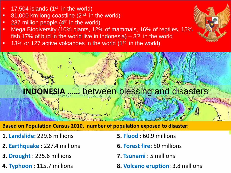
How about Disasters in Indonesia?
Trend: Disasters will continue to increase, all the intensity, frequency, magnitude, and its spread. Environmental damage also increases hydro-meteorological disasters.
Disaster Events: 77% is hydro-meteorological disasters (floods, landslides, cyclones, droughts, tidal-waves).
Disaster management has become a national priority in RPJMN 2010-2014. Development targets for 2012 are economic growth by 6.7%; reduce inflation by 5.3%;
and reduce unemployment by 6.5%; which are influenced by 5 factors: 1) European economic crisis, 2) the geopolitics in the Middle East, 3) Political and sociology
dynamics, and homeland security, 4) the dynamics in Asia Pacific region, and 5) natural disasters
Speech of President of Republic of Indonesia 19-2-2012
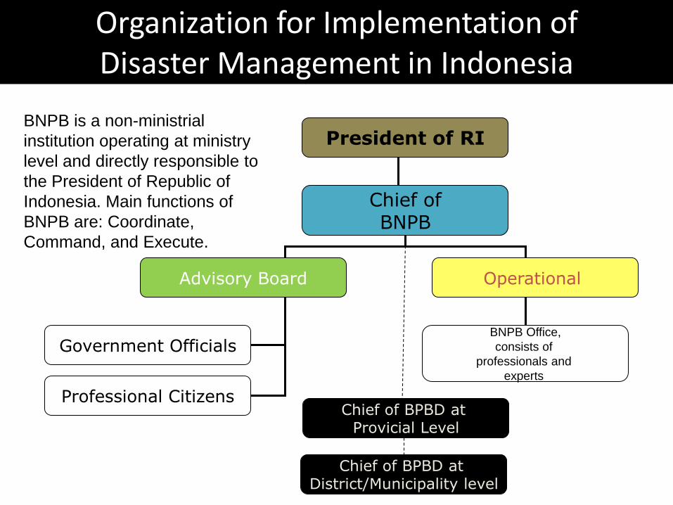
Chief of BPBD at District/Municipality level
Chief of BPBD at Provicial Level
Professional Citizens
Government Officials BNPB Office,
consists of
professionals and
experts
Advisory Board Operational
Chief of BNPB
President of RI
Organization for Implementation of Disaster Management in Indonesia
BNPB is a non-ministrial
institution operating at ministry
level and directly responsible to
the President of Republic of
Indonesia. Main functions of
BNPB are: Coordinate,
Command, and Execute.
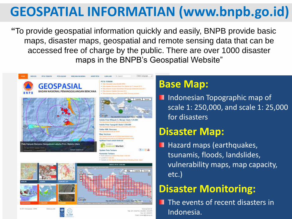
GEOSPATIAL INFORMATIAN (www.bnpb.go.id) “To provide geospatial information quickly and easily, BNPB provide basic
maps, disaster maps, geospatial and remote sensing data that can be
accessed free of charge by the public. There are over 1000 disaster maps in the BNPB’s Geospatial Website”
Base Map: Indonesian Topographic map of scale 1: 250,000, and scale 1: 25,000 for disasters
Disaster Map: Hazard maps (earthquakes, tsunamis, floods, landslides, vulnerability maps, map capacity, etc.)
Disaster Monitoring: The events of recent disasters in Indonesia.
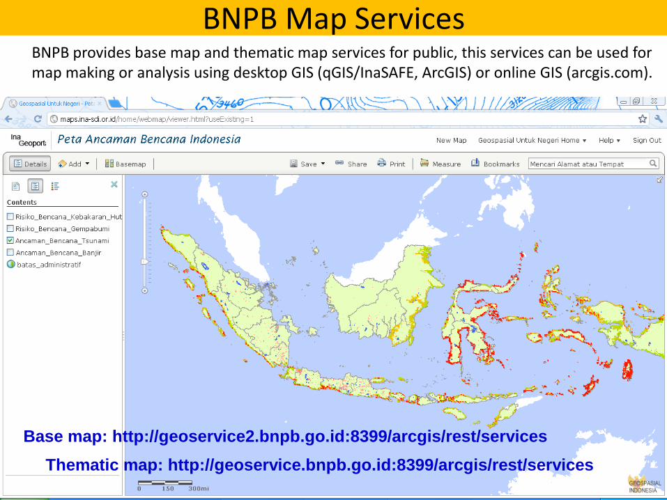
BNPB Map Services BNPB provides base map and thematic map services for public, this services can be used for
map making or analysis using desktop GIS (qGIS/InaSAFE, ArcGIS) or online GIS (arcgis.com).
Base map: http://geoservice2.bnpb.go.id:8399/arcgis/rest/services
Thematic map: http://geoservice.bnpb.go.id:8399/arcgis/rest/services
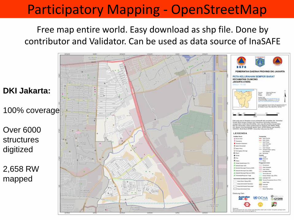
Participatory Mapping - OpenStreetMap
Free map entire world. Easy download as shp file. Done by contributor and Validator. Can be used as data source of InaSAFE
DKI Jakarta:
100% coverage
Over 6000
structures
digitized
2,658 RW
mapped
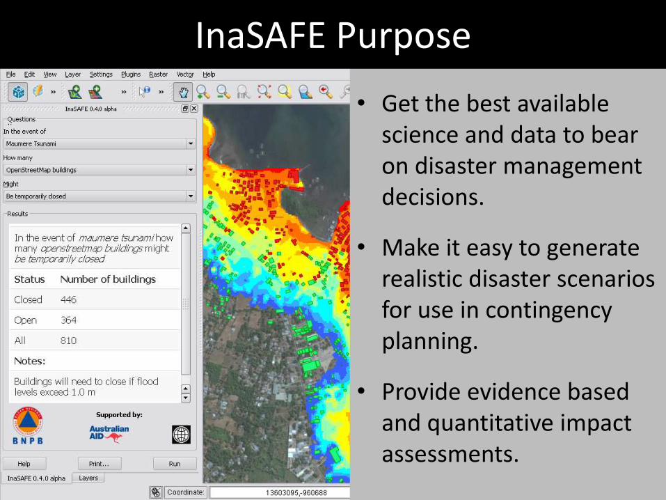
• Get the best available science and data to bear on disaster management decisions.
• Make it easy to generate realistic disaster scenarios for use in contingency planning.
• Provide evidence based and quantitative impact assessments.
InaSAFE Purpose
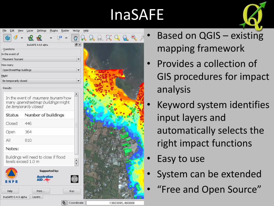
• Based on QGIS – existing mapping framework
• Provides a collection of GIS procedures for impact analysis
• Keyword system identifies input layers and automatically selects the right impact functions
• Easy to use
• System can be extended
• “Free and Open Source”
InaSAFE
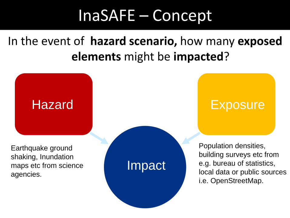
InaSAFE – Concept
Hazard Exposure
Impact
Earthquake ground
shaking, Inundation
maps etc from science
agencies.
Population densities,
building surveys etc from
e.g. bureau of statistics,
local data or public sources
i.e. OpenStreetMap.
In the event of hazard scenario, how many exposed elements might be impacted?
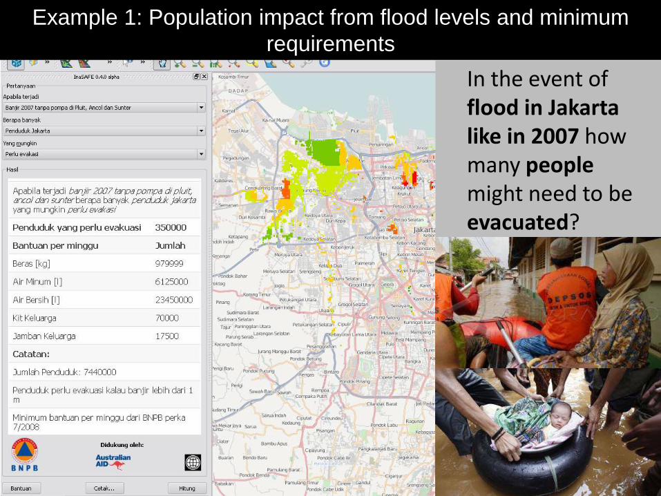
In the event of flood in Jakarta like in 2007 how many people might need to be evacuated?
Example 1: Population impact from flood levels and minimum
requirements
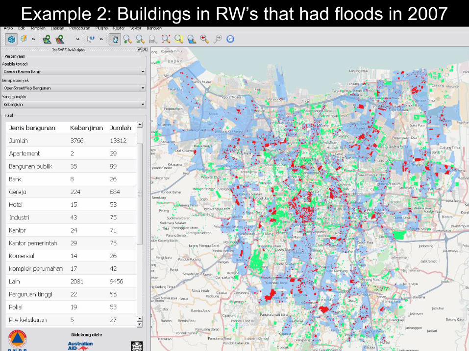
Example 2: Buildings in RW’s that had floods in 2007
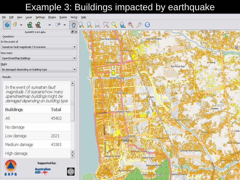
Example 3: Buildings impacted by earthquake
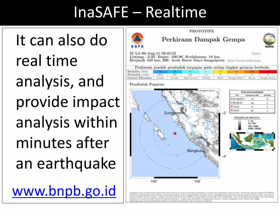
InaSAFE – Realtime
It can also do real time analysis, and provide impact analysis within minutes after an earthquake
www.bnpb.go.id
Challenges
• Hazard and exposure data must exist and be available to disaster managers
• Format, metadata and distribution methods must be standardised
• Initiatives like Open Street Map can help!
16
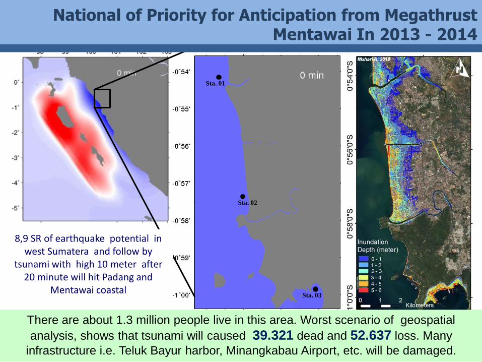
Sta. 01
Sta. 02
Sta. 03
National of Priority for Anticipation from Megathrust Mentawai In 2013 - 2014
8,9 SR of earthquake potential in west Sumatera and follow by
tsunami with high 10 meter after 20 minute will hit Padang and
Mentawai coastal
There are about 1.3 million people live in this area. Worst scenario of geospatial
analysis, shows that tsunami will caused 39.321 dead and 52.637 loss. Many
infrastructure i.e. Teluk Bayur harbor, Minangkabau Airport, etc. will be damaged.
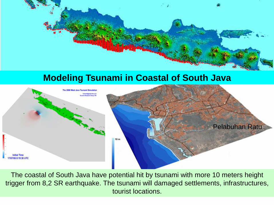
10 meter
The coastal of South Java have potential hit by tsunami with more 10 meters height
trigger from 8,2 SR earthquake. The tsunami will damaged settlements, infrastructures,
tourist locations.
Modeling Tsunami in Coastal of South Java
Pelabuhan Ratu
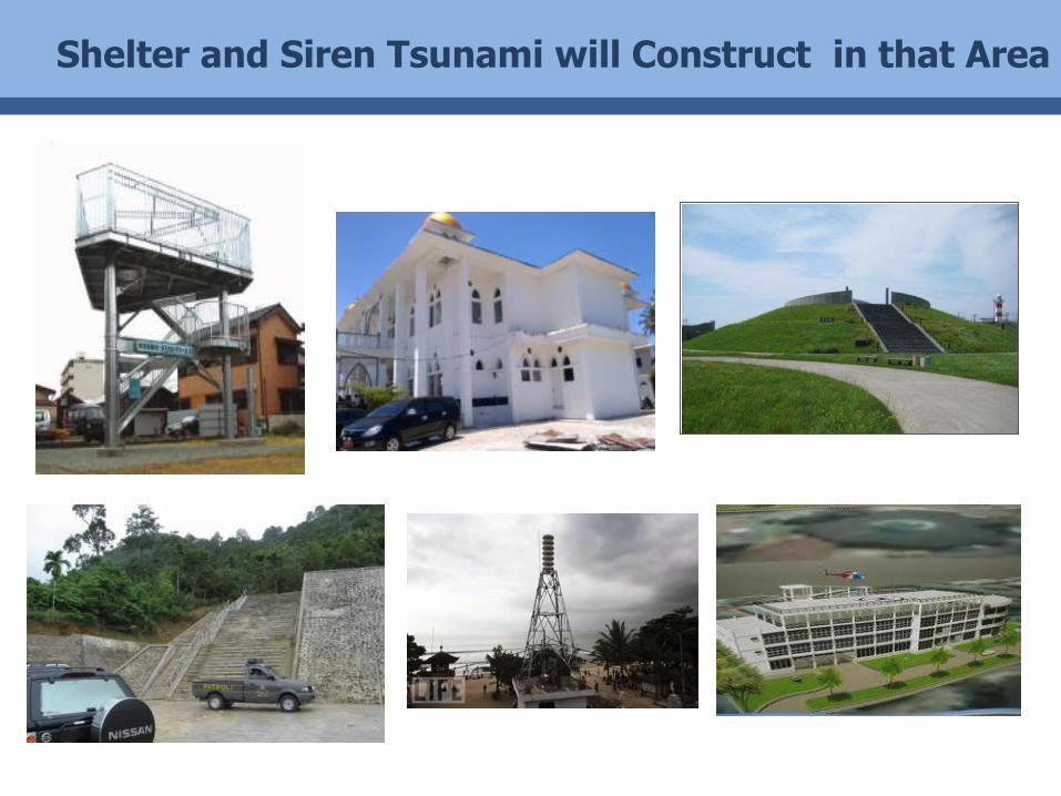
Shelter and Siren Tsunami will Construct in that Area

Closing
• The extent of the disaster-prone region of Indonesia with 13 types of disasters require geospatial and tools such as InaSAFE to process it in quickly, effectively and efficiently.
• BNPB still require cooperation with various parties to provide and analyze geospatial and remote sensing data / information in quickly, effectively and efficiently.
• End-to-End in disaster response is From-Person-To-Person, that will resulted a resilient disaster communities.
Indonesia Tangguh
InaSAFE 0.4.0 soft launch today - available for download at:
http://tinyurl.com/inasafe-install

Ngiyabonga Dankie
Thank You
BADAN NASIONAL PENANGGULANGAN BENCANA (National Agency for Disaster Management)
Jl. Ir. H. Juanda No. 36 Jakarta Pusat 10120, Indonesia
Phone : +62-21-3458400
Fax. : +62-21-3458500
Email : [email protected]
Website : www.bnpb.go.id
Facebook : www.facebook.com/bnpb.indonesia
Twitter : @BNPB_Indonesia
YouTube : BNPBIndonesia
Related Documents