WORKING PAPER 112 International Water Management Institute Indigenous and Institutional Profile: Limpopo River Basin Anton Earle, Jaqui Goldin, Rose Machiridza Daniel Malzbender, Emmanuel Manzungu and Tiego Mpho

Welcome message from author
This document is posted to help you gain knowledge. Please leave a comment to let me know what you think about it! Share it to your friends and learn new things together.
Transcript

WORKING PAPER 112
I n t e r n a t i o n a lWater ManagementI n s t i t u t e
Indigenous and InstitutionalProfile: Limpopo RiverBasin
Anton Earle, Jaqui Goldin, Rose MachiridzaDaniel Malzbender, Emmanuel Manzunguand Tiego Mpho

Working Paper 112
Indigenous and Institutional Profile:Limpopo River Basin
Anton EarleJaqui Goldin
Rose MachiridzaDaniel Malzbender
Emmanuel Manzunguand
Tiego Mpho
International Water Management Institute

ii
The authors: Anton Earle is a Director of the African Centre for Water Research and works as a consultantfor the African Water Issues Research Unit (CIPS, University of Pretoria) on the African Models ofTransboundary Governance project. His core research interest is transboundary water resources management– identifying and developing elements which promote cooperation over shared water resources in thesouthern African region.
Jaqui Goldin has worked extensively on monitoring and evaluation projects and research methodology andon scrutinizing the gap between policy and its implementation, with a particular focus on the water sector.Jaqui is Director of The Africa Project (TAP), Surveys for Africa cc.
Rose Machiridza is the Water and Sanitation Programme Research Coordinator with World Vision Zimbabwe.Previously, she was a Research Associate in the Department of Soil Science and Agricultural Engineering atthe University of Zimbabwe. Her research interests include gender aspects in irrigation, water resources /supply and sanitation.
Daniel Malzbender is a Director of the African Centre for Water Research and works as a consultant for theAfrican Water Issues Research Unit (CIPS, University of Pretoria) on the African Models of TransboundaryGovernance project. His core research interest is (international) water law and the development of stakeholderparticipation processes as elements of transboundary water resource management in southern Africa.
Emmanuel Manzungu is a Research Associate / Lecturer in the Department of Soil Science And AgriculturalEngineering at the University of Zimbabwe. His research interests include catchment management andstrategic management of water resources.
Tiego Mpho is the Water Programme Officer at IUCN (World Conservation Union), Botswana. His researchinterests include the practical application of Integrated Water Resources Management (IWRM).
Acknowledgements: The financing of the project by the Challenge Program for Water and Food isacknowledged gratefully. Furthermore, the authors wish to record their thanks to the following individuals:Neels Kruger for his valuable contribution to the compilation of the ethnographic information for the SouthAfrican part of the basin; Sue Hart for making available Brian Beck’s library; and Mimi Van der Merwe andHanna Botha from the JSG Library (Special Collections) at the University of Stellenbosch for their valuableassistance. The authors are particularly indebted to the staff of the International Water Management Institute(IWMI), Pretoria, for their ongoing insights and intellectual contribution to this paper. In particular, mentionis made of Barbara van Koppen, Doug Merrey and Amy Sullivan.
Earle, A.; Goldin, J.; Machiridza, R.; Malzbender, D.; Manzungu, E.; Mpho, T. 2006. Indigenous andinstitutional profile: Limpopo River Basin. Colombo, Sri Lanka: International Water Management Institute.65p. (IWMI Working Paper 112)
/ river basins / institutions / water resource management / history / colonialism / social aspects / conflict/ water law / gender / Botswana / Mozambique / Zimbabwe /
ISBN 92-9090-637-5
ISBN 978-92-9090-637-7
Copyright © 2006, by IWMI. All rights reserved.
Please note that color photographs of this paper can be seen at
http://www.iwmi.cgiar.org/pubs/working/Index.htm
Please direct inquiries and comments to: [email protected]
IWMI receives its principal funding from 58 governments, private foundations and internationaland regional organizations known as the Consultative Group on International AgriculturalResearch (CGIAR). Support is also given by the Governments of Ghana, Pakistan, South Africa,Sri Lanka and Thailand.

iii
Contents
List of Figures ........................................................................................................................... v
Acronyms and Abbreviations .................................................................................................... vii
Foreword .................................................................................................................................... ix
Summary (English) .................................................................................................................... xi
Summary (Portuguese) ............................................................................................................. xv
Introduction ................................................................................................................................ 1
Current distribution of ethnic and linguistic groups in the Limpopo Basin .............................. 4
A historic overview of natural resource governance regimes ................................................. 17
Transboundary interactions between basin communities ......................................................... 37
The interface between customary rules and constitutional values .......................................... 38
Conclusion .................................................................................................................................. 40
Literature Cited ......................................................................................................................... 43
Appendix One ............................................................................................................................ 47


v
List of Figures
Figure 1: Hydrological, political, and population characteristics of theLimpopo Basin .......................................................................................................... 1
Figure 2: Distribution of ethnic and language groups in Botswana ........................................... 6
Figure 3: Distribution of ethnic and language groups in the Mozambicanpart of the Limpopo Basin ....................................................................................... 8
Figure 4: Distribution of language groups in North-Eastern South Africa,including the South African part of the Limpopo Basin .......................................... 8
Figure 5: Distribution of Bantu-speaking groups in the interior ofSouth Africa c. 1800 ................................................................................................ 10
Figure 6: Distribution of ethnic groups in the Zimbabwean partof the Limpopo Basin ............................................................................................... 16

Acronyms and Abbreviations
AWIRU African Water Issues Research Unit, University of PretoriaBSAC British South Africa CompanyCC Catchment CouncilCGIAR Consultative Group on International Agricultural ResearchCMA Catchment Management AgencyDNA Direcção Nacional de Águas (National Directorate of Water)DWAF Department of Water Affairs and ForestryFRELIMO Mozambique Liberation FrontGWP Global Water PartnershipICM Integrated Catchment ManagementIFPRI International Food Policy Research InstituteIIASA International Institute for Applied Systems AnalysisINERA Institut de l‘environnement et de recherches agricoles
(Environmental and Agricultural Research Institute)INGC Instituto Nacional de Gestão de CalamidadesIWMI International Water Management InstituteIWRM Integrated Water Resource ManagementMoA Ministry of AgricultureOAU Organization of African UnityOFS Orange Free StateRAU Reforma Administrativa UltramarinaRDC Rural District CouncilRENAMO Mozambique National ResistanceSADC Southern African Development CommunitySATAC Southern Africa Technical Advisory CommitteeSCC Sub-Catchment CouncilTAC Technical Advisory CommitteeWAB Water Apportionment BoardWMA Water Management AreaZAR Zuid-Afrikaanse RepubliekZINWA Zimbabwe National Water Authority
vii

viii

ix
Foreword
This Working Paper reports on research carried out in the Limpopo River Basin, by the researchteam in that basin implementing Project number 47, supported by the Challenge Program on Waterand Food. The Project title is “Transboundary Water Governance for Agricultural and EconomicGrowth and Improved Livelihoods in the Limpopo and Volta basins: Towards African IndigenousModels of Governance.” A companion Working Paper (Opoku-Ankomah et al. 2006) is beingproduced reporting on similar work in the Volta River Basin.
In sub-Saharan Africa, there are some 63 transboundary river basins, i.e., basins shared bytwo or more countries. Development and management of the resources in these basins requirescooperation among the riparian countries; and institutional arrangements are needed as a mechanismfor such cooperation. The question is thus, not whether transboundary water management in Africashould be strengthened, but rather how. In part, the knowledge needed can be derived fromexperiences in developed countries and Asia. However, there are at least three reasons why Africamust be cautious in copying the transboundary experience of others. First, in general, water scarcityin sub-Saharan Africa is primarily ‘economic’ water scarcity; i.e., it is not lack of water but thelack of financial and human resources and poor governance that are the key issues. This impliesthat the win-win option of capacity building for new resource development should receive higherpriority than the division of scarce resources among competing users, as is often the case elsewhere.Second, sub-Saharan Africa is overwhelmingly poor, and there is an extreme dependence uponaccess to water for rural livelihoods, particularly for the poor and women, groups that tend not tobe strongly represented in decision-making bodies at an international scale. Third, indigenousarrangements in the management of natural resources, in particular land and water, continue to bevery important in Africa, a point invariably neglected in international agreements and indeed in“modern” national water laws.
So how can transboundary institutions be built which address sub-Saharan Africa’s uniqueconditions? This project on African Models of Transboundary River Basin Governance hypothesizesthat through an indigenous African “bottom-up” approach, starting from local traditions and socialarrangements, it will be possible to create more resilient and successful transboundary waterinstitutions than would otherwise be possible, while also giving greater voice to the poor, womenand men alike, in the process. In order to tackle this problem, the project began with an assessmentof the current institutional arrangements from an historical perspective. This is largely a literaturereview, using published and unpublished sources. The present Working Paper reports on the resultsof this historical hydro-political assessment of the Limpopo River Basin. The second phase of theproject is currently (2005-2006) supporting groups of postgraduate students who are doing detailedcase study field work in rural areas in order to identify potential local traditions and socialarrangements that could possibly be built into the design of larger-scale river basins.

x
The African Models of Transboundary River Basin Governance project involves a directpartnership among two CGIAR centers (IWMI and the International Food Policy Research Institute,IFPRI), several national research partners, and government water management institutions (includingthe Water Resources Commission of Ghana, Department of Water Affairs of South Africa), andone advanced research institute (Center for Development Research, University of Bonn). In theVolta Basin, the national research partners are the Institut de l’environnement et de recherchesagricoles (Environmental and Agricultural Research Institute, INERA, Burkina Faso) and the WaterResearch Institute, Ghana. In the Limpopo Basin, the formal national research partners are theDepartment of Soil Science and Agricultural Engineering, University of Zimbabwe and the AfricanWater Issues Research Unit (AWIRU), University of Pretoria, South Africa. In addition Waternet,a regional consortium of universities promoting integrated water resources management is involved.The project has also benefited from an association with the University of Eduardo Mondlane,Mozambique.IWMI and its partners are grateful to the Challenge Program on Water and Food for its support.
Douglas J. MerreyProject LeaderMarch 2006

xi
Summary
This paper presents an overview of water-related governance structures and institutions in theLimpopo Basin. The Basin is of critical socio-economic importance to the 14 million peopledistributed across the four riparian states of Botswana, Mozambique, South Africa and Zimbabwe.Urban centers, mostly in Botswana and South Africa, are major water users supplying industries,power stations and municipalities. Water is also used in rural areas for domestic, livestock wateringand irrigation purposes. While irrigated agricultural activities are largely concentrated in South Africaand Zimbabwe, the majority of rural populations engage in rain-fed agriculture, which does notguarantee secure livelihoods. This is due, in large part, to the region’s semi-arid climate whereonly two out of every five agricultural seasons produce reasonable crop yields. These climaticconditions emphasize the need for effective management of transboundary water resources andeffective governance structures, delivery and control mechanisms. Appropriate institutionalframeworks and governance structures have a pivotal role in defining the socio-economic situationof the people in the Basin.
This project attempts to assess the potential of indigenous institutions to contribute to effectivewater governance as an integral part of the pluralistic legal system of water management. This issignificant because people in the Basin and throughout Africa, despite being governed by statutorylaw and formal institutions, are still influenced by systems that pre-date statutory law. In somecases, these systems operate independently or alongside statutory laws. By providing a sketch ofthe hydropolitical history of the basin, this paper presents background material as a prelude to fieldresearch that is being undertaken in the second phase of the project. The material that is presentedhere is, therefore, largely based on secondary data sources, including sources from academicliterature in history, archaeology, anthropology, etc., as well as public sources. These data wereanalyzed in relation to the key objectives of the study.
The paper begins by defining two recurring important concepts: indigenous and institutions.Institutions are herein understood as regularized patterns of behavior that emerge from underlyingstructures, which may refer to a set of rules or organizations that may encompass legallyconstructed and informal rules and regulations (Leach et al. 1997; Berry 1989; cf. North 1990;Folke and Colding 2001; Nemarundwe 2003). The paper endorses Nemarundwe’s (2003) contentionthat it is often difficult to separate institutions from the structures or organizations that ensure thatthe institutions are adhered to, and it is, therefore, best to study them together. ‘Indigenous people’are used in anthropology to describe a non-dominant group in a delineated territory with a more orless acknowledged claim to aboriginality. Indigenous institutions can therefore be defined as rules,norms and their enforcement of rural groupings whose livelihoods are predominantly based onsmall-scale agriculture (cropping, livestock, fisheries, hunting/gathering); whose socio-politicalcohesion is based on a sense of ethnicity and not only residence, and for whom tribal authorityor local self-governing institutions play a role in some or many domains of life, over and above‘modern’ local government and state-induced or private water management institutions.
xii
The evolution of indigenous governance structures and their interface with statutory frameworksis analyzed in terms of the socio-political history that is specific to each of the riparian states, giventheir unique experiences. Data show that the Limpopo Basin is predominantly inhabited by peoplespeaking languages of the Bantu linguistic family. An analysis of the language and population groupsin the four basin countries shows that some groups were found across nation-state boundaries andthat different ethnic groups were also found to be living in the same locality. There were alsosimilarities across the basin countries in the way that institutions associated with rain-makingceremonies were structured. Despite the similarities, the profile concludes that local nuances aresignificant, and should not be underestimated, because the four nation states to which these groupsnow belong have experienced very different historic developments. These developments havetended to cause substantial differences between the groups and their traditional governance regimes.It is hypothesized that social interactions between different ethnic groups within the samegeographical locality shaped water management practices and traditional governance structures.In other words, practices originally shared by groups with similar historic origin have taken differentdirections, depending on the socio-political systems the groups have experienced. This remains aninteresting line of enquiry, as is the possibility of similarities within the same ethnic group in differentnation states, especially if some level of interaction was maintained or the groups were in contiguouslocalities.
The profile also highlights potential risks due to phenomena such as climatic change that hasthe potential to jeopardize water-dependent activities such as agriculture. Exposure to differenttypes of risk raises the question of variance in types of responses that local/indigenous populationshave adapted to environmental changes, both in the short and long term, and considers the way inwhich these adaptations vary across both micro-environments and within localities/groups. Ofparticular relevance to the line of inquiry that will be followed during the fieldwork phase of thisproject, is whether any discernible basin-wide patterns of change in the physical and the socialenvironment emerge and, if so, whether there are patterns of behavioral changes that can bediscerned. It is also important to examine ways in which livelihoods have been sustained in theface of risk and uncertainty around agricultural modes of production. An overriding question thatmust be asked is, how valid it is to advocate agriculture-based livelihoods in the basin and if it isvalid, to what extent these activities contribute to sustainable livelihoods for the people living in thebasin?
Also relevant to the next phase of the project is the impact that the socio-political environmenthas had on indigenous water management. The rise (and sometimes fall) of civilizations, kingdoms,states and institutions, has had important contemporary implications. What is currently perceivedas ‘indigenous’ is a construction of political and social interactions of various groups of peoplewithin defined but fluid historical periods. This also raises the question of what new ethnic/indigenouswater management practices are under construction in the basin today. What processes occur atthe local level and what is the extent and nature of the modifications in patterns of behavior thatare a result of changes over time in both the physical and socio-political environment? It is necessaryto uncover the vestiges of indigenous water management in the basin and to explain the variationand endurance of indigenous practices. The relationship between the current state and traditional/indigenous regimes is a crucial area of inquiry, particularly because of the uneven success of stateinterventions. While the state has managed to claim the legal and administrative domain, there isstill opportunity available for indigenous water management systems to prosper. To what extent dostates recognize this fact, and what form does this recognition take, if any?

xiii
The spread of the concept of IWRM and how it relates to indigenous water practices is anotherrelevant line of enquiry. “Official” IWRM is largely untested at local levels in terms of relevanceand application, and even less so within the context of riparian countries. In what ways, if at all,does IWRM take into account the livelihoods of local people, particularly in the case of indigenousinstitutions operational within the basin? A critical aspect of this study is the issue of boundaries.IWRM promotes governance along hydrological rather than political-administrative boundaries. Andyet, indigenous or traditional water management tends to be premised on local political and socialstructures. This questions whether new boundaries proposed within the principles of IWRM can,or should, replace long standing boundaries and whether, instead, in the light of local traditionalwater management regimes, there are elements of IWRM that need to be questioned? Up-scalingof local traditional regimes pose challenges, not just at the national level, but also at the basin level.The fieldwork phase of the project will provide insights into these and many other unansweredquestions.

xiv
xv
Sumário
Este documento apresenta uma panorâmica das estruturas e instituições de governação relacionadascom a água na Bacia Hidrográfica do Rio Limpopo. A Bacia Hidrográfica é de importância socio-económica fundamental para os 14 milhões de pessoas, distribuídos pelos quatro países ribeirinhos:o Botsuana, Moçambique, África do Sul e Zimbabué. Os centros urbanos, na sua maioria noBotsuana e África do Sul, são grandes utilizadores de água fornecendo indústrias, estações geradorasde electricidade e municipalidades. A água é também utilizada nas áreas rurais para uso doméstico,dar de beber ao gado e irrigação. Apesar das actividades de irrigação agrícola estaremconcentradas principalmente na África do Sul e no Zimbabué, a maioria das populações ruraispraticam a agricultura alimentada com a chuva, o que não garante um nível de vida seguro. Tal,deve-se em grande parte, ao clima semiárido da região onde apenas duas em cada cinco estaçõesde colheita agrícola produzem uma quantidade razoável de cereais. Estas condições climatéricassublinham a necessidade para uma gestão eficaz de recursos hídricos transfronteiriços e estruturaseficazes de governação e mecanismos de distribuição e controlo desses recursos. Quadrosinstitucionais e estruturas de governação apropriados desempenham um papel fulcral na definiçãoda situação socio-económica das populações da Bacia Hidrográfica.
Este projecto esforça-se por avaliar o potencial das instituições indígenas para contribuir parauma governação dos recursos hídricos eficaz como parte integral do sistema jurídico pluralista degestão de água. Tal é significativo porque as populações da Bacia Hidrográfica e em todo ocontinente africano, apesar de serem governadas pela lei estatutária e por instituições formais,estão ainda influenciadas por sistemas anteriores à lei estatutária. Em alguns casos, estes sistemasoperam independentemente ou juntamente com as leis estatutárias. Ao proporcionar um esboçoda história hidropolítica da Bacia Hidrográfica, este documento apresenta material básico comoum prelúdio à investigação no terreno que está a ser levada a cabo na segunda fase do projecto.O material aqui apresentado é, por isso, baseado em grande escala em fontes secundárias de dados,incluindo fontes de literatura académica em história, arqueologia, antropologia etc. e ainda em fontespúblicas. Estes dados foram analisados em relação aos objectivos chave do estudo.
O documento começa por definir dois conceitos recorrentes importantes: indígenas einstituições. Assim, neste documento entende-se por instituições um modelo regularizado decomportamento que emerge de estruturas profundas que podem referir-se a um grupo de regrasou organizações que podem envolver regras e regulamentos construídas legalmente ou de carácterinformal (Leach et al. 1997; Berry 1989; cf. North 1990; Folke and Colding 2001; Nemarundwe2003). O documento endossa a discordância de Nemarundwe (2003) segundo a qual, muitas vezes,é difícil separar as instituições das estruturas ou organizações que garantam que elas sejamrespeitadas e, por isso, é melhor estudá-las em conjunto. ‘Os povos indígenas’ são usados emantropologia ‘para descrever um grupo não dominante num território delineado com umareivindicação mais ou menos reconhecida de “aboriginalidade.” Por isso, as instituições indígenaspodem ser definidas como regras, normas e sua aplicação na vida dos grupos rurais cujo sustentoestá predominantemente baseado na agricultura de pequena escala (produção de cereais, gado,pescaria, caça / colheitas); cuja coesão sócio política é baseada num sentido de etnicidade e

xvi
não só no seu local de residência e para quem a autoridade tribal ou instituições de autogoverno local desempenham um papel em alguns ou muitos domínios da vida, para além dosgovernos locais “modernos” e instituições de gestão de água induzidas pelo estado ou de carácterprivado.
A evolução das estruturas de governação indígena e a sua interligação com enquadramentosestatutários é analisada nos termos da história sócio política que é específica a cada um dos paísesribeirinhos, dadas as suas experiências únicas. Os dados demonstram que a Bacia Hidrográficado Rio Limpopo é predominantemente habitada por populações que falam algumas línguas da famílialinguística Bantu. Uma análise da língua e grupos populacionais nos quatro países da baciahidrográfica demonstra que alguns vivem através das fronteiras dos estados e que grupos étnicosdiferentes são também encontrados a viver nas mesmas áreas e localidades. Há tambémsemelhanças sobre a forma através da qual as instituições associadas com as cerimónias paraimplorar a chuva estão estruturadas em todos os países da bacia. Apesar das semelhanças, o perfilconclui que as tonalidades locais são significativas e não devem ser subestimadas porque os quatropaíses aos quais estes grupos agora pertencem registaram desenvolvimentos históricos muitodiferentes uns dos outros. Estes desenvolvimentos tiveram a tendência de causar diferençassubstanciais entre os grupos e os seus regimes de governação tradicionais. Apresenta-se comohipótese que as interacções sociais entre os diferentes grupos étnicos na mesma área ou localidadegeográfica moldaram as práticas de gestão dos recursos hídricos e as estruturas de governaçãotradicional. Por outras palavras, as práticas que eram originalmente partilhadas pelos grupos comuma origem histórica idêntica seguiram diferentes direcções dependendo dos sistemas sócio políticosa que os grupos foram sujeitos. Tal situação mantém-se como uma interessante linha no tema deinvestigação como o é ainda a possibilidade das semelhanças no seio do mesmo grupo étnicoresidente em diferentes países, especialmente se é mantido um determinado nível de interacçãoou ainda se os grupos vivem em localidades contíguas.
O perfil sublinha ainda riscos potenciais que são devidos a fenómenos como as mudançasclimatéricas com o potencial de prejudicar as actividades dependentes da água como, por exemplo,a agricultura. A exposição a tipos diferentes de riscos provoca a questão de variação nos tipos derespostas que as populações locais / indígenas adaptaram às alterações ambientais tanto a curtocomo longo prazo e considera a forma como tais adaptações variam tanto entre os meios ambientesmicros como no seio das localidades ou grupos. Neste projecto, é de relevância particular à linhade investigação que será seguida durante a fase de trabalho no terreno, a possibilidade de serdiscernível a emergência de algum modelo de mudanças no meio ambiente físico e social em todaa bacia hidrográfica e, em caso afirmativo, se há espécimes de alterações no comportamento quepodem ser distinguidas. É também importante examinar as formas que têm vindo a sustentar osmeios de vida frente aos riscos e incertezas que rodeiam os modos de produção agrícola. Umapergunta primordial que deve ser feita é: - até que ponto é válido fazer a advocacia de meios desubsistência baseados na agricultura na bacia hidrográfica e, no caso de o ser, até que pontocontribuem estas actividades para com os meios de subsistência sustentáveis das populações quevivem na bacia hidrográfica?
É também relevante para a próxima fase do projecto o impacto que o meio ambiente sócioeconómico teve na gestão indígena dos recursos hídricos. A edificação (e algumas vezes aderrocada) de civilizações, reinados, estados e instituições tem tido importantes implicaçõescontemporâneas. O que actualmente é entendido como “indígena” é uma edificação de interacçõespolíticas e sociais de vários grupos de pessoas integradas em períodos históricos definidos masfluidos. Tal situação levanta também a questão de quais são as novas práticas étnicas / indígenasde gestão de recursos hídricos que estão a ser hoje edificadas na bacia hidrográfica. Quais são os

xvii
processos que ocorrem a nível local e qual a extensão e natureza das modificações no modelo decomportamento que são um resultado directo das mudanças realizadas com o decorrer do tempo,tanto no meio ambiente físico como no sócio político? É necessário desvendar os vestígios da gestãoindígena de recursos hídricos na bacia hidrográfica e explicar a variação e a capacidade deresistência das práticas indígenas. O relacionamento entre os regimes actuais de estado etradicionais / indígenas é uma área crucial de investigação, devido particularmente ao sucessoirregular das intervenções estatais. Apesar do estado ter chamado a si o domínio legal eadministrativo, há ainda oportunidades disponíveis para que os sistemas indígenas de gestão derecursos de água possam prosperar. Até que ponto os estados reconhecem este facto e, se o fazem,que forma assume tal reconhecimento?
A propagação do conceito de IWRM e como este se relaciona com as práticas indígenasrelacionadas com os recursos hídricos é uma outra linha de investigação relevante. Até ao momento,o IWRM “Oficial” quase que não foi testado aos níveis locais em termos da sua relevância eaplicações e muito menos o foi no contexto dos países ribeirinhos. Sob que formas o IWRM tomaem consideração os meios de subsistência das populações locais, se é que o faz, particularmenteno caso de instituições indígenas que operam na bacia hidrográfica? Um aspecto crítico deste estudoé a questão das fronteiras. O IWRM promove a governação dentro dos limites hidrológicos emvez de nos limites político administrativos. Apesar disso, a gestão indígena ou tradicional dos recursoshídricos tende a estar baseada em estruturas locais de ordem política e social. Tais questões sobrese os novos limites propostos em relação aos princípios da IWRM podem ou devem substituir limiteshá muito introduzidos e se há, em vez disso, elementos da IWRM que necessitam de ser investigadosà luz dos regimes de gestão tradicional local de recursos hídricos? Intensificar os regimes tradicionaislocais apresenta desafios não só a nível nacional como também a nível de bacia hidrográfica. Afase do projecto de trabalho no terreno irá proporcionar um conhecimento sobre estas e muitasoutras perguntas que ainda não foram respondidas.

1
INTRODUCTION
The Limpopo River Basin is home to around 14 million people in four riparian states, Botswana,Mozambique, South Africa and Zimbabwe. Three of these four states (with the exception ofMozambique) are the most economically developed states in southern Africa (Turton 2003). Theircontribution to the Southern African Development Community (SADC) GDP in 2002 was as follows:South Africa - 65.7 percent; Zimbabwe - 3.6 percent; Botswana – 3.1 percent and Mozambique– 2.2 percent (SADC n.d.). Urban centers such as Gaborone, Francistown (both in Botswana),Pretoria, (parts of) Johannesburg and Polokwane (all in South Africa) are major users of waterresources of the basin, supplying industries, power stations and municipalities. Juxtaposed to theseurban centers are rural areas where water is used for domestic purposes, livestock watering andirrigation. Irrigation, concentrated largely in South Africa and Zimbabwe tends to rely on storedwater. The majority of the rural population relies on rain-fed agriculture for their livelihoods. Suchlivelihoods are largely insecure as sources of sufficient and sustainable food supply because of thesemi-arid climate and extremely variable rainfall. Figure 1 shows some of the details that havebeen discussed.
Figure 1. Hydrological, political, and population characteristics of the Limpopo Basin.
Source: Louw and Gichuki 2003.
Population Density(persons per km3)
< 22 - 1010 - 4040 - 100> 500Major cities (>100,000 people)RiversPolitical boundaries (Intl.)Political boundaries (Natl.)Water bodies
Botswana
South Africa
Gaboroneo
Pretoriao
Zimbabwe
Mozambique
Indian Ocean
Swaziland
Johannesburgo
70 0 70 140 kilometers
© 2003 World Resources Institute
Bulawayo
2
Some of the above-mentioned rural communities are related to or descended from the kingdoms,societies and empires which existed in the basin over the past 2,000 years, attracted to the waterand other resources. Groups such as the Zimbabwe culture settled and farmed in the basin atsites such as Mapungubwe, K2 and Great Zimbabwe from as early as 1000 AD (Huffman 2000).These groups became affluent from farming and controlling long distance trade with settlementson the east African coast, and developed complex social structures for governing natural resourcemanagement. One study has shown that the rise and fall of these empires can be linked to climaticconditions in the basin, with drier periods prompting abandonment of established sites in favor ofmigration to wetter areas of the basin (Huffman 2000).
Significant changes in the way water resources are managed in the basin have been recordeddue to a combination of natural, political and social factors. The imposition of nation-states by colonialauthorities in the nineteenth century changed the landscape by parceling out natural and humanresources to the newly created states irrespective of existing social and political realities. The dilution,and in some cases obliteration of the socio-political fabric resulted in severe economic disruptionsfor local populations based on agriculture. Decades of interventions aimed at improving agricultureof local populations have not yielded the expected results. Agricultural water use and agriculturalproduction still remain low, despite the introduction of “appropriate” technologies. It can be arguedthat one of the reasons for this is the neglect of local level water institutions that might provemore efficient in meeting the needs of the local population.
This paper sketches the hydro-political profile of the Limpopo Basin based on the hypothesisthat local institutions are critical to viable livelihoods of the local people. Leach et al. (1997) andBerry (1989) define ‘institutions’ as regularized patterns of behavior emerging from underlyingstructures or sets of rules in use. There have also been attempts at distinguishing between institutionsand organizations. North (1990: 5) defines institutions as the rules of the game, while organizationsare taken to be the players or the groups of actors ‘bound together by some common purpose’.Institutions also encompass formal legally constructed and informal rules and regulations(Nemarundwe 2003). At the local level, institutions are often informal and based on traditional normsand values (Folke and Colding 2001). It is important to note that institutions deal with differentissues. For example, at the local level, some institutions may be more directly associated withresource management activities, while others may be more closely associated with cultural beliefsystems. Nemarundwe (2003) observes that it is often difficult to separate institutions from thestructures that ensure that the institutions are adhered to; therefore, they are usually studied together.This approach is adopted in this paper.
There are various forms of institutions involved in the management of natural resources, suchas water, at local level. These can be categorized under three broad areas, state institutions, civilsociety institutions and traditional institutions (Nemarundwe 2003). State institutions, also calledformal or modern institutions, are defined broadly as regularized patterns of behavior recognizedin law. These derive their legitimacy from statutory instruments, elections, etc. Civil societyinstitutions can be external or internal. External civil society institutions are mostly donor-fundedand usually not resident within the community. Their source of legitimacy is usually funding andaccess to other material resources. Internal civil society institutions are usually locally-based, althoughoften initiated by donors. Legitimacy of these comes from elections, the external civil society andconstitutions. Traditional (indigenous) institutions are also called informal institutions and are definedas conventions and social norms of behavior, which are usually very flexible in their operation andhave fluid boundaries. They are usually based on kinship and lineage ties, and spiritual and culturalvalues and belief systems.
3
The term “indigenous” is ill-defined and carries a wide range of meanings. A dictionarydefinition would read as “Indigenous: belonging naturally to a place …i.e., of the peopleregarded as the original inhabitants of an area.” An exclusive definition such as this wouldleave only the San Bushmen as indigenous inhabitants of the basin (and much of the rest of southernAfrica). Another more useful understanding of the term ‘indigenous people’ is used in anthropologyto describe a group in a delineated territory with a more or less acknowledged claim to aboriginalitywhose productivity is linked with non-industrial mode of production. The current project proposesthe following working definition: ‘indigenous’ institutions refer to rules, norms and their enforcementof:
¶ rural groupings whose livelihoods are predominantly based on small-scale agriculture(cropping, livestock, fisheries, hunting/gathering); and
¶ whose socio-political cohesion is based on a sense of ethnicity, besides residence, and
¶ for whom tribal authority or local self-governing institutions play a role in some ormany domains of life, besides ‘modern’ local government and state-induced or private watermanagement institutions.
This indigenous institutional profile describes various indigenous institutions, laws and regimesaround natural resources management, with particular emphasis on water and is organizedchronologically. Despite the fact that the current project is focused on water governance structures,it includes governance structures of other natural resources (land, trees, animals, etc), becausethese frequently have a direct bearing on water resources. For example, control of, or rights to, aparticular parcel of land may include implicit or explicit allocation of other resources found on thatland. A change in land use would, in most cases, lead to a change in the impacts on water resourcesas well.
‘Customary law’ forms an important dimension of indigenous water management, because itsapplication poses a number of challenges. Bennett (2004) has provided a treatise on the subject inrelation to southern Africa. While the discussion is based on examples from marriage, wills andadministration of estates, it nevertheless provides valuable insight into the complexities that areinvolved. Colonialism is an important backdrop against which customary law has been applied inthe region.
There are three broad areas where the challenges associated with customary law manifestthemselves. The first relates to the nature of customary law. Bennett (2004) observes that thepossibility of vagueness and ambiguity is quite high in customary law, since it is largely unwrittenand survives in oral tradition. Customary rules are generated by community acceptance of certainstandards of behavior. The tendency of some African societies to be decentralized and acephalousmeans that the authority of customary laws extends only as far as people affected are inclined toaccept it. Because it is largely undifferentiated and unsystematic, customary law tends to be generaland imprecise. This, however, can be seen as a desirable trait of flexibility (ibid).
The second group of challenges relates to ascertainment of customary law, i.e., how to proveand ascertain customary law. In South Africa and Zimbabwe, this has been generally left to thecourts to solve. In Botswana, however, there is legislation that regulates the ascertainment ofcustomary law in the form of the Customary Law (Administration and Ascertainment) Act.

4
The third group of challenges refers to potential conflict areas in the practical application ofcustomary law. There are five such areas, namely:
i) Conflicts between domestic (meaning the law applicable in a specific state) common lawand domestic system of customary law. This is an internal conflict (in the modern state)where the question is about social and legal pluralism within the state.
ii) Conflicts between two or more domestic systems of customary law. This can be seen asan inter-tribal conflict regarding the supremacy and subordination of different customarylaws.
iii) Conflicts between a domestic system of customary law and a foreign system of customarylaw.
iv) Conflicts between a domestic system of common law and a foreign system of customarylaw; and
v) Conflicts between a foreign system of common law and a domestic system of customarylaw.
This paper documents water-related governance structures and institutions in the Limpopo Basin,paying particular attention to situations of potential legal pluralism. In these situations, people aregoverned by statutory law and institutions while still operating under institutional arrangements that,in some cases, pre-date statutory law or operate independently of the framework of statutory law.
The material presented here is largely based on secondary data sources, which includehistorical, archaeological as well as legal and policy documents. The information gleaned from thesesources was analyzed in relation to the key objectives of the study. It needs to be pointed out,however, that the sources were rather limited as far as indigenous water management structuresare concerned and were in fact often limited to purely anecdotal evidence.
CURRENT DISTRIBUTION OF ETHNIC AND LINGUISTIC GROUPS IN THELIMPOPO BASIN
Before the evolution of indigenous resource governance structures and their interface with statutoryframeworks are described, it is useful to provide an overview of the present-day distribution ofethnic and linguistic groups in the basin. The overview of language and population groups in thefour basin countries reflect that some of the groups are found across nation-state boundaries whiledifferent ethnic groups are found in the same locality.
While groups of similar origin exist in the different countries, the influence of the nation stateshould not be underestimated. Since the nation states to which these groups now belong have seendifferent historic developments, substantial differences between the groups and their traditionalgovernance regimes have emerged over time. As far as traditional governance regimes areconcerned, groups of different origin situated in the same nation state might share more similaritieswith each other than with groups of the same historic origin situated in a neighboring nation state.

5
This study therefore looks at the current situation on a country basis in order to adequately addressthis reality1.
1. Botswana
‘Botswana’ in Tswana literally means ‘Land of the Tswana people’. This has given the impression,both within and outside the country, that Botswana is an ethnic monolith. The recognition ofmulticulturalism in Botswana was, until the 1990s, blocked by development of a unifying nationalculture, which is largely based on Setswana (Tswana language) culture. Diverse people speakingdialects of a common language were incorporated into a string of Tswana states, which were linkedby the kinship ties of their rulers. These rulers came together against common enemies. Everyonewithin the colonial2 boundaries of Botswana was therefore regarded as a Motswana (plural,Batswana), regardless of ethnic origin. The reality, however, is that less than half the population is‘ethnic Tswana’ by origin. There is a greater number of ‘ethnic Tswana’ in South Africa in a regioncalled Bophuthatswana, which also refers to its population as Batswana, than there are in Botswana.
In spite of aiming for mono-culturalism, eight self-administering tribal reserves have beenrecognized since before independence (see figure 2). These are recognized as Tswana tribaldivisions, although in reality some of them are not of Tswana origin. Today, most Botswana nationalsacknowledge membership in one of these eight tribal states – Tawana (Batawana) in the northwest,Ngwato (Bangwato, Bamangwato or Bagamangwato) in east-central areas, Kwena (Bakwena)and Ngwaketse (Bangwaketse), Kgatla (Bakgatla) and Tlokwa (Batlokwa), Malete (Balete orBamalete) and Rolong (Barolong) in the south-east. However, there exist internal divisions withinthe eight Tswana tribes. This is reflected in the fact that most political parties active in Botswanahave recognized ethnic overtones, i.e., the parties tend to be made up of, and to represent, particularTswana tribes.
The Botswana constitution states that,
The ex-officio Members of the House of Chiefs shall be such persons as are for the time beingperforming the functions of the office of the Chief in respect of the Bakgatla, Bakwena, Bamalete,Bamangwato, Bangwaketse, Barolong, Batawana and Batlokwa Tribes, respectively (Republic ofBotswana 1966: Constitution, ch. 78).
These attempts to create a homogenous society have not been very successful and effortsare now underway to change the constitution, so that it recognizes the different tribes in Botswana.A report in the Daily News (Friday 8 April 2005) tells of a Member of Parliament who said thathe never sings the national anthem, which says ‘this land is our inheritance’, because it does notapply to his tribe, Bakgalagadi, and he will not sing until the constitution has been changed.
1Different terminologies referring to the same population groups can often be found in the literature (e.g., Venda orBavenda; Shangaan or Shangana). In this profile, the terminology as used by the respective literature sources has beenmaintained. Some sections discussing specific population groups therefore make reference to more than one name for thesame population group.
2This term is used loosely to refer to a period that was generally known as ‘colonial’ in Africa, although Botswana wasnever a colony but a British protectorate.

6
Under the section on Botswana’s ‘colonial era’, an attempt will be made to ‘tribalise’ theTswana of Botswana, but below, the present ethnic structure of the Botswana part of the LimpopoBasin is presented. The major ethnic groups in the Botswana part of the basin are the Tswana,Kalanga, Basarwa, and Kgalagadi.
Tswana: this is the largest ethnic group and comprises more than half of the total population. Ofthe eight Tswana tribes, the groups present in the Limpopo Basin are the Bakwena, Bangwato,and Bangwaketse. The Ngwato constitute the largest traditional ‘tribal’ state, although they are inreality less than one fifth ethnically ‘pure’ Tswana. They constitute the Khalagari, Tswapong, Birwaand Kalanga peoples. The Tswapong and Birwa, who live on the edge of the Limpopo Valley, arerelated in kinship and language to the Pedi (Northern Sotho) people who live across the LimpopoRiver in South Africa.
Tswana culture emphasized livestock rearing among the different groups as opposed to cropproduction activities. Livestock rearing therefore remains a significant cultural status symbol andsource of rural livelihoods. Often, the poorest villagers find informal employment herding livestockfor the relatively well off community members living in towns and cities.
Kalanga: The Kalanga, originally from Zimbabwe, and presently found on the Botswana/Zimbabweborder, occupy the upper northeastern part of the basin along the Shashe river. Sometimes referredto as Ngwato simply because they live within the Ngwato administrative boundaries, they are saidto be the largest and most vocal ethnic minority in Botswana. The Kalanga group is also largerthan any of the constituent groups of the Tswana cluster. Related to the Zimbabwean Karanga(Karanga is a dialect of the Shona language in Zimbabwe) and other Shona peoples of Zimbabwe;
Figure 2. Distribution of ethnic and language groups in Botswana.
Source: Department of Surveys and Mapping, Botswana 2001.
KgalagadiDistrict
South Africa
Bangwakeste
Barolong
SouthernDistrict
Kweneng DistrictBakwena
BakgalagadiBasarwa
Ghanzi DistrictBasarwa
Central DistrictBangwatoBasarwaBatawapong
ChobeDistrict
NgamilandDistrict
Namibia
Zambia
Zimbabwe
North Eastern DistrictKalanga
South Eastern DistrictBakgatlaBatlokwaBalate
7
their language (western Shona) is very different from Tswana (western Sotho). The Ngwatooverlords reduced Kalanga traditional rulers to sub-chiefs; therefore, Kalanga ethnic activistsconsider their identity in terms of antagonism to the Ngwato. The Kalanga were known for producingarable crops, had greater access to missions and therefore education and they had access toZimbabwe (because of their physical location), thus creating inequalities with the Tswana.
While the Kalanga would be antagonistic to the Tswana, the situation on the ground is varied;some of the Kalanga opt for militant assertion of their Kalangahood against the Tswana, especiallythe Ngwato; while some (the majority and most of the middle class) limit expressions ofKalangahood to private situations while publicly exchanging this for submission to Tswana dominationfor political and economic success. They have, therefore, hung on to their own tribal identity whileadopting Setswana culture and becoming integrated into Botswana national society.
Kgalagadi are located in south-east Botswana, although they have also been incorporated intoTswanadom - so much so that they are now almost indistinguishable from the Tswana. Today, thename refers to people living in the Kalahari Desert. Presently, the tribe is made up of about fivemain groups: the Bakgwateng, Babolaongwe, Bangologa, Baphaleng and Bashaga. The first fourgroups, however, trace their ancestry back to a common origin. Bashaga are believed to have fledinto the area and joined the Babolaongwe group. The Khalagari, whose language is closely relatedto Tswana (Central Sotho), can also be referred to as ‘Western Sotho’ from where they originate.Khalagari are therefore culturally Sotho, and their prowess was in cattle raising and hunting ratherthan farming. Their name has now adopted a Tswana form, i.e., Kgalagadi (Kalahari in English)and this is the official Tswana term for the desert named after the Khalagari people.
Basarwa (San Bushmen) are traditionally hunter-gatherers with the men hunting and the womengathering, although this division of labor is not fixed. They do not cultivate crop land, although theymay own some livestock, mostly for subsistence. This group is found mixed with other Tswanagroups and their culture has been corrupted by the incorporation into the Tswana culture. Todayonly a few Basarwa remain.
2. Mozambique
The Mozambican part of the Limpopo Basin is populated by three different ethnic groups, theChangana, the Copi and the Tshwa. Of these, the Changana (which speak the Tsonga dialect ofXichangana) and Tshwa are sub-groups of the larger Tsonga group, whilst the Copi (speaking Cicopi)arose from a mixture of peoples in the 1700s (INGC et al. 2003). The Changana are the majorityethnic group within the Mozambique part of the basin, populating the Western and Southern partsof Mozambique’s basin area. This area contains the districts of Massangena, Chicualacuala,Massingir, Chigubo, Mabalane, Guijá, Chókwe, Bilene, Xai-Xai, Cidade de Xai-Xai, as well as mostparts of Chibuto. Small areas of Chibuto and Panda district are populated by Copi. The Tshwa areconcentrated along the eastern border of the basin in Mabote and Funhalouro districts, as well asparts of Panda and Massinga districts (figure 3).
The current distribution of Tsonga sub groups in the Limpopo Basin resulted from a series ofBantu migrations during the early nineteenth century (INGC et al. 2003), following the expansionof the Zulu empire. These migrations were precipitated by a severe period of drought that beganin the 1790s, culminating in the widespread famine reported in 1830 (INGC et al. 2003). Aroundthis time, the Nguni (the Nguni people formed part of the Ndebele empire – see Zimbabwe section

8
Figure 3. Distribution of ethnic and language groups in the Mozambican part of theLimpopo Basin.
Figure 4. Distribution of language groups in North-Eastern South Africa, including the SouthAfrican part of the Limpopo Basin3.
3Pietersburg has since been renamed into Polokwane.
Source: Van der Merwe and Van Niekerk 2004.
Source: INGC et al. 2003.
Beitbridge
Chicualacuala
Massingir
Mabalane
Guijá
Chókwe
Bilene Xai-xai
Manjacaze
Chibuto
Panda
Funhalouro
Chigubo
MassangenaMabote
MassingaLouis Trichardt
Pafun
isiZuluAfrikaansSesotho sa LeboaEnglishisiXhosaSesothoXitsongaSetswanasiSwatiisiNdebeleTshivenda
Language
Pietersburg
Johannesburg

9
below) warlord, Soshangane, founded the Gaza Empire on the southern banks of the Limpopo,now the district of Bilene. This empire dominated the Limpopo Basin and reached as far north asthe Zambezi until the late 1890s (INGC et al. 2003). Gungunhane, the last king of the Gaza Empire,moved the capital to Manjacaze (just outside the Limpopo Basin about 40 km from the coast),from where he could control and exploit the Limpopo Delta, while remaining above the flood zoneof the coastlands (INGC et al. 2003)4.
3. South Africa
Besides some patches where Afrikaans, primarily spoken by the white population, is the dominantlanguage, the main languages spoken in the South African part of the Limpopo Basin are Setswana,Sesotho, Xitsonga and Tshivenda (figure 4). The distribution of dominant languages, as indicatedon the map, also represents the settlement areas of the main population groups in the South Africanportion of the Basin, as they are today. The western parts of the basin are home to Setswanaspeaking Tswana people (also referred to as Western Sotho) while the central parts are populatedby Sothos. The Venda settled in the Northern and Northeastern areas of the South African partsof the basin with Tsonga people living in the Eastern parts, in the South African lowveld area. Afurther, more detailed description of ethnic and language groups in the South African part of thebasin is provided in the following overview.
Background to Bantu speaking groups north of the Vaal River
Ethnographers generally divide major Bantu-speaking groups of southern Africa into two groups,the Nguni and the Sotho, although smaller subdivisions existed under these two main groups. Ngunigroups were found in the eastern parts of the interior of South Africa and can be divided into thenorth Nguni and the south Nguni (figure 5). The various Zulu and Swazi groups were generallyassociated with the north Nguni, whereas the Xhosa, Mpondo, Thembu and Mpondomise groupsare associated with the south Nguni. The same geographically based divisions could be found amongSotho groups, where, under the Western Sotho (or Tswana), one would be able to identify groupssuch as the Rolong, Hurutshe, Kwena, Fokeng and Kgatla. The Northern Sotho, on the other hand,were characterized by the Pedi as well as an amalgamation of smaller groups identified as theBasutho, or the south Sotho group. Other smaller language groups such as the Venda, Lemba andTshonga Shangana, developed outside these more distinct and larger groups, but as time progressedthey were to a lesser or greater degree influenced and absorbed by neighboring groups. One shouldremember the terms “Nguni” and “Sotho” refer to broad and comprehensive groups that showsimilarities in their origins and language. The term does not imply that these Nguni / Sotho groupswere homogeneous and static because these population groups experienced geographical andcultural fluidity.
4Acknowledgement to Neels Kruger, University of Pretoria (Department of Anthropology/Archaeology) for his researchinto the ethnic groups in the Limpopo Basin – South Africa.
10
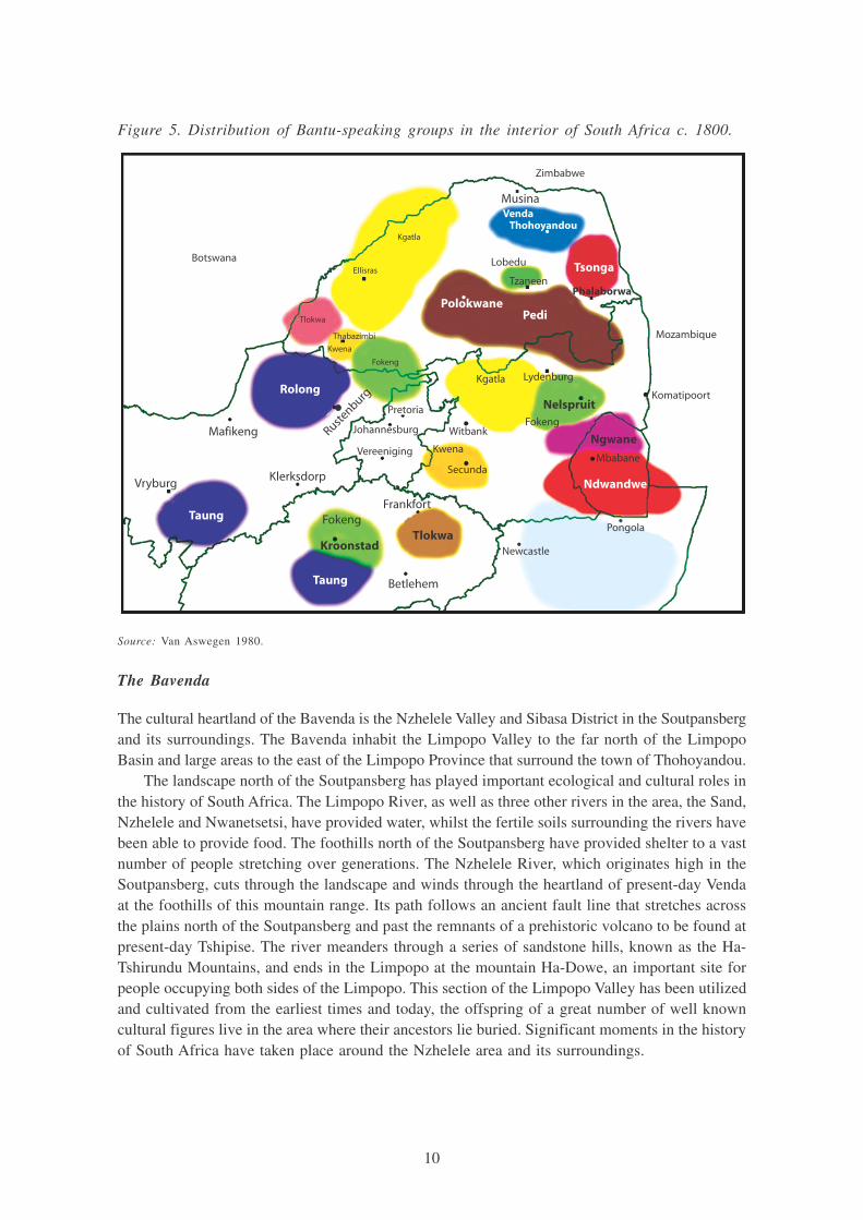
Figure 5. Distribution of Bantu-speaking groups in the interior of South Africa c. 1800.
The Bavenda
The cultural heartland of the Bavenda is the Nzhelele Valley and Sibasa District in the Soutpansbergand its surroundings. The Bavenda inhabit the Limpopo Valley to the far north of the LimpopoBasin and large areas to the east of the Limpopo Province that surround the town of Thohoyandou.
The landscape north of the Soutpansberg has played important ecological and cultural roles inthe history of South Africa. The Limpopo River, as well as three other rivers in the area, the Sand,Nzhelele and Nwanetsetsi, have provided water, whilst the fertile soils surrounding the rivers havebeen able to provide food. The foothills north of the Soutpansberg have provided shelter to a vastnumber of people stretching over generations. The Nzhelele River, which originates high in theSoutpansberg, cuts through the landscape and winds through the heartland of present-day Vendaat the foothills of this mountain range. Its path follows an ancient fault line that stretches acrossthe plains north of the Soutpansberg and past the remnants of a prehistoric volcano to be found atpresent-day Tshipise. The river meanders through a series of sandstone hills, known as the Ha-Tshirundu Mountains, and ends in the Limpopo at the mountain Ha-Dowe, an important site forpeople occupying both sides of the Limpopo. This section of the Limpopo Valley has been utilizedand cultivated from the earliest times and today, the offspring of a great number of well knowncultural figures live in the area where their ancestors lie buried. Significant moments in the historyof South Africa have taken place around the Nzhelele area and its surroundings.
Source: Van Aswegen 1980.
Taung
Taung
Rolong
Tsonga
Tlokwa
Ndwandwe
Nelspruit
Betlehem
Mafikeng
VryburgKlerksdorp
Kroonstad
FokengFrankfort
Rustenburg
o
Vereeniging
Johannesburg
Pretoria
Secunda
Witbank
Kwena
Kgatla Lydenburg
Fokeng
Mbabane
Pongola
Newcastle
Ngwane
Komatipoort
Mozambique
Phalaborwa
PediPolokwane
Thohoyandou
Tzaneen
Lobedu
VendaMusina
Zimbabwe
Botswana
Thabazimbi
Kwena
Fokeng
Tlokwa
Ellisras
Kgatla

11
A summary of the history of the Venda
Linguistically and culturally the Bavenda display similarities with the western Shona (or Kalanga)of Zimbabwe (Wentzel 1983). According to Peires (1986), the Venda nation was Shona in origin.Some aspects of the Venda vocabulary can, however, also be compared to that of the Sotho. Despitethese similarities, Venda has sufficiently unique elements to be considered as a distinct language.The language of the Venda has three regional variants. An archaic form of Venda known asTwamamba still exists in the north-western Soutpansberg, and another dialect called Ilafuri is spokenin the western and central mountains. An eastern variant known as Tshimbedzi is used by Vendapeople in southern Zimbabwe (Loubser 1988).
The origins and political history of the Bavenda have intrigued researchers and scholars. Twoschools of thought have dominated interpretations of Venda origins: an early school emphasizingmigration, and the current school emphasizing local development (Loubser 1988). The first migration-focused school based their hypotheses on Singo oral traditions, indicating that the ancestors of theVenda originated somewhere north of the Zambezi River in the vicinity of present day Malawi.Singo is the “totemic name” of the politically dominant group among the Venda (Loubser 1988).During their southward migration through Shona territory, several Shona elements were incorporatedinto this pre-Venda culture. The Singo group, of which at least five different oral traditions exist,moved through present-day Zimbabwe and Shona territory. Here the Singo came into contact withsome important Zimbabwean groups, including the Rozvi living at Danangombe, the capital ofChangamire Rozwi from about 1693 to the early 1820s, also known as Dhlo Dhlo. The Rozwi areremembered as the principal Zimbabwean dynasty of the past and they were the builders of mostof the Dzimbabwe capitals in the country.
It is said that the first three generations of the Singo lineage ruled north of the Limpopo Riverand the last five ruled in the Soutpansberg, prior to the rule of the Venda chief Makhado in 1864(Loubser 1988). During the seventeenth century, this group of Shona immigrants, the royal Singo,moved south into South Africa and settled on the banks of the Njelele River (Stayt 1931) near theSoutpansberg. Here they built their capital, known as Dzata. According to this source, they extendedtheir power base and dominated the whole of the Venda Kingdom. Most traditions agree that anunited Singo elite expanded from Dzata to incorporate virtually all earlier communities in theSoutpansberg. The Singo Empire came to an end with a dispute over the succession of chief Thoho-ya-Ndou. According to genealogical information, the Singo Empire in the Nzhelele Valley is likelyto have dispersed between 1750 and 1800 (Van Warmelo 1935; Stayt 1931). The Bavenda are,therefore, a conglomeration of the original Venda group and several other groups. The Venda familyformed the royal group and their leaders were acknowledged as chiefs of the whole population.
Under the leadership of chief Thoho-ya-Ndou, the Venda extended their authority over theSoutpansberg area, and under his rule the area experienced relative peace. After Thoho-ya-Ndou’sdeath, leadership was disputed and three main sections emerged during the split. The three distinctgroups, the Western, Eastern and Southern Venda define the basis of the Venda classification (VanWarmelo 1935). The Western section mainly comprises the Ramabulana Singo, the Eastern section,the Tshivase and the Mphaphuli dynasties, whilst the Southern section includes former vassals ofthe Singo that gradually became incorporated into the Sotho chiefdoms.
In each of these areas independent chiefs ruled the various Venda tribes. While the easterntribes remained relatively isolated, the western tribes had greater contact with other tribes andwhite settlers. There is also more information about the origins and development of the Westerntribes, whose chiefs descend from the senior bloodline of Thoho-ya-Ndou. Chief Mpephu isrecognized as the most senior of all the Venda chiefs of the Western Venda group.

12
5Harries (1989) examines critically the assumptions of ‘Tsonga’ ethnicity and his critical examination of ethnicity ispertinent to this report, because all reference to ethnic groups or tribal entities must consider the dynamic and changingnature of these identities and cannot assume an existing ‘static’ tribal identity that has been carried forward from pre-colonial to colonial times. Harries’ point is that ethnicity is a constructed notion and the history of its construction mustbe addressed.
The second and current school emphasis is on local development and bases its interpretationmostly on the fragmented and highly telescoped non-Singo traditions (Loubser 1988: 9). Ratherthan looking for Venda migrations from central Africa, scholars of the new perspective emphasizelocalized developments and influences. These scholars stress developments among diverse Vendacommunities that had existed prior to the Singo. According to researchers, this group of people,the VaNgona, existed in the Nzhelele Valley and they were the builders of the Dzata ruins (Ralushai1977). They were later scattered all over the Soutpansberg and, with the reign of the chief Thoho-ya-Ndou, became the Bavenda people. Many scientists view this theory of “Venda isolation” as amyth and question the theory of local origins and hypotheses of development that exclude notionsof migration.
Present status
Today large rural settlements can be found in the Upper Nzhelele Valley, an area that, in formeryears was classified as the “Venda homeland.” The tropical climate of the Soutpansberg area anddaily rain and mist showers high up in the mountain feed into the runoff streams that become theNzhelele River. The river provides water to the fertile valleys at the foothills of the Soutpansberg.The communities that live in these fertile valleys are predominantly Venda speaking and use thevalley for extensive agricultural activity. Water is extracted from the Nzhelele to adjacent farmsfor irrigation and for domestic use. Some households also depend on the river for food, as it is arich source of fish. The Nzhelele has played a similar role in the lives of people over manygenerations and for the Venda people, the heartland has been defined by the Nzhelele River itself.
The Tsonga / Shangaan5
The Tsonga/Shangaan people occupy the eastern section of the Limpopo Province along the westernborder of the Kruger National Park, stretching into both Swaziland and Mozambique. The largerareas surrounding Giyani and Malamulele stretches from the escarpment in the north east up tothe Lebombo Mountains. This area is comprised of a highveld escarpment as well as western andeastern plain regions. The northern region is fairly mountainous whilst the southern region levelsout to plains. The territory occupied by the Tsonga/Shangaan enjoys summer rainfall with an annualrainfall varying between 500 to 700 mm. As a result of the low rainfall and high temperatures, soilis poor and it does not retain water well. This soil type is not suited to crops, although it doesprovide good feeding grounds for cattle. Various large rivers (Great Letaba, Little Letaba, LevubuShingwedzi and Nsami Rivers) pass through this area. This eastern section of the Limpopo Provincebushveld bordering the Kruger National Park is classified as “Mixed Bushwillow Woodlands.” Theheartland of the Tsonga/Shangaan is around Giyani and the Letaba Valley.
13
A summary of the history of the Tsonga / Shangana
The first Tsonga groups appear to have settled in southern Mozambique around 1544 and wereagriculturists. In the nineteenth century, three groups existed among the Tsonga people; a southerngroup that included the Maputa, Tembe and Mpfumo, a central group, including the Khosa, NkunaMavunda and Maluleke, and the northern group that was comprised of the Hlengwe and the Tswa.
Settlements of Tsonga sub-groups in the Limpopo Basin were also affected by a severe periodof drought that began in the 1790s, and culminated in the widespread famine reported in 1830(INGC et al. 2003). Around 1820, various Nguni groups forcefully moved into the area of the Tsongagroups in Mozambique. The first Nguni group to strike the Tsonga settlements was that ofZwangendaba (from the Jele clan), followed by Nxaba and his people. The final Nguni group thatimpacted on the lives of the Tsonga was the Shangana under the command of Soshangane(Manukuza). The Shangana moved into the fertile valleys of the Limpopo Valley, but after theexpansion of the Zulu empire (Mfecane) and the military expeditions of the Zulu king Shaka in1835, Soshangane moved his people north to the Zambezi River. Soshangane integrated variouslocal groups including Shonas into the Shangana group. As has been discussed in the section aboveon Mozambique, he established the Gaza kingdom (named after his great grandfather) stretchingfrom the Zambezi River to Delagoa Bay.
A pox-epidemic forced the Shangana to move southwards back into the Limpopo Valley. VariousTsonga groups moved over the Lebombo Mountains in fear of the return of Soshangane, settlingto the north of the area later known as Gazankulu. Soshangane’s death in 1858 initiated a periodof chaos and the disintegration of the Gaza kingdom. He was, contrary to his final wishes, succeededby his son Mawewe, whose reign was soon violently contested by his brother, Muzila, Soshangane’schoice of succession. The dispute over succession between the two brothers caused Tsonga peopleto move from Mozambique into South Africa. Mawewe died in 1872 and he was succeeded byHanyana who fled to the former Gaza area after a run-in with the then Transvaal authorities. AfterMawewe’s death there was a period of peace and stability when many Tsonga groups movedback to their former settlement areas.
Peires (1986) claims that the Tsonga were influenced by Shona and Sotho cultures long beforethey left Delegoa Bay. According to him, this is because the Tsonga were traders who sailed theircanoes as far as 500 km up the Limpopo and Nkomati rivers, trading in gold, ivory, iron, copper,rhinoceros horn, furs, amber, cloth and beads among the Venda, Phalaborwa, Sotho and Portuguese.According to Harries (1989), the use of the term ‘Tsonga-speaking’ with reference to the nineteenthcentury is misleading because there was no linguistic unity but rather a rich variety of languagesthat reflected the diverse geographical origins. The codification of Tsonga, as a language, accordingto Harries (1989), was undertaken only towards the end of the nineteenth century by missionarieswho, trained to categorize and classify, reified this linguistic category into an ethnic group.
The Tsonga groups that live in the Giyani-Malamulele areas today are the descendants of groupsthat fled into the area during the reign of Soshangane and the subsequent power struggle betweenhis sons.
Present status
In 1913, an area exclusively for “black occupation in the Lowveld” was demarcated and it wasthis area that was later named “Gazankulu”. The passing of the Bantu Self-Government Act (Act46 of 1959) marked the establishment of Tribal Authorities throughout South Africa and theorigination of formal Bantu Homelands with Gazankulu as the ‘homeland’ of the Tsonga / Shangaan.

14
The Swazi and Ndebele (NGUNI)
The northern Nguni groups were found in a large area covering Mpumalanga, Swaziland, andKwazuluNatal, east of the Drakensberg extending into the Eastern Cape. The groups related to theSwazi can be found in the mountainous kingdom of Swaziland, sections of Natal and Mpumalanga inthe mountainous areas including the Drakensberg and the bushveld. The present day Kingdom ofSwaziland, sections of Mpumalanga, Limpopo Province and Gauteng are occupied by Swazi peopletoday. Because relatively few Swazi live in the Limpopo Basin, this profile does not cover a historyof the Swazi people, which has relevance in particular for the southern sections of the Mpumalangaand the present day Swaziland itself, a nation currently ruled by King Mswati III.
The West and North Sotho (SOTHO)
The Sotho groups were found in the interior of the highveld areas of South Africa. At the end ofthe eighteenth century, they occupied a large area that included present-day Botswana, large sectionsof the then Transvaal (today Limpopo Province and Mpumalanga), the Free State Province aswell as parts of the Northern Cape.
Archaeological evidence tells us that the area between the Vaal River and the Malopo/Marico/Limpopo rivers was relatively densely populated by the fifteenth century AD by Sotho-speakingrelatives. Based on Sotho oral histories, various groups apparently were the originators of the currentSotho-speaking community. At the end of the fifteenth century, Chief Mokgatla broke away fromthe Hurutshe group and settled in the Witwatersrand area to form the Kgatla. As with the otherSotho groups the Kgatla split into several smaller groups including the Pedi, Tlokwa, Phuting andKholokwe. The most prominent chieftaincy to separate was the Pedi. Not much is known aboutthe earlier history of the Pedi, but its separation from the Kgatla probably occurred during theseventeenth century. The Pedi moved northeast and settled in the Steelpoort Valley in the south-east of the Limpopo Basin. The initial group became influential over smaller neighboring Sothogroups. The foundations of the Pedi were laid by Chief Thulare. Under his rule, large amounts ofcattle and many small communities were assimilated by Pedi and formed the basis for a Sothostate. The Pedi was the only Kgatla group to remain in this part of the Limpopo Basin. OtherSotho groups moved over the Vaal River into the Free State. Today, Western and Northern Sothogroups can be found across the northern parts of South Africa and Botswana, in the LimpopoProvince, Northwest and Mpumalanga.
4. Zimbabwe
The Zimbabwean inhabitants of the Limpopo Basin are from two major groups, the Bantu and thenon-Bantu. The former outnumber the latter, who were the original inhabitants of the Basin. Mostof the non-Bantu were driven out by the Bantu with those who remained being influenced by theBantu way of life.
The Ndebele, descendants of Soshangane, are the largest ethnic group within the basin, althoughat national level they constitute about 20 percent of the population. While most discussions on ethnicgroups in Zimbabwe focus on the Shona and Ndebele, they ignore the variety of ethnic groups,particularly in the Limpopo Basin. The reason for this will be briefly explained under the pre-colonialsection.

15
The principal ethnic groups residing in the Zimbabwe part of the basin (and assumed to havebeen present even in the colonial period) are presented below. It should be noted that, whilelanguage is perhaps the most distinguishing characteristic, other cultural differences exist. Figure6 provides a map showing the locations of the various groups.
Ndebele
The Ndebele people are found in the Matebeleland north and south provinces where Ndebele isrecognized as the official language. It is the second most widely spoken African language inZimbabwe after Shona. Most ethnic communities in the Mzingwane catchment therefore speakNdebele.
Sotho
Sotho is a cover name for a group of related languages namely Kurutsi, Mangwato, Birwa andSotho. In the context of Zimbabwe, the cover name, Sotho, is generally used to refer to the Birwa.Sotho is spoken in the southwestern part of Zimbabwe, mainly in Gwanda, and in some parts ofthe Bulilimamangwe (Plumtree) district. Some parts of Beitbridge also have Sotho speaking people(Shashe, Machuchuta, Masera and Siyoka 2). The Sotho are located in regions which are dry andprone to drought. The total population of the Sotho in Zimbabwe is not known, although Hachipola(1998), reports that in Gwanda (where they are most common) they number approximately 56,000.
According to Hachipola (1998), the inhabitants of the area (the Sotho) suggest that the areasthey occupy today were once occupied by the Tonga (in other countries this ethnic group is referredto as Tsonga, but are referred to as Tonga in Zimbabwe) and some of the totems of the Sotho aresaid to have originated from the Tonga. Some of the people moved to the area as a consequenceof Zimbabwe’s liberation war in the 1970s and during the various phases of land apportionment.Consultations with chiefs, sub-chiefs and councilors in the area by Hachipola (1998) revealed thatthere were no voluntary migrants to the area due to its arid nature.
Other ethnic communities in the area (Gwanda) include the Ndebele, Venda, Shangani andNyanja. Some of the population are from Malawi and Zambia, and speak Nyanja and Bemba.The Ndebele language has had a major influence on the Sotho speaking people in Gwanda (wherethe majority of the Sotho are found), so that most of them are now bilingual with some havingshifted their linguistic allegiance to Ndebele, as the languages are related.
Shangani
Shangani-speaking people are found in Beitbridge, Mwenezi and Mberengwa, although they aretraditionally from the Chiredzi District. They are also found in parts of Mozambique (where theyare referred to as Changana), South Africa and in Swaziland. The word ‘Shangani’ is derived fromfollowers of Soshangane from the Ndebele Empire. It is therefore a generic or political term thatdoes not specifically describe the peoples who speak the language, because it incorporates suchpeople as the Ndau, Chopi, Ngoni and Nyembani, people who followed Soshangane as he movednorth from South Africa. However, in Zimbabwe, official records refer to the language and thisgroup of people as Shangani, although they would prefer not to be called by this name (Hachipola1998). The estimated population of the Shangani in Zimbabwe is 122,000.
16
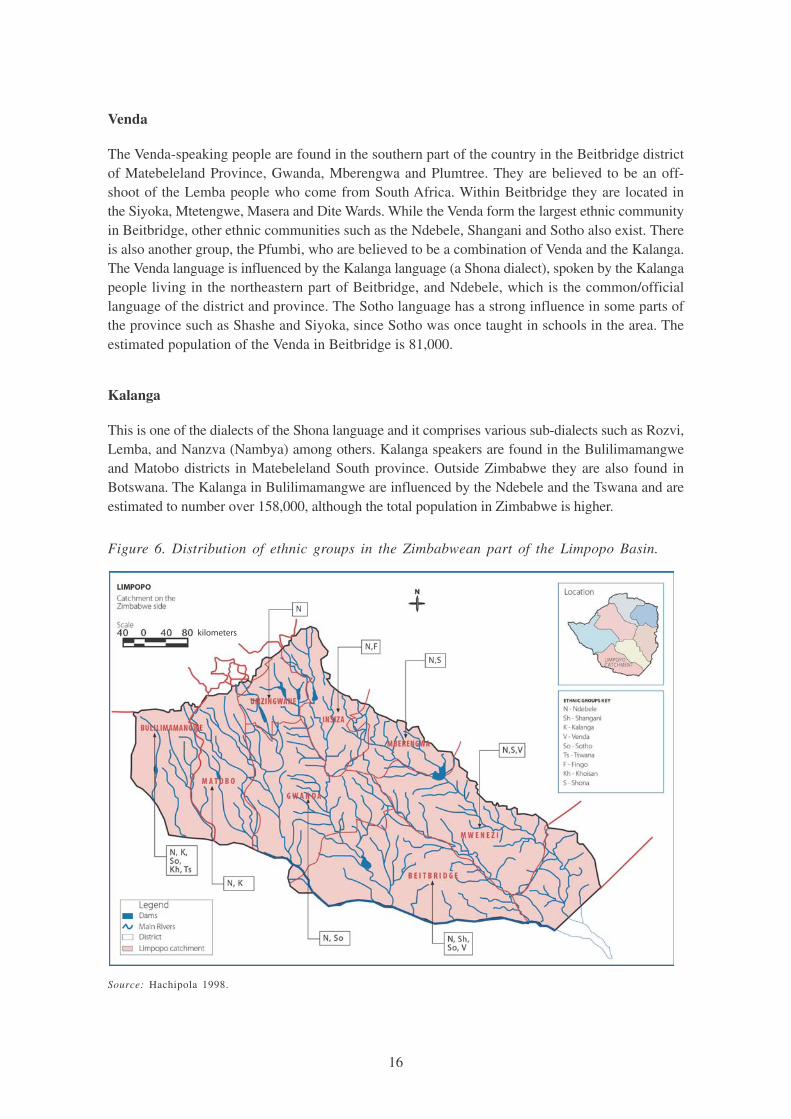
Venda
The Venda-speaking people are found in the southern part of the country in the Beitbridge districtof Matebeleland Province, Gwanda, Mberengwa and Plumtree. They are believed to be an off-shoot of the Lemba people who come from South Africa. Within Beitbridge they are located inthe Siyoka, Mtetengwe, Masera and Dite Wards. While the Venda form the largest ethnic communityin Beitbridge, other ethnic communities such as the Ndebele, Shangani and Sotho also exist. Thereis also another group, the Pfumbi, who are believed to be a combination of Venda and the Kalanga.The Venda language is influenced by the Kalanga language (a Shona dialect), spoken by the Kalangapeople living in the northeastern part of Beitbridge, and Ndebele, which is the common/officiallanguage of the district and province. The Sotho language has a strong influence in some parts ofthe province such as Shashe and Siyoka, since Sotho was once taught in schools in the area. Theestimated population of the Venda in Beitbridge is 81,000.
Kalanga
This is one of the dialects of the Shona language and it comprises various sub-dialects such as Rozvi,Lemba, and Nanzva (Nambya) among others. Kalanga speakers are found in the Bulilimamangweand Matobo districts in Matebeleland South province. Outside Zimbabwe they are also found inBotswana. The Kalanga in Bulilimamangwe are influenced by the Ndebele and the Tswana and areestimated to number over 158,000, although the total population in Zimbabwe is higher.
Figure 6. Distribution of ethnic groups in the Zimbabwean part of the Limpopo Basin.
Source: Hachipola 1998.
kilometers

17
A HISTORIC OVERVIEW OF NATURAL RESOURCE GOVERNANCEREGIMES
The following section describes the evolution of indigenous natural resource governance structuresand the factors that influenced this evolution over time. It is divided into four distinct time periods:pre-colonial period; colonial period; post-colonial era; and post cold war period.
Pre-colonial times
There is scant reliable information on most of the pre-colonial institutional structures in the basin.The first peoples to occupy the basin were San/Bushman hunter-gatherer clans. Permanentsettlements were initiated with the influx of Bantu-speaking tribes from the northeast around AD300 (Huffman 2000). One of the most important pre-colonial farming settlements in southern Africa,Mapungubwe, lies in the Limpopo Basin. This site is located in the north of South Africa close tothe borders of both Botswana and Zimbabwe at the confluence of the Shashe and Limpopo rivers.At its peak, it was home to about 10,000 people and controlled about 30,000 km2 of territory, makingit southern Africa’s first state (Huffman 2000). Mapungubwe was an important center of civilizationin southern Africa and provides a useful site from which to derive an understanding of the cultureof that portion of the Limpopo Basin. The remains of Bantu-speaking settlers in the Mapungubweregion have been dated to between AD 350 and AD 450, with evidence of pottery making andagricultural production (Huffman 2000). The identity of this Bantu-speaking group remains largelya mystery, but the Mapungubwe people were the first state-organized society southern Africa hasknown. Golden objects, ivory, beads (glass and gold) and clay figurines, as well as large amountsof potshards, were found at these sites and also appear in sites dating back to this phase of theIron Age. The various groups which initially settled the area are known as the Zimbabwe culture.Their main settlements were Mapungubwe (from AD 1220 to 1290), Great Zimbabwe (AD 1290to 1450) and Khami, near present day Bulawayo (AD 1450 to 1820). Settlements of the Zimbabweculture were also situated in present-day southern Mozambique, where the settlement of Manekweniwas a centre for cattle raising, agriculture and the gold trade between the twelfth and the eighteenthcentury (IIASA 2001). Related sub-groups settled in the Venda region of South Africa.
The climate of this period was warm and wet, conducive to production of sorghum and millet(Tyson and Lindesay 1992). From 600 to 900 AD the climate was drier coinciding with no farmingcommunities reported in the area. By about AD 900 the climate became wetter again and theZhizo people settled in the area. During the ensuing two centuries, various groupings of peopledeveloped, establishing trade links with the East African coast (Sofala, Bazaruto, Kilwa, etc.).Initially, those who settled in the area between about AD 1000 and AD 1100 relied on cattle fortheir wealth, with cultivation agriculture producing a subsistence level of food. However, once coastaltrade patterns became established several groups, such as the K2 people and the Leokwe, becamewealthy through trading gold, ivory and pottery (Huffman 2000). The scope of this paper does notpermit an in-depth exploration of slavery, but anecdotal evidence suggests that the slave trade wasalso an important part of this economy and a determinant of power relationships between variousgroups in and outside the basin territory. As a result of this increase in wealth, in-group socialstratification became more pronounced, leading to the stratification of Zimbabwe society into twogroups: nobles and commoners (Huffman 2000). These two groups had different rights, duties andbehavior patterns. The higher class “nobles” controlled access to resources.

18
This class distinction was legitimized by the concept of “sacred leadership” – the belief thatthere is a metaphysical relationship between the leader and the land. In the case of the Zimbabweculture, sacred leadership was intertwined with ”traditional” African deities and it was the deitywho made it rain, or who made crops succeed or fail (Huffman 2000). The leader of the grouphad access to the deity through a hierarchy of ancestors. For example, the Kalanga people inZimbabwe had rain-gods who provided them with rains. The provision and control of rains was atool that enhanced the status of ruling lineages among the Kalanga (Makamuri 1995).
Rain is reported (Makamuri 1995) to have come from four directions, each direction pointingto a rain god. These gods occasionally fought, resulting in droughts. Water resources among theKalanga were also guarded by animal water guardians, e.g., mermaids, particular fish types andsnakes. This ordering of the universe is different from rainmaking amongst other Bantu speakingcultures in southern Africa. For example, the Nguni see rainmakers as special “herbalists,” notchiefs, a tradition of sacred leadership reiterated amongst the rain-queens. Thus, a noble leader’spower was based, in part, on the claim that his or her ancestors would intervene to ensure thefertility of the land and its people. Rainmaking ceremonies would usually take place on steep-sidedhills that were inaccessible to commoners. The ability of a leader to induce a deity to provide raindetermined how powerful the leader was. Periods of climatic perturbation, such as drought wouldlead to changes in the political powerbase, with evidence emerging of population shifts from onesite to another corresponding to changes in the climatic regime (Huffman 2000).
The stratified groups that formed part of the Zimbabwe culture resided in separate areas. Thenobles generally occupied the higher ground, such as the hill of Mapungubwe, while the commonerssettled on the plains on the superior agricultural land. This was because the nobles derived mostof their income from trade, while the commoners were more reliant on agriculture and cattle fortheir livelihoods. Specific fields were set aside to generate resources for the capital (the centralnode of an “empire” such as Mapungubwe). Residents contributed to cultivating these fields as atribute to the nobles, whilst, it seems from archaeological data, that further a field, land wascultivated for household subsistence. During wet periods the Shashe River would flood, makingagriculture on its floodplains a possibility. The receding flood would leave fertile, moist soil in whichvarious crops could be grown, in a similar pattern to that occurring along the banks of the NileRiver (Huffman 2000). Typically, the commoners had access to the flooded plains, while the noblesrelied on ground water wells for their fields, domestic use and cattle watering purposes. The demiseof the Mapungubwe capital in AD 1290 and the movement of the Zimbabwe culture to the GreatZimbabwe site coincide with the end of the wet period of AD 900 to 1300.
The Great Zimbabwe state was an important center for Botswana, in that this is where oneof the minor tribes of Botswana, the Kalanga, were first called by this name6. They later spreadout across Zimbabwe and Botswana, in the western part of which some Kalanga descendents areknown as Wumbe. Other Kalanga chiefdoms descended from groups of Sotho such as the Nswazwiand Chizwina. From 1200 – 1400 AD a number of powerful dynasties began to emerge amongthe Sotho in the western Transvaal, resulting in what were known as the Rolong chiefdoms. TheCentral Sotho dynasties (Tswana of Botswana) of the Hurutshe, Kwena and Kgatla were derivedfrom the break-up of the Phofu dynasty in the Transvaal. This break-up was explained as a responseto drought, which forced junior brothers to break away and migrate, after which they formed otherchiefdoms. Evidence of farming activities among these groups show that in the beginning, farming
6Minor, in that the state recognizes the Tswana tribes while all others are ‘minor,’ although it is far from minor numeri-cally and influentially.

19
expanded in small homesteads, each clustered around a cattle corral with a few larger settlementsas evidence of chiefdoms. This later changed with the growth of larger states, often hostile toeach other and competing for cattle wealth, subject populations, control of hunting and mineraltribute and trade. The Kwena and Hurutshe migrants founded the Ngwaketse chiefdom amongthe Khalagari-Rolong in southeastern Botswana. Some of the Kwena moved to the north ofBotswana and formed the Ngwato state. Eastern Botswana was historically associated with theKhalagari (Kgalagadi) chiefdoms and culture, which was a Sotho speaking group whose prowesswas in cattle raising and hunting rather than farming. In the Serowe area in east-central Botswanathere was a thriving Toutswe farming culture whose prosperity was based on cattle herding.
Of particular relevance in the pre-colonial history of what is today the country of Zimbabwe(as opposed to the Zimbabwe culture described above), is the story of the Ndebele and Shonatribes. The area now occupied by the Ndebele (the Limpopo Basin) was once occupied by theShona, who themselves had pushed out the original inhabitants. The original inhabitants of the areawere non-Bantu groups such as the San and Khoi-Khoi. The Ndebele, leaving their originalsettlement area further south, due to the forceful expansion of the Zulu empire under Shaka, pushedthe Shona up from the Southern part of present-day Zimbabwe and settled there. The Ndebele-Shona ‘conflicts’ are well documented, with the former being alleged to have vanquished the weakShona. Beach (1994), an authority on pre-colonial Zimbabwe, says this was exaggerated and amyth for a number of reasons. First, there were Shona-speaking groups that lived among theNdebele. Second, there are reports of counter-raids by the Shona on the Ndebele. The raids weresporadic and were very much determined by local needs. For example, the Ndebele raided theShona for grain, women and young men. The grain was required to supplement their diet as theNdebele were largely pastoralist. The women and young men were required for numerical growthof the tribe (young men would directly add to the number and women would bear children). TheShona in turn, would engage in counter-raids for the acquisition of cattle.
Third, there was active cooperation for purposes of trade (Beach 1994) as well as religiouscooperation between the Shona and Ndebele. For example, the latter paid tribute to various spiritmediums of the Shona. In turn, the local overlord of the area, Nemakonde, also paid tribute toLobengula, the Ndebele King who entered into a contract with the settlers, which resulted in landappropriation for the settlers. The Ndebele also had a cordial relationship with the great Chaminukamedium who lived near the Rozvi polity (Beach 1994). These show that the conflicts between theShona and Ndebele were exaggerated and there were actually various forms of cooperationbetween the two, to the extent that they influenced each other’s activities and probably cultures.
Despite this reality, the image of conflict was actually promoted. For example, some missionariessought support for their missions to save the souls of the ‘savage’ Ndebele. Travelers used this tostress the wilderness of the country through which they traveled as a means to attract more peopleto join them. Settlers used this to justify their position in the country, i.e., to maintain peace betweenthe tribes. The Ndebele perpetuated the myth in order to build up their military image. The Shonaalso contributed to this in order to gain the support of the settlers who had made themselves the‘saviors’ of the Shona from the Ndebele. These events later spilled into the colonial regime.

20
The Colonial Era
The Colonial period in the Limpopo Basin can be characterized by contradictions and complexitiesand it is critical to state that:
(a) each basin state had a different colonial experience,
(b) colonization took place in different phases and at different times for each country,
(c) in some countries the traditional structures were decimated, whereas in others they wereartificially elevated and even protected.
Colonization systematically imposed authoritarian principles on human settlements with strategicpolitical systems that were engineered for rigidity and control. This phased process was one whereborders were defined and people were divided into groups as the subjects of different colonialpowers. Among other effects, these new arrangements signaled an end to resolving environmental,political, or demographic issues by migration. While carving out “spheres of influence” colonialpowers entered into a wide range of agreements. These included agreements about how to managewater, access to water supply, allocation of flows, and border delimitation on water bodies (Heyns1995). Traditional rural societies were affected in different ways, but importantly, natural resourcemanagement functions that had been controlled by rural communities themselves were consequentlycontrolled and administered from regional capitals rather than from local villages. Because authoritywas subverted outside of local spheres of governance, traditional structures and powers wereweakened and became subservient to the political goals of the colonial administration.
Colonial borders defined modern independent states after the colonial period. The South Africanportion of the basin was defined by the Zuid-Afrikaanse Republiek (ZAR), which existed as asovereign state from 1854 to 1910, and by the Union of South Africa from 1910 to 1961. TheZimbabwean portion of the basin was defined by the original borders of the Federation of Northernand Southern Rhodesia and Nyasaland. The Mozambican portion was defined by the Portuguesecolony of Mozambique. Botswana was never a colony (it was a British Protectorate) and this hasresulted in greater retention of traditional systems. Different colonial experiences and their impacton traditional natural resource management structures become clear when looking at it from acountry-specific perspective.
1. Botswana (1885-1966)
Increasing trade in ivory and ostrich feathers in Botswana (then Bechuanaland) attractedmissionaries and Boer trekkers to the east of Botswana in the 1840s. With the scramble for Africain the 1880s, the British tried to keep their ‘missionary road’ through Botswana to present dayZimbabwe open to enable them to expand their activities. They did this by proclaiming Botswanaa British protectorate in 1885, thus keeping the Boers out. This declaration did not go unopposedhowever. The leading Tswana chiefs in the country separately sent messages to the Queen ofEngland to the effect that they wished to rule in their areas without subscribing to British law, asshown by one such message:

21
I Sechele, son of Motswasele, Chief of the Bakwena, having with me my sonsand younger brothers, have heard the message concerning the protection ofthe Queen of England and give thanks for it. Concerning the laws which shallbe established in the country, I say I wish to rule among my people accordingto custom, but I give the Queen to rule among white people, wherever theyare (Tlou and Campbell 1984: 209).
Some chiefs opposed the idea of Botswana as a protectorate because they did not see againstwhom they needed to be protected and saw no need for it. To them it meant their country wasbeing taken away from them. In addition, they had seen that Tswana were being badly treated bythe British, who had taken some of the Batswana land (Tlou and Campbell 1984). The chiefstherefore mistrusted this development and the territory remained divided into eight largely self-administering tribal reserves, each under the rule of a Kgosi (Chief). Therefore, the coming ofthe British did not result in as much change in traditional institutions as it might have.
As a dry country with little promise of exploitable resources, the British saw no need to colonizeBotswana. Instead, they hoped to hand it over to the British South Africa Company (BSAC), whichwas responsible for British expansion activities in Africa. Again, the leading Tswana chiefs opposedthis and Botswana continued as a British protectorate. The British hoped to eventually hand theterritory over and make it an extension of either Rhodesia or South Africa. Therefore, itsadministrative capital remained at Mafikeng in South Africa outside Botswana’s borders.
There is very little record of the water history of Botswana, likely due to its dry ecology. Waterresources were considered important mostly in relation to livestock rearing, the main livelihoodactivity for most of the tribes. Drilling for water began on a large scale in the early days of theProtectorate by both the colonial government and the Dikgosi (Chiefs). However, these effortswere mainly concentrated in large villages. Fees were charged for using this water and individualswere encouraged to drill their own boreholes. Those who drilled their own boreholes were allowedto use the water for themselves without having to share, as was necessary with open water sources(Tlou and Campbell 1984). Laws prohibited drilling boreholes close to each other to protect grazingland. Among the Bakgatla (one of the eight Tswana tribes), syndicates were formed that wereresponsible for buying and drilling boreholes for exclusive use of members of the group (Tlou andCampbell 1984). The ‘colonial’ government became increasingly involved in water developmentafter realizing that the boreholes that had been drilled were unable to provide sufficient water forthe villages and towns. This led to the construction of dams to improve water supply, illustratingthe colonial government’s active involvement in developing water supply infrastructure.
In 1966, the Republic of Botswana became independent with Seretse Khama, from theBangwato tribe, as its first president. State intervention in water management increased in an effortto expand access in the semi-arid country.
2. Mozambique (c. 1880 – 1975)
Although the Portuguese arrived in East Africa during the 1400s, their activity in present-dayMozambique centered on the coastal trading posts of Lourenco Marques, Inhambane and Ilha deMozambique while much of the inland remained independent until 1914 (Bergstrand 2003). Theformal administrative hierarchy of the Portuguese colonial empire was initiated in 1934 by the“Reforma Administrativa Ultramarina (RAU)”. This reform divided the colony of Mozambique

22
into “regulados” (kingdoms), each of which had a traditional leader, then called a “regulado7”.Regulados exercised administrative functions such as tax collection or supervising the constructionof roads and wells on behalf of the colonial government (Bergstrand 2003). This made the“regulados” an important part of the colonial “indirect rule” structure. Given this importance thecolonial government would intervene in succession decisions in order to ensure that the “regulados”in power would not disobey orders or cause resistance. The intervention of the colonial governmentshifted traditional leaders’ responsibility from serving their communities to serving the (colonial)state, which substantially undermined their perceived legitimacy among their communities(Bergstrand 2003). This close linkage modified chieftaincy structures. The colonial state alsoinfluenced FRELIMO’s stance towards traditional leadership after independence and was one ofthe reasons for replacing traditional leadership structures with alternative governance structures(see description under post-colonial below).
According to Anstey (2001), natural resource use in colonial Mozambique was governed byformal state legislation but enforcement of this legislation was limited due to weak administrativestructures. It can therefore be concluded that whatever customary water management arrangementsthat existed at that time may have continued parallel to the formal state legislation. However,available research material focuses on traditional natural resource governance systems in the northof present-day Mozambique, while little information is available on natural resource governanceregimes in Mozambique’s south, including the Limpopo Basin area. Verification of the aboveconclusion can, therefore, only be achieved through further research on the matter in the LimpopoBasin area itself.
3. South Africa
For South Africa, Turton et al. (2004) have defined at least four (but possibly more) phases ofcolonization. They suggest that the four phases coincided with periods of European settler movementand were accompanied by the migration of Africanized Europeans, who were starting to view theiridentity as being distinct from that of citizens living in European metropoles.
According to the definition of Turton et al. (2004) the colonization of present-day South Africatook place in four distinct so-called frontier phases:
¶ The First Phase of the Frontier had two distinct components. The first, from 1652 to1834, saw the colonization of parts of South Africa. The second, from 1834 to 1900, includeda significant event known as the Mfecane (Difaqane), the forceful expansion of the Zuluempire under Shaka, which coincided with a period of internecine strife that laid thehinterland of South Africa (including parts of the Limpopo Basin) to waste. The resultingrelative absence of coherent social units in the hinterland made settlement by AfricanizingEuropeans possible. During this period, the Khoi-Khoi, original inhabitants of the area, weredestroyed by disease attributed to initial European settlement.
7“Regulado” refers to the Territory and “Regulo”, the Ruler.

23
¶ The Second Phase of the Frontier (1834 to 1900) saw the influx of Boers into the hinterlandof present day South Africa. The Boers were settlers of Dutch (and later also Germanand French Huguenot) origin, who gradually developed an “African” identity and viewedthemselves as “African,” from which the name Afrikaners, is derived. The inland moveof these settlers was largely driven by three factors. First was their search for pastures,as they began largely as pastoralists. Second was the availability of largely unoccupiedareas of land as a result of the Mfecane, and third, their desire to become independentfrom British colonial rule. Their inland move led to the establishment of the first twosovereign states in the region – the Orange Free State (OFS) and the Zuid-AfrikaanseRepubliek (ZAR). Significantly, these two states were established in terms of the coretenets of the Treaties of Westphalia and Osnabrück. This made them fundamentally differentin nature from the previous kingdoms and social groupings found in Africa, as they werebuilt on the European notion of state sovereignty. Prior to the Treaty of Westphalia,sovereignty was earned and was the sole preserve of the monarchies in Europe. Thesemonarchies were linked through marriage and this gave rise to the notion that sovereignstates were only those that were recognized by these “families.” Arising from this wasthe notion of recognition as a fundamental component of sovereignty. Once the Treaty ofWestphalia was signed, it codified the notion of sovereignty and gave rise to a new worldorder with sovereignty as its foundation. The OFS and ZAR were the first states in Africathat existed in terms of the Westphalian State System, i.e., as independent states based onthe notion of sovereignty.
¶ The Third Phase of the Frontier was characterized by two distinct economic activities:capitalism and subsistence farming. As Giliomee (1981) and Turton et al. (2004) note, theso-called burgher right entitled each citizen to two farms, resulting in permanent landsettlements in the Boer Republics. The historic Cattle Killing Delusion (1857) punctuatedthis period of history. The Xhosa, in the then Transkei, experienced severe hardship aftera series of droughts, paying cattle for reparation after losing previous wars and losing largenumbers of the remaining cattle to lung sickness. In 1857, the (would-be) prophets Sifuba-Sibanzi (the Broad-Chested One) and Napakade (the Eternal One) “appeared” to a younggirl named Nongqawuse, near the Gxarha River. They told her that if the Xhosasslaughtered all their cattle, burnt all their grain and destroy their pots, only then would theirland return to its original health. They also promised that, should the Xhosa do this, theywould come back with larger herds of cattle, they would have enough grain and the whiteswould disappear. Thus, everything would return to normal. The Xhosa heeded this prophecyand about 90 percent of them slaughtered their cattle (nearly 20,000 head) and destroyedtheir grain (Turton et al. 2004). On 17 February 1857, the Xhosa waited for the fulfillmentof the prophecy. However, nothing happened, and thus, Nongqawuse heralded a mass suicideof the Xhosa. Forty thousand died of starvation. Around the same number of Xhosa lefttheir land to seek work in the Cape Colony. The colonial government took advantage ofthe situation and forced the Xhosa into wage labor (Turton et al. 2004). Some commentators(Turton et al. 2004) trace the destruction of traditional Xhosa society to this event, becauseit resulted in Xhosa citizens becoming laborers for the first time.

24
¶ The Fourth Phase of the Frontier occurred as a result of the discovery of diamonds (1867)and gold (1886). These discoveries attracted the interest of Britain, resulting in events suchas the Jamieson Raid and the South African Anglo-Boer War and culminating in theestablishment of the Union of South Africa as a British colony in 1910 (until independencein 1961).
These developments changed the role of traditional leadership within the colonial governanceframework. The policy of the Cape Colony was to eliminate traditional government, because atthe time, chiefs were believed to be the main obstacle to Britain’s civilizing mission (Bennett 2004).A completely different strategy was pursued by the colonial administration of Natal (driven byLord Shepstone), where chiefs were given governmental and judicial powers. At the same time,the (British) Lieutenant Governor was deemed “Supreme Chief of the African people,” which meantthat the colonial government could rule African subjects by executive decree, rather than the normallegislative process (Bennett 2004). This regime was also imposed on the Transvaal (which includesthe Limpopo Basin area) during the short period of British rule from 1877 to 1881, and was retainedafter the retrocession (the restoration of independence from Britain for the Transvaal Republicafter the Boers defeated British troops at Majuba) (Bennett 2004). As has been mentioned above,the system of indirect rule changed the authority and nature of traditional rule substantially.Traditional leaders became functionaries of the colonial administration and derived their power andauthority from this administration. The effect of this was that they assumed a sense of accountabilityupwards rather than to their subjects (Bennett 2004) and, the legitimacy of their rule wasundermined.
In 1894, a council system was introduced by the government of the Cape Colony (later extendedto the Transkei) that formed the model for future local governments in rural areas (Bennett 2004).Local and district councils were created, whose members consisted mainly of traditional leadersappointed to the councils by the Cape Governor. In 1909, the control of “native affairs” was vestedin the Governor-General and a Department of Native Affairs was established. In 1920, the NativeAffairs Act was passed, which extended the council system nationwide (that is to the Union ofSouth Africa established in 1910). The councils set up under this system had to perform all dutiesin the rural areas that elsewhere were performed by municipalities, including the provision of watersupplies and sanitation. As most councils were not capable of handling the extensive duties, thesystem faltered within a decade (Bennett 2004). This coincided with a change in policy by thecentral government that envisaged the “retribalization” of Africans as part of the rule and dividestrategy. This policy was also motivated, as Vail (1989) notes, by the observation that African leaderscould be used far more cheaply than the employment of expensive European officials (Vail 1989:9). A 1927 amendment of the Native Affairs Act gave chiefs civil jurisdiction over disputes arisingwithin their areas and also created the Governor General Supreme Chief. Acting through theDepartment of Native Affairs, the Governor General Supreme Chief had full authority to divideand create tribes and to appoint any person he chose as a chief or headman (Bennett 2004). Thiscompliance of traditional leaders with state policy created a cadre of subdued traditional leaderswho were discouraged from taking decisions or initiatives themselves.
The council system was formally abolished by the Bantu Authorities Act of 1951, whichsignificantly enhanced the status of chiefs. Chiefs, the lowest level of a three tier authority consistingof tribal, regional and territorial authorities, were responsible for administering the general affairsof the tribe and for advising and assisting the government (Bennett 2004). This system disruptedtraditional systems of governance and laid the foundation for the relationship between traditionalleaders and the Apartheid government after South Africa’s independence from Britain in 1961.

25
During this time, many traditional leaders became the instruments of the Apartheid governmentfor governing the population in the so-called independent homelands. In 1959, the Promotion ofBantu Self-Government Act created eight (later nine) national units, based on the reservesestablished under the 1913 Land Act, which were designated “national homelands” and fell underthe jurisdiction of “territorial authorities”. This policy continued until 1994.
One can speculate that the developments and legal and political systems, illustrated above,had an impact on natural resource management and water resource management in particular.Yet, little is known about the relationship between traditional water governance structures and thestatutory water management regime(s) of the colonial government.
According to Tewari (2001), for quite some time the (European) settler community and thenative communities ran as separate entities without control over the other. This resulted in a dualsystem of land ownership and as a result, a dual system of water rights developed (ibid). On onehand the settler community established and aligned itself increasingly in commercial terms, whileon the other hand the native community was subsistence inclined and had ownership of resourcesbased on the chief’s control without individual tenure (ibid). While indigenous water managementpractices were not codified in written form and were handed down from generation to generationby oral means, the government of the ZAR and the British colonial government promulgated aseries of laws regulating water use and management. These laws dealt exclusively with thecommercial use of water and thus excluded the indigenous population, which was engaged mainlyin subsistence agriculture.
A key water user at the time was commercial agriculture, which directed water laws towardregulating water use for commercial farming, and in particular irrigation. In the Transvaal, the firstlaw that laid down substantive rules for the use of public water was enacted in 1894 (Turton et al.2004). This law defines a public stream as water flowing in a defined channel; the channel maycontain water throughout the year or may be dry for any period. Private water, on the other hand,consists of a spring or stream, which is not of a permanent nature, not capable of subdivision, orhaving no defined course extending to a property adjoining that on which it originates (ibid).Regarding the use of public water, the law laid down the following provisions:
¶ A riparian owner is declared to be entitled to the reasonable use of the water of a publicstream for household and agricultural purposes;
¶ He may lead the water out of the stream by means of furrows, and he may construct aweir in the channel to divert it;
¶ Where two persons want to use the same water and cannot agree the matter must go toarbitration, but if they both consent, they can have recourse to the courts;
¶ Water taken from a public stream must not be led beyond the boundaries of riparian land,and all furrows must be kept in proper order;
¶ The liability of a riparian proprietor for damages occasioned to lower riparian owners throughhis taking water from a public stream for domestic or agricultural purposes is limited tocases where (a) he takes more than half the flow when the stream forms the boundarybetween two or more farms, (b) he makes unreasonable use of the water he has takenout, or c) he wastes the water or uses it wrongfully (Hall 1939).

26
These principles depart from those of the Cape courts which were common law, i.e., exhaustiveuse for animal and domestic purposes and proportionate sharing for irrigation. This law was thefirst enactment in which priority of position is recognized as giving preference. It was also thefirst measure in which ordinary legal tribunals were excluded from jurisdiction in any disputesregarding water rights (Hall 1939).
Subsequent developments in the codification of water law in the Transvaal, including the LimpopoBasin, were strongly influenced by developments in the Cape Colony. The Cape Colony IrrigationAct of 1906 was mainly concerned with administration while regulation of irrigation and waterrights was controlled by common law based upon Roman-Dutch law. This was the firstcomprehensive codification of the water law and applied only to the Cape Colony (Turton et al.2004). The Transvaal followed this lead and adopted the general framework of the Cape Act.However, it made provision for central control of public water by an Irrigation Department (Halland Burger 1957).
The first important law dealing with water rights after the formation of the Union of SouthAfrica in 1910 was the Union Irrigation and Conservation of Water Act No. 8 of 1912. This Actprovided for a national law regulating the use of water in public streams and effected a compromisebetween the water law in the north (Transvaal) and that of the south (Cape) (Turton et al. 2004).It kept the general framework of the Cape Act No.32 of 1906, yet its provisions were modified toembrace northern conditions (ibid).
Goldin (2005) notes, the 1912 Act provided special judicial machinery for defining water rightsalong public streams, settlement of disputes, granting of servitudes and permits and other matters.It also contained a number of provisions designed to promote the development of irrigation in theUnion. The Act contained a complete codification of the South African Water Law. This law didnot provide for any government control over public water resources. The allocation of water betweenriparian owners was the responsibility of Water Courts. The Department of Irrigation was establishedwith the Director of Irrigation as its chief executive (ibid). Allocation of water resources by theWater Courts was expensive and the machinery of the courts were lacking in this respect. Thesecourts were not able to allocate water resources, especially regarding those of large rivers, likethe Orange, Limpopo, Inkomati and Maputo, nor did the courts have the necessary knowledgeand information to deal with water disputes between citizens. Also, citizens could not supply thecourts with the necessary knowledge and information. Therefore, there was an appeal forresponsibility of allocation of public waters to be vested with the state. This was based on practicalconsiderations and not on the interpretation of Roman and Roman-Dutch Law (Goldin 2005; Turtonet al. 2004).
Administration of the Irrigation Act was placed in a special department, the IrrigationDepartment. This department stood under a Director of Irrigation with a staff of engineers andother administrative officers. Irrigation projects, settlements, and applications for loans wereconsidered by this department. The services of government engineers in connection with irrigationprojects were available and water boring for agricultural and stock farming was carried out by theDepartment (Turton et al. 2004). By the end of the 1920s, the activities of the Irrigation Departmentwere expanded and included collection and assessment of hydrological and climatic data for thedevelopment of future irrigation projects (ibid).
In 1934, Parliament passed an amendment (Act 46 of 1934) to the Irrigation Act of 1912.This act suggested that protection of water in any area be left to the discretion of the government(Turton et al. 2004). The Act also stated that construction of large storage works within a protectedarea could only be carried out after permission had been obtained from the Minister of Irrigation.This granting of permission was at the discretion of the Minister. Only diversion and storage works

27
of a very small capacity in water protection areas did not need the permission of the Minister tobe constructed (ibid). The Act also gave the government greater powers of expropriation forfacilitating the construction of government irrigation schemes than it previously possessed.
Legal developments, as described above, make it clear that development of water law in SouthAfrica, including the Limpopo Basin, were driven by the interest in developing and maintainingfarmland for irrigation and commercial farming by white farmers. The water needs of the indigenouspopulation were excluded from the statutory water management regime, which was heavily centeredon commercial use, primarily agricultural use (Goldin 2005).
This situation did not significantly change after the promulgation of the Water Act No. 54 of1956. The purpose of this Act was to consolidate and amend the laws pertaining to the control,conservation, and use of water for domestic, agricultural, urban, and industrial purposes (Turton etal. 2004). This increased the scope of water law in South Africa to such an extent that whileriparian owners could still use the water resources on their private property, the state could alsoallocate water to industries and non-riparian users (ibid). This Law classified water resources intotwo categories: private and public water. Public water was further divided into two categories:normal streaming and surplus water (Hall and Burger 1957). The principles of South African WaterLaw had originated at a stage when industrial development in the country was limited in extent.Water allocations for industrial development therefore did not pose a great problem. The aim ofthe 1956 Water Act was to ensure that industrialists were allocated water for industrial development(Goldin 2005). Their intention was also to make provision for greater state control over the allocationof water and for the allocation of responsibilities to government to make water available to users,other than agriculture and domestic, and for the allocation to non-riparian users (ibid). Theseprinciples for greater state control over water were strengthened further by a number of amendmentsto the Water Act (Act 57 of 1957, Act 56 of 1961, Act 63 of 1963, Act 71 of 1956, Act 11 of 1966,Act 79 of 1967 and Act 7 of 1969) (Turton et al. 2004).
On an institutional level, the Irrigation Department was succeeded by the Department of WaterAffairs. The focus of the new Department was no longer on irrigation alone, but was to securefair allocation of water for all categories of water consumers (Goldin 2005). Yet, the law continuedto prioritize commercial uses (agricultural and industrial) and thus, marginalized non-commercialuses of water, including and most importantly water use for subsistence farming and livestockwatering as practiced by the majority of the indigenous rural population.
4. Zimbabwe
The status and role of traditional society changed dramatically during colonial rule that began in1890 and ended in 1980. Before the colonial era there were different types of traditional leaders,from those exercising authority over a few villages to a paramount chief exercising authority overa wide area. Traditional leaders also played a religious role that included rain-making ceremonies.The sphere of influence of these leaders was acquired through conquest. In this regard, just beforethe arrival of European settlers in 1890, the Ndebele-speaking group was the most influential.
The conquest disrupted economic activities such as farming. The Southwest part of Zimbabwe,in which the Limpopo Basin is located, had a succession of Shona-speaking cultures and politicalunits before the Ndebele arrived. These were primarily agriculturalists, although the environmentfavored cattle breeding (Beach 1994). Nevertheless, there was a viable traditional economy.Agriculture was successful to the extent that early European settlers, whose economic activitieswere centered on mining with little to no agricultural production, depended on the indigenous people

28
for their food needs (Herbst 1990: 13; cf. Manzungu and Machiridza 2005). The settlers are alsorecorded to have raided the cattle of the indigenous people (Beach 1994).
The arrival of European settlers was most significant for the appropriation of land from thenatives. The settlers, wishing to expand the mining activities, started in the south and moved northin search of more mineral wealth. However, there were no minerals in the north, forcing the settlersto consider new economic pursuits for their survival. Realizing that the natives were successful intheir agricultural activities, the settlers considered diverting into export agriculture activities. Thisdepended on the appropriation of native lands for housing the settlers and for production purposes.In this process, the settlers set up systems to ensure the success of their agricultural activities.These included, in addition to land appropriation, control over access to water, control of nativeagricultural activities, the relocation of natives into reserves where their economic activities weremonitored, and implementation of policies and legislation that supported the settlers. Such policyand legislation instruments included financial support for settlers only, debt adjustment measuresand favorable market prices for settler produce. The favorable market prices for the settlers wereachieved by taxing the natives to subsidize the settlers.
The conquest of the various indigenous groups changed the role of traditional society. Thecolonial state imposed a new system of local governance based on the notion of indirect rule andthereby compromised a governance system that was largely sustainable and had its own identity.This was done through centralization of resource use management for purposes of politicallycontrolling the natives. The erosion of the economic base of the indigenous people, through activitiessuch as the appropriation of land, resulted in the insecurity of communities who now had to relyon subsistence-farming.
The transformation of traditional institutions into state organs was another important characteristicof the colonial era. Various steps were taken to reduce the influence of the native institutions andtheir leaders in an effort to consolidate settler power and thus achieve political, economic and socialcontrol. This was done through the control of economic drivers such as access to land and water.Manzungu and Machiridza (2005) describe the policy and legislative mechanisms that wereemployed by the colonial state to affect this. For example, three major water laws were passedwhich had the effect of limiting access to water by the indigenous population. The 1927 WaterAct attached water rights to land rights where the natives had no rights to land following landappropriation by the settlers. The natives were placed in reserves where rights to land wereregistered with the Communal Area Bodies, so that they could only apply for a water right as acommunity, and then the right was held by the District Administrator or Minister of WaterDevelopment on behalf of the community. The 1947 Water Amendment Act focused on the definitionsof public and private water following new commercial interests of the settlers, including issueslike fish farming and vlei (dambos [seasonally flooded wetlands] or wetlands in depressions)cultivation. Through the Natural Resources Act of 1941, native initiatives in agricultural productionwere thwarted on the basis that their activities, which included furrow irrigation, wetland cultivation(regardless of the fact that this had earlier been accepted as a new and viable economic activityfor the settlers) and shifting cultivation among others, were detrimental to the environment. The1976 Water Act perpetuated the 1927 principle of water rights being attached to rights to land sothat the indigenous population was still disadvantaged in terms of access to water.
In terms of the role of traditional authority in water management, two developments occurred.First, access to and management of water were centralized with the establishment of Water Courts,which were responsible for issuing water rights and settling disputes. This in turn led to the seconddevelopment: the role of traditional leaders was undermined because people had to seek the
29
intervention of the Water Court in all water related issues. The colonial state therefore disregardedthe fact that the natives had their own systems for water management, especially for irrigationfurrows that they had dug. In fact, the colonial state took over the management of these ‘informal’irrigation furrows.
Post-colonial Era
Independence for African countries signaled a shift in the political relationship between governmentsand the traditional authorities, generally resulting in the further centralization of powers to thenational government away from the traditional authorities. These developments took place at differenttimes in the respective countries, as they became independent at different times.
1. Botswana
The combined efforts of the ‘colonial’ government and traditional leadership to drill boreholes withthe common purpose of providing water for the inhabitants of the land and for watering livestock(an important livelihood activity for natives and the settlers), encouraged good working relationsbetween the state and traditional leadership. Traditional leadership structures have therefore almostremained intact because the early dikgosi resisted the erosion of their power by the British.However, the post-‘colonial’ government has somewhat changed the role of traditional leadershipin an effort to improve water supply.
The Tribal Land Act of 1970 and Water Act of 1968 transferred land and water administrativepowers from traditional leaders to Land and Water Apportionment Boards, respectively. Today, itis the Water Apportionment Board (WAB) who is the responsible agent for granting rights to waterand managing any issues relating to water. Once again, the role of traditional leaders has beeneroded. Individuals are still permitted to drill boreholes on their private properties without seekinga right to do so. Under the 1968 Water Act, the WAB can revoke water rights that are not utilizedby the holders of the rights. This situation, as happened in Zimbabwe during the colonial period,centralizes water management under the overall control of the state to the effect that traditionalleadership is sidelined.
In 1974, the government established a policy through which the Ministry of Agriculture (MoA)could rehabilitate and build small earth dams and provide productive water for livestock watering,irrigation and fishing to many of the rural poor, especially in the Limpopo Basin. The policy intendedto devolve greater water resources management to syndicate dam users in order to foster ownershipand sustainability reminiscent of pre-colonial times. Some of the dams date to 1914, having beenbuilt and maintained by indigenous communities before giving way to the now ubiquitous centralizedmanagement approach. However, the Small Dams Project has been characterized bymismanagement and inadequate control regarding use of the water by farmers (Ministry ofAgriculture 2003). In addition, related issues such as maintenance of dam infrastructure, waterrights and duties are still unclear for most dam groups. These problems have affected the use andmaintenance of these water resources and pose threats to rural village food security and overallpoverty alleviation.

30
2. Mozambique
After independence from Portugal in 1975, Mozambique saw a fundamental shift in the approachto the involvement of traditional leadership structures in governance issues. Guided by its Marxistprinciples, the post-independence government attempted to eliminate traditional authorities as theywere seen as representing feudal governance structures incompatible with the ideals of a socialistsociety. In the eyes of FRELIMO (the then governing, and only officially allowed party), this viewwas confirmed by the close linkage of traditional authorities with the colonial government. TheFRELIMO government embarked on replacing traditional leadership via the creation of party andstate administration structures (dynamizing groups, village secretaries). In line with socialist policies,natural resources such as land were nationalized and the state legislation dealing with naturalresource use expanded while implementation remained limited due to capacity problems. Theestablishment of the new structures remained generally limited. The ongoing civil conflict, but evenmore so deeply rooted allegiances to traditional leaders, prevented the implementation of the“revolutionary” structures. According to interviews held by Bergstrand (2003), village secretarieswere not perceived as legitimate leaders, as they had no relation to traditional structures and customsand enjoyed very little respect. This resulted in the increased use of force by the FRELIMOgovernment to make people obey the orders of the village secretaries (Bergstrand 2003), therebyfurther undermining the authority and perceived legitimacy of the “revolutionary” structures. As aresult of the imposition of a “modern administrative system” the people increasingly turned towardsthe institution they saw representing their own culture, traditional leaders (Bergstrand 2003), despitethe corruption of the traditional structures by the colonial government.
FRELIMO’s stance towards traditional leaders was used by RENAMO as a core strategy inthe civil war. In order to gain the support of rural communities, the revival of traditional structuresand religions and the “liberation of oppressed traditional leaders from Marxist control” became akey element of RENAMO’s war strategy. Although a Mozambican government official (DNA 2005)alleged in an interview with one of the authors that this resulted from opportunistic deliberationsrather than respect for the value of traditional structures, it was noted that RENAMO-controlledareas had a vibrant traditional leadership structure. This legacy could prove to be beneficial forthe involvement of traditional structures in natural resource governance, given the recent shift bythe Mozambique government towards greater involvement of traditional, local structures in the overallgovernance framework (see post cold war section below).
3. South Africa
As far as the role of traditional leaders and customary rules in South Africa is concerned, theperiod after formal independence (1961) saw a continuation of the policies established previously.The Bantu Homelands Constitution Act of 1971 gave the President power to create legislativeassemblies for areas with an established territorial authority, which could in turn be transformedinto fully self-governing territories (Bennett 2004). By this means, the Transkei, Bophuthatswana,Venda and Ciskei were granted “independence” (though not formally recognized internationally)between 1976 and 1981. Chiefs occupied half the seats in the homeland legislative assemblies(Bennett 2004). As these were often largely dependant on national government for resources, theApartheid government continued to have great de facto control of these authorities. This was usedpolitically by the South African government as supporters of Apartheid (within the traditionalauthorities) were well placed to benefit from the development of homeland governments (Bennett2004). Hence, whilst officially promoting a strong role for traditional governance structures, these

31
structures were to a large extent manipulated to suit the needs of the South African government.The establishment of homeland governments has impacted negatively on the credibility of traditionalleadership in many areas and undermined the efficiency of those traditional governance systems.Ten years into the South African democracy, this remains one of the factors contributing to thedifficulties in defining the nature and role of traditional governance systems.
4. Zimbabwe
In Zimbabwe, the post-colonial era (1980 – 1990) continued the uneasy relationship between thetraditional system and the government. This is reflected by the nature of the authority that isaccorded to Chiefs. Traditional leaders continued to play an important role in rural communities,particularly in natural resource management despite being undermined by colonial and post-colonialadministrations.
In the first years of independence, the state was suspicious of traditional leaders because oftheir alleged collusion with the oppressive colonial administration. For example, their judicial powerswere transferred to popularly elected court officials. Despite their official sidelining, traditionalleaders retained a great deal of legitimacy among their subjects. For example, they were stillpermitted to take part in land allocation decisions where land was left to them to decide how todistribute to their subjects. This was different from water however, in that their role in watermanagement was never specified. They participated in water-related issues in the execution oftheir other duties, not because they had a mandate for managing water. The judicial powers oftraditional leaders were later restored after 1995 following the realization that traditional leaderswere influential in the politics of the village. The restoration of their powers was therefore moreof a political than a management decision.
Following independence, the new government tried to address the ‘colonial injustices’ that werenegatively impacting the natives. One of the expectations was the redistribution of land and re-orienting economic drivers to include the previously excluded natives as beneficiaries. However,in terms of water management, not much changed. Water management continued under the WaterAct with its adverse consequences for the natives. The 1976 Water Act continued the concept of(i) rights to water being linked to rights to land, (ii) the priority date system and (iii) water rightsissued in perpetuity. This meant that regardless of political independence, access to water wasstill as it was during the colonial period because rights to water were held by the settlers, andnatives had no latitude to contest this state of affairs. It was not until the 1991/2 drought that effortswere made to revisit the Water Act of 1976 (Manzungu 2001).
The role of traditional leaders in water management was never specified, unlike their role inland issues. One area in which tradition has persisted is rain-making ceremonies. Conducted beforethe onset of the main rains, they are coordinated by traditional leaders who call upon theirsubordinates to contribute towards this ceremony. While the actual ceremony itself is conductedby a spirit medium, it is the traditional leaders who make it happen. The ceremonies tend to beethnicity-based with each chief conducting his own ceremonies, creating a degree of variationbetween and among different communities. Hand in hand with the rainmaking ceremonies are aseries of taboos that are meant to safeguard the environment. For example, washing clothes inrivers is generally prohibited. Another taboo which has survived time is one against indiscriminatecutting down of trees – and it is chiefs who generally give permission to cut down trees becauseof the legitimacy accorded to the traditional leaders, even though the legal rights are vested in astate-appointed board.

32
Recent Developments: 1990 to the Present
The end of the cold war fundamentally changed the balance of forces within the region. This laidthe path open for the independence of Namibia in 1990, the signing of a peace treaty in Mozambiquein 1992 and the election of a democratic government in South Africa in 1994.
International conventions on water resource management have significantly shaped thecontemporary water discourses in southern Africa. In this respect, the Integrated Water ResourcesManagement (IWRM) principles as enunciated by the International Conference on Water andEnvironment in Dublin have been the most significant. Manzungu (2004) argues that the currentwave of water reforms in the region (see e.g., Malawi 2001; Mozambique 1995; Tanzania 2002;Zambia 1994; Zimbabwe 1998a, 1998b) can be attributed in part to this development. This raisesquestions about the compatibility of the reforms with those of the other countries in the region ingeneral and to local water management in particular.
These reforms promote stakeholder participation, calling on a participatory approach in generaland participation of women in particular (GWP-TAC 2000). In many cases there are legal andpolicy provisions for ensuring local participation in water management, although in reality no practicalmechanisms have been put in place for achieving this. Legal provisions tend to exclude localtraditional institutions in favor of what are called democratic institutions, which in many cases areartificial. In the end, regardless of what changes take place people still subscribe to their localtraditional leadership in most aspects of their lives.
It is also important to highlight the fact that the southern African region is perhaps the onlyregion in the world where there has been a concerted effort to have in place a regional approachto water resource management. Cooperation within the framework of the Southern AfricanDevelopment Community (SADC), a regional economic grouping to which all the countries belong,is helping to popularize new management approaches (Green Cross International 2000). This isevidenced by the Protocol on Shared Water Courses in the SADC countries (SADC 1995; SADC2000); the setting up of the SADC Water Sector Coordinating Unit in Maseru, Lesotho in 1996(the precursor to the SADC Water Division now based in Gaborone, Botswana); as well as theproduction of the Regional Strategic Action Plan for IWRM for the period 1999 – 2004 (SADCWater Sector 1998) and the Southern African Water Vision (GWP – SATAC 2000). It is alsosignificant that all the regional programs include a component of stakeholder participation. However,this remains to be operationalized to any meaningful degree. In fact, international water conventionsare solely between state parties rendering the question of stakeholder participation somewhat suspectin this arena (Manzungu 2004).
The following paragraphs describe how the Limpopo Basin countries have tried to integrateIWRM and stakeholder participation within their legal and policy frameworks and how this relatesto the role of traditional institutions in water management. Challenges that remain in this area,especially how to fashion an IWRM agenda that best suits local interests in terms of makingproductive water accessible to poor rural farmers, are also highlighted. This is of particularimportance, because the framework for interstate cooperation such as the Limpopo BasinCommission currently has no provision for non-state actors, although the protocol does provide forstakeholder participation.

33
1. Botswana
Traditional leadership structures, including their role in indigenous water resources management inBotswana, are dwindling. Politicians have collectively agreed that in this era of democracy, thereis no place for a traditional leader, and parliament is the only law-making body recognized by theConstitution. The debate about chieftainship vis-à-vis modern politics has become popular in recentyears with more youthful heirs abandoning their traditional duties to join politics or find employment.While the institution of Chieftainship is recognized by the Constitution as an advisory body, Chiefshave become nothing more than quasi-judicial officers working for the Government and answerableto politicians (Botswana Gazette, Wednesday 11 August 2004).
There is thus an absence of intact local level traditional leadership in water management. Thishas been exacerbated by the prevailing water scarcity in the whole country along with the entrenchedview of water as a social good. Since independence, the government of Botswana has centralizedand subsidized water resources development, protection and management. However, on the whole,Botswana has taken few steps in modernizing water related law and policies.
2. Mozambique
Since the 1992 end of the civil war in Mozambique and the election of a democratic government,there has been a more favorable stance towards traditional governance structures. State institutionsremain weak, particularly in rural areas, and there is varied influence of either customary or stateadministration, with a generally high suspicion towards either form of authority. New laws andpolicies have been adopted in an attempt to bring together customary structures, elected localstructures and local state administration. The implications of the new policies, however, remainunclear and relations between the different structures are often problematic. According to DNA(2005), the Mozambican government has recognised this problem and is in the process of promotinglegislation that will set out the rights and responsibilities of traditional leaders. According to thesame source (DNA 2005), there is an effort within the government to involve traditional and localgovernance structures more in decision making at the national level. According to Bergstrand (2003),it can be debated whether these initiatives are not part of FRELIMO’s strategy to gain politicalcontrol over rural areas, where its support is currently weak. Nevertheless, there seems to beevidence that greater involvement of traditional leaders and recognition of traditional governancestructures, including those dealing with natural resource management, is being promoted by theMozambican government.
An important piece of legislation in this context is Decree 15/2000, 20 June, which recognizesthe role of community authorities in controlling natural resources. Community authorities arecharacterized as “traditional chiefs, village secretaries and other leaders recognised as such bytheir respective local communities” (Ribeiro 2001). Hence, whilst including other forms ofgovernance at the local level, the decree paves the way for the involvement of traditional leadershipin resource management.
Decree 15/2000 is in line with the objectives of the National Water Policy of 1995, which statesthat the use of the resource is facilitated by the participation of beneficiaries and that the degreeand form of participation will depend on the local conditions and the type of service needed (Section2 (b)). Together with decree 15/2000 this may open the door for recognition of traditional watergovernance structures where local conditions favour such recognition. Whether this recognition ispurely legal, born out of political strategy as questioned by Bergstrand (2003), or will indeed be

34
implemented and become part of the wider natural resource management framework, remains tobe seen.
Although extensive fieldwork would be needed to provide accurate information on customaryarrangements in the Limpopo Basin, Ibraimo’s 1999 study on water law in Mozambique indicatesthat there are various customary water management arrangements in existence. These differ fromprovince to province and even within provinces depending on the tradition and cultural values ofthe respective local communities (Ibraimo 1999). According to Ibraimo, customary law distinguishedbetween private and community ownership, with water being considered as a community resourcethat everybody could use freely. While some basic principles of water-related customs are known,information on the exact nature of these remains scarce, leading Ibraimo (1999) to conclude thatextensive field work by a multidisciplinary team of sociologists, anthropologists, environmentalistsand lawyers is needed to fill this gap.
3. South Africa
After South Africa’s transition to democracy in 1994 the country has seen the enactment of newwater laws and of a new, comprehensive National Water Resource Strategy (2002). The latter isthe general planning framework for the country’s water resources in the future. The most importantlegal instruments governing water management and water service provision in South Africa arethe National Water Act (No 36 of 1998) and the Water Services Act (Act 108 of 1997), respectively(Goldin 2005). The key player on the institutional level is the Department of Water Affairs andForestry (DWAF). The DWAF is responsible for the implementation of the National Water ResourceStrategy and various functions under the National Water Act and Water Services Act, such as forexample, the administration of the new license system and the allocation of water. The provisionof water services lies primarily within the responsibility of local municipalities, with the DWAFexercising an oversight function.
The DWAF is a national department with regional offices in all parts of the country. Internally,it is subdivided into various Directorates and Branches according to substantive issue areas. Inline with the National Water Act, the country has been divided into 19 Water Management Areas(WMAs) and new institutions, Catchment Management Agencies (CMAs) are to be establishedas the designated authority of the catchment (Goldin 2005). Catchment Management Agenciesare statutory bodies to be established under the National Water Act with jurisdiction in a definedwater management area. A CMA therefore manages water resources and coordinates functionsof other institutions involved in water related matters within WMAs. The CMAs are governed bya governing board, which must represent the relevant interests in a WMA and must have appropriatecommunity, racial and gender representation (ibid).
At present, there is no explicit formal recognition of customary water management structuresin the National Water Act and there are in practice no vehicles for integrating customary andstatutory water management structures into a comprehensive water management system. This could,however, be possible within the given legal framework in South Africa. The role of traditionalleadership and customary law has been re-defined in the new South African Constitution (Act 108of 1996). Provisions that deal with traditional leadership can be found in Chapter 12, and Section211 explicitly recognizes the institution, status and role of traditional leadership according to customarylaw (subject to the Constitution). Section 211 (2) stipulates that a traditional authority that observesa system of customary law may function “subject to any applicable legislation and customs, whichincludes amendments to, or repeal of, that legislation or those customs.” Whilst recognizing the

35
institution of traditional leadership and the plurality of legal systems, this principle effectivelyestablishes the superiority of statutory law over customary law. In other words, customary law istolerated only when it does not contradict statutory law. Furthermore, the legislature is entitled torepeal existing customary law, amend it or replace it by statutory legislation. It is therefore possiblethat ongoing legislative activity will, over time, restrict and inhibit customary law, curtailing theinfluence of traditional leaders in the process. Thus, while traditional leadership as an institution isprotected by the South African Constitution, the degree to which traditional leadership will play arole in the overall governance system in the future remains in doubt.
What this means for the relationship between customary water management arrangementsand statutory law in South Africa has been explored by Malzbender et al. (2005). They concludethat, although the National Water Act of 1998 does not explicitly recognize traditional watergovernance structures, there is room for the recognition and integration of these structures intothe overall water governance framework. Arguments for this are derived from the policy papersthat guide the interpretation of the National Water Act, namely the Implementation Policy forCatchment Management and the White Paper on Traditional Leadership, which according toMalzbender et al. (2005) potentially provide vehicles for effective cooperation between traditionaland statutory water governance structures.
4. Zimbabwe
Due in part to their continuing legitimacy and because of the potential of the leaders being politicalallies to the ruling parties, the power of traditional leaders was retained after the first decade ofindependence. The Traditional Leaders Act (Zimbabwe 1998) gives traditional leaders room to takeleadership in all development aspects through their participation in development committees andcouncils.
It is important to note that traditional leaders have powers to preside over customary law andlocal courts in civil cases (Zimbabwe 1998)8. According to the Traditional Leader’s Act [Chapter29:17] (Zimbabwe 1998), the Chiefs have the responsibility for:
¶ Over-seeing collection of levies, taxes, rates and charges by village heads, payable in termsof the Rural District Councils Act.
¶ Ensuring that the land and its natural resources are used and exploited according to thelaw, in particular in controlling over-cultivation, over-grazing, indiscriminate destruction offlora and fauna, illegal settlements and degradation, abuse or misuse of land and naturalresources.
¶ Resolving disputes relating to land and customary law in their area.
The Headmen are responsible for executing these on behalf of the Chief while the Headmenin turn can pass on some of these responsibilities to the Village Heads.
8The hierarchy of traditional leaders from the top is Chiefs, Headmen and Village heads.

36
Water reforms have taken place in Zimbabwe resulting in two new pieces of water legislation,the Water Act (1998) and ZINWA Act (1998). Under the Water Act, the country was divided into7 catchments based on hydrological boundaries. Each of these catchments was further dividedinto sub-catchments. Catchment and Sub-Catchment Councils (CCs and SCCs) were establishedfor managing water resources in these areas, respectively. The CCs are made up of electedmembers of the SCCs9. Focus has been on the effectiveness of these councils and it isacknowledged that they are facing various limitations. Many councilors were voted into theirrespective councils with little or no background in managing water or the objectives of the waterreform process, resulting in ignorance of what they were expected to do (Latham 2002). Decisionmaking, therefore, has tended to be dominated by the large-scale commercial farmers who hadprevious knowledge of managing water (ibid).
One factor limiting effectiveness of the councils is that water users do not consider the councilsrelevant, because these new structures are based on hydrological boundaries while users tend torelate more to political-administrative boundaries. This is compounded by the fact that traditionalauthority systems tend to be strong forces in resource management and local-level decision making(Swatuk 2002). In addition, people tend to respect their indigenous/traditional institutions more thanthe formal state institutions and they subscribe to them for all issues of their lives, of which wateris one. Manzungu (2002), therefore, postulates the concept of Integrated Catchment Management(ICM) rather than IWRM, as this caters for the management of the environment surrounding andsupporting the livelihoods of people.
Members of CCs and SCCs have expressed the need for clear boundaries including jurisdictionalboundaries, i.e., what is their authority and how do they work with other authorities such as RuralDistrict Councils (RDCs). Another problem for the councils is that their roles have not been clearlydefined, making it even more difficult for them to effectively manage water resources. According toSwatuk (2002), the role of the catchment manager can be contentious because while supposedlyserving the needs of the locals in the catchment, the manager has to report to ZINWA, a state institution,rather than to the CC and SCCs as stakeholder organizations. Therefore, they are far from beingautonomous because the state is always looking over their shoulders. This could be another reasonwhy water users tend to subscribe to the traditional over the new water management institutions.
Another emerging issue is that of primary water use. Primary water use is not clearly defined,which can result in different people employing different normative frameworks in addressing primarywater use. Primary water use is also not quantified in the new Water Act (Zimbabwe 1998a). Insome cases, activities such as family vegetable gardens have been labeled as secondary wateruse, if vegetables produced in the garden are sold. This is on the basis that primary water usesare for non-commercial activities. However, these gardens are not for ‘commercial purposes’, butare primarily for household consumption. In the colonial era, primary water use was set at 50 gallonsper capita (228 liters by British standards). Presently, the determination of quantities of primarywater use is left to the discretion of the CCs. This means that the rights of some communities canbe infringed upon (Manzungu and Machiridza 2005), including corrupt practices in water allocation.
The riparian principle, in use in the colonial period, which guaranteed access rights to thosecommunities adjacent to a river for non-commercial water use, is no longer recognized. Afterindependence, the riparian principle enabled smallholder farmers to engage in small gardens forfood production and income generation, but this was expunged from the new Water Act. This
9The Limpopo Basin, on the Zimbabwean side, lies in the Mzingwane catchment, which is sometimes referred to as theLimpopo Catchment.

37
exposes farmers to ponderous and expensive regulatory requirements and calls into question thegovernment’s ability to control the activities of smallholders in this area. Other reforms institutedinclude the Water Resources Management strategy and the Multi-stakeholder Platforms Strategyin Water Resources Management.
TRANSBOUNDARY INTERACTIONS BETWEEN BASIN COMMUNITIES
What is evident from the research to date is that historic tribal groupings can be divided by present-day international boundaries. In various parts of Africa the predominant state formation vehiclewas colonization by the European powers. Territories were delineated, either in the capitals ofEurope (with the Berlin conference of 1885 being the starting point of what was later referred toas the “Scramble for Africa”) or on the battlefield in Africa. The states that emerged through thisprocess were formally recognized by the inaugural meeting of the Organization of African Unity(OAU) in 1964, where a decision was taken not to change any of the existing borders. The resultis that countries in Africa are, to a greater degree than other parts of the world, an amalgamationof various disparate population groups. Some commentators (Buzan 1991) refer to this nuance interms of a ‘state-nation’, in which the state borders were determined before nationhood wasestablished, as opposed to the ‘nation-state’ in which nationhood preceded statehood.
Of particular relevance to this paper is the fact that southern African rivers were often arbitrarilychosen by colonial governments to serve as borders between their respective territories. Due tothe predominantly arid climate and low rainfall to runoff ratios of the region (O’Keeffe et al. 1992),most rivers have relatively small average annual flows with high levels of natural variability. Wherea river may present an obstacle in many parts of the world, forming a natural barrier, the rivers ofsouthern Africa have the potential to draw people together instead. Large rivers are well suited tonavigational uses and small rivers allow the movement of people and goods across them, encouragingaccess to resources in another part of the region. Over time different groups of people settle oneither bank of the river and start interacting with groups on the opposite bank. Integration betweengroups slowly takes place because customs, beliefs and languages are shared over time. Thecoexistence of the groups on opposing banks of a river is often characterized by frequent interaction,either in the form of trade, access to resources, religious ceremonies or social events such asweddings and funerals. The legacy of this cross-border interaction is that communities often feelthat they have more in common with people on the opposing bank of the river, albeit in anothercountry, than they do with their fellow-citizens in the capital city.
This situation has been observed by Turton and Earle (2003) on field visits to the Okavango,Zambezi and the Chobe river basins. While accompanying a traditional leader from the Kwando/Cubango province of Angola on a visit to Rundu in the Kavango region of Namibia, it was notedthat he spoke the same language as the community he met with. This occurred notwithstandingthe fact that the Angolan traditional leader comes from the town of Menongue, about 300 km northof Rundu, deep inside Angolan territory. Both towns are in the Okavango basin. In Botswana, thevillages in the Chobe enclave have a Kgosi (Chief) related to the Hompa (Chief) across the ChobeRiver in Namibia, with the two chiefs sharing the surname of Sim(n)vula (pers comm. Masule2004).

38
An example of transboundary interactions between basin communities in the Limpopo Basinis observed between Botswana and Zimbabwe. Due to internal strife some of the Kalanga inBotswana were forced to flee back into Zimbabwe. They returned with their Chief and settled intheir original home, Jetjeni, which is in the Bulilimamangwe District in southern Zimbabwe. In 1959,this exiled group in Zimbabwe negotiated with the Zimbabwean and Botswana governments forrepatriation, and this was granted. The Chief however did not manage to go back with those whowere repatriated and he eventually died in Zimbabwe in 1960. In 2003, his remains were exhumedfor reburial in Botswana, where-upon some of the Botswana-Kalanga who were still in Zimbabwedecided to go back to Botswana with their Chief. However, while the Kalanga were repatriated,they probably have very little in common with the Kalanga in Botswana now, making cooperationbetween these groups potentially difficult. Instead, there could be potential cooperation of theKalanga groups on either side of the border because of a common culture. In principle, one couldargue that transboundary co-operation between communities is likely to occur where there areshared meanings, for example a common culture rather than merely sharing geographical space.
From the time that the Bakanswazwi were permitted to return to Botswana, transboundaryinteractions were common as these people visited their families across the border. To date, theseinteractions continue among those who remained behind in Zimbabwe when the remains of theChief were taken back to Botswana and those who retuned to Botswana with the remains.
THE INTERFACE BETWEEN CUSTOMARY RULES AND CONSTITUTIONALVALUES
The following examples illustrate relationships between customary rules and constitutional valuesand statutory law.
Gender roles
Hemson (2004) in his paper ‘Women are weak when they are amongst men’ examines the genderaspects of water delivery and the participation of women in managing water supplies. He locatesthe role of women within a broader framework of subordination and powerlessness in rural areasin particular, noting that women access land through their husbands and not in their own right.Hemson’s (2004) point is that this has serious implications for post-colonial management systemsbecause, despite constitutional laws to the contrary, men remain key stakeholders where traditionalauthority has been retained. Hemson (2004) observes that traditional authorities still retain controland that centralized approaches do little to loosen the hold of the traditional over the ‘modern’.Hemson (2004) makes the point that the retention of traditional authority does not necessarily havepositive effects on all groups, in particular on women.
The dominant role of men does not mean that women are in all cases subordinate. There areexamples of extended power imbued in individual females. In Zimbabwe and Mozambique forexample, all spirit mediums are female and they are powerful within their traditional communities.Also in the South African part of the Limpopo Basin, female spirit mediums play a powerful rolein traditional society. Their decision, for example, on who is a bad spirit, can even lead to the deathof individuals.
Another example is the case of the late Rain Queen Modjadji (in South Africa), which reflectsthe power engendered in a woman, who has absolute sovereignty with a leadership role intimately

39
connected with her ability to invoke rain. This traditional role bestowed upon the Queen is operationaltoday with rules and values that remained largely unchanged (although the adherence to this setof rules has recently been challenged by the current Modjadji herself). Further research would benecessary to understand the way in which the values that enshroud the Rain Queen coincide withthe relationship between male authority figures and female authority figures in the region.
The position of individual females in traditional societies in the Limpopo Basin, however, doesnot reflect the position of women in these societies in general, including their hierarchical positionin management of local water resources. Jha et al. (2004) note that it was men who assumeddominant roles in creating, cleaning and protecting water sources, although women (and boy andgirl children) were the ones who fetched water for use in homesteads.
The dominant role of men in most traditional societies in the basin is at odds with theconstitutional values of democratic states. The ability of traditional societies to integrate these “new”values will be part of the determination as to whether and how “traditional” and “modern” valuesystems can interact over time.
Traditional vs. statutory
The end of Apartheid in South Africa brought about a shift in traditional governance. Today, tenyears into democracy, both customary and statutory tenure influence the way in which water andland is managed in South Africa.
There is tension between past and present because modern statutory laws do not yet articulatesmoothly with traditional norms and values, as the following example in the South African part ofthe basin illustrates. According to Badenhorst (2004), the municipality of Tzaneen is confrontedwith nearly insurmountable infrastructure costs for water delivery due to the land allocation practicesof traditional leaders. Under customary law traditional leaders have the right to allocate plots ofcommunal land to individual community members. This has lead to the uncoordinated establishmentof a large number of small-scale settlements within the jurisdictional area of the municipality withoutadherence to state-of-the-art town planning principles (Badenhorst 2004). The municipality is obliged,by statute, to supply water services to all residents in its area of jurisdiction, including the looselyspread settlements. The municipality therefore has to build and maintain an extensive network ofwater pipelines serving only a limited number of households and people. This has adverse effectson the municipal budget and undermines service delivery standards in other areas, as large amountsof revenue need to be allocated to water provision.
Another example of tensions between traditional and statutory rules was also observed in theSouth African part of the Limpopo Basin. Malzbender et al. (2005) reflect on the ambivalencethat is part of everyday life for a government official working in the regional offices of theDepartment of Water Affairs and Forestry in the Limpopo Province. This official adheres to oneset of rules and values proclaimed by the National Water Act (1998), as well as a traditional setof rules relating to organising water resources and water provision. The fact that this particularofficial supports a water management and supply scheme under traditional rule, which operatesoutside the framework of statutory law, emphasizes the tensions between traditional and statutorystructures. However, while the particular official, aware of the statutory provisions, acknowledgesthe tensions between the two systems, this is viewed differently by the users in the village itself.Although the villagers are aware that water service provision is one of the functions of thegovernment, they see their village’s initiative as a means of complementing the government’s effortsrather than as being in conflict with the statutory regime – hence as an alternative path to thesame goal.

40
Furthermore, there is a subtle change in the way in which consumers perceive the same watersources today as they did during the Apartheid period. Today, in many parts of Limpopo Province,citizens tend to defer to state authority rather than to their own communities. Ownership of waterand issues of delivery are seen to be the responsibility of the state with a consequence that naturalresources suffer neglect when consumers feel that it is no longer their duty to look after theirwater supply. The state is perceived to be the mechanism that should protect the resource and theonus is on the state to provide clean water to its citizens. A useful way of preserving the traditionalsense of responsibility for the water resources could be to integrate traditional responses to scarcityor vulnerability of the water resource into ‘modern’ rules and laws, and encourage developmentof a symbiotic relationship between modern and traditional approaches that could go a long way tofill gaps where the state is not able to act as custodian of the water resources.
An interesting example of integrating traditional norms into statutory law is provided by Section20 of the draft South African Communal Land Rights Bill (of October 2003). Pursuant to Section19 (2) of the Bill, the Minister (of Land Affairs) must determine the location and extent of theland to be transferred to a community. According to the Bill, this determination must include theconsideration of various factors. The transfer of land rights must comply with relevant statutorylegislation, including spatial planning law (Section 19 (1)) and a municipality’s IntegratedDevelopment Plan (Section 19 (4). The Bill also creates land rights for women (Section 19 (4)(b)), including land rights based on “old order rights” of a male spouse, either to be held jointlywith the spouse (Section 19 (4) (b) (i) or, in case of a widow of a spouse, to be held solely bysuch woman (Section 19 (4) (b) (ii)). According to Section 20 (2) (a) of the draft Bill, theadministration and use of community land is to be regulated by community rules, in other words bycustomary law. Importantly, however, these community rules must be registered with the DirectorGeneral of the Department of Land Affairs and comply with the requirements of the Constitutionand the Communal Land Rights Act (once promulgated). If a community fails to register its rules,a standard set of rules prescribed by a Regulation of the Minister applies. Thus, the Bill providesfor the management of communal land according to customary rules, but imposes certainrequirements to align such customary rules with the values of the Constitution and the requirementsof statutory law. Still in draft form and therefore still subject to possible amendments, the Bill couldlead to synergies between customary rules and statutory law.
CONCLUSION
This profile of institutional aspects of the Limpopo Basin has highlighted a number of physical andsocio-political issues. There are certain risks associated with agricultural activities in the basin.This raises several issues, including responses of local/indigenous populations to environmentalchanges in the short and long term. A related point is whether the changes and the adaptations, ifany, vary across micro-environments and localities/groups. Are there any discernible basin-widepatterns in the changes in the physical environment and the related adaptations? Second, giventhat agricultural production faces uncertainty, how are livelihoods sustained in such an environment?Is it correct to talk about agriculture-based livelihoods and if so, how much contribution doesagriculture make to the livelihoods? This is important since South Africa, and to an extent Zimbabwe,has been a major destination of migrant labor. It is interesting to examine whether the Basin is anet exporter or importer of labor, especially rural labor that is assumed to be available for agriculture.

41
Perhaps the socio-political environment has had the most dramatic impact on indigenous watermanagement. In this respect, the rise (and sometimes fall) of civilizations, kingdoms, states andinstitutions are just not a historical curiosity – this has important contemporary implications. Forexample, the current understanding of the word ‘indigenous’ reflects that this notion is a constructionof the interactions of political and social interactions of various groups of people and socio-politicalsystems. What new ethnic/indigenous water management practices are under construction in theBasin today and what is the dynamic extent and nature of indigenous water management practices?
There are a number of processes that occur at the local level where change is ongoing. Theexact nature and extent of the modifications/adaptations to changes in both the physical and socio-political environment are uncertain? It is also unclear to what extent indigenous water managementsystems have been interfered with and how much traditional practices still influence the way inwhich water is managed, protected or used today.
The rise of IWRM and how it relates to indigenous water practices is an important line ofinquiry. IWRM is a product of international debate, but is largely untested at the local level in termsof its relevance and applicability to Africa. Local natural resource management practices are ofteninherently ‘integrated’, but the way in which this integration occurs is not yet readily well understood.This study investigates issues of boundaries and the transboundary governance systems are yet tobe deciphered. One such boundary, for instance, is the boundary between conventional IWRMthat promotes hydrological, rather than political-administrative boundaries and indigenous or traditionalwater management, largely premised on local political and social structures. Whether, and in whatways do the new boundaries promoted by principles of IWRM replace boundaries that have existedfor generations and generations. What are the elements of IWRM that don’t ‘fit’ and how do theyneed to be interrogated to preserve best practice advocated by traditional water managementstructures?
The relationship between the present State and traditional/indigenous regimes is a crucial areaof inquiry given that State intervention has been more or less successful in conserving, using,managing or protecting water resources. Although the State has successfully claimed for itself thelegal and administrative domain, there are spaces where state intervention is inadequate and whereindigenous water management systems are far more effective. Whether or not the State is willingor able to acknowledge the interface between traditional and statutory systems of watermanagement is another question.

42

43
LITERATURE CITED
Anstey, S. 2001. A bottle of coke at the end of the world: Modernist and customary institutions in naturalresource governance in northern Mozambique. In: Commons Newsletter Volume (3), Part (2), 2002. CASS/PLAAS CBNRM Programme. Bellville, South Africa: University of Western Cape.
Badenhorst, H. 2004. Personal communication with the head of the municipal engineering department - Waterand Sewerage Division at the Tzaneen Municipality.
Beach, D. N. 1994. War and politics in Zimbabwe, 1840-1900. Mambo Press. Gweru. Zimbabwe.
Bennett, T. W. 2004. Customary law in South Africa. Lansdowne: Juta. South Africa.
Bergstrand, N. 2003. Traditional authority in Mozambique – A potential resource in the implementationof a rural development project? Lund: Lund University. Sweden.
Berry, S. 1989. Social institutions and access to resources. Africa, 59(1):41–55.
Buzan, B. 1991. People, states and fear: An agenda for international security studies in the post-cold warera. London: Harvester Wheatsheaf.
Department of Surveys and Mapping. 2001. Distribution of ethnic and language groups in Botswana.Gaborone, Botswana.
DNA (Direcção Nacional de Águas). 2005. Personal communication with an employee of the NationalDirectorate of Water, International Rivers Office, Mozambique.
Folke, C.; and Colding, J. 2001. Traditional conservation practices. Encyclopedia of Biodiversity, 5: 681-693.
Giliomee, H. 1981. Processes in development of the Southern African frontier. In: Lamar, H.; and Thompson,L. (eds.). The Frontier in History: North America and Southern Africa Compared. New Haven and London:Yale University Press.
Goldin, J. 2005. Trust and Transformation in the Water Sector. Doctoral Thesis (Unpublished), Universityof Cape Town, Cape Town.
Green Cross International. 2000. Water for peace in the Middle East and Southern Africa. Green CrossInternational, Geneva.
GWP-SATAC. 2000. Water for the 21st Century: Vision to action – Southern Africa. Global Water Partnership– Southern Africa Technical Advisory Committee, Stockholm and Harare.
GWP-TAC. 2000. Integrated Water Resources Management. Global Water Partnership – Technical AdvisoryCommittee, Stockholm.
Hachipola, S. J. 1998. A survey of the minority languages of Zimbabwe. Harare. University of ZimbabwePublications. Zimbabwe.
Hall, C. G. 1939. The Origin and development of water rights in South Africa. Oxford: Oxford UniversityPress.
Hall, C. G.; and Burger, A. P. 1957. Hall on water rights in South Africa. Oxford: Oxford University Press.Cited in Turton, A. R.; Meissner, R.; Mampane, P. M.; and Seremo, O. 2004. A hydropolitical history ofSouth Africa’s international river basins. Pretoria: Water Research Commission.
Hammond-Tooke, D. 1993. The roots of black South Africa: An introduction to the traditional culture ofthe black people of South Africa, Jonathan Ball Publishers, Johannesburg.
Harries, P. 1989. Exclusion, classification and internal colonialism: The emergence of ethnicity among theTsonga speakers of South Africa. In: Vail, L. (ed). The creation of tribalism in Southern Africa, JamesCurrey, London.
44
Hemson, D. 2004. ‘Women are weak when they are amongst men’: the participation of women in ruralwater committees in South Africa. HSRC Publishers, Pretoria.
Herbst, J. 1990. State and politics in Zimbabwe. University of Zimbabwe Publications, Zimbabwe andUniversity of California Press, United States of America.
Heyns, P. S. 1995. Existing and planned development projects on international rivers in the SADC region.In: the Proceedings of the Conference of SADC Ministers Responsible for Water Resources Management.Pretoria, 23-24 November 1995.
Huffman, T. N. 2000. Mapungubwe and the origins of the Zimbabwe culture. South Africa ArchaeologicalSociety Goodwin Series 8: 14-29.
Ibraimo, L. R. 1999. Water law, water rights and water supply (Africa) – Mozambique study country report.DFID KaR Project R7327.Silsoe: Cranfield University.
INGC (Instituto Nacional de Gestão de Calamidades); UEM (Universidade Eduardo Mondlane); FEWSNET(Famine Early Warning System Network); and MIND (Mozambique Integrated Information Network forDecision-Making). 2003. Atlas for Disaster Preparedness and Response in the Limpopo Basin. CapeTown: Creda Communications.
IIASA (International Institute for Applied Systems Analysis). 2001. Country Briefs: Mozambique –Chronology of History. [online] Available at http://www.iiasa.ac.at/Research/POP/pde/briefs/mz-history.html.
Jha, N.; van Koppen, B.; and Makola, N. J. 2004. Indigenous water tenure in Sub-Saharan Africa.Unpublished Draft Paper. Pretoria, South Africa: IWMI.
Latham, C. J. K. 2002. Manyame Catchment Council: a review of the reform of the water sector in Zimbabwe.Physics and Chemistry of the Earth. Volume 27: Nos. 11-22. 907-917.
Leach, M.; Mearns, R.; and Scoones, I. 1997. Challenges to community-based sustainable development:Dynamics, entitlements and institutions. IDS Bulletin, 28(4):4 – 14.
Loubser, J. N. 1988. Archaeological contributions to Venda ethnohistory. PhD-thesis submitted at theUniversity of the Witwatersrand. Johannesburg: South Africa.
Louw, A.; and Gichuki, F. 2003. Limpopo Basin Profile: Strategic research for enhancing agricultural waterproductivity. www.waterandfood.org.
Makamuri, B. B. 1995. Local environmental conservation strategies: Karanga religion, politics andenvironmental control. In: Grove, R.; and McGregor, J. (eds). Environment and History 1 (1995): 297 –311. The White Horse Press, Cambridge, UK.
Malawi. 2001. Water resources management policy and strategies. Draft of February 2001. Mvalo andCompany for the Ministry of Water Development, Lilongwe, Malawi.
Malzbender, D.; Goldin, J.; Turton, A.; and Earle, A. 2005. Traditional water governance and South Africa’s“National Water Act” – Tension or cooperation? Paper presented at the International workshop on‘African Water Laws: Plural Legislative Frameworks for Rural Water Management in Africa’, 26-28 January2005, Gauteng, South Africa. http://www.nri.org/waterlaw/AWLworkshop/papers.htm.
Manzungu, E. 2001. A lost opportunity: The case of the water reform debate in the Fourth Parliament ofZimbabwe. Zambezia XXVIII (i). Zimbabwe.
Manzungu, E. (ed.) 2002. The processes and dynamics of catchment management in Zimbabwe. Harare.Save Africa Trust Publications. Zimbabwe.

45
Manzungu, E. and Machiridza, R. 2005. Economic-legal ideology and water management in Zimbabwe:Implications for smallholder agriculture. Paper presented at the International workshop on ‘AfricanWater Laws: Plural Legislative Frameworks for Rural Water Management in Africa’, 26-28 January 2005,Gauteng, South Africa. http://www.nri.org/waterlaw/AWLworkshop/papers.htm.
Manzungu, E. 2004. Water for all: Improving water resource governance in Southern Africa, GatekeeperSeries No.113. IIED. United Kingdom.
Masule, L. 2004. Personal communication with the Kgosi (Chief) of Kavimba village, Chobe, Botswana.
Ministry of Agriculture. 2003. Consultancy Report on the Management of Small Dams. Gabarone, Botswana.
Mozambique. 1995. Politica Nacional de Auguas, 6 August 1995. Republic of Mozambique, Maputo.
Nemarundwe, N. 2003. Negotiating resource access: Institutional arrangements for woodlands and wateruse in southern Zimbabwe. PhD Thesis, Swedish University of Agricultural Sciences, Uppsala.
North, D. 1990. Institutions, institutional change and economic performance. Cambridge University Press,Cambridge.
O’Keeffe, J.; Uys, M.; and Bruton, M. N. 1992. Freshwater systems. In: Fuggle, R. F.; and Rabie, M. A.(eds.). 1992. Environmental Management in South Africa. Johannesburg: Juta & Co.
Opoku-Ankomah, Y.; Dembélé, Y.; Ampomah, B. Y.; and Somé, L. 2006. Hydro-political assessment of watergovernance from the top-down and review of literature on local level institutions and practices in theVolta basin. IWMI Working Paper No. 111. Colombo, Sri Lanka: IWMI.
Peires, J. 1986. The emergence of black political communities. In: Cameron, T. (ed) An illustrated history ofSouth Africa, Southern Book Publishers, Johannesburg.
Ralushai, V. N. M. N. 1977. Conflicting accounts of Venda history with particular reference to the role ofMutupo in Social organisation. PhD-thesis submitted at the Queen’s University of Belfast. Belfast: UK.
Republic of Botswana. 1966. Botswana Constitution, chapter 78. Gaborone. Botswana.
Ribeiro, A. 2001. Natural resource management policy in Mozambique: An overview. Marena ResearchProject Working Paper No 7. Liverpool: University of Liverpool.
SADC (South African Development Community). 1995. Protocol on Shared Water Courses Systems in theSouthern African Development Community (SADC) Region. SADC Council of Ministers. Gaborone.Botswana.
SADC Water Sector. 1998. Regional Strategic Action Plan for Integrated Water Resources Developmentand Management in the SADC Countries (1999 – 2004). Summary report, SADC WSCU: Maseru.
SADC. n.d. Regional Indicative Strategic Development Plan. Gabarone, Botswana: SADC.
SADC. 2000. Protocol on Shared Water Course Systems in the Southern African Development Community(SADC) Region. SADC Council of Ministers, Gaborone, Botswana.
Stayt, H. A. 1931. The BaVenda. Oxford University Press for the International Institute of African Languagesand Culture, London. Cited in: Hammond-Tooke, D. 1993. The roots of black South Africa: Anintroduction to the traditional culture of the black people of South Africa, Jonathan Ball Publishers,Johannesburg.
Swatuk, L. A. 2002. Water reforms in Zimbabwe: some observations based on the Save catchment experiencesand suggestions for ways forward. In: Manzungu, E. (ed). The processes and dynamics of catchmentmanagement in Zimbabwe. Harare. Save Africa Trust Publications. Zimbabwe.

46
Tanzania. 2002. National Water Policy. Draft translation July 2002. Ministry of Water and LivestockDevelopment, Dar es Salaam.
Tewari, D. D. 2001. An analysis of the evolution of water rights in South African society: An account ofthree hundred years. Durban: University of Natal.
Tlou, T.; and Campbell, A. 1984. History of Botswana. Macmillan Botswana Publishing Company, Gaborone,Botswana.
Turton, A. R. 2003. The political aspects of institutional developments in the water sector: South Africaand its international river basins. Unpublished D. Phil thesis. University of Pretoria.
Turton, A. R.; and Earle, A. 2003. Discussion Document on the Implications of International Treaties onthe Development of a Management Regime for the Okavango River Basin. Deliverable D 6.2 of the Waterand Ecosystem Resources in Rural Development (WERRD) Project. African Water Issues Research Unit(AWIRU). Pretoria University.
Turton, A. R.; Meissner, R.; Mampane, P. M.; and Seremo, O. 2004. A hydropolitical history of South Africa’sinternational river basins. Pretoria: Water Research Commission.
Tyson, P. D.; and Lindesay, J. A. 1992. The climate of the last 2000 years in southern Africa. The Holocene2:271-278.
Van Aswegen, H. J. 1980. Geskiedenis van Africa: Van die Vrogste Oorspronge tot Onafhanklikheid,Academica, Pretoria and Cape Town.
Vail, L. (ed) 1989. The creation of tribalism in Southern Africa, James Currey, London.
Van der Merwe, I. J.; and Van Niekerk, L. O. 1994. Language in South Africa: Distribution and change.Stellenbosch: University of Stellenbosch.
Van Warmelo, N. J. 1935. A Preliminary survey of the Bantu Tribes of South Africa. Pretoria: The GovernmentPrinter.
Wentzel, P. J. 1983. The relationship between Venda and western Shona, 3. Pretoria: University of SouthAfrica.
Zambia. 1994. National Water Policy. Ministry of Energy and Water Development, Lusaka, Zambia.
Zimbabwe. 1998. Traditional Leaders Act [Chapter 29:17], Harare, Zimbabwe.
Zimbabwe. 1998a. Water Act [Chapter 20:24], Harare, Zimbabwe.
Zimbabwe. 1998b. Zimbabwe National Water Authority Act [Chapter 20:25], Harare, Zimbabwe.
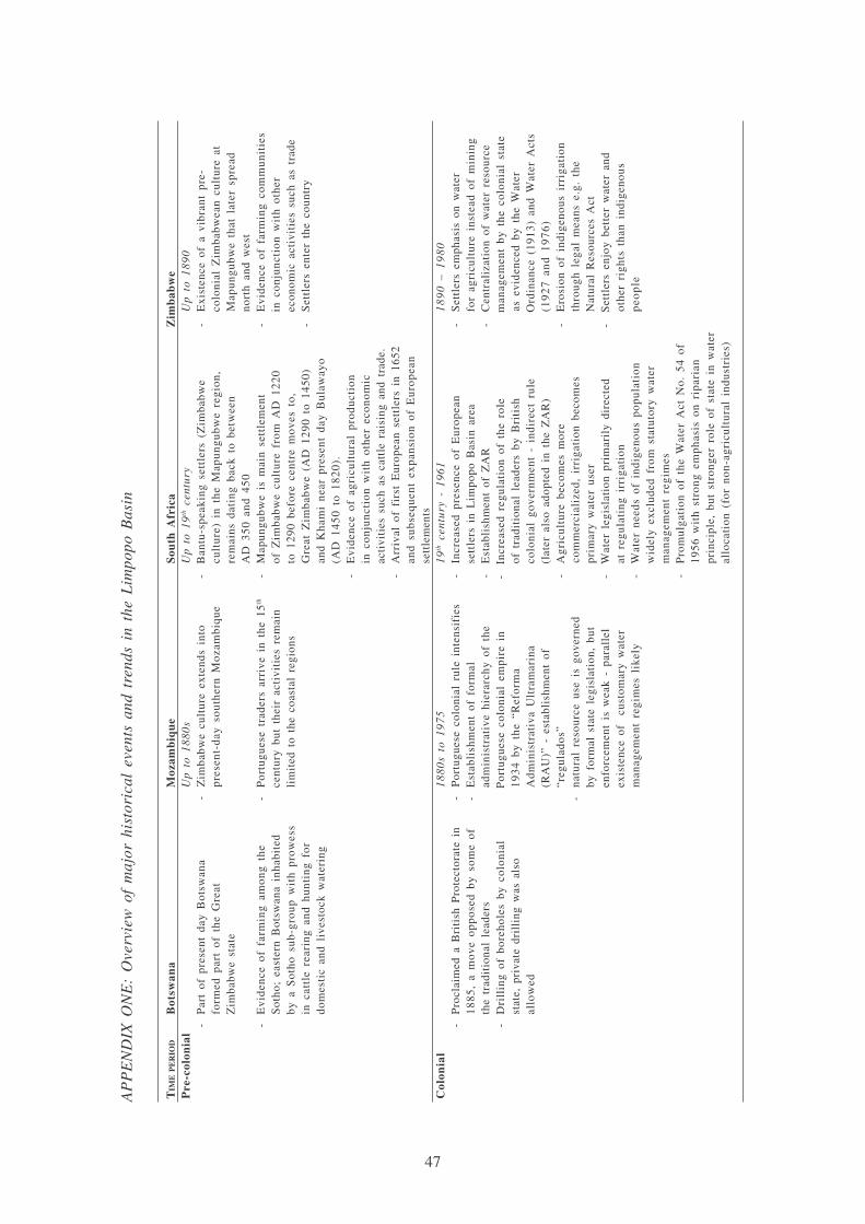
47
AP
PE
ND
IX O
NE
: O
verv
iew
of
maj
or h
isto
rica
l ev
ents
and
tre
nds
in t
he L
impo
po B
asin
TIM
EP
ER
IOD
Bot
swan
aM
ozam
biq
ue
Sou
th A
fric
aZ
imb
abw
eP
re-c
olon
ial
Up
to 1
880s
Up
to 1
9th c
entu
ryU
p t
o 1
89
0-
Par
t of
pre
sent
day
Bot
swan
a-
Zim
babw
e cu
ltur
e ex
tend
s in
to-
Ban
tu-s
peak
ing
sett
lers
(Z
imba
bwe
-E
xist
ence
of
a vi
bran
t pr
e-fo
rmed
par
t of
the
Gre
atpr
esen
t-da
y so
uthe
rn M
ozam
biqu
ecu
ltur
e) i
n th
e M
apun
gubw
e re
gion
,co
loni
al Z
imba
bwea
n cu
ltur
e at
Zim
babw
e st
ate
rem
ains
dat
ing
back
to
betw
een
Map
ungu
bwe
that
lat
er s
prea
dA
D 3
50 a
nd 4
50no
rth
and
wes
t-
Evi
denc
e of
far
min
g am
ong
the
-P
ortu
gues
e tr
ader
s ar
rive
in
the
15th
-M
apun
gubw
e is
mai
n se
ttle
men
t-
Evi
denc
e of
far
min
g co
mm
unit
ies
Sot
ho;
east
ern
Bot
swan
a in
habi
ted
cent
ury
but
thei
r ac
tivi
ties
rem
ain
of Z
imba
bwe
cult
ure
from
AD
122
0in
con
junc
tion
wit
h ot
her
by a
Sot
ho s
ub-g
roup
wit
h pr
owes
sli
mit
ed t
o th
e co
asta
l re
gion
sto
129
0 be
fore
cen
tre
mov
es t
o,ec
onom
ic a
ctiv
itie
s su
ch a
s tr
ade
in c
attl
e re
arin
g an
d hu
ntin
g fo
rG
reat
Zim
babw
e (A
D 1
290
to 1
450)
-S
ettl
ers
ente
r th
e co
untr
ydo
mes
tic
and
live
stoc
k w
ater
ing
and
Kha
mi
near
pre
sent
day
Bul
away
o(A
D 1
450
to 1
820)
.-
Evi
denc
e of
agr
icul
tura
l pr
oduc
tion
in c
onju
ncti
on w
ith
othe
r ec
onom
icac
tivi
ties
suc
h as
cat
tle
rais
ing
and
trad
e.-
Arr
ival
of
firs
t E
urop
ean
sett
lers
in
1652
and
subs
eque
nt e
xpan
sion
of
Eur
opea
nse
ttle
men
tsC
olon
ial
18
80
s to
19
75
19th
cen
tury
- 1
961
18
90
– 1
98
0-
Pro
clai
med
a B
riti
sh P
rote
ctor
ate
in-
Por
tugu
ese
colo
nial
rul
e in
tens
ifie
s-
Incr
ease
d pr
esen
ce o
f E
urop
ean
-S
ettl
ers
emph
asis
on
wat
er18
85,
a m
ove
oppo
sed
by s
ome
of-
Est
abli
shm
ent
of f
orm
alse
ttle
rs i
n L
impo
po B
asin
are
afo
r ag
ricu
ltur
e in
stea
d of
min
ing
the
trad
itio
nal
lead
ers
adm
inis
trat
ive
hier
arch
y of
the
-E
stab
lish
men
t of
ZA
R-
Cen
tral
izat
ion
of w
ater
res
ourc
e-
Dri
llin
g of
bor
ehol
es b
y co
loni
alP
ortu
gues
e co
loni
al e
mpi
re i
n-
Incr
ease
d re
gula
tion
of
the
role
man
agem
ent
by t
he c
olon
ial
stat
est
ate,
pri
vate
dri
llin
g w
as a
lso
1934
by
the
“Ref
orm
aof
tra
diti
onal
lea
ders
by
Bri
tish
as e
vide
nced
by
the
Wat
eral
low
edA
dmin
istr
ativ
a U
ltra
mar
ina
colo
nial
gov
ernm
ent
- in
dire
ct r
ule
Ord
inan
ce (
1913
) an
d W
ater
Act
s(R
AU
)” -
est
abli
shm
ent
of(l
ater
als
o ad
opte
d in
the
ZA
R)
(19
27
an
d 1
97
6)
“reg
ulad
os”
-A
gric
ultu
re b
ecom
es m
ore
-E
rosi
on o
f in
dige
nous
irr
igat
ion
-na
tura
l re
sour
ce u
se i
s go
vern
edco
mm
erci
aliz
ed,
irri
gati
on b
ecom
esth
roug
h le
gal
mea
ns e
.g.
the
by f
orm
al s
tate
leg
isla
tion
, bu
tpr
imar
y w
ater
use
rN
atur
al R
esou
rces
Act
enfo
rcem
ent
is w
eak
- pa
rall
el-
Wat
er l
egis
lati
on p
rim
aril
y di
rect
ed-
Set
tler
s en
joy
bett
er w
ater
and
exis
tenc
e of
cu
stom
ary
wat
erat
reg
ulat
ing
irri
gati
onot
her
righ
ts t
han
indi
geno
usm
anag
emen
t re
gim
es l
ikel
y-
Wat
er n
eeds
of
indi
geno
us p
opul
atio
np
eop
lew
idel
y ex
clud
ed f
rom
sta
tuto
ry w
ater
man
agem
ent
regi
mes
-P
rom
ulga
tion
of
the
Wat
er A
ct N
o. 5
4 of
1956
wit
h st
rong
em
phas
is o
n ri
pari
anpr
inci
ple,
but
str
onge
r ro
le o
f st
ate
in w
ater
allo
cati
on (
for
non-
agri
cult
ural
ind
ustr
ies)

48
TIM
EP
ER
IOD
Bot
swan
aM
ozam
biq
ue
Sou
th A
fric
aZ
imb
abw
eP
ost-
colo
nia
l1
97
5 –
19
90
19
61
– 1
99
41
98
0 –
19
92
-19
66:
Bot
swan
a be
com
es a
n-
Moz
ambi
que
beco
mes
-C
onti
nued
man
ipul
atio
n of
tra
diti
onal
-P
erio
dic
drou
ghts
res
ulti
ng i
nin
depe
nden
t re
publ
icin
depe
nden
t (1
975)
lead
ersh
ip s
truc
ture
s an
d de
velo
pmen
tca
lls
for
revi
sion
of
Wat
er A
ct-
Wat
er A
ct o
f 1
968
and
the
Tri
bal
-F
RE
LIM
O g
over
nmen
t ai
ms
atof
“ho
mel
and”
pol
icie
sL
and
Act
of
1970
tra
nsfe
rred
lan
del
imin
atin
g tr
adit
iona
l au
thor
itie
s-
Con
sequ
ent
eros
ion
of c
redi
bili
ty o
fan
d w
ater
adm
inis
trat
ive
pow
ers
and
to r
epla
ce t
hem
wit
htr
adit
iona
l le
ader
ship
has
und
erm
ined
from
tra
diti
onal
lea
ders
alte
rnat
ive
gove
rnin
g st
ruct
ures
effi
cien
cy o
f m
any
trad
itio
nal
-C
entr
aliz
ed w
ater
all
ocat
ion
thro
ugh
(vil
lage
sec
reta
ries
, et
c)go
vern
ance
reg
imes
the
Wat
er A
ppor
tion
men
t B
oard
-N
atur
al r
esou
rces
are
nat
iona
lize
d-
Wat
er u
se p
rim
aril
y fo
r co
mm
erci
al-
1974
: po
licy
to
buil
d sm
all
dam
s-
Wea
k im
plem
enta
tion
of
irri
gati
on a
nd i
ndus
tria
l us
e, i
ndig
enou
sfo
r li
vest
ock
wat
erin
g,na
tura
l re
sour
ce g
over
nmen
tpo
pula
tion
wid
ely
excl
uded
fro
mri
ghts
of
som
e co
mm
unit
ies
not
legi
slat
ion
acce
ss t
o w
ater
for
resp
ecte
d-
Tra
diti
onal
str
uctu
res
rem
ain
stro
ng,
com
mer
cial
(an
d do
mes
tic)
use
part
icul
arly
in
RE
NA
MO
- c
ontr
olle
dar
eas
Rec
ent
1992
– p
rese
nt19
94 –
pre
sent
1994
– p
rese
nt-
Eff
orts
at
‘dem
ocra
tizi
ng’
soci
ety
-E
nd o
f ci
vil
war
(19
92)
and
-T
rans
itio
n to
dem
ocra
cy w
ith
-A
dopt
ion
of I
WR
M p
rinc
iple
sis
res
ulti
ng i
n gr
adua
l m
argi
nali
zati
onel
ecti
on o
f fi
rst
dem
ocra
tic
firs
t de
moc
rati
c el
ecti
ons
as c
onta
ined
in
the
Wat
er A
ctof
the
tra
diti
onal
ins
titu
tion
s in
the
go
ver
nm
ent
on
27
Apr
il 1
994
and
ZIN
WA
Act
(19
98)
man
agem
ent
of n
atur
al r
esou
rces
-A
dopt
ion
of N
atio
nal
Wat
er-
Ado
ptio
n of
Whi
te P
aper
on
-F
orm
atio
n of
Cat
chm
ent
and
-E
ffor
ts t
o m
oder
nize
wat
erP
olic
y (1
995)
, w
hich
pro
mot
esN
atio
nal
Wat
er P
olic
y fo
rS
ub-C
atch
men
t C
ounc
ils
for
man
agem
ent
e.g.
pro
duct
ion
ofw
ider
pub
lic
part
icip
atio
nS
outh
Afr
ica
(199
7)w
ater
man
agem
ent
the
Nat
iona
l W
ater
Mas
ter
Pla
n-
Att
empt
s to
int
egra
te t
radi
tion
al-
Pro
mul
gati
on o
f N
atio
nal
Wat
er-
Att
empt
s at
dec
entr
aliz
ing
gove
rnan
ce r
egim
es i
n ov
eral
lA
ct (
1998
)w
ater
man
agem
ent,
gove
rnan
ce f
ram
ewor
k-
Abo
lish
men
t of
rip
aria
n pr
inci
ple
but
no r
ecog
niti
on o
f-
Dec
ree
15/2
000
reco
gniz
es t
he-
wat
er b
ecom
es p
ubli
c go
od w
ith
indi
geno
us i
nsti
tuti
ons
role
of
com
mun
ity
auth
orit
ies
stat
e as
cus
todi
an o
f w
ater
res
ourc
es(i
nclu
ding
tra
diti
onal
lea
ders
)-
For
mat
ion
of C
atch
men
t M
anag
emen
tin
con
trol
ling
nat
ural
res
ourc
esA
genc
ies
init
iate
d -
obje
ctiv
e:-
Few
res
earc
h re
sult
s, b
ut i
niti
alde
cent
rali
zed
man
agem
ent
and
evid
ence
of
func
tion
ing
cust
omar
yw
ides
prea
d st
akeh
olde
r pa
rtic
ipat
ion,
wat
er m
anag
emen
t re
gim
esbu
t no
exp
lici
t re
cogn
itio
n of
ind
igen
ous
wat
er m
anag
emen
t re
gim
es

ISBN: 92-9090-637-5ISBN: 978-92-9090-637-7
SM
IWMI is a Future Harvest Centersupported by the CGIAR
Postal AddressP O Box 2075ColomboSri Lanka
Location127, Sunil MawathaPelawattaBattaramullaSri Lanka
Telephone+94-11 2787404
Fax+94-11 2786854
Websitehttp://www.iwmi.org
I n t e r n a t i o n a lWater ManagementI n s t i t u t e
Related Documents


