July 9, 2007 Document of the World Bank Report No. 38298-IN India Land Policies for Growth and Poverty Reduction Agriculture and Rural Development Sector Unit India Country Management Unit South Asia Region Public Disclosure Authorized Public Disclosure Authorized Public Disclosure Authorized Public Disclosure Authorized Public Disclosure Authorized Public Disclosure Authorized Public Disclosure Authorized Public Disclosure Authorized

Welcome message from author
This document is posted to help you gain knowledge. Please leave a comment to let me know what you think about it! Share it to your friends and learn new things together.
Transcript
July 9, 2007
Document of the World Bank
Report N
o. 38298-IN
India Land Policies for G
rowth and Poverty R
eduction
Report No. 38298-IN
IndiaLand Policies for Growth and PovertyReduction
Agriculture and Rural Development Sector UnitIndia Country Management UnitSouth Asia Region
Pub
lic D
iscl
osur
e A
utho
rized
Pub
lic D
iscl
osur
e A
utho
rized
Pub
lic D
iscl
osur
e A
utho
rized
Pub
lic D
iscl
osur
e A
utho
rized
Pub
lic D
iscl
osur
e A
utho
rized
Pub
lic D
iscl
osur
e A
utho
rized
Pub
lic D
iscl
osur
e A
utho
rized
Pub
lic D
iscl
osur
e A
utho
rized
INDIA
Land Policies for Growth and Poverty Reduction
Table of Contents
Acknowledgments ....................................................................................................................................................... v
Executive Summary ................................................................................................................................................. vi
Policy Matrix .......................................................................................................................................................... xv
I . INTRODUCTION ................................................................................................................................................... 1 .............................................................................................................. 1 . Why addressing land issues is important 1 .......................................................................................................... 2 . Why there is scope to address land issues 3
................................................................................................................................................ . 3 Plan of the report 5
I1 . LAND ADMINISTRATION: STRUCTURE AND KEY CHALLENGES ....................................................... 6 1 . Historical evolution and overall structure of land records .................................................................................... 6 2 . Revenue department ............................................................................................................................................. 7
........................................................................................................................................... . 3 Survey and settlement 9 4 . Stamps and registration ....................................................................................................................................... 11 5 . Policy Implications ............................................................................................................................................. 14
I11 . IMPROVING TEXTUAL RECORDS: EXAMPLES AND POTENTIAL ................................................ 15 1 . Land records ....................................................................................................................................................... 15
1.1 Status and benefits from computerization of land records ........................................................................... 15 1.2 Best practice ................................................................................................................................................. 18 1.3 Remaining challenges .................................................................................................................................. 18 1.4 Policy implications ...................................................................................................................................... 18
2 . Modernizing property registration: Advances made and challenges ahead ....................................................... 19 2.1 Benefits from modernizing property registration .................................................................................. 19 2.2 Best practice elements ................................................................................................................................. 20 2.3 Remaining challenges .................................................................................................................................. 21 2.4 Policy implications ...................................................................................................................................... 22
I11 . IMPROVING THE STATUS OF SPATIAL RECORDS ............................................................................... 23 1 . The spatial framework: Rational and status in India .......................................................................................... 23 2 . Why pilots with modem technology had limited success .................................................................................. 24 3 . Implications for India ....................................................................................................................................... 25
3.1 Improving coverage of the spatial framework ............................................................................................. 27 ...................................................................................................... 3.2 Piloting solutions for specific situations 28
3.3 Redefining the role of the public sector ....................................................................................................... 29
V . TOWARDS GREATER TENURE SECURITY ................................................................................................ 3 1 1 . The purpose of registration and the difference between deeds and titles ............................................................ 31 2 . Options for improving a deeds system ............................................................................................................... 32 3 . Making a transition towards title registration: Opportunities and challenges ..................................................... 32
......................................................................................................................................... 4 . Implications for India 35
VI . LAND OWNERSHIP REFORM ....................................................................................................................... 37 1 . Justification and background .............................................................................................................................. 37
................................................................................................................. 2 . Land reform implementation in India 38 ............................................................................................. 3 . Empirical evidence on the impact of land reform 39
4 . Other options to increase land access by the poor .............................................................................................. 43
VII . LAND LEASE MARKETS ........................................................................................................................... 47 1 . Some stylized facts on land rental markets in India ............................................................................................ 47 2 . Efficiency and equity impact of land rental: International evidence ................................................................. 48 3 . Empirical evidence on efficiency and equity impact of land rental in India ....................................................... 49 4 The gender dimension of land access through rental markets ......................................................................... 53 5 Policy implications .............................................................................................................................................. 54
VIII . IMPROVING LAND ACCESS BY THE POOREST ................................................................................. 55 1 . Empirical evidence on operation of land sales markets ..................................................................................... 55 2 . Improving the functioing of land sales markets ................................................................................................. 55 3 . Protecting land ownership and access by the poorest ........................................................................................ 58
I X TOWARDS AN INTEGRATED LAND POLICY ......................................................................................... 60 1 . Key conclusions from empirical analysis .......................................................................................................... 60 2 . Options to fully realize the potential of land administration ............................................................................. 60 3 . Optoins for policy reform ................................................................................................................................. 62
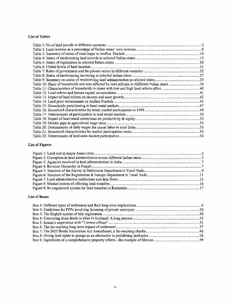
List of Tables
.................................................................................................... Table 1 : No of land parcels in different countries 3 Table 2: Land revenue as a percentage of Indian states' own revenue .................................................................... 8 Table 3: Summary of status of rural maps in Andhra Pradesh .............................................................................. 10 Table 4: Status of modernizing land records in selected Indian states ............................................................... 15 Table 5: Status of registration in selected Indian states .......................................................................................... 20 Table 6: Global levels of land taxation ................................................................................................................... 21 Table 7: Roles of government and the private sector in different countries ........................................................... 25 Table 8: Status of modernizing surveying in selected Indian states ....................................................................... 27 Table 9: Summary on status of modernizing land administration in selected states .............................................. 35 Table 10: Share of households and area affected by land reforms in diffferent Indian states ................................ 38 Table 1 1 : Characteristics of households in states with low and high land reform effort ........................................ 40 Table 12: Land reform and human capital accumulation ....................................................................................... 41 Table 13: Impact of land reform on income and asset growth ................................................................................ 42
.......................................................................................... Table 14: Land price determinants in Andhra Pradesh 45 Table 15: Households participating in land rental markets ..................................................................................... 47
.......................................................... Table 16: Household characteristics by rental market participation in 1999 49 Table 17: Determinants of participation in land rental markets .............................................................................. 50
.................................................................... Table 18: Impact of land rental restrictions on productivity & equity 52 ................................................................................................... Table 19: Gender gaps in agricultural wage rates 53
Table 20: Determinants of daily wages for casual labor in rural India ................................................................... 53 ..................................................................... Table 21: Household characteristics by market participation status 55
Table 22: Determinants of land sales market participation ..................................................................................... 56
List of Figures
Figure 1 : Land cost in major Asian cities ................................................................................................................. 2 Figure 2: Corruption in land adrmnistration across different Indian states ............................................................... 3
.................................................................................... Figure 3: Agencies involved in land adrmnistration in India 7 .................................................................................................................... Figure 4: Revenue Hierarchy in Punjab 7
Figure 5: Structure of the Survey & Settlement Department in Tamil Nadu ............................................................ 9 Figure 6: Structure of the Registration & Stamps Department in Tamil Nadu ....................................................... 11 Figure 7: Land administration institutions and data flows ...................................................................................... 13 Figure 8: Manual system of effecting land transfers ............................................................................................. 16 Figure 9: Re-engineered system for land transfers in Karnataka ........................................................................... 17
List of Boxes
Box 1 : Different types of settlement and their long-term implications .................................................................... 6 Box 2: Guidelines for PPPs involving licensing of private surveyors .................................................................... 26 Box 3: The English system of title registration ...................................................................................................... 30 Box 4: Converting from deeds to titles in Scotland: A long process ...................................................................... 32
................................................................................................ Box 5: Kerala's experience with "Torrens offices" 33 ........................................................................................ Box 6: The far-reaching long term impact of settlement 37
Box 7: The 2005 Hindu Succession Act Amendment, a far-reaching chanbe ........................................................ 46 Box 8: Giving land rights to groups as an alternative to prohibiting land sales ..................................................... 58 Box 9: Ingredients of a comprehensive property reform - the example of Mexico ................................................ 59
Acknowledgements
Thls report was prepared by a team led by Klaus Deininger, under the overall guidance of Adolfo Brizzi and Gajanand Pathrnanathan, Sector Managers. Major contributors to the report, which was initiated by Isabel Lavadenz, are Tony Burns, Edward Cook, Tim Hanstad, Songqing Jin, Kundan Kumar, Karen Macours, Hari K. Nagarajan, Kevin Nettle, Susan Nichols, Robin Nielsen, Tore Olsen, Nee1 Ratan, Guta1a.V. Subrahmanyam, Sanjay Upadhyay, Sonal Vats, and Barbara Verardo. Invaluable administrative assistance was provided by Sarita Rana, Sandra Sousa, and Lilac Thomas. The team would llke to thank Deepak Ahluwalia, Deepak Bhatia, Rabih Karaky, Martien Van Nieuwkoop, and Michael Carter for helpful comments and the peer reviewers, Robert Buckley, Jonathan Lindsay, Pedro Olinto, and N.C. Saxena for their valuable guidance and advice throughout the preparation of the report.
We gratefully acknowledge the cooperation and valuable assistance provided by officials from the Ministry of Rural Development and the Department of Land Resources, the National Informatics Center, and the Commission for Agricultural Cost and Prices (CACP), Government of India. In addition, invaluable support was received from the officials from Departments of Revenue, Stamps and Registration, Rural Development, and Information Technology in numerous states. Key inputs for the report from policy-makers at the national and the state level, academia, civil society, and international organizations were received during a 2-day workshop on land policies and administration held in New Delhi in Jan. 2006 which was organized jointly with the Ministry of Rural Development and CACP, with support from the Food and Agricultural Organization of the United Nations, the Rural Development Institute, and the UK Department for International Development (DFID). This report has also received funding fiom DFID although the views expressed do not necessarily reflect their official policy.
INDIA - LAND POLICIES FOR GROWTH AND POVERTY REDUCTION
Executive summary
1. Introduction
In India, land continues to be of enormous economic, social, and symbolic relevance. The way in which access to land can be obtained and its ownership documented is at the core of the livelihood of the large majority of the poor, especially in rural and tribal areas and will determine the extent to which increasingly scarce natural resources are managed. Land policies and administration are critical determinants of the transaction cost associated with and modalities to access land for business and residential use and, through the ease of using land as collateral for credit, the development of the financial sector. Land also continues to be a major source of government revenue and a key element for implementing government programs. This implies that land policies and institutions will have a far- reaching impact on the ability to sustain India's current high rate of growth, the extent to which such growth reaches the poor, and the level and spatial distribution of economic activity.
As land administration -through the revenue department- was the core of the colonial structures and continues to be a key pillar of local government today, issues relating to land have long been the subject of an animated policy debate. There is consensus among policy makers that land administration -which fell into neglect as officers had to attend to a myriad of other duties- is in urgent need of improvement to be able to effectively fulfill its functions in the 21" century. The key question is not 'whether' but rather 'how' to go about this task most effectively and which policy issues need to be addressed to ensure that doing so will be sustainable and will have an impact on improved land access and greater productivity. Recent advances by a number of states that have used IT to help them make significant progress in modernizing their land administration system, as well as nation-wide survey evidence, provide an opportunity to revisit this question. The goal of this report is to draw on recent empirical evidence, to assess the extent to which land-related institutions have improved in individual states and the impact of a range of land-related policies to identify areas for action by policy-makers to ensure that the opportunities provided by modem technology and the convergence of interests visible in recent initiatives such as the National e-Governance Program, can be most effectively utilized. In the case of land administration we draw on a review of land records, survey and settlement, and land registration in 14 states while a nation-wide survey that spans the 1982-99 period provides the basis for an assessment of land policies.
2. Institutional structure and challenges
Most of the institutions and processes for administering land in India were adopted fiom the British at Independence and have been little modified since. Given that their main purpose was to raise resources, the land revenue as well as the survey and settlement department as the key institutions responsible for land administration in India had been focused on productive rural areas that provided opportunities to generate tax revenues. Both urban and 'marginal' rural areas remained outside the system. Thls distinction, which was difficult to justify in the first place, has increasingly become archaic, in three respects.
First, and most importantly, any piece of rural land that had been transacted through sale at any point after 1882 thereby entered the land registry system, implying that records about it are maintained not only by the revenue but also the stamps and registration department. This duplication of institutions increases transaction costs for land owners without providing commensurate benefits but, more importantly, introduces a major source of tenure insecurity and even fraud because, for a variety of reasons, the records maintained by both institutions may well be inconsistent. While the most radical solution, which indeed has been mooted in policy circles, would be to merge the two departments, doing so may encounter strong bureaucratic resistance. Even if it were feasible, it is an option only if and when the necessary ground-work, much of which will be discussed in this report, has been undertaken. At the same time, steps to clarify the legal situation of land records and ensure back-office integration will be essential.
Second, rural areas at the urban fringe have increasingly become subject to urbanization. Although t h ~ s is associated with a significant increase of land values that would require a more precise survey, in many Indian states the result of this process was that the survey department's responsibility for maintaining an accurate spatial record of land ownership lapsed and responsibility for doing so was de facto transfened to municipal corporations who were interested in maintaining spatial records only for tax purposes. While some have done so relatively well, implying that spatial records that were established for tax purposes could, in principle, be used as a basis for ownership records, others did not live up to the task, resulting in outdated map products of inferior quality that appear to be one of the reasons underlying the high levels of land-related conflict (28% of parcels according to one study) in peri- urban areas. Clarifying the institutional situation with a view towards eliminating this 'spatial data vacuum' where it
exists, and ensuring that there is one agency, with the necessary capacity, to maintain spatial records in rural and urban areas is a priority for policy.
Last, but by no means least in importance, even revenue lands that had previously been waste and thus were not subject to settlement surveys have increasingly been brought under agricultural cultivation. It implies that one of the key challenges from a poverty perspective is to extend land adrmnistration to the areas that have been left out. Doing so will require clarification of the interface with the forest department and a broadening of tenure choices that can be accommodated within the land administration system to include, for example, forms of communal ownership. Given the large number of land and people involved, and the high concentration of poverty in these areas, settling these issues is of very high priority for poverty reduction and will require major policy decisions. Some of these decisions are currently under debate in the discussion of the Forest Rights Bill. Once the broad policy parameters have been set, a serious implementation effort will be needed. While h s can build on the general principles identified in this report, they will have to be elaborated in more detail.
3. Improving textual land records
Review of states' experience with initiatives to computerize revenue records and land registries, spearheaded by MoRD and MIT respectively, allows identifying best practices for this process, the benefits from doing so, and the challenges that remain to be addressed. In both cases a number of factors that were critical for success can be identified. Although supported by central funds, most innovative solutions came about as a result of innovation by individual states, subsequently adopted by others. Also, in all cases, innovations were designed to draw heavily on India's strengths in IT, extensive use was made of sub-contracting and PPPs to overcome weaknesses of the public sector, and emphasis was on broad coverage and quick roll-out of viable innovations with a possibility of learning from experience and adding more sophistication later, rather than designing a "perfect" solution from the start.
Computerization of land records, which is now fully or partly operational in KA, GJ, RJ, MP, MA, and TN, has yielded four key benefits. First, it has simplified the system and significantly reduced petty corruption that was traditionally involved in getting access to land records. While the amounts involved in individual cases may have been small, aggregate losses associated with petty corruption can be very large -a survey from Karnataka estimates that computerization in this state saved Rs. 80 cr. of bribes and 6.6 cr. in waiting time per year. This is in addition to the largely non-quantifiable impact of computerization on villagers' attitude to the bureaucracy that may be very important in environments where governance is an issue. Second, computerization improved the quality with which government services are delivered and is generating large surpluses from user fees in the states where it has been rolled out and manual records been abolished. Third, computerization helped to improve credit access. Finally, a number of states demonstrated that computerized records can be used as a springboard to integrate revenue records with the registry and even spatial data by automating the back-end of the process, efforts to have surveys done before mutation, providing registry officials with access to the land records database before registering a document, etc. All of this points towards considerable unexploited potential for future improvements that should be utilized.
This successful experience allows derivation of four best practice principles: First, digitization will be useful only if computerized records are routinely used, something that requires that manual records be abolished. This, together with the dynamic nature of land records (and the fact that such a step may face bureaucratic resistance), puts a premium on selectivity in what needs to be computerized and on speedy completion of digitization. l b s seems to be a key reason why thus far only states who outsourced digitization to a private operator with clear timelines have been successful in making the switch. Second, the ability of the computerized system to be financially self-sufficient and use the income generated to sustain andlor improve the system has been critical to reduce political interference and outsource specific tasks in cases where public sector capacity was insufficient. Business models to ensure this need to be encouraged. Third, to ensure acceptance of and confidence in the system, three factors are essential, namely (i) transparency of the process, as embodied in a verification process with active participation of land owners; (ii) integrity of the data, through state data centers with appropriate security features and audit trails; and (iii) publicity, i.e, making data available on the internet. Finally, there is considerable demand for access to land records at the village level and a number of strategies have been adopted to better respond to this demand while the necessary connectivity to allow village-level access is put in place.
The impressive success of some leading states in shifting from manual to electronic records should not conceal the fact that, in many instances, large amounts of money have been spent on initiatives to computerize land records with as of yet little impact on the ground, implying that there is considerable scope to re-orient or accelerate ongoing programs to enhance their effectiveness. Our review suggests that the effectiveness of Go1 schemes for CLRICMLR could be enhanced by incorporating the best practices identified above more systematically in design and evaluation of enhance the effectiveness of to be funded under this scheme. Specifically computerization initiatives should
receive support only if the information to be digitized is relevant for land owners, if a time bound plan for data verification and abolishing manual records exists, if key elements of the process are outsourced to the private sector, if issues of data integrity are satisfactorily addressed, and if they are based on a business model that has the potential to fully cover operational cost. Complying with such requirements is not difficult and the ability to draw on the experience of states that have already completed the process will allow 'latecomer' states to realize significant costs savings. Efforts to make this experience more widely and easily accessible to other states may merit support.
A second issue of relevance for policy makers relates to the fact that, even for the leading states, the benefits from record computerization could be significantly enhanced if guidance and model regulations were available on a number of key issues that include but are not limited to (i) the nature of information to be digitized and a data architecture that can eventually provide a basis to link revenue and registration records in a way that ensures minimum consistency and portability of software across states; (ii) best practices on achieving the integration of rural land records with urban property card systems; and (iii) ways to achieve functional integration not only with registration but also with surveys that go beyond a mere computerization of old manual systems and thus will be cheaper and more sustainable in the long term. Supporting well-defined pilots to provide guidance on some of these will be important to reap full benefits fiom computerization and should be a priority for GoI.
Computerizing registration of deeds which is fully or partly completed in AP, KA, MA, RJ, and TN, has also helped to realize large benefits. One is that, in a number of states, computerization has been associated with a significant increase in the number of registered land transfers and increased revenue from duties even though duty rates had in some cases been substantially reduced. This suggests that more transparent processes for registration and property valuation increased the usefulness of services to customers and that demand for registration is price elastic. In addition, the fact that in some states encumbrance certificates for a significant length of time are available helps to increase tenure security. Being able to obtain these electronically via the internet implies a significant reduction in the transaction costs for sellers and purchasers as well as banks although evidence regarding its impact on credit market activity is still limited. Finally, computerizing registry data has created the preconditions for a functional integration between registration and records that will have to be a key element of any effort to make the land administration system more conclusive and thus reduce the transaction costs and insecurity involved in dealing with land.
"Best practice" elements that have facilitated effective computerization of the registry are the following: First, more than in the case of land records, computerization of the registry has been based on a thorough re-engineering of the underlying business practices that involved the standardization and simplification of deeds (contrary to digitizing virtually everything that's on the record), the development of a process to automate market valuation, and the setting of clear performance standards (parallel to including mutation from the start). Second, to ensure financial sustainability, roll-out proceeded from offices with high transaction volume to those with less land market activity, with adaptations made in the process. Third, outsourcing to the private sector was a key element fiom the very beginning and payment schedules were designed to have high-volume offices implicitly subsidize low-volume ones, thereby ensuring equality of user fees throughout the state. From a purely commercial perspective, computerizing of land registration is straightforward and the main source of resistance is likely to be political, often fiom people in the system whose ability to obtain rents would be negatively affected. Similar the situation for revenue records, it will be important for Go1 to provide states with incentives that allow overcoming such resistance and draw equal with the more progressive states in terms of computerizing registration. To the extent that the ease of transacting land provided by a well-functioning registry will be an important consideration in investment decisions by firms or individuals who are not limited to a given state, failure to do so can over time translate into widening disparities between more advanced and backward states.
Also, a number of policy issues need to be addressed even in more advanced states. First, even though some states have moved to reduce high levels of stamp duty that tended to drive transactions into informality, the taxes levied on property transfers in India, in contrast to land taxes, remain among the highest in the world. Unless they are reduced, even the best technical solutions for improving land records are unlikely to be sustainable. Options to partially replace stamp duty with higher land taxes-levied on market values and ideally shared between local bodies and states- would be more in line with international best practice and need to be explored urgently. Second, it will be important to ensure completeness and consistency of revenue and registry records. This will require regulatory changes to ensure that mutations, e.g. through succession, that did not need to be registered in the past, will be registered automatically and free of charge, which that will not be difficult if the systems are linked electronically. Third, the lack of a consistent reference to spatial parcel identifiers in the registry is one of the key sources of incompleteness and insecurity and needs to be tackled, as will be discussed in more detail below. Finally, there is a strong perception about registry officials lacking accountability. This issue can be addressed once these officials

have easy access to the information needed to perform basic checks on the transaction that are offered to them for registration. While none of these issues poses insurmountable difficulties and many of them will require only small administrative changes in regulations, leadership by Go1 to support pilots, dnve the process and ensure communication across states is llkely to have an important role, especially if it is linked to the provision of finances.
4. Improving the status of spatial land records
Regarding spatial data, there is consensus on three issues. First, establishment of a comprehensive, reasonably accurate, cost-effective and affordable spatial framework will be a key element of any strategy to improve India's land administration system. Second, due to long neglect and gaps in institutional responsibilities, the quality and reliability of existing spatial data is much inferior to that of the textual database and neither simple digitization of existing data nor attempts to resurrect the tradition of revisional surveys that had been established by the British will be sufficient to address the problem. Third, there is an urgent need to develop viable and replicable models to improve and maintain spatial records, along the lines of what was aclueved for textual records. This is more difficult because of the highly specialized nature of surveying, the presence of strong vested interests pushing for technically sophisticated rather than the economically viable options, and the fact that surveying costs tend to increase exponentially with precision. A spatially differentiated approach will be needed that chooses strategies based on comparing the costs of available technical options to the likely benefits in a given environment and where cost recovery options are based on beneficiaries' capacity to pay. Still, there is little reason to believe that the principles that helped to achieve success for textual records should not be applicable in the area of surveying as well.
In fact, a cursory review of pilot surveying activities suggests that a key reason for the failure to develop replicable models is that these key success factors have been almost completely neglected. First, instead of drawing on existing information and expanding from there, surveying pilots tried to start from scratch with a complete resurvey. Second, instead of considering a range of technology options and then focusing on cost-effective ones where India has world class capacity, "modern technology" was narrowly defined in terms of electronic total stations (ETS), an expensive option in which India has little comparative advantage and which provides a level of precision that is not needed for at least 80% of the country. Cheaper and more appropriate options such as photogrammetry and use of handheld GPS devices received little attention. Third, even though the need to recover cost was critical to ensure that solutions for textual records remained focused on clients' needs and overall affordability, in addition to helping to avoid undue political interference, it was not adopted in the case of spatial pilots. Finally, although none of the states that successfully completed computerization of textual records did so without outsourcing key components to the private sector, surveying remains a government monopoly in all but three Indian states (AP, KA, and MA). Even in these states what passes as 'private sector' appears de facto more as an appendix to the government that has limited autonomy either in financial (rates are set by the government) or technical matters (technology is narrowly prescribed and output has to be delivered in paper form and checked by officials).
To address this issue, it will be desirable that (i) public sector activity focus first and foremost on comprehensive coverage with a low precision cadastral index map -something that is a clear public good- rather than establish islands of high quality spatial data in an ocean that remains largely uncharted. Combining satellite imagery with existing spatial data (i.e. village maps, tax maps, etc.) offers an appropriate and cost-effective opportunity to do so; (ii) pilots focus on developing scalable and cost-effective ways to generate spatial data and link them to textual records that are applicable to archetypical situations (e.g. unrecorded subdivisions, complete change in land use patterns, loss of spatial data, or complete lack of survey) and be geared towards producing procedural insights that form the basis for regulations and guidelines; and (iii) a major effort to expand capacity and increase the role of private surveyors (with structures for accountability) is mounted so that, instead of crowding out the private sector, public efforts be focused on setting a regulatory framework and doing or at least financing surveys in (marginal and tribal) lands that would otherwise not be attractive to private operators.
5. Putting the elements together: Towards greater tenure security and easier transferability of land
From the very start, the goal of efforts to modernize land administration in India was to increase tenure security and reduce the cost of transferring land. While modernization of textual and spatial records is a necessary condition for h s , it will be fully effective only if accompanied by an appropriate legal and regulatory framework. In this context, a key concern that is widely debated in policy circles, has been whether, and if yes when and how, India should make the transition towards a system of title registration, often also referred to as a Torrens system.
Both deeds and title registration are intended to put rights in land on public record. The key difference is that, while under title registration, the register serves as primary evidence of ownership, a deed provides only evidence of an isolated transaction that says nothing about the validity of this transaction. Simply put, under a deeds system
potential purchasers will need to expend resources to investigate whether the seller's title is genuine whereas under a title system this is not needed as the validity of such claims has already been checked for them by the registry system. The cost of a title search by a potential buyer depends on (i) the completeness of the information contained in the registry; the ease of searchmg it; and (iii) the reliability of registry information. To reduce these costs, steps to make registration compulsory, computerizing it and facilitating searches by parcel as well as by person, and ensuring that all documents entered into the registry have undergone at least rudimentary checks for validity by the registrar have been adopted all around the world to improve deeds systems (e.g. in the Netherlands, South Africa, US). Moreover, improved deeds systems of this nature constituted an essential first step towards making the transition towards a title system Taking these steps will be essential for India irrespectively of whether or not an eventual transition to Torrens title is envisaged. Even in the states where land administration is most advanced, considerable further action will be required to reach the point where all of these are implemented.
Once this is the case, the decision on whether to make the transition towards a full title registration system will hinge on three factors. First, there needs to be sufficient political support to make legal and institutional changes needed by a system of title over and above one of deeds registration. Second, even if the capacity to run a title registration system is available, a consensus on the desirability of incurring these costs needs to be reached. Finally, an important decision relates to the establishment of a guarantee fund that is essential for a system of title registration in contrast to merely an improved deeds system. This implies that a title system is more expensive to run but has lower costs of conveyancing whereas the cost of operating a deeds system is lower but the effort required from conveyancers is higher. This suggests that two key dimensions for analysis of this issue are related to sustainability and distribution of benefits. Concerning the latter, a title registration system imposes higher costs on society as a whole whlch make it cheaper to transfer land. Regarding the former, title systems are vulnerable to informality and can become dysfunctional if a large part of users is not willing or able to pay for the cost of running such a system.
A better understanding of the magnitudes involved in the Indian context would be critical to reach an informed decision on whether or not to go for a title registration system. Close monitoring of efforts to move towards title that have been initiated in AP is likely to yield important insights for other Indian states faced with similar questions. Comparing the experience of England and Scotland, two countries which, starting from a basis that was much superior to that encountered even in the most advanced Indian states, made a successful transition from a deeds to a title system over a period of decades with that of less successful experiences of developing countries trying to make such a transitions without having in place the infrastructure to support such a system or being aware of the complex issues involved suggests that trying to fast-track these processes carries a significant risks.
A more immediate goal, to be accomplished at least in the medium-term is to functionally integrate the different databases used in land administration so as to be able to provide land owners with a certificate -which can even be called a "Torrens titlew- that combines relevant and current information pertaining to a plot (i.e. ownership status, transaction history, current and past mortgages and liens, and a map that allows identification of neighbors and general boundaries) irrespectively of the government department maintaining the information. If combined with options to maintain spatial data at low cost and regulations to ensure that any changes in either textual or spatial records will automatically be effective throughout the system and to require registry officials to perform at least basic validity checks before registering a document, this would allow to realize 90% of the benefits from a title registration system at a fraction of the cost -while at the same time providing a more appropriate basis to decide whether transition towards full title will be desirable.
6. Land ownership reform
Although improving land administration along the lines discussed above can have a significant impact on the welfare of those who own land, it will at best provide indirect benefits to the large number of households who are landless and who, without tangible assets, may well be caught in a poverty trap from which it is difficult to escape. In India's situation, policies to strengthen land administration will have be complemented by considering opportunities for the poor to access land as a means of improving their asset status and livelihood.
Policies of land reform, through abolition of intermediary interests, tenancy legislation, and land ownership ceilings have formed the core of Go1 policies to improve the land ownership structure. We use empirical evidence from a nation-wide survey spanning the 1982-99 period to assess whether such reforms, proxied by dummies at the sate level, have been associated with higher levels of investment in physical and human capital, growth, and how their impact has evolved over time. Results from doing so suggest that transferring land ownership may have been quite effective, although limited variation in land reform implementation has to be taken into account in interpreting them. Although they were initially worse off, households in states that had higher levels of reform effort saw their welfare and investment improve more than those in states were land reform implementation remained lackluster. This is
supported by econometric evidence which points towards a positive, significant, and quantitatively important contribution of land reform to investment and growth with an overall effect that compares favorably to other forms of social spending. At the same time, econometric evidence also suggests that the positive impact of land reform legislation has been declining over time and actually risks becoming negative, somethng that would be consistent with the notion that land reform legislation is no longer very effective in transferring new land to the poor but continues to affect the efficiency with which land is used by land reform beneficiaries as well as land owners targeted by land reform due to the fact that these may take preventive measures to escape this threat.
If the above analysis is correct, other mechanisms to bring land to the poor may have to be identified. Evidence fiom different Indian states points towards a range of options for doing so. One option that has been implemented with some success in AP, would be to provide the poor with legal assistance to either resolve pending cases or to ensure implementation of court orders on the ground. As the large number of pending court cases generates large negative externalities, one might even h n k of specific incentives to resolve these, possibly in tandem with a participatory process of improving the land administration system. A second option, currently implemented in WB, KA, and AP, is to provide funds to the poor to acquire very small plots of land in the market, either for residential and market gardening or for productive purposes, often through self-help groups. At the same time, to avoid land reform legislation ending up having negative effect on the welfare of the poor, it will be desirable to (i) allow subdivision and transfer of land received through land reform, especially in the course of generational change; (ii) systematically empower civil society to help resolve land cases; and (iii) explore the scope and effectiveness of land markets as a means of providing land access.
Third, where large amounts of land continue to be held by government, regularization should be much easier. Options to provide secure access and title to such land include a variety of tenurial instruments such as transfer of government wasteland to private parties, long-term leases, of occupancy rights, and fonnal recognition of communal tenure. These include long-term leases, extension of survey to a specific area, possibly with the option of opting for communal land ownership, or transfer of government wasteland on an ad-hoc basis. Evidence from AP highlights not only that there is a considerable amount of land that does not have clear title but also that providing a clear certificate (patta) can significantly increase land values, by 15% to 20% for privately owned and by 30% to 45% for assigned or occupied land. Moreover, having a clearly defined right also increases the probability of a plot of land being rented out, thereby providing indirect benefits to the poor. Finally, the considerable potential to improve the welfare of women who depend on agriculture by giving them land rights or ensuring that they can inherit such land has often been neglected in the past. The 2005 amendment to the Hindu Succession Act breaks new ground in this respect and sufficient attention to disseminating its content so as to allow it to become effective on the ground would be warranted.
7. Land lease markets
Although land rental markets in India remain highly regulated, empirical evidence on the functioning of land lease markets or the impact of such regulation on poor peoples' ability to access land or use it productively remains limited. This is surprising in view of the fact that, contrary to other countries such as China and Vietnam where economic growth has prompted a veritable explosion in land rental activity, rental market participation in India has declined continuously since independence, despite the fact that in India land rental provides virtually the only option for accessing land by a large pool of landless while (involuntary) landlessness is virtually non-existent in either China or Vietnam. The fact that more households rent land at any point in time than benefited from land reforms through India's entire independent history illustrates the magnitude and policy relevance of the issue.
Use of nationally representative data provides four important insights. First, land rental markets contribute to greater equity and productivity of land use by allowing the "productive poor" and landless to access land and obtain returns to their labor that are significantly higher than what they would be able to obtain in casual labor markets. While in the 1980s, land rental was biased in favor of those with higher levels of assets, thls bias has disappeared in the late 1990s, presumably as a result of the growth of the non-farm economy. Second, contrary to hypotheses of 'reverse tenancy' according to which the majority of land entering rental markets is supplied by small and marginal farmers in a situation of relative duress, households with higher levels of education supply rent to the market, presumably to take up more lucrative employment in the non-farm economy. This interpretation is consistent with the finding that activity in land lease markets increases with the overall level of economic development in a village. Third, state- level land rental restrictions reduce the ability of the poor to access land and also have a negative impact on productivity, implying that eliminating such restrictions could help to improve both equity and efficiency. Finally, wage rates in casual labor markets for both agriculture and non-farm activity discriminate strongly against women even though there is no evidence to suggest that women are less productive than men in agricultural self-
employment. This suggests that the relative benefits from being able to access land through rental markets would be larger for women than for men, implying that freeing up land rental markets could have a positive gender impact. This is of particular significance in view of the fact that the extent of gender discrimination does not disappear or decrease with economic development.
To reap the potential benefits from land rental, it will be important to (i) make land leasing legal in states where it is not; (ii) explore options to allow sitting long-term tenants (e.g. baragadars in West Bengal) to acquire full ownership of all or part of the land they occupy; (iii) replace rent ceilings and other limitations on land leasing with a more enabling legislation such as dissemination of standardized contracts for the longer term, local help in conflict resolution, etc. As one would expect the benefits from liberalizing land lease markets to be large, the impact of eliminating land lease restrictions in states where doing so is politically feasible should be carefully monitored and disseminated to generate political momentum for similar steps in other settings.
8. Land sales markets
The above suggests that land rental is an important mechanism to increase efficiency of land use. However, policy makers have often been concerned that in rural areas where, as a result of credit markets imperfections, households are not able to fully insure against shocks, distress sales may have a negative impact on both equity and efficiency. In other words, farmers would be forced to sell of their land, often to usurious moneylenders or other unscrupulous persons, at bargain prices that are well below the productive value of the land just to ensure their survival in the face of a shock. As they will not be able to re-acquire the land through purchase once prices return to normal, this would leave them permanently landless, an outcome that is llkely to be undesirable both from an equity and an efficiency point of view. Indeed, historically, distress sales were a major factor that led to the accumulation of large amounts of land by powerful, though often not very efficient, landlords and moneylenders.
While there are few restrictions on sales markets in India except general land ownership ceilings, the govenunent maintains laws that restrict sale of land from tibals to non-tibals as a means to eliminate as much as possible the undesirable impact of landlessness However, thls policy is often not adhered to and procedures to ensure recovery of land that was sold in contravention of such restrictions are cumbersome, costly, and largely ineffective. To assess whether such a restriction continues to be justified, we use data on land transactions during the 1982-99 period to explore the functioning of land markets in general, and the extent of tibal land market participation in particular.
A number of interesting findings emerge. First, even though the land sales markets provides less opportunity for land acquisition than land rental markets and the fact that participation requires higher levels of assets, markets constitute a more promising avenue to land access for the landless than non-market channels. Second, we find clear evidence for drought shocks to increase activity in land sales markets, supporting the notion that involuntary distress sales by the poor continue to be an important phenomenon despite legislation to the contrary. Thud, consistent with the notion that credit market imperfections are at the root of involuntary land sales, availability of safety net programs (employment guarantee scheme) and access to banks significantly reduce the propensity to sell, especially during droughts whereas greater inequality contributes to an increase in land transactions. Presence of banks helps activate land sales markets in general but reduces the tendency for land sales to occur in drought years. Finally, SCs and STs are less llkely to sell or purchase land even after household and village characteristics are controlled for.
While t h s suggests that restricting land sales by tibals may have some effect, it leaves open the question whether a prohibition on land sales and rentals is needed and whether other policies allowing tibals to utilize land more productively may be a more appropriate policy. Regarding the first issue, international experience points towards a number of mechanisms, including a right of first refusal, the requirement of obtaining community permission for land transfers, the need for a community decision to allow land sales in general, or an involvement of the community in land sale negotiations that can acheve the same goal but foreclose less options for !Abals to benefit from productivity-enhancing transfers. As to the second issue, there is little doubt that f d y establishing and documenting tibals' property rights to the land they cultivate will be more effective to provide them with incentives to manage such land in a sustainable fashion than a prohibition on land sales. While large-scale initiatives to do so on land that is currently classified as forest will have to await passage of the Tribal Land Bill, there are many situations where, for a variety of reasons, tribal land rights on revenue land are unclear from a legal perspective or not well documented in the applicable records. Immediate action to redress this situation will be critical and needs to accompany any efforts to prevent involuntary land alienation by tibals.
In fact, there are many examples from other countries where emphasis on safety nets, together with providing an overriding right to the community, was a much superior approach to avoiding undesirable land alienation than prohbitions that will not prevent those in dire need from selling their land - but reduce even further what they can
get for it. By re-orienting energies from prohibition of alienation towards regularization of land occupation in tribal areas as well as systematic resolution of conflicts from past sales according to well-established criteria, it will be possible to make a more significant contribution to improving the livelihood of the poorest groups and at the same time reduce the potential for land-related conflict and extremist movements whose main rallying cry is land-related injustices. There are many international examples that can be drawn upon and doing so would be fully consistent with PESA and the spirit underlying the tribal land rights bill - and launching a major effort at implementation once this legislation is passed would provide an opportunity to put land administration truly into the service of the poor.
9. Priority actions and next steps
Although land administration and policy in India are complex subjects with a bewildering amount of detail and variation across states, a number of key messages and priority actions emerge fiom. First, land admmstration is an integrated system that is only as strong at the weakest link in the chain. Trying to compartmentalize it into different 'boxes' that are unconnected to each other (either registry or records or survey or rural-urban) will not help to improve the overall performance of the system. In this sense, improvement of textual records has made a very promising start but still only solved half of the problem. At the same time, improving spatial records is much more complex and trying to fix spatial records in an environment where issues relating to textual records are not sorted out may be risky. MoRD's efforts to improve the land administration system, and the effectiveness of Go1 support to such efforts, could be improved, if a clear policy to lay out these issues were available and used to guide allocation of funds to, and reporting on the use of these funds from, individual states. Second, policy makers underestimate the intimate links between land administration and policy, in both directions, at their peril. Although land administration it highly technical, no amount of technical sophistication will neutralize the impact of adverse policies that push the concerned households into informal systems. Similarly, land administration provides important tools to implement policies. In fact, one reason why India has no shortage of bold land policy initiatives for the poor which look very attractive on paper but could not be implemented in practice, is the fact that its land administration system is weak in general and often non-existent or dysknctional in the areas where the poorest live. This implies that there are a number of priority actions in administration and policy.
Expand computerization, integration, and use of textual records to ensure full coverage: Even though states that successfully computerized textual records benefited significantly from doing so, many progress remains slow at best in others. Go1 efforts to accelerate this effort could be improved by (i) clarifying the overall policy and use it to establish clear criteria and accountability mechanisms for allocation of central funds; (ii) publicizing best practice approaches on the techmcal and legal or regulatory side through different channels (incl. websites) and promoting exchange and communication among technical staff across states; (iii) putting greater emphasis on full functional integration between records and registry together with a systematic process to establish consistency and eliminate any ambiguities on the legal status of specific land parcels.
Provide a basis for state-wide spatial coverage: Large amounts of money have been, and continue to be, spent on surveying pilots with ill-defined objectives, the results of which are rarely subject to a rigorous evaluation. To the contrary, pilots often make officials lose sight of the forest for the trees. Drawing on India's capabilities to combine satellite imagery with existing village maps and other readily available spatial products to generate a basic cadastral index map would be a lower cost option to provide a comprehensive framework, identify gaps, and on this basis establish criteria for ways to address spatial data problems in an affordable manner that should have priority over ETS equipment and specific outputs should be defined in the near t e r n
Pilot ways of improving textual and spatial records for well-defined situations: In line with the ultimate goal of the land administration system, the purpose of piloting should be to establish processes that can be scaled up rapidly to improve the overall (i.e. textual and spatial) record and formulate regulations that can help to do so, possibly by subcontracting to the private sector. To achieve this, pilots should be targeted to archetypical situations arising from the nature of India's land records (i.e. unrecorded subdivisions; inconsistencies across records, decaylloss of maps, change of land use patterns, unsettled lands). It would be ideal to set up a technical working group to steer this process with the goal of producing results, to feed into a broad debate on this topic, in a 12-18 month time frame.
Allow private sector participation in surveying, focusing government on a regulatory role: Given the size of the gaps in spatial data and the limitations that make it difficult for the public sector to address them comprehensively, the almost complete prohibition of private participation in survey is surprising -and inconsistent with international best practice and India's own experience in computerizing textual records. Efforts to change this should focus on (i) providing a regulatory framework for application of a range of survey methods with defined precision requirements; (ii) strengthening capacity in the private and the public sector; and (iii) revamping survey processes, e.g. shifting from paper-based to electronic ones to reduce cost and make survey more affordable.
Reduce stamp duty rates and explore the scope for replacing them with a land tax: There is little doubt that the high rates of stamp duty currently assessed upon registering land transfers push people into informality while reducing government revenue. Reducing these rates, which are very high by international standards, is likely to be necessary to ensure the sustainability of any improvements made in land administration. To make such a step revenue-neutral, it may be useful to consider combining it with an increase in the land tax for specific groups, possibly to be shared between states and local governments. While such a decision will not be easy politically, it is likely to have a more profound impact on India's land administration system than a transition towards a title registration system.
Eliminate restrictions on land markets: All over the world, land rental markets allow rural dwellers to join the rural non-farm economy in a way that provides those who stay back with access to additional productive resources. Indian evidence shows that rental restrictions reduce equity as well as efficiency. It will thus be desirable to (i) make leasing legal where it is currently prohibited and replace rent ceilings with regulations to facilitate rental markets instead of constraining them; (ii) allow transferability of land by land reform beneficiaries at least through lease and explore options for making the gains from such reform permanent; (iii) drop restrictions on sale of land to non- agriculturalists and subdivision which have little economic justification; and (iv) review legislation on compulsory land acquisition and, subject to the prevention of undesirable externalities, allow farmers or their representatives to negotiate with and if desired transfer land directly to investors rather than having to go through government and often receive only very limited compensation.
Complement restrictions on tribal alienation with flexible mechanisms providing them with property rights: While there is little doubt that alienation of lands through distress sales is an extremely undesirable outcome that should be avoided, increasing rates of tribal landlessness suggest that regulations are often not effective in preventing it. In the short term, the most promising way to prevent tribal land alienation is likely to be effective safety nets, something that could possibly be combined with mechanisms for communities to have a greater say in whether or not land should be transferable such as a right of first refusal or community consent for sales. Providing tribals with real property rights, either individually or as a group, would in the long term make a more important contribution to their productive development and thus the avoidance of distress sales. Therefore, the longer-term goal should be to implement systematic programs that would recognize tribal land rights - and resolve whatever conflicts exist as a result of past alienations in contravention of the law according to accepted principles of policy.
INDIA - LAND POLICES FOR GROWTH AND POVERTY REDUCTION
Policy Matrix
Timing
ST
ST
ST
ST
STIMT
ST/MT
ST/MT
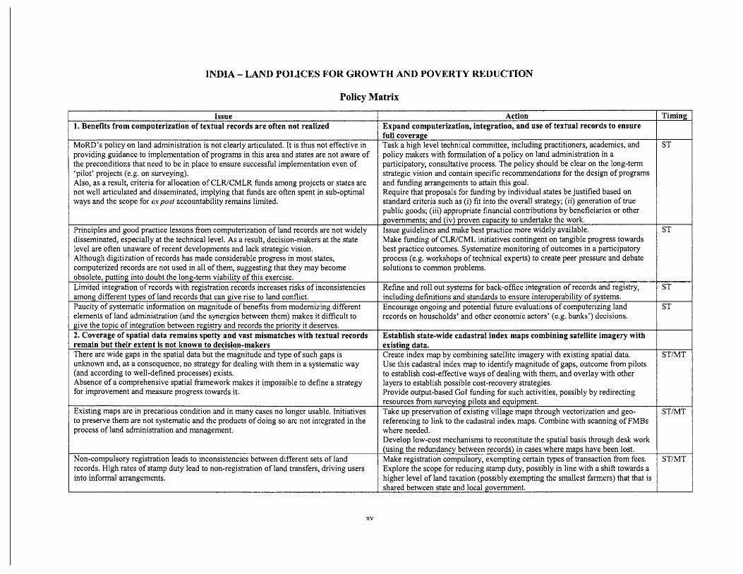
Issue 1. Benefits from computerization of textual records are often not realized
MoRD's policy on land administration is not clearly articulated. It is thus not effective in providing guidance to implementation of programs in this area and states are not aware of the preconditions that need to be in place to ensure successful implementation even of 'pilot' projects (e.g. on surveying). Also, as a result, criteria for allocation of CLR/CMLR funds among projects or states are not well articuIated and disseminated, implying that funds are often spent in sub-optimal ways and the scope for expost accountability remains limited.
Principles and good practice lessons from computerization of land records are not widely disseminated, especially at the technical level. As a result, decision-makers at the state level are often unaware of recent developments and lack strategic vision. Although digitization of records has made considerable progress in most states, computerized records are not used in all of them, suggesting that they may become obsolete, putting into doubt the long-term viability of this exercise. Limited integration of records with registration records increases risks of inconsistencies among different types of land records that can give rise to land conflict. Paucity of systematic information on magnitude of benefits from modernizing different elements of land administration (and the synergies between them) makes it dificult to give the topic of integration between registry and records the priority it deserves. 2. Coverage of spatial data remains spotty and vast mismatches with textual records remain but their extent is not known to decision-makers There are wide gaps in the spatial data but the magnitude and type of such gaps is unknown and, as a consequence, no strategy for dealing with them in a systematic way (and according to well-defined processes) exists. Absence of a comprehensive spatial framework makes it impossible to define a strategy for improvement and measure progress towards it.
Existing maps are in precarious condition and in many cases no longer usable. Initiatives
Action Expand computerization, integration, and use of textual records to ensure full coverage Task a high level technical committee, including practitioners, academics, and policy makers with formulation of a policy on land administration in a participatory, consultative process. The policy should be clear on the long-term strategic vision and contain specific recommendations for the design of programs and funding arrangements to attain this goal. Require that proposals for funding by individual states be justified based on standard criteria such as (i) fit into the overall strategy; (ii) generation of true public goods; (iii) appropriate financial contributions by beneficiaries or other governments; and (iv) proven capacity to undertake the work. Issue guidelines and make best practice more widely available. Make funding of CLWCML initiatives contingent on tangible progress towards best practice outcomes. Systematize monitoring of outcomes in a participatory process (e.g. workshops of technical experts) to create peer pressure and debate solutions to common problems.
Refine and roll out systems for back-office integration of records and registry, including definitions and standards to ensure interoperability of systems. Encourage ongoing and potential future evaluations of computerizing land records on households' and other economic actors' (e.g. banks') decisions.
Establish state-wide cadastral index maps combining satellite imagery with existing data. Create index map by combining satellite imagery with existing spatial data. Use this cadastral index map to identify magnitude of gaps, outcome from pilots to establish cost-effective ways of dealing with them, and overlay with other layers to establish possible cost-recovery strategies. Provide output-based Go1 funding for such activities, possibly by redirecting resources from surveying pilots and equipment. Take up preservation of existing village maps through vectorization and geo-
to preserve them are not systematic and the products of doing so are not integrated in the process of land administration and management.
Non-compulsory registration leads to inconsistencies between different sets of land records. High rates of stamp duty lead to non-registration of land transfers, driving users into informal arrangements.
referencing to link to the cadastral index maps. Combine with scanning of FMBs where needed. Develop low-cost mechanisms to reconstitute the spatial basis through desk work (using the redundancy between records) in cases where maps have been lost. Make registration compulsory, exempting certain types of transaction from fees. Explore the scope for reducing stamp duty, possibly in line with a shift towards a higher level of land taxation (possibly exempting the smallest farmers) that that is shared between state and local government.
xvi
Timing 1
ST
STMT
MT
MT
STIMT
STMT
ST
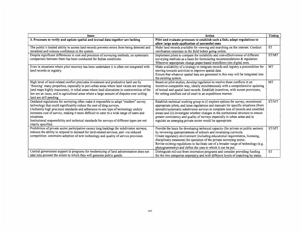
Issue 3. Processes to verify and update spatial and textual data together are lacking
The public's limited ability to access land records prevents errors from being detected and remedied and reduces confidence in the system. Despite significant differences in cost and precision of surveying methods, no systematic comparison between them has been conducted for Indian conditions.
Even in situations where pilot resurvey has been undertaken it is often not integrated with land records or registry.
High level of land-related conflict precIudes investment and productive land use by 'freezing' many properties, especially in peri-urban areas where land values are increasing (and maps highly inaccurate), in tribal areas where land alienations in contravention of the law are an issue, and in agricultural areas where a large amount of disputes over ceiIing land are still pending. Outdated reguIations for surveying often make it impossible to adopt "modern" survey technology that could significantly reduce the cost of ding surveys. Uniformly high precision standards and adherence to one type of technology unduly increases cost of survey, making it more difficult to cater to a wide range of users and situations. Institutional responsibility and technical standards for surveys of different types are not clearly specified. Prohibition of private sector participation causes long backlogs for subdivision surveys, reduces the ability to respond to demand for land-related services, and -via reduced competition- constrains adoption of new technology and quality of service provision.
Central government support to programs for modernizing of land administration does not take into account the extent to which they will generate public goods.
Action Pilot and evaluate processes to establish such a link; adapt regulations to allow large scale application of successful ones Make land records available for viewing and searching on the internet. Conduct verification exercises in the field before going online. Implement pilots to compare the suitability and cost-effectiveness of different surveying methods as a basis for formulating recommendations & regulation. Wherever appropriate change paper-based workflows into digital ones. Make availability of a strategy to integrate records and registry a precondition for moving towards activities to improve spatial data. Ensure that whatever spatial data are generated in this way will be integrated into the existing system. Based on pilot studies, develop regulation to resolve these conflicts in an incentive-compatible way, ideally simultaneously with a comprehensive updating of textual and spatial land records. Establish incentives, with sunset provisions, for setting conflicts out of court in an expeditious manner.
Establish technical working group to (i) explore options for survey, recommend appropriate pilots, and issue regulations and manuals for specific situations (from sporadic/systematic subdivision surveys to complete loss of records and unsettled areas) and (ii) investigate whether changes in the institutional structure to ensure greater consistency and quality of surveys especially in urban areas and to regulate an emerging private sector would be appropriate.
Provide the basis for developing technical capacity (for private or public sectors) by reviewing appropriateness of schools and revamping curricula. Create regulatory environment (including educational requirements, licensing, disciplinary measures) for operation of the private surveying sector. Revise existing regulations to facilitate use of a broader range of technology (e.g. photogrammetry) and define the uses to which it can be put. Distinguish roll-out from innovation programs and consider providing funding for the two categories separately and with different levels of matching by states.
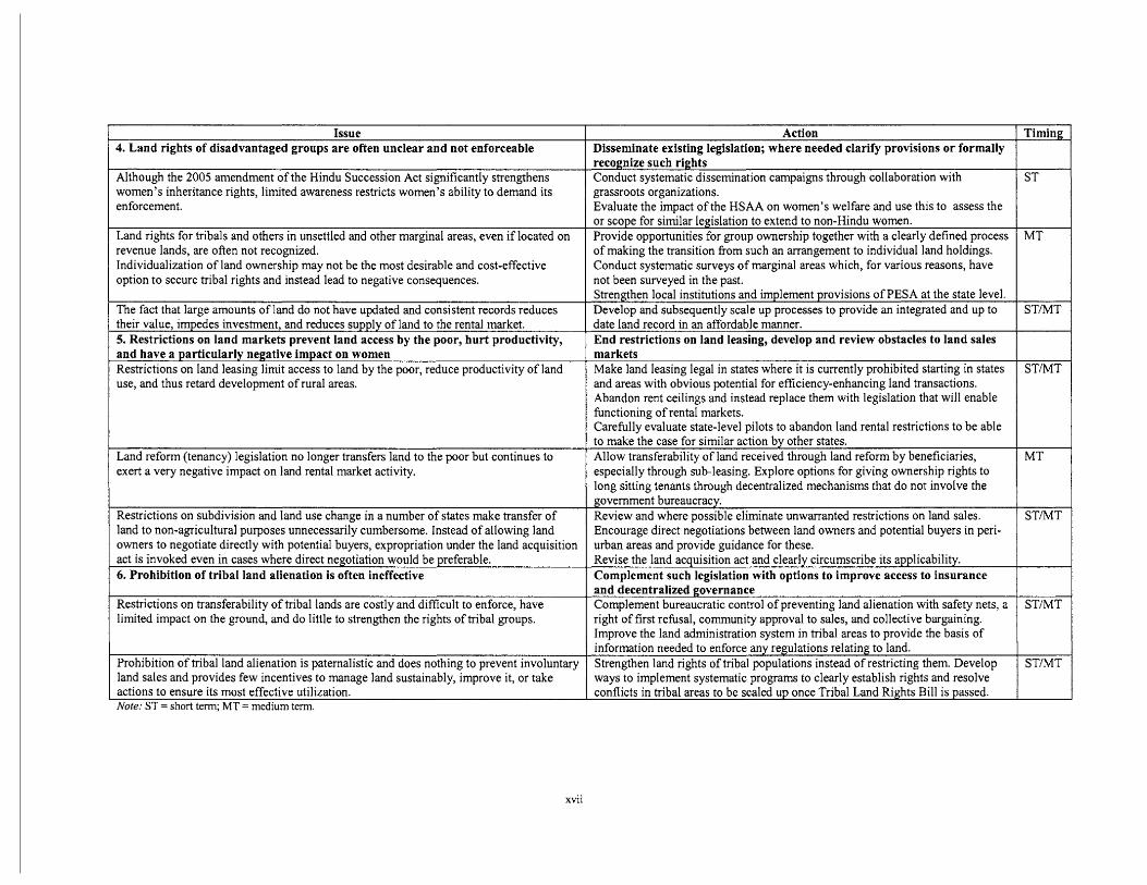
4. Land rights of disadvantaged groups are often unclear and not enforceable
Although the 2005 amendment of the Hindu Succession Act significantly strengthens women's inheritance rights, limited awareness restricts women's ability to demand its enforcement.
Land rights for tribals and others in unsettled and other marginal areas, even if located on revenue lands, are often not recognized. Individualization of land ownership may not be the most desirable and cost-effective option to secure tribal rights and instead lead to negative consequences.
'The fact that large amounts of land do not have updated and consistent records reduces their value, impedes investment, and reduces supply of Iand to the rental market. 5. Restrictions on land markets prevent land access by the poor, hurt productivity, and have a particularly negative impact on women Restrictions on land leasing limit access to land by the poor, reduce productivity of land use, and thus retard development of rural areas.
Land reform (tenancy) Iegislation no longer transfers land to the poor but continues to exert a very negative impact on land rental market activity.
Restrictions on subdivision and land use change in a numbe; of states make transfer of -
land to non-agricultural purposes unnecessarily cumbersome. Instead of allowing land owners to negotiate directly with potentiaI buyers, expropriation under the land acquisition act is invoked even in cases where direct negotiation would be preferable. 6. Prohibition of tribal land alienation is often ineffective
Restrictions on transferability of tribal lands are costly and difficult to enforce, have limited impact on the ground, and do little to strengthen the rights of tribal groups.
Prohibition of tribal land alienation is paternalistic and does nothing to prevent involuntary land sales and provides few incentives to manage land sustainably, improve it, or take actions to ensure its most effective utilization. Note: ST = short term; MT = medium term.
Action Disseminate existing legislation; where needed clarify provisions or formally
grassroots organizations. Evaluate the impact of the HSAA on women's welfare and use this to assess the or scope for similar legislation to extend to non-Hindu women. Provide opportunities for group ownership together with a clearly defined process of making the transition from such an arrangement to individual land holdings. Conduct systematic surveys of marginal areas which, for various reasons, have not been surveyed in the past.
Timing
reco~nize such rights Conduct systematic dissemination campaigns through collaboration with ST
Strengthen local institutions and implement provisions of PESA at the state level. Develop and subsequently scale up processes to provide an integrated and up to STMT date land record in an affordable manner. End restrictions on land leasing, develop and review obstacles to land sales markets Make land leasing legal in states where it is currently prohibited starting in states and areas with obvious potential for efficiency-enhancing Iand transactions. Abandon rent ceilings and instead replace them with legislation that will enable functioning of rental markets. Carefully evaluate state-level pilots to abandon land rental restrictions to be able
especially through sub-Ieasing. Explore options for giving ownership rights to long sitting tenants through decentralized mechanisms that do not involve the
STtMT
to makethe case for similar action by other states. Allow transferability of land received through land reform by beneficiaries, MT
Encourage direct negotiations between land owners and potential buyers in peri- urban areas and provide guidance for these. Revise the land acauisition act and clearlv circumscribe its av~licabilitv.
government bureaucracy. Review and where possible eliminate unwarranted restrictions on land sales.
Complement such legislation with options to improve access to insurance ]
STMT
right of first refusal, community approval to sales, and collective bargaining. Improve the land administration system in tribal areas to provide the basis of information needed to enforce anv reeuIations relatine to land.
and decentralized Complement bureaucratic control of preventing land alienation with safety nets, a STtMT
xvii
Strengthen land rights of tribal populations instead of restricting them. Develop ways to implement systematic programs to clearly establish rights and resolve conflicts in tribal areas to be scaled up once TribaI Land Rights Bill is passed.
ST/MT
I. INTRODUCTION
In India, land continues to be of enormous economic, social, and symbolic relevance. The way in which land can be accessed and its ownership documented is at the core of the livelihood of the large majority of the poor, especially in rural and tribal areas and will determine the extent to which increasingly scarce natural resources are managed. Land policies and administration are critical determinants of the transaction cost associated with and modalities to access land for productive, residential, and business use and, through the ease of using land as collateral for credit, the development of the financial sector. Land also is to be a major source of government revenue and a key element for implementing government programs. This implies that land policies and institutions will have a far-reachng impact on the ability to sustain India's current high rate of growth, the extent to which such growth reaches the poor, and the level and spatial distribution of economic activity.
At the same time, the policies put in place by different states and the institutions tasked to implement them often fail to live up to the importance of the issue. In fact, land administration institutions seem to impose high costs without generating commensurate benefits and seem to be generally perceived as corruption, mismanaged, and lacking transparency. With land reform policies have largely run their course, and despite growing evidence that restricting land rental may do little to help the poor, many observers have lost confidence in the ability of land institutions to contribute to the welfare of the poor or the potential for improving the performance of land administration. In this introductory section we first show that land administration in India does indeed have many shortcomings. In this introduction we first use data from India to show that addressing the shortcomings of the land administration system will indeed be necessary. We then highlight some the recent success stories to argue that doing so is entirely feasible but only if, in addition to focusing on technical aspects, a number of policy issues will be addressed as well.
1. Why addressing land issues is important
Land is of critical importance for the poorest and most marginalized sections of society whose main livelihood continues to depend on agriculture and who may, for a variety of reasons completely outside their control, have very insecure or completely non-existent land rights. This makes it difficult for poor people for whom land is in most cases the most important productive asset, to hl ly utilize their productive potential, thereby reducing their welfare and their ability to accumulate assets. Even if land has been surveyed, the complexity and high cost of services by the land administration system may prompt potential users to opt for informal arrangements rather than use of the official system, which may lead to a similar situation of informality. In fact, various observers have recently drawn attention to the fact that an ill-functioning system of land administration, together with a second-best policy regime that is often both a cause and a consequence of the latter, can also seriously reduce overall economic growth. Although the main focus of the analysis in this report is on the rural economy, we report some of these to highlight the broader importance of the topic and to emphasize that the distinction between rural and urban is to some extent artificial and that, what is needed is a national land administration system, based on a legal and institutional framework that is sufficiently flexible to accommodate the needs of both rural and urban areas.
Lack of land rights: Given the way in which land rights were settled by the British, numerous households in marginal areas remain without any rights to land that they have owned for very long periods of time. This not only reduces their incentives to invest in the land and manage it sustainably but also their ability to obtain credit for doing so. In addition to reducing productivity, investment, and welfare, it also implies that, in case the land is needed for other purposes, they may not be legally entitled to any compensation. The areas involved are often very large; for example, many tribals in southern and western Orissa are cultivating land on the hill slopes without any title because the survey equipment used at the time was unsuitable for land above a gradient of 10 degrees which was categorized as state owned uncultivable wasteland, despite the fact that much of it is possessed and cultivated by tribal households (Saxena 2005). In fact, 74% of land in scheduled areas of Orissa is categorized as state land, with 26% and 48% being revenue and forest land, respectively (Kumar et al. 2006). Similarly, in Madhya Pradesh, the status of a total of 12,395 km2 or more than 3 million acres, the so-called 'orange areas' is disputed, preventing those cultivating them from obtaining ownershp (Upadhyay 2006).
The challenge of informality: Complex and costly procedures of land administration together with legislation that makes tenancy often imply that completely prohibits land leasing or imposes strict conditions on it often have only the result of driving the poor into informal arrangements. This not only deprives them of formal recognition but also makes it difficult for them to access formal credit but also other government programs. For example, in Tamil Nadu where efforts to provide targeted payments to producers in compensation for increases in electricity rates remained
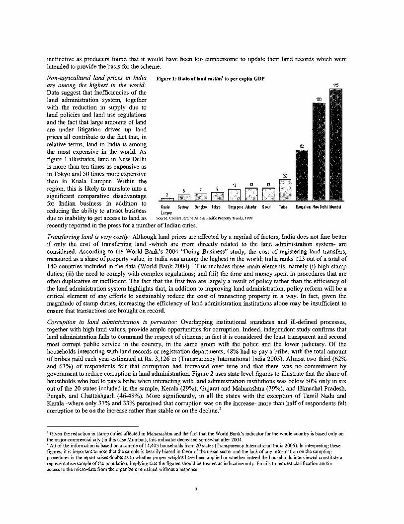
ineffective as producers found that it would have been too cumbersome to update their land records which were intended to provide the basis for the scheme.
Non-agricultural land prices in India Figure 1: Ratio of land eost/mf to per capita GDP are among the highest in the world: 115
Data suggest that inefficiencies of the land administration system, together with the reduction in supply due to land policies and land use regulations and the fact that large amounts of land are under litigation drives up land prices all contribute to the fact that, in relative terms, land in India is among the most expensive in the world. As figure 1 illustrates, land in New Delhi is more than ten times as expensive as in Tokyo and 50 times more expensive than in Kuala Lumpur. Within the region, t h s is likely to translate into a significant comparative disadvantage for Indian business in addition to
Bangalore Nw Dehi Mumbai reducing the ability to attract business L"~,,, due to inability to get access to land as Source: Colliers Jardine Asia & Pacific Propem ~rendr , 1999
recently reported in the press for a number of Indian cities.
Transferring land is very costly: Although land prices are affected by a myriad of factors, India does not fare better if only the cost of transferring land -which are more directly related to the land administration system- are considered. According to the World Bank's 2004 "Doing Business" study, the cost of registering land transfers, measured as a share of property value, in India was among the highest in the world; India ranks 123 out of a total of 140 countries included in the data (World Bank 2004).' T h ~ s includes three main elements, namely (i) lugh stamp duties; (ii) the need to comply with complex regulations; and (iii) the time and money spent in procedures that are often duplicative or inefficient. The fact that the first two are largely a result of policy rather than the efficiency of the land administration system lughlights that, in addition to improving land administration, policy reform will be a critical element of any efforts to sustainably reduce the cost of transacting property in a way. In fact, given the magnitude of stamp duties, increasing the efficiency of land administration institutions alone may be insufficient to ensure that transactions are brought on record.
Corruption in land administration is pervasive: Overlapping institutional mandates and ill-defined processes, together with hlgh land values, provide ample opportunities for corruption. Indeed, independent study c o n f m that land administration fails to command the respect of citizens; in fact it is considered the least transparent and second most corrupt public service in the country, in the same group with the police and the lower judiciary. Of the households interacting with land records or registration departments, 48% had to pay a bribe, with the total amount of bribes paid each year estimated at Rs. 3,126 cr (Transparency International India 2005). Almost two third (62% and 63%) of respondents felt that corruption had increased over time and that there was no commitment by government to reduce corruption in land admmistration. Figure 2 uses state level figures to illustrate that the share of households who had to pay a bribe when interacting with land administration institutions was below 50% only in six out of the 20 states included in the sample, Kerala (29%), Gujarat and Maharashtra (39%), and Himachal Pradesh, Punjab, and Chatttishgarh (46-48%). More significantly, in all the states with the exception of Tamil Nadu and Kerala -where only 37% and 33% perceived that corruption was on the increase- more than half of respondents felt corruption to be on the increase rather than stable or on the decline.'
' Given the reduction in stamp duties affected in Maharashtra and the fact that the World Bank's indicator for the whole country is based only on the major commercial city (in this case Mumbai), this indicator decreased somewhat after 2004.
All of the information is based on a sample of 14,405 households from 20 states (Transparency International India 2005). In interpreting these figures, it is important to note that the sample is heavily biased in favor of the urban sector and the lack of any information on the sampling procedures in the report raises doubts as to whether proper weights have been applied or whether indeed the households interviewed constitute a representative sample of the population, implying that the figures should be treated as indicative only. Emails to request clarification and/or access to the micro-data from the organizers remained without a response.
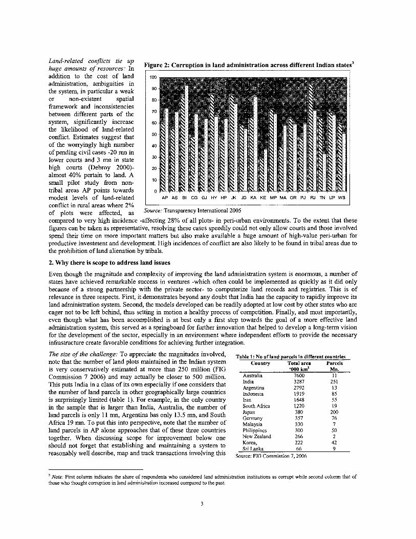
Land-related conjicts tie up huge amounts of resources: In ,
Figure 2: Corruption in land administration across different Indian states3 I
addition to the cost of land administration, ambiguities in the system, in particular a weak or non-existent spatial framework and inconsistencies between different parts of the system, significantly increase the likelihood of land-related conflict. Estimates suggest that of the worryingly high number of pending civil cases -20 mn in lower courts and 3 mn in state high courts (Debroy 2000)- almost 40% pertain to land. A small pilot study from non- tribal areas AP points towards
2. Why there is scope to address land issues
modest levels of land-related
Even though the magnitude and complexity of improving the land administration system is enormous, a number of states have achieved remarkable success in ventures -which often could be implemented as quickly as it did only because of a strong partnershp with the private sector- to computerize land records and registries. This is of relevance in three respects. First, it demonstrates beyond any doubt that India has the capacity to rapidly improve its land administration system. Second, the models developed can be readily adopted at low cost by other states who are eager not to be left behind, thus setting in motion a healthy process of competition. Finally, and most importantly, even though what has been accomplished is at best only a first step towards the goal of a more effective land administration system, this served as a springboard for further innovation that helped to develop a long-term vision for the development of the sector, especially in an environment where independent efforts to provide the necessary infrastructure create favorable conditions for achieving further integration.
AP AS BI CG GJ HY HP JK JD KA KE MP MA OR PJ RJ M UP WB
The size of the challenge: To appreciate the magnitudes involved, note that the number of land plots maintained in the Indian system is very conservatively estimated at more than 250 million (FIG Commission 7 2006) and may actually be closer to 500 million. This puts India in a class of its own especially if one considers that the number of land parcels in other geographically large countries is surprisingly limited (table 1). For example, in the only country in the sample that is larger than India, Australia, the number of land parcels is only 11 mn, Argentina has only 13.5 mn, and South Afnca 19 mn. To put this into perspective, note that the number of land parcels in AP alone approaches that of these three countries together. When discussing scope for improvement below one should not forget that establishing and maintaining a system to reasonably well describe, map and track transactions involving this
conflict in rural areas where 2% of plots were affected, as Source: Transparency International 2005
compared to very high incidence -affecting 28% of all plots- in pen-urban environments. To the extent that these figures can be taken as representative, resolving these cases speedily could not only allow courts and those involved spend their time on more important matters but also make available a huge amount of high-value peri-urban for productive investment and development. High incidences of conflict are also likely to be found in tribal areas due to the prohibition of land alienation by tribals.
Table 1: No of land parcels in different countries Countw Total area Parcels
'000 km2 Mn. Australia 7600 11 India 3287 Argentina 2792 Indonesia 1919 Iran 1648 South Africa 1220 Japan 380 Germany 357 Malaysia 330 Philippines 300 New Zealand 266 Korea, 222 Sri Lanka 66
Source: FIG Commission 7,2006
Note: First column indicates the share of respondents who considered land administration institutions as corrupt while second column that of those who thought corruption in land administration increased compared to the past.
large amount of objects in a way that is accessible at the village level is by itself a huge accomplishment that distinguishes India from many other developing countries.
Initial successes of computerizing textual records: Building on India's strengths in IT, a number of frontrunner states have achieved considerable success in improving the quality with which land-related information is maintained, reducing the cost of managing it, and making it easier for users to access such information. Although doing so has not always been sufficient to ensure that the information on land maintained by different government departments is consistent, up to date, and has comprehensive coverage, studies suggest that it did have an impact on reducing transaction cost and improving transparency and governance within the system exists. In addition, it has resulted in the development of technical solutions, in particular software packages that can be readily adopted by states wishing to make the transition towards a computerized system to realize similar benefits.
A wave of adaptation: Realization of the advantage of a computerized land administration system and the danger of being left behind, together with the availability of Go1 funding and the fact that processes for doing so are now well defined and technical hurdles to be overcome have been identified, has allowed a large number of states to adapt the processes developed by the early adopters to their own needs and often make considerable progress towards an improved system of managing textual land records. Given that tested processes for doing are readily available, it appears that the main challenge to be overcome is no longer of a technical but rather of a political nature. Especially in view of the fact that funding is not a key constraint, lack of progress in some states is due either to lack of information on best practices or to political resistance by specific groups who may be concerned about possibly adverse impacts of doing so on their welfare. The key issue is to codify and disseminate best practices and take measures that could help to ensure that they are being implemented quickly.
The dzflculties associated with moving towards a comprehensive vision: Although it facilitated some remarkable successes and led to the re-definition of processes in a number of cases, computerization of textual records also highlighted the shortcomings of just automating existing systems that may have been appropriate in colonial times but not seen any major change since then. In doing so, three elements have been of particular importance. First, there is scope for review and often simplification of processes, e.g. by separating out some of the information on agricultural production that has little relevance for ownership but had been included in original records due to their function as a basis for taxation. Second, successful computerization of textual records put both the shortcomings of existing land records as well as the problems with spatial data -which are generally much worse than textual records- into much sharper relief. Finally, the process has clearly highlighted that, even with improved textual records, there is a long way to go before the basis goal of having a conclusive record of land ownership widely available at an affordable cost can be attained. To do so, integration of the various systems, whch requires overcoming the current fragmented nature of land administration institutions (e.g. between rural and urban land records or between land records, registration, and survey) which has often little substantive justification. m l e far-reachmg institutional changes will be highly contentious politically and may thus not be feasible at this point, a number of states have started to move towards 'virtual' integration of processes, functions, and information across departments as a second best option. Initiatives, such as the national e-governance project, that aim to establish such connectivity will provide the basis for doing so. Given current plans for roll-out of the necessary infrastructure, broad connectivity is likely to be more widely available in a few years and it will be important to utilize the time until then to establish processes and make the regulatory changes needed to implement them once it becomes available.
In addition to the lessons noted above, the successful computerization of textual records also helped to demonstrate the intimate link between policy issues and land administration, in two ways. On the one hand, a number of policies, in particular high stamp duties and land reform and land use regulations that tend to dnve users into informality pose a threat to the sustainability of efforts to modernize the land administration system. On the other hand, policy makers may not be aware of the potential benefits from having in place a comprehensive and well-functioning system of land administration not only for overall economic activity but also for the ability to implement certain types of policies in a more cost-effective and often also efficient way.
India's remarkable progress in improving the land administration system is unlikely to be sustainable, and prospects for realizing the vision of an integrated and effective institution will not be achieved, unless a number of key policy issues that have emerged as key constraints are being addressed. First, levels of stamp duty that are extraordinarily high by international standards will continue to dnve transactions underground and thus undermine completeness of the registry. Second, an outdated regulatory framework that leaves little space for private sector participation and precludes the use of low-cost modem technology for surveying makes it impossible to generate spatial information at a cost that will allow land administration to reach out to the poor and marginalized whose land rights have long
been neglected. Finally, legislation, most of it associated with past land reform efforts seriously limits the incentives for individuals to truthfully declare their land holdings (e.g. by registering land in the name of non-existent persons) and ways to deal with such situations, as well as modifications to the legislation, may be required to be able to modernize the land administration system in a way that is sustainable and allows it to live up to its potential.
3. Plan of the report
The main purpose of this report is to review new empirical evidence on land administration and land policy, as well as the possible interaction between the two, to derive policy conclusions. The empirical basis for the discussion of land administration is provided by a review of land records, survey and settlement, and land registration in 14 states. Chapter two describes the origin, nature, and main functions of current institutions and the ensuing problems for secure tenure and easy transferability of land. Chapter three identifies elements of a "best practice7' approach to improving textual data (records and registration) and, based on a review of states' experience, identifies the associated benefits. In both cases, the evidence is used to identify unresolved issues that should be addressed by pilots and to identify criteria and indicators of performance that could help make centrally sponsored schemes more effective. Chapter four reviews the extent to which lessons from improving textual records could help to give a boost to improvement of the spatial database for land administration, an area that has thus far been largely neglected (not surprising in view of the cost and complexity of the issue) but that will require urgent attention n if initiatives to have a system providing higher levels of tenure security are ever to bear h i t . Chapter five concludes the discussion on land administration by assessing the scope for title registration to help improve tenure security in India and by identifying that need to be discussed.
The key contribution of our discussion of land policy is that, for each of the policy issues of land reform, land leasing, and land sales markets, we provide household-level evidence, based on a nationally representative survey of a panel of about 5,000 households (or their descendents) who were interviewed in 1982 and then again in 1999. Chapter 6 highlights that land reform has helped increase accumulation of physical and human capital but that the impact is declining over time. It therefore explores a range of alternative ways to increase land ownership by the poor. Chapter 7 explores the functioning of land lease markets, and the extent to which restrictions on land leasing reduce the scope for productivity- and equity enhancing transfers through such markets which could be particularly beneficial for women. Chapter 8 reviews the operation of land sales markets and suggests alternative approaches for preventing land loss by tribal people and chapter 9 concludes with a series of policy recommendations.
11. LAND ADMINISTRATION: INSTITUTIONAL STRUCTURE AND KEY CHALLENGES
Land administration deals with the recording, processing and dissemination of information about ownership, value and use of land and the resources associated to it. It includes the determination of property rights and other attributes of the land that relate to its value and use, the survey and description of these, their detailed documentation and the provision of relevant information in support of land markets (UNECE 1996). A land administration system that is affordable, accessible, and efficient will help to (i) provide secure land tenure for land owners, thus encouraging them to invest and manage this asset in a sustainable manner; (ii) facilitate low cost transfers that allow land to move from less to more productive producers through rental or sale; (iii) provide a basis for the use of land as a collateral for effective operation of financial markets; (iv) allow spatial planning for issues ranging from provision of infrastructure such as roads and utility lines to environmental protection; and (v) enable local and central government to effectively implement programs and collect revenue.
1. Historical evolution and overall structure of land records
One of the reasons for land administration in India to often fail to live up to this goal is that most of the institutions and processes for administering land in India were adopted fiom the British at Independence and have been little modified since. Land administration in India has its origin in colonial land taxation. Most of the institutions and processes to administer land resemble closely those established under British rule when land revenue was the main source of government income, amounting to 60% of total British government revenue in the 1840s. The amount of taxes (land revenue) to be paid was determined in a process called settlement, the nature of which differs for different parts of the country, depending on the time and way of their incorporation into the empire (box 1).
Box 1: Different types of settlement and their long-term implications Depending largely on the political preferences in place at the time when a specific area was brought under colonial administration, the British adopted one of three land revenue systems: landlord-based systems (zamindan' or malguzari), cultivator-based systems (ryotwari) or village- based systems (mahalwari):
Zamindari systems were established in Bengal, Bihar, Orissa, many parts of UP, the Central Provinces (Madhya Pradesh) and some parts of Madras Presidency (Tamil Nadu and Andhra Pradesh), generally areas with have good quality soils and adequate rainfall. It effectively provided property rights in land to the landlord (zamindar) who in tum had to deliver a certain amount of revenue to the colonial administration while being allowed to keep any surplus for himself. In some areas, the level of revenue to be delivered was fixed in perpetuity under the 1793 "permanent settlement" while in others temporary settlements were revised after a number of years. Also, while in most areas land records remained with the government, they were maintained directly by zamindars in Bihar.
Under ryotwari, which was adopted in most areas of the Madras and Bombay Residencies and in Assam which generally had lower inherent agricultural potential, revenue settlement was made directly with the cultivator (ryot). To provide the basis for revenue collection, a cadastral survey, to be updated regularly through revisional surveys, was canied out and a detailed title document, called record of rights (RoR), was prepared. Tax liabilities were then calculated as the monetary value of a share of the estimated average annual output from the land.
Under the village-based (mahalwan') system, which was adopted in the North-West Provinces and Punjab, village bodies were responsible for the land revenue. Depending on the nature of the village body, the final result could be similar to a zamindari system (if there was one big landlord) or a ryotwari-type arrangement with individual cultivators.
This historical process had far-reaching implications not only on subsequent development through the security of property rights, the nature of political power, and the overall distribution of wealth. It also affected the nature of land administration institutions and the quality of the records supporting these institutions that continues to the present day. For example, cadastral maps in zamindari areas, where revenue was fixed permanently and maintaining records thus did not offer benefits in terms of higher tax revenue, are generally less well maintained than those in ryotwari areas.
The primacy of revenue affected the coverage, nature, and evolution of the land administration system, in three respects: First, to the extent that the main purpose of the system was to enable the state to collect revenue, it focused on use rather than ownershp and incentives for owners to keep records up to date remained limited. Second, there was limited attention to the spatial framework; and maps were prepared only with reference to the village and infrequently updated. Finally, coverage was eclectic and land a b s t r a t i o n focused on agricultural lands only, thus excluding urban as well as marginal lands. For the latter, there remain large tracts of "unsettled" land whch, although they may have been occupied by local people for generations, remain de jure under state ownership with the result that even long-standing occupants may legally be 'encroachers' who will not be eligible for compensation in case the land is needed for other purposes.
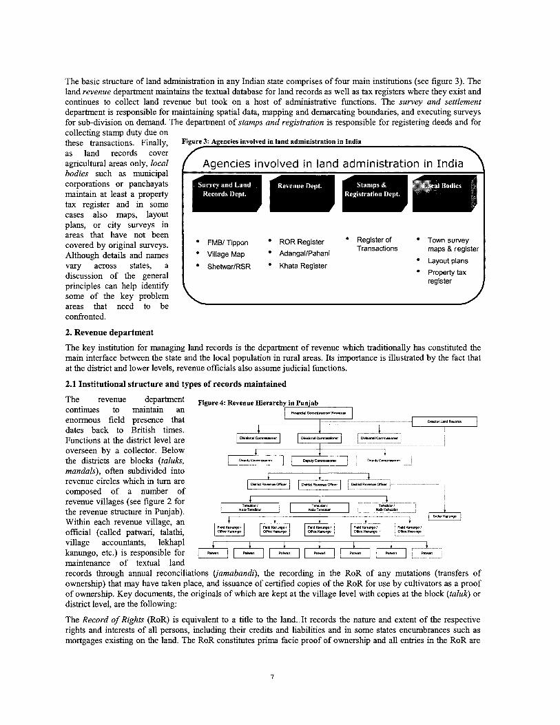
The basic structure of land ahnistration in any Indian state comprises of four main institutions (see figure 3). The land revenue department maintains the textual database for land records as well as tax registers where they exist and continues to collect land revenue but took on a host of administrative functions. The survey and settlement department is responsible for maintaining spatial data, mapping and demarcating boundaries, and executing surveys for sub-division on demand. The department of stamps and registration is responsible for registering deeds and for collecting stamp duty due on these transactions. Finally, Figure 3: Agencies involved in land administration in India as land records cover agricultural areas only, local Agencies involved in land administration in India
plans, or city surveys in areas that have not been covered by original surveys. Although details and names vary across states, a discussion of the general principles can help identify some of the key problem areas that need to be
I FMBl Tippon ROR Register Register Of Town survey Transactions maps & register
Village Map AdangallPahani Layout plans
Shehvar/RSR Khata Register Property tax register
confronted.
2. Revenue department
The key institution for managing land records is the department of revenue which traditionally has constituted the main interface between the state and the local population in rural areas. Its importance is illustrated by the fact that at the district and lower levels, revenue officials also assume judicial functions.
2.1 Institutional structure and types of records maintained
The revenue department Figure 4: Revenue Hierarchy in Punjab continues to maintain an FI-I.I c ~ ~ ~ ~ . . ~ ~ R~
enormous field presence that ....................................................................... Drrstw L.rd Record.
dates back to British times. I 1 .................................
Functions at the district level are / Dlvl.-lCommwr*r I / avwmlanrm-, I DlrWon.ICamuuan
overseen by a collector. Below the districts are blocks (taluks, mandals), often subdivided into revenue circles which in turn are composed of a number of revenue villages (see figure 2 for the revenue structure in Punjab). Within each revenue village, an official (called patwari, talathi, village accountants, lekhapl I
i i 4 i i i i kanungo, etc.) is responsible for I RM. 1 I/ I [ -1 1 RMn Rmvl Rhrl Rhn R W n RMn
maintenance of textual land records through annual reconciliations (jamabandi), the recording in the RoR of any mutations (transfers of ownership) that may have taken place, and issuance of certified copies of the RoR for use by cultivators as a proof of ownership. Key documents, the originals of which are kept at the village level with copies at the block (taluk) or district level, are the following:
The Record of Rights (RoR) is equivalent to a title to the land. It records the nature and extent of the respective rights and interests of all persons, including their credits and liabilities and in some states encumbrances such as mortgages existing on the land. The RoR constitutes prima facie proof of ownership and all entries in the RoR are
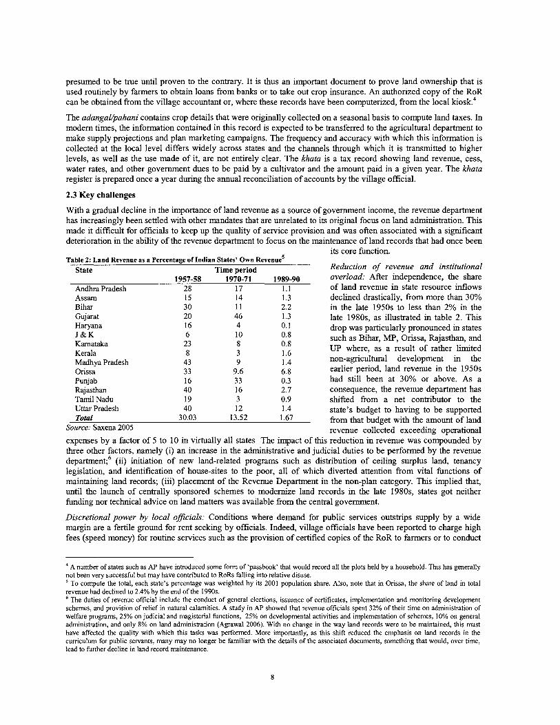
presumed to be true until proven to the contrary. It is thus an important document to prove land ownership that is used routinely by farmers to obtain loans from banks or to take out crop insurance. An authorized copy of the RoR can be obtained from the village accountant or, where these records have been computerized, from the local l ~ o s k . ~
The adangal/pahani contains crop details that were originally collected on a seasonal basis to compute land taxes. In modem times, the information contained in this record is expected to be transferred to the agricultural department to make supply projections and plan marketing campaigns. The frequency and accuracy with which this information is collected at the local level differs widely across states and the channels through which it is transmitted to higher levels, as well as the use made of it, are not entirely clear. The khata is a tax record showing land revenue, cess, water rates, and other government dues to be paid by a cultivator and the amount paid in a given year. The khata register is prepared once a year during the annual reconciliation of accounts by the village official.
2.3 Key challenges
With a gradual decline in the importance of land revenue as a source of government income, the revenue department has increasingly been settled with other mandates that are unrelated to its original focus on land administration. This made it difficult for officials to keep up the quality of service provision and was often associated with a significant deterioration in the ability of the revenue department to focus on the maintenance of land records that had once been
its core function. Table 2: Land Revenue as a Percentage of Indian States' Own ~ e v e n u e ~
State Time period Reduction of revenue and institutional 1957-58 1970-71 1989-90 overload: After independence, the share
Andhra Pradesh 28 17 1.1 of land revenue in state resource inflows Assam 15 14 1.3 declined drastically, from more than 30% Bihar 3 0 11 2.2 in the late 1950s ;o less than 2% in the Gujarat 20 46 1.3 late 1980s, as illustrated in table 2. T h s Haryana 16 4 0.1 drop was particularly pronounced in states J & K 6 10 0.8
23 8 such as Bihar, MP, Orissa, Rajasthan, and
Karnataka 0.8 Kerala 8 3 1.6 UP where, as a result of rather limited
Madhya Pradesh 43 9 1.4 non-agricultural development in the Orissa 33 9.6 6.8 earlier period, land revenue in the 1950s Punjab 16 33 0.3 had still been at 30% or above. As a Rajasthan 40 16 2.7 consequence, the revenue department has Tamil Nadu 19 3 0.9 shifted from a net contributor to the Uttar Pradesh 40 12 1.4 state's budget to having to be supported Total 30.03 13.52 1.67 from that budget with the amount of land
Source: Saxena 2005 revenue collected exceeding operational expenses by a factor of 5 to 10 in virtually all states The impact of this reduction in revenue was compounded by three other factors, namely (i) an increase in the administrative and judicial duties to be performed by the revenue department;6 (ii) initiation of new land-related programs such as distribution of ceiling surplus land, tenancy legislation, and identification of house-sites to the poor, all of which diverted attention from vital functions of maintaining land records; (iii) placement of the Revenue Department in the non-plan category. T h s implied that, until the launch of centrally sponsored schemes to modernize land records in the late 1980s, states got neither funding nor technical advice on land matters was available fiom the central government.
Discretional power by local oficials: Conditions where demand for public services outstrips supply by a wide margin are a fertile ground for rent seeking by officials. Indeed, village officials have been reported to charge high fees (speed money) for routine services such as the provision of certified copies of the RoR to farmers or to conduct
A number of states such as AP have introduced some form of 'passbook' that would record all the plots held by a household. This has generally not been very successful but may have contributed to RoRs falling into relative disuse.
TO compute the total, each state's percentage was weighted by its 2001 population share. Also, note that in Orissa, the share of land in total revenue had declined to 2.4% by the end of the 1990s.
The duties of revenue official include the conduct of general elections, issuance of certificates, implementation and monitoring development schemes, and provision of relief in natural calamities. A study in AP showed that revenue officials spent 32% of their time on administration of welfare programs, 25% on judicial and magisterial functions, 25% on developmental activities and implementation of schemes, 10% on general administration, and only 8% on land administration (Agrawal 2006). With no change in the way land records were to be maintained, this must have affected the quality with which this tasks was performed. More importantly, as this shift reduced the emphasis on land records in the cumculum for public servants, many may no longer be familiar with the details of the associated documents, something that would, over time, lead to further decline in land record maintenance.
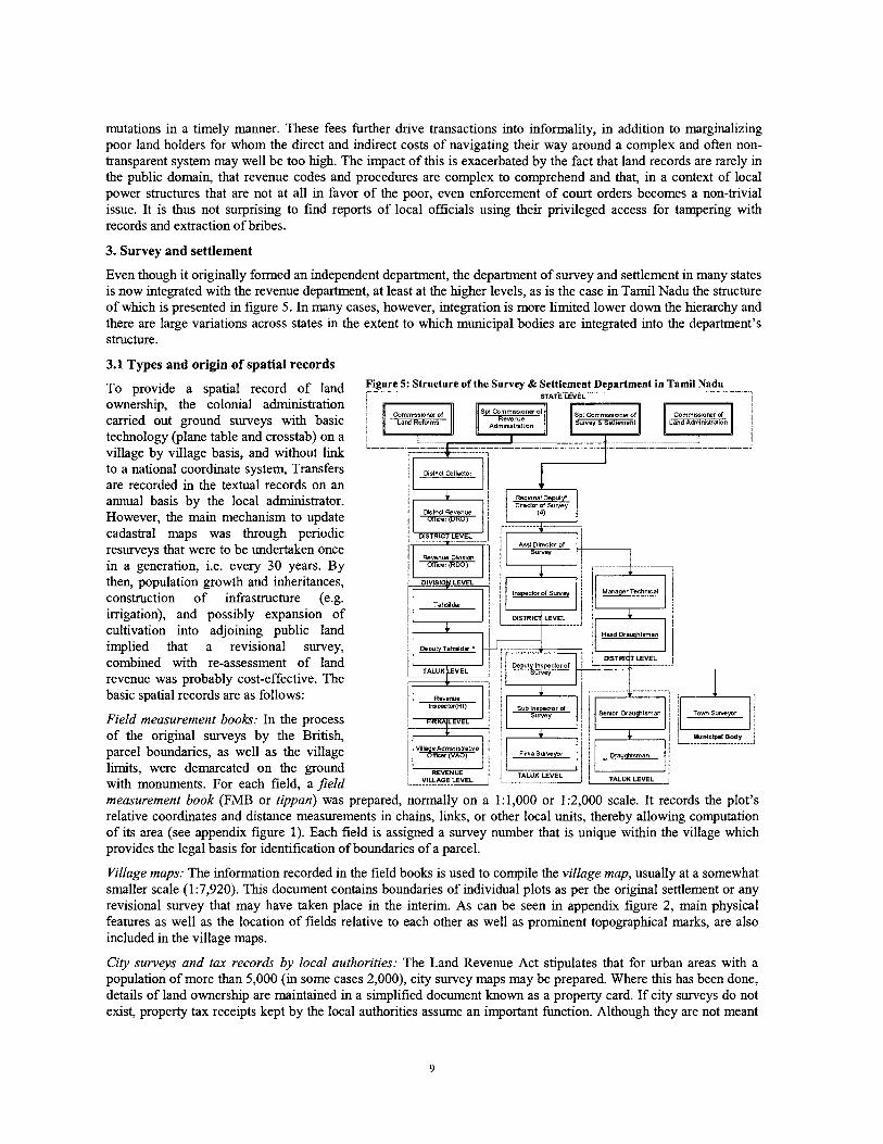
mutations in a timely manner. These fees further drive transactions into informality, in addition to marginalizing poor land holders for whom the direct and indirect costs of navigating their way around a complex and often non- transparent system may well be too high. The impact of this is exacerbated by the fact that land records are rarely in the public domain, that revenue codes and procedures are complex to comprehend and that, in a context of local power structures that are not at all in favor of the poor, even enforcement of court orders becomes a non-trivial issue. It is thus not surprising to find reports of local officials using their privileged access for tampering with records and extraction of bribes.
3. Survey and settlement
Even though it originally formed an independent department, the department of survey and settlement in many states is now integrated with the revenue department, at least at the higher levels, as is the case in Tamil Nadu the structure of whch is presented in figure 5. In many cases, however, integration is more limited lower down the hierarchy and there are large variations across states in the extent to which municipal bodies are integrated into the department's structure.
3.1 Types and origin of spatial records
T~ provide a spatial record of land Figure 5: Structure of the Suwey & Settlement Department in Tamil Nadu
ownership, the colonial administration carried out ground surveys with basic technology (plane table and crosstab) on a village by village basis, and without link
to a national coordinate system, Transfers are recorded in the textual records on an annual basis by the local administrator. However, the main mechanism to update cadastral maps was through periodic resurveys that were to be undertaken once As* Dtnctcr of
in a generation, i.e. every 30 years. By then, population growth and inheritances, construction of infrastructure (e.g. irrigation), and possibly expansion of cultivation into adjoining public land implied that a revisional survey, combined with re-assessment of land revenue was probably cost-effective. The basic spatial records are as follows:
Field measurement books: In the process of the original surveys by the British, parcel boundaries, as well as the village limits, were demarcated on the ground with monuments. For each field, a field measurement book (FMB or tippan) was prepared, normally on a 1:1,000 or 1:2,000 scale. It records the plot's relative coordinates and distance measurements in chains, I d s , or other local units, thereby allowing computation of its area (see appendix figure 1). Each field is assigned a survey number that is unique within the village which provides the legal basis for identification of boundaries of a parcel.
Village maps: The information recorded in the field books is used to compile the village map, usually at a somewhat smaller scale (1:7,920). This document contains boundaries of individual plots as per the original settlement or any revisional survey that may have taken place in the interim. As can be seen in appendix figure 2, main physical features as well as the location of fields relative to each other as well as prominent topographical marks, are also included in the village maps.
City surveys and tax records by local authorities: The Land Revenue Act stipulates that for urban areas with a population of more than 5,000 (in some cases 2,000), city survey maps may be prepared. Where this has been done, details of land ownership are maintained in a simplified document known as a property card. If city surveys do not exist, property tax receipts kept by the local authorities assume an important function. Although they are not meant
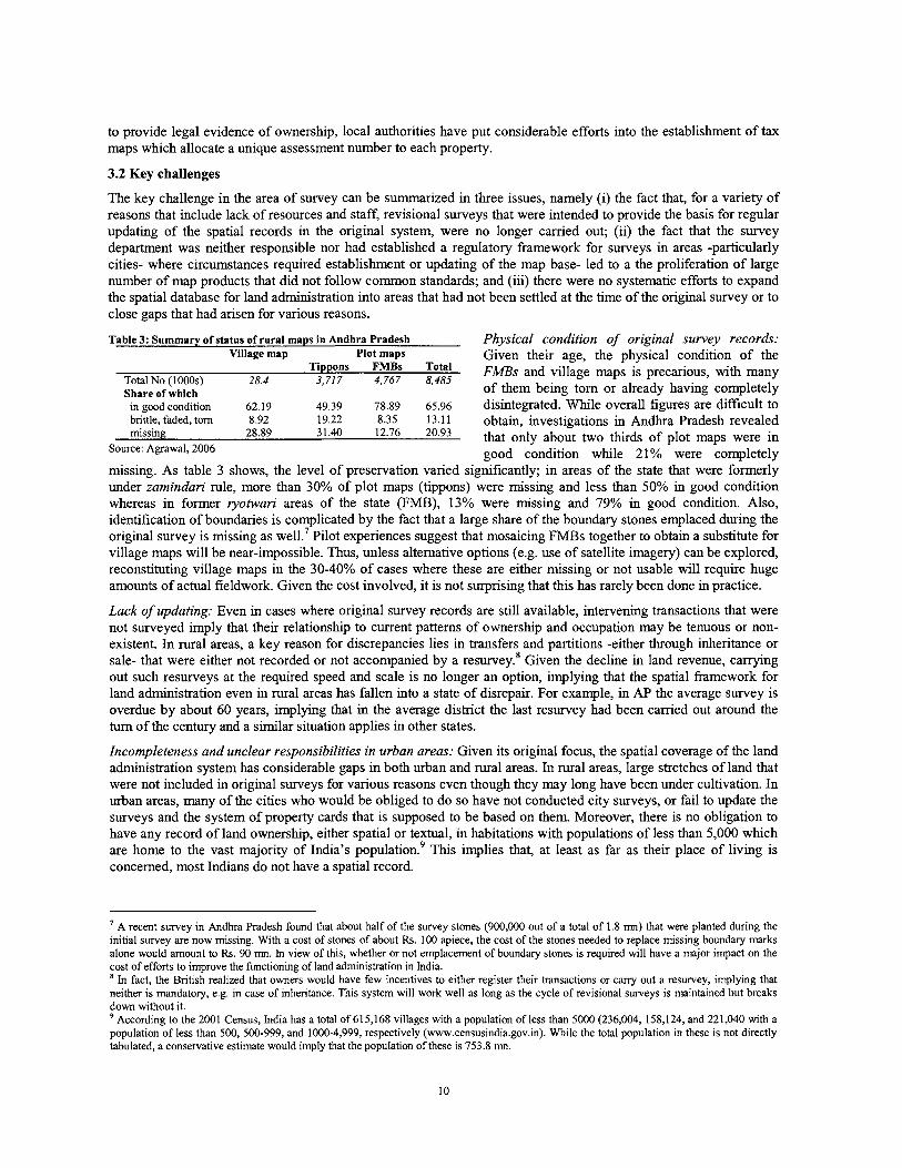
to provide legal evidence of ownership, local authorities have put considerable efforts into the establishment of tax maps which allocate a unique assessment number to each property.
3.2 Key challenges
The key challenge in the area of survey can be summarized in three issues, namely (i) the fact that, for a variety of reasons that include lack of resources and staff, revisional surveys that were intended to provide the basis for regular updating of the spatial records in the original system, were no longer carried out; (ii) the fact that the survey department was neither responsible nor had established a regulatory framework for surveys in areas -particularly cities- where circumstances required establishment or updating of the map base- led to a the proliferation of large number of map products that did not follow common standards; and (iii) there were no systematic efforts to expand the spatial database for land administration into areas that had not been settled at the time of the original survey or to close gaps that had arisen for various reasons.
Table 3: Summary of status of rural maps in Andhra Pradesh Physical condition of original survey records: Village map plot maps Given their age, the physical condition of the
Total No (1 000s) 28.4 Tippons FMBs FMBs and village maps is precarious, with many
3,717 4,767 8,485 Share of which of them being tom or already having completely
in good condition 62.19 49.39 78.89 65.96 disintegrated. While overall figures are difficult to brittle, faded, tom 8.92 19.22 8.35 13.11 obtain, investigations in Andhra Pradesh revealed missing 28.89 31.40 12.76 20.93 that only about two thirds of plot maps were in
Source: Agrawal, 2006 good condition while 21% were completely missing. As table 3 shows, the level of preservation varied significantly; in areas of the state that were formerly under zamindari rule, more than 30% of plot maps (tippons) were missing and less than 50% in good condition whereas in former ryotwari areas of the state (FMB), 13% were missing and 79% in good condition. Also, identification of boundaries is complicated by the fact that a large share of the boundary stones emplaced during the original survey is missing as well.' Pilot experiences suggest that mosaicing FMBs together to obtain a substitute for village maps will be near-impossible. Thus, unless alternative options (e.g. use of satellite imagery) can be explored, reconstituting village maps in the 30-40% of cases where these are either missing or not usable will require huge amounts of actual fieldwork. Given the cost involved, it is not surprising that this has rarely been done in practice.
Lack of updating: Even in cases where original survey records are still available, intervening transactions that were not surveyed imply that their relationship to current patterns of ownership and occupation may be tenuous or non- existent. In rural areas, a key reason for discrepancies lies in transfers and partitions -either through inheritance or sale- that were either not recorded or not accompanied by a resurvey.* Given the decline in land revenue, carrying out such resurveys at the required speed and scale is no longer an option, implying that the spatial framework for land administration even in rural areas has fallen into a state of disrepair. For example, in AP the average survey is overdue by about 60 years, implying that in the average district the last resurvey had been carried out around the turn of the century and a similar situation applies in other states.
Incompleteness and unclear responsibilities in urban areas: Given its original focus, the spatial coverage of the land admimstration system has considerable gaps in both urban and rural areas. In rural areas, large stretches of land that were not included in original surveys for various reasons even though they may long have been under cultivation. In urban areas, many of the cities who would be obliged to do so have not conducted city surveys, or fail to update the surveys and the system of property cards that is supposed to be based on them. Moreover, there is no obligation to have any record of land ownership, either spatial or textual, in habitations with populations of less than 5,000 which are home to the vast majority of India's population.9 This implies that, at least as far as their place of living is concerned, most Indians do not have a spatial record.
' A recent survey in Andhra Pradesh found that about half of the survey stones (900,000 out of a total of 1.8 mn) that were planted during the initial survey are now missing. With a cost of stones of about Rs. 100 apiece, the cost of the stones needed to replace missing boundary marks alone would amount to Rs. 90 mn. In view of this, whether or not emplacement of boundary stones is required will have a major impact on the cost of efforts to improve the functioning of land administration in India.
In fact, the British realized that owners would have few incentives to either register their transactions or cany out a resurvey, implying that neither is mandatory, e.g. in case of inheritance. This system will work well as long as the cycle of revisional surveys is maintained but breaks down without it.
According to the 2001 Census, India has a total of 615,168 villages with a population of less than 5000 (236,004, 158,124, and 221,040 with a population of less than 500,500-999, and 1000-4,999, respectively (www.censusindia.gov.in). While the total population in these is not directly tabulated, a conservative estimate would imply that the population of these is 753.8 mn.
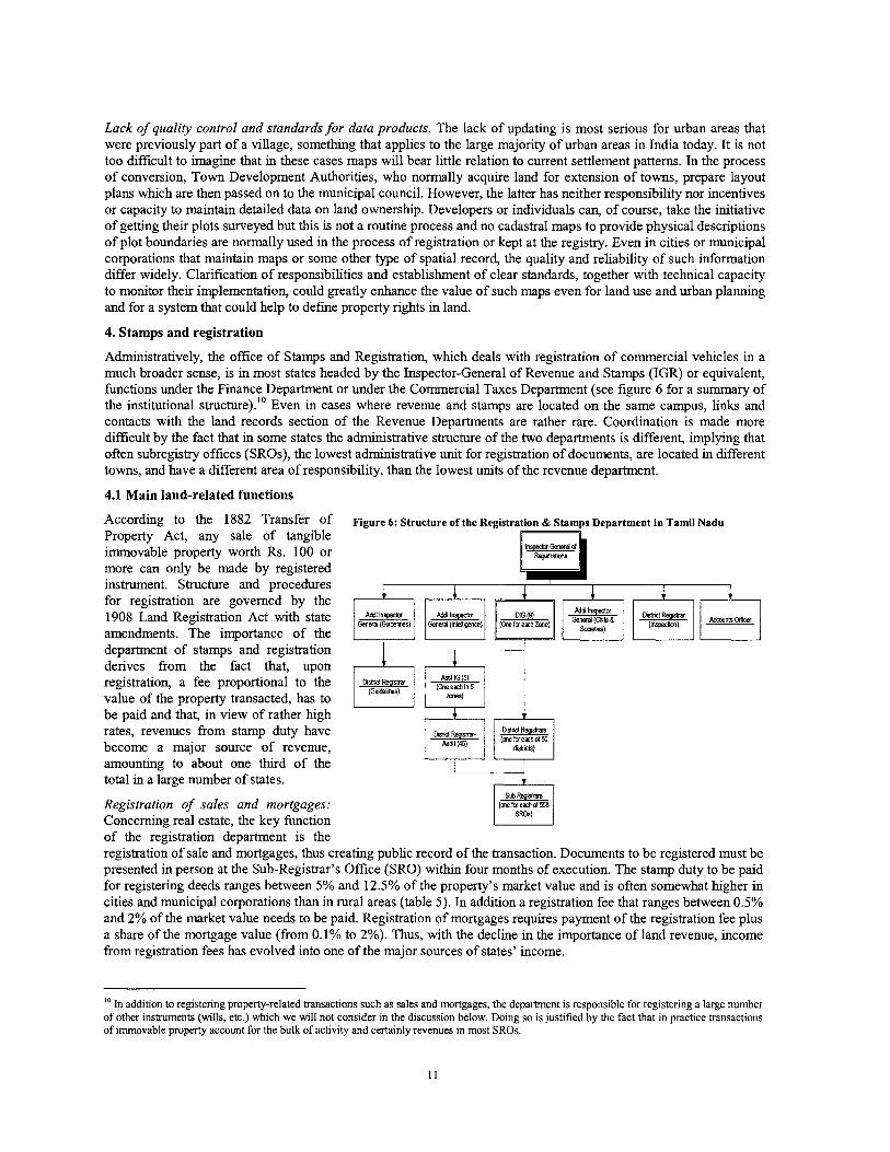
Lack of quality control and standards for data products. The lack of updating is most serious for urban areas that were previously part of a village, something that applies to the large majority of urban areas in India today. It is not too dificult to imagine that in these cases maps will bear little relation to current settlement patterns. In the process of conversion, Town Development Authorities, who normally acquire land for extension of towns, prepare layout plans which are then passed on to the municipal council. However, the latter has neither responsibility nor incentives or capacity to maintain detailed data on land ownership. Developers or individuals can, of course, take the initiative of getting their plots surveyed but this is not a routine process and no cadastral maps to provide physical descriptions of plot boundaries are normally used in the process of registration or kept at the registry. Even in cities or municipal corporations that maintain maps or some other type of spatial record, the quality and reliability of such information differ widely. Clarification of responsibilities and establishment of clear standards, together with technical capacity to monitor their implementation, could greatly enhance the value of such maps even for land use and urban planning and for a system that could help to define property rights in land.
4. Stamps and registration
Administratively, the office of Stamps and Registration, which deals with registration of commercial vehicles in a much broader sense, is in most states headed by the Inspector-General of Revenue and Stamps (IGR) or equivalent, functions under the Finance Department or under the Commercial Taxes Department (see figure 6 for a summary of the institutional structure).'' Even in cases where revenue and stamps are located on the same campus, links and contacts with the land records section of the Revenue Departments are rather rare. Coordination is made more difficult by the fact that in some states the administrative structure of the two departments is different, implying that often subregistry offices (SROs), the lowest administrative unit for registration of documents, are located in different towns, and have a different area of responsibility, than the lowest units of the revenue department.
4.1 Main land-related functions
According to the 1882 Transfer of Property Act, any sale of tangible immovable property worth Rs. 100 or more can only be made by registered instrument. Structure and procedures for registration are governed by the 1908 Land Registration Act with state amendments. The importance of the department of stamps and registration derives from the fact that, upon registration, a fee proportional to the value of the property transacted, has to be paid and that, in view of rather high rates, revenues from stamp duty have become a major source of revenue, amounting to about one thlrd of the total in a large number of states.
Registration of sales and mortgages: Concerning real estate, the key function
Figure 6: Structure of the Registration & Stamps Department in Tamil Nadu I
of the registration department is the registration of sale and mortgages, thus creating public record of the transaction. Documents to be registered must be presented in person at the Sub-Registrar's Office (SRO) within four months of execution. The stamp duty to be paid for registering deeds ranges between 5% and 12.5% of the property's market value and is often somewhat higher in cities and municipal corporations than in rural areas (table 5). In addition a registration fee that ranges between 0.5% and 2% of the market value needs to be paid. Registration of mortgages requires payment of the registration fee plus a share of the mortgage value (from 0.1% to 2%). Thus, with the decline in the importance of land revenue, income from registration fees has evolved into one of the major sources of states' income.
10 In addition to registering property-related transactions such as sales and mortgages, the department is responsible for registering a large number of other instruments (wills, etc.) which we will not consider in the discussion below. Doing so is justified by the fact that in practice transactions of immovable property account for the bulk of activity and certainly revenues in most SROs.
Supply of encumbrance certificates: The sub-registries also supply, against a nominal processing fee, encumbrance certificates (ECs) that contain all registered dealings for a given parcel over a stipulated period. These certificates are usually prepared by manually going through the indexes of registered transactions. Having an encumbrance certificate for a long enough period is important for purchasers of land to explore possible defects in the title which a potential seller holds to a specific piece of immovable property, implying that the ease with which such documents can be made available will have a major bearing on tenure security. The encumbrance certificate is also relevant for financial institutions wanting to use a property as collateral for a loan to ensure that no prior and possibly superior liens has been registered on it. It is thus not surprising that tlus service is in high demand by the public and the financial sector. At the same time, the fact that registration is not compulsory -and evaded to avoid having to pay stamp duty even in cases where it would be required by law- greatly constrains the value of evidence from the registration system, irrespectively of whether it is generated manually or via computer.
4.2 Key challenges
In practice, the effectiveness of registration, is reduced by four factors, namely (i) high stamp duty and often opaque methods of valuing properties prompt parties to either keep their transactions informal, with negative consequences for the completeness or integrity of the system; (ii) low efficiency and high cost even of routine operations act as M h e r deterrent to formalizing transactions; (iii) lack of links to other parts of the property system reduces the security which registration can provide even under optimum conditions; and (iv) the fact that registration does neither ensure legal validity of a transaction nor provides parties with additional assurance as to the validity of the transaction, discourages registration. We discuss these in turn below.
High stamp duties discourage registration
High transfer taxes push transactions into informality: Despite recent reductions of stamp duty by some states, rates remain, with an average of only slightly below 10% of the value of the transaction, very high by international standards. This discourages formal land transactions and lead the parties involved to avoid registration through various means such as powers of attorney and other side agreements, thereby reducing government revenue and threatening to undermine the completeness of the land administration system. In the case of mortgages, a common practice to avoid payment of stamp duty is to enter into an equitable mortgage by way of deposit of title deeds rather than a formally registered mortgage.
Undervaluation and corruption: To avoid having to pay high stamp duties, many parties resort to reporting land values that are significantly below what was actually paid. The problem with explicitly or implicitly condoning such an approach in manual systems1' is that values of land have to be determined or certified by a government official who will often demand a fee for his "service".
Costly and complex procedures even for routine operations
Indexing and retrieval is dzficult: Deeds are often lengthy and complex documents that may run over 40 or 50 pages, and specialist knowledge will be required to decipher them and navigate the system. One reason is that the plethora of state-specific land reform legislations and land use restrictions adds to complexity. Simplification of these laws could help to standardize deeds -sometlung that is presently often not complied with even in situations where regulations exist- and thus help make the process of registering property more transparent and less costly. The registration system is governed by antiquated procedures including manual copying and indexing of documents by person rather than by parcel which increases the cost of obtaining information. High costs of obtaining information are particularly important in case of encumbrance certificates for mortgages where they could well result in a large number of otherwise credit-worthy borrowers being rationed out of the credit market.
Long delays in pe$ormance of essential tasks: Absence of performance standards that made it possible for public servants to keep documents pending for registration or not return original document for years without a good reason. In Madhya Pradesh, it takes 30 days or more for an encumbrance certificate to be issued, an activity that can be performed in less than 5 minutes in neighbouring states (Price Waterhouse Coopers 2006). Delays of 2 to 3 years in registration are not uncommon where extensive and often unnecessary quality assurance procedures slow the
States deal with this problem in interesting, though slightly contradictory ways. For example, in Kerala the stamp duty was increased by 2 points (to 14%) based on the argument that doing so would be needed to maintain government's tax income in the face of pervasive underdeclaration of land values. In Kamataka, when computerized market valuation was introduced, the amount calculated was automatically reduced by one third to account for previous undervaluation.
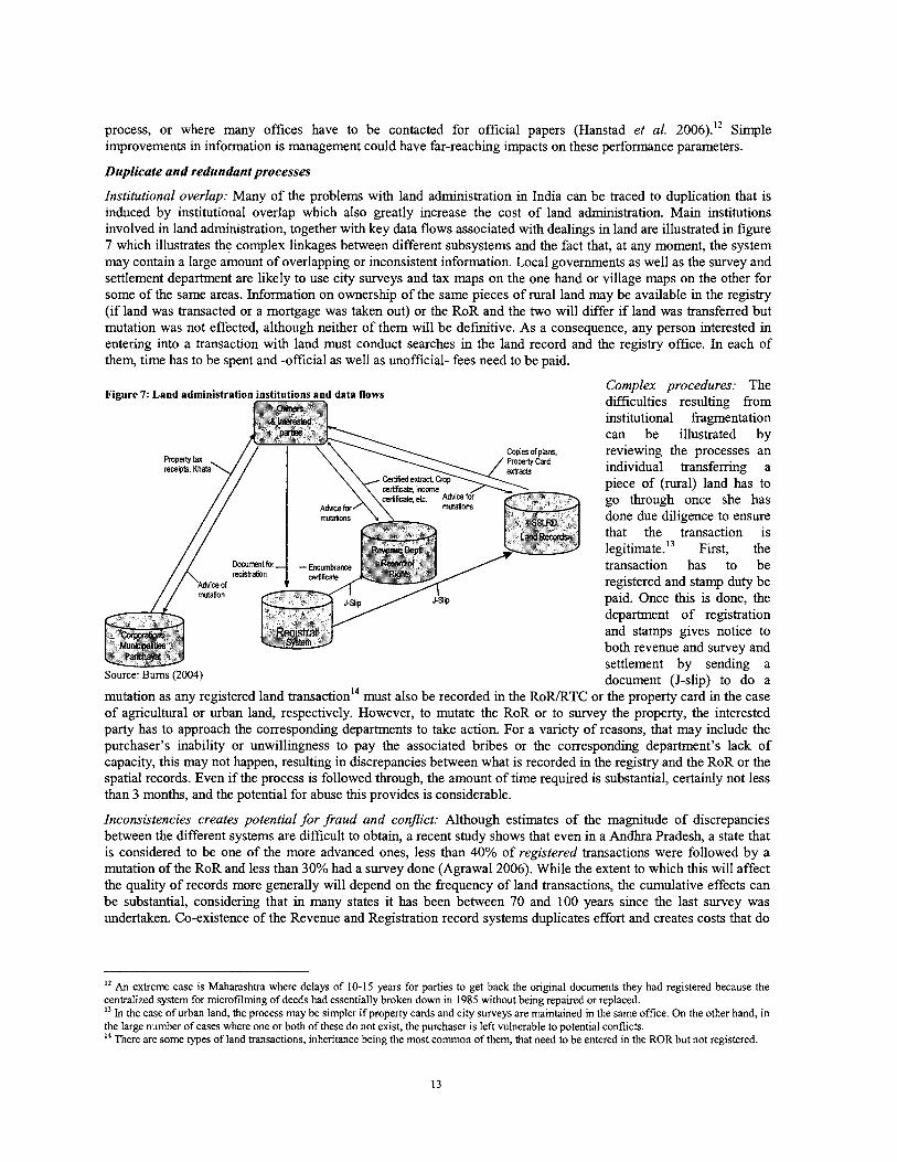
process, or where many offices have to be contacted for official papers (Hanstad et al. 2006).12 Simple improvements in information is management could have far-reaching impacts on these performance parameters.
Duplicate and redundant processes
Institutional overlap: Many of the problems with land administration in India can be traced to duplication that is induced by institutional overlap whlch also greatly increase the cost of land administration. Main institutions involved in land administration, together with key data flows associated with dealings in land are illustrated in figure 7 which illustrates the complex linkages between different subsystems and the fact that, at any moment, the system may contain a large amount of overlapping or inconsistent information. Local governments as well as the survey and settlement department are likely to use city surveys and tax maps on the one hand or village maps on the other for some of the same areas. Information on ownership of the same pieces of rural land may be available in the registry (if land was transacted or a mortgage was taken out) or the RoR and the two will differ if land was transferred but mutation was not effected, although neither of them will be definitive. As a consequence, any person interested in entering into a transaction with land must conduct searches in the land record and the registry office. In each of them, time has to be spent and -official as well as unofficial- fees need to be paid.
Complex procedures: The Figure 7: Land administration institutions and data flows difficulties resulting from
institutional fragmentation can be illustrated by reviewing the processes an individual transferring a piece of (rural) land has to go through once she has done due diligence to ensure that the transaction is legitimate.I3 First, the transaction has to be registered and stamp duty be paid. Once h s is done, the department of registration and stamps gives notice to both revenue and survey and settlement by sending a document (J-slip) to do a
mutation as any registered land transaction14 must also be recorded in the RoRRTC or the property card in the case of agricultural or urban land, respectively. However, to mutate the RoR or to survey the property, the interested party has to approach the corresponding departments to take action. For a variety of reasons, that may include the purchaser's inability or unwillingness to pay the associated bribes or the corresponding department's lack of capacity, this may not happen, resulting in discrepancies between what is recorded in the registry and the RoR or the spatial records. Even if the process is followed through, the amount of time required is substantial, certainly not less than 3 months, and the potential for abuse this provides is considerable.
Inconsistencies creates potential for fraud and conflict: Although estimates of the magnitude of discrepancies between the different systems are difficult to obtain, a recent study shows that even in a Andhra Pradesh, a state that is considered to be one of the more advanced ones, less than 40% of registered transactions were followed by a mutation of the RoR and less than 30% had a survey done (Agrawal2006). While the extent to which this will affect the quality of records more generally will depend on the frequency of land transactions, the cumulative effects can be substantial, considering that in many states it has been between 70 and 100 years since the last survey was undertaken. Co-existence of the Revenue and Registration record systems duplicates effort and creates costs that do
l2 An extreme case is Maharashtra where delays of 10-15 years for parties to get back the original documents they had registered because the centralized system for microfilming of deeds had essentially broken down in 1985 without being repaired or replaced. l 3 In the case of urban land, the process may be simpler if property cards and city surveys are maintained in the same office. On the other hand, in the large number of cases where one or both of these do not exist, the purchaser is left vulnerable to potential conflicts. l4 There are some types of land transactions, inheritance being the most common of them, that need to be entered in the ROR but not registered.
not correspond to any tangible benefit and can lead to mismatch of information regarding the same piece of land.I5 This generates ample potential for fraud and land-related conflict which are near impossible to resolve, in addition to overburdening the judicial system Responses from the World Bank's 'doing business' study reveal that, the reason for property conflicts is in inappropriate description of boundaries or faults inherent to the system of land a h s t r a t i o n . Depending on the state, these conflicts take between 3 and 12 years to resolve, a period during which nobody will undertake any investment on the land under concern.
Presumptive nature of registration and lack of cross-checks
Limited value added by registration: While the law states that registration of a legally valid deed will result in transfer of title to a given property, the registrar has no obligation -and often lacks the ability- to check the validity of any deed that is presented for registration. Even in cases when rudimentary checking could have discovered a defect in the transaction, the registration department cannot currently be held accountable for having registered a deed in which title was unclear or disputed. In fact, given that the rationale for registration was generation of revenue, the registrar will, at least in principle, register any document put to him as long as the formal procedures are met and appropriate stamp duty is paid. This means that the perceived benefits from having a transaction registered may be significantly below the cost of doing so, implying that land owners may opt out of the system.
No checking of spatial data: The registry's inability to access andlor easily refer to cadastral maps makes it very difficult for registry officials to perform even basic checks on the either the validity or the legality of instruments delivered to them, making it in near-impossible to enforce stricter standards of accountability. This is exacerbated by the fact that the description of land parcels in many deeds may leave a lot to be desired in terms of providing an accurate location of the property, particularly in urban areas, something that greatly increases the possibility of hture disputes. Thus the system expands large amounts of effort to ensure the correct identification of parties to a deed (an issue that is regulated in minute detail) but virtually no regulation exists to provide for the accurate geographical description of the land in question.
5. Policy implications
The complexity and overlaps in the land administration system put of additional strain on a system that already has difficulty to cope with demand and there is little disagreement about the need for improvement. In fact, states have launched a large number of promising initiatives aiming to address some of these problems. Since the late 1980s, the central government, under the leadership of MoRD, MIT, and NIC, has provided invaluable technical and financial support and guidance to make these innovations feasible and to transfer successful ones to other states. Reviewing this experience will thus be critical to chart out a possible way forward for land administration in India. Reviewing lessons from these efforts in the area of both textual and spatial records can provide some cues for ways of addressing the issues as well as more concrete policy recommendations.
l 5 A famous example relates to land that has been acquired by government under the Land Acquisition Act. In such a case, the registration department, being unaware of change in ownership status that have happened, will issue an encumbrance certificate that does not indicate the true ownership status of the land, a fact that was exploited on a large scale in fraudulent land sales during the time when the urban land ceiling act was imposed. This problem used to be very acute in urban areas where land that was subject to ongoing proceedings under urban ceiling legislation (and thus likely to become government property in the future) was offloaded to unsuspecting buyers who were not aware of the proceedings under the Ceiling Act (Saxena 2005).
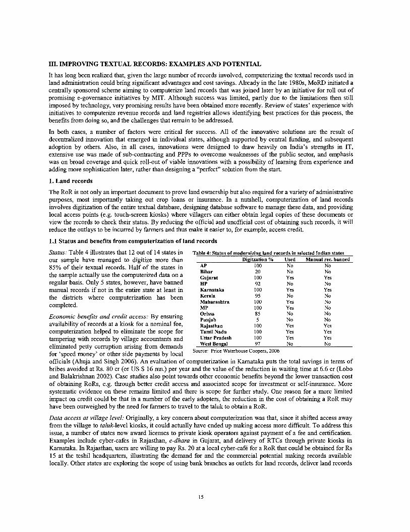
111. IMPROVING TEXTUAL RECORDS: EXAMPLES AND POTENTIAL
It has long been realized that, given the large number of records involved, computerizing the textual records used in land administration could bring significant advantages and cost savings. Already in the late 1980s, MoRD initiated a centrally sponsored scheme aiming to computerize land records that was joined later by an initiative for roll out of promising e-governance initiatives by MIT. Although success was limited, partly due to the limitations then still imposed by technology, very promising results have been obtained more recently. Review of states' experience with initiatives to computerize revenue records and land registries allows identifying best practices for this process, the benefits from doing so, and the challenges that remain to be addressed.
In both cases, a number of factors were critical for success. All of the innovative solutions are the result of decentralized innovation that emerged in individual states, although supported by central funding, and subsequent adoption by others. Also, in all cases, innovations were designed to draw heavily on India's strengths in IT, extensive use was made of sub-contracting and PPPs to overcome weaknesses of the public sector, and emphasis was on broad coverage and quick roll-out of viable innovations with a possibility of learning from experience and adding more sophistication later, rather than designing a "perfect" solution from the start.
1. Land records
The RoR is not only an important document to prove land ownership but also required for a variety of administrative purposes, most importantly taking out crop loans or insurance. In a nutshell, computerization of land records involves digitization of the entire textual database, designing database software to manage these data, and providing local access points (e.g. touch-screen kiosks) where villagers can either obtain legal copies of these documents or view the records to check their status. By reducing the official and unofficial cost of obtaining such records, it will reduce the outlays to be incurred by farmers and thus make it easier to, for example, access credit.
1.1 Status and benefits from computerization of land records
Status: Table 4 illustrates that 12 Out of 14 States in Table 4: Status of modernizing land records in selected Indian states our sample have managed to digitize more than Digitzation % Used Manual rec. banned 85% of their textual records. Half of the states in AP 100 NO NO
Bihar 20 No No the sample actually use the computerized data on a Gujarat 100 Yes Yes regular basis. Only 5 states, however, have banned ~p 92 NO NO
manual records ifnot in the entire state at least in Karnataka 100 Yes Yes the districts where computerization has been Kerala 95 NO NO
Maharashtra 100 Yes No completed. MP 100 Yes No
Economic benefill and credit access: By ensuring ;zb 85 No No 5 No No
availability of records at a kiosk for a nominal fee, Rajastha,, 100 Yes Yes computerization helped to eliminate the scope for Tamil Nadu 100 Yes Yes tampering with records by village accountants and Utfar Pradesh 100 Yes Yes eliminated petty corruption arising from demands Bengal 97 No No
for 'speed money' or other side payments by local Source: Price Waterhouse Coopers, 2006
officials (Ahuja and Singh 2006). An evaluation of computerization in Karnataka puts the total savings in terms of bribes avoided at Rs. 80 cr (or US $ 16 mn.) per year and the value of the reduction in waiting time at 6.6 cr (Lobo and Balakrishnan 2002). Case studies also point towards other economic benefits beyond the lower transaction cost of obtaining RoRs, e.g. through better credit access and associated scope for investment or self-insurance. More systematic evidence on these remains limited and there is scope for further study. One reason for a more limited impact on credit could be that in a number of the early adopters, the reduction in the cost of obtaining a RoR may have been outweighed by the need for farmers to travel to the taluk to obtain a RoR.
Data access at village level: Originally, a key concern about computerization was that, since it shifted access away from the village to taluk-level kiosks, it could actually have ended up making access more difficult. To address this issue, a number of states now award licenses to private kiosk operators against payment of a fee and certification. Examples include cyber-cafes in Rajasthan, e-dhara in Gujarat, and delivery of RTCs through private luosks in Karnataka. In Rajasthan, users are willing to pay Rs. 20 at a local cyber-cafe for a RoR that could be obtained for Rs 15 at the teshll headquarters, illustrating the demand for and the commercial potential making records available locally. Other states are exploring the scope of using bank branches as outlets for land records, deliver land records
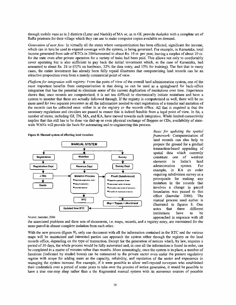
through mobile vans as in 2 districts (Latur and Nashik) of MA or, as in GJ, provide thalathis with a complete set of RoRs printouts for their village which they can use to make computer copies available on demand.
Generation of user fees: In virtually all the states where computerization has been effected, significant fee income, which can in turn be used to expand coverage with the system, is being generated. For example, in Karnataka, total income generated fiom sale of RTCs in 2004amounted to about Rs. 19 cr. per year, leaving a surplus of about 10 cr. for the state even after private operators for a variety of tasks had been paid. T h s allows not only to comfortably cover operating but is also sufficient to pay back the initial investment which, in the case of Karnataka, had amounted to about Rs. 24 cr (52% on hardware, 32% for data entry, and 15% for training). The fact that in many cases, the entire investment has already been fully repaid illustrates that computerizing land records can be an attractive proposition even from a merely commercial point of view.
Platform for integration with registry: From the point of view of the overall land administration system, one of the most important benefits from computerization is that doing so can be used as a springboard for back-office integration that has the potential to eliminate some of the current duplication of institutions over time. Experience shows that, once records are computerized, it is not too difficult to electronically initiate mutations and have a system to monitor that these are actually followed through. If the registry is computerized as well, there will be no more need for two separate processes as all the information needed to start registration of a transfer and mutation of the records can be collected once -either in at the registry or the records office. All that is required is that the necessary regulations and circulars are passed to ensure this is indeed feasible from a legal point of view. In fat, a number of states, including GJ, TN, MA, and KA, have moved towards such integration. While limited connectivity implies that this still has to be done via dial-up or even physical exchange of floppies or CDs, availability of state- wide WANs will provide the basis for automating and re-engineering this process.
With the new process (figure 9), only one document with all the information contained in the RTC and the various maps will be maintained and interested parties can approach the system either through the registry or the land records office, depending on the type of transaction. Except for the generation of notices which, by law, requires a period of 30 days, the whole process would be fully automated and, in case all the information is found in order, can be completed in a matter of minutes rather than months. More interestingly, once the system is in place, a number of functions (indicated by shaded boxes) can be outsourced to the private sector even under the present regulatory regime with scope for adding more as the capacity, reliability, and reputation of the sector and experience in managing the system increase. For example, if it were possible to allow well-reputed surveyors who established their credentials over a period of some years to take over the process of notice generation, it would be possible to have a true one-stop shop rather than a the fragmented manual system with its numerous sources of possible
Basis for updating the spatial Figure 8: Manual system of effecting land transfers framework: Computerization of
land records can also help to
[ MANUAL SYSTEM I prepare the ground for a gradual + transaction-based upgrading of + + spatial data whch currently Registration Mutation Survey constitute one of weakest
+ + + elements in India's land Registration Dept Revenue Dept Survey Dept administration system. For
+ example, in KA an order
/ Phodi (Subdivision)) ' requiring subdivision survey as a
+ Deeds
+ I
\ 1 effect (Jaamdar 2006). The RTC + manual process used earlier is
Map + Tippan + Akarbhand illustrated in figures 8. One [ U p ( . t n ( ] 4 I notes that three different
institutions have to be Source: Jaamdar, 2006 approached in sequence with all the associated problems and three sets of documents, i.e. maps, records, and a registry entry, are maintained for the same parcel in almost complete isolation from each other.
*Sewrate amlcatno a 1-9
* ~ n d ~ p o n d ~ t xttion a d d a p
m ~ p l ~ ~ due to Igk 01 suvepr.
*o~o~E(. B I I X O M I S ~ ~ ~ I r&Ore
.separate appl~catmn, +tion
.Way a mm@ion
. I - ~
prerequisite for malung any mutation in the records that involves a change in parcel boundaries was passed to this L J
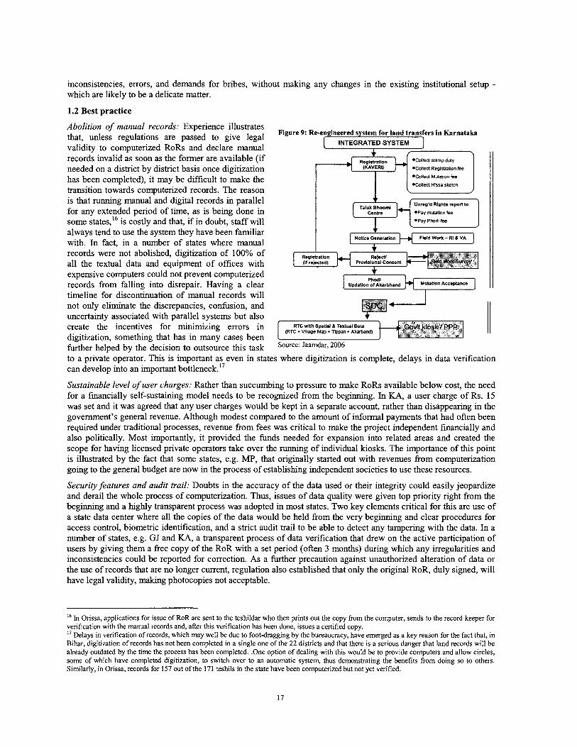
inconsistencies, errors, and demands for bribes, without making any changes in the existing institutional setup - which are likely to be a delicate matter.
1.2 Best practice
Abolition of manual records: Experience illustrates that, unless regulations are passed to give legal Figure 9: Re-engineered system for land transfers in Karnataka
INTEGRATED SYSTEM validity to computerized RoRs and declare manual records invalid as soon as the former are available (if
\ *Coiled stamp duty
needed on a district by district basis once digitization *Coiled Rw~straban fee
has been completed), it may be difficult to make the *Coiled Mutatlon fee
*CoIIea HlSSa sketch transition towards computerized records. The reason J
is that running manual and digital records in parallel for any extended period of time, as is being done in *Pay mutation fee
some states,16 is costly and that, if in doubt, staff will always tend to use the system they have been familiar
Field Work - RI 8 VA with. In fact, in a number of states where manual records were not abolished, digitization of 100% of Reoistratlon
all the textual data and equipment of offices with (r rejected) Provisional Consem
expensive computers could not prevent computerized records from falling into disrepair. Having a clear timeline for discontinuation of manual records will not only eliminate the discrepancies, confusion, and uncertainty associated with parallel systems but also
RTC wlth Spatlal 8 Textual Data create the incentives for minimizing errors in (RTC +Village Map + T,ppan +
digitization, something that has in many cases been further helped by the decision to outsource this task Jaamdar,2006
to a private operator. This is important as even in states where digitization is complete, delays in data verification can develop into an important bottleneck. l7
Sustainable level of user charges: Rather than succumbing to pressure to make RoRs available below cost, the need for a financially self-sustaining model needs to be recognized from the beginning. In KA, a user charge of Rs. 15 was set and it was agreed that any user charges would be kept in a separate account, rather than disappearing in the government's general revenue. Although modest compared to the amount of informal payments that had often been required under traditional processes, revenue from fees was critical to make the project independent financially and also politically. Most importantly, it provided the funds needed for expansion into related areas and created the scope for having licensed private operators take over the running of individual kiosks. The importance of thls point is illustrated by the fact that some states, e.g. MP, that originally started out with revenues from computerization going to the general budget are now in the process of establishng independent societies to use these resources.
Security features and audit trail: Doubts in the accuracy of the data used or their integrity could easily jeopardize and derail the whole process of computerization. Thus, issues of data quality were given top priority right from the beginning and a highly transparent process was adopted in most states. Two key elements critical for this are use of a state data center where all the copies of the data would be held from the very beginning and clear procedures for access control, biometric identification, and a strict audit trail to be able to detect any tampering with the data. In a number of states, e.g. GJ and KA, a transparent process of data verification that drew on the active participation of users by giving them a free copy of the RoR with a set period (often 3 months) during which any irregularities and inconsistencies could be reported for correction. As a further precaution against unauthorized alteration of data or the use of records that are no longer current, regulation also established that only the original RoR, duly signed, will have legal validity, malung photocopies not acceptable.
l6 In Orissa, applications for issue of RoR are sent to the teshildar who then prints out the copy from the computer, sends to the record keeper for verification with the manual records and, after this verification has been done, issues a certified copy. I' Delays in verification of records, which may well be due to foot-dragging by the bureaucracy, have emerged as a key reason for the fact that, in Bihar, digitization of records has not been completed in a single one of the 22 districts and that there is a serious danger that land records will be already outdated by the time the process has been completed. .One option of dealing with this would be to provide computers and allow circles, some of which have completed digitization, to switch over to an automatic system, thus demonstrating the benefits from doing so to others. Similarly, in Orissa, records for 157 out of the 171 teshils in the state have been computerized but not yet verified.
Putting data on the internet: An increasing number of states (MP, OR, RJ) now make land records data, in most cases those from a year before rather than the current ones, publicly available on the internet for viewing while others (GJ and KA) who use intranet facilities could easily follow. Doing so further increases transparency and users' confidence in the system and can help remove some of the secrecy that currently surrounds land records. In cases where problems are known to exist this could be combined with a structured process to report and resolve any inconsistencies, possibly through public viewing and verification of records in the field. Enhancing the search facilities available on the web would allow government and non-governmental organizations to use the database for more systematic searches that can be beneficial for planning and many other purposes. Moreover, if electronic signatures are legally recognized, this provides the basis for licensing of private kiosks to deliver RoRs, something the importance of which will certainly increase with the advent of greater connectivity in rural areas.
1.3 Remaining challenges
Even though different states have made considerable progress in computerizing land records, the fact that others are still lagging behnd points towards potential to apply some of the lessons learned.
Prioritization of contents and integration with other systems: RoRs in different states contain large amounts of information (cropping patterns, source of irrigation, soil quality etc) that was hstorically important for revenue purposes but has limited relevance for land ownership. Given the large amount of land records involved, any additional data field to be digitized will have major implications in terms of the costs and logistics of the process. It is therefore important to be selective and ensure that whatever information is entered into the computer is actually relevant for property rights in land.'' While digitization of redundant fields may not have been a problem for the more advanced states, the less favorable policy and institutional environment in cases where the process remains to e completed, and the fact that a focus on computerizing the "wrong" records can be used as a strategic move to delay or derail the process, suggest that attention to and guidance for this issue will be important. Even if the cost of digitizing these data may seem marginal, it will slow down the process and tie up resources that could be more profitably used elsewhere. Identifying a set of fields that are common with the registry and with other states so as to ensure interoperability and portability of software would be of great importance.
Extension to urban areas: Given the low transaction volume in rural areas, computerization of rural records is arguably economically less rewarding than computerization of property cards in urban areas where land values and demand for documents certifying property ownership are much higher. Indeed, a number of states have made considerable advances in this respect. For example, Maharashtra, where city surveys are well maintained, has issued about 5.6 million property cards and all 138 City Survey offices put in place a fully computerized system to handle these documents. Advances in this area are also made in Gujarat where property cards for 7 municipal areas have already been completed and those for other areas are in progress. Guidance regarding issuance and verification of property cards would be particularly important for areas, including small rural settlements, where these do not already exist.
Institutional integration: Although computerization of records and registration has shown some impressive results, the current land record system is only the computerization of a very old system without any serious re-engineering of the underlying processes or an examination of the extent to which these may still be appropriate. Ways to achieve functional integration not only with registration but also with surveys that go beyond a mere computerization of old manual systems and thus will be cheaper and more sustainable in the long term. Supporting well-defined pilots to provide guidance on some of these will be important to reap full benefits from computerization and should be a priority for GoI.
1.4 Policy implications
Our review clearly points towards a number of best practices that are critical for computerization to be successful. Tlus suggests that the effectiveness of Go1 schemes for CLRICMLR could be enhanced by incorporating the best practices identified above more systematically in program design and evaluation of proposals to be funded under this scheme. Specifically computerization initiatives should be supported only if the information to be digitized is
" For example, in Kerala, computerization of almost 95% of an estimated 10.6 mn records at considerable cost had less than the expected impact because the document computerized was the basic tax receipt (BTR) which attests to the payment of land revenue only instead of the thadapar pagarp, i.e. the local equivalent of the ROR." In Bihar, the decision to computerize not only register 2, which is used by revenue karamcharis in their day-to day work, but also an old survey record (chalu khatiyan) that has not been updated since the early 20" century and is thus largely irrelevant led to major delays in data entry. These were compounded by the fact that one of the documents was available at the taluk and the other one at the district level.
clearly relevant for land owners, if a time bound plan for data verification and abolishing manual records exists, if key elements of the process are outsourced to the private sector, if there are plans to address concerns of data integrity in a satisfactory way, and if they are based on a business model that has the potential to fully cover operational cost.
Complying with such requirements would not be difficult; to the contrary the ability to draw on the experience of states that have already completed the process is likely to allow 'latecomer' states to realize significant costs savings and efforts to make this experience more easily available may merit support. Widely disseminating criteria for proposals to be eligible for Go1 support upfront will not only generate a broader debate that could be very useful to educate policy makers but also provide a basis for accountability of government officials ex post by putting down expectations against which their performance can eventually be compared. Given the demonstrated revenue earning potential of projects in this area, it would be prudent to carefully examine the need for central funds and possibly make a more specific distinction between "roll-out" activities which will eventually generate revenue of their own and "pilot" activities that generate significant amounts of new knowledge and thus may warrant 100% Go1 financing. Both the ways in which these funds are rewarded (e.g. through competitive grants mechanisms in the case of pilots) and the specific outputs to be expected could, in turn, be specified in more detail to increase the scope for having maximum impact.
2. Modernizing property registration: Advances made and challenges ahead
While starting from the other end of the spectrum, considerable progress in computerizing land registration has been made in states such as Andhra Pradesh (CARD), Maharashtra (SARITA), Tamil Nadu (C-STAR), Rajasthan (RajCREST), and Karnataka (KAVERI). Table 5 illustrates that, in addition to this group where a computerized registration system is fully operational in all or the large majority of SROs, there is a second group of states, including Bihar, Himachal Pradesh, Kerala, Madhya Pradesh, Orissa, Punjab, Uttar Pradesh and West Bengal, where efforts have not gone much beyond data entry or piloting on a limited scale. Reviewing the accomplishments and some of the obstacles encountered in this context allows drawing out lessons and challenges for the sector.
2.1 Benefits from modernizing property registration
Improved delivery of registration services: In the states that completed the process, service level agreements and penalties in case of non-performance ensure that standards that are vastly improved from what was the case before are regularly met and the arbitrariness of valuation has been greatly reduced. The experience shows that computerization can help to improve accountability by reducing the scope for demands for 'speed money' as well as discretional valuation of properties. Also, under the new system, search for encumbrance certificates takes minutes rather than days and can in many cases be done through the internet, rather than through physical presence in the SRO. Although quantitative evidence thus far is limited, this makes it easier for banks to check a potential client's credit worthiness and should thus be associated with lugher levels of credit access, something that is consistent with a large recent increase in mortgage lending that has been observed in India.
Increased number of transactions and tax revenue: In Maharashtra, computerization has been associated with a 50% increase in the number of registered transfers, fiom about 1 mn. in 1998199 to more than 1.5 rnn in 2004105. Stamp duty collected during the same period has more than doubled, fiom Rs. 1624 cr. to Rs. 4137 cr., despite a significant reduction in the rate of stamp duty (from 13% to 8%) that was undertaken gradually before 2004. We also note that so far reductions in stamp duty have been implemented only in states (i.e. MA, KA, and AP) where the registry is fully computerized. While this correlation is not enough to establish causality, it suggests that an automated registry can make it easier to implement such changes. In all cases, reduced rates were associated with increased total stamp revenue, suggesting that informality is not insurmountable and that even citizens are likely to be willing to pay 'reasonable' amounts of taxes in a hassle fiee and predictable environment.
Transparency through automatic valuation: A key problem that in the past plagued land registration was the lugh level of discretion by individual officials in valuing property which was often seen as an invitation for corruption. To reduce arbitrariness in the process, an automatic mass valuation module is embedded in most states' software. The associated reduction in bureaucrats' discretionary power is one of the most visible benefits from computerization of the registry. The experience of different states also illustrates that, with increased connectivity, virtually all of the advanced states are moving towards putting market valuation guidelines on the web to enhance transparency.
Encumbrance certzficates: Operation of a filly automated registry in an environment where registration is compulsory will, over time, lead to accumulation of evidence that would allow ready issuance of encumbrance
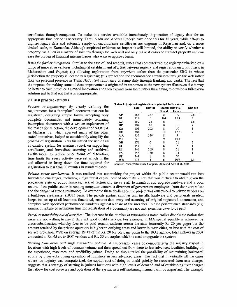
certificates through computers. To make this service available immediately, digitization of legacy data for an appropriate time period is necessary. Tamil Nadu and Andhra Pradesh have done this for 18 years, while efforts to digitize legacy data and automate supply of encumbrance certificates are ongoing in Rajasthan and, on a more limited scale, in Karnataka. Although empirical evidence on impact is still limited, the ability to verify whether a property has a lien in a matter of minutes through the web will not only make it easier to transact property and can ease the burden of financial intermediaries who want to approve loans.
Basis for further integration: Similar to the case of land records, states that computerized the registry embarked on a range of innovative ventures including (i) establishment of a llnk between registry and registration on a pilot basis in Maharashtra and Gujarat; (ii) allowing registration from anywhere rather than the particular SRO in whose jurisdiction the property is located in Rajasthan; (iii) application for encumbrance certificates through the web rather than via personal presence in Tamil Nadu; (iv) remittance of stamp duty through franking and banks. The fact that the impetus for making some of these improvements originated in responses to the new system illustrates that it may be better to first introduce a limited innovation and then expand from there rather than trying to develop a full-blown solution just to find out that it is inappropriate.
2.2 Best practice elements Table 5: Status of registration in selected Indian states
Process re-engineering: By clearly defining the Total Digital Stamp duty (%) Reg. fee requirements for a "complete" document that can be Rural Urban registered, designing simple forms, accepting only AP 387 3 87 5 10 0.5
complete documents, and immediately returning B1 111 o 8.4 15.4 2 GJ 150 25 6 1.5 incomplete documents with a written explanation of HP 109 10 8 8 2
the reason for reiection, the development of SARITA KA 202 202 8 10 1
in ~aharashtra ,~ which sparked A n y of the other states' initiatives, helped to considerably simplify the process of registration. This facilitated the use of an automated system for scrutiny, check on supporting certificates, and immediate scanning and archival. Furthermore, to reduce other forms of discretion, time limits for every activity were set which in the end allowed to bring down the time required for registration to less than 30 minutes in standard cases.
KE 308 0 10 12.5 2 MA 359 359 8 8 MP 226 0 9 10.4 OR 176 0 8 11 2 PJ 153 0 6 6 1 RJ 346 269 8 11 1 TN 558 350 8 13 1 UP 344 1 8 10 WB 238 4 6 1018 1.1
Source: Price Waterhouse Coopers, 2006 and Alm et al. 2004
Private sector involvement: It was realized that undertaking the project within the public sector would mn into formidable challenges, including a high initial capital cost of about Rs. 20 cr. that was difficult to obtain given the precarious state of public finances; lack of technically savvy staff to maintain and upgrade hardware and a poor record of the public sector in running computer centers; a diversion of government employees from their core roles; and the danger of strong resistance;. To overcome these challenges, the project was outsourced to private vendors on a build-operate-transfer (BOT) basis. The private partner supplies and installs hardware and peripherals needed, keeps the set up at all locations functional, ensures data entry and scanning of original registered documents, and complies with specified performance standards against a share of the user fees. In case performance standards (e.g. minimum uptime or maximum time for registration of a document) are not met, penalties have to be paid.
Fiscal sustainability out of user fees: The increase in the number of transactions noted earlier dispels the notion that users are not willing to pay if they get good quality service. For example, in MA spatial equality is achieved by cross-subsidization whereby fees to be paid remain uniform across the state (currently Rs 20 per page) but the amount retained by the private operators is lugher in outlying areas and lower in main cities, in line with the cost of service provision. With on average Rs. 12 of the Rs. 20 fee per page going to the BOT agency, total inflows in 2004 amounted to Rs. 45 cr. to BOT vendors and Rs. 35 cr. surplus which is used to upgrade the system.
Starting @om areas with high transaction volume: All successful cases of computerizing the registry started in locations with high levels of business volume and then spread out from there to less advanced localities, building on the experience, resources, and credibility gained. Doing so also entailed the possibility of maintaining horizontal equity by cross-subsidizing operation of registries in less advanced areas. The fact that in virtually all the cases where the registry was computerized, the capital cost of doing so could quickly be recovered from user charges suggests that a strategy of starting in (urban) locations with high levels of demand and of establishing user charges that allow for cost recovery and operation of the system in a self-sustaining manner, will be important. The example
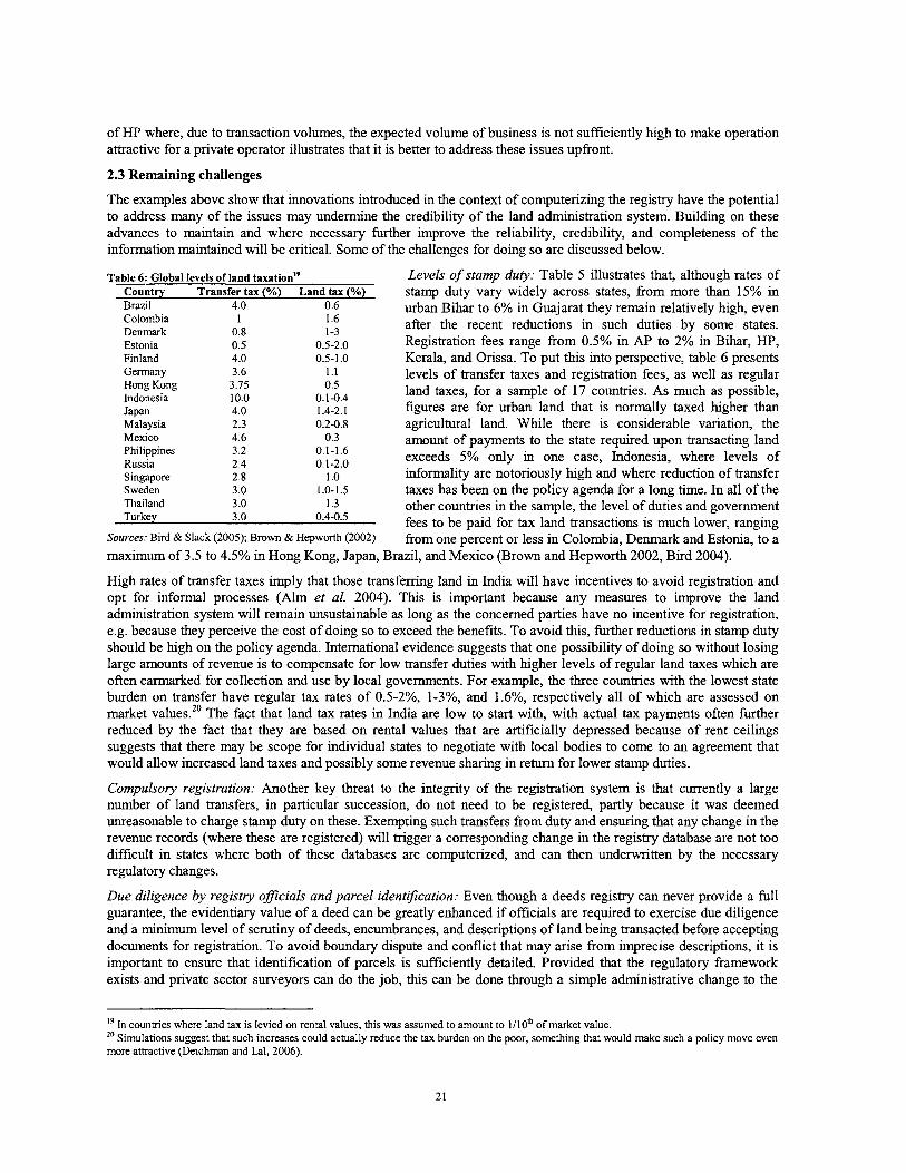
of HP where, due to transaction volumes, the expected volume of business is not sufficiently high to make operation attractive for a private operator illustrates that it is better to address these issues upfront.
2.3 Remaining challenges
The examples above show that innovations introduced in the context of computerizing the registry have the potential to address many of the issues may undermine the credibility of the land administration system. Building on these advances to maintain and where necessary fiuther improve the reliability, credibility, and completeness of the information maintained will be critical. Some of the challenges for doing so are discussed below.
Table 6: Global levels of land taxationI9 Country Transfer tax (%) Land tax (%) Brazil 4.0 0.6 Colombia 1 1.6 Denmark 0.8 1-3 Estonia 0.5 0.5-2.0 Finland 4.0 0.5-1 .O Germany 3.6 1.1 Hong Kong 3.75 0.5 Indonesia 10.0 0.1-0.4 Japan 4.0 1.4-2.1 Malaysia 2.3 0.2-0.8
Levels of stamp duty: Table 5 illustrates that, although rates of stamp duty vary widely across states, from more than 15% in urban Bihar to 6% in Guajarat they remain relatively high, even after the recent reductions in such duties by some states. Registration fees range from 0.5% in AP to 2% in Bihar, HP, Kerala, and Orissa. To put this into perspective, table 6 presents levels of transfer taxes and registration fees, as well as regular land taxes, for a sample of 17 countries. As much as possible, figures are for urban land that is normally taxed hlgher than agricultural land. While there is considerable variation, the
Mexico 4.6 0.3 amount of payments to the state required upon transacting land Philippines 3.2 0.1-1.6 Russia 2.4 0.1-2.0 exceeds 5% only in one case, Indonesia, where levels of Singapore 2.8 1 .o informality are notoriously high and where reduction of transfer Sweden 3.0 I .o-1.5 taxes has been on the policy agenda for a long time. In all of the Thailand 3.0 1.3 other countries in the sample, the level of duties and government Turkey 3.0 0.4-0.5 fees to be paid for tax land transactions is much lower, ranging
Sources: Bird & Slack (2005); Brown & Hepworth (2002) from one percent or less in Colombia, Denmark and Estonia, to a maximum of 3.5 to 4.5% in Hong Kong, Japan, Brazil, and Mexico (Brown and Hepworth 2002, Bird 2004).
High rates of transfer taxes imply that those transferring land in India will have incentives to avoid registration and opt for informal processes (Alm et al. 2004). This is important because any measures to improve the land a d s t r a t i o n system will remain unsustainable as long as the concerned parties have no incentive for registration, e.g, because they perceive the cost of doing so to exceed the benefits. To avoid thls, further reductions in stamp duty should be high on the policy agenda. International evidence suggests that one possibility of doing so without losing large amounts of revenue is to compensate for low transfer duties with higher levels of regular land taxes which are often earmarked for collection and use by local governments. For example, the three countries with the lowest state burden on transfer have regular tax rates of 0.5-2%, 1-3%, and 1.6%, respectively all of which are assessed on market values.20 The fact that land tax rates in India are low to start with, with actual tax payments often further reduced by the fact that they are based on rental values that are artificially depressed because of rent ceilings suggests that there may be scope for individual states to negotiate with local bodies to come to an agreement that would allow increased land taxes and possibly some revenue sharing in return for lower stamp duties.
Compulsory registration: Another key threat to the integrity of the registration system is that currently a large number of land transfers, in particular succession, do not need to be registered, partly because it was deemed unreasonable to charge stamp duty on these. Exempting such transfers from duty and ensuring that any change in the revenue records (where these are registered) will trigger a corresponding change in the registry database are not too difficult in states where both of these databases are computerized, and can then underwritten by the necessary regulatory changes.
Due diligence by registry officials and parcel identification: Even though a deeds registry can never provide a full guarantee, the evidentiary value of a deed can be greatly enhanced if officials are required to exercise due diligence and a minimum level of scrutiny of deeds, encumbrances, and descriptions of land being transacted before accepting documents for registration. To avoid boundary dispute and conflict that may arise from imprecise descriptions, it is important to ensure that identification of parcels is sufficiently detailed. Provided that the regulatory framework exists and private sector surveyors can do the job, this can be done through a simple administrative change to the
l9 In countries where land tax is levied on rental values, this was assumed to amount to 1/10' of market value. Simulations suggest that such increases could actually reduce the tax burden on the poor, something that would make such a policy move even
more attractive (Deichman and Lal, 2006).
deeds system; in fact survey plans that meet certain standards are routinely required in many deeds systems around the world.
Political support: Experience illustrates that in states where computerization has made less progress than desired, the root cause can most often be found in political resistance from within the land administration system rather than technical issues that could not be resolved.*' Such resistance by vested interests should not come as too much of a surprise; in fact resistance from survey or lawyers' lobbies has accompanied most changes in the area of land a b s t r a t i o n , from the introduction of para-legal landbrokers through Sir Robert Torrens in South Australia in the 19" century to the establishment of a new title register that did not require intervention by notaries it Peru in the 1990s. In addition to adhering to the above principles, political support from the highest level, including pronouncements by central government, will therefore be important to overcome such resistance.
2.4 Policy implications
The fact that, despite the considerable commercial potential, the process of automating registration is unlikely to be completed on its own implies that, similar the situation for revenue records, it will be of importance to provide states with incentives that allow to overcome resistance and draw equal with the more progressive states in terms of computerizing registration. To the extent that the ease of transacting land provided by a well-functioning registry will be an important consideration in investment decisions by f m or individuals who are not limited to a given state, failure to do so can over time translate into widening disparities between more advanced and backward states.
For example, in Kerala, resistance by deeds writers and other staff concerned about losing discretionary power forced the registration deparhnent to disable most of the functionality of the software used, implying that deeds and valuation are still being done manually and the system is used only to generate indices of deeds. Experience form land administration projects in other countries where similar issues were encountered suggests that steps to min such people in IT skills to avoid their displacement have the benefit of helping to maintain the institutional memory. Of course, an equally clear line on corruption will be necessary.
IV. IMPROVING THE STATUS OF SPATIAL RECORDS
One of the unusual features of India's land administration system is that large part of the information used on a daily basis is actually based on textual rather than spatial data. While this allowed India to make progress in a much more rapid way than if it had tried to first sort out its graphical database, running a land administration system without maps is clearly not sustainable in the long term. Finding cost-effective ways of updating the spatial records, many of which are in much worse condition than textual ones, is thus of high importance. Specifically, it will help to (i) reduce boundary disputes whlch are already appearing in increased number in peri-urban areas; (ii) eliminate overlaps between parcels and thus allow users to have more confidence in the information provided by the system; and (iii) identify and subsequently devise strategies for eliminating gaps in coverage of textual andlor spatial records and in doing so also provide a basis for more sustainable management of public lands.
In tlus chapter we argue that applying the principles that helped to underwrite the successful computerization of textual records can also provide a basis for improvement of spatial records. To do so, we show that failure to adhere to these principles is a key reason for the lack of success of the large majority of pilots which India has conducted in the area of surveying. We then highlight that a combination of satellite imagery with existing spatial data (village maps) can be used to provide an index map that will allow states to obtain near-complete spatial coverage at a very reasonable cost. Doing so would allow policy-makers to (i) quickly obtain an overview of the types of problems encountered in different areas of the country that could serve as a basis for assessing the needs in tenns of improving spatial data; (ii) devise new ways, based on a wide range of modem technology, to address these problems in a way that uses existing data and India's IT capacity in innovative ways; (iii) get at least a rough idea of the types and possible magnitude of benefits to be had from improving land records that can help to realistically estimate the potential for cost recovery and thus potential private sector involvement; (iv) use all of this information to make decisions on the allocation of public funds for improvement of spatial infrastructure that would not only fit into a broader strategic framework but also allow development of private sector capacity to complement the expertise already available within government.
1. The spatial framework for land administration: Rationale and status in India
There is little doubt that a well-defined spatial framework is needed to eliminate ambiguity in the system, thereby avoiding boundary disputes and increasing tenure security, in addition to providing other benefits including the ability to search by geographical location, planning for infrastructure, and provision of other services. Moreover, a defining characteristic of well-functioning land registration systems, whether based on title or improved deeds, is that they allow unambiguous identification of land parcels.
Having a spatial reference to allow pin down the parcels over whch rights are recorded in the textual register, thus ensuring completeness, i.e. that all land parcels are indeed identified, and that there are no gaps or overlaps of the parcels for which rights are registered. T h s also provides a framework to record changes in parcels, e.g. through sub-division or consolidation, either in graphical form or directly in the digital data. This can be useful to validate textual data, identifying, for example, parcels where numerical data is not available. Spatial data can also be used to support common registration queries, such as quickly identifying parties with interests in adjoining parcels for service of notice as well as other broader spatial queries such as the identification of land parcels impacted by possible future development activity. The cadastral spatial data can also be integrated with other spatial data such as topographic data, satellite imagery, etc, to support broader objectives such as the formulation of land policy and better land management. The spatial framework can support user-friendly graphical means of accessing the data by plot. Many people will not know their survey numbers, but most will be able to identify their holdings on a map. The use of spatial map data also readily supports a graphical interface to land records on computers or the internet.
However, even though it is essential for land administration to fulfill its basic mandate, the spatial framework for land administration in India is much inferior to what is the case for textual records. Originally, updating of spatial records was expected to be carried out through periodic resurveys using traditional technology. While it is difficult to get an accurate picture, available evidence illustrates that in many states spatial information is seriously out of date: In AP, HP, KA, Punjab, and Tamil Nadu, the last resurvey has been conducted around 1900,~~ that there are many more districts in other states where the last resurvey dates back to the period before independence, and that even where resurveys were declared 'completed', considerable gaps may persist. It is thus not surprising to find that
22 In Tamil Nadu, an attempt to update spatial information was undertaken in 1987 but this is judged not to have been too successful
the coverage and often also quality and reliability of spatial data is weak and that simple digitization of existing data will not be sufficient to establish a workable solution.
At the same time, attempts at implementing traditional resurveys of the type conducted by the British in virtually all states suggest that resumption of the 30-year cycle of revisional surveys established then is not a viable option for improving the spatial framework. The time and financial requirements of such ventures proved to be too large. Even most optimistic estimates put the cost for a state such as Kamataka at about 1,000 cr and a time requirement of about 20 years. Moreover, even if it were technically feasible, a full resurvey is likely to carry high political costs. The reputation for corruption which land admistration has acquired and the tendency of such an exercise to generate conflict among households who had peacefully coexisted earlier have greatly reduced the political attractiveness and thus feasibility of a full resurvey.23 This means that new models to conduct survey will be needed. In choosing such models, the complexity of surveying and the fact that costs tend to increase exponentially with precision requirements -which will imply that modalities will have to vary with land values- needs to be taken into account.
In view of the well-documented difficulties of traditional methods to improve the spatial framework, high hopes are generally pinned on expensive "modem" equipment to solve the predicament of spatial land administration data in India. In fact, to respond to this challenge, MoRD has launched an ambitious series of 'pilots' in all states to modernize the spatial data. These pilots are focused almost exclusively on high-tech electronic total stations (ETS). Experience with such technology in India and elsewhere suggests that the scope for these pilots should be broadened for two reasons. First, while ETS has its place within a broader array of survey technologies, reliance on ETS only will not allow the scale needed to address India's problems,24 apart from the fact that the capacity required to use it effectively is beyond what is available in India's public sector for the foreseeable future implying that precision in actual use is well below potential and sustainability of the data will not be assured. 25 It will therefore be critical to carefully identify the strengths and weaknesses of specific technologies in specific contexts and to apply a judicious mix that is most suitable for specific situations.
A second and more fundamental concern is that technology is embedded in a broader institutional environment and that, before narrowing the discussion down to technology and accuracy of surveys, it will be necessary to clarify (i) the role and responsibility of the state vs. that of individuals to maintain the spatial framework; (ii) the scope for private sector involvement; and (iii) the way in which public funds should be allocated. To do so, we first identify some of the reasons why past efforts had limited success and then aim to draw some lessons from thls experience.
2. Why pilots with 'modern technology' had limited success
Limited attention to existing information: Contrary to many developing countries where cadastral databases do not exist and have to be created from scratch, one of the great advantages of India is that the spatial record created by the British, in the form of village maps and FMBs, is surprisingly accurate and the main problems of the spatial database are due to lack of updating or wholesale change of land use. This implies that in (rural) areas where land use has not changed dramatically and old spatial records are still available, efforts to utilize h s information may be warranted, especially in view of the fact that MoRD is also involved in efforts to preserve these records. It appears, however, the large majority of pilots conducted under past MoRD financed schemes was either directed towards areas where these records were no longer available or did not make extensive use of them. Obviously, a full resurvey will be the most attractive option from a merely technical point of view. However, experience from a number of recent pilots where the changes in different households' land areas that resulted from the resurvey created significant upheaval and conflict among neighbors suggest that doing so might not be desirable from a social point of view even if the funds for doing so were available. With limited funds, the case to focus only on incidents where changes have been recorded or to employ methodologies that build on or combine different types of existing data in a more
23 "The policy makers are acutely aware of the unsatisfactory nature of the output of survey operations and the exploitative nature that the whole process had acquired over the years. For instance, Govt. of Rajasthan decided to do away with the Department of Settlement altogether and transformed it into a much thinner Department of Land Records with no systems for wholesale periodic revision of records in place. In Madhya Pradesh, settlement was ordered in 26 districts in 1990, but had to be suspended in 2000 due to persistent complaints by locals. ... Many Survey Directorates (as in West Bengal and Tamil Nadu) are either under-worked or have been given other miscellaneous responsibilities. Politically it is safer to let the existing record of rights with all their deficiencies continue, rather than expect that government servants would bring any large- scale improvements through survey based on the ground situation. State has abdicated its responsibility and correction of records has been left to the individual initiative." (Saxena, 2005) 24 Estimates suggest that, even if the speed of surveying were to be tripled from what had been obtained in the final phase of a 33-village pilot in KA that is generally considered to have been quite successful, it would take more than two centuries to cover the whole state (Bums 2004). 25 A few random checks of measurements taken in one of the pilots by an independent consultant revealed that the accuracy attained was in the order of magnitude of meters rather than centimeters, a level that could have been attained with much cheaper technology.
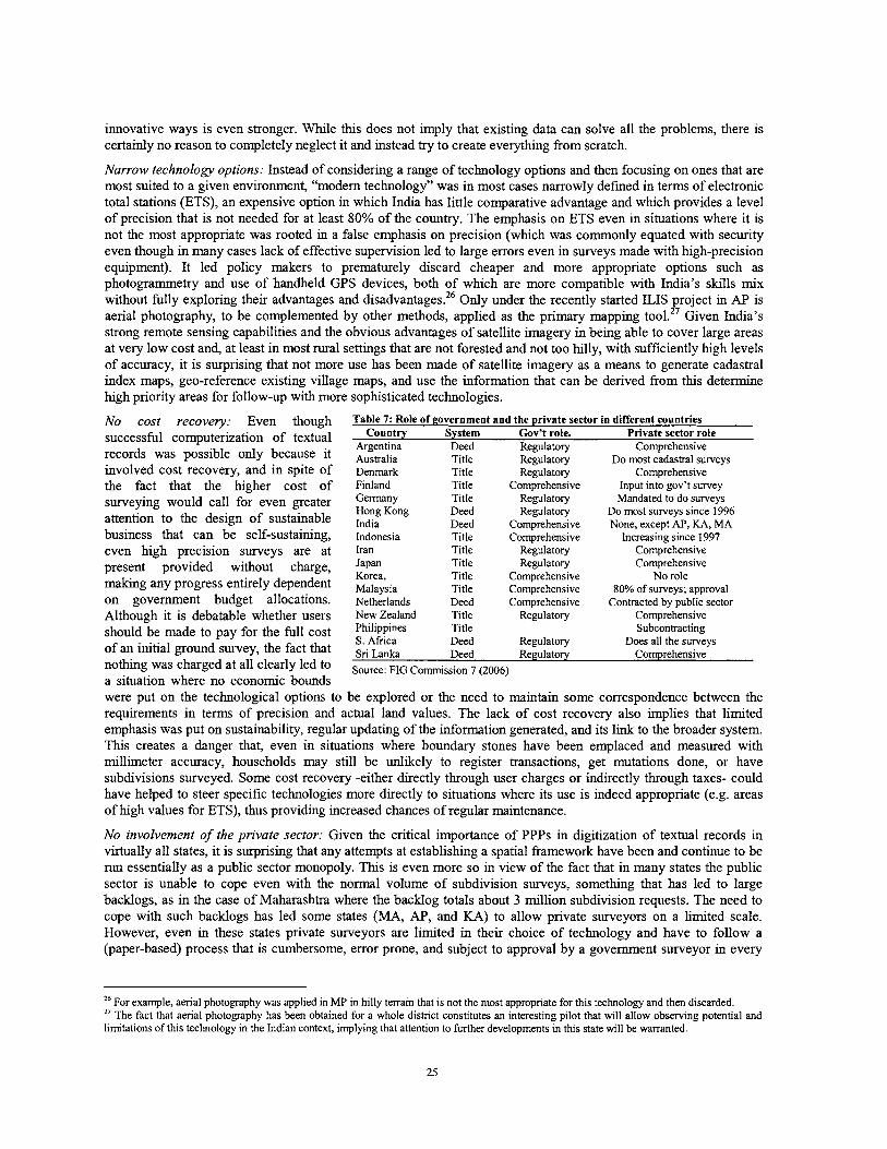
innovative ways is even stronger. While this does not imply that existing data can solve all the problems, there is certainly no reason to completely neglect it and instead try to create everything from scratch.
Narrow technology options: Instead of considering a range of technology options and then focusing on ones that are most suited to a given environment, "modem technology" was in most cases narrowly defined in terms of electronic total stations (ETS), an expensive option in which India has little comparative advantage and which provides a level of precision that is not needed for at least 80% of the country. The emphasis on ETS even in situations where it is not the most appropriate was rooted in a false emphasis on precision (which was commonly equated with security even though in many cases lack of effective supervision led to large errors even in surveys made with high-precision equipment). It led policy makers to prematurely discard cheaper and more appropriate options such as photogrammetry and use of handheld GPS devices, both of which are more compatible with India's skills mix without fully exploring their advantages and disadvantages.26 Only under the recently started ILIS project in AP is aerial photography, to be complemented by other methods, applied as the primary mapping tool.27 Given India's strong remote sensing capabilities and the obvious advantages of satellite imagery in being able to cover large areas at very low cost and, at least in most rural settings that are not forested and not too hilly, with sufficiently high levels of accuracy, it is surprising that not more use has been made of satellite imagery as a means to generate cadastral index maps, geo-reference existing village maps, and use the information that can be derived from this determine high priority areas for follow-up with more sophsticated technologies.
No cost recovery: Even though Table 7: Role of government and the private sector in different countries successful computerization of textual COUnt'y System Gov't role. Private sector role
Argentina Deed Regulatory Comprehensive records was possible only because it Australia Title Regulatory Do most cadastral surveys involved cost recovery, and in spite of Denmark Title Regulatory Comprehensive the fact that the higher cost of Finland Title Comprehensive Input into gov't survey - surveying would call for even greater Gmany Title Regulatory Mandated to do surveys
Hong Kong Deed Regulatory Do most surveys since 1996 attention to the design of sustainable India Deed Comprehensive None, except AP, KA, MA business that can be self-sustaining, Indonesia Title Comrehensive Increasing since 1997
even high ~recision survevs are at Iran Title ~e'gulatory comprehensive " L
present provided without charge, Japan Title ~ e g u l a t o j comprehensive Korea, Title Comprehensive No role
making any progress entirely dependent Malaysia Title Comprehensive 80% of surveys; approval on government budget a l l ~ ~ a t i ~ n ~ . Netherlands Deed Comprehensive Contracted by public sector Although it is debatable whether users New Zealand Title Regulatory Comprehensive
shouldbe made to pay for the full cost ~ ~ ~ ~ ~ ~ e S Title Subcontracting Deed Regulatory Does all the surveys of an initial ground survey, the fact that Sri Deed Regulatory Comprehensive
nothmg was charged at all clearly led to Source: FIG (2006, a situation where no economic bounds were put on the technological options to be explored or the need to maintain some correspondence between the requirements in terms of precision and actual land values. The lack of cost recovery also implies that limited emphasis was put on sustainability, regular updating of the information generated, and its link to the broader system. This creates a danger that, even in situations where boundary stones have been emplaced and measured with millimeter accuracy, households may still be unlikely to register transactions, get-mutations done, or have subdivisions surveyed. Some cost recovery -either directly through user charges or indirectly through taxes- could have helped to steer specific technologies more directly to situations where its use is indeed appropriate (e.g. areas of high values for ETS), thus providing increased chances of regular maintenance.
No involvement of the private sector: Given the critical importance of PPPs in digitization of textual records in virtually all states, it is surprising that any attempts at establishing a spatial framework have been and continue to be run essentially as a public sector monopoly. T h s is even more so in view of the fact that in many states the public sector is unable to cope even with the normal volume of subdivision surveys, something that has led to large backlogs, as in the case of Maharashtra where the backlog totals about 3 million subdivision requests. The need to cope with such backlogs has led some states (MA, AP, and KA) to allow private surveyors on a limited scale. However, even in these states private surveyors are limited in their choice of technology and have to follow a (paper-based) process that is cumbersome, error prone, and subject to approval by a government surveyor in every
26 For example, aerial photography was applied in MP in hilly terrain that is not the most appropriate for this technology and then discarded. '' The fact that aerial photography has been obtained for a whole district constitutes an interesting pilot that will allow observing potential and limitations of this technology in the Indian context, implying that attention to further developments in this state will be warranted.
single case: All of these factors tend to increase the cost of a survey, thereby preventing the system from scaling up quickly, and drive most people out of the system.
To put India's regulatory regime into perspective, table 7 summarizes the role of the private sector in surveying in 17 countries. Doing so highlights not only India's exceptional position in tenns of the number of land parcels but also that India is also the only country, in addition to South Korea, where, with the exception of three states, private survey activity is not allowed at all. This is surprising as even countries where the role of the private sector has historically been strongly circumscribed such as Indonesia, the Philippines, and Fmland, have significantly increased the role the private sector plays in the conduct of survey either through subcontracting or by having private sector fums operate independently, subject to government approval of the survey plans generated.
One of the arguments advanced in favor of restricting the role of private surveyors in India is that maintenance of the spatial framework is a responsibility of the public sector. In this context, the experience from Eastern European transition countries, that faced a similar problem after the collapse of communism, can be of interest. Box 2, which is taken almost verbatim from the guidelines elaborated by the UN ECE Workmg Party on Land Administration suggests that, if a number of key principles are followed, the private sector can perform a very important role in surveying.
Box 2: Guidelines for PPPs involving licensing of private surveyors
The issue of how much latitude to give to the private sector has been a concern for governments all over the world. The following passage, which is almost literally taken from the guidelines elaborated by the UN-ECE WPLA highlights insights of Eastem European counties on this topic.
Land administration activities lie at the heart of good government. Nations are defined by their land coverage and land represents the source of wealth and the basis for economic prosperity. It is therefore axiomatic that land administration represents a key group of public activities. But with proper safeguards and good management, it is possible for specific activities to be transferred to the private sector under PPP arrangements. There are many examples of this in relation to licences or concessions granted to surveyors. In addition to the general principles guiding PPPs in land administration, there are a number of key principles relating to such arrangements.
1. Governments retain final responsibility for the discharge of all public tasks. Even in licensing or concessionary arrangements the government will, at least in the public perception, be held ultimately accountable for performance and liable for the consequences of any errors or mistakes. At the same time, private partners should be made fully responsible for their activities, including liability for poor performance or mistakes.
2. If the government wants to assign a public task to a third party, it should specify, ideally by regulation, the requirements to be met to ensure proper implementation. Such regulations will comprise (i) professional standards (education, training, ethical behaviour); (ii) exact competencies; (iii) indicators for performance measurement; and (iv) liability, including financial and other penalties (e.g. revocation of license) for failure to meet performance standards or mistakes. These requirements should be included, possibly in a more explicit form, in a licence or concession.
3. The govemment must make appropriate arrangements for monitoring and auditing performance by the private partner. Such arrangements may be included within the licence, concession or statutory regulation. The extent to which the government retains control will need to be carefully examined in light of the specific functions to be carried out. While 'hands on' control by government may provide assurance, it must be avoided that this comes at the cost of stifling the innovation and initiative which is the that the government is seeking from the private partner.
Source: UN-ECE, Working Party on Land Administration (WPLA), 2005 ht~:Nwww.unece.ore/hlm/~1a~4thSession LA.htm.
As illustrated in box 2, these principles include (i) full responsibility and liability of the private sector for poor performance; (ii) a strong regulatory framework that includes professional standards, responsibilities, indicators for performance measurement, and clear provisions for liability; and (iii) sufficient latitude for creativity and innovation by the private sector within this framework. Obviously, a well-regulated private sector can not emerge overnight and capacity-building and training efforts will be required. Still, the fact that private sector involvement has allowed most of the transition countries to build a well-functioning surveying sector in a relatively short time period suggests that this route could also be an option for India, especially in view of the fact that these principles are not qualitatively different from those applied in digitizing textual records.
3. Implications for India
To meet the challenges and develop a sustainable model for spatial data, it will be necessary to strengthen the regulatory role of the govemment and take active steps to expand surveying capacity at the ground level while at the same time putting in place a more comprehensive but low-precision framework that can not only form the basis for prioritizing among potential areas for improving the spatial framework but also be elaborated upon by private parties, e.g, through subdivision surveys. Running pilots that would explore technology options in specific cases would accompany both of these processes. Doing so would have the advantage that (i) limited public sector capacity would be focused on establishing the regulatory framework and providing basic public goods; (ii) instead of focusing only on areas that have already been surveyed, as is implicitly done in the current system, the criteria to do surveys will be more transparent, it will be possible to bring equity considerations to bear and at least offer scope to deal with the urgent need of surveying the many marginal lands that have not been settled in British days; (iii) it
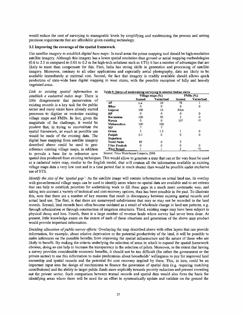
would reduce the cost of surveying to manageable levels by simplifying and modernizing the process and setting precision requirements that are affordable given existing technology.
3.1 Improving the coverage of the spatial framework
Use satellite imagery to establish digital base maps: In rural areas the prime mapping tool should be high-resolution satellite imagery. Although this imagery has a lower spatial resolution than ground or aerial mapping methodologies (0.6 to 2.5 m compared to 0.01 to 0.2 m for high-tech solutions such as ETS) it has a number of advantages that are likely to more than compensate for this. First, India has strong skills in generation and processing of satellite imagery. Moreover, contrary to all other applications and especially aerial photography, data are llkely to be available immediately at minimal cost. Second, the fact that imagery is readily available should allows quick production of state-wide base digital mapping in most states, with the possible exception of hilly and heavily vegetated areas.
Link to existing spatial information to establish a cadastral index map: There is little disagreement that preservation of existing records is a key task for the public sector and many states have already started processes to digitize or vectorize existing village maps and FMBs. In fact, given the magnitude of the challenge, it would be prudent that, in trying to reconstitute the spatial framework, as much as possible use would be made of the existing data. The digital base mapping from satellite imagery described above could be used to geo-
Table 8: Status of modernizing surveying in selected Indian states Village maps (%) FMBs (%) - .
Scaned Vectorized Scaned Vectorized AP n.a. 10 78 1 Bihar 0 0 0 0 Gujarat 100 10 Pilot HP 0 0 0 0 Karnataka 100 50 2 0 Kerala 0 0 1 O? ?? Maharashtra 100 100 MP 7 7 Orissa 3 1.5 1 0 Punjab 0.1 0 0 0 Rajasthan Tamil Nadu 85 0 5 Uttar Pradesh 0 0 0 0
reference existing village maps, in addition West Bengal 1 1 2 ??
to provide a base for to reference new Source: Price Waterhouse Coopers, 2006
spatial data produced from existing techniques. This would allow to generate a map that can at the very least be used as a cadastral index map, similar to the English model, that will contain all the information available in existing village maps data a very low cost and in a time period that is much shorter than would be possible under exclusive use of ETS.
Identfi the size of the 'spatial gap ': As the satellite image will contain information on actual land use, its overlay with geo-referenced village maps can be used to identify areas where no spatial data are available and to set criteria that can help to establish priorities for undertaking work to fill these gaps in a much more systematic way, and taking into account a variety of technical and cost-recovery options, than has been possible in the past. To illustrate this, note that there are a number of key reasons that result in discrepancy between existing spatial records and actual land use. The fist, is that there are unsurveyed subdivisions that may or may not be recorded in the land records. Second, land records have often become outdated as a result of wholesale change in land use patterns, e.g. through urbanization or through construction of irrigation structures. Third, existing maps may have been subject to physical decay and loss. Fourth, there is a large number of revenue lands where survey had never been done. At present, little knowledge exists on the extent of each of these situations and generation of the above map product would provide important information.
Deciding allocation ofpublic survey eforts: Overlaying the map described above with other layers that can provide information, for example, about relative deprivation or the potential productivity of the land, it will be possible to make inferences on the possible benefits from improving the spatial infrastructure and the nature of those who are llkely to benefit. By making the criteria underlying the selection of areas in which to expand the spatial framework obvious, doing so can help to increase the transparency in the selection of pilots. Moreover, to the extent that having a survey provides considerable economic benefits, it should not be too difficult (for either the government or the private sector) to use t h s information to make predications about households' willingness to pay for improved land ownership and spatial records and the potential for cost recovery implied by these. This, in turn, could be an important input into the design of mechanisms to finance the generation of spatial data (e.g. requiring matching contributions) and the ability to target public funds more explicitly towards poverty reduction and prevent crowding out the private sector. Such comparison between textual records and spatial data would also form the basis for identifying areas where there will be need for an effort to systematically update and validate on the ground the
textual and graphical information contained in the land administration system where, for example, due to efforts to avoid land ceilings and other administrative restrictions, such information is seriously out of date.
Approximate (and reduce) the cost of closing the 'spatial gap ': While the numerous redundancies that are built into India's land administration system tend to increase transaction costs and should therefore be eliminated, they can possibly be very useful to help in (re-)establishing some of the spatial information if made use of in a systematic manner. For example, in situations where maps have disintegrated, records (as well as FMBs) may still be available, allowing at the very least to ex ante identify the number of surveys that need to be undertaken and the neighbors who have to be notified. Even in situations where survey has not been conducted at all, the satellite image could be relied upon to assess patterns of land use and gain an approximate idea of the requirements involved in establishng a spatial frame. Pilots will be necessary to work out the details of such an approach in each of a number of specific cases and are in more detail discussed below.
3.2 Pilots options for specific situations
As measurements done in colonial days were surprisingly precise, the main reason for the maps that had been generated then to become outdated is through unrecorded subdivisions or structural change such as urbanization. Having a state-wide digital base map overlaid with existing village maps would not only allow quantification of the relative incidence of these situations but also help to devise strategies for addressing them.
Technical options: There is little doubt that, in order to establish a land administration system that is widely affordable, India needs to allow for a range of technology options that is broader than what has been available in the past, allowing in particular extensive use of satellite imagery and handheld GPS. However, even though the general range of precision that can be achieved with these technologies is well known, the need to explore these under Indian conditions together with the rather rapid development of technology in this field make it mandatory to explore technology options in more detail under local conditions before starting to draft any regulations. Given the far-reaching implications of doing so, it will be critical to ensure that a wide range of technology options as well as actual field conditions are taken into account.
Subdivisions: One class of situations is unsurveyed or -recorded subdivisions in situations (mainly in rural areas where there is still a "reasonable" correspondence between the map base and current land use. In this case, piloting of re-survey options with different types of technology can provide an informational basis that would allow to use the information from the satellite-cum village map to determine the extent to which actual land use still corresponds to the boundaries identified on the village map, something that is likely to depend on the age of the maps, the frequency of transactions, and the completeness of their recording. This will provide an indication whether surveys on a sporadic or a systematic basis would be more appropriate. Overlaying this with a map indicating the area's economic potential should also help in deciding about the possibility to share some of the cost.
Mismatches: A second situation that is likely to be encountered is that there is considerable mismatch between the situation on the ground and what is recorded in different types of records, e.g. because of the desire of large land owners to evade land ceiling legislation. Once the magnitude of this issue has been determined, possibly helped by some simple local inquiries through the village officer, it will be possible to devise strategies for dealing with the situation. Key issues are likely to be whether or not a systematic field verification exercise that would clarify textual as well as spatial records, will be required, how such an exercise would be financed, and what changes in the regulatory framework will be needed to allow it to be effective, i.e. to be able to resolve at least the majority of conflicts on the spot. Pilots to explore these issues in concrete settings will be of immense importance for informing the policy process.
Complete change in land use patterns: The most promising way to deal with non-existence of maps or complete lack of correspondence between existing village maps and actual patterns of land use is likely to check availability and quality of alternative spatial products in other government departments, especially tax maps with municipal corporations. If the resolution of the imagery is sufficient, a first assessment of the quality of these maps can be obtained to determine the extent of re-survey needed. If there is a desire to transform these into ownership records, options for a participatory and transparent process of systematic ground verification to do so will need to be explored through pilots.
Decay and loss: In case village maps have been lost, algorithms to reconstitute spatial information to create a simple index map from the imagery, together with the textual records can be explored through pilots and subsequent public verification of the resulting product. If successful, these procedures could be put down in regulations that could allow the process to be used on a wider scale.
Complete lack of survey: One of the shortcomings of past pilots has been their focus on land that had already been settled. As a result, certain types of land in Andhra Pradesh, Assam, Karnataka, Kerala, Madhya Pradesh, Maharashtra, Orissa and Tamil Nadu, especially those that had been part of princely states and those above a certain slope (10') were excluded from consideration. Although satellite imagery may not be the most suitable for these lands due to hilly terrain, this is extremely important for equity reasons because it was essentially state action that deprived large number of tribal households of their rights even though it was often occupied and used. In fact, in 2000, the Go0 decided to confer ownership to people in scheduled areas cultivating land up to a 30' slope and to carry out a special survey to demarcate the lands in question. Not surprisingly in view of the fact hat the technology is not the most suitable for this type of circumstances, carrying out this survey with ETS proved unsuccessful. Mounting a pilot to do so instead with handheld GPS -a technology that is much cheaper and, because it is less demanding in tenns of manpower can be undertaken with much greater local participation, would not only be an ideal opportunity to broaden the range of choices considered but also to develop procedures that could make a huge difference to the welfare of tribal populations all over the country.
3 3 Redefining and strengthening the role of the public sector
Expand availability of capacity: The fact that meeting normal needs of day-to day resurveys already stretches current public sector capacity to its limits, suggests that expanding the number of trained surveyors will be critical. This will, in the first instance require technical training. The experience of AP, where in a collaborative effort between the survey department and local self-help groups, training of village youths to become 'barefoot' surveyors with the possibility of subsequently acquiring a license with the possibility of either being attached to local SHG federations or receive a loan to start up their own business, suggests that there are plenty of innovative options that can be explored to increase survey capacity not only in urban centers but also at the village level where lack of surveying capacity is a significant bottleneck. Given that simple handheld computers with 1-2 m precision are available at a cost that is comparable to that of setting up a computer kiosk, there could be considerable scope to explore business models for entrepreneurial rural youth that could make use of this opportunity and provide surveying capacity at the local level at a reasonable cost.
Regulatoryframework for private sector involvement: Expansion of supply alone will not be effective unless it is combined with a regulatory framework that allows private surveyors greater independence from the public sector or, in the majority of Indian states, allows private sector activity in the first place. Such delegation of responsibility by the state to licensed surveyors may need to be a gradual process that is based on clear standards of service delivery and penalties in case of non-performance, and ideally an independent self-regulating body that provides a first level of enforcement. Whlle t h ~ s will require further work, there are plenty of country experiences that can be drawn upon and adapted to the Indian situation.
Updating technical regulations: While expansion of capacity will be important, it can do little to reduce the cost of doing surveys and there is a significant danger that, unless lower-cost options together with less demanding precision requirements are developed and put in place, even promising innovations to make surveys an integral part of the process of mutation may not be complied with. Rewriting survey regulations -which are often quite archaic- to bring them up to date can in many cases be combined with efforts to integrate new technology where appropriate. It appears that recent developments in handheld GPS provide options that are well suited to the requirements of rural areas in India. For example, in Uganda, systematic demarcation using handheld GPS with an accuracy of 10 cm is currently undertaken at an average cost of US$ 0.41 per point, i.e. $ 1.6-3.2 per parcel depending on its physical shape. A systematic investigation of the options available, including pilot applications to test the potential under field conditions, would thus be highly desirable and could provide a basis for such decisions in India.
Re-engineer business processes: The above should be integrated with and informed by re-engineering of business processes to suit Indian conditions, similar to what was done for registration and, a more limited extent, land records. For example, if a decision has been reached that in rural areas regular subdivision surveys on an index map may be conducted using handheld GPS devices, it would be possible to design a completely electronic process where the local surveyor downloads existing spatial records either from the internet at the local luosk or from the taluk office, goes to the field to record the coordinates for the newly formed parcels and have the survey duly authenticated by the affected parties, and uploads the modified plan for archiving. Supporting pilots to explore such lower-cost options not only for sporadic subdivision surveys but also for systematic demarcation in situations where either records have been lost or no previous survey has been conducted would be of high priority and should at least complement MoRD's current emphasis on high-end technology, especially in view of the fact that Indian experience suggests that households are not willing to pay infinite amounts for surveys.
Focus public support on poor areas: The above is particularly important because India contains large amounts of land, especially in tribal areas, where no survey has been undertaken yet and where, as a result, property rights to land may be highly insecure or subject to appropriation by powerful private interests. While private surveyors will be able to cater to the needs of the better-off in areas with higher levels of land values, especially if regulation is put in place that will allow a reduction in the cost of doing so, it is these groups who should be the focus of government's efforts. The benefits from doing so, in terms of poverty reduction, environmental protection, and possible local development could be enormous. In addition, development of processes to deal with these issues will be important to prepare the ground and to be able to effectively implement the provisions of the tribal land rights bill, once passed.
V. TOWARDS GREATER TENURE SECURITY
From the very start, efforts to modernize land administration in India were not an end by themselves but intended to help increase tenure security and make it easier to transfer land. While modernization of each of the subsystems is a necessary condition for such an impact, either textual or spatial records will be fully effective only if accompanied by an appropriate legal and regulatory framework. A key concern in this context has been whether, and if yes when and how, India should make the transition towards a system of title registration, often also laown as 'Torrens' system. This chapter briefly clarifies key differences between title and deed registration systems and, based on a discussion of options to improve deeds systems, highlights the trade-offs to be considered in making a decision of whether or not to make the transition to a title system as well as the strategies available for doing so.
1. The purpose of registration and the difference between deeds and titles
The key function of a land registration system is to facilitate land transactions by placing rights in land on public record. While there are many variations of both, it is useful to consider key elements of deed and title registration.
A deeds registration system is a public repository where documents evidencing transactions with land can be lodged, numbered and dated, indexed, and archived. Recording of the document will give public notice of the transaction, serve as evidence for it, and may assign priority to the right claimed in that document with registered deeds normally taking priority over unregistered ones, or any deeds registered subsequently. However, registration of a deed does not imply any inference about the legal validity of the transaction or that the parties were legally entitled to carry out the transaction. As discussed earlier, the registration office will, in principle, register anything and in practice in India officers often invest more time in ensuring the identity of the parties to the transaction than the physical location and attributes of the land.
Under registration of titles, the register itself serves as the primary evidence of ownership. It is commonly identified by three attributes, namely (i) the mirror principle indicating that the situation in the registry is an exact reflection of reality; (ii) the curtain principle, implying that anybody interested in inquiring about the title status of a given property will not have to engage in a lengthy search of documents but can rely on the evidence from the title registry being definitive; and (iii) the assurance principle according to which the government will indemnify for damages incurred as a consequence of errors in the registry.
Box 3: The English system of title registration In Britain, no system of land administration existed before 1862 when the Land Registry Act, which introduced a voluntary system of land registration, became law. The attempt to introduce land registration failed, however, as the Act's high accuracy requirement for boundary demarcation was too costly to comply with, in addition to prompting a large number of conflicts among adjoining land owners. After successive legislation, this lead to the concept of registration with general boundaries in 1875, the use of the national Ordnance Survey Map (a very low precision map) as the basis for mapping land registration in 1897.
The Land Transfer Act, which was passed in the same year, made registration of title compulsory in dealings with land in the County of London. Compulsory registration of title was extended to cover the rest of the country in a process whereby municipalities were progressively designated as areas for compulsory registration in case of sales. Since 1 December 1990, the whole of England and Wales has been subject to compulsory registration. Once an initial registration had been effected, all other transactions and dealings (e.g. mortgages, creation of new rights of way, bankruptcies, leases etc.) need to be registered.
The Chief Land Registrar acts as a title insurer, taking responsibility even if the error or omission has not arisen as a result of a mistake by the land registry (e.g. they unwittingly registered fraudulent documents) although the size of indemnity will be affected by the level of carelessness by the person involved and the registry has the possibility to sue the person who committed the fraud. This guarantee covers not only the land register but also any search certificates and official copies of registers and plans issued in response to a proper application. With a total of about 20 mn registered (and 3 mn unregistered) parcels worth about £ 3,000 billion, the annual volume of transactions amounts to 4.6 mn, plus more than 1 l mn enquiries. With a total income of £410 mn, indemnity payments in 2003104 amounted to £ 2.65 mn.
Source: Based on Manthorpe (2004)
To illustrate, if, under title registration, A fraudulently sells a piece of land (which actually belongs to C) to B who purchases in good faith, B becomes the rightful owner and any claims by C are extinguished as soon as the sale is registered. The only recourse open to C would be to demand compensation, but not restitution of the property, from the state which in turn has the option to sue A. The need to ensure that the responsibility taken up by the state can be met is one of the reasons why title registration systems are normally associated with a guarantee fund to facilitate payment of such compensation. By contrast, under a deeds system, it is B's responsibility to investigate the veracity of A's ownership claims and C will be able to demand restitution of the property from B, implying that B will incur the loss. Put simply, under a deeds system, the cost of acquiring information about the ownership status of a particular piece of land have to be incurred by the purchaser (something that may lead to a less than optimum amount of land market activity) while under a title system the state guarantees this information.
One common misconception is that the Torrens system of registration of title guarantees boundaries in the sense of guaranteeing lengths of boundaries and areas of parcels. In fact no title registration legislation expressly supports that notion, no case law supports it. To the contrary, many more modem title registration statutes expressly provide that indefeasiblity does not extend to the lengths, bearing and areas of registered parcels. Whlle boundaries that can be identified with hgh levels of precision may be an advantage, they are not essential for a title registration system. In some cases, surveying and mapping can be undertaken with cheap cost effective methods. For example, in England, which operates on a title registration system, attempts to require costly high-precision surveys failed (see box 3) and instead a system is used where many of the title boundaries have not been measured but are what is known as "general boundaries". These boundaries are defined by pre-existing buildings, walls fences and hedges, rather than by fixed measurement. Cadastral maps then serve essentially as indexes to the land parcels and related titles as well as field measurements. They may or may not have legal status but, in case they have, will be guaranteed to correctly show only the relationship of the land to adjoining parcels and to other features such as roads and public land. This has the great advantage that cadastral index maps can be compiled from best available information, e.g. tax maps in some parts of Australia, or regular topographical ordnance survey maps as in England.
2. Options for improving a deeds system
Before deciding whether or not to make the transition to a Torrens system, it will be good to explore the options for improving the existing system. Based on our earlier discussion, the cost which a potential buyer has to incur depend on (i) the completeness of the information contained in the registry; the ease of searching it; and (iii) the reliability of such information. Taking a number of simple procedural to reduce these costs can to greatly improve the value of a deeds system. These include:
Compulsory registration: Registration may be made a condition of the validity of the deed by providing in the law that unregistered deeds may not be admtted in court as evidence of title. Documents which are not registered can then be safely ignored and searching the deeds register, which can be automated by having encumbrance certificates computerized, will enable anybody dealing in land to make sure that no material factor has been overlooked, thereby affording significant protection against concealed conveyancing.
Parcel based indexing: Basic deeds registration systems are normally indexed under the names of the parties, rather than a unique parcel identifier, with cadastral maps not being used in the system and sometimes not even required as part of the documentation for the transaction. Virtually all countries where deeds systems operate satisfactorily have found that an improved system that using unique parcel numbers to identify documents will have less ambiguity than a system using changing names of grantees and grantors, making it much easier to review and assess all the documents required to determine the validity of a claim to ownershp before entering into a transaction. Thus, whle development of plans showing parcel boundaries, unique parcel identities and cadastral index maps is a precondition for moving towards title, it is likely to be required to improve deeds systems irrespectively of whether a transition is planned or not. As the cost of surveying increases exponentially with the level of precision required, much hinges on the extent to which existing information can be used and the degree of accuracy required.
Standardization and computerization: Computerization of title abstracts as well as the links to cadastral maps, parcel based indices, and examination of documents described earlier can greatly improve the quality of information provided by deeds registries and reduce the cost of searchmg them. A number of countries, such as the Netherlands, South Africa, and the USA use these techniques to run highly effective deeds systems that offer levels of protection that are equivalent, or even higher, than those found in title systems that are not effectively implemented or where a government guarantee is not feasible. While other countries, including Scotland and Hong Kong, decided to convert to a title system even from a well- established deeds system, there are little inherent advantages of one model vs. the other and any decision will have to be based on the merits of the case at hand (Manthorpe 2004).
Examination of documents to ensure compliance with laws and regulations: The risks of a deed being not properly drawn can be fbrther minimized by requiring officials to check compliance with essential rules and making the registry liable for any damages incurred as a consequence of negligence andlor by having insurance. Insurance against defects in title for a property being transferred is a common arrangement in most states of the USA where title insurance companies have developed as private deeds registers and will insure purchasers against losses as a result of defective title.
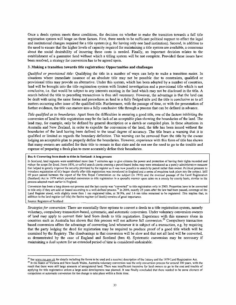
Once a deeds system meets these conditions, the decision on whether to make the transition towards a full title registration system will hinge on three factors. First, there needs to be sufficient political support to effect the legal and institutional changes required for a title system (e.g. for having only one land institution). Second, in addition to the need to ensure that the higher levels of capacity required for maintaining a title system are available, a consensus about the social desirability of incurring these costs is needed. Finally, an important decision relates to the establishment of a guarantee fund without which a titling system will be not complete. Provided these issues have been resolved, a strategy for conversion has to be agreed upon.
3. Making a transition towards title registration: Opportunities and challenges
Qualified or provisional title: Qualifying the title in a number of ways can help to make a transition easier. In situations where immediate issuance of an absolute title may not be possible due to constraints, qualified or provisional titles may provide an alternative. Under thls system, which has been adopted by a number of countries, land will be brought into the title registration system with limited investigation and a provisional title which is not conclusive, i.e. that would be subject to any interests existing in the land which may not be disclosed in the title. A search behind the title to preceding transactions is thus still necessary. However, the advantage is that the land can be dealt with using the same f o m and procedures as land in a fully fledged title and the title is conclusive as to all matters occurring after issue of the qualified title. Furthermore, with the passage of time, or with the presentation of further evidence, the title can mature into a fully conclusive title through a process that can be defined in advance.
Title qualified as to boundaries: Apart from the difficulties in ensuring a good title, one of the factors inhibiting the conversion of land to title registration may be the lack of an acceptable plan showing the boundaries of the land. The land may, for example, only be defined by general description or a sketch or compiled plan. In these situations in Australia and New Zealand, in order to expedite the conversion of the land, the title has been issued without the boundaries of the land having been defined to the usual degree of accuracy. The title bears a warning that it is qualified or limited as regards the boundary definition. This warning can be removed from the title by the owner lodging an acceptable plan to properly define the boundaries. However, experience with this form of title has shown that many owners are satisfied for their title to remain in that state and do not see the need to go to the trouble and expense of preparing a fresh plan to more accurately define their boundaries.
Box 4: Converting from deeds to titles in Scotland: A long process
In Scotland, land registers were established more than 7 centuries ago to give citizens the power and protection of having their rights recorded and reduce the scope for fraud. From 1876, so-called search sheets creating a parcel-based index map were introduced as a purely administrative measure that helped to greatly improve the security provided by the register as it was now possible to search by parcel rather than owner. Political pressure to introduce registration of title began shortly after title registration was introduced in England and a series of enquiries took place into the subject. Still 69 years passed between the report of the first Royal Commission on the subject (in 1910) and the eventual passage of the Land Registration (Scotland) Act in 1979 which provided conversion to title registration in a sporadic manner upon sales on a county by county basis, similar to the process adopted much earlier in England.
Conversion has been a long drawn-out process and the last county was "converted" to title registration only in 2003. Properties have to be converted to title only if they are sold or leased according to a well-defined process.28 In 2004, exactly 25 years after the law had been passed, coverage of the Land Register stood, with slightly more than 1 mn registered titles, at 38.9%, and 1.6 mn titles remained to be registered. This implies that, in addition to the land register (of title) the Sasine register (of deeds) remains of great importance.
Source: Registers of Scotland
Strategies for conversion: There are essentially three options to convert a deeds to a title registration system, namely voluntary, compulsory transaction-based, systematic, and automatic conversion. Under voluntary conversion owners of land may apply to convert their land from deeds to title registration. Experience with this measure alone in countries such as Australia has shown that thls process will not achieve full conver~ ion .~~ Compulsory transaction based conversion offers the advantage of converting land whenever it is subject of a transaction, e.g. by requiring that the party lodging the deed for registration may be required to produce proof of a good title which will be examined by the Registry. The disadvantage is that conversion will be slow and that not all land will be converted, as demonstrated by the case of England and Scotland (box 4). Systematic conversion may be necessary if maintaining a dual system for an extended period of time is considered undesirable.
See www.ros.aov.uk for details including the forms to be used and a succinct description of the history and the 1979 Land Registration Act. 29 In the States of Victoria and New South Wales, Australia voluntary conversion was the only conversion process for around 100 years, with the result that there were still large amounts of unregistered land. There was insufficient incentive for land owners to go to the cost and trouble of applying for title registration unless a large scale development was planned. It was finally concluded that there needed to be some element of compulsion or automatic conversion for the change to take place within a finite time.
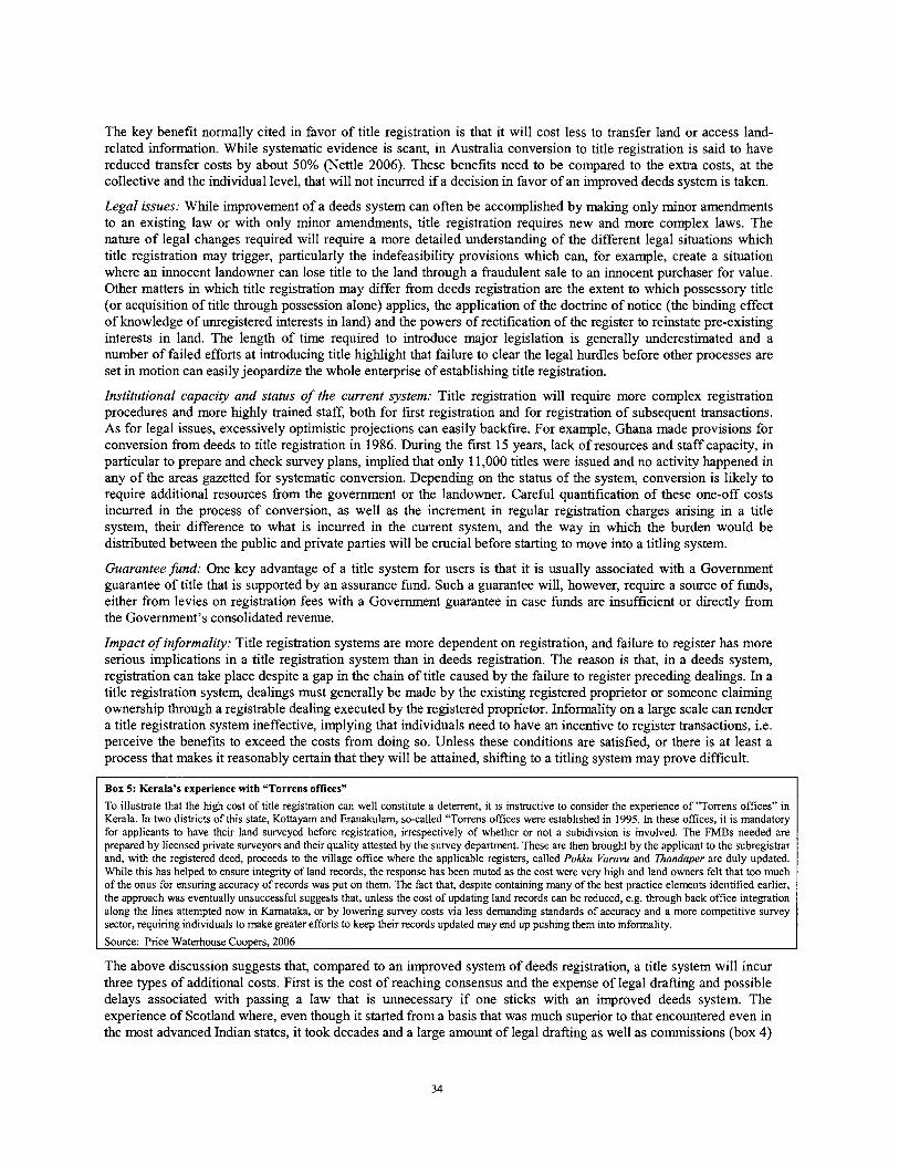
The key benefit normally cited in favor of title registration is that it will cost less to transfer land or access land- related information. While systematic evidence is scant, in Australia conversion to title registration is said to have reduced transfer costs by about 50% (Nettle 2006). These benefits need to be compared to the extra costs, at the collective and the individual level, that will not incurred if a decision in favor of an improved deeds system is taken.
Legal issues: While improvement of a deeds system can often be accomplished by making only minor amendments to an existing law or with only minor amendments, title registration requires new and more complex laws. The nature of legal changes required will require a more detailed understanding of the different legal situations which title registration may trigger, particularly the indefeasibility provisions which can, for example, create a situation where an innocent landowner can lose title to the land through a fraudulent sale to an innocent purchaser for value. Other matters in which title registration may differ from deeds registration are the extent to which possessory title (or acquisition of title through possession alone) applies, the application of the doctrine of notice (the binding effect of knowledge of unregistered interests in land) and the powers of rectification of the register to reinstate pre-existing interests in land. The length of time required to introduce major legislation is generally underestimated and a number of failed efforts at introducing title highlight that failure to clear the legal hurdles before other processes are set in motion can easily jeopardize the whole enterprise of establishing title registration.
Institutional capacity and status of the current system: Title registration will require more complex registration procedures and more highly trained staff, both for first registration and for registration of subsequent transactions. As for legal issues, excessively optimistic projections can easily backfire. For example, Ghana made provisions for conversion from deeds to title registration in 1986. During the first 15 years, lack of resources and staff capacity, in particular to prepare and check survey plans, implied that only 11,000 titles were issued and no activity happened in any of the areas gazetted for systematic conversion. Depending on the status of the system, conversion is likely to require additional resources from the government or the landowner. Careful quantification of these one-off costs incurred in the process of conversion, as well as the increment in regular registration charges arising in a title system, their difference to what is incurred in the current system, and the way in which the burden would be distributed between the public and private parties will be crucial before starting to move into a titling system.
Guarantee fund: One key advantage of a title system for users is that it is usually associated with a Government guarantee of title that is supported by an assurance fund. Such a guarantee will, however, require a source of funds, either from levies on registration fees with a Government guarantee in case funds are insufficient or directly from the Government's consolidated revenue.
Impact of informality: Title registration systems are more dependent on registration, and failure to register has more serious implications in a title registration system than in deeds registration. The reason is that, in a deeds system, registration can take place despite a gap in the chain of title caused by the failure to register preceding dealings. In a title registration system, dealings must generally be made by the existing registered proprietor or someone claiming ownership through a registrable dealing executed by the registered proprietor. Informality on a large scale can render a title registration system ineffective, implying that individuals need to have an incentive to register transactions, i.e. perceive the benefits to exceed the costs from doing so. Unless these conditions are satisfied, or there is at least a process that makes it reasonably certain that they will be attained, shifting to a titling system may prove difficult.
Box 5: Kerala's experience with "Torrens officesn
To illustrate that the high cost of title registration can well constitute a deterrent, it is instructive to consider the experience of "Torrens offices" in Kerala. In two districts of this state, Kottayam and Eranakulam, so-called "Torrens offices were established in 1995. In these offices, it is mandatory for applicants to have their land surveyed before registration, irrespectively of whether or not a subidivsion is involved. The FMBs needed are prepared by licensed private surveyors and their quality attested by the survey department. These are then brought by the applicant to the subregistrar and, with the registered deed, proceeds to the village office where the applicable registers, called Pokku Varavu and Bandaper are duly updated. While this has helped to ensure integrity of land records, the response has been muted as the cost were very high and land owners felt that too much of the onus for ensuring accuracy of records was put on them. The fact that, despite containing many of the best practice elements identified earlier, the approach was eventually unsuccessful suggests that, unless the cost of updating land records can be reduced, e.g, through back office integration along the lines attempted now in Kamataka, or by lowering survey costs via less demanding standards of accuracy and a more competitive survey sector, requiring individuals to make greater efforts to keep their records updated may end up pushing them into informality.
Source: Price Waterhouse Coopers, 2006
The above discussion suggests that, compared to an improved system of deeds registration, a title system will incur three types of additional costs. First is the cost of reaching consensus and the expense of legal drafting and possible delays associated with passing a law that is unnecessary if one sticks with an improved deeds system. The experience of Scotland where, even though it started from a basis that was much superior to that encountered even in the most advanced Indian states, it took decades and a large amount of legal drafting as well as commissions (box 4)
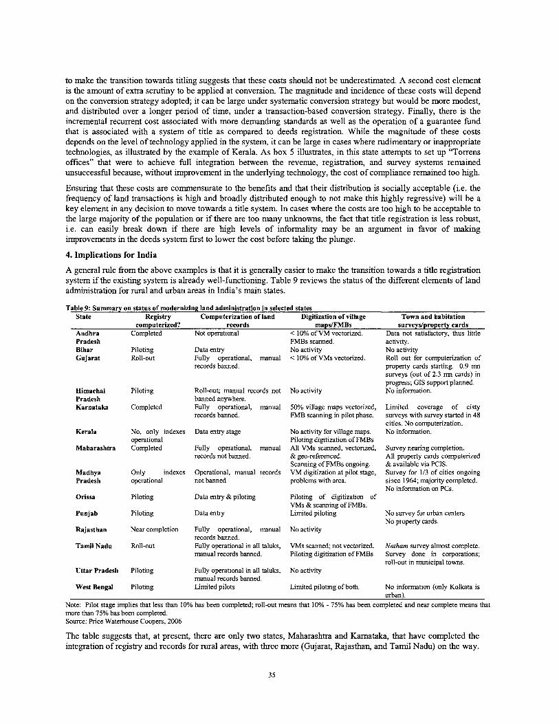
to make the transition towards titling suggests that these costs should not be underestimated. A second cost element is the amount of extra scrutiny to be applied at conversion. The magnitude and incidence of these costs will depend on the conversion strategy adopted; it can be large under systematic conversion strategy but would be more modest, and distributed over a longer period of time, under a transaction-based conversion strategy. Finally, there is the incremental recurrent cost associated with more demanding standards as well as the operation of a guarantee fund that is associated with a system of title as compared to deeds registration. While the magnitude of these costs depends on the level of technology applied in the system, it can be large in cases where rudimentary or inappropriate technologies, as illustrated by the example of Kerala. As box 5 illustrates, in t h s state attempts to set up "Torrens offices" that were to acheve full integration between the revenue, registration, and survey systems remained unsuccessful because, without improvement in the underlying technology, the cost of compliance remained too high.
Ensuring that these costs are commensurate to the benefits and that their distribution is socially acceptable (i.e. the frequency of land transactions is high and broadly distributed enough to not make this lughly regressive) will be a key element in any decision to move towards a title system. In cases where the costs are too high to be acceptable to the large majority of the population or if there are too many unknowns, the fact that title registration is less robust, i.e. can easily break down if there are high levels of informality may be an argument in favor of making improvements in the deeds system first to lower the cost before taking the plunge.
4. Implications for India
A general rule from the above examples is that it is generally easier to make the transition towards a title registration system if the existing system is already well-functioning. Table 9 reviews the status of the different elements of land admmistration for rural and urban areas in India's main states.
Table 9: Summary on status of modernizing land administration in selected states State Registry Computerization of land Digitization of village Town and habitation
computerized? records maps/FMBs surveydproperty cards Andhra Comoleted Not ooerational < 10% of VM vectorized. Data not satisfactow. thus little . . Pradesh FMBs scanned. activity. Bihar Piloting Data entry No activity No activity Gujarat Roll-out Fully operational, manual < 10% of VMs vectorized. Roll out for computerization of
records banned. property cards starting. 0.9 mn surveys (out of 2.3 mn cards) in progress; GIs support planned.
Himachal Piloting Roll-out; manual records not No activity No information. Pradesh banned anywhere. Karnataka Completed Fully operational, manual 50% village maps vectorized, Limited coverage of cisty
records banned. FMB scanning in pilot phase. surveys with survey started in 48 cities. No computerization.
Kerala No, only indexes Data entry stage No activity for village maps. No information. operational Piloting digitization of FMBs
Maharashtra Completed Fully operational, manual All VMs scanned, vectorized, Survey nearing completion. records not banned. & geo-referenced. All property cards computerized
Scanning of FMBs ongoing. & available via PCIS. Madhya Only indexes Operational, manual records VM digitization at pilot stage, Survey for 113 of cities ongoing Pradesh operational not banned problems with area. since 1964; majority completed.
No information on PCs. Orissa Piloting Data entry &piloting Piloting of digitization of
VMs & scanning of FMBs. Punjab Piloting Data entry Limited piloting No survey for urban centers
No property cards. Rajasthan Near completion Fully operational, manual No activity
records banned. Tamil Nadu Roll-out Fully operational in all taluks, VMs scanned; not vectorized. Natham survey almost complete.
manual records banned. Piloting digitization of FMBs Survey done in corporations; roll-out in municipal towns.
Uttar Pradesh Piloting Fully operational in all taluks, No activity manual records banned.
West Bengal Piloting Limited pilots Limited piloting of both. No information (only Kolkata is urban).
Note: Pilot stage implies that less than 10% has been completed; roll-out means that 10% - 75% has been completed and near complete means that more than 75% has been completed. Source: Price Waterhouse Coopers, 2006
The table suggests that, at present, there are only two states, Maharashtra and Karnataka, that have completed the integration of registry and records for rural areas, with three more (Gujarat, Rajasthan, and Tamil Nadu) on the way.
In UP and MP, records are fully computerized but computerization of the registry remains in its early stages whereas in AP, the registry is fully computerized but land records continue to be handled manually. Of course, a land registration system will have to serve urban areas as well as rural ones and, in addition, requires at least a rudimentary basis of spatial information. Concerning urban areas, only MA has completed computerization of property cards and GJ as well as TN are in the process of surveying urban areas and computerizing property cards. As discussed earlier, the quality of spatial data in rural areas is most advanced in MA, with KA and TN as distant followers and hardly any activity in the other states.
While this brief review does not imply that embarking on a "big bang" conversion to a title registration system as is attempted by AP, will be completely impossible, it does suggest that doing so will be a rather complex, risky, and costly exercise. The reason is that, contrary to the case of Scotland, where the necessary infrastructure was fully in place and had been operating successfully for a long time when the decision to shift towards title had been made , significant cost will have to be incurred to establish the legal and institutional basis, to update both spatial and textual data, to adjudicate, and to handle conflicts arising from the process. As all of these will provide valuable lessons for other Indian states, it will be important to monitor this effort closely to draw lessons that will be of much broader relevance.
At the same time, the above discussion suggests that, in states where there is less scope for taking such far-reaching decisions, this should not taken as an excuse for delaying a determined move to make far-reaching improvements to the existing deeds system that will be needed irrespectively of whether or not an eventual transition to title is envisaged. The goal should be to achieve full functional integration of the different textual and spatial databases used in land administration in the medium term so as to be able to provide land owners with a certificate -which can even be called a "Torrens titlev- that combines relevant and current information pertaining to a plot (i.e, ownership status, transaction hlstory, current and past mortgages and liens, and a map that allows identification of neighbors and general boundaries) irrespectively of the government department maintaining the information. This should be combined with a regulatory framework to (i) provide clear, affordable standards for spatial records and ensure their integration with textual ones across the country; (ii) require registry officials to perform at least basic validity checks before registering a document; and (iii) mechanisms for updating that are complete and sufficiently cost-effective. If this can be achieved, it would allow realization of about 90% of the benefits from a titling system at a fraction of the cost - whlle at the same time providing a more appropriate basis to decide whether transition towards full title will be desirable.
VI. LAND OWNERSHIP REFORM
Although improving land administration along the lines discussed above can have a significant impact on the welfare of those who own land, it will at best provide indirect benefits to the large number of households who are landless and who, without tangible assets, may well be caught in a poverty trap from which it is difficult to escape. In India's situation, policies to strengthen land administration will have be complemented by considering opportunities for the poor to access land as a means of improving their asset status and livelihood. Land reform has long been a key element in the Indian government's strategy. However, surprising in view of the large amount of effort devoted to thls policy, the amount of analysis of its impact on a national scale (as compared to case study evidence) has been quite limited. We use a long panel of households that spans the 1982 to 1999 period to provide at least suggestive evidence on this issue and derive some implications for policy.
1. Justification and background
Researchers and policy makers are increasingly aware that the way in which productive assets and the associated economic opportunities are distributed will have far-reaching implications for long-term development (Bardhan et al. 2000, World Bank 2005). Empirical studies demonstrated the far-reaching and long-lasting implications of initial differences in land holding patterns on productivity, growth, and social articulation (Nugent and Robinson 2002, Banerjee and Iyer 2004). A number of channels through which high levels of asset inequality may reduce growth have been identified in the literature. These include credit market imperfections in the presence of indivisible investments, e.g. in education (Galor and Zeira 1993, Aghion and Bolton 1997); wealth-induced limitations on households' ability to articulate their concerns in the political arena (Bourguignon and Verdier 2000); high inequality reducing local communities' willingness and ability to provide public goods that benefit all inhabitants (Cardenas 2003); and a link between inequality and destructive tensions and social strife that can directly and indirectly undermine the basis for economic growth (Conning and Robinson 2002).
Box 6: The far-reaching long term impact of settlement The impact of the type of settlement was far-reaching as it affected the nature of property rights and incentives to invest in land, the distribution of wealth and the structure of political power.
Dtfferences in the security ofproperty rights: In landlord areas, concentration of power in the hands of the landlords made peasant property relatively insecure as any productivity-enhancing investments ran the risk of being expropriated by the landlord. In contrast, in the yoyotwari areas, farmers had an explicit, typically written, contract with the colonial state, implying higher investment incentives. Incentives for public investment were reduced because the permanent nature of the settlement, together with the political power of zamindars would have made it difficult for the state to increase rents. The colonial state had thus more interest in the prosperity of non-landlord areas which could be translated into higher rents, something that is indeed reflected in a much higher level of public investment in irrigation, railways, schools and other infrastructure.
Differences in the distribution of wealth: Under landlord systems, landlords were given the authority to extract as much as they could from the tenants, and, as a result, they were in a position to appropriate most of the gains in productivity, something for which they could use judicial and other powers vested in them by the colonial. As the 19" century experienced significant productivity growth, the landlord class grew rich and inequality increased. By contrast, in rajatwari areas, the British raised rents frequently to extract surplus from tenants and differentiation within the rural population remained more limited. The distribution of wealth is important because (i) it determines the size of the group with enough wealth to be able to make lumpy or risky investments to raise productivity; (ii) it affects the balance between owner-cultivation and sharecroppers which in tum will have implications for productivity; and (iii) it made it likely that the political interests of the rural masses would diverge from that of the elite, in particular the support for programs to expropriate the assets of the rich. Post-independence, this implied that the masses may have focused more towards expropriating from the rich than towards trying to establish public goods (schools, water, electricity) while the rich, who had been mainly absentee landlords, focused on salvaging their wealth or transfening it to urban areas rather than improving productivity and living conditions in rural areas.
There is also a large body of empirical literature on agricultural production has shown that, due to the transaction costs involved in supervising hired labor (Carter 1984, Feder 1985, Eswaran and Kotwal 1985, Benjamin 1995), a farm structure based on owner-operated units is more efficient than one based on wage labor (Berry and Cline 1979, Binswanger et al. 1995). Market mechanisms can, in principle, be relied upon to equalize the operational distribution of land holdings and thus help maximize production. However, high levels of transaction costs limit the scope for rental markets to do so while credit market imperfections, together with the collateral value of land, reduce the number of transactions in land sales markets and, even in cases where these have the highest shadow value for land, fail to transfer land to the poorest (Binswanger and Elgin 1988). To overcome these obstacles, appropriate ways of government intervention that provide land access to the most productive producers can have significant social and economic benefits (Chau 1998, Carter and Zimmerman 2000).
In situations where non-market forces have deprived the majority of the population from acquiring asset ownership, a redistribution of assets, even though it would improve efficiency and equity, is unlikely to be brought about through market forces alone (Zimmerman and Carter 2003). The potential productivity benefits from a more
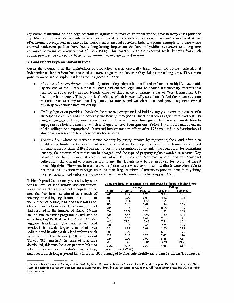
egalitarian distribution of land, together with an argument in favor of historical justice, have in many cases provided a justification for redistributive policies as a means to establish a foundation for an inclusive and broad-based pattern of economic development in some of the world's most unequal societies. India is a prime example for a case where colonial settlement policies have had a long-lasting impact on the level of public investment and long-term economic performance (Government of India 1966). Th~s, together with the expected social benefits fiom such action, provides the conceptual basis for government to engage in land reforms.
2. Land reform implementation in India
Given the inequality in the distribution of productive assets, especially land, which the country inherited at Independence, land reform has occupied a central stage in the Indian policy debate for a long time. Three main policies were used to implement land reforms (Mearns 1999):
Abolition of intermediaries immediately after independence is considered to have been highly successful. By the end of the 1950s, almost all states had enacted legislation to abolish intermediary interests that resulted in some 20-25 million tenants -most of them in the zamindari areas of West Bengal and UP- becoming landowners. This part of land reforms, which is essentially complete, shifted the power structure in rural areas and implied that large tracts of forests and wasteland that had previously been owned privately came under state ownership.
Ceiling legislation provides a basis for the state to expropriate land held by any given owner in excess of a state-specific ceiling and subsequently transferring it to poor farmers or landless agricultural workers. By contrast passage and implementation of ceiling laws was very slow, giving land owners ample time to engage in subdivision, much of which is alleged to have been spurious. Before 1972, little lands in excess of the ceilings was expropriated. Increased implementation efforts after 1972 resulted in redistribution of about 5.4 mn acres to 5.6 mn beneficiary households.
Tenancy laws aimed to increase tenure security by sitting tenants by registering them and often also establishing limits on the amount of rent to be paid or the scope for new rental transactions. Legal provisions across states differ from each other in the definition of a tenant,30 the conditions for permitting tenancy, the amount of rent that can be charged, and the type of property rights awarded to tenants. Key issues relate to the circumstances under which landlords can "resume" rented land for 'personal cultivation', the amount of compensation, if any, that tenants have to pay in return for receipt of partial ownership rights. However, in most states, implementation was also slow and landlords were often able to resume self-cultivation with wage labor and evict large numbers of tenants to prevent them fiom gaining more permanent land rights in anticipation of such laws becoming effective (Appu 1997).
Table 10 provides summary statistics by state for the level of land reform implementation, measured as the share of total population or area that has been transferred as a result of tenancy or ceiling legislation, in addition to the number of ceiling laws and their total age. Overall, land reform constituted a major effort that resulted in the transfer of almost 10 mn ha, 2.5 mn ha under programs to redistribute of ceiling surplus land, and 7.35 mn ha under tenancy legislation. The amount of land involved is much larger than what was
Table 10: Households and area affected by land reforms in Indian States Tenancv Ceiling -
State Area (%) Pop. (%) Area (%) Pop. (%) AP 3.48 0.75 8.34 3.81
redistributed in other ~ s i a n land reforms such RJ 0.00 0.16 6.63 0.75 as Japan (2 mn has), Korea (0.58 mn has) and 3.65 3.23 2.47 1.24
UP Taiwan (0.24 mn has). In terms of total area WB 0.00 0.00 5.81 3.68 6.41 10.80 14.91 19.73
distributed, this puts India on par with Mexico ~ ~ t ~ l 5.45 5.35 4.41 2.27 which, in a much more land-abundant setting, Source: Kaushik (2005).
and over a much longer period that started in-1917, managed to distribute slightly more than 13 mn ha (Deininger et
'O In a number of states including Andhra Pradesh, Bihar, Kamataka, Madhya Pradesh, Uttar Pradesh, Haryana, Punjab, Rajasthan and Tamil Nadu, the definition of 'tenant' does not include sharecroppers, implying that the extent to which they will benefit from protection will depend on local discretion.
al. 2002). Although the magnitude of accomplishments is put somewhat into perspective if the share of land and population are considered, land reform in India was undoubtedly a major historical event, ,especially if the amount of land distributed under abolition of intermediaries is added to these figures.
Comparing the share of households benefiting from tenancy legislation to that of the area transferred points towards large variation across states in the total amount redistributed and relative magnitudes. In some cases, e.g. Kerala or West Bengal, 12.5% and 10.8% of the population benefited fiom a transfer of 8.5% and 6.4% of the land area, respectively and plot sizes for land transferred remained considerably below the state average, implying that the goal was to maximize the number of beneficiaries. On the other hand, while some states (e.g. Gujarat or Tamil Nadu) provided beneficiaries with plots of about average size, in most of the states the fact that the share of beneficiaries remains significantly below the area share points towards transfer of above-average plot sizes, as in Maharashtra (27% of area distributed to 10.7% of population), Kamataka (15.4% and 5.3%), AP and MP (3.5% and 2.2% to 0.75% and 0.61% of population).
Even though tenancy reform also required government intervention, mainly in registering tenants, the amount of bureaucratic effort involved is modest compared to ceiling laws which require appropriation of land by the state and its subsequent redistribution. It is thus not surprising to find that, with 4.4% and 2.3%, the shares of area and beneficiary households, respectively, remained significantly below the figures for tenancy reform. Although some states such as Rajasthan, UP, Bihar, and AP transferred more land (6.6%, 5.8%, 4.4%, and 8.3%) under ceiling than through tenancy legislation, results seem to have been biased towards transfer of above-average sized plots of land, suggesting that even where it was possible to acquire above ceiling land by the state, overcoming political pressures in the distribution of such land may have been difficult. Only West Bengal, a state that ranks at or near the top for both measures and that is characterized by a formidable level of grassroots-level organization (Rawal 2001, Banerjee et al. 2002b) seems to have been able to avoid pressures to transfer above-ceiling lands in larger chunks.
A more detailed look at the time dimension of these measures allows a number of conclusions (Kausluk 2005): After a spurt of land transfers in the 1970s and 1980s, progress has slowed down considerably; in fact between 1995196 and 2003104, i.e. for almost a decade, progress in awarding land rights to tenants had come to a complete standstill and the increment in ceiling surplus land transferred during the period amounted to only 10,800 ha. The latter represents about one tenth of the land declared ceiling surplus, with the remainder being tied up in litigation. This suggests not only that fiwther progress in achieving redistribution of ceiling land could be slow -it would take almost 90 years to dispose of remaining ceiling surplus cases if the current pace is maintained- but also that, by clogging up the court system and preventing it from quickly dispensing justice in other urgent matters, the ceiling legislation may impose external effects beyond land rental markets (Moog 1997).~'
The literature on land reforms in India and beyond is considerable (Warriner 1969, Thorner 1976, King 1977, Haque and Singh 1986) and highlights that, where it was effectively implemented, land reforms yielded positive results.32 For example, a very effective drive of registering tenants in West Bengal after 1978 has been shown to have led to significant productivity gains, largely as a result of massive efforts at grassroots mobilization of tenants (Bane rjee et al. 2002b) in line with earlier studies (Lieten 1996, Rawal 2001). Attention to land reform is widely seen as one of the key reasons for the remarkable political stability in West Bengal. Use of state level data over time suggests that land reforms had a significant impact on poverty reduction -though not on increased productivity (Besley and Burgess 2000)- something that is interpreted as indicating that the poverty reducing impact of land reforms will be worth the cost in terms of productivity (Besley et al. 2004). At the same time, there is little evidence on three areas, namely (i) the impact of land reform on investment; (ii) its interaction with other policies; and (iii) the longer-term impact of maintaining land reform legislation.
3. Empirical evidence on the impact of land reform
To explore this issue empirically, we use a nation-wide panel survey of about 5,000 rural households who were interviewed by NCAER in both 1982 and 1999 and assess the extent to which cumulative land reform legislation andlor implementation at the state level affected changes in the accumulation of human and physical capital and
" In addition to cases related to contestation by landlords, there is an unknown number of instances where beneficiaries were allocated land but were either unable to establish effective possession or were subsequently evicted. A field survey to explore this issue in Andhra Pradesh pointed to at least 20% of beneficiaries who were not able to access the property they had received although the number of those who are able to file court cases calling for their (re)instatement is much more limited. '' Successive generations of IAS officers in the Lal Bahadur Shastri National Academy of Administration in Mussoorie have made a significant contribution to the area by conducting case studies of land reform implementation in almost all of India's states that have thus far resulted in the publication of 10 volumes on the subject that are replete with empirical evidence.
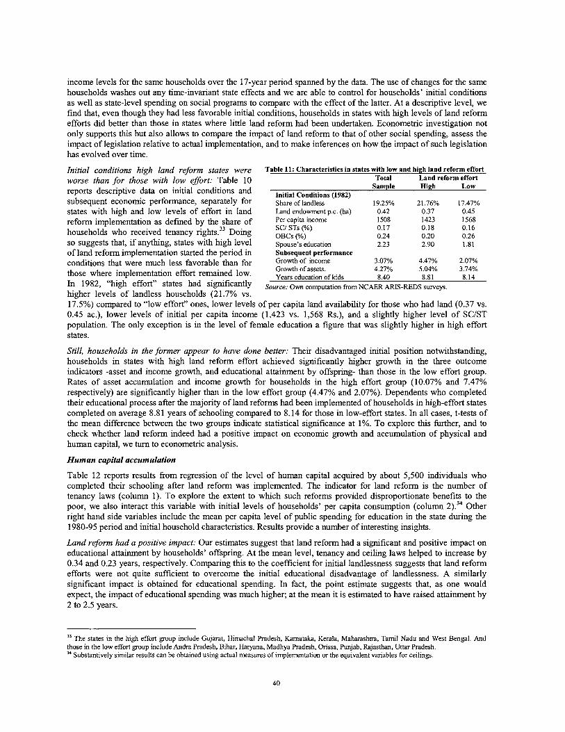
income levels for the same households over the 17-year period spanned by the data. The use of changes for the same households washes out any time-invariant state effects and we are able to control for households' initial conditions as well as state-level spending on social programs to compare with the effect of the latter. At a descriptive level, we find that, even though they had less favorable initial conditions, households in states with high levels of land reform efforts did better than those in states where little land reform had been undertaken. Econometric investigation not only supports this but also allows to compare the impact of land reform to that of other social spending, assess the impact of legislation relative to actual implementation, and to make inferences on how the impact of such legislation has evolved over time.
Initial conditions high land reform states were worse than for those with low efort: Table 10 reports descriptive data on initial conditions and subsequent economic performance, separately for states with high and low levels of effort in land reform implementation as defined by the share of households who received tenancy rights.33 Doing so suggests that, if anyhng, states with high level of land reform implementation started the period in conditions that were much less favorable than for those where implementation effort remained low. In 1982, "high effort" states had significantly higher levels of landless households (2 1.7% vs.
Table 11: Characteristics in states with low and high land reform effort Total Land reform effort
Sample High Low Initial Conditions (1982) . , Share of landless Land endowment p.c. (ha) Per capita income SCI STs (%) OBCs (%) Spouse's education Subsequent performance Growth of income Growth of assets. Years education of kids 8.40 8.81 8.14
Source: Own computation from NCAER ARIS-REDS surveys.
17.5%) compared to "low effort" ones, lower levels of per capita land availability for those who had land (0.37 vs. 0.45 ac.), lower levels of initial per capita income (1,423 vs. 1,568 Rs.), and a slightly higher level of SCIST population. The only exception is in the level of female education a figure that was slightly higher in high effort states.
Still, households in the former appear to have done better: Their disadvantaged initial position notwithstanding, households in states with high land reform effort achieved significantly higher growth in the three outcome indicators -asset and income growth, and educational attainment by offspring- than those in the low effort group. Rates of asset accumulation and income growth for households in the hlgh effort group (10.07% and 7.47% respectively) are significantly hgher than in the low effort group (4.47% and 2.07%). Dependents who completed their educational process after the majority of land reforms had been implemented of households in high-effort states completed on average 8.81 years of schooling compared to 8.14 for those in low-effort states. In all cases, t-tests of the mean difference between the two groups indicate statistical significance at 1%. To explore this further, and to check whether land reform indeed had a positive impact on economic growth and accumulation of physical and human capital, we turn to econometric analysis.
Human capital accumulation
Table 12 reports results from regression of the level of human capital acquired by about 5,500 individuals who completed their schooling after land reform was implemented. The indicator for land reform is the number of tenancy laws (column 1). To explore the extent to which such reforms provided disproportionate benefits to the poor, we also interact this variable with initial levels of households' per capita consumption (column 2).34 Other right hand side variables include the mean per capita level of public spending for education in the state during the 1980-95 period and initial household characteristics. Results provide a number of interesting insights.
Land refonn had a positive impact: Our estimates suggest that land reform had a significant and positive impact on educational attainment by households' offspring. At the mean level, tenancy and ceiling laws helped to increase by 0.34 and 0.23 years, respectively. Comparing this to the coefficient for initial landlessness suggests that land reform efforts were not quite sufficient to overcome the initial educational disadvantage of landlessness. A similarly significant impact is obtained for educational spending. In fact, the point estimate suggests that, as one would expect, the impact of educational spending was much higher; at the mean it is estimated to have raised attainment by 2 to 2.5 years.
" The states in the high effort group include Gujarat, Himachal Pradesh, Kamataka, Kerala, Maharashtra, Tamil Nadu and West Bengal. And those in the low effort group include Andra Pradesh, Bihar, Haryana, Madhya Pradesh, Orissa, Punjab, Rajasthan, Uttar Pradesh. 34 Substantively similar results can be obtained using actual measures of implementation or the equivalent variables for ceilings.
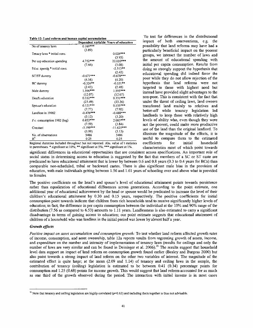
Table 12: Land reform and human capital accumulation To test for differences in the distributional Dependent variable: Years of education impact e.g. the
No of tenancy laws 0.169*** possibility that land reforms may have had a (3.89)
Tenacy laws * initial cons.
Per cap education spending 4.752*** (7.66)
Educ. spendg * initial cons.
SCIST dummy
BC dummy
Male dummy
Head's education
Spouse's education 0.151*** 0.155*** (7.77) (7.92)
Landless in 19982 -0.476*** -0.488*** (3.12) (3.20)
P.c. consumption 1982 (log) 0.853*** 2.083*** (7.59) (3.84)
Constant -3.199*** -1 1.625*** (3.99) (3.13)
No. of observations 5486 5486 R~ 0.25 0.25
Regional dummies included throughout but not reported. Abs. value o f t statistics in parentheses. * significant at 10%; ** significant at 5%; *** significant at 1%.
particularly beneficial impact on the poorest groups, we interact the number of laws and the amount of educational spending with initial per capita consumption. Results from doing so strongly support the hypothesis that educational spending did indeed favor the poor while they do not allow rejection of the hypothesis that land reforms were not targeted to those with highest need but instead have provided slight advantages to the non-poor. This is consistent with the fact that under the threat of ceiling laws, land owners transferred land mainly to relatives and better-off while tenancy legislation led landlords to keep those with relatively high levels of ability who, even though they were not the poorest, could make more productive use of the land than the original landlord. To illustrate the magnitude of the effects, it is useful to compare them to the estimated coefficients for initial household characteristics most of which point towards
significant differences in educational opportunities that are consistent across specifications. An important role of social status in determining access to education is suggested by the fact that members of a SC or ST caste are predicated to have educational attainment that is lower by between 0.6 and 0.8 years (0.3 to 0.4 years for BCs) than comparable non-scheduled, tribal or backward castes. There is also significant male bias in the provision of education, with male individuals getting between 1.56 and 1.61 years of schooling over and above what is provided to females
The positive coefficients on the head's and spouse's level of educational attainment points towards persistence rather than equalization of educational differences across generations. According to the point estimate, one additional year of educational achievement by the head or spouse would be predicated to increase the level of their children's educational attainment by 0.30 and 0.15 years, respectively. The positive coefficients for initial consumption point towards indicate that children from rich households tend to receive significantly hgher levels of education; in fact, the difference in per capita consumption between the individual at the 10% and 90% range of the distribution (7.56 as compared to 6.53) amounts to 1.1 1 years. Landlessness is also estimated to cany a significant disadvantage in terms of gaining access to education; our point estimate suggests that educational attainment of children of a household who was landless in the initial period was lower by almost half a year.
Growth effects
Positive impact on asset accumulation and consumption growth: To test whether land reform affected growth rates of income, consumption, and asset ownership, table 12a reports results from regressing growth of assets, income, and expenditure on the number and intensity of implementation of tenancy laws (results for ceilings and only the number of laws are very similar and can be found in Deininger et al. 2006) .~~ The results suggest that household level data support an impact of land reform on consumption growth found earlier (Besley and Burgess 2000) but also point towards a strong impact of land reform on the other two variables of interest. The magnitude of the estimated effect is quite large; at the mean (2.09 and 1.14) of tenancy and ceiling laws in the sample, the contribution of tenancy (ceiling) legislation is estimated to be between 0.41 (0.34) percentage points for consumption and 1.25 (0.68) points for income growth. T h ~ s would suggest that land reform accounted for as much as one k r d of the growth observed during the period. The interaction with initial income is in most cases
'' Note that tenancy and ceiling legislation are highly correlated (p=0.63) and including them together is thus not advisable.
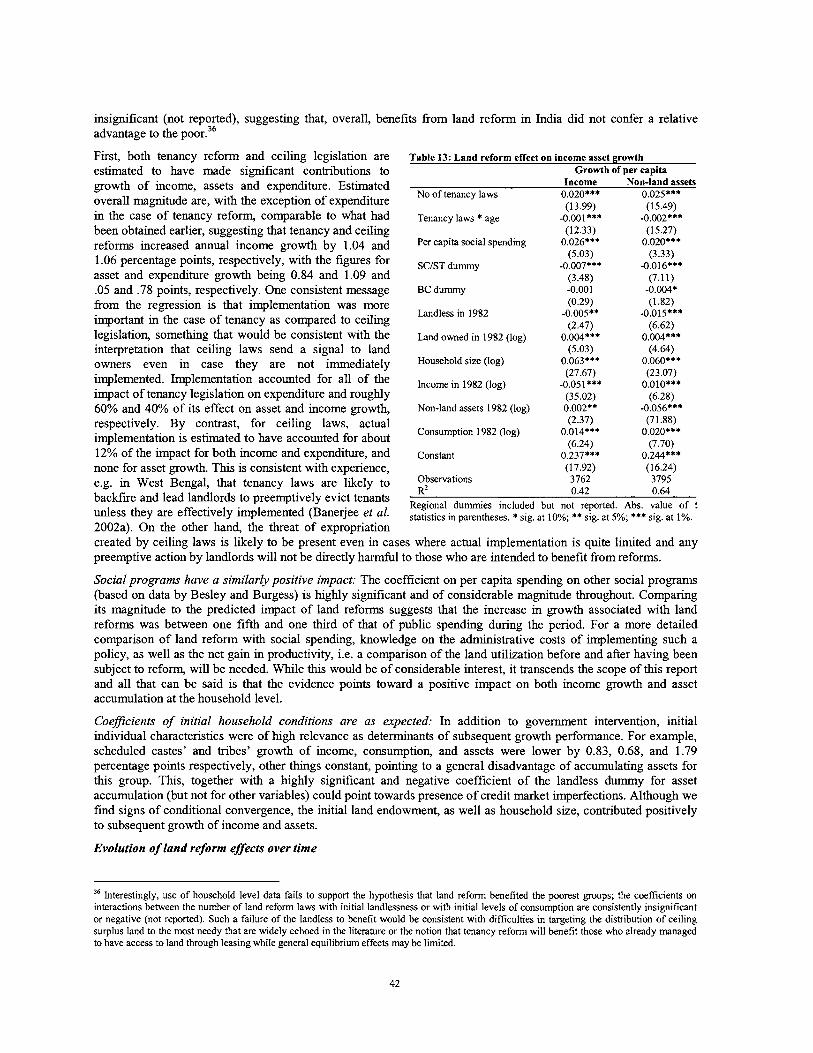
insignificant (not reported), suggesting that, overall, benefits fiom land reform in India did not confer a relative advantage to the poor.36
First, both tenancy reform and ceiling legislation are estimated to have made significant contributions to growth of income, assets and expenditure. Estimated overall magnitude are, with the exception of expenditure in the case of tenancy reform, comparable to what had been obtained earlier, suggesting that tenancy and ceiling reforms increased annual income growth by 1.04 and 1.06 percentage points, respectively, with the figures for asset and expenditure growth being 0.84 and 1.09 and .05 and .78 points, respectively. One consistent message fiom the regression is that implementation was more important in the case of tenancy as compared to ceiling legislation, something that would be consistent with the interpretation that ceiling laws send a signal to land owners even in case they are not immediately implemented. Implementation accounted for all of the impact of tenancy legislation on expenditure and roughly 60% and 40% of its effect on asset and income growth, respectively. By contrast, for ceiling laws, actual implementation is estimated to have accounted for about 12% of the impact for both income and expenditure, and none for asset growth. T h s is consistent with experience, e.g. in West Bengal, that tenancy laws are likely to backfire and lead landlords to preemptively evict tenants unless they are effectively implemented (Banerjee et al. 2002a). On the other hand, the threat of expropriation
Table 13: Land reform effect on income asset growth Growth of per capita
Income on-iand assets No of tenancy laws 0.020*** 0.025***
(13.99) (1 5.49) Tenancy laws * age -0.001*** -0.002***
(12.33) (15.27) Per capita social spending 0.026*** 0.020***
(5.03) (3.33) SCIST dummy -0.007*** -0.016***
(3.48) (7.11) BC dummy -0.001 -0.004*
(0.29) (1 32) Landless in 1982 -0.005** -0.015***
(2.47) (6.62) Land owned in 1982 (log) 0.004*** 0.004***
(5.03) (4.64) Household size (log) 0.063*** 0.060***
(27.67) (23.07) Income in 1982 (log) -0.051 *** O.OlO***
(35.02) (6.28) Non-land assets 1982 (log) 0.002** -0.056***
(2.37) (71.88) Consumption 1982 (log) 0.014*** 0.020***
(6.24) (7.70) Constant 0.237*** 0.244***
(17.92) (16.24) Observations 3762 3795 R~ 0.42 0.64
Regional dummies included but not reported. Abs. value of t statistics in parentheses. * sig. at 10%; ** sig. at 5%; *** sig. at 1%.
created by ceiling laws is likely to be present even in cases where actual implementation is quite limited and any preemptive action by landlords will not be directly harmful to those who are intended to benefit fiom reforms.
Social programs have a similarly positive impact: The coefficient on per capita spending on other social programs (based on data by Besley and Burgess) is highly significant and of considerable magnitude throughout. Comparing its magnitude to the predicted impact of land reforms suggests that the increase in growth associated with land reforms was between one fifth and one third of that of public spending during the period. For a more detailed comparison of land reform with social spending, knowledge on the administrative costs of implementing such a policy, as well as the net gain in productivity, i.e. a comparison of the land utilization before and after having been subject to reform, will be needed. While thls would be of considerable interest, it transcends the scope of this report and all that can be said is that the evidence points toward a positive impact on both income growth and asset accumulation at the household level.
Coeflcients of initial household conditions are as expected: In addition to govenunent intervention, initial individual characteristics were of high relevance as determinants of subsequent growth performance. For example, scheduled castes' and tribes' growth of income, consumption, and assets were lower by 0.83, 0.68, and 1.79 percentage points respectively, other things constant, pointing to a general disadvantage of accumulating assets for this group. Thls, together with a highly significant and negative coefficient of the landless dummy for asset accumulation (but not for other variables) could point towards presence of credit market imperfections. Although we find signs of conditional convergence, the initial land endowment, as well as household size, contributed positively to subsequent growth of income and assets.
Evolution of land reform effects over time
'' Interestingly, use of household level data fails to support the hypothesis that land reform benefited the poorest groups; the coefficients on interactions between the number of land reform laws with initial landlessness or with initial levels of consumption are consistently insignificant or negative (not reported). Such a failure of the landless to benefit would be consistent with difficulties in targeting the distribution of ceiling surplus land to the most needy that are widely echoed in the literature or the notion that tenancy reform will benefit those who already managed to have access to land through leasing while general equilibrium effects may be limited.
Reform impact declines over time: As in most states the bulk of land reform implementation was undertaken shortly after the promulgation of the respective laws, it will be of interest to use our sample to assess whether the effectiveness of land reforms in bringing about growth and asset accumulation has changed over time. Table 13 reports results from estimating the above equations having the number of (tenancy) laws interacted with time. Doing so provides a number of insights. First, and consistent with earlier evidence, the number of laws is estimated to have a very significant and positive impact on income, and non-land asset growth. However, the interaction with mean age of the legislation is, however, significant and negative, pointing towards a tendency for the impact of such legislation to decline over time.37 The point estimate for the land reform measure increases significantly if we allow the effectiveness of land reform legislation to decline with age of the applicable legislation at a rate of 1.5% per annum, implying that the growth-effect of land reform will disappear between 25 to 30 years after it had been first promulgated, suggesting that it could become negative in the not too far fkture.
An intuitive explanation for the negative time effect from our regression is be that the positive impact of land reform legislation is contingent on actual implementation and distribution of land. Given that the laws have by now become largely ineffective in distributing any further land, it should not be too surprising to find that the direct impact from having these laws on the books will be rather limited. While the indirect impact of such legislation could go either way, it is likely to be negative because indirect benefits, e.g. through increases in wage rates, are likely to be linked to implementation while restrictions on beneficiaries' ability to use the land they received and on the willingness of landlords to supply land to the market through voluntary land transactions will have an impact even without any land being transferred. The magnitude of potentially negative supply effects could actually be quite large, implying that this effect could over time actually come to outweigh the positive impacts of land reform.
The negative coefficient is consistent with the experience from other countries in a number of respects. The most effective land reforms, in particular those in Japan, Korea, and Taiwan, transferred assets during a relatively short period of time, after which markets, were allowed to operate, at least within broad limits. By comparison, processes of land reform that were drawn out for a long time may have had counterintuitive effects. For example, in Brazil, labor and land reform policies instituted in the 1960s have contributed to tenant eviction and large-scale subsidy- dependent agricultural mechanization that substituted capital for labor, giving rise to a highly concentrated pattern of production (Binswanger et al. 1995). This has reached a point where de-regulation of land rental and rural labor markets are seen as key obstacles to achieving a smaller-scale production structure that can in time (and with appropriate policies such as credit for land purchase) also help to address the problem of latfundismo (Rezende 2005). Similarly, in the Philippines, a long drawn-out process of land reforms that entailed a very low limit on operational land holding, together with prohibitions on land leasing is found to have negatively affected land lease as well as rural credit markets, thus severely reducing private investment in rural areas up to the point where it has been accused of trapping many households in rural areas in poverty not only because of investment disincentives but also because of the inability of beneficiaries to increase their holdings even through rental (Fabella 2003).
4. Other options to increase land ownership and access by the poor
The above results suggest that providing land access to the poor can have a significant and very positive impact, thereby vindicating the emphasis on redistributing land in post-Independence India. They also support the notion that land has a broader social and cultural relevance. At the same time, they imply that the legal mechanisms that have been used to redistribute land earlier are no longer very effective and that their continued maintenance may have to be re-thought. This suggests that there is scope to explore the potential of other mechanisms to make land available to the poor. In fact, a number of states have recently started to initiate programs that aim to go beyond the traditional land reform paradigm in a number of ways, namely to (i) make legal assistance available to the poor to help them overcome the shortcomings of past land reform legislation; (ii) provide grants or loans that allow the poor to acquire small quantities of land, normally in a group, through purchase in the market or through devolution of state land; (iii) increase women's inheritance rights and disseminating recent legal changes so as to allow effective exercise of these rights; (iv) give recognition andlor full title to occupants of land without proper documentation; and (v) empower communities to demand more effective delivery of services from local revenue departments.
Legal assistance: Although detailed figures are hard to come by, with some estimating that land-related conflicts account for two thuds of all pending court cases, the large amount of land related litigation in India is proverbial. While part of these are related to land ceiling legislation, which has nearly 20 lakh acres tied up in dispute, others, especially at the local level, are more mundane but never get resolved because the courts are overloaded, options to
" Note that very similar results are obtained if ceiling legislation is used instead (Deininger et al. 2006).
43
settle out of are either not known or not available, or where court orders are not being implemented because those affected, often tribals, are ignorant about the enforcement mechanisms available. A number of states, including GJ, KA, and AP, have recently embarked on programs to make legal assistance available in a number of forms such as (i) systematic identification and pursuit of pending land cases through law students; (ii) courses to familiarize members of self-help or other community groups with key land-related legislation; and (iii) conduct of a systematic inventory of pending land issues to identify and subsequently resolve all land-related problems in a locality. In tribal areas, the latter will include not only conflicts between individuals but also those relating to lack of regularization and alienation of tribal lands, forest boundary issues, and scrutiny of cases under land transfer regulations that have not been enforced. These efforts have elicited a very positive response, suggesting that similar approaches could be of use in cases of systematic field survey and clarification of rights or, if combined with some incentive compatible mechanism to encourage the parties to strike a deal, in disposing of pending cases for a wide range of issues.
Regularization of government land: There is little doubt about the potential to regularize occupation on government land, either by giving outright ownership or through long-term and secure leases, to enhance land access by the poor. The largest amount of lands is without doubt concentrated in the country's more marginal areas and tackling them would be a key priority. In fact, in many cases of marginal lands, the state continues to be the largest land owner and focusing policy on land alienation between private parties without the possibility of giving the people cultivating these lands the option of acquiring more secure use or ownership rights is likely to have only a limited impact. At the same time, considerable amounts of land that have long been occupied but for which documentation is either not available or outdated often remain in long settled areas. For example, in AP, conduct of a systematic inventory in a number of districts during the 2003-5 period provided the information subsequently allowing the state to distribute a total of 3,25 lakh acres to 2.4 lakh beneficiary households (Raju et al. 2006) and it is likely that a systematic review will lead to similar results in other states.
Landpurchase: One of the key justifications for land reform has been the insight that, to achleve sustainable poverty reduction, government programs should not only provide temporary relief but transfer or help in the acquisition of assets. Agricultural land is not only an asset that can generate self-employment, utilize unused family labor in the most productive manner to produce for self-consumption and marketable surplus in a way that utilizes the skills of the poor, and can be transferred if the family wants to shift out of agriculture. However, in most states neither lowering of the ceiling nor a significant increase in the amount of ceiling land that can be made available is an option. To the extent that distributing state lands is not an option, acquisition of land through purchase by the poor, often in a group, may be considered.
, Some states, including West Bengal and Karnataka, have decided to improve upon existing rural housing schemes by acquiring land for subsequent distribution to the poor in small "homestead and garden" plots. The rationale for this is to provide households with an economically valuable asset that gives them an opportunity to generate surplus and improve their economic condition. Sample budgets from West Bengal suggest that a 3 decimal plot that includes a mall pond would allow households to implement an intensive rotation of crops that could keep them occupied for 150 days a year and, with an expected annual net income of Rs. 16,800, provide a return to labor in excess of Rs. 100 per day. Although initial expenses are significant, the ability to obtain a return of this magnitude could well make such a scheme an economically viable proposition.
The Government of Andhra Pradesh, with support from the World Bank, has recently launched a similar scheme that aims to allow the poorest agricultural wage laborers in rural areas to acquire up to 1 acre of productive agricultural land based on direct negotiation with the landlord, with SHGs providing loan-financing and in many cases also significant technical assistance and supervision. While training requirements are high and further empirical evidence on the incomes obtained and the economic feasibility of the scheme is desirable, it appears that the program, which is integrated into a wider effort to clarify land issues at the local level, generates significant and positive external effects. For example, in project areas even those who are unable to enter the land purchase program are reported to be in a much better position to acquire land through leasing and thereby improve their livelihood. While descriptive evidence from AP suggests that in many cases the poor indicate to prefer land to a liquid asset (livestock) even if the latter is of higher value, the cost and benefits of such a step will need to be assessed carefully and compared to those of alternative options of transferring (non-land) assets to the poor.
Giving clear titles: One can argue that the government's strong emphasis on numerical targets for redistributive land reform has diverted attention away from whether beneficiaries are able to appropriately utilize lands transferred to them under a variety of schemes or that they actually have appropriate title to it that would allow them to do so.
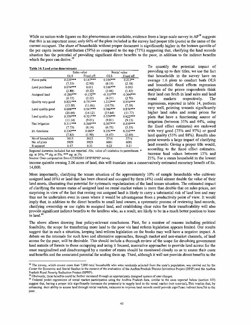
While no nation-wide figures on this phenomenon are available, evidence fiom a large-scale survey in AP~' suggests that this is an important issue; only 66% of the plots included in the survey had proper title (patta) in the name of the current occupant. The share of households without proper document is significantly higher in the bottom quintile of the per capita income distribution (59%) as compared to the top (71%) suggesting that, clarifying the land records situation has the potential of providing significant direct benefits to the poor, in addition to the indirect benefits which the poor can derive.39
Table 14: Land price determinants To quantify the potential impact of Sales value Rental value providing up to date titles, we use the fact
OLS Fixed eff. OLS Fixed eff. Pucca patta 0.235*** 0.147*** 0.354*** 0.213**
(7.53) (2.90) (6.19) (2.18) Land purchased 0.074*** 0.01 1 0.166*** 0.093
(2.88) (0.32) (3.46) (1.43) Assimed land -0.280*** -0.132** -0.333*** -0.304*** -
(6.33) Quality very good 0.821 ***
(13.58) Land quality good 0.688***
(20.64) Land quality fair 0.359***
(1 1.14) Has irrigation 0.311***
(7.73) In. functions 0.330***
that households in the survey have on average 1.6 plots to conduct both OLS and household fixed effects regression analysis of the prices respondents think their land can fetch in land sales and land rental markets respectively. The regressions, reported in table 14, perform very well, pointing towards significantly higher land sales and rental prices for plots that have a hnctioning source of irrigation (between 35% and 44%, using the fixed effect estimates) are endowed with very good (75% and 97%) or good
(7.83) (1.90) (4.47) (2.69) land (55% and 88%). ~esults-also No of households 3615 3615 3716 3716
5929 5929 608 1 6081 point towards a large impact of clarifying
No. of plots R-squared 0.47 0.3 1 0.23 0.21 land records: Giving a proper title would,
Regional dummies included but not reported. Abs. value o f t statistics in parentheses. * according the fixed effect estimates, sig. at 10%; ** sig. at 5%; *** sig. at 1%. lncrease land values between 15% and Source: Own computation from CESS2003 DPIPIRPRP survey 21%. For a mean household in the lowest income quintile owning 2.06 acres of land, this will translate into a conservatively estimated monetary benefit of Rs. 14,000.
More importantly, clarifying the tenure situation of the approximately 10% of sample households who cultivate assigned land (6%) or land that has been cleared and occupied by them (4%) could almost double the value of their land assets, illustrating that potential for systematic regularization of the land tenure situation. The estimated impact of clarifying the tenure status of assigned land on rental market values is more than double that on sales prices, not surprising in view of the fact that renting out assigned land is likely to cany a substantial risk of land loss and may thus not be undertaken even in cases where it would be advantageous fiom a productivity point of view. It would imply that, in addition to the direct benefits to small land owners, a systematic process of reviewing land records, clarifying ownership or use rights to assigned land, and establishing clear rules for their transferability will also provide significant indirect benefits to the landless who, as a result, are likely to be in a much better position to lease in land.40
The above allows drawing four policy-relevant conclusions. First, for a number of reasons including political feasibility, the scope for transferring more land to the poor via land reform legislation appears limited. Our results suggest that in such a situation, keeping land reform legislation on the books may well have a negative impact. A debate on the rationale for such laws and alternative approaches, through market and non-market channels, of land access for the poor, will be desirable. This should include a thorough review of the scope for devolving government land outside of forests to those occupying and using it Second, innovative approaches to provide land access for the most marginalized and disadvantaged by a number of states should be monitored closely so as to assess their costs and benefits and the associated potential for scaling them up. Third, although it will not provide direct benefits to the
38 The survey, which covers more than 7,000 rural households who were randomly selected from the state's population, was carried out by the Center for Economic and Social Studies in the context of the evaluation of the Andhra Pradesh District Initiatives Project (DPIP) and the Andhra Pradesh Rural Poverty Reduction Project (RPRP). 39 Obviously, these benefits could be further increased through an appropriately designed system of user charges. 40 Ordered probit regressions of rental market participation using the Andhra Pradesh data, similar to the ones reported below (section VII) suggest that, having a proper title significantly increases the propensity to supply land to the rental market (not reported),.This implies that, by enhancing their ability to access land through rental markets, measures to improve land records could provide significant indirect benefits to the poor.
landless, giving land users clear titles, ideally by systematically clarifying land records and determining the status of assigned lands, can greatly increase the asset endowment of the predominantly poor households who do not have clear documentation, presumably because they have not been able to afford the transaction cost of dealing with the complex land a h s t r a t i o n system or due to resistance to recognizing their tenure of the land they have been assigned at the local level. Finally, the much greater security of women's inheritance rights afforded by the recent amendment to the Hindu Succession Act is a huge step forward that provides a tremendous opportunity to empower rural women in India. Evidence fiom other countries suggests that dissemination of innovative existing legislation is a very cost-effective way to increase awareness of these provisions which in turn has a significant impact on household behavior (Deininger et al. 2006). As women will be able to exercise their rights only if they are aware of them, dissemination efforts should be high on the list of priorities, ideally as a first step towards a more comprehensive and systematic review of land records and land ownership by the poor.
Box 7: The 2005 Hindu Succession Act Amendment - a far-reaching change
The 2005 Hindu Succession Act Amendment (HSAA) addresses a number of issues which in the past had negatively affected gender equality. First, it is clarified that all agricultural land is to be inherited according to the HAS, annulling earlier regulations in a number of states -e.g. UP, Delhi, HY, PJ, and JK which together are home to more than one sixth of India's population that gave primacy to male descendants. Second, sons and daughters are now both independent coparceners with shares of the property that can not be willed away. In particular, daughters have rights equal to sons in residing and obtaining a share of the parental dwelling house. Finally, widows of a pre-deceased son or of a predeceased son of a predeceased son or a brother can get an equal share of the land and non-land inheritance even in cases where they have remamed, something that had not been possible earlier.
The HSAA demonstrates not only that policy change is possible even on a contentious topic but also that such change can affect a huge number of individuals and with far-reaching multiplier effects. Even where the income derived from the land in question is small, a woman's ability to access (or the prospect of being able to access) her own regular stream of income will affect her bargaining power within the household and the way in which resources in the household are spent. Although no analysis of the impact of the HSAA is available, evidence from India points towards significantly lower rates (18% vs. 48%) of intra-marital violence against women who own property as compared to landless ones (Panda and Aganval2005) and having a greater share of household income going to women has been linked to higher spending on children's education and health (Quisumbing and Maluccio 2003). The implications could be far-reaching, and possibly affect not only women's ability to start out enterprises of their own but also the magnitude of dowry which has is traditionally viewed as a substitute for a woman's share in her parental property. A more detailed examination of these benefits and the extent to which they depend on dissemination would be highly desirable.
Strengthening women's rights: One issue, the importance of which has often been overlooked in the past relates to land tenure security, in particular inheritance rights, for women even though the negative impacts of limitations on Indian women's ability to inherit land have long been recognized (Agarwal 1994). The 2005 amendment to the Hindu succession Act (see box 7) demonstrates that policy change even on such a controversial issue is feasible and the challenge now is to disseminate these rules and ensure their implementation. If those affected are aware of legal provisions and confident that they will be implemented, the implications of this change, which is comparable to reductions in stamp duty if land is registered in women's name in a number of states, are likely to be far-reaching. Possible impacts would include to greater empowerment and bargaining power of women within the household but could also include an increased number of non-agricultural enterprise startups by them. Ensuring that dissemination of these changes is adequate to make women aware of their rights is a high priority.
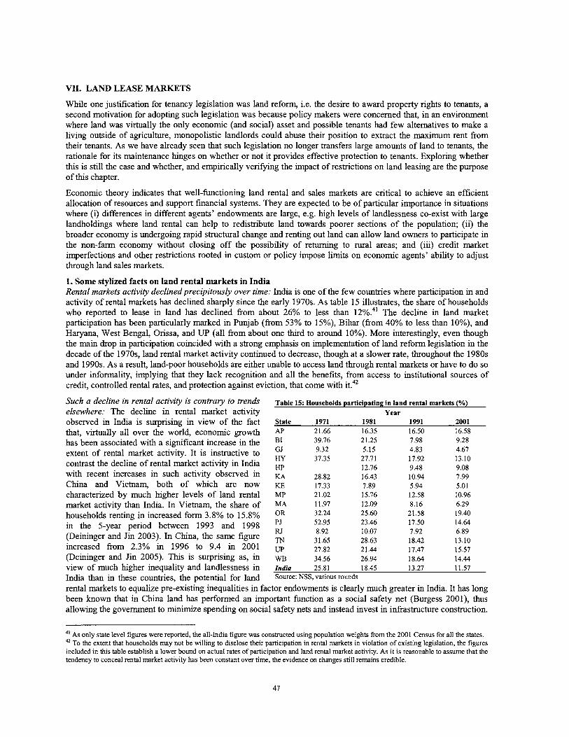
VII. LAND LEASE MARKETS
While one justification for tenancy legislation was land reform, i.e. the desire to award property rights to tenants, a second motivation for adopting such legislation was because policy makers were concerned that, in an environment where land was virtually the only economic (and social) asset and possible tenants had few alternatives to make a living outside of agriculture, monopolistic landlords could abuse their position to extract the maximum rent from their tenants. As we have already seen that such legislation no longer transfers large amounts of land to tenants, the rationale for its maintenance hinges on whether or not it provides effective protection to tenants. Exploring whether this is still the case and whether, and empirically verifying the impact of restrictions on land leasing are the purpose of this chapter.
Economic theory indicates that well-functioning land rental and sales markets are critical to achieve an efficient allocation of resources and support financial systems. They are expected to be of particular importance in situations where (i) differences in different agents' endowments are large, e.g. high levels of landlessness co-exist with large landholdings where land rental can help to redistribute land towards poorer sections of the population; (ii) the broader economy is undergoing rapid structural change and renting out land can allow land owners to participate in the non-farm economy without closing off the possibility of returning to rural areas; and (iii) credit market imperfections and other restrictions rooted in custom or policy impose limits on economic agents' ability to adjust through land sales markets.
1. Some stylized facts on land rental markets in India Rental markets activity declinedprecipitously over time: India is one of the few countries where participation in and activity of rental markets has declined sharply since the early 1970s. As table 15 illustrates, the share of households who reported to lease in land has declined from about 26% to less than 1 2 % ~ ~ ' The decline in land market participation has been particularly marked in Punjab (from 53% to 15%), Bihar (fiom 40% to less than lo%), and Haryana, West Bengal, Orissa, and UP (all from about one thud to around 10%). More interestingly, even though the main drop in participation coincided with a strong emphasis on implementation of land reform legislation in the decade of the 1970s, land rental market activity continued to decrease, though at a slower rate, throughout the 1980s and 1990s. As a result, land-poor households are either unable to access land through rental markets or have to do so under informality, implying that they lack recognition and all the benefits, from access to institutional sources of credit, controlled rental rates, and protection against eviction, that come with it.42
Such a decline in rental activity is COntrU?Y to trends Table 15: Households participating in land rental markets (%) elsewhere: The decline in rental market activity Year observed in India is surprising in view of the fact State 1971 1981 1991 2001 that, virtually all over the world, economic growth AP 21.66 16.35 16.50 16.58 has been associated with a significant increase in the B1 39.76 21.25 7.98 9.28
GJ extent of rental market activity. It is instructive to Hy
9.32 5.15 4.83 4.67 37.35 27.71 17.92 13.10 contrast the decline of rental market activity in India HP 12.76 9.48 9.08
with recent increases in such activity observed in KA 28.82 16.43 10.94 7.99 China and Vietnam, both of which are now KE 17.33 7.89 5.94 5.01 characterized by much higher levels of land rental MP 2 1.02 15.76 12.58 10.96 market activity than India. In Vietnam, the share of MA 11.97 12.09 8.16 6.29 households renting in increased form 3.8% to 15.8% OR 32.24 25.60 21.58 19.40 in the 5-year period between 1993 and 1998 52.95 23.46 17.50 14.64
8.92 10.07 7.92 6.89 (Deininger and Jin 2003). In China, the same figure TN 31.65 28.63 18.42 13.10 increased from 2.3% in 1996 to 9.4 in 2001 Up 27.82 21.44 17.47 15.57 (Deininger and Jin 2005). This is surprising as, in w~ 34.56 26.94 18.64 14.44 view of much higher inequality and landlessness in India 25.81 18.45 13.27 11.57 India than in these countries, the potential for land Source: NSS, various rounds
rental markets to equalize pre-existing inequalities in factor endowments is clearly much greater in India. It has long been known that in China land has performed an important hnction as a social safety net (Burgess 2001), thus allowing the government to minimize spending on social safety nets and instead invest in infrastructure construction.
4' As only state level figures were reported, the all-India figure was constructed using population weights fiom the 2001 Census for all the states. 42 TO the extent that households may not be willing to disclose their participation in rental markets in violation of existing legislation, the figures included in this table establish a lower bound on actual rates of participation and land rental market activity. As it is reasonable to assume that the tendency to conceal rental market activity has been constant over time, the evidence on changes still remains credible.
In addition, high levels of rental market activity in China played a key role in facilitating growth of the rural non- farm economy, allowing those who do not have a comparative advantage in agriculture to rent out their land to those who lack alternative opportunities (Deininger 2003).
The number of households aflected is large: Although reported participation in India's rental markets has declined over time and is now low by international standards, the number of people who access land through rental markets every year is still enormous. Even according to the official figures, which are likely to suffer from considerable underreporting, the number of those who have received land through land reform throughout the country's independent history. Tlus has a number of implications, namely (i) in view of the discrepancy between actual and observed rental market activity, especially in view of what is observed in other countries, a large number of participants are at present either driven into informal rental transactions or completely rationed out of the rental market; (ii) even modest changes in the policy environment for land rental will have far-reaching impacts on the livelihoods of a large number of households; and (iii) allowing those who rent land informally to be officially recognized is likely to have a significant and positive impact on their livelihood. A more detailed analysis of rental markets is thus clearly warranted.
2. Efficiency and equity impact of land rental: Conceptual issues and international evidence
Endowments and ability as basic determinants of market participation: To understand the rationale for land rental market functioning, let households be endowed with fixed amounts of labor and land but different levels of agricultural ability. As it is costly to supervise hired labor in agricultural production (Binswanger et al. 1995), it will be more efficient for households to allocate their labor between self employment in fanning on their own land and off-farm employment at the going wage rather than cultivating using wage labor. It can then be shown that it will be those with higher levels of ability and lower per capita endowments of land who will tend to rent in land which they will use more efficiently than those from whom they are renting. This implies that rental markets will transfer land to "land-poor but efficient" producers and that it will increase overall productivity in the economy (Deininger and Jin 2005). Also, any increases of the wage for off-farm employment will increase the supply of land to the rental market and thus the amount of land transacted in rental markets. This will result in a reduction of the rental rate and, in a risk-free environment this will make everybody better off.
The role of transaction cost and policy: Land rental market participation is not costless. Those interested in participating need to acquire information on market conditions while actual participation requires the screening of possible applications, negotiation, and enforcement of payments. The existence of such transaction costs will drive a wedge between the amount of resources expended by renters and what is received by landlords. This will expand the range of producers who remain in autarky, thereby reducing both the number of households able to gain access to land through rental, and the amount of land transacted through such markets. Anything that reduces these transaction costs will thus increase rental market participation, total output and productivity, and social welfare. Policies, such as the restrictions on rental imposed in India, will also increase the transaction costs of land market participation as, for example, they force market participants to spend resources on circumventing them or entering into informal agreements. They would therefore similarly negative impacts on social welfare.
Urban evidence worldwide demonstrates significant policy impacts: A number of studies analyzed the impacts of rent ceilings and other forms of policy restrictions that increase transaction costs of land rental in urban contexts. In these settings, rent control served as a textbook example for policies that can effectively transfer resources in the short term but will be associated with inefficiencies in the medium to long run (Amott 2003). The key reason is that, by fixing rents below their equilibrium level, rent controls reduce the supply of new housing or the maintenance of existing units by landlords who face an artificially reduced price. Rental restrictions would indeed transfer resources fiom landlords to sitting tenants when they are imposed but also make access to rental property for those who were not renting when the controls were imposed more difficult (Basu and Emerson 2000). With a constant or decreasing number of beneficiaries and an increasing number of new entrants who need to access to land through now distorted markets, the social cost of keeping land rental restrictions in place is expected to increase over time. In practical terms, this has led policy-makers in many urban areas of the world to realize that rent controls do not benefit the poor and that a more flexible approach will be needed mix (Arnott 1995).
But rental restrictions could be more significant in rural areas: Although empirical evidence from rural areas is more limited, a number of reasons would lead one to expect a larger and more significant negative impact of rental restrictions on the functioning of such markets than in urban settings. First, as owners of urban housing stock have less opportunities to revert to self-cultivation (or cultivation with wage labor) than rural land owners, the supply of housing to urban markets will be less elastic, and thus the negative supply response less pronounced, than in the case
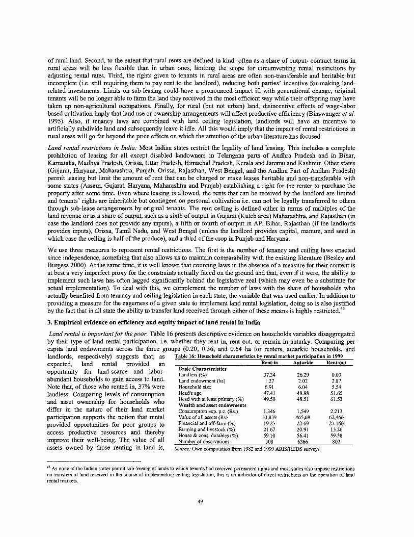
of rural land. Second, to the extent that rural rents are defined in kind -often as a share of output- contract terms in rural areas will be less flexible than in urban ones, limiting the scope for circumventing rental restrictions by adjusting rental rates. Third, the rights given to tenants in rural areas are often non-transferable and heritable but incomplete (i.e. still requiring them to pay rent to the landlord), reducing both parties' incentive for making land- related investments. Limits on sub-leasing could have a pronounced impact if, with generational change, original tenants will be no longer able to farm the land they received in the most efficient way while their offspring may have taken up non-agricultural occupations. Finally, for rural (but not urban) land, disincentive effects of wage-labor based cultivation imply that land use or ownership arrangements will affect productive efficiency (Binswanger et al. 1995). Also, if tenancy laws are combined with land ceiling legislation, landlords will have an incentive to artificially subdivide land and subsequently leave it idle. All this would imply that the impact of rental restrictions in rural areas will go far beyond the price effects on which the attention of the urban literature has focused.
Land rental restrictions in India: Most Indian states restrict the legality of land leasing. This includes a complete prohibition of leasing for all except disabled landowners in Telangana parts of Andhra Pradesh and in Bihar, Kamataka, Madhya Pradesh, Orissa, Uttar Pradesh, Himachal Pradesh, Kerala and Jammu and Kashrnir. Other states (Gujarat, Haryana, Maharashtra, Punjab, Orissa, Rajasthan, West Bengal, and the Andhra Part of Andhra Pradesh) permit leasing but limit the amount of rent that can be charged or make leases heritable and non-transferable with some states (Assam, Gujarat, Haryana, Maharashtra and Punjab) establishing a right for the renter to purchase the property after some time. Even where leasing is allowed, the rents that can be received by the landlord are limited and tenants' rights are inheritable but contingent on personal cultivation i.e. can not be legally transferred to others through sub-lease arrangements by original tenants. The rent ceiling is defined either in tenns of multiples of the land revenue or as a share of output, such as a sixth of output in Gujarat (Kutch area) Maharashtra, and Rajasthan (in case the landlord does not provide any inputs), a fifth or fourth of output in AP, Bihar, Rajasthan (if the landlords provides inputs), Orissa, Tamil Nadu, and West Bengal (unless the landlord provides capital, manure, and seed in which case the ceiling is half of the produce), and a third of the crop in Punjab and Haryana.
We use three measures to represent rental restrictions. The first is the number of tenancy and ceiling laws enacted since independence, something that also allows us to maintain comparability with the existing literature (Besley and Burgess 2000). At the same time, it is well known that counting laws in the absence of a measure for their content is at best a very imperfect proxy for the constraints actually faced on the ground and that, even if it were, the ability to implement such laws has often lagged significantly behind the legislative zeal (which may even be a substitute for actual implementation). To deal with thls, we complement the number of laws with the share of households who actually benefited from tenancy and ceiling legislation in each state, the variable that was used earlier. In addition to providing a measure for the eagerness of a given state to implement land rental legislation, doing so is also justified by the fact that in all state the ability to transfer land received through either of these means is highly re~ t r i c ted .~~
3. Empirical evidence on efficiency and equity impact of land rental in India
Land rental is important for the poor. Table 16 presents descriptive evidence on households variables disaggregated by their type of land rental participation, i.e. whether they rent in, rent out, or remain in autarky. Comparing per capita land endowments across the three groups (0.20, 0.36, and 0.64 ha for renters, autarkic households, and landlords, respectively) suggests that, as Table 16: Household characteristics by rental market participation in 1999 . -
expected, laid rental provided an Rent-in Autarkic Rent-out opportunity for land-scarce and labor- ~ ~ ~ ~ ( " ~ t e r i s t i C s 37.34 26.29 0.00 abundant households to gain access to land. h n d endomat (ha) 1.27 2.02 2.87 Note that, of those who rented in, 37% were Household size 6.91 6.04 5.54 landless. Comparing levels of consumption Head's age 47.41 48.98 51.65
and asset ownership for households who ~~~l~~n",'~~~~,"~'~S 49.50 48.51 61.53
differ in the nature of their land market ~~~~~~~i~~ exD, o,c, (RS,) 1.346 1.549 2.213 uarticivation suuvorts the notion that rental value oiall asseis ~RS)' ' 33,839 465,68 62,466 . . provided opportunities for poor groups to and off-farm (%) 19.23 22.69 27.160
Farming and livestock (%) access productive resources and thereby House &cons, durables 21.67 20.91 13.26 59.10 56.41 59.58
improve their well-being. The value of all ~ ~ ~ b ~ ~ ~ f ~ + , ~ ~ ~ ~ ~ ~ i ~ ~ ~ 308 6366 802 assets owned by those renting in land is, SOUTC,: OW computation from 1982 and 1999 ARISIREDS surveys
43 AS none of the Indian states permit sub-leasing of lands to which tenants had received permanent rights and most states also impose restrictions on transfers of land received in the course of implementing ceiling legislation, this is an indicator of direct restrictions on the operation of land rental markets.
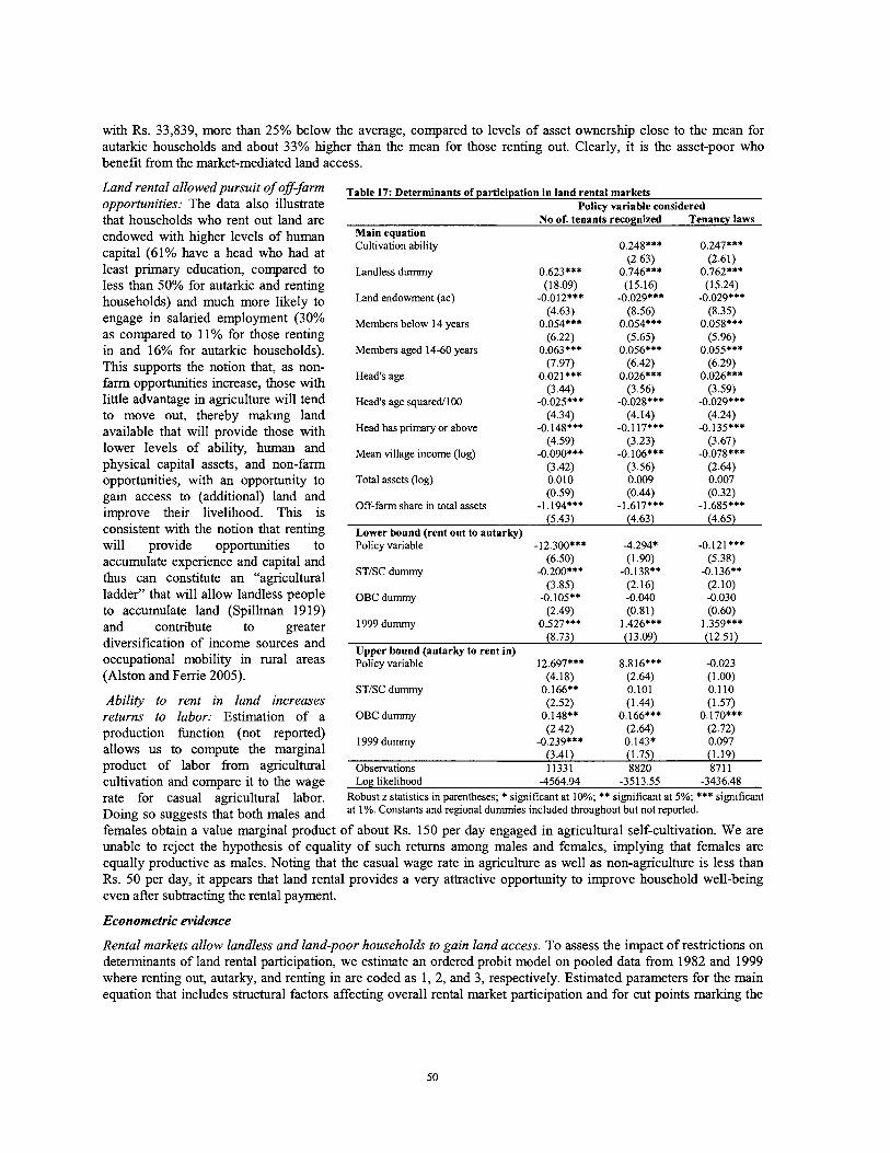
with Rs. 33,839, more than 25% below the average, compared to levels of asset ownership close to the mean for autarkic households and about 33% higher than the mean for those renting out. Clearly, it is the asset-poor who benefit from the market-mediated land access.
Land rental allowed pursuit of of-farm opportunities: The data also illustrate that households who rent out land are endowed with higher levels of human capital (61% have a head who had at least primary education, compared to less than 50% for autarkic and renting households) and much more likely to engage in salaried employment (30% as compared to 11% for those renting in and 16% for autarkic households).
Table 17: Determinants of participation in land rental markets Policy variable considered
No of. tenants recognized Tenancy laws Main equation Cultivation ability 0.248*** 0.247***
(2.63) (2.61) Landless dummy 0.623*** 0.746*** 0.762***
(1 8.09) (15.16) (15.24) Land endowment (ac) -0.012*** -0.029*** -0.029***
(4.63) (8.56) (8.35) Members below 14 years 0.054*** 0.054*** 0.058***
(6.22) (5.65) (5.96) Members aged 14-60 years 0.063*** 0.056*** 0.055***
This supports the notion that, as non- (7.97) (6.42) (6.29) Head's age 0.021*** 0.026*** 0.026*** farm opportunities increase, those with
(3.44) (3.56) (3.59) little advantage in agriculture will tend Head's age sauared/l@O -0.025*** -0.028*** -0.029*** - . to move out. theiebv makine land (4.34) (4.14) (4.24) available that 'will pro;ide thosYe with Head has primary Or above -0.148*** -0:117*** -0.135***
(4.59) (3.23) (3.67) lower levels of ability, human and Mean village income (log) -0.090*** -0.106*** -0.078*** physical capital assets, and non-farm (3.42) (3.56) (2.64) opportunities, with an opportunity to Total assets (log) 0.010 0.009 0.007 gain access to (additional) land and (0.59) (0.44 (0.32) improve their livelihood. This is Off-farm share in total assets -1.194*** -1.617*** -1.685***
5.43) (4.63) (4.65) consistent with the notion that renting L~~~~ bound irent out to
( - .
will provide opportunities to Policy variable -12.300*** -4.294* -0.121*** accumulate experience and capital and (6.50) (1.90) (5.38) thus can constitute an "agricultural STISC dummy -0.200*** -0.138** -0.136**
(3.85) (2.16) (2.10) ladder" that will allow landless people o ~ c dummy -0.105** -0.040 -0.030 to accumulate land (S~illman 19 19) (2.49) (0.81) (0.60) . . and contribute to greater 1999dummy 0.527';' 1.426*** 1.359*** diversification of income sources and Upper bound (autarky to rent in)
(8.73) (13.09) (12.51)
occupational mobility in rural areas policy variable 12.697*** 8.816*** -0.023 (Alston and Ferrie 2005). (4.18) (2.64) (1 .@O)
STISC dummy 0.166** 0.101 0.1 10 Ability to rent in land increases (2.52) (1.44) (1.57) returns to labor: Estimation of a OBCdummy 0.148** 0.166*** 0.170*** production function (not reported) (2.42) (2.64) (2.72)
1999 dummy -0.239*** 0.143* 0.097 allows us to compute the marginal (3.41) (1.75) (1.19) product of labor from agricultural Obse,ations 11331 8820 871 1 cultivation and compare it t o the wage Log likelihood -4564.94 -3513.55 -3436.48 rate for casual agricultural labor. Robust z statistics in parentheses; * significant at 10%; ** significant at 5%; *** significant
in^ so suggests that both males and at 1%. Constants and regional dummies included throughout but not reported.
females obtain a value marginal product of about Rs. 150 per day engaged in agricultural self-cultivation. We are unable to reject the hypothesis of equality of such returns among males and females, implying that females are equally productive as males. Noting that the casual wage rate in agriculture as well as non-agriculture is less than Rs. 50 per day, it appears that land rental provides a very attractive opportunity to improve household well-being even after subtracting the rental payment.
Econometric evidence
Rental markets allow landless and land-poor households to gain land access. To assess the impact of restrictions on determinants of land rental participation, we estimate an ordered probit model on pooled data from 1982 and 1999 where renting out, autarky, and renting in are coded as 1, 2, and 3, respectively. Estimated parameters for the main equation that includes structural factors affecting overall rental market participation and for cut points marking the
transition between renting out and autarky as well as autarky and renting in, respectively, are reported in table 17." Regressions support the descriptive evidence of rental markets opening up an important avenue for land access to the poor. Landless households are estimated to be significantly more likely to gain access to land through the rental market. Similarly, higher land endowments are estimated to increase households' propensity to supply land to the rental market while endowments with family labor, especially of members in the 14-60 year age group, increase the propensity to rent in land. This supports the notion that, by transferring land to those with higher endowments of family labor, markets will improve the scope for gainful employment of labor in rural areas. Fears about free operation of rental markets leading to 'reverse tenancy' that would push marginal farmers from the land, and give way to concentration of operational land holdings are thus unlikely to be justified:
Wealth barriers to rental market participation disappeared: Contrary to widespread belief which assumes that markets will favor the wealthy, the lack of significance of households' total asset ownership suggests that, consistent with descriptive statistics, land rental markets are not biased against the poor although the composition of households' asset portfolio does matter.
Land rental increases productivity of land use: To be able to identify the impact of rental markets on productivity, we estimate a stochastic production frontier (not reported) that provides a measure of agricultural ability for each household in the sample. This measure is then included in the regression and in all of the three specifications, the coefficient on our measure of agricultural ability is highly significant, suggesting that it is households with higher levels of ability who gain access to additional land through the rental market. This implies that rental markets can be expected to increase overall productivity of land use in the economy. 45
Land rental facilitates off-farm development: We also find that hgher levels of education, measured by whether the head has completed at least primary education, increase the propensity to supply land to rental market due to higher opportunity cost of labor for more educated individuals. Mean village income increases the tendency to rent out, implying that as, with overall development, the level of income increases, households will be more likely to move out of agriculture and supply their land to the rental market, thereby allowing those with higher levels of agricultural ability to increase their holdings and income levels, similar to what is happening in China. The hlghly significant coefficient on ability also supports our hypothesis of rental markets transferring land from less to more efficient producers, pointing to the potential for land transfers through rental to significantly enhance efficiency.
Rental restrictions reduced supply of land to the rental market: We find that policy measures not only reduced demand (as indicated by the upper bound equation) but also supply.46 This is in line with evidence suggesting that landlords will be less ready to rent out their land if regulations either imply that part or all of their property rights to land that is rented out may be lost or limit their ability to fieely negotiate the amount of rent to be paid. Thls result obtains irrespectively of the variable chosen to empirically represent policy. Comparing coefficients suggests that the number of laws passed had the least impact, followed by implementation of ceiling and tenancy legislation, consistent with the notion that ceilings pose less of a threat than tenancy laws which -in contrast to the former which is applicable only to large owners- apply to all market participants irrespectively of the size of their holding and because enforcement of the latter is less politically controversial and administratively complex than that of ceilings. We also note that, even after adjusting for the factors discussed earlier, scheduled castes and tribes as well as other backward castes are less likely to rent out land than others, a finding that may be due to lower levels of social capital and thus either less opportunity to find partners in rental markets or to protect property rights to rented out land. The highly significant 1999 dummy illustrates that supply of land to rental markets has increased significantly over time, beyond the expansion due to higher village income. This result is robust to the choice of policy variable.
Rental restrictions make it more dzficult to rent in land: Turning to the (upper) bound between autarky and renting in, the fact that coefficient estimates for all policy variables are positive suggests that these depressed demand, making it more difficult to obtain land through rental markets. Across specifications, the level of significance is much higher for variables relating to the intensity of enforcement; in fact the number of laws, while of the expected
Right hand side variables include (i) a set of household characteristics including total asset and land endowments, age, education, household composition, and dummies for caste as well as landlessness; (ii) a measure of agricultural ability that is derived from a stochastic frontier production function to make inferences on the impact of land markets on productivity of land use; (iii) mean village income to assess the response of rental markets to higher non-agricultural activity; and (iv) the three measures for rental restrictions as discussed above. 45 Results with ability are reported separately because the fact that ability is defined only for households or dynasties who engaged in agricultural production in either of the two periods reduces the sample by about 2,500 observations. The fact that this does not significantly change our results provides an additional robustness check. 46 TO interpret the coefficients in the lower bound equation marking the transition form renting out to autarky, note that a positive coefficient implies expansion of the rent-out regime and better functioning of rental markets while a negative coefficient suggests the opposite.
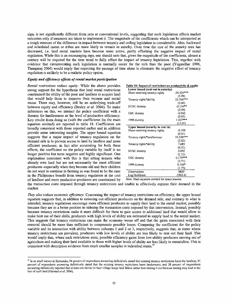
sign, is not significantly different from zero at conventional levels, suggesting that such legislation affects market outcomes only if measures are taken to implement it. The magnitude of the coefficients which can be interpreted as a rough measure of the difference in impact between tenancy and ceiling legislation is considerable. Also, backward and scheduled castes or tribes are more likely to remain in autarky. Over time the size of the autarky area has decreased, i.e. land rental markets have become more active, partly offsetting the negative impact of rental regulation. While this is an encouraging sign, one should note that, given the magnitude of the coefficients, almost a century will be required for the time trend to fully offset the impact of tenancy legislation. This, together with evidence that circumventing such legislation is normally easier for the rich than the poor (Yugandhar 1996, Thangaraj 2004) would imply that expecting the passage of time alone to eliminate the negative effect of tenancy regulation is unlikely to be a realistic policy option.
Equity and efficiency effects of rental market participation
Rental restrictions reduce equity: While the above provides Table 18: Impact of restrictions on productivity & equity
strong support for the hypothesis that land rental restrictions Lower bound (rent out to autarky)
constrained the ability of the poor and landless to acquire land Share receiving tenancy rights -26.524*** (3.09)
that would help them to improve their income and social ~ ~ ~ ~ ~ ~ r i ~ h ~ ~ + ~ b i l i ~ ~ 32.764*** status. There may, however, still be an underlying trade-off (2.60) between equity and efficiency (Besley et al. 2004). To make ST/SCdu-y -0.134**
inferences on this, we interact the policy coefficient with a OBC dummy (2.09) -0.042
dummy for landlessness or the level of productive efficiency. (0.85) Key results from doing so (with the coefficients for the main 1999 dummy 1.427*** equation omitted) are reported in table 18. Coefficients are (13.07)
broadly consistent with those reported earlier and in addition ~ ~ ~ ~ ~ ~ ? ! ~ ~ $ ~ ~ ~ ~ g ~ t in) -0.109
provide some interesting insights. The upper bound equation (0.01) suggests that a major impact of tenancy regulation on the Tenancyrights*landlessness 35.528*** demand side is to prevent access to land by landless and more (2.82)
efficient producers; in fact after accounting for both these Tenancyrights*ability 7.689 (0.51)
effects, the coefficient on the policy variable by itself is no ST/SC dumy 0.092 longer positive but turns negative and highly significant. One (1.31) explanation consistent with this is that sitting tenants who OBcdummy 0.170***
already own land but are not necessarily the most efficient 1999dumy
(2.71) 0.144.
producers -especially when they become old and their children (1.75) do not want to continue in farming as was found to be the case Observations 8820 in the Philippines benefit from tenancy regulation at the cost Log likelihood -3502.61
of landless and more productive producers are constrained by Note: Main equation omitted for space reasons
the transaction costs imposed through tenancy restrictions and unable to effectively express their demand in the market.
They also reduce economic eflciency: Concerning the impact of tenancy restrictions on efficiency, the upper bound equation suggests that, in addition to rationing out efficient producers on the demand side, and contrary to what is intended, tenancy regulations encourage more efficient producers to supply their land to the rental market, possibly because they are in a better position to sidestep the transaction costs imposed by this intervention. Instead, possibly because tenancy restrictions make it more difficult for them to gain access to additional land that would allow to make best use of their skills, producers with high levels of ability are estimated to supply land to the rental market. This suggests that tenancy restrictions can make the economy worse off and that the gains associated with their removal should be more than sufficient to compensate possible losers. Comparing the coeficient for the policy variable and its interaction with ability between columns 1 and 2 or 3, respectively, suggests that, in states where tenancy restrictions are prevalent, producers with low levels of ability are less likely to rent out their land. Thls would imply that, where such restrictions exist, possible efficiency gains from low-ability producers moving out of agriculture and making their land available to those with higher levels of ability are less likely to materialize. This is consistent with descriptive evidence from much smaller samples in individual states.47
47 In as small survey in Karnataka, 94 percent of respondents answering definitively stated that existing tenancy restrictions harm the landless; 91 percent of respondents answering definitively stated that the existing tenancy restrictions harm landowners; and 38 percent of respondents answering definitively reported that at least one farmer in their village keeps land fallow rather than renting it out because renting may lead to the loss of such land (Hanstad et a/. 2006).
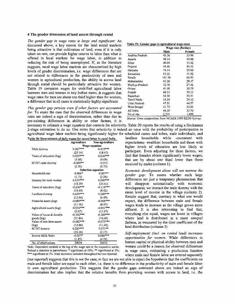
4 The gender dimension of land access through rental
The gender gap in wage rates is large and significant: As discussed above, a key reason for the land rental markets being attractive is that cultivation of land, even if it is only taken on rent, can provide hgher returns to labor than what is offered in local markets for wage labor, in addition to reducing the risk of being unemployed. If, as the literature suggests, rural wage labor markets are characterized by high levels of gender discrimination, i.e. wage differences that are not related to differences in the productivity of men and women in agricultural production, the ability to access land through rental should be particularly attractive for women. Table 19 compares wages for unskilled agricultural labor between men and women in key Indian states. It suggests that wage rates for men are about one third higher than for women, a difference that in all cases is statistically highly significant.
Table 19: Gender gaps in agricultural wage rates Wage rate (Rslday)
Male Female Andhra Pradesh 45.36 33.94 Assam 48.14 49.06 Bihar 40.05 33.42 Gujarat 44.46 40.32 Haryana 74.14 59.00 Kamataka 43.22 31.92 Kerala 101.36 60.93 Maharashtra 43.26 28.37 Madhya hadesh 32.30 27.42 Orissa 41.00 30.79 Punjab 68.53 59.13 Rajasthan 54.50 55.51 Tamil Nadu 54.24 29.33 Uttar hadesh 47.51 44.57
This gender gap persists even if other factors are accounted Bengal 4 1.75 32.02 All India for: To make the case that the observed differences in wage No of obs,
46.35 33.70 2,322 1,699
rates are indeed a sign of discrimination, rather than due to Source: Own from NCAER 1999 REDS Survey, pre-existing differences in ability or other factors, it is necessary to estimate a wage equation that corrects for selectivity. Table 20 reports the results of using a Heckmann 2-stage estimation to do so. One notes that selectivity is indeed an issue with the probability of participation in agricultural wage labor markets being significantly higher for scheduled castes and tribes, male individuals, and Table 20: Determinants of daily wages for casual labor in rural India landless households while -consistent with
Agriculture Non-agriculture expectations- wealthier households and those with Wage equation
0.267*** 0.415*** higher levels of education are less likely to
Male dummy (25.14) (18.43) participate. Even adjusting for these factors, we
Years of education (log) 0.035*** 0.036*** find that females obtain significantly lower wages; (5.68) (4.69) that are by about one h r d lower than those
SC/ST caste dummy -0.028** -0.012 received by males (column 1). (2.50) (0.73)
Household size
Dummy for male worker
Years of education (log)
Landless dummy
Financial assets (log)
Agricultural assets (log)
Value of house & durable goods (log) Value of non-farm assets (log) SCIST dummy
Selection equation -0.006' 0.007** (1.73) (2.24)
0.433*** 0.990*** (18.29) (33.41)
-0.236*** -0.1 la*** (1 8.49) (8.42)
0.429*** 0.248*** (12.64) (6.49)
-0.089*** -0.068*** (1 1.96) (8.47)
-0.016*** -0.051 *** (3.67) (1 1.07)
-0.342*** -0.289*** (21 36) (16.60)
-0.082*** -0.072*** (12.88) (1 1.45)
0.283*** 0.071**
Economic development alone will not narrow the gender gap: To assess whether such large differences are just a temporary phenomenon that will disappear automatically with economic development, we interact the male dummy with the mean level of income in the village (column 2). Results suggest that, contrary to what one would expect, the difference between male and female wages tends to increase as the village grows more affluent. It is also interesting to find that, everythng else equal, wages are lower in villages where land is distributed in a more unequal fashion, as measured by the Gini coefficient of the land distribution (column 3).
(10.16) (2.17) Self-employment (incl. on rented land) increases Inverse Mills Ratio -0.027* 0.086***
(1.85) (4.19) opportunities for women: While differences in No. of observations 30038 30032 human capital or physical ability between men and
Note: De~endent variable is the loa of the wage rate in the res~ective sector. women could be a reason for observed differences - - Robust z statistics in parentheses. * significant at 10%; ** significant at 5%; in wage rates, estimating a production function *** significant at 1%. State dummies included throughout but not reported. where male and female labor are entered separately (not reported) suggests that this is not the case; in fact we are not able to reject the hypothesis that the coefficients on male and female labor are equal to each other, i.e. there is no difference in the productivity of male and female labor in own agricultural production. This suggests that the gender gaps estimated above are indeed an sign of discrimination but also implies that the relative benefits from providing women with access to land, i.e. the
difference between what they could earn from agricultural cultivation on such land -even after the rental fee has been deducted- and their opportunity wage in casual agricultural labor, is significantly higher than for men. This is consistent with anecdotal evidence from Andhra Pradesh where a large number of women organized in self-help groups found land rental to be a very attractive opportunity and often used the group to obtain access to such an opportunity, possibly even paying more to the landlord than was allowed under existing rent ceiling legislation. Case studies suggest that a combination of women having better access to finance, as well as social pressure and availability of alternative opportunities for land owners has led to a significant increased in women's land rental market participation that has a very positive impact on their ability to generate income.
5 Policy implications
Freeing land rental could yield significant benefits: Our analysis suggests that rental markets can make a significant contribution to productivity and equity and that the pro-poor nature of land rental has significantly improved over time as wealth biases that had earlier characterized such markets have been eliminated. Rental markets are more active in places with higher levels of non-farm activity, thus making an increasingly important contribution to diversification of livelihoods in rural areas. The fact that tenancy and ceiling laws are found to reduce rather than increase land access by landless and more efficient producers is cause for concern. Consistent with our earlier results on land reform, it suggests that, even in situations where such laws may have led to significant social gains in the past, maintaining them could develop into an increasingly potent obstacle to productivity growth and land access by the land-poor, in particular women. All of this supports the desirability of eliminating land rental market restrictions that is articulated in the Government's most recent 5-year plan (Government of India 2002)~' In fact, by demonstrating the significance and magnitude of these impacts quantitatively, our results reinforce the importance of taking action on this issue, especially in commercialized areas.
Replace rent ceilings with enabling regulations: Where tenancy is allowed but subject to maximum rent levels andlor a minimum lease term, legislation to remove maximum rents or minimum length terms, or -in cases where this is not feasible politically- at least replace these with what is reasonable and enforceable given local conditions. Attempts to impose rules that will not be attractive to either of the parties and that therefore will encourage short- term contracts or drive transactions underground, thereby reducing incentives for longer-term investment, depriving tenants of any form of protection, and malung them unable to access bank loans and crop insurance. Instead of trying to enforce these, government should aim to reduce transaction costs and encourage long-term rental contracts that would encourage investment and sustainable management, in addition to allowing tenants to get access to the necessary institutional support. Options to do so include dissemination of rental options and standardized contracts (which can be in writing, especially if they are for a longer term).
Explore options for making land reform permanent: Experience from other countries suggests that freeing rental can yield significant benefits but also that political resistance from sitting tenants can make their implementation difficult. Where beneficiaries from past tenancy reform are not full owners, it will thus be prudent to explore market-based options that can help to convert them into owners. For example, giving protected tenants an option to "buy out" landlords, based on mutual agreement, with the possibility of government or NGOs providing guidance on "fair" land values and assistance in negotiating such agreements on a village by village basis, and possibly even in obtaining access to sources of finance for implementing them. A program with similar characteristics is already contemplated in West Bengal and, if implemented, it could provide valuable lessons for other states.
Carefully evaluate state pilots: As in the case of land administration, any initiatives to liberalize land leasing will have to be taken forward by individual states. This implies that action to liberalize rental markets is likely to be taken first in situations where the potential for rental markets is already high. Further analysis of state-level data could help to support the case for reform and to identify specific ways of implementing it. Furthermore, careful and impartial monitoring of such efforts to assess their impact will be critical to generate the momentum for M e r reform within a state and to make the case for reform in similar settings. As our results point suggest that women could derive particularly large benefits from such a measure, careful attention to potential gender-differentiated impacts would be warranted.
48 '. ... freedom in leasing of land, both leasing in' and 'leasing out' will help generate income for both lessee and lessor/contractor. A legislation needs to be enacted to facilitate the land utilisation by making land transactions easier and facilitating leasing and contract farming." (Government of India 2002, p. 528).
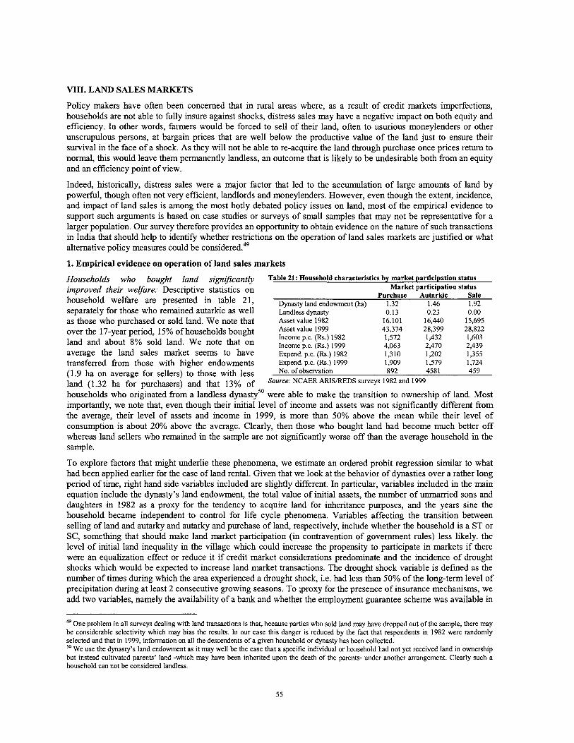
VIII. LAND SALES MARKETS
Policy makers have often been concerned that in rural areas where, as a result of credit markets imperfections, households are not able to fully insure against shocks, distress sales may have a negative impact on both equity and efficiency. In other words, farmers would be forced to sell of their land, often to usurious moneylenders or other unscrupulous persons, at bargain prices that are well below the productive value of the land just to ensure their survival in the face of a shock. As they will not be able to re-acquire the land through purchase once prices return to normal, h s would leave them permanently landless, an outcome that is likely to be undesirable both from an equity and an efficiency point of view.
Indeed, historically, distress sales were a major factor that led to the accumulation of large amounts of land by powerful, though often not very efficient, landlords and moneylenders. However, even though the extent, incidence, and impact of land sales is among the most hotly debated policy issues on land, most of the empirical evidence to support such arguments is based on case studies or surveys of small samples that may not be representative for a larger population. Our survey therefore provides an opportunity to obtain evidence on the nature of such transactions in India that should help to identify whether restrictions on the operation of land sales markets are justified or what alternative policy measures could be ~ons idered .~~
1. Empirical evidence on operation of land sales markets
Households who bought land Table 21: Household characteristics by market participation status
improved their welfare: Descriptive statistics on Market participation status Purchase Autarkic Sale
household welfare are presented in table 2 1, Dynasty land endowment (ha) .32 1.46 1.92 separately for those who remained autarkic as well Landless dynasty 0.13 0.23 0.00 as those who purchased or sold land. We note that Asset value 1982 16,101 16,440 15,695
over the 17-year period, 15% of households bought ec:QE: iE; 1982 43,374 28,399 28,822 1,572 1,432 1,603
land and about 8% sold land. We note that on Incomep,c, (&,) 1999 4,063 2,470 2,439 average the land sales market seems to have ~xpend.p.c. (h.) 1982 1,310 1,202 1,355 transferred from those with hlgher endowments Expend. p.c. (&.) 1999 1,909 1,579 1,724 (1.9 ha on average for sellers) to those with less obsewation 892 4581 459
land (1.32 ha for and that 13% of SO"'~~:NC~ERARIS/REDS~~~~~Y~ 1982and 1999
households who originated from a landless dynastyS0 were able to make the transition to ownership of land. Most importantly, we note that, even though their initial level of income and assets was not significantly different from the average, their level of assets and income in 1999, is more than 50% above the mean while their level of consumption is about 20% above the average. Clearly, then those who bought land had become much better off whereas land sellers who remained in the sample are not significantly worse off than the average household in the sample.
To explore factors that might underlie these phenomena, we estimate an ordered probit regression similar to what had been applied earlier for the case of land rental. Given that we look at the behavior of dynasties over a rather long period of time, right hand side variables included are slightly different. In particular, variables included in the main equation include the dynasty's land endowment, the total value of initial assets, the number of unmarried sons and daughters in 1982 as a proxy for the tendency to acquire land for inheritance purposes, and the years sine the household became independent to control for life cycle phenomena. Variables affecting the transition between selling of land and autarky and autarky and purchase of land, respectively, include whether the household is a ST or SC, something that should make land market participation (in contravention of government rules) less likely. the level of initial land inequality in the village which could increase the propensity to participate in markets if there were an equalization effect or reduce it if credit market considerations predominate and the incidence of drought shocks which would be expected to increase land market transactions. The drought shock variable is defined as the number of times during which the area experienced a drought shock, i.e. had less than 50% of the long-term level of precipitation during at least 2 consecutive growing seasons. To ;proxy for the presence of insurance mechanisms, we add two variables, namely the availability of a bank and whether the employment guarantee scheme was available in
49 One problem in all surveys dealing with land transactions is that, because parties who sold land may have dropped out of the sample, there may be considerable selectivity which may bias the results. In our case this danger is reduced by the fact that respondents in 1982 were randomly selected and that in 1999, information on all the descendents of a given household or dynasty has been collected. 50 We use the dynasty's land endowment as it may well be the case that a specific individual or household had not yet received land in ownership but instead cultivated parents' land -which may have been inherited upon the death of the parents- under another arrangement. Clearly such a household can not be considered landless.
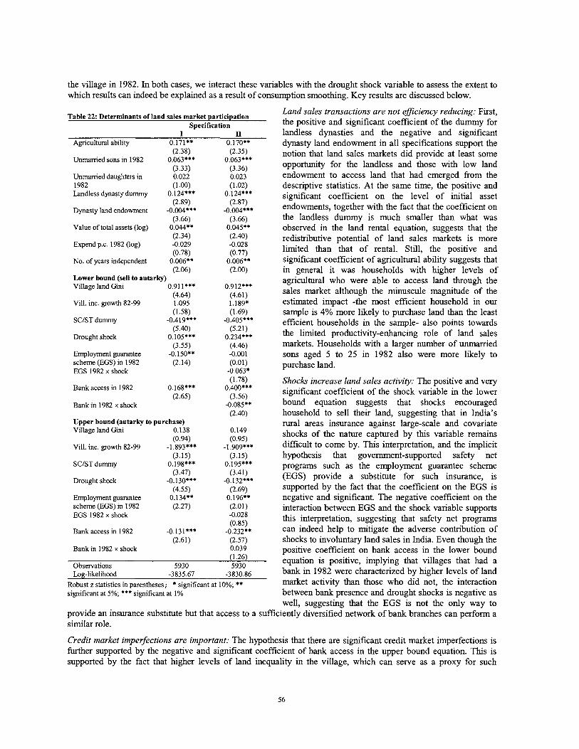
the village in 1982. In both cases, we interact these variables with the drought shock variable to assess the extent to which results can indeed be explained as a result of consumption smoothing. Key results are discussed below.
Table 22: Determinants of land sales market participation Specification
I Agricultural ability 0.171**
(2.38) Unmamed sons in 1982 0.063***
(3.33) Unmamed daughters in 0.022 1982 (1 Landless dynasty dummy 0.124***
(2.89) Dynasty land endowment -0.004***
(3.66) Value of total assets (log) 0.044**
(2.34) Expend p.c. 1982 (log) -0.029
(0.78) No. of years independent 0.006**
(2.06) Lower bound (sell to autarky) Village land Gini 0.91 I***
(4.64) Vill. inc. growth 82-99 1.095
(1.58) SCIST dummy -0.419***
(5.40) Drought shock 0.105***
(3.55) Employment guarantee -0.150** scheme (EGS) in 1982 (2.14) EGS 1982 x shock
Land sales transactions are not eficiency reducing: First, the positive and significant coefficient of the dummy for landless dynasties and the negative and significant dynasty land endowment in all specifications support the notion that land sales markets did provide at least some opportunity for the landless and those with low land endowment to access land that had emerged from the descriptive statistics. At the same time, the positive and significant coefficient on the level of initial asset endowments, together with the fact that the coefficient on the landless dummy is much smaller than what was observed in the land rental equation, suggests that the redistributive potential of land sales markets is more limited than that of rental. Still, the positive and significant coefficient of agricultural ability suggests that in general it was households with higher levels of agricultural who were able to access land through the sales market although the minuscule magnitude of the estimated impact -the most efficient household in our sample is 4% more likely to purchase land than the least efficient households in the sample- also points towards the limited productivity-enhancing role of land sales markets. Households with a larger number of unmarried sons aged 5 to 25 in 1982 also were more llkely to purchase land.
(1.78) Shocks increase land sales activity: The positive and very Bank access in 1982 0.168*** 0.400***
(2.65) (3.56) significant coefficient of the shock variable in the lower Bank in 1982 x shock -0.085** bound equation suggests that shocks encouraged
(2.40) household to sell their land, suggesting that in India's Upper bound (autarky to purchase) rural areas insurance against large-scale and covariate Village land Gini 0.138 0.149
(0.94) (0.95) shocks of the nature captured by this variable remains ViU. inc. growth 82-99 -1.893*** -1.909*** difficult to come by. This interpretation, and the implicit
(3.15) (3.15) hypothesis that government-supported safety net SCIST dummy 0.198*** 0.195*** programs such as the employment guarantee scheme
(3.47) (3.41) Drought shock -0.130*** -0.132*** (EGS) provide a substitute for such insurance, is
(4.55) (2.69) supported by the fact that the coefficient on the EGS is Employment guarantee 0.134" 0.196** negative and significant. The negative coefficient on the scheme (EGS) in 1982 (2.27) (2.01) interaction between EGS and the shock variable supports EGS 1982 x shock -0.028
(0.85) this interpretation, suggesting that safety net programs ~ a n k access in 1982 -0.131*** -0.232** can indeed help to mitigate the adverse contribution of
(2.61) (2.57) shocks to involuntary land sales in India. Even though the Bank in 1982 x shock 0.039 positive coefficient on bank access in the lower bound
(1.26) Observations 5930 5930
equation is positive, implying that villages that had a ~og-likelihood -3835.67 -3830.86 bank in 1982 were characterized by hgher levels of land
~ o b u s t z statistics in parentheses; * significant at 10%; ** market activity than those who did not, the interaction significant at 5%; *** significant at 1% between bank presence and drought shocks is negative as
well, suggesting that the EGS is not the only way to provide an insurance substitute but that access to a sufficiently diversified network of bank branches can perform a similar role.
Credit market imperfections are important: The hypothesis that there are significant credit market imperfections is further supported by the negative and significant coefficient of bank access in the upper bound equation. This is supported by the fact that higher levels of land inequality in the village, which can serve as a proxy for such
imperfections, significantly increase land market activity on the sale side but are estimated to not have any impact on land purchases. Results from the transaction cost equations also reveal that economically more dynamic villages (as proxied by the mean rate of income growth in the village over the 1982-99 period) reduce the transaction costs associated with purchasing of land but do not have an appreciable impact on land sales.
Caste restrictions have some impact: Finally, the coefficient on a dummy indicating whether a household belongs to scheduled caste or tribe should provide an indication of the extent to which restrictions on tribal land sales do have an impact. Our results in this context are mixed. First, the significant and negative coefficient in the lower bound equation points indeed to a much lower incidence of land sales among SCs and STs. At the same time, the fact that we can not reject that hypothesis of equality between an SC and an ST dummy when introduced separately from each other (not reported) casts at least some doubt on the interpretation that all of the quantitatively rather large coefficient can be attributed to the specific policy restriction under consideration -which after all should apply only to STs and not to SCs rather than a general stigma of lower castes. This is to some extent supported by the positive and also hlghly significant coefficient on the SCIST dummy in the upper bound equation which suggests that this group also faced significant restrictions in participating on the demand side of land sales markets.
2. Improving the functioning of land markets
While it supports the view that there is reason for being concerned about distress sales, the one surprising aspect of the above results is that land sales markets are not inherently bad for the poor but instead offer the most promising route to acquire land available to the landless. This is in line with other studies on land sales markets in India. For example, a recent study from West Bengal finds that, even in the state that has arguable implemented land reform most ardently, land sales markets have, since the late 1970s, transferred more land to the poor than land reform implementation (Bardhan and Mookhe rjee 2006). Although the factors underlying this phenomenon, for example the role of land ceilings, remain to be explored, this suggests that land sales markets should not be neglected by policy makers and that possible links between rental and sales where, e.g. tenants in a free rental market will be able to acquire slulls and, via longer-term contracts, eventually be able to acquire land ownership through purchase, could be an important path out of poverty. In this respect, a number of issues are of relevance.
Changes in land use: Changes of land use fiom agriculture to non-agriculture, especially but not only at the urban periphery are to be expected in a growing economy and should be possible as long as they are do not generate negative externalities. However, a number of states, e.g. KA, MA and TN prevent acquisition of agricultural land by non-agriculturists or allow changes in land use only upon special permission. In practice, this precludes industrialists or other non-agricultural land users from negotiating directly with land owners. Instead, they have to go through land acquisition by the state which often acquires land for a fraction of its true value from farmers and then sells it on to the final users at a huge profit. As in the areas where this is an issue, land owners will be well aware of market conditions, there is no reason for preventing them fiom negotiating with private industry directly. This can be encouraged by eliminating land restrictions such as the ones mentioned above, improving land administration in general, and opening up land records to the public.
Subdivision restrictions: A number of states continue to maintain subdivision restrictions intending to prevent fragmentation of holdings below a 'minimum' size that ranges fiom 0.5 to 1.25 ha. In rural areas, with little or no evidence for increasing returns to scale in agriculture, such restrictions are difficult to justify fiom a productivity perspective. Moreover, experience in India and other countries suggests that they are rarely effective in preventing subdivision but instead lead to such processes being done in an informal manner, something that greatly increases the potential for land-related conflict and in addition makes it very difficult for the actual cultivators (who can not register the land in their name) to get access to credit. In peri-urban areas, the problem is even more acute as it prevents small farmers fiom selling their land in small pieces to benefit fiom high prices and encourages informal deals and corruption. Eliminating such restrictions would therefore be desirable.
Compulsory land acquisition: In an environment where land rights are ofien ill-defined and the ability of individuals or groups to transfer their rights is highly restricted, land acquisition will have to be resorted to more often, and even in situations where no public purpose is involved and negotiation between private parties may be more expedient and advantageous, than land taking by the public sector. This is especially relevant given that bureaucrats are often ill-equipped to represent local communities and that the Land Acquisition Act's main intention was to make it easy for the state to acquire land, with very little thought having been given to protecting the rights of land owners and providing them with appropriate compensation. While amending the LAA to remedy these defects is one important issue for policy, it is equally critical to more clearly define and strengthen land rights by individuals and groups in areas where land acquisition is likely so as to allow more decentralized negotiation.
3. Protecting land ownership and access by the poorest
Although, with the exception of land ownership ceilings, land sales markets in India operate in a rather unrestricted fashion, the government maintains strict restrictions on sale of land from tribals to non-tribals to eliminate as much as possible the impacts of landlessness which are considered to be particularly undesirable in the case of tribals who in many cases rely on land for the main part of their livelihood (Government of India - National Committee on the Development of Backward Areas 1981). However, procedures to ensure recovery of land from tribals who sold in contravention of regulations are difficult to enforce and have not prevented large-scale land loss by tribal populations.
The importance of the issue is illustrated even by official statistics !?om the land records which are llkely to leave out a large number of benami holdings, i.e. land in tribal areas that is held by tribals in the name of non-tribals. For example, in the scheduled areas of AP, more than half of the land is held by non-tribals and census figures point towards a continuing decrease in the ratio of cultivators to agricultural laborers in India's tribal areas. Consistent with our failure to find a clear impact of restriction on land sales by tribals, this suggests that in many cases such restrictions may be largely ineffective. Together with the hlgh cost of enforcing such a policy, and the near impossibility of recovering land once it has been sold, this suggests that exploring alternative options. In fact, other countries' experience with restrictions on land sales suggests that even in cases where they would be justified, i.e. where those selling land do not receive a realistic value for their land at the point of sale, such restrictions may be difficult to implement and, rather than avoiding land sales by the poor, may M h e r depress the returns of those who have no other choice due to imperfections in markets for credit and insurance (box 8). A number of considerations for a more flexible regime might be relevant.
Box 8: Giving land rights to groups as an alternative to prohibiting land sales
Restrictions on land sales markets can increase the costs associated with certain actions, but if the rewards from circumventing them are high enough, will not eliminate them. For example, owners who have no desire to farm tend to disregard the temporary prohibition of land sales in Nicaragua and circumvent it by long-term rentals with the promise to sell which, because of the associated insecurity, lead to them receiving much lower land prices. The danger of beneficiaries' undervaluing their land could be reduced through other means, and the goal of preventing small landowners from selling out in response to temporary shocks would be better served by ensuring that they have access to output and credit markets and to technical assistance, and by providing safety nets during disasters to avoid distress sales.
One case where temporary restrictions on land sales can be justified is in the presence of significant knowledge gaps. This was the case, for example, in many transition countries in Eastern Europe where, after decades of collectivism, new landowners' did not really understand the working of land sales markets and were thus in danger of disposing of a hugely valuable asset way below its true value, something that would have led to negative social consequences and re-concentration of land in the hands of speculators. To avoid this, many counties introduced moratoria on land sales, e.g. for the first 10 years after land had been privatized to prevent quick sell-offs at unrealistically low prices. In some transition and developing countries (e.g. Albania and Mexico), but also in developed ones (e.g. France or Germany) a permanent 'right of first refusal' is in place. This means that before selling land to an outsider, neighbors and other village members (or in some cases other government bodies) must be given the opportunity to acquire the land at the same price for some period, usually 30 or 45 days. This can not only help to allay fears by being about being bought out by outsiders but also make the prices paid for land public knowledge and prevent land from being disposed of at fire-sale prices -in which case somebody can offer a higher price.
A second reason why communities may restrict land sales is that, in closely knit (indigenous) communities, disposition of land by one individual can generate negative externalities for the whole community who has the obligation to care for him or her after the loss of land (Andolfatto 2002). This implies that giving communities the right to make a conscious choice by the group and the group has clear and transparent mechanisms for changing the land tenure regime, such restrictions are unlikely to be harmful. If traditional social ties loosen or the efficiency loss from the sales restriction becomes too high, groups are likely to allow sales to outsiders in some form. For example, if an outside investor requires land, it may be more efficient for the group to bargain as a whole and to jointly obtain the benefits accruing from such a transfer (and possibly invest them in social goods) rather than having individuals do so. For example, in Mexico, communities were recently given the ability to decide -by majority voting- whether they would want to eliminate the restriction on sales to outsiders. Quite surprisingly, in a country that has about 10 times the per capita income of India, only about 12-15% of the communities -largely those living in peri-urban areas where demand for land was very high and where often large junks of land had already been sold informally- chose to freely allow sale of land by individuals, suggesting that they did perceive that the benefits from maintaining (and internally enforcing) land sales restrictions for the time being did exceed the costs from doing so, especially in view of the fact that they would always be able to change this policy should the need to do so arise.
Prevent ineficient land loss by improving markets for credit and insurance: There is little doubt that prohibition of land sales is a costly second- or even third-best policy and that it would be more effective and preferable to deal with the root cause rather than the symptoms. To do the former, both international experience and our empirical results suggest that the first line of defense against productivity-reducing land sales should be effective implementation of safety nets that would eliminate the need for individuals to dispose of their land to cope with shocks in the first instance. Access to banks and savings or federations of SHGs who can provide access to credit in situations of distress would have the same function and should be encouraged.
Emphasize (group) rights rather than prohibitions: While wholesale prohibition of land sales will not always prevent socially undesirable land alienations, it may have the impact of preventing desirable land transfers where

groups could negotiate with outsiders to obtain significant benefits. To the extent that such cases currently require government to resort to expropriation -with amounts of compensation determined in what often seems rather arbitrary ways- constraints that had originally been intended to improve the welfare of tribal populations may well end up worsening it. There is now a growing current all over the world to deal with such situations by giving rights to the group who -as long as they follow transparent and democratic procedures- can decide about the specific way in which land rights should be defined (including possible restrictions on land alienation) and allocated internally based on their own mechanisms and preferences. Given that existing legislation such as the PESA already defines an institutional framework at the local level that has many of these properties, it would be worthwhile to consider that, instead of deciding in a centralized and rather paternalistic fashion whether or not land should be alienable, it would be better to gradually devolve this authority to the community level provided that such a decision be taken at the local level in a transparent way, and with the possibility of enlisting the support of pubic servants in its enforcement. Having a debate on this issue, followed by a clear policy decision in this sense would be highly desirable.
I Box 9: Ingredients of a comprehensive property reform - the example of Mexico I From the 1917 revolution until 1992, Mexico has implemented a large-scale process of land reform, which distributed more than 100 million hectares, or 50% of the arable area, from large farms to the "social sector" which comprised of so-called ejidos. Despite the physical achievements, the desired benefits did not materialize because of numerous restrictions on tenure security and transferability of land within the ejido. To overcome these, the Mexican Government adopted in 1992 a comprehensive set of reforms that focused on modifications of the legal environment and institutional changes. The goal was to not only eliminate restrictions on the functioning of land markets but also empower communities to choose the property rights regime most suitable to their needs (i.e. either communal, individual, or mixed), increase security of tenure and investment by issuing certificates of land ownership, and deal with the backlog of land conflicts that had been inherited from the past. To do so, a large-scale a systematic program of land regularization, called PROCEDE, was implemented which yielded quite impressive results at least in terms of the area certified.
One key lesson from this experience is that, in view of the fact that many (informal) land transactions that were essentially illegal had taken place, an effective way of resolving disputes was a must. To allow this, a system of 42 land courts and one appeals court were created. In 5 years, these courts dealt with nearly half a million conflicts, there by helping to eliminate a huge backlog of cases that had accumulated from the past. In dealing with conflicts in a systematic manner, these courts were explicitly instructed to seek settlement out of court and special mechanisms were put in place to ensure accessibility by the poor. Since small farmers who had been under the tutelage of local authorities for a long period of time would still find it difficult to ascertain their rights -especially to correct past irregularities- a special institution, the Procuraduria Agraria, was created to provide legal assistance to land holders and represent them in court dealings, perform an ombudsman function, and supervise the implementation of the regularization program. Evaluation of the program suggests that, in addition to the economic benefits that were associated with clarification of land rights and receipt of a secure and unambiguous document, beneficiaries often perceived the main impact to be in helping them to gain independence from local political bosses who had long used land as a means for exercising political power.
Deal with the huge backlog of land alienations in a quick andjlexible way: Even if policy is changed to allow more flexibility and greater community control in transfer of land, a large number of land transfers from tribals that have been undertaken in contravention of the law will have to be dealt with. This is in some way similar to instances as discussed above where systematic adjudication efforts will be needed to update the spatial framework and link it to textual records because of too many irregularities in non-tribal areas. Any efforts to clarify and enhance the land rights enjoyed by tribal people will need to be combined with a mechanism to resolve this backlog in a quick and comprehensive way. In a similar experience in Mexico (box 9), efforts to improve the land administration system had to be accompanied by a involved and rather complex effort of adjudication -which included special incentives to make those involved settle out of court- to resolve any pending disputes and conflicts. Similar approaches to systematic conflict resolution will need to be thought about for programs to extend tenure security to tribal areas and populations. The goal should be to have these in place by the time the Tribal (Forest) Land Bill is passed so as to ensure that -in contrast to many other progressive and far-reachmg laws in India- this piece of legislation can be swiftly implemented and thus have a real impact on the ground.
IX. TOWARDS AN INTEGRATED LAND POLICY
While few Indian policy makers disagree on the importance of land administration and land policies for the poor, lack of systematic empirical evidence on the status of land administration in different states and on the impact of specific policies on intended beneficiaries has often resulted in a highly -and unnecessarily- polarized debate on these issues. This report is departs from the premise that the opportunities provided by new technology and overall economic growth in India warrant a closer look at empirical evidence to inform policy making in these critical areas. This section first summarizes some of the more surprising findings from the review of empirical evidence before drawing out some possible implications and options for policy.
1. Key conclusions from empirical analysis
Modernization of land administration has made greater progress than is often realized by observers, including policy makers at various levels. Although progress varies across states who moved at very different speeds with no single state having developed an approach addressing all the areas to be covered, putting together states' experience allows clear identification of the steps to be taken to put in place for a more comprehensive land admistration system. Experience also illustrates that doing so provides an opportunity to significantly enhance tenure security, investment incentives, and access to credit, while at the same time simplifying the system to reduce the transaction costs of securing and transferring land rights. The transition towards comprehensive management of land administration, although by no means automatic, is thus definitely within reach.
New data used for this study also suggest that the pessimism about the poor being able to benefit from land (rental or sales) markets that had traditionally underwritten government interventions to overcome perceived imperfections in these markets -which may have been justified in the past- is no longer warranted. We find that rental markets work in favor of the poor, that restricting them will reduce productivity and equity, and that unclear land records reduce the scope for land rental. Also, land sales markets emerge as an important channel to provide land access. Whle prevention of involuntary land loss by the poor through distress sales is a desirable goal, our analysis implies that restricting transferability of land is rarely the most appropriate measure to do so and should thus be complemented by other instruments.
One issue that emerges clearly from our analysis is that the synergies between land administration and land policies are stronger than often assumed. On the one hand, lack of land rights in many marginal areas and outdated or contradictory records may be more important than traditional market imperfections in reducing asset endowments by the poor, the ability to use land in the most effective way, and the potential for land markets to operate. Similarly, a merely technical approach to land administration that neglects critical policy dimensions, e.g. in terms of stamp duties my not be sustainable. The recent amendment to the Hindu Succession Act illustrates the potential impact of policy measures to change the way rights are defined. With well-defined land rights, on the other hand, elimination of restrictions on lease markets will have a positive impact and it will be possible to put in place policies to help avoid distress sales by the poor and reduce the need to rely on ex-post intervention to deal with this issue.
In view of the above, it will be desirable for government to (i) build on the successes in land administration but integrate the systems to eliminate duplication at the operational level; (ii) systematically clarify land ownership including resolution of disputes and a basic spatial reference, (iii) expand beyond settled areas to ensure that the most needy will not be left out, and (iv) ensure that operational and policy issues are tackled in tandem. T h ~ s is a task of huge proportions which existing institutions are not well-equipped to handle on their own. Experience from computerization of textual records suggests that, if the regulatory framework is clear and enforced effectively, PPPs offer a major opportunity to scale up successful approaches. To take advantage of this opportunity, greater focus of the public sector on regulatory functions and evaluation of pilots to determine their potential will be required.
2. Options to fully realize the potential of land administration
Establish a high level technical committee: Despite considerable successes with computerization of textual records, MoRD's does not have a well articulated policy on this issue. This makes it difficult to guide implementation of programs in this area, to ensure that results obtained will be sustainable, and to make states aware of sequencing issues such as preconditions for moving from textual to spatial records. As a result, criteria for allocation of CLRICMLR funds among projects or states are not well articulated and disseminated, implying that finds are often spent in sub-optimal ways and the scope for ex post accountability remains limited. To deal with this it would be desirable to establish a high level t echca l committee, with tenure long enough to allow it to take a long-term view,
This committee would include practitioners from successful states, NIC technical experts, academics, and policy makers from MoRD as well as MIT and possible other ministries affected.
A key task of this committee, to be accomplished in the short tenn, would be to draw on existing experience to formulate of a policy on land administration in a participatory, consultative process. The policy should be clear on the strategic vision and contain specific recommendations for the design of programs and h d i n g arrangements to attain this goal. Once in place, proposals for funding by individual states can then be justified and judged based on (i) their fit into the overall strategy and compliance with key elements (e.g. the switch from manual to computerized records); (ii) the extent to which they generate true public goods; (iii) financial contribution by beneficiaries or state government in line with their means; and (iv) proven capacity for implementation or appropriate outsourcing arrangements. This will also help to clarify the targets to be accomplished by specific interventions which in turn can serve as a basis for allocation of future funds.
Beyond this immediate task, the committee would be responsible for defining and possibly also supporting pilots, overseeing their systematic evaluation, ensuring that lessons are codified in regulations, and recommending ways to scale up successful experiences. T h s would include the tasks of exploring options for survey, recommend appropriate pilots, and issue regulations and manuals for specific situations (from sporadiclsystematic subdivision surveys to complete loss of records and unsettled areas) and investigating whether changes in the institutional structure to ensure greater consistency and quality of surveys especially in urban areas and to regulate an emerging private sector would be appropriate. It could feed into a more systematic process of monitoring in a participatory process (e.g. workshops of technical experts, websites, etc.) to disseminate principles and good practices in land adrrrrmstration at the technical level and to increase awareness of recent developments that would prevent individual states having to re-invent processes from scratch.
Integrate textual records: Limited integration of records with registration records increases the risk of inconsistencies among different types of land records that can give rise to land conflict. To deal with this, it will be desirable to refine and roll out systems for back-office integration of records and registry, including definitions and standards to ensure interoperability at the technical level. This should be combined with more systematic evaluations of the impact of specific elements of land record computerization on household welfare and decisions by other economic actors (e.g. banks). Doing so would allow to give the topic the policy attention it deserves, overcome bureaucratic resistance to such a step, and provide guidance as to priority areas for attention.
Provide a basis for state-wide spatial coverage: Large amounts of money have been, and continue to be, spent on surveying pilots with ill-defined objectives, the results of whlch are rarely subject to a rigorous evaluation. To the contrary, pilots often make officials lose sight of the forest for the trees. Drawing on India's capabilities to combine satellite imagery with existing village maps and other readily available spatial products to generate a basic cadastral index map would be a lower cost option to provide a comprehensive framework, identify gaps, and on this basis establish criteria for ways to address spatial data problems in an affordable manner that should have priority over ETS equipment and specific outputs should be defined in the near term. This could be easily combined with preservation of existing village maps through vectorization and geo-referencing to link to the cadastral index maps.
Pilot ways of improving textual and spatial records for well-defined situations: In line with the ultimate goal of the land administration system, the purpose of piloting should be to establish processes that can be scaled up rapidly to improve the overall (i.e. textual and spatial) record and formulate regulations that can help to do so, possibly by subcontracting to the private sector. To achieve this, pilots should be targeted to archetypical situations arising from the nature of India's land records (i.e. unrecorded subdivisions; inconsistencies across records, decaylloss of maps, change of land use patterns, unsettled lands). It would be ideal to set up a technical working group to steer this process with the goal of producing results, to feed into a broad debate on thls topic, in a 12-18 month time frame.
Allow private sector participation in surveying, focusing government on a regulatory role: Given the size of the gaps in spatial data and the limitations that make it difficult for the public sector to address them comprehensively, the almost complete prohbition of private participation in survey is surprising -and inconsistent with international best practice and India's own experience in computerizing textual records. Efforts to change this should focus on (i) providing a regulatory framework for application of a range of survey methods with defined precision requirements; (ii) strengthening capacity in the private and the public sector; and (iii) revamping survey processes, e.g. shifting from paper-based to electronic ones to reduce cost and make survey more affordable.
3. Options for policy reform
Reduce stamp duty rates and explore the scope for replacing them with a land tax: There is little doubt that the high rates of stamp duty currently assessed upon registering land transfers push people into informality while reducing government revenue. Reducing these rates, which are very high by international standards, is likely to be necessary to ensure the sustainability of any improvements made in land administration. To make such a step revenue-neutral, it may be useful to consider combining it with an increase in the land tax for specific groups, possibly to be shared between states and local governments. W l e such a decision will not be easy politically, it is likely to have a more profound impact on India's land administration system than a transition towards a title registration system
Eliminate restrictions on land markets: All over the world, land rental markets allow nual dwellers to join the rural non-farm economy in a way that provides those who stay back with access to additional productive resources. Indian evidence shows that rental restrictions reduce equity as well as efficiency. It will thus be desirable to (i) make leasing legal where it is currently prohibited and replace rent ceilings with regulations to facilitate rental markets instead of constraining them; (ii) allow transferability of land by land reform beneficiaries at least through lease and explore options for making the gains from such reform permanent; (iii) drop restrictions on sale of land to non- agriculturalists and subdivision which have little economic justification; and (iv) review legislation on compulsory land acquisition and, subject to the prevention of undesirable externalities, allow farmers or their representatives to negotiate with and if desired transfer land directly to investors rather than having to go through govemment and often receive only very limited compensation.
Provide options for a wider range of ownership patterns: Although expansion of survey coverage will be critical to ensure that poor people in marginal areas will be able to gain secure land rights, in many of these situations, award of individual title may not be the most appropriate option; indeed some observers have linked such individualization with the break-up of traditional community structures and widespread land transfer. To prevent these, it will be important to have a menu of tenure options, including communal ones, available and to allow groups to choose freely and depending on their specific needs, with the possibility of making the transition to individual holdings at a later stage if desired.
Complement restrictions on tribal alienation with flexible mechanisms providing them with property rights: While there is little doubt that alienation of lands through distress sales is an extremely undesirable outcome that should be avoided, increasing rates of tribal landlessness suggest that regulations are often not effective in preventing it. In the short term, the most promising way to prevent tribal land alienation is likely to be effective safety nets, somethmg that could possibly be combined with mechanisms for communities to have a greater say in whether or not land should be transferable such as a right of first refusal or community consent for sales. Providing tribals with real property rights, either individually or as a group, would in the long term make a more important contribution to their productive development and thus the avoidance of distress sales. Therefore, the longer-term goal should be to implement systematic programs that would recognize tribal land rights - and resolve whatever conflicts exist as a result of past alienations in contravention of the law according to accepted principles of policy.
Develop state-specific roadmaps to improve land policy and administration and monitor closely: Contrary to the case of land administration where the need for change is widely acknowledged and a wide array of experiences can be drawn upon to identify at least the f is t steps on this way, policy issues remain more controversial. To ensure that any reforms are properly sequenced and synchronized with improvements in the land administration structure, it will be important to base such reforms on a broad policy dialogue to help set priorities, sequence implementation, and monitor realization of the desired impact. While specific strategies will need to be state specific, there is considerable scope for assistance by the center and for comparing experience and learning across different states.
References
Agarwal, B. 1994. A Field of One's Own: Gender and Land Rights in South Asia South Asian Studies. Cambridge; New York and Melbourne: Cambridge University Press.
Aghion, P. and P. Bolton. 1997. "A Theory of Trickle-Down Growth and Development." Review of Economic Studies 64 (2): 15 1-72.
Agrawal, V. K. 2006. "Andhra Pradesh Pilot Project on Integrated Land Information System." . Hyderabad: Paper presented at MoRD-WB Workshop on Land policies and administration in India, New Delhi Jan 5 and 6,2006.
Ahuja, M. and A. P. Singh. 2006. "Evaluation of Computerization of Land Records in Karnataka." Economic and Political Weekly January 7,2006 69-77.
Alm, J., P. Annez, and A. Modi. 2004. "Stamp duty in Indian states: A case for reform." World Bank Policy Research Paper 3413. Washington DC: World Bank.
Alston, L. J. and J. P. Ferrie. 2005. "Time on the Ladder: Career Mobility in Agriculture, 1890-1938." NBER Working Paper 1 123 1. Cambridge MA: National Bureau of Economic Research.
Andolfatto, D. 2002. "A Theory of Inalienable Property Rights." Journal of Political Economy 110 (2): 382-93.
Appu, P. S. 1997. Land Reforms in India: A Survey of Policy, Legislation and Implementation. New Delhi: Vikas Publishing House.
Arnott, R. 1995. "Time for revisionism or rent control?" Journal of Economic Perspectives 9 (1): 99-120.
Arnott, R. 2003. "Tenancy rent control." Swedish Economic Policy Review 10 (1): 89-121.
Banejee, A., P. J. Gertler and M. Ghatak. 2002a. "Empowerment and Efficiency: Tenancy Regorm in West Bengal." Journal of Political Economy 110 (2): 239-80.
Banejee, A. V., P. J. Gertler and M. Ghatak. 2002b. "Empowerment and Efficiency: Tenancy Reform in West Bengal." Journal of Political Economy 110 (2): 239-80.
Banejee, A. V. and L. Iyer. 2004. "History, Institutions, and Economic Performance: The Legacy of Colonial Land Tenure Systems in India." MIT Working Paper 02-27 Cambridge, MA.
Bardhan, P., S. Bowles and H. Gintis. 2000. "Wealth Inequality, Wealth Constraints and Economic Performance." In Atkinson, A. B. and F. Bourguignon, eds., Handbook of income distribution. Amsterdam: North-Holland.
Bardhan, P. and D. Mookhejee. 2006. "Land Reform, Decentralized Governance, and Rural Development in West Bengal." . Stanford, CA: Paper prepared for the Stanford Center for International Development Conference on Challenges of Economic Policy Reform in Asia, May 31-June 3 2006.
Basu, K. and P. M. Emerson. 2000. "The Economics of Tenancy Rent Control." Economic Journal 110 (466): 939-62.
Benjamin, D. 1995. "Can Unobserved Land Quality Explain the Inverse Productivity Relationship?" Journal of Development Economics 46 (1): 5 1-84.
Berry, R. A. and W. R. Cline. 1979. Agrarian Structure and Productivity in Developing Countries. Baltimore: Johns Hopkins University Press.
Besley, T. and R. Burgess. 2000. "Land Reform, Poverty Reduction, and Growth: Evidence from India." Quarterly Journal of Economics 115 (2): 389-430.
Besley, T., R. Burgess, and B. Esteve-Volart. 2004. "Operationalising pro-poor growth: India case study." . London: DFID, BMZ, GTZ, KfW, and the World Bank.
Binswanger, H. P., K. Deininger and G. Feder. 1995. "Power, Distortions, Revolt and Reform in Agricultural Land Relations." Handbook of development economics 3B 2659-772.
Binswanger, H. P.and M. Elgin. 1988. "What Are the Prospects for Land Reform?" In Maunder, A. and A. Valdes, eds., Agriculture and governments in an interdependent world. Proceedings of the Twentieth International Conference of Agricultural Economists. Aldershot: Ashgate.
Bird, R. M. 2004. International handbook of land andproperty taxation Cheltenham, U.K. and Northampton, Mass.: Elgar.
Bourguignon, F. and T. Verdier. 2000. "Oligarchy, Democracy, Inequality and Growth." Journal of Development Economics 62 (2): 285-313.
Brown, P. K. and M. A. Hepworth. 2002. "A study of European land tax systems." Working Paper WP02PB1. Cambridge, MA: Lincoln Institute of Land Policy.
Burgess, R. 2001. "Land and Welfare: Theory and Evidence from China." London School of Economics Working Paper.
Bums, T. A. 2004. "Computerization of land records: Building on Karnataka's experience." . Wollongong: Land Equity International.
Cardenas, J. C. 2003. "Real Wealth and Experimental Cooperation: Experiments in the Field Lab." Journal of Development Economics 70 (2): 263-89.
Carter, M. R. 1984. "Identification of the inverse relationship between farm size and productivity: an empirical analysis of peasant agricultural production." Oxford Economic Papers 36 131-45.
Carter, M. R. and F. J. Zimmerman. 2000. "The Dynamic Cost and Persistence of Asset Inequality in an Agrarian Economy." Journal of Development Economics 63 (2): 265-302.
Chau, N. H. 1998. "Land Reforms in the Presence of Monitoring Costs and International Trade." Review of International Economics 6 (4): 564-79.
Conning, J. and J. A. Robinson. 2002. "Land Reform and the Political Organization of Agriculture." CEPR Working Paper 3204 London.
Debroy, B. 2000. "Some issues in law reform in India." In J.J.Dethier, eds., Governance, Decentralization and Reform in China, India and Russia. Dordrecht: Kluwer.
Deininger, K., M. Maertens, P. Olinto, and F. Lara. 2002. "Redistribution, Investments and Human Capital Accumulation: The Case of Agrarian Reform in the Philippines." World Bank Discussion Paper. Washington D.C.
Deininger, K. 2003. Land Policies for Growth and Poverty Reduction. A World Bank Policy Research Report. Oxford and New York: World Bank and Oxford University Press.
Deininger, K., S. Jin, and H. K. Nagarajan. 2006. "Land reforms, poverty reduction, and economic growth: Evidence from India." World Band Policy Research Working Paper. Washington DC: World Bank.
Deininger, K., D. Ayalew, and T. Yamano. 2006. "Legal knowledge and economic development: The case of land rights in Uganda." World Band Policy Research Working Paper 3868. Washington DC: World Bank.
Deininger, K. and S. Jin. 2003. "Land Sales and Rental Markets in Transition: Evidence from Rural Vietnam." World Bank Policy Research Working Paper 3013. Washington, DC: World Bank.
Deininger, K. and S. Jin. 2005. "The potential of land markets in the process of economic development: Evidence from China." Journal of Development Economics 78 (1): 24 1-70.
Eswaran, M. and A. Kotwal. 1985. "A Theory of Contractual Structure in Agriculture." American Economic Review 75: 352-67.
Fabella, R. V. 2003. "The Comprehensive Agrarian Reform Program and Coase Theorem." Philippine Review of Economics 40 (1): 109-14.
Feder, G. 1985. "The Relation between Farm Size and Farm Productivity: The Role of Family Labor, Supervision and Credit Constraints." Journal ofDevelopment Economics 18 (2-3): 297-313.
FIG Commission 7. 2006. "Cadastral Template. A worldwide comparison of cadastral systems." . Melbourne: PCGIAP, University of Melbourne, and FIG.
Galor, 0 . and J. Zeira. 1993. "Income Distribution and Macroeconomics." Review ofEconomic Studies 60 (1): 35-52.
Government of India. 1966. "Implementation of Land Reforms: A reveiw by the land reforms implementation committee of the National Development Council." . New Delhi: Planning Commission.
Government of India. 2002. "loth Five Year Plan (2002-2007)." . New Delhi: Planning Commision.
Government of India - National Committee on the Development of Backward Areas. 1981. "Report on Development of Tribal Areas." . New Delhi: Planning Commission.
Hanstad, T., T. Haque, and R. Nielsen. 2006. "Improving Land Access for India's Rural Poor." . New Delhi: Paper presented at the MoRD~World Bank workshop on "Land Policies for Accelerated Growth and Poverty Reduction in India", Jan. 5 and 6,2006.
Haque, T. and A. Singh. 1986. Agrarian Reforms and Institutional Changes in India. New Delhi: Concept Publishing Company.
Jaamdar, S. M. 2006. "Integration of phodi process with mutation in bhoomi." . Bangalore: Paper presented at MoRD-WE3 Workshop on Land policies and administration in India, New Delhi Jan 5 and 6,2006.
Kaushik, A. 2005. "Nature of land market interventions in India." Institute for Sustainable Development Noida.
King, R. 1977. Land Reform: a World Survey. London: G.Bell and Sons.
Kumar, K., P. R. Choudhury, S. Sarangi, P. Mishra, and S. Behera. 2006. "Contested landscapes, dispossessed people: Land, forests, and tribals in Orissa." . New Delhi: Paper presented at the MoRDiWorld Bank workshop on "Land Policies for Accelerated Growth and Poverty Reduction in India", Jan. 5 and 6,2006.
Lieten, G. K. 1996. "Land Reforms at Centre Stage: The Evidence on West Bengal." Development and Change 27 (1): 11 1-30.
Lobo, A. and S. Balakrishnan. 2002. "Report card on service of bhoorni kiosks: An assessment of benefits by users of the computerized land records system in Karnataka." Working Paper. Bangalore: Public Affairs Centre.
Manthorpe, J. 2004. "Comparative Analysis on the Cadastral Systems in the European Union. United Kingdom: National mapping, land valuation, land registration." . London: Permanent Committee on Cadastre of the EU.
Mearns, R. 1999. "Access to Land in Rural India." Policy Research Working Paper 2123. Washingon DC: World Bank.
Moog, R. S. 1997. Whose interests are supreme? Organizational politics in the civil courts in India. Ann Arbor, Michigan: Association for Asian Studies.
Nettle, K. 2006. "Titles vs. deeds: International experience and implications for India." . New Delhi: Paper presented at the MoRDiWorld Bank workshop on "Land Policies for Accelerated Growth and Poverty Reduction in India", Jan. 5 and 6,2006.
Nugent, J. B. and J. A. Robinson. 2002. "Are Endowments Fate?" CEPR Working Paper 3206. London.
Panda, P. and B. Agarwal. 2005. "Marital violence, human development and women's property status in India ." World Development 33 (5): 823-50.
Price Waterhouse Coopers. 2006. "Status assessment of land records, registration, and survey in 14 Indian states." . New Delhi: mimeo.
Quisumbing, A. R. and J. A. Maluccio. 2003. "Resources at Marriage and Intrahousehold Allocation: Evidence from Bangladesh, Ethiopia, Indonesia, and South Africa." Oxford Bulletin of Economics and Statistics 65 (3): 283-327.
Raju, K., K. Akella, and K. Deininger. 2006. "New opportunities to increase land access in India: The example of Andhra Pradesh." . New Delhi: Paper presented at the MoRDiWorld Bank workshop on "Land Policies for Accelerated Growth and Poverty Reduction in India", Jan. 5 and 6,2006.
Rawal, V. 2001. "Agrarian Reform and Land Markets: A Study of Land Transactions in Two Villages of West Bengal, 1977- 1995." Economic Development and Cultural Change 49 (3): 61 1-29.
Rezende, G. C. d. 2005. "Politicas trabalhista e fundiaria e seus efeitos adversos sobre o emprego agricoloa, a etrutura agraria e o desenvolvimento territorial rural no Brasil." Texto para discussao No 1108. Rio de Janeiro: Instituto de Pesquisa Econornica Aplicada (IPEA).
Saxena, N. C. 2005. "Updating Land Records: Is Computerisation Sufficient?" Economic and Political Weekly 40 (4): 131-46.
Spillman, W. J. 1919. "The agricultural ladder." American Economic Review 9 (1): 170-9.
Thangaraj, M. 2004. Land reforms in India. Volume 9. Tamil Nadu--An unfinished task New Delhi; Thousand Oaks, Calif. and London: Sage Publications.
Thorner, D. 1976. Agrarian Prospect in India. New Delhi: Allied Publishers.
Transparency International India. 2005. "India corruption study 2005." . New Delhi: Transparency International.
UNECE. 1996. "Land Administration Guidelines, With Special References to Countries in Transition." United Nations Economic Commission for Europe, ECE/HBP/96, New York and Geneva.
Upadhyay, S. 2006. "Tribals and their lands: Legal issues and concerns with special reference to Madhya Pradesh and Andhra Pradesh." . New Delhi: Paper presented at the MoRDiWorld Bank workshop on "Land Policies for Accelerated Growth and Poverty Reduction in India", Jan. 5 and 6,2006.
Warriner, D. 1969. Land Reform in Principle and Practice. Oxford: Clarendon Press.
World Bank. 2004. Doing business in 2004: Understanding Regulation. Washington DC: World Bank, International Finance Corporation, and Oxford University Press.
World Bank. 2005. "World Development Report 2006: Equity and Development." . Washington, DC: The World Bank and Oxford University Press.

Yugandhar, B. N. 1996. Land reforms in India. Volume 3. Andhra Pradesh--People's pressure and administrative innovations New Delhi; Thousand Oaks, Calif. and London: Sage Publications.
Zimmerman, F. J. and M. R. Carter. 2003. "Asset Smoothing, Consumption Smoothing and the Reproduction of Inequality under Risk and Subsistence Constraints." Journal of Development Economics 71 (2): 233-60.
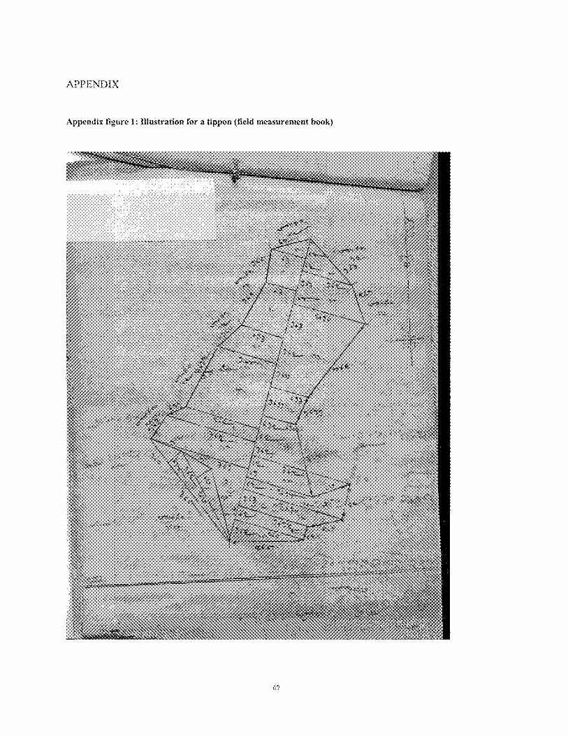
APPENDIX
Appendix figure I: Xlfustration for n tippon (field meacurement book)
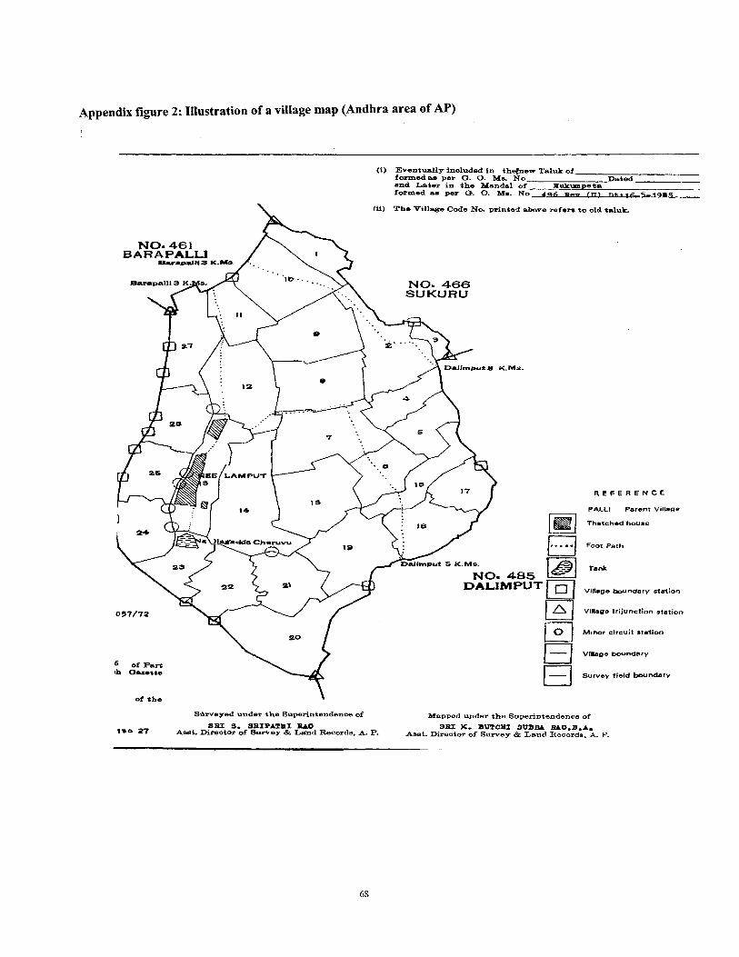
Appendix figure 2: Illustration of a village map (Andhra area of AP)
(i) Eventually inoludad in thelnaaTaluk of formed ae per a. 0. MB NO Dated and Later in t he Mandal of P u k m m e b -
-. formed am per a. 0. Ms. N; 496 as- (n! nt. r 6 5,1085
to old t e l u t
R E F E R E N C E
PALL! Perern Village
Thatched house
Foot Path
Village b n d a r y ststion
Village trljunction station
M~nor circuit station
Village boundary
Survev fleld boundary
Sdrveyed under the Superintendenoe of Mspped upder tho Superintendenoe of SBI 9. SRIPIIPHI BAO 9R.Z %- BUTCXI SWM M 0 . B . A .
1%- 27 Asst. Direator of S w e y & Land Records, A. P- Asat. Direotor of Survey & Land Records. A. P.
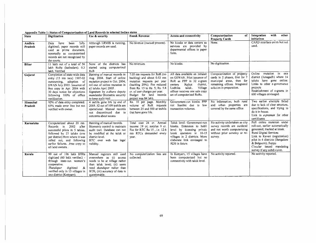
Pradesh
Appendix Table 1: Status of Computerization o
Data have been fully digitized; paper records still used as prime document, reportedly as computerized records are not recognized by
State Digitization
Gujarat
Bihar
Himachal Pradesh
the courts. I1 lakh out of a total of 56 lakh RoRs (kathedars). 0.3 lakh. Verified Completion of state-wide data entry (1 5 mn recs) 1997-02 outsourcing, adoption of SWAN July 2003. Issuance of free copy in Apr. 2004 with 30 days notice for objections following 100% of office verification. 92% of data entry completed. 65% made error free but not verified with owner.
digitized (60 lakh verified) - through state-run women's cooperative. Thanciaper digitized verified only in 15 villages in
Karnataka Computerized about 20 mn. Records in 2002 after successful pilots in 5 taluks, followed by 27 taluks (one per district) from where it was rolled out, and following earlier failures. .Free copy to all land owners..
Land Records in selected Indian states
RoR Banning of manual records in Aug. 2004. Start of online mutation project in Oct. 2004; roll-out of online mutation in a11 taluks April 2005 . Signature by e-dhara deputy mamlatdar Biometric security
None of the distncts has started using computerized
to keep audit t~ail. 4 teshils gone life by end of 2005. 52 out of 109 teshils are operational. Manual records not discontinued due to concerns about access
Computerization of Property Cards None.
Banning of manual records. Biomehic control to maintain audit trail. Database can not be modified at the taIuk or district level. RTC over web has legal validity.
Access and connectivity
No kiosks or data centers as services are provided by departmental offices in paper
Use & security
Although LRMIS is running, paper records are used.
No revenues.
7.05 mn requests for RoR (no backlog) and about 0.53 mn mutation requests per year (backlog 20%). Fee reduced from Rs. 15 to Rs. 5; Rs. 5.8 cr. of user charges per year. Budget for land records
Fees& Revenue
No revenue (manual process).
project was 84 lakh. Rs. 10 per page. Monthly
No kiosks.
volume -of R ~ R requests between 25 and 500 at teshils that have gone life.
No digitization.
Total cost 24 cr. Annual income 19 cr; surplus 9 cr. Fee for RTC Rs 15 , i.e. 12.6 mn RTCs demanded every year.
transaction volumes. covered by the same office
All data available on intranet on GSWAN. Pilot issuance of RoR as PPP in 32 e-gram centers Rajkot district, Lodhika taluk.. Village officer receives one sale copy set of computerized RoRs.
Taluk level: Government-run kiosks. Extension to hobli level by licensing private kiosk operators in 10-15 villages in 2 districts. More elaborate link envisaged to RDS in future.
Computerization of property cards in 2 phases, first for 7 municipal areas, then for remaining offices. Integrated solution in preparation.
No activity undertaken as city survey records are outdated and not worth computerizing without prior scrutiny or re- survey.
Manual registers still used everywhere as (i) access needs to be at village rather than taluk level; (ii) users need thanciaper rather than BTR; (iii) accuracy of data is
No activity reported. No computerization fees are collected.
Integration with other I
In Kottyam, 15 viIlages have been computerized but no connectivity with taluk level.
questionable.
initiatives
used.
1
Online mutation in one district (Junagadh) where 14 taluks have gone online. Links to other e-governance projects Establishment of e-grams in 600 villages envisaged.
Two earlier attempts failed due to lack of clear structure, specifications, and trylng to do it in-house. Link to e-praman for other certificates Full online mutation under roll-out; earlier automatically generated; tracked at kiosk. Rural Digital Services Link to Kaveri (registration) pilot in 4 districts (Bangalore & Belgaum); floppy. Circular issued mandating
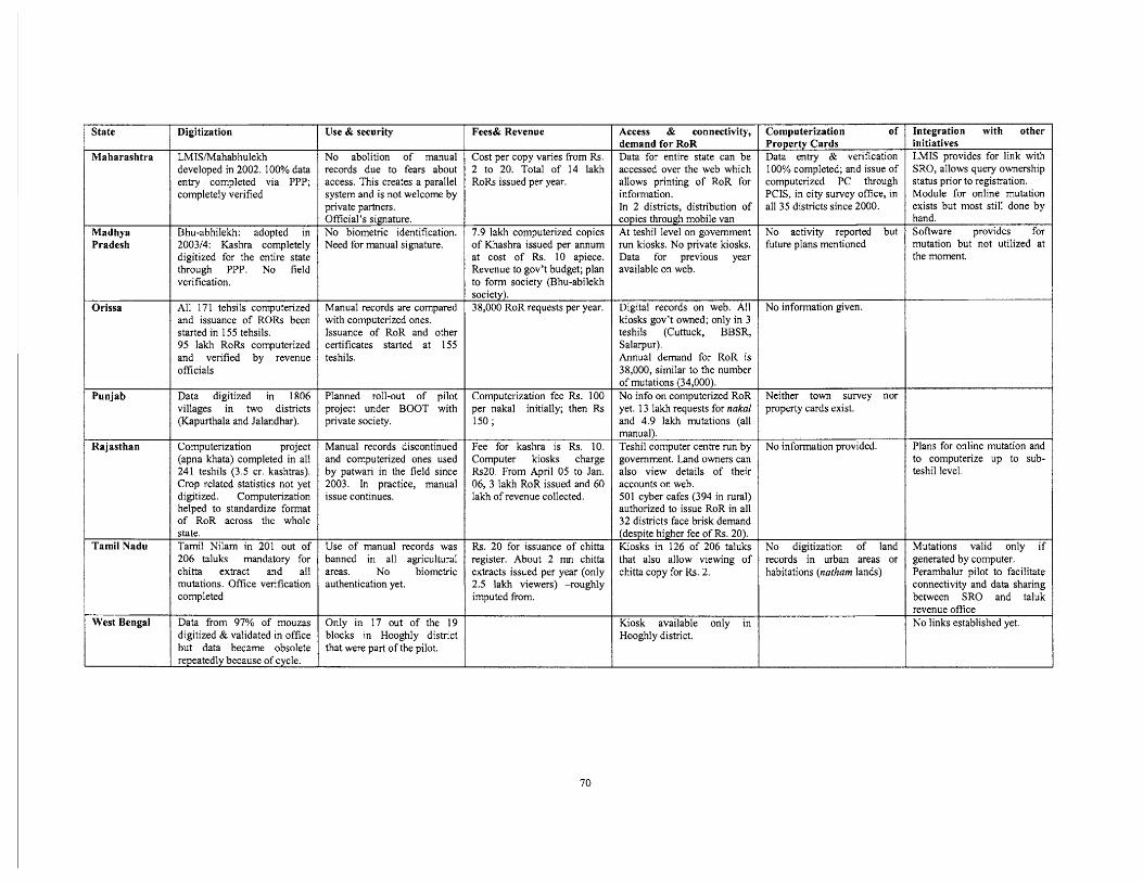
Integration with other initiatives LMIS provides for link with SRO, allows query ownership status prior to registration. Module for online mutation exists but most still done by hand. Software provides for mutation but not utilized at the moment.
j
Plans for online mutation and to computerize up to sub- teshil level.
Mutations valid only if generated by computer. Perambalur pilot to facilitate connectivity and data sharing between SRO and taluk revenue office No links established yet.
State
Maharashtra
Madhya Pradesh
Orissa
Punjab
Rajasthan
Tamil Nadu
I West Bengal
Digitization
LMIS/Mahabhulekh developed in 2002. 100% data entry completed via PPP; completely verified
Bhu-abhilekh: adopted in 2003/4: Kashra completely digitized for the entire state through PPP. No field verification.
All 171 tehsils computerized and issuance of RORs been started in 155 tehsils. 95 lakh RoRs computerized and verified by revenue officials
Data digitized in 1806 villages in two districts (Kapurthala and Jalandhar).
Computerization project (apna khata) completed in all 241 teshils (3.5 cr. kashtras). Crop related statistics not yet digitized. Computerization helped to standardize format of RoR across the whole state. Tamil Nilam in 201 out of 206 taluks mandatory for chitta extract and all mutations. Office verification completed
Data from 97% of mouzas digitized & validated in office but data became obsolete repeatedly because of cycle.
Use & security
No abolition of manual records due to fears about access. This creates a parallel system and is not welcome by private partners. Official's signature.
Access & connectivity, demand for RoR Data for entire state can be accessed over the web which allows printing of RoR for information. In 2 districts, distribution of copies through mobile van At teshil level on government run kiosks. No private kiosks. Data for previous year available on web.
Digital records on web. All kiosks gov't owned; only in 3 teshils (Cuttuck, BBSR, Salarpur). Annual demand for RoR is 38,000, similar to the number of mutations (34,000). No info on computerized RoR yet. 13 lakh requests for nakal and 4.9 lakh mutations (all manual). Teshil computer centre run by government. Land owners can also view details of their accounts on web. 501 cyber cafes (394 in rural) authorized to issue RoR in all 32 districts face brisk demand
Fees& Revenue
Cost per copy varies from Rs. 2 to 20. Total of 14 lakh RoRs issued per year.
Computerization of Property Cards Data entry & verification 100% completed; and issue of computerized PC through PCIS, in city survey office, in all 35 districts since 2000.
No activity reported but future plans mentioned
No information given.
Neither town survey nor property cards exist.
No information provided.
No digitization of land records in urban areas or habitations (natham lands)
Use of manual records was banned in all agricultural areas. No biometric authentication yet.
Only in 17 out of the 19 blocks in Hooghly district that were part of the pilot.
No biometric identification. Need for manual signature.
Manual records are compared with computerized ones. Issuance of RoR and other certificates started at 155 teshils.
Planned roll-out of pilot project under BOOT with private society.
Manual records discontinued and computerized ones used by patwari in the field since 2003. In practice, manual issue continues.
7.9 lakh computerized copies of Khashra issued per annum at cost of Rs. 10 apiece. Revenue to gov't budget; plan to form society (Bhu-abilekh society). 38,000 RoR requests per year.
Computerization fee Rs. 100 per nakal initially; then Rs 150;
Fee for kashra is Rs. 10. Computer kiosks charge Rs20. From April 05 to Jan. 06, 3 lakh RoR issued and 60 lakh of revenue collected.
Rs. 20 for issuance of chitta register. About 2 mn chitta extracts issued per year (only 2.5 la& viewers) -roughly imputed from.
(despite higher fee of Rs. 20). Kiosks in 126 of 206 taluks that also allow viewing of chittacopy for Rs. 2.
Kiosk available only in Hooghly district.
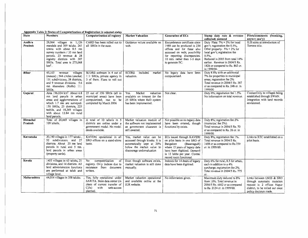
Appendix Tablt State
Andhra Pradesh
Bihar
Gujarat
Himachal Pradesh
Karnataka
Kerala
Maharashtra
I: Status of Computerization a Numbers
28,064 villages in 1,126 mandals and 309 taluks. 261 towns with about 8.5 mn survey numbers 1 35 mn land parcels. 23 revenue & 28 registry districts with 387 SROs. Total area is 275,068 km2.
45,103 revenue villages (mauza) ; 544 circles (anchal, I01 subdivisions, 38 districts, and 9 revenue divisions. 5.6 mn khatedars (RoRs) 11 1 . . SROs. Area 196,024 km2. About 6.8 mn land parcels in urban areas and agglomerations of which 1.7 mn are surveyed. 150 SROs, 25 districts, 225 teshils, and 18,349 viIlages with about 12.84 mn rural land parcels. Total of 20,669 villages in 109 tehsils.
30,190 villages in 177 taluks , 52 subdivisions, and 27 districts. About 20 mn land parcels in rural and 5 mn. land parcels in urban areas (property cards).
1453 villages in 63 taluks, 21 divisions, and 14 districts. A11 land administration functions are performed at taluk and village level. 44,014 villages in 358 taluks.
Zegistration in selected states Computerization of registry
CARD has been rolled out to all SROs in the state.
SCORE software in 4 out of 1 I1 SROs, private agency in 3 of them. Plans to roll out exist.
25 out of 150 SROs (all in municipal areas) have been computerized; rest to be completed by March 2006
A total of 10 tehsils in 5 districts are online under a government model. No model deeds available.
KAVERI operational in all SRO offices on a stand-alone basis.
No computerization of registry. OnIy indices due to resistance from document writers.
Yes, fully operational under SARITA. State data center (in place of current transfer of CDs) with web-access planned.
Market Valuation
Guidance values available on web.
SCORE included market valuation.
Yes. Market valuation avaiIable on intranet for the 25 SROs where ReD system has been impIemented.
Market valuation module of the software not implemented as government clearance is still awaited.
Yes, market value can be accessed through kiosks. It is automatically kept at 20% below the market value to discourage undervaluation
Even though software exists, market valuation is still done manually.
Market valuation operational and available online at the IGR website.
Generation of ECs
Encumbrance certificate since 1988 can be produced in 234 offices and for these also accessed on web; possibility for reporting discrepancies. 10 min. rather than 1-5 days to generate EC.
No legacy data have been computerized.
Not clear.
Not possible as no legacy data have been entered, though functionality exists.
ECs issued through KAVERI on pilot basis in one SRO of Bangalore (Basavagudi) where 15 years of legacy data have been digitized. Demand is 12 Iakhs per year. Central record room functional. Indexes for 14 dears of legacy data have been digitized.
No information given.
I
Duty 8%; registration fee 2% (municipal fee 2%). Total revenue in 200415 Rs. 70 cr as compared to Rs. 26 cr. in
Stamp duty rate & revenue collected; demand Duty Flats: 7% + 2% for local gov't; registration fee O.S%, Other property: 5% + 2% for local gov't; registration fee 0.5%, Reduced in 2005 from totaI 14% earlier. Revenue in 2004/5 Rs. 1826 cr compared to Rs. 862 cr. in 1999100. Duty 8.4% with an additional 7% for properties in municipal areas; registration fee 2% Total revenue in 200415 Rs. 387 CT as compared to Rs. 248 cr. in 1 999100 Duty 6%; registration fee 1.5%. No information on totaI revenue.
1 999100. Duty 8%; registration fee 1 %. 1 Links to RTC established on a
Pilotslcomments (franking, anywr; con'y) ILIS aims at introduction of Torrens titIe.
Connectivity to villages being established through SWAN. Integration with land records envisioned.
~ o t a l revknui in 200415 ~ s . 1 658 cr as compared to Rs .759 cr. in 1999100.
pilot basis.
Duty 6% for rural, 8.5 for urban, each in addition to a 4% surcharge; registration fee 2%. TotaI revenue in 200415 Rs. 775 cr . Maximum duty reduced to 8% from 10%. Total revenue in 200415 Rs. 4662 cr as compared to Rs. 2124 cr. in 1999100.
Links between LMIS & SRO through automatic mutation request in 2 offices Napur district, to be rolled out once policy decision made.
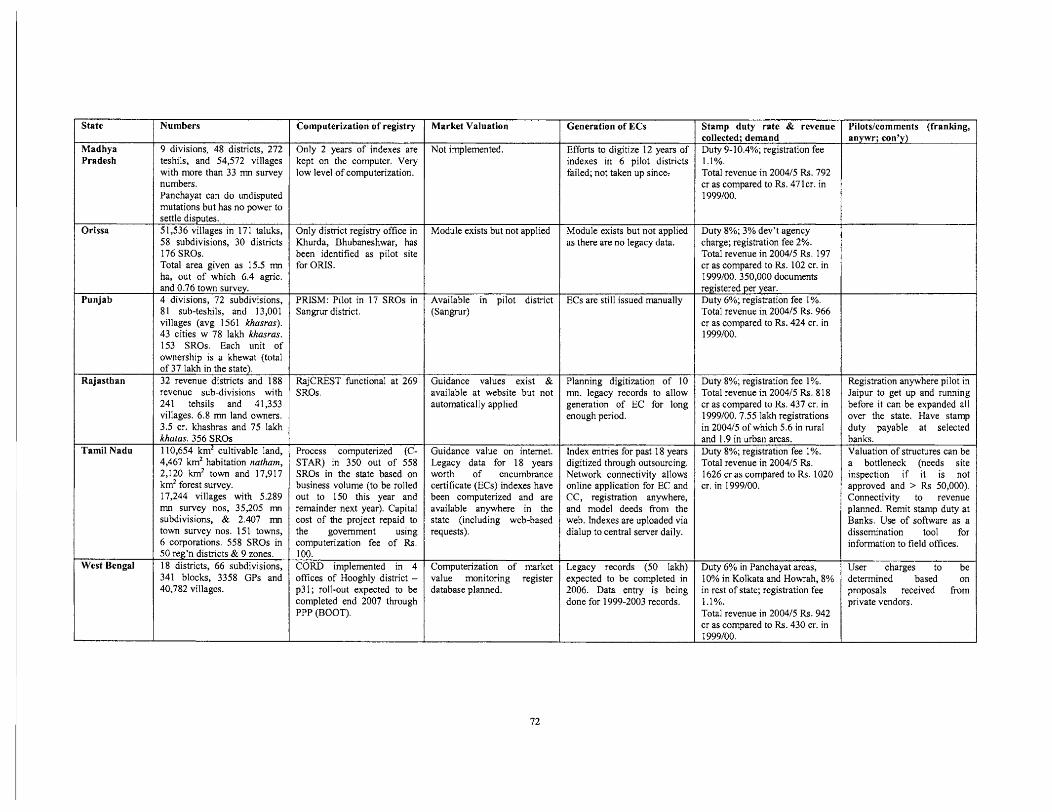
State
Madhya Pradesh
Orissa
Punjab
Rajasthan
Tamil Nadu
West Bengal
Numbers
9 divisions, 48 districts, 272 teshils, and 54,572 villages with more than 33 rnn survey numbers. Panchayat can do undisputed mutations but has no power to settle disputes. 51,536 villages in 171 taluks, 58 subdivisions, 30 districts 176 SROs. Total area given as 15.5 mn ha, out of which 6.4 agric. and 0.76 town survey. 4 divisions, 72 subdivisions, 81 sub-teshils, and 13,001 villages (avg 1 561 khasras). 43 cities w 78 lakh khasras. 153 SROs. Each unit of ownership is a khewat (total of 37 Iakh in the state). 32 revenue districts and 188 revenue sub-divisions with 241 tehsils and 41,353 villages. 6.8 mn land owners. 3.5 cr. khashras and 75 lakh khatas. 356 SROs 1 10,654 km2 cultivable land, 4,467 km2 habitation natham, 2,120 km2 town and 17,917 km2 forest survey. 17,244 vilIages with 5.289 mn survey nos, 35,205 mn subdivisions, & 2.407 mn townsurveynos.151 towns, 6 corporations. 558 SROs in 50 reg'n districts & 9 zones. 18 districts, 66 subdivisions, 341 blocks, 3358 GPs and 40,782 villages.
Computerization of registry
Only 2 years of indexes are kept on the computer. Very low level of computerization.
Only district registry office in Khurda, Bhubaneshwar, has been identified as pilot site for ORIS.
PRISM: Pilot in 17 SROs in Sangrur district.
RajCREST functional at 269 SROs.
Process computerized (C- STAR) in 350 out of 558 SROs in the state based on business volume (to be rolled out to 150 this year and remainder next year). Capital cost of the project repaid to the government using computerization fee of Rs. 100. CORD implemented in 4 offices of Hooghly district - p3 1 ; roll-out expected to be completed end 2007 through PPP (BOOT).
Market Valuation
Not implemented.
Module exists but not applied
Available in pilot district (Sangrur)
Guidance values exist & available at website but not automatically applied
Guidance value on internet. Legacy data for 18 years worth of encumbrance certificate (ECs) indexes have been computerized and are available anywhere in the state (including web-based requests).
Computerization of market
Generation of ECs
Efforts to digitize 12 years of indexes in 6 pilot districts failed; not taken up since:
Module exists but not applied as there are no legacy data.
ECs are still issued manually
Planning digitization of 10 mn. legacy records to allow generation of EC for long enough period.
Index entries for past 18 years digitized through outsourcing. Network connectivity allows online application for EC and CC, registration anywhere, and model deeds from the web. Indexes are uploaded via dialup to central server daily.
Legacy records (50 lakh)
Stamp duty rate & revenue collected; demand Duty 9-10.4%; registration fee 1.1%. Total revenue in 2004/5 Rs. 792 cr as compared to Rs. 471 cr. in 1999100.
Pilots/comments (franking, anywr; con'y)
value monitoring register database planned.
Duty 8%; 3% dev't agency charge; registration fee 2%. TotaI revenue in 2004/5 Rs. 197 cr as compared to Rs. 102 cr. in 1999100. 350,000 documents registered per year. Duty 6%; registration fee 1%. Total revenue in 200415 Rs. 966 cr as compared to Rs. 424 cr. in 1999100.
Duty 8%; registration fee 1%. Total revenue in 2004/5 Rs. 818 cr as compared to Rs. 437 cr. in 1999100.7.55 lakh registrations in 200415 of which 5.6 in rural and 1.9 in urban areas. Duty 8%; registration fee 1%. Total revenue in 200415 Rs. 1626 cr as compared to Rs. 1020 cr. in 1999100.
Duty 6% in Panchayat areas, 10% in Kolkata and Howrah, 8% in rest of state; registration fee I . 1 %. Total revenue in 2004/5 Rs. 942 cr as compared to Rs. 430 cr. in 1 999/00.
expected to be completed in 2006. Data entry is being done for 1999-2003 records.
Registration anywhere pilot in Jaipur to get up and running before it can be expanded all over the state. Have stamp duty payable at selected banks. Valuation of structures can be a bottleneck (needs site inspection if it is not approved and > Rs 50,000). Connectivity to revenue planned. Remit stamp duty at Banks. Use of software as a dissemination tool for information to field offices.
User charges to be determined based on proposals received from private vendors.
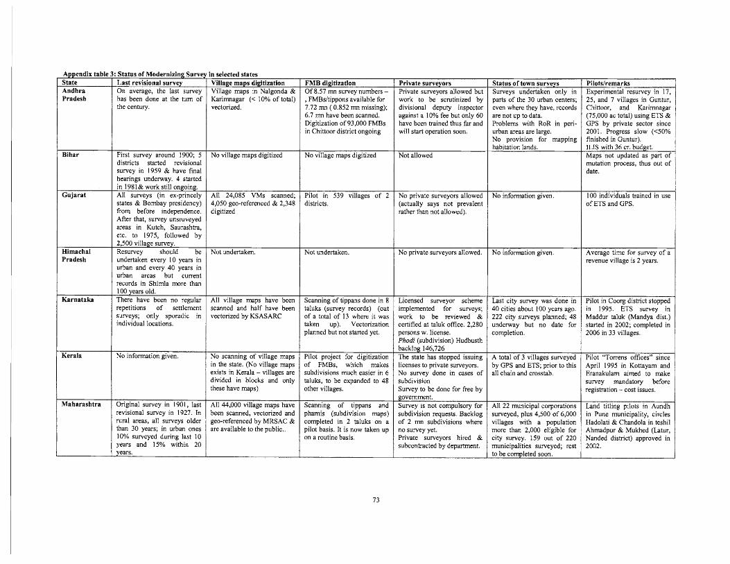
Pradesh
Bihar
Gujarat r Himachal L Pradesh
: Status of Modernizing Surve Last revisional survey On average, the last survey has been done at the turn of the century.
First survey around 1900; 5 districts started revisional survey in 1959 & have final hearings underway. 4 started in 198 1& work still ongoing. All surveys (in ex-princely states & Bombay presidency) from before independence. After that, survey unsruveyed areas in Kutch, Saurashtra, etc. to 1975, followed by 2,500 village survey. Resurvey should be undertaken every 10 years in urban and every 40 years in urban areas but current records in Shimla more than 100 years old. There have been no regular repetitions of settlement surveys; only sporadic in individual locations.
No information given.
Original survey in 1901, last revisional survey in 1927. In rural areas, all surveys older than 30 years; in urban ones 10% surveyed during last 10 years and 15% within 20 years.
In selected states Village maps digitization Village maps in Nalgonda & Karimnagar (< 10% of total) vectorized.
No village maps digitized
All 24,085 VMs scanned; 4,050 geo-referenced & 2,348 digitized
Not undertaken.
All village maps have been scanned and half have been vectorized by KSASARC
No scanning of village maps in the state. (No village maps exists in Kerala - villages are divided in blocks and only these have maps)
All 44,000 village maps have been scanned, vectorized and geo-referenced by MRSAC & are available to the public..
FMB digitization Of 8.57 mn survey numbers - , FMBsItippons available for 7.72 mn ( 0.852 mn missing); 6.7 mn have been scanned. Digitization of 93,000 FMBs in Chittoor district ongoing
No village maps digitized
Pilot in 539 villages of 2 districts.
Not undertaken.
Scanning of tippans done in 8 taluks (survey records) (out of a total of 13 where it was taken up). Vectorization planned but not started yet.
Pilot project for digitization of FMBs, which makes subdivisions much easier in 6 taluks, to be expanded to 48 other villages.
Scanning of tippans and phamis (subdivision maps) completed in 2 taluks on a pilot basis. It is now taken up on a routine basis.
Private surveyors Private surveyors allowed but work to be scrutinized by divisional deputy inspector against a 10% fee but only 60 have been trained thus far and will start operation soon.
Not allowed
No private surveyors allowed (actually says not prevalent rather than not allowed).
No private surveyors allowed.
Licensed surveyor scheme implemented for surveys; work to be reviewed & certified at taluk office. 2,280 persons w. license. Phodi (subdivision) Hudbusth backlog 146,726 The state has stopped issuing licenses to private surveyors. No survey done in cases of subdivision Survey to be done for free by government . Survey is not compulsory for subdivision requests. Backlog of 2 mn subdivisions where no survey yet. Private surveyors hired & subcontracted by department.
Status of town surveys Surveys undertaken only in parts of the 30 urban centers; even where they have, records are not up to data. Problems with RoR in peri- urban areas are large. No provision for mapping habitation lands.
No information given.
No information given.
Last city survey was done in 40 cities about 100 years ago. 222 city surveys planned; 48 underway but no date for completion.
A total of 3 villages surveyed by GPS and ETS; prior to this all chain and crosstab.
All 22 municipal corporations surveyed, plus 4,500 of 6,000 villages with a population more than 2,000 eligible for city survey. 159 out of 220 municipalities surveyed; rest to be comleted soon.
Pilotslremarks Experimental resurvey in 17, 25; and 7 villages i n Guntur, Chittoor, and Karimnagar (75,000 ac total) using ETS & GPS by private sector since 2001. Progress slow (-GO% finished in Guntur). ILiS with 36 cr. budget. Maps not updated as part of mutation process, thus out of date.
100 individuals trained in use of ETS and GPS.
Pilot in Coorg district stopped in 1995. ETS survey in I Maddur taluk (Mandya -dist.) started in 2002; completed in 2006 in 33 villages.
Pilot "Torrens offices" since April 1995 in Kottayam and Eranakularn aimed to make survey mandatory before registration - cost issues.
Land titling pilots in Aundh in Pune municipality, circles Hadolati & Chandola in teshil Ahmadpur & Mukhed (Latur, Nanded district) approved in 2002.
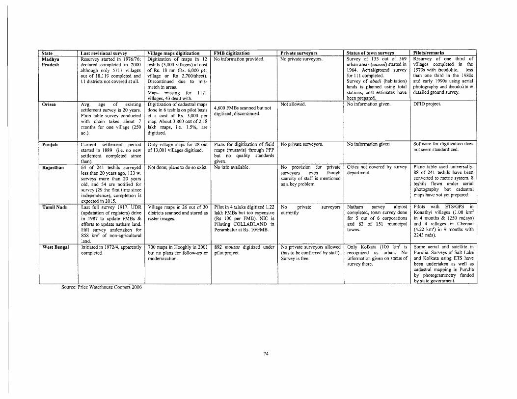
State Madhya Pradesh
Orissa
Last revisional survey Resurvey started in 1976/76; declared completed in 2000 although only 5717 villages out of 18,119 completed and 11 districts not covered at all.
Avg, age of existing settlement survey is 20 years. Plain table survey conducted with chain takes about 7 months for one village (250 ac.).
/ Source: Price Waterhouse Coopers 2006
Punjab
Rajasthan
Tamil Nadu
West Bengal
Village maps digitization I FMB digitization Digitization of maps in 12 1 No information provided.
Current settlement period started in 1889 (i.e. no new settlement completed since then). 64 of 241 teshils surveyed less than 20 years ago, 123 w. surveys more than 20 years old, and 54 are notified for survey (29 the first time since independence); completion is expected in 20 15. Last full survey 1917. UDR (updatation of registers) drive in 1987 to update FMBs & efforts to update natham land. Hill survey undertaken for 858 km2 of non-agricultural land. Initiated in 197214, apparently completed.
teshils (3,000 villag&) at cost of Rs. 18 mn (Rs. 6,000 per village or Rs 2,700lsheet). Discontinued due to mis- match in areas. Maps missing for 1 121 villages, 43 dealt with. Digitization of cadastral maps done in 6 teshils on pilot basis at a cost of Rs. 3,000 per map. About 3,800 out of 2.18 lakh maps, i.e. 1.5%, are digitized.
49600 FMBs scanned but digitized; discontinued.
Only village maps for 28 out of 13,001 villages digitized.
Village maps in 26 out of 30 districts scanned and stored as raster images.
Plans for digitization of field maps (musavis) through PPP but no quality standards
Not done; plans to do so exist.
700 maps in Hooghly in 2001 but no plans for follow-up or modernization.
gven. No info available.
Pilot in 4 taluks digitized 1.22 lakh FMBs but too expensive (Rs 100 per FMB). NIC is Piloting COLLABLAND in Perambalur at Rs. 10lFMB.
892 mouzas digitized under pilot project.
Private surveyors No private surveyors.
Not allowed.
No private surveyors.
No provision for private surveyors even though scarcity of staff is mentioned as a key problem
No private surveyors currently
No private surveyors allowed (has to be confirmed by staff). Survey is free.
Status of town surveys Survey of 135 out of 369 urban areas (nazool) started in 1964. Aeriallground survey for I 1 1 completed. Survey of abadi (habitation) lands is planned using total stations; cost estimates have been prepared. No information given.
No information given
Cities not covered by survey department
Natham survey almost completed, town survey done for 5 out of 6 corporations and 82 of 151 municipal towns.
Only Kolkata (100 km2 is recognized as urban. No information given on status of survey there.
Pilots/remarks Resurvey of one third of villages completed in the 1970s with theodolite, less than one third in the 1980s and early 1990s using aerial photography and theodolite w detailed ground survey.
DFID project.
Software for digitization does not seem standardized.
Plane table used universally. 88 of 241 teshils have been converted to metric system. 8 teshils flown under aerial photography but cadastral maps have not yet prepared.
Pilots with ETSIGPS in Konathyi villages (1 .O8 km2 in 4 months & 1250 mdays) and 4 villages in Chennai (4.22 km2) in 9 months with 2243 mds).
Some aerial and satellite in Purulia. Surveys of Salt Lake and Kolkata using ETS have been undertaken as well as cadastral mapping in Purulia by photogrammetry funded by state government.
Related Documents