Initial Environmental Examination This initial environmental examination report is a document of the borrower. The views expressed herein do not necessarily represent those of ADB's Board of Directors, Management, or staff, and may be preliminary in nature. This report is an updated version of the IEE report posted in May 2018 available on adb.org/projects/documents/ind-43464-026-iee. In preparing any country program or strategy, financing any project, or by making any designation of or reference to a particular territory or geographic area in this document, the Asian Development Bank does not intend to make any judgments as to the legal or other status of any territory or area. Project Number: 43464-026 June 2020 IND: Himachal Pradesh Clean Energy Transmission Investment Program - Tranche 2 Submitted by: HP Power Transmission Corporation Limited (HPPTCL)

Welcome message from author
This document is posted to help you gain knowledge. Please leave a comment to let me know what you think about it! Share it to your friends and learn new things together.
Transcript
Initial Environmental Examination
This initial environmental examination report is a document of the borrower. The views expressed herein do not necessarily represent those of ADB's Board of Directors, Management, or staff, and may be preliminary in nature. This report is an updated version of the IEE report posted in May 2018 available on adb.org/projects/documents/ind-43464-026-iee.
In preparing any country program or strategy, financing any project, or by making any designation of or reference to a particular territory or geographic area in this document, the Asian Development Bank does not intend to make any judgments as to the legal or other status of any territory or area.
Project Number: 43464-026 June 2020
IND: Himachal Pradesh Clean Energy Transmission Investment Program - Tranche 2
Submitted by:
HP Power Transmission Corporation Limited (HPPTCL)
Recd. 9.06.20SFG Log: 4181
Initial EnvironmentalExamination
Project Number: 43464-026-IND
June 2020
India: Himachal PradeshCleanEnergy Transmission InvestmentProgramme
Loan 3001-IND (Tranche – 2)
Prepared by HP Power Transmission Corporation Limited (HPPTCL)
The initial environmental examination is a document of the borrower. The views expressed herein do not necessarily represent those of ADB’s Board of Directors, Management, or staff, and may be preliminary innature.
TABLE OF CONTENTS EXECUTIVE SUMMARY .................................................................................................................................. 1
1 INTRODUCTION ....................................................................................................................................... 11
1.1 Background ....................................................................................................................................... 11
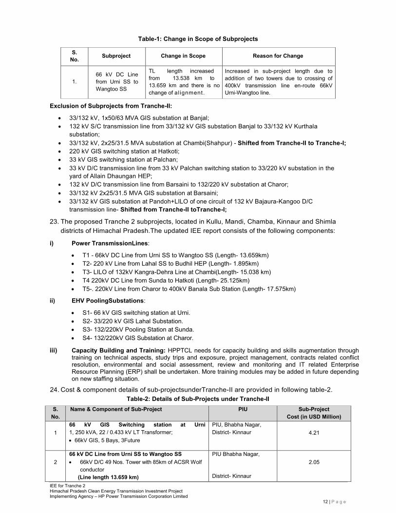
1.2 Scope of Work andMethodologyAdopted .......................................................................................... 13
2 POLICY, LEGAL AND ADMINISTRATIVE FRAMEWORK ................................................................... 15
2.1 Country’sLegal Framework and Regulatory Requirements for the Project ........................................15
2.2 EnvironmentalClearance ................................................................................................................. 16
2.3 ForestsClearance ............................................................................................................................ 16
2.4 WildlifeClearance............................................................................................................................. 16
2.5 RequiredClearances/Permissions ................................................................................................... 16
2.6 InternationalAgreements ................................................................................................................. 17
2.7 Asian Development BankSafeguardPolicies ................................................................................... 18
2.8 Project Categorisation asperADB ................................................................................................ 18
3 DESCRIPTION OF THE PROJECT ........................................................................................................ 19
3.1 Type of Project ................................................................................................................................ 19
3.2 Category of Project .......................................................................................................................... 19
3.3 Capacity Buildingand Training ........................................................................................................ 20
3.4 Brief Description of the Sub-Projects ............................................................................................... 20
3.5 Land Requirement ........................................................................................................................... 25
3.6 Location of Sub-Projects............................................................................................................. 26
3.7 Associated Facilities ................................................................................................................... 32
3.8 Implementation Plan ........................................................................................................................ 33
4 DESCRIPTION OF ENVIRONMENT (BASELINE DATA) ........................................................................ 36
4.1.1 Physical Resources ................................................................................................................. 36
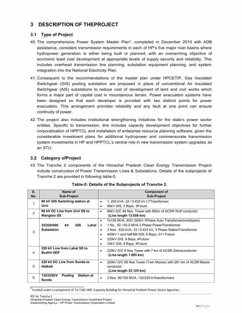
4.1.2 Climate & Rainfall .................................................................................................................... 37
4.1.3 Ambient Air Quality .................................................................................................................. 38
4.1.4 Noise Quality ........................................................................................................................... 40
4.1.5 Topography ............................................................................................................................. 41
4.1.6 Geomorphology & SoilTypes ................................................................................................... 42
4.1.7 Soil Quality............................................................................................................................... 43
4.1.8 Water Resources (Surface and Ground Water) ...................................................................... 45
4.1.9 Water Quality of theSub-Project Area ...................................................................................... 46
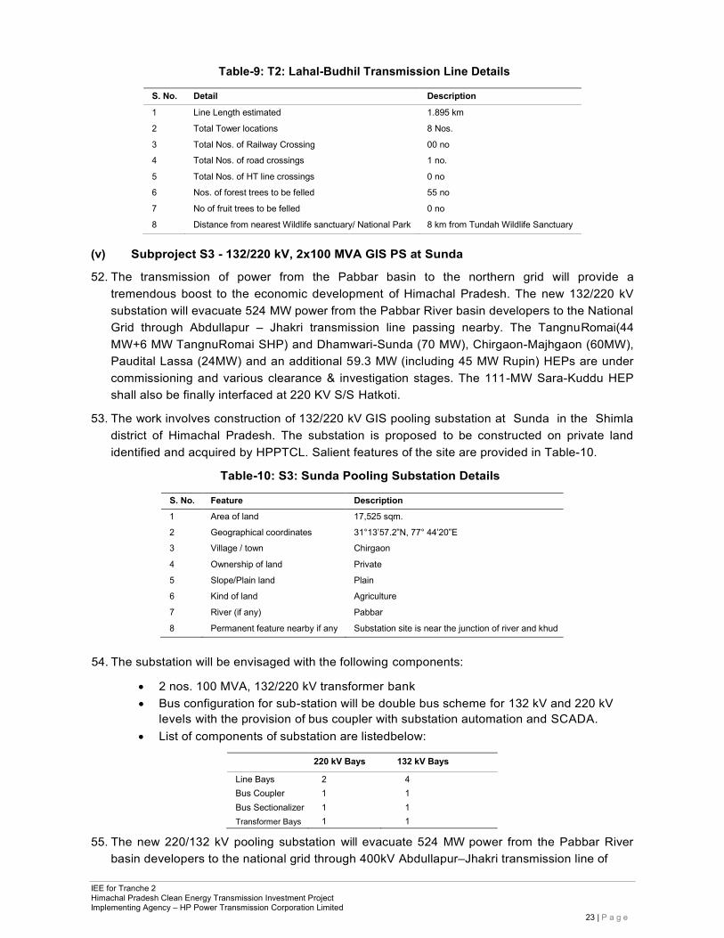
4.1.10 Geology ................................................................................................................................... 53
4.1.11 Seismicity................................................................................................................................. 53
4.2 Ecological Resources ...................................................................................................................... 54
4.2.1 Terrestrial Ecology ................................................................................................................... 54
4.3 Socioeconomic Profile ..................................................................................................................... 60
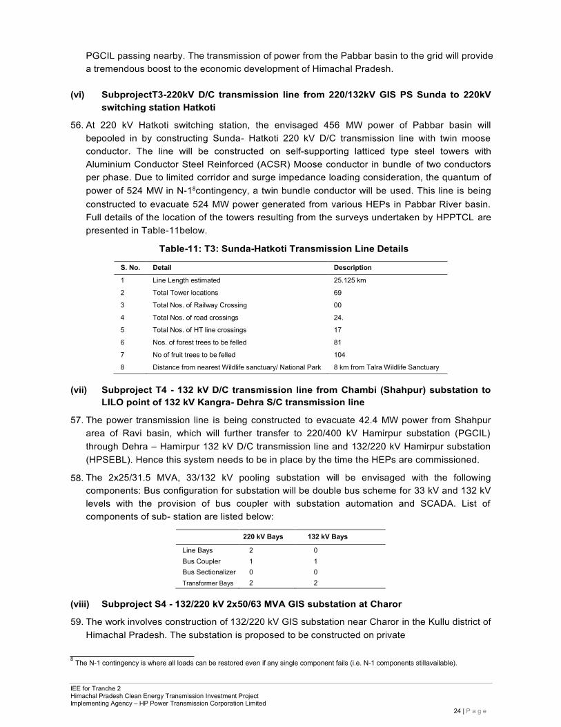
4.3.1 Demography ............................................................................................................................ 62
4.3.2 Employment / Working Population Details ............................................................................... 63
4.3.3 Industries ................................................................................................................................. 64
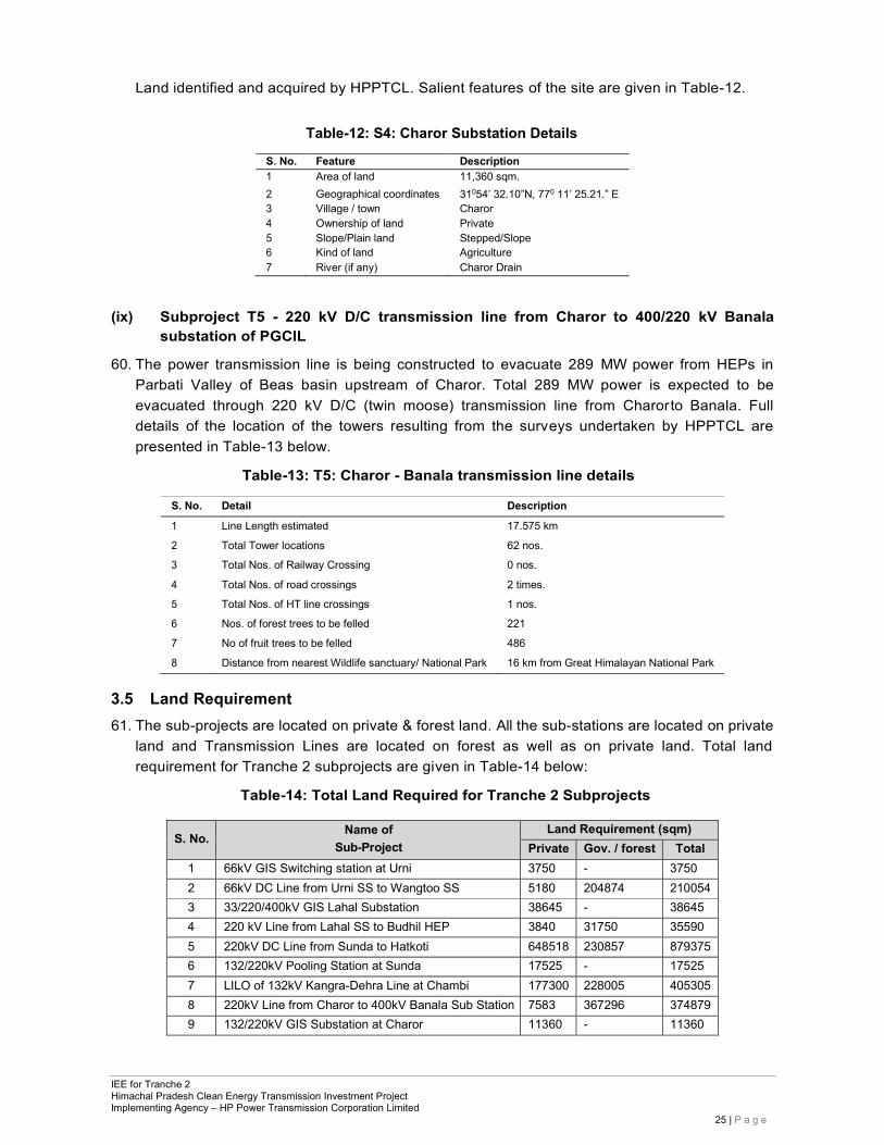
4.3.4 InfrastructureFacilities.............................................................................................................. 64
4.3.5 Land Use ........................................................................................................................................ 65
4.3.6 Agricultural Development/Other income sources Agriculture .................................................. 67
4.3.7 Horticulture .............................................................................................................................. 68
4.3.8 Beekeeping .............................................................................................................................. 69
4.3.9 Animal Husbandry .......................................................................................................................... 69
4.3.10 Fisheries .................................................................................................................................. 70
4.3.11 Mineral Development ............................................................................................................... 70
4.3.12 Tourism Facilities ..................................................................................................................... 70
4.3.13 Social and Cultural Resources ................................................................................................ 71
4.3.14 Sites of Cultural, Archaeological and Historical Significance ................................................... 73
5 ANTICIPATEDENVIRONMENTALIMPACTSANDMITIGATIONMEASURES .......................................... 75
5.1 Environment Problems Associated with Project LocationandDesign ........................................... 75
5.2 EnvironmentalImpactsAssociatedwithPre-ConstructionStage......................................................... 75
5.2.1 Acquisition of Cultivable and Noncultivablelands ................................................................. 75
5.2.2 Impacts on Temporary UseofLand ........................................................................................... 76
5.3 EnvironmentalProblemsAssociatedwithConstructionandOperationStage ....................................... 76
5.3.1 Impact onPhysicalResources .................................................................................................. 76
5.3.2 Impact onEnvironmentalResources ......................................................................................... 77
5.3.3 Impact onEcologicalResources ............................................................................................... 80
5.3.4 ImpactonEcologicalResourcesduetoChangeinScopeofSub-Projects ...................................... 82
5.3.5 Impact onHumanEnvironment ................................................................................................. 83
5.3.6 WasteDisposal ......................................................................................................................... 85
5.4 Environmental Impacts Associated with Operations andMaintenanceStage ............................... 87
5.4.1 ElectricShock ........................................................................................................................... 87
5.4.2 NoiseGeneration ...................................................................................................................... 87
5.4.3 Maintenance of Transmission lineandSubstation .................................................................... 87
5.4.4 OilSpillage................................................................................................................................ 87
5.4.5 Sulphur Hexafluoride (SF6)Leakage ........................................................................................ 88
5.5 EnvironmentalManagementPlan ...................................................................................................... 88
6 ANALYSISOFALTERNATIVES .............................................................................................................. 91
6.1 HPPTCL’s Approach forRouteSelection .......................................................................................... 91
6.2 Methodology for Selection of Route: Environmental and Socialview ............................................... 91
6.3 Alternatives forSubprojectComponents ........................................................................................... 92
6.3.1 TransmissionLines .............................................................................................................. 92
6.3.2 GISSubstations ........................................................................................................................ 93
6.3.3 Reasons for theFinalSelection ................................................................................................. 96
6.4 Distance fromSensitiveReceptors ................................................................................................... 96
7 INFORMATION DISCLOSURE, CONSULTATION, AND PARTICIPATION ............................................ 100
7.1 Information Disclosure ............................................................................................................... 100
7.2 Public Consultation .......................................................................................................................... 100
7.3 Consultation Findings ...................................................................................................................... 102
7.4 Public Consultation during Construction & Updation of IEE ............................................................ 103
8 GRIEVANCE REDRESSAL MECHANISM ............................................................................................. 104
8.1 Awareness of Stakeholders ............................................................................................................. 104
8.2 The Grievance Redressal Mechanism ............................................................................................ 104
9 ENVIRONMENTAL MANAGEMENT PLAN ........................................................................................... 106
9.1 Institutional Arrangements ............................................................................................................... 106
9.2 Environmental Management Plan ................................................................................................. 107
9.3 Monitoring of Environmental Management Plan (EMP) ................................................................ 108
9.4 Environmental Monitoring Plan ..................................................................................................... 108
9.5 Environmental Monitoring Report (EMR) ...................................................................................... 108
9.6 Health and Safety Management .................................................................................................... 109
9.6.1 Health and Safety Issues .................................................................................................. 109
9.6.2 AwarenessProgram ............................................................................................................... 109
9.6.3 SafetyAudits .......................................................................................................................... 110
9.7 Environmental Management Budget ............................................................................................. 110
10 FIELD BASED ENVIRONMENT DUE DELIGENCE……………………………………………………… 112
11 CONCLUSIONS AND RECOMMENDATIONS ............................................................................... ….113
APPENDICES Appendix-I: - Rapid Environmental Assessment (REA) Checklist ............................................................. 117
Appendix-II:-Alternative Site Analysis for Grid Sub-stations...................................................................... 120
Appendix-III:-Alternative Route Analysis for Transmission Line Sub-projects........................................... 126
Appendix-IV:-Details of Public Consultations Conducted During Original IEE Preparation in 2012 .......... 133
Appendix-V:-Details of Participants and Photographs of Public Consultation Organised during Upadation of IEE in March & April, 2018 .................................................................................................................... 141
Appendix-VI: - Grievance Redressal Committee ....................................................................................... 146
Appendix-VII:-Environment and Social Monitoring Cell (ESC) .................................................................. 147
Appendix-VIII:-Copiesof ForestClerances applicable for sub projects……………………………………….148
Appendix-IX: -Environment Management Plan(EMP) ............................................................................... 158
Appendix-X: - EnvironmentalMonitoringPlan ............................................................................................. 168
ABBREVIATIONS
ADB – Asian DevelopmentBank ACSR – Aluminium Conductor Steel Reinforced AMSL – Average Mean SeaLevel CEA – Central ElectricityAuthority CPCB – Central Pollution Control Board, Government of India DCor D/C – DoubleCircuit DPR – Detailed ProjectReport EA – ExecutingAgency EARF – Environmental Assessment and Review Framework EIA – Environmental ImpactAssessment EMoP – Environmental Monitoring Plan EMP – Environmental Management Plan EHV – Extra HighVoltage EPC – Engineering, Procurement and Construction ESC – Environment and SocialCell GHG – Green HouseGases GoHP – Government of Himachal Pradesh GoI – Government ofIndia GRM – Grievance Redressal Mechanism HP – HimachalPradesh HPCEDIP – Himachal Pradesh Clean Energy Development Investment
Program HPCETIP – Himachal Pradesh Clean Energy Transmission Investment
Program HPSPCB – HP State Pollution ControlBoard HPPCL – Himachal Pradesh Power Corporation Limited HPPTCL – HP Power Transmission Corporation Limited HPSEB – Himachal Pradesh State ElectricityBoard IA – ImplementingAgency IEE – Initial EnvironmentalExamination LILO – Line – in- Line-out MFF – Multi-tranche FinancingFacility MOEF – Ministry of Environment and Forests, Government of India PCB – Poly ChlorinatedBiphenyl PGCIL – Power Grid Corporation of India Limited PMU – Project ManagementUnit ROW – Right ofWay RP – ResettlementPlan SF6 – SulphurHexafluoride
WEIGHTS AND MEASURES ha(hectare) – 10,000 sqm km – 1,000m kV – kilovolt (1,000volts) kW – kilowatt(1,000 kWh – kilowatt-hour MVA – Megavolt-Amperes MW – MegaWatt
IEE for Tranche 2 Himachal Pradesh Clean Energy Transmission Investment Project Implementing Agency – HP Power Transmission Corporation Limited
7 | P a g e
EXECUTIVE SUMMARY
1. Himachal Pradesh is a mountainous state in northern India with a population of slightly over 6 million, has abundant water resources in the five major rivers flowing through the state from the western Himalayas. The hydropower generation potential of Himachal Pradesh is about 27436 MW, which is about one-fourth of the total hydropower potential of India. In its Hydropower Policy (2007)1, the Government of Himachal Pradesh (GoHP) targets its comparative advantage in hydropower with the goal to become the "Hydropower State" of the country.
2. The Himachal Pradesh Clean Energy Transmission Investment Program (HPCETIP) is a $350 million multi tranche financing facility (MFF) from the Asian Development Bank (ADB), which will contribute to economic development in Himachal Pradesh through expanded power supplies from clean energy sources, and support a sustainable electricity sector in the state. HPCETIP will produce the following outcomes: (i) increase availability of clean energy downstream at pooling stations for effective power evacuation in a financially sustainable manner, (ii) improve state finances and power sector financial viability from sales revenue earned from powerexports,(iii)improve sector governance,(iv)improve capacity in HP PowerTransmission Corporation Limited (HPPTCL) for better planning, implementation and management of powerevacuation infrastructure, and energy efficiency, and (v) improvement in implementation standards of environmental and social safeguards in the sector. With ADB support, the proposed program will sustain the energy sector reform agenda, and is expected to help attract other long-term financiers to the State.
3. The ADB-approved Initial Environmental Examination (IEE) report, May, 2018 has been updated due to minor revision in the length and addition of two nos. of towers in one of the subprojects (Urni SS to Wangtoo SS)under loan 3001-IND (Tranche-II) as listed in table E1.
Table E.1: Change in Scope of Subprojects
S. No. Subproject Change in Scope Reason for Change
1.
66 kV DC Line from Urni SS to Wangtoo SS
TL length increased from 13.538km to 13.659 km and there is nochange of alignment.
Increased in sub-project length due to addition of two towers due to crossing of 400kV transmission line en-route 66kV Urni-Wangtoo line.
Exclusion of Subprojects from Tranche-II:
• 33/132 kV, 1x50/63 MVA GIS substation at Banjal; • 132 kV S/C transmission line from 33/132 kV GIS substation Banjal to 33/132 kV Kurthala
substation; • 33/132 kV, 2x25/31.5 MVA substation at Chambi(Shahpur) - Shifted from Tranche-II to
Tranche-I; • 220 kV GIS switching station at Hatkoti; • 33 kV GIS switching station at Palchan; • 33 kV D/C transmission line from 33 kV Palchan switching station to 33/220 kV substation in
the yard of Allain Dhaungan HEP; • 132 kV D/C transmission line from Barsaini to 132/220 kV substationat Charor; • 33/132 kV 2x25/31.5 MVA GIS substation at Barsaini; • 33/132 kV GIS substation at Pandoh+LILO of one circuit of 132 kV Bajaura-KangooD/C
transmission line- Shifted from Tranche-II toTranche-I;
1 Government of Himachal Pradesh, 2007 Hydro Power Policy (2007). Shimla
IEE for Tranche 2 Himachal Pradesh Clean Energy Transmission Investment Project Implementing Agency – HP Power Transmission Corporation Limited
8 | P a g e
4. The proposed Tranche 2 subprojects are located in Kullu,Mandi,Chamba,Kinnaur and Shimla districts of Himachal Pradesh.The updated IEE report consists of the following components:
i) Power TransmissionLines: • T1 - 66kV DC Line from Urni SS to Wangtoo SS (Length- 13.659km) • T2- 220 kV Line from Lahal SS to Budhil HEP (Length- 1.895km) • T3- LILO of 132kV Kangra-Dehra Line at Chambi (Length- 15.038km) • T4 220kV DC Line from Sunda to Hatkoti (Length- 25.125km) • T5-. 220kV Line from Charor to 400kV Banala Sub Station (Length- 17.575km)
ii) Substations: • S1- 66 kV GIS switching station at Urni. • S2- 33/220 kV GIS Lahal Substation. • S3- 132/220kV Pooling Station at Sunda. • S4- 132/220kV GIS Substation at Charor.
iii) Capacity Building and Training: HPPTCL needs for capacity building and skills augmentation through training on technical aspects, study trips and exposure, project management, contracts related conflict resolution, environmental and social assessment, review and monitoring and IT related Enterprise Resource Planning (ERP) shall be undertaken. More training modules may be added in future depending on new staffing situation.
5. Associated Facilities: There are several hydropower projects (HEPs) that will connect to these lines and substations in the future and HPPTCL will evaluate these projects once their details are provided by the project proponents. HPPTCL has a standard application procedure prescribed by HP Energy Regulatory Commission (HPERC) making it mandatory for all associatedHEPs toprovideinformationtoensurethattheirfacilitiescomplywithGoIandGoHP rules for environmental and social clearances before they connect to the HPPTCL transmission system.
6. Ministry of Environment, Forest & Climate Change (MoEF&CC), Government of India’s (GoI) through Environment Impact Assessment (EIA) Notification, 2006 and its subsequent amendments, made mandatory Environmental Clearance for the projects listed in the schedule of the said EIA Notification. The projects, listed in the schedule of Environmental Impact Assessment (EIA) Notification 2006 and its subsequent amendments, are required to obtain Environmental Clearance from MoEF&CC / SEIAA. Power Transmission projects; have been exempted from Environmental Clearance as they are not listed in the schedule of EIA Notification 2006 and its subsequent amendments. Forest Clearance from HPForest Department &MoEF&CC is required only in cases where subproject is constructed on forest land or requires cutting of forest trees. However, National Environmental Policy 2006 of Government of India (GoI) and Safeguard Policy Statement 2009 of ADB and procedures and guidelines thereto apply to all components/subprojects funded by ADB.
7. The Tranche-II Project has been classified as environmental category “B” based on ADB Rapid Environmental Assessment (REA) Checklist (see Appendix 1). During updationof IEE report, due consideration has been given if there is impact on environmental classification of the sub- projects, due to change of scope of sub-projects, using screening criteria as per ADB REA Checklist.
8. The Urni, Lahal, Sunda & Charor substations land belong to HPPTCL and private land has been acquired for all substations. The larger extent of proposed transmission lines from Sunda- Hatkoti (25.125 km), Urni-Wangtoo (13.659 km),Charor-Barnala (17.575 km), Lahal- Budhil
IEE for Tranche 2 Himachal Pradesh Clean Energy Transmission Investment Project Implementing Agency – HP Power Transmission Corporation Limited
9 | P a g e
(1.895 km) and LILO of 132 kV Kangra Dehra Transmission line at Chambi (15.038 km) will run mostly from hilltop to hilltop through barren lands, cultivated lands, uncultivated lands and forestlands. These line routes have been selected with least impacts on forests, trees, cultivable land and habitation. Wherever possible, the alignments have been proposed either on hilltop-to-hilltop routes or towers with extra heights to reduce the impacts on land underneath while maintaining the mandatory clearance as per Indian Electricity Act (Rules 77 and 80). The proposed alignments pose minimum disturbance to any Reserve Forests or any Sanctuary and National Parks in the State. However, few trees will be required to be felled that fall under the RoW for which Compensatory Afforestation will be done as per Forest (Conservation) Act 1980 (along with its subsequent amendments) and as per HPPTCL’s Environment and Social Safeguards Policy2011.
9. Any of the sub-projects are not passing through notified protected area (Wildlife Sanctuary, National Park or Conservation Reserves, etc.). No endangered or protected species of flora or fauna are reported at any of the subprojectsites.
10. No archaeological/protected monument is located in the projectvicinity.
11. No reliable baseline information of air, noise, water & soil quality were exists for sub-project locations during original IEE report preparation. However, collection of baseline parameters of water, air, soil, and noise have been done during construction as per ADB approved monitoring plan,which has been used for the establishment of baseline data during IEE updation and same has been provided in this updated IEE report under the chapter “Description of Environment”. The quality of air, noise, water & soilis generally found good in the sub-project sites.There is no negative impact envisaged on environmental baseline during construction of sub-projects.
12. Based on the environmental assessment and surveys conducted for the project so far, it is evident that the potential adverse environmental impacts can be mitigated to an acceptable level by adequate implementation of the mitigation measures identified in the EMP. Adequate provisions have been made in the project to cover the environmental mitigation and monitoring requirements, and their associated costs. Adverse impacts if noticed during implementation will be mitigated using appropriate design and managementmeasures.
13. The proposed project will have number of positive impacts as well as negative impacts as providedbelow:
• State Government shall benefit largely from the large volumes for exportable surplus ofpower.
The local people shall benefit due to improvement in quality and reliability oftheelectricity supply as well as funds that will flow into the area to provide them with better roads, health facilities due to higher allocations to the Local Area Development Funds from generation projects to the district. Improvement in lifestyles of local people shall be themain positive impact of this project.
• There will be removal of fruit and non-fruit trees for the transmission line and substations, which is the main negative impact to the proposed project area. However, the compensation for crop and trees shall be made as per HPPTCL’s Resettlement, Relief, Rehabilitation and Compensation Policy May 2011. Compensatory afforestation shall be carried out wherever forest land isused.
IEE for Tranche 2 Himachal Pradesh Clean Energy Transmission Investment Project Implementing Agency – HP Power Transmission Corporation Limited
10 | P a g e
• Environment pollution due to cut and fill operations, transportation of construction materials, disposal of debris, disturbance to the farming activities, nuisance from dust, noise, vehicle fumes, black smoke, vibration as well as silt runoff due to construction activities are the short term negative impacts due to proposed project.
14. Overall, the major environmental impacts associated with transmission projects are limited to the construction period and can be mitigated to an acceptable level by implementation of recommended measures and by best engineering and environmental practices. The impact matrix depicts that the project will not have significant negative environmental impacts and the project would help in improving the socio-economic conditions of this developing State. As the project falls in Category “B” as per the ADB’s REA checklist even after change in scope of sub- projects, no detailed EIA study isrequired.
15. Public consultations with the project affected communities, stakeholders, and government officers focused on existing environmental conditions around the proposed transmission lines/ substations and the potential impacts that could happen due to project implementation have been completed. Public Consultation is a continuous process and conducted throughout the project during design, pre-construction, construction and operation.Consultations have been organized during construction phase as well as separate Public Consultations have been organized during March & April, 2018 for the upadation of IEE report in respect of the subprojects, which have revise scope. Main issues of consultation were – i) People want location of Substation and Transmission Line Route away from the habitation; ii) People wanted to know about Job & business (supply of material, labour, etc.) opportunities during construction & operation of project; iii) People wanted to know about compensation for land and trees.There are no other significant environmental issues which have been raised by people during consultation.
16. Proper Grievance Redressal Mechanism (GRM) has been implemented by HPPTCL to overcome public inconvenience during the sub-project activities. Copy of the office order regarding constitution of Grievance Redressal Committee (GRC) at Corporate Office level & PIU level is provided in Appendix-VI, Copy of the same is also uploaded on HPPTCL’s website.
17. The Initial Environment Examination (IEE) ascertains that it is unlikely to cause any significant environmental impacts. Few impacts were identified attributable to the proposed sub-projects. Proper mitigation measures have been suggested and incorporated in the Environmental Management Plan to avoid / minimize these anticipated impacts.
18. The Executing Agency (HPPTCL) shall ensure that EMP forms part of bid document and works contract.The same shall be revised if necessary during project implementation or if there is any change in the project design and with approval of ADB.
IEE for Tranche 2 Himachal Pradesh Clean Energy Transmission Investment Project Implementing Agency – HP Power Transmission Corporation Limited
11 | P a g e
1 INTRODUCTION
1.1 Background 19. The hydropower generation potential of Himachal Pradesh is about 27436 MW, which is about
one-fourth of the total hydropower potential of India. In its Hydropower Policy (2007)2, the Government of Himachal Pradesh (GoHP) targets its comparative advantage in hydropower with the goal to become the "hydropower state" of the country. The state's hydropower development includes construction of enabling infrastructure such as road access and transmission interconnections to facilitate hydropower development, and to encourage investment from the state, central government and private sectors in hydro power generation projects—the majority of which are run-off-river type. This will improve state finances from sales revenue earned from supplying surplus power to the national grid.In addition to developing its hydropower resources, HP has to build out its electric transmission infrastructure so that the additional power can be efficiently transmitted within the state and exported to the national grid.
20. For improvement, strengthening of existing and building of new infrastructure for effective power evacuation, the Government of Himachal Pradesh (GoHP) through the Government of India (GoI), had requested the Asian Development Bank (ADB) for a multi- tranche financing facility(MFF) to partly finance the power sector investment program in the state.The investment program covers investments for transmission of clean energy to National Grid of India by construction of pooling substations and EHV transmission lines. To implement this activity, Himachal Pradesh Government has established H.P. Power Transmission Corporation Limited (HPPTCL) vide HP Government Notification Nos.: MPP-A (1)-4/2006-Loose dated 11th September, 2008 as the State Transmission Utility (STU).
21. The $350 million investments in the MFF will contribute to support the economic development in Himachal Pradesh through expanded power supplies from clean energy sources, and support a sustainable state electricity sector in the state. The Himachal Pradesh Clean Energy Transmission Investment Program (HPCETIP) will produce the following outcomes: (i) increase availability of clean energy downstream at polling stations for effective power evacuation in a financially sustainable manner, (ii) improve state finances and power sector financial viability from sales revenue earned from power exports, (iii) improve sector governance, (iv) improve capacity in HP Power Transmission Corporation Limited (HPPTCL) for better planning, implementation and management of power evacuation infrastructure, and energy efficiency through a better power management program, and (v) improvement in implementation standards of environmental and social safeguards in the sector. With ADB support, the proposed program will sustain the energy sector reform agenda, and is expected to help attract other long-term financiers to thestate.
22. The ADB-approved Initial Environmental Examination (IEE) report, May, 2018 has been updated due to minor revision in the length and addition of two no. of towers in one of thesubprojects under loan 3001-IND (Tranche-II) as listed in table 1.
2 Government of Himachal Pradesh, Hydro Power Policy (2007). Shimla.
IEE for Tranche 2 Himachal Pradesh Clean Energy Transmission Investment Project Implementing Agency – HP Power Transmission Corporation Limited
12 | P a g e
Table-1: Change in Scope of Subprojects
S. No. Subproject Change in Scope Reason for Change
1. 66 kV DC Line from Urni SS to Wangtoo SS
TL length increased from 13.538 km to 13.659 km and there is no change of al ignment .
Increased in sub-project length due to addition of two towers due to crossing of 400kV transmission line en-route 66kV Urni-Wangtoo line.
Exclusion of Subprojects from Tranche-II:
• 33/132 kV, 1x50/63 MVA GIS substation at Banjal; • 132 kV S/C transmission line from 33/132 kV GIS substation Banjal to 33/132 kV Kurthala
substation; • 33/132 kV, 2x25/31.5 MVA substation at Chambi(Shahpur) - Shifted from Tranche-II to Tranche-I; • 220 kV GIS switching station at Hatkoti; • 33 kV GIS switching station at Palchan; • 33 kV D/C transmission line from 33 kV Palchan switching station to 33/220 kV substation in the
yard of Allain Dhaungan HEP; • 132 kV D/C transmission line from Barsaini to 132/220 kV substation at Charor; • 33/132 kV 2x25/31.5 MVA GIS substation at Barsaini; • 33/132 kV GIS substation at Pandoh+LILO of one circuit of 132 kV Bajaura-Kangoo D/C
transmission line- Shifted from Tranche-II toTranche-I;
23. The proposed Tranche 2 subprojects, located in Kullu, Mandi, Chamba, Kinnaur and Shimla districts of Himachal Pradesh.The updated IEE report consists of the following components:
i) Power TransmissionLines:
• T1 - 66kV DC Line from Urni SS to Wangtoo SS (Length- 13.659km) • T2- 220 kV Line from Lahal SS to Budhil HEP (Length- 1.895km) • T3- LILO of 132kV Kangra-Dehra Line at Chambi(Length- 15.038 km) • T4 220kV DC Line from Sunda to Hatkoti (Length- 25.125km) • T5-. 220kV Line from Charor to 400kV Banala Sub Station (Length- 17.575km)
ii) EHV PoolingSubstations:
• S1- 66 kV GIS switching station at Urni. • S2- 33/220 kV GIS Lahal Substation. • S3- 132/220kV Pooling Station at Sunda. • S4- 132/220kV GIS Substation at Charor.
iii) Capacity Building and Training: HPPTCL needs for capacity building and skills augmentation through training on technical aspects, study trips and exposure, project management, contracts related conflict resolution, environmental and social assessment, review and monitoring and IT related Enterprise Resource Planning (ERP) shall be undertaken. More training modules may be added in future depending on new staffing situation.
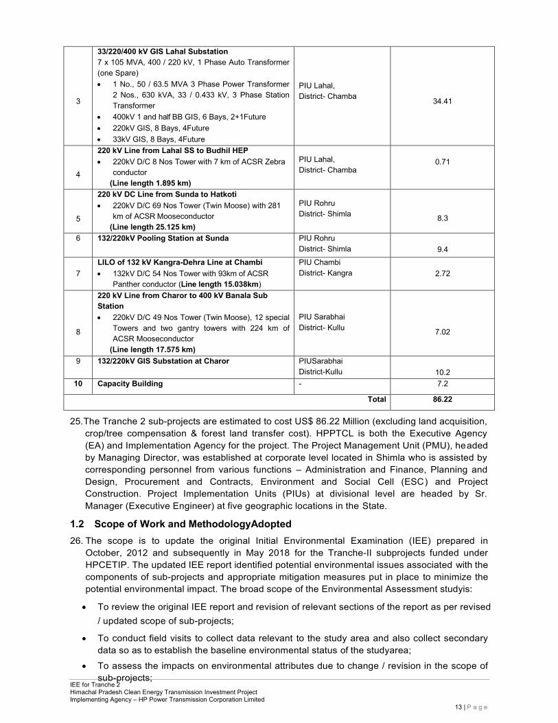
24. Cost & component details of sub-projectsunderTranche-II are provided in following table-2. Table-2: Details of Sub-Projects under Tranche-II
S. No.
Name & Component of Sub-Project PIU Sub-Project Cost (in USD Million)
1
66 kV GIS Switching station at Urni 1, 250 kVA, 22 / 0.433 kV LT Transformer; • 66kV GIS, 5 Bays, 3Future
PIU, Bhabha Nagar, District- Kinnaur
4.21
2
66 kV DC Line from Urni SS to Wangtoo SS • 66kV D/C 49 Nos. Tower with 85km of ACSR Wolf
conductor (Line length 13.659 km)
PIU Bhabha Nagar,
District- Kinnaur
2.05
IEE for Tranche 2 Himachal Pradesh Clean Energy Transmission Investment Project Implementing Agency – HP Power Transmission Corporation Limited
13 | P a g e
3
33/220/400 kV GIS Lahal Substation 7 x 10⁵ MVA, 400 / 220 kV, 1 Phase Auto Transformer (one Spare) • 1 No., 50 / 63.5 MVA 3 Phase Power Transformer
2 Nos., 630 kVA, 33 / 0.433 kV, 3 Phase Station Transformer
• 400kV 1 and half BB GIS, 6 Bays, 2+1Future • 220kV GIS, 8 Bays, 4Future • 33kV GIS, 8 Bays, 4Future
PIU Lahal, District- Chamba
34.41
4
220 kV Line from Lahal SS to Budhil HEP • 220kV D/C 8 Nos Tower with 7 km of ACSR Zebra
conductor (Line length 1.895 km)
PIU Lahal, District- Chamba
0.71
5
220 kV DC Line from Sunda to Hatkoti • 220kV D/C 69 Nos Tower (Twin Moose) with 281
km of ACSR Mooseconductor (Line length 25.125 km)
PIU Rohru District- Shimla
8.3
6 132/220kV Pooling Station at Sunda PIU Rohru District- Shimla
9.4
7
LILO of 132 kV Kangra-Dehra Line at Chambi • 132kV D/C 54 Nos Tower with 93km of ACSR
Panther conductor (Line length 15.038km)
PIU Chambi District- Kangra
2.72
8
220 kV Line from Charor to 400 kV Banala Sub Station • 220kV D/C 49 Nos Tower (Twin Moose), 12 special
Towers and two gantry towers with 224 km of ACSR Mooseconductor
(Line length 17.575 km)
PIU Sarabhai District- Kullu
7.02
9 132/220kV GIS Substation at Charor PIUSarabhai District-Kullu
10.2
10 Capacity Building - 7.2
Total 86.22
25. The Tranche 2 sub-projects are estimated to cost US$ 86.22 Million (excluding land acquisition, crop/tree compensation & forest land transfer cost). HPPTCL is both the Executive Agency (EA) and Implementation Agency for the project. The Project Management Unit (PMU), headed by Managing Director, was established at corporate level located in Shimla who is assisted by corresponding personnel from various functions – Administration and Finance, Planning and Design, Procurement and Contracts, Environment and Social Cell (ESC) and Project Construction. Project Implementation Units (PIUs) at divisional level are headed by Sr. Manager (Executive Engineer) at five geographic locations in the State.
1.2 Scope of Work and MethodologyAdopted 26. The scope is to update the original Initial Environmental Examination (IEE) prepared in
October, 2012 and subsequently in May 2018 for the Tranche-II subprojects funded under HPCETIP. The updated IEE report identified potential environmental issues associated with the components of sub-projects and appropriate mitigation measures put in place to minimize the potential environmental impact. The broad scope of the Environmental Assessment studyis:
• To review the original IEE report and revision of relevant sections of the report as per revised
/ updated scope of sub-projects;
• To conduct field visits to collect data relevant to the study area and also collect secondary data so as to establish the baseline environmental status of the studyarea;
• To assess the impacts on environmental attributes due to change / revision in the scope of sub-projects;
IEE for Tranche 2 Himachal Pradesh Clean Energy Transmission Investment Project Implementing Agency – HP Power Transmission Corporation Limited
14 | P a g e
• To assess the impacts on environmental attributes due to the location, design, constructionandoperationoftheproposedProject;
• To prepare an Environment Management Plan (EMP) outlining the measures for mitigating the impacts for protecting the environment including institutional arrangements;
• To identify critical environmental parameters required to be monitored subsequent to the implementation of the proposedproject;
• To carry out consultation with local people to identify public perception regarding the project; • To carry out field-based environment due diligence due to minor revision in the length of
transmission line and addition of two no. of towers in 66kV D/C Urni-Wangtoo line subprojects; and
• To establish an Environment Monitoring Plan for HPPTCL and submitted environmental monitoring reports to ADB at regular intervals.
27. In this report, the different activities that are likely to take place to achieve the project
objectives have been analyzed and the potential impacts that may accompany them have been identified, assessed for significance, and concomitant avoidance, mitigation, and compensation measures were prepared in consultation with stakeholders to be incorporated on the engineering design and project implementation.The IEE addresses the environmental management requirements of the Government of India (GOI) and Asian Development Bank.Specifically,this report:
• Provides description of subprojects and theircomponents;
• Provides information about the baseline environmental setting of the studyarea;
• Provides information on potential environmental impacts of the proposed subproject activities with its magnitude, distribution andduration;
• Provides information on required mitigation measures with cost to minimize the impacts; Analyses the alternatives options considering alternative locations, designs, management approaches for selection of most feasible and environmental acceptable options;
• Provides details of stakeholder’sconsultations;
• Designs an environmental management and monitoring plan with institutional measures for effective implementation of mitigates measures proposed and addressing grievances.
28. The substation specific topography survey and the transmission line route survey works have
been completed. The data regarding soil, topography, contour, land cutting and filling required, distance from water bodies and distance from major roads,details of forest/non-forest, fruit/non-fruit trees being affected, and land details has been collected by HPPTCL. This supplementary information has been provided for each of these subprojects by HPPTCL to ADB.
29. Public consultations have been done with the project affected communities, stakeholders and government officers focused on existing environmental conditions around the proposed transmission lines/substations and the potential impacts that could happen due to project implementation. Since the HPCETIP does not involve activities that have significant adverse impacts, the present IEE has been updated to determine the impact of power transmission aspects as per ADB’s Safeguard Policy Statement (SPS) 2009 and Environmental Assessment Guidelines(2003)3. Accordingly, the environmental classifications for the Tranche 2 subprojects continue to be, “CategoryB” as per REA checklist enclosed as Appendix-I.
3 ADB 2003: Operations Manual, Environment Policy, Environmental Guidelines for Selected Industrial and Power Projects, and Environmental Assessment Guidelines, Manila.
IEE for Tranche 2 Himachal Pradesh Clean Energy Transmission Investment Project Implementing Agency – HP Power Transmission Corporation Limited
15 | P a g e
2 POLICY, LEGAL AND ADMINISTRATIVE FRAMEWORK 30. India has well defined institutional and legislative framework. The legislation covers all
components of environment viz. air, water, soil, terrestrial and aquatic flora and fauna, natural resources, and sensitive habitats. The environmental legislations in India are framed to protect the valued environmental components and comply with its commitment to international community under various conventions and protocols as well Asian Development Bank has also developed interventions to guide social and environment safeguards, in their Safeguard Policy Statement, 2009. This assessment is about the applicability of above laws and regulations, and safeguards. This chapter summarizes thefollowing:
• Applicability of various National and local laws and regulations at different stages of project implementations;
• Applicability of ADB safeguards policies and categorization of the project.
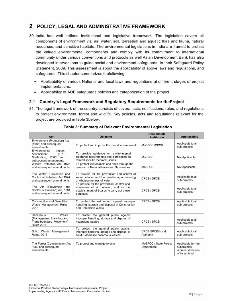
2.1 Country’s Legal Framework and Regulatory Requirements for theProject 31. The legal framework of the country consists of several acts, notifications, rules, and regulations
to protect environment, forest and wildlife. Key policies, acts and regulations relevant for the project are provided in table 3below.
Table 3: Summary of Relevant Environmental Legislation
Act
Objective
Responsible Institution
Applicability
Environment (Protection) Act (1986) and subsequent amendments
To protect and improve the overall environment
MoEFCC /CPCB
Applicable to all sub-projects
Environmental Impact Assessment (EIA) Notification, 2006 and subsequent amendments
To provide guidance on environmental clearance requirements and clarification on related specific technical issues
MoEFCC
Not Applicable
Wildlife Protection Act, 1972 and subsequent amendments
To protect wild animals and birds through the creation of National Parks and Sanctuaries
MoEFCC
Not Applicable
The Water (Prevention and Control of Pollution) Act 1974 and subsequent amendments
To provide for the prevention and control of water pollution and the maintaining or restoring of wholesomeness of water.
CPCB / SPCB
Applicable to all sub-projects
The Air (Prevention and Control of Pollution) Act, 1981 and subsequent amendments
To provide for the prevention, control and abatement of air pollution, and for the establishment of Boards to carry out these purposes.
CPCB / SPCB
Applicable to all sub-projects
Construction and Demolition Waste Management Rules, 2016
To protect the evironment against improper handling, storage and disposal of Construction and Demolition Waste
CPCB / SPCB Applicable to all sub-projects
Hazardous Waste (Management, Handling and Trans-boundary Movement) Rules 2016
To protect the general public against improper handling, storage and disposal of hazardous wastes
CPCB / SPCB
Applicable to all sub-projects
Solid Waste Management Rules, 2016
To protect the general public against improper handling, storage and disposal of solid & domestic hazardous wastes
CPCB/SPCB/Local Authority
Applicable to all sub-projects
The Forest (Conservation) Act 1980 and subsequent amendments
To protect and manage forests
MoEFCC / State Forest Department
Applicable for the subprojects require diversion of forest land
IEE for Tranche 2 Himachal Pradesh Clean Energy Transmission Investment Project Implementing Agency – HP Power Transmission Corporation Limited
16 | P a g e
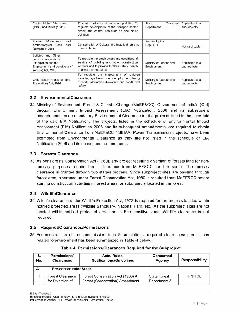
Central Motor Vehicle Act (1988) and Rules (1988)
To control vehicular air and noise pollution. To regulate development of the transport sector, check and control vehicular air and Noise pollution.
State Transport Department
Applicable to all sub-projects
Ancient Monuments and Archaeological Sites and Remains (1958)
Conservation of Cultural and historical remains found in India.
Archaeological Dept. GOI
Not Applicable
Building and Other construction workers (Regulation and the Employment and conditions of service) Act, 1996
To regulate the employment and conditions of service of building and other construction workers and to provide for their safety, health and welfare measures
Ministry of Labour and Employment
Applicable to all sub-projects
Child labour (Prohibition and Regulation) Act, 1986
To regulate the employment of children including age limits, type of employment, timing of work, information disclosure and health and safety.
Ministry of Labour and Employment
Applicable to all sub-projects
2.2 EnvironmentalClearance 32. Ministry of Environment, Forest & Climate Change (MoEF&CC), Government of India’s (GoI)
through Environment Impact Assessment (EIA) Notification, 2006 and its subsequent amendments, made mandatory Environmental Clearance for the projects listed in the schedule of the said EIA Notification. The projects, listed in the schedule of Environmental Impact Assessment (EIA) Notification 2006 and its subsequent amendments, are required to obtain Environmental Clearance from MoEF&CC / SEIAA. Power Transmission projects; have been exempted from Environmental Clearance as they are not listed in the schedule of EIA Notification 2006 and its subsequent amendments.
2.3 Forests Clearance 33. As per Forests Conservation Act (1980), any project requiring diversion of forests land for non-
forestry purposes require forest clearance from MoEF&CC for the same. The forestry clearance is granted through two stages process. Since subproject sites are passing through forest area, clearance under Forest Conservation Act, 1980 is required from MoEF&CC before starting construction activities in forest areas for subprojects located in the forest.
2.4 WildlifeClearance 34. Wildlife clearance under Wildlife Protection Act, 1972 is required for the projects located within
notified protected areas (Wildlife Sanctuary, National Park, etc.).As the subproject sites are not located within notified protected areas or its Eco-sensitive zone, Wildlife clearance is not required.
2.5 RequiredClearances/Permissions 35. For construction of the transmission lines & substations, required clearances/ permissions
related to environment has been summarized in Table-4 below.
Table 4: Permissions/Clearances Required for the Subproject
S. No.
Permissions/ Clearances
Acts/ Rules/ Notifications/Guidelines
Concerned Agency
Responsibility
A. Pre-constructionStage
1 Forest Clearance for Diversion of
Forest Conservation Act (1980) & Forest (Conservation) Amendment
State Forest Department &
HPPTCL
IEE for Tranche 2 Himachal Pradesh Clean Energy Transmission Investment Project Implementing Agency – HP Power Transmission Corporation Limited
17 | P a g e
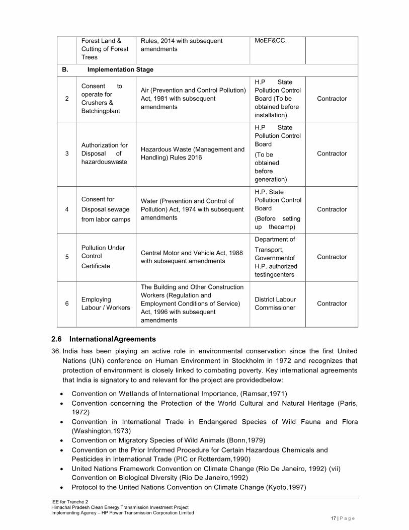
Forest Land & Cutting of Forest Trees
Rules, 2014 with subsequent amendments
MoEF&CC.
B. Implementation Stage
2
Consent to operate for Crushers & Batchingplant
Air (Prevention and Control Pollution) Act, 1981 with subsequent amendments
H.P State Pollution Control Board (To be obtained before installation)
Contractor
3
Authorization for Disposal of hazardouswaste
Hazardous Waste (Management and Handling) Rules 2016
H.P State Pollution Control Board (To be obtained before generation)
Contractor
4
Consent for Disposal sewage from labor camps
Water (Prevention and Control of Pollution) Act, 1974 with subsequent amendments
H.P. State Pollution Control Board (Before setting up thecamp)
Contractor
Department of
5
Pollution Under Control Certificate
Central Motor and Vehicle Act, 1988 with subsequent amendments
Transport, Governmentof H.P. authorized testingcenters
Contractor
6
Employing Labour / Workers
The Building and Other Construction Workers (Regulation and Employment Conditions of Service) Act, 1996 with subsequent amendments
District Labour Commissioner
Contractor
2.6 InternationalAgreements 36. India has been playing an active role in environmental conservation since the first United
Nations (UN) conference on Human Environment in Stockholm in 1972 and recognizes that protection of environment is closely linked to combating poverty. Key international agreements that India is signatory to and relevant for the project are providedbelow:
• Convention on Wetlands of International Importance, (Ramsar,1971) • Convention concerning the Protection of the World Cultural and Natural Heritage (Paris,
1972) • Convention in International Trade in Endangered Species of Wild Fauna and Flora
(Washington,1973) • Convention on Migratory Species of Wild Animals (Bonn,1979) • Convention on the Prior Informed Procedure for Certain Hazardous Chemicals and
Pesticides in International Trade (PIC or Rotterdam,1990) • United Nations Framework Convention on Climate Change (Rio De Janeiro, 1992) (vii)
Convention on Biological Diversity (Rio De Janeiro,1992) • Protocol to the United Nations Convention on Climate Change (Kyoto,1997)
IEE for Tranche 2 Himachal Pradesh Clean Energy Transmission Investment Project Implementing Agency – HP Power Transmission Corporation Limited
18 | P a g e
2.7 Asian Development Bank SafeguardPolicies 37. The Asian Development Bank has defined its safeguard requirements in the Safeguard Policy
Statement 2009 (SPS). The prime objectives of these safeguard policies are to: (i) avoid adverse impacts of projects on the environment and affected people, where possible; and (ii) minimize, mitigate, and/or compensate for adverse project impacts on the environment and affected people when avoidance is notpossible.
2.8 Project Categorization as perADB
38. ADB uses a classification system to reflect the significance of a project’s potential environmental impacts. A project’s category is determined by the category of its mostenvironmentallysensitive component, including direct, indirect, cumulative, and induced impacts in the project’s area of influence. Each proposed project is scrutinized as to its type, location, scale, and sensitivity and the magnitude of its potential environmental impacts. Projects are assigned to one of the following four categories: (i) Category A: A proposed project is classified as category A if it is likely to have significant adverse environmental impacts that are irreversible, diverse, or unprecedented. These impacts may affect an area larger than the sites or facilities subject to physical works. An environmental impact assessment is required. (ii) Category B: A proposed project is classified as category B if its potential adverse environmental impacts are less adverse than those of category A projects. These impacts are site-specific, few if any of them are irreversible, and in most cases mitigation measures can be designed more readily than for category A projects. An initial environmental examination is required. (iii) Category C: A proposed project is classified as category C if it is likely to have minimal or no adverse environmental impacts. No environmental assessment is required although environmental implications need to be reviewed. (iv) CategoryFI: A proposed project is classified as category FI if it involves investment of ADB funds to or through a FI.
39. Using the prescribed ADB Rapid Environmental Assessment Checklist (see Appendix 1), Tranche 2 project environmental category continue to be category B.
IEE for Tranche 2 Himachal Pradesh Clean Energy Transmission Investment Project Implementing Agency – HP Power Transmission Corporation Limited
19 | P a g e
3 DESCRIPTION OF THEPROJECT
3.1 Type of Project 40. The comprehensive Power System Master Plan4, completed in December 2010 with ADB
assistance, considers transmission requirements in each of HP’s five major river basins where hydropower generation is either being built or planned, with an overarching objective of economic least cost development at appropriate levels of supply security and reliability. This includes overhead transmission line planning, substation equipment planning, and system integration into the National Electricity Plan.
41. Consequent to the recommendations of the master plan under HPCETIP, Gas Insulated Switchgear (GIS) pooling substation are proposed in place of conventional Air Insulated Switchgear (AIS) substations to reduce cost of development of land and civil works which forms a major part of capital cost in mountainous terrain. Power evacuation systems have been designed so that each developer is provided with two distinct points for power evacuation. This arrangement provides reliability and any fault at one point can ensure continuity of power.
42. The project also includes institutional strengthening initiatives for the state’s power sector entities. Specific to transmission, this includes capacity development objectives for further corporatization of HPPTCL and installation of enterprise resource planning software, given the considerable investment plans for additional hydropower and commensurate transmission system investments in HP and HPPTCL’s central role in new transmission system upgrades as an STU.
3.2 Category ofProject 43. The Tranche 2 components of the Himachal Pradesh Clean Energy Transmission Project
include construction of Power Transmission Lines & Substations. Details of the subprojects of Tranche 2 are provided in following table-5.
Table-5: Details of the Subprojects of Tranche 2.
S. No.
Name of Sub-Project
Component of Sub-Project
1 66 kV GIS Switching station at Urni
• 1, 250 kVA, 22 / 0.433 kV LTTransformer; • 66kV GIS, 5 Bays, 3Future
2 66 kV DC Line from Urni SS to Wangtoo SS
• 66kV D/C 49 Nos. Tower with 85km of ACSR Wolf conductor (Line length 13.659 km)
3
33/220/400 Substation
kV
GIS
Lahal
• 7x10⁵ MVA, 400/ 220kV,1Phase Auto Transformer(oneSpare) • 1 No., 50 / 63.5 MVA 3 Phase PowerTransformer • 2 Nos., 630 kVA, 33 / 0.433 kV, 3 Phase StationTransformer • 400kV 1 and half BB GIS, 6 Bays, 2+1 Future • 220kV GIS, 8 Bays, 4Future • 33kV GIS, 8 Bays, 4Future
4
220 kV Line from Lahal SS to Budhil HEP • 220kV D/C 8 Nos Tower with 7 km of ACSR Zebraconductor
(Line length 1.895 km)
5
220 kV DC Line from Sunda to Hatkoti
• 220kV D/C 69 Nos Tower (Twin Moose) with 281 km of ACSR Moose conductor (Line length 25.125 km)
6 132/220kV Pooling Station at Sunda • 2 Nos. 80/100 MVA, 132/220 kVtransformers
4
Funded under a component of TA 7181-IND: Capacity Building for Himachal Pradesh Power Sector Agencies.
IEE for Tranche 2 Himachal Pradesh Clean Energy Transmission Investment Project Implementing Agency – HP Power Transmission Corporation Limited
20 | P a g e
S. No.
Name of Sub-Project
Component of Sub-Project
7 LILO of 132 kV Kangra-Dehra Line at Chambi
• 132kV D/C 54 Nos Tower with 93km of ACSR Panther conductor (Line length 15.038 km)
8
220 kV Line from Charor to 400 kV Banala Sub Station
• 220kV D/C 49 Nos Tower (Twin Moose), 12 special Towers and two gantry towers with 224 km of ACSR Moose conductor (Line length 17.575 km)
9 132/220kV Charor
GIS Substation at • 2 Nos. 80/100MVA, 132/220 KVTransformers
3.3 Capacity Building andTraining 44. HPPTCL, established on 11thSeptember, 2008, has been hiring staff on secondment from the
previously unbundled HP State Electricity Board Limited (HPSEBL). To have effective and oriented personnel, HPPTCL needs capacity building and skills augmentation through training on technical aspects, study trips and exposure, project management, contracts related conflict resolution, environmental and social assessment, review and monitoring and IT related Enterprise Resource Planning (ERP). More training modules may be added in future depending on emerging staffing situation.
3.4 Brief Description of theSub-Projects 45. Due to the fast emerging energy demand in the country, there is a distinct necessity for
strengthening and expanding the transmission networks. Himachal Pradesh is going to be the hub of clean energy generating facilities through hydroelectric potential. As a number of new projects are planned in Pabbar, Sangla, Ravi, Beas, Satluj River basins, HPPTCL is intending to construct an Integrated Transmission System in the area due to limited corridor availability and mountainous terrain constraints. This will take care of network reliability and redundancy in the system to evacuate power in case of an outage of any transmission line because of unforeseen conditions. In most cases, the circuit outage contingency is taken care of although tower outage contingency is not being met. Figure-1 gives the location of the transmission lines and the substations under Tranche-II within the HP State.
(i) Subproject S1 - 66 kV Gas Insulated Switchgear (GIS) switching station atUrni: 46. To evacuate overall power generated in Satluj basin, a 66 kV switching substation is proposed
to be constructed at Urni and it will be connected to proposed 400 kV substation of Power Grid nearby through Wangtoo substation5 which will cater to 421 MW power from various HEPs of Satluj basin. This switching station will connect Abdullapur (Haryana) via HPPTCL Wangtoo 66/220/400 kV substation, which will further transfer the power to 400 kV PGCIL station at Abdullapur through Abdullapur 400 kV D/C transmission line (PGCIL-JP). The work involves construction of a new switching substation of voltage 66 kV near Urni in the Kinnaur district of Himachal Pradesh. The switching substation is proposed to be constructed on land identified and purchased by HPPTCL by mutual agreement. The switching substation will be envisaged with the following components:
• Bus configuration for switching substation will be double bus scheme for 66 kV levels with the provision of bus coupler with substation automation and SCADA.
• 66 kV Bays include: Line Bays- 4 nos. and Bus Coupler- 1 no. • 66 kV bays for connecting individual hydro projects of IPPs with this switching station
shall be provided by the IPPs as per regulatory norms.
5 Wangtoo substation funded by ADB in Tranche - 1
IEE for Tranche 2 Himachal Pradesh Clean Energy Transmission Investment Project Implementing Agency – HP Power Transmission Corporation Limited
21 | P a g e
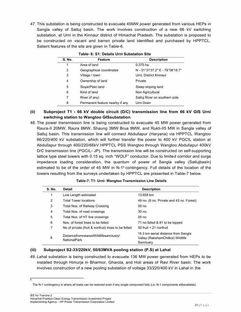
47. This substation is being constructed to evacuate 45MW power generated from various HEPs in Sangla valley of Satluj basin. The work involves construction of a new 66 kV switching substation, at Urni in the Kinnaur district of Himachal Pradesh. The substation is proposed to be constructed on vacant and barren private land identified and purchased by HPPTCL. Salient features of the site are given in Table-6.
Table- 6: S1: Details Urni Substation Site S. No. Feature Description
1 Area of land 0.375 ha 2 Geographical coordinates N - 31°31'37.2" E - 78°08'18.7" 3 Village / town Urni, District Kinnaur 4 Ownership of land Private
5 Slope/Plain land Steep sloping land 6 Kind of land Non Agricultural 7 River (if any) Satluj River on southern side 8 Permanent feature nearby if any Urni Drain
(ii) Subproject T1 - 66 kV double circuit (D/C) transmission line from 66 kV GIS Urni switching station to Wangtoo GISsubstation
48. The power transmission line is being constructed to evacuate 45 MW power generated from Raura-II 20MW, Raura 8MW, Shaung 3MW Brua 9MW, and Rukti-II5 MW in Sangla valley of Satluj basin. This transmission line will connect Abdullapur (Haryana) via HPPTCL Wangtoo 66/220/400 kV substation, which will further transfer the power to 400 kV PGCIL station at Abdullapur through 400/220/66kV HPPTCL PSS Wangtoo through Wangtoo Abdullapur 400kV D/C transmission line (PGCIL- JP). The transmission line will be constructed on self-supporting lattice type steel towers with 0.15 sq. inch “WOLF” conductor. Due to limited corridor and surge impedance loading consideration, the quantum of power of Sangla valley (Satlujbasin) estimated to be of the order of 45 MW in N-16 contingency. Full details of the location of the towers resulting from the surveys undertaken by HPPTCL are presented in Table-7 below.
Table-7: T1: Urni- Wangtoo Transmission Line Details
S. No. Detail Description 1 Line Length estimated 13.659 km 2 Total Tower locations 49 no. (6 no. Private and 43 no. Forest) 3 Total Nos. of Railway Crossing 00 no 4 Total Nos. of road crossings 30 no. 5 Total Nos. of HT line crossings 05 no 6 Nos. of forest trees to be felled 71 no felled & 81 to be lopped 7 No of private (fruit & nonfruit) trees to be felled 50 fruit + 21 nonfruit
8 DistancefromnearestWildlifesanctuary/
NationalPark
16.3 km aerial distance from Sangla Valley (RakshamChitkul) Wildlife Sanctuary
(iii) Subproject S2-33/220kV, 50/63MVA pooling station (P.S) at Lahal 49. Lahal substation is being constructed to evacuate 136 MW power generated from HEPs to be
installed through Himurja in Bharmor, Gharola, and Holi areas of Ravi River basin. The work involves construction of a new pooling substation of voltage 33/220/400 kV in Lahal in the
6
The N-1 contingency is where all loads can be restored even if any single component fails (i.e. N-1 components stillavailable)
IEE for Tranche 2 Himachal Pradesh Clean Energy Transmission Investment Project Implementing Agency – HP Power Transmission Corporation Limited
22 | P a g e
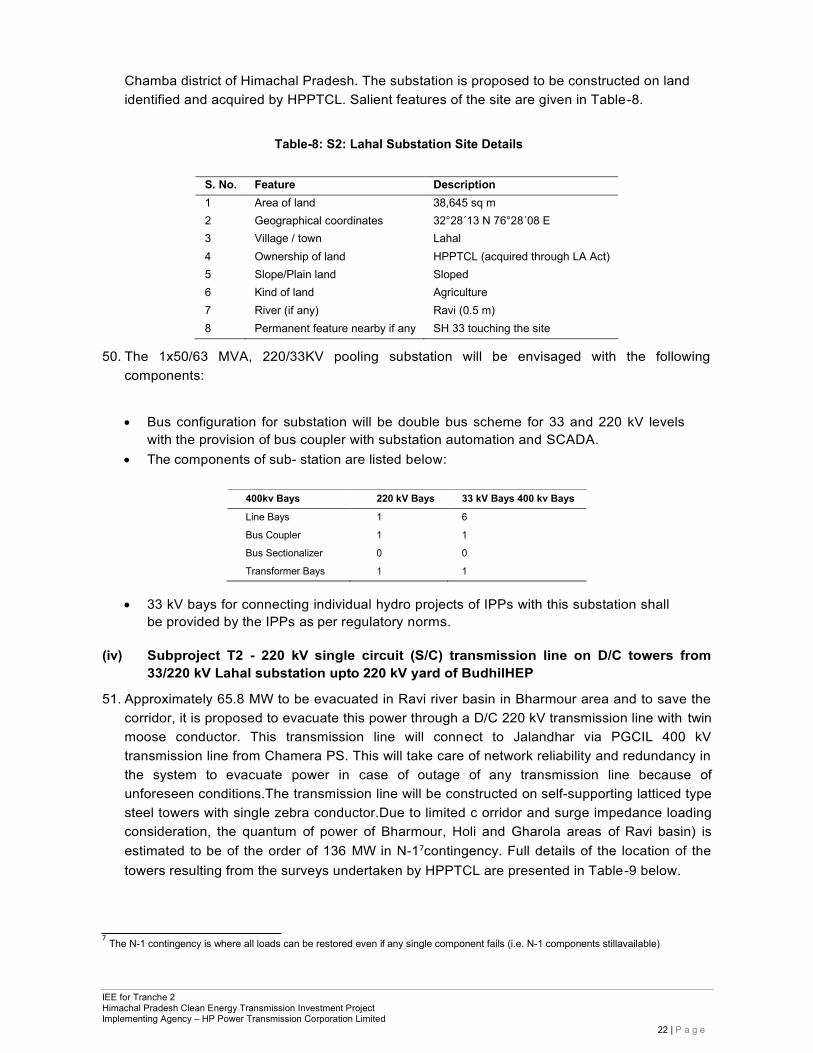
Chamba district of Himachal Pradesh. The substation is proposed to be constructed on land identified and acquired by HPPTCL. Salient features of the site are given in Table-8.
Table-8: S2: Lahal Substation Site Details
S. No. Feature Description 1 Area of land 38,645 sq m 2 Geographical coordinates 32°28´13 N 76°28´08 E 3 Village / town Lahal 4 Ownership of land HPPTCL (acquired through LA Act) 5 Slope/Plain land Sloped 6 Kind of land Agriculture 7 River (if any) Ravi (0.5 m) 8 Permanent feature nearby if any SH 33 touching the site
50. The 1x50/63 MVA, 220/33KV pooling substation will be envisaged with the following components:
• Bus configuration for substation will be double bus scheme for 33 and 220 kV levels with the provision of bus coupler with substation automation and SCADA.
• The components of sub- station are listed below:
400kv Bays 220 kV Bays 33 kV Bays 400 kv Bays
Line Bays 1 6
Bus Coupler 1 1
Bus Sectionalizer 0 0
Transformer Bays 1 1
• 33 kV bays for connecting individual hydro projects of IPPs with this substation shall be provided by the IPPs as per regulatory norms.
(iv) Subproject T2 - 220 kV single circuit (S/C) transmission line on D/C towers from
33/220 kV Lahal substation upto 220 kV yard of BudhilHEP
51. Approximately 65.8 MW to be evacuated in Ravi river basin in Bharmour area and to save the corridor, it is proposed to evacuate this power through a D/C 220 kV transmission line with twin moose conductor. This transmission line will connect to Jalandhar via PGCIL 400 kV transmission line from Chamera PS. This will take care of network reliability and redundancy in the system to evacuate power in case of outage of any transmission line because of unforeseen conditions.The transmission line will be constructed on self-supporting latticed type steel towers with single zebra conductor.Due to limited c orridor and surge impedance loading consideration, the quantum of power of Bharmour, Holi and Gharola areas of Ravi basin) is estimated to be of the order of 136 MW in N-17contingency. Full details of the location of the towers resulting from the surveys undertaken by HPPTCL are presented in Table-9 below.
7 The N-1 contingency is where all loads can be restored even if any single component fails (i.e. N-1 components stillavailable)
IEE for Tranche 2 Himachal Pradesh Clean Energy Transmission Investment Project Implementing Agency – HP Power Transmission Corporation Limited
23 | P a g e
Table-9: T2: Lahal-Budhil Transmission Line Details
S. No. Detail Description
1 Line Length estimated 1.895 km
2 Total Tower locations 8 Nos.
3 Total Nos. of Railway Crossing 00 no
4 Total Nos. of road crossings 1 no.
5 Total Nos. of HT line crossings 0 no
6 Nos. of forest trees to be felled 55 no
7 No of fruit trees to be felled 0 no
8 Distance from nearest Wildlife sanctuary/ National Park 8 km from Tundah Wildlife Sanctuary
(v) Subproject S3 - 132/220 kV, 2x100 MVA GIS PS at Sunda
52. The transmission of power from the Pabbar basin to the northern grid will provide a tremendous boost to the economic development of Himachal Pradesh. The new 132/220 kV substation will evacuate 524 MW power from the Pabbar River basin developers to the National Grid through Abdullapur – Jhakri transmission line passing nearby. The TangnuRomai(44 MW+6 MW TangnuRomai SHP) and Dhamwari-Sunda (70 MW), Chirgaon-Majhgaon (60MW), Paudital Lassa (24MW) and an additional 59.3 MW (including 45 MW Rupin) HEPs are under commissioning and various clearance & investigation stages. The 111-MW Sara-Kuddu HEP shall also be finally interfaced at 220 KV S/S Hatkoti.
53. The work involves construction of 132/220 kV GIS pooling substation at Sunda in the Shimla district of Himachal Pradesh. The substation is proposed to be constructed on private land identified and acquired by HPPTCL. Salient features of the site are provided in Table-10.
Table-10: S3: Sunda Pooling Substation Details
S. No. Feature Description 1 Area of land 17,525 sqm.
2 Geographical coordinates 31°13’57.2”N, 77° 44’20”E
3 Village / town Chirgaon
4 Ownership of land Private
5 Slope/Plain land Plain
6 Kind of land Agriculture
7 River (if any) Pabbar
8 Permanent feature nearby if any Substation site is near the junction of river and khud
54. The substation will be envisaged with the following components:
• 2 nos. 100 MVA, 132/220 kV transformer bank • Bus configuration for sub-station will be double bus scheme for 132 kV and 220 kV
levels with the provision of bus coupler with substation automation and SCADA. • List of components of substation are listedbelow:
220 kV Bays 132 kV Bays
Line Bays 2 4 Bus Coupler 1 1 Bus Sectionalizer 1 1 Transformer Bays 1 1
55. The new 220/132 kV pooling substation will evacuate 524 MW power from the Pabbar River basin developers to the national grid through 400kV Abdullapur–Jhakri transmission line of
IEE for Tranche 2 Himachal Pradesh Clean Energy Transmission Investment Project Implementing Agency – HP Power Transmission Corporation Limited
24 | P a g e
PGCIL passing nearby. The transmission of power from the Pabbar basin to the grid will provide a tremendous boost to the economic development of Himachal Pradesh.
(vi) SubprojectT3-220kV D/C transmission line from 220/132kV GIS PS Sunda to 220kV switching station Hatkoti
56. At 220 kV Hatkoti switching station, the envisaged 456 MW power of Pabbar basin will bepooled in by constructing Sunda- Hatkoti 220 kV D/C transmission line with twin moose conductor. The line will be constructed on self-supporting latticed type steel towers with Aluminium Conductor Steel Reinforced (ACSR) Moose conductor in bundle of two conductors per phase. Due to limited corridor and surge impedance loading consideration, the quantum of power of 524 MW in N-18contingency, a twin bundle conductor will be used. This line is being constructed to evacuate 524 MW power generated from various HEPs in Pabbar River basin. Full details of the location of the towers resulting from the surveys undertaken by HPPTCL are presented in Table-11below.
Table-11: T3: Sunda-Hatkoti Transmission Line Details
S. No. Detail Description
1 Line Length estimated 25.125 km
2 Total Tower locations 69
3 Total Nos. of Railway Crossing 00
4 Total Nos. of road crossings 24.
5 Total Nos. of HT line crossings 17
6 Nos. of forest trees to be felled 81
7 No of fruit trees to be felled 104
8 Distance from nearest Wildlife sanctuary/ National Park 8 km from Talra Wildlife Sanctuary
(vii) Subproject T4 - 132 kV D/C transmission line from Chambi (Shahpur) substation to
LILO point of 132 kV Kangra- Dehra S/C transmission line
57. The power transmission line is being constructed to evacuate 42.4 MW power from Shahpur area of Ravi basin, which will further transfer to 220/400 kV Hamirpur substation (PGCIL) through Dehra – Hamirpur 132 kV D/C transmission line and 132/220 kV Hamirpur substation (HPSEBL). Hence this system needs to be in place by the time the HEPs are commissioned.
58. The 2x25/31.5 MVA, 33/132 kV pooling substation will be envisaged with the following components: Bus configuration for substation will be double bus scheme for 33 kV and 132 kV levels with the provision of bus coupler with substation automation and SCADA. List of components of sub- station are listed below:
220 kV Bays 132 kV Bays
Line Bays 2 0 Bus Coupler 1 1 Bus Sectionalizer 0 0 Transformer Bays 2 2
(viii) Subproject S4 - 132/220 kV 2x50/63 MVA GIS substation at Charor
59. The work involves construction of 132/220 kV GIS substation near Charor in the Kullu district of Himachal Pradesh. The substation is proposed to be constructed on private
8 The N-1 contingency is where all loads can be restored even if any single component fails (i.e. N-1 components stillavailable).
IEE for Tranche 2 Himachal Pradesh Clean Energy Transmission Investment Project Implementing Agency – HP Power Transmission Corporation Limited
25 | P a g e
Land identified and acquired by HPPTCL. Salient features of the site are given in Table-12.
Table-12: S4: Charor Substation Details
S. No. Feature Description 1 Area of land 11,360 sqm. 2 Geographical coordinates 31054’ 32.10”N, 770 11’ 25.21.” E 3 Village / town Charor 4 Ownership of land Private 5 Slope/Plain land Stepped/Slope 6 Kind of land Agriculture 7 River (if any) Charor Drain
(ix) Subproject T5 - 220 kV D/C transmission line from Charor to 400/220 kV Banala substation of PGCIL
60. The power transmission line is being constructed to evacuate 289 MW power from HEPs in Parbati Valley of Beas basin upstream of Charor. Total 289 MW power is expected to be evacuated through 220 kV D/C (twin moose) transmission line from Charorto Banala. Full details of the location of the towers resulting from the surveys undertaken by HPPTCL are presented in Table-13 below.
Table-13: T5: Charor - Banala transmission line details
S. No. Detail Description
1 Line Length estimated 17.575 km
2 Total Tower locations 62 nos.
3 Total Nos. of Railway Crossing 0 nos.
4 Total Nos. of road crossings 2 times.
5 Total Nos. of HT line crossings 1 nos.
6 Nos. of forest trees to be felled 221
7 No of fruit trees to be felled 486
8 Distance from nearest Wildlife sanctuary/ National Park 16 km from Great Himalayan National Park
3.5 Land Requirement 61. The sub-projects are located on private & forest land. All the sub-stations are located on private
land and Transmission Lines are located on forest as well as on private land. Total land requirement for Tranche 2 subprojects are given in Table-14 below:
Table-14: Total Land Required for Tranche 2 Subprojects
S. No. Name of
Sub-Project Land Requirement (sqm)
Private Gov. / forest Total 1 66kV GIS Switching station at Urni 3750 - 3750 2 66kV DC Line from Urni SS to Wangtoo SS 5180 204874 210054 3 33/220/400kV GIS Lahal Substation 38645 - 38645 4 220 kV Line from Lahal SS to Budhil HEP 3840 31750 35590 5 220kV DC Line from Sunda to Hatkoti 648518 230857 879375 6 132/220kV Pooling Station at Sunda 17525 - 17525 7 LILO of 132kV Kangra-Dehra Line at Chambi 177300 228005 405305 8 220kV Line from Charor to 400kV Banala Sub Station 7583 367296 374879 9 132/220kV GIS Substation at Charor 11360 - 11360
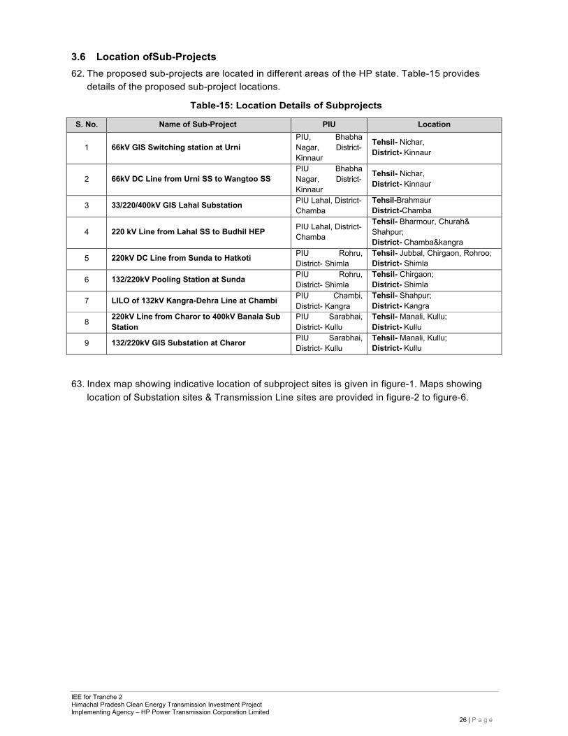
IEE for Tranche 2 Himachal Pradesh Clean Energy Transmission Investment Project Implementing Agency – HP Power Transmission Corporation Limited
26 | P a g e
3.6 Location ofSub-Projects 62. The proposed sub-projects are located in different areas of the HP state. Table-15 provides
details of the proposed sub-project locations.
Table-15: Location Details of Subprojects
S. No. Name of Sub-Project PIU Location
1
66kV GIS Switching station at Urni PIU, Bhabha Nagar, District- Kinnaur
Tehsil- Nichar, District- Kinnaur
2
66kV DC Line from Urni SS to Wangtoo SS
PIU Bhabha Nagar, District- Kinnaur
Tehsil- Nichar, District- Kinnaur
3 33/220/400kV GIS Lahal Substation PIU Lahal, District- Chamba
Tehsil-Brahmaur District-Chamba
4
220 kV Line from Lahal SS to Budhil HEP PIU Lahal, District-
Chamba
Tehsil- Bharmour, Churah& Shahpur; District- Chamba&kangra
5 220kV DC Line from Sunda to Hatkoti PIU Rohru, District- Shimla
Tehsil- Jubbal, Chirgaon, Rohroo; District- Shimla
6 132/220kV Pooling Station at Sunda PIU Rohru, District- Shimla
Tehsil- Chirgaon; District- Shimla
7 LILO of 132kV Kangra-Dehra Line at Chambi PIU Chambi, District- Kangra
Tehsil- Shahpur; District- Kangra
8 220kV Line from Charor to 400kV Banala Sub Station
PIU Sarabhai, District- Kullu
Tehsil- Manali, Kullu; District- Kullu
9 132/220kV GIS Substation at Charor PIU Sarabhai, District- Kullu
Tehsil- Manali, Kullu; District- Kullu
63. Index map showing indicative location of subproject sites is given in figure-1. Maps showing location of Substation sites & Transmission Line sites are provided in figure-2 to figure-6.
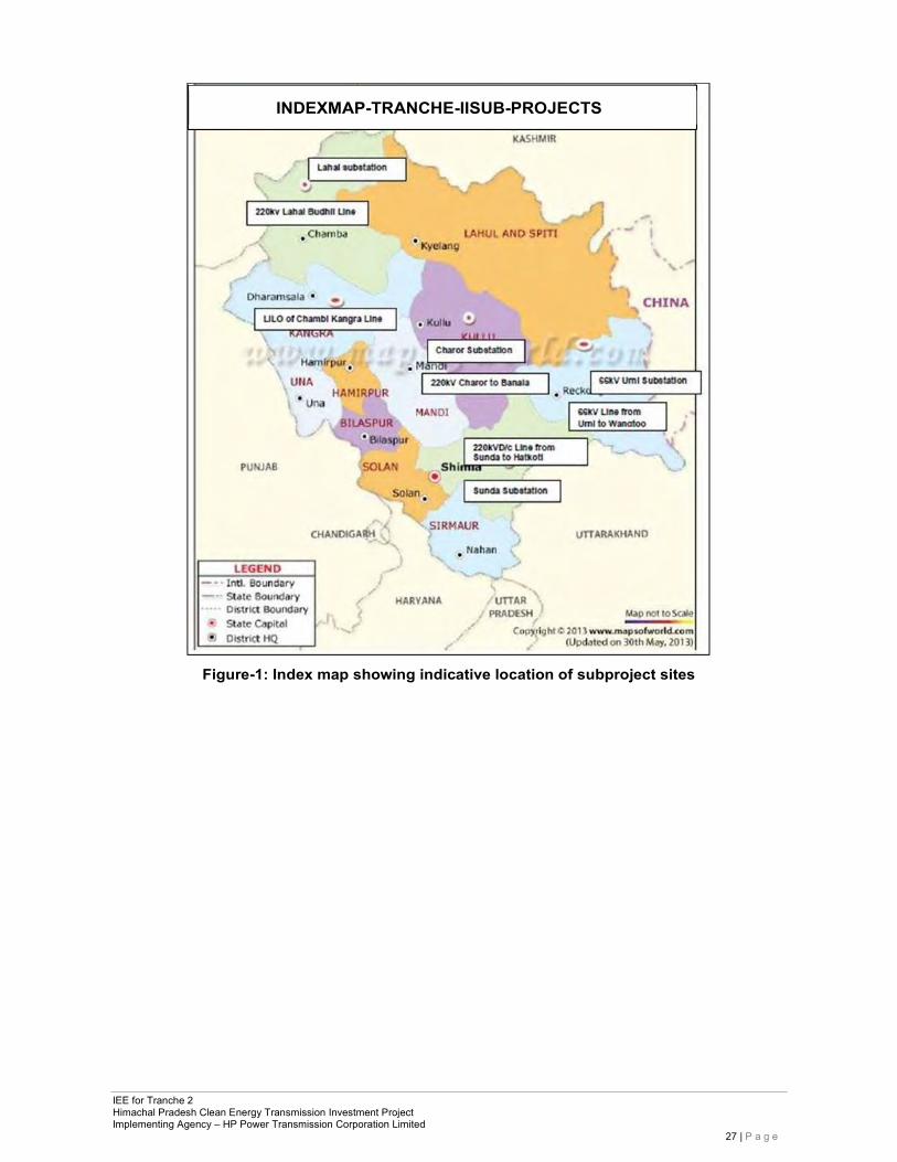
IEE for Tranche 2 Himachal Pradesh Clean Energy Transmission Investment Project Implementing Agency – HP Power Transmission Corporation Limited
27 | P a g e
Figure-1: Index map showing indicative location of subproject sites
INDEXMAP-TRANCHE-IISUB-PROJECTS
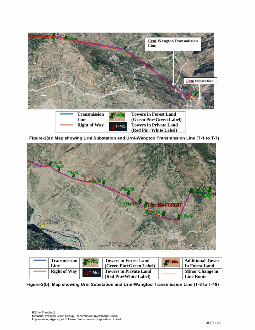
IEE for Tranche 2 Himachal Pradesh Clean Energy Transmission Investment Project Implementing Agency – HP Power Transmission Corporation Limited
28 | P a g e
Transmission
Line Towers in Forest Land
(Green Pin+Green Label)
Right of Way
Towers in Private Land
(Red Pin+White Label) Figure-2(a): Map showing Urni Substation and Urni-Wangtoo Transmission Line (T-1 to T-7)
Transmission
Line Towers in Forest Land
(Green Pin+Green Label)
Additional Tower
In Forest Land
Right of Way
Towers in Private Land
(Red Pin+White Label) Minor Change in
Line Route
Figure-2(b): Map showing Urni Substation and Urni-Wangtoo Transmission Line (T-8 to T-19)
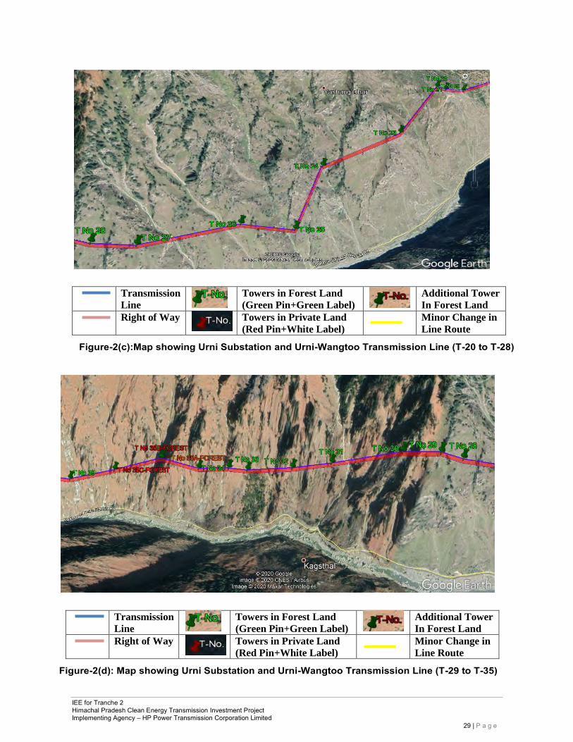
IEE for Tranche 2 Himachal Pradesh Clean Energy Transmission Investment Project Implementing Agency – HP Power Transmission Corporation Limited
29 | P a g e
Transmission
Line Towers in Forest Land
(Green Pin+Green Label)
Additional Tower
In Forest Land
Right of Way
Towers in Private Land
(Red Pin+White Label) Minor Change in
Line Route
Figure-2(c):Map showing Urni Substation and Urni-Wangtoo Transmission Line (T-20 to T-28)
Transmission
Line Towers in Forest Land
(Green Pin+Green Label)
Additional Tower
In Forest Land
Right of Way
Towers in Private Land
(Red Pin+White Label) Minor Change in
Line Route
Figure-2(d): Map showing Urni Substation and Urni-Wangtoo Transmission Line (T-29 to T-35)
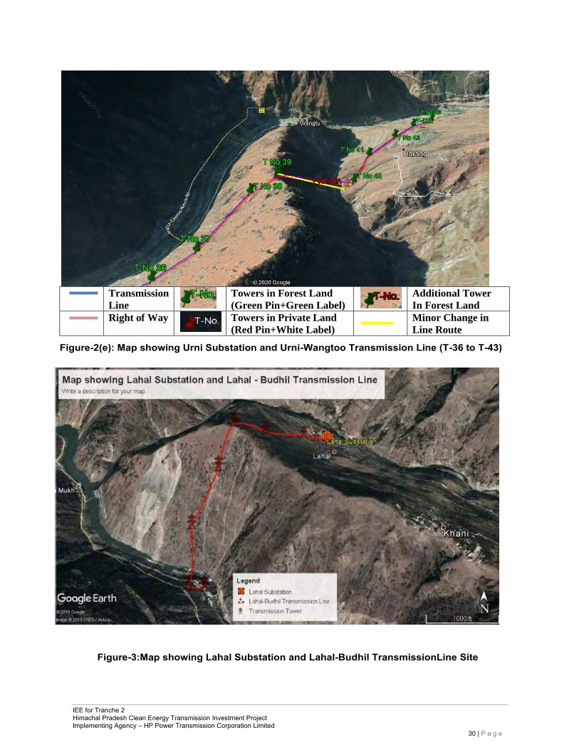
IEE for Tranche 2 Himachal Pradesh Clean Energy Transmission Investment Project Implementing Agency – HP Power Transmission Corporation Limited
30 | P a g e
Transmission
Line Towers in Forest Land
(Green Pin+Green Label)
Additional Tower
In Forest Land
Right of Way
Towers in Private Land
(Red Pin+White Label) Minor Change in
Line Route
Figure-2(e): Map showing Urni Substation and Urni-Wangtoo Transmission Line (T-36 to T-43)
Figure-3:Map showing Lahal Substation and Lahal-Budhil TransmissionLine Site
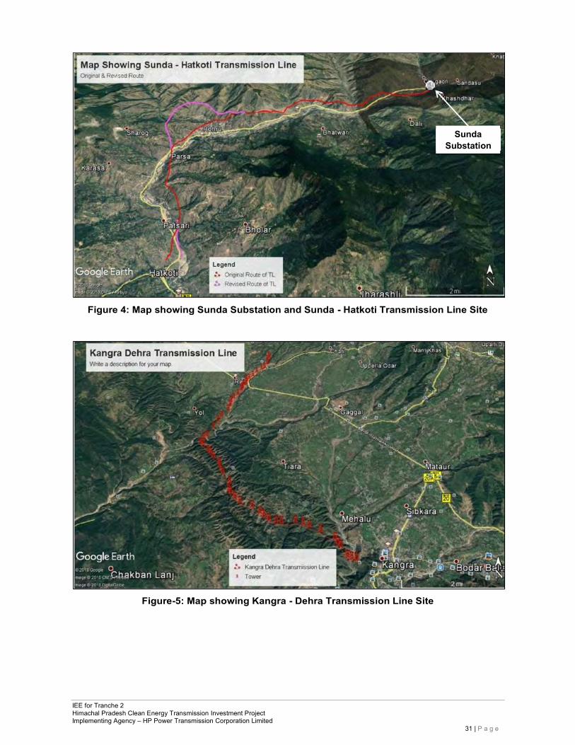
IEE for Tranche 2 Himachal Pradesh Clean Energy Transmission Investment Project Implementing Agency – HP Power Transmission Corporation Limited
31 | P a g e
Figure 4: Map showing Sunda Substation and Sunda - Hatkoti Transmission Line Site
Figure-5: Map showing Kangra - Dehra Transmission Line Site
Sunda Substation
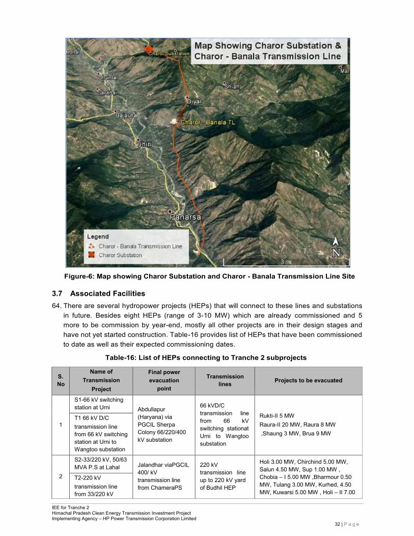
IEE for Tranche 2 Himachal Pradesh Clean Energy Transmission Investment Project Implementing Agency – HP Power Transmission Corporation Limited
32 | P a g e
Figure-6: Map showing Charor Substation and Charor - Banala Transmission Line Site
3.7 Associated Facilities 64. There are several hydropower projects (HEPs) that will connect to these lines and substations
in future. Besides eight HEPs (range of 3-10 MW) which are already commissioned and 5 more to be commission by year-end, mostly all other projects are in their design stages and have not yet started construction. Table-16 provides list of HEPs that have been commissioned to date as well as their expected commissioning dates.
Table-16: List of HEPs connecting to Tranche 2 subprojects
S. No
Name of Transmission
Project
Final power evacuation
point
Transmission
lines
Projects to be evacuated
1
S1-66 kV switching station at Urni
Abdullapur (Haryana) via PGCIL Sherpa Colony 66/220/400 kV substation
66 kVD/C transmission line from 66 kV switching stationat Urni to Wangtoo substation
Rukti-II 5 MW Raura-II 20 MW, Raura 8 MW ,Shaung 3 MW, Brua 9 MW
T1 66 kV D/C transmission line from 66 kV switching station at Urni to Wangtoo substation
2
S2-33/220 kV, 50/63 MVA P.S at Lahal
Jalandhar viaPGCIL 400/ kV transmission line from ChameraPS
220 kV transmission line up to 220 kV yard of Budhil HEP
Holi 3.00 MW, Chirchind 5.00 MW, Salun 4.50 MW, Sup 1.00 MW , Chobia – I 5.00 MW ,Bharmour 0.50 MW, Tulang 3.00 MW, Kurhed, 4.50 MW, Kuwarsi 5.00 MW , Holi – II 7.00
T2-220 kV transmission line from 33/220 kV
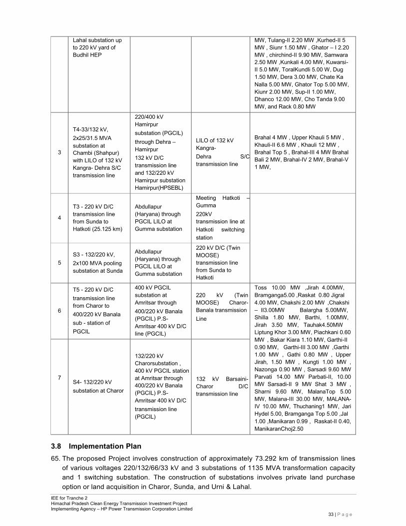
IEE for Tranche 2 Himachal Pradesh Clean Energy Transmission Investment Project Implementing Agency – HP Power Transmission Corporation Limited
33 | P a g e
Lahal substation up to 220 kV yard of Budhil HEP
MW, Tulang-II 2.20 MW ,Kurhed-II 5 MW , Siunr 1.50 MW , Ghator – I 2.20 MW , chirchind-II 9.90 MW, Samwara 2.50 MW ,Kunkali 4.00 MW, Kuwarsi- II 5.0 MW, ToralKundli 5.00 W, Dug 1.50 MW, Dera 3.00 MW, Chate Ka Nalla 5.00 MW, Ghator Top 5.00 MW, Kiunr 2.00 MW, Sup-II 1.00 MW, Dhanco 12.00 MW, Cho Tanda 9.00 MW, and Rack 0.80 MW
3
T4-33/132 kV, 2x25/31.5 MVA substation at Chambi (Shahpur) with LILO of 132 kV Kangra- Dehra S/C transmission line
220/400 kV Hamirpur substation (PGCIL) through Dehra – Hamirpur 132 kV D/C transmission line and 132/220 kV Hamirpur substation Hamirpur(HPSEBL)
LILO of 132 kV Kangra- Dehra S/C transmission line
Brahal 4 MW , Upper Khauli 5 MW , Khauli-II 6.6 MW , Khauli 12 MW , Brahal Top 5 , Brahal-III 4 MW Brahal Bali 2 MW, Brahal-IV 2 MW, Brahal-V 1 MW,
4
T3 - 220 kV D/C transmission line from Sunda to Hatkoti (25.125 km)
Abdullapur (Haryana) through PGCIL LILO at Gumma substation
Meeting Hatkoti – Gumma 220kV transmission line at Hatkoti switching station
5
S3 - 132/220 kV, 2x100 MVA pooling substation at Sunda
Abdullapur (Haryana) through PGCIL LILO at Gumma substation
220 kV D/C (Twin MOOSE) transmission line from Sunda to Hatkoti
T5 - 220 kV D/C 400 kV PGCIL substation at Amritsar through 400/220 kV Banala (PGCIL) P.S- Amritsar 400 kV D/C line (PGCIL)
220 kV (Twin MOOSE) Charor- Banala transmission Line
Toss 10.00 MW ,Jirah 4.00MW, Bramganga5.00 ,Raskat 0.80 Jigral 4.00 MW, Chakshi 2.00 MW ,Chakshi – II3.00MW Balargha 5.00MW, Shilla 1.80 MW, Barthi, 1.00MW, Jirah 3.50 MW, Tauhak4.50MW Liptung Khor 3.00 MW, Piachkani 0.60 MW , Bakar Kiara 1.10 MW, Garthi-II 0.90 MW, Garthi-III 3.00 MW ,Garthi 1.00 MW , Gathi 0.80 MW , Upper Jirah, 1.50 MW , Kungti 1.00 MW , Nazonga 0.90 MW , Sarsadi 9.60 MW Parvati 14.00 MW Parbati-II, 10.00 MW Sarsadi-II 9 MW Shat 3 MW , Sharni 9.60 MW, MalanaTop 5.00 MW, Malana-III 30.00 MW, MALANA- IV 10.00 MW, Thuchaning1 MW, Jari Hydel 5.00, Bramganga Top 5.00 ,Jal 1.00 ,Manikaran 0.99 , Raskat-II 0.40, ManikaranChoj2.50
6
transmission line from Charor to 400/220 kV Banala
sub - station of PGCIL
7
S4- 132/220 kV substation at Charor
132/220 kV Charorsubstation , 400 kV PGCIL station at Amritsar through 400/220 kV Banala (PGCIL) P.S- Amritsar 400 kV D/C
132 kV Barsaini- Charor D/C transmission line
transmission line (PGCIL)
3.8 Implementation Plan 65. The proposed Project involves construction of approximately 73.292 km of transmission lines
of various voltages 220/132/66/33 kV and 3 substations of 1135 MVA transformation capacity and 1 switching substation. The construction of substations involves private land purchase option or land acquisition in Charor, Sunda, and Urni & Lahal.
IEE for Tranche 2 Himachal Pradesh Clean Energy Transmission Investment Project Implementing Agency – HP Power Transmission Corporation Limited
34 | P a g e
66. For construction of transmission lines, the project would involve survey work, forest clearance, design and engineering of plant equipment, floating tenders for procurement, civil works related to 220/132/66/33 kV lines and 220/132/66/33 kV GIS substations testing and commissioning. The overall project implementation schedule for the project is detailed in Table-17.
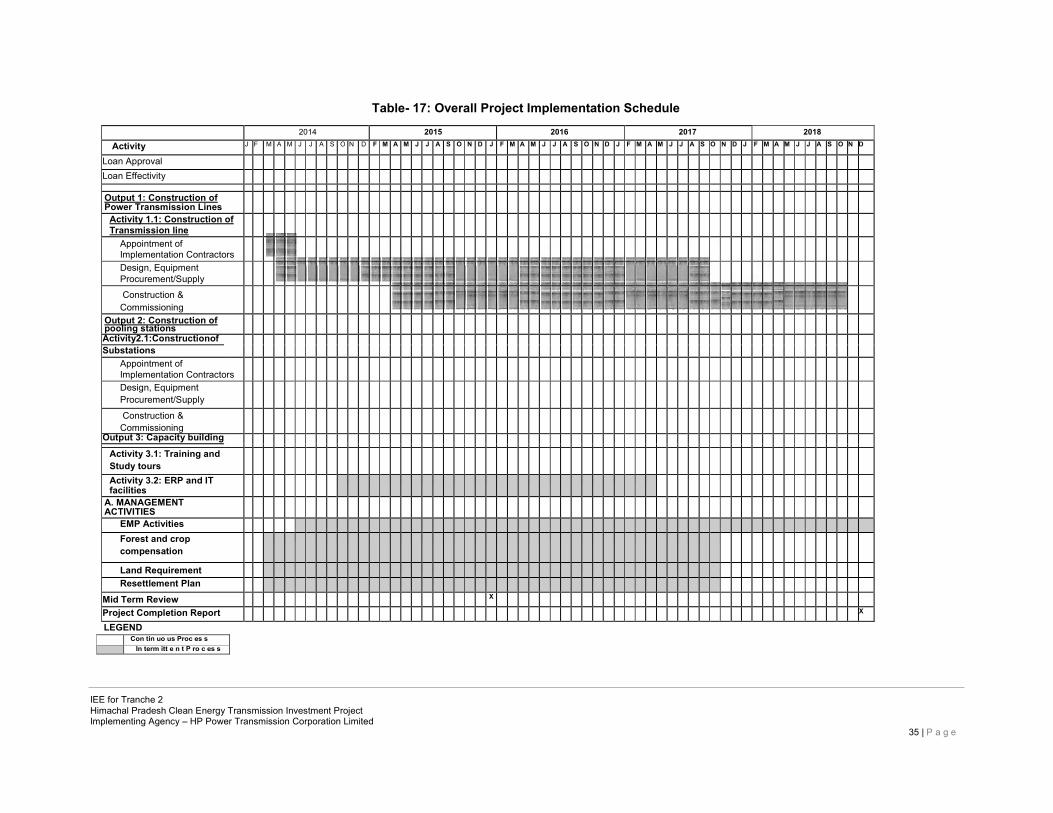
Table- 17: Overall Project Implementation Schedule
2014 2015 2016 2017 2018
Activity J F M A M J J A S O N D F M A M J J A S O N D J F M A M J J A S O N D J F M A M J J A S O N D J F M A M J J A S O N D
Loan Approval
Loan Effectivity
Output 1: Construction of Power Transmission Lines
Activity 1.1: Construction of Transmission line
Appointment of Implementation Contractors
Design, Equipment Procurement/Supply
Construction & Commissioning
Output 2: Construction of pooling stations
Activity2.1:Constructionof
Substations Appointment of Implementation Contractors
Design, Equipment Procurement/Supply
Construction & Commissioning
Output 3: Capacity building
Activity 3.1: Training and Study tours
Activity 3.2: ERP and IT facilities
A. MANAGEMENT ACTIVITIES
EMP Activities
Forest and crop compensation
Land Requirement
Resettlement Plan
Mid Term Review X
Project Completion Report X
LEGEND Con tin uo us Proc es s In term itt e n t P ro c es s
IEE for Tranche 2 Himachal Pradesh Clean Energy Transmission Investment Project Implementing Agency – HP Power Transmission Corporation Limited
35 | P a g e
IEE for Tranche 2 Himachal Pradesh Clean Energy Transmission Investment Project Implementing Agency – HP Power Transmission Corporation Limited
36 | P a g e
4 DESCRIPTION OF ENVIRONMENT (BASELINE DATA)
67. Himachal Pradesh is a north Indian mountainous state. The climate of the state varies from subtropical to temperate. The total area of Himachal Pradesh is 55,673 sq. km, which is 1.74% of the total area of India. The state is very rich in natural resources especially forest and water resources, as it has many permanent glaciers, dense forests, mountain peaks and a network of rivers, with the 5 main rivers including the - Satluj, Beas, Ravi, Chenab, and Pabbar. The outer and lesser Himalayan watersheds of the state covering 28,970 sq. km area are of great national importance, as entire northern India depends largely for water and power produced by run-of-the- river projects from this region. Himachal Pradesh extends from the Shivalik Hills in the south to the Great Himalayan ranges including a slice of the trans-Himalayas in thenorth.
4.1.1 PhysicalResources 68. Kinnaur district: Kinnaur is situated 77°45' and 79°00’35’’ east longitudes and between
31°55'50'' and 32°05'15'' north latitudes. The district is entirely hilly except few small, deep valleys in between. The district has a total geographical area of 6401 sq. km which covers about 11.5 % area of the state. On the western side lies the Shimla district and on the north and north-west lies the Lahaul and Spiti. Kinnaur is about 235 km from Shimla is having the three high mountains ranges i.e. Zanskar, Greater Himalayas and Dhauladhar, enclosing valleys of Sutlej, Spiti, Baspa and their tributaries. The slopes of the valleys are covered with thick wood, orchards, fields, and picturesque hamlets.
69. Shimla district: is located at the south-east of Himachal Pradesh and have geographical area of 5131 sqkm. The district lies between north latitude 30º43'00'' and 30º45'48'' and east longitude 76º59'22'' and 78º18'40'' and fall in Survey of India degree-sheets Nos. 53A, 53E, 53F & 53I. The district is bounded by Mandi district in north, Kullu district in north-west, Kinnaur in the north-east, Sirmaur and Solan districts in the south and west respectively. District has inter-state boundary in the south - east with State of Uttrakhand. The district is well connected by rail and road network. The nearest airports are at Simla (Jubbal Hatti) and Chandigarh.
70. Chamba district: The district is situated between north latitude 32° 11΄30″ and 33° 13΄ 06″, and east longitude 75° 49΄ 00” and 77° 03΄ 30″ . The area of the district is 6,528 sq.km. with Chamba as its headquarters. There are 1591 villages in the district. The district has been divided into 6 sub-divisions [Chamba, Churah, Pangi, Bharmaur, Dalhousie, Chowari]. There are 7 tehsils [Chamba, Churah, Salooni, Pangi, Bharmaur, Dahlhousie, Bhatiyat] and 3 sub- tehsils [Bhallai, Holi, Sihunta].
71. Kullu district: Kullu district is situated in the inner Himalayas between 300 51’ 00” North latitude and 770 06’ 04” East longitude. The district is bounded on the north and east by Lahaul and Spiti district; south-east by Kinnaur district; south by Shimla district; south-west
IEE for Tranche 2 Himachal Pradesh Clean Energy Transmission Investment Project Implementing Agency – HP Power Transmission Corporation Limited
37 | P a g e
and west by Mandi district and on the north-west by Kangra district. The total geographical area of the Kullu district is 5,503 sq. km which comprises of mountain peaks as high as Deo-Tibba (6,123 m) and as low as Jalori pass (3,000 m), the valleys of the Beas, the Parvati, the Sainj, the Tirthan and the valleys of Ani and Kurpan. In terms of geographical conditions, the district is mountainous cruised by rivers and valleys. The Satluj and Beas are the principal rivers with many tributaries. The altitude of the district ranges from 500 m to 5000 m amsl, but the habitation is only up to 3500m.
72. Kangra district The Kangra District of Himachal Pradesh is situated in the Western Himalayas between 31°2 to 32°5 N and 75° to 77°45 E. The district has a geographical area of 5,739 km. which constitutes 10.31% of the geographical area of the State. According to 2001 census, the total population of the district was 1,339,030, which is the highest in the state (22.50% of the population). The altitude of the district ranges from 427 to 6401m above mean sea level, with the lowest being in the plains areas bordering Gurdaspur district of Punjab in the west and Una and Hamirpur districts of H.P to the south while the highest being amidst the Dhauladhar mountain range which forms the border with Chamba and Kullu districts. The district has considerable diversity in its soils, physiography, land use patterns and cropping systems. On the basis of these, the district has further been divided into five sub-regions i.e. PirPanjal, Dhauladhar, Kangra Shiwalik, Kangra Valley and Beas Basin.
4.1.2 Climate & Rainfall 73. Kinnaur: The variance of climate, is as varied as the area. One experiences change, from
the heat of the tropical zone, almost to the freezing temperature of a lowland winter. In the outer Himalayas, which is partly under the influence of the periodical rain, the temperature is much more uniform than in the interior, where, the summer is sultry and the winter extremely cold at elevation of from 8000 to 10,000 feet, in favorable situations, such as Chango, Leo, and Moorang the temperature of July and August is 20° to 22° C and in October temperature is about 10° C. At an elevation of 12,000 feet the summer temperature is between 13° C to 18° C and in October it is 3° to 4°C. In summers it is fairly warm in lower hills. The winter is often rigorous, and in some parts people do not venture out of their homes because of heavy snow. The mean monthly temperature varies from 5° C to 23°C.
74. The district receives rainfall from the month of June till September. The marginal shift in the monsoon pattern has been noticed over the period of years. The average annual rainfall in the district is 816 mm. However much of the rainfall is received in parts of lower Kinnaur. There is a progressive decrease in rainfall as one goes from west to east. The parts of upper Kinnaur receive more snowfall than the rainfall. The district receives heavy snowfall from November end or early December till March or sometimes April. During this period, the area remains totally cutoff from rest of the area. The higher peaks of Kinnaur district are completely covered with snow throughout the year.
75. Shimla: The climate of the district is sub-tropical in the valleys and tends to be temperate at the hilltops. There are four major seasons. The winter season commences from October and lasts up to March, summer extends from March to June followed by monsoon period extending upto September. The average annual rainfall in the district is about 999.64mm,
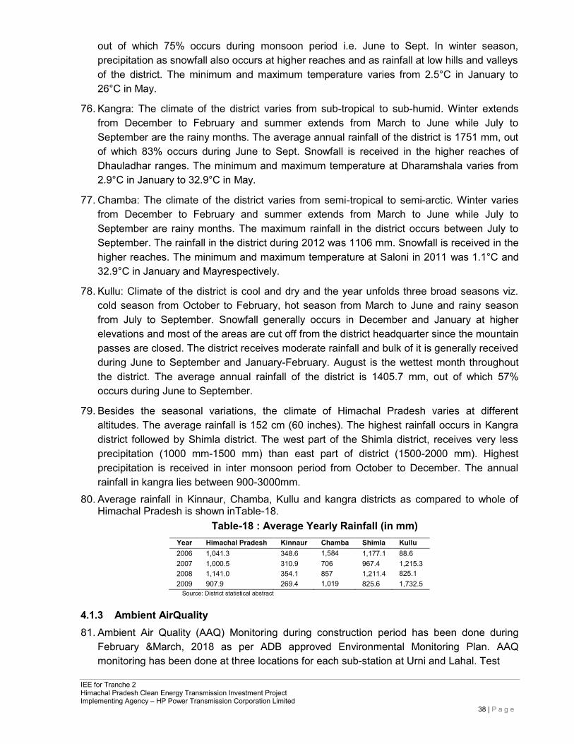
IEE for Tranche 2 Himachal Pradesh Clean Energy Transmission Investment Project Implementing Agency – HP Power Transmission Corporation Limited
38 | P a g e
out of which 75% occurs during monsoon period i.e. June to Sept. In winter season, precipitation as snowfall also occurs at higher reaches and as rainfall at low hills and valleys of the district. The minimum and maximum temperature varies from 2.5°C in January to 26°C in May.
76. Kangra: The climate of the district varies from sub-tropical to sub-humid. Winter extends from December to February and summer extends from March to June while July to September are the rainy months. The average annual rainfall of the district is 1751 mm, out of which 83% occurs during June to Sept. Snowfall is received in the higher reaches of Dhauladhar ranges. The minimum and maximum temperature at Dharamshala varies from 2.9°C in January to 32.9°C in May.
77. Chamba: The climate of the district varies from semi-tropical to semi-arctic. Winter varies from December to February and summer extends from March to June while July to September are rainy months. The maximum rainfall in the district occurs between July to September. The rainfall in the district during 2012 was 1106 mm. Snowfall is received in the higher reaches. The minimum and maximum temperature at Saloni in 2011 was 1.1°C and 32.9°C in January and Mayrespectively.
78. Kullu: Climate of the district is cool and dry and the year unfolds three broad seasons viz. cold season from October to February, hot season from March to June and rainy season from July to September. Snowfall generally occurs in December and January at higher elevations and most of the areas are cut off from the district headquarter since the mountain passes are closed. The district receives moderate rainfall and bulk of it is generally received during June to September and January-February. August is the wettest month throughout the district. The average annual rainfall of the district is 1405.7 mm, out of which 57% occurs during June to September.
79. Besides the seasonal variations, the climate of Himachal Pradesh varies at different altitudes. The average rainfall is 152 cm (60 inches). The highest rainfall occurs in Kangra district followed by Shimla district. The west part of the Shimla district, receives very less precipitation (1000 mm-1500 mm) than east part of district (1500-2000 mm). Highest precipitation is received in inter monsoon period from October to December. The annual rainfall in kangra lies between 900-3000mm.
80. Average rainfall in Kinnaur, Chamba, Kullu and kangra districts as compared to whole of Himachal Pradesh is shown inTable-18.
Table-18 : Average Yearly Rainfall (in mm)
Year Himachal Pradesh Kinnaur Chamba Shimla Kullu 2006 1,041.3 348.6 1,584 1,177.1 88.6 2007 1,000.5 310.9 706 967.4 1,215.3 2008 1,141.0 354.1 857 1,211.4 825.1 2009 907.9 269.4 1,019 825.6 1,732.5
Source: District statistical abstract
4.1.3 Ambient AirQuality 81. Ambient Air Quality (AAQ) Monitoring during construction period has been done during
February &March, 2018 as per ADB approved Environmental Monitoring Plan. AAQ monitoring has been done at three locations for each sub-station at Urni and Lahal. Test
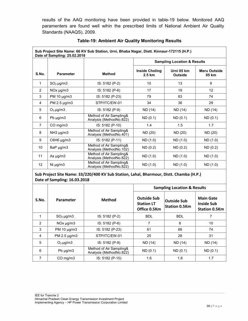
IEE for Tranche 2 Himachal Pradesh Clean Energy Transmission Investment Project Implementing Agency – HP Power Transmission Corporation Limited
39 | P a g e
results of the AAQ monitoring have been provided in table-19 below. Monitored AAQ paramenters are found well wihin the prescribed limits of National Ambient Air Quality Standards (NAAQS), 2009.
Table-19: Ambient Air Quality Monitoring Results
Sub Project Site Name: 66 KV Sub Station, Urni, Bhaba Nagar, Distt. Kinnaur-172115 (H.P.) Date of Sampling: 25.02.2018
S.No.
Parameter
Method
Sampling Location & Results
Inside Choling 2.5 km
Urni 05 km Outside
Meru Outside 05 km
1 SO2 µg/m3 , IS: 5182 (P-2) 10 13 9
2 NOx µg/m3 IS: 5182 (P-6) 17 19 12
3 PM 10 µg/m3 IS: 5182 (P-23) 79 83 74
4 PM 2.5 µg/m3 STP/ITC/EW-01 34 36 29
5 O3 µg/m3 , IS: 5182 (P-9) ND (14) ND (14) ND (14)
6 Pb µg/m3 Method of Air Sampling& Analysis (MethodNo.822) ND (0.1) ND (0.1) ND (0.1)
7 CO mg/m3 IS: 5182 (P-10) 1.4 1.5 1.7
8 NH3 µg/m3 Method of Air Sampling& Analysis (MethodNo.401) ND (20) ND (20) ND (20)
9 C6H6 µg/m3 IS: 5182 (P-11) ND (1.0) ND (1.0) ND (1.0)
10 BaP µg/m3 Method of Air Sampling& Analysis (MethodNo.102) ND (0.2) ND (0.2) ND (0.2)
11 As µg/m3 Method of Air Sampling& Analysis (MethodNo.822) ND (1.0) ND (1.0) ND (1.0)
12 Ni µg/m3 Method of Air Sampling& Analysis (MethodNo.822) ND (1.0) ND (1.0) ND (1.0)
Sub Project Site Name: 33/220/400 KV Sub Station, Lahal, Bharmour, Distt. Chamba (H.P.) Date of Sampling: 16.03.2018
S.No.
Parameter
Method
Sampling Location & Results
Outside Sub Station LT Office 0.5Km
Outside Sub Station 0.5Km
Main Gate Inside Sub Station 0.5Km
1 SO2 µg/m3 , IS: 5182 (P-2) BDL BDL 7
2 NOx µg/m3 IS: 5182 (P-6) 7 8 10
3 PM 10 µg/m3 IS: 5182 (P-23) 61 66 74
4 PM 2.5 µg/m3 STP/ITC/EW-01 25 28 31
5 O3 µg/m3 , IS: 5182 (P-9) ND (14) ND (14) ND (14)
6 Pb µg/m3 Method of Air Sampling& Analysis (MethodNo.822) ND (0.1) ND (0.1) ND (0.1)
7 CO mg/m3 IS: 5182 (P-10) 1.6 1.6 1.7
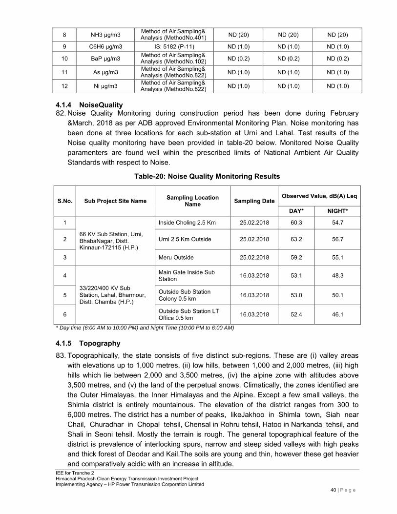
IEE for Tranche 2 Himachal Pradesh Clean Energy Transmission Investment Project Implementing Agency – HP Power Transmission Corporation Limited
40 | P a g e
8 NH3 µg/m3 Method of Air Sampling& Analysis (MethodNo.401) ND (20) ND (20) ND (20)
9 C6H6 µg/m3 IS: 5182 (P-11) ND (1.0) ND (1.0) ND (1.0)
10 BaP µg/m3 Method of Air Sampling& Analysis (MethodNo.102) ND (0.2) ND (0.2) ND (0.2)
11 As µg/m3 Method of Air Sampling& Analysis (MethodNo.822) ND (1.0) ND (1.0) ND (1.0)
12 Ni µg/m3 Method of Air Sampling& Analysis (MethodNo.822) ND (1.0) ND (1.0) ND (1.0)
4.1.4 NoiseQuality 82. Noise Quality Monitoring during construction period has been done during February
&March, 2018 as per ADB approved Environmental Monitoring Plan. Noise monitoring has been done at three locations for each sub-station at Urni and Lahal. Test results of the Noise quality monitoring have been provided in table-20 below. Monitored Noise Quality paramenters are found well wihin the prescribed limits of National Ambient Air Quality Standards with respect to Noise.
Table-20: Noise Quality Monitoring Results
S.No.
Sub Project Site Name
Sampling Location
Name
Sampling Date
Observed Value, dB(A) Leq
DAY* NIGHT*
1
66 KV Sub Station, Urni, BhabaNagar, Distt. Kinnaur-172115 (H.P.)
Inside Choling 2.5 Km 25.02.2018 60.3 54.7
2
Urni 2.5 Km Outside
25.02.2018
63.2
56.7
3 Meru Outside 25.02.2018 59.2 55.1
4
33/220/400 KV Sub Station, Lahal, Bharmour, Distt. Chamba (H.P.)
Main Gate Inside Sub Station
16.03.2018
53.1
48.3
5 Outside Sub Station
Colony 0.5 km
16.03.2018
53.0
50.1
6 Outside Sub Station LT
Office 0.5 km
16.03.2018
52.4
46.1
* Day time (6:00 AM to 10:00 PM) and Night Time (10:00 PM to 6:00 AM)
4.1.5 Topography 83. Topographically, the state consists of five distinct sub-regions. These are (i) valley areas
with elevations up to 1,000 metres, (ii) low hills, between 1,000 and 2,000 metres, (iii) high hills which lie between 2,000 and 3,500 metres, (iv) the alpine zone with altitudes above 3,500 metres, and (v) the land of the perpetual snows. Climatically, the zones identified are the Outer Himalayas, the Inner Himalayas and the Alpine. Except a few small valleys, the Shimla district is entirely mountainous. The elevation of the district ranges from 300 to 6,000 metres. The district has a number of peaks, likeJakhoo in Shimla town, Siah near Chail, Churadhar in Chopal tehsil, Chensal in Rohru tehsil, Hatoo in Narkanda tehsil, and Shali in Seoni tehsil. Mostly the terrain is rough. The general topographical feature of the district is prevalence of interlocking spurs, narrow and steep sided valleys with high peaks and thick forest of Deodar and Kail.The soils are young and thin, however these get heavier and comparatively acidic with an increase in altitude.
IEE for Tranche 2 Himachal Pradesh Clean Energy Transmission Investment Project Implementing Agency – HP Power Transmission Corporation Limited
41 | P a g e
4.1.6 Geomorphology & Soil Types 84. Kinnaur: district presents an intricate mosaic of mountain ranges, hills and deep valleys. It
is primarily a hilly district, with altitudes ranging from 1,500 m to more than 6,500 m amsl. There is a general increase in elevation, from west to east and from south to north. Master slope is south-westerly. The drainage system of the district forms a part of the Indus River basin, except a small part in the northeastern area, which is apart of the Ganga River system. Geomorphologically, the district has been sub divided into the fluvial terrain, fluvio- glacial terrain, Alpines / meadows and Rocky terrain.
85. Taking into consideration, the morphological and physio-chemical characteristics of the soils and general similarity in them, the various types of soils observed in the district can be grouped into three major types viz Type-I, Type-II& Type-III. Type-I soil is coarse loamy, mixed in nature. The soil is developed from granites, highly metamorphosed gneisses, schists and occurs on moderately sloping to steep lands. These soils are well drained, with moderately rapid permeability. Natural vegetation exists in these soils and various crops are cultivated according to the suitability.
86. Kullu: Geomorphology of the area plays an important role in deciphering the sub-surface and surface hydrogeological conditions. On the basis of hydro geomorphological and geological set up, the study area can be divided into the following geomorphic units.
• Mountainous area- Dhauladhar and Pir-Panjal ranges trend NW-SE and peaks ranging in height between 4200-5000m above mean sea level.
• Snow covered area- Northern and northeastern parts of Kullu district are covered with snow and snow line exists in this area.
• Denuded hills- The presence of residual ridges along the intermontane valleys suggest that these ridges are the remnants of High Relief Mountains and formed active erosion.
• Valley area - Fluvial processes and structural disturbances in the area form intermontane valleys. Kullu valley is elongated and broadly v-shaped in cross-section and denuded hills along thesides.
• Terrace area- Number of terraces is formed along the river valleys in Kullu district. Terraces are generally noticed on the western bank of the Beas River. Two levels of terraces are demarcated near Bhunter, which are covered with thick vegetation.
87. The elevation of Kullu district ranges from 914m to 4084m above mean sea level with varied agro-climatic conditions. The texture of soil ranges from sandy loam to clay loam and the colour of the soil also vary from brown to dark brown. Generally the soil is acidic in nature. Depth of the soil varies from 50 to 100 cms. But despite this, all the agro climatic conditions provide a range of potentialities for growing cash crops like, off season vegetables, seed potatoes, pulses and temperate fruits.
88. Kangra: Kangra district presents an intricate mosaic of mountain ranges, hills and valleys. It is primarily a hilly district, with altitudes ranging from 350 m amsl to 4880 m amsl in the hills of Dauladhar. Physiographically, the district can be divided into six units-viz. (i) high hills, which cover almost 60% of the district (ii) Fluvio glacial outwash terraces, which is located in the north eastern part of the district (iii) structural terraces, in the central part (iv) valley fills (v) piedmont plain and (vi) flood plain.
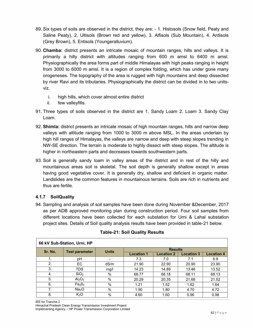
IEE for Tranche 2 Himachal Pradesh Clean Energy Transmission Investment Project Implementing Agency – HP Power Transmission Corporation Limited
42 | P a g e
89. Six types of soils are observed in the district, they are: - 1. Histosols (Snow field, Peaty and Saline Peaty), 2. Ultisols (Brown red and yellow), 3. Alfisols (Sub Mountain), 4. Ardisols (Grey Brown), 5. Entisols (Youngeralluvium).
90. Chamba: district presents an intricate mosaic of mountain ranges, hills and valleys. It is primarily a hilly district with altitudes ranging from 600 m amsl to 6400 m amsl. Physiographically the area forms part of middle Himalayas with high peaks ranging in height from 3000 to 6000 m amsl. It is a region of complex folding, which has under gone many orogeneses. The topography of the area is rugged with high mountains and deep dissected by river Ravi and its tributaries. Physiographically the district can be divided in to two units- viz.
i. high hills, which cover almost entire district ii. few valleyfills.
91. Three types of soils observed in the district are 1. Sandy Loam 2. Loam 3. Sandy Clay Loam.
92. Shimla: district presents an intricate mosaic of high mountain ranges, hills and narrow deep valleys with altitude ranging from 1000 to 3000 m above MSL. In the areas underlain by high hill ranges of Himalayas, the valleys are narrow and deep with steep slopes trending in NW-SE direction. The terrain is moderate to highly dissect with steep slopes. The altitude is higher in northeastern parts and decreases towards southwestern parts.
93. Soil is generally sandy loam in valley areas of the district and in rest of the hilly and mountainous areas soil is skeletal. The soil depth is generally shallow except in areas having good vegetative cover. It is generally dry, shallow and deficient in organic matter. Landslides are the common features in mountainous terrains. Soils are rich in nutrients and thus are fertile.
4.1.7 SoilQuality 94. Sampling and analysis of soil samples have been done during November &December, 2017
as per ADB approved monitoring plan during construction period. Four soil samples from different locations have been collected for each substation for Urni & Lahal substation project sites. Details of Soil quality analysis results have been provided in table-21 below.
Table-21: Soil Quality Results
66 kV Sub-Station, Urni, HP
Sr. No. Test parameter Units Results Location 1 Location 2 Location 3 Location 4
1. pH - 7.3 7.0 7.1 6.9 2. EC dS/m 21.90 22.90 20.90 23.90 3. TDS mg/l 14.23 14.89 13.46 13.52 4. SiO2 % 68.77 68.18 68.11 68.13 5. Al2O3 % 20.29 20.35 21.68 21.52 6. Fe203 % 1.21 1.52 1.62 1.64 7. Na2O % 1.90 1.80 4.70 4.72 8. K2O % 4.60 1.60 0.96 0.98
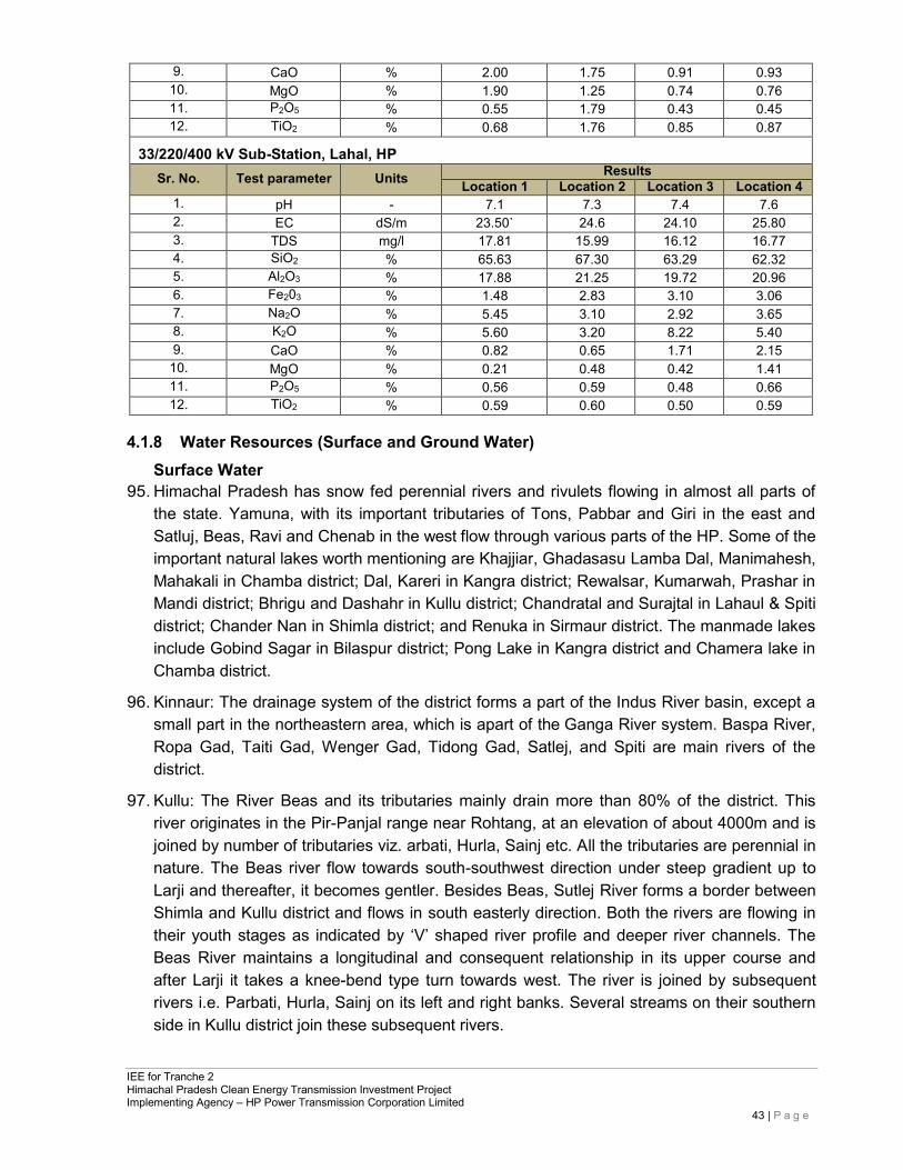
IEE for Tranche 2 Himachal Pradesh Clean Energy Transmission Investment Project Implementing Agency – HP Power Transmission Corporation Limited
43 | P a g e
9. CaO % 2.00 1.75 0.91 0.93 10. MgO % 1.90 1.25 0.74 0.76 11. P2O5 % 0.55 1.79 0.43 0.45 12. TiO2 % 0.68 1.76 0.85 0.87
33/220/400 kV Sub-Station, Lahal, HP Sr. No. Test parameter Units Results
Location 1 Location 2 Location 3 Location 4 1. pH - 7.1 7.3 7.4 7.6 2. EC dS/m 23.50` 24.6 24.10 25.80 3. TDS mg/l 17.81 15.99 16.12 16.77 4. SiO2 % 65.63 67.30 63.29 62.32 5. Al2O3 % 17.88 21.25 19.72 20.96 6. Fe203 % 1.48 2.83 3.10 3.06 7. Na2O % 5.45 3.10 2.92 3.65 8. K2O % 5.60 3.20 8.22 5.40 9. CaO % 0.82 0.65 1.71 2.15 10. MgO % 0.21 0.48 0.42 1.41 11. P2O5 % 0.56 0.59 0.48 0.66 12. TiO2 % 0.59 0.60 0.50 0.59
4.1.8 Water Resources (Surface and Ground Water) Surface Water
95. Himachal Pradesh has snow fed perennial rivers and rivulets flowing in almost all parts of the state. Yamuna, with its important tributaries of Tons, Pabbar and Giri in the east and Satluj, Beas, Ravi and Chenab in the west flow through various parts of the HP. Some of the important natural lakes worth mentioning are Khajjiar, Ghadasasu Lamba Dal, Manimahesh, Mahakali in Chamba district; Dal, Kareri in Kangra district; Rewalsar, Kumarwah, Prashar in Mandi district; Bhrigu and Dashahr in Kullu district; Chandratal and Surajtal in Lahaul & Spiti district; Chander Nan in Shimla district; and Renuka in Sirmaur district. The manmade lakes include Gobind Sagar in Bilaspur district; Pong Lake in Kangra district and Chamera lake in Chamba district.
96. Kinnaur: The drainage system of the district forms a part of the Indus River basin, except a small part in the northeastern area, which is apart of the Ganga River system. Baspa River, Ropa Gad, Taiti Gad, Wenger Gad, Tidong Gad, Satlej, and Spiti are main rivers of the district.
97. Kullu: The River Beas and its tributaries mainly drain more than 80% of the district. This river originates in the Pir-Panjal range near Rohtang, at an elevation of about 4000m and is joined by number of tributaries viz. arbati, Hurla, Sainj etc. All the tributaries are perennial in nature. The Beas river flow towards south-southwest direction under steep gradient up to Larji and thereafter, it becomes gentler. Besides Beas, Sutlej River forms a border between Shimla and Kullu district and flows in south easterly direction. Both the rivers are flowing in their youth stages as indicated by ‘V’ shaped river profile and deeper river channels. The Beas River maintains a longitudinal and consequent relationship in its upper course and after Larji it takes a knee-bend type turn towards west. The river is joined by subsequent rivers i.e. Parbati, Hurla, Sainj on its left and right banks. Several streams on their southern side in Kullu district join these subsequent rivers.
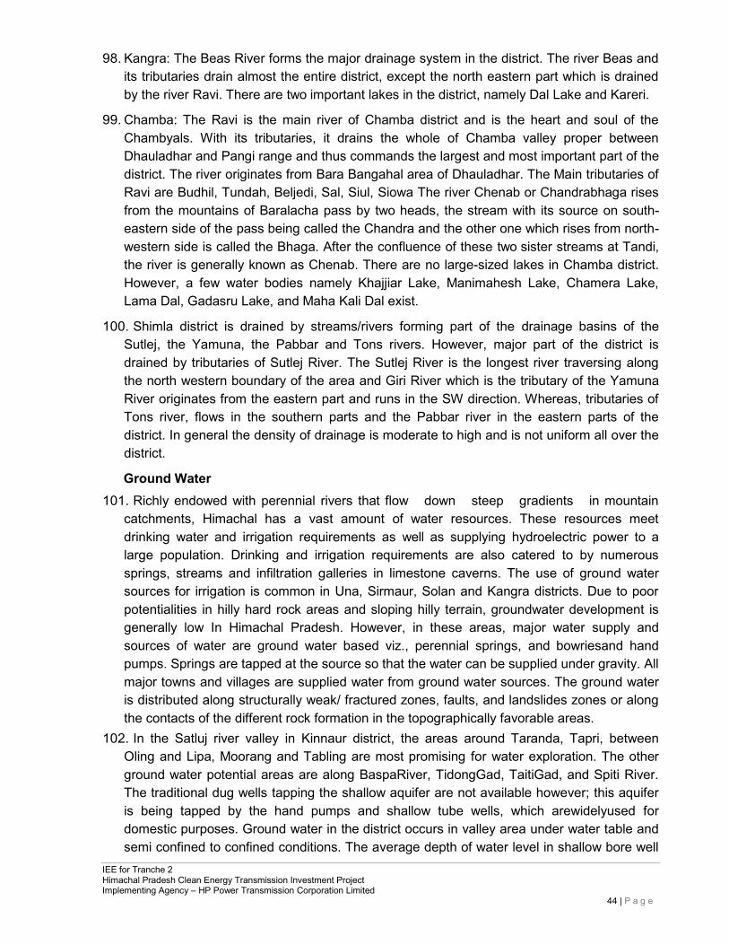
IEE for Tranche 2 Himachal Pradesh Clean Energy Transmission Investment Project Implementing Agency – HP Power Transmission Corporation Limited
44 | P a g e
98. Kangra: The Beas River forms the major drainage system in the district. The river Beas and its tributaries drain almost the entire district, except the north eastern part which is drained by the river Ravi. There are two important lakes in the district, namely Dal Lake and Kareri.
99. Chamba: The Ravi is the main river of Chamba district and is the heart and soul of the Chambyals. With its tributaries, it drains the whole of Chamba valley proper between Dhauladhar and Pangi range and thus commands the largest and most important part of the district. The river originates from Bara Bangahal area of Dhauladhar. The Main tributaries of Ravi are Budhil, Tundah, Beljedi, Sal, Siul, Siowa The river Chenab or Chandrabhaga rises from the mountains of Baralacha pass by two heads, the stream with its source on south- eastern side of the pass being called the Chandra and the other one which rises from north- western side is called the Bhaga. After the confluence of these two sister streams at Tandi, the river is generally known as Chenab. There are no large-sized lakes in Chamba district. However, a few water bodies namely Khajjiar Lake, Manimahesh Lake, Chamera Lake, Lama Dal, Gadasru Lake, and Maha Kali Dal exist.
100. Shimla district is drained by streams/rivers forming part of the drainage basins of the Sutlej, the Yamuna, the Pabbar and Tons rivers. However, major part of the district is drained by tributaries of Sutlej River. The Sutlej River is the longest river traversing along the north western boundary of the area and Giri River which is the tributary of the Yamuna River originates from the eastern part and runs in the SW direction. Whereas, tributaries of Tons river, flows in the southern parts and the Pabbar river in the eastern parts of the district. In general the density of drainage is moderate to high and is not uniform all over the district.
Ground Water 101. Richly endowed with perennial rivers that flow down steep gradients in mountain
catchments, Himachal has a vast amount of water resources. These resources meet drinking water and irrigation requirements as well as supplying hydroelectric power to a large population. Drinking and irrigation requirements are also catered to by numerous springs, streams and infiltration galleries in limestone caverns. The use of ground water sources for irrigation is common in Una, Sirmaur, Solan and Kangra districts. Due to poor potentialities in hilly hard rock areas and sloping hilly terrain, groundwater development is generally low In Himachal Pradesh. However, in these areas, major water supply and sources of water are ground water based viz., perennial springs, and bowriesand hand pumps. Springs are tapped at the source so that the water can be supplied under gravity. All major towns and villages are supplied water from ground water sources. The ground water is distributed along structurally weak/ fractured zones, faults, and landslides zones or along the contacts of the different rock formation in the topographically favorable areas.
102. In the Satluj river valley in Kinnaur district, the areas around Taranda, Tapri, between Oling and Lipa, Moorang and Tabling are most promising for water exploration. The other ground water potential areas are along BaspaRiver, TidongGad, TaitiGad, and Spiti River. The traditional dug wells tapping the shallow aquifer are not available however; this aquifer is being tapped by the hand pumps and shallow tube wells, which arewidelyused for domestic purposes. Ground water in the district occurs in valley area under water table and semi confined to confined conditions. The average depth of water level in shallow bore well
IEE for Tranche 2 Himachal Pradesh Clean Energy Transmission Investment Project Implementing Agency – HP Power Transmission Corporation Limited
45 | P a g e
ranges from 10 to 30 m below ground level. Ground water of the Kinnaur district is alkaline in nature9. pH of shallow ground water ranges from 6.95 to 7.75. The electrical conductivity (EC) in the area ranges from 127-672 micro mhos/cm. Nitrate values range between 1-10 mg/l. The chemical quality reveals that the overall ground water quality is good and is suitable for domestic and irrigational use. However, quality of water from hot springs in Karcham has brackish water with EC 1780 micro mhos/cm and fluoride concentration 3.5mg/l.
4.1.9 Water Quality of the Sub-ProjectArea 103. Sampling and analysis of water samples have been done during November & December,
2017 as per ADB approved monitoring plan during construction period. Four water quality samples from different locations have been collected for each substation for Urni&Lahal substation project sites. Water quality of the sub-project area is generally good. All the test results are within permissible limits. Details of ground water quality analysis results have been provided in table-22 below.
Table-22: Ground Water Quality Results
66 kV Sub-Station, Urni, HP
Sr. No.
Name of the parameter
Units
Requirement Results
Acceptable limit
Permissible limit in
absence of alternative
source Loca
tion-
1
Loca
tion-
2
Loca
tion-
3
Loca
tion-
4
1. Color NTU 5 15 0.10 0.15 0.1 0.10 2. Hardness as CaCO3 mg/L 200 600 55.60 54.47 55.77 53.70 3. Odour - Odorless Odorless - - - - 4. TDS mg/L 500 2000 56.39 59.16 58.37 59.56 5. Turbidity NTU 1 5 0.10 0.19 1.95 0.11 6. Cyanide as CN mg/L 0.05 No Relaxation N/D N/D N/D N/D 7. Chloride as Cl mg/L 250 1000 15.36 15.57 15.70 16.15 8. Flouride as F mg/L 1.0 1.5 0.33 0.81 0.75 0.77 9. Nitrate as NO3 mg/L 45 No Relaxation 0.63 0.87 0.80 0.87
10. pH - 6.5-8.5 No Relaxation 7.2 7.4 7.8 7.5 11. Sulphate as SO4 mg/L 200 400 N/D N/D N/D N/D 12. Phenolic Compound
as C6H5OH mg/L 0.001 0.002 N/D N/D N/D N/D
13. Arsenic as As mg/L 0.01 0.05 N/D N/D N/D N/D 14. Copper as Cu mg/L 0.05 1.5 N/D N/D N/D N/D 15. Cadmium mg/L 0.003 No Relaxation N/D N/D N/D N/D 16. Iron as Fe mg/L 0.3 No Relaxation N/D N/D N/D N/D 17. Lead as Pb mg/L 0.01 No Relaxation N/D N/D N/D N/D 18 Calcium as Ca2+ mg/L 75 200 35.09 36.29 35.54 35.99 19. Magnesium as Mg2+ mg/L 30 100 4.98 5.62 5.58 5.78 20. Manganese as Mn mg/L 0.1 0.3 N/D N/D N/D N/D
9 As per Ground Water Information Booklet, Himachal Pradesh, 2008
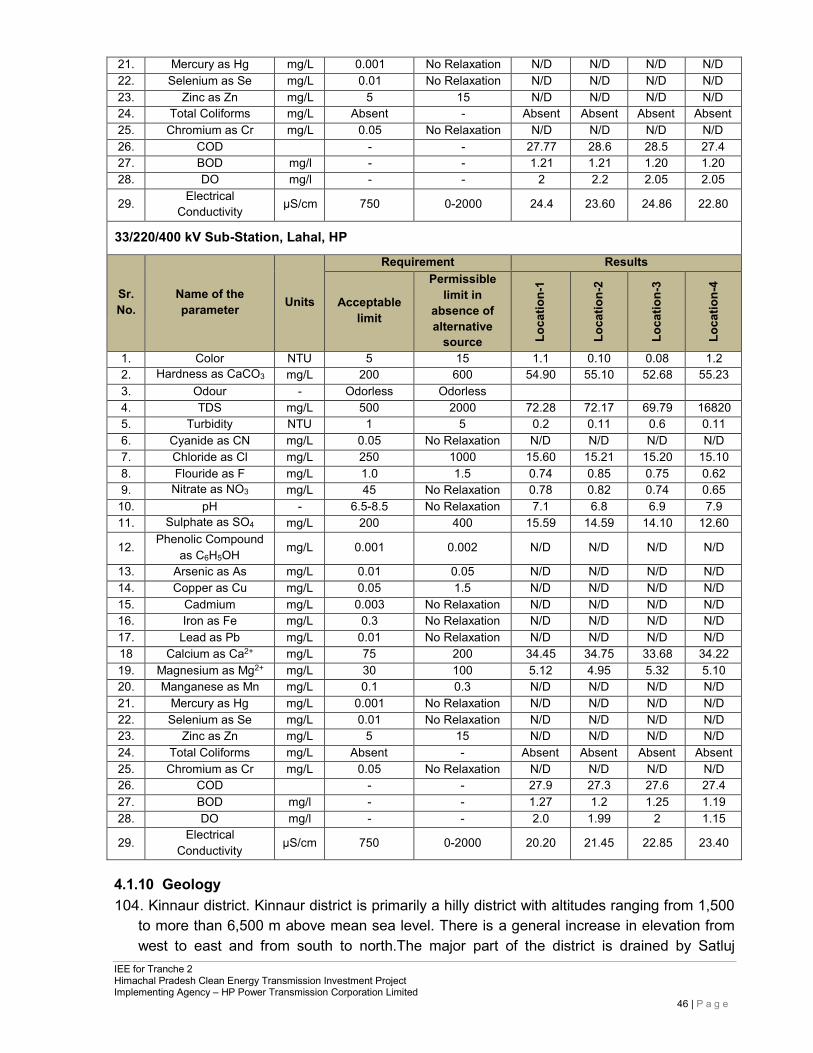
IEE for Tranche 2 Himachal Pradesh Clean Energy Transmission Investment Project Implementing Agency – HP Power Transmission Corporation Limited
46 | P a g e
21. Mercury as Hg mg/L 0.001 No Relaxation N/D N/D N/D N/D 22. Selenium as Se mg/L 0.01 No Relaxation N/D N/D N/D N/D 23. Zinc as Zn mg/L 5 15 N/D N/D N/D N/D 24. Total Coliforms mg/L Absent - Absent Absent Absent Absent 25. Chromium as Cr mg/L 0.05 No Relaxation N/D N/D N/D N/D 26. COD - - 27.77 28.6 28.5 27.4 27. BOD mg/l - - 1.21 1.21 1.20 1.20 28. DO mg/l - - 2 2.2 2.05 2.05
29. Electrical Conductivity µS/cm 750 0-2000 24.4 23.60 24.86 22.80
33/220/400 kV Sub-Station, Lahal, HP
Sr. No.
Name of the parameter
Units
Requirement Results
Acceptable limit
Permissible limit in
absence of alternative
source Loca
tion-
1
Loca
tion-
2
Loca
tion-
3
Loca
tion-
4
1. Color NTU 5 15 1.1 0.10 0.08 1.2 2. Hardness as CaCO3 mg/L 200 600 54.90 55.10 52.68 55.23 3. Odour - Odorless Odorless
4. TDS mg/L 500 2000 72.28 72.17 69.79 16820 5. Turbidity NTU 1 5 0.2 0.11 0.6 0.11 6. Cyanide as CN mg/L 0.05 No Relaxation N/D N/D N/D N/D 7. Chloride as Cl mg/L 250 1000 15.60 15.21 15.20 15.10 8. Flouride as F mg/L 1.0 1.5 0.74 0.85 0.75 0.62 9. Nitrate as NO3 mg/L 45 No Relaxation 0.78 0.82 0.74 0.65
10. pH - 6.5-8.5 No Relaxation 7.1 6.8 6.9 7.9 11. Sulphate as SO4 mg/L 200 400 15.59 14.59 14.10 12.60
12. Phenolic Compound as C6H5OH
mg/L 0.001 0.002 N/D N/D N/D N/D
13. Arsenic as As mg/L 0.01 0.05 N/D N/D N/D N/D 14. Copper as Cu mg/L 0.05 1.5 N/D N/D N/D N/D 15. Cadmium mg/L 0.003 No Relaxation N/D N/D N/D N/D 16. Iron as Fe mg/L 0.3 No Relaxation N/D N/D N/D N/D 17. Lead as Pb mg/L 0.01 No Relaxation N/D N/D N/D N/D 18 Calcium as Ca2+ mg/L 75 200 34.45 34.75 33.68 34.22 19. Magnesium as Mg2+ mg/L 30 100 5.12 4.95 5.32 5.10 20. Manganese as Mn mg/L 0.1 0.3 N/D N/D N/D N/D 21. Mercury as Hg mg/L 0.001 No Relaxation N/D N/D N/D N/D 22. Selenium as Se mg/L 0.01 No Relaxation N/D N/D N/D N/D 23. Zinc as Zn mg/L 5 15 N/D N/D N/D N/D 24. Total Coliforms mg/L Absent - Absent Absent Absent Absent 25. Chromium as Cr mg/L 0.05 No Relaxation N/D N/D N/D N/D 26. COD - - 27.9 27.3 27.6 27.4 27. BOD mg/l - - 1.27 1.2 1.25 1.19 28. DO mg/l - - 2.0 1.99 2 1.15
29. Electrical Conductivity µS/cm 750 0-2000 20.20 21.45 22.85 23.40
4.1.10 Geology 104. Kinnaur district. Kinnaur district is primarily a hilly district with altitudes ranging from 1,500
to more than 6,500 m above mean sea level. There is a general increase in elevation from west to east and from south to north.The major part of the district is drained by Satluj
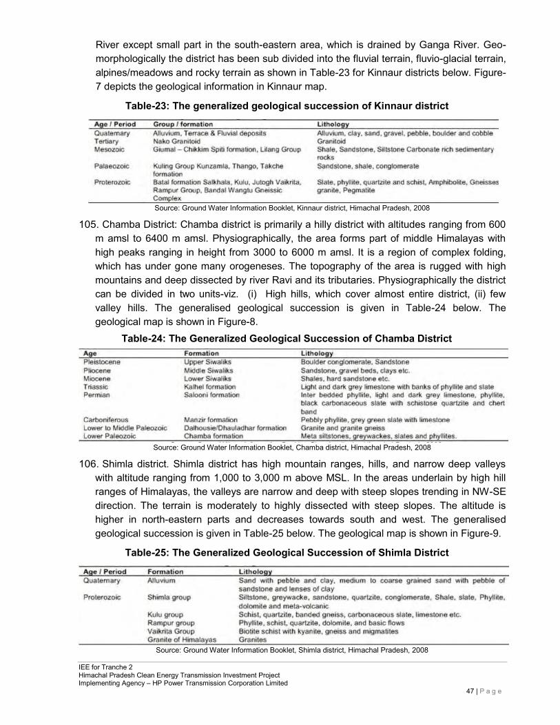
IEE for Tranche 2 Himachal Pradesh Clean Energy Transmission Investment Project Implementing Agency – HP Power Transmission Corporation Limited
47 | P a g e
River except small part in the south-eastern area, which is drained by Ganga River. Geo- morphologically the district has been sub divided into the fluvial terrain, fluvio-glacial terrain, alpines/meadows and rocky terrain as shown in Table-23 for Kinnaur districts below. Figure-7 depicts the geological information in Kinnaur map.
Table-23: The generalized geological succession of Kinnaur district
Source: Ground Water Information Booklet, Kinnaur district, Himachal Pradesh, 2008
105. Chamba District: Chamba district is primarily a hilly district with altitudes ranging from 600 m amsl to 6400 m amsl. Physiographically, the area forms part of middle Himalayas with high peaks ranging in height from 3000 to 6000 m amsl. It is a region of complex folding, which has under gone many orogeneses. The topography of the area is rugged with high mountains and deep dissected by river Ravi and its tributaries. Physiographically the district can be divided in two units-viz. (i) High hills, which cover almost entire district, (ii) few valley hills. The generalised geological succession is given in Table-24 below. The geological map is shown in Figure-8.
Table-24: The Generalized Geological Succession of Chamba District
Source: Ground Water Information Booklet, Chamba district, Himachal Pradesh, 2008
106. Shimla district. Shimla district has high mountain ranges, hills, and narrow deep valleys with altitude ranging from 1,000 to 3,000 m above MSL. In the areas underlain by high hill ranges of Himalayas, the valleys are narrow and deep with steep slopes trending in NW-SE direction. The terrain is moderately to highly dissected with steep slopes. The altitude is higher in north-eastern parts and decreases towards south and west. The generalised geological succession is given in Table-25 below. The geological map is shown in Figure-9.
Table-25: The Generalized Geological Succession of Shimla District
Source: Ground Water Information Booklet, Shimla district, Himachal Pradesh, 2008
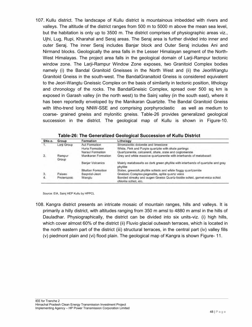
IEE for Tranche 2 Himachal Pradesh Clean Energy Transmission Investment Project Implementing Agency – HP Power Transmission Corporation Limited
48 | P a g e
107. Kullu district. The landscape of Kullu district is mountainous imbedded with rivers and valleys. The altitude of the district ranges from 500 m to 5000 m above the mean sea level, but the habitation is only up to 3500 m. The district comprises of physiographic areas viz., Ujhi, Lug, Rupi, Kharahal and Seraj areas. The Seraj area is further divided into inner and outer Seraj. The inner Seraj includes Banjar block and Outer Seraj includes Ani and Nirmand blocks. Geologically the area falls in the Lesser Himalayan segment of the North- West Himalayas. The project area falls in the geological domain of Larji-Rampur tectonic window zone. The Larji-Rampur Window Zone exposes, two Granitoid Complex bodies namely (i) the Bandal Granitoid Gneisses in the North West and (ii) the JeoriWangtu Granitoid Gneiss in the south-west. The BandalGranaitoid Gneiss is considered equivalent to the Jeori-Wangtu Gneissic Complex on the basis of similarity in tectonic position, lithology and chronology of the rocks. The BandalGneisic Complex, spread over 500 sq km is exposed in Garash valley (in the north west) to the Sainj valley (in the south east), where it has been reportedly enveloped by the Manikaran Quartzite. The Bandal Granitoid Gneiss with litho-trend long NNW-SSE and comprising porphyroclastic as well as medium to coarse- grained gneiss and mylonitic gneiss. Table-26 provides generalized geological succession in the district. The geological map of Kullu is shown in Figure-10.
Table-26: The Generalized Geological Succession of Kullu District
Source: EIA, Sainj HEP Kullu by HPPCL
108. Kangra district presents an intricate mosaic of mountain ranges, hills and valleys. It is primarily a hilly district, with altitudes ranging from 350 m amsl to 4880 m amsl in the hills of Dauladhar. Physiographically, the district can be divided into six units-viz. (i) high hills, which cover almost 60% of the district (ii) Fluvio glacial outwash terraces, which is located in the north eastern part of the district (iii) structural terraces, in the central part (iv) valley fills (v) piedmont plain and (vi) flood plain. The geological map of Kangra is shown Figure- 11.
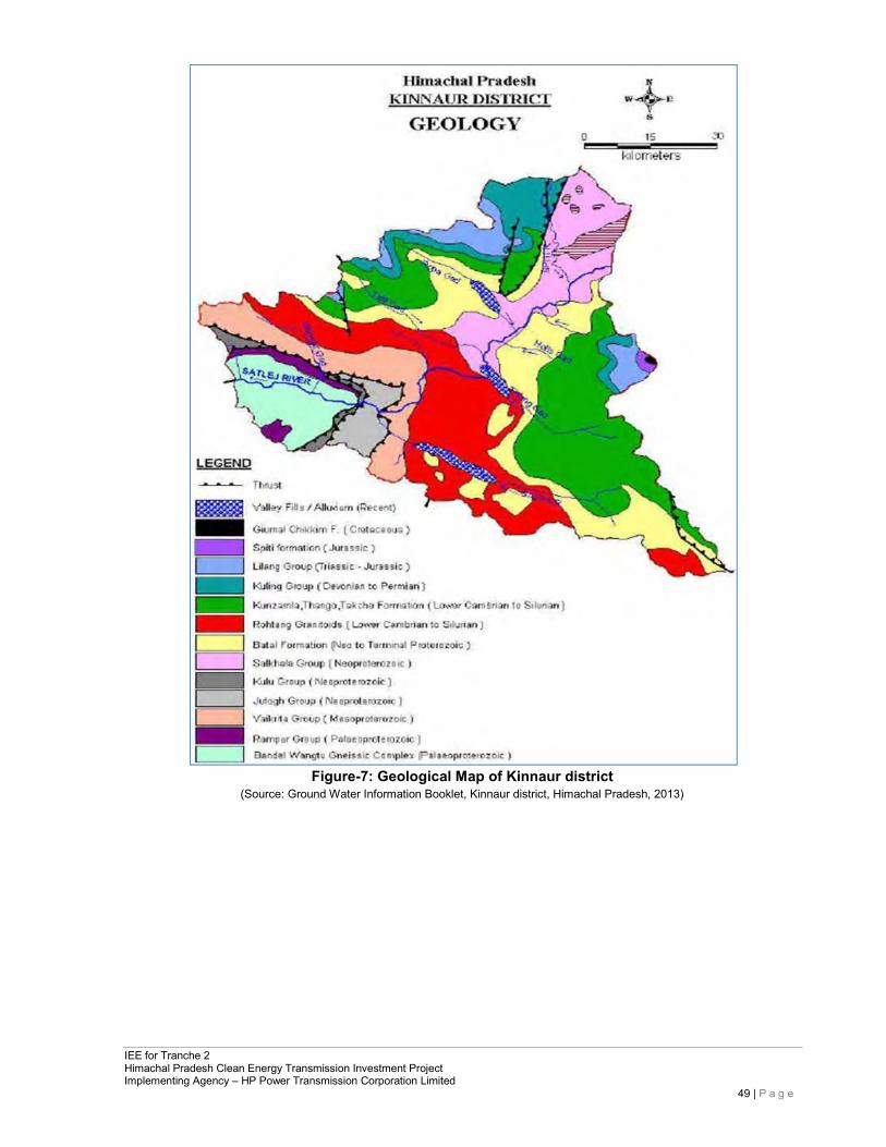
IEE for Tranche 2 Himachal Pradesh Clean Energy Transmission Investment Project Implementing Agency – HP Power Transmission Corporation Limited
49 | P a g e
Figure-7: Geological Map of Kinnaur district
(Source: Ground Water Information Booklet, Kinnaur district, Himachal Pradesh, 2013)
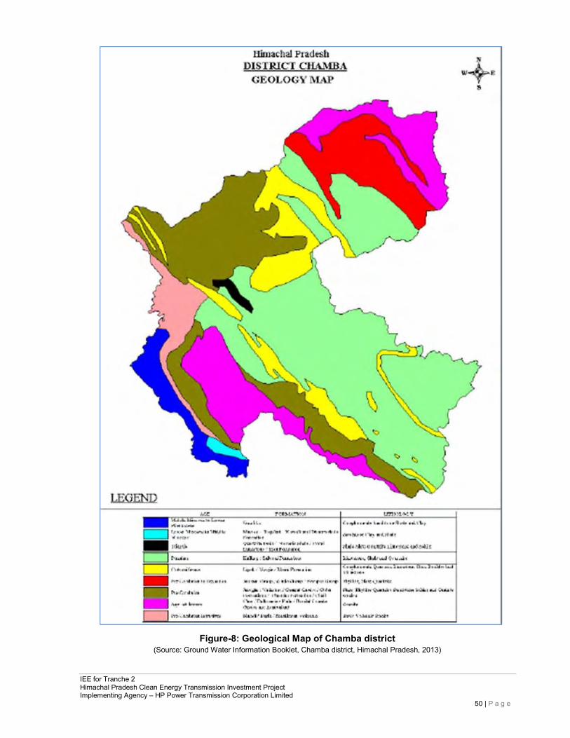
IEE for Tranche 2 Himachal Pradesh Clean Energy Transmission Investment Project Implementing Agency – HP Power Transmission Corporation Limited
50 | P a g e
Figure-8: Geological Map of Chamba district (Source: Ground Water Information Booklet, Chamba district, Himachal Pradesh, 2013)
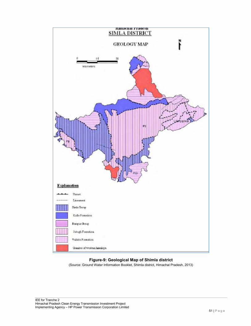
IEE for Tranche 2 Himachal Pradesh Clean Energy Transmission Investment Project Implementing Agency – HP Power Transmission Corporation Limited
51 | P a g e
Figure-9: Geological Map of Shimla district (Source: Ground Water Information Booklet, Shimla district, Himachal Pradesh, 2013)
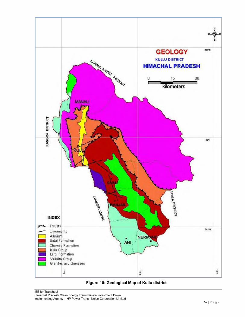
IEE for Tranche 2 Himachal Pradesh Clean Energy Transmission Investment Project Implementing Agency – HP Power Transmission Corporation Limited
52 | P a g e
Figure-10: Geological Map of Kullu district
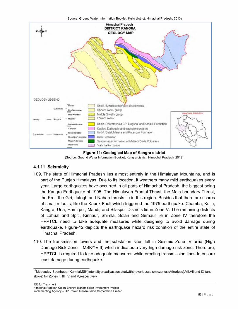
IEE for Tranche 2 Himachal Pradesh Clean Energy Transmission Investment Project Implementing Agency – HP Power Transmission Corporation Limited
53 | P a g e
(Source: Ground Water Information Booklet, Kullu district, Himachal Pradesh, 2013)
Figure-11: Geological Map of Kangra district (Source: Ground Water Information Booklet, Kangra district, Himachal Pradesh, 2013)
4.1.11 Seismicity 109. The state of Himachal Pradesh lies almost entirely in the Himalayan Mountains, and is
part of the Punjab Himalayas. Due to its location, it weathers many mild earthquakes every year. Large earthquakes have occurred in all parts of Himachal Pradesh, the biggest being the Kangra Earthquake of 1905. The Himalayan Frontal Thrust, the Main boundary Thrust, the Krol, the Giri, Jutogh and Nahan thrusts lie in this region. Besides that there are scores of smaller faults, like the Kaurik Fault which triggered the 1975 earthquake. Chamba, Kullu, Kangra, Una, Hamirpur, Mandi, and Bilaspur Districts lie in Zone V. The remaining districts of Lahual and Spiti, Kinnaur, Shimla, Solan and Sirmaur lie in Zone IV therefore the HPPTCL need to take adequate measures while designing to avoid damage during earthquake. Figure-12 depicts the earthquake hazard risk zonation of the entire state of Himachal Pradesh.
110. The transmission towers and the substation sites fall in Seismic Zone IV area (High Damage Risk Zone – MSK10 VIII) which indicates a very high damage risk zone. Therefore, HPPTCL is required to take adequate measures while erecting transmission lines to ensure least damage during earthquake.
10Medvedev-Sponheuer-Karnik(MSK)intensitybroadlyassociatedwiththevariousseismiczonesisVI(orless),VII,VIIIand IX (and above) for Zones II, III, IV and V,respectively
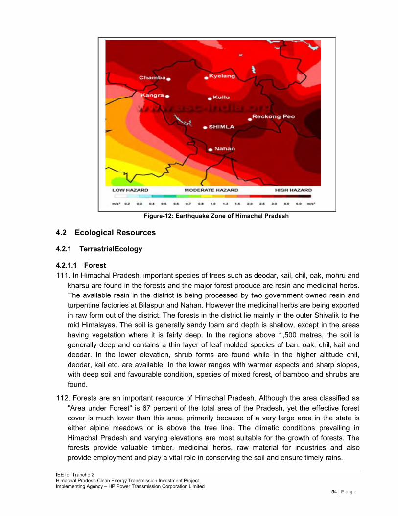
IEE for Tranche 2 Himachal Pradesh Clean Energy Transmission Investment Project Implementing Agency – HP Power Transmission Corporation Limited
54 | P a g e
Figure-12: Earthquake Zone of Himachal Pradesh
4.2 Ecological Resources
4.2.1 TerrestrialEcology
4.2.1.1 Forest 111. In Himachal Pradesh, important species of trees such as deodar, kail, chil, oak, mohru and
kharsu are found in the forests and the major forest produce are resin and medicinal herbs. The available resin in the district is being processed by two government owned resin and turpentine factories at Bilaspur and Nahan. However the medicinal herbs are being exported in raw form out of the district. The forests in the district lie mainly in the outer Shivalik to the mid Himalayas. The soil is generally sandy loam and depth is shallow, except in the areas having vegetation where it is fairly deep. In the regions above 1,500 metres, the soil is generally deep and contains a thin layer of leaf molded species of ban, oak, chil, kail and deodar. In the lower elevation, shrub forms are found while in the higher altitude chil, deodar, kail etc. are available. In the lower ranges with warmer aspects and sharp slopes, with deep soil and favourable condition, species of mixed forest, of bamboo and shrubs are found.
112. Forests are an important resource of Himachal Pradesh. Although the area classified as "Area under Forest" is 67 percent of the total area of the Pradesh, yet the effective forest cover is much lower than this area, primarily because of a very large area in the state is either alpine meadows or is above the tree line. The climatic conditions prevailing in Himachal Pradesh and varying elevations are most suitable for the growth of forests. The forests provide valuable timber, medicinal herbs, raw material for industries and also provide employment and play a vital role in conserving the soil and ensure timely rains.
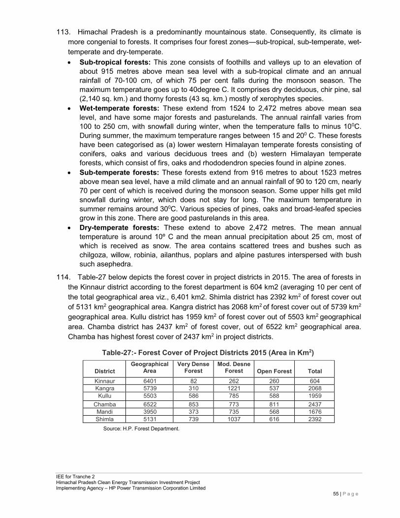
IEE for Tranche 2 Himachal Pradesh Clean Energy Transmission Investment Project Implementing Agency – HP Power Transmission Corporation Limited
55 | P a g e
113. Himachal Pradesh is a predominantly mountainous state. Consequently, its climate is more congenial to forests. It comprises four forest zones—sub-tropical, sub-temperate, wet- temperate and dry-temperate. • Sub-tropical forests: This zone consists of foothills and valleys up to an elevation of
about 915 metres above mean sea level with a sub-tropical climate and an annual rainfall of 70-100 cm, of which 75 per cent falls during the monsoon season. The maximum temperature goes up to 40degree C. It comprises dry deciduous, chir pine, sal (2,140 sq. km.) and thorny forests (43 sq. km.) mostly of xerophytes species.
• Wet-temperate forests: These extend from 1524 to 2,472 metres above mean sea level, and have some major forests and pasturelands. The annual rainfall varies from 100 to 250 cm, with snowfall during winter, when the temperature falls to minus 100C. During summer, the maximum temperature ranges between 15 and 200 C. These forests have been categorised as (a) lower western Himalayan temperate forests consisting of conifers, oaks and various deciduous trees and (b) western Himalayan temperate forests, which consist of firs, oaks and rhododendron species found in alpine zones.
• Sub-temperate forests: These forests extend from 916 metres to about 1523 metres above mean sea level, have a mild climate and an annual rainfall of 90 to 120 cm, nearly 70 per cent of which is received during the monsoon season. Some upper hills get mild snowfall during winter, which does not stay for long. The maximum temperature in summer remains around 300C. Various species of pines, oaks and broad-leafed species grow in this zone. There are good pasturelands in this area.
• Dry-temperate forests: These extend to above 2,472 metres. The mean annual temperature is around 10º C and the mean annual precipitation about 25 cm, most of which is received as snow. The area contains scattered trees and bushes such as chilgoza, willow, robinia, ailanthus, poplars and alpine pastures interspersed with bush such asephedra.
114. Table-27 below depicts the forest cover in project districts in 2015. The area of forests in the Kinnaur district according to the forest department is 604 km2 (averaging 10 per cent of the total geographical area viz., 6,401 km2. Shimla district has 2392 km2 of forest cover out of 5131 km2 geographical area. Kangra district has 2068 km2 of forest cover out of 5739 km2 geographical area. Kullu district has 1959 km2 of forest cover out of 5503 km2 geographical area. Chamba district has 2437 km2 of forest cover, out of 6522 km2 geographical area. Chamba has highest forest cover of 2437 km2 in project districts.
Table-27:- Forest Cover of Project Districts 2015 (Area in Km2)
District
Geographical Area
Very Dense Forest
Mod. Desne Forest
Open Forest
Total
Kinnaur 6401 82 262 260 604 Kangra 5739 310 1221 537 2068 Kullu 5503 586 785 588 1959
Chamba 6522 853 773 811 2437 Mandi 3950 373 735 568 1676 Shimla 5131 739 1037 616 2392
Source: H.P. Forest Department.
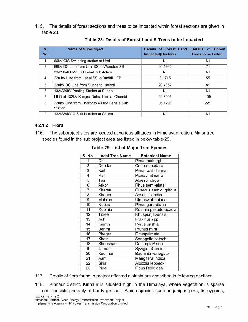
IEE for Tranche 2 Himachal Pradesh Clean Energy Transmission Investment Project Implementing Agency – HP Power Transmission Corporation Limited
56 | P a g e
115. The details of forest sections and trees to be impacted within forest sections are given in
table 28. Table-28: Details of Forest Land & Trees to be impacted
S.
No. Name of Sub-Project Details of Forest Land
Impacted(Hectare) Details of Forest Trees to be Felled
1 66kV GIS Switching station at Urni Nil Nil 2 66kV DC Line from Urni SS to Wangtoo SS 20.4362 71 3 33/220/400kV GIS Lahal Substation Nil Nil 4 220 kV Line from Lahal SS to Budhil HEP 3.1715 55
5 220kV DC Line from Sunda to Hatkoti 20.4857 81 6 132/220kV Pooling Station at Sunda Nil Nil 7 LILO of 132kV Kangra-Dehra Line at Chambi 22.8005 109
8 220kV Line from Charor to 400kV Banala Sub Station
36.7296 221
9 132/220kV GIS Substation at Charor Nil Nil
4.2.1.2 Flora 116. The subproject sites are located at various altitudes in Himalayan region. Major tree
species found in the sub project area are listed in below table-29.
Table-29: List of Major Tree Species
S. No. Local Tree Name Botanical Name 1 Chil Pinus roxburghii 2 Deodar Cedrusdeodara 3 Kail Pinus wallichiana 4 Rai Piceasmithiana 5 Tos Abiespindrow 6 Arkor Rhus semi-alata 7 Kharsu Quercus semicurpifolia 8 Khanor Aesculus indica 9 Mohran Ulmuswallichiana 10 Neoza Pinus gerardiana 11 Robinia Robinia pseudo-acacia 12 Titree Rhuspunjabensis 13 Ash Fraxinus spp. 14 Kainth Pyrus pashia 15 Behmi Prunus mira 16 Phegra Ficuspalmata 17 Khair Senegalia catechu 18 Sheesham DalburgiaSisoo 19 Jamun SyzigiumCumini 20 Kachnar Bauhinia variegate 21 Aam Mangifera Indica 22 Siris Albizzia lebbeck 23 Pipal Ficus Religiosa
117. Details of flora found in project affected districts are described in following sections.
118. Kinnaur district. Kinnaur is situated high in the Himalaya, where vegetation is sparse and consists primarily of hardy grasses. Alpine species such as juniper, pine, fir, cypress,
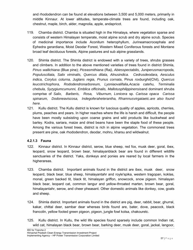
IEE for Tranche 2 Himachal Pradesh Clean Energy Transmission Investment Project Implementing Agency – HP Power Transmission Corporation Limited
57 | P a g e
and rhododendron can be found at elevations between 3,500 and 5,000 meters, primarily in middle Kinnaur. At lower altitudes, temperate-climate trees are found, including oak, chestnut, maple, birch, alder, magnolia, apple, andapricot.
119. Chamba district. Chamba is situated high in the Himalaya, where vegetation sparse and consists of western Himalayan temperate, moist alpine scrub and dry alpine scrub. Species of medicinal importance include Aconitum heterophyllum, Jurineamacrocephala and Ephedra gerardiana, Moist Deodar Forest, Western Mixed Coniferous forests and Montane broad leaf deciduous forests, Alpine pastures and sub alpine grasslands.
120. Shimla district. The Shimla district is endowed with a variety of trees, shrubs grasses and climbers. In addition to the above mentioned varieties of trees found in district Shimla, Pinus wallichiana (Blue pine); Piceasmithiana (Rai), Abiesspectabilis, Juniperusmacropoda,
Populusciliata, Salix viminalis, Quercus dilata, Alnusindica. Cedrusdeodara, Aesculus
indica, Corylus colurna, Juglans regia, Prunus cornata, Pinus roxburghii(Chil), Quercus
leucotrichophora, Rododendronarboreum, Lyoniaovalifalia,Acacia catehu, Terminalia
chebula, Syzygiumcumunni, Emblica officinalis, Mallotusphilippinensisand dominant shrubs comprise of Salix, Barberis, Rosa, Viburnum, Lonicera sp. Carissa opaca Carissa
spinarum, Dodoneaviscosa, Indegoferaheterantha, Rhamnusvirgataetc.are also found
here.
121. Kullu district. The Kullu district is known for luscious quality of apples, apricots, cherries, plums, peaches and pears. In higher reaches where the life is harsh and difficult, the people have been mostly subsisting upon coarse grains and wild products like buckwheat and barley. Kodra, sariara, maize and dried beans have been the staple food of these people. Among the various forest trees, district is rich in alpine vegetation. The commonest trees present are pine, oak rhododendron, deodar, mohru, kharsu and wildwalnut.
4.2.1.3 Fauna 122. Kinnaur district. In Kinnaur district, serow, blue sheep, red fox, musk deer, goral, ibex,
leopard, snow leopard, brown bear, himalayanblack bear are found in different wildlife sanctuaries of the district. Yaks, donkeys and ponies are reared by local farmers in the higherareas.
123. Chamba district. Important animals found in the district are ibex, musk deer, snow leopard, black bear, blue sheep, himalayantahr and royle'spika, western tragopan, koklas, monal, green backed tit, black tit, himalayan griffon, snowcock, snow pigeon. himalayan black bear, leopard cat, common langur and yellow-throated marten, brown bear, goral, himalayantahr, serow, and cheer pheasant. Other domestic animals like donkey, cow, goats and sheep.
124. Shimla district. Important animals found in the district are pig, deer, rabbit, bear, ghurral, kakar, chittal deer, sambar dear whereas birds found are, bater, dove, peacock, black francolin, yellow footed green pigeon, pigeon, jungle fowl kolsa, chakouretc.
125. Kullu district. In Kullu, the wild life species found sparsely include common Indian rat, wild cat, himalayan black bear, brown bear, barking deer, musk deer, goral, jackal, langoor,
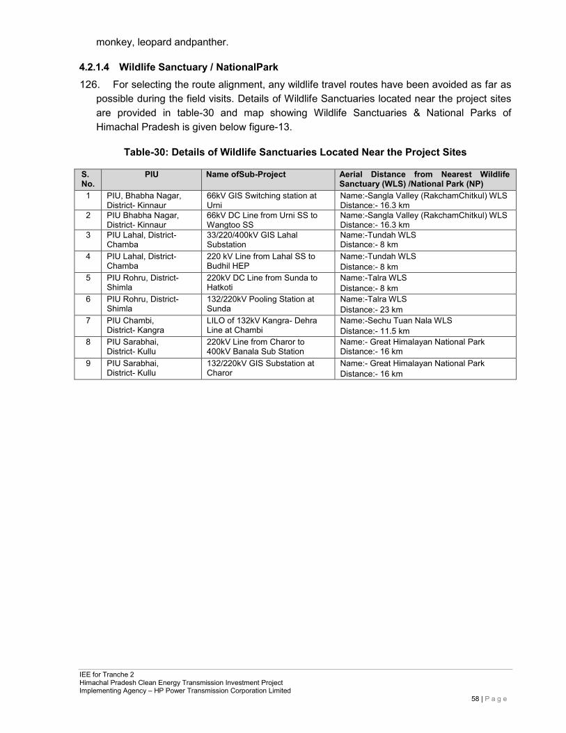
IEE for Tranche 2 Himachal Pradesh Clean Energy Transmission Investment Project Implementing Agency – HP Power Transmission Corporation Limited
58 | P a g e
monkey, leopard andpanther.
4.2.1.4 Wildlife Sanctuary / NationalPark 126. For selecting the route alignment, any wildlife travel routes have been avoided as far as
possible during the field visits. Details of Wildlife Sanctuaries located near the project sites are provided in table-30 and map showing Wildlife Sanctuaries & National Parks of Himachal Pradesh is given below figure-13.
Table-30: Details of Wildlife Sanctuaries Located Near the Project Sites
S. No.
PIU Name ofSub-Project Aerial Distance from Nearest Wildlife Sanctuary (WLS) /National Park (NP)
1 PIU, Bhabha Nagar, District- Kinnaur
66kV GIS Switching station at Urni
Name:-Sangla Valley (RakchamChitkul) WLS Distance:- 16.3 km
2 PIU Bhabha Nagar, District- Kinnaur
66kV DC Line from Urni SS to Wangtoo SS
Name:-Sangla Valley (RakchamChitkul) WLS Distance:- 16.3 km
3 PIU Lahal, District- Chamba
33/220/400kV GIS Lahal Substation
Name:-Tundah WLS Distance:- 8 km
4 PIU Lahal, District- Chamba
220 kV Line from Lahal SS to Budhil HEP
Name:-Tundah WLS Distance:- 8 km
5 PIU Rohru, District- Shimla
220kV DC Line from Sunda to Hatkoti
Name:-Talra WLS Distance:- 8 km
6 PIU Rohru, District- Shimla
132/220kV Pooling Station at Sunda
Name:-Talra WLS Distance:- 23 km
7 PIU Chambi, District- Kangra
LILO of 132kV Kangra- Dehra Line at Chambi
Name:-Sechu Tuan Nala WLS Distance:- 11.5 km
8 PIU Sarabhai, District- Kullu
220kV Line from Charor to 400kV Banala Sub Station
Name:- Great Himalayan National Park Distance:- 16 km
9 PIU Sarabhai, District- Kullu
132/220kV GIS Substation at Charor
Name:- Great Himalayan National Park Distance:- 16 km
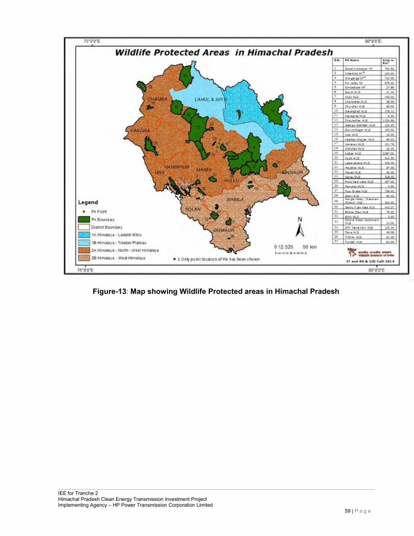
IEE for Tranche 2 Himachal Pradesh Clean Energy Transmission Investment Project Implementing Agency – HP Power Transmission Corporation Limited
59 | P a g e
Figure-13: Map showing Wildlife Protected areas in Himachal Pradesh
IEE for Tranche 2 Himachal Pradesh Clean Energy Transmission Investment Project Implementing Agency – HP Power Transmission Corporation Limited
60 | P a g e
4.3 Socioeconomic Profile
4.3.1 Demography 127. As per the Census 201111, the total Population of Himachal Pradesh is 68.6 Lacs. Thus
the population of Himachal Pradesh forms 0.57 percent of India in 2011. Himachal Pradesh has total population of 6,864,602 in which males were 3,481,873 while females were 3,382,729. Total area of Himachal Pradesh is 55,673 square km. Thus the population Density of Himachal Pradesh is 123 per square km which is lower than national average 382 per square km.
Kinnaur: 128. In 2011, Kinnaur had population of 84,121 of which male and female were 46,249 and
37,872 respectively. In 2001 census, Kinnaur had a population of 78,334 of which males were 42,173 and remaining 36,161 were females. Kinnaur District population constituted 1.23 percent of total Maharashtra population. In 2001 census, this figure for Kinnaur District was at 1.29 percent of Maharashtra population. There was change of 7.39 percent in the population compared to population as per 2001. In the previous census of India 2001, Kinnaur District recorded increase of 9.91 percent to its population compared to 1991.
129. The initial provisional data released by census India 2011, shows that density of Kinnaur district for 2011 is 13 people per sq. km. In 2001, Kinnaur district density was at 12 people per sq. km. Kinnaur district administers 6,401 square kilometers of areas.
130. Average literacy rate of Kinnaur in 2011 were 80.00 compared to 75.20 of 2001. If things are looked out at gender wise, male and female literacy were 87.27 and 70.96 respectively. For 2001 census, same figures stood at 84.30 and 64.40 in Kinnaur District. Total literate in Kinnaur District were 60,699 of which male and female were 36,697 and 24,002 respectively. In 2001, Kinnaur District had 51,913 in itsdistrict.
131. With regards to Sex Ratio in Kinnaur, it stood at 819 per 1000 male compared to 2001 census figure of 857. The average national sex ratio in India is 940 as per latest reports of Census 2011 Directorate. In 2011 census, child sex ratio is 963 girls per 1000 boys compared to figure of 979 girls per 1000 boys of 2001 census data.
Kangra: 132. In 2011, Kangra had population of 1,510,075 of which male and female were 750,591
and 759,484 respectively. In 2001 census, Kangra had a population of 1,339,030 of which males were 661,254 and remaining 677,776 were females. Kangra District population constituted 22.00 percent of total Maharashtra population. In 2001 census, this figure for Kangra District was at 22.03 percent of Maharashtra population. There was change of 12.77 percent in the population compared to population as per 2001. In the previous census of India 2001, Kangra District recorded increase of 14.05 percent to its population compared to 1991.
133. The initial provisional data released by census India 2011, shows that density of Kangra
11 As per Census of India, 2011 Data
IEE for Tranche 2 Himachal Pradesh Clean Energy Transmission Investment Project Implementing Agency – HP Power Transmission Corporation Limited
61 | P a g e
district for 2011 is 263 people per sq. km. In 2001, Kangra district density was at 233 people per sq. km. Kangra district administers 5,739 square kilometers of areas.
134. Average literacy rate of Kangra in 2011 were 85.67 compared to 80.08 of 2001. If things are looked out at gender wise, male and female literacy were 91.49 and 80.02 respectively. For 2001 census, same figures stood at 87.54 and 73.01 in Kangra District. Total literate in Kangra District were 1,152,640 of which male and female were 606,443 and 546,197 respectively. In 2001, Kangra District had 940,505 in its district.
135. With regards to Sex Ratio in Kangra, it stood at 1012 per 1000 male compared to 2001 census figure of 1025. The average national sex ratio in India is 940 as per latest reports of Census 2011 Directorate. In 2011 census, child sex ratio is 876 girls per 1000 boys compared to figure of 836 girls per 1000 boys of 2001 census data.
Kullu:
136. In 2011, Kullu had population of 437,903 of which male and female were 225,452 and 212,451 respectively. In 2001 census, Kullu had a population of 381,571 of which males were 198,016 and remaining 183,555 were females. Kullu District population constituted 6.38 percent of total Maharashtra population. In 2001 census, this figure for Kullu District was at 6.28 percent of Maharashtra population. There was change of 14.76 percent in the population compared to population as per 2001. In the previous census of India 2001, Kullu District recorded increase of 26.17 percent to its population compared to 1991.
137. The initial provisional data released by census India 2011, shows that density of Kullu district for 2011 is 80 people per sq. km. In 2001, Kullu district density was at 69 people per sq. km. Kullu district administers 5,503 square kilometers of areas.
138. Average literacy rate of Kullu in 2011 were 79.40 compared to 72.90 of 2001. If things are looked out at gender wise, male and female literacy were 87.39 and 70.91 respectively. For 2001 census, same figures stood at 83.98 and 60.88 in Kullu District. Total literate in Kullu District were 307,672 of which male and female were 174,550 and 133,122 respectively. In 2001, Kullu District had 239,649 in its district.
139. With regards to Sex Ratio in Kullu, it stood at 942 per 1000 male compared to 2001 census figure of 927. The average national sex ratio in India is 940 as per latest reports of Census 2011 Directorate. In 2011 census, child sex ratio is 962 girls per 1000 boys compared to figure of 960 girls per 1000 boys of 2001 census data.
Chamba:
140. In 2011, Chamba had population of 519,080 of which male and female were 261,320 and 257,760 respectively. In 2001 census, Chamba had a population of 460,887 of which males were 235,218 and remaining 225,669 were females. Chamba District population constituted 7.56 percent of total Maharashtra population. In 2001 census, this figure for Chamba District was at 7.58 percent of Maharashtra population. There was change of 12.63 percent in the population compared to population as per 2001. In the previous census of
IEE for Tranche 2 Himachal Pradesh Clean Energy Transmission Investment Project Implementing Agency – HP Power Transmission Corporation Limited
62 | P a g e
India 2001, Chamba District recorded increase of 17.19 percent to its population compared to 1991.
141. The initial provisional data released by census India 2011, shows that density of Chamba district for 2011 is 80 people per sq. km. In 2001, Chamba district density was at 71 people per sq. km. Chamba district administers 6,522 square kilometers of areas.
142. Average literacy rate of Chamba in 2011 were 72.17 compared to 62.91 of 2001. If things are looked out at gender wise, male and female literacy were 82.59 and 61.67 respectively. For 2001 census, same figures stood at 76.41 and 48.85 in Chamba District. Total literate in Chamba District were 323,842 of which male and female were 186,064 and 137,778 respectively. In 2001, Chamba District had 246,169 in its district.
143. With regards to Sex Ratio in Chamba, it stood at 986 per 1000 male compared to 2001 census figure of 959. The average national sex ratio in India is 940 as per latest reports of Census 2011 Directorate. In 2011 census, child sex ratio is 953 girls per 1000 boys compared to figure of 955 girls per 1000 boys of 2001 censusdata.
Shimla:
144. In 2011, Shimla had population of 814,010 of which male and female were 425,039 and 388,971 respectively. In 2001 census, Shimla had a population of 722,502 of which males were 380,996 and remaining 341,506 were females. Shimla District population constituted11.86 percent of total Maharashtra population. In 2001 census, this figure for Shimla District was at 11.89 percent of Maharashtra population. There was change of 12.67 percent in the population compared to population as per 2001. In the previous census of India 2001, Shimla District recorded increase of 17.02 percent to its population compared to 1991.
145. The initial provisional data released by census India 2011, shows that density of Shimla district for 2011 is 159 people per sq. km. In 2001, Shimla district density was at 141 people per sq. km. Shimla district administers 5,131 square kilometers of areas.
146. Average literacy rate of Shimla in 2011 were 83.64 compared to 79.12 of 2001. If things are looked out at gender wise, male and female literacy were 89.59 and 77.13 respectively. For 2001 census, same figures stood at 87.19 and 70.07 in Shimla District. Total literate in Shimla District were 612,642 of which male and female were 342,846 and 269,796 respectively. In 2001, Shimla District had 504,330 in its district.
147. With regards to Sex Ratio in Shimla, it stood at 915 per 1000 male compared to 2001 census figure of 896. The average national sex ratio in India is 940 as per latest reports of Census 2011 Directorate. In 2011 census, child sex ratio is 925 girls per 1000 boys compared to figure of 929 girls per 1000 boys of 2001 census data.
4.3.2 Employment / Working Population Details12 148. In Himachal Pradesh out of total population, 3,559,422 were engaged in work activities.
57.9% of workers describe their work as Main Work (Employment or Earning more than 6
IEE for Tranche 2 Himachal Pradesh Clean Energy Transmission Investment Project Implementing Agency – HP Power Transmission Corporation Limited
63 | P a g e
Months) while 42.1% were involved in Marginal activity providing livelihood for less than 6 months. Of 3,559,422 workers engaged in Main Work, 919,786 were cultivators (owner or co-owner) while 68,668 were Agricultural labourers. (Source: Census of India, 2011)
149. Kinnaur: In Kinnaur district out of total population, 56,273 were engaged in work. 83.1% of workers describe their work as Main Work (Employment or Earning more than 6 Months) while 16.9% were involved in Marginal activity providing livelihood for less than 6 months. Of 56,273 workers engaged in Main Work, 25,890 were cultivators (owner or co-owner) while 1,759 were Agricultural laborers.
150. Kangra: In Kangra district out of total population, 675,170 were engaged in work activities. 46.5% of workers describe their work as Main Work (Employment or Earning more than 6 Months) while 53.5% were involved in Marginal activity providing livelihood for less than 6 months. Of 675,170 workers engaged in Main Work, 69,424 were cultivators (owner or co-owner) while 11,122 were Agricultural labourers.
151. Kullu: In Kullu district out of total population, 269,084 were engaged in work activities. 72.1% of workers describe their work as Main Work (Employment or Earning more than 6 Months) while 27.9% were involved in Marginal activity providing livelihood for less than 6 months. Of 269,084 workers engaged in Main Work, 132,503 were cultivators (owner or co- owner) while 7,172 were Agricultural laborers.
152. Chamba: In Chamba district out of total population, 294,035 were engaged in work activities. 40.7% of workers describe their work as Main Work (Employment or Earning more than 6 Months) while 59.3% were involved in Marginal activity providing livelihood for less than 6 months. Of 294,035 workers engaged in Main Work, 51,959 were cultivators (owner or co-owner) while 2,650 were Agricultural laborers.
153. Shimla: In Shimla district out of total population, 430,926 were engaged in work activities. 72.3% of workers describe their work as Main Work (Employment or Earning more than 6 Months) while 27.7% were involved in Marginal activity providing livelihood for less than 6 months. Of 430,926 workers engaged in Main Work, 156,511 were cultivators (owner or co-owner) while 17,486 were Agricultural laborers.
4.3.3 Industries 154. Because of difficult geographical terrain and topography of the Shimla district, the
chances to set up modern, medium and large scale industries are quite limited. Therefore, there are only cottage and smallscale industries that rely on varied type of local raw materials, like wool, juices, fruits and wood. The cool and dust free climate of the district is also quite congenial for the growth of the electronic industry in the district. There is one electronic complex operating in Shoghi. Cotton carding, threshing, fruit canning preservation, bakeries, and oil expelling are the main agro-based industries operating in the district. Earlier, wooden packaging cases, was the main wood based industry, operating in the district, but with the replacement of wooden boxes by cartons, this industry has lost its importance. However, wooden furniture, toys, sticks, and joinery are still operating in the district. Stone crushers and earthen pottery are the main mineral based industries of the district. There are number of textile based units also which are engaged in the
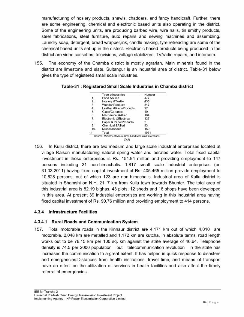
IEE for Tranche 2 Himachal Pradesh Clean Energy Transmission Investment Project Implementing Agency – HP Power Transmission Corporation Limited
64 | P a g e
manufacturing of hosiery products, shawls, chaddars, and fancy handicraft. Further, there are some engineering, chemical and electronic based units also operating in the district. Some of the engineering units, are producing barbed wire, wire nails, tin smithy products, steel fabrications, steel furniture, auto repairs and sewing machines and assembling. Laundry soap, detergent, bread wrapper,ink, candle making, tyre retreading are some of the chemical based units set up in the district. Electronic based products being produced in the district are video cassettes, televisions, voltage stabilizers, TV/radio repairs, and intercom.
155. The economy of the Chamba district is mostly agrarian. Main minerals found in the district are limestone and slate. Sultanpur is an industrial area of district. Table-31 below gives the type of registered small scale industries.
Table-31 : Registered Small Scale Industries in Chamba district
Type ofIndustries
1. Food &Allied Number 477
2. Hosiery &Textile 435 3. WoodenProducts 347 4. Leather &RaxinProducts 97 5. Glass/Ceramics 49 6. Mechanical &Allied 164 7. Electronic &Electrical 137 8. Paper & PaperProducts 2 9. Chemical &Allied 93 10. Miscellaneous 150
11. Total 1951 Source: Ministry of Micro, Small and Medium Enterprises
(GoI)
156. In Kullu district, there are two medium and large scale industrial enterprises located at village Raison manufacturing natural spring water and aerated water. Total fixed capital investment in these enterprises is Rs. 154.94 million and providing employment to 147 persons including 21 non-himachalis. 1,817 small scale industrial enterprises (on 31.03.2011) having fixed capital investment of Rs. 405.465 million provide employment to 10,628 persons, out of which 123 are non-himachalis. Industrial area of Kullu district is situated in Shamshi on N.H. 21, 7 km from Kullu town towards Bhunter. The total area of this industrial area is 82.19 bighas. 43 plots, 12 sheds and 16 shops have been developed in this area. At present 39 industrial enterprises are working in this industrial area having fixed capital investment of Rs. 90.76 million and providing employment to 414 persons.
4.3.4 Infrastructure Facilities
4.3.4.1 Rural Roads and Communication System 157. Total motorable roads in the Kinnaur district are 4,171 km out of which 4,010 are
motorable. 2,048 km are metalled and 1,172 km are kutcha. In absolute terms, road length works out to be 78.15 km per 100 sq. km against the state average of 46.64. Telephone density is 74.5 per 2000 population but telecommunication revolution in the state has increased the communication to a great extent. It has helped in quick response to disasters and emergencies.Distances from health institutions, travel time, and means of transport have an effect on the utilization of services in health facilities and also affect the timely referral of emergencies.
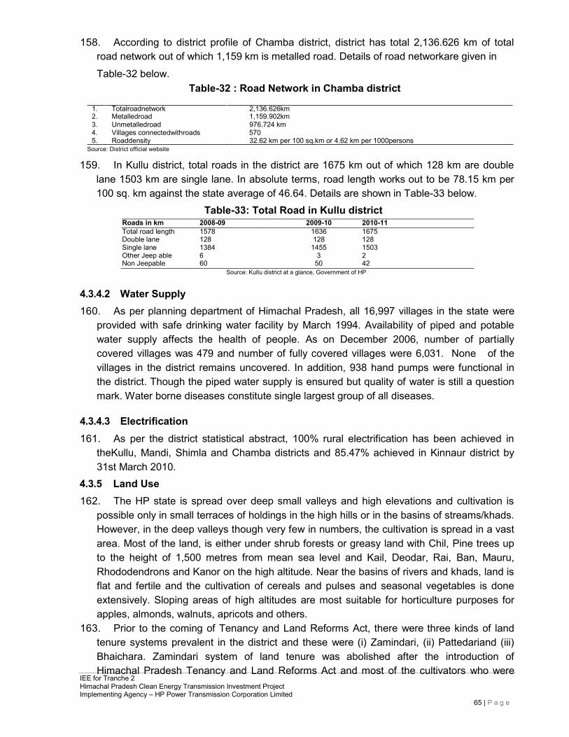
IEE for Tranche 2 Himachal Pradesh Clean Energy Transmission Investment Project Implementing Agency – HP Power Transmission Corporation Limited
65 | P a g e
158. According to district profile of Chamba district, district has total 2,136.626 km of total road network out of which 1,159 km is metalled road. Details of road networkare given in Table-32 below.
Table-32 : Road Network in Chamba district
1. Totalroadnetwork 2,136.626km 2. Metalledroad 1,159.902km 3. Unmetalledroad 976.724 km 4. Villages connectedwithroads 570 5. Roaddensity 32.62 km per 100 sq.km or 4.62 km per 1000persons
Source: District official website
159. In Kullu district, total roads in the district are 1675 km out of which 128 km are double lane 1503 km are single lane. In absolute terms, road length works out to be 78.15 km per 100 sq. km against the state average of 46.64. Details are shown in Table-33 below.
Table-33: Total Road in Kullu district
Roads in km 2008-09 2009-10 2010-11 Total road length 1578 1636 1675 Double lane 128 128 128 Single lane 1384 1455 1503 Other Jeep able 6 3 2 Non Jeepable 60 50 42
Source: Kullu district at a glance, Government of HP
4.3.4.2 Water Supply 160. As per planning department of Himachal Pradesh, all 16,997 villages in the state were
provided with safe drinking water facility by March 1994. Availability of piped and potable water supply affects the health of people. As on December 2006, number of partially covered villages was 479 and number of fully covered villages were 6,031. None of the villages in the district remains uncovered. In addition, 938 hand pumps were functional in the district. Though the piped water supply is ensured but quality of water is still a question mark. Water borne diseases constitute single largest group of all diseases.
4.3.4.3 Electrification 161. As per the district statistical abstract, 100% rural electrification has been achieved in
theKullu, Mandi, Shimla and Chamba districts and 85.47% achieved in Kinnaur district by 31st March 2010.
4.3.5 Land Use 162. The HP state is spread over deep small valleys and high elevations and cultivation is
possible only in small terraces of holdings in the high hills or in the basins of streams/khads. However, in the deep valleys though very few in numbers, the cultivation is spread in a vast area. Most of the land, is either under shrub forests or greasy land with Chil, Pine trees up to the height of 1,500 metres from mean sea level and Kail, Deodar, Rai, Ban, Mauru, Rhododendrons and Kanor on the high altitude. Near the basins of rivers and khads, land is flat and fertile and the cultivation of cereals and pulses and seasonal vegetables is done extensively. Sloping areas of high altitudes are most suitable for horticulture purposes for apples, almonds, walnuts, apricots and others.
163. Prior to the coming of Tenancy and Land Reforms Act, there were three kinds of land tenure systems prevalent in the district and these were (i) Zamindari, (ii) Pattedariand (iii) Bhaichara. Zamindari system of land tenure was abolished after the introduction of Himachal Pradesh Tenancy and Land Reforms Act and most of the cultivators who were
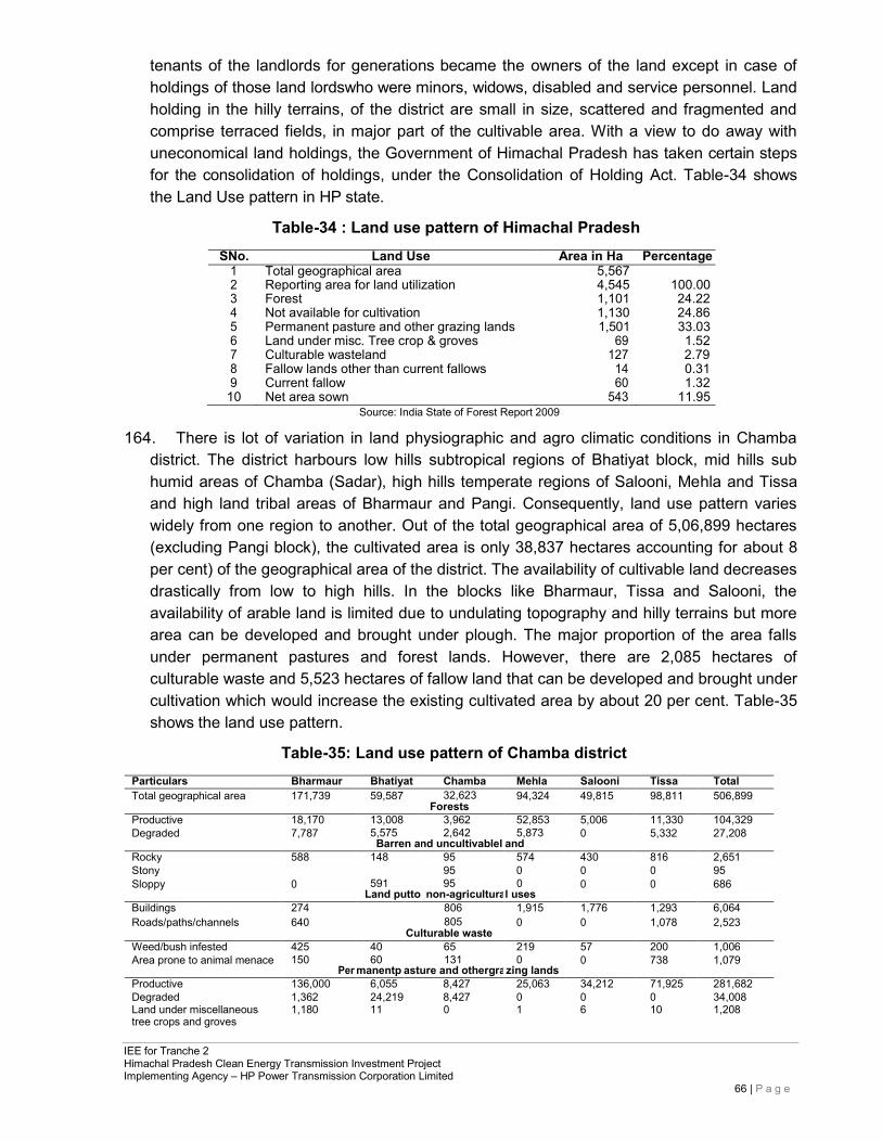
IEE for Tranche 2 Himachal Pradesh Clean Energy Transmission Investment Project Implementing Agency – HP Power Transmission Corporation Limited
66 | P a g e
tenants of the landlords for generations became the owners of the land except in case of holdings of those land lordswho were minors, widows, disabled and service personnel. Land holding in the hilly terrains, of the district are small in size, scattered and fragmented and comprise terraced fields, in major part of the cultivable area. With a view to do away with uneconomical land holdings, the Government of Himachal Pradesh has taken certain steps for the consolidation of holdings, under the Consolidation of Holding Act. Table-34 shows the Land Use pattern in HP state.
Table-34 : Land use pattern of Himachal Pradesh
SNo. Land Use Area in Ha Percentage 1 Total geographical area 5,567
2 Reporting area for land utilization 4,545 100.00 3 Forest 1,101 24.22 4 Not available for cultivation 1,130 24.86 5 Permanent pasture and other grazing lands 1,501 33.03 6 Land under misc. Tree crop & groves 69 1.52 7 Culturable wasteland 127 2.79 8 Fallow lands other than current fallows 14 0.31 9 Current fallow 60 1.32
10 Net area sown 543 11.95 Source: India State of Forest Report 2009
164. There is lot of variation in land physiographic and agro climatic conditions in Chamba district. The district harbours low hills subtropical regions of Bhatiyat block, mid hills sub humid areas of Chamba (Sadar), high hills temperate regions of Salooni, Mehla and Tissa and high land tribal areas of Bharmaur and Pangi. Consequently, land use pattern varies widely from one region to another. Out of the total geographical area of 5,06,899 hectares (excluding Pangi block), the cultivated area is only 38,837 hectares accounting for about 8 per cent) of the geographical area of the district. The availability of cultivable land decreases drastically from low to high hills. In the blocks like Bharmaur, Tissa and Salooni, the availability of arable land is limited due to undulating topography and hilly terrains but more area can be developed and brought under plough. The major proportion of the area falls under permanent pastures and forest lands. However, there are 2,085 hectares of culturable waste and 5,523 hectares of fallow land that can be developed and brought under cultivation which would increase the existing cultivated area by about 20 per cent. Table-35 shows the land use pattern.
Table-35: Land use pattern of Chamba district
Particulars Bharmaur Bhatiyat Chamba Mehla Salooni Tissa Total Total geographical area 171,739 59,587 32,623
Forests 94,324 49,815 98,811 506,899
Productive 18,170 13,008 3,962 52,853 5,006 11,330 104,329 Degraded 7,787 5,575
Barren a 2,642
nd uncultivablel 5,873
and 0 5,332 27,208
Rocky 588 148 95 574 430 816 2,651 Stony 95 0 0 0 95 Sloppy 0 591
Land putto 95
non-agricultura 0
l uses 0 0 686
Buildings 274 806 1,915 1,776 1,293 6,064 Roads/paths/channels 640 805
Culturable waste 0 0 1,078 2,523
Weed/bush infested 425 40 65 219 57 200 1,006 Area prone to animal menace 150
Per 60
manentp 131
asture and othergra 0
zing lands 0 738 1,079
Productive 136,000 6,055 8,427 25,063 34,212 71,925 281,682 Degraded 1,362 24,219 8,427 0 0 0 34,008 Land under miscellaneous 1,180 11 0 1 6 10 1,208 tree crops and groves
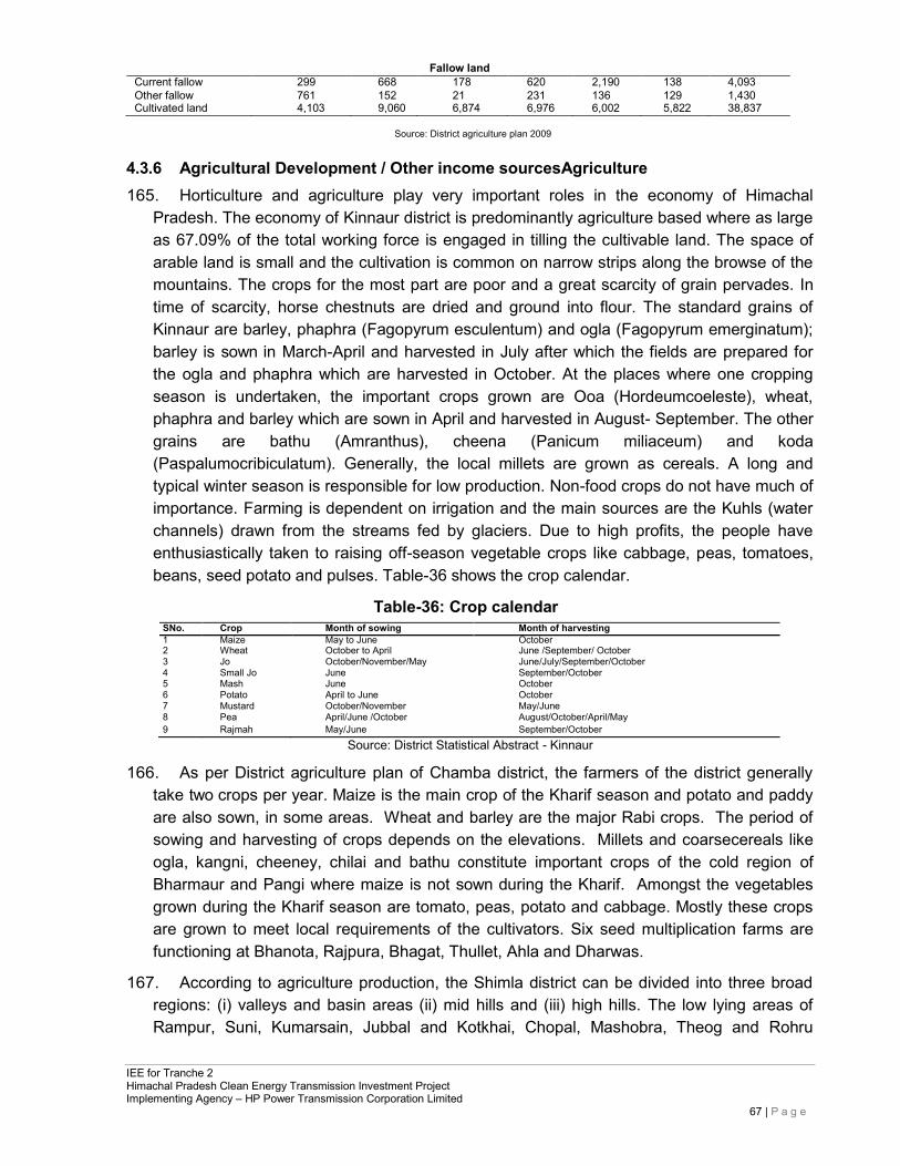
IEE for Tranche 2 Himachal Pradesh Clean Energy Transmission Investment Project Implementing Agency – HP Power Transmission Corporation Limited
67 | P a g e
Fallow land
Current fallow 299 668 178 620 2,190 138 4,093 Other fallow 761 152 21 231 136 129 1,430 Cultivated land 4,103 9,060 6,874 6,976 6,002 5,822 38,837
Source: District agriculture plan 2009
4.3.6 Agricultural Development / Other income sourcesAgriculture 165. Horticulture and agriculture play very important roles in the economy of Himachal
Pradesh. The economy of Kinnaur district is predominantly agriculture based where as large as 67.09% of the total working force is engaged in tilling the cultivable land. The space of arable land is small and the cultivation is common on narrow strips along the browse of the mountains. The crops for the most part are poor and a great scarcity of grain pervades. In time of scarcity, horse chestnuts are dried and ground into flour. The standard grains of Kinnaur are barley, phaphra (Fagopyrum esculentum) and ogla (Fagopyrum emerginatum); barley is sown in March-April and harvested in July after which the fields are prepared for the ogla and phaphra which are harvested in October. At the places where one cropping season is undertaken, the important crops grown are Ooa (Hordeumcoeleste), wheat, phaphra and barley which are sown in April and harvested in August- September. The other grains are bathu (Amranthus), cheena (Panicum miliaceum) and koda (Paspalumocribiculatum). Generally, the local millets are grown as cereals. A long and typical winter season is responsible for low production. Non-food crops do not have much of importance. Farming is dependent on irrigation and the main sources are the Kuhls (water channels) drawn from the streams fed by glaciers. Due to high profits, the people have enthusiastically taken to raising off-season vegetable crops like cabbage, peas, tomatoes, beans, seed potato and pulses. Table-36 shows the crop calendar.
Table-36: Crop calendar
SNo. Crop Month of sowing Month of harvesting 1 Maize May to June October 2 Wheat October to April June /September/ October 3 Jo October/November/May June/July/September/October 4 Small Jo June September/October 5 Mash June October 6 Potato April to June October 7 Mustard October/November May/June 8 Pea April/June /October August/October/April/May 9 Rajmah May/June September/October
Source: District Statistical Abstract - Kinnaur
166. As per District agriculture plan of Chamba district, the farmers of the district generally take two crops per year. Maize is the main crop of the Kharif season and potato and paddy are also sown, in some areas. Wheat and barley are the major Rabi crops. The period of sowing and harvesting of crops depends on the elevations. Millets and coarsecereals like ogla, kangni, cheeney, chilai and bathu constitute important crops of the cold region of Bharmaur and Pangi where maize is not sown during the Kharif. Amongst the vegetables grown during the Kharif season are tomato, peas, potato and cabbage. Mostly these crops are grown to meet local requirements of the cultivators. Six seed multiplication farms are functioning at Bhanota, Rajpura, Bhagat, Thullet, Ahla and Dharwas.
167. According to agriculture production, the Shimla district can be divided into three broad regions: (i) valleys and basin areas (ii) mid hills and (iii) high hills. The low lying areas of Rampur, Suni, Kumarsain, Jubbal and Kotkhai, Chopal, Mashobra, Theog and Rohru
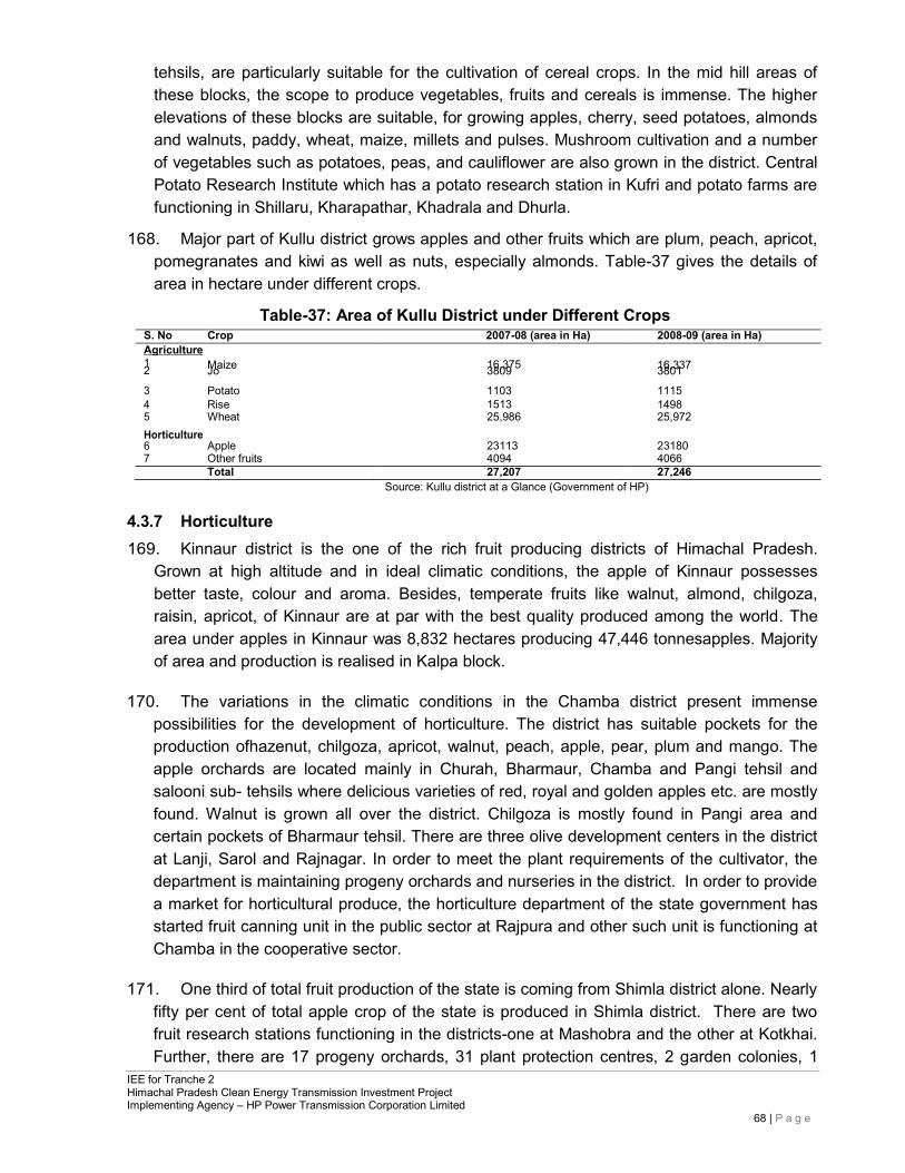
IEE for Tranche 2 Himachal Pradesh Clean Energy Transmission Investment Project Implementing Agency – HP Power Transmission Corporation Limited
68 | P a g e
tehsils, are particularly suitable for the cultivation of cereal crops. In the mid hill areas of these blocks, the scope to produce vegetables, fruits and cereals is immense. The higher elevations of these blocks are suitable, for growing apples, cherry, seed potatoes, almonds and walnuts, paddy, wheat, maize, millets and pulses. Mushroom cultivation and a number of vegetables such as potatoes, peas, and cauliflower are also grown in the district. Central Potato Research Institute which has a potato research station in Kufri and potato farms are functioning in Shillaru, Kharapathar, Khadrala and Dhurla.
168. Major part of Kullu district grows apples and other fruits which are plum, peach, apricot, pomegranates and kiwi as well as nuts, especially almonds. Table-37 gives the details of area in hectare under different crops.
Table-37: Area of Kullu District under Different Crops
S. No Crop 2007-08 (area in Ha) 2008-09 (area in Ha) Agriculture
1 2 Maize Jo 16,375 3809 16,337 3801
3 Potato 1103 1115 4 5
Rise Wheat
1513 25,986
1498 25,972
Horticulture 6
Apple
23113
23180
7 Other fruits 4094 4066 Total 27,207 27,246
Source: Kullu district at a Glance (Government of HP)
4.3.7 Horticulture 169. Kinnaur district is the one of the rich fruit producing districts of Himachal Pradesh.
Grown at high altitude and in ideal climatic conditions, the apple of Kinnaur possesses better taste, colour and aroma. Besides, temperate fruits like walnut, almond, chilgoza, raisin, apricot, of Kinnaur are at par with the best quality produced among the world. The area under apples in Kinnaur was 8,832 hectares producing 47,446 tonnesapples. Majority of area and production is realised in Kalpa block.
170. The variations in the climatic conditions in the Chamba district present immense possibilities for the development of horticulture. The district has suitable pockets for the production ofhazenut, chilgoza, apricot, walnut, peach, apple, pear, plum and mango. The apple orchards are located mainly in Churah, Bharmaur, Chamba and Pangi tehsil and salooni sub- tehsils where delicious varieties of red, royal and golden apples etc. are mostly found. Walnut is grown all over the district. Chilgoza is mostly found in Pangi area and certain pockets of Bharmaur tehsil. There are three olive development centers in the district at Lanji, Sarol and Rajnagar. In order to meet the plant requirements of the cultivator, the department is maintaining progeny orchards and nurseries in the district. In order to provide a market for horticultural produce, the horticulture department of the state government has started fruit canning unit in the public sector at Rajpura and other such unit is functioning at Chamba in the cooperative sector.
171. One third of total fruit production of the state is coming from Shimla district alone. Nearly fifty per cent of total apple crop of the state is produced in Shimla district. There are two fruit research stations functioning in the districts-one at Mashobra and the other at Kotkhai. Further, there are 17 progeny orchards, 31 plant protection centres, 2 garden colonies, 1
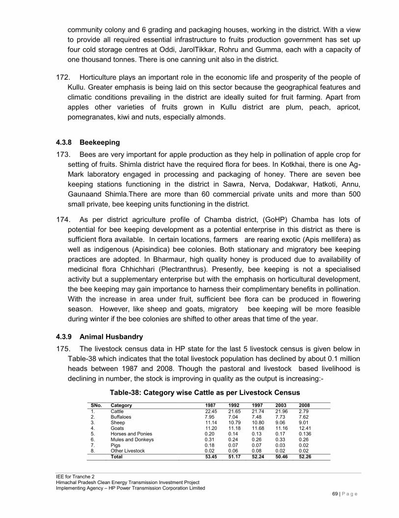
IEE for Tranche 2 Himachal Pradesh Clean Energy Transmission Investment Project Implementing Agency – HP Power Transmission Corporation Limited
69 | P a g e
community colony and 6 grading and packaging houses, working in the district. With a view to provide all required essential infrastructure to fruits production government has set up four cold storage centres at Oddi, JarolTikkar, Rohru and Gumma, each with a capacity of one thousand tonnes. There is one canning unit also in the district.
172. Horticulture plays an important role in the economic life and prosperity of the people of Kullu. Greater emphasis is being laid on this sector because the geographical features and climatic conditions prevailing in the district are ideally suited for fruit farming. Apart from apples other varieties of fruits grown in Kullu district are plum, peach, apricot, pomegranates, kiwi and nuts, especially almonds.
4.3.8 Beekeeping 173. Bees are very important for apple production as they help in pollination of apple crop for
setting of fruits. Shimla district have the required flora for bees. In Kotkhai, there is one Ag- Mark laboratory engaged in processing and packaging of honey. There are seven bee keeping stations functioning in the district in Sawra, Nerva, Dodakwar, Hatkoti, Annu, Gaunaand Shimla.There are more than 60 commercial private units and more than 500 small private, bee keeping units functioning in the district.
174. As per district agriculture profile of Chamba district, (GoHP) Chamba has lots of potential for bee keeping development as a potential enterprise in this district as there is sufficient flora available. In certain locations, farmers are rearing exotic (Apis mellifera) as well as indigenous (Apisindica) bee colonies. Both stationary and migratory bee keeping practices are adopted. In Bharmaur, high quality honey is produced due to availability of medicinal flora Chhichhari (Plectranthrus). Presently, bee keeping is not a specialised activity but a supplementary enterprise but with the emphasis on horticultural development, the bee keeping may gain importance to harness their complimentary benefits in pollination. With the increase in area under fruit, sufficient bee flora can be produced in flowering season. However, like sheep and goats, migratory bee keeping will be more feasible during winter if the bee colonies are shifted to other areas that time of the year.
4.3.9 Animal Husbandry 175. The livestock census data in HP state for the last 5 livestock census is given below in
Table-38 which indicates that the total livestock population has declined by about 0.1 million heads between 1987 and 2008. Though the pastoral and livestock based livelihood is declining in number, the stock is improving in quality as the output is increasing:-
Table-38: Category wise Cattle as per Livestock Census
SNo. Category 1987 1992 1997 2003 2008 1. Cattle 22.45 21.65 21.74 21.96 2.79 2. Buffaloes 7.95 7.04 7.48 7.73 7.62 3. Sheep 11.14 10.79 10.80 9.06 9.01 4. Goats 11.20 11.18 11.68 11.16 12.41 5. Horses and Ponies 0.20 0.14 0.13 0.17 0.136 6. Mules and Donkeys 0.31 0.24 0.26 0.33 0.26 7. Pigs 0.18 0.07 0.07 0.03 0.02 8. Other Livestock 0.02 0.06 0.08 0.02 0.02
Total 53.45 51.17 52.24 50.46 52.26
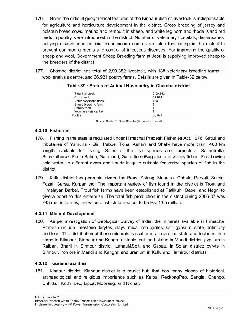
IEE for Tranche 2 Himachal Pradesh Clean Energy Transmission Investment Project Implementing Agency – HP Power Transmission Corporation Limited
70 | P a g e
176. Given the difficult geographical features of the Kinnaur district, livestock is indispensable for agriculture and horticulture development in the district. Cross breeding of jersey and holstein breed cows, marino and rembuilt in sheep, and white leg horn and rhode island red birds in poultry were introduced in the district. Number of veterinary hospitals, dispensaries, outlying dispensaries artificial insemination centres are also functioning in the district to prevent common ailments and control of infectious diseases. For improving the quality of sheep and wool, Government Sheep Breeding farm at Jeori is supplying improved sheep to the breeders of the district.
177. Chamba district has total of 2,90,852 livestock, with 138 veterinary breeding farms, 1 wool analysis centre, and 36,921 poultry farms. Details are given in Table-39 below.
Table-39 : Status of Animal Husbandry in Chamba district
Total live stock 2,90,852 Crossbred 27,994 Veterinary institutions 138 Sheep breeding farm 1 Poultry farm 1 Wool analysis centre 1
Poultry 36,921
Source: District Profile of Chmaba (district official website)
4.3.10 Fisheries 178. Fishing in the state is regulated under Himachal Pradesh Fisheries Act, 1976. Satluj and
tributaries of Yamuna - Giri, Pabber Tons, Ashani and Shalvi have more than 400 km length available for fishing. Some of the fish species are Torputitora, Salmotrulta, Schyzpthorax, Fasio Salmo, Gairdineri, GairedinerriBagarius and weedy fishes. Fast flowing cold water, in different rivers and khuds is quite suitable for varied species of fish in the district.
179. Kullu district has perennial rivers, the Beas, Solang, Manalsu, Chhaki, Parvati, Sujoin, Fozal, Garsa, Kurpan etc. The important variety of fish found in the district is Trout and Himalayan Barbel. Trout fish farms have been established at Patlikuhl, Babeli and Nagni to give a boost to this enterprise. The total fish production in the district during 2006-07 was 243 metric tonnes, the value of which turned out to be Rs. 13.5 million.
4.3.11 Mineral Development 180. As per investigation of Geological Survey of India, the minerals available in Himachal
Pradesh include limestone, birytes, clays, mica, iron pyrites, salt, gypsum, slate, antimony and lead. The distribution of these minerals is scattered all over the state and includes lime stone in Bilaspur, Sirmaur and Kangra districts; salt and slates in Mandi district; gypsum in Rajban, Bharli in Sirmour district; Lahaul&Spiti and Sapatu in Solan district; byryte in Sirmour, iron ore in Mandi and Kangra; and uranium in Kullu and Hamirpur districts.
4.3.12 TourismFacilities 181. Kinnaur district. Kinnaur district is a tourist hub that has many places of historical,
archaeological and religious importance such as Kalpa, ReckongPeo, Sangla, Chango, Chhitkul, Kothi, Leo, Lippa, Moorang, and Nichar.
IEE for Tranche 2 Himachal Pradesh Clean Energy Transmission Investment Project Implementing Agency – HP Power Transmission Corporation Limited
71 | P a g e
182. Chamba district. The Chamba town stands on a plateau on the right bank of the Ravi river valley between Dhauladharand Zanskar ranges south of the inner Himalayas. This town was founded by Raja Sahil Varman when he conquered the lower Rani valley from the petty chiefs called Ranas and Thakurs in the beginning of 10th Century. Important tourism places in Chamba district are Bhuri Singh Museum, AkhandChandi Palace, Bharmour, Champavati temple, Chamunda Devi Temple, Chaugan, Dalhousie, Hari Rai Temple, Kilar (Pangi valley HQ), Laxmi Narayan Temple, Manimahesh Lake, Rang Mahal, Saho, Sui Mata Temple, Vajreshwari temple, and Chhatrari.
183. Shimla district. Shimla district has many places of historical, archaeological and religious importance. Apart from Shimla town, Kufri, Naldehra, Narkanda, Rohru, Hatkoti, Kotgarh, Rampur, Sarahan are the main centres, of tourist interest. Shimla is also known for a number of fairs and festivals. Lavi fair of Rampur, which has acquired the status of international fair, is the most important and popular fair of the district. Large number of traders comes all the way from other states to Rampur to buy woollen articles, dry fruits and medicinal herbs. Certain other fairs held in the district are Sippi fair of Mashobra, Barara fair of Kumarsain, Bhoj fair organized in village Guman in Rohru Tehsil, Charyoli fair held in village Bodna in Chopal tehsil, Chunehar fair of Theog tehsil, Dudhbahali fair of Rampur tehsil. In addition, Jagna Shari fair of tehsil Jubbal, Mahasu Jatar (Mahasu Village), Pathar-ka-khel fair (of Halog), Rampur-k-Jatar (village Rampuri), Rihali Fair (Suni tehsil), Rohru Fair, Sarahan Fair and Shancha fair (Village Baragaon) also take place in the district. These fairs provide not only a good platform for social and cultural integration, but also give a big boost to economic activity.
184. The Kullu valley well connected by air and road and is situated on either side of river Beas and attracts national and international tourists. The Kullu valley runs north to south of this Beas river and is 80 km long and about 2 km at its broadest. The valley is famous for its exquisitely woven colourful handmade shawls and Kullu caps. Important tourists site in Kullu valley are Manali valley, Bajaura, Banjar, Bijli Mahadev Temple, Camping site Raison, Kasol, Katrain, Larji, Malana, Manikaran, Naggar, Raghunathji Temple, Vaishno Devi Temple and Great Himalyan National Park.
4.3.13 Social and Cultural Resources
4.3.13.1 Education Facilities 185. There are 1,612 primary school and 350 secondary and 306 higher secondary schools
in Shimla district and 189 primary schools and 38 secondary and 44 higher secondary schools in Kinnaur district. There are 1,115 primary school and 81 secondary and 85 high schools in Chamba district. The details are shown in Table-40 and Table-41 below.
Table-40: Detail of School and Colleges in year 2009 – 10 in Kinnaur & Shimla districts
S no. Item Kinnaur Shimla
1 Primary schools 189 1,612 2 students enrolled in Primary Schools 5,904 52,663 3 Teachers in Primary schools 532 3,545 4 Secondary schools 38 350 5 students enrolled in Secondary Schools 3,811 35,266 6 Teachers in Secondary schools 119 3,462 7 Higher Secondary Schools 44 306
IEE for Tranche 2 Himachal Pradesh Clean Energy Transmission Investment Project Implementing Agency – HP Power Transmission Corporation Limited
72 | P a g e
8 Students enrolled in HigherSecondary 3,857 53,709 9 Teachers in Higher SecondarySchools 439 4,926 10 Colleges 1 09 11 Students enrolled inColleges 321 12,858 12 CollegesTeachers 21 270
Source: District Statistical Abstract 2009-10
186. The districts have some technical and law colleges and distance learning programs and correspondence courses offered by various study centres under Open University Scheme of Indian Universities.
Table-41 : Detail of Educational institutes and literacy in Chamba district Degree colleges 7- Chamba, Chowari, Banikhet, Salooni, Tissa, Pangi andBharmour. B.Ed.College 1-Chamba Polytechnic institutes 2- Chamba and Banikhet. Seniorsecondaryschools 81 Highschools 85 Middleschools 239 Primaryschools 1,115 Literacyrate 63.73% (2001CENSUS) Maleliteracy 77.22% FemaleLiteracy 49.78%
Source: http://www.himachalpr.gov.in
187. The number of primary schools has increased from 425 in 1995 to 730 in 2006-07, the impact of which has been reflected by the increasing literacy rate in the district. The number of middle and high/senior secondary schools has also increased over the period. In order to provide higher educational facilities, the number of colleges has increased to 4 during 2006-07. The teacher- student ratio at primary level has decreased over the period and is 1:13 at present but at middle level the ratio is 1:65 which needs to be reduced by increasing the number of teachers (details inTable-42).
Table-42: Number of Recognized Schools and Colleges in Kullu District (2010-11) Year Primaryschools Middleschools High /seniorsecondary Colleges
schools 2006-07 730 115 87 4 2007-08 741 129 104 4 2008-09 741 128 104 4 2009-10 743 128 104 4 2010-11 749 127 104 4
Source: District Statistical Abstract
4.3.13.2 Health Facilities
188. Shimla district has 1645 allopathic hospitals, 220 community health centres, 201 primary health centres, and 28 civil hospitals. Chamba district has 1 civil hospital, 7 community health centres, 42 primary health centres, and 176 sub centres. Kullu district has 2 civil hospitals, 5 community health centres, 17 primary health centres, and 1 Homeopathy health centre. Table-43 gives the details.
Table-43: List of Government Institutions
SNo. Health Institution Kinnaur Shimla Chamba Kullu
1 Regional Hospitals 1 1 1
2 Civil Hospital 1 28 1 2 3 Community Health Centers 3 220 7 6 4 Primary Health Centers 21 201 42 17 5 Sub-Centers 31 112 176 99 6 Ayurvedic Hospitals 1 2 2
7 Ayurvedic Dispensaries 27 147 99
8 Rural Centers 3
IEE for Tranche 2 Himachal Pradesh Clean Energy Transmission Investment Project Implementing Agency – HP Power Transmission Corporation Limited
73 | P a g e
9 Homeopathy Hospital 2 1
10 AvailableBeds 99
Source: District official website
189. As per the reports of Planning Department of Himachal Pradesh, Table -44 shows the status of various infrastructures in the state as on 31st March 2009.
Table-44: Rural Infrastructure in Himachal Pradesh at the end of 31st March 2009
Nos. Item Unit Position as on 31.3.2009 1 Road Length (Motorable) km. 30,302 2. Villages connected with Roads No 9,243 3 Bridges No 1,604 4 Primary Schools No 10,751 5. Middle Schools Nos. 2,338 6 High Schools Nos. 835 7 Senior Secondary Schools Nos. 223 8 Veterinary Hospitals Nos. 283 9. Veterinary Dispensaries Nos. 1,753 10. PHC/CHC/RH/SHCs Nos. 522 11. Health Sub-Centres Nos. 2,071 12. Civil Dispensaries Nos. 41 13 Ayurvedic Dispensaries Nos. 1,126
Source: Planning department, Himachal Pradesh (http://hpplanning.nic.in/)
4.3.14 Sites of Cultural, Archaeological and Historical Significance 190. Kinnaur district. There are several temples in Kinnaur district that date back to ancient
times. The Chandika Temple at Kothi (also called Koshtampi) is an ancient temple dedicated to goddess Chandika, more especially designated as ShuwangChandika. The Mathi Temple at Chhitkul (3450m), which is the last and highest village in the Baspa valley, has three temples, the main one was said to have been constructed about five hundred years ago. There are couple of Buddhist monasteries at Kalpa including the Hu-Bu-Ian-Car Gompa, said to be founded it by Rinchensang-Po (950-1055AD). Kalpa is located close to the foot of 6050meter high Kinner Kailash, the legendary winter home of Shiva. KinnerKailash mountain is regarded as one of the mythical homes of Lord Shiva, where a 79 feet high rock formation resembles Sivalinga. This Sivalinga changes the colour as the day passes. Also visible on the stretch is the peak of Raldang(5499 m). At Chango(3058m), buddhism is generally practiced, but there are some local Hindu deities too namely Gyalbo, DablaandYulsa. In Lippa (2438m), there are three Buddhist temples dedicated to GaldangChhoikar, Dunguir and Kangyur. Apart from the Buddhist temples there is yet another old sanctuary dedicated to Tangtashu, a local deity. Other important sites in Kinnaur district are Moorang, Nichar, Nako, Namgya, Pooh, Chango Temples at Chango, Rakchham, Ribba, Maheshwar Temple at Sungra, RarangMonastery at Rarang, Durga Temple at Ropa, Charang Temple, Brelengi Gompa at Brelengi near Peo.
191. Chamba district. Chamba is the capital of a culturally rich ancient hill state. It has been endowed with numerous monuments of varying antiquity which include temples, palaces, stylish buildings of high aesthetic value and beautiful green spaces known as chowgan. The monuments like AkhandChandi Palace, along with Zenana Palace, Lakshmi Narayan Temple, Rang Mahal and above all the majestic chowgan are valuable historical and cultural assets.AkhandChandi and Zenana Mahal were built by Raja Umed Singh sometime between 1748 and 1764. LaxmiNarayan Temple, Bansigopal Temple, Sita Ram Temple, ChampavatiTemple, Hari Rai Temple, VajareshwariTemple, Chamunda Devi Temple, Suhi
IEE for Tranche 2 Himachal Pradesh Clean Energy Transmission Investment Project Implementing Agency – HP Power Transmission Corporation Limited
74 | P a g e
Mata Temple, Temples of Chauntra, KharuraandJansaliMohallas are the other historic and cultural important places of Chamba. There is also a fair organised every year from 15th of the Chait to the first of Baisakhi which is popularly known as Sui Mata ka Mela.
192. Bhuri Singh Power House is a hydel generation power house made by Mian Bhuri Singh, who became the Raja of Chamba in 1904. This was the first power house in the northern India. As such Chambatown had electricity even before Lahore.
193. Shimla district. The ancient Hatkoti Temples are within the project area. On the basis of the architectural design and style of sculpture it is believed that the Hatkoti temples belong to the Gupta period and must have been built between the 6th and 9th century A.D. At the heart of the Hatkoti valley stand the hills of Sunpuri, merging into each other, making it sacred for the localities to call it the Ardhnarishwar. Surmounting this hillock is a small temple with another finely chiseled image of Mahishasurmardini, made of stone. Small temples scattered nearby are said to have been built by the Pandavas. In the month of November, the Lavi Fair is organized here. Narkanda (2708 m) has an ancient temple of Hatu Mata as well as wonderful slopes for skiing. Beyond Rampur, a small village, Sarahan provides a spectacular view of Shrikhand Mahadev (5227 m) and hiking opportunities to the nearby villages such as Ranwin and Bashal Peak. The Bhimakali temple, dedicated to Goddess Durga, where as per legend, this is where goddess Shakti destroyed the mythical demon king, Bhasmasur. At Tattapani, 51 km from Shimla, there are hot sulfurous springs as well as Shiv Goofa at Saraur (4km).
194. Kullu district. Raghunathji Temple is dedicated to the chief deity of Kullu-Raghunath Ji. Dussehra festival is held in its name. The idol is same which was used by Lord Rama himself at the time of AshwameghYagya and was brought from Tretnath temple of Ayodhya. VaishnoDevi Temple, on the way to Manali 3 km. from Kullu has a small cave just like Vaishno Devi Temple. Bhakhali Temple, about 10 km far from Kullu, is the adobe of Jagannathimata, also called as Bhuweneshawari, sister of Lord Narayana. The temple is 1500 years old. Bijli Mahadev Temple (2435 m) on Mathan is 11 km from Kullu. Addi Brahma Temple (Khokhan) is 12 km from Kullu on a link road from Shamshi at 4 km distance from there. The temple of Aadi Brahma is in Pagoda style. Other important cultural and heritage sites of Kullu district are Bishweshwer Temple (Bajuara), Rama Temple (Manikaran), Gurudwara Shri Narayan Hari (Manikaran), Dhungri or Hadimba Temple, Manu Maharaj Temple (Manali-Village), Vashistha Rishi Temple (Manali), Rama Temple (Left Bank), Gauri Shankar Temple (Left Bank), Sandhya Devi Temple (Left Bank), Dashal Temple (Left Bank), Tripura Sundary Temple (Naggar), Guari Shankar Temple (Naggar), Murlidhar Temple (Thawa-Naggar), Vishnu Temples (Naggar), ShringaRishi Temple (Banjar), Parshuram Temple (Banjar), Ambika Temple (Banjar), Shrikhand Mahadev (Banjar), and Dhar Deo Dhank Cave (Nirmand).
IEE for Tranche 2 Himachal Pradesh Clean Energy Transmission Investment Project Implementing Agency – HP Power Transmission Corporation Limited
75 | P a g e
5 ANTICIPATED ENVIRONMENTAL IMPACTS ANDMITIGATION MEASURES
5.1 Environment Problems Associated with Project Location and Design 195. Potential adverse environment impacts associated with transmission lines have been
avoided or minimised through careful route selection. The alignment is sited away from major settlements, whenever possible, to account for future urban expansion. Forests and vegetation areas have been avoided wherever possible; and flexible tower placement, tower design for placing conductor at height and selecting alignment that has hilltop- to-hilltop route shall be selected to minimise cutting of trees in the forest areas. Alignment in this project has avoided geologically unstable areas, which can also pose foundation related problems. Land acquisition is required for placing transmission towers on private land. However, any damage to the crops during the construction phase of the project will be compensated by HPPTCL as per its Policy. Associated impacts on agricultural land will be restricted to the construction phase and will be temporary in nature. After construction, agricultural land within the transmission corridors can be used again for farming purpose of crops less than 3 m in height.
5.2 Environmental Impacts Associated with Pre-ConstructionStage
5.2.1 Acquisition of Cultivable and Non cultivablelands 196. There may be some permanent loss of agricultural/horticultural productivity due to
reduction in land availability due to acquisition of land for tower bases and substations which will have to be dealt with according to the Land Acquisition Act of the government. However, wherever only temporary loss of productivity happens, following measures will have to be taken prior to the projecta ctivities:
• Avoid harvesting season wherever possible for the project activities, • Ensure existing irrigation facilities are maintained in working condition, • Protect /preserve topsoil and reinstate after construction iscompleted, • Repair /reinstate damaged bunds after construction is complete,and • Compensation for temporary loss in agricultural production.
5.2.2 Impacts on Temporary Use of Land 197. The mobilisation of construction equipment and construction materials will require space
for storage and parking of construction vehicles and equipment, construction material storage yards, disposal sites, and labour camps for human resource to avoid environmental impact and public inconvenience. These locations must comply with the local laws and regulations and need approval from authorities to utilise these facilities (access roads, telecommunication, and pipe borne water supply). It is important that selection of temporary lands is at least 500 m away, depending on practicability as per local site conditions from highly populated areas, water bodies, natural flow paths, agricultural lands, important ecological habitats and residential areas. Removal of trees and green cover vegetation should be minimised during preparation of facilities.
IEE for Tranche 2 Himachal Pradesh Clean Energy Transmission Investment Project Implementing Agency – HP Power Transmission Corporation Limited
76 | P a g e
5.3 Environmental Problems Associated with Construction and OperationStage 198. The project activities during construction phase will involve clearing of trees along the
route alignment wherever required, excavation for installation of towers, erection of towers, civil works related to transmission line and line stringing. For substations, it will involve excavation for building and equipment foundations, civil works and erection of equipment. During the operation phase, most of the construction phase impacts will get stabilized and the impacts will be restricted only to the operation and maintenance of the project.
199. The impacts on the environment from various activities of the project can be categorised asfollows:
Impact on Physical Resources • Impact onTopography • Impact on Climate • Impact on Aesthetics of Landscape
Impact on Environmental Resources • Impact on Air Quality • Impact on Noise Levels • Impact on surface Water Quality • Impact on ground Water Quality • Impact on Soils and Geology
Impact on Ecological Resources • TerrestrialEcology • WildLife • AquaticEcology
Impact on HumanEnvironment • Health andSafety • Agriculture • Socio-economics • Resettlement and Rehabilitation • Culturalsites • Traffic and Transport • Interference with other utilities and traffic
Waste Disposal • Solid waste disposal • Liquid waste disposal.
200. The impacts of the project activities on various environmental attributes are discussed in
subsequent sections.
5.3.1 Impact on PhysicalResources
5.3.1.1 Impact onTopography 201. During the construction of the transmission line and substation, the topography will
change due to excavation and erection of tower, fill and cut for leveling the tower erection place.The most prominent impact on the surface topography will be due to the
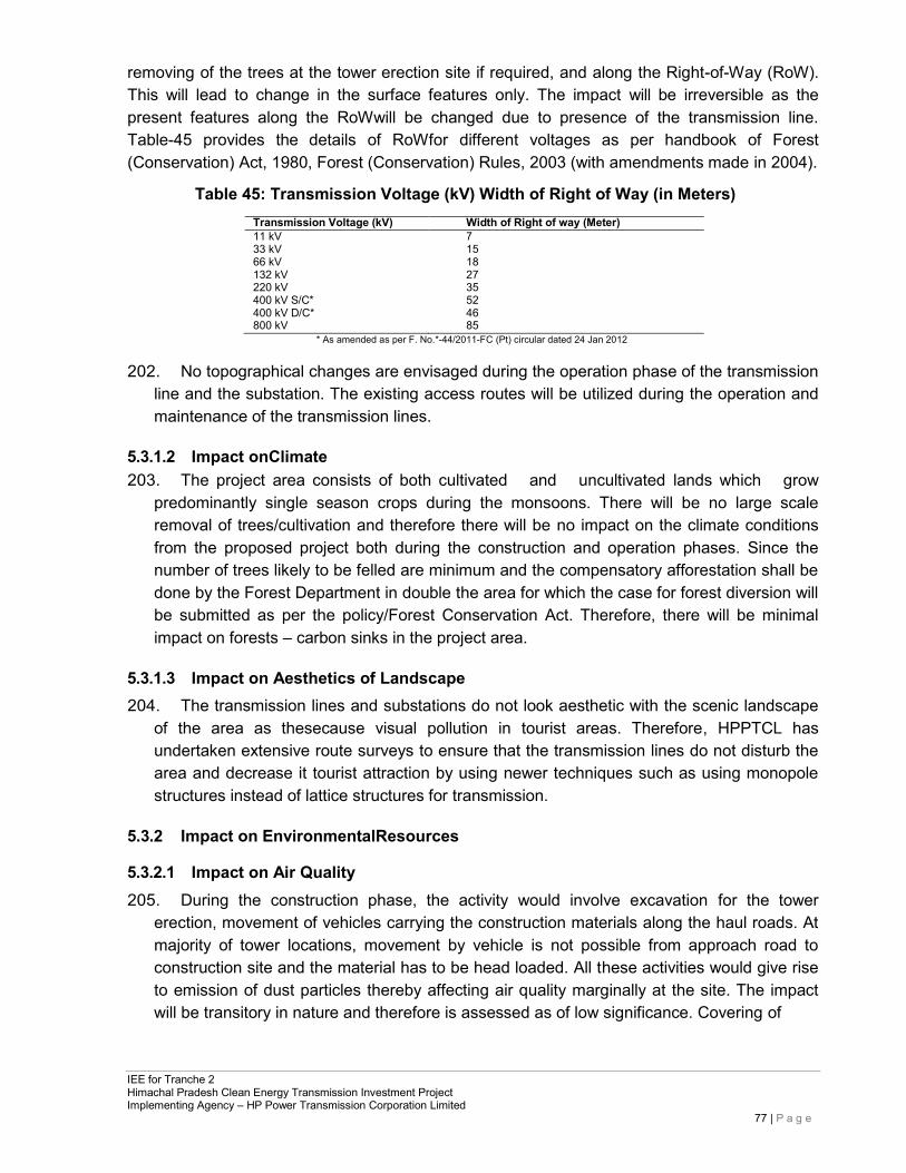
IEE for Tranche 2 Himachal Pradesh Clean Energy Transmission Investment Project Implementing Agency – HP Power Transmission Corporation Limited
77 | P a g e
removing of the trees at the tower erection site if required, and along the Right-of-Way (RoW). This will lead to change in the surface features only. The impact will be irreversible as the present features along the RoWwill be changed due to presence of the transmission line. Table-45 provides the details of RoWfor different voltages as per handbook of Forest (Conservation) Act, 1980, Forest (Conservation) Rules, 2003 (with amendments made in 2004).
Table 45: Transmission Voltage (kV) Width of Right of Way (in Meters)
Transmission Voltage (kV) Width of Right of way (Meter) 11 kV 7 33 kV 15 66 kV 18 132 kV 27 220 kV 35 400 kV S/C* 52 400 kV D/C* 46 800 kV 85
* As amended as per F. No.*-44/2011-FC (Pt) circular dated 24 Jan 2012
202. No topographical changes are envisaged during the operation phase of the transmission line and the substation. The existing access routes will be utilized during the operation and maintenance of the transmission lines.
5.3.1.2 Impact onClimate 203. The project area consists of both cultivated and uncultivated lands which grow
predominantly single season crops during the monsoons. There will be no large scale removal of trees/cultivation and therefore there will be no impact on the climate conditions from the proposed project both during the construction and operation phases. Since the number of trees likely to be felled are minimum and the compensatory afforestation shall be done by the Forest Department in double the area for which the case for forest diversion will be submitted as per the policy/Forest Conservation Act. Therefore, there will be minimal impact on forests – carbon sinks in the project area.
5.3.1.3 Impact on Aesthetics of Landscape 204. The transmission lines and substations do not look aesthetic with the scenic landscape
of the area as thesecause visual pollution in tourist areas. Therefore, HPPTCL has undertaken extensive route surveys to ensure that the transmission lines do not disturb the area and decrease it tourist attraction by using newer techniques such as using monopole structures instead of lattice structures for transmission.
5.3.2 Impact on EnvironmentalResources
5.3.2.1 Impact on Air Quality 205. During the construction phase, the activity would involve excavation for the tower
erection, movement of vehicles carrying the construction materials along the haul roads. At majority of tower locations, movement by vehicle is not possible from approach road to construction site and the material has to be head loaded. All these activities would give rise to emission of dust particles thereby affecting air quality marginally at the site. The impact will be transitory in nature and therefore is assessed as of low significance. Covering of
IEE for Tranche 2 Himachal Pradesh Clean Energy Transmission Investment Project Implementing Agency – HP Power Transmission Corporation Limited
78 | P a g e
stockpiles, minimising double handling and drop loads as well as sprinkling of water during excavation will reduce the dust emission to a great extent.
206. The construction of transmission line and the substation will not have any negative impact on the air quality of the region during the operation phase.
5.3.2.2 Impact on NoiseLevels 207. During the construction phase, the major sources of noise pollution are movement of
vehicles carrying the construction material and equipment to the site. Most of the access roads along the alignment are motor able and project traffic would be negligible. The major work of the construction is expected to be carried out during the day time. Apart from vehicles bringing in materials to the nearest road, construction works for the transmission line will not require powered equipment. As such, noise emissions will be minor. As the predominant land use along most part of the alignment is agricultural/forest, there will be few residential areas exposed to noise generated during the construction phase and the noise produced during the construction period will have negligible impact on residents.
208. Following measures will help to keep noise and vibration in acceptable level during construction phase:
• Contractor shall preferably limit working time for activities that create noise within normal day hours of the public except for construction site near public sensitive receptors. Construction related activities closer to sensitive receptors have to be scheduled in coordination with the relevant authorities andcommunity.
• Noisy equipment such as generators should be sited away from residential areas. • Contractor and suppliers of construction materials should strictly implement noise
control regulations stipulated by the Noise Pollution (Regulation and Control Rules 2000) for all construction vehicles and equipment.
• At substation sites, contractor shall equip their heavy construction equipment and plants with exhaust silencers to limit the engine noise so as not to exceed 75 dB (compacters/rollers, loaders and cranes) and regularly maintain all construction vehicles and machinery that should meet the CPCB’s Noise Standards.
209. During the operation phase of the project, there will be corona noise from the conductors which will be felt only up to 15 to 30 m area, hence the ambient noise level meets the CPCB standard for residential areas (55 dB(A) during daytime and 45 dB(A) during night time).
5.3.2.3 Impact on Surface WaterQuality 210. The construction and operation of the transmission lines will not have any major impact
on the surface and ground water quality in the area. Contamination of water bodies may result due to construction of access road to the substation site, spilling of construction materials and surface runoff from the construction site joining the water body. There may be increase in the turbidity levels temporarily where the proposed alignment is crossing a watercourse and if the surface runoff during construction meets the river. This can be avoided by careful selection of the tower site and the temporary access roads so that the surface runoff does not meet the river.
IEE for Tranche 2 Himachal Pradesh Clean Energy Transmission Investment Project Implementing Agency – HP Power Transmission Corporation Limited
79 | P a g e
211. Proposed activities will create temporary impacts to the existing drainage system in the area including irrigation canals, natural flow paths and also earth and line drains. Thus, incorporation of following measures will minimise anticipated impact due to obstruction of natural flow paths and existing drainage:
• Provisions of temporary drainage facilities and routing ponds to the particular locations if existing drains are obstructed due to construction activities.
• Maintenance of all drainage paths by avoiding blockages at all times. • Contractor should minimise excavation of beds of any streams, irrigation
systems, and other water resources available in the project area. • Stagnant water should be cleared by the contractor.
212. Care shall be taken to locate the temporary construction worker sheds away from the water bodies. Adequate drinking water facilities, sanitary facilities and drainage in the temporary sheds of construction workers should be provided to avoid the surface water pollution. Provision of adequate washing and toilet facilities should be made obligatory. This should from an integral component in the planning stage before commencement of construction activity by the contractor. Operation of transmission lines will not cause any release to the surface water bodies.
5.3.2.4 Impact on Hydrology and WaterResources 213. Water needs during construction of the Project would be limited to sanitary water and
minimal amounts of water for construction (such as spraying for dust prevention). There would be a negligible impact on water resources. Operation of the lines would neither require any water nor pollute the water resources.
5.3.2.5 Impact on Ground WaterQuality 214. Ground water pollution can take place, if chemical substances and oily waste get
leached by precipitation of water and percolate to the ground water table. For transmission line construction activity, no chemical substance or oil is used hence there is no impact on ground water quality. The silt discharge from the earth work around water bodies, oil, grease and fuel release from the construction vehicles/equipment and spoil from construction and other construction related activities such as raw sewerage from worker accommodation sites may mix with runoff water. This situation will accentuate during the rainy season and could have a significant impact on surface and ground water. Thus following measures will be required in order to prevent deterioration of water quality from the construction and construction related activities:
• All construction vehicles and equipment should be maintained in proper conditions without any leakages,
• Contractors shall use silt traps and erosion control measures where the construction is carried out in close proximity to the water bodies to avoid entering of cement particles, rock, rubbles and wastewater to the surrounding waterbodies,
Construction activities requiring digging should be preferably done in the dry season, and
IEE for Tranche 2 Himachal Pradesh Clean Energy Transmission Investment Project Implementing Agency – HP Power Transmission Corporation Limited
80 | P a g e
• Waste oil should be collected properly and disposed to the approved recyclers.
5.3.2.6 Impact on Soil andGeology 215. Project activities including excavation, cut and fill operations, removal of trees and green
cover vegetation will enhance the soil erosion during the rainy season. Removal of trees and green cover vegetation will reduce infiltration rate of rainwater. The impact on soils will be due to the soil erosion at the tower construction sites along the access routes. The excavation activity and land clearance in the erosion prone areas have to be minimised while conducting the site selection for towers. Revetment and stabilization of tower construction sites will be done after completion of construction activity. Also increased acceleration of surface runoff will damage the topsoil. The impacts associated with excessive erosion and other civil works can be avoided or minimised by following mitigation measures:
• Maximum effort should be taken to minimise removal of trees and green cover vegetation.
• Minimise obstruction or destruction to natural drainage pattern of the surrounding area. • Proper treatment of clearing and filling areas against flowacceleration. • Turfingworkshouldbetakenpriortorainyseasonaroundthesubstation. • Contractors shall follow proper muck disposal plan for cut and fill operation around
sharp/deep slopeareas. • Piling activities will preferably be done in non-rainy season, as the piled materials will
spread all over the area and contaminate close by water bodies. • Topsoil (2-3 cm from the top of the soil), which are removed during construction from
the cultivated lands must be stored separately for future utilization of cultivated lands near tower leg locations.
5.3.3 Impact on Ecological Resources 216. Since substation is constructed in vacant government/private land and transmission line
is routed from the unhabitated areas, there is no displacement of people or animals. It will away also not cause any disturbance to the life of people and local animals and birds movement. In transmission line construction, there is no dynamic equipment and moving machinery causing noise pollution, water and air pollution. There is no national park, wildlife sanctuary, bird sanctuary, wetland in the route alignment of the proposed transmission line. The ecological impacts are briefly described in the following sections.
5.3.3.1 Impact on TerrestrialEcology 217. There is no sensitive ecological area such as national park, wildlife sanctuary and bird
sanctuary crossing the proposed TL route alignment. The removal of herbaceous vegetation from the soil and loosening of the top soil generally causes soil erosion. However, such impacts would be primarily confined to the project site during initial periods of the construction phase and would be minimised through adoption of mitigation measures
IEE for Tranche 2 Himachal Pradesh Clean Energy Transmission Investment Project Implementing Agency – HP Power Transmission Corporation Limited
81 | P a g e
like paving and surface treatment and water sprinkling.
218. The initial construction works along the alignment involving land clearance, cutting, filling, and leveling that may cause loss of vegetation. This will be an irreversible impact. Care has been taken to avoid the thick plantations/vegetation as far as possible and tower locations are selected mostly in plain cultivable fields where the vegetation is thin. This will minimise the tree loss. Compensation will be paid to tree owners in the private areas as per GoHP rules. Where the clearing of fields and forest area is unavoidable along the route alignment, the compensatory afforestation will be required for forest areas for which clearance will be obtained from the appropriate authority of the forest department; and for fruit and non-fruit trees in the fields, the amount for compensation for fields will be paid directly to the farmers.
Impact on Flora and Fauna
219. Some forest and fruit trees will need to be removed from the project area for the RoWafter getting prior permission from competent authorities of Forest Department (GoHP) and MoEF&CC/GoI. None of the declared environmentally sensitive areas is located within the route alignment. As per forest department records, none of the flora and fauna that are rare, endangered, endemic or threatened will be affected. Migratory paths of small mammals and reptiles may be affected due to construction activities. The route alignments and site selection have been done only after consulting the local forest authorities ensuring that route alignments do not interfere with known paths of migration of wildlife.
220. However noise, vibration and emission from construction vehicles, equipment will occur during construction and pre-construction stages in temporary manner, which may adversaly affect the fauna of the area. The impacts related to above activities are temporary and can be mitigated through following measures13.
• Strict attention on worker force regarding disturbance to surrounding habitats, flora and fauna including hunting of animals and fishing in waterbodies,
• Selection of approved locations for material storage yards and labourcamps away from the environmental sensitive areas,and
• Prevent entering of construction waste (cement particles, rock, rubbles and waste water) and sanitary waste to the surrounding waterbodies.
Impact on Forest & Trees
221. The project requires forest land & feeling of trees for the Transmission line sub-projects. Table-46 provides the details of forest land & trees to be impacted for subprojects and status of Forest Clearance from MoEF&CC.
13 The compliance to the above shall be responsibility on the contractor as per contract provisions. Any violations reported by the public shall be dealt as per provisions of thelaw.
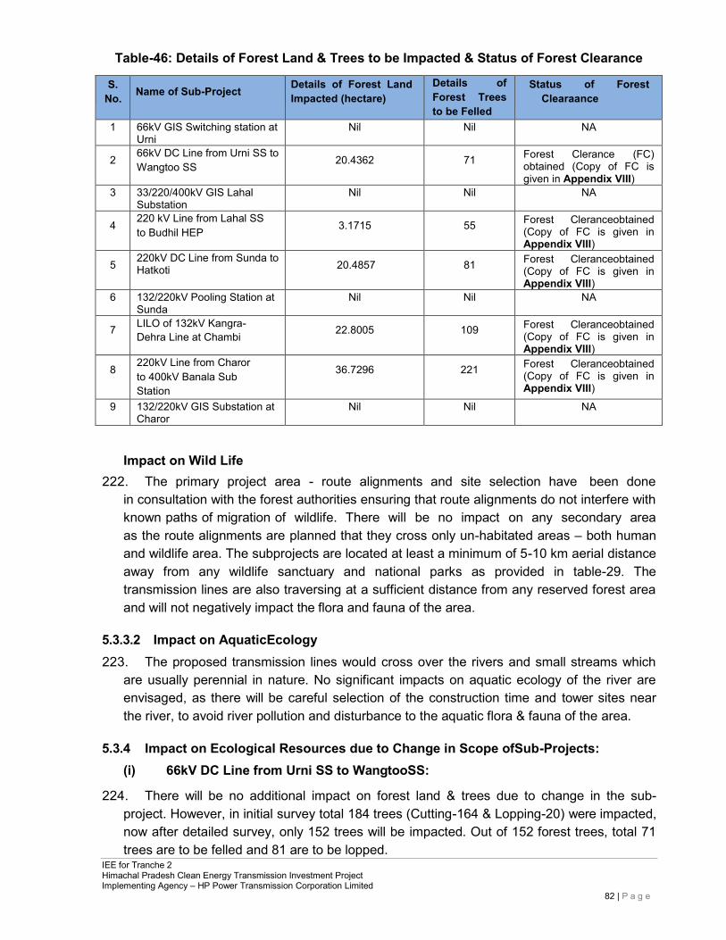
IEE for Tranche 2 Himachal Pradesh Clean Energy Transmission Investment Project Implementing Agency – HP Power Transmission Corporation Limited
82 | P a g e
Table-46: Details of Forest Land & Trees to be Impacted & Status of Forest Clearance
S. No. Name of Sub-Project Details of Forest Land
Impacted (hectare) Details of Forest Trees to be Felled
Status of Forest Clearaance
1 66kV GIS Switching station at Urni
Nil Nil NA
2 66kV DC Line from Urni SS to Wangtoo SS 20.4362 71 Forest Clerance (FC)
obtained (Copy of FC is given in Appendix VIII)
3 33/220/400kV GIS Lahal Substation
Nil Nil NA
4 220 kV Line from Lahal SS to Budhil HEP 3.1715 55 Forest Cleranceobtained
(Copy of FC is given in Appendix VIII)
5 220kV DC Line from Sunda to Hatkoti 20.4857 81 Forest Cleranceobtained
(Copy of FC is given in Appendix VIII)
6 132/220kV Pooling Station at Sunda
Nil Nil NA
7 LILO of 132kV Kangra-Dehra Line at Chambi 22.8005 109 Forest Cleranceobtained
(Copy of FC is given in Appendix VIII)
8 220kV Line from Charor to 400kV Banala Sub Station
36.7296 221 Forest Cleranceobtained (Copy of FC is given in Appendix VIII)
9 132/220kV GIS Substation at Charor
Nil Nil NA
Impact on Wild Life 222. The primary project area - route alignments and site selection have been done
in consultation with the forest authorities ensuring that route alignments do not interfere with known paths of migration of wildlife. There will be no impact on any secondary area as the route alignments are planned that they cross only un-habitated areas – both human and wildlife area. The subprojects are located at least a minimum of 5-10 km aerial distance away from any wildlife sanctuary and national parks as provided in table-29. The transmission lines are also traversing at a sufficient distance from any reserved forest area and will not negatively impact the flora and fauna of the area.
5.3.3.2 Impact on AquaticEcology 223. The proposed transmission lines would cross over the rivers and small streams which
are usually perennial in nature. No significant impacts on aquatic ecology of the river are envisaged, as there will be careful selection of the construction time and tower sites near the river, to avoid river pollution and disturbance to the aquatic flora & fauna of the area.
5.3.4 Impact on Ecological Resources due to Change in Scope ofSub-Projects:
(i) 66kV DC Line from Urni SS to WangtooSS:
224. There will be no additional impact on forest land & trees due to change in the sub- project. However, in initial survey total 184 trees (Cutting-164 & Lopping-20) were impacted, now after detailed survey, only 152 trees will be impacted. Out of 152 forest trees, total 71 trees are to be felled and 81 are to be lopped.
IEE for Tranche 2 Himachal Pradesh Clean Energy Transmission Investment Project Implementing Agency – HP Power Transmission Corporation Limited
83 | P a g e
(ii) 220kV DC Line from Sunda to Hatkoti:
225. Forest land requirement has been increased due to re-routing of Transmission Line. Earlier 20.4857 ha forest land proposed for diversion, now 22.9585 ha forest land required diversion after re-routing of transmission line (TL). For additional forest land diversion, forest clearance application is under progress. In the initial survey total 105 forest trees (Cutting 40 & Lopping-65) were impacted. However after detailed survey, during forest clearance application, 117 number of forest trees were identified for felling. Due to re-routing of TL impact on forest trees have been reduced as number of trees required to be cut has been decreased to 81 number of forest trees in comparison to 117 number of forest trees.
(iii) 220kV Line from Charor to 400kV Banala SubStation:
226. There will be no additional impact on forest land & trees due to change in the sub- project. However in initial survey total 1900 trees (Cutting-1120 & Lopping-780) were impacted, now after detailed survey, only 373 trees will be impacted. Out of 373 forest trees, total 221 trees are required to be felled and 152 are to be lopped.
227. There is no additional impact on wildlife due to change in scope of sub-projects, as none of the revised TL route length is passing through the protected areas notified under Wildlife Protection Act.
5.3.5 Impact on Human Environment
Health andSafety
228. Health and safety impacts will be in terms of risk of accidents and exposure to electromagnetic fields along the alignment. The accidents may be caused due to electrocution, lightening, fires and explosions. To avoid this, the houses will be allowed within the RoWof the project, only if the stipulated safety clearance is met with. Necessary training regarding safety aspects to the personnel working at the transmission line will be provided by the contractor. Personal protective equipment like safety gloves, helmet, mufflers etcwill be provided during construction period and during the maintenance work. First aid facilities will be made available with the labour gangs and doctors called in from nearby towns when necessary.
229. Project activities may create accidental damage to general public and the construction workers. Therefore, contractors should take necessary action to enhance personal safety during construction through followingmeasures:
• Organise awareness programs relevant to personal safety of the workers and general public in thearea.
• Installation of warning signs to particular locationssuch as transverse points of local road network by transmissionlines.
• Provide protective safety belts, footwear, helmets, goggles, eye-shields and clothes to workers depending on theirduty.
• Arrangement of proper first aid unit and transport facilities to take injured people to the hospitals.
• Workers should be covered by the statutory Workmen Compensation as per GoI laws by the contractor.
IEE for Tranche 2 Himachal Pradesh Clean Energy Transmission Investment Project Implementing Agency – HP Power Transmission Corporation Limited
84 | P a g e
Agriculture
230. Permanent and temporary loss of agricultural land occurs due totower location in the agricultural field and loss of crop for access routes. As per standard HP policy, land will be acquired for each tower erection, besides private land required for substations. As far as possible, the prime agricultural land will be avoided and the construction will be done after crop harvesting. HPPTCL has formulated a comprehensive Resettlement, Relief, Rehabilitation and Compensation (RRRC) Policy to address the issue.
Socio-Economics
231. Construction of transmission line will generate local employment, as number of unskilled labours (men/women) will be required at the time of construction activities. Local employment during this period will increase socio-economic standards of the residents of the projectarea.
Temporary Outage of the Electricity
232. Temporary disconnection of power supply will occur during the construction activities. Thus, general public and the commercial / industrial places, which are located in project-affected area, will face inconvenience for short periods of time. Thus, following measures will have to betaken:
• Advance notice to the public about the time and the duration of the utility disruption,and
• Restore the utilities immediately to overcome public inconvenience.
Resettlement and Rehabilitation
233. For the construction of transmission line and seven substations, purchase of private land is required. The detail of resettlement and rehabilitation involved in the project are given in Resettlement Planning document prepared separately for Tranche2.
Cultural sites
234. There are no important archaeological, historical or cultural sites along the route alignment; hence no impact on these sites is envisaged. In the case of discovery of archaeological features during excavation/construction works, GoI’sregulations shall apply and will be observed bycontractors.
Traffic and Transport
235. During the construction phase, traffic disturbance needs to be minimised by avoiding high- density areas, using proper traffic signs, ensuring proper access roads and avoiding roadblockage.
Impact on Local Road Network 236. Transformers, tower material, substation equipment, iron bars, concrete materials, piling
equipment, will be transported through the provincial and local road network to the project site. Transporting of large quantities of materials using heavy vehicles could exceed the carrying capacity of the road. This would lead to physical damages to local road network. Also, contractor should properly maintain all road sections, which will be utilized for the construction relatedactivities.
IEE for Tranche 2 Himachal Pradesh Clean Energy Transmission Investment Project Implementing Agency – HP Power Transmission Corporation Limited
85 | P a g e
237. The access road to the substation land from the nearest road head will be constructed. For transmission line, no road is likely to be constructed and existing village roads, footpaths have to be used as no movement of mechanized machinery will be done. The tower line material will be transported up to the nearest road head andthereby taken to tower site manually. The local community cannot encroach along the transmission line routes, as encroachment of any forestland is punishable by law. Interference with Other Utilities and Traffic
238. A standing committee - Power Telecom Co-ordination Committee (P.T.C.C.) has been constituted by Government of India to plan and implement the mitigating measures for the induced voltage, which may occur nearby telecom circuits and suggest necessary protection measures to be adopted. The committee suggests measures like rerouting of the telecom circuits, conversion of overhead telecom circuits into cables etc. to minimize the interference. It is mandatory for HPPTCL to seek clearance prior to construction from telecom authorities and wherever necessary from aviation authorities that are likely to be affected by the construction of transmission lines. The exact cost to mitigate the impacts of induction in neighboring telecom circuits would vary from case to case. In general, the system is planned and executed in such a way that adequate clearance is maintained between transmission lines on the one hand, and railways, civil aviation and defense installations on the other. Wherever the transmission lines passes near the airport, the towers beyond specified height are painted in alternate orange and white stripes for easy visibility and warning lights are placed on the top of these towers.
5.3.6 Waste Disposal
Solid WasteDisposal 239. The solid waste generation at the location of the tower erection site will mostly include
metal scraps and wooden packing material. Waste will be minimisedand recycled wherever possible. Final waste will be collected and disposed off in compliance with applicable GoI/GoHPregulations and rules by the contractor.
Sanitary Waste Disposal at Construction Sites and Labour Camps 240. The labour camps at the site of tower erection will be temporary in nature and the
human excreta will not be significant to cause contamination of ground water. Those places where most labourwill be staying will be near hamlets which shall use the community services for solid waste, water and sanitation. Adequate drinking water facilities, sanitary facilities and drainage in the temporary sheds of the construction workers should be provided to avoid the surface water pollution. This should form an integral component in the planning stage before commencement of construction activity.
241. There should be proper solid waste disposal procedure to enhance sanitation of workers who stay in camps. Thus, possibilities of infecting water borne diseases or vector borne diseases (parasitic infections) will be eliminated by adopting proper solid waste disposal procedure. Unacceptable solid waste disposal practices such as open dumping of solid waste and poor sanitation facilities will lead to pollution of surrounding environment, contamination of water bodies and increase adverse impact to the aquatic; terrestrial lives and general public inhabited in the area. Surroundings of labour camps, garbage disposal sites and material storage yards provide favorable habitats for vectors of diseases
IEE for Tranche 2 Himachal Pradesh Clean Energy Transmission Investment Project Implementing Agency – HP Power Transmission Corporation Limited
86 | P a g e
such as mosquitoes, rats and flies. 242. Thus following measures are needed to protect and enhance the quality of environment
during the construction stage: • A better way to overcome garbage disposal as mentioned above is by reducing or
avoiding the construction of labour camps, thus the selection of majority of skilled and unskilled workers from the project influence area will be a proper measure in this regard.
• Provision of the solid waste disposal, sanitation and sewage facilities at all substation sites for the construction/labour camps to avoid or minimise health hazards and environmental pollution.
• Contractor should handle and manage waste generated from the construction/labour camps without contamination to natural environment and it will reduce risk to general public who stay close to sites. Also, contractor should be responsible to enhance the quality of environment.
• Adequate supply of water should be provided to the urinals, toilets and wash rooms of the workers’ accommodation at substation sites.
• Contractor should provide garbage bins to all workers’ accommodationandconstruction sites, for dumping wastes regularly in a hygienic manner with the help of Public Health Inspector (PHI) in the area.
Liquid Waste Disposal
243. There will be no oil or chemical waste generated during the construction of transmission line, hence no mitigation is required. For substations, the transformer oil is the main constituent of the liquid stored. The transformer oil shall be stored as per IS -1866/200014and IEC-60422/199815codes- and any waste oil shall disposed as per Hazardous Waste (Management, Handling, Trans- boundary Movement) Rules 2009 and any waste oil removed from transformer will be sold to government approved recycler and will not be disposed off in the ground or any rivulet /stream as per EMP.
Disposal of Debris
244. As a result of construction related activities, spoil and debris will be generated during the construction stage. Improper disposal of the debris will have an impact on the surrounding ecology, public health and scenic beauty. Following measures will minimise the impacts associated with disposal of debris:
• Spoil materials (soil, sand, rock) generated from construction activities shall be used wherever possible for site levelling and back-filling. Dismentledand demolished structural materials, if any, should not be dumped in agricultural lands.
• Preparation of a Muck Disposal Management Plan, if required, for the sub- project and selection of the disposal site by excluding locations, which are closer to residential, commercial and public sensitive areas, is necessary by the contractor.
14 Code of Practice for Electrical Maintenance and supervision of Mineral Insulating oil inEquipment 15 Supervision and maintenance guide for mineral insulating oils in electricalequipment
IEE for Tranche 2 Himachal Pradesh Clean Energy Transmission Investment Project Implementing Agency – HP Power Transmission Corporation Limited
87 | P a g e
Prior approval should be obtained for such dumping grounds / land fill sites from relevant local authorities.
• Dumped materials will interfere with the drainage pattern of the area, any water bodies, agricultural lands, marshlands and down slope or any environmental sensitive areas if not planned properly. The material has to be dumped at sites marked by the concerned authorities such as Forest, Roads, or Panchayats (local community) by the contractor as per contract provisions.
245. During operation phase, corridor along the alignment will be chopped of vegetation and lopping of trees will be done for maintenance purpose. This will also reduce the chances of fires due to electrics parks.
5.4 Environmental Impacts Associated with Operations and Maintenance
Stage
5.4.1 ElectricShock 246. This may lead to death or injury to the workers and public in the area. This
can be minimised or avoidedby:
• Security fences around substation.
• Establishment of warning signs.
• Careful design using appropriate technologies to minimize hazards.
5.4.2 NoiseGeneration 247. During the operation phase of the project, there may be corona noise from the
conductors which will be felt only up to 15 to 30 m area, hence the ambient noise level will meet the CPCB standard for residential areas (55 dB(A) during daytime and 45 dB(A) during nighttime.
5.4.3 Maintenance of Transmission line andSubstation 248. Possible exposure to electromagnetic interference could occur during these activities.
Design of transmission line should comply with the limits of electromagnetic interference from overhead powerlines.
5.4.4 OilSpillage 249. Contamination of water on land/nearby water bodies by the transformer oil can
occur during operation due to leakage or accident. Substation transformers are normally located within secure and impervious areas with a storage capacity of 100% spare oil. Also proper drainage facilities will be constructed during the construction stage to avoid overflow or contamination with natural flow paths especially during the rainy season. HPPTCL will maintain account of the usage of oil, using technical methods and procedures for oil monitoring mechanism, and will have mitigation plan for any oil spillage.
IEE for Tranche 2 Himachal Pradesh Clean Energy Transmission Investment Project Implementing Agency – HP Power Transmission Corporation Limited
88 | P a g e
5.4.5 Sulphur Hexa fluoride (SF6) Leakage 250. SF6 is a non-toxic greenhouse gas used as a dielectric in circuit breakers, switch gear,
and other electrical equipment. Very highgrade sealing system and erection methodology is followed to keep the loss of SF6 within 0.1% every year. SF6 handling is part of each contract technical specifications, and required design and routine test are done after manufacturing of the circuit breaker and gas insulated switchgear. SF6 gas handling system for evacuation and storage is always used for the maintenance of the circuit breaker and gas insulated switchgear. SF6 gas leakage records will be maintained in each substation. This allows tracking of any release of SF6 gas to the atmosphere.
5.5 Environmental Management Plan 251. Based on the environmental assessment of the project activities, an Environment
Management Plan (EMP) has been developed for the project to mitigate any adverse environmental impacts. The EMP discusses anticipated impacts and mitigation measures and monitoring requirements and responsible authorities to implement the EMP with respect to the following stages: (i) pre-construction, (ii) construction, and (iii) operation and maintenance. Detailed, site-specific mitigation measures and monitoring plans were developed and will be implemented during the project implementation phase.
252. The EMP table for the project is provided in Appendix-VI, which identifies feasible and cost- effective measures to be taken to reduce potential significant, adverse, impacts to acceptable levels. Here, proper mitigation measures are proposed for each potential impact, including details on responsible parties for implementation of mitigation measures and supervision. A summary environmental impact matrix and the mitigation measures are given in Table-47.
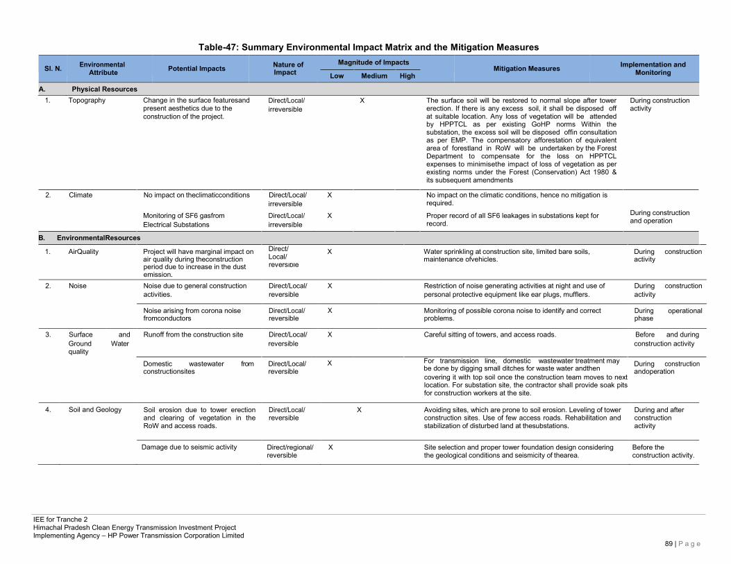
IEE for Tranche 2 Himachal Pradesh Clean Energy Transmission Investment Project Implementing Agency – HP Power Transmission Corporation Limited
89 | P a g e
Table-47: Summary Environmental Impact Matrix and the Mitigation Measures
Sl. N. Environmental Attribute
Potential Impacts Nature of
Impact Magnitude of Impacts
Low Medium High
Mitigation Measures Implementation and
Monitoring
A. Physical Resources 1. Topography Change in the surface featuresand
present aesthetics due to the construction of the project.
Direct/Local/ irreversible
X The surface soil will be restored to normal slope after tower erection. If there is any excess soil, it shall be disposed off at suitable location. Any loss of vegetation will be attended by HPPTCL as per existing GoHP norms Within the substation, the excess soil will be disposed offin consultation as per EMP. The compensatory afforestation of equivalent area of forestland in RoW will be undertaken by the Forest Department to compensate for the loss on HPPTCL expenses to minimisethe impact of loss of vegetation as per existing norms under the Forest (Conservation) Act 1980 & its subsequent amendments
During construction activity
2. Climate No impact on theclimaticconditions Direct/Local/
irreversible
X No impact on the climatic conditions, hence no mitigation is
required.
Monitoring of SF6 gasfrom Electrical Substations
Direct/Local/ irreversible
X Proper record of all SF6 leakages in substations kept for record.
During construction and operation
1. AirQuality Project will have marginal impact on
air quality during theconstruction Direct/ Local/
X Water sprinkling at construction site, limited bare soils, maintenance ofvehicles.
During construction activity
period due to increase in the dust emission.
reversible
2. Noise Noise due to general construction Direct/Local/ X Restriction of noise generating activities at night and use of During construction activities. reversible personal protective equipment like ear plugs, mufflers. activity
Noise arising from corona noise fromconductors
Direct/Local/ reversible
X Monitoring of possible corona noise to identify and correct problems.
During phase
operational
3. Surface and Runoff from the construction site Direct/Local/ X Careful sitting of towers, and access roads. Before and during Ground Water quality
Domestic wastewater from constructionsites
reversible
Direct/Local/ reversible
X For transmission line, domestic wastewater treatment may be done by digging small ditches for waste water andthen
construction activity
During construction andoperation
B. EnvironmentalResources
covering it with top soil once the construction team moves to next location. For substation site, the contractor shall provide soak pits for construction workers at the site.
4. Soil and Geology Soil erosion due to tower erection and clearing of vegetation in the RoW and access roads.
Direct/Local/ reversible
X Avoiding sites, which are prone to soil erosion. Leveling of tower construction sites. Use of few access roads. Rehabilitation and stabilization of disturbed land at thesubstations.
During and after construction activity
Damage due to seismic activity Direct/regional/ reversible
X Site selection and proper tower foundation design considering the geological conditions and seismicity of thearea.
Before the construction activity.
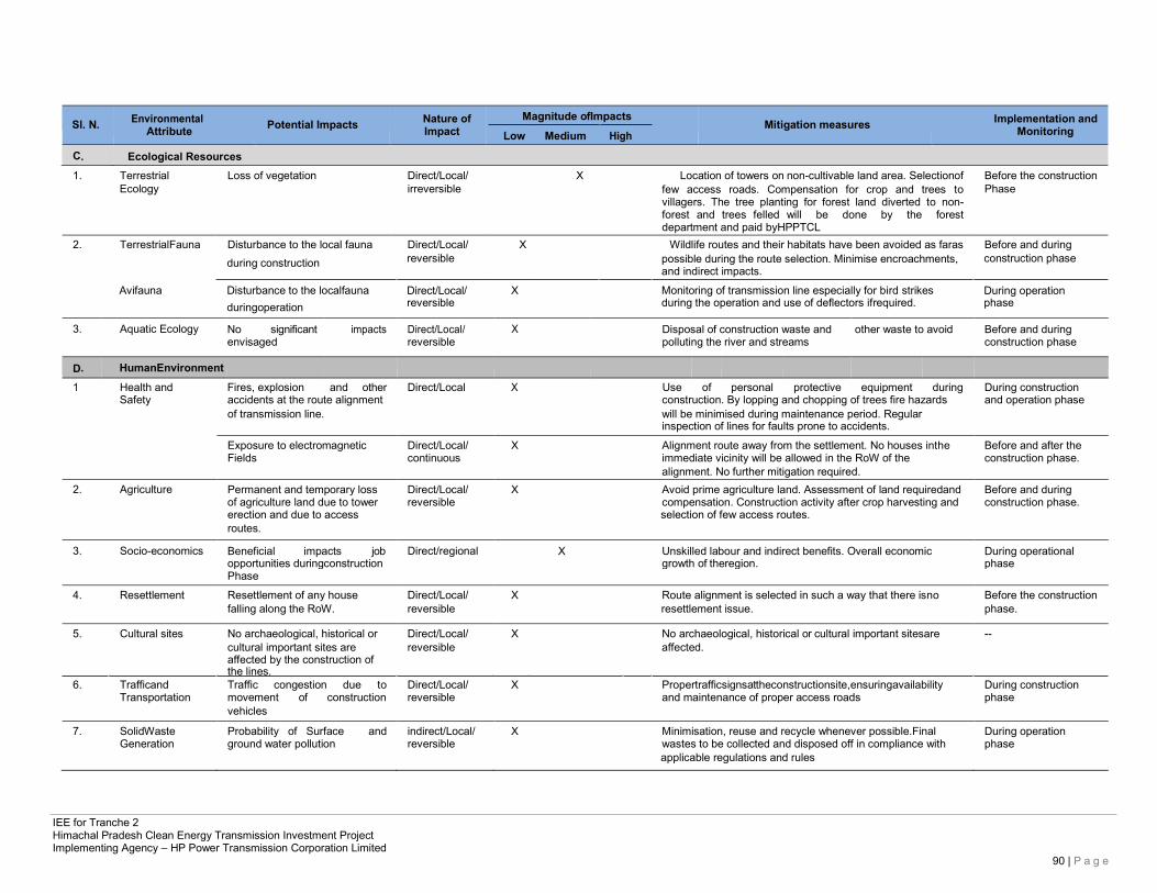
IEE for Tranche 2 Himachal Pradesh Clean Energy Transmission Investment Project Implementing Agency – HP Power Transmission Corporation Limited
90 | P a g e
Sl. N. Environmental Attribute
Potential Impacts Nature of
Impact Magnitude ofImpacts
Low Medium High
Mitigation measures Implementation and
Monitoring
C. Ecological Resources
1. Terrestrial Loss of vegetation Direct/Local/ X Location of towers on non-cultivable land area. Selectionof Before the construction Ecology irreversible few access roads. Compensation for crop and trees to
villagers. The tree planting for forest land diverted to non- forest and trees felled will be done by the forest department and paid byHPPTCL
Phase
2. TerrestrialFauna Disturbance to the local fauna Direct/Local/ X Wildlife routes and their habitats have been avoided as faras Before and during during construction
Avifauna Disturbance to the localfauna
duringoperation
reversible
Direct/Local/ reversible
possible during the route selection. Minimise encroachments, and indirect impacts.
X Monitoring of transmission line especially for bird strikes during the operation and use of deflectors ifrequired.
construction phase
During operation phase
3. Aquatic Ecology No significant envisaged
impacts Direct/Local/ reversible
X Disposal of construction waste and polluting the river and streams
other waste to avoid Before and during construction phase
D. HumanEnvironment
1 Health and Fires, explosion and other Direct/Local X Use of personal protective equipment during During construction Safety accidents at the route alignment construction. By lopping and chopping of trees fire hazards and operation phase
of transmission line. will be minimised during maintenance period. Regular inspection of lines for faults prone to accidents.
Exposure to electromagnetic Direct/Local/ X Alignment route away from the settlement. No houses inthe Before and after the Fields continuous immediate vicinity will be allowed in the RoW of the construction phase. alignment. No further mitigation required.
2. Agriculture Permanent and temporary loss Direct/Local/ X Avoid prime agriculture land. Assessment of land requiredand Before and during of agriculture land due to tower reversible compensation. Construction activity after crop harvesting and construction phase. erection and due to access selection of few access routes.
routes.
3. Socio-economics Beneficial impacts job opportunities duringconstruction
Direct/regional X Unskilled labour and indirect benefits. Overall economic growth of theregion.
During operational phase
Phase
4. Resettlement Resettlement of any house Direct/Local/ X Route alignment is selected in such a way that there isno Before the construction falling along the RoW. reversible resettlement issue. phase.
5. Cultural sites No archaeological, historical or Direct/Local/ X No archaeological, historical or cultural important sitesare -- cultural important sites are
affected by the construction of reversible affected.
the lines.
6. Trafficand Traffic congestion due to Direct/Local/ X Propertrafficsignsattheconstructionsite,ensuringavailability During construction Transportation movement of construction reversible and maintenance of proper access roads phase
vehicles
7. SolidWaste Probability of Surface and indirect/Local/ X Minimisation, reuse and recycle whenever possible.Final During operation Generation ground water pollution reversible wastes to be collected and disposed off in compliance with phase
applicable regulations and rules
IEE for Tranche 2 Himachal Pradesh Clean Energy Transmission Investment Project Implementing Agency – HP Power Transmission Corporation Limited
91 | P a g e
6 ANALYSIS OF ALTERNATIVES
6.1 HPPTCL’s Approach for Route Selection 256. As per its Environment and Social Safeguards Policy (ESSP), May,2011, HPPTCL shall
adopt a proactive route alignment approach. Preliminary route selection for transmission lines shall be done by HPPTCL based on walk over surveys, usage of tools such as the forest atlas, revenue papers and 1:50,000 topographical maps of the area from Survey of India. It shall strive to move towards using modern tools like Geographical Information System (GIS)/Global Positioning System (GPS) for a precision in route alignment with the larger picture in view while finalizing the route.
• During route alignment, all possible efforts shall be made to avoid forest areas or to keep it to the barest minimum. Whenever it becomes unavoidable due to the geography of the terrain or heavy cost involved in avoiding it, different alternative options shall be considered to minimize the requirement of forest area. The selected route shall be easily accessible in dry, rainy and winter (snow) seasons for maintenance purposes.
• At the planning stage itself, one of the factors that govern the establishment of the transmission line is the infringement of populated/forest/cultivated area and scarce land. Wherever such infringements are substantial, different alternative options are to be considered.
6.2 Methodology for Selection of Route: Environmental and Social view 257. Route selection among alternatives considers environmental parameters, availability
of logistics support during construction, operation and maintenance of transmission lines and specific geographical condition to construct the lines along most feasible routes that were identified are based on the relevant topographic maps and walkover surveys.
258. For selection of the optimum route/site, the following points are taken into consideration by HPPTCL as per its ESSP May 2011:
• The transmission l ineavoids environmentally sensitive areas, eco sensitive zones, forests, sanctuaries national parks, biosphere reserves.
• The transmission line route impacts minimally on natural resources to accomplish this, route selection of transmission line is undertaken in close consultation with representation of the state Forest, Environment, and Revenue Departments. Site-specific alterations are made to avoid environmentally sensitive areas and settlements at execution stage.
• The proposed transmission line bypasses human habitationby a safe distance. • No monuments of cultural, archaeological or historical significance are affected. • The proposed transmission line does not adversely impact any local community
assets such as playground, hospitals, schools, places of worship etc. • The proposed route of transmission line does not create any threat to the
survival of any community with special reference to tribal community. • Avoidance of mining protected and reserved forest, archaeological and other
IEE for Tranche 2 Himachal Pradesh Clean Energy Transmission Investment Project Implementing Agency – HP Power Transmission Corporation Limited
92 | P a g e
sensitive areas unstable ground feature, marshy low lying areas, river beds and earth slip zones.
• Minimizing number of crossing of major rivers/railway lines, national and state highways, overhead EHV power line, number of towers and communication lines.
• Routing is kept away from large habitations, densely populated areas, animal / bird sanctuaries, and utility pipelines to the extent possible and avoid areas reserved for planned and future development.
• Restricted areas such as civil and military installations and airfields have been avoided.
• To minimize adverse impacts on natural habitats, human habitations efforts will be made to locate majority of substations/towers on barren, waste, or fallow agricultural lands.
259. In addition, HPPTCL shall follow the principle of avoidance by avoiding the forestland unless it is inescapable and in such instances, it shall obtain prior clearance from competent authorities. It shall abide by the relevant guidelines of State and Central government, including the directions of the Hournable Supreme Court of India from time to time.
6.3 Alternatives for Subproject Components
6.3.1 TransmissionLines 260. In order to achieve this, HPPTCL has undertaken route selection for transmission
lines in close consultation with representatives from Land Acquisition, Departments of Forest, Department of Wildlife Conservation and the local community. Although under the National law, HPPTCL has the right ofway, yet it considers alternative alignments during site selection, with minor alterations to avoid environmentally sensitive areas and settlements at the implementation stage. As per ESSP May 2011, HPPTCL shall follow the following guidelines:
• Minimum of three alternative routes shall be studied in detail using a set of techno- economical, environmental, ecological and social impact parameters to arrive at the most optimally suitable alignment that is technically feasible, economically viable, socially justified and environmentallysafe.
• A maximum width of Right of Way (RoW) for transmission lines on forestland and minimum clearances between conductors (depending on specific voltage) and trees to be adhered in routeselection.
• HPPTCL has attempted at reducing the number of trees affected and width of the Right ofWay
• (RoW) etc. through adoption of appropriate technological option like construction of narrow base towers, towers with extension, compact towers, multi-circuits, and monopole towers and/or innovating upon standard procedures. Specially designed high towers shall be used for reducing impact on trees, orchards wildlife and crossing wetlands,riverbeds.
• HPPTCL shall explore possibility of adopting a variable width RoW,wherever
IEE for Tranche 2 Himachal Pradesh Clean Energy Transmission Investment Project Implementing Agency – HP Power Transmission Corporation Limited
93 | P a g e
feasible, so as to minimize land requirement especially cutting of trees and removal of othervegetation.
• Tower sites shall preferably, as far as technically feasible and permitted by the safety parameters mandatory under Indian Electricity Act Rules 77 and 80 regarding clearances from ground and buildings respectively. The towers may be located on mountain ridges to save trees in the RoW below the conductors on the valley side between two successivetowers.
• All efforts to minimize the involvement of trees falling in RoWshall be made. HPPTCL shall minimize number of trees required to be felled even if their cost has been paid. Pruning of trees will be done wherever required instead of heavy lopping orfelling.
• To minimize damage to the environment HPPTCL shall use manual stringing in thick forest and on slopes whereverpossible.
• Transmission line design shall comply with the limits of electromagnetic interference from overhead powerlines.
• Visible pathways along the transmission line alignment shall be maintained for patrolling and maintenancepurposes.
• For aviation safety, in addition to putting visible signs along the conductors and on the towers, the route alignment would be shared with the nearest airport or nearest office of the AirportsAuthority.
• In addition, care is also taken to avoid/minimiseprotected parks/forests, bird sanctuaries and any other forest area rich in wildlife.
6.3.2 GIS Substations 261. For selection of appropriate site for substation, the following points are taken
into consideration:
• Site selection should consider seismicity and geography of the local area; the area should not be prone to landslide or be unstable.
• Construction activities do not adversely affect the population living near the proposed substations and does not create any threat to the survival of any community with special reference to tribal community etc.
• The location of substation does not affect any monument of cultural or historical importance.
• No resettlement of households by the substation site, no loss of livelihoods, siting of transformers away from schools, hospitals and other sensitive receptors, with due consultation with the community and local government units concerned.
• Transformers and other equipment specifications compliant with GoIrules/regulations & International Electro-technical Commission (IEC) standards shall be followed.
• Construction techniques and machinery selection shall be made with a view to minimize ground disturbance.
• While planning for substations, drainage lines shall also be marked and studied to avoid seepage/leakages and pollution of water sources and springs etc.
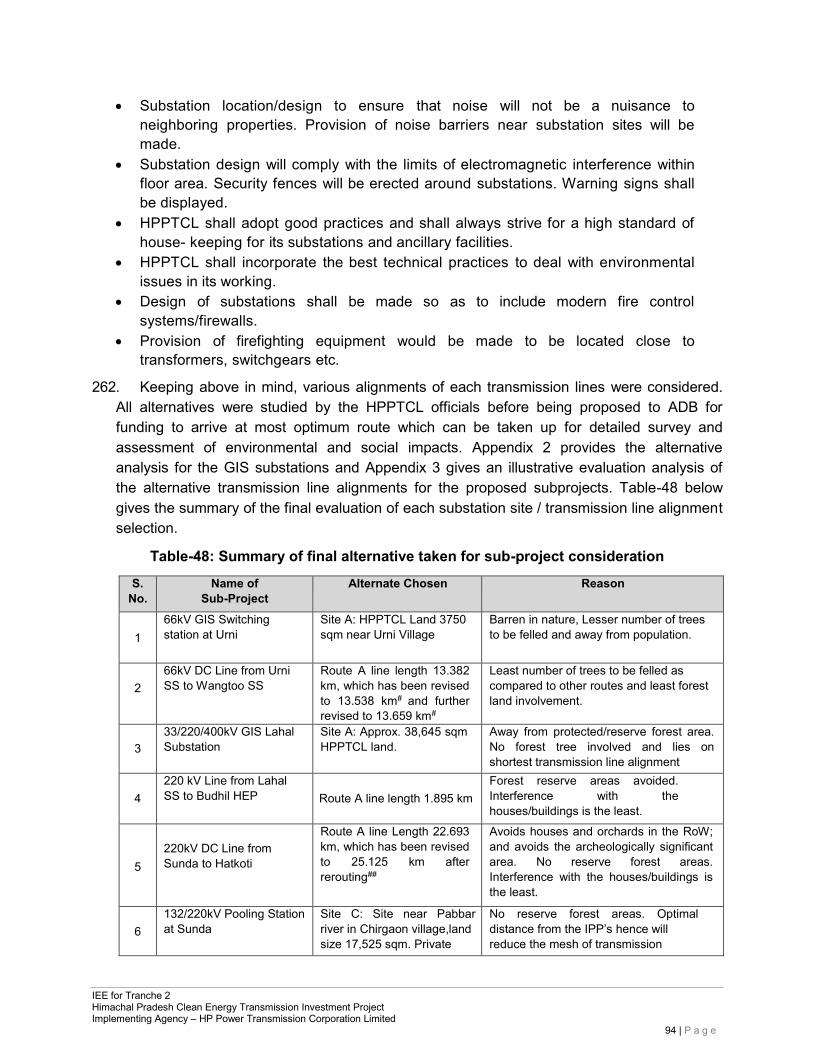
IEE for Tranche 2 Himachal Pradesh Clean Energy Transmission Investment Project Implementing Agency – HP Power Transmission Corporation Limited
94 | P a g e
• Substation location/design to ensure that noise will not be a nuisance to neighboring properties. Provision of noise barriers near substation sites will be made.
• Substation design will comply with the limits of electromagnetic interference within floor area. Security fences will be erected around substations. Warning signs shall be displayed.
• HPPTCL shall adopt good practices and shall always strive for a high standard of house- keeping for its substations and ancillary facilities.
• HPPTCL shall incorporate the best technical practices to deal with environmental issues in its working.
• Design of substations shall be made so as to include modern fire control systems/firewalls.
• Provision of firefighting equipment would be made to be located close to transformers, switchgears etc.
262. Keeping above in mind, various alignments of each transmission lines were considered. All alternatives were studied by the HPPTCL officials before being proposed to ADB for funding to arrive at most optimum route which can be taken up for detailed survey and assessment of environmental and social impacts. Appendix 2 provides the alternative analysis for the GIS substations and Appendix 3 gives an illustrative evaluation analysis of the alternative transmission line alignments for the proposed subprojects. Table-48 below gives the summary of the final evaluation of each substation site / transmission line alignment selection.
Table-48: Summary of final alternative taken for sub-project consideration
S. No.
Name of Sub-Project
Alternate Chosen Reason
1
66kV GIS Switching station at Urni
Site A: HPPTCL Land 3750 sqm near Urni Village
Barren in nature, Lesser number of trees to be felled and away from population.
2
66kV DC Line from Urni SS to Wangtoo SS
Route A line length 13.382 km, which has been revised to 13.538 km# and further revised to 13.659 km#
Least number of trees to be felled as compared to other routes and least forest land involvement.
3
33/220/400kV GIS Lahal Substation
Site A: Approx. 38,645 sqm HPPTCL land.
Away from protected/reserve forest area. No forest tree involved and lies on shortest transmission line alignment
4
220 kV Line from Lahal SS to Budhil HEP
Route A line length 1.895 km
Forest reserve areas avoided. Interference with the houses/buildings is the least.
5
220kV DC Line from Sunda to Hatkoti
Route A line Length 22.693 km, which has been revised to 25.125 km after rerouting##
Avoids houses and orchards in the RoW; and avoids the archeologically significant area. No reserve forest areas. Interference with the houses/buildings is the least.
6
132/220kV Pooling Station at Sunda
Site C: Site near Pabbar river in Chirgaon village,land size 17,525 sqm. Private
No reserve forest areas. Optimal distance from the IPP’s hence will reduce the mesh of transmission
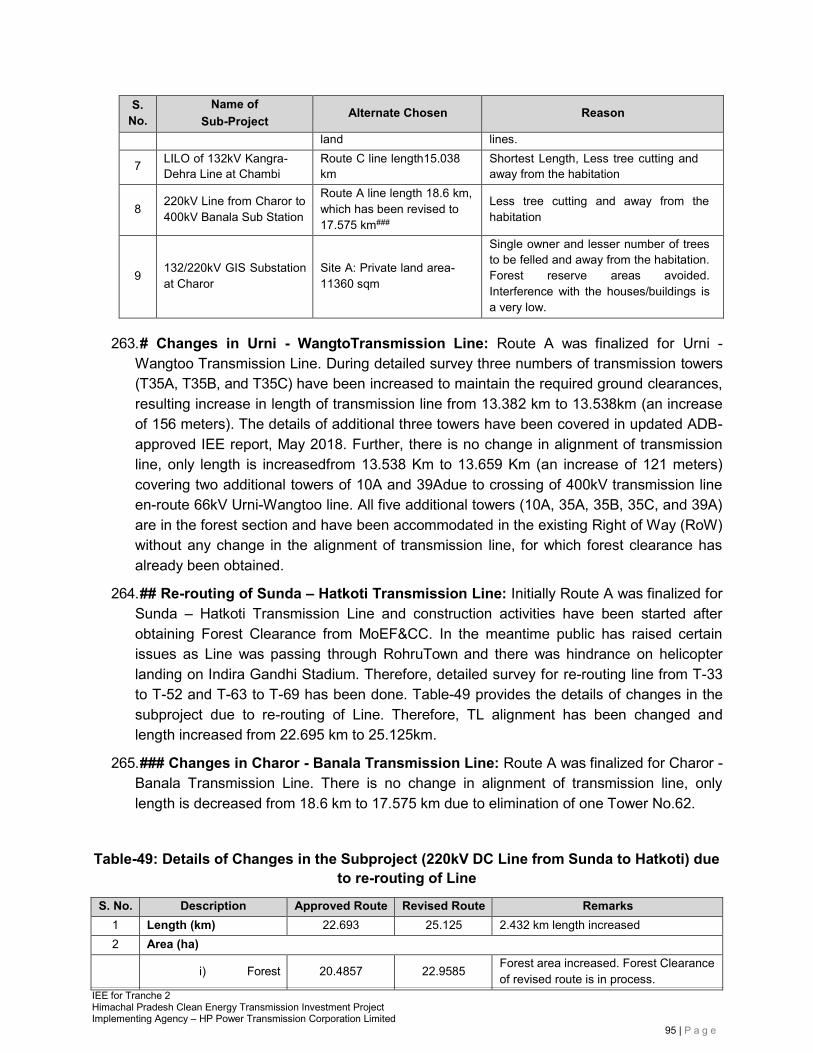
IEE for Tranche 2 Himachal Pradesh Clean Energy Transmission Investment Project Implementing Agency – HP Power Transmission Corporation Limited
95 | P a g e
S. No.
Name of Sub-Project
Alternate Chosen Reason
land lines.
7 LILO of 132kV Kangra- Dehra Line at Chambi
Route C line length15.038 km
Shortest Length, Less tree cutting and away from the habitation
8 220kV Line from Charor to
400kV Banala Sub Station
Route A line length 18.6 km, which has been revised to 17.575 km###
Less tree cutting and away from the habitation
9
132/220kV GIS Substation at Charor
Site A: Private land area- 11360 sqm
Single owner and lesser number of trees to be felled and away from the habitation. Forest reserve areas avoided. Interference with the houses/buildings is a very low.
263. # Changes in Urni - WangtoTransmission Line: Route A was finalized for Urni - Wangtoo Transmission Line. During detailed survey three numbers of transmission towers (T35A, T35B, and T35C) have been increased to maintain the required ground clearances, resulting increase in length of transmission line from 13.382 km to 13.538km (an increase of 156 meters). The details of additional three towers have been covered in updated ADB-approved IEE report, May 2018. Further, there is no change in alignment of transmission line, only length is increasedfrom 13.538 Km to 13.659 Km (an increase of 121 meters) covering two additional towers of 10A and 39Adue to crossing of 400kV transmission line en-route 66kV Urni-Wangtoo line. All five additional towers (10A, 35A, 35B, 35C, and 39A) are in the forest section and have been accommodated in the existing Right of Way (RoW) without any change in the alignment of transmission line, for which forest clearance has already been obtained.
264. ## Re-routing of Sunda – Hatkoti Transmission Line: Initially Route A was finalized for Sunda – Hatkoti Transmission Line and construction activities have been started after obtaining Forest Clearance from MoEF&CC. In the meantime public has raised certain issues as Line was passing through RohruTown and there was hindrance on helicopter landing on Indira Gandhi Stadium. Therefore, detailed survey for re-routing line from T-33 to T-52 and T-63 to T-69 has been done. Table-49 provides the details of changes in the subproject due to re-routing of Line. Therefore, TL alignment has been changed and length increased from 22.695 km to 25.125km.
265. ### Changes in Charor - Banala Transmission Line: Route A was finalized for Charor - Banala Transmission Line. There is no change in alignment of transmission line, only length is decreased from 18.6 km to 17.575 km due to elimination of one Tower No.62.
Table-49: Details of Changes in the Subproject (220kV DC Line from Sunda to Hatkoti) due to re-routing of Line
S. No. Description Approved Route Revised Route Remarks 1 Length (km) 22.693 25.125 2.432 km length increased 2 Area (ha)
i) Forest 20.4857 22.9585 Forest area increased. Forest Clearance of revised route is in process.
IEE for Tranche 2 Himachal Pradesh Clean Energy Transmission Investment Project Implementing Agency – HP Power Transmission Corporation Limited
96 | P a g e
ii) Private 58.9398 64.8518 Area requirement increased.
3 No. of Forest Tree
Cutting 117 81 Number of trees to be cut has been reduced
Non-cutting 13 40 Number of trees coming within RoW (not to be cut) has been increased
4 No. of Fruit Tree
Cutting 56 104 Number of fruit trees to be cut has been increased
Non-cutting 88 132 Number of fruit trees coming within RoW (not to be cut) has been increased
5 No. of Tower 65 69 Number of towers have been increased
6.3.3 Reasons for the FinalSelection
266. Considering the reasons listed above, the proposed substation sites were deemed the best suitable. The alternatives for each substation site were studied by the HPPTCL officials before being proposed to ADB for funding to arrive at most optimum site. These are all Gas Insulated Switchgear (GIS) Stations and all equipment except transformers and reactors if any, shall be housed in GIS buildings. The clearance as earlier shall be mentioned as per Indian Electricity Act (Rules 77 and 80) are being met. HPPTCL is in the process of collecting additional information and has taken up substation sites for detailed survey. These selected options mostly involve no population at the site, lesser cultivated area and minimum acquisition problems and therefore selected for detailed survey as final sites.
267. Considering the selection criteria listed earlier, three transmission line alignments for each subproject were considered. As such these three alternatives were studied by the HPPTCL officials before being proposed to ADB for funding to arrive at most optimum route which will be taken up for detailed survey and assessment of environmental and social impacts. The proposed routes were deemed the best suitable as these involved lesser populated areas, uncultivated areas and minimum RoW problems, hence selected for detailed surveys. These line routes have been selected with least impacts on forests, trees cultivable land and habitation. Wherever possible, the alignments have been proposed either on hilltop-to-hilltop routes or towers with extra heights to reduce the impacts on land underneath while maintaining the mandatory clearance as per Indian Electricity Act (Rules 77 and 80). The proposed alignments pose minimum disturbance to any reserve forests or any sanctuary and national parks in the state.
6.4 Distance from Sensitive Receptors 268. Distance from various receptors is given in Table-50 below:
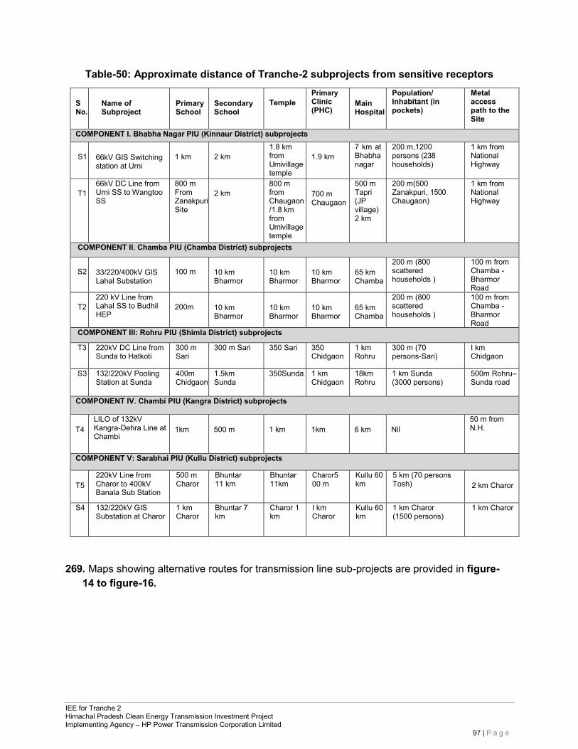
IEE for Tranche 2 Himachal Pradesh Clean Energy Transmission Investment Project Implementing Agency – HP Power Transmission Corporation Limited
97 | P a g e
Table-50: Approximate distance of Tranche-2 subprojects from sensitive receptors
S No.
Name of Subproject
Primary School
Secondary School
Temple
Primary Clinic (PHC)
Main Hospital
Population/ Inhabitant (in pockets)
Metal access path to the Site
COMPONENT I. Bhabha Nagar PIU (Kinnaur District) subprojects
S1
66kV GIS Switching station at Urni
1 km
2 km
1.8 km from Urnivillage temple
1.9 km
7 km at Bhabha nagar
200 m,1200 persons (238 households)
1 km from National Highway
T1
66kV DC Line from Urni SS to Wangtoo SS
800 m From ZanakpuriSite
2 km
800 m from Chaugaon /1.8 km from Urnivillage temple
700 m Chaugaon
500 m Tapri (JP village) 2 km
200 m(500 Zanakpuri, 1500 Chaugaon)
1 km from National Highway
COMPONENT II. Chamba PIU (Chamba District) subprojects
S2
33/220/400kV GIS Lahal Substation
100 m
10 km Bharmor
10 km Bharmor
10 km Bharmor
65 km Chamba
200 m (800 scattered households )
100 m from Chamba - Bharmor Road
T2
220 kV Line from Lahal SS to Budhil HEP
200m
10 km Bharmor
10 km Bharmor
10 km Bharmor
65 km Chamba
200 m (800 scattered households )
100 m from Chamba - Bharmor Road
COMPONENT III: Rohru PIU (Shimla District) subprojects
T3 220kV DC Line from Sunda to Hatkoti
300 m Sari
300 m Sari 350 Sari 350 Chidgaon
1 km Rohru
300 m (70 persons-Sari)
I km Chidgaon
S3 132/220kV Pooling Station at Sunda
400m Chidgaon
1.5km Sunda
350Sunda 1 km Chidgaon
18km Rohru
1 km Sunda (3000 persons)
500m Rohru– Sunda road
COMPONENT IV. Chambi PIU (Kangra District) subprojects
T4
LILO of 132kV Kangra-Dehra Line at Chambi
1km
500 m
1 km
1km
6 km
Nil
50 m from N.H.
COMPONENT V: Sarabhai PIU (Kullu District) subprojects
T5
220kV Line from Charor to 400kV Banala Sub Station
500 m Charor
Bhuntar 11 km
Bhuntar 11km
Charor500 m
Kullu 60 km
5 km (70 persons Tosh)
2 km Charor
S4 132/220kV GIS Substation at Charor
1 km Charor
Bhuntar 7 km
Charor 1 km
I km Charor
Kullu 60 km
1 km Charor (1500 persons)
1 km Charor
269. Maps showing alternative routes for transmission line sub-projects are provided in figure- 14 to figure-16.
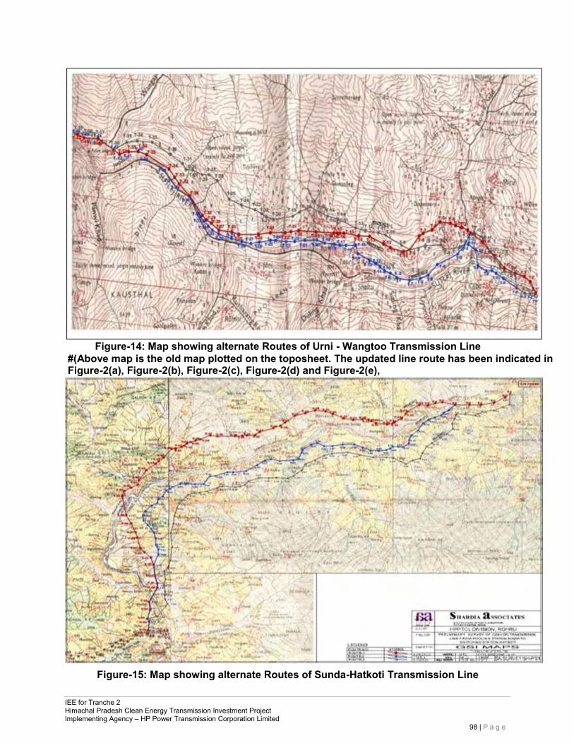
IEE for Tranche 2 Himachal Pradesh Clean Energy Transmission Investment Project Implementing Agency – HP Power Transmission Corporation Limited
98 | P a g e
Figure-14: Map showing alternate Routes of Urni - Wangtoo Transmission Line
#(Above map is the old map plotted on the toposheet. The updated line route has been indicated in Figure-2(a), Figure-2(b), Figure-2(c), Figure-2(d) and Figure-2(e),
Figure-15: Map showing alternate Routes of Sunda-Hatkoti Transmission Line
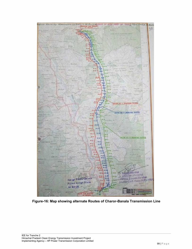
IEE for Tranche 2 Himachal Pradesh Clean Energy Transmission Investment Project Implementing Agency – HP Power Transmission Corporation Limited
99 | P a g e
Figure-16: Map showing alternate Routes of Charor-Banala Transmission Line
IEE for Tranche 2 Himachal Pradesh Clean Energy Transmission Investment Project Implementing Agency – HP Power Transmission Corporation Limited
100 | P a g e
7 INFORMATION DISCLOSURE, CONSULTATION, AND PARTICIPATION
7.1 InformationDisclosure 270. In line with ADB’s Public Communications Policy, HPPTCL is required to ensure
that relevant project information about social and environment safeguard issues is made available during the initial stages to affected people and other stakeholders, including the general public at district headquarters where it is publicly accessible in English, Hindi and any other vernacular local language. ADB and HPPTCL will also post these documents as well as the Environment Assessment and Review Framework Document (EARF) and the IEE on their respective websites.
271. Incorporation of the environmental concerns of APs through the public consultation in the decision making process will avoid or minimise conflict situations during the implementation process as well as enable them to provide meaningful inputs into the project design and its implementation. HPPTCL can conduct public consultation and information disclosure through public meetings andnotice.
272. During the project formulation stage, HPPTCL had conducted a project scoping exercise and reconnaissance survey of the proposed system. Accordingly, during public consultation sessions, considerable dialogue had been held between HPPTCL representatives, individuals, and groups from the community to make them aware of the proposedproject.
273. The project-affected community residing beside the proposed transmission line has already gained a reasonable knowledge about the potential grievances, which may arise in the future. The community was also informed about the Grievance Redressal Mechanism (GRM), which will be followed by HPPTCL as per procedure listed in its Environmental and Social Safeguards Policy May 2011 for making complaints, including the place and the responsible person to contact in thisregard.
274. In line with GoI’s Environmental Impact Assessment (EIA) Notification 2006 (including amendments), public consultation and information disclosure will be undertaken through public notice prior to the approval by MoEF&CC only for Category B1 and A projects (This is not applicable for Tranche-2 project as Environmental Clearance is not required for Tranche-2 subprojects). According to ADB SPS 2009, Category B projects, public consultation and information disclosure is to be made during the initial stages by the client itself. This activity supports the view to understand the public’s perception of the project and respond to their concerns and suggestions during the early stages of the project design. Incorporation on the environmental concerns to the decisionmaking process through the public consultation will avoid or minimise conflict situation during the implementationprocess.
7.2 Public Consultation 275. Public consultations were conducted in project-affected area between February to 30
September 2012 during preparation of IEE. The community aired theiropinionsfreely on the project, its impact,and suggestions for mitigating adverse impacts. People
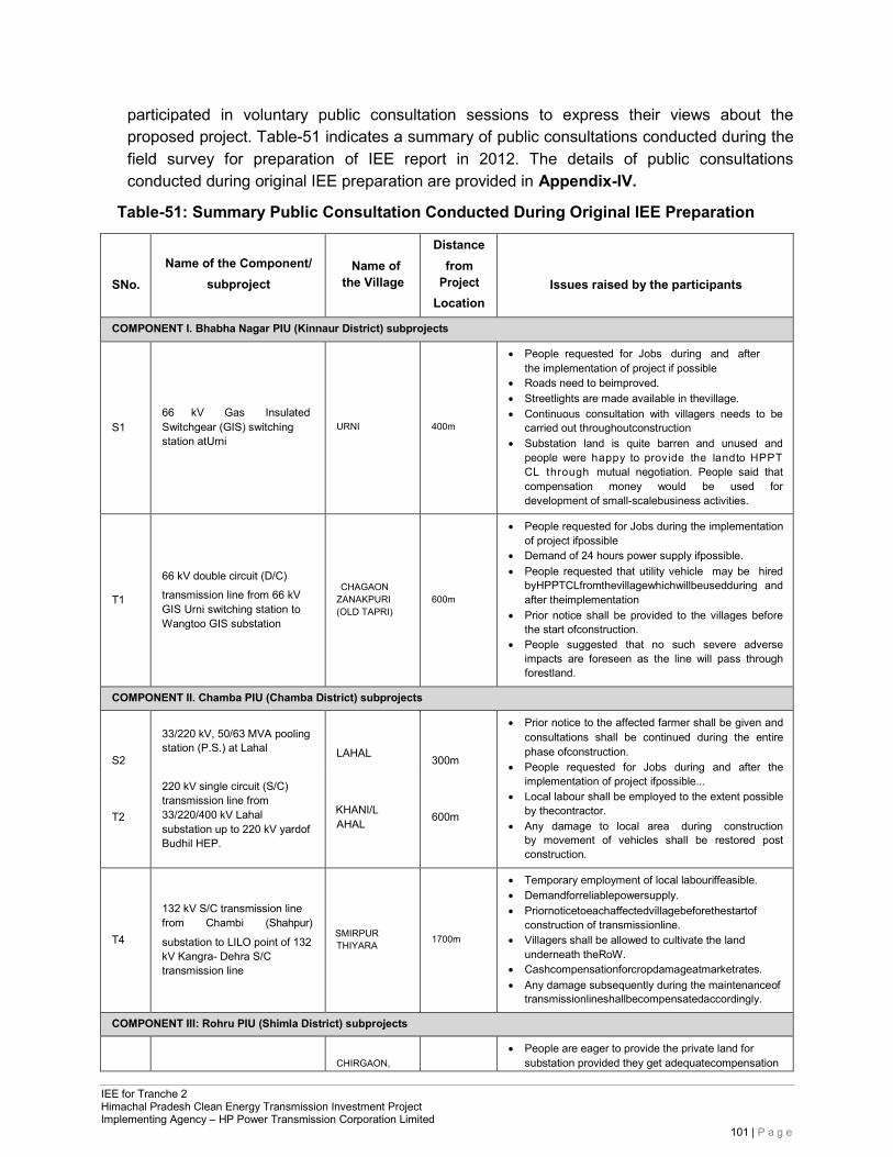
IEE for Tranche 2 Himachal Pradesh Clean Energy Transmission Investment Project Implementing Agency – HP Power Transmission Corporation Limited
101 | P a g e
participated in voluntary public consultation sessions to express their views about the proposed project. Table-51 indicates a summary of public consultations conducted during the field survey for preparation of IEE report in 2012. The details of public consultations conducted during original IEE preparation are provided in Appendix-IV.
Table-51: Summary Public Consultation Conducted During Original IEE Preparation
SNo.
Name of the Component/
subproject
Name of the Village
Distance from
Project Location
Issues raised by the participants
COMPONENT I. Bhabha Nagar PIU (Kinnaur District) subprojects
S1
66 kV Gas Insulated Switchgear (GIS) switching station atUrni
URNI
400m
• People requested for Jobs during and after the implementation of project if possible
• Roads need to beimproved. • Streetlights are made available in thevillage. • Continuous consultation with villagers needs to be
carried out throughoutconstruction • Substation land is quite barren and unused and
people were happy to provide the landto HPPT CL through mutual negotiation. People said that compensation money would be used for development of small-scalebusiness activities.
T1
66 kV double circuit (D/C)
transmission line from 66 kV GIS Urni switching station to Wangtoo GIS substation
CHAGAON ZANAKPURI (OLD TAPRI)
600m
• People requested for Jobs during the implementation of project ifpossible
• Demand of 24 hours power supply ifpossible. • People requested that utility vehicle may be hired
byHPPTCLfromthevillagewhichwillbeusedduring and after theimplementation
• Prior notice shall be provided to the villages before the start ofconstruction.
• People suggested that no such severe adverse impacts are foreseen as the line will pass through forestland.
COMPONENT II. Chamba PIU (Chamba District) subprojects
S2
33/220 kV, 50/63 MVA pooling station (P.S.) at Lahal
LAHAL
300m
• Prior notice to the affected farmer shall be given and consultations shall be continued during the entire phase ofconstruction.
• People requested for Jobs during and after the implementation of project ifpossible...
• Local labour shall be employed to the extent possible by thecontractor.
• Any damage to local area during construction by movement of vehicles shall be restored post construction.
T2
220 kV single circuit (S/C) transmission line from 33/220/400 kV Lahal substation up to 220 kV yardof Budhil HEP.
KHANI/LAHAL
600m
T4
132 kV S/C transmission line from Chambi (Shahpur)
substation to LILO point of 132 kV Kangra- Dehra S/C transmission line
SMIRPUR THIYARA
1700m
• Temporary employment of local labouriffeasible. • Demandforreliablepowersupply. • Priornoticetoeachaffectedvillagebeforethestartof
construction of transmissionline. • Villagers shall be allowed to cultivate the land
underneath theRoW. • Cashcompensationforcropdamageatmarketrates. • Any damage subsequently during the maintenanceof
transmissionlineshallbecompensatedaccordingly.
COMPONENT III: Rohru PIU (Shimla District) subprojects
CHIRGAON,
• People are eager to provide the private land for substation provided they get adequatecompensation
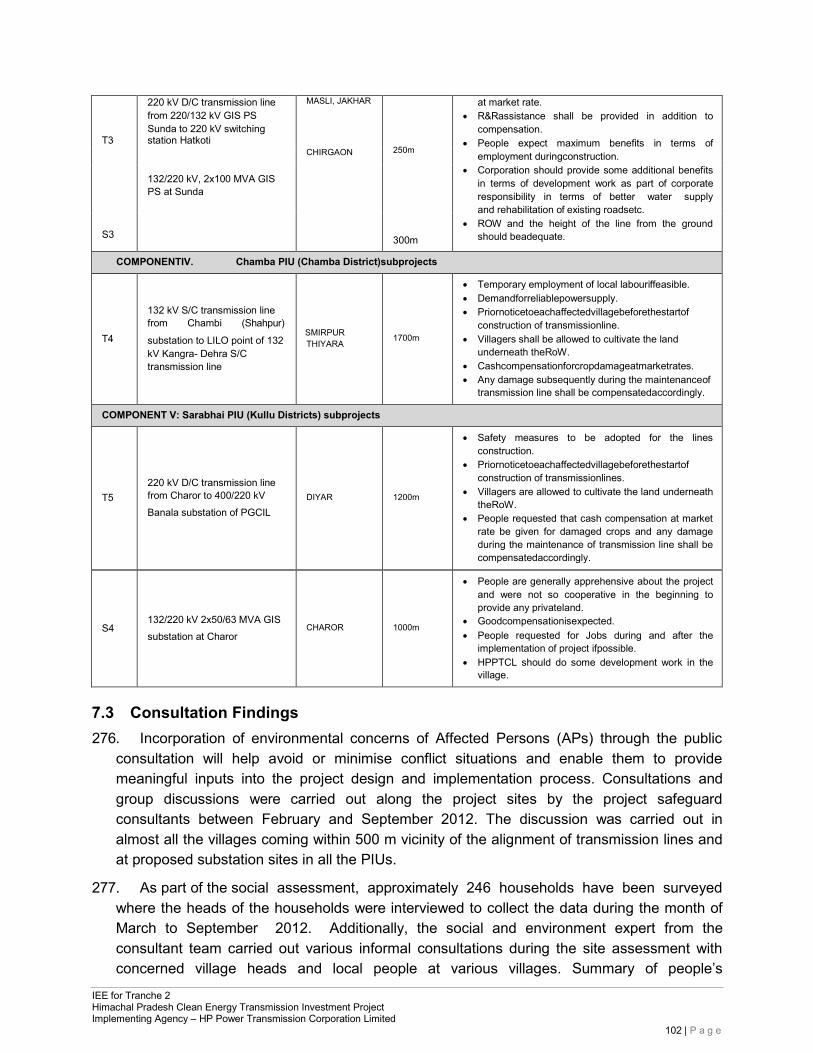
IEE for Tranche 2 Himachal Pradesh Clean Energy Transmission Investment Project Implementing Agency – HP Power Transmission Corporation Limited
102 | P a g e
T3
220 kV D/C transmission line from 220/132 kV GIS PS Sunda to 220 kV switching station Hatkoti
MASLI, JAKHAR
250m
300m
at market rate. • R&Rassistance shall be provided in addition to
compensation. • People expect maximum benefits in terms of
employment duringconstruction. • Corporation should provide some additional benefits
in terms of development work as part of corporate responsibility in terms of better water supply and rehabilitation of existing roadsetc.
• ROW and the height of the line from the ground should beadequate.
CHIRGAON
132/220 kV, 2x100 MVA GIS PS at Sunda
S3
COMPONENTIV. Chamba PIU (Chamba District)subprojects
T4
132 kV S/C transmission line from Chambi (Shahpur)
substation to LILO point of 132 kV Kangra- Dehra S/C transmission line
SMIRPUR THIYARA
1700m
• Temporary employment of local labouriffeasible. • Demandforreliablepowersupply. • Priornoticetoeachaffectedvillagebeforethestartof
construction of transmissionline. • Villagers shall be allowed to cultivate the land
underneath theRoW. • Cashcompensationforcropdamageatmarketrates. • Any damage subsequently during the maintenanceof
transmission line shall be compensatedaccordingly.
COMPONENT V: Sarabhai PIU (Kullu Districts) subprojects
T5
220 kV D/C transmission line from Charor to 400/220 kV Banala substation of PGCIL
DIYAR
1200m
• Safety measures to be adopted for the lines construction.
• Priornoticetoeachaffectedvillagebeforethestartof construction of transmissionlines.
• Villagers are allowed to cultivate the land underneath theRoW.
• People requested that cash compensation at market rate be given for damaged crops and any damage during the maintenance of transmission line shall be compensatedaccordingly.
S4
132/220 kV 2x50/63 MVA GIS substation at Charor
CHAROR
1000m
• People are generally apprehensive about the project and were not so cooperative in the beginning to provide any privateland.
• Goodcompensationisexpected. • People requested for Jobs during and after the
implementation of project ifpossible. • HPPTCL should do some development work in the
village.
7.3 Consultation Findings 276. Incorporation of environmental concerns of Affected Persons (APs) through the public
consultation will help avoid or minimise conflict situations and enable them to provide meaningful inputs into the project design and implementation process. Consultations and group discussions were carried out along the project sites by the project safeguard consultants between February and September 2012. The discussion was carried out in almost all the villages coming within 500 m vicinity of the alignment of transmission lines and at proposed substation sites in all the PIUs.
277. As part of the social assessment, approximately 246 households have been surveyed where the heads of the households were interviewed to collect the data during the month of March to September 2012. Additionally, the social and environment expert from the consultant team carried out various informal consultations during the site assessment with concerned village heads and local people at various villages. Summary of people’s
IEE for Tranche 2 Himachal Pradesh Clean Energy Transmission Investment Project Implementing Agency – HP Power Transmission Corporation Limited
103 | P a g e
perception of the project during the consultation is presented in Appendix-IV. Tables A4.1-12 (inside Appendix 4) lists villages where the consultations were held in the Chamba, Kullu, Mandy, Shimla and Kinnaur Districts. Table A4.13 gives the general perception for all the Tranche-II subprojects.
7.4 Public Consultation during Construction & Updation ofIEE 278. Public Consultation is a continuous process and conducted throughout the project during
design, pre-construction, construction and operation. Consultations have been organized during construction phase as well as separate Public Consultations have been organized during March and April, 2018 for the upadation of IEE report in respect of the subprojects, which have revise scope. Issues discussed during Public Consultations have been provided below and attendance sheet & photographs are provided in Appendix-V.
279. Issues discussed during Public Consultations conducted for updation of IEEreport:
• Most of the people want location of Substation and Transmission Line Route away from the habitation;
• Local people are happy as they are getting business & employment opportunities; • Most of the participant wanted to know about Job & business (supply of
material, labour, etc.) opportunities during construction & operation of project;
• People wanted to know about compensation for land and trees; • Continuous consultation with villagers needs to be carried out throughout
construction;
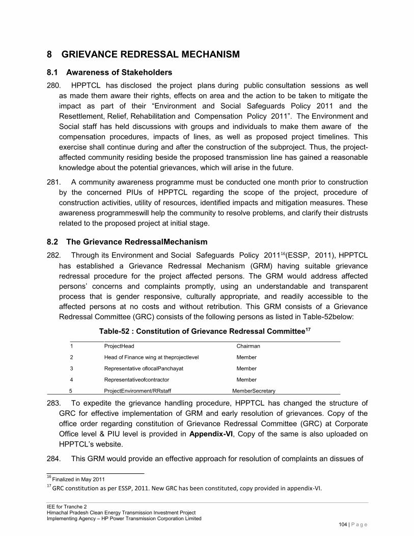
IEE for Tranche 2 Himachal Pradesh Clean Energy Transmission Investment Project Implementing Agency – HP Power Transmission Corporation Limited
104 | P a g e
8 GRIEVANCE REDRESSAL MECHANISM
8.1 Awareness of Stakeholders 280. HPPTCL has disclosed the project plans during public consultation sessions as well
as made them aware their rights, effects on area and the action to be taken to mitigate the impact as part of their “Environment and Social Safeguards Policy 2011 and the Resettlement, Relief, Rehabilitation and Compensation Policy 2011”. The Environment and Social staff has held discussions with groups and individuals to make them aware of the compensation procedures, impacts of lines, as well as proposed project timelines. This exercise shall continue during and after the construction of the subproject. Thus, the project- affected community residing beside the proposed transmission line has gained a reasonable knowledge about the potential grievances, which will arise in the future.
281. A community awareness programme must be conducted one month prior to construction by the concerned PIUs of HPPTCL regarding the scope of the project, procedure of construction activities, utility of resources, identified impacts and mitigation measures. These awareness programmeswill help the community to resolve problems, and clarify their distrusts related to the proposed project at initial stage.
8.2 The Grievance RedressalMechanism 282. Through its Environment and Social Safeguards Policy 201116(ESSP, 2011), HPPTCL
has established a Grievance Redressal Mechanism (GRM) having suitable grievance redressal procedure for the project affected persons. The GRM would address affected persons’ concerns and complaints promptly, using an understandable and transparent process that is gender responsive, culturally appropriate, and readily accessible to the affected persons at no costs and without retribution. This GRM consists of a Grievance Redressal Committee (GRC) consists of the following persons as listed in Table-52below:
Table-52 : Constitution of Grievance Redressal Committee17
1 ProjectHead Chairman
2 Head of Finance wing at theprojectlevel Member
3 Representative oflocalPanchayat Member
4 Representativeofcontractor Member
5 ProjectEnvironment/RRstaff MemberSecretary
283. To expedite the grievance handling procedure, HPPTCL has changed the structure of GRC for effective implementation of GRM and early resolution of grievances. Copy of the office order regarding constitution of Grievance Redressal Committee (GRC) at Corporate Office level & PIU level is provided in Appendix-VI, Copy of the same is also uploaded on HPPTCL’s website.
284. This GRM would provide an effective approach for resolution of complaints an dissues of
16 Finalized in May 2011 17
GRC constitution as per ESSP, 2011. New GRC has been constituted, copy provided in appendix-VI.
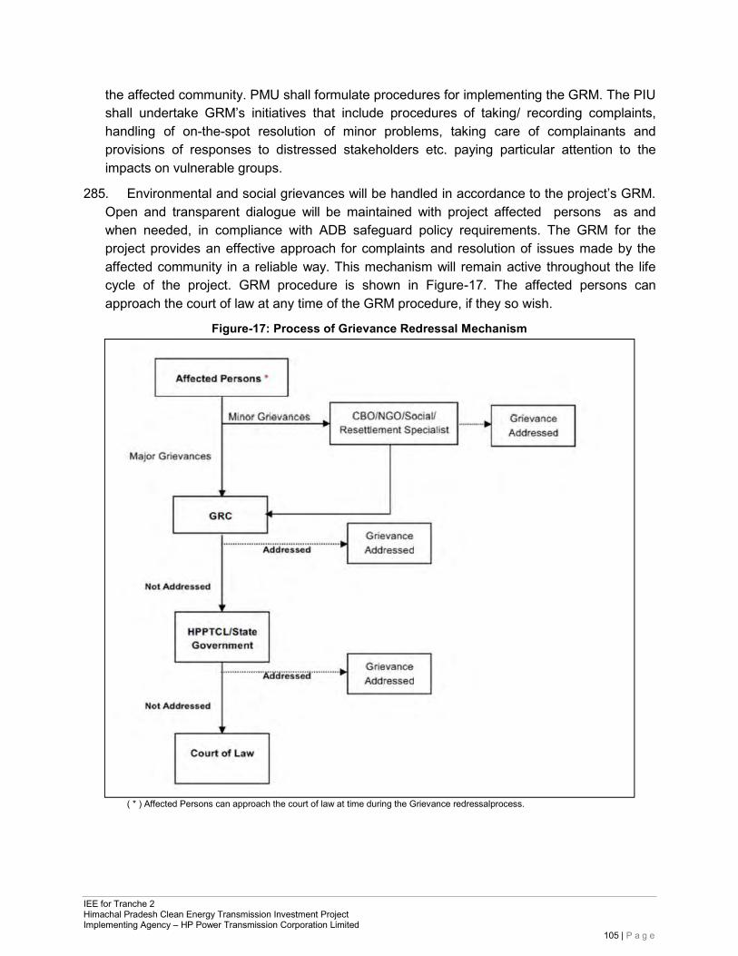
IEE for Tranche 2 Himachal Pradesh Clean Energy Transmission Investment Project Implementing Agency – HP Power Transmission Corporation Limited
105 | P a g e
the affected community. PMU shall formulate procedures for implementing the GRM. The PIU shall undertake GRM’s initiatives that include procedures of taking/ recording complaints, handling of on-the-spot resolution of minor problems, taking care of complainants and provisions of responses to distressed stakeholders etc. paying particular attention to the impacts on vulnerable groups.
285. Environmental and social grievances will be handled in accordance to the project’s GRM. Open and transparent dialogue will be maintained with project affected persons as and when needed, in compliance with ADB safeguard policy requirements. The GRM for the project provides an effective approach for complaints and resolution of issues made by the affected community in a reliable way. This mechanism will remain active throughout the life cycle of the project. GRM procedure is shown in Figure-17. The affected persons can approach the court of law at any time of the GRM procedure, if they so wish.
Figure-17: Process of Grievance Redressal Mechanism
( * ) Affected Persons can approach the court of law at time during the Grievance redressalprocess.
IEE for Tranche 2 Himachal Pradesh Clean Energy Transmission Investment Project Implementing Agency – HP Power Transmission Corporation Limited
106 | P a g e
9 ENVIRONMENTAL MANAGEMENT PLAN
9.1 Institutional Arrangements 286. HPPTCL is state powertransmission utility (STU) licensed to operate in the state of
Himachal Pradesh. HPPTCL is both the Executing Agency (EA) and Implementation Agency (IA) for the project. The Project Management Unit (PMU) at corporate level is headed by Senior Project Manager (Planning) who will be assisted by corresponding personnel from various functions – Administration and Finance, Projects Planning and Design, Procurement and contracts, Environment Cell and Projects Construction. Project Implementation Units (PIUs) at divisional level of the project construction unit are headed by Executive Engineers at five locations – Rohru, Lahal, Chambi, Bhabanagar and Sarabhai (Kullu). PMU structure is shown in Figure-18.
287. The Environment and Social cell (ESC) at the corporate level monitors the policy and implementation related environmental impacts of all projects of HPPTCL. The Environmental Officer in the ESC assists PIUs in all environmental aspects of the projects in compliance with HPPTCL’s Environment and Social Safeguards Policy, May 2011. The Environmental Officer (HPPTCL has designated one Chief Environment & RR Specialist) is assisted by two loan funded Environment and Social consultants. This cell is also responsible for the implementation of Environmental Management Plan for all the subprojects funded by ADB. As per ADB’s Safeguard Policy Statement 2009, PMU and ESC are required to conduct regular monitoring of environmental compliance of each subproject funded by ADB to ensure compliance with project covenants. Structure of ESC constituted by HPPTCL is given in Appendix-VII.
288. The implementation of the EMP during the construction phase is the responsibility of the contractor. The PMU is responsible for ensuring all measures suggested in the EMP are included in the design and bid documents. The PIU in participation with the ESC is also responsible for monitoring and enforcement of the EMP during construction.
289. The duties of the Environmental and Social Cell at corporate level areto:
• Monitor the implementation of mitigation measuresduring construction and operation phases of the project.
• Prepare suitable environmental management reports for various sites. • Advise and coordinate field units activity towards effective environment management. • Liaise with the Ministry of Power, CEA, MoEF. GoHP and state agencies such as
HPPCL, HPPCB, HP Forest Department and seek their help to solve the environment related issues of the project implementation.
• Advice to project planning/design cells on environmental and social issues while route selection of the alignment at the planning/design stage to avoid negative environmental impacts. Similarlyadvise for inclusion of environment and social safeguard provisions in contract documents.
• Advise PIU on training and awareness raising for environmental and social issues to the project/contract staff.
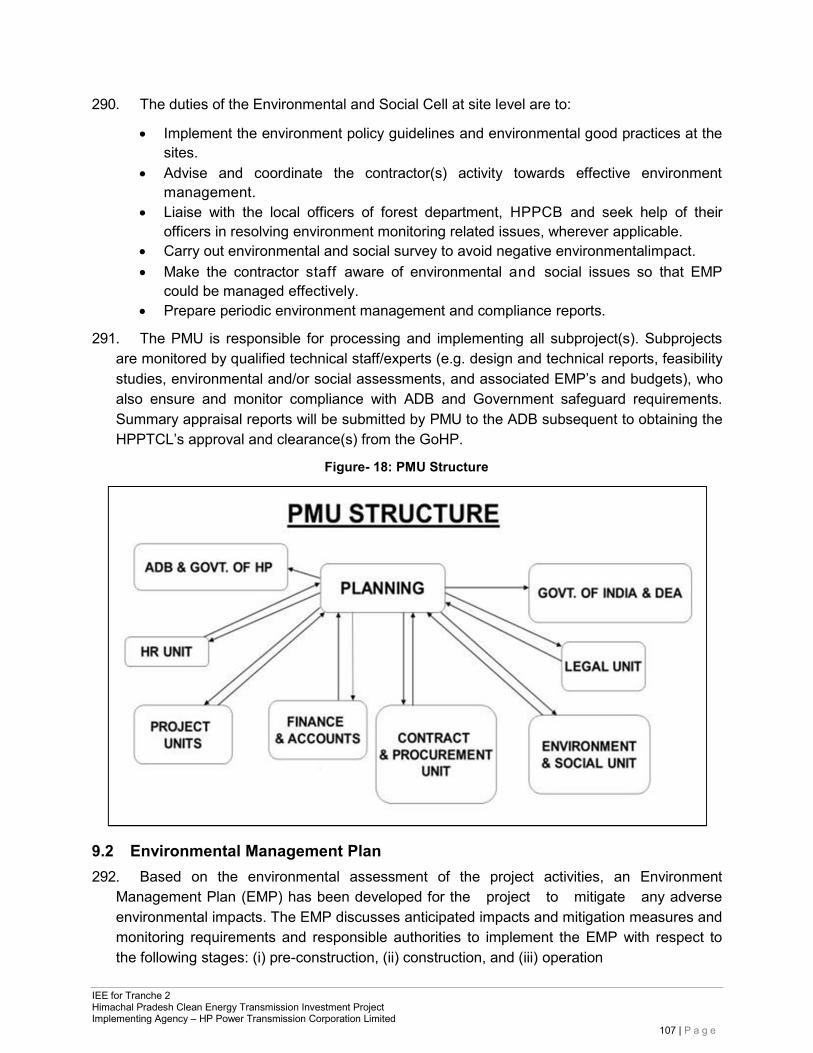
IEE for Tranche 2 Himachal Pradesh Clean Energy Transmission Investment Project Implementing Agency – HP Power Transmission Corporation Limited
107 | P a g e
290. The duties of the Environmental and Social Cell at site level are to:
• Implement the environment policy guidelines and environmental good practices at the sites.
• Advise and coordinate the contractor(s) activity towards effective environment management.
• Liaise with the local officers of forest department, HPPCB and seek help of their officers in resolving environment monitoring related issues, wherever applicable.
• Carry out environmental and social survey to avoid negative environmentalimpact. • Make the contractor staff aware of environmental and social issues so that EMP
could be managed effectively. • Prepare periodic environment management and compliance reports.
291. The PMU is responsible for processing and implementing all subproject(s). Subprojects are monitored by qualified technical staff/experts (e.g. design and technical reports, feasibility studies, environmental and/or social assessments, and associated EMP’s and budgets), who also ensure and monitor compliance with ADB and Government safeguard requirements. Summary appraisal reports will be submitted by PMU to the ADB subsequent to obtaining the HPPTCL’s approval and clearance(s) from the GoHP.
Figure- 18: PMU Structure
9.2 Environmental Management Plan 292. Based on the environmental assessment of the project activities, an Environment
Management Plan (EMP) has been developed for the project to mitigate any adverse environmental impacts. The EMP discusses anticipated impacts and mitigation measures and monitoring requirements and responsible authorities to implement the EMP with respect to the following stages: (i) pre-construction, (ii) construction, and (iii) operation
IEE for Tranche 2 Himachal Pradesh Clean Energy Transmission Investment Project Implementing Agency – HP Power Transmission Corporation Limited
108 | P a g e
and maintenance. Detailed, site-specific mitigation measures and monitoring plans were developed and will be implemented during the project implementation phase.
293. The EMP table for the project is provided in Appendix-IX, which identifies feasible and cost- effective measures to be taken to reduce potential significant, adverse, impacts to acceptable levels. Here, proper mitigation measures are proposed for each potential impact, including details on responsible parties for implementation of mitigation measures and supervision. The subproject specific EMP costs are separately assessed. These EMP will form part of bidding document as well.
9.3 Monitoring of Environmental Management Plan (EMP) 294. The mitigation measures suggested require monitoring of environmental parameters -
both during construction and operational phases of the project. The monitoring of the environmental aspects shall be ensured by the Environment and Social Cell of HPPTCL. During the construction phase, the contractor should ensure that activities like handling of earth works, disposal of debris, storage of materials, labour camps, putting proper traffic signals is done properly to have minimum impact. This in turn should be monitored by the Project Manager of the individual transmission line/substation subproject. The PIU will supervise the contractor. Other environmental good practices include sanitary waste management, noise abatement, maintaining hygienic conditions, maintenance of fire and safety equipment.
295. The Environmental and Social Cell will ensure that site engineers and contractors adhere and comply with all measures and procedures identified in the EMP. Activities to be monitored include: all planning, coordination and management activities related to the implementation of safeguard issues; the identification of corrective and preventive actions; records of health and safety matters and training activities; consultations with project affected people (as and when needed, particularly during the implementation); feedback, trouble shooting and project related grievances; preparation of progress and monitoring reports as required by the ADB; and verifying the projects overall compliance with safeguard measures and its progress towards achieving the intended loan outcomes.
9.4 Environmental Monitoring Plan 296. To ensure that project would not generate negative impacts to the overall environment
quality, monitoring of environmental parameter has to be performed by HPPTCL/Contractor as per contract provisions. The monitoring activities of the project include site supervision, verification of permits, monitoring of water quality, soil, noise and air. Monitoring of the quality of water, soil, air and noise during the construction stage is the responsibility of the contractor by the approved government agency. The Environmental Monitoring Plan for measurement of environmental quality parameters and its periodicity for the Project is summarised in Appendix-X.
9.5 Environmental Monitoring Report (EMR) 297. Mitigation measures related to construction as specified in the EMP will be
incorporated into civil works contracts and their implementation will be primarily the the responsibility of the contractors. In addition, contractors will be required to submit monthly
IEE for Tranche 2 Himachal Pradesh Clean Energy Transmission Investment Project Implementing Agency – HP Power Transmission Corporation Limited
109 | P a g e
progress reports on the implementation of EMP measures to PIU/PMU. The PMU and the HPPTCL will report to the ADB on progress achieved against the EMP activities and milestones on a half-yearly basis. Progress reports will include a description of implementable activities and their status; identify the responsible parties involved in their implementation; and provide project management schedules and timeframes for doing so, along with their associated costs.
298. The Environment and Social Cell after interaction with Project managers of PIUs will prepare and submit performance monitoring reports to the ADB twice in a year. This report will includethe results of environmental monitoring to demonstrate that sound environmental management practices are applied, and the set environments targets are achieved. The environmental monitoring report will be submitted by the PIU to the PMU, which will include the result of environmental monitoring into its environmental report.
299. In case the implementation of EMP measures is not satisfactory, HPPTCL may engage external qualified experts to verify monitoring reports and assess the significant impacts and risks. These external monitoring experts will recommend actions for HPPTCL to enhance environmental compliance. ADB will continue to monitor project compliance with ADB safeguard plans and requirements on an on-going basis throughout the duration of the contract.
9.6 Health and SafetyManagement
9.6.1 Health and SafetyIssues 300. To avoid/minimize inherent risks during construction, operation and maintenance, HPPTCL
has formulated “Environment and Social Safeguards Policy (ESSP) in May 2011” This policy has laid down safety guidelines for EHV substations and lines in operations and maintenance (O&M) and construction areas. Some other implications and mitigations from safety point of view are shown in Table-53 below:
Table-53: Safety Implication and Mitigation
SNo. Implication Mitigation
1 Electromagnetic effect Adequate horizontal and vertical clearances are provided as per Indian Electricity Act rules.
2 Mechanical Factor of safety in tower structure, conductor and insulator is provided
3 Lightning stroke Each tower is provided with ground wire and earthed. Earthing system for permissible step and touch potential in substation design.
4 Ground clearance infringement
No construction is permitted. Land is not allowed to be converted to non- agriculture use. However, there is no restriction on movement of people
9.6.2 Awareness Program 301. Some of the safety awareness activities suchas:
• Public awareness by meeting with villagers, builders, transporters, school s, NGOs/CBOs, and putting up safety posters, safety slogan and advertisement in media.
IEE for Tranche 2 Himachal Pradesh Clean Energy Transmission Investment Project Implementing Agency – HP Power Transmission Corporation Limited
110 | P a g e
• District collector/ electrical inspector/ police department/ local authority approached for removal/ prevention of unauthorized construction nearby EHV transmission lines violating Electricity Act2003.
• Education to workers on Personal Protective Equipment (PPE) and safetytools. • Periodic Health (Regarding HIV/AIDS/STD) &Safety Awareness Programs for
workers.
9.6.3 Safety Audits 302. Safety inspections are done at each PIU in a regular way. Steps neededto follow:
• Checking of safety tools- i. Availability and its presentcondition. ii. Utilization andtesting.
• Check for implementation of safety rules and safety instruction for all substation operation and maintenanceactivities.
• Safety awareness and identifying hazards for various maintenance activities in the switch yard and the transmission lines.
• Precaution to be taken while issuingpermit for the work. • Operation of portable fire extinguishers and their healthiness. • Ensuring electromagnetic field (EMF) is minimised at all transmission line and substation
sites using proper design criteria as per Indian Electricity Actrules.
9.7 Environmental Management Budget 303. The compliance with the EMP has been prepared based upon optimum and reasonable
costs that are derived upon minimisation of mitigation measures on a “least-cost” basis. Without such expenditures, the project might generate significant environmental impacts, causing the biophysical environment in the area to deteriorate and indirectly depressing the economies of local communities. Based upon the environmental issues identified, assessment of the project impact on the environment, EMP cost is estimated to implement the key environmental measures and environmental management & monitoring plan as listed in table-54below.
Table-54: Environmental Management Budget for Tranche-II Sub-projects
S. No.
Description
Quantity
Unit
Rate Amount (in Rs) (in Rs)
A. Environmental Monitoring (Pre-constructionStage) 1 Air Quality 8 No. 7,214 57,712.0 2 Water Quality 8 No. 15,000 120,000.0 3 Noise Levels 8 No. 4,809 38,472.0 4 Soil 8 No. 12,500 100,000.0
Total Cost 3,16,184.0
B. Environmental Monitoring (Construction Stage)
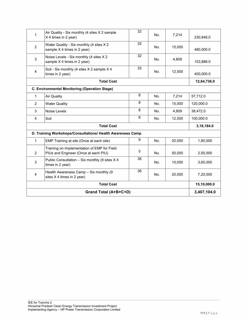
IEE for Tranche 2 Himachal Pradesh Clean Energy Transmission Investment Project Implementing Agency – HP Power Transmission Corporation Limited
111 | P a g e
1 Air Quality - Six monthly (4 sites X 2 sample X 4 times in 2 year)
32 No. 7,214
230,848.0
2 Water Quality - Six monthly (4 sites X 2 sample X 4 times in 2 year)
32 No. 15,000
480,000.0
3 Noise Levels - Six monthly (4 sites X 2 sample X 4 times in 2 year)
32 No. 4,809
153,888.0
4 Soil - Six monthly (4 sites X 2 sample X 4 times in 2 year)
32 No. 12,500
400,000.0
Total Cost 12,64,736.0
C. Environmental Monitoring (Operation Stage)
1 Air Quality 8 No. 7,214 57,712.0
2 Water Quality 8 No. 15,000 120,000.0
3 Noise Levels 8 No. 4,809 38,472.0
4 Soil 8 No. 12,500 100,000.0
Total Cost 3,16,184.0
D. Training Workshops/Consultations/ Health Awareness Camp
1 EMP Training at site (Once at each site) 9 No. 20,000 1,80,000
2
Training on Implementation of EMP for Field PIUs and Engineer (Once at each PIU)
5
No.
50,000
2,50,000
3 Public Consultation – Six monthly (9 sites X 4 times in 2 year)
36 No. 10,000 3,60,000
4 Health Awareness Camp – Six monthly (9 sites X 4 times in 2 year)
36 No. 20,000 7,20,000
Total Cost 15,10,000.0
Grand Total (A+B+C+D) 3,407,104.0
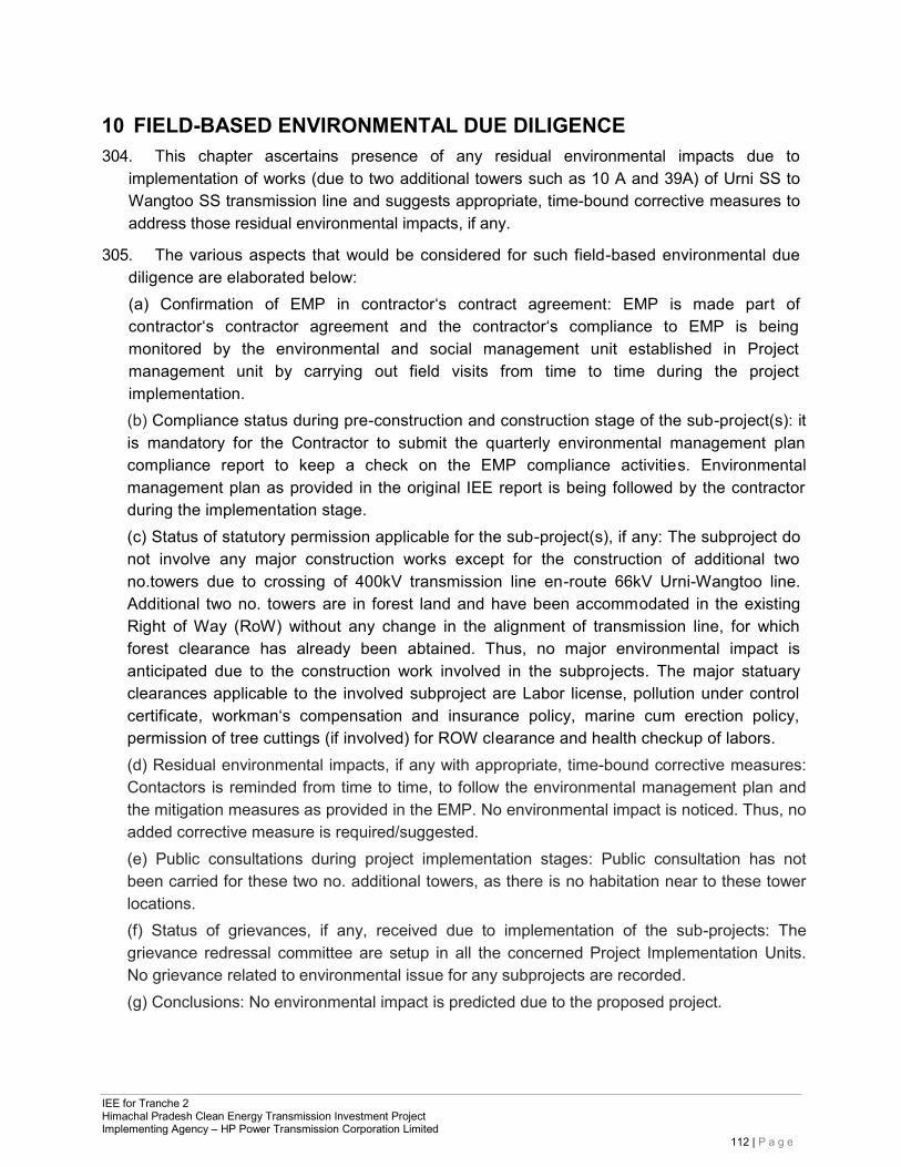
IEE for Tranche 2 Himachal Pradesh Clean Energy Transmission Investment Project Implementing Agency – HP Power Transmission Corporation Limited
112 | P a g e
10 FIELD-BASED ENVIRONMENTAL DUE DILIGENCE 304. This chapter ascertains presence of any residual environmental impacts due to
implementation of works (due to two additional towers such as 10 A and 39A) of Urni SS to Wangtoo SS transmission line and suggests appropriate, time-bound corrective measures to address those residual environmental impacts, if any.
305. The various aspects that would be considered for such field-based environmental due diligence are elaborated below: (a) Confirmation of EMP in contractor‘s contract agreement: EMP is made part of contractor‘s contractor agreement and the contractor‘s compliance to EMP is being monitored by the environmental and social management unit established in Project management unit by carrying out field visits from time to time during the project implementation. (b) Compliance status during pre-construction and construction stage of the sub-project(s): it is mandatory for the Contractor to submit the quarterly environmental management plan compliance report to keep a check on the EMP compliance activities. Environmental management plan as provided in the original IEE report is being followed by the contractor during the implementation stage. (c) Status of statutory permission applicable for the sub-project(s), if any: The subproject do not involve any major construction works except for the construction of additional two no.towers due to crossing of 400kV transmission line en-route 66kV Urni-Wangtoo line. Additional two no. towers are in forest land and have been accommodated in the existing Right of Way (RoW) without any change in the alignment of transmission line, for which forest clearance has already been abtained. Thus, no major environmental impact is anticipated due to the construction work involved in the subprojects. The major statuary clearances applicable to the involved subproject are Labor license, pollution under control certificate, workman‘s compensation and insurance policy, marine cum erection policy, permission of tree cuttings (if involved) for ROW clearance and health checkup of labors. (d) Residual environmental impacts, if any with appropriate, time-bound corrective measures: Contactors is reminded from time to time, to follow the environmental management plan and the mitigation measures as provided in the EMP. No environmental impact is noticed. Thus, no added corrective measure is required/suggested. (e) Public consultations during project implementation stages: Public consultation has not been carried for these two no. additional towers, as there is no habitation near to these tower locations. (f) Status of grievances, if any, received due to implementation of the sub-projects: The grievance redressal committee are setup in all the concerned Project Implementation Units. No grievance related to environmental issue for any subprojects are recorded. (g) Conclusions: No environmental impact is predicted due to the proposed project.
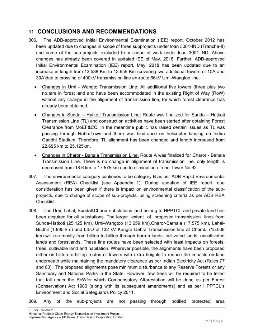
IEE for Tranche 2 Himachal Pradesh Clean Energy Transmission Investment Project Implementing Agency – HP Power Transmission Corporation Limited
113 | P a g e
11 CONCLUSIONS AND RECOMMENDATIONS 306. The ADB-approved Initial Environmental Examination (IEE) report, October 2012 has
been updated due to changes in scope of three subprojects under loan 3001-IND (Tranche-II) and some of the sub-projects excluded from scope of work under loan 3001-IND. Above changes has already been covered in updated IEE of May, 2018. Further, ADB-approved Initial Environmental Examination (IEE) report, May, 2018 has been updated due to an increase in length from 13.538 Km to 13.659 Km (covering two additional towers of 10A and 39A)due to crossing of 400kV transmission line en-route 66kV Urni-Wangtoo line.
• Changes in Urni - Wangto Transmission Line: All additional five towers (three plus two no.)are in forest land and have been accommodated in the existing Right of Way (RoW) without any change in the alignment of transmission line, for which forest clearance has already been obtained.
• Changes in Sunda – Hatkoti Transmission Line: Route was finalized for Sunda – Hatkoti Transmission Line (TL) and construction activities have been started after obtaining Forest Clearance from MoEF&CC. In the meantime public has raised certain issues as TL was passing through RohruTown and there was hindrance on helicopter landing on Indira Gandhi Stadium. Therefore, TL alignment has been changed and length increased from 22.695 km to 25.125km.
• Changes in Charor - Banala Transmission Line: Route A was finalized for Charor - Banala Transmission Line. There is no change in alignment of transmission line, only length is decreased from 18.6 km to 17.575 km due to elimination of one Tower No.62.
307. The environmental category continues to be category B as per ADB Rapid Environmental Assessment (REA) Checklist (see Appendix 1). During updation of IEE report, due consideration has been given if there is impact on environmental classification of the sub-projects, due to change of scope of sub-projects, using screening criteria as per ADB REA Checklist.
308. The Urni, Lahal, Sunda&Charor substations land belong to HPPTCL and private land has been acquired for all substations. The larger extent of proposed transmission lines from Sunda-Hatkoti (25.125 km), Urni-Wangtoo (13.659 km),Charor-Barnala (17.575 km), Lahal- Budhil (1.895 km) and LILO of 132 kV Kangra Dehra Transmission line at Chambi (15.038 km) will run mostly from hilltop to hilltop through barren lands, cultivated lands, uncultivated lands and forestlands. These line routes have been selected with least impacts on forests, trees, cultivable land and habitation. Wherever possible, the alignments have been proposed either on hilltop-to-hilltop routes or towers with extra heights to reduce the impacts on land underneath while maintaining the mandatory clearance as per Indian Electricity Act (Rules 77 and 80). The proposed alignments pose minimum disturbance to any Reserve Forests or any Sanctuary and National Parks in the State. However, few trees will be required to be felled that fall under the RoWfor which Compensatory Afforestation will be done as per Forest (Conservation) Act 1980 (along with its subsequent amendments) and as per HPPTCL’s Environment and Social Safeguards Policy 2011.
309. Any of the sub-projects are not passing through notified protected area
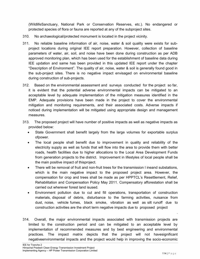
IEE for Tranche 2 Himachal Pradesh Clean Energy Transmission Investment Project Implementing Agency – HP Power Transmission Corporation Limited
114 | P a g e
(WildlifeSanctuary, National Park or Conservation Reserves, etc.). No endangered or protected species of flora or fauna are reported at any of the subproject sites.
310. No archaeological/protected monument is located in the project vicinity.
311. No reliable baseline information of air, noise, water & soil quality were exists for sub- project locations during original IEE report preparation. However, collection of baseline parameters of water, air, soil, and noise have been done during construction as per ADB approved monitoring plan, which has been used for the establishment of baseline data during IEE updation and same has been provided in this updated IEE report under the chapter “Description of Environment”. The quality of air, noise, water & soil is generally found good in the sub-project sites. There is no negative impact envisaged on environmental baseline during construction of sub-projects.
312. Based on the environmental assessment and surveys conducted for the project so far, it is evident that the potential adverse environmental impacts can be mitigated to an acceptable level by adequate implementation of the mitigation measures identified in the EMP. Adequate provisions have been made in the project to cover the environmental mitigation and monitoring requirements, and their associated costs. Adverse impacts if noticed during implementation will be mitigated using appropriate design and management measures.
313. The proposed project will have number of positive impacts as well as negative impacts as provided below: • State Government shall benefit largely from the large volumes for exportable surplus
ofpower. • The local people shall benefit due to improvement in quality and reliability of the
electricity supply as well as funds that will flow into the area to provide them with better roads, health facilities due to higher allocations to the Local Area Development Funds from generation projects to the district. Improvement in lifestyles of local people shall be the main positive impact of thisproject.
• There will be removal of fruit and non-fruit trees for the transmission l ineand substations, which is the main negative impact to the proposed project area. However, the compensation for crop and trees shall be made as per HPPTCL’s Resettlement, Relief, Rehabilitation and Compensation Policy May 2011. Compensatory afforestation shall be carried out wherever forest land isused.
• Environment pollution due to cut and fill operations, transportation of construction materials, disposal of debris, disturbance to the farming activities, nuisance from dust, noise, vehicle fumes, black smoke, vibration as well as silt runoff due to construction activities are the short term negative impacts due to proposed project
.
314. Overall, the major environmental impacts associated with transmission projects are limited to the construction period and can be mitigated to an acceptable level by implementation of recommended measures and by best engineering and environmental practices. The impact matrix depicts that the project will not havesignificant negativeenvironmental impacts and the project would help in improving the socio-economic
IEE for Tranche 2 Himachal Pradesh Clean Energy Transmission Investment Project Implementing Agency – HP Power Transmission Corporation Limited
115 | P a g e
conditions of this developing State. As the project falls in Category “B” as per the ADB’s REA checklist even after change in scope of sub-projects, no detailed EIA study is required.
315. Public consultations with the project affected communities, stakeholders, and government officers focused on existing environmental conditions around the proposed transmission lines/ substations and the potential impacts that could happen due to project implementation have been completed. Public Consultation is a continuous process and conducted throughout the project during design, pre-construction, construction an operation. Consultations have been organized during construction phase as well as separate Public Consultations have been organized during March &April, 2018 for the upadation of IEE report in respect of the subprojects, which have revise scope. Main issues of consultation were – i) People want location of Substation and Transmission Line Route away from the habitation; ii) People wanted to know about Job & business (supply of material, labour, etc.) opportunities during construction & operation of project; iii) People wanted to know about compensation for land and trees. There are no other significant environmental issues which have been raised by people during consultation.
316. Proper Grievance Redressal Mechanism (GRM) has been implemented by HPPTCL to overcome public inconvenience during the sub-project activities. Copy of the office order regarding constitution of Grievance Redressal Committee (GRC) at Corporate Office level & PIU level is provided in Appendix-VI, Copy of the same is also uploaded on HPPTCL’s website.
317. The Initial Environment Examination (IEE) ascertains that it is unlikely to cause any significant environmental impacts. Few impacts were identified attributable to the proposed sub-projects. Proper mitigation measures have been suggested and incorporated in the Environmental Management Plan to avoid / minimize these anticipatedimpacts.
318. The Executing Agency (HPPTCL) shall ensure that EMP forms part of bid document and works contract. The same shall be revised if necessary during project implementation or if there is any change in the project design and with approval of ADB.
319. If there will be any change / revision in scope of Tranche-II sub-projects, this updated IEE report shall be further updated accordingly or addendum to updated IEE report shall be prepared and submitted to ADB for approval.

IEE for Tranche 2 Himachal Pradesh Clean Energy Transmission Investment Project Implementing Agency – HP Power Transmission Corporation Limited
116 | P a g e
APPENDICES
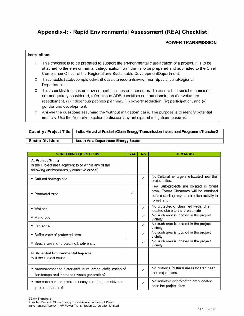
IEE for Tranche 2 Himachal Pradesh Clean Energy Transmission Investment Project Implementing Agency – HP Power Transmission Corporation Limited
117 | P a g e
Instructions:
◻ This checklist is to be prepared to support the environmental classification of a project. It is to be attached to the environmental categorization form that is to be prepared and submitted to the Chief Compliance Officer of the Regional and Sustainable DevelopmentDepartment.
◻ ThischecklististobecompletedwiththeassistanceofanEnvironmentSpecialistinaRegional Department.
◻ This checklist focuses on environmental issues and concerns. To ensure that social dimensions are adequately considered, refer also to ADB checklists and handbooks on (i) involuntary resettlement, (ii) indigenous peoples planning, (iii) poverty reduction, (iv) participation, and (v) gender and development.
◻ Answer the questions assuming the “without mitigation” case. The purpose is to identify potential impacts. Use the “remarks” section to discuss any anticipated mitigationmeasures.
Appendix-I: - Rapid Environmental Assessment (REA) Checklist
POWER TRANSMISSION
Country / Project Title: India: Himachal Pradesh Clean Energy Transmission Investment ProgrammeTranche-2
Sector Division: South Asia Department Energy Sector
SCREENING QUESTIONS Yes No REMARKS A. Project Siting Is the Project area adjacent to or within any of the following environmentally sensitive areas?
- Cultural heritage site
No Cultural heritage site located near the project sites.
- Protected Area
Few Sub-projects are located in forest area. Forest Clearance will be obtained before starting any construction activity in forest land.
- Wetland
No protected or classified wetland is located close to the project site
- Mangrove
No such area is located in the project vicinity.
- Estuarine
No such area is located in the project vicinity.
- Buffer zone of protected area
No such area is located in the project vicinity.
- Special area for protecting biodiversity
No such area is located in the project vicinity.
B. Potential Environmental Impacts Will the Project cause...
- encroachment on historical/cultural areas, disfiguration of landscape and increased waste generation?
No historical/cultural areas located near the project sites.
- encroachment on precious ecosystem (e.g. sensitive or protected areas)?
No sensitive or protected area located near the project sites.
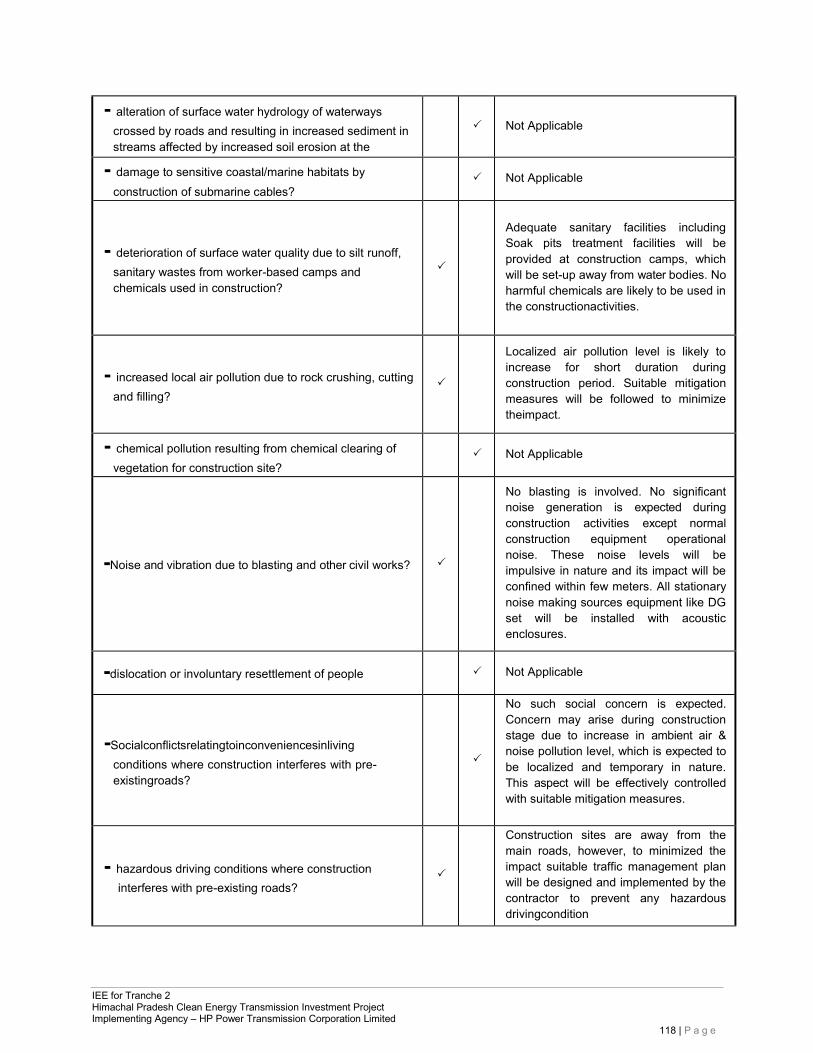
IEE for Tranche 2 Himachal Pradesh Clean Energy Transmission Investment Project Implementing Agency – HP Power Transmission Corporation Limited
118 | P a g e
- alteration of surface water hydrology of waterways crossed by roads and resulting in increased sediment in streams affected by increased soil erosion at the
Not Applicable
- damage to sensitive coastal/marine habitats by construction of submarine cables?
Not Applicable
- deterioration of surface water quality due to silt runoff,
sanitary wastes from worker-based camps and chemicals used in construction?
Adequate sanitary facilities including Soak pits treatment facilities will be provided at construction camps, which will be set-up away from water bodies. No harmful chemicals are likely to be used in the constructionactivities.
- increased local air pollution due to rock crushing, cutting and filling?
Localized air pollution level is likely to increase for short duration during construction period. Suitable mitigation measures will be followed to minimize theimpact.
- chemical pollution resulting from chemical clearing of vegetation for construction site?
Not Applicable
-Noise and vibration due to blasting and other civil works?
No blasting is involved. No significant noise generation is expected during construction activities except normal construction equipment operational noise. These noise levels will be impulsive in nature and its impact will be confined within few meters. All stationary noise making sources equipment like DG set will be installed with acoustic enclosures.
-dislocation or involuntary resettlement of people
Not Applicable
-Socialconflictsrelatingtoinconveniencesinliving
conditions where construction interferes with pre- existingroads?
No such social concern is expected. Concern may arise during construction stage due to increase in ambient air & noise pollution level, which is expected to be localized and temporary in nature. This aspect will be effectively controlled with suitable mitigation measures.
- hazardous driving conditions where construction interferes with pre-existing roads?
Construction sites are away from the main roads, however, to minimized the impact suitable traffic management plan will be designed and implemented by the contractor to prevent any hazardous drivingcondition
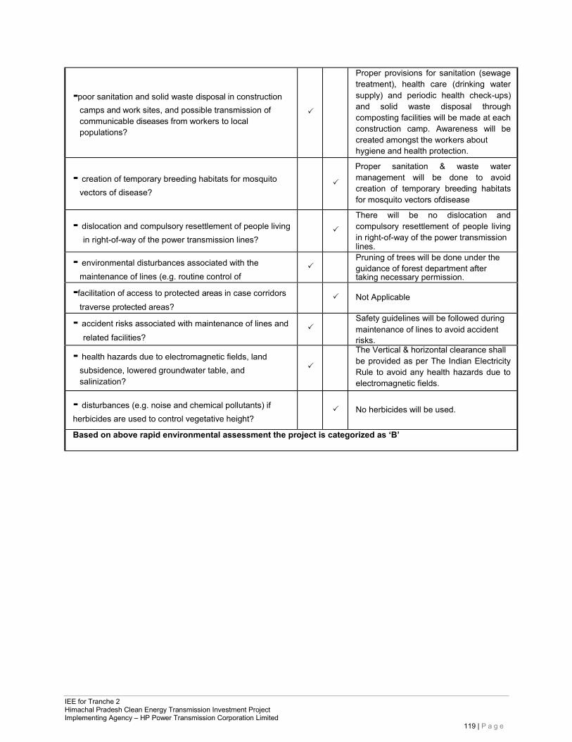
IEE for Tranche 2 Himachal Pradesh Clean Energy Transmission Investment Project Implementing Agency – HP Power Transmission Corporation Limited
119 | P a g e
-poor sanitation and solid waste disposal in construction camps and work sites, and possible transmission of communicable diseases from workers to local populations?
Proper provisions for sanitation (sewage treatment), health care (drinking water supply) and periodic health check-ups) and solid waste disposal through composting facilities will be made at each construction camp. Awareness will be created amongst the workers about hygiene and health protection.
- creation of temporary breeding habitats for mosquito vectors of disease?
Proper sanitation & waste water management will be done to avoid creation of temporary breeding habitats for mosquito vectors ofdisease
- dislocation and compulsory resettlement of people living in right-of-way of the power transmission lines?
There will be no dislocation and compulsory resettlement of people living in right-of-way of the power transmission lines.
- environmental disturbances associated with the maintenance of lines (e.g. routine control of
Pruning of trees will be done under the guidance of forest department after taking necessary permission.
-facilitation of access to protected areas in case corridors traverse protected areas?
Not Applicable
- accident risks associated with maintenance of lines and related facilities?
Safety guidelines will be followed during maintenance of lines to avoid accident risks.
- health hazards due to electromagnetic fields, land subsidence, lowered groundwater table, and salinization?
The Vertical & horizontal clearance shall be provided as per The Indian Electricity Rule to avoid any health hazards due to electromagnetic fields.
- disturbances (e.g. noise and chemical pollutants) if herbicides are used to control vegetative height?
No herbicides will be used.
Based on above rapid environmental assessment the project is categorized as ‘B’
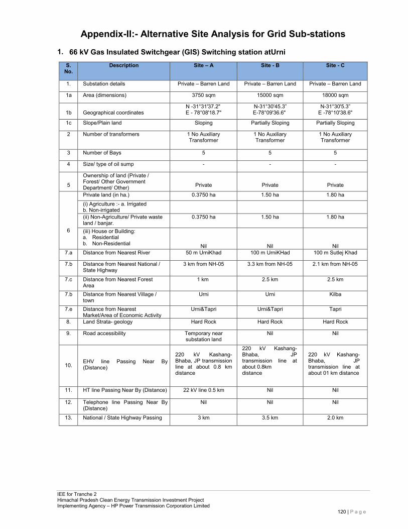
IEE for Tranche 2 Himachal Pradesh Clean Energy Transmission Investment Project Implementing Agency – HP Power Transmission Corporation Limited
120 | P a g e
Appendix-II:- Alternative Site Analysis for Grid Sub-stations
1. 66 kV Gas Insulated Switchgear (GIS) Switching station atUrni
S. No.
Description Site – A Site - B Site - C
1. Substation details Private – Barren Land Private – Barren Land Private – Barren Land
1a Area (dimensions) 3750 sqm 15000 sqm 18000 sqm
1b
Geographical coordinates
N -31°31'37.2" E - 78°08'18.7"
N-31°30'45.3” E-78°09'36.6"
N-31°30'5.3” E -78°10'38.6"
1c Slope/Plain land Sloping Partially Sloping Partially Sloping
2 Number of transformers 1 No Auxiliary Transformer
1 No Auxiliary Transformer
1 No Auxiliary Transformer
3 Number of Bays 5 5 5
4 Size/ type of oil sump - - -
5
Ownership of land (Private / Forest/ Other Government Department/ Other)
Private
Private
Private
6
Private land (in ha.) 0.3750 ha 1.50 ha 1.80 ha (i) Agriculture :- a. Irrigated b. Non-irrigated
(ii) Non-Agriculture/ Private waste land / banjar.
0.3750 ha 1.50 ha 1.80 ha
(iii) House or Building: a. Residential b. Non-Residential
Nil
Nil
Nil 7.a Distance from Nearest River 50 m UrniKhad 100 m UrniKHad 100 m Sutlej Khad
7.b Distance from Nearest National / State Highway
3 km from NH-05 3.3 km from NH-05 2.1 km from NH-05
7.c Distance from Nearest Forest Area
1 km 2.5 km 2.5 km
7.b Distance from Nearest Village / town
Urni Urni Kilba
7.e Distance from Nearest Market/Area of Economic Activity
Urni&Tapri Urni&Tapri Tapri
8. Land Strata- geology Hard Rock Hard Rock Hard Rock
9. Road accessibility Temporary near substation land
Nil Nil
10.
EHV line Passing Near By (Distance)
220 kV Kashang- Bhaba, JP transmission line at about 0.8 km distance
220 kV Kashang- Bhaba, JP transmission line at about 0.8km distance
220 kV Kashang- Bhaba, JP transmission line at about 01 km distance
11. HT line Passing Near By (Distance) 22 kV line 0.5 km Nil Nil
12. Telephone line Passing Near By (Distance)
Nil Nil Nil
13. National / State Highway Passing 3 km 3.5 km 2.0 km
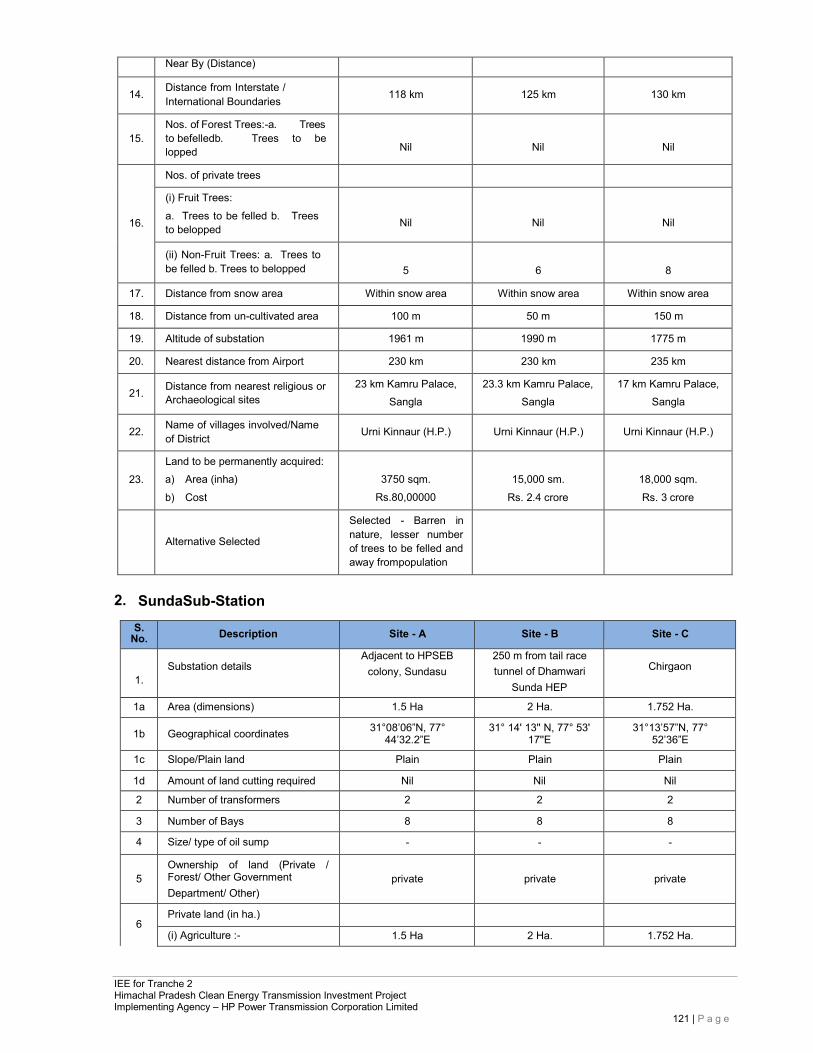
IEE for Tranche 2 Himachal Pradesh Clean Energy Transmission Investment Project Implementing Agency – HP Power Transmission Corporation Limited
121 | P a g e
Near By (Distance)
14. Distance from Interstate / International Boundaries 118 km 125 km 130 km
15.
Nos. of Forest Trees:-a. Trees to befelledb. Trees to be lopped
Nil
Nil
Nil
16.
Nos. of private trees
(i) Fruit Trees: a. Trees to be felled b. Trees to belopped
Nil
Nil
Nil
(ii) Non-Fruit Trees: a. Trees to be felled b. Trees to belopped
5
6
8
17. Distance from snow area Within snow area Within snow area Within snow area
18. Distance from un-cultivated area 100 m 50 m 150 m
19. Altitude of substation 1961 m 1990 m 1775 m
20. Nearest distance from Airport 230 km 230 km 235 km
21. Distance from nearest religious or
Archaeological sites 23 km Kamru Palace,
Sangla 23.3 km Kamru Palace,
Sangla 17 km Kamru Palace,
Sangla
22. Name of villages involved/Name of District Urni Kinnaur (H.P.) Urni Kinnaur (H.P.) Urni Kinnaur (H.P.)
23.
Land to be permanently acquired: a) Area (inha) b) Cost
3750 sqm.
Rs.80,00000
15,000 sm.
Rs. 2.4 crore
18,000 sqm. Rs. 3 crore
Alternative Selected
Selected - Barren in nature, lesser number of trees to be felled and away frompopulation
2. SundaSub-Station
S. No. Description Site - A Site - B Site - C
1. Substation details
Adjacent to HPSEB colony, Sundasu
250 m from tail race tunnel of Dhamwari
Sunda HEP
Chirgaon
1a Area (dimensions) 1.5 Ha 2 Ha. 1.752 Ha.
1b Geographical coordinates 31°08’06”N, 77° 44’32.2”E
31° 14' 13'' N, 77° 53' 17''E
31°13’57”N, 77° 52’36”E
1c Slope/Plain land Plain Plain Plain
1d Amount of land cutting required Nil Nil Nil
2 Number of transformers 2 2 2
3 Number of Bays 8 8 8
4 Size/ type of oil sump - - -
5
Ownership of land (Private / Forest/ Other Government Department/ Other)
private
private
private
6
Private land (in ha.)
(i) Agriculture :- 1.5 Ha 2 Ha. 1.752 Ha.
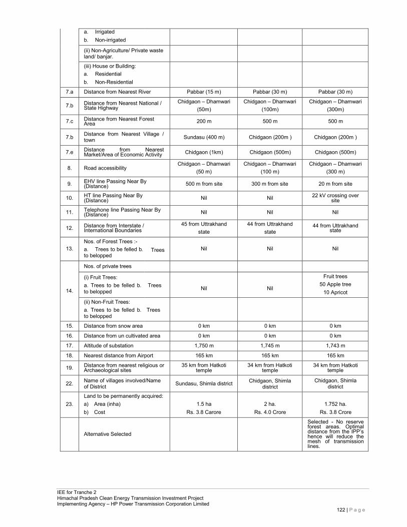
IEE for Tranche 2 Himachal Pradesh Clean Energy Transmission Investment Project Implementing Agency – HP Power Transmission Corporation Limited
122 | P a g e
a. b.
Irrigated Non-irrigated
(ii) Non-Agriculture/ Private waste land/ banjar.
(iii) House or Building: a. Residential b. Non-Residential
7.a Distance from Nearest River Pabbar (15 m) Pabbar (30 m) Pabbar (30 m)
7.b Distance from Nearest National / State Highway
Chidgaon – Dhamwari (50m)
Chidgaon – Dhamwari (100m)
Chidgaon – Dhamwari (300m)
7.c Distance from Nearest Forest Area 200 m 500 m 500 m
7.b Distance from Nearest Village / town Sundasu (400 m) Chidgaon (200m ) Chidgaon (200m )
7.e Distance from Nearest Market/Area of Economic Activity Chidgaon (1km) Chidgaon (500m) Chidgaon (500m)
8. Road accessibility Chidgaon – Dhamwari
(50 m) Chidgaon – Dhamwari
(100 m) Chidgaon – Dhamwari
(300 m)
9. EHV line Passing Near By (Distance) 500 m from site 300 m from site 20 m from site
10. HT line Passing Near By (Distance) Nil Nil 22 kV crossing over
site
11. Telephone line Passing Near By (Distance) Nil Nil Nil
12. Distance from Interstate / International Boundaries
45 from Uttrakhand state
44 from Uttrakhand state
44 from Uttrakhand state
13.
Nos. of Forest Trees :- a. Trees to be felled b. to belopped
Trees
Nil
Nil
Nil
14.
Nos. of private trees
(i) Fruit Trees: a. Trees to be felled b. to belopped
Trees
Nil
Nil
Fruit trees 50 Apple tree
10 Apricot
(ii) Non-Fruit Trees: a. Trees to be felled b. to belopped
Trees
15. Distance from snow area 0 km 0 km 0 km
16. Distance from un cultivated area 0 km 0 km 0 km
17. Altitude of substation 1,750 m 1,745 m 1,743 m
18. Nearest distance from Airport 165 km 165 km 165 km
19. Distance from nearest religious or Archaeological sites
35 km from Hatkoti temple
34 km from Hatkoti temple
34 km from Hatkoti temple
22. Name of villages involved/Name of District Sundasu, Shimla district Chidgaon, Shimla
district Chidgaon, Shimla
district
23.
Land to be permanently acquired: a) Area (inha) b) Cost
1.5 ha
Rs. 3.8 Carore
2 ha.
Rs. 4.0 Crore
1.752 ha.
Rs. 3.8 Crore
Alternative Selected
Selected - No reserve forest areas. Optimal distance from the IPP’s hence will reduce the mesh of transmission lines.
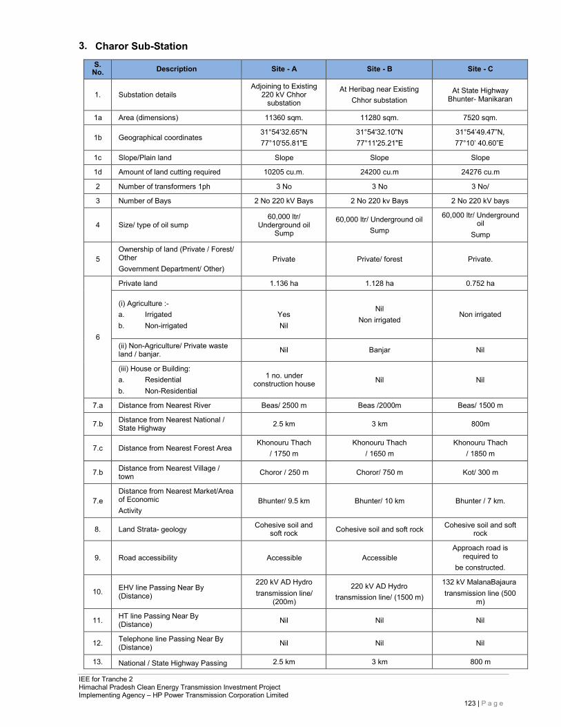
IEE for Tranche 2 Himachal Pradesh Clean Energy Transmission Investment Project Implementing Agency – HP Power Transmission Corporation Limited
123 | P a g e
3. Charor Sub-Station
S. No. Description Site - A Site - B Site - C
1.
Substation details
Adjoining to Existing 220 kV Chhor
substation
At Heribag near Existing Chhor substation
At State Highway Bhunter- Manikaran
1a Area (dimensions) 11360 sqm. 11280 sqm. 7520 sqm.
1b
Geographical coordinates 31°54'32.65"N 77°10'55.81"E
31°54'32.10"N 77°11'25.21"E
31°54’49.47”N, 77°10’ 40.60”E
1c Slope/Plain land Slope Slope Slope
1d Amount of land cutting required 10205 cu.m. 24200 cu.m 24276 cu.m
2 Number of transformers 1ph 3 No 3 No 3 No/
3 Number of Bays 2 No 220 kV Bays 2 No 220 kv Bays 2 No 220 kV bays
4
Size/ type of oil sump
60,000 ltr/ Underground oil
Sump
60,000 ltr/ Underground oil Sump
60,000 ltr/ Underground oil
Sump
5
Ownership of land (Private / Forest/ Other Government Department/ Other)
Private
Private/ forest
Private.
6
Private land 1.136 ha 1.128 ha 0.752 ha
(i) Agriculture :- a. Irrigated b. Non-irrigated
YesNil
Nil
Non irrigated
Non irrigated
(ii) Non-Agriculture/ Private waste land / banjar. Nil Banjar Nil
(iii) House or Building: a. Residential b. Non-Residential
1 no. under
construction house
Nil
Nil
7.a Distance from Nearest River Beas/ 2500 m Beas /2000m Beas/ 1500 m
7.b Distance from Nearest National / State Highway 2.5 km 3 km 800m
7.c
Distance from Nearest Forest Area
Khonouru Thach / 1750 m
Khonouru Thach / 1650 m
Khonouru Thach / 1850 m
7.b Distance from Nearest Village / town Choror / 250 m Choror/ 750 m Kot/ 300 m
7.e
Distance from Nearest Market/Area of Economic Activity
Bhunter/ 9.5 km
Bhunter/ 10 km
Bhunter / 7 km.
8. Land Strata- geology Cohesive soil and soft rock Cohesive soil and soft rock Cohesive soil and soft
rock
9.
Road accessibility
Accessible
Accessible
Approach road is required to
be constructed.
10.
EHV line Passing Near By (Distance)
220 kV AD Hydro transmission line/
(200m)
220 kV AD Hydro transmission line/ (1500 m)
132 kV MalanaBajaura transmission line (500
m)
11. HT line Passing Near By (Distance) Nil Nil Nil
12. Telephone line Passing Near By (Distance) Nil Nil Nil
13. National / State Highway Passing 2.5 km 3 km 800 m
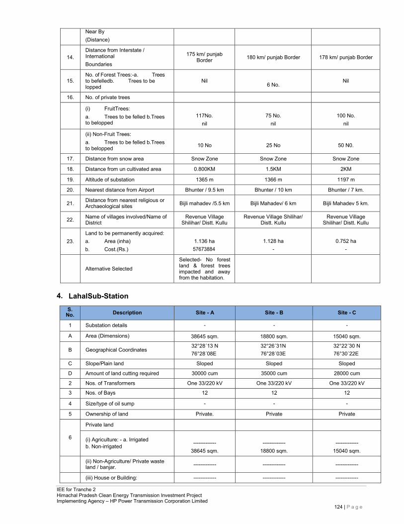
IEE for Tranche 2 Himachal Pradesh Clean Energy Transmission Investment Project Implementing Agency – HP Power Transmission Corporation Limited
124 | P a g e
Near By (Distance)
14.
Distance from Interstate / International Boundaries
175 km/ punjab
Border
180 km/ punjab Border
178 km/ punjab Border
15.
No. of Forest Trees:-a. Trees to befelledb. Trees to be lopped
Nil
6 No.
Nil
16. No. of private trees
(i) FruitTrees: a. Trees to be felled b.Trees to belopped
117No.
nil
75 No.
nil
100 No.
nil (ii) Non-Fruit Trees:
a. Trees to be felled b.Trees to belopped
10 No
25 No
50 N0.
17. Distance from snow area Snow Zone Snow Zone Snow Zone
18. Distance from un cultivated area 0.800KM 1.5KM 2KM
19. Altitude of substation 1365 m 1366 m 1197 m
20. Nearest distance from Airport Bhunter / 9.5 km Bhunter / 10 km Bhunter / 7 km.
21. Distance from nearest religious or Archaeological sites Bijli mahadev /5.5 km Bijli Mahadev/ 6 km Bijli Mahadev 5 km.
22. Name of villages involved/Name of District
Revenue Village Shilihar/ Distt. Kullu
Revenue Village Shilihar/ Distt. Kullu
Revenue Village Shilihar/ Distt. Kullu
23.
Land to be permanently acquired: a. Area (inha) b. Cost.(Rs.)
1.136 ha 57673884
1.128 ha
-
0.752 ha
-
Alternative Selected
Selected- No forest land & forest trees impacted and away from the habitation.
4. LahalSub-Station
S. No. Description Site - A Site - B Site - C
1 Substation details - - -
A Area (Dimensions) 38645 sqm. 18800 sqm. 15040 sqm.
B Geographical Coordinates 32°28´13 N 76°28´08E
32°26´31N 76°28´03E
32°22´30 N 76°30´22E
C Slope/Plain land Sloped Sloped Sloped
D Amount of land cutting required 30000 cum 35000 cum 28000 cum
2 Nos. of Transformers One 33/220 kV One 33/220 kV One 33/220 kV
3 Nos. of Bays 12 12 12
4 Size/type of oil sump - - -
5 Ownership of land Private. Private Private
6
Private land
(i) Agriculture: - a. Irrigated b. Non-irrigated
-------------
38645 sqm.
-------------
18800 sqm.
-------------
15040 sqm. (ii) Non-Agriculture/ Private waste
land / banjar. ------------- ------------- -------------
(iii) House or Building: ------------- ------------- -------------
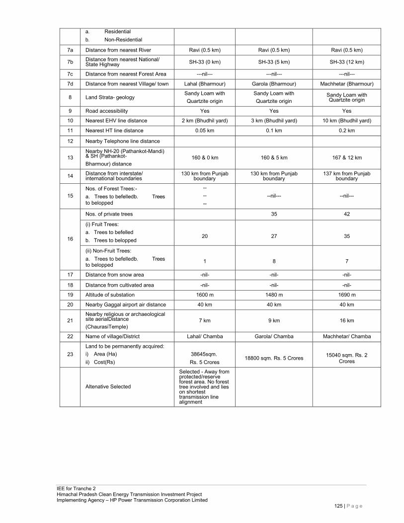
IEE for Tranche 2 Himachal Pradesh Clean Energy Transmission Investment Project Implementing Agency – HP Power Transmission Corporation Limited
125 | P a g e
a. Residential b. Non-Residential
7a Distance from nearest River Ravi (0.5 km) Ravi (0.5 km) Ravi (0.5 km)
7b Distance from nearest National/ State Highway SH-33 (0 km) SH-33 (5 km) SH-33 (12 km)
7c Distance from nearest Forest Area ---nil--- ---nil--- ---nil---
7d Distance from nearest Village/ town Lahal (Bharmour) Garola (Bharmour) Machhetar (Bharmour)
8 Land Strata- geology Sandy Loam with Quartzite origin
Sandy Loam with Quartzite origin
Sandy Loam with Quartzite origin
9 Road accessibility Yes Yes Yes
10 Nearest EHV line distance 2 km (Bhudhil yard) 3 km (Bhudhil yard) 10 km (Bhudhil yard)
11 Nearest HT line distance 0.05 km 0.1 km 0.2 km
12 Nearby Telephone line distance
13
Nearby NH-20 (Pathankot-Mandi) & SH (Pathankot- Bharmour) distance
160 & 0 km
160 & 5 km
167 & 12 km
14 Distance from interstate/ international boundaries
130 km from Punjab boundary
130 km from Punjab boundary
137 km from Punjab boundary
15
Nos. of Forest Trees:- a. Trees to befelledb. Trees to belopped
-- -- --
--nil---
--nil---
16
Nos. of private trees 35 42
(i) Fruit Trees: a. Trees to befelled b. Trees to belopped
20
27
35
(ii) Non-Fruit Trees: a. Trees to befelledb. Trees to belopped
1
8
7
17 Distance from snow area -nil- -nil- -nil-
18 Distance from cultivated area -nil- -nil- -nil-
19 Altitude of substation 1600 m 1480 m 1690 m
20 Nearby Gaggal airport air distance 40 km 40 km 40 km
21
Nearby religious or archaeological site aerialDistance (ChaurasiTemple)
7 km
9 km
16 km
22 Name of village/District Lahal/ Chamba Garola/ Chamba Machhetar/ Chamba
23
Land to be permanently acquired: i) Area (Ha) ii) Cost(Rs)
38645sqm. Rs. 5 Crores
18800 sqm. Rs. 5 Crores
15040 sqm. Rs. 2
Crores
Altenative Selected
Selected - Away from protected/reserve forest area. No forest tree involved and lies on shortest transmission line alignment
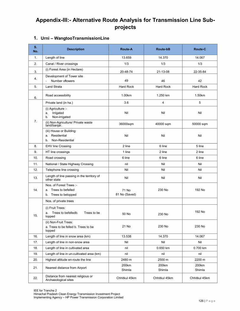
IEE for Tranche 2 Himachal Pradesh Clean Energy Transmission Investment Project Implementing Agency – HP Power Transmission Corporation Limited
126 | P a g e
Appendix-III:- Alternative Route Analysis for Transmission Line Sub- projects
1. Urni – WangtooTransmissionLine
S. No. Description Route-A Route-bB Route-C
1. Length of line 13.659 14.370 14.067
2. Canal / River crossings 1/3 1/3 1/3
3. (i) Forest Area (in Hectare)
20-48-74 21-13-08 22-35-84
4. Development of Tower site ‐ Number oftowers
49
46
42
5. Land Strata Hard Rock Hard Rock Hard Rock
6.
Road accessibility
1.00km
1.250 km
1.50km
7.
Private land (in ha.) 3.6 4 5
(i) Agriculture :- a. Irrigated b. Non-irrigated
Nil
Nil
Nil
(ii) Non-Agriculture/ Private waste land/banjar. 36000sqm 40000 sqm 50000 sqm
(iii) House or Building: a. Residential b. Non-Residential
Nil
Nil
Nil
8. EHV line Crossing 2 line 6 line 5 line
9. HT line crossings 1 line 2 line 2 line
10. Road crossing 6 line 6 line 6 line
11. National / State Highway Crossing nil Nil Nil
12. Telephone line crossing Nil Nil Nil
13. Length of line passing in the territory of other state Nil Nil Nil
14.
Nos. of Forest Trees :- a. Trees to befelled b. Trees to belopped
71 No
81 No (Saved)
230 No
192 No
15.
Nos. of private trees
(i) Fruit Trees: a. Trees to befelledb. Trees to be lopped
50 No
230 No
192 No
(ii) Non-Fruit Trees: a. Trees to be felled b. Trees to be lopped
21 No
230 No
230 No
16. Length of line in snow area (km) 13.538 14.370 14.067
17. Length of line in non-snow area Nil Nil Nil
18. Length of line in cultivated area nil 0.650 km 0.700 km
19. Length of line in un-cultivated area (km) nil nil nil
20. Highest altitude en-route the line 2480 m 2500 m 2200 m
21. Nearest distance from Airport 200km Shimla
200km Shimla
200km Shimla
22. Distance from nearest religious or Archaeological sites Chhitkul 45km Chhitkul 45km Chhitkul 45km
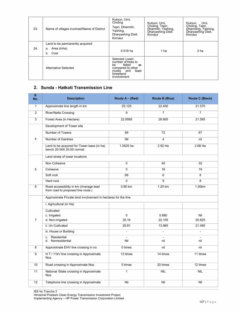
IEE for Tranche 2 Himachal Pradesh Clean Energy Transmission Investment Project Implementing Agency – HP Power Transmission Corporation Limited
127 | P a g e
23.
Name of villages involved/Name of District
Kutoun, Urni, Choling Tapri, Dharmlin, Yashing, Dharyashing Distt. Kinnaur
Kutoun, Urni, Choling, Tapri, Dharmlin, Yashing, Dharyashing Distt. Kinnaur
Kutoun, Urni, Choling, Tapri, Dharmling, Yashing, Dharyashing Distt. Kinnaur
24.
Land to be permanently acquired: a. Area (inha) b. Cost
0.518 ha
1 ha
2 ha
Alternative Selected
Selected- Least number of trees to be felled as compared to other routes and least forestland involvement.
2. Sunda - Hatkoti Transmission Line
S. No.
Description
Route A – (Red)
Route B (Blue)
Route C (Black)
1 Approximate line length in km 25.125 22.450 21.570
2 River/Nalla Crossing 9 7 7
3 Forest Area (in Hectare) 22.9585 28.665 21.595
4
Development of Tower site
Number of Towers 69 73 67
Number of Gantries Nil 4 nil
Land to be acquired for Tower base (in ha) bench 20.00X 20.00 normal
1.5525 ha 2.92 Ha 2.68 Ha
5
Land strata of tower locations
Non Cohesive 0 40 32
Cohesive 0 18 19
Soft rock 69 6 8
Hard rock 0 9 8
6 Road accessibility in km (Average lead from road to proposed line route.)
0.80 km 1.20 km 1.50km
Approximate Private land involvement in hectares for the line.
i. Agricultural (in Ha)
Cultivated
c. Irrigated 0 5.880 Nil 7 d. Non-irrigated 35.16 22.155 20.825
ii. Un Cultivated 29.81 13.965 21.490
iii. House or Building - - -
c. Residential d. Nonresidential
- Nil
- nil
- nil
8 Approximate EHV line crossing in no. 0 times nil nil
9 H T / 11kV line crossing in Approximate Nos.
13 times 14 times 11 times
10 Road crossing in Approximate Nos. 5 times 20 times 12 times
11 National /State crossing in Approximate Nos.
1 NIL NIL
12 Telephone line crossing in Approximate Nil Nil Nil
IEE for Tranche 2 Himachal Pradesh Clean Energy Transmission Investment Project Implementing Agency – HP Power Transmission Corporation Limited
128 | P a g e
Nos.
13 length of route / line passing in the territory of other state Nil NIL NIL
14
Approximate Nos. of Trees in Forest land
a. Cutting b. Noncutting
81 40
85 126
60 54
15
Approximate Nos. of Private Trees in line route
i. fruit trees a. Cutting b. Non cutting
56 88
45 60
109 70
ii. Non-fruittreesa. Cutting b. Non cutting
15 25
16 32
20 40
16
Approximate Length of line route in snow zone area (in km) Nos. of towers
25.125
22.450
21.570
69
73
67
17
Approximate Length of line route in non- snow zone area (in km) Nos. of towers
Nil nil nil
0 0 0
18
Approximate Length of line route in cultivated area (in km) Nos. of towers
5.76
8.010
5.950
20 30 23
19
Approximate Length of line route in Un- cultivated area (in km) Nos. of towers
12.80
3.990
6.140
33
12
21
20
Approximate Length of line route in Government/ Shamlat area (in km) Nos. of towers Reserved forest
6.56 9.180 6.170
16 22 15
Nil 2.260 3.310
Alternative chosen Selected- Less tree cutting and away from the habitation
3. Charor-Banala TransmissionLine
S. No.
Description
Route – A (Red)
Route – B (Blue)
Route – C (Green)
1. Length of line 17.575 KM 19.346 KM 21.366 Km
2. Canal / River crossings 2 2 2
3.
(i) Forest Area (in Hectare) 36.7296 4.645 5.1
Development of Tower site
4. - Number of towers along with gantries 63 66 68 - Land to be acquired for tower base 0.7583 1.032 1.9788
5.
Land Strata of Tower Location
Non Cohesive 20% 40% 47%
Cohesive 40% 23% 23%
Soft Rock 19% 19% 19%
IEE for Tranche 2 Himachal Pradesh Clean Energy Transmission Investment Project Implementing Agency – HP Power Transmission Corporation Limited
129 | P a g e
Hard Rock 31% 16% 21%
6. Road accessibility 0.43% 0.50% 0.65% Agriculture Private land (in ha.)
(i):-Cultivated 32 41 49 - Irrigated 0 0 0 - Non-irrigated 0 0 0
7.
(ii) Non-Agriculture / Private waste land. 5.00 6.06 7.01 (iii) House or Building:
- Residential - - - - Non-Residential
8. Approximate EHV line crossing in No. 1 1 1
9. HT/11kV line crossing in approximate No. 5 8 7
10 Road crossing in approximate No. 5 7 7
11. National/ State crossing in approximate N0. 3 3 3
12. Telephone line crossing in approximate No. 4 8 6
13. Length of Route/ line passing in the
territory of other state
0
0
0
Nos. of Forest Trees :-
14. - Trees to be felled 221 323 345 - Trees to be lopped 152 210 248 Nos. of private trees
Fruit Trees:
- Trees to be felled 486 598 887 15. - Trees to be lopped 10 289 299
Non-Fruit Trees:
- Trees to be felled 105 545 623 - Trees to be lopped 23 78 112
16. Length of line in mountainous area 100% 100% 100%
17. Length of line in non-mountainous area 0% 0% 0%
18. Length of line in cultivated /horticultural area 7.048 6.500 8.510
19. Length of line in un-cultivated area
20. Highest altitude en-route the line 1500m 1545m 1560m
21 Distance from nearest airport 5500m 6000m 6550m
22 Distance from nearest religious or archaeological sites 1000 700 900
Charor,Lashani,Birni,
Charor,Lashani,Birni, Charor,Lashani,Birni ,
23
Name of villages involved/Name of District
Lingna,Boshadhar,
Dyiar,Tharas,Goradhar, Dalashani, Banala /Kulu
Hawai,Sayah,Lingna,Boshadhar, Dyiar, Tharas, GoradharDalashani, Banala /Kulu
Hawai,Sayah,Lingna ,Boshadhar, Dyiar, Garsa, Bhedhu farm Tharas,Goradhar Dalashani, Banala /Kulu
IEE for Tranche 2 Himachal Pradesh Clean Energy Transmission Investment Project Implementing Agency – HP Power Transmission Corporation Limited
130 | P a g e
24
Land to be permanently acquired: - Area (inha) - Cost.
0.7583
3crore
0.8595
3.4crore
0.9635
3.8crore
Alternative chosen
Selected- Less tree cutting and away from the habitation
4. Lahal - Budhil TransmissionLine
S. No. Description Route-A Route-B Route-C
1. Length of line 1.895 km 1.921 km 2.371 km
2. Canal / River crossings Ravi Ravi Ravi
3. Forest Area (in Hectare) 3.175 4.820 5.01
4.
Development of Tower site ‐ Number oftowers ‐ Land to be acquired for towerbase
8 nos. 15X15 sqm.
8 nos. 15X15 sqm.
9 nos. 15X15 sqm.
5. Land Strata Sandy Loam of Quartzite
Sandy Loam of Quartzite
Sandy Loam of Quartzite
6.
Road accessibility
Yes (Chamba- Bharmour
State Highway)
Yes (Chamba- Bharmour
State Highway)s
Yes (Chamba- Bharmour
State Highway)
7. Private land (in ha.)
(i) Agriculture:- a. Irrigated b. Non-irrigated
NilNil
2.661
Nil Nil
1.550
NilNil
2.936 (ii) Non-Agriculture / Private waste land /
banjar. Nil Nil Nil
(iii) House or Building: a. Residential b. Non-Residential
NilNil
01 Nil
01 Nil
8. EHV line Crossing Nil Nil Nil
9. HT line crossings 01 nos. 01 nos. 01 nos.
10. Road crossing 01 01 01
11. National / State Highway Crossing 01 01 01
12. Telephone line crossing Nil Nil Nil
13. Length of line passing in the territory of other state Nil Nil Nil
14.
Nos. of Forest Trees :- a. Trees to be felled b. Trees tobe lopped
55 Nil
60 10
65 20
15. Nos. of private trees
(i) FruitTrees: a. Trees to be felled b. Trees to be lopped
22 NilNil
35 Nil Nil
40 NilNil
(ii) Non-Fruit Trees: a. Trees to be felled b. Trees to be lopped
18 NilNil
20 Nil Nil
12 NilNil
16. Length of line in snow area 1.767 km. 1.921Km. 2.371 km.
IEE for Tranche 2 Himachal Pradesh Clean Energy Transmission Investment Project Implementing Agency – HP Power Transmission Corporation Limited
131 | P a g e
17. Length of line in non-snow area Nil Nil Nil
18. Length of line in cultivated area 0.7599 km. 0.4430 km. 0.839 km.
19. Length of line in un-cultivated area 0.9061 km. 1.377 km. 1.431 km.
20. Highest altitude en-route the line 2100.27 m. 2095.00 m. 2105.00 m.
21. Nearest distance from Airport 200 km. 200 km. 200 km.
22. Distance from nearest religious or Archaeological sites
7 km.(Chaurasi Temple)
7 km.(Chaurasi Temple)
7 km.(Chaurasi Temple)
23.
Name of villages involved/Name of District
Khanni, Lahal/Chamba Khanni, Lahal/Chamba Khanni,
Lahal/Chamba
24.
Land to be permanently acquired: a. Area (inha) b. Cost
Nil
Nil
Nil
Alternative Selected
Selected- Less tree cutting and away from the habitation
5. Kangra - Dehra TransmissionLine
S. No. Description Route A – (Route-1) Route B (Route-2) Route C (Route-3)
1 Approximate line length in km 17.39 16.00 15.038
2 River/Nalla Crossing (Nos) 19 10 15
3 Forest Area (in Hectare) 5-80-000 Hac 3-30-000 Hac 22-80-05 Hac
4
Development of Tower site
Number of Towers - - 54
Land to be acquired for Tower base (in ha) bench 20.00X 20.00 normal - - 0-08-60 Hac
5 Road accessibility in km (Average lead from road to proposed line route.) 3.00 3.00 2.50
6
Approximate Private land involvement in hectares for the line.
i. Agricultural (in Ha)
02-24-45 Hac
04-27-50 Hac
- Cultivated c. Irrigated d. Non-irrigated
ii. Un Cultivated 47-71-20 Hac 43-70-70 Hac 05-69-42 Hac
iii. House or Building Nil Nil Nil
c. Residential d. Nonresidential
Nil Nil Nil
7 Approximate EHV line crossing in no. 5
4
1
8 H T / 11kV line crossing in Approximate Nos.
5
9 Road crossing in Approximate Nos. - - 2
10 National /State Boundary crossing in Approximate Nos.
Nil Nil Nil
11 Telephone line crossing in Approximate Nos. Nil Nil Nil
12 length of route / line passing in the territory of other state Nil Nil Nil
13 Approximate Nos. of Trees in Forest land
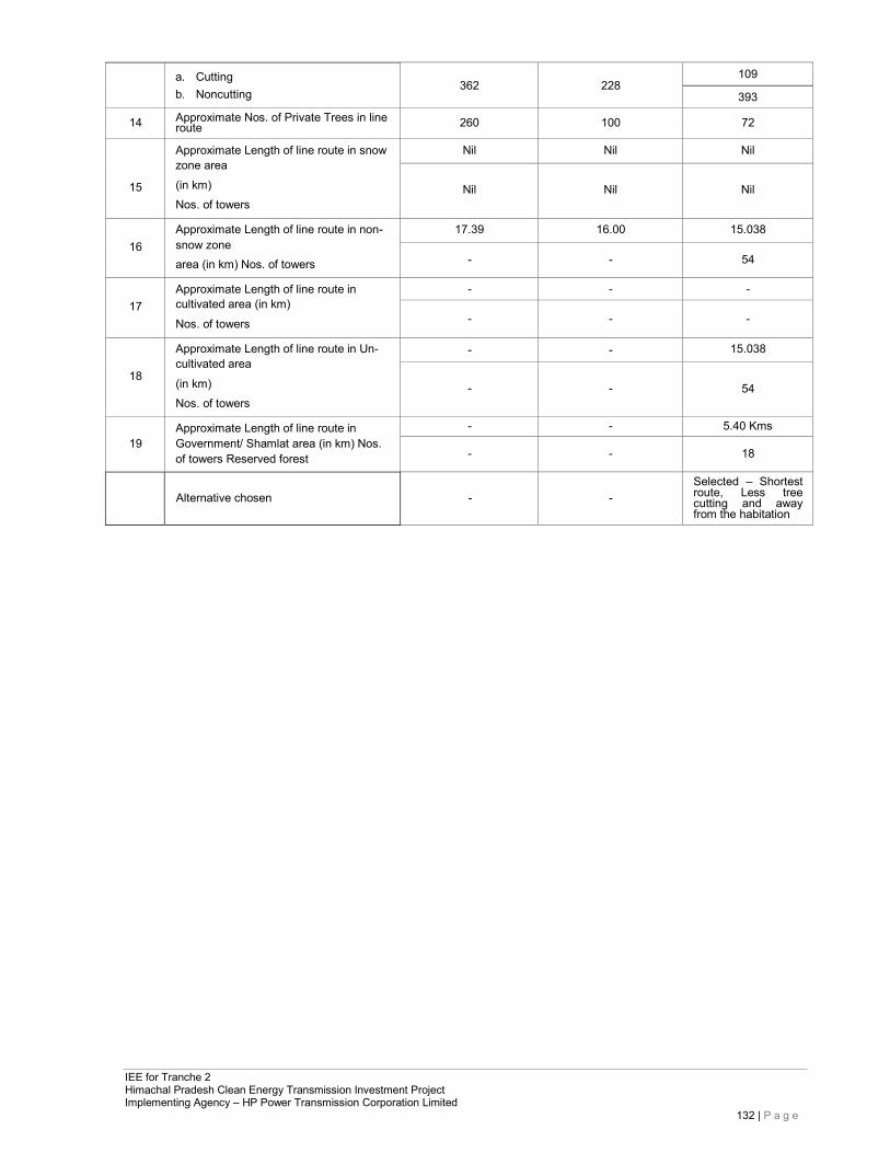
IEE for Tranche 2 Himachal Pradesh Clean Energy Transmission Investment Project Implementing Agency – HP Power Transmission Corporation Limited
132 | P a g e
a. Cutting b. Noncutting
362
228
109
393
14 Approximate Nos. of Private Trees in line route 260 100 72
15
Approximate Length of line route in snow zone area (in km) Nos. of towers
Nil Nil Nil
Nil
Nil
Nil
16
Approximate Length of line route in non- snow zone area (in km) Nos. of towers
17.39 16.00 15.038
- - 54
17
Approximate Length of line route in cultivated area (in km) Nos. of towers
- - -
- - -
18
Approximate Length of line route in Un- cultivated area (in km) Nos. of towers
- - 15.038
-
-
54
19
Approximate Length of line route in Government/ Shamlat area (in km) Nos. of towers Reserved forest
- - 5.40 Kms
- - 18
Alternative chosen
-
-
Selected – Shortest route, Less tree cutting and away from the habitation
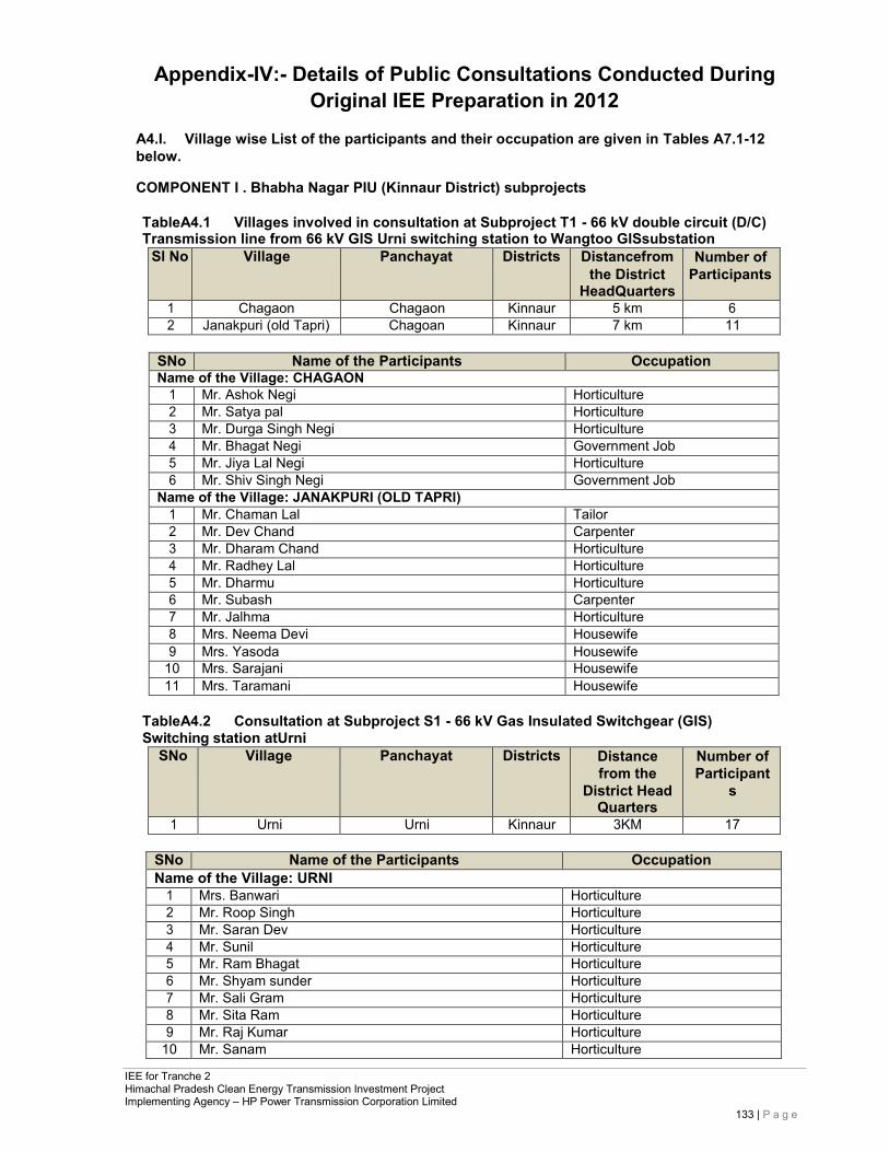
IEE for Tranche 2 Himachal Pradesh Clean Energy Transmission Investment Project Implementing Agency – HP Power Transmission Corporation Limited
133 | P a g e
Appendix-IV:- Details of Public Consultations Conducted During Original IEE Preparation in 2012
A4.I. Village wise List of the participants and their occupation are given in Tables A7.1-12 below.
COMPONENT I . Bhabha Nagar PIU (Kinnaur District) subprojects
TableA4.1 Villages involved in consultation at Subproject T1 - 66 kV double circuit (D/C) Transmission line from 66 kV GIS Urni switching station to Wangtoo GISsubstation
Sl No Village Panchayat Districts Distancefrom the District
HeadQuarters
Number of Participants
1 Chagaon Chagaon Kinnaur 5 km 6 2 Janakpuri (old Tapri) Chagoan Kinnaur 7 km 11
SNo Name of the Participants Occupation Name of the Village: CHAGAON
1 Mr. Ashok Negi Horticulture 2 Mr. Satya pal Horticulture 3 Mr. Durga Singh Negi Horticulture 4 Mr. Bhagat Negi Government Job 5 Mr. Jiya Lal Negi Horticulture 6 Mr. Shiv Singh Negi Government Job
Name of the Village: JANAKPURI (OLD TAPRI) 1 Mr. Chaman Lal Tailor 2 Mr. Dev Chand Carpenter 3 Mr. Dharam Chand Horticulture 4 Mr. Radhey Lal Horticulture 5 Mr. Dharmu Horticulture 6 Mr. Subash Carpenter 7 Mr. Jalhma Horticulture 8 Mrs. Neema Devi Housewife 9 Mrs. Yasoda Housewife
10 Mrs. Sarajani Housewife 11 Mrs. Taramani Housewife
TableA4.2 Consultation at Subproject S1 - 66 kV Gas Insulated Switchgear (GIS) Switching station atUrni
SNo Village Panchayat Districts Distance from the
District Head Quarters
Number of Participant
s
1 Urni Urni Kinnaur 3KM 17
SNo Name of the Participants Occupation Name of the Village: URNI
1 Mrs. Banwari Horticulture 2 Mr. Roop Singh Horticulture 3 Mr. Saran Dev Horticulture 4 Mr. Sunil Horticulture 5 Mr. Ram Bhagat Horticulture 6 Mr. Shyam sunder Horticulture 7 Mr. Sali Gram Horticulture 8 Mr. Sita Ram Horticulture 9 Mr. Raj Kumar Horticulture
10 Mr. Sanam Horticulture
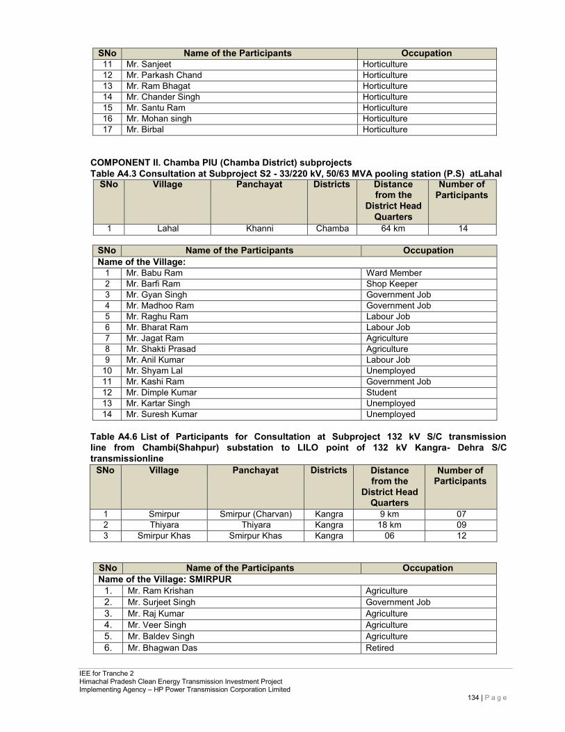
IEE for Tranche 2 Himachal Pradesh Clean Energy Transmission Investment Project Implementing Agency – HP Power Transmission Corporation Limited
134 | P a g e
SNo Name of the Participants Occupation 11 Mr. Sanjeet Horticulture 12 Mr. Parkash Chand Horticulture 13 Mr. Ram Bhagat Horticulture 14 Mr. Chander Singh Horticulture 15 Mr. Santu Ram Horticulture 16 Mr. Mohan singh Horticulture 17 Mr. Birbal Horticulture
COMPONENT II. Chamba PIU (Chamba District) subprojects Table A4.3 Consultation at Subproject S2 - 33/220 kV, 50/63 MVA pooling station (P.S) atLahal
SNo Village Panchayat Districts Distance from the
District Head Quarters
Number of Participants
1 Lahal Khanni Chamba 64 km 14
SNo Name of the Participants Occupation Name of the Village:
1 Mr. Babu Ram Ward Member 2 Mr. Barfi Ram Shop Keeper 3 Mr. Gyan Singh Government Job 4 Mr. Madhoo Ram Government Job 5 Mr. Raghu Ram Labour Job 6 Mr. Bharat Ram Labour Job 7 Mr. Jagat Ram Agriculture 8 Mr. Shakti Prasad Agriculture 9 Mr. Anil Kumar Labour Job
10 Mr. Shyam Lal Unemployed 11 Mr. Kashi Ram Government Job 12 Mr. Dimple Kumar Student 13 Mr. Kartar Singh Unemployed 14 Mr. Suresh Kumar Unemployed
Table A4.6 List of Participants for Consultation at Subproject 132 kV S/C transmission line from Chambi(Shahpur) substation to LILO point of 132 kV Kangra- Dehra S/C transmissionline
SNo Village Panchayat Districts Distance from the
District Head Quarters
Number of Participants
1 Smirpur Smirpur (Charvan) Kangra 9 km 07 2 Thiyara Thiyara Kangra 18 km 09 3 Smirpur Khas Smirpur Khas Kangra 06 12
SNo Name of the Participants Occupation Name of the Village: SMIRPUR
1. Mr. Ram Krishan Agriculture 2. Mr. Surjeet Singh Government Job 3. Mr. Raj Kumar Agriculture 4. Mr. Veer Singh Agriculture 5. Mr. Baldev Singh Agriculture 6. Mr. Bhagwan Das Retired
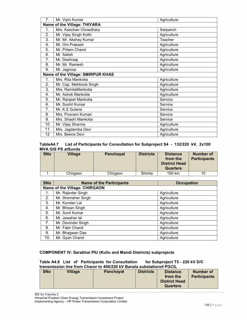
IEE for Tranche 2 Himachal Pradesh Clean Energy Transmission Investment Project Implementing Agency – HP Power Transmission Corporation Limited
135 | P a g e
7. Mr. Vipin Kumar Agriculture Name of the Village: THIYARA
1. Mrs. Kanchan Chowdhary Sarpanch 2. Mr. Vijay Singh Kothi Agriculture 3. Mr. Mr. Akshay Kumar Teacher 4. Mr. Om Prakash Agriculture 5. Mr. Pritam Chand Agriculture 6. Mr. Satish Agriculture 7. Mr. Deshraaj Agriculture 8. Mr. Mr. Ramesh Agriculture 9. Mr. Jagroop Agriculture
Name of the Village: SMIRPUR KHAS 1. Mrs. Rita Mankotia Agriculture 2. Mr. Cap. Mehboob Singh Agriculture 3. Mrs. RamitaMankotia Agriculture 4. Mr. Ashok Mankotia Agriculture 5. Mr. Ranjeet Mankotia Service 6. Mr. Sushil Kumar Service 7. Mr. K.S Guleria Service 8. Mrs. Poonam Kumari Service 9. Mrs. Shashi Mankotia Service 10 Mr. Vijay Sharma Agriculture 11 Mrs. Jagdamba Devi Agriculture 12 Mrs. Beena Devi Agriculture
TableA4.7 List of Participants for Consultation for Subproject S4 - 132/220 kV, 2x100 MVA GIS PS atSunda
SNo Village Panchayat Districts Distance from the
District Head Quarters
Number of Participants
1 Chirgaon Chirgaon Shimla 150 km 10
SNo Name of the Participants Occupation Name of the Village: CHIRGAON
1. Mr. Rajinder Singh Agriculture 2. Mr. Shemsher Singh Agriculture 3. Mr. Kundan Lal Agriculture 4. Mr. Bhisan Singh Agriculture 5. Mr. Sunil Kumar Agriculture 6. Mr. Jawahar lal Agriculture 7. Mr. Devinder Singh Agriculture 8. Mr. Fakir Chand Agriculture 9. Mr. Bhagwan Das Agriculture
10. Mr. Gyan Chand Agriculture
COMPONENT IV: Sarabhai PIU (Kullu and Mandi Districts) subprojects
Table A4.8 List of Participants for Consultation for Subproject T5 - 220 kV D/C transmission line from Charor to 400/220 kV Banala substationof PGCIL
SNo Village Panchayat Districts Distance from the
District Head Quarters
Number of Participants
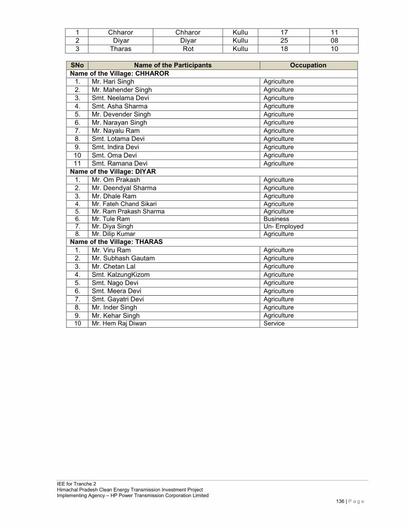
IEE for Tranche 2 Himachal Pradesh Clean Energy Transmission Investment Project Implementing Agency – HP Power Transmission Corporation Limited
136 | P a g e
1 Chharor Chharor Kullu 17 11 2 Diyar Diyar Kullu 25 08 3 Tharas Rot Kullu 18 10
SNo Name of the Participants Occupation Name of the Village: CHHAROR
1. Mr. Hari Singh Agriculture 2. Mr. Mahender Singh Agriculture 3. Smt. Neelama Devi Agriculture 4. Smt. Asha Sharma Agriculture 5. Mr. Devender Singh Agriculture 6. Mr. Narayan Singh Agriculture 7. Mr. Nayalu Ram Agriculture 8. Smt. Lotama Devi Agriculture 9. Smt. Indira Devi Agriculture 10 Smt. Oma Devi Agriculture 11 Smt. Ramana Devi Agriculture
Name of the Village: DIYAR 1. Mr. Om Prakash Agriculture 2. Mr. Deendyal Sharma Agriculture 3. Mr. Dhale Ram Agriculture 4. Mr. Fateh Chand Sikari Agriculture 5. Mr. Ram Prakash Sharma Agriculture 6. Mr. Tule Ram Business 7. Mr. Diya Singh Un- Employed 8. Mr. Dilip Kumar Agriculture
Name of the Village: THARAS 1. Mr. Viru Ram Agriculture 2. Mr. Subhash Gautam Agriculture 3. Mr. Chetan Lal Agriculture 4. Smt. KalzungKizom Agriculture 5. Smt. Nago Devi Agriculture 6. Smt. Meera Devi Agriculture 7. Smt. Gayatri Devi Agriculture 8. Mr. Inder Singh Agriculture 9. Mr. Kehar Singh Agriculture 10 Mr. Hem Raj Diwan Service
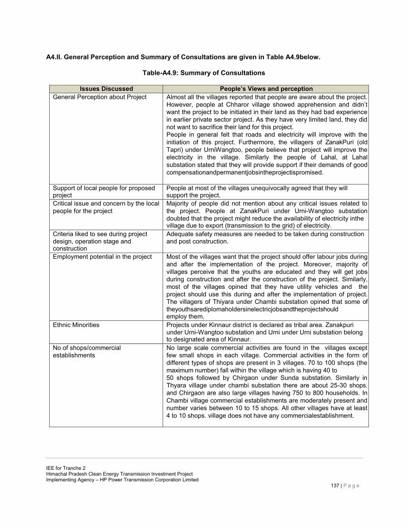
IEE for Tranche 2 Himachal Pradesh Clean Energy Transmission Investment Project Implementing Agency – HP Power Transmission Corporation Limited
137 | P a g e
A4.II. General Perception and Summary of Consultations are given in Table A4.9below.
Table-A4.9: Summary of Consultations
Issues Discussed People’s Views and perception General Perception about Project Almost all the villages reported that people are aware about the project.
However, people at Chharor village showed apprehension and didn’t want the project to be initiated in their land as they had bad experience in earlier private sector project. As they have very limited land, they did not want to sacrifice their land for this project. People in general felt that roads and electricity will improve with the initiation of this project. Furthermore, the villagers of ZanakPuri (old Tapri) under UrniWangtoo, people believe that project will improve the electricity in the village. Similarly the people of Lahal, at Lahal substation stated that they will provide support if their demands of good compensationandpermanentjobsintheprojectispromised.
Support of local people for proposed project
People at most of the villages unequivocally agreed that they will support the project.
Critical issue and concern by the local people for the project
Majority of people did not mention about any critical issues related to the project. People at ZanakPuri under Urni-Wangtoo substation doubted that the project might reduce the availability of electricity inthe village due to export (transmission to the grid) of electricity.
Criteria liked to see during project design, operation stage and construction
Adequate safety measures are needed to be taken during construction and post construction.
Employment potential in the project Most of the villages want that the project should offer labour jobs during and after the implementation of the project. Moreover, majority of villages perceive that the youths are educated and they will get jobs during construction and after the construction of the project. Similarly, most of the villages opined that they have utility vehicles and the project should use this during and after the implementation of project. The villagers of Thiyara under Chambi substation opined that some of theyouthsarediplomaholdersinelectricjobsandtheprojectshould employ them.
Ethnic Minorities Projects under Kinnaur district is declared as tribal area. Zanakpuri under Urni-Wangtoo substation and Urni under Urni substation belong to designated area of Kinnaur.
No of shops/commercial establishments
No large scale commercial activities are found in the villages except few small shops in each village. Commercial activities in the form of different types of shops are present in 3 villages. 70 to 100 shops (the maximum number) fall within the village which is having 40 to 50 shops followed by Chirgaon under Sunda substation. Similarly in Thyara village under chambi substation there are about 25-30 shops. and Chirgaon are also large villages having 750 to 800 households. In Chambi village commercial establishments are moderately present and number varies between 10 to 15 shops. All other villages have at least 4 to 10 shops. village does not have any commercialestablishment.
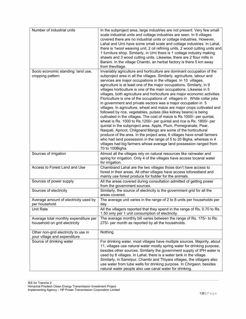
IEE for Tranche 2 Himachal Pradesh Clean Energy Transmission Investment Project Implementing Agency – HP Power Transmission Corporation Limited
138 | P a g e
Number of industrial units In the subproject area, large industries are not present. Very few small scale industrial units and cottage industries are seen. In 9 villages covered there are no industrial units or cottage industries. However, Lahal and Urni have some small scale and cottage industries. In Lahal, there is 1wool weaving unit, 2 oil refining units, 2 wood cutting units and 1 furniture shop. Similarly, in Urni there is 1 cottage industry making shawls and 3 wood cutting units. Likewise, there are 2 flour mills in Barsini. In the village Chambi, an herbal factory is there 5 km away from thevillage.
Socio economic standing: land use, cropping pattern
Invariably agriculture and horticulture are dominant occupation of the subproject area in all the villages. Similarly, agriculture, labour and services are major occupations in the villages. In 10 villages, agriculture is at least one of the major occupations. Similarly, in 9 villages horticulture is one of the main occupations. Likewise in 5 villages, both agriculture and horticulture are major economic activities. Floriculture is one of the occupations of villagers in . White collar jobs in government and private sectors was a major occupation in 5 villages. In agriculture, wheat and maize are major crops cultivated and followed by rice, vegetables, pulses (like kidney beans) is being cultivated in the villages. The cost of maize is Rs 1000/- per quintal, wheat is Rs. 1000 to Rs.1200/- per quintal and rice is Rs. 1800/- per quintal in the subproject area. Apple, Plum, Pomegranate, Pear, Naspati, Apricot, Chilgoand Mango are some of the horticultural produce of the area. In the project area, 6 villages have small farmers who had land possession in the range of 5 to 20 Bigha, whereas in 4 villages had big farmers whose average land possession ranged from 70 to 100Bigha.
Sources of irrigation Almost all the villages rely on natural resources like rainwater and spring for irrigation. Only 4 of the villages have access tocanal water for irrigation.
Access to Forest Land and Use Chambiand Lahal are the two villages those don’t have access to forest in their areas. All other villages have access toforestland and mainly use forest produce for fodder for the animals.
Sources of power supply All the areas covered during consultation admitted of getting power from the government sources.
Sources of electricity Similarly, the source of electricity is the government grid for all the areas covered.
Average amount of electricity used by per household
The average unit varies in the range of 2 to 8 units per households per day.
Unit Rate All the villagers reported that they spend in the range of Rs. 0.70 to Rs. 1.50 only per 1 unit consumption of electricity.
Average total monthly expenditure per household on grid electricity
The average monthly bill varies between the range of Rs. 175/- to Rs. 275/- per month as reported by all the households.
Other non-grid electricity to use in your village and expenditure
Nothing
Source of drinking water For drinking water, most villages have multiple sources. Majority, about 11, villages use natural water mostly spring water for drinking purpose, besides other sources. Similarly the government supply of IPH water is used by 8 villages. In Lahal, there is a water tank in the village. Similarly, in Samirpur, Chambi and Thiyara villages, the villagers also use water from tube wells for drinking purpose. In Chirgaon, besides natural water people also use canal water for drinking.
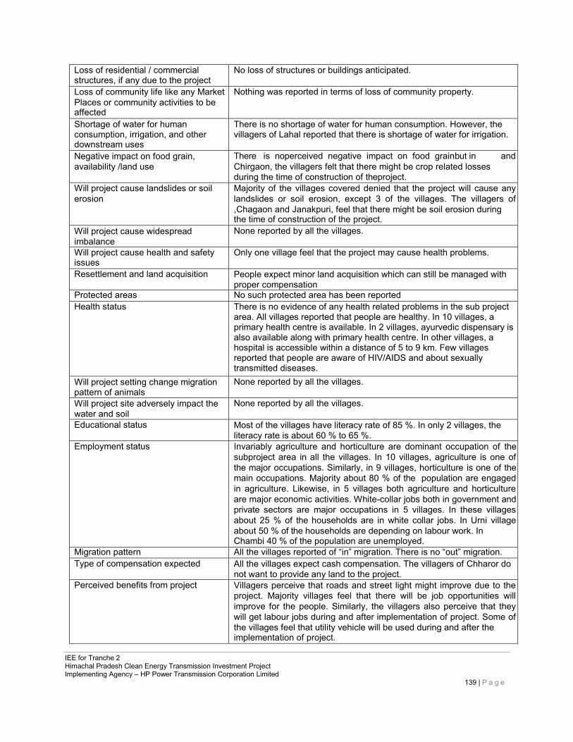
IEE for Tranche 2 Himachal Pradesh Clean Energy Transmission Investment Project Implementing Agency – HP Power Transmission Corporation Limited
139 | P a g e
Loss of residential / commercial structures, if any due to the project
No loss of structures or buildings anticipated.
Loss of community life like any Market Places or community activities to be affected
Nothing was reported in terms of loss of community property.
Shortage of water for human consumption, irrigation, and other downstream uses
There is no shortage of water for human consumption. However, the villagers of Lahal reported that there is shortage of water for irrigation.
Negative impact on food grain, availability /land use
There is noperceived negative impact on food grainbut in and Chirgaon, the villagers felt that there might be crop related losses during the time of construction of theproject.
Will project cause landslides or soil erosion
Majority of the villages covered denied that the project will cause any landslides or soil erosion, except 3 of the villages. The villagers of ,Chagaon and Janakpuri, feel that there might be soil erosion during the time of construction of the project.
Will project cause widespread imbalance
None reported by all the villages.
Will project cause health and safety issues
Only one village feel that the project may cause health problems.
Resettlement and land acquisition People expect minor land acquisition which can still be managed with proper compensation
Protected areas No such protected area has been reported Health status There is no evidence of any health related problems in the sub project
area. All villages reported that people are healthy. In 10 villages, a primary health centre is available. In 2 villages, ayurvedic dispensary is also available along with primary health centre. In other villages, a hospital is accessible within a distance of 5 to 9 km. Few villages reported that people are aware of HIV/AIDS and about sexually transmitted diseases.
Will project setting change migration pattern of animals
None reported by all the villages.
Will project site adversely impact the water and soil
None reported by all the villages.
Educational status Most of the villages have literacy rate of 85 %. In only 2 villages, the literacy rate is about 60 % to 65 %.
Employment status Invariably agriculture and horticulture are dominant occupation of the subproject area in all the villages. In 10 villages, agriculture is one of the major occupations. Similarly, in 9 villages, horticulture is one of the main occupations. Majority about 80 % of the population are engaged in agriculture. Likewise, in 5 villages both agriculture and horticulture are major economic activities. White-collar jobs both in government and private sectors are major occupations in 5 villages. In these villages about 25 % of the households are in white collar jobs. In Urni village about 50 % of the households are depending on labour work. In Chambi 40 % of the population are unemployed.
Migration pattern All the villages reported of “in” migration. There is no “out” migration. Type of compensation expected All the villages expect cash compensation. The villagers of Chharor do
not want to provide any land to the project. Perceived benefits from project Villagers perceive that roads and street light might improve due to the
project. Majority villages feel that there will be job opportunities will improve for the people. Similarly, the villagers also perceive that they will get labour jobs during and after implementation of project. Some of the villages feel that utility vehicle will be used during and after the implementation of project.
IEE for Tranche 2 Himachal Pradesh Clean Energy Transmission Investment Project Implementing Agency – HP Power Transmission Corporation Limited
140 | P a g e
Perceived loss Most of the villages fear that they will lose land. Other organizations active in the area In all the villages Mahila Mandal (women groups) are present. Few of
the villages have Yuvak Mandal (youth groups). In Urni village, there are about 9 organisations.
Village Committee In all the villages, the decisions are taken by gram Panchayat and Gramsabha held on any critical and community related issues. All the Panchayat members and Sarpanch actively participate to take a decision on any community related issues.
Other issuers In most villages, people welcomed the project and agreed to cooperate during the implementation of project. Some of the villages demand that power should be available for 24 hours. As discussed the villagers of Chharor are against the project. The villagers of Zanakpuri need primary health care centre and a high school in their village.
Usefulness of consultation All the villagers admitted that the consultation is useful, and happy as they got an opportunity to share their views before the government officials.
Involvement of people in implementation
All the participants during the consultation admitted that the local people will provide full cooperation and involvement forthe implementation of the project. As discussed the villagers of Chharaor are against the project.
This general perception document is common with the Resettlement Planning document prepared for the project.
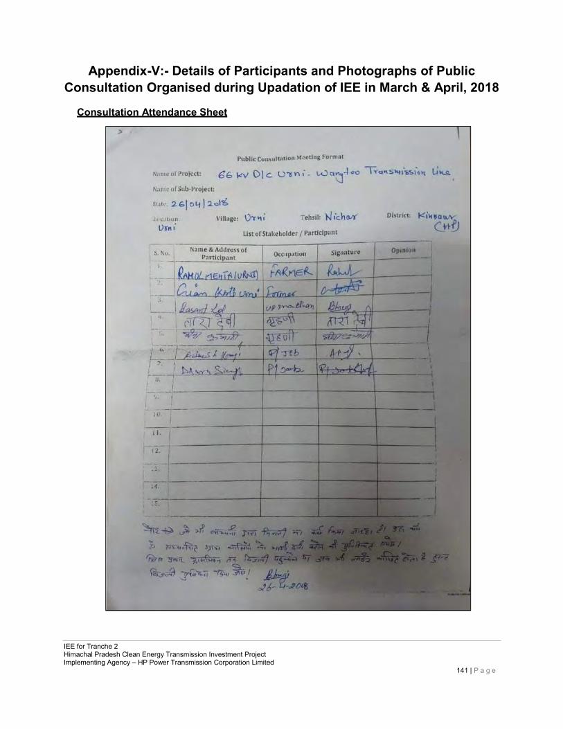
IEE for Tranche 2 Himachal Pradesh Clean Energy Transmission Investment Project Implementing Agency – HP Power Transmission Corporation Limited
141 | P a g e
Appendix-V:- Details of Participants and Photographs of Public Consultation Organised during Upadation of IEE in March & April, 2018
Consultation Attendance Sheet
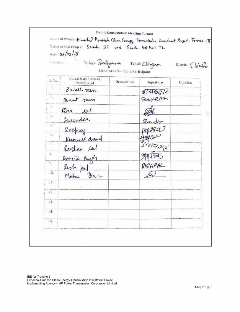
IEE for Tranche 2 Himachal Pradesh Clean Energy Transmission Investment Project Implementing Agency – HP Power Transmission Corporation Limited
142 | P a g e
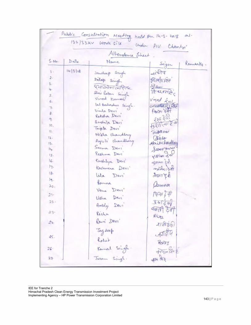
IEE for Tranche 2 Himachal Pradesh Clean Energy Transmission Investment Project Implementing Agency – HP Power Transmission Corporation Limited
143 | P a g e
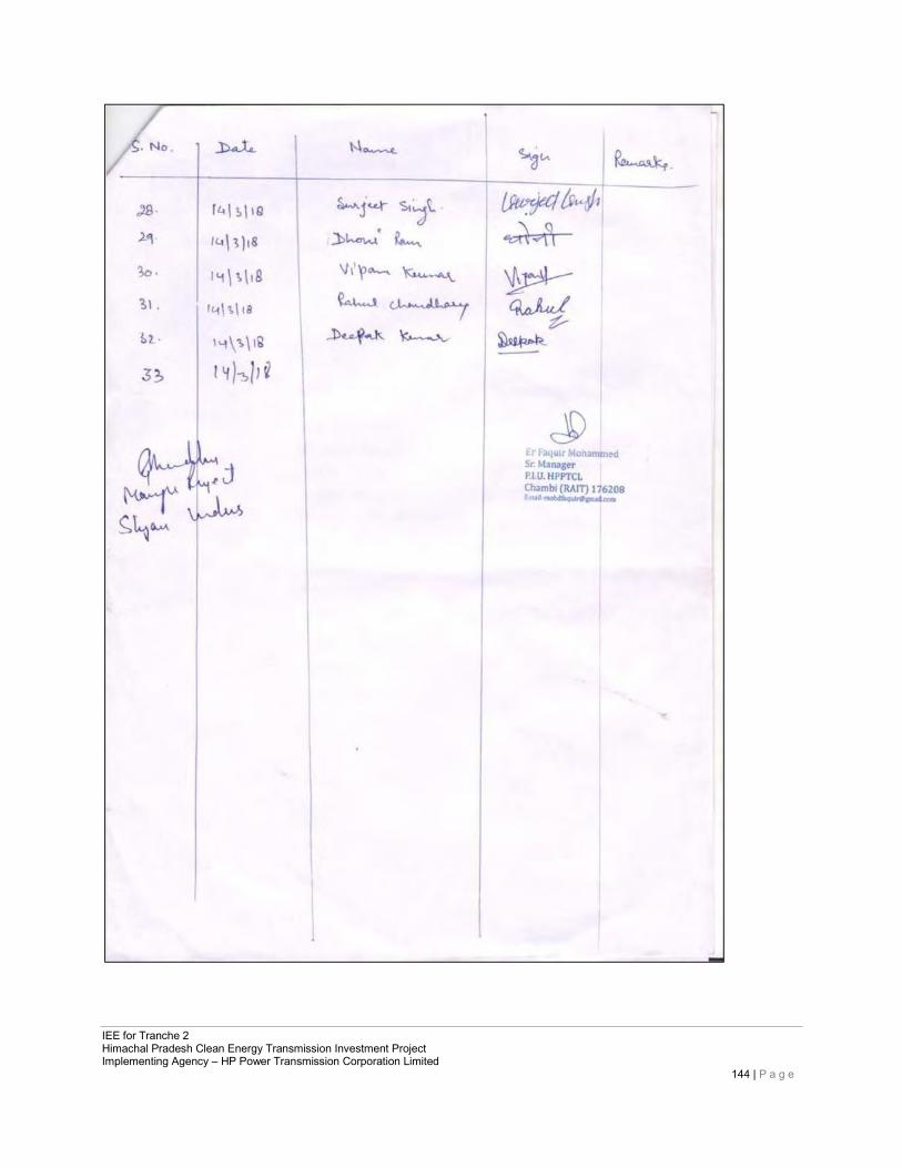
IEE for Tranche 2 Himachal Pradesh Clean Energy Transmission Investment Project Implementing Agency – HP Power Transmission Corporation Limited
144 | P a g e
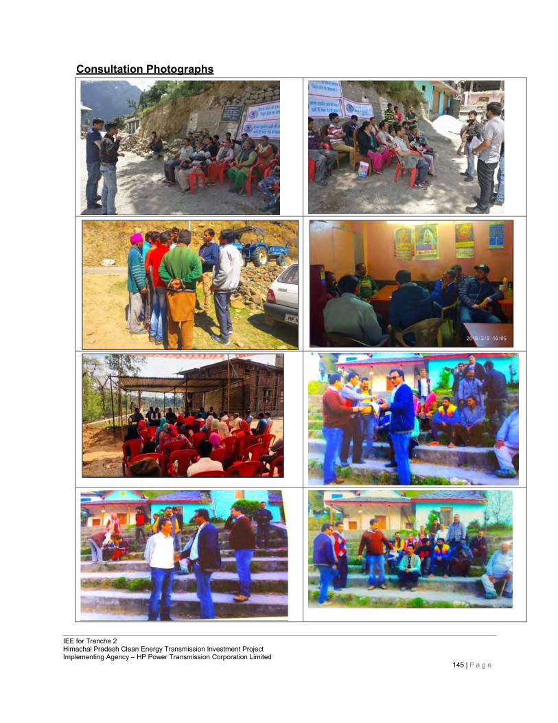
IEE for Tranche 2 Himachal Pradesh Clean Energy Transmission Investment Project Implementing Agency – HP Power Transmission Corporation Limited
145 | P a g e
Consultation Photographs
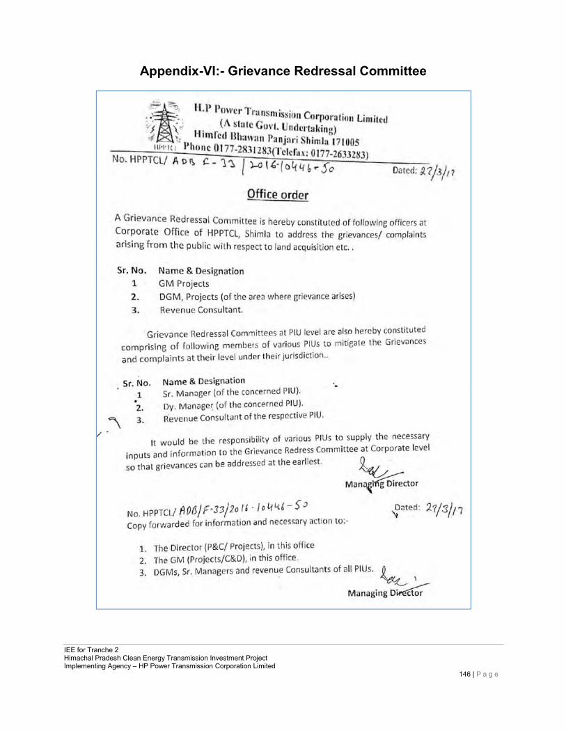
IEE for Tranche 2 Himachal Pradesh Clean Energy Transmission Investment Project Implementing Agency – HP Power Transmission Corporation Limited
146 | P a g e
Appendix-VI:- Grievance Redressal Committee
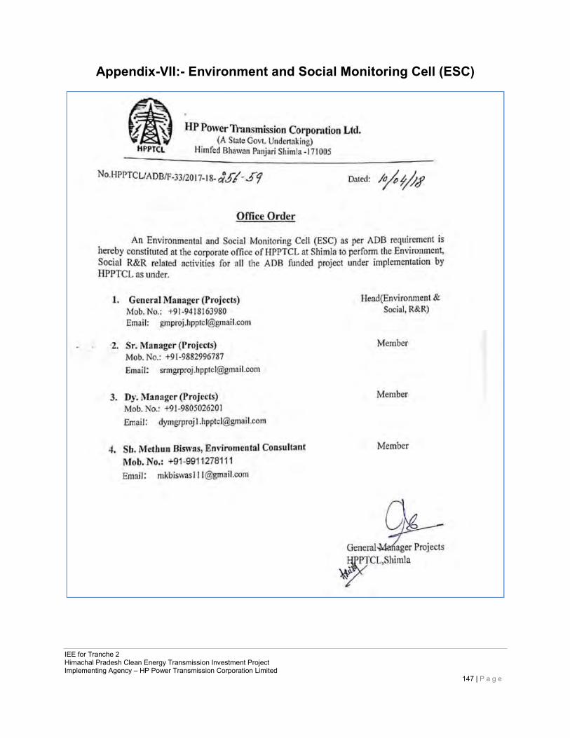
IEE for Tranche 2 Himachal Pradesh Clean Energy Transmission Investment Project Implementing Agency – HP Power Transmission Corporation Limited
147 | P a g e
Appendix-VII:- Environment and Social Monitoring Cell (ESC)
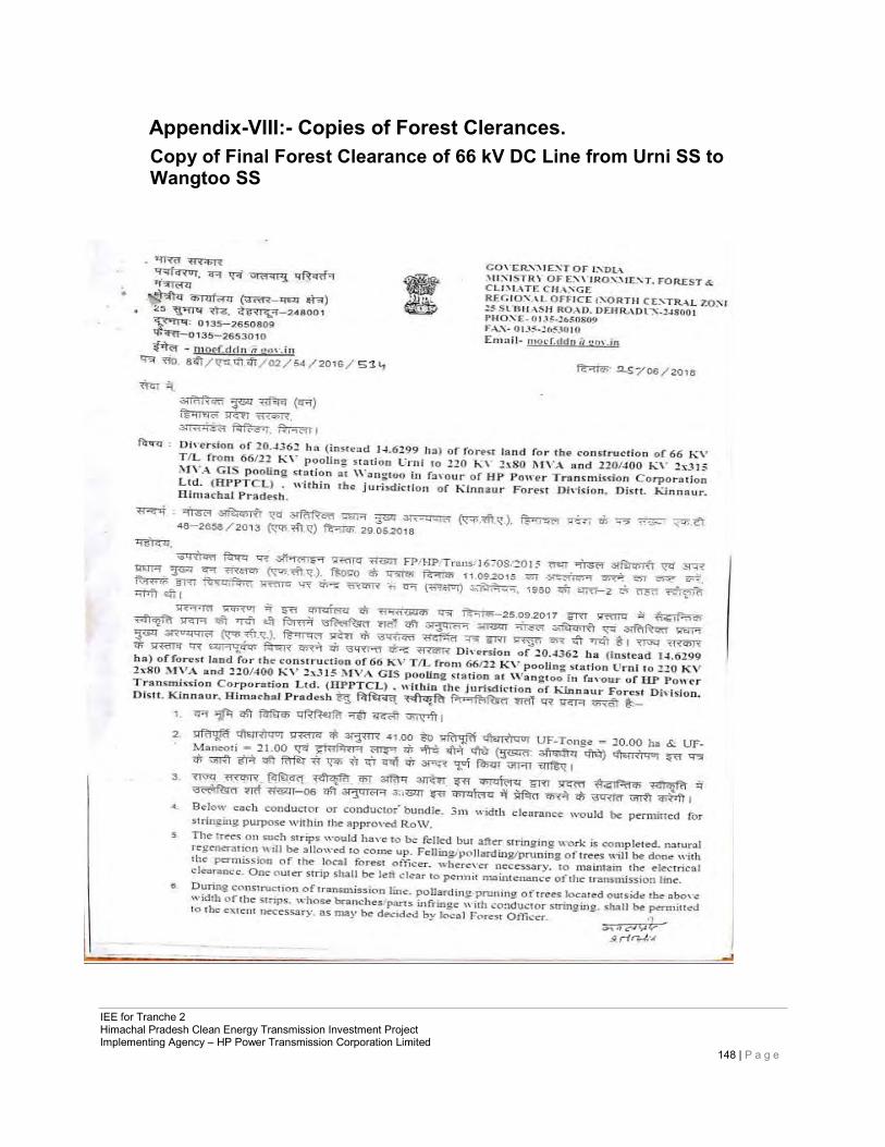
IEE for Tranche 2 Himachal Pradesh Clean Energy Transmission Investment Project Implementing Agency – HP Power Transmission Corporation Limited
148 | P a g e
Appendix-VIII:- Copies of Forest Clerances. Copy of Final Forest Clearance of 66 kV DC Line from Urni SS to Wangtoo SS
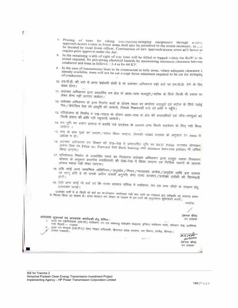
IEE for Tranche 2 Himachal Pradesh Clean Energy Transmission Investment Project Implementing Agency – HP Power Transmission Corporation Limited
149 | P a g e
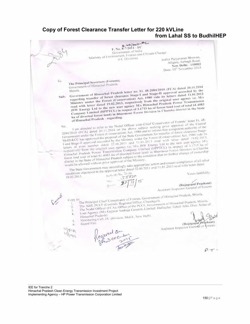
IEE for Tranche 2 Himachal Pradesh Clean Energy Transmission Investment Project Implementing Agency – HP Power Transmission Corporation Limited
150 | P a g e
Copy of Forest Clearance Transfer Letter for 220 kVLine from Lahal SS to BudhilHEP
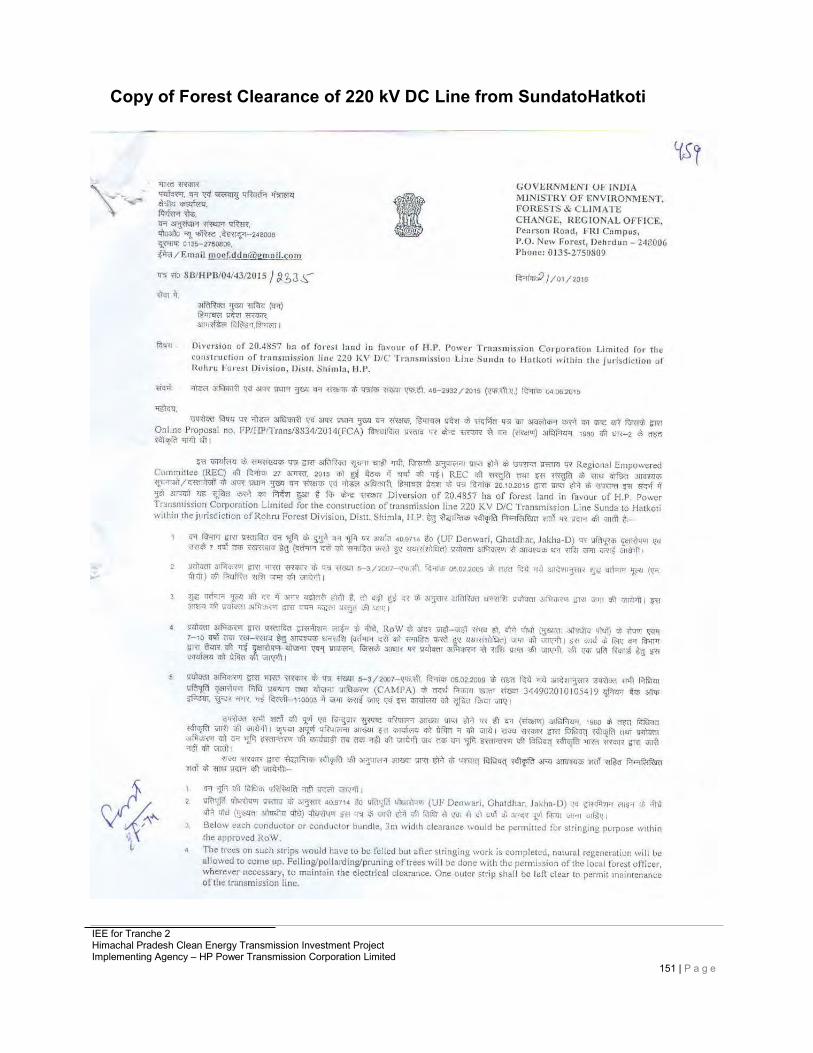
IEE for Tranche 2 Himachal Pradesh Clean Energy Transmission Investment Project Implementing Agency – HP Power Transmission Corporation Limited
151 | P a g e
Copy of Forest Clearance of 220 kV DC Line from SundatoHatkoti

IEE for Tranche 2 Himachal Pradesh Clean Energy Transmission Investment Project Implementing Agency – HP Power Transmission Corporation Limited
152 | P a g e
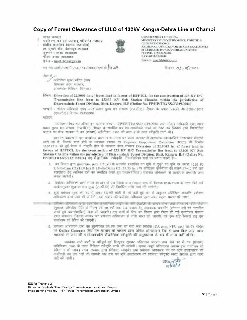
IEE for Tranche 2 Himachal Pradesh Clean Energy Transmission Investment Project Implementing Agency – HP Power Transmission Corporation Limited
153 | P a g e
Copy of Forest Clearance of LILO of 132kV Kangra-Dehra Line at Chambi
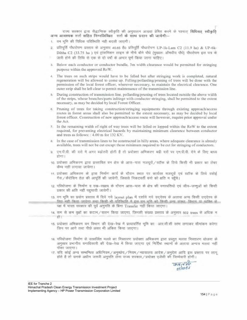
IEE for Tranche 2 Himachal Pradesh Clean Energy Transmission Investment Project Implementing Agency – HP Power Transmission Corporation Limited
154 | P a g e
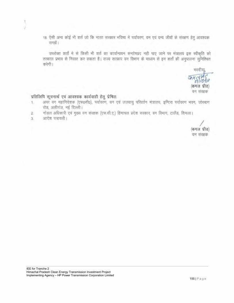
IEE for Tranche 2 Himachal Pradesh Clean Energy Transmission Investment Project Implementing Agency – HP Power Transmission Corporation Limited
155 | P a g e
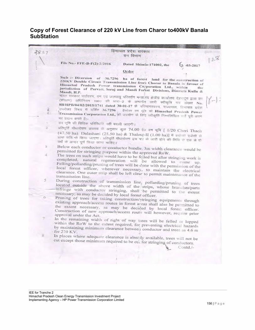
IEE for Tranche 2 Himachal Pradesh Clean Energy Transmission Investment Project Implementing Agency – HP Power Transmission Corporation Limited
156 | P a g e
Copy of Forest Clearance of 220 kV Line from Charor to400kV Banala SubStation
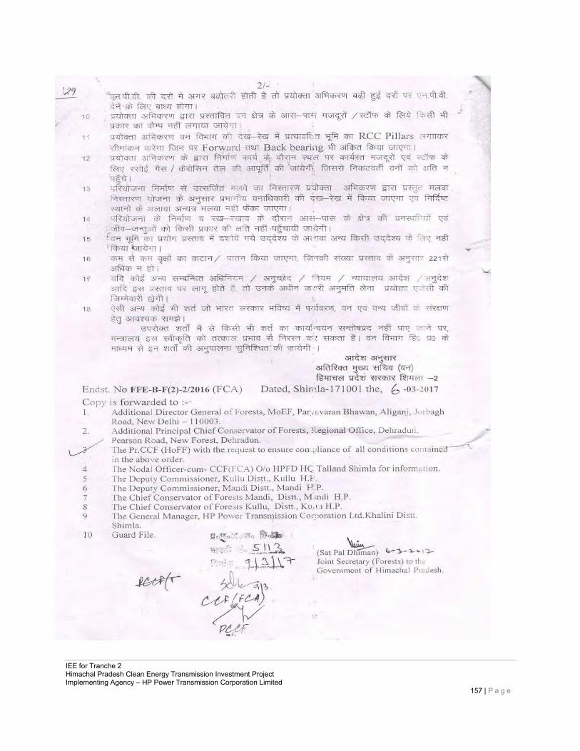
IEE for Tranche 2 Himachal Pradesh Clean Energy Transmission Investment Project Implementing Agency – HP Power Transmission Corporation Limited
157 | P a g e
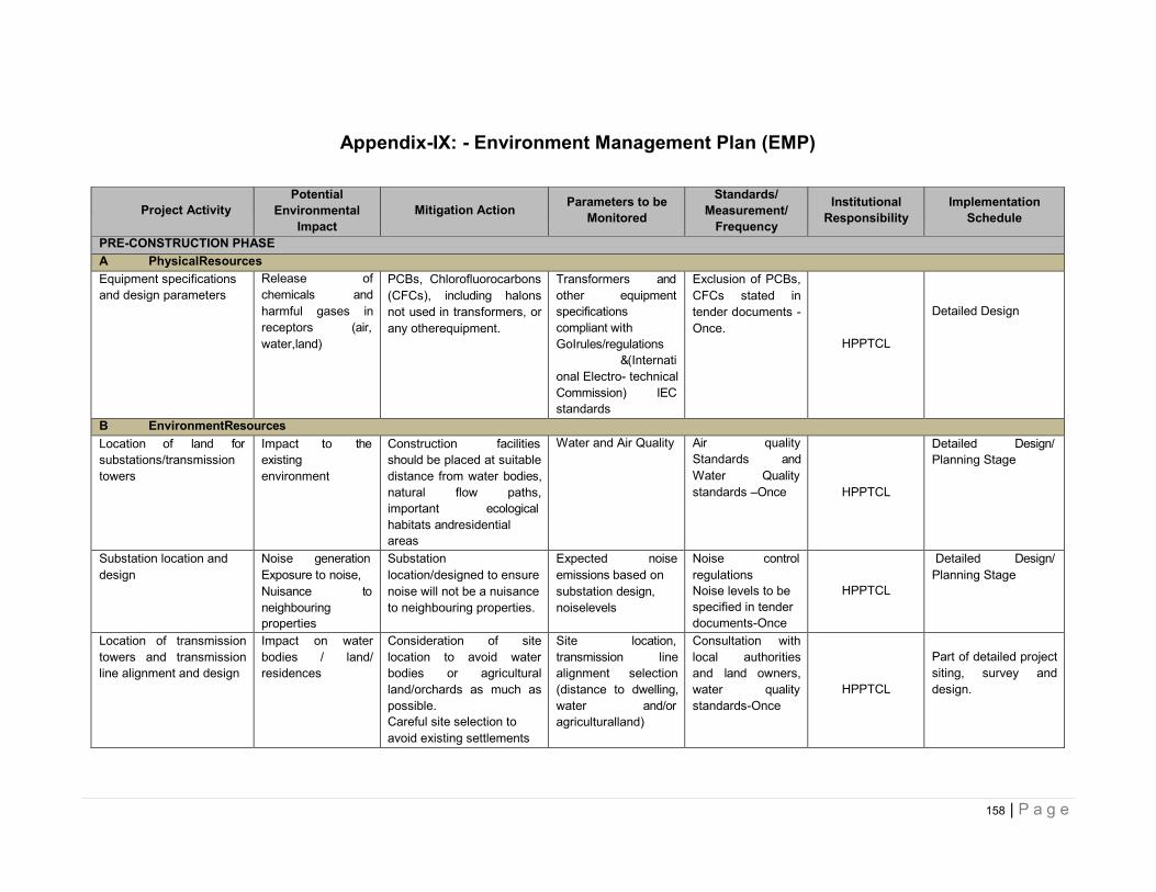
158 | P a g e
Appendix-IX: - Environment Management Plan (EMP)
Project Activity
Potential Environmental
Impact
Mitigation Action Parameters to be
Monitored
Standards/ Measurement/
Frequency
Institutional Responsibility
Implementation Schedule
PRE-CONSTRUCTION PHASE A PhysicalResources Equipment specifications and design parameters
Release of chemicals and harmful gases in receptors (air, water,land)
PCBs, Chlorofluorocarbons (CFCs), including halons not used in transformers, or any otherequipment.
Transformers and other equipment specifications compliant with GoIrules/regulations &(International Electro- technical Commission) IEC standards
Exclusion of PCBs, CFCs stated in tender documents - Once.
HPPTCL
Detailed Design
B EnvironmentResources Location of land for substations/transmission towers
Impact to the existing environment
Construction facilities should be placed at suitable distance from water bodies, natural flow paths, important ecological habitats andresidential areas
Water and Air Quality Air quality Standards and Water Quality standards –Once
HPPTCL
Detailed Design/ Planning Stage
Substation location and design
Noise generation Exposure to noise, Nuisance to neighbouring properties
Substation location/designed to ensure noise will not be a nuisance to neighbouring properties.
Expected noise emissions based on substation design, noiselevels
Noise control regulations Noise levels to be specified in tender documents-Once
HPPTCL
Detailed Design/ Planning Stage
Location of transmission towers and transmission line alignment and design
Impact on water bodies / land/ residences
Consideration of site location to avoid water bodies or agricultural land/orchards as much as possible. Careful site selection to avoid existing settlements
Site location, transmission line alignment selection (distance to dwelling, water and/or agriculturalland)
Consultation with local authorities and land owners, water quality standards-Once
HPPTCL
Part of detailed project siting, survey and design.
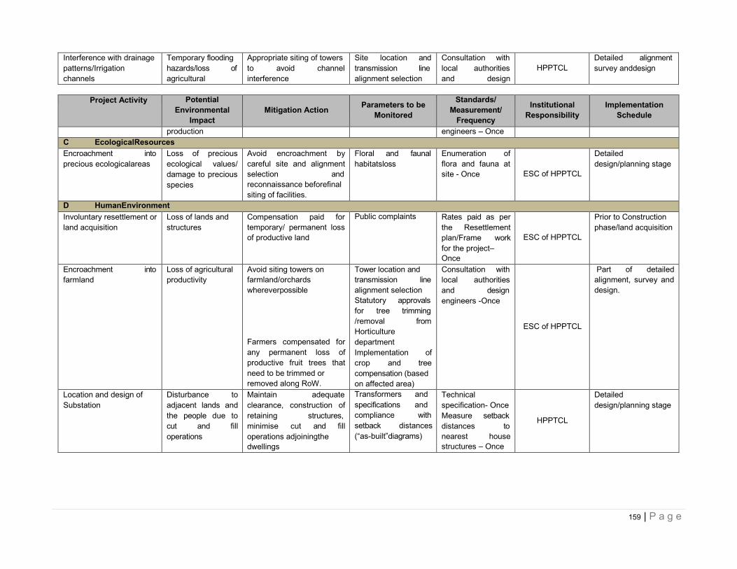
159 | P a g e
Interference with drainage patterns/Irrigation channels
Temporary flooding hazards/loss of agricultural
Appropriate siting of towers to avoid channel interference
Site location and transmission line alignment selection
Consultation with local authorities and design
HPPTCL
Detailed alignment survey anddesign
Project Activity Potential
Environmental Impact
Mitigation Action Parameters to be
Monitored
Standards/ Measurement/
Frequency
Institutional Responsibility
Implementation Schedule
production engineers – Once
C EcologicalResources Encroachment into precious ecologicalareas
Loss of precious ecological values/ damage to precious species
Avoid encroachment by careful site and alignment selection and reconnaissance beforefinal siting of facilities.
Floral and faunal habitatsloss
Enumeration of flora and fauna at site - Once
ESC of HPPTCL
Detailed design/planning stage
D HumanEnvironment Involuntary resettlement or land acquisition
Loss of lands and structures
Compensation paid for temporary/ permanent loss of productive land
Public complaints Rates paid as per the Resettlement plan/Frame work for the project– Once
ESC of HPPTCL
Prior to Construction phase/land acquisition
Encroachment into farmland
Loss of agricultural productivity
Avoid siting towers on farmland/orchards whereverpossible
Farmers compensated for any permanent loss of productive fruit trees that need to be trimmed or removed along RoW.
Tower location and transmission line alignment selection Statutory approvals for tree trimming /removal from Horticulture department Implementation of crop and tree compensation (based on affected area)
Consultation with local authorities and design engineers -Once
ESC of HPPTCL
Part of detailed alignment, survey and design.
Location and design of Substation
Disturbance to adjacent lands and the people due to cut and fill operations
Maintain adequate clearance, construction of retaining structures, minimise cut and fill operations adjoiningthe dwellings
Transformers and specifications and compliance with setback distances (“as-built”diagrams)
Technical specification- Once Measure setback distances to nearest house structures – Once
HPPTCL
Detailed design/planning stage
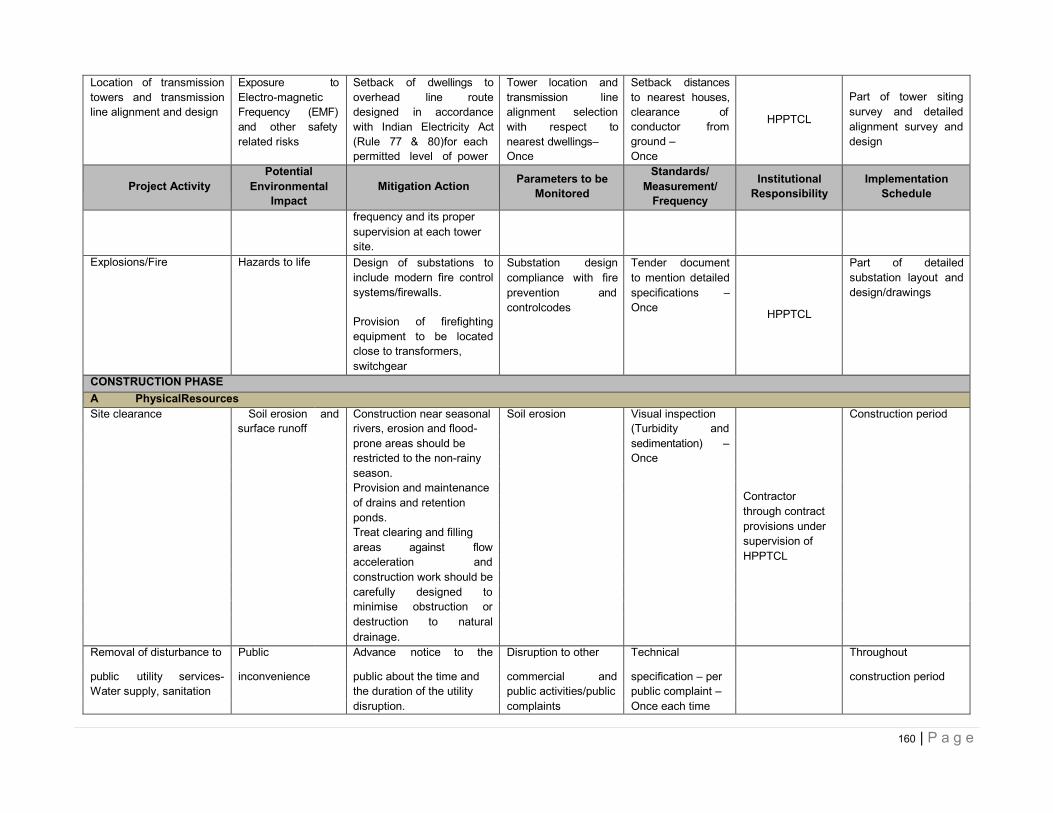
160 | P a g e
Location of transmission towers and transmission line alignment and design
Exposure to Electro-magnetic Frequency (EMF) and other safety related risks
Setback of dwellings to overhead line route designed in accordance with Indian Electricity Act (Rule 77 & 80)for each permitted level of power
Tower location and transmission line alignment selection with respect to nearest dwellings– Once
Setback distances to nearest houses, clearance of conductor from ground – Once
HPPTCL
Part of tower siting survey and detailed alignment survey and design
Project Activity
Potential Environmental
Impact
Mitigation Action Parameters to be
Monitored
Standards/ Measurement/
Frequency
Institutional Responsibility
Implementation Schedule
frequency and its proper supervision at each tower site.
Explosions/Fire Hazards to life Design of substations to include modern fire control systems/firewalls.
Provision of firefighting equipment to be located close to transformers, switchgear
Substation design compliance with fire prevention and controlcodes
Tender document to mention detailed specifications – Once
HPPTCL
Part of detailed substation layout and design/drawings
CONSTRUCTION PHASE A PhysicalResources Site clearance Soil erosion and Construction near seasonal Soil erosion Visual inspection
Contractor through contract provisions under supervision of HPPTCL
Construction period surface runoff rivers, erosion and flood- (Turbidity and
prone areas should be sedimentation) –
restricted to the non-rainy Once
season.
Provision and maintenance
of drains and retention
ponds.
Treat clearing and filling
areas against flow
acceleration and
construction work should be
carefully designed to
minimise obstruction or
destruction to natural
drainage.
Removal of disturbance to Public Advance notice to the Disruption to other Technical Throughout
public utility services- inconvenience public about the time and commercial and specification – per construction period Water supply, sanitation the duration of the utility public activities/public public complaint –
disruption. complaints Once each time
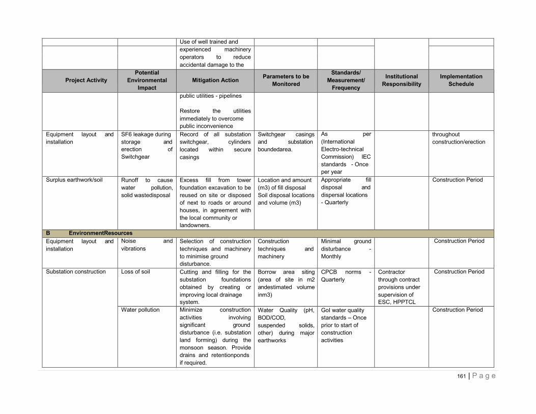
161 | P a g e
Use of well trained and
experienced machinery
operators to reduce
accidental damage to the
Project Activity
Potential Environmental
Impact
Mitigation Action Parameters to be
Monitored
Standards/ Measurement/
Frequency
Institutional Responsibility
Implementation Schedule
public utilities - pipelines
Restore the utilities immediately to overcome public inconvenience
Equipment layout and installation
SF6 leakage during storage and erection of Switchgear
Record of all substation switchgear, cylinders located within secure casings
Switchgear casings and substation boundedarea.
As per (International Electro-technical Commission) IEC standards - Once per year
throughout construction/erection
Surplus earthwork/soil Runoff to cause water pollution, solid wastedisposal
Excess fill from tower foundation excavation to be reused on site or disposed of next to roads or around houses, in agreement with the local community or landowners.
Location and amount (m3) of fill disposal Soil disposal locations and volume (m3)
Appropriate fill disposal and dispersal locations - Quarterly
Construction Period
B EnvironmentResources Equipment layout and installation
Noise and vibrations
Selection of construction techniques and machinery to minimise ground disturbance.
Construction techniques and machinery
Minimal ground disturbance - Monthly
Construction Period
Substation construction Loss of soil Cutting and filling for the substation foundations obtained by creating or improving local drainage system.
Borrow area siting (area of site in m2 andestimated volume inm3)
CPCB norms - Quarterly
Contractor through contract provisions under supervision of ESC, HPPTCL
Construction Period
Water pollution Minimize construction activities involving significant ground disturbance (i.e. substation land forming) during the monsoon season. Provide drains and retentionponds if required.
Water Quality (pH, BOD/COD, suspended solids, other) during major earthworks
GoI water quality standards – Once prior to start of construction activities
Construction Period
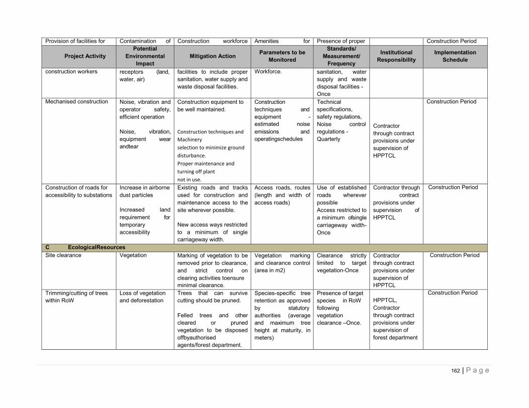
162 | P a g e
Provision of facilities for Contamination of Construction workforce Amenities for Presence of proper Construction Period
Project Activity Potential
Environmental Impact
Mitigation Action Parameters to be
Monitored
Standards/ Measurement/
Frequency
Institutional Responsibility
Implementation Schedule
construction workers receptors (land, water, air)
facilities to include proper sanitation, water supply and waste disposal facilities.
Workforce. sanitation, water supply and waste disposal facilities - Once
Mechanised construction Noise, vibration and operator safety, efficient operation
Noise, vibration, equipment wear andtear
Construction equipment to be well maintained.
Construction techniques and
Machinery
selection to minimize ground
disturbance.
Proper maintenance and
turning off plant
not in use.
Construction techniques and equipment - estimated noise emissions and operatingschedules
Technical specifications, safety regulations, Noise control regulations - Quarterly
Contractor through contract provisions under supervision of HPPTCL
Construction Period
Construction of roads for accessibility to substations
Increase in airborne dust particles
Increased land requirement for temporary accessibility
Existing roads and tracks used for construction and maintenance access to the site wherever possible.
New access ways restricted to a minimum of single carriageway width.
Access roads, routes (length and width of access roads)
Use of established roads wherever possible Access restricted to a minimum ofsingle carriageway width-Once
Contractor through contract provisions under supervision of HPPTCL
Construction Period
C EcologicalResources Site clearance Vegetation Marking of vegetation to be
removed prior to clearance, and strict control on clearing activities toensure minimal clearance.
Vegetation marking and clearance control (area in m2)
Clearance strictly limited to target vegetation-Once
Contractor through contract provisions under supervision of HPPTCL
Construction Period
Trimming/cutting of trees within RoW
Loss of vegetation and deforestation
Trees that can survive cutting should be pruned.
Felled trees and other cleared or pruned vegetation to be disposed offbyauthorised agents/forest department.
Species-specific tree retention as approved by statutory authorities (average and maximum tree height at maturity, in meters)
Presence of target species in RoW following vegetation clearance –Once.
HPPTCL, Contractor through contract provisions under supervision of forest department
Construction Period
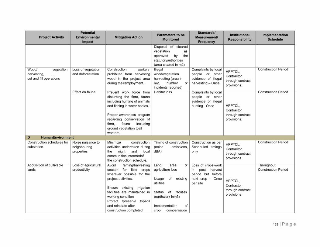
163 | P a g e
Project Activity
Potential Environmental
Impact
Mitigation Action Parameters to be
Monitored
Standards/ Measurement/
Frequency
Institutional Responsibility
Implementation Schedule
Disposal of cleared vegetation as approved by the statutoryauthorities (area cleared in m2)
Wood/ vegetation harvesting, cut and fill operations
Loss of vegetation and deforestation
Construction workers prohibited from harvesting wood in the project area during theiremployment.
Illegal wood/vegetation harvesting (area in m2, number of incidents reported)
Complaints by local people or other evidence of illegal harvesting – Once
HPPTCL, Contractor through contract provisions.
Construction Period
Effect on fauna Prevent work force from disturbing the flora, fauna including hunting of animals and fishing in water bodies.
Proper awareness program regarding conservation of flora, fauna including ground vegetation toall workers.
Habitat loss Complaints by local people or other evidence of illegal hunting - Once
HPPTCL, Contractor through contract provisions.
Construction Period
D HumanEnvironment Construction schedules for substation
Noise nuisance to neighbouring properties
Minimize construction activities undertaken during the night and local communities informedof the construction schedule.
Timing of construction (noise emissions, dBA)
Construction as per Scheduled timings only
HPPTCL, Contractor through contract provisions
Construction Period
Acquisition of cultivable lands
Loss of agricultural productivity
Avoid faming/harvesting season for field crops wherever possible for the project activities.
Ensure existing irrigation facilities are maintained in working condition Protect /preserve topsoil and reinstate after construction completed
Land area of agriculture loss
Usage of existing utilities
Status of facilities (earthwork inm3)
Implementation of crop compensation
Loss of crops-work in post harvest period but before next crop – Once per site
HPPTCL, Contractor through contract provisions
Throughout Construction Period
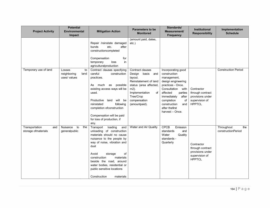
164 | P a g e
Project Activity
Potential Environmental
Impact
Mitigation Action Parameters to be
Monitored
Standards/ Measurement/
Frequency
Institutional Responsibility
Implementation Schedule
Repair /reinstate damaged bunds etc. after constructioncompleted
(amount paid, dates, etc.)
Compensation for temporary loss in agriculturalproduction
Temporary use of land Losses neighboring uses/ values
to land
Contract clauses specifying careful construction practices.
Contract clauses Design basis and layout. Reinstatement of land status (area affected, m2). Implementation of Tree/Crop compensation (amountpaid).
Incorporating good construction management, design engineering practices - Once. Consultation with affected parties immediately after completion of construction and after thefirst harvest – Once.
Construction Period
As much as possible existing access ways will be used.
Productive land will be reinstated following completion ofconstruction
Contractor through contract provisions under supervision of HPPTCL
Compensation will be paid for loss of production, if any.
Transportation and storage ofmaterials
Nuisance to generalpublic
the Transport loading and unloading of construction materials should no cause nuisance to the people by way of noise, vibration and dust
Avoid storage of construction materials beside the road, around water bodies, residential or public sensitive locations
Water and Air Quality CPCB Emission standards and Water Quality standards - Quarterly
Contractor through contract provisions under supervision of HPPTCL
Throughout the constructionPeriod
Construction materials
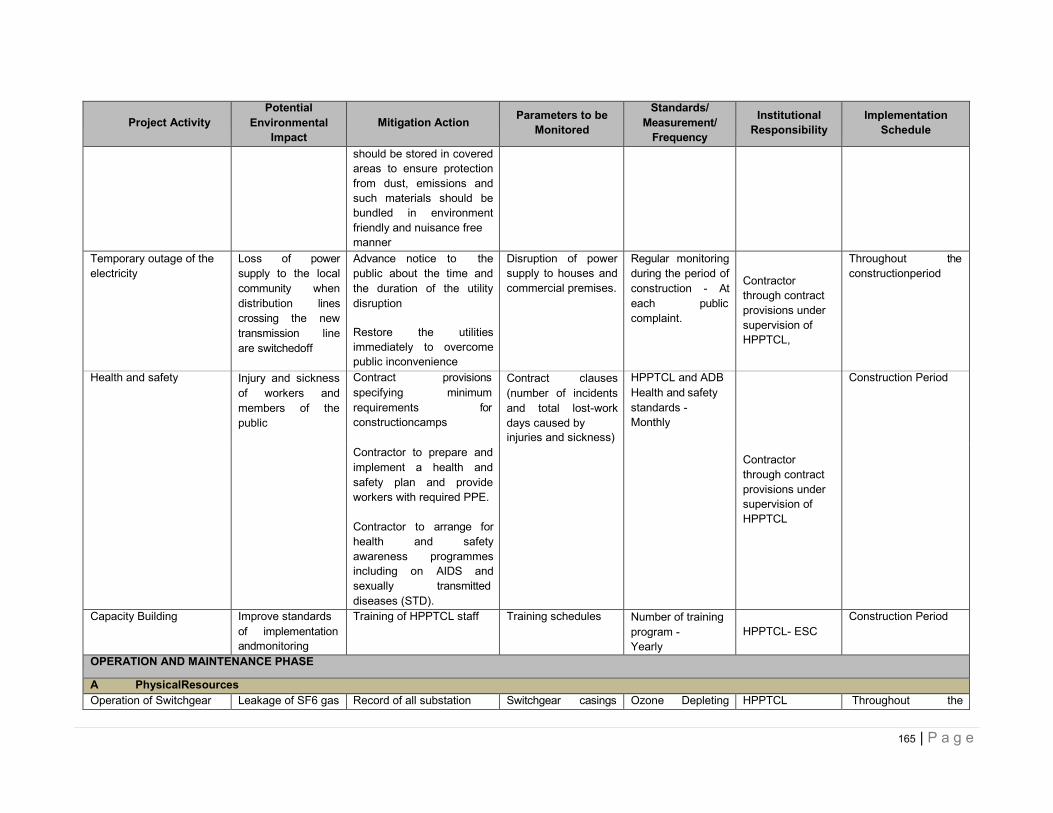
165 | P a g e
Project Activity
Potential Environmental
Impact
Mitigation Action Parameters to be
Monitored
Standards/ Measurement/
Frequency
Institutional Responsibility
Implementation Schedule
should be stored in covered areas to ensure protection from dust, emissions and such materials should be bundled in environment friendly and nuisance free manner
Temporary outage of the electricity
Loss of power supply to the local community when distribution lines crossing the new transmission line are switchedoff
Advance notice to the public about the time and the duration of the utility disruption
Restore the utilities immediately to overcome public inconvenience
Disruption of power supply to houses and commercial premises.
Regular monitoring during the period of construction - At each public complaint.
Contractor through contract provisions under supervision of HPPTCL,
Throughout the constructionperiod
Health and safety Injury and sickness of workers and members of the public
Contract provisions specifying minimum requirements for constructioncamps
Contract clauses (number of incidents and total lost-work days caused by injuries and sickness)
HPPTCL and ADB Health and safety standards - Monthly
Construction Period
Contractor to prepare and implement a health and safety plan and provide workers with required PPE.
Contractor to arrange for health and safety awareness programmes including on AIDS and sexually transmitted diseases (STD).
Contractor through contract provisions under supervision of HPPTCL
Capacity Building Improve standards of implementation andmonitoring
Training of HPPTCL staff Training schedules Number of training program - Yearly
HPPTCL- ESC
Construction Period
OPERATION AND MAINTENANCE PHASE
A PhysicalResources Operation of Switchgear Leakage of SF6 gas Record of all substation Switchgear casings Ozone Depleting HPPTCL Throughout the
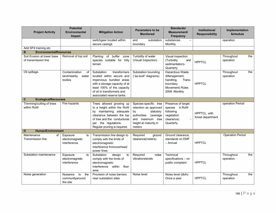
166 | P a g e
Project Activity
Potential Environmental
Impact
Mitigation Action Parameters to be
Monitored
Standards/ Measurement/
Frequency
Institutional Responsibility
Implementation Schedule
switchgear located within secure casings
and substation boundary
substances – Monthly
operation
Add SF6 training etc
B EnvironmentalResources Soil Erosion at tower base of transmission line
Removal of top soil Planting of buffer zone species suitable for hilly terrain
Turbidity of water (Visual Inspection)
Visual inspection (Turbidity and sedimentation)- Quarterly
HPPTCL
Throughout operation
the
Oil spillage Contamination of land/nearby water bodies
Substation transformers located within secure and impervious bundled areas with a storage capacity of at least 100% of the capacity of oil in transformers and associated reserve tanks.
Substation bounding (“as-built” diagrams)
Hazardous Waste (Management, handling, Trans- boundary Movement) Rules 2009 -Monthly
HPPTCL
Throughout operation
the
C EcologicalRecourses Trimming/cutting of trees within RoW
Fire hazards Trees allowed growing up to a height within the RoW by maintaining adequate clearance between the top of tree and the conductoras per the regulations. Regular pruning is required.
Species-specific tree retention as approved by statutory authorities (average and maximum tree height at maturity,in meters
Presence of target species in RoW following vegetation clearance) - Quarterly.
HPPTCL, with forest department
operation Period
D HumanEnvironment Maintenance of Transmission line
Exposure to electromagnetic interference
Transmission line design to comply with the limits of electromagnetic interference fromoverhead power lines
Required ground clearance(meters).
Ground clearance, standards on EMF – Annual
HPPTCL
Operation Period
Substation maintenance Exposure to electromagnetic interference
Substation design to comply with the limits of electromagnetic interference within floor area
Required noise vibrationslevels
Technical specifications – on public complaint
HPPTCL
Throughout operation
the
Noise generation Nuisance to the communityaround the site
Provision of noise barriers near substation sites
Noise level Noise level (dbA)- Once a year
HPPTCL
Throughout operation
the
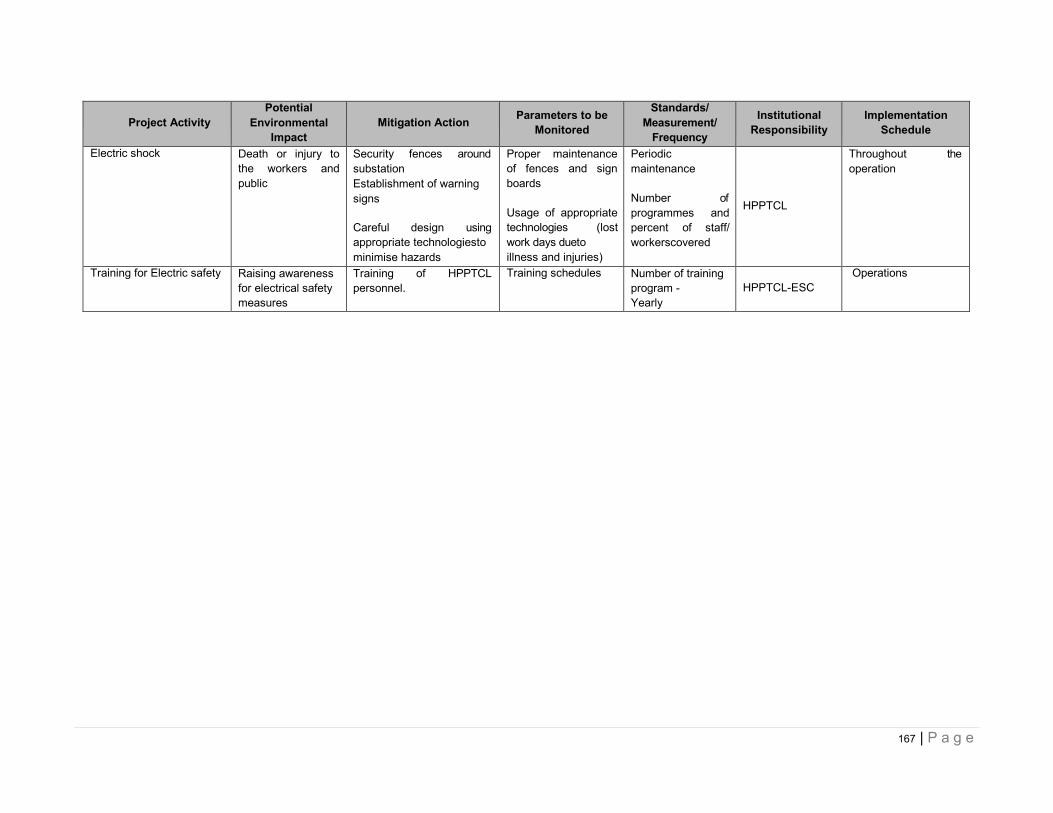
167 | P a g e
Project Activity
Potential Environmental
Impact
Mitigation Action Parameters to be
Monitored
Standards/ Measurement/
Frequency
Institutional Responsibility
Implementation Schedule
Electric shock Death or injury to the workers and public
Security fences around substation Establishment of warning signs
Careful design using appropriate technologiesto minimise hazards
Proper maintenance of fences and sign boards
Usage of appropriate technologies (lost work days dueto illness and injuries)
Periodic maintenance
Number of programmes and percent of staff/ workerscovered
HPPTCL
Throughout the operation
Training for Electric safety Raising awareness for electrical safety measures
Training of HPPTCL personnel.
Training schedules Number of training program - Yearly
HPPTCL-ESC
Operations
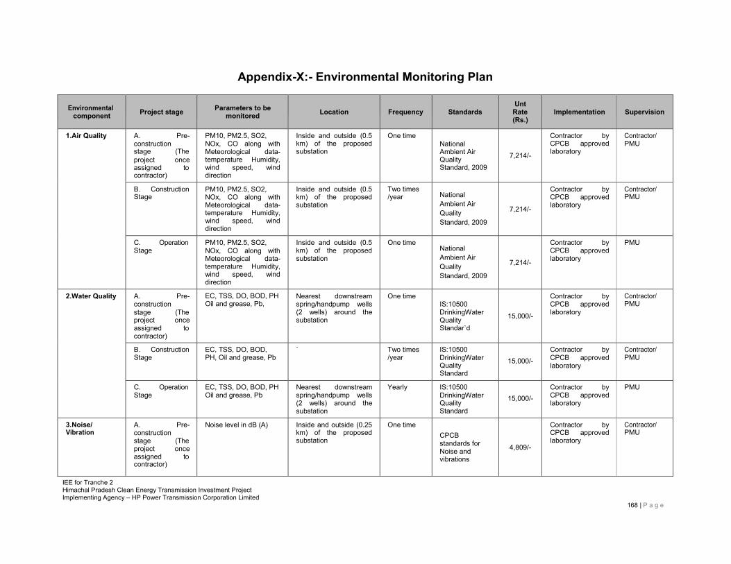
IEE for Tranche 2 Himachal Pradesh Clean Energy Transmission Investment Project Implementing Agency – HP Power Transmission Corporation Limited
168 | P a g e
Appendix-X:- Environmental Monitoring Plan
Environmental
component
Project stage
Parameters to be
monitored
Location
Frequency
Standards
Unt Rate (Rs.)
Implementation
Supervision
1.Air Quality A. Pre- construction stage (The project once assigned to contractor)
PM10, PM2.5, SO2, NOx, CO along with Meteorological data- temperature Humidity, wind speed, wind direction
Inside and outside (0.5 km) of the proposed substation
One time National Ambient Air Quality Standard, 2009
7,214/-
Contractor by CPCB approved laboratory
Contractor/ PMU
B. Construction Stage
PM10, PM2.5, SO2, NOx, CO along with Meteorological data- temperature Humidity, wind speed, wind direction
Inside and outside (0.5 km) of the proposed substation
Two times /year
National Ambient Air Quality Standard, 2009
7,214/-
Contractor by CPCB approved laboratory
Contractor/ PMU
C. Operation Stage
PM10, PM2.5, SO2, NOx, CO along with Meteorological data- temperature Humidity, wind speed, wind direction
Inside and outside (0.5 km) of the proposed substation
One time National Ambient Air Quality Standard, 2009
7,214/-
Contractor by CPCB approved laboratory
PMU
2.Water Quality A. Pre- construction stage (The project once assigned to contractor)
EC, TSS, DO, BOD, PH Oil and grease, Pb,
Nearest downstream spring/handpump wells (2 wells) around the substation
One time IS:10500 DrinkingWater Quality Standar`d
15,000/-
Contractor by CPCB approved laboratory
Contractor/ PMU
B. Construction Stage
EC, TSS, DO, BOD, PH, Oil and grease, Pb
` Two times /year
IS:10500 DrinkingWater Quality Standard
15,000/- Contractor by CPCB approved laboratory
Contractor/ PMU
C. Operation Stage
EC, TSS, DO, BOD, PH Oil and grease, Pb
Nearest downstream spring/handpump wells (2 wells) around the substation
Yearly IS:10500 DrinkingWater Quality Standard
15,000/-
Contractor by CPCB approved laboratory
PMU
3.Noise/ Vibration
A. Pre- construction stage (The project once assigned to contractor)
Noise level in dB (A) Inside and outside (0.25 km) of the proposed substation
One time CPCB standards for Noise and vibrations
4,809/-
Contractor by CPCB approved laboratory
Contractor/ PMU
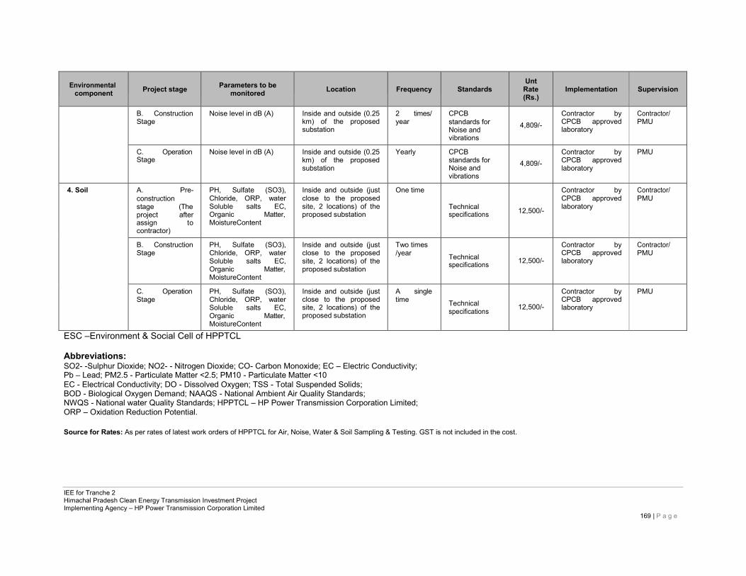
IEE for Tranche 2 Himachal Pradesh Clean Energy Transmission Investment Project Implementing Agency – HP Power Transmission Corporation Limited
169 | P a g e
Environmental
component
Project stage
Parameters to be
monitored
Location
Frequency
Standards
Unt Rate (Rs.)
Implementation
Supervision
B. Construction Stage
Noise level in dB (A) Inside and outside (0.25 km) of the proposed substation
2 times/ year
CPCB standards for Noise and vibrations
4,809/- Contractor by CPCB approved laboratory
Contractor/ PMU
C. Operation Stage
Noise level in dB (A) Inside and outside (0.25 km) of the proposed substation
Yearly CPCB standards for Noise and vibrations
4,809/- Contractor by CPCB approved laboratory
PMU
4. Soil A. Pre- construction stage (The project after assign to contractor)
PH, Sulfate (SO3), Chloride, ORP, water Soluble salts EC, Organic Matter, MoistureContent
Inside and outside (just close to the proposed site, 2 locations) of the proposed substation
One time
Technical specifications
12,500/-
Contractor by CPCB approved laboratory
Contractor/ PMU
B. Construction Stage
PH, Sulfate (SO3), Chloride, ORP, water Soluble salts EC, Organic Matter, MoistureContent
Inside and outside (just close to the proposed site, 2 locations) of the proposed substation
Two times /year
Technical specifications
12,500/-
Contractor by CPCB approved laboratory
Contractor/ PMU
C. Operation Stage
PH, Sulfate (SO3), Chloride, ORP, water Soluble salts EC, Organic Matter, MoistureContent
Inside and outside (just close to the proposed site, 2 locations) of the proposed substation
A single time
Technical specifications
12,500/-
Contractor by CPCB approved laboratory
PMU
ESC –Environment & Social Cell of HPPTCL
Abbreviations: SO2- -Sulphur Dioxide; NO2- - Nitrogen Dioxide; CO- Carbon Monoxide; EC – Electric Conductivity; Pb – Lead; PM2.5 - Particulate Matter <2.5; PM10 - Particulate Matter <10 EC - Electrical Conductivity; DO - Dissolved Oxygen; TSS - Total Suspended Solids; BOD - Biological Oxygen Demand; NAAQS - National Ambient Air Quality Standards; NWQS - National water Quality Standards; HPPTCL – HP Power Transmission Corporation Limited; ORP – Oxidation Reduction Potential.
Source for Rates: As per rates of latest work orders of HPPTCL for Air, Noise, Water & Soil Sampling & Testing. GST is not included in the cost.
Related Documents