1 Indented Head Archaeological Survey of the Maritime Landscape of Half Moon Bay / Indented Head, Victoria. A report submitted for the 2008 Portarlington Fieldschool Written by Rhonda Steel, Jody Bulman, Matthew Carter and Luke Kotys February 2008

Welcome message from author
This document is posted to help you gain knowledge. Please leave a comment to let me know what you think about it! Share it to your friends and learn new things together.
Transcript

1
Indented Head
Archaeological Survey of the Maritime Landscape of Half Moon Bay / Indented Head, Victoria.
A report submitted for the 2008 Portarlington Fieldschool
Written by Rhonda Steel, Jody Bulman, Matthew Carter and Luke Kotys
February 2008

2
Contents Aim 3 Introduction 3 Site Maps 4 History 5-6 The PS Ozone 6 Marking of PS Ozone wreck 7 Significance 7 The Dominion 7-8 Status 8 Methods 8 Walk/Swimline Search 8-9 Circular Search 9 Mapping 9 Photography 10 Results 10-12 Discussion 13 Visible Remains 13-15 Bibliography 15 Appendix 16-22

3
Aim The purpose of this investigation was to use various survey methods in order
to gain an overall appraisal of the maritime landscape of Indented Head, Victoria. It
was also a priority to use the survey data to assess whether a third, unknown and
previously documented, shipwreck was located in the area.
Introduction
Half Moon Bay, Indented Head is located north of St. Leonards on the
Bellarine Peninsula, Victoria. The Bellarine Peninsula is on the south western end of
Port Phillip Bay. Half Moon Bay is marked by the exposed wreck of the PS Ozone
which can be seen from the land. The Ozone was sunk in 1925 to act as a breakwater
for the local fisherman of the area and has since become a feature landmark of the
region. A monument featuring the preserved anchor of the Ozone was erected on the
main street overlooking the bay.
Our task was to survey the area of the bay within the headlands and as far out
as the hazard marker. It was already known that two wrecks, the PS Ozone and
Dominion were located within this area. As detailed archaeological work had already
been completed on both of these wrecks in previous studies by the Flinders University
Field School 2004, we surveyed them only in so far as they fit into the maritime
landscape of the area.
Half Moon Bay is 360 metres long and the hazard marker is 115 metres off the
centre of the beach. Rocky headlands are found at both ends of the sandy beach with
old boat ramp at the south eastern end of the bay. Set back from the beach, 11 boat
sheds are dotted along the dunes. A storm water drain deposits run off water
approximately half way along the beach. Taylors Reserve camping area is located at
Indented Head with people enjoying a range of activities including fishing, diving,
snorkelling and kayaking.
The majority of the bay is reasonably shallow only being between 0.5 and 3
metres deep. The bay floor is mostly covered by fine grain sand, with reef and rock at
either ends of the bay. The wrecks in the bay act as artificial reefs by provide structure
for aquatic plants as well as food and shelter for a variety of marine animals. Western

4
stingaree, Trygonoptera mucosa are very common in the bay and despite their small
size should be considered dangerous due to the two venomous spines on the tail.
Figure 1: Map of Port Phillip Bay, Victoria showing location of Indented Head.
Figure 2: Map of Half Moon Bay, Indented Head showing location of Dominion and PS Ozone.

5
History
For thousands of years the Port Phillip Bay Area has been the home to
Indigenous peoples who utilised the resources from both the terrestrial and marine
environments. The first Europeans to enter the area arrived in 1802 with the Port
Phillips Association being formed to promote the settlement of the Port Phillip Area
(Wynd 1988:2). By the late 1830’s the surrounding land was divided among a
number of large runs, and farming became the major economic activity of the area.
Shipping also became increasingly important as produce was moved from point to
point and fishing developed as a significant industry, with small boats a common sight
around the Port Phillip Bay Area.
Half-Moon bay was one such area in which small watercraft played an
important role in the local community. In 1925, the PS Ozone was purchased by a
ship breaker, J Hill, and stripped of all its fittings. The hulk of the Ozone was then
purchased by Captain Forbes in October 1925 and towed to Indented Head to be sunk
as part of a v-shaped breakwater together with the hulk of the Dominion.
6
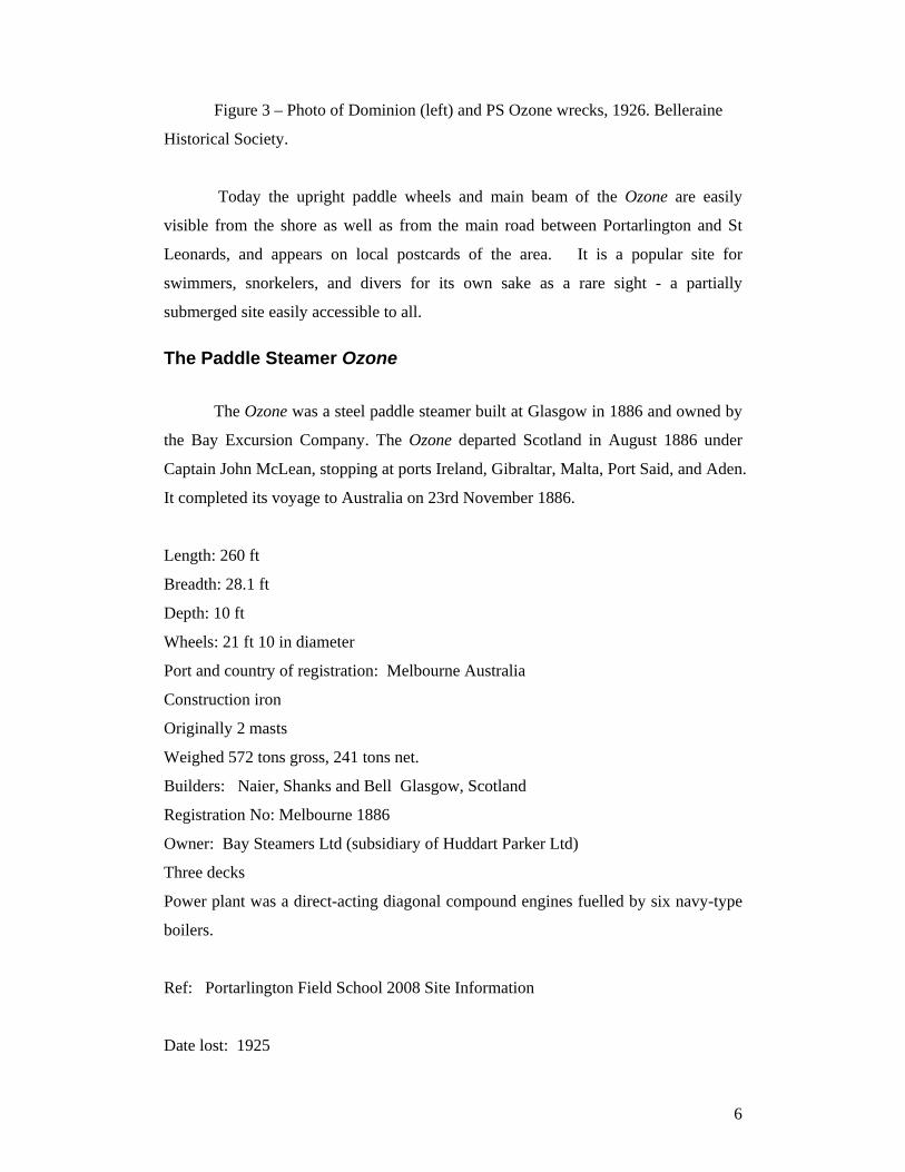
Figure 3 – Photo of Dominion (left) and PS Ozone wrecks, 1926. Belleraine
Historical Society.
Today the upright paddle wheels and main beam of the Ozone are easily
visible from the shore as well as from the main road between Portarlington and St
Leonards, and appears on local postcards of the area. It is a popular site for
swimmers, snorkelers, and divers for its own sake as a rare sight - a partially
submerged site easily accessible to all.
The Paddle Steamer Ozone
The Ozone was a steel paddle steamer built at Glasgow in 1886 and owned by
the Bay Excursion Company. The Ozone departed Scotland in August 1886 under
Captain John McLean, stopping at ports Ireland, Gibraltar, Malta, Port Said, and Aden.
It completed its voyage to Australia on 23rd November 1886.
Length: 260 ft
Breadth: 28.1 ft
Depth: 10 ft
Wheels: 21 ft 10 in diameter
Port and country of registration: Melbourne Australia
Construction iron
Originally 2 masts
Weighed 572 tons gross, 241 tons net.
Builders: Naier, Shanks and Bell Glasgow, Scotland
Registration No: Melbourne 1886
Owner: Bay Steamers Ltd (subsidiary of Huddart Parker Ltd)
Three decks
Power plant was a direct-acting diagonal compound engines fuelled by six navy-type
boilers.
Ref: Portarlington Field School 2008 Site Information
Date lost: 1925
7
Official wreck number: 88947
Age of ship at time of wreck: 59
Location: Port Phillip Bay, Indented Head
Marking of Ozone wreck The northern extremity of the wreck has been marked by an unlit IALA north
Cardinal pile with topmark in a position bearing 146 deg. 42 min. (T) distance 1113
meters from Point George Beacon (Lat. 38 deg.07 min. 9 sec. S Long 144 deg. 42 min.
3 sec. E., (approx).
Lat min -38.1384833
Lat max -38.1384833
Long min 144.7129833
Long max 144.7129833
Ref: Victorian Shipwreck Notice to Mariners 1841-2003 Peter Taylor 2003 dover
publications Victoria
Significance The Ozone is representative of the golden age of paddle steamships when
these ships transported hundreds of day trippers from Melbourne across Port Phillip
Bay to Queenscliff and Sorrento. The Ozone had a major effect on other vessels
engaged in the excursion trade. It outclassed many of the older vessels engaged in the
excursion trade such as the Williams and Golden Crown due to its superior new
paddle-steam technology. Other older vessels such as the Lonsdale competed against
the Ozone for business.
The Dominion
The Dominion was a wooden barque of 1124 gross built in Quebec Canada in
1879. It was licensed as a coal/wool lighter operating in Port Phillip Bay until it was
purchased along with the Ozone and scuttled in Indented Head.
Length: 190ft
Breadth: 37ft

8
Depth: 24ft
Swimming, snorkeling and diving and the cumulative damage on site may
continue to break down the wrecks. The wrecks at Indented head have largely settled
to the sea floor but will continue to break down as the boiler sets and paddlewheels
continue to erode.
Status The two wrecks are classified as historic shipwrecks as defined by the Heritage Act 1995 Victoria and the Historic Shipwrecks Act 1976 (Commonwealth).
Methods
The large and diverse area of the bay area required a non-random systematic
survey which was undertaken using three methods namely; walk line, swimline, and a
circular search. These particular methods were chosen in combination as together
they offered the best overall coverage of the bay area.
Walk/swimline search
Due to the orientation of the bay a point high on the beach was selected to
begin the search, this allowed us to ensure that the first search line included all areas
of water. The orientation of the search line was chosen by taking a bearing (1300)
from the north-western extent of the breakwater in line with the isolated danger mark
and the visible remains of the Ozone wreck (Fig. 3). A GPS was used to plot the
starting point (55H: 0299403, UTH: 5776451), and was taken from location number
zfour. There were five people positioned at 5m intervals covering a distance of 25m,
extending 90 degrees from the bearing. The 5m distance between people was chosen
as the visibility allowed us to comfortably see our adjacent team member, compasses
were used to maintain our bearing, and a measuring tape enabled us to maintain our
distance.
When points of interest were encountered the line was stopped and
measurements, photographs, and sketches were made, where possible GPS points
were also plotted. Once we reached the opposite end of the bay, we took a reciprocal
bearing and turned using the last person as an axis. As our next line was made up of
9
four people we were reduced to covering 20m. Due to rising tides we abandoned the
walking line half way across the bay in order to continue our search with snorkel and
scuba. The point was buoyed so that we could continue from our previous position
without missing any areas. After this run was completed we again turned on our axis
and continued the swimline along the same bearing as was initially used. This
completed our walk/swimline search.
Circular search
In order to cover the location to the left of the known wrecks in the bay, and
due to information received regarding the presence of an unknown wreck, it was
decided to proceed with a circular search using the isolated danger marker as our
central axis. Four divers were spread apart at 5m intervals to cover a radius of 20m.
A second circle search, with divers again at 5m intervals, was completed but this time
with a radius of 40m and divers positioned at the 25m, 30m, 35m and 40m points.
This method of search enabled us to cover an area of 5026 square metres of seafloor
and thus allowed us to complete our underwater survey of the bay area.
Mapping
Our next step was to plot the various points of interest that we had found and
to create a map of the surrounding beach area. Initially, a eTrix Garmin handheld GPS
unit was used to plot the position of various points of interest. This unit allowed us to
gather information quickly and to plot the location of points out of sight from the total
station e.g. the Ozone’s anchor. This GPS enabled us to create a reasonably accurate
working map of the area. The boatsheds surrounding the bay were also photographed,
measured, and mapped using tape measures. This provided us with the dimensions
and layouts of the various buildings. A Sokkia total station was also used to map the
area. This was setup using the nearby HSM 299 survey mark to allow our points of
interest to be integrated within the national geodetic grid. A total of 33 points were
entered into the total station (appendix a). Once these points had been determined we
were able to plot them onto graph paper to create a precise map of the bay area.

10
Photography
Canon PowerShot A710IS 7.1 mega pixel used inside a Canon WP-DC6
waterproof case as well as an Olympus U7795SW. Cameras were used to record
images of artefacts and wrecks as well as to capture photos of landscapes.
Results Two maps were produced as a result of our survey. The first map used the
Total Station data (App.) to provide a highly accurate rendering of the bay, a number
of the boat sheds, points on the Ozone wreck, and the isolated hazard marker (Fig. 1).
Figure 4: Map of Total Station points from Indented Head, drawn by Rhonda Steel (For full scale drawing see the appendix).

11
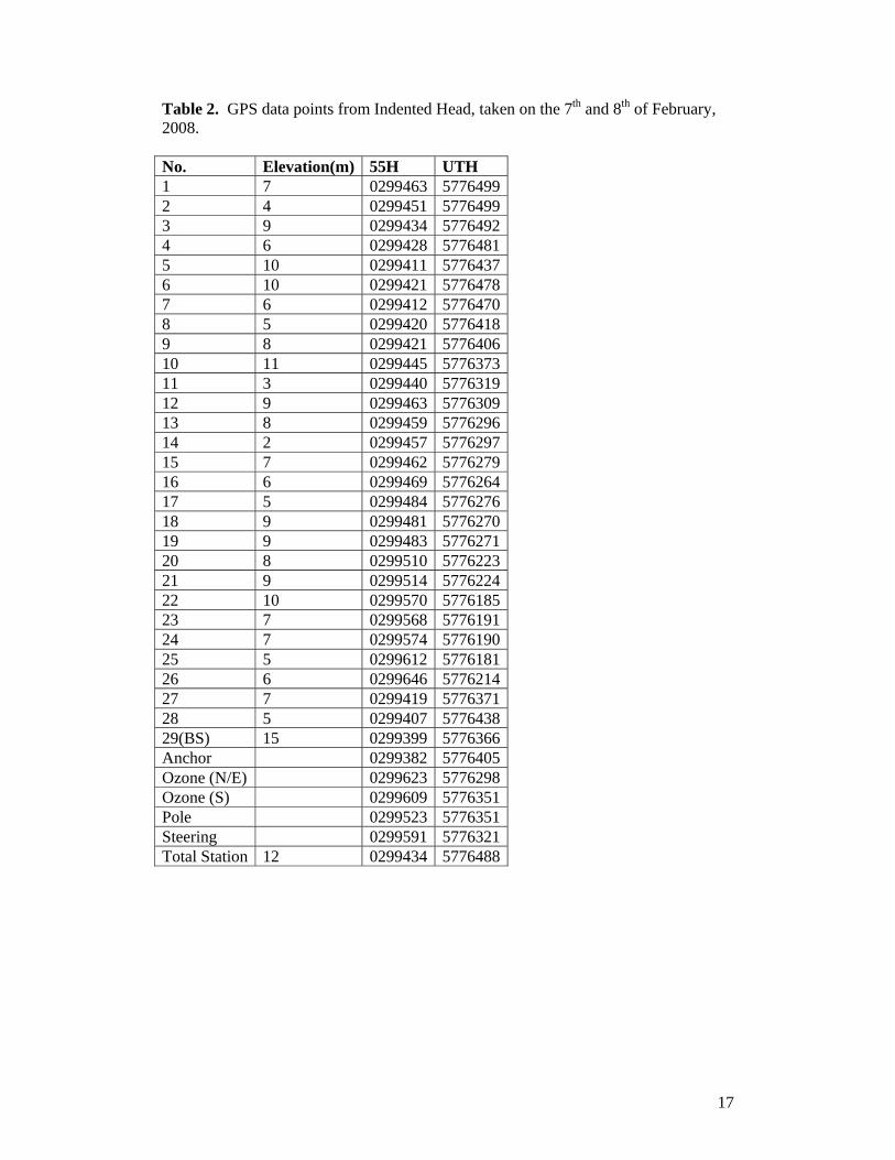
The second map, similar to the first, was produced using GPS data (App.) of the
shoreline, boat sheds, Ozone wreck and other points of interest (Fig. 5). Due to the
nature of the GPS equipment this map is less accurate than the total station map,
however it provides a good template on which to plot further items of the maritime
landscape.
Figure 5: Map of the Indented Head maritime landscape, drawn by Rhonda Steel (For full scale see appendix).
As can be seen in Fig. 5 the bay curves between two breakwaters, both of
which were constructed using rocks. The south eastern breakwater is the longer of the
two. The Dominion and PS Ozone wrecks lie adjacent to one another, however they
are at odd angles due to issues during sinking. Both these wrecks are in various states
of decay, the PS Ozone is the more visibly present of the two with paddle wheels and
12
metal remains protruding above the surface of the water. Figure 5 also shows the
positioning of the boatsheds around the bay and the gaps where boatsheds used to be.
During the survey a number of features were discovered in the bay area. A
piece of rectangular wood was discovered on the waterline. Further out four separate
metal items were surveyed. One metal pole was found emerging from the seabed near
the north western breakwater. An emerging metal pole and round metal object were
located within the vicinity of the Ozone during the swimline search. A coil of anchor
chain and some other metal objects were also identified during the circular search.
In addition to the features inside the bay nearby there is an anchor monument of the
Ozone. The anchor on display was found among one of the nearby wrecks within Half
Moon Bay. It is of metal material and highly corroded. It appeared to be of the
Trotman anchor type, due to the style of ‘horns’ located on both sides of the anchor.
Table 1: Features discovered during the survey of Indented Head.
# Description Width Length Height On tape line
Location
1 Square wooden item
East 39cm west 55cm
89cm 10cm 7m5cm 55h0299438 utm5776357
2 Concrete ramp central
3.72m 5.32m 55h02999596 5776189
3 Concrete ramp east end part
1.89m 5.32m
4 Concrete ramp west end part
2m 5.32m
5 Gap between parts 10cm 6 End of search east
side 55h 02999590
5776186 7 Metal stake 120 deg. To centre boat
shed 8 Metal item 11cm 44cm 3cm Hazard post 0 deg.
Middle shed 250 deg. Wheel of wreck 60 deg.
9 Round metal item 60cm 22cm 4.8m from wreck 10 Chain pile-
40 links 60cm 23cm 10cm 7m 5cm 20 cm diameter
A Start of search Direction 130 deg. 55h0299403 utm5776451
Dominion wreck 8m west end 4m east end 10m center
45m 2m
11 Anchor 55H 0299382 uth 5776405

13
12 Metal framing 1.56m north 1.45m South
2.06m 180 degrees from Nav pole 280 degrees to center shed
Discussion
Our investigation of the Indented Head area revealed a number of points of
archaeological interest which include both terrestrial and marine based sites. When
viewed together these sites represent a maritime heritage landscape which presents a
framework through which to interpret a unique aspect of our collective past. As
discussed above, the individual sites include at least two shipwrecks, the two
breakwaters, the eleven boatsheds, the Ozone anchor display and the interpretive
signage.
Visible remains The wrecks of the PS Ozone and the Dominion are two of the most prominent
features of the maritime landscape of Indented Head. The pieces of the Ozone which
protrude above the water line draw the attention of visitors to the area. These wrecks
represent the maritime heritage of the area, not only because they were significant
ships which sailed in the area but also because of their re-use as part of the breakwater.
The breakwaters at both the northern and southern aspects of the bay are also
significant aspects of the maritime landscape. These breakwaters have been
significantly reduced from their original size but still provide us with evidence of past
human activities in the bay including fishing, and recreational boating.
Another aspect off the maritime landscape is the boatsheds that are found
along the shore of the bay. These sheds housed a number of small watercraft, a
function which they continue today. This is a significant link to the past when such
small vessels were essential in the day to day transport of people and materials from
the fledgling area. The spacing between the boatsheds reveal that over time while
some sheds have been modified and upgraded others have been demolished and not
replaced. These sheds also provide a tangible link between the ocean and land
portions of the landscape. Often maritime studies are limited by the way people view
them as entirely based in the ocean, however as we have shown here the landscape

14
extends beyond just wrecks and what can be found beneath the water, it includes
associated items on shore, such as boatsheds, and their relation to maritime activities.
The large sign post at the south eastern end of the bay explains the history and
significance of the two wrecks in the bay. This sign came about after work completed
in previous field schools. It is a useful tool to engage the public in the maritime
landscape at the same time as teaching them about the area. This shows how work in
the area not only benefits academia but also the community in general.
There is an anchor monument on display overlooking Half Moon Bay. It is a
monument in recognition of the nearby paddle steamer wreck Ozone, and was
unveiled on 14th January 1995. The wreck has become a feature landmark for
Indented Head and a symbol of the marine heritage of the area. The anchor has thus
become a symbol of more than just the wrecks in the adjacent bay but also for the
seafaring tradition of the coast itself.
The maritime landscape not only involves visible aspects but also those which
are less noticeable. During the swim/walk searches a number of artefacts were found,
these were mostly of metal. The majority were found further out in the bay near the
wrecks which is to be expected, it is likely that a number of these, including the
anchor chain, are actually associated with the wrecks. Others such as the metal frame
and bar at either end of the bay may have been involved in the formation of the
breakwater. It is important to note these parts of the survey within the maritime
landscape scope, often smaller objects are overlooked in favour of the more obvious
maritime markers such as wrecks and breakwaters, however it is the whole picture
rather than just the obvious points that creates a landscape.
While it has been shown that Indented Head has a unique and visible maritime
landscape this must be now be put into the larger context of the surrounding area of
Portarlington and Port Philip Bay. Both the Ozone and the Dominion plied these
waters during a time of economic boom and major development.
The maritime landscape, as with any other landscape, is continuously
changing. The area of Indented Head is not stable but rather a fluid environment
which is impacted on by the activities of all those in the region. Not only are new
things brought into the environment but also things are taken away or breaking down.
For example, the photos of the wreck when it was first sunk and those of it currently
illustrate the deterioration of the wreck over time. So while a future survey of the
area would no doubt have changes, what is important to understand from this report is
15
the interrelated nature of the underwater sites with the shore and its surroundings.
Furthermore it is necessary to place Indented Head within the broader context of
Philip Bay and early Australian development.
Bibliography Edgar, G. J. (2000) Australian Marine Life, Revised Edition. Reed New Holland, Sydney Australia. Wynd, I. (1988) Balla-wein: A History of the Shire of Bellarine. Shire of Bellarine, Melbourne

16
Appendix Table 1 - Total station points taken on the 7th of February 2008, at Half Moon Bay, Indented Head.
Point ZA HAR Distance from BS (m)
BS 86 59 09 0 1 93 51 10 242 35 22 32.167 2 102 44 15 252 15 06 8.269 3 103 07 07 326 16 34 8.207 4 96 50 21 351 36 43 15.119 5 88 32 40 38 55 20 26.419 6 92 16 04 25 06 18 24.919 7 91 42 04 23 36 18 30.867 8 91 23 43 351 38 06 75.872 9 90 39 38 352 09 19 114.266 10 90 17 39 342 41 03 169.664 11 90 13 52 342 03 03 174.366 12 90 33 40 335 57 36 185.908 13 90 13 12 338 25 14 194.938 14 90 14 51 337 41 49 198.564 15 90 11 51 337 11 29 212.119 16 90 02 47 336 03 18 234.036 17 90 27 55 330 55 08 224.111 18 90 13 10 332 54 21 225.570 19 90 15 43 332 29 40 229.323 20 90 08 00 328 14 39 282.241 21 90 07 47 327 36 43 286.419 22 89 53 04 321 26 24 336.372 23 90 16 46 320 58 51 329.892 24 90 13 19 320 26 04 334.708 25 90 18 14 315 34 29 357.867 26 90 26 17 305 45 19 357.069 27 90 30 22 301 14 07 272.587 28 90 27 34 305 19 23 276.152 29 90 34 15 303 20 30 235.108 30 90 43 09 300 22 08 197.962 31 90 16 09 344 56 36 154.414 32 90 42 56 356 47 47 96.994 33 90 46 45 11 26 46 58.260 BS 86 58 52 359 59 35 129.679
17
Table 2. GPS data points from Indented Head, taken on the 7th and 8th of February, 2008. No. Elevation(m) 55H UTH 1 7 0299463 57764992 4 0299451 57764993 9 0299434 57764924 6 0299428 57764815 10 0299411 57764376 10 0299421 57764787 6 0299412 57764708 5 0299420 57764189 8 0299421 577640610 11 0299445 577637311 3 0299440 577631912 9 0299463 577630913 8 0299459 577629614 2 0299457 577629715 7 0299462 577627916 6 0299469 577626417 5 0299484 577627618 9 0299481 577627019 9 0299483 577627120 8 0299510 577622321 9 0299514 577622422 10 0299570 577618523 7 0299568 577619124 7 0299574 577619025 5 0299612 577618126 6 0299646 577621427 7 0299419 577637128 5 0299407 577643829(BS) 15 0299399 5776366Anchor 0299382 5776405Ozone (N/E) 0299623 5776298Ozone (S) 0299609 5776351Pole 0299523 5776351Steering 0299591 5776321Total Station 12 0299434 5776488

18
Figure 6 – PS Ozone wreck at Indented Head (Photo taken by Luke Kotys).
Figure 7 – Dominion wreck at Indented Head (Photo taken by Luke Kotys).

19
Figure 8 – Large metal pole, seabed of Indented Head (Photo taken by Rhonda Steel).
Figure 9 – PS Ozone anchor monument, indented head (Photo taken by Luke Kotys).

20
Figure 10 – 40 link chain pile (see results number 10) (Photo taken by Luke Kotys).
Figure 11– Western stingaree, Trygonoptera mucosa (Photo taken by Luke Kotys).

21
Figure 12 – Setting up the total station (Photo taken by Rhonda Steel).
Figure 13 – Hazard marker and PS Ozone at Indented Head (Photo taken by Rhonda Steel).

22
Figure 14 – Square wooden item (see results feature number 1) (Photo taken by Rhonda Steel).
Figure 15 - Round metal object found near the Ozone wreck (Photo taken by Rhonda Steel).
Related Documents


![Student Manual 2017 - Portarlington Taekwon Do manual.pdfW } o ] v P } v d l Á } v } ^ Z } } o W v Z](https://static.cupdf.com/doc/110x72/5e4a37e081eb1658ab61e0dd/student-manual-2017-portarlington-taekwon-do-manualpdf-w-o-v-p-v-d-l-.jpg)