Geological Society, London, Special Publications doi: 10.1144/SP353.10 2011; v. 353; p. 189-219 Geological Society, London, Special Publications A. Perrineau, J. Van Der Woerd, Y. Gaudemer, et al. plateau building and of fluvial terraces: implications for catchment evolution Al cosmogenic isotope dating 26 Be and 10 constrained by Incision rate of the Yellow River in Northeastern Tibet service Email alerting articles cite this article to receive free e-mail alerts when new here click request Permission this article to seek permission to re-use all or part of here click Subscribe London, Special Publications or the Lyell Collection to subscribe to Geological Society, here click Notes guest on March 10, 2011 Downloaded by 2011 © The Geological Society of London

Welcome message from author
This document is posted to help you gain knowledge. Please leave a comment to let me know what you think about it! Share it to your friends and learn new things together.
Transcript
Geological Society, London, Special Publications
doi: 10.1144/SP353.10 2011; v. 353; p. 189-219Geological Society, London, Special Publications
A. Perrineau, J. Van Der Woerd, Y. Gaudemer, et al. plateau building
andof fluvial terraces: implications for catchment evolution Al cosmogenic isotope dating26Be and 10constrained by
Incision rate of the Yellow River in Northeastern Tibet
serviceEmail alerting
articles cite this article to receive free e-mail alerts when newhereclick
requestPermission
this article to seek permission to re-use all or part ofhereclick
SubscribeLondon, Special Publications or the Lyell Collection
to subscribe to Geological Society,hereclick
Notes
guest on March 10, 2011Downloaded by
2011© The Geological Society of London
Incision rate of the Yellow River in Northeastern Tibet constrainedby 10Be and 26Al cosmogenic isotope dating of fluvial terraces:implications for catchment evolution and plateau building
A. PERRINEAU1,2, J. VAN DER WOERD2, Y. GAUDEMER1, JING LIU-ZENG3,
R. PIK4, P. TAPPONNIER1, R. THUIZAT2 & ZHENG RONGZHANG5
1Laboratoire de Tectonique, Institut de Physique du Globe de Paris – UMR 7154,
4 place Jussieu, 75254 cedex 05, Paris, France2Institut de Physique du Globe de Strasbourg – UMR CNRS/UDS 7516, Ecole et Observatoire
des Sciences de la Terre, University of Strasbourg, 5 rue Rene Descartes,
67084 Strasbourg cedex, France3Institute of Tibetan Plateau Research, Chinese Academy of Sciences, 18 Shuang Qing Rd,
PO Box 2871, Beijing 100085, China4Centre de Recherche Petrographiques et Geochimiques – UPR1167,
15 rue Notre-Dame des Pauvres, 54501 Vandoeuvre-les-Nancy, France5China Earthquake Administration, Beijing, China
*Corresponding author (e-mail: [email protected])
Abstract: Unlike other large rivers flowing out of Tibet, the Yellow River escapes from theplateau towards the NE crossing no less than five NW–SE striking, actively growing ranges andintervening basins. Thick Plio-Quaternary deposits and fluvial terraces testify to a phase of aggra-dation and sediment infill up to the average surface elevation (3200–3250 m a.s.l.) of the Gonghe,Guide and Qinghai Lake basins. A set of seven main terraces across the Gonghe Basin suggestsprogressive down-cutting of the Yellow River carving the 500 m deep Longyang gorge at thebasin exit. 10Be and 26Al concentrations in quartz of surface and sub-surface samples of fourterraces constrain the timing of incision by determining the burial age of the deposit and theexposure age of its surface. Modelling the depth dependence of the 10Be concentration and the26Al/10Be ratio allows us to constrain the onset of the ongoing phase of incision to 120–250 ka.These ages suggest long-term incision rates between 2–6 mm a21. Together with the presentmorphology of the Yellow River terraces across the Gonghe basin and the Longyang gorge, ourresults imply rapid river catchment evolution and interaction between river dynamics, tectonicand climate in northeastern Tibet.
How and when the Tibetan Plateau reached itspresent altitude and shape are important to investi-gate as the topography influences atmospheric cir-culations, thus the climate, but also because itmay be used to constrain models of TibetanPlateau evolution (e.g. Tapponnier et al. 1982;England & Houseman 1986; Peltzer & Tapponnier1988; Houseman & England 1993; Royden et al.1997; Fluteau et al. 1999; Tapponnier et al. 2001;Liu-Zeng et al. 2008). In the stepped growthmodel of Tibet of Tapponnier et al. (2001), north-eastern Tibet is the youngest part of the plateauthat formed from Pliocene time to present (Meyeret al. 1998; Metivier et al. 1998). The region ischaracterized by narrow actively growing ranges(e.g. Tapponnier et al. 1990; Meyer et al. 1998;
Van der Woerd et al. 2001) that separate flatrapidly filling closed sedimentary basins (Meyeret al. 1998; Metivier et al. 1998; Van der Woerd1998). Such process may have been active in thecentral part of the Tibetan Plateau, leading to theformation of a high topography at c. 5000 m a.s.l.From this point of view, the northeastern Tibetanregion is a key place to unravel processes of theformation of the Tibetan Plateau. Understanding thedifferent roles of tectonics, climate and the evolvingdrainage is thus important to constrain the formationof the present topography of Tibet (e.g. Clark et al.2004; Liu-Zeng et al. 2008).
The Yellow River, together with the Jinsha,Lancang (Mekong), and Nu (Salween) rivers, drainsthe Tibetan Plateau on its eastern rim (Fig. 1). While
From: Gloaguen, R. & Ratschbacher, L. (eds) Growth and Collapse of the Tibetan Plateau.Geological Society, London, Special Publications, 353, 189–219.DOI: 10.1144/SP353.10 0305-8719/11/$15.00 # The Geological Society of London 2011.
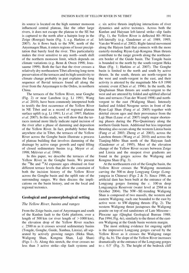
Fig. 1. Seismotectonic map of the upper reaches of the Yellow River across northeastern Tibet. Fault modified from Van der Woerd (1998), Meyer et al. (1998), Tapponnier et al.(2001). Seismicity from Iris catalogue, focal mechanisms from Harvard. Gonghe 1990 M 7 earthquake isoseismal from Chen et al. (1996). Topographical background is contoursextracted from SRTM DEM with a 30 s precision.
A.PERRIN
EAUETAL.
190
its source is located on the high summer monsooninfluenced central plateau, like the other largerivers, it does not escape the plateau to the SE butis captured to the north after a hairpin loop in theZoige (Roergai) basin (Fig. 1; e.g. Harkins et al.2007). As it flows back to the NW, north of theAnyemaqen Shan, it enters regions of lesser precipi-tation that barely feed the river. This particularitymakes the river sensitive to any north–south shiftof the northern monsoon limit, which depends onclimate variations (e.g. Benn & Owen 1998; Jous-saume 1999). Both the fact that the river crosses arelatively dry northeastern Tibet allowing long-termpreservation of the terraces and its high sensitivity toclimate change probably in part explains the longsequence of fluvial terraces found all along theriver from the Anyemaqen to the Ordos, in northernChina.
The terraces of the Yellow River, near Gonghe(Fig. 2) or near Lanzhou (e.g. Li 1991; Wanget al. 2010), have been commonly interpreted bothto testify the first occurrence of the Yellow Riverin NE Tibet and as a record of regional plateausurface uplift (e.g. Li 1991; Li et al. 1997; Harkinset al. 2007). In this study, we will show that the ter-races instead more likely indicate rapid incision ofthe river after a phase of damming and depositionof the Yellow River. In fact, probably better thananywhere else in Tibet, the terraces of the YellowRiver across the Gonghe basin illustrate a processof plateau building that involves damming of thedrainage by active range growth and rapid fillingof closed sedimentary basins (e.g. Meyer et al.1998; Metivier et al. 1998).
In this paper, we describe the terraces of theYellow River in the Gonghe basin. We presentthe 10Be and 26Al exposure ages obtained on fourdifferent terrace levels that allow the constraint ofboth the incision history of the Yellow Riveracross the Gonghe basin and the uplift rate of thesurrounding ranges. We then discuss the impli-cations on the basin history, and on the local andregional tectonics.
Geological and geomorphological setting
The Yellow River, basins and ranges
From the Zoige basin, east of Anyemaqen and southof the Kunlun fault to the Gobi platform, over alength of 500 km (or river length of .1000 km),the elevation drop of the Yellow River reachesc. 2500 m as it crosses several sedimentary basins(Tongde, Gonghe, Guide, Xunhua, Linxia), all sep-arated by actively growing ranges (Heka Shan,Waligong Shan, Kongma Shan, Laji Shan)(Figs 1–3). Along this stretch, the river crosses noless than 3 active strike–slip fault systems and
c. six active thrusts implying interactions of riverdynamics and active tectonics. Across both theKunlun and Haiyuan left-lateral strike–slip faults(Fig. 1), the Yellow River is deflected 80–90 kmleft-laterally (e.g. Gaudemer et al. 1989, 1995;Van derWoerd et al. 2002). Right-lateral movementalong the Haiyen fault that connects with the moreeasterly-trending Riyue-Laji-Kongma Shan thrustscontribute to the range growth along the northeast-ern border of the Guide basin. The Tongde basinis bounded to the north by the south-vergent HekaShan (Fig. 1; Harkins et al. 2007). The Gonghebasin is limited to the north and south by activethrusts. In the south, thrusts are north-vergent inthe west and south-vergent in the east, and theiractivity is attested by the magnitude Mw 6.9 1990seismic event (Chen et al. 1996). In the north, theQinghainan Shan thrusts are south-vergent to thewest and are attested by folded and uplifted alluvialfans and terraces (Van der Woerd 1998) and north-vergent to the east (Waligong Shan). Intenselyfaulted and folded Neogene series in front of theRyue-Laji Shan (Fang et al. 2005) together withdetrital zircon ages and their provenance from theLaji Shan (Lease et al. 2007) imply major shorten-ing phases during the Plio-Quaternary along thenorthern Guide basin. Additional but less importantthrusting also occurs along the western Linxia basin(Fang et al. 2003; Zheng et al. 2003), across theLanzhou thrusts (Wang et al. 2010) and across theTianjing-Mibo Shan north of the Haiyuan fault(Gaudemer et al. 1995). Most of the elevationchange of the Yellow River occurs between Zoigeand Linxia and the steepest river gradients arefound in the gorges across the Waligong andKongma Shan (Fig. 3).
At the northeastern exit of the Gonghe basin, theYellow River crosses the Waligong mountainscarving the 500 m deep Longyang Gorge (Long-yangxia in Chinese) (Figs 2 & 3). Since 1986, anartificial dam has been built at the entrance of theLongyang gorges forming the c. 100 m deepLongyangxia Reservoir (water level at 2568 m inOctober 2004). The NW–SE-trending WaligongShan is composed of two massifs, the western andeastern Waligong, each one bounded to the east byactive west- to SW-dipping thrusts (Fig. 2). Thewestern Waligong thrust juxtaposes the Waligonggranite on top of red sandstones of Late Miocene–Pliocene age (Qinghai Geological Bureau 1988;Pan 1994; Fig. 4e), similarly to the thrust of the east-ern Waligong at the Guide basin western margin.
The most striking evidence for ongoing upliftis the impressive Longyang gorges carved by theYellow River as it crosses the Waligong range(Fig. 4a, b). The slope of the Yellow River increasesdramatically at the entrance of the Longyang gorgesto c. 0.58 (Fig. 3). The height of the bedrock cliff
INCISION RATE OF YELLOW RIVER IN NE TIBET 191
reaches c. 300–500 m in the gorge (Fig. 4). Otherevidence for active tectonic uplift are given by theabraded bedrock abandoned above the gorge. Atpresent, the bedrock slopes towards the west asexpected if it were back-tilted to the west due touplift of the Waligong on top of a west-dippingthrust (Fig. 5).
The Yellow River terraces across the
Gonghe Basin
The Gonghe Basin is a NW–SE-trending250 ! 50 km wide sedimentary basin (Figs 1 &2). It is bounded to the north by the activelygrowing Qinghainan Shan and to the south by the
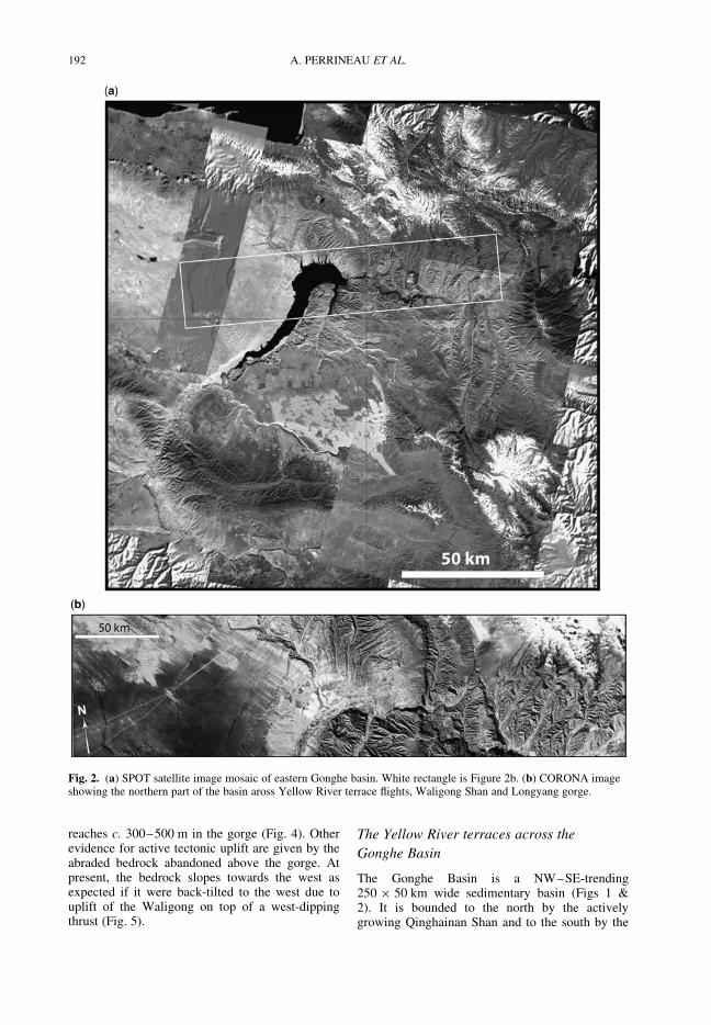
Fig. 2. (a) SPOT satellite image mosaic of eastern Gonghe basin. White rectangle is Figure 2b. (b) CORONA imageshowing the northern part of the basin aross Yellow River terrace flights, Waligong Shan and Longyang gorge.
A. PERRINEAU ET AL.192
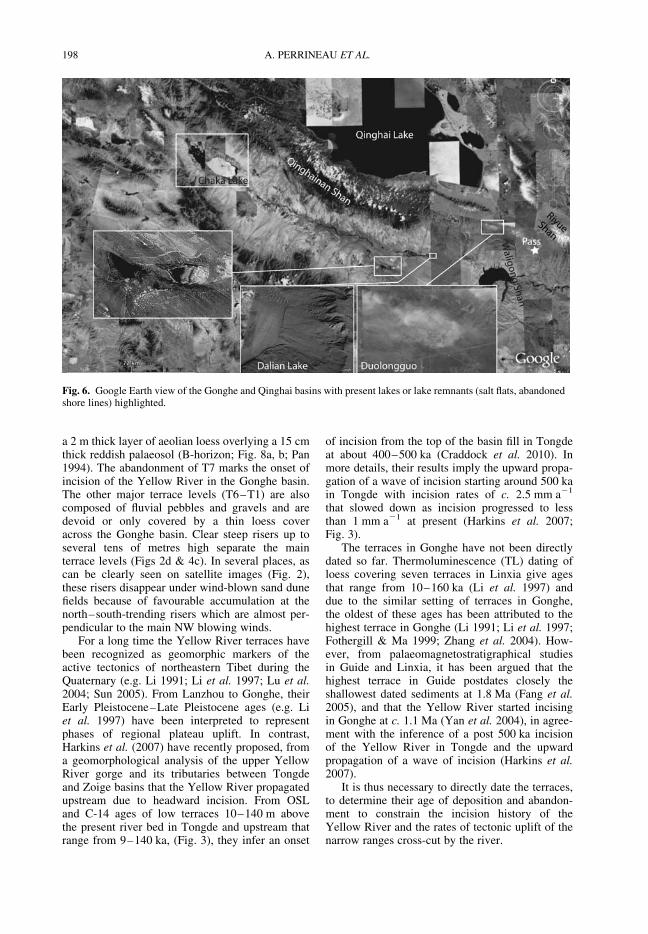
Ngola Shan (or Gonghenan Shan) and the HekaShan. It is filled with up to 1200 m of Quaternarysediments (Qinghai Geological Bureau 1988;Metivier et al. 1998). Semi-arid climatic conditionsprevail over most of the basin (annual precipitationaverage 250–350 mm; Domroes & Peng 1988) andsand dune fields occupy the eastern part of it (Figs2 & 4c). The basin is almost entirely internallydrained except in its eastern part where it iscrossed by the Yellow River. In contrast with theQinghai Lake basin located just north of the Qin-ghainan Shan (Fig. 1) and occupied by the largestfreshwater lake of China (4500 sq. m and about27 m deep; Qin 1992), only small lakes are visibleacross the Gonghe basin. Evidence for higherlake levels can be seen in abandoned lake shorelines or lake deposits (e.g. around Dalian lake orChaka salt lake; Fig. 6; Van der Woerd 1998).Despite their proximity, both basins have slightlydifferent present climatic regimes characterizedby dryer conditions in Gonghe (Domroes & Peng1988).
As it crosses the Gonghe basin and incisesthrough the sediment pile (Fig. 4d), the Yellow
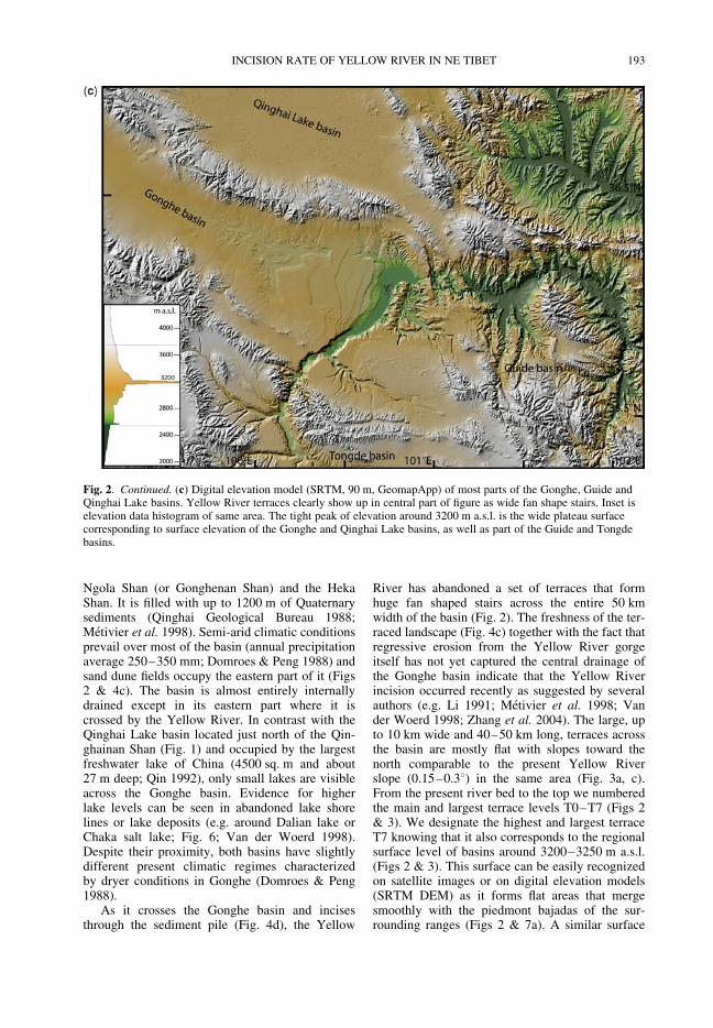
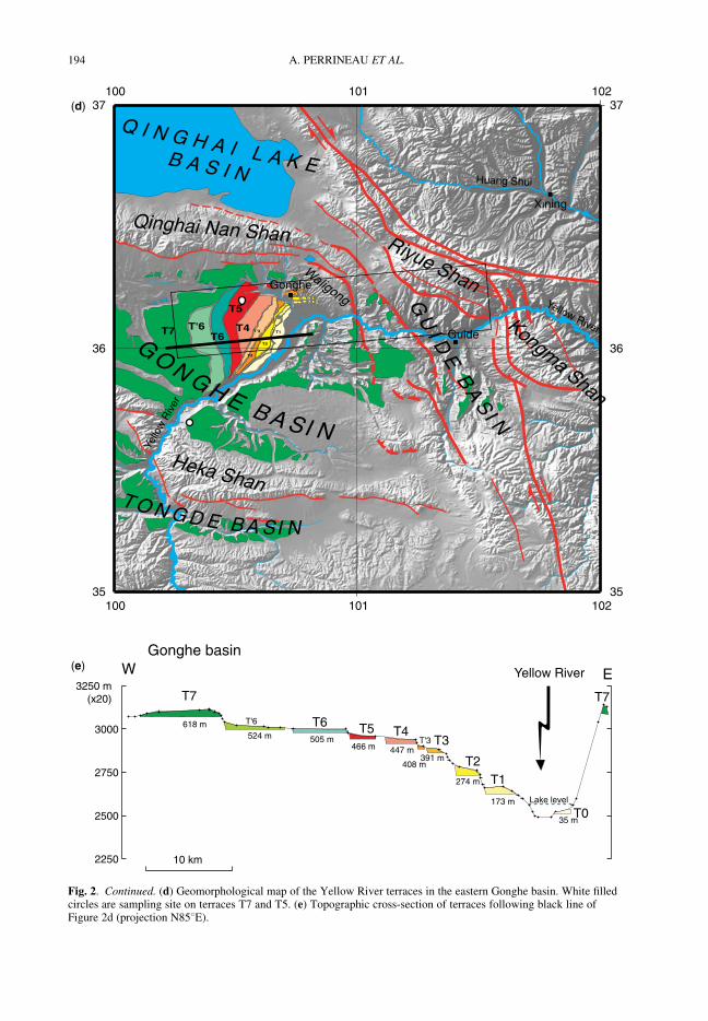
River has abandoned a set of terraces that formhuge fan shaped stairs across the entire 50 kmwidth of the basin (Fig. 2). The freshness of the ter-raced landscape (Fig. 4c) together with the fact thatregressive erosion from the Yellow River gorgeitself has not yet captured the central drainage ofthe Gonghe basin indicate that the Yellow Riverincision occurred recently as suggested by severalauthors (e.g. Li 1991; Metivier et al. 1998; Vander Woerd 1998; Zhang et al. 2004). The large, upto 10 km wide and 40–50 km long, terraces acrossthe basin are mostly flat with slopes toward thenorth comparable to the present Yellow Riverslope (0.15–0.38) in the same area (Fig. 3a, c).From the present river bed to the top we numberedthe main and largest terrace levels T0–T7 (Figs 2& 3). We designate the highest and largest terraceT7 knowing that it also corresponds to the regionalsurface level of basins around 3200–3250 m a.s.l.(Figs 2 & 3). This surface can be easily recognizedon satellite images or on digital elevation models(SRTM DEM) as it forms flat areas that mergesmoothly with the piedmont bajadas of the sur-rounding ranges (Figs 2 & 7a). A similar surface
Fig. 2. Continued. (c) Digital elevation model (SRTM, 90 m, GeomapApp) of most parts of the Gonghe, Guide andQinghai Lake basins. Yellow River terraces clearly show up in central part of figure as wide fan shape stairs. Inset iselevation data histogram of same area. The tight peak of elevation around 3200 m a.s.l. is the wide plateau surfacecorresponding to surface elevation of the Gonghe and Qinghai Lake basins, as well as part of the Guide and Tongdebasins.
INCISION RATE OF YELLOW RIVER IN NE TIBET 193
T2
T3
T'3 T1
(d)
(e) W E
2250
2500
2750
3000
3250 m(x20)
10 km
T7 T7
T6T'6T5 T4
T'3 T3
T2T1
T0
Yellow River
Gonghe basin
Lake level
618 m524 m 505 m
466 m 447 m
408 m391 m
274 m
173 m
35 m
35
36
37
35
36
37
100 101 102
100 101 102
Q I N G H A I L A K EB A S I N
Qinghai Nan Shan
Heka Shan
Waligong
Riyue Shan
Huang Shui
Yello
w R
iver
Yellow River
GO N GH E B A SI N
T O N G D E B A SI N
GU
I DE
BA
SI N
Kongma Shan
Xining
Guide
Gonghe
T7 T6
T5
T4T'6
Fig. 2. Continued. (d) Geomorphological map of the Yellow River terraces in the eastern Gonghe basin. White filledcircles are sampling site on terraces T7 and T5. (e) Topographic cross-section of terraces following black line ofFigure 2d (projection N858E).
A. PERRINEAU ET AL.194
level correlates with the top of the sediment fill inthe Guide and Tongde basin (Fothergill & Ma1999; Fang et al. 2005; Harkins et al. 2007). Inter-estingly, this level is also the highest palaeo-lakestand of the Qinghai lake basin to the north
(c. 3250 m; e.g. Lister et al. 1991; Fang et al.2005; Rhode et al. 2007, 2010; Liu et al. 2010).
T7 is clearly recognized as a fluvial terracedeposit at the entrance of the Gonghe basin northof Heka Shan (Figs 2 & 7b). T7 is now covered by
0,0
0,2
0,4
0,6
0,0
0,2
0,4
0,6
2000
3000
4000
2000
3000
4000
0 50 100 150300 200 100700 600 500 400900 800
Distance along Yellow river (km)
Altitude (m)
(x100)
Slope (°)
+
T7T7 T7
Zoige
Kunlun FaultNorth Anyemaqen South
Anyemaqen Heka Shan
WaligongKongma
Jingun Tongde GongheGuide
Xunhua140 m 140±10ka OSL
60m T2 40 ka C14/37 ka OSL6m T1 9 ka C14
65 m 30 ka C14
9 m 19 ka C1410m 18 ka C14
240m 90/110 ka OSL
(a)
(b)
(c)
2000
3000
4000
0 50 100 150 km100
Altitude (m)
(x100)
T7T7 T766'654
3'3
2
1
0
5
4
3
2
South Anyemaqen
Heka Shan
Waligong Kongma
Tongde Gonghe Guide Xunhua
140±10ka OSL140 m
WLB
WRB
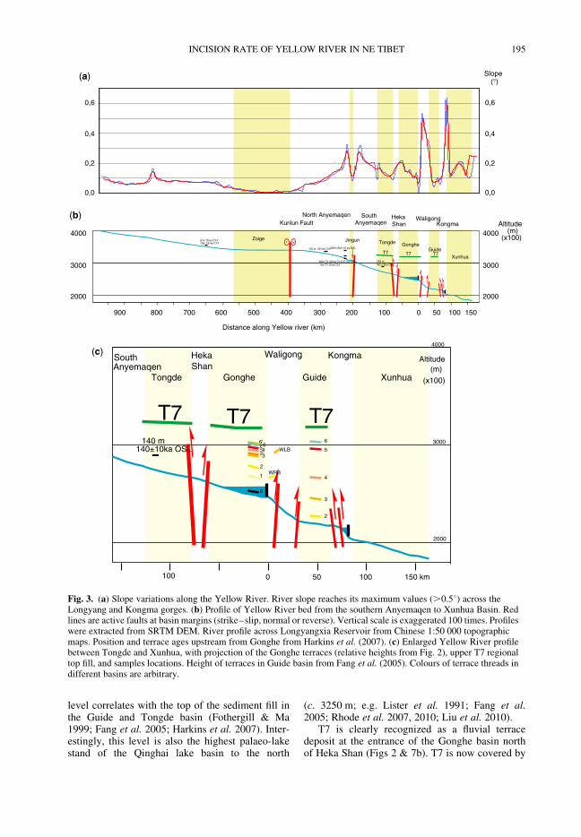
Fig. 3. (a) Slope variations along the Yellow River. River slope reaches its maximum values (.0.58) across theLongyang and Kongma gorges. (b) Profile of Yellow River bed from the southern Anyemaqen to Xunhua Basin. Redlines are active faults at basin margins (strike–slip, normal or reverse). Vertical scale is exaggerated 100 times. Profileswere extracted from SRTM DEM. River profile across Longyangxia Reservoir from Chinese 1:50 000 topographicmaps. Position and terrace ages upstream from Gonghe from Harkins et al. (2007). (c) Enlarged Yellow River profilebetween Tongde and Xunhua, with projection of the Gonghe terraces (relative heights from Fig. 2), upper T7 regionaltop fill, and samples locations. Height of terraces in Guide basin from Fang et al. (2005). Colours of terrace threads indifferent basins are arbitrary.
INCISION RATE OF YELLOW RIVER IN NE TIBET 195
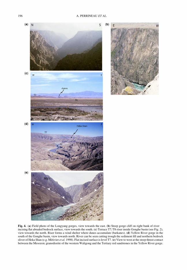
Fig. 4. (a) Field photo of the Longyang gorges, view towards the east. (b) Steep gorge cliff on right bank of riverincising flat abraded bedrock surface, view towards the south. (c) Terrace T7/T6 riser inside Gonghe basin (see Fig. 2),view towards the north. Riser forms a wind shelter where dunes accumulate (barkanes). (d) Yellow River gorge in thesouth of the Gonghe basin, view towards north. River can be seen cutting trough the sediment fill and northern bedrocksliver of Heka Shan (e.g. Metivier et al. 1998). Flat incised surface is level T7. (e) View to west at the steep thrust contactbetween the Mesozoic granodiorite of the westernWaligong and the Tertiary red sandstones in the Yellow River gorge.
A. PERRINEAU ET AL.196
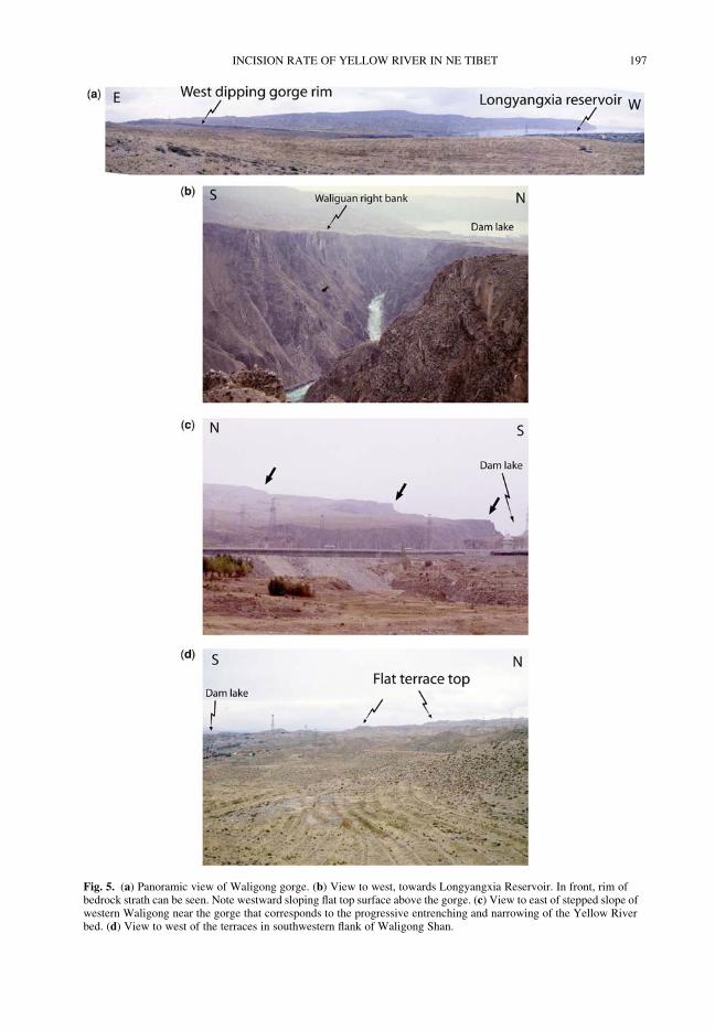
Fig. 5. (a) Panoramic view of Waligong gorge. (b) View to west, towards Longyangxia Reservoir. In front, rim ofbedrock strath can be seen. Note westward sloping flat top surface above the gorge. (c) View to east of stepped slope ofwestern Waligong near the gorge that corresponds to the progressive entrenching and narrowing of the Yellow Riverbed. (d) View to west of the terraces in southwestern flank of Waligong Shan.
INCISION RATE OF YELLOW RIVER IN NE TIBET 197
a 2 m thick layer of aeolian loess overlying a 15 cmthick reddish palaeosol (B-horizon; Fig. 8a, b; Pan1994). The abandonment of T7 marks the onset ofincision of the Yellow River in the Gonghe basin.The other major terrace levels (T6–T1) are alsocomposed of fluvial pebbles and gravels and aredevoid or only covered by a thin loess coveracross the Gonghe basin. Clear steep risers up toseveral tens of metres high separate the mainterrace levels (Figs 2d & 4c). In several places, ascan be clearly seen on satellite images (Fig. 2),these risers disappear under wind-blown sand dunefields because of favourable accumulation at thenorth–south-trending risers which are almost per-pendicular to the main NW blowing winds.
For a long time the Yellow River terraces havebeen recognized as geomorphic markers of theactive tectonics of northeastern Tibet during theQuaternary (e.g. Li 1991; Li et al. 1997; Lu et al.2004; Sun 2005). From Lanzhou to Gonghe, theirEarly Pleistocene–Late Pleistocene ages (e.g. Liet al. 1997) have been interpreted to representphases of regional plateau uplift. In contrast,Harkins et al. (2007) have recently proposed, froma geomorphological analysis of the upper YellowRiver gorge and its tributaries between Tongdeand Zoige basins that the Yellow River propagatedupstream due to headward incision. From OSLand C-14 ages of low terraces 10–140 m abovethe present river bed in Tongde and upstream thatrange from 9–140 ka, (Fig. 3), they infer an onset
of incision from the top of the basin fill in Tongdeat about 400–500 ka (Craddock et al. 2010). Inmore details, their results imply the upward propa-gation of a wave of incision starting around 500 kain Tongde with incision rates of c. 2.5 mm a21
that slowed down as incision progressed to lessthan 1 mm a21 at present (Harkins et al. 2007;Fig. 3).
The terraces in Gonghe have not been directlydated so far. Thermoluminescence (TL) dating ofloess covering seven terraces in Linxia give agesthat range from 10–160 ka (Li et al. 1997) anddue to the similar setting of terraces in Gonghe,the oldest of these ages has been attributed to thehighest terrace in Gonghe (Li 1991; Li et al. 1997;Fothergill & Ma 1999; Zhang et al. 2004). How-ever, from palaeomagnetostratigraphical studiesin Guide and Linxia, it has been argued that thehighest terrace in Guide postdates closely theshallowest dated sediments at 1.8 Ma (Fang et al.2005), and that the Yellow River started incisingin Gonghe at c. 1.1 Ma (Yan et al. 2004), in agree-ment with the inference of a post 500 ka incisionof the Yellow River in Tongde and the upwardpropagation of a wave of incision (Harkins et al.2007).
It is thus necessary to directly date the terraces,to determine their age of deposition and abandon-ment to constrain the incision history of theYellow River and the rates of tectonic uplift of thenarrow ranges cross-cut by the river.
Fig. 6. Google Earth view of the Gonghe and Qinghai basins with present lakes or lake remnants (salt flats, abandonedshore lines) highlighted.
A. PERRINEAU ET AL.198
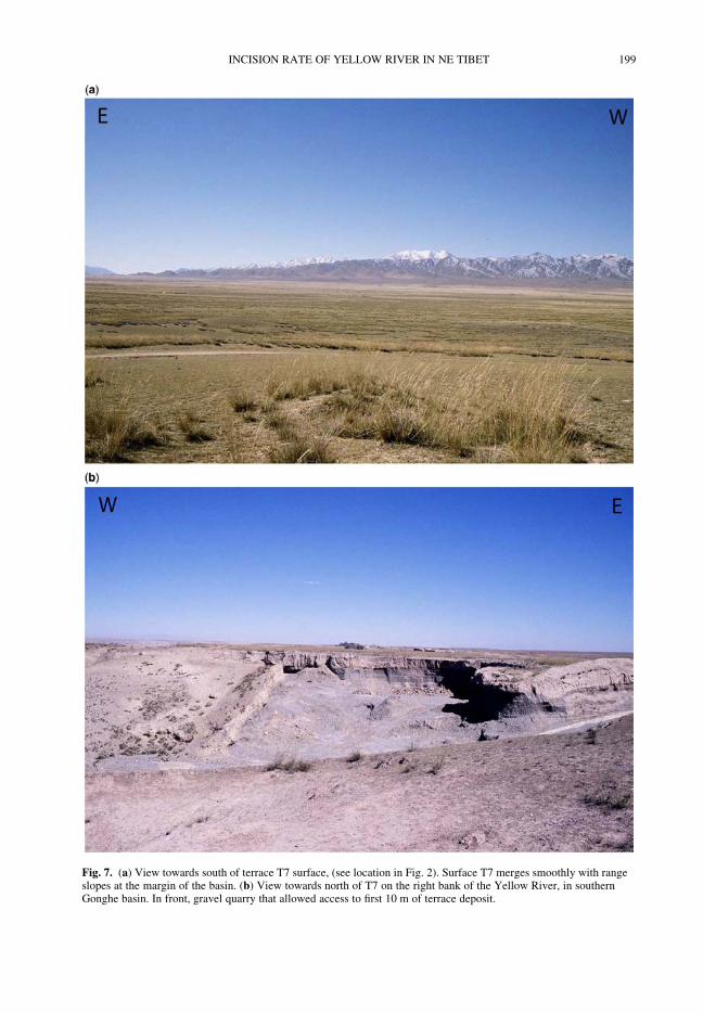
Fig. 7. (a) View towards south of terrace T7 surface, (see location in Fig. 2). Surface T7 merges smoothly with rangeslopes at the margin of the basin. (b) View towards north of T7 on the right bank of the Yellow River, in southernGonghe basin. In front, gravel quarry that allowed access to first 10 m of terrace deposit.
INCISION RATE OF YELLOW RIVER IN NE TIBET 199
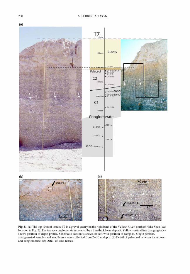
Fig. 8. (a) The top 10 m of terrace T7 in a gravel quarry on the right bank of the Yellow River, north of Heka Shan (seelocation in Fig. 2). The terrace conglomerate is covered by a 2 m thick loess deposit. Yellow vertical line (hanging tape)shows position of depth profile. Schematic section is shown on left with position of samples. Single pebbles,amalgamated samples and sand lenses were collected from 2–10 m depth. (b) Detail of palaeosol between loess coverand conglomerate. (c) Detail of sand lenses.
A. PERRINEAU ET AL.200
Terrace dating, results and interpretation
Cosmogenic nuclide dating method
Cosmogenic nuclides are produced in situ by theinteractions between secondary cosmic ray particlesand surface rocks. Cosmogenic nuclides accumulatein rocks as long as they stay at/near to the surfaceof the Earth. 10Be and 26Al are mainly producedin quartz from O and Si by spallation and muoniccapture, and the ubiquity of this mineral makes it afavoured target. The concentration of cosmogenicradioactive nuclides in a rock, N, is given by:
dN
dt" P# lN; (1)
where l is the decay constant of the nuclide con-sidered and P is the production rate, which dep-ends on the geographic location and altitude. Forsub-surface samples, the production rate decreasesexponentially with depth following:
P(z) " P(0) exp #zr
L
! "; (2)
where P(0) is the production rate at the surface, z thedepth of the sample, r the density of the overlyingmaterial andL the attenuation length of the interact-ing particle. Analysing deep (shielded) samples maygive access to the amount of inheritance. Indeed,samples situated below several times the penetrationdepth are shielded from cosmic radiations and theircosmogenic nuclide concentrations thus correspondto nuclides accumulated before being deposited,that is, the inherited component. When inheritanceand erosion are assumed to be negligible, then theminimum exposure age of a sample is given by:
tmin "1
lln
1# lN
P
# $: (3)
Taking into account erosion, inheritance and pro-duction by muons, the number of 10Be atomsgrows with time according to:
N(z, Dt) " N0(z, Dt) exp (#lDt)
$ Pn
l$ r
Ln1exp # r
Lnz
# $2
64
3
75
! 1# exp # l$ r
Ln1
# $Dt
# $# $
$ Pm
l$ r
Lm1exp # r
Lmz
# $2
64
3
75
! 1# exp # l$ r
Lm1
# $Dt
# $# $, (4)
where N0(z, Dt) is the inherited component, (n, m)subscripts for spallation by neutron and muons,respectively.
Samples were processed in the CosmogenicNuclides Laboratory of the University of Strasbourgfollowing standard methods described in Kohl &Nishiizumi (1992). 10Be/9Be and 26Al/27Al ratioswere determined by accelerator mass spectrometry(AMS) at the ASTER (CEREGE, Aix-en-Provence)facility except two samples (Qi4-29-1 and Qi4-29-19, Table 1), which were measured at theCenter for Accelerator Mass Spectrometry at Law-rence Livermore National Laboratory (Table 1).Natural 9Be has been assumed to be not present inour samples after a set of samples has beenchecked by ICP-MS. The total 9Be concentrationis thus determined by the amount of carrier addedto the sample.
The 26Al concentrations were measured in asubset of samples to better constrain the exposurehistory of the terraces. As the stable isotope 27Alis naturally present in quartz minerals, sample con-tent of natural 27Al was measured by ICP-MS beforeaddition of 27Al carrier. 10Be and 26Al have differentdecay constants and production rates, but the sameproduction profiles. They can thus be analysedtogether and compared. In case of a simple exposurehistory, without a period of burial, the 26Al/10Benuclide ratio approximates 6.75 (Balco 2009).
Nuclide concentrations were determined fromthe AMS measurements and the amount of corre-sponding stable isotope (Table 1). Ages were mod-elled using the CRONUS online calculator (Balcoet al. 2008) version 2.2 (April 2009). Sub-surfacesample concentrations have been modelled byfitting the sample concentrations following equation(2) (see also Granger & Smith 2000) and usingthe constant surface production rate determinedby the CRONUS calculator (see details below).We used the revised 10Be decay constant of5.1+ 0.26 ! 1027 a21 of Nishiizumi et al. (2007)and the 26Al decay constant of 9.83 ! 1027 a21,following Balco et al. (2008). Penetration depthsused for depth profiles ages calculation are160 g cm22 for neutrons and 1500 g cm22 formuons (Granger & Smith 2000; Gosse & Phillips2001). We used densities of 2.65 for quartz, 2.7for granite, 2.5 for a mix gravel/pebble/cobbledeposit, 1.8 for soil, 1.4 for loess. No topographicshielding correction was needed given the extentand flatness of the terraces. All other data used inthe calculator, as advised by Balco et al. (2008)and Frankel (2010), are given in Table 1.
The largest analytical uncertainty comes fromthe production rate estimation (Gosse & Phillips2001). Balco et al. (2008) estimated this uncertaintyto approximate 10%. It is however larger for depthsamples because uncertainties on penetration
INCISION RATE OF YELLOW RIVER IN NE TIBET 201
Table 1. 10Be and 26Al analytical results of surface and sub-surface samples of the Yellow River terraces in the Gonghe basin
Sample name Sampledescription
Latitude(8N)
Longitude(8E)
Elevation(m a.s.l.)
Depth(cm)
Samplethickness(cm)
10Beconcentration
(at g21)
err 26Alconcentration
(at g21)
err [26Al]/[10Be] ratio
err
Terrace T5Qi4-30 Quartz cobble 36.17584 100.52143 2920 0 3 2.98E$ 06 8.44E$ 04 na na na naQi4-30-2‡ 3.12E$ 06 8.87E$ 04 na na na naQi4-33 Quartz cobble 36.17567 100.52181 2920 0 4 2.98E$ 06 8.57E$ 04 na na na naQi4-34 Quartz cobble 36.17520 100.52123 2920 0 8 3.26E$ 06 9.37E$ 04 na na na naQi4-36 Quartz cobble 36.17532 100.521 2918 0 5.5 3.27E$ 06 9.27E$ 04 na na na naQi4-36-2‡ 3.34E$ 06 9.77E$ 04 na na na naQi4-38 Quartz cobble 36.17555 100.52113 2920 0 6 3.05E$ 06 9.43E$ 04 na na na naQi4-39 Quartz cobble 36.17566 100.52179 2919 0 8 3.74E$ 06 1.02E$ 05 na na na naQi4-40 Quartz cobble 36.17595 100.52154 2920 0 5 2.84E$ 06 8.52E$ 04 na na na na
Terrace T7Qi4-29-1* Quartz cobble 35.70043 100.29636 3196 200 5 9.55E$ 05 2.56E$ 04 4.64E$ 06 5.33E$ 05 4.86 0.57Qi4-29-27a† 8 amalgamated
pebbles35.70043 100.29636 3194 200–220 2 1.53E$ 06 4.39E$ 04 na na na na
Qi4-29-27b† 13 amalgamatedpebbles
35.70043 100.29636 3194 200–220 2 1.32E$ 06 4.04E$ 04 na na na na
Qi4-29-27c† 32 amalgamatedpebbles
35.70043 100.29636 3194 200–220 1.5 1.47E$ 06 6.43E$ 04 8.88E$ 06 4.31E$ 05 6.03 0.39
Qi4-29-27d† 55 amalgamatedpebbles
35.70043 100.29636 3194 200–220 1 1.54E$ 06 5.53E$ 04 9.11E$ 06 3.94E$ 05 5.91 0.33
Weighted mean: 1.4615E$ 06+ 0.1031E$ 06Qi4-29-19* Quartz cobble 35.70043 100.29636 3194 230 4 1.07E$ 06 2.85E$ 04 6.33E$ 06 2.13E$ 05 5.89 0.25Qi4-29-9 Quartz cobble 35.70043 100.29636 3194 240 4.5 2.13E$ 06 7.31E$ 04 8.77E$ 06 3.80E$ 05 4.12 0.23Qi4-29-13 Quartz cobble 35.70043 100.29636 3194 260 5.5 7.66E$ 05 2.83E$ 04 na na na naQi4-29-11 Quartz cobble 35.70043 100.29636 3194 320 6 3.97E$ 05 1.61E$ 04 2.43E$ 06 1.11E$ 05 6.12 0.37Qi4-29-11-2‡ 4.00E$ 05 1.59E$ 04 na na na na
A.PERRIN
EAUETAL.
202
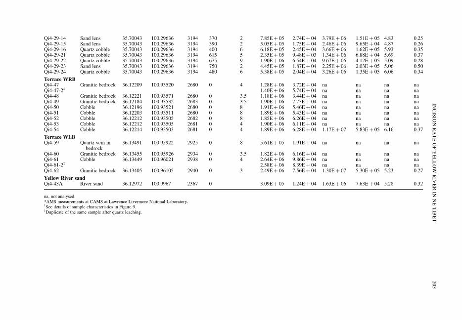
Qi4-29-14 Sand lens 35.70043 100.29636 3194 370 2 7.85E$ 05 2.74E$ 04 3.79E$ 06 1.51E$ 05 4.83 0.25Qi4-29-15 Sand lens 35.70043 100.29636 3194 390 2 5.05E$ 05 1.75E$ 04 2.46E$ 06 9.65E$ 04 4.87 0.26Qi4-29-16 Quartz cobble 35.70043 100.29636 3194 400 6 6.18E$ 05 2.45E$ 04 3.66E$ 06 1.62E$ 05 5.93 0.35Qi4-29-21 Quartz cobble 35.70043 100.29636 3194 615 5 2.35E$ 05 9.48E$ 03 1.34E$ 06 6.88E$ 04 5.69 0.37Qi4-29-22 Quartz cobble 35.70043 100.29636 3194 675 9 1.90E$ 06 6.54E$ 04 9.67E$ 06 4.12E$ 05 5.09 0.28Qi4-29-23 Sand lens 35.70043 100.29636 3194 750 2 4.45E$ 05 1.87E$ 04 2.25E$ 06 2.03E$ 05 5.06 0.50Qi4-29-24 Quartz cobble 35.70043 100.29636 3194 480 6 5.38E$ 05 2.04E$ 04 3.26E$ 06 1.35E$ 05 6.06 0.34
Terrace WRBQi4-47 Granitic bedrock 36.12209 100.93520 2680 0 4 1.28E$ 06 3.72E$ 04 na na na naQi4-47-2‡ 1.40E$ 06 5.74E$ 04 na na na naQi4-48 Granitic bedrock 36.12221 100.93571 2680 0 3.5 1.18E$ 06 3.44E$ 04 na na na naQi4-49 Granitic bedrock 36.12184 100.93532 2683 0 3.5 1.90E$ 06 7.73E$ 04 na na na naQi4-50 Cobble 36.12196 100.93521 2680 0 8 1.91E$ 06 5.46E$ 04 na na na naQi4-51 Cobble 36.12203 100.93511 2680 0 8 1.89E$ 06 5.43E$ 04 na na na naQi4-52 Cobble 36.12212 100.93505 2682 0 8 1.85E$ 06 6.26E$ 04 na na na naQi4-53 Cobble 36.12212 100.93505 2681 0 4 1.90E$ 06 6.11E$ 04 na na na naQi4-54 Cobble 36.12214 100.93503 2681 0 4 1.89E$ 06 6.28E$ 04 1.17E$ 07 5.83E$ 05 6.16 0.37
Terrace WLBQi4-59 Quartz vein in
bedrock36.13491 100.95922 2925 0 8 5.61E$ 05 1.91E$ 04 na na na na
Qi4-60 Granitic bedrock 36.13455 100.95926 2934 0 3.5 1.82E$ 06 6.16E$ 04 na na na naQi4-61 Cobble 36.13449 100.96021 2938 0 4 2.64E$ 06 9.86E$ 04 na na na naQi4-61-2‡ 2.58E$ 06 8.39E$ 04 na na na naQi4-62 Granitic bedrock 36.13405 100.96105 2940 0 3 2.49E$ 06 7.56E$ 04 1.30E$ 07 5.30E$ 05 5.23 0.27
Yellow River sandQi4-43A River sand 36.12972 100.9967 2367 0 3.09E$ 05 1.24E$ 04 1.63E$ 06 7.63E$ 04 5.28 0.32
na, not analysed.*AMS measurements at CAMS at Lawrence Livermore National Laboratory.†See details of sample characteristics in Figure 9.‡Duplicate of the same sample after quartz leaching.
INCISIO
NRATEOFYELLOW
RIV
ERIN
NETIBET
203
depths (6%), sample depth (0.5%) and density ofoverlying material (2–3%) must be added. Finaluncertainties on production rates are then comprisedbetween 10 and 12%. Uncertainties from the chemi-cal processing are low (1–2%). Uncertainties fromthe AMS measurement are comprised between 1.8and 3.5%. Total analytical uncertainties on ages,not considering modelling errors, thus range from11–13% (Table 1).
We sampled four different terrace levels forcosmogenic dating, T7 and T5 in the basin, andtwo strath terrace levels in the gorge, WRB (Wali-gong right bank) and WLB (Waligong left bank)(Fig. 2, Table 1).
Cosmogenic nuclide measurements
Terrace T7 samplesStratigraphy. On the southern side of the Gonghe
basin, north of Heka Shan and on the right bank ofthe Yellow River, clean exposure of the top 10 mof the T7 level can be seen in a gravel quarry usedfor road constructions (Figs 2d, 7 & 8). Theterrace conglomerate is a thick fill deposit, com-posed of gravels, pebbles and cobbles with a few5–50 cm thick and several metres long sand lenses(Fig. 8c). It is covered by a 15 cm thick reddishpalaeosol (Fig. 8b), itself covered by c. 2 m ofaeolian loess (in the following sections, layer andsample depths are given relative to present groundsurface, i.e., the top of the loess deposit). Theconglomerate pile is marked by an angular
unconformity at c. 3.5–4 m depth. In an east–west section, the c. 58 west-dipping pebble layersand sand lenses are intersected by overlying hori-zontal layers. In the north–south section, the angularunconformity disappears, but a clear layer transitioncan be seen in the section approximately at the samedepth (Fig. 8). The two conglomerate units will becalled C1 and C2 from bottom to top in the follow-ing sections. The top 20 cm of the C2 conglomerate,just below the palaeosol, is marked by a visibleincrease in the amount of whitish quartz-vein centi-metric pebbles (Fig. 9; Table 1). Our field obser-vations and inspection of the quarry cliffs have notallowed us to distinguish any other sedimentationinterruption or other unconformities. Note that thelatter would be difficult to detect since there is noobvious change in the nature and origin of thematerial deposited. Therefore, in the following dis-cussion, we will consider the section analysed as asequence of two depositional events (assumingthat other sedimentation interruptions, if present,lasted only for short periods compared to thewhole life time of the terrace), followed by the for-mation of a palaeosol, itself followed by the depo-sition of loess.
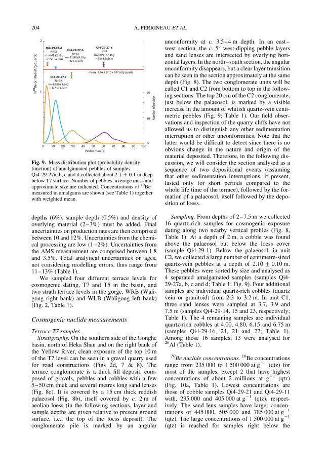
Sampling. From depths of 2–7.5 m we collected16 quartz-rich samples for cosmogenic exposuredating along two nearby vertical profiles (Fig. 8,Table 1). At a depth of 2 m, a cobble was foundabove the palaeosol but below the loess cover(sample Qi4-29-1). Below the palaeosol, in unitC2, we collected a large number of centimetre-sizedquartz-vein pebbles at a depth of 2.10+ 0.10 m.These pebbles were sorted by size and analysed as4 separated amalgamated samples (samples Qi4-29-27a, b, c and d; Table 1; Fig. 9). Four additionalsamples are individual quartz-rich cobbles (quartzvein or granitoid) from 2.3 to 3.2 m. In unit C1,three sand lenses were sampled at 3.7, 3.9 and7.5 m (samples Qi4-29-14, 15 and 23, respectively;Table 1). The 4 remaining samples are individualquartz-rich cobbles at 4.00, 4.80, 6.15 and 6.75 m(samples Qi4-29-16, 24, 21 and 22; Table 1).Among those 16 samples, 13 were analysed for26Al (Table 1).
10Be nuclide concentrations. 10Be concentrationsrange from 235 000 to 1 500 000 at g21 (qtz) formost of the samples, except 2 that have highestconcentrations of about 2 millions at g21 (qtz)(Fig. 10a, Table 1). Lowest concentrations arethose of cobble samples Qi4-29-21 and Qi4-29-11with, 235 000 and 405 000 at g21 (qtz), respect-ively. The sand lens samples have larger concen-trations of 445 000, 505 000 and 785 000 at g21
(qtz). The large concentrations of 1 500 000 at g21
(qtz) is reached for samples right below the
Fig. 9. Mass distribution plot (probability densityfunction) of amalgamated pebbles of samplesQi4-29-27a, b, c and d collected about 2.1+ 0.1 m deepbelow T7 surface. Number of pebbles, average mass andapproximate size are indicated. Concentrations of 10Bemeasured in amalgams are shown (see Table 1) togetherwith weighted mean.
A. PERRINEAU ET AL.204
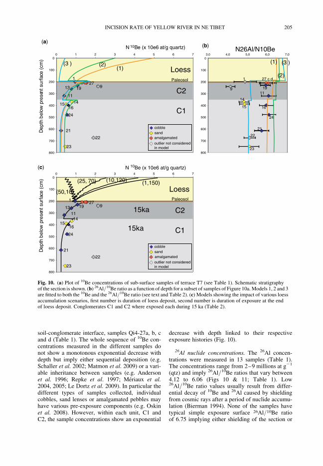
soil-conglomerate interface, samples Qi4-27a, b, cand d (Table 1). The whole sequence of 10Be con-centrations measured in the different samples donot show a monotonous exponential decrease withdepth but imply either sequential deposition (e.g.Schaller et al. 2002; Matmon et al. 2009) or a vari-able inheritance between samples (e.g. Andersonet al. 1996; Repke et al. 1997; Meriaux et al.2004, 2005; Le Dortz et al. 2009). In particular thedifferent types of samples collected, individualcobbles, sand lenses or amalgamated pebbles mayhave various pre-exposure components (e.g. Oskinet al. 2008). However, within each unit, C1 andC2, the sample concentrations show an exponential
decrease with depth linked to their respectiveexposure histories (Fig. 10).
26Al nuclide concentrations. The 26Al concen-trations were measured in 13 samples (Table 1).The concentrations range from 2–9 millions at g21
(qtz) and imply 26Al/10Be ratios that vary between4.12 to 6.06 (Figs 10 & 11; Table 1). Low26Al/10Be ratio values usually result from differ-ential decay of 10Be and 26Al caused by shieldingfrom cosmic rays after a period of nuclide accumu-lation (Bierman 1994). None of the samples havetypical simple exposure surface 26Al/10Be ratioof 6.75 implying either shielding of the section or
0
100
200
300
400
500
600
700
800
0 1 2 3 4 5 6 7
N 10Be (x 10e6 at/g quartz) D
epth
bel
o w p
rese
nt s
urfa
c e (
cm)
22
23
9
1415
1
13 19
21
24
16
11
Paleosol
Paleosol
27
22
23
9
1415
1
13 19
21
24
16
11
27
(a)
cobblesandamalgamated
amalgamated
outlier not consideredin model
cobblesand
outlier not consideredin model
0
100
200
300
400
500
600
700
800
0 1 2 3 4 5 6 7
Dep
th b
elow
pre
sent
sur
face
(cm
)
(c)
15ka
15ka C1
C2
Loess
C1
C2
Loess
(25, 70) (10,120) (1,150)
(50,10)
0
100
200
300
400
500
600
700
800
3,0 4,0 5,0 6,0 7,0N26Al/N10Be
23
21
27 c d
22
24
16
1119
1
9
14
15
(b)
(1)(1)(2)
(2)
(3 ) (3 )
N 10Be (x 10e6 at/g quartz)
Fig. 10. (a) Plot of 10Be concentrations of sub-surface samples of terrace T7 (see Table 1). Schematic stratigraphyof the section is shown. (b) 26Al/10Be ratio as a function of depth for a subset of samples of Figure 10a.Models 1, 2 and 3are fitted to both the 10Be and the 26Al/10Be ratio (see text and Table 2). (c) Models showing the impact of various loessaccumulation scenarios, first number is duration of loess deposit, second number is duration of exposure at the endof loess deposit. Conglomerates C1 and C2 where exposed each during 15 ka (Table 2).
INCISION RATE OF YELLOW RIVER IN NE TIBET 205
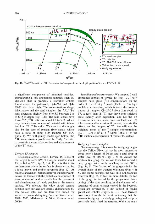
a significant component of inherited nuclides.Disregarding a few anomalous samples, such as,Qi4-29-1 that is probably a reworked cobblefound above the palaeosol, Qi4-29-9 and Qi4-29-22 that have high 10Be concentrations (largeinheritance) and the sand samples, the 26Al/10Beratio decreases slightly from 6 to 5.7 between 2 mto 6.15 m depth (Fig. 10b). The sand lenses havelower 26Al/10Be ratios of about 4.8 to 5.06, whichmay indicate incorporation of material with inher-ited low 26Al/10Be ratios. We note that this mightalso be the case of present river sands, whichhave a ratio of about 5.28 (sample Qi4-43A,Table 1). We will jointly model (see below) the10Be concentration profile and the 26Al/10Be ratioto constrain the age of deposition and abandonmentof the T7 level.
Terrace T5 samplesGeomorphological setting. Terrace T5 is one of
the largest terraces SW of Gonghe situated about150 m below T7 (Figs 2, 3 & 12). It is flat in itsnorthern part where the surface is characterized bya loose gravel and pebble pavement (Fig. 12). Atplaces, sand dunes (barkanes) travel southeastwardsacross the terrace with the probable consequence ofincorporation of modern sand below the pavementand abandonment of sandy patches at the terracesurface. We selected the wide paved surfacebecause such surfaces are usually characterized bylow erosion rates and are thus well suited forsurface exposure dating (e.g. Van der Woerd et al.1998, 2006; Meriaux et al. 2004; Matmon et al.2009).
Sampling and measurements.We sampled 7 wellembedded cobbles on terrace T5 (Fig. 12). The 7samples have close 10Be concentrations on theorder of 3 ! 106 at g21 quartz (Table 1). This highnuclide concentration, which is twice the concen-tration of samples Qi4-29-27 from 2 m depth inT7, suggest that: (1) T7 must have been shieldedquite rapidly after deposition; and (2) the T5terrace surface has never been shielded; and (3)inheritance and/or erosion, if present, have similareffects on the samples of T5. We will use theweighted mean of the 7 sample concentrations(3.21+ 0.30 ! 106 at g21 (qtz); Table 1) as the10Be nuclide concentration of terrace T5 surface.
Waligong terrace samplesGeomorphology. It is across the Waligong ranges
that the Yellow River has cut its most impressivegorge over a length of 30 km and a total drop ofwater level of 200 m (Figs 2 & 3). Across thewestern Waligong, the Yellow River has carved adeep gorge with walls reaching about 500 m(Fig. 3a, b). The flat top of the gorge mimics theoverall shape of the western Waligong (Figs 4 &5), and slopes towards the west into Longyangxiareservoir (Fig. 2). In fact, in more details, the topof the gorge is formed by the progressive downcutting of the river resulting in abandonment of asequence of strath terraces carved in the bedrock,which are covered by a thin deposit of fluvialgravel and cobbles (Figs 5 & 13). These terracesnow slope towards the west indicating that thewestern Waligong is actively growing and has pro-gressively back tilted the terraces. While the main
noisor e on - erusopxetnatsnocsteady-state e rosion
1 Ma
2 MaN26
AI/N
10B
e
3 Ma
10ka
100
ka
1M
a
500 ka
1
10
1.0E+04 1.0E+05 1.0E+06 1.0E+07 1.0E+08 1.0E+09
N10Be
T7 - sand samplesT7 - cobbles
-23
-15
-14
-22
-9
-1
-19-27c
-27d-11
T7 - Qi4-29-1 base of loessYellow river modern sandWaligong terraces
-21
-43A
-24
-16
-54
-62
Fig. 11. 26Al/10Be ratio v. 10Be for a subset of samples from the depth profile of terrace T7 (Table 1).
A. PERRINEAU ET AL.206
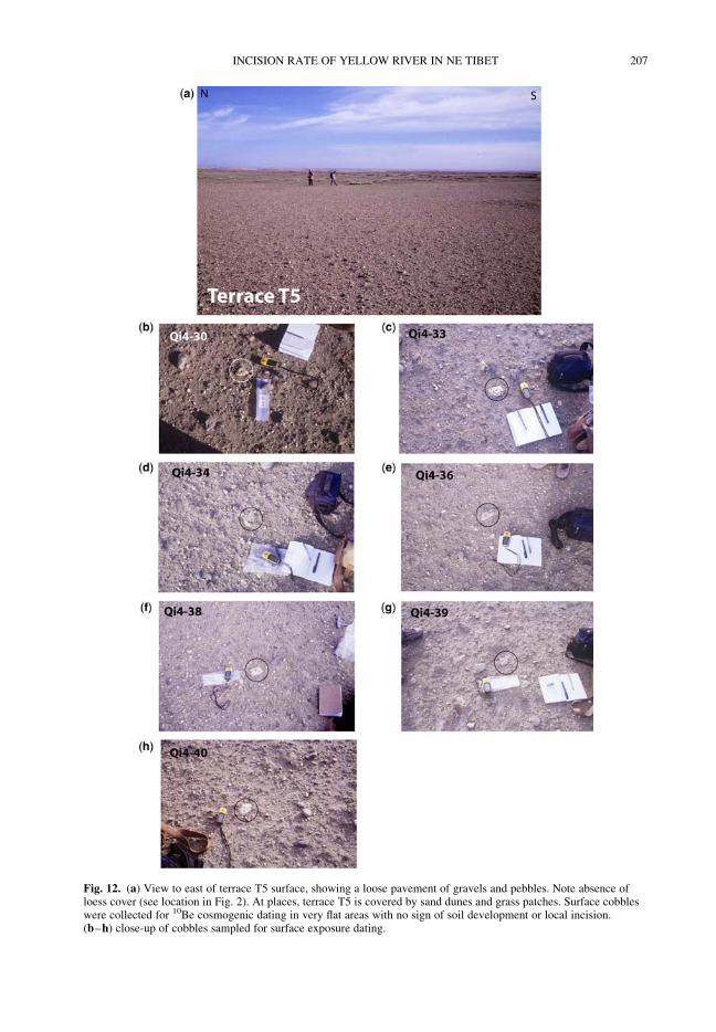
Fig. 12. (a) View to east of terrace T5 surface, showing a loose pavement of gravels and pebbles. Note absence ofloess cover (see location in Fig. 2). At places, terrace T5 is covered by sand dunes and grass patches. Surface cobbleswere collected for 10Be cosmogenic dating in very flat areas with no sign of soil development or local incision.(b–h) close-up of cobbles sampled for surface exposure dating.
INCISION RATE OF YELLOW RIVER IN NE TIBET 207
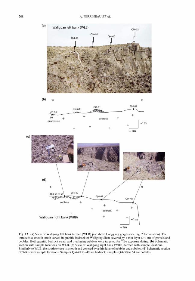
Fig. 13. (a) View of Waligong left bank terrace (WLB) just above Longyang gorges (see Fig. 2 for location). Theterrace is a smooth strath carved in granitic bedrock of Waligong Shan covered by a thin layer (.1 m) of gravels andpebbles. Both granitic bedrock strath and overlaying pebbles were targeted for 10Be exposure dating. (b) Schematicsection with sample locations on WLB. (c) View of Waligong right bank (WRB) terrace with sample locations.Similarly toWLB, the strath terrace is smooth and covered by a thin layer of pebbles and cobbles. (d) Schematic sectionof WRB with sample locations. Samples Qi4-47 to -49 are bedrock, samples Qi4-50 to 54 are cobbles.
A. PERRINEAU ET AL.208
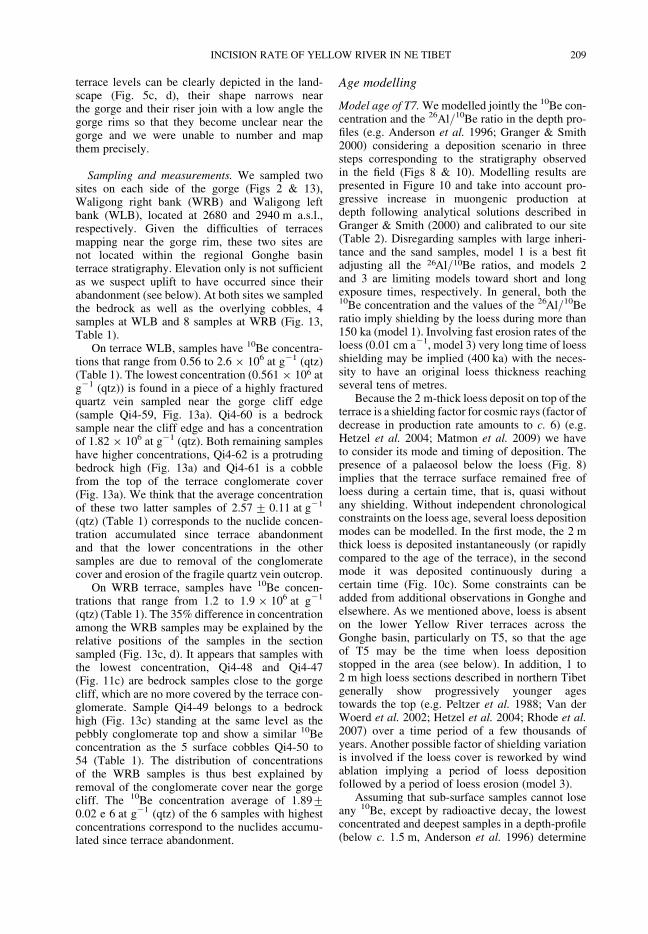
terrace levels can be clearly depicted in the land-scape (Fig. 5c, d), their shape narrows nearthe gorge and their riser join with a low angle thegorge rims so that they become unclear near thegorge and we were unable to number and mapthem precisely.
Sampling and measurements. We sampled twosites on each side of the gorge (Figs 2 & 13),Waligong right bank (WRB) and Waligong leftbank (WLB), located at 2680 and 2940 m a.s.l.,respectively. Given the difficulties of terracesmapping near the gorge rim, these two sites arenot located within the regional Gonghe basinterrace stratigraphy. Elevation only is not sufficientas we suspect uplift to have occurred since theirabandonment (see below). At both sites we sampledthe bedrock as well as the overlying cobbles, 4samples at WLB and 8 samples at WRB (Fig. 13,Table 1).
On terrace WLB, samples have 10Be concentra-tions that range from 0.56 to 2.6 ! 106 at g21 (qtz)(Table 1). The lowest concentration (0.561 ! 106 atg21 (qtz)) is found in a piece of a highly fracturedquartz vein sampled near the gorge cliff edge(sample Qi4-59, Fig. 13a). Qi4-60 is a bedrocksample near the cliff edge and has a concentrationof 1.82 ! 106 at g21 (qtz). Both remaining sampleshave higher concentrations, Qi4-62 is a protrudingbedrock high (Fig. 13a) and Qi4-61 is a cobblefrom the top of the terrace conglomerate cover(Fig. 13a). We think that the average concentrationof these two latter samples of 2.57+ 0.11 at g21
(qtz) (Table 1) corresponds to the nuclide concen-tration accumulated since terrace abandonmentand that the lower concentrations in the othersamples are due to removal of the conglomeratecover and erosion of the fragile quartz vein outcrop.
On WRB terrace, samples have 10Be concen-trations that range from 1.2 to 1.9 ! 106 at g21
(qtz) (Table 1). The 35% difference in concentrationamong the WRB samples may be explained by therelative positions of the samples in the sectionsampled (Fig. 13c, d). It appears that samples withthe lowest concentration, Qi4-48 and Qi4-47(Fig. 11c) are bedrock samples close to the gorgecliff, which are no more covered by the terrace con-glomerate. Sample Qi4-49 belongs to a bedrockhigh (Fig. 13c) standing at the same level as thepebbly conglomerate top and show a similar 10Beconcentration as the 5 surface cobbles Qi4-50 to54 (Table 1). The distribution of concentrationsof the WRB samples is thus best explained byremoval of the conglomerate cover near the gorgecliff. The 10Be concentration average of 1.89+0.02 e 6 at g21 (qtz) of the 6 samples with highestconcentrations correspond to the nuclides accumu-lated since terrace abandonment.
Age modelling
Model age of T7.Wemodelled jointly the 10Be con-centration and the 26Al/10Be ratio in the depth pro-files (e.g. Anderson et al. 1996; Granger & Smith2000) considering a deposition scenario in threesteps corresponding to the stratigraphy observedin the field (Figs 8 & 10). Modelling results arepresented in Figure 10 and take into account pro-gressive increase in muongenic production atdepth following analytical solutions described inGranger & Smith (2000) and calibrated to our site(Table 2). Disregarding samples with large inheri-tance and the sand samples, model 1 is a best fitadjusting all the 26Al/10Be ratios, and models 2and 3 are limiting models toward short and longexposure times, respectively. In general, both the10Be concentration and the values of the 26Al/10Beratio imply shielding by the loess during more than150 ka (model 1). Involving fast erosion rates of theloess (0.01 cm a21, model 3) very long time of loessshielding may be implied (400 ka) with the neces-sity to have an original loess thickness reachingseveral tens of metres.
Because the 2 m-thick loess deposit on top of theterrace is a shielding factor for cosmic rays (factor ofdecrease in production rate amounts to c. 6) (e.g.Hetzel et al. 2004; Matmon et al. 2009) we haveto consider its mode and timing of deposition. Thepresence of a palaeosol below the loess (Fig. 8)implies that the terrace surface remained free ofloess during a certain time, that is, quasi withoutany shielding. Without independent chronologicalconstraints on the loess age, several loess depositionmodes can be modelled. In the first mode, the 2 mthick loess is deposited instantaneously (or rapidlycompared to the age of the terrace), in the secondmode it was deposited continuously during acertain time (Fig. 10c). Some constraints can beadded from additional observations in Gonghe andelsewhere. As we mentioned above, loess is absenton the lower Yellow River terraces across theGonghe basin, particularly on T5, so that the ageof T5 may be the time when loess depositionstopped in the area (see below). In addition, 1 to2 m high loess sections described in northern Tibetgenerally show progressively younger agestowards the top (e.g. Peltzer et al. 1988; Van derWoerd et al. 2002; Hetzel et al. 2004; Rhode et al.2007) over a time period of a few thousands ofyears. Another possible factor of shielding variationis involved if the loess cover is reworked by windablation implying a period of loess depositionfollowed by a period of loess erosion (model 3).
Assuming that sub-surface samples cannot loseany 10Be, except by radioactive decay, the lowestconcentrated and deepest samples in a depth-profile(below c. 1.5 m, Anderson et al. 1996) determine
INCISION RATE OF YELLOW RIVER IN NE TIBET 209
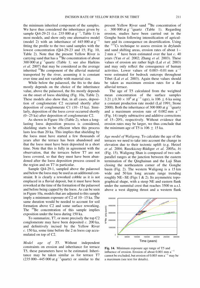
Table 2. Depth profile model parameters (see Fig. 10)
Model Inheritance(at g21
quartz)
Exposureof C1(ka)
Erosion rate(cm a21)
Exposureof C2(ka)
Erosion rate(cm a21)
Duration ofloess deposit
(ka)
Exposureloess(ka)
Erosion rate(cm a21)
Total durationof exposure
(ka)
1 235 000 15 0 45 0.005 1 150 0.0001 210
2 445 000 15 0 20 0 1 80 0 115
3 235 000 15 0 50 0 400 0.01 465
Models ofFigure 10c
235 000 15 0 15 0 50 10 0 90235 000 15 0 15 0 25 70 0 125235 000 15 0 15 0 10 120 0 160235 000 15 0 15 0 1 150 0 181
A.PERRIN
EAUETAL.
210
the minimum inherited component of the samples.We have thus considered the inheritance given bysample Qi4-29-21 (i.e. 235 000 at g21, Table 1) inmost models, and show only one alternative model(model 2) with an inheritance of 445 000 at g21
fitting the profile to the two sand samples with thelowest concentration (Qi4-29-23 and 15; Fig. 10,Table 2). Note that the present Yellow River iscarrying sand that has a 10Be concentration of about300 000 at g21quartz (Table 1; see also Harkinset al. 2007) that may be considered as the averageinherited 10Be component of the alluvial materialtransported by the river, assuming it is constantover time and not variable with material size.
While below the palaeosol, the fits to the datamostly depends on the choice of the inheritancevalue, above the palaeosol, the fits mostly dependson the onset of loess shielding (Fig. 10a, Table 2).These models also show that, in all cases, deposi-tion of conglomerate C2 occurred shortly afterdeposition of conglomerate C1 (10–15 ka). Simi-larly, deposition of the loess cover occurred shortly(0–25 ka) after deposition of conglomerate C2.
As shown in Figure 10c (Table 2), when a long-lasting loess deposition process is considered,shielding starts to be efficient when this processlasts less than 20 ka. This implies that shielding bythe loess must have started a few thousands ofyears after the terrace has been abandoned andthat the loess must have been deposited in a shorttime. Note that this is fully in agreement with theobservation, that the terraces below T7 are notloess covered, so that they must have been aban-doned after the loess deposition process ceased inthe region and on T7 in particular.
Sample Qi4-29-1, sampled above the palaeosoland below the loessmay be used as an additional con-straint. It is clearly a reworked cobble as it is notemplaced in a fluvial deposit, but it must have beenreworked at the time of the formation of the palaeosoland before being capped by the loess. As can be seenin Figure 10a, models that are adjusted to this sampleimply a minimum exposure of C2 of 10–15 ka. Thesame duration would be needed to account for soilformation above C2 and some surface reworking.The 10Be concentration of this sample impliesexposition under the loess during 150 ka.
To summarize, T7, or more precisely the top C2conglomerate may have been deposited c. 200 ka,and definitively incised by the Yellow Riverc. 150 ka, some time before the 2 m loess cap accu-mulated on top of C2.
Model age of T5. Without independentconstraints on erosion and inheritance for terraceT5, these parameters have to be estimated. Inheri-tance may be taken similar as for terrace T7(235 000–445 000 at g21quartz) or similar to the
present Yellow River sand 10Be concentration ofc. 300 000 at g21quartz (Table 1). Regardingerosion, studies have been carried out in theGonghe basin following intensification of agricul-ture and its consequence on desertification. Usingthe 137Cs technique to assess erosion in drylandsand sand shifting areas, erosion rates of about 1–2 mm a21 have been estimated over the last c. 40years (Yan et al. 2002; Zhang et al. 2003). Thesevalues of erosion are rather high (Lal et al. 2003)and may only reflect the consequence of humanactivities. Lower values of 0.003–0.01 mm a21
were estimated for bedrock outcrops throughoutTibet (Lal et al. 2003). Again these values shouldbe taken as maximum erosion rates for a flatalluvial terrace.
The age of T5 calculated from the weightedmean concentration of the surface samples3.21+0.30 ! 106 at g21 (qtz), is 106+ 6 ka usinga constant production rate model (Lal 1991; Stone2000). Both the inheritance of 300 000 at g21quartzand a maximum erosion rate of 0.002 mm a21
(Fig. 14) imply subtractive and additive correctionsof 15–20%, respectively. Without evidence thaterosion rates may be larger, we thus conclude thatthe minimum age of T5 is 106+ 15 ka.
Age model of Waligong. To calculate the age of theterraces we need to take into account the change inelevation due to their tectonic uplift (e.g. Hetzelet al. 2004; Ruszkiczay-Rudiger et al. 2005a, b)(Fig. 15). Waligong Shan is composed of two sub-parallel ranges at the junction between the easterntermination of the Qinghainan and the Laji Shanclosing the northeastern corner of the Gonghebasin (Fig. 2). The western Waligong is a 15 kmwide and 50 km long arcuate range trendingroughly NE–SE (Figs 1 & 2). Its asymmetric topo-graphical shape, with a steep NE and eastern flankunder the summital crest that reaches 3500 m a.s.l.above a west dipping thrust and a western flank
= 0 m
m/a
= 0.001 mm/a
= 0.003 mm/a
= 0.006 mm/a
0
1000000
2000000
3000000
4000000
5000000
0 50000 100000 150000 200000 250000 300000
Time (years)
N10
Be
(at
/g q
uart
z)
Fig. 14. Minimum exposure age range of T5 andinfluence of erosion. Erosion of about 0.001 mm a21
cannot be excluded, but erosion of 0.003 mm a21 may bea maximum (see text for details).
INCISION RATE OF YELLOW RIVER IN NE TIBET 211
that slopes c. 3.58westward, (Fig. 4e) indicate that itis an east-vergent crustal anticline. The easternWaligong is less elevated but larger (20–30 km),trends NW–SE and makes up the western limit ofthe Guide basin. Similarly to the western Waligong,it has a steep eastern rimmarked by a thrust at its base(Pan 1994) and grows as an east-vergent anticline(Fig. 2). As can be seen in the field (Fig. 13) thestrath terraces are carved into the Waligong Meso-zoic granodiorite (Geologicalmap ofQinghai 1988).
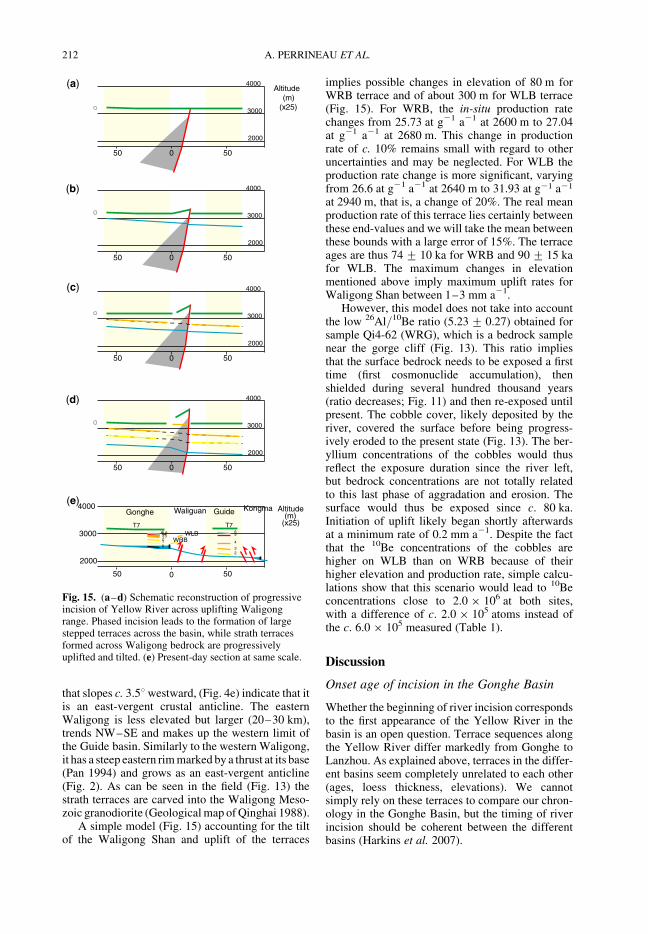
A simple model (Fig. 15) accounting for the tiltof the Waligong Shan and uplift of the terraces
implies possible changes in elevation of 80 m forWRB terrace and of about 300 m for WLB terrace(Fig. 15). For WRB, the in-situ production ratechanges from 25.73 at g21 a21 at 2600 m to 27.04at g21 a21 at 2680 m. This change in productionrate of c. 10% remains small with regard to otheruncertainties and may be neglected. For WLB theproduction rate change is more significant, varyingfrom 26.6 at g21 a21 at 2640 m to 31.93 at g21 a21
at 2940 m, that is, a change of 20%. The real meanproduction rate of this terrace lies certainly betweenthese end-values and we will take the mean betweenthese bounds with a large error of 15%. The terraceages are thus 74+ 10 ka for WRB and 90+ 15 kafor WLB. The maximum changes in elevationmentioned above imply maximum uplift rates forWaligong Shan between 1–3 mm a21.
However, this model does not take into accountthe low 26Al/10Be ratio (5.23+ 0.27) obtained forsample Qi4-62 (WRG), which is a bedrock samplenear the gorge cliff (Fig. 13). This ratio impliesthat the surface bedrock needs to be exposed a firsttime (first cosmonuclide accumulation), thenshielded during several hundred thousand years(ratio decreases; Fig. 11) and then re-exposed untilpresent. The cobble cover, likely deposited by theriver, covered the surface before being progress-ively eroded to the present state (Fig. 13). The ber-yllium concentrations of the cobbles would thusreflect the exposure duration since the river left,but bedrock concentrations are not totally relatedto this last phase of aggradation and erosion. Thesurface would thus be exposed since c. 80 ka.Initiation of uplift likely began shortly afterwardsat a minimum rate of 0.2 mm a21. Despite the factthat the 10Be concentrations of the cobbles arehigher on WLB than on WRB because of theirhigher elevation and production rate, simple calcu-lations show that this scenario would lead to 10Beconcentrations close to 2.0 ! 106 at both sites,with a difference of c. 2.0 ! 105 atoms instead ofthe c. 6.0 ! 105 measured (Table 1).
Discussion
Onset age of incision in the Gonghe Basin
Whether the beginning of river incision correspondsto the first appearance of the Yellow River in thebasin is an open question. Terrace sequences alongthe Yellow River differ markedly from Gonghe toLanzhou. As explained above, terraces in the differ-ent basins seem completely unrelated to each other(ages, loess thickness, elevations). We cannotsimply rely on these terraces to compare our chron-ology in the Gonghe Basin, but the timing of riverincision should be coherent between the differentbasins (Harkins et al. 2007).
(a)
(b)
(c)
(d)
(e)
2000
3000
4000
0 5050
Altitude (m)
(x25)
2000
3000
4000
0 50
Altitude (m)
(x25)
2000
3000
4000
0 50
2000
3000
4000
0 50
2000
3000
4000
0 50
50
50
50
50
T7 T766' 6543'3
210
5
4
32
Waliguan KongmaGonghe Guide
WLBWRB
Fig. 15. (a–d) Schematic reconstruction of progressiveincision of Yellow River across uplifting Waligongrange. Phased incision leads to the formation of largestepped terraces across the basin, while strath terracesformed across Waligong bedrock are progressivelyuplifted and tilted. (e) Present-day section at same scale.
A. PERRINEAU ET AL.212
Several authors have proposed that incision inthe Gonghe Basin began at c. 150 ka (e.g. Li 1991;Pan 1994). Evidences for a major change alongthe Yellow River 150 ka ago have been summarizedby Zhang et al. (2004). Periods of high regres-sive erosion from the Longyang gorges and theSanmen gorges (in the middle reaches of theYellow River north of the Ordos plateau, inset,Fig. 1) are reported around that time (Zhang et al.2000; Wang et al. 2002). This period of erosion inthe Longyang gorges could have followed thefolding of the fluvial sediments of the Gongheformation (Li 1991). An increased sedimentationin the marine delta of the river could be related tothis period of high erosion and to the climatewarming of MIS-5 (Imbrie et al. 1984).
However, it has been proposed that incisionbegan c. 500 (+200) ka ago in the Tongde Basin(Harkins et al. 2007; Craddock et al. 2010), follow-ing the last 1.8 Ma lacustrine deposit near the top ofthe section in Guide (Li et al. 1997). A direct impli-cation is that incision in the Gonghe Basin began atthe same time or before, but not after, which meansthat T7 must be much older than results from ourinvestigations suggest. This can only be achievedif a significant amount of erosion or a long periodof shielding occurred andmay imply that all terracesare significantly older. A 140 ka (OSL) terracelocated 140 m above the Yellow River is locatedat an elevation of c. 2830 m in the Tongde basin(Harkins et al. 2007; Craddock et al. 2010). For
comparison, an equivalent terrace in the GongheBasin would be near to T1, which is expected tobe much younger than 140 ka.
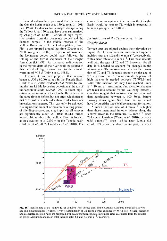
Incision rates of the Yellow River in the
Gonghe Basin
Terrace ages are plotted against their elevation onFigure 16. The minimum and maximum long-termincision rates are c. 2 and c. 6 mm a21, respectively,with a mean rate of c. 4 mm a21. This mean rate fitswell with the ages of T5 and T7. However, for alldata it is needed to account for changes in theincision rate. The incision rate between the forma-tion of T7 and T5 depends strongly on the age ofT7, if erosion on T5 remains small. A period ofhigh incision is needed between T5/WLB andWRB. The incision rate may have reached 9 mma21 (10 mm a21 maximum, if no elevation changesare taken into account for the Waligong terraces).Our data suggest that incision was first slow andthen accelerated between c. 100–50 ka, beforeslowing down again. Such fast incision wouldhave favoured the steepWaligong gorges formation.
A mean incision rate of 4 mm a21 is higherthan those mentioned in other places along theYellow River in the literature, 0.7 mm a21 since70 ka near Lanzhou (Wang et al. 2010), between0.75–1 mm a21 since 166 ka near Linxia (Liet al. 1997) for the downstream part, between
2500
3000
250 ka0 50 100 150 200
2.3 mm/a
3.7 mm/a
2.6 mm/a
3.9 mm/a
3.7 mm/a
9.1
mm
/a
6.0
mm
/a
4.0 mm/a
9 m
m/a
T7
T5
WLB
WRB
Elevation(m)
106 ka
180 ka 250 ka
Huang He
120 ka
150 ka180 ka( = 0.0038 mm/a)
( = 0.0048 mm/a)
Fig. 16. Incision rate of the Yellow River deduced from terrace ages and elevations. Coloured boxes are allowedage and elevation ranges. Yellow River elevation taken at Waligong gorges entrance (! WRB site). Several scenariosand associated incision rates are proposed. For Waligong terraces, rates are mean rates calculated from the middleof boxes. Maximum and mean total incision rates 6.0 and 4.0 mm a21, in orange.
INCISION RATE OF YELLOW RIVER IN NE TIBET 213
0.9–1.0 mm a21 for the last 140 ka in the TongdeBasin (Harkins et al. 2007). But it is in agreementwith the 6 mm a21since 93 ka in the Guide Basinproposed by Pan (1994).
Climatic correlations and formation of the
set of terraces
Climatic fluctuations play a key role in shapingfluvial terraces. Correlation of terrace formationperiods with climatic events is however not straight-forward, because uncertainties inherent to the cos-mogenic nuclides dating method often prevent fromdetermining a precise correlation. Transitionalperiods between glacial and interglacial periodsseem nevertheless to play a major role in formingfluvial terraces. These periods would be favourablefor incision, while aggradation would occur duringstable climatic phases, possibly both glacial and inter-glacial (e.g. Pan et al. 2003; Vandenberghe 2003).
Loess in northeastern China was mainly depos-ited during glacial periods, while palaeosols devel-oped during interglacial phases, alternating loessand palaeosol layers being correlated to climaticfluctuations (e.g. Ding et al. 2002). The fact thatT7 gravels are directly overlain by a palaeosol andthis palaeosol by a loess cover suggests that thisterrace was abandoned during a deglaciation periodand covered by loess during an a posteriori glacialevent (Gao et al. 2008; Pan et al. 2009). No such cli-matic indicators are available for the other terraces,although it is reasonable to assume that their for-mation followed a similar process, that is, a for-mation as a consequence of dry/cold to wet/warmclimate transition.
The terraces in the Gonghe Basin could havebeen formed during glacial periods and abandonedat the transition with warmer periods, when theriver high incision power enabled it to break damsformed by the Waligong Shan.
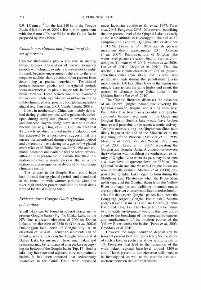
Evidence for a Gonghe-Guide-Qinghai
palaeo-lake
Small lakes can be found in several places in thepresent Gonghe basin (Fig. 6); Chaka Lake, in theNW, has a present elevation of 3060 m; DalianLake, at an elevation of 2850 m (Yan et al. 2002);Duolonggou lake, north of Gonghe city, at anelevation of 3194 m. Lacustrine sediments can befound at several places in the Gonghe basin and atDalian Lake for instance. These small lakes andsediments may be remnants of a larger lake occupy-ing the bottom of the Gonghe basin (Fig. 17). Such alake may have covered adjacent intra-mountainousbasins. It has been reported that sedimentarysequences in the Guide Basin were deposited
under lacustrine conditions (Li et al. 1997; Pareset al. 2003; Fang et al. 2005).Moreover, it is strikingthat the present level of the Qinghai Lake is exactlyat the same altitude as Duolonggou lake and as T7sampling site (3200 m). Qinghai lake exists sincec. 0.5 Ma (Yuan et al. 1990) and its presentmaximum depth approximates 20 m (Colmanet al. 2007). Reconstructions of Qinghai lakewater level palaeo-elevations lead to various chro-nologies (Colman et al. 2007; Madsen et al. 2008;Liu et al. 2010; Rhode et al. 2010). The lakereached a maximum elevation of 3260 m (palaeo-shorelines older than 30 ka) and its level wasparticularly high during the penultimate glacialmaximum (c. 150 ka). Other lakes in the region see-mingly experienced the same high-stand event, thenearest in distance being Gahai Lake in theQaidam Basin (Fan et al. 2010).
The Chinese literature discusses the existenceof an eastern Qinghai palaeo-lake covering theQinghai, Gonghe, Xinghai and Xining basin (e.g.Pan 1994). It is based on a possible stratigraphiccontinuity between sediments in the Guide andQinghai Basin. Such a lake would have brokeninto several parts due to the recent tectonic activity.Tectonic activity along the Qinghainan Shan faultlikely began at the end of the Miocene or at thebeginning of the Pliocene (Metivier et al. 1998;Meyer et al. 1998; Van der Woerd 1998; Fanget al. 2005; Lease et al. 2007) separating theQinghai and Gonghe Basin. A connection betweenthe two basinswas possible at the southeastern extre-mity of Qinghai Lake when the pass may have beenat a lower elevation (present elevation: 3350 m). TheQinghai Basin and the western Gonghe Basin arenow internally drained. Madsen et al. (2008) pro-posed that Qinghai Lake began to form during theMiddle or Late Pleistocene when the Riyue Shanuplift separated the Qinghai Basin from the YellowRiver drainage system. Uplifting mountain rangescrossing the river course would have acted as bound-aries for the eastern Qinghai palaeo-lake, near theLongyang gorges (Gonghe Basin exit), Shanbagorges (Guide Basin exit) or Jishi Gorges (XunhuaBasin exit) (Fig. 17). The change from a lacustrineto a fluviatile environment would in this case corre-spond to the breaching of the topographic barriersand emplacement of the modern course of theYellow River across the basins (Pares et al. 2003;Craddock et al. 2010).
However, no large lacustrine deposit can befound at present to attest more clearly the existenceof such a lake, in particular at our sampling site ofT7. Processes that lead to the formation of thewide palaeo-regional base-level around 3200 mand of lakes present at this elevation stills need tobe investigated, as well as the possible past con-nections between the different basins.
A. PERRINEAU ET AL.214
Fig. 17. Topographical contours at 3150, 3200 and 3250 m a.s.l. showing possible extensions of a regional palaeolake or closed basin in the area of Qinghai and Gonghe basins beforetheir separation due to lake capture by Yellow River and growth of the Qinghainan Shan. Lake surface elevation may have reached 3200–3250 m a.s.l. This mapping, drawn from thepresent topography, does not account for large tectonic and morphological changes.
INCISIO
NRATEOFYELLOW
RIV
ERIN
NETIBET
215
Conclusion
The Gonghe Basin is one of the widest basins ofnortheastern Tibet. It contains noteworthy wide ter-races that testify to an important and recent waterlevel decrease. Our results indicate that terraceswere formed at the transition between glacial andinterglacial periods. The upper one probably datesfrom the penultimate glacial maximum (MIS-6;Imbrie et al. 1984; Thompson et al. 1997). Obtainedages show that incision occurs at a mean rate ofc. 4 mm a21. Higher incision rates during someperiods may be related to Waligong Shan uplift,although the tectonic signal remains difficult to sep-arate from the river incision. Our results highlightthe consequences of mountain growth and the inter-play between tectonic and climatic processes inbuilding the Tibetan Plateau. We provide chrono-logical constraints supporting that this part of theplateau evolved rapidly in recent time from aninternally drained but interconnected set of closedbasins to an externally river drained plateau margin.
Field access and field trip support was provided byInstitute of Tibetan Plateau Research, Chinese Academyof Sciences, Beijing, and the Chinese Earthquake Admin-istration, Beijing, and its local bureau in Xining. Weacknowledge support from INSU-CNRS (programmesRelief de la Terre), from CNES-SPOT Image (Tectoscopeprogram, image acquired through ISIS program). The 10Bemeasurements were performed at the ASTERAMS Frenchnational facility (CEREGE, Aix-en-Provences), which issupported by the INSU-CNRS, the French Ministry ofResearch and Higher Education, IRD, and CEA. Twomeasurements were also made at Center for AcceleratorMass Spectrometry at Lawrence Livermore National Lab-oratory. We thank Ecole et Observatoire des Sciences de laTerre (Strasbourg, France) and Universite de Strasbourgfor support and making possible the operation of the cos-mogenic laboratory of Institut de Physique du Globe deStrasbourg (UMR 7516) and Laboratoire d’Hydrogeologieet de Geochimie de Strasbourg (UMR 7517).
References
Anderson, R. S., Repka, J. L. & Dick, G. S. 1996.Explicit treatment of inheritance in dating depositionalsurfaces using in situ 10Be and 26Al. Geology, 24,47–51.
Balco, G. 2009. 26Al–10Be exposure age/erosion ratecalculators: update from v. 2.1 to v. 2.2. World WideWeb Address: http://hess.ess.washington.edu/math/docs/al_be_v22/al_be_docs.html.
Balco, G., Stone, J., Lifton, N. & Dunai, T. 2008. Acomplete and easily accessible means of calculatingsurface exposure ages or erosion rates from 10Be and26Al measurements. Quaternary Geochronology, 3,174–495.
Benn, D. & Owen, L. A. 1998. The role of the Indiansummer monsoon and the mid-latitude westerlies inHimalayan glaciation: review and speculative
discussion. Journal of the Geological Society,London, 155, 353–363.
Bierman, P. R. 1994. Using in-situ cosmogenic isotopes toestimate rates of landscape evolution: a review fromthe geomorphic perspective. Journal of GeophysicalResearch, 99, 13 885–13 896.
Chen, Y. T., Xu, L. S., Li, X. & Zhao, M. 1996. Sourceprocess of the 1990 Gonghe, China, earthquake andtectonic stress field in the northeastern Qinghai-Xizang(Tibetan) plateau. Pure and Applied Geophysics, 146,697–715.
Clark, M. K., Schoenbohm, L. M. et al. 2004. Surfaceuplift, tectonics, and erosion of eastern Tibet fromlarge-scale drainage patterns. Tectonics, 23, TC1006,doi: 10.1029/2002TC001402.
Colman, S. M.,Yu, S.-Y.,An, Z. &Henderson, A. C. G.2007. Late Cenozoic climate changes in China’swestern interior: a review of research on LakeQinghai and comparison with other records. Quatern-ary Science Reviews, 26, 2281–2300.
Craddock,W. H.,Kirby, E.,Harkins, N.W.,Zhang, H.,Shi, X. & Liu, J. 2010. Rapid fluvial incision alongthe Yellow River during headward integration.Nature Geoscience, doi: 10.1038/NGEO777.
Ding, Z. L., Derbyshire, E., Yang, S. L., Yu, Z. W.,Xiong, S. F. & Liu, T. S. 2002. Stacked 2.6-Magrain size record from the Chinese loess based onfive sections and correlation with the deep-sea d18Orecord. Paleoceanography, 17, doi: 10.1029/2001PA000725.
Domroes, M. & Peng, G. 1988. The Climate of China.Springer, Berlin.
England, P. C. & Houseman, G. A. 1986. Finite straincalculations of continental deformation: 2. Comparisonwith the India-Asia collision zone. Journal of Geo-physical Research, 91, 3664–3676, doi: 10.1098/rsta.1988.0135.
Fan, Q. S., Lai, Z. P., Long, H., Sun, Y. J. & Liu, X. J.2010. OSL chronology for lacustrine sedimentsrecording high stands of Gahai Lake in QaidamBasin, northeastern Qinhai-Tibetan Plateau. Quatern-ary Geochronology, 5, 223–227.
Fang, X., Garzione, C., Van der Voo, R., Li, J. &Fan, M. 2003. Flexural subsidence by 29 Ma onthe NE edge of Tibet from the magnetostratigraphyof Linxia Basin, China. Earth and Planetary ScienceLetters, 210, 545–560.
Fang, X., Yan, M. et al. 2005. Late Cenozoic defor-mation and uplift of the NE Tibetan Plateau: evidencefrom high-resolution magnetostratigraphy of the GuideBasin, Qinghai Province, China. GSA Bulletin, 117,1208–1225.
Fluteau, F., Ramstein, G. & Besse, J. 1999. Simulatingthe evolution of the Asian and African monsoonsduring the past 30 Ma using an atmospheric generalcirculation model. Journal of Geophysical Research,104, 11 995–12 018.
Fothergill, P. A. & Ma, H. 1999. Preliminaryobservations on the geomorphic evolution of theGuide Basin, Qinghai Province, China: implicationsfor the uplift of the northeast margin of the TibetanPlateau. In: Smith, B. J., Whalley, W. B. &Warke, P. A. (eds) Uplift, Erosion and Stability:Perspectives on Long-term Landscape Development.
A. PERRINEAU ET AL.216
Geological Society, London, Special Publications,162, 183–200.
Frankel, K. L. 2010. Terrestrial cosmogenic nuclidegeochronology data reporting standards needed. EOS,Transactions, American Geophysical Union, 91,31–32.
Gao, H., Liu, X., Pan, B., Wang, Y., Yu, Y. & Li, J.2008. Stream response to Quaternary tectonic andclimatic change: evidence from the upper WeiheRiver, central China. Quaternary International, 186,123–131.
Gaudemer, Y., Tapponnier, P. et al. 1995. Partitioningof crustal slip between linked, active faults in theeastern Qilian Shan, and evidence for a majorseismic gap, the “Tianzhu gap”, on the WesternHaiyuan Fault, Gansu (China). Geophysical JournalInternational, 120, 599–645.
Gaudemer, Y., Tapponnier, P. & Turcotte, D. L. 1989.River offsets across active strike–slip faults. AnnalesTectonicae, III, 55–76.
Gosse, J. C. & Phillips, F. M. 2001. Terrestrial in situ cos-mogenic nuclides: theory and applications.QuaternaryScience Reviews, 20, 1475–1560.
Granger, D. E. & Smith, A. L. 2000. Dating buriedsediments using radioactive decay and muogenic pro-duction of 26Al and 10Be. Nuclear Instruments andMethods in Physics Research, B172, 822–826.
Harkins, N., Kirby, E., Heismath, A., Robinson, R. &Reiser, U. 2007. Transient fluvial incision in theheadwaters of the Yellow River, northeastern Tibet.Journal of Geophysical Research, 112, F03S04, doi:10.1029/2006JF000570.
Hetzel, R., Tao, M. et al. 2004. Late Pleistocene/Holocene slip rate of the Zhangye thrust (QilianShan, China) and implications for the active growthof the northeastern Tibetan Plateau. Tectonics, 23,TC6006, doi: 10.1029/2004TC001653.
Houseman, G. & England, P. 1993. Crustal thickeningv. lateral expulsion in the Indian–Asian continentalcollision. Journal of Geophysical Research, 98,12 233–12 249.
Imbrie, J., Hays, J. D. et al. 1984. The orbital theory ofPleistocene climate: support from a revised chronologyof the d18O record. In:Berger, A., Imbrie, J.,Hays, J.,Kukla, G. & Saltzman, B. (eds) Milankowitch andClimate. Reidel, the Netherlands, 269–305.
Joussaume, S. 1999. Climat d’hier a demain, CNRSEdition, CEA.
Kohl, C. P. &Nishiizumi, K. 1992. Chemical isolation ofquartz for measurements of in-situ-produced cosmo-genic nuclides. Geochimica et Cosmochimica Acta,56, 3583–3587.
Lal, D. 1991. Cosmic ray labeling of erosion surfaces: insitu nuclide production rates and erosionmodels. Earthand Planetary Science Letters, 104, 424–439.
Lal, D., Harris, N. B. W. et al. 2003. Erosion history ofthe Tibetan Plateau since the last interglacial: con-straints from the first studies of cosmogenic 10Befrom Tibetan bedrock. Earth and Planetary ScienceLetters, 217, 33–42.
Lease, R. O.,Burbank, D.W.,Gehrels, G. E.,Wang, Z.& Yuan, D. 2007. Signatures of mountain building:Detrital zircon U/Pb ages from northeastern Tibet.Geology, 35, 1239–1242.
Le Dortz, K.,Meyer, B. et al. 2009. Holocene right-sliprate determined by cosmogenic and OSL dating on theAnar fault. Geophysical Journal International, 179,700–710; doi: 10.1111/j.1365–246X.2009.04309.x.
Li, J. 1991. The environmental effects of the upliftof the Qinghai-Xizang Plateau. Quaternary ScienceReviews, 10, 479–483.
Li, J.-J., Fung, X.-M. et al. 1997. Magnetostratigraphicdating of river terraces: rapid and intermittent incisionby the Yellow River of the northeastern margin ofthe Tibetan Plateau during the Quaternary. Journal ofGeophysical Research, 102, 10 121–10 132.
Lister, G. S., Kelts, K., Chen, K., Yu, J. & Niessen, F.1991. Lake Qinghai, China: closed-basin lake levelsand the oxygen isotope record for ostracods since thelatest Pleistocene. Paleogeography, Paleoclimatology,Paleoecology, 84, 141–162.
Liu, X. J., Lai, Z. P., Fan, Q. S., Long, H. & Sun, Y. J.2010. Timing for high lake levels of QinghaiLake in the Qinghai-Tibetan Plateau since the lastinterglaciation based on quartz OSL dating. Quatern-ary Geochronology, 5, 218–222.
Liu-Zeng, J., Tapponnier, P., Gaudemer, Y. & Ding, L.2008. Quantifying landscape differences across theTibetan plateau: implications for topographic reliefevolution. Journal of Geophysical Research, 113,F04018, doi: 10.1029/2007JF000897.
Lu, H.,Wang, X. et al. 2004. Geomorphologic evidenceof phased uplift of the northeastern Qinghai-TibetPlateau since 14 million years ago. Science in China,Series D Earth Sciences, 47, 822–833.
Madsen, D. B.,Haizhou, M., Rhodes, D.,Brantigham,P. J. & Forman, S. L. 2008. Age constraints on thelate Quaternary evolution of Qinghai Lake, TibetanPlateau. Quaternary Research, 69, 316–325.
Matmon, A., Simhai, O. et al. 2009. Desert pavement-coated surfaces in extreme deserts present thelongest-lived landforms on Earth. Geological Societyof America Bulletin, 121, 688–697, doi: 10.1130/B26422.1.
Meriaux, A.-S., Ryerson, F. J. et al. 2004. Rapidslip along the central Altyn Tagh Fault: Morpho-chronologic evidence from Cherchen He andSulamu Tagh. Journal of Geophysical Research, 109,B06401.
Meriaux, A.-S., Tapponnier, P. et al. 2005. The Aksaysegment of the Northern Altyn Tagh fault: tectonicgeomorphology, landscape evolution and Holoceneslip-rate. Journal of Geophysical Research, 110,B04404.
Metivier, F., Gaudemer, Y., Tapponnier, P. & Meyer,B. 1998. Northeastward growth of the Tibet Plateaudeduced from balanced reconstruction of two deposi-tional areas: the Qaidam and Hexi Corridor basins,China. Tectonics, 17, 823–842.
Meyer, B., Tapponnier, P. et al. 1998. Crustal thicken-ing in Gansu-Qinghai lithospheric mantle subductionand oblique, strike–slip controlled growth of theTibet Plateau. Geophysical Journal International,135, 1–47.
Nishiizumi, K., Imamura, M., Caffe, M., Southon, J.,Finkel, R. &McAnich, J. 2007. Absolute calibrationof 10Be AMS standards. Nuclear Instruments andMethods in Physics Research B, 258, 403–413.
INCISION RATE OF YELLOW RIVER IN NE TIBET 217
Oskin, M., Peng, L., Shelef, E., Strane, M., Gurney,E., Singer, B. & Zhang, X. 2008. Elevated shearzone loading rate during an earthquake cluster ineastern California. Geology, 36, 507–510, doi:10.1130/G24814A.1.
Pan, B. 1994. Research upon the geomorphologic evol-ution of the Guide Basin and the development of theYellow River. Arid Land Geography, 7, 43–50.
Pan, B., Burbank, D., Wang, Y., Wu, G., Li, J. &Guan, Q. 2003. A 900 ka record of strath terraceformation during glacial-interglacial transitions innorthwest China. Geology, 31, 957–960.
Pan, B., Su, H.,Hu, Z.,Hu, X.,Gao, H.,Li, J. &Kirby, E.2009. Evaluating the role of climate and tectonicsduring non-steady incision of the Yellow River:evidence from a 1.24 terrace record near Lanzhou,China. Quaternary Science Reviews, 28, 3281–3290,doi: 10.1016/j.quascirev.2009.09.003.
Pares, J. M., van der Voo, R., Downs, W. R., Yan, M. &Fang, X. 2003. Northeastward growth and uplift of theTibetan Plateau: magnetostratigraphic insights fromthe Guide Basin. Journal of Geophysical Research,108, doi: 10.1029/2001JB0012349.
Peltzer, G. & Tapponnier, P. 1988. Formation andevolution of strike–slip faults, rifts, and basinsduring the India-Asia collision: an experimentalapproach. Journal of Geophysical Research, 93,15 085–15 117.
Qin, B. 1992. The hydrological characteristics andwater budget of Qinghai lake drainage basin,Chin. J. Oceanology and Limnology, 11, 314–320.
QINGHAI GEOLOGICAL BUREAU. 1988. GeologicalMap of Qinghai-Xizang. Ministry of Geology,Geological Press, Xining.
Repka, J. L., Anderson, R. S. & Finkel, R. C. 1997.Cosmogenic dating of fluvial terraces, FreemontRiver, Utah. Earth and Planetary Science Letters,152, 59–73.
Rhode, D., Haiying, Z., Madsen, D. B., Xing, G.,Brantingham, P. J., Ma, H. & Olsen, J. W. 2007.Epipaleolithic/early Neolithic settlements at QinghaiLake, western China. Journal of ArchaeologicalScience, 34, 600–612.
Rhode, D., Haizhou, M., Madsen, D. B., Branting-ham, P. J., Forman, S. L. & Olsen, J. W. 2010.Palaeoenvironmental and archaeological investi-gations at Qinghai Lake, western China: geomorphicand chronometric evidence of lake level history.Quaternary International, 218, 29–44.
Royden, L., Burchfiel, B. C., King, R. W., Wang, E.,Chen, Z. L., Shen, F. & Liu, Y. P. 1997. Surfacedeformation and lower crustal flow in easternTibet. Science, 276, 788–790, doi: 10.1126/science.276.5313.788.
Ruszkiczay-Rudiger, Zs., Fodor, L., Bada, G.,Leel-Ossy, Sz., Horvath, E. & Dunai, T. J. 2005a.Quantification of Quaternary vertical movements inthe central Pannonian Basin: a review of chronologicdata along the Danube River, Hungary. Tectonophy-sics, 410, 157–172.
Ruszkiczay-Rudiger, Zs., Dunai, T. J., Bada, G.,Fodor, L. & Horvath, E. 2005b. Middle to latePleistocene uplift rate of the Hungarian MountainRange at the Danube Bend (Pannonian Basin)
using in situ produced 3He. Tectonophysics, 410,173–187.
Schaller, M., von Blanckenburg, F., Veit, H. &Kubik, P. W. 2002. Influence of periglacial coverbeds on in situ-produced cosmogenic 10Be in soilsections. Geomorphology, 49, 255–267.
Stone, J. O. 2000. Air pressure and cosmogenic isotopesproduction. Journal of Geophysical Research, 105,23 753–23 759.
Sun, J. 2005. Long-term fluvial archives in the Fen WeiGraben, central China, and their bearing on the tectonichistory of the India–Asia collision system duringthe Quaternary. Quaternary Science Reviews, 24,1279–1286.
Tapponnier, P., Peltzer, G.,Armijo, R., Le Dain, A.-Y.& Cobbold, P. 1982. Propagating extrusion tectonicsin Asia: new insights from simple experiments withplasticine. Geology, 10, 611–616.
Tapponnier, P., Meyer, B. et al. 1990. Active thrustingand folding in the Qi Lian Shan, and decouplingbetween the upper crust and mantle in northeasternTibet. Earth and Planetary Science Letters, 97,382–403.
Tapponnier, P., Xu, Z. Q., Roger, F., Meyer, B.,Arnaud, N., Wittlinger, G. & Yang, J. S. 2001.Oblique stepwise rise and growth of the TibetPlateau. Science, 294, 1671–1677.
Thompson, L. G., Yao, T. et al. 1997. Tropical climateinstability: the last glacial cycle from a Qinghai-Tibetan ice core. Science, 276, 1821–1825.
Vandenberghe, J. 2003. Climate forcing of fluvial systemdevelopment: an evolution of ideas. QuaternaryScience Reviews, 22, 2053–2060.
Van der Woerd, J. 1998. Couplage cinematique entredecrochements et chevauchements actifs dans le norddu Tibet. Croissance du Plateau Tibetain. PhD thesis,University Paris VII.
Van der Woerd, J., Klinger, Y., Sieh, K., Tapponnier,P., Ryerson, F. J. &Meriaux, A.-S. 2006. Long-termslip rate of the southern San Andreas Fault from10Be–26Al surface exposure dating of an offset alluvialfan. Journal of Geophysical Research, 111, B04407,doi: 10.1029/2004JB003559.
Van derWoerd, J., Tapponnier, P. et al. 2002. Uniformpostglacial slip-rate along the central 600 km of theKunlun Fault (Tibet), from 26Al, 10Be and 14C datingof riser offsets, and climatic origin of the regionalmorphology. Geophysical Journal International, 148,356–388.
Van der Woerd, J., Xu, X. et al. 2001. Rapid activethrusting along the northwestern range front of theTanghe Nan Shan (western Gansu, China). Journal ofGeophysical Research. 106, 30 475–30 504.
Wang, P., Jiang, H., Yuan, D., Liu, X. & Zhang, B.2010. Optically stimulated luminescence dating ofsediments from the Yellow River terraces inLanzhou: tectonic and climatic implications. Qua-ternary Geochronology, 5, 181–186.
Wang, S., Wu, X., Zhang, Z., Jiang, F., Xue, B.,Tong, G. & Tian, G. 2002. Sedimentary records ofenvironmental evolution in the Sanmen Lake Basinand the Yellow River running through the SanmenxiaGorges eastward into the sea. Science in China(Series D), 47, 596–608.
A. PERRINEAU ET AL.218

Yan, M., Pares, J. M., van der Voo, R., Rea, D. K. &Fan, X. 2004. Pleistocene magnetostratigraphy ofthe Gonghe Basin, NE Tibetan Plateau: headwardincision of the Yellow River after 1.8 Ma. AmericanGeophysical Union, spring meeting 2004, abstracdtGP31A-17.
Yan, P., Shi, P., Gao, S., Chen, L., Zhang, X. & Bai, L.2002. 137Cs dating of lacustrine sediments and humanimpacts on Dalian Lake, Qinghai Province, China.Catena, 47, 91–99.
Yuan, B. Y.,Chen, K. Z.,Bowler, J. M. & Je, S. S. 1990.The formation and evolution of Qinghai Lake.Quaternary Sciences, 3, 233–243 (in Chinese withEnglish abstract).
Zhang, C.,Gong, J., Zou, X.,Dong, G., Li, X.,Dong, Z.& Qing, Z. 2003. Estimates of soil movement ina study area in Gonghe Basin, north-east of
Qinghai-Tibet Plateau. Journal of Arid Environments,53, 285–295.
Zhang, Z., Wang, S., Wu, X., Jiang, F. & Li, X.2000. Age and environmental implications of theSanmen Basin piercing in the middle reaches ofYellow River. Journal of Geosciences of China, 2,42–44.
Zhang, Z., Wang, S., Yang, X., Jiang, F., Shen, J. &Li, X. 2004. Evidence of a geological event andenvironmental change in the catchment area of theYellow River at 0.15 Ma. Quaternary International,117, 35–40.
Zheng, D., Zhang, P., Wan, J., Li, C. & Cao, J.2003. Late Cenozoic deformation subsequence innortheastern margin of Tibet: Detrital AFT recordsfrom Linxia Basin. Science in China, Series D, 46,266–275.
INCISION RATE OF YELLOW RIVER IN NE TIBET 219
Related Documents