TEAM MEMBERS TANG, Lik-yin CHIU, Chun-hei LAI, Ka-ngai LAM, Ho-ching LAM, Hoi-chun TANG, King-man WU, Long-hei CIVL4101 Capstone Design Project INCEPTION REPORT Pedestrian Corridor linking up MTR Ngau Tau Kok Station and Kwun Tong Promenade UID 3035573173 3035566584 3035573202 3035574608 3035567289 3035567605 3035566194 GROUP FL

Welcome message from author
This document is posted to help you gain knowledge. Please leave a comment to let me know what you think about it! Share it to your friends and learn new things together.
Transcript

TEAM MEMBERSTANG, Lik-yinCHIU, Chun-heiLAI, Ka-ngaiLAM, Ho-chingLAM, Hoi-chunTANG, King-manWU, Long-hei
CIVL4101 Capstone Design ProjectINCEPTION REPORT
Pedestrian Corridor linking up MTR Ngau Tau KokStation and Kwun Tong Promenade
UID3035573173303556658430355732023035574608303556728930355676053035566194 GROUP FL

CIVL4101 Capstone Design Project 2021-22 Inception Report
Ngau Tau Kok Pedestrian Corridor Group FL
Issue 01 - September 2021 i Group FL
Table of Contents
1. INTRODUCTION----------------------------------------------------------------------------------1
1.1 Project Background and Objectives--------------------------------------------------------------------1
1.2 Purpose of Report-----------------------------------------------------------------------------------------2
1.3 Scope of Report-------------------------------------------------------------------------------------------2
2. APPROACH AND METHODOLOGY---------------------------------------------------------2
2.1 Main Flow-----------------------------------------------------------------------------------------------2-4
2.2 Detailed List of Topics in Each Phase------------------------------------------------------------------4
3. SITE CONSTRAINTS AND CONCERNS----------------------------------------------------4
3.1 Social and Economic Concerns and Opportunities------------------------------------------------4-5
3.2 Structural Constraints---------------------------------------------------------------------------------6-10
3.3 Geotechnical Constraints---------------------------------------------------------------------------10-13
3.4 Environmental Constraints-------------------------------------------------------------------------13-17
3.5 Transportational Concerns and Opportunities--------------------------------------------------17-23
3.6 Drainage Concerns----------------------------------------------------------------------------------23-26
3.7 Constructability Concerns--------------------------------------------------------------------------26-30
4. WORK ACCOMPLISHED------------------------------------------------------------------------------30
5. PROJECT PROGRAMME AND JOB DUTY-------------------------------------------------------30
5.1 Project Programme--------------------------------------------------------------------------------------30
5.2 Job Duty--------------------------------------------------------------------------------------------------30
Appendices:
Appendix A – Detailed list of topics in each phase
Appendix B – Site visit records
Appendix C – Meeting minutes
Appendix D – Project programme
Appendix E – Job duty
Appendix F – Brainstormed idea and selling point
Appendix G – Reference list
CIVL4101 Capstone Design Project 2021-22 Inception Report
Ngau Tau Kok Pedestrian Corridor Group FL
Issue 01 - September 2021 1 Group FL
1. INTRODUCTION
1.1 Project Background and Objectives
Kowloon East has transformed into a core business area and has been overcrowded with
pedestrians and traffic with the increasing working population. Traffic congestion in both
pedestrian and car roads will only be worsened if there is no alternative to accommodate them.
In fact, Energizing Kowloon East Office (EKEO) has implemented several projects to improve
the situation of air pollution and traffic congestion in Kwun Tong and Kowloon Bay Business
Area (KBBA), however they are ineffective in the view of residents in Kowloon East (Tse, 2019).
Up till early 2019, commercial floor area in Kowloon East has occupied over 2.6 million square
meters of land and was expected to be even enlarged to 7 million square meters in the future
(Tse, 2019). According to the observations on weekdays especially during the peak hours when
people go to and leave from work, the roads in the vicinity of Kwun Tong Road and Hoi Yuen
Road are fully saturated with pedestrians and vehicles. This situation is expected to be worsened
further until collapse due to the increase of commercial floor area.
This capstone project has its focus put on another busy route which is the linkage between the
MTR Ngau Tau Kok Station and Kwun Tong Promenade. The EKEO has conducted research
and confirmed that Lai Yip Street which links up Hoi Bun Road and MTR Ngau Tau Kok station
is one of the major pedestrian corridors in Kowloon Tong Business Area (KTBA) (EKEO 2013).
Passengers walking in between these two locations have to come across multiple streets. This
could be inconvenient and unpleasant especially under bad weather conditions. Currently, a
medium-term proposal has been planned but the emphasis is not on the linkage mentioned above.
Therefore, a long-term proposal of constructing a weatherproof grade-separated pedestrian
corridor connecting MTR Ngau Tau Kok Station and Kwun Tong promenade (Hoi Bun Road)
will be the focus of this project. The objective is to provide an alternative, which can be subway,
footbridge etc., which frees the passengers from clogging in busy Lai Yip Road and ameliorate
the experience of them under bad weather conditions such as rain.
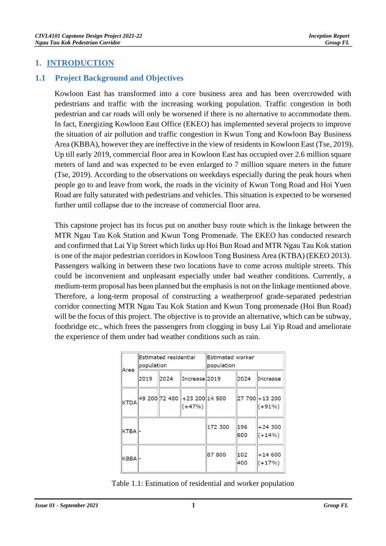
Table 1.1: Estimation of residential and worker population

CIVL4101 Capstone Design Project 2021-22 Inception Report
Ngau Tau Kok Pedestrian Corridor Group FL
Issue 01 - September 2021 2 Group FL
1.2 Purpose of Report
This report aims to demonstrate the inception that the project team has done in the beginning
stage of the design project. Constraints and opportunities of the designated sites were
identified for decision making on the alternatives of feasible schemes in the later stage. Project
programme and the corresponding schedule are provided in this report as well.
1.3 Scope of Report
The scope of the report includes:
(a). Design approach and methodology
(b). Site constraints and concerns in various aspects
(c). Work accomplished/ Project progress
(d). Project programme and milestone
(e). Duty roster
(f). Minutes of regular meeting
2. APPROACH AND METHODOLOGY
2.1 Main Flow
There are five main phases in the design process. Please see the appendix A for the detailed
list of topics in each phase.
2.1.1 Phase 1 is the Inception Stage which mainly involves researching the background of the project
such as the purposes, construction constraints, special issues, and development opportunities.
After the site visit on 5th September, the preliminary findings were consolidated, and the team
combined the findings with drawings, surveys, and data collected to develop a proper
preliminary site constraints record. The methodology of the whole project was developed
with targeted critical dates and project completion indicators for continuous progress. How to
carry out each step is the team’s major goal under methodology. To extract more site
information, the team proposed to request for the 6 existing government reports for reference.
To better utilize the manpower, the team is separated into different squads such as geotechnical,
transportation etc. to achieve a better division of labor.
2.1.2 Phase 2 is the Post-Inception Stage. This phase lays down the foundation to the phase 3 of
Feasibility Study. This phase also develops essential inspirations for the initial concept of the
design solution and other alternatives. In this phase, the aforementioned 6 government reports
will be studied in depth in all 7 aspects (social-and economy, environmental, geotechnical,
transportation, structural, drainage & sewage, and constructability issues) to do comparative
studies for the existing similar structures in Hong Kong and other cities. More detailed, the
site conditions for the Footbridge system in Wan Chai MTR station to Immigration
Headquarter and the Lai Yip site is of high similarity and referential value. Next, the ongoing

CIVL4101 Capstone Design Project 2021-22 Inception Report
Ngau Tau Kok Pedestrian Corridor Group FL
Issue 01 - September 2021 3 Group FL
proposed short-, mid-, and long-term development by Energizing Kowloon East Office
(EKEO) around Lai Yip Street will be investigated in order to synchronize the development
footstep with the government. Lastly, the team would develop the main principles for design
such as design direction, selling point and theme.
2.1.3 Phase 3 is the Feasibility Study Stage, and the team would further investigate the constraints
and opportunities in Lai Yip site in 3 steps. The first step is the consolidation of the project
focus by identifying the Client’s needs, targets of the study, current demand in Kwun Tong
and the user's properties including the preferred mode of transport and the travel patterns
associated. The second step is to conduct forecasting on the pedestrian demand subjected to
the CBD2’s development, development induced vehicular trip generation and attractions, and
the population growth in the design year to set out the design input in phase 4. The third step
is a detailed version of the phase 2 post-inception which combines government reports,
previous and in-house conducted impact assessments, and site investigation to estimate the
full feasibility in 9 aspects. The major findings of phase 3 will be presented at the end to
highlight its importance. A special feature in phase 3 is the consideration of using Modular
Integrated Construction (MiC) and the evaluation of the feasibility of Design for
Manufacturing and Assembly (DFMA).
2.1.4 Phase 4 is the Preliminary Design Stage. The first step is to develop an initial form of the
project. The team would evaluate the major choices such as subway, flyover, covered walkway,
existing road improvement scheme and the combinations of all above forms. Several proposed
ideas will be presented in the first step. The second step is the option evaluation. Our team
proposed using a multinomial logit model to define the degree of suitability under 10 aspects.
The weighting of each aspect would be calibrated before the final decision is made. The
suitability, social-and economy, environmental, geotechnical, transportation, structural,
drainage & sewage, cost and safety concerns are taken into consideration. Under each aspect,
comparisons would be made between options and these aspects are taking sustainable
development into consideration by balancing between social, environment and the economy.
At the end of the second step, one final solution will be selected with the highest utility. The
final solution’s key features would be highlighted with justifications. The third step in phase
4 is the conceptual design. The architectural design with the system’s access location will be
concluded and modeled using REVIT (Building Information Modelling software) to set out
the superstructure. Next, the team would develop the geotechnical scheme such as
investigating the ground profile, ground parameters with foundation design followed by the
structural scheme with construction material selection. The preliminary sizing of structural
elements will be carried out. Then the construction method and sequence is proposed for a safe
construction. Lastly, cost-related programmes such as initial cost estimations and a cost-
benefit analysis of the structure will be carried out to ensure that the project is financially
justifiable. The last step is the technical impact assessment in 4 aspects (environmental, traffic,
drainage, and visual) for the concluded design solution to ensure that the negative impact is
kept to minimal, and remedial actions will be provided in case of excessive impacts to improve
the sustainability of the structure.

CIVL4101 Capstone Design Project 2021-22 Inception Report
Ngau Tau Kok Pedestrian Corridor Group FL
Issue 01 - September 2021 4 Group FL
2.1.5 Phase 5 is the Detailed Design Stage; the design procedures are similar to the step 3 and 4 in
phase 4 Preliminary Design Stage. However, there are some extra elements that would be
included in phase 5. For the architectural design, rendering of the concept plan will be carried
out and the access facilities will include location selection reasons. The barrier-free facilities
are also taken into consideration. Latest update of BIM will be included and a detailed setting
out plan will be generated. For the geotechnical scheme, there will be more design criteria and
geological investigation will be more specific under strategic location such as column
placement for fly over or tunnel’s configuration. For the underground structure and the
superstructure, more detailed calculations with detailing of the critical elements will be
included. After theoretical design, the construction sequence will be carefully planned with
indication of potential safety risk and mitigation measures. The master programme with key
dates and the critical path will be deduced to manage the project effectively. The team would
prepare the Bills of Quantities and conduct a full cost-benefit analysis by comparing the design
solution and the do-nothing option throughout the design life from the initial stage to the period
after the completion. The team would carry out risk management by completing the risk
assessment and evaluating the construction impact made on the nearby area such as settlement.
Lastly, a full 4-part impact assessment similar to the last phase would be done to ensure a
sound project. For more details of each phase, please see the appendix A
2.2 Detailed List of Topics in Each Phase
Please refer to Appendix A.
3. SITE CONTRAINTS AND CONCERNS
3.1 Social and Economic Concerns and Opportunities
3.1.1 Public concern & Media pressure
Public involvement is essential to a successful construction project. Opinions and suggestions should
be collected through public consultations during the design stage of a project. A public infrastructure
should not only focus on the convenience that is going to bring to the society but also cater all needs
and minimize the dissenting opinion in any stages. For both private and public construction projects,
social constraints may be insignificant compared to other constraints, but it could be a major
impediment to the construction.
The use of the money is one of the biggest concerns from the public and media. As all the
expenditure from a public project will be paid with the Government treasury, a large attention will be
drawn to whether every dollar is used properly (Kong and Lau, 2006). Therefore, project details
should be announced and updated to the citizens anytime, in particular moneywise. Or else, the
public concern and media pressure could force them to suspend the construction until modifications
have been made.
CIVL4101 Capstone Design Project 2021-22 Inception Report
Ngau Tau Kok Pedestrian Corridor Group FL
Issue 01 - September 2021 5 Group FL
3.1.2 Economic budget
The economic constraint of a project is mainly referring to the budget for the construction. The money
budget has to cover all the expenditures in the construction work such as salaries, land cost, materials
purchase, and compensation for who is affected by the construction. Over-budget and waste of
resources may occur if the budget is not well-estimated and allocated properly during the construction
stage. The efficiency and quality can be influenced by running out of budget. Therefore, if the
resources planning and cost estimation are not completed precisely, economic issues can be expected
halfway throughout the project and lead to poor performance eventually.
3.1.3 Land ownership
Buildings and infrastructures are closely packed together in Hong Kong to fulfill the daily needs from
citizens. In Ngau Tau Kok, industrial buildings are compacted on both sides of Lai Yip Street and
office buildings in Hoi Bun Road are right next to each other. During the design stage, besides
consideration of the existing structure, the proposed infrastructure should also take account of the land
ownership nearby. No matter if the project is related to a footbridge or underground subway, the
construction work cannot commence until permission is granted or the land is reclaimed. Although the
Government has the authority to take over the land for public purposes according to “Lands
Resumption Ordinance (cap. 124)”, it is common and necessary to make compensation for any
pecuniary loss from the client or the land holder. Thus, the land ownership should be examined in the
early stage from data in The Land Registry under the HKSAR to avoid conflicts with owners of the
land and existing properties.
3.1.4 Opportunities: Future growth on business and commercial sector in Kowloon East
The Energizing Kowloon East Office was established in 2012 to enhance and monitor the development
of Kowloon East. The Government aimed to transform Kowloon East into the second Core Business
District to gain more competitiveness. Lai Yip Street and Hoi Bun Road are also a part of the targeted
area of urban renewal. Currently, more and more business buildings of both global and local companies
are constructed along Hoi Bun Road. Also, there are ongoing and upcoming projects that turn the old
industrial buildings in Lai Yip Street into modern high-rise buildings for commercial and business
purposes. For example, Lawsgroup has already commenced the construction process of a 29-storeys
commercial building at the end of Lai Yip Street. This architecture with its iconic circular shape is
planned to provide spaces for office use, catering industry and retail stores. Not only private enterprises
are participating in the development of Kowloon East, but the Government has also proposed projects
to modernize the region. According to the feasibility study that was conducted by the Kowloon East
Office, another commercial building with more than 20000 square meters gross floor area is planned
to replace the old public toilet and hawker bazaar. These projects are believed to turn Kowloon East
into a smart and dynamic district.

CIVL4101 Capstone Design Project 2021-22 Inception Report
Ngau Tau Kok Pedestrian Corridor Group FL
Issue 01 - September 2021 6 Group FL
3.2 Structural Constraints
3.2.1 Insufficient areas for footbridge support
Constructing footbridges along Lai Yip Street is one of the desirable solutions. However, the
pedestrian pavement is not wide enough for columns and staircases. The width of the current pavement
is around 3m. After the construction of the footbridge, the remaining area for pedestrians to walk is
narrow, with an estimation of not enough 1.5m. It is also not possible to have the columns on the kerbs
at the midway of the road, as the width of the kerbs is around 1m.
Pavement (Around 3m) Kerb (Around 1m)
The solution is to either minimize the sectional dimension of the column. The reduction of column
size would lead to structural problems, and it requires further calculation in the future stage.
Another solution is to consider other locations for the columns and staircases. For example, these
supports can be constructed on the refuge islands at the intersection of Lai Yip Street and Wai Yip
Street. From the map below, there are 4 refuge islands in the area. The refuge islands are within 100-
200 m2. However, the use of this footbridge will be reduced as the path is shortened. The location of
staircases is critical.
Figure 3.3: Map showing the refuge islands in the intersection of Lai Yip Street and Wai Yip Street
(Source: Google map)

CIVL4101 Capstone Design Project 2021-22 Inception Report
Ngau Tau Kok Pedestrian Corridor Group FL
Issue 01 - September 2021 7 Group FL
3.2.2 Insufficient headroom for the construction of footbridges
On the eastern side of Lai Yip Street, the commercial buildings and industrial buildings have extending
structures at 4-5m above the ground surface. The headroom is small, and these structural components
obstruct the potential footbridges.
Figure 3.4 and Figure 3.5: Extending structural components from buildings (took in site visit)
3.2.3 Limited width of bridge deck
Due to several reasons as mentioned above, the width of the bridge deck is limited. Consider a similar
footbridge, the Central Elevated Walkway, which connects the MTR stations to the Central Business
District with abundant commercial buildings. It has a width of around 7m. The pedestrian flow on Lai
Yip Street is slightly less than Central, so it is reasonable to be narrower (~5m). However, due to the
mentioned reason (limited location of columns, external structural components of private buildings),
the width of the bridge deck is also limited. It probably cannot span for 5m width. If the footbridge has
a narrow bridge deck, it may not solve the problem of huge pedestrian flow in Kwun Tong district.
According to the Structural Design Manual for Highways and Railways 2013, Chapter 12.7, “The
minimum clear width of walkway surface on footbridges, elevated walkways, and their associated
ramps and stairways shall be 2000 mm, except on stairs to tram or similar platforms where a lesser
width is necessary because of limited space.” And “To avoid impeding pedestrian movement, the clear
distance between obstructions such as roof columns, parapets and handrails on footbridges, elevated
walkways, subways, and their associated ramps and stairways shall not be less than 2000 mm.”
Therefore, the deck width is an issue to the project.

CIVL4101 Capstone Design Project 2021-22 Inception Report
Ngau Tau Kok Pedestrian Corridor Group FL
Issue 01 - September 2021 8 Group FL
3.2.4 Constraints and opportunity Materials for structural members
Common materials that are used in construction are reinforced concrete and steel. According to the
Highway Department (2021), the majority of the footbridges are made of reinforced concrete in Hong
Kong. The reason behind is because of the humid climate in Hong Kong which may greatly affect the
effectiveness of steel structure. For steel structure, it is more costly and requires frequent maintenance.
Nevertheless, it is also favorable for long span structures. Therefore, using reinforced concrete as
columns is preferred in this stage.
Nevertheless, for the bridge deck, prestressed concrete is one of the alternatives other than reinforced
concrete. Prestressed concrete is more cost effective as it carries a certain amount of stress before in
used, such that a large part of the strength can be utilized. Therefore, a beam of thinner web can be
adopted and there is more headroom
3.2.5 Possible loadings and loading combinations for potential footbridge(s)
For the loading on the footbridge, the dead load is the self-weight of the structural components,
staircases, lift sharf, roof cover, etc. The live load will be the weight of pedestrians on the footbridge
and also the rainwater accumulated on the cover of the footbridge or in the drainage system. According
to the Code of Practice for Structural Use of Concrete 2013, Factor of Safety (FOS) should be adopted
when considering different load cases. The table below shows the load combinations and values of γfs
under Ultimate Limit State (ULS):
Table 3.1: Load combinations and values of γf for the ultimate limit state
(Source: Table 2.1 – Code of Practice for Structural Use of Concrete 2013)
3.2.6 Wind loads and other minor loads for potential footbridge(s)
As the designated location is close to the sea. It is predicted that the wind load may be larger than in
other areas. Other loads like construction load, thermal actions, bearing friction shall be considered.
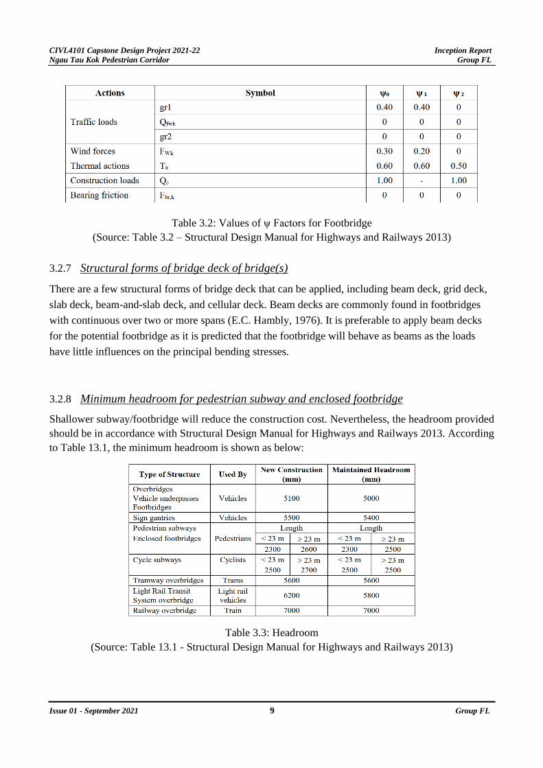
According to the Structural Design Manual for Highways and Railways 2013 – Table 3.2, the Values
of ψ Factors for Footbridge is shown below:
CIVL4101 Capstone Design Project 2021-22 Inception Report
Ngau Tau Kok Pedestrian Corridor Group FL
Issue 01 - September 2021 9 Group FL
Table 3.2: Values of ψ Factors for Footbridge
(Source: Table 3.2 – Structural Design Manual for Highways and Railways 2013)
3.2.7 Structural forms of bridge deck of bridge(s)
There are a few structural forms of bridge deck that can be applied, including beam deck, grid deck,
slab deck, beam-and-slab deck, and cellular deck. Beam decks are commonly found in footbridges
with continuous over two or more spans (E.C. Hambly, 1976). It is preferable to apply beam decks
for the potential footbridge as it is predicted that the footbridge will behave as beams as the loads
have little influences on the principal bending stresses.
3.2.8 Minimum headroom for pedestrian subway and enclosed footbridge
Shallower subway/footbridge will reduce the construction cost. Nevertheless, the headroom provided
should be in accordance with Structural Design Manual for Highways and Railways 2013. According
to Table 13.1, the minimum headroom is shown as below:
Table 3.3: Headroom
(Source: Table 13.1 - Structural Design Manual for Highways and Railways 2013)
CIVL4101 Capstone Design Project 2021-22 Inception Report
Ngau Tau Kok Pedestrian Corridor Group FL
Issue 01 - September 2021 10 Group FL
3.2.9 Minimum width of subway
According to the Structural Design Manual for Highways and Railways 2013, Chapter 12.7, “This
width shall be not less than 3000 mm for subways and their associated ramps and stairways.”
And “To avoid impeding pedestrian movement, the clear distance between obstructions such as roof
columns, parapets and handrails on footbridges, elevated walkways, subways, and their associated
ramps and stairways shall not be less than 2000 mm.
3.2.10 Changes in direction
According to the Structural Design Manual for Highways and Railways 2013, Chapter 12.7, “The
corner formed by a change in direction shall be splayed or curved to the largest radius that is practical.
Pedestrian conflicts will thereby be reduced and feeling of insecurity eased. The latter is particularly
important in subways, where pedestrians tend to feel vulnerable, and thus the corners should have a
minimum radius of 4.6 m where possible in order that a minimum visibility distance of 4 m is achieved.”
3.3 Geotechnical Constraints
3.3.1 Site description
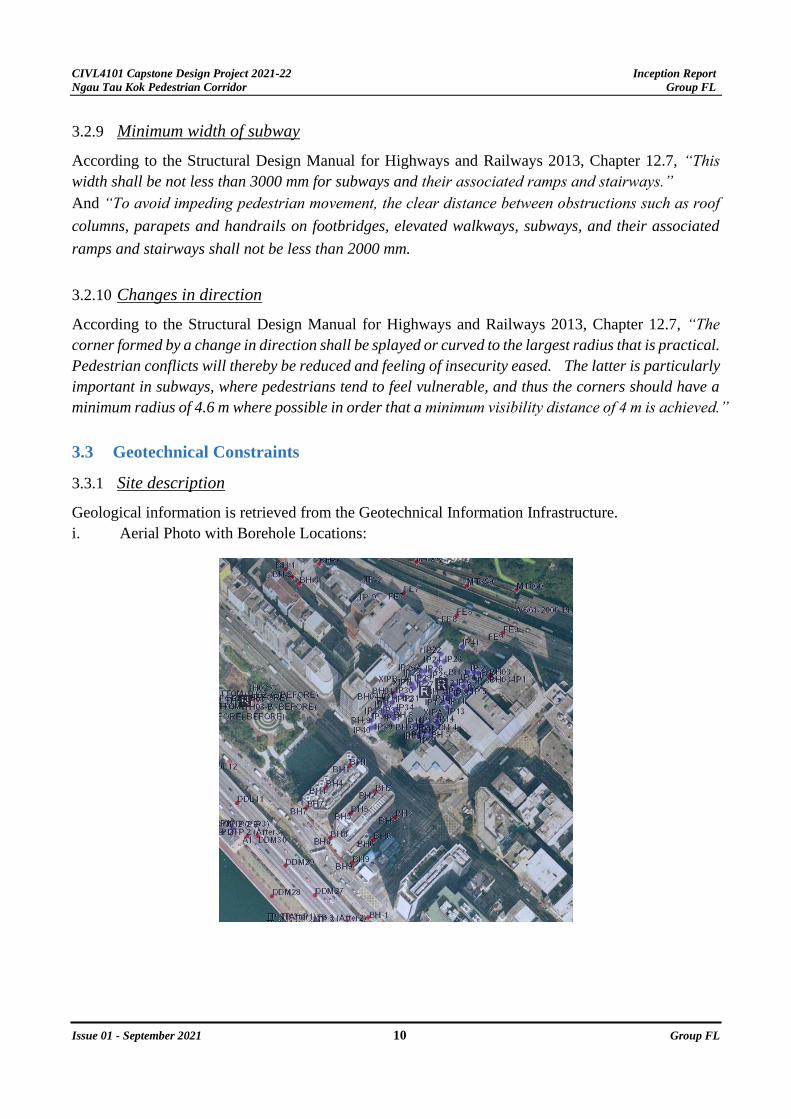
Geological information is retrieved from the Geotechnical Information Infrastructure.
i. Aerial Photo with Borehole Locations:

CIVL4101 Capstone Design Project 2021-22 Inception Report
Ngau Tau Kok Pedestrian Corridor Group FL
Issue 01 - September 2021 11 Group FL
ii. Solid Geology of Site:
The rock in site is Klb_gfm (Mount Butler Granite: fine- to medium-grained granite).
iii. Registered Feature record along Lai Yip Street and Wai Yip Street
There is no current register feature found along Lai Yip Street and Wai Yip Street. Future construction
for the walkway will not affect the existing register feature.
3.3.2 Construction of Foundation
All engineering structures resting on the earth must be carried by foundations. Footbridge requires
foundations under the supporting columns and stairs. There are two types of foundations, shallow and
deep foundations which are constrained by the size of structure to be constructed and the geological
profile (i.e., types of underlying soils). Data should be obtained from existing ground investigation.
Shallow foundations up to 3m depth can be applied if the structure is relatively light-weight and there
is no significant lateral load such as wind load. While deep foundations are adopted if the soil beneath
the structure is too weak for a shallow foundation, or the structure is large-scale. The choice of
foundation depends on the borehole records.

CIVL4101 Capstone Design Project 2021-22 Inception Report
Ngau Tau Kok Pedestrian Corridor Group FL
Issue 01 - September 2021 12 Group FL
In this project, we can take reference from the borehole records (BH1, BH2 and BH3) located near
Hoi Bun Road to estimate the geological profile of the construction site. From the records, the top
layer is always fill soil classified as ‘LOOSE, GREYISH BROWN SILTY FINE TO COARSE SAND’
which is up to around 7-meter-depth in these three boreholes. The suitability of using shallow
foundations is still under investigation.
Moreover, foundation in this site is limited by the narrow pedestrian roads and small pedestrian
island. When construction is to be done in urban area, all decisions are constrained by the potential
disruption brought to the public during construction. Ground is excavated for construction of
foundation, so these areas are blocked. Part of pedestrian road will be enclosed. Therefore, its
location and size have to be suitable so that they do not block the whole original road and fit the
structural design.

CIVL4101 Capstone Design Project 2021-22 Inception Report
Ngau Tau Kok Pedestrian Corridor Group FL
Issue 01 - September 2021 13 Group FL
3.3.3 Excavation of Subway
There are two main methods to excavate underground to construct a subway. They are cut and cover
method and deep bore method. Depending on the site constraints, cost and etc., suitable one has to be
chosen. During the construction, disruption to above-ground life has to be minimized, especially in
this busy area which is full of pedestrians and traffic. Deep bore method can achieve this but tunnel
boring machine is hard to control in small-scale construction and it is much more expensive. Cut and
cover method is cheaper and easy to perform but it has to follow the street pattern and the streets above
the subway have to be temporarily disabled until the construction of slurry wall and cover slab has
been done. As a result, huge disturbance will be made to the traffic, pedestrians, and business owners
along the route. In the three proposed options, subways may be constructed under Kwun Tong Road,
Hoi Bun Road or football court in Hoi Bun Road Park. Pros and cons of using either these two methods
have to be well justified.
3.4 Environmental Constraints
3.4.1 Environmental Impact Assessment (EIA)
i. According to the Environmental Impact Assessment Ordinance (EIAO) (Cap. 499) Section 4,
a project is classified as a Designated Project if listed under Schedule 2 and 3 of the EIAO and
statutory environmental impact assessment (EIA) should be carried out before construction and
operation.
ii. The proposed pedestrian corridor (The project) lies within none of the listed projects in
Schedule 2, and by inspection is expected to cover less than 20 ha (=200,000m2) as illustrated
in Figure 3.4a. The project is expected to be a small-scale project affecting fewer than 100,000
population, and is therefore considered as a non-designated project having 'limited potential of
giving rise to adverse environmental impacts' referring to ETWB TCW No. 13/2003 Section 4
& Annex E. Preliminary Environmental Review (PER) is, however, still required as per Annex
D. Standard pollution control measures is expected to be adopted with reference to
Recommended Pollution Control Clauses for Construction Contracts (RPCC) to minimize
nuisance to nearby sensitive receivers during both construction and operation stages. Reference
would also be made to Hong Kong Planning Standards and Guidelines Chapter 9.
iii. Relevant environmental concerns would first be identified in this inception report, followed by
potential impact prediction and evaluation along with option assessment in subsequent
feasibility study. Impact mitigation measures would also be proposed to minimize residual
impact. Methodology would be adopted according to EIAO and Technical Memorandum on
Environmental Impact Assessment Process (EIAO-TM).

CIVL4101 Capstone Design Project 2021-22 Inception Report
Ngau Tau Kok Pedestrian Corridor Group FL
Issue 01 - September 2021 14 Group FL
Figure 3.4a Area of Proposed Study Area
3.4.2 Air Quality Impact
i. Air Sensitive Receivers (ASRs) within 500m study boundary are found to be mostly domestic
premises, educational institutions, and offices.
ii. The major source of potential air quality impact during construction phase would be fugitive
dust generated through site clearance, earthworks such as excavation and backfilling,
stockpiling, materials processing, and handling, transportation of waste etc. Requirements
stipulated under Air Pollution Control (Construction Dust) Regulation, Cap. 311R and Section
1 of Annex 4 of the EIAO-TM should be observed. Methodologies listed under Annex 12 of the
EIAO-TM would be followed for air quality impact prediction.
iii. Since the proposed pedestrian corridor is designed for pedestrians, no motorized vehicles
should be allowed and hence no traffic emission is expected. Thus, during the operation phase,
no criteria pollutants listed under Air Quality Objectives is expected to be generated.
iv. Environmental monitoring and auditing (EM&A) of air quality would be carried out during
construction. Dust suppression would also be implemented in accordance with Air Pollution
Control (Construction Dust) Regulation, including but not limited to spraying water on the
surface of dusty material before, during and after earthworks, covering up stockpile with
impervious sheeting, or even compacting or hydroseeding large stockpile for prolonged storage
etc.
3.4.3 Noise Impact
i. Assessment area for Noise Sensitive Receivers (NSRs) are defined to be within 300m from
the project boundary under EIAO Guidance Note No. 9/2010. NSRs are found to comprise
mainly domestic premises and educational institutions.

CIVL4101 Capstone Design Project 2021-22 Inception Report
Ngau Tau Kok Pedestrian Corridor Group FL
Issue 01 - September 2021 15 Group FL
ii. The major source of potential noise impact during construction phase would be from the
operation of powered mechanical equipment (PME). Regulations stipulated under Noise
Control Ordinance (NCO), Cap. 400 should be observed. Methodologies listed under Annex
13 of the EIAO-TM would be followed for air quality impact assessment and prediction.
Construction noise levels at NSRs would be evaluated with reference to TM on Noise from
Construction Work other than Percussive Pilling (TM-GW).
iii. Construction Noise Permit (CNP) has to be applied for use of PME outside permitted hours,
that is 07.00 – 19.00, whereas a CNP for percussive piling is always required for piling works
within the permitted hours and is generally restricted outside permitted hour
iv. As the pedestrian corridor is designed for pedestrians only, no road traffic noise is anticipated
during operation phase. Moreover, no fixed plants would be installed, and no fixed noise is
anticipated. Therefore, noise impact during operation phase is negligible.
v. Standard noise mitigation measures would be implemented to minimize noise impact,
including but not limited to the use of Quality Powered Mechanical Equipment (QPME),
erection of noise barrier, fitting of silencer or muffler for noisy machines. Concurrent use of
multiple PMEs and nighttime work would be avoided as far as possible.
3.4.4 Water Quality Impact
i. Assessment area for Water Sensitive Receivers (WSRs) are commonly defined to be within
500m form the study boundary.
ii. The major sources of water quality impact during construction phase would be sewage effluent
generated from construction activities and site surface runoff from exposed soil during
inclement weather. Regulations stipulated under Water Pollution Control Ordinance (WPCO),
Cap. 358 should be observed. Annex 6 of EIAO-TM and ProPECC PN 1/94 – Practice Note
for Professional Persons on “Construction Site Drainage” should be referred to. No polluted
waters should be discharged into stormwater drains under WPCO, TM on Standards for
Effluents Discharged into Drainage and Sewerage Systems, Inland and Coastal Waters should
be observed when discharging sewage into public drains.
iii. Good site practices and mitigation measures should be carried out following the philosophy of
source reduction, including but limited to deployment of portable toilet on site, onsite
pretreatment of wastewater onsite before discharging into public sewer.
iv. As the project includes no dredging or reclamation works during construction phase and no
point discharge would be made in operation phase, provided that relevant mitigation measures
are implemented, no adverse impact on water quality would be anticipated. Only qualitative
assessment would be performed.

CIVL4101 Capstone Design Project 2021-22 Inception Report
Ngau Tau Kok Pedestrian Corridor Group FL
Issue 01 - September 2021 16 Group FL
3.4.5 Waste Management Implication
i. During the construction phase, construction, and demolition (C&D) waste such as broken
concrete and excavated materials would be the major source of waste generation. A sorting
area should be designated on site to facilitate waste segregation. Waste management hierarchy
should be followed, and different containers should be allocated for temporary storage of C&D
waste to facilitate reuse, recycle and disposal. In particular, inert public fill should be reused
as soon as possible for onsite backfilling or in other construction sites before disposal to
government approved public filling reception facilities. Regulations stipulated under Waste
Disposal Ordinance (WDO), Cap. 354 should be observed.
ii. Chemical waste such as metal finishing is also expected to be generated during construction
phase. Special storage facilities, with correct packaging and labelling, designated as chemical
waste stores should be provided for further collection by licensed chemical waste collectors.
The Chemical Waste Control Scheme stipulated under Waste Disposal (Chemical Waste)
(General) Regulation, Cap. 354C should be followed.
iii. No waste generation activity is anticipated during operation phase.
3.4.6 Land Contamination
i. Site visit, review of aerial photos and government record have been carried out and no
potentially contaminated land uses as listed under Annex 19 of EIAO-TM have been identified.
3.4.7 Ecological Impact
i. The proposed study area has long been a man-made environment since early 1970s. The area
neither lies within a recognized sites of conservation importance nor encroaches or affect
important habitats. It is unlikely to house the presence of conservation important species.
According to Annexes 8 and 16 of EIAO-TM, ecological assessment is not required.
3.4.8 Landscape and Visual Impact
i. Assessment area for Land and Visual Sensitive Receivers (SRs) are defined to be within 500m
from the project boundary under EIAO Guidance Note No. 8/2010.
ii. Temporary roadblocks, noise barriers and formworks etc. would be erected in the site during
construction phase. This would result in temporary adverse visual impact to nearby visual
sensitive receivers (VSRs). Moreover, depending on the alignment of the pedestrian corridor,
adverse impact may be incurred on VSRs in operation phase. Remedial measures such as screen
painting, façade treatment and greening could be employed in accordance with Annex 18 of
EIAO. Reference to Annex 10 should also be made for impact evaluation.
iii. Negligible landscape impact is expected due to the small scale of the proposed project.

CIVL4101 Capstone Design Project 2021-22 Inception Report
Ngau Tau Kok Pedestrian Corridor Group FL
Issue 01 - September 2021 17 Group FL
3.4.9 Cultural Heritage
i. No historic building or cultural heritage is located within the study are according to the
Antiquities and Monuments Office. No adverse impact is anticipated on the nearest listed
ungraded historic building, Kowloon Flour Mills, as in Figure 3.4b.
Figure 3.4b Nearest Listed Historic Building
3.5 Transportational Concerns and Opportunities
3.5.1 Opportunity: Adequate junction capacity of Wai Yip Street and Lai Yip Street
According to the Traffic Impact Assessment in May 2021 for Proposed Office Development at 334-
336 and 338 Kwun Tong Road, the existing 9 junction’s performance is evaluated, and the Reserve
Capacity (RC) of Wai Yip Street and Lai Yip Street junction is above 15% indicating a high
performance currently. Especially in the PM peak hour, the RC is 190% representing that the team
may utilize the time window at night to avoid adverse traffic impact due to construction. Also, the 58%
RC in the AM peak hour also indicates that there is room for possible road work without significant
impact on existing traffic. In the TIA, a reference case and a design case for the proposed office and
traffic forecast in 2027 also indicates a RC of 39% in AM and 148% in PM (Ho Wang SPB Limited,
2021). This ensures that there will be an adequate capacity in 2025 when the pedestrian corridor is
proposed to commence.
Reserve Capacity in the 9 junctions in base year (Ho Wang SPB Limited 2021: 8)

CIVL4101 Capstone Design Project 2021-22 Inception Report
Ngau Tau Kok Pedestrian Corridor Group FL
Issue 01 - September 2021 18 Group FL
Reserve Capacity in the 9 junctions in the Office design year (Ho Wang SPB Limited 2021: 14)
3.5.2 Road widening difficulties
According to the TIA in May 2021 for the proposed office in point 1, the existing Kwun Tong Road
flyover is a permanent structure and the columns of it prevent road widening to divert traffic during
the construction of the proposed office. Also, the existing B5 and B6 exits of the MTR Ngau Tau Kok
station contain 2 staircases that enable pedestrians to enter the subway and they prevent the road
widening again (Ho Wang SPB Limited, 2021). Our proposed pedestrian corridor also needs to divert
the traffic during construction at that junction and thus, we meet the same difficulty in not being able
to widen the road.
Map of road widening difficulties (Ho Wang SPB Limited 2021: Figure 5.3)

CIVL4101 Capstone Design Project 2021-22 Inception Report
Ngau Tau Kok Pedestrian Corridor Group FL
Issue 01 - September 2021 19 Group FL
Furthermore, the future development such as the office and retail building near location 1 and the
government proposed building near location 2 (Energizing Kowloon East Office, 2021) in picture
below (left) may make the original pedestrian path narrower and road widening is not possible due to
insufficient space on the pedestrian road.
Left: location map (Data Dictionaries n.d.: 8) Right: narrowed pedestrian road in location 1 currently (Source: Ka Ngai Lai)
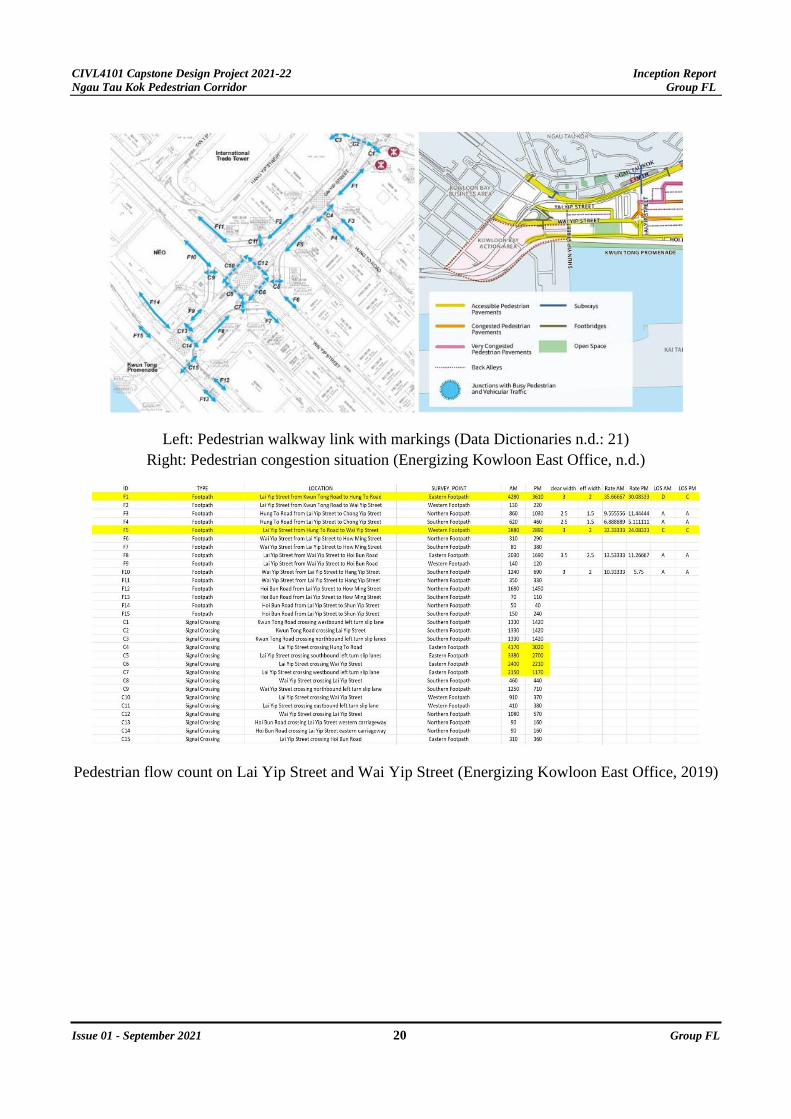
3.5.3 Heavy pedestrian flow with growing demand
According to the Energizing Kowloon East Office, the identified pedestrian walkways in orange are
congested pedestrian pavement and the roads marked in pink are very congested (Kwun Tong Business
Area Pedestrian Environment Improvement Scheme for Transformation, n.d.). After collecting the
pedestrian traffic data from the government data website, the Level of Service at F1 and F5 (see picture
below for their locations) are the most undesirable being C or D in AM and PM peak hour after our
team’s calculation. The crossing of C4 to C7 also has up to 4170 pedestrian flow per hour. The clear
path showing the starting point from MTR Ngau Tau Kok Exit B6 to C-Bons International has the
highest flow. The critical path is from F1 → C4 → F5 → C5 → C6 → C7 (Traffic Surveys in Kowloon
East, n.d.). With the more rapid office and retail buildings near C3, more trip attractions are expected
and the C1 to C3 may increase in demand, the original critical path will also have increased demand.
Thus, there is a huge constraint in construction of the pedestrian corridor not to hinder the critical path
or to direct pedestrians to other less congested pathways.
CIVL4101 Capstone Design Project 2021-22 Inception Report
Ngau Tau Kok Pedestrian Corridor Group FL
Issue 01 - September 2021 20 Group FL
Left: Pedestrian walkway link with markings (Data Dictionaries n.d.: 21) Right: Pedestrian congestion situation (Energizing Kowloon East Office, n.d.)
Pedestrian flow count on Lai Yip Street and Wai Yip Street (Energizing Kowloon East Office, 2019)
CIVL4101 Capstone Design Project 2021-22 Inception Report
Ngau Tau Kok Pedestrian Corridor Group FL
Issue 01 - September 2021 21 Group FL
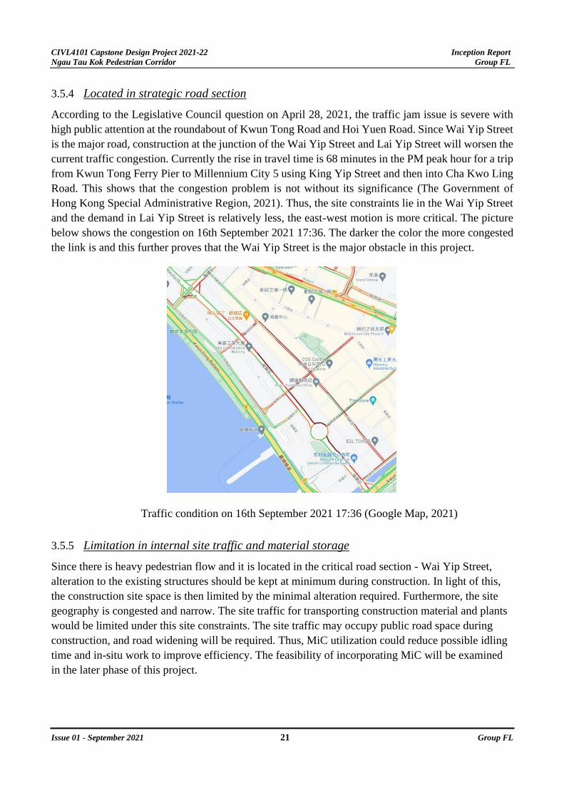
3.5.4 Located in strategic road section
According to the Legislative Council question on April 28, 2021, the traffic jam issue is severe with
high public attention at the roundabout of Kwun Tong Road and Hoi Yuen Road. Since Wai Yip Street
is the major road, construction at the junction of the Wai Yip Street and Lai Yip Street will worsen the
current traffic congestion. Currently the rise in travel time is 68 minutes in the PM peak hour for a trip
from Kwun Tong Ferry Pier to Millennium City 5 using King Yip Street and then into Cha Kwo Ling
Road. This shows that the congestion problem is not without its significance (The Government of
Hong Kong Special Administrative Region, 2021). Thus, the site constraints lie in the Wai Yip Street
and the demand in Lai Yip Street is relatively less, the east-west motion is more critical. The picture
below shows the congestion on 16th September 2021 17:36. The darker the color the more congested
the link is and this further proves that the Wai Yip Street is the major obstacle in this project.
Traffic condition on 16th September 2021 17:36 (Google Map, 2021)
3.5.5 Limitation in internal site traffic and material storage
Since there is heavy pedestrian flow and it is located in the critical road section - Wai Yip Street,
alteration to the existing structures should be kept at minimum during construction. In light of this,
the construction site space is then limited by the minimal alteration required. Furthermore, the site
geography is congested and narrow. The site traffic for transporting construction material and plants
would be limited under this site constraints. The site traffic may occupy public road space during
construction, and road widening will be required. Thus, MiC utilization could reduce possible idling
time and in-situ work to improve efficiency. The feasibility of incorporating MiC will be examined
in the later phase of this project.

CIVL4101 Capstone Design Project 2021-22 Inception Report
Ngau Tau Kok Pedestrian Corridor Group FL
Issue 01 - September 2021 22 Group FL
Lai Yip Street and Wai Yip Street cross junction (Source: King Man Tang)
3.5.6 Impact on public transport
According to the TIA on Proposed Office Development at 334-336 and 338 Kwun Tong Road in May
2021, the area has high connectivity with a vast number of public transport modes. Buses, minibuses,
and MTR are the 3 most common modes (Ho Wang SPB Limited, 2021). With the large number of
stops near the site, the negotiation and liaison with the public transport companies would require more
time and design effort especially those stops on Wai Yip Street and Hoi Bun Road. The pictures below
show the result of the TIA retrieved revealing the locations of the stops near the site area.
CIVL4101 Capstone Design Project 2021-22 Inception Report
Ngau Tau Kok Pedestrian Corridor Group FL
Issue 01 - September 2021 23 Group FL
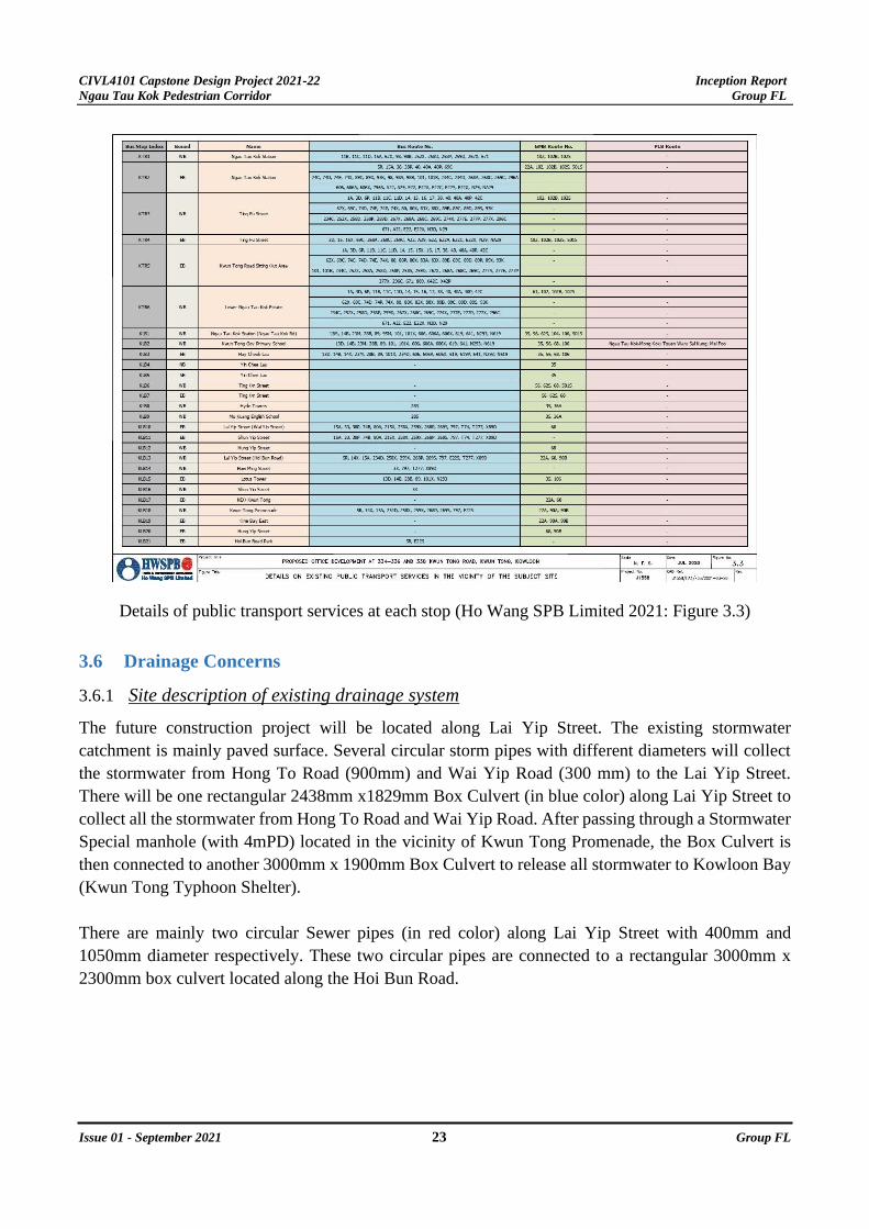
Details of public transport services at each stop (Ho Wang SPB Limited 2021: Figure 3.3)
3.6 Drainage Concerns
3.6.1 Site description of existing drainage system
The future construction project will be located along Lai Yip Street. The existing stormwater
catchment is mainly paved surface. Several circular storm pipes with different diameters will collect
the stormwater from Hong To Road (900mm) and Wai Yip Road (300 mm) to the Lai Yip Street.
There will be one rectangular 2438mm x1829mm Box Culvert (in blue color) along Lai Yip Street to
collect all the stormwater from Hong To Road and Wai Yip Road. After passing through a Stormwater
Special manhole (with 4mPD) located in the vicinity of Kwun Tong Promenade, the Box Culvert is
then connected to another 3000mm x 1900mm Box Culvert to release all stormwater to Kowloon Bay
(Kwun Tong Typhoon Shelter).
There are mainly two circular Sewer pipes (in red color) along Lai Yip Street with 400mm and
1050mm diameter respectively. These two circular pipes are connected to a rectangular 3000mm x
2300mm box culvert located along the Hoi Bun Road.

CIVL4101 Capstone Design Project 2021-22 Inception Report
Ngau Tau Kok Pedestrian Corridor Group FL
Issue 01 - September 2021 24 Group FL
Existing stormwater drainage along Lai Yip Street and Wai Yip Street

CIVL4101 Capstone Design Project 2021-22 Inception Report
Ngau Tau Kok Pedestrian Corridor Group FL
Issue 01 - September 2021 25 Group FL
3.6.2 Hydrological condition
i. Rainfall intensity:
To estimate the rainfall intensity, the intensity duration frequency equation (IDF) is used.
i = a / (td + b)c
Where:
i = rainfall intensity (mm/hr)
td = duration in minutes (time of concentration) (< 240 mins)
a,b,c = storm constants
According to table 3a of the stormwater drainage manual, the storm constant with different
return periods can be found. As suggested by the Drainage Service Department (DSD). The
return period for the urban drainage trunk system and the urban drainage branch system should
take the return period as 200 years and 50 years respectively. As the largest diameter of the
pipe doesn’t exceed 1.8m, the system in the site area is the urban drainage branch system. The
return period should be chosen as 50 yrs. The storm constant with a return period of 50 years
should be used. In the later stage of the project, the specific catchment area affected by the
construction can be found out. After calculating the time of concentration of the catchment area,
the rainfall intensity can be calculated.
ii. Surface water runoff: To estimate the surface water runoff, the rational method will be used.
Q = 0.278 CIA
Where:
Q = peak runoff (m3/s)
C = runoff coefficient
I = rainfall intensity (mm/hr)
A = catchment area (km2) (<1.5km2)
As the site area is in a developed urban area, the runoff coefficient is taken as 1.0. The rainfall
intensity and catchment area can be determined after the feasibility study.

CIVL4101 Capstone Design Project 2021-22 Inception Report
Ngau Tau Kok Pedestrian Corridor Group FL
Issue 01 - September 2021 26 Group FL
iii. Susceptibility of flooding blackspot: According to the blackspot location map from DSD website, there are no flooding blackspots
in the site area.
Since both the subway and footbridge will be constructed near the sea. The above element will
be required to ensure the structure will not be affected by water. During the construction of the
subway, it should avoid damaging the existing sewer and storm pipe.
Further investigation on the flood level and hydrological condition is required for the
construction of subways. It is to prevent the water seepage and the flooding inside the subway.
The subway should be water-proof and designed to minimize the possibility of water entering
the subway. The detailed design will be investigated in the reference design stage.
3.6.3 Design/Acceptance Criteria
Water protection of footbridge and subway before, during and after the construction
3.6.4 Impact On Existing Drainage System
The new footbridge may affect the behavior of the rainwater flow and collection system. The design
of collecting rainwater at the footbridge roof and flooding assessment will be done in the reference
design stage.
During the construction of the support of the bridge, the temporary work area may block the manhole
constructed on Lai Yip Street. The construction may increase the difficulty of checking the drainage
and sewerage system as the less manholes are available for accessing the system.
3.7 Constructability Concerns
3.7.1 Space concern
As mentioned above, the major problem found in Lai Yip Street is that there is not enough space for
constructing a bridge. The east and west side of Lai Yip Street has a very narrow width which can only
accommodate 3-4 people at the same time. Both east and west sides of Lai Yip Street are covered with
pedestrian walkway canopy from existing buildings. This greatly limited the space available for
construction and finding space for bridge or subway exits can be very challenging. There is limited
space for installing the bridge column which will hinder the pedestrian flow in the original walkway.
One more thing to be considered is that either ramp or lift must be provided for disables based on
Structures Design Manual for Highways and Railways 2013. Thus, both the footbridge and subway
will require large width to construct lift to bring disability to different ground levels.

CIVL4101 Capstone Design Project 2021-22 Inception Report
Ngau Tau Kok Pedestrian Corridor Group FL
Issue 01 - September 2021 27 Group FL
One of the possible approaches to creating more space for bridges and subways can be the negotiation
with the private landowner to remove the canopies and extend the road width. Another approach is to
rearrange the Lai Yip Street Traffic. By simplifying and combining the walkway and safety island, as
shown in the photo below, the area of the islands will largely increase. This will be favorable for the
construction of either bridge or subway exit. However, careful traffic study must be carried out to
identify the traffic impact of such a new arrangement.
3.7.2 DFMA and MiC
Since MIC is still developing and relatively new in Hong Kong, many companies and construction
projects are in the stage of learning how to use modular construction units. Site workers may not be
familiar and therefore the speed of the construction may be lower than expected. Although currently
there are more and more projects focusing on MIC, there is a lack of skilled workers for MIC in Hong
Kong. Such techniques may not be the best solution.
Apart from that, the selection of factories for manufacturing precast units should be considered. In the
current Hong Kong situation, the most common way of obtaining modular units is to purchase from
other countries and deliver them overseas. The selection of which countries and manufacturing
companies will highly depend on the cost and time. After the precast units arrive in Hong Kong, the

CIVL4101 Capstone Design Project 2021-22 Inception Report
Ngau Tau Kok Pedestrian Corridor Group FL
Issue 01 - September 2021 28 Group FL
site for storage should be considered. Since Lai Yip Street is very narrow, there is no space for the
storage of precast units. Thus, these modular units should be stored in other places within Hong Kong
and delivered to Lai Yip Street when needed.
Considering the practical site situation, even if modular units are immediately installed after delivery,
space is still required for storage of at least 2-3 modular units. Since Lai Yip Street is a double-road
for traffic, one possible solution is to block one road for the storage of modular units while another
road allows traffic flow. However, this approach will greatly influence the capacity of the traffic road
and may even induce traffic jams at Lai Yip Street.
To transport heavy modular units and large sections of the bridge, permission from the Transport
Department is required since such precast units are usually large and heavy. The dimensions of precast
units are not satisfied with the current traffic law in view of road safety. The road may not have enough
width and height for entering and delivering. Thus, the transport path should be carefully selected to
prevent such problems. Yet, based on the Lai Yip Street’s road condition, the space of the road should
be sufficient for entering. Apart from transporting through cars, modular units can also be delivered
by ships. However, a more detailed approach will be finalized at other stages to decide if using shipping
or not.
3.7.3 Possible ground movement
To construct a subway under Lai Yip Street, it is expected that there will be a ground movement
affecting road safety, no matter how deep the subway is. Thus, rearrangement of the traffic is needed.
It is expected that the road above will be blocked during the construction period. However, this action
will affect the road traffic significantly and there may be serious traffic jams around the region of Lai
Yip Street. To minimize this effect, the construction period of the subway should be as short as possible.
Despite traditional construction methods, other techniques like MIC may be used to shorten the
construction time.
Another approach is to construct the subway as deep as possible to minimize ground movement.
However, if the subway is constructed too deep, it will be a challenge to connect the subway to the
existing subway at MTR station.
Whether the geographic situation is suitable for installing and operating a Tunnel Boring Machine is
still being investigated. More data like the boreholes information and geotechnical tests will be needed
in the preliminary stage to make further justification.
3.7.4 Possible construction materials
Although most of the footbridges in Hong Kong are made of reinforced concrete, glass and steel, other
materials may be used to improve the whole quality of the design. For example, Ethylene
Tetrafluoroethylene (ETFE) is an innovative construction material that provides a lightweight
alternative to glass. ETFE not only has a similar light transmission rate, but it is also much lighter than
CIVL4101 Capstone Design Project 2021-22 Inception Report
Ngau Tau Kok Pedestrian Corridor Group FL
Issue 01 - September 2021 29 Group FL
glass. It just takes 1 % of the weight of glass of the same size, which largely reduces the loading on
the footbridge. This provides a great opportunity for designing a footbridge with innovative design.
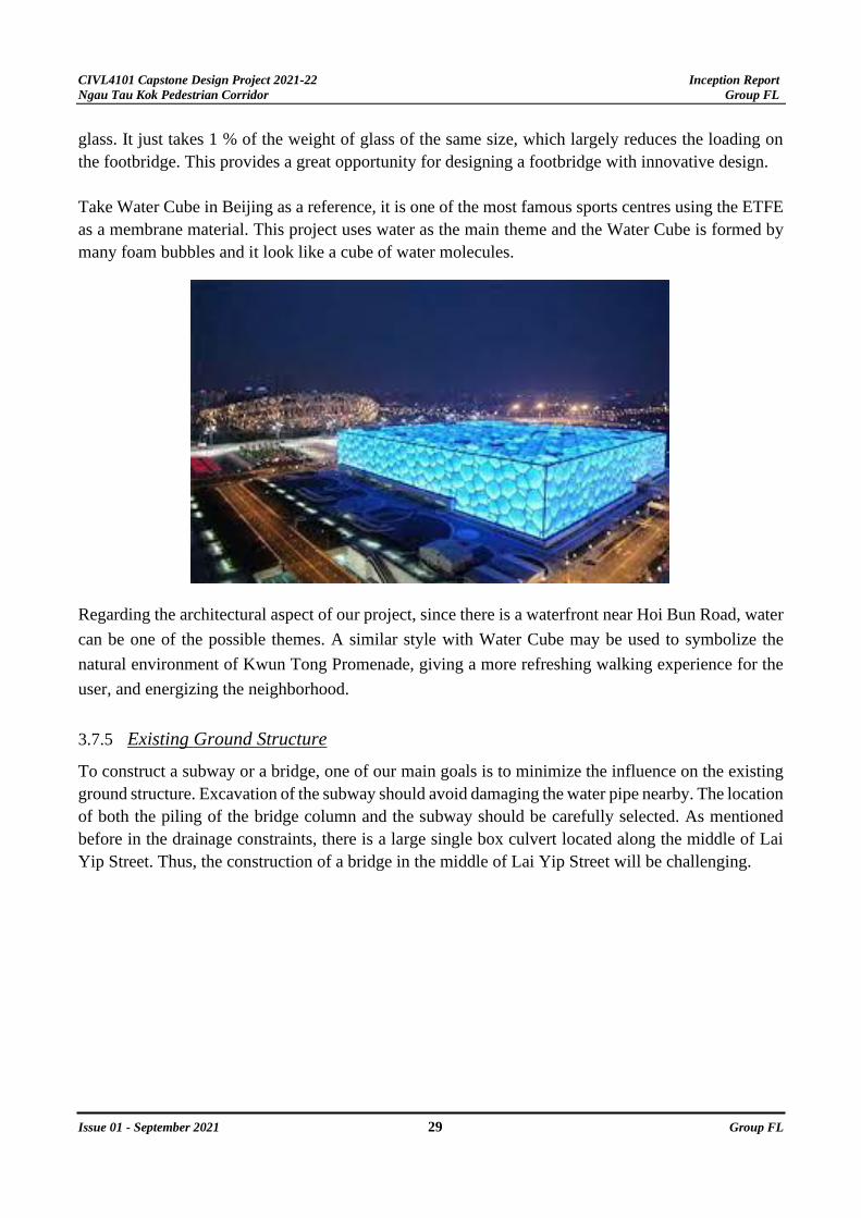
Take Water Cube in Beijing as a reference, it is one of the most famous sports centres using the ETFE
as a membrane material. This project uses water as the main theme and the Water Cube is formed by
many foam bubbles and it look like a cube of water molecules.
Regarding the architectural aspect of our project, since there is a waterfront near Hoi Bun Road, water
can be one of the possible themes. A similar style with Water Cube may be used to symbolize the
natural environment of Kwun Tong Promenade, giving a more refreshing walking experience for the
user, and energizing the neighborhood.
3.7.5 Existing Ground Structure
To construct a subway or a bridge, one of our main goals is to minimize the influence on the existing
ground structure. Excavation of the subway should avoid damaging the water pipe nearby. The location
of both the piling of the bridge column and the subway should be carefully selected. As mentioned
before in the drainage constraints, there is a large single box culvert located along the middle of Lai
Yip Street. Thus, the construction of a bridge in the middle of Lai Yip Street will be challenging.

CIVL4101 Capstone Design Project 2021-22 Inception Report
Ngau Tau Kok Pedestrian Corridor Group FL
Issue 01 - September 2021 30 Group FL
The lowest point of the water pipe at the left side of Lai Yip is -1.84mPD while the right one is -
1.29mPD. Therefore, to construct a subway, the height should be much lower than the drainage pipe
to prevent any water pipe burst.
4. WORK ACCOMPLISHED
On 5th September, the team went to the site for a site visit and please see appendix B to the site visit
report. During the period of 5th September to 23rd September, the team have met for 3 times and the
meeting minutes with agenda are attached at appendix C. Lastly the brainstormed idea and selling
point of the study is included in appendix F.
5. PROJECT PROGRAMME AND JOB DUTY
5.1 Project Programme
Apart from the meetings and site visit, the methodology of the whole study is set with a programme
plan with key dates and durations, please see appendix D for the detailed plan.
5.2 Job Duty
In order to clearly divide the job evenly among teammates, the job duty is set. The list is in appendix
E.
CIVL4101 Capstone Design Project 2021-22 Inception Report
Ngau Tau Kok Pedestrian Corridor Group FL
Issue 01 - September 2021 31 Group FL
Appendix A - Detailed list of topics in each phase
Phase 1: Inception stage
1. Background study of the project
2. Methodology and Approaches of the project
2.1. Main Flow
2.2. Detailed list of topics in each phase
3. Identification of site constraints and opportunities
3.1. Social-and economy
3.2. Environmental
3.3. Geotechnical
3.4. Transportation
3.5. Structural
3.6. Drainage and Sewage
3.7. Constructability
Phase 2: Post-Inception stage
1. Detailed Review of existing Kwun Tong District study
1.1. Kowloon Bay Business Area Pedestrian Environment Improvement – Feasibility
Study (KBBA Study)
1.2. Pedestrian Environment Improvement Scheme for Transformation of Kwun Tong
Business Area – Feasibility Study (KTBA Study)
1.3. San Po Kong Business Area Pedestrian Environment and Traffic Improvement –
Feasibility Study (SPKBA Study)
1.4. Planning and Engineering Study on Kwun Tong Action Area – Feasibility Study
(KTAA Study)
1.5. Planning and Engineering Study on Kowloon Bay Action Area – Feasibility Study
(KBAA Study)
1.6. Technical Study on Lai Yip Street Site (LYS Study)
2. Review of similar structures in Hong Kong and other cities
2.1. Central Elevated Walkway
2.2. Mong Kong footbridge (Above Mong Kok road)
2.3. Wan Chai footbridge
2.4. KF93 & KF93A (Intersection of Jordan Road and Lin Cheung Road)
3. Review of proposed development along Lai Yip Street
3.1. Short-term
3.2. Medium-term
3.3. Long-term

CIVL4101 Capstone Design Project 2021-22 Inception Report
Ngau Tau Kok Pedestrian Corridor Group FL
Issue 01 - September 2021 32 Group FL
4. Development principles
4.1. Theme
4.2. Wow factor
4.3. Design Principles
Phase 3: Feasibility Study stage
1. Identification of needs and background
1.1. Background, targets, and related fields of study
1.2. Client’s needs
1.3. Pedestrian demands
1.4. Vehicle demand
1.5. Convenience
1.6. Users’ preference properties
2. Demand forecasting model
2.1. Population growth
2.2. Existing trip generation and attraction
2.3. Trip generation and attraction due to future development
2.4. Pedestrian flow
2.5. Vehicle flow
3. Engineering assessments
3.1. social-and economy
3.2. Environmental
3.3. Geotechnical (including previous study of previous ground investigation)
3.4. Transportation
3.5. Structural
3.6. Drainage and sewage
3.7. Constructability
3.8. Possibility of utilizing MiC and DFMA
3.9. Cost estimation
4. Findings Highlight
Phase 4: Preliminary Design stage
1. Development of initial idea and forms
1.1. Subway
1.2. Flyover
1.3. Covered walkway
1.4. Roads and junction modifications
1.5. Combinations of all
1.6. Proposed ideas

CIVL4101 Capstone Design Project 2021-22 Inception Report
Ngau Tau Kok Pedestrian Corridor Group FL
Issue 01 - September 2021 33 Group FL
2. Options and alternatives evaluation
2.1. Multinomial logit model and parameters calibration
2.2. Suitability
2.3. Social-and economy
2.4. Environmental
2.5. Geotechnical
2.6. Transportation
2.7. Structural
2.8. Drainage and sewage
2.9. Constructability
2.10. Cost
2.11. Safety
2.12. Design solution highlights
2.13. Design solution justifications
3. Conceptual design
3.1. Architectural design
3.2. Access facilities (escalators and elevators)
3.3. Building Information Modelling (BIM)
3.4. Setting out
3.5. Geotechnical scheme
3.6. Foundation design
3.7. Structural scheme with construction materials
3.8. Structural design
3.9. Construction scheme (with MiC and DFMA)
3.10. Project schedule (master programme)
3.11. Cost estimations
3.12. Cost-Benefit Analysis
4. Preliminary engineering Impact Assessment
4.1. Environmental Impact Assessment
4.2. Traffic Impact Assessment
4.3. Drainage Impact Assessment
4.4. Visual Impact Assessment
Phase 5: Detailed Design stage
1. Development Architectural design with rendering in BIM
2. Provision of Access facilities (escalators and elevators)
2.1. Location and justifications
2.2. Mode of access
2.3. Barrier-free access facilities
CIVL4101 Capstone Design Project 2021-22 Inception Report
Ngau Tau Kok Pedestrian Corridor Group FL
Issue 01 - September 2021 34 Group FL
3. Building Information Modelling (BIM)
4. Setting out
5. Geotechnical scheme
5.1. Standard code
5.2. Geotechnical parameters
5.3. Ground profile
5.4. Design criteria
5.5. Site investigation in strategic locations
6. Foundation design
7. Structural scheme with construction materials
7.1. Design assumptions
7.2. Design criteria
7.3. Code of Practice used
7.4. Material standards
7.5. Loadings
8. Structural design
8.1. Framing plan
8.2. Identification of critical structural elements
8.3. Sizing
8.4. Detailing
8.5. Detailed calculations of critical structural elements
9. Construction scheme
9.1. Construction sequence and method
9.2. MiC and DFMA
9.3. Safety concerns and mitigations
10. Project schedule
10.1. Master programme
10.2. Critical path
10.3. Key dates
11. Cost estimations
11.1. Bills of Quantities
12. Cost-benefit Analysis
12.1. Full cost and benefits evaluation
12.2. Do-Nothing option
12.3. Design solution
12.4. Comparison between the Do-Nothing and the Design solution
12.5. Internal rate of return
CIVL4101 Capstone Design Project 2021-22 Inception Report
Ngau Tau Kok Pedestrian Corridor Group FL
Issue 01 - September 2021 35 Group FL
13. Risk Management
13.1. Risk assessment
14. Impact on nearby area
14.1. Settlement
14.2. Impact on nearby structure
15. Environmental Impact Assessment
15.1. Air
15.2. Noise
15.3. Water
15.4. Solid Waste
15.5. Hazard
15.6. Visual and Landscape Impact Assessment
15.7. Ecology
15.8. Cultural (historical site and heritage)
16. Traffic Impact Assessment
16.1. Traffic survey and data
16.2. Existing traffic situations
16.3. Site traffic forecasting and distributions
16.4. Demand forecasting for traffic in design year
16.5. Analysis of traffic in design life
16.6. Critical road links and junction’s impact
16.7. Major and minor road links and junction’s impact
16.8. Traffic mitigation
16.9. Access facilities and intra-site road network
16.10. Pedestrian and cyclist analysis
16.11. Railway impact
16.12. Internal transportation
16.13. Construction traffic
16.14. Temporary Traffic Management (TTM)
16.15. Remedies at potential congested road links and junctions
16.16. Composite effect due to nearby development
16.17. Junction capacity and delay analysis in peak hour throughout design life
CIVL4101 Capstone Design Project 2021-22 Inception Report
Ngau Tau Kok Pedestrian Corridor Group FL
Issue 01 - September 2021 36 Group FL
17. Drainage Impact Assessment
17.1. Current drainage services and their hydraulic bank full capacity
17.2. Current flooding susceptibility
17.3. Current water levels
17.4. Current catchment details
17.5. Temporary drainage system during construction
17.6. Proposed drainage services
17.7. Proposed catchment details
17.8. Estimated peak flows, water levels and flood levels
17.9. Permanent mitigation measures
18. Visual Impact Assessment
18.1. Change of visual composition
18.2. Change of visual obstruction
18.3. Impact to public viewers
18.4. Impact to visual resources
18.5. Visual impact during construction
18.6. Lighting and shading impact
18.7. Permanent mitigation measures

CIVL4101 Capstone Design Project 2021-22 Inception Report
Ngau Tau Kok Pedestrian Corridor Group FL
Issue 01 - September 2021 37 Group FL
Appendix B - Site visit records
Site visit (5/9)
Meeting Minutes
September 5, 2021
1. Opening
The site visit was called to meet at 12:00PM on September 5, 2021, at Ngau Tau Kok Station Exit
B6.
2. Present
All group members
3. Apologies
NIL
4. Activities
4.1. Our team found out the path of the proposed subways connecting Ngau Tau Kok Station and Hoi
Bun Road.
4.2. Our team found three main pedestrian routes for the site area.
4.3. Our team found out the site constraints
5. Discussion
We went through the path of the proposed subways connecting Ngau Tau Kok Station and Hoi Bun
Road. There will be a passageway through the International Trade Tower. Then the proposed subway
connecting to Hoi Bun Road will be built under Wai Yip Street.
From our observation, there are many industrial buildings near both sides of Lai Yip Street, such as
Man Sheung Industrial building, Draco Industrial building. Therefore, the pedestrian flow will be
maximized on weekdays.
We found a signal control junction that will cause inconvenience to the pedestrian crossing Wai Yip
Street and Lai Yip Street. The travelling time of path 1 and path 2 is affected by this junction.

CIVL4101 Capstone Design Project 2021-22 Inception Report
Ngau Tau Kok Pedestrian Corridor Group FL
Issue 01 - September 2021 38 Group FL
5.1. Observation: Demand generation location
- Major demand expected: office building with commercial uses.
- Industrial buildings are mostly not engaged in manufacturing activities anymore and demand
generation or attractions are expected to be lower.
- Action to take: transportation survey .
- #1 Major trip generation and attraction location.
- #2 Routes with the most demand.
5.2. Observations: Pedestrian crossing at Lai Yip Street and Kwun Tong Road junction
- The pedestrian crossing across the junction of Lai Yip Street and Kwun Tong Road has 3 links
with alternating signals. The crossing takes long time.
- The first island across the junction makes the capacity limiting since the island is of small size.
- Action to take: possible consideration with the mid-term mitigation measures, i.e., introduce an
exit in proposed pedestrian subway.
5.3. Observations: Pedestrian crossing at Lai Yip Street and Wai Yip Road cross junction
- The first island near C-Bons International Center has the smallest size with uneven ground. The
capacity of such island is limiting for the pedestrian crossing.
- On average, crossing from one side of the street to the other side following the official crossing
lines requires 4 consecutive pedestrian crossings with a long waiting time.
- Action to take: redesign of the pedestrian junction is possible if flyover were to be built for even
higher capacity cross junction for vehicles.
5.4.Observations: Pedestrian road along Lai Yip Street
- The east and west side of Lai Yip Street has a relatively narrow width which can accommodate 3-
4 people at the same time.
- The east and west side of Lai Yip Street are usually covered with pedestrian walkway canopy from
existing buildings.
- The west side of Lai Yip street is narrowed due to current construction site of the East350
construction.
- Action to take: possible negotiation and legal issues research regarding the canopy.

CIVL4101 Capstone Design Project 2021-22 Inception Report
Ngau Tau Kok Pedestrian Corridor Group FL
Issue 01 - September 2021 39 Group FL
5.5. Observations: Current pedestrian route choice
We have a detailed discussion about the three main pedestrian paths. Path 1 is going straight from
Exit B6 of Ngau Tau Kok station. The pedestrian can reach the building on the right-hand side of Lai
Yip Street such as C-BONS International Centre, Taked Centre. Path 2 is passing through Lai Yip
Street from the junction near exit B6. Then the pedestrian will walk along the current construction
site to reach the buildings on the left-hand side of Lai Yip Street such as the NEO building, United
Oversea Plaza. Path 3 is the longest route. The pedestrian will walk through the International Trade
Tower to reach Hoi Bun Promenade.
6. Action Item
- All the findings were listed down in the draft of inception report for everyone’s reference
- The meeting had been recorded and the link was shared via google drive
7. Adjournment
The meeting was adjourned at around 14:30 PM as scheduled.
8. Next Meeting
Our next meeting is going to be held on Friday, September 10, 2021, at 20:30 PM.
9. Submitted by: Chiu Chun Hei, Marco

CIVL4101 Capstone Design Project 2021-22 Inception Report
Ngau Tau Kok Pedestrian Corridor Group FL
Issue 01 - September 2021 40 Group FL
Appendix C – Meeting Minutes
1st Internal Meeting Minutes
Meeting Minutes
September 10, 2021
1. Opening
The meeting started at 20:30PM on September 10, 2021, at Main Building 113G room.
2. Present
All group members
3. Apologies
NIL
4. Activities
- Our team present the draft of inception report to moderator and industrial tutor.
- Our team asked questions about the inception report.
5. Discussion
Industrial tutor and moderator advised us to classify whether the land area belongs to the government
or not. Besides, the industrial tutor and moderator suggested that we find out all the feasible paths to
construct a footbridge or tunnel before the detailed report.
6. Action Item
- The meeting had been recorded and the link was shared via google drive
7. Adjournment
The meeting was adjourned at around 21:30 PM as scheduled.
8. Next Meeting
Our next meeting is going to be held on Sunday, September 12, 2021, at 20:30 PM.
9. Submitted by: Chiu Chun Hei, Marco

CIVL4101 Capstone Design Project 2021-22 Inception Report
Ngau Tau Kok Pedestrian Corridor Group FL
Issue 01 - September 2021 41 Group FL
2nd Internal Meeting Minutes
Meeting Minutes
September 12, 2021
1. Opening
The meeting started at 18:00PM on September 12, 2021, at zoom
2. Present
All group members
3. Apologies
NIL
4. Activities
- Our team had a discussion about the content of the inception report.
- Our team asked questions about the inception report.
5. Discussion
We had a discussion about the content of the inception report. It should have three main parts which
are introduction, methodology and site constraints. Then we have a detailed discussion about the
methodology part and site constraints part.
For the methodology part, it should indicate the important phases of the capstone project and clearly
show the workflow of the project. For the site constraints part, It should cover seven aspects which
are social-and economy, structural, geotechnical, drainage, traffic, environmental and
constructability aspects.
Finally, we had a work distribution and set the internal deadline on 16/9.
6. Action Item
- The meeting had been recorded and the link was shared via google drive
7. Adjournment
The meeting was adjourned at around 20:30 PM as scheduled.

CIVL4101 Capstone Design Project 2021-22 Inception Report
Ngau Tau Kok Pedestrian Corridor Group FL
Issue 01 - September 2021 42 Group FL
8. Next Meeting
Our next meeting is going to be held on Sunday, September 19, 2021, at 20:30 PM.
9. Submitted by: Chiu Chun Hei, Marco
CIVL4101 Capstone Design Project 2021-22 Inception Report
Ngau Tau Kok Pedestrian Corridor Group FL
Issue 01 - September 2021 43 Group FL
3rd Internal Meeting Minutes
Meeting Minutes
September 19, 2021
1. Opening
The meeting started at 22:00PM on September 19, 2021, at zoom
2. Present
All group members
3. Apologies
NIL
4. Activities
- Our team had a discussion about the format of the inception report.
5. Discussion
We had a discussion about the format of the inception report. We decided to use Harvard referencing
style and assign a groupmate to finish the formatting work.
We set the internal deadline of formatting work on 22/9.
6. Action Item
- The meeting had been recorded and the link was shared via google drive
7. Adjournment
The meeting was adjourned at around 22:30 PM as scheduled.
8. Next Meeting
Our next meeting is going to be held on Tuesday, September 28, 2021, at 20:30 PM.
9. Submitted by: Chiu Chun Hei, Marco
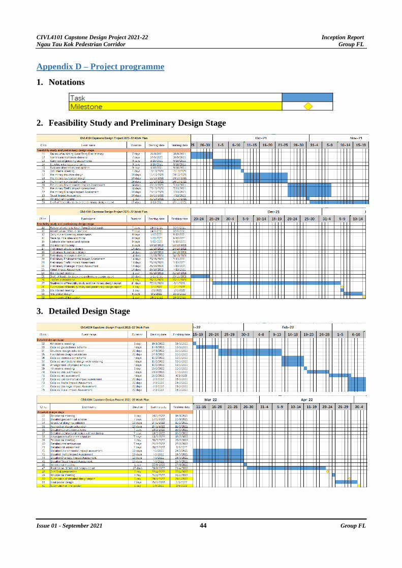
CIVL4101 Capstone Design Project 2021-22 Inception Report
Ngau Tau Kok Pedestrian Corridor Group FL
Issue 01 - September 2021 44 Group FL
Appendix D – Project programme
1. Notations
2. Feasibility Study and Preliminary Design Stage
3. Detailed Design Stage

CIVL4101 Capstone Design Project 2021-22 Inception Report
Ngau Tau Kok Pedestrian Corridor Group FL
Issue 01 - September 2021 45 Group FL
Appendix E – Job Duty
TASK PEOPLE START END STATUS
Government feasibility study and
reports research
TANG, Lik-yin 14/9/2021 14/9/2021 Complete
Email for reports request TANG, Lik-yin 14/9/2021 14/9/2021 Complete
Information research All members 2/9/2021 - In
progress
Introduction LAM, Ho-ching
LAM, Hoi-chun
18/9/2021 21/9/2021 Complete
Approach and methodology TANG, Lik-yin
WU, Long-hei
TANG, King-man
12/9/2021 16/9/2021 Complete
Site concern: Social-and economy TANG, King-man 12/9/2021 16/9/2021 Complete
Site concern: Structural LAM, Ho-ching 12/9/2021 16/9/2021 Complete
Site concern: Geotechnical LAM, Hoi-chun 12/9/2021 16/9/2021 Complete
Site concern: Environmental WU, Long-hei 12/9/2021 16/9/2021 Complete
Site concern: Transportational TANG, Lik-yin 12/9/2021 16/9/2021 Complete
Site concern: Drainage CHIU, Chun-hei 12/9/2021 16/9/2021 Complete
Site concern: Constructability LAI, Ka-ngai 12/9/2021 16/9/2021 Complete
Project programme TANG, King-man 12/9/2021 16/9/2021 Complete
Meeting minute recording CHIU, Chun-hei 5/9/2021 - In
progress
Final formatting TANG, King-man 21/9/2021 22/9/2021 Complete
Presentation of inception report All members 28/9/2021 28/9/2021 Not start

CIVL4101 Capstone Design Project 2021-22 Inception Report
Ngau Tau Kok Pedestrian Corridor Group FL
Issue 01 - September 2021 46 Group FL
Appendix F – Brainstormed idea and selling point
1. Brainstormed idea
Disclaimer: brainstormed solution without considering functionality, constructability and other issues
concerned
Solution 1
Long straight footbridge along path 1
Advantages
• Most convenient
• Cost saving compared to subway
• The shortest path between two designated locations
Potential problems
• Not enough space for bridge supports
• Less construction cost compared to subway
• Blocking Lai Yip Road is necessary for the
construction of a footbridge. This will largely affect
the traffic flow and traffic Jam may result.

CIVL4101 Capstone Design Project 2021-22 Inception Report
Ngau Tau Kok Pedestrian Corridor Group FL
Issue 01 - September 2021 47 Group FL
Solution 2
Extend proposed subway +
footbridge along path 2
Advantages • Large improvement for the walking experience of
path 2 users. Save a lot of time waiting for so
many crossing signals.
• Can utilities the proposed subway given by the
government
Potential problems • Not enough space for subway exit
Solution 3
Extend proposed subway for path 3 Advantages: • Can fully utilize the proposed subway by the
government.
Potential problems: • Construction cost for subways is higher

CIVL4101 Capstone Design Project 2021-22 Inception Report
Ngau Tau Kok Pedestrian Corridor Group FL
Issue 01 - September 2021 48 Group FL
• Not straightforward for path 1 and 2 passengers.
Pedestrians may choose the original path on the
ground instead of using the new path. The
problem of long detours could not be solved.
2. Brainstormed selling point
- In line with the KTBA development into CBD2
- Walkable
- Green
- Environmentally friendly
- Vibrant
- Cyber/ futuristic look
- With Hong Kong culture
- May include digital elements
- May include the use of BIM

CIVL4101 Capstone Design Project 2021-22 Inception Report
Ngau Tau Kok Pedestrian Corridor Group FL
Issue 01 - September 2021 49 Group FL
Appendix G– Reference list
1. EKEO, 2013. [online] Ekeo.gov.hk. Available at:
<https://www.ekeo.gov.hk/walkablekwuntong/file/KTBA_ES_(Eng)-final.pdf> [Accessed 22
September 2021].
2. Hambly, E. (2014). Bridge Deck Behaviour, Second Edition (Second ed.). Boca Raton, FL: CRC
Press.
3. Highways Department. (2021). Footbridge and Subway Structures of Hong Kong. Retrieved
from:
https://www.hyd.gov.hk/en/publications_and_publicity/publications/hyd_factsheets/doc/e_Footbr
idges_and_Subways.pdf
4. Kong, J. and Lau, E. (2006). IDENTIFICATION OF CONSTRAINTS IN CONSTRUCTION.
PROJECTS TO IMPROVE PERFORMANCE. Netherlands: in-house publishing.
5. Wong, M., 2019. LCQ19: Projects to improve pedestrian and traffic networks in Kowloon East.
[online] Info.gov.hk. Available at:
<https://www.info.gov.hk/gia/general/201906/19/P2019061900392.htm> [Accessed 22
September 2021].
6. Government’s information:
Cap. 311 Air Pollution Control Ordinance.[online] Available at:
<https://www.elegislation.gov.hk/hk/cap311> [Accessed 21 Sep. 2021].
Cap. 354 Waste Disposal Ordinance.[online] Available at:
<https://www.elegislation.gov.hk/hk/cap354> [Accessed 22 Sep. 2021].
Cap. 358 Water Pollution Control Ordinance.[online] Available at:
<https://www.elegislation.gov.hk/hk/cap358> [Accessed 21 Sep. 2021].
Cap. 400 Noise Control Ordinance.[online] Available at:
<https://www.elegislation.gov.hk/hk/cap400> [Accessed 22 Sep. 2021].
Cap. 499 Environmental Impact Assessment Ordinance.[online] Available at:
<https://www.elegislation.gov.hk/hk/cap499?tab=m> [Accessed 21 Sep. 2021].
Cap. 595 Hazardous Chemicals Control Ordinance.[online] Available at:
<https://www.elegislation.gov.hk/hk/cap595> [Accessed 22 Sep. 2021].
n.d. Data Dictionaries. [ebook] Hong Kong: Energizing Kowloon East Office. Available at:
<https://www.ekeo.gov.hk/en/Open_data/Data_dict.pdf> [Accessed 20 September 2021].
Data.gov.hk. n.d. Traffic Surveys in Kowloon East. [online] Available at:
<https://data.gov.hk/en-data/dataset/hk-devb-traf-traf> [Accessed 20 September 2021].

CIVL4101 Capstone Design Project 2021-22 Inception Report
Ngau Tau Kok Pedestrian Corridor Group FL
Issue 01 - September 2021 50 Group FL
Ekeo.gov.hk. n.d. Kwun Tong Business Area Pedestrian Environment Improvement Scheme
for Transformation. [online] Available at:
<https://www.ekeo.gov.hk/walkablekwuntong/1st_stage_key.html> [Accessed 20 September
2021].
Energizing Kowloon East Office, n.d. Pedestrian Environment. [image] Available at:
<https://www.ekeo.gov.hk/walkablekwuntong/1st_stage_key.html> [Accessed 20 September
2021].
Energizing Kowloon East Office, 2019. LYS Study – Pedestrian Survey Data (conducted in
April 2019). [image] Available at: <https://data.gov.hk/en-data/dataset/hk-devb-traf-traf>
[Accessed 20 September 2021].
Energizing Kowloon East Office, 2021. Technical Study on The Lai Yip Street Site in
Kowloon East Briefing with Task Force on Kai Tak Harbour front Development. [online]
Hong Kong. Available at:
<https://www.ekeo.gov.hk/filemanager/content/public/en/TFKT_20210511_ppt_item3.pdf>
[Accessed 16 September 2021].
Epd.gov.hk (n.d.). Technical Memorandum on Environmental Impact Assessment Process.
[online] Available at: <https://www.epd.gov.hk/eia/english/legis/memorandum/TM.pdf>
[Accessed 21 Sep. 2021].
Epd.gov.hk. (2018). Home | Environmental Protection Department. [online] Available at:
<https://www.epd.gov.hk/epd/english/top.html>.
Google Map, 2021. Available at:
<https://www.google.com.hk/maps/@22.3036045,114.1613826,17z?hl=zh-TW> [Accessed
16 September 2021].
Guidelines and Procedures for Environmental Impact Assessment of Government Projects
and Proposals. (2003). [online] Available at: <https://www.epd.gov.hk/eia/hb/materials/C-
2003-13-0-1.pdf> [Accessed 22 Sep. 2021].
Ho Wang SPB Limited, 2021. Proposed Office Development at 334-336 and 338 Kwun Tong
Road, Kwun Tong, Kowloon Traffic Impact Assessment Report. [online] Hong Kong.
Available at:
<https://www.info.gov.hk/tpb//en/application_collection/A_K14_804/Traffic_Impact_Assess
ment_1.pdf> [Accessed 20 September 2021].
Planning Department (n.d.). PLANNING DEPARTMENT THE GOVERNMENT OF THE
HONG KONG SPECIAL ADMINISTRATIVE REGION HONG KONG PLANNING
STANDARDS AND GUIDELINES Environment. [online] Planning Department. Available
at: <https://www.pland.gov.hk/pland_en/tech_doc/hkpsg/full/pdf/ch9.pdf> [Accessed 22 Sep.
2021].

CIVL4101 Capstone Design Project 2021-22 Inception Report
Ngau Tau Kok Pedestrian Corridor Group FL
Issue 01 - September 2021 51 Group FL
The Government of Hong Kong Special Administrative Region, 2021. LCQ20: Traffic
congestion problems in Kwun Tong. [online] Available at:
<https://www.info.gov.hk/gia/general/202104/28/P2021042800378.htm> [Accessed 20
September 2021].
The Government of Hong Kong Special Administrative Region, 2018. Stormwater Drainage
Manual: Planning, Design and Management. Available at:
<https://www.dsd.gov.hk/EN/Files/Technical_Manual/technical_manuals/Stormwater_Drain
age_Manual_Eurocodes.pdf> [Accessed 16 September 2021]
Related Documents