Grant agreement n°607405 Date: 10 February 2017 Lead Beneficiary: UCL Nature: Other Dissemination level: PU QA4ECV Scientific Report In-Situ Data for the Validation of Spaceborne Albedos

Welcome message from author
This document is posted to help you gain knowledge. Please leave a comment to let me know what you think about it! Share it to your friends and learn new things together.
Transcript

Grantagreementn°607405
Date:10February2017LeadBeneficiary:UCLNature:OtherDisseminationlevel:PU
QA4ECVScientificReport
In-SituDatafortheValidationofSpaceborneAlbedos
2/10
Work-package WP5Deliverable ContributiontoD5.2Title In-SituDatafortheValidationofSpacebornealbedosNature ODissemination PULeadBeneficiary UCLDate 10-02-2017Status FinalAuthors Jan-PeterMullerandSaidKharbouche(UCL/MSSL)Editors Jan-PeterMuller(UCL/MSSL)Reviewers Contact [email protected] http://www.qa4ecv.eu/
This document has been produced in the context of the QA4ECV project (Quality Assurance for EssentialClimate Variables). The research leading to these results has received funding from the EuropeanUnion'sSeventh Framework Programme (FP7 THEME [SPA.2013.1.1-03]) under grant agreement n° 607405. Allinformationinthisdocumentisprovided"asis"andnoguaranteeorwarrantyisgiventhattheinformationis fit foranyparticularpurpose.Theuserthereofuses the informationat its sole riskand liability.For theavoidance of all doubts, the European Commission has no liability in respect of this document, which ismerelyrepresentingtheauthors’view.

3/10
ExecutiveSummary/AbstractInordertovalidatealbedoproducts, insituTower-baseddatafromSURFRADandFLUXNETweredownloadedandindexedbytimeandlocation.Withthesedatathesatellite-derivedalbedocanbeassessedatthreespectralbroadband:VIS,NIRandSW.However,VISandNIRareonlyavailableatveryfewstations.The timeperiodvaries fromstation to stationbutgenerally they start in themid1990sforSURFRADandfrom1989forFLUXNET. There isonecontinent(Australia) with surface hyperspectral measurements but there is nosystematic time series of spectral BRF measurements. PARABOLA data hasbeencollected invarious fieldcampaignsand is systematicallycollectedovertheCEOS-WGCV-IVOSRADCALNETsite,RoadRoadValley,NV,USA
TableofContents
TableofContents1.Fluxnet...........................................................................................................................................42.SURFRAD.......................................................................................................................................6
3.PARABOLA....................................................................................................................................8
4.SatelliteAlbedos.........................................................................................................................9
4/10
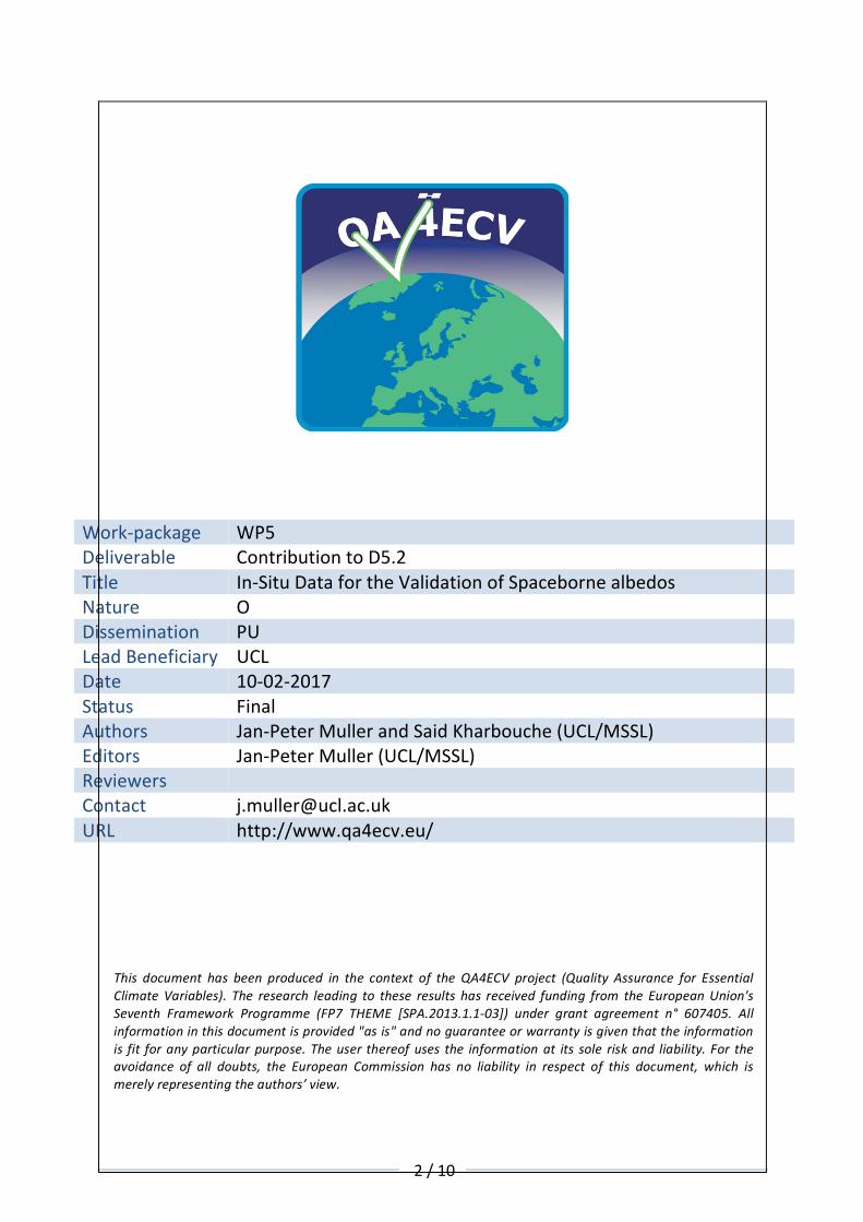
1.FluxnetDatafrom166Fluxnetsitesweredownloaded(SiteID,startyear,endyear):(AR-SLu,2009,2011),(AR-Vir,2009,2012),(AT-Neu,2002,2012),(AU-ASM,2010,2013),(AU-Ade,2007,2009),(AU-Cpr,2010,2014),(AU-Cum,2012,2014),(AU-DaP,2007,2013),(AU-DaS,2008,2014),(AU-Dry,2008,2014),(AU-Emr,2011,2013),(AU-Fog,2006,2008),(AU-GWW,2013,2014),(AU-Gin,2011,2014),(AU-How,2001,2014),(AU-Lox,2008,2009),(AU-RDF,2011,2013),(AU-Rig,2011,2014),(AU-Rob,2014,2014),(AU-Stp,2008,2014),(AU-TTE,2012,2013),(AU-Tum,2001,2014),(AU-Wac,2005,2008),(AU-Whr,2011,2014),(AU-Wom,2010,2012),(AU-Ync,2012,2014),(BE-Bra,1996,2014),(BE-Lon,2004,2014),(BE-Vie,1996,2014),(BR-Sa3,2000,2004),(CA-Man,1994,2008),(CA-NS1,2001,2005),(CA-NS2,2001,2005),(CA-NS3,2001,2005),(CA-NS4,2002,2005),(CA-NS5,2001,2005),(CA-NS6,2001,2005),(CA-NS7,2002,2005),(CA-Qfo,2003,2010),(CA-SF1,2003,2006),(CA-SF2,2001,2005),(CA-SF3,2001,2006),(CH-Cha,2005,2014),(CH-Dav,1997,2014),(CH-Fru,2005,2014),(CH-Lae,2004,2014),(CH-Oe1,2002,2008),(CH-Oe2,2004,2014),(CN-Cha,2003,2005),(CN-Cng,2007,2010),(CN-Dan,2004,2005),(CN-Din,2003,2005),(CN-Du2,2006,2008),(CN-Ha2,2003,2005),(CN-HaM,2002,2004),(CN-Qia,2003,2005),(CN-Sw2,2010,2012),(CZ-BK1,2004,2008),(CZ-BK2,2004,2006),(CZ-wet,2006,2014),(DE-Akm,2009,2014),(DE-Geb,2001,2014),(DE-Gri,2004,2014),(DE-Hai,2000,2012),(DE-Kli,2004,2014),(DE-Lkb,2009,2013),(DE-Obe,2008,2014),(DE-RuR,2011,2014),(DE-RuS,2011,2014),(DE-Seh,2007,2010),(DE-SfN,2012,2014),(DE-Spw,2010,2014),(DE-Tha,1996,2014),(DK-Fou,2005,2005),(DK-NuF,2008,2014),(DK-Sor,1996,2014),(DK-ZaF,2008,2011),(DK-ZaH,2000,2014),(ES-LgS,2007,2009),(ES-Ln2,2009,2009),(FI-Hyy,1996,2014),(FI-Jok,2000,2003),(FI-Lom,2007,2009),(FI-Sod,2001,2014),(FR-Fon,2005,2014),(FR-Gri,2004,2013),(FR-LBr,1996,2008),(FR-Pue,2000,2014),(GF-Guy,2004,2014),(IT-BCi,2004,2014),(IT-CA1,2011,2014),(IT-CA2,2011,2014),(IT-CA3,2011,2014),(IT-Col,1996,2014),(IT-Cp2,2012,2014),(IT-Cpz,1997,2009),(IT-Isp,2013,2014),(IT-La2,2000,2002),(IT-Lav,2003,2014),(IT-MBo,2003,2013),(IT-Noe,2004,2014),(IT-PT1,2002,2004),(IT-Ren,1998,2013),(IT-Ro1,2000,2008),(IT-Ro2,2002,2012),(IT-SR2,2013,2014),(IT-SRo,1999,2012),(IT-Tor,2008,2014),(JP-MBF,2003,2005),(JP-SMF,2002,2006),(NL-Hor,2004,2011),(NL-Loo,1996,2013),(NO-Adv,2011,2014),(NO-Blv,2008,2009),(RU-Che,2002,2005),(RU-Cok,2003,2014),(RU-Fyo,1998,2014),(RU-Ha1,2002,2004),(SD-Dem,2005,2009),(SN-Dhr,2010,2013),(US-AR1,2009,2012),(US-AR2,2009,2012),(US-ARM,2003,2012),(US-ARb,2005,2006),(US-ARc,2005,2006),(US-Blo,1997,2007),(US-Cop,2001,2007),(US-GBT,1999,2006),(US-GLE,2004,2014),(US-Ha1,1991,2012),(US-KS2,2003,2006),(US-Los,2000,2014),(US-MMS,1999,2014),(US-Me1,2004,2005),(US-Me2,2002,2014),(US-Me6,2010,2014),(US-Myb,2010,2014),(US-NR1,1998,2014),(US-Ne1,2001,2013),(US-Ne2,2001,2013),(US-Ne3,2001,2013),(US-ORv,2011,2011),(US-PFa,1995,2014),(US-Prr,2010,2013),(US-SRG,2008,2014),(US-SRM,2004,2014),(US-Syv,2001,2014),(US-Ton,2001,2014),(US-Tw1,2012,2014),(US-Tw2,2012,2013),(US-Tw3,2013,2014),(US-Tw4,2013,2014),(US-Twt,2009,2014),(US-UMB,2000,2014),(US-UMd,2007,2014),(US-Var,2000,2014),(US-WCr,1999,2014),(US-Whs,2007,2014),(US-Wi0,2002,2002),(US-Wi3,2002,2004),(US-Wi4,2002,2005),(US-Wi6,2002,2003),(US-Wi9,2004,2005),(US-Wkg,2004,2014),(ZA-Kru,2000,2010),(ZM-Mon,2000,2009)Only19(outof53listed)ofthesestationsoperatea“FairUsePolicy”asdescribedby

5/10
A.Cescatti,B.Marcolla,S.K.S.Vannan,J.Y.Pan,M.O.Roman,X.Yang,P.Ciais,R.B.Cook,B.E.Law,G.Matteucci,M.Migliavacca,E.Moors,A.D.Richardson,G.Seufert,andC.B.Schaaf,“IntercomparisonofMODISalbedoretrievalsandinsitumeasurementsacrosstheglobalFLUXNETnetwork,”RemoteSensingofEnvironment,vol.121,pp.323–334,2012.
Figure1SpatialdistributionofallFLUXNETsites.Datafrom166sitesarebeingusedinQA4ECV.seenextfigure
Figure2SpatialdistributionofthesitestobeemployedinQA4ECVvalidation.ReddotsareFLUXNETsitesandgreencrossesareSURFRADsites.
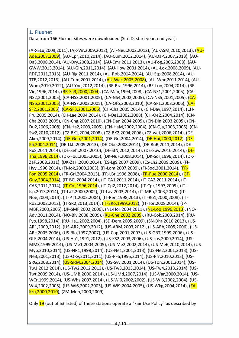
Variable Units Description SW_IN_POT Shortwave radiation, incoming, potential (top of atmosphere) HH W m-2 DD W m-2 average from half-hourly data WW-MM W m-2 average from daily data
SW_IN_F Shortwave radiation, incoming consolidated from SW_IN_F_MDS and SW_IN_ERA (negative values set to zero)
6/10
HH W m-2 SW_IN_F_MDS used if SW_IN_F_MDS_QC is 0 or 1 DD W m-2 average from half-hourly data WW-YY W m-2 average from daily data SW_IN_F_QC Quality flag for SW_IN_F HH adimensional 0 = measured; 1 = good quality gapfill; 2 = downscaled from ERA
DD adimensional fraction between 0-1, indicating percentage of measured and good quality gapfill data
WW-YY adimensional fraction between 0-1, indicating percentage of measured and good quality gapfill data (average from daily data)
LW_IN_F Longwave radiation, incoming, consolidated from LW_IN_F_MDS and LW_IN_ERA
HH W m-2 LW_IN_F_MDS used if LW_IN_F_MDS_QC is 0 or 1 DD W m-2 average from half-hourly data WW-YY W m-2 average from daily data LW_IN_F_QC Quality flag for LW_IN_F HH adimensional 0 = measured; 1 = good quality gapfill; 2 = downscaled from ERA
DD adimensional fraction between 0-1, indicating percentage of measured and good quality gapfill data
NETRAD Net radiation HH W m-2 DD W m-2 average from half-hourly data (only days with more than 50% records available) WW-YY W m-2 average from daily data (only periods with more than 50% records available) NETRAD_QC Quality flag of NETRAD HH adimensional not defined DD adimensional fraction between 0-1, indicating percentage of data available (measured)
WW-YY adimensional fraction between 0-1, indicating percentage of data available (average from daily data)
SW_DIF Shortwave radiation, diffuse incoming HH W m-2 DD W m-2 average from half-hourly data (only days with more than 50% records available) WW-YY W m-2 average from daily data (only periods with more than 50% records available) SW_DIF_QC Quality flag of SW_DIF HH adimensional not defined DD adimensional fraction between 0-1, indicating percentage of data available (measured)
WW-YY adimensional fraction between 0-1, indicating percentage of data available (average from daily data)
SW_OUT Shortwave radiation, outgoing HH W m-2 DD W m-2 average from half-hourly data (only days with more than 50% records available) WW-YY W m-2 average from daily data (only periods with more than 50% records available) SW_OUT_QC Quality flag of SW_OUT HH adimensional not defined DD adimensional fraction between 0-1, indicating percentage of data available (measured)
WW-YY adimensional fraction between 0-1, indicating percentage of data available (average from daily data)
Table1MostusefulVariablesfromFluxnetdata.Unfortunatelyitisnotclearwhich,ifany,ofthesestationshaveLAIorFAPARmeasurements
2.SURFRADDatafromthefollowing8SURFRADstationshavebeendownloadedandindexed:

7/10
Code Name Latitude Longitude Elevation Installed
BND* Bondville,Illinois
40.052°N
88.37309°W 230m April1994
TBL TableMountain,Boulder,Colorado
40.125°N
105.2368°W 1689m July1995
DRA DesertRock,Nevada
36.624°N
116.0195°W 1007m March1998
FPK FortPeck,Montana
48.308°N
105.1017°W 634m November
1994
GCM GoodwinCreek,Mississippi
34.255°N 89.873°W 98m December
1994
PSU Penn.StateUniv.,Pennsylvania
40.720°N 77.9308°W 376m June1998
SXF SiouxFalls,SouthDakota
43.734°N 96.6233°W 473m June2003
SGP ARMSouthernGreatPlainsFacility,Oklahoma
36.604°N 97.4853°W 314m
Table2OverviewofSURFRADsites.Datafromallofhese8sitesarebeingemployedinQA4ECV.
Figure3GeographicaldistributionofNOAASURFRADsiteswithintheUSA.

8/10
variables descriptionlatitude latitudeindecimaldegreeslongitude longitudeindecimaldegreeselevation elevationabovesealevelinmetresyear Year(1994..2016)jday Julianday(1through365[or366])
month numberofthemonth(01-12)day dayofthemonth(01-31)hour houroftheday(0-23)min minuteofthehour(0-59)dt decimaltimezen solarzenithangle(degrees)
dw_solardownwellingglobalsolar
(Wattsm^-2)uw_solar globalsolar(Wattsm^-2)direct_n direct-normalsolar(Wattsm^-2)
diffusedownwellingdiffusesolar
(Wattsm^-2)Table3MostusedVariablesofSURFRADdata.
3.PARABOLAThePARABOLAinstrument(Deering&Leone,1986;Abdouetal.,2000;Brueggeetal.,2000)iscurrentlytheonlyinsituinstrumentcapableofmeasuringnear-instantaneousmultispectralBRF.Thereisonlyinstrumentleft(atNASAJPL)whichcanusedtomakethesemeasurementsatpresent.CNEShavedevelopedaversionoftheCIMEL-318(NASAAERONET),whichcanbeemployedtomakespectralBRFmeasurements,whichisbeingdeployedaspartoftheCEOS-WGCV-IVOSRADCALNETsystem.Itismostsuitedtomeasurementsofbrightplaya-likesurfacessuchasmineralsalts(RailroadValley)fromatowerat10-12mheight.However,PARABOLAhasalsobeenusedtomakemeasurementsofprairiegrassin(FIFE)anddeciduous;coniferousforestsin1994(BOREAS)andAfricansavannahsitesin2000(SAFARI2000).Subsequenttothis,C.Bruegge(privatecommunication)hasreportedthatPARABOLAisdeployedsince2000tomeasurespectralBRDFoverthevicariousradiometriccalibrationsiteestablishedbyNASAandtheUniversityofArizonaatRailroadValley,NV,USA.Abdou,W.A.,M.Helminger,J.Conel,C.J.Bruegge,S.Pilorz,J.V.Martonchik,andB.Gaitley,
“Paraboladirectionalfieldradiometerforaidinginspacesensordatainterpretations,”JGeophysicalResearch,vol.106,no.11,pp.11967–11976,2000.
Bruegge,C.,M.Helmlinger,J.Conel,B.Gaitley,andW.Abdou,“PARABOLAIII:Asphere-scanningradiometerforfielddeterminationofsurfaceanisotropicreflectancefunctions,”RemoteSensingReviews,vol.19,pp.75–94,2000.
DeeringD.,&P.Leone,“Asphere-scanningradiometerforrapiddirectionalmeasurementsofskyandgroundradiance,”RemoteSensingofEnvironment,vol.19,pp.1–24,1986.

9/10
4.SatelliteAlbedosTheinsitudataisbeingusedtoassessBHR(Bi-HemisphericalReflectanceorwhiteskyalbedo)andDHR(Direct-HemisphericalReflectanceorblackskyalbedo)fordifferentproductsoverthreebroadbands:VIS,NIRandSW.Thefollowingsatellitedataofalbedoshasbeenextractedoverthesesites:
• AlbedosderivedfromAVHRR-only(VIS,NIR,SW)• AlbedosderivedfromAVHRR+GEO(SWonly)• AlbedosderivedfromMERIS+VGT+Proba-V(VIS,NIR,SW)• AlbedosderivedfromMODIS_collection6(VIS,NIR,SW)
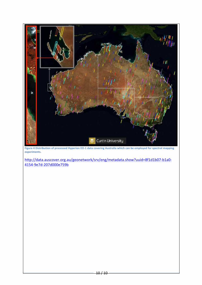
TherearenopermanentinsitustationswhichmakesystematicobservationsofSpectralBRF/BRDF/albedoforassessingtheQA4ECVspectralalbedos.Arecentpublicationdescribesanewsetofcoarseresolution(6.7km)multispectralBRDFmeasurements.DerivedfromtheFrenchPOLDERinstrumentin2008,itlinkstheBRDFtothe16IGBPlandcoverclasses.Itoperatesatthefollowingwavelengthbandcentresof4434905656707637658659101020nm.ThewavelengthsinboldarethoseincommonwiththewavelengthsbeingprocessedwithinthespectralproductbyQA4ECV.F.-M.BréonandF.Maignan,“ABRDF-BPDFdatabasefortheanalysisofEarthtargetreflectances,”EarthSystemScienceData,Jan.2017.DOI:10.5194/essd-9-31-2017ThereisaONEnationwideset(Australia)ofhyperspectralsurfacereflectancemeasurementswhichcouldbeemployedtosimulatedifferentsatellitesensorsoverdifferentsurfacecovertypeswhichisderivedfromtheNASAHyperion-1instrument.However,noBRFmeasurementsareavailable.Seefurtherdescriptionbelow.
10/10
Figure4DistributionofprocessedHyperionEO-1datacoveringAustraliawhichcanbeemployedforspectralmappingexperiments.
http://data.auscover.org.au/geonetwork/srv/eng/metadata.show?uuid=8f1d1b07-b1a0-4154-9e7d-207d000e759b
Related Documents