This article appeared in the journal Rock Art Research, published by the International Federation of Rock Art Organisations (IFRAO) and the Australian Rock Art Research Association (AURA). The attached copy is furnished to the author(s) for internal non- commercial research and education use, including for instruction at the author’s institution and for sharing with colleagues. Other uses, including reproduction and distribution, or selling or licensing copies, or posting to personal, institutional or third-party websites are prohibited. Authors are permitted to post their version of the article (e.g. in Word form) to their personal website or institutional repository. Authors desiring to post this PDF version on their personal websites need to request permission to do so from IFRAO/AURA at [email protected]. Provided for non-commercial research and education use. Not for reproduction, distribution or commercial use.

Welcome message from author
This document is posted to help you gain knowledge. Please leave a comment to let me know what you think about it! Share it to your friends and learn new things together.
Transcript
91Rock Art Research 2014 -‐‑ Volume 31, Number 1, pp. 92-‐‑100. D. WRIGHT et al.
This article appeared in the journal Rock Art Research, published by
the International Federation of Rock Art Organisations (IFRAO) and
the Australian Rock Art Research Association (AURA).
The attached copy is furnished to the author(s) for internal non-
commercial research and education use, including for instruction
at the author’s institution and for sharing with colleagues. Other
uses, including reproduction and distribution, or selling or licensing
copies, or posting to personal, institutional or third-party websites
are prohibited.
Authors are permitted to post their version of the article (e.g. in
Word form) to their personal website or institutional repository.
Authors desiring to post this PDF version on their personal
websites need to request permission to do so from IFRAO/AURA at
Provided for non-commercial research and education use.
Not for reproduction, distribution or commercial use.
Rock Art Research 2014 -‐‑ Volume 31, Number 1, pp. 92-‐‑100. D. WRIGHT et al.92
KEYWORDS: Cupule – Residue – Use-‐‑wear – Function – Jabiluka – Australia
A SCIENTIFIC STUDY OF A NEW CUPULE SITEIN JABILUKA, WESTERN ARNHEM LAND
Duncan Wright, Sally K. May, Paul S. C. Taçon and Birgitta Stephenson
Abstract. Cupules (engraved pits) have been observed on every continent with the exception of Antarctica, and cover Lower, Middle and Upper Palaeolithic contexts. Despite this remarkable spatial distribution and the perceived antiquity of these petroglyphs very few
of morphology, manufacture and function poorly understood. In Australia, lack of detailed
review literature for Australian cupule sites and present detailed archaeological results from a new site in western Arnhem Land. By applying metric, use-‐‑wear and residue analysis we
complexities.
Introduction
Cupules are human-‐‑made cup-‐‑shaped petroglyphs formed through percussion. Cupules can be distin-‐‑guished from grinding hollows and natural potholes, being more numerous, uniform shaped/sized and often located at natural boundaries (e.g. lines and cave entrances) in the rock (Bednarik 1993a, 2008: 68; Taçon et al. 1997: 943). In Australia, they are commonly closely and regularly spaced, on vertical and sloping (as well as horizontal) rock faces and may directly relate to other petroglyphs and/or painted art.
Cupules are thought to have been made during both Pleistocene and Holocene periods (Bednarik 2008; Taçon et al. 1997: 945). Pleistocene contexts include La Ferrassie in France (Peyrony 1934); Auditorium Cave in India (Bednarik 1993b), Daraki-‐‑Chattan, in India (Kumar 1996: 38), Sai Island in Sudan (van Peer et al. 2003), Kalahari sites in South Africa (Beaumont and Bednarik 2012), and probably also Rhino Cave in Botswana (although radiocarbon and thermoluminescence dates remain ‘problematic’ for this site) (Coulson et al. 2011: 23). A Pleistocene antiquity has been argued for Australian examples based loosely on oral histories (Chaloupka 1993a: 235) and extensive studies of art superimposition across Kakadu and Arnhem Land (Taçon and Chippindale 1994: 215) and the Kimberley region (Walsh 1994; Welch 1992; 1993: 101). Direct dates from oxalate salts overlying cupules in the Kimberley and Keep River regions suggest a short chronology of >6600 years ago (Aubert 2012; Watchman 1997, 2004; Watchman et al. 1997). This is supported by AMS dates (<3000 years ago) from cupules in the Laura
River Region, Cape York (Cole and Watchman 2005), and a buried cupule surface at Jinmium in the Keep River region (Roberts et al. 1998a). A charcoal sample associated with buried cupules at the Leichardt site, Arnhem Land was dated to 5180 ± 130 BP (SUA-‐‑244) (Kamminga and Allen 1973: 88).
The function/s of cupules remain poorly understood (Bednarik 2010). Utilitarian and/or symbolic motivation for cupule production was suggested, with artistic activities indicated by the small size (i.e. impractical for processing food/ochre), position on sloping or vertical surfaces, dense clustering and frequent association
lines in the rock) (Bednarik 2008; Parkman 1986; Taçon et al. 1997). Artistic motivation for the production of cupules is, however, rarely visible in the archaeological record (Bednarik 2008: 72). A notable exception is Rhino Cave in Botswana where awas decorated with rock paintings, in addition to over three hundred overlapping ‘grooves and depressions’ (Coulson et al. 2011: 20). Ritual activity was suggested based on excavated materials (ochre, large quantities of exotic MSA points, grinding stones and an exfoliated piece from the cupule panel), evidence for intentional lithic burning and breakage and observations based on site context and lighting (Coulson et al. 2011: 50).
In America, cupule function has been examined through analysis of residues (e.g. Buonasera 2012: 65–82; Schneider and Bruce 2009). Results frequently support non-‐‑utilitarian use (Buonasera 2012), however, plant and animal residues have been recorded, suggesting some cupules may have had utilitarian roles
93Rock Art Research 2014 -‐‑ Volume 31, Number 1, pp. 92-‐‑100. D. WRIGHT et al.
(Schneider and Bruce 2009; Zepeda-‐‑Herman 2012). No detailed use-‐‑wear/ residue analysis has, thus far, been reported for cupules in the Australian context where interpretations utilise ethnographic records. For example, Charles Mountford (1976: 22) recorded that cupules in the Musgrave Ranges (South Australia) were made to ‘propagate the creative powers of an Ancestral Being and thereby increase the population of the natural species associated with that Being’. A ceremonial role
rock art) at a Green Plum Dreaming site near the Mann River in eastern Arnhem Land (Taçon et al. 1997: 947).
Pecked circles and pits have been recorded through-‐‑out Australia, concentrated in the Kimberley, Keep River, Victoria River, Kakadu/western Arnhem Land and Cape York areas of northern Australia (Chaloupka 1993b; Cole and Watchman 2005; Donaldson 2007; Edwards 1979; Flood 1987, 1997; Graham and Mulvaney 1995; Gunn 1989; Jones and Brockwell 1990; McNickle 1991, 1993; Sullivan and Haskovec 1986; Taçon et al. 1997; Walsh 1994; Watchman 1997, 2004; Watchman et al. 1997; Welch 1992, 1993). Cupule sites have also been found through the Chillagoe, Hervey and Expedition Range regions of central Queensland (Bednarik 1993a), Victoria (Bednarik et al. 2003; Bednarik 2008), central and southern Australia (Flood 1997; Franklin 1991; Maynard 1976, 1979; Mountford 1976), Tasmania (Bednarik et al. 2007; Brown 1991; Sims 1977, 2008) and Pilbara in Western Australia (McNickle 1984, 1985). These petroglyphs are found in rockshelters and on
rock faces (e.g. Bond Bay, Tasmania). Understanding the spatial distribution of cupules in
Australia is problematic given the scarcity of detailed
residues), with results ‘often limited to their incidental occurrence in photographs together with other motifs’
classification (Donaldson 2007 vs McNickle 1991; Rosenfeld 1999: 31 vs Taçon et al. 1997) and disputed
2009). Cupules in Tasmania and South Australia (e.g. Bednarik et al. 2007; Cosgrove 1983) have elsewhere been termed ‘cup and ring motifs’, ‘pits’, ‘circles’, ‘mine markers’ or ‘natural hollows’ (e.g. Field and McIntosh 2009; Flood 1997: 149, 238; Mountford 1976). Taçon et al. (1997: 960) suggest that detailed documentation of cupule sites may assist assessment of ‘long-‐‑range settlement and migration patterns for the earliest periods of north Australian prehistory’ and enable
and expressing their relationships to landscapes’. In this
(including use-‐‑wear and residue analysis) from recently re-‐‑discovered cupules in western Arnhem Land and reassess distribution and function of known cupule sites in Australia.questions:1. Can use-‐‑wear and residue analysis, including
newly developed techniques for PSR polarisation (Stephenson 2011), provide insights into the purpose of cupules in northern Australia?
2. How does the Djawumbu cupule site relate to its wider cultural landscape?
Djawumbu cupule site and others recorded in the region?
The Djawumbu (Djawumba) site complex
A large cupule site recently recorded within the Jabiluka leasehold area, western Arnhem Land, provides a further opportunity to study northern Australian cupules. The site is located on the Djawumbu Massif, an isolated sandstone outlier on the eastern
recorded in 2012 during survey conducted as part of the Mirrar Rock Art Project.
and Bunidj communities used Djawumbu to ‘get away from mosquitoes and for ceremonies’ (Chaloupka 1978: iii; Toby Gangali and Dolly Yarnmalu cited in Layton 1981: 12–13; Kamminga and Allen 1973: 53). Elder
a ceremony ground that continued to be used in the contact period but was now ‘dead’ (pers. comm. 2010). Toby Gangali includes Djawumbu in his description of walking routes, in particular a route between the historic sites of Oenpelli and Baroalba Timber Camp (Layton 1981: 19, Table 4; see also Kamminga and Allen 1973: 44, 53). While he is describing walking routes used in the contact period, many such routes would have followed earlier, pre-‐‑contact seasonal movements and made use of known rockshelters and water sources.
Extensive surveys on and around Djawumbu were conducted by Kamminga and Allen (1973), Morley
(1982). Kamminga and Allen (1973) recorded six rockshelters along the edge of the massif (Djawumubu 1–6; Kamminga and Allen 1973: iv). Chaloupka (1975) also worked in the Mirrar-‐‑Gundjeihmi clan estate and
rock art, archaeological deposits and Dreaming sites). In 1978, two important site complexes were recorded: Boywek Bagolui-‐‑Almudj (which connected Wirrmuyurr Swamp with the eastern escarpment) and Djawumbu-‐‑Madjawarrnja (Chaloupka 1978; Keen 1980). In 1997, Chaloupka carried out site surveys with Senior Custodians and Northern Land Council employees, confirming the importance of the Boywek-‐‑Bagolui Almudj sacred site complex. Pancontinental Mining Ltd soon afterwards commissioned their own rock art study of the Jabiluka leasehold area with work undertaken by
1980). Systematic surveys revealed approximately 189 sites from the Magela Creek series and Djawumba Massif, including archaeological deposits, rock art panels, and burial sites but no ‘mythological sites’ (Morley and Lovett 1980: 2). All of these studies
Rock Art Research 2014 -‐‑ Volume 31, Number 1, pp. 92-‐‑100. D. WRIGHT et al.94
combine to reveal important cultural associations for the Djawumbu complex.
The most famous of the Djawumbu sites, Mala-‐‑kunanja II (known as Madjedbebe by Mirarr Custo-‐‑dians), has been the focus for three major excavations (Kamminga and Allen 1973; Roberts et al. 1990). Cul-‐‑tural activity was radiocarbon dated to 24 000 – 20 000 , with shell middens containing human re-‐‑mains postdating 7000 years ago (Kamminga andAllen 1973). Pieces of red/yellow ochre and haematite were associated with Pleistocene deposits, and threegrinding stones (one impregnated with ochre) dated to approximately 20 000–18 000 (Kamminga
and Allen 1973: 48–49; Mulvaney andKamminga 1999: 138). Subsequent sand auger and excavation allowed Rhys Jones and colleagues to re-‐‑date Madjedbebe (Roberts et al. 1990; 1998b). Thermoluminescence dates were used to interpret occupation from 61 ± 10 ka (Roberts et al. 1990). TL dates were criticised by some archaeologists due to large standard errors (Hiscock 1990) and stratigraphic observations (Bowdler 1990; Hiscock 1990).
The Djawumbu cupule site is one of only two within Mirrar country and only just under a dozen recorded from central Arnhem Land to the southern end of Kakadu National Park.
Its exact location is restricted at the request of Mirarr traditional owners; however, it is located near Madjedbebe and at the top of the Djawumbu Massif. The outlier is approximately 3 km long, 1 km wide (at widest point), located between the Oenpelli-‐‑Jabiru road (to the west) and Jabiluka tailing dam (to the east). The top of Djawumbu varies
between a sparsely vegetated, boulder-‐‑strewn plain in the south/centre to a maze of eroded passageways, chambers and rockshelters in the north and west. The
including rock art, stone arrangements and grinding hollows.
A substantial open corridor, located in the northern portion, provides access to a large opening containing many cultural sites (painted art, circular stone
A small enclosed corridor, formed by two boulders leaning against each other to make a rockshelter, is located at the edge of this opening, running east-‐‑west
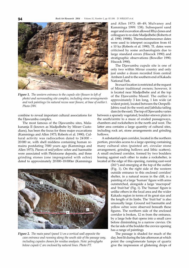
(261°) and emerging at the top of the outlier (Fig. 1). On the right side of the western outside entrance to this enclosed corridor/
outstretched, alongside a large ‘macropod’
unlike others in the local area and the wider Kakadu region in terms of its great size and the length of its limbs. The ‘fruit bat’ is also unusually large. Ground red haematite and yellow ochre were observed beneath these
corridor is broken, 12 m from the entrance, by a large hole that opens into a small cave before diminishing to a narrow crevice. On the far side of the boulder the crevice opening has a range of paintings
The passage is shaded for much of the day, best lit during the late afternoon at which point the conglomerate lumps of quartz give the impression of glistening drops of
Figure 1.photo) and surrounding site complex, including stone arrangements
Photo DW.
Figure 2. The main panel (panel 1) on a vertical wall opposite the
95Rock Art Research 2014 -‐‑ Volume 31, Number 1, pp. 92-‐‑100. D. WRIGHT et al.
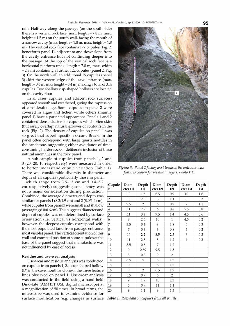
rain. Half-‐‑way along the passage (on the south side) there is a vertical rock face (max. length = 7.8 m, max. height = 1.5 m) on the south wall, facing the mouth of a narrow cavity (max. length = 1.8 m, max. height = 1.8 m). The vertical rock face contains 177 cupules (Fig. 2; henceforth panel 1), adjacent to and downslope from the cavity entrance but not continuing deeper into the passage. At the top of the vertical rock face is a horizontal platform (max. length = 7.8 m, max. width = 2.3 m) containing a further 122 cupules (panel 2; Fig. 3). On the north wall an additional 15 cupules (panel 3) skirt the western edge of the cave entrance (max. length = 0.6 m, max height = 0.4 m) making a total of 314 cupules. Two shallow cup-‐‑shaped hollows are located
In all cases, cupules (and adjacent rock surfaces) appeared smooth and weathered, giving the impression of considerable age. Some cupules on panel 2 were covered in algae and lichen while others (mainly panel 1) have a patinated appearance. Panels 1 and 2 contained dense clusters of cupules which often skirt (but rarely overlap) natural grooves or contours in the rock (Fig. 2). The density of cupules on panel 1 was so great that superimposition occurs. Breaks in the
the sandstone, suggesting either avoidance of time-‐‑consuming harder rock or deliberate inclusion of these natural anomalies in the rock panel.
A sub-‐‑sample of cupules from panels 1, 2 and 3 (20, 20, 10 respectively) were measured in order to better understand cupule variation (Table 1). There was considerable diversity in diameter and depth of all cupules (particularly those in panel 1 which range from 3.5–13 cm and 0.4–3.2 cm respectively) suggesting consistency was not a major consideration during production. Combined, the average diameter and depth was similar for panels 1 (8.3/1.9 cm) and 2 (8.0/1.4 cm), while cupules from panel 3 were small and shallow (averaging 6.0/0.6 cm). This suggests diameter and depth of cupules was not determined by surface orientation (i.e. vertical vs horizontal walls), however, the deepest cupules correspond with the most populated (and from passage entrance, most visible) panel. The vertical orientation of this wall and cramped position of some cupules at the base of the panel suggest that manufacture was
Residue and use-‐‑wear analysis
Use-‐‑wear and residue analysis was conducted on cupules from panels 1, 2, a cup-‐‑shaped hollow (D) in the cave mouth and one of the three feature lines observed on panel 1. Use-‐‑wear analysis
Dino-‐‑Lite (AM413T USB digital microscope) at
microscope was used to examine evidence for surface modification (e.g. changes in surface
Figure 3.
Cupule
#
Diam-‐‑
eter (1)
Depth
(1)
Diam-‐‑
eter (2)
Depth
(2)
Diam-‐‑
eter (3)
Depth
(3)
1 13 1.5 8.5 0.9 10 1.82 10 2.5 8 1.1 8 0.33 9.5 2 6 0.7 7 1.14 11 2.9 6 0.8 5.5 0.85 11 3.2 9.5 1.4 4.5 0.66 8 2.5 10 1 4.5 0.27 3.5 0.4 8 1.8 5 0.38 7 0.6 6 0.8 5 0.29 10 2.2 8.5 2.5 6 0.310 11 2.8 8 1.2 4 0.211 5.5 0.8 7 1.212 9 2.89 9.5 1.513 5 0.8 9 214 6.5 5 8 1.215 9 1 6 1.316 9 2 6.5 1.717 5.5 0.7 6 218 9 1.9 10 2.319 5 0.9 11 1.120 9 1.1 9 1.3
Table 1.
Rock Art Research 2014 -‐‑ Volume 31, Number 1, pp. 92-‐‑100. D. WRIGHT et al.96
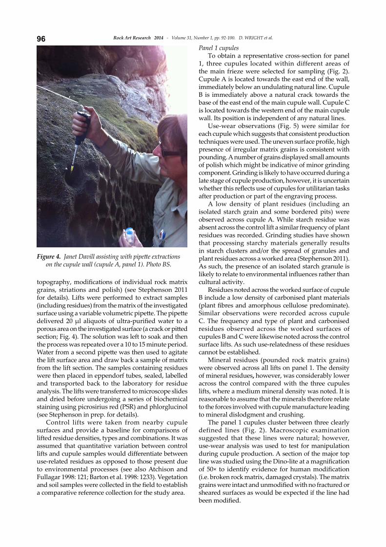
grains, striations and polish) (see Stephenson 2011 for details). Lifts were performed to extract samples (including residues) from the matrix of the investigated
section; Fig. 4). The solution was left to soak and then the process was repeated over a 10 to 15 minute period.
the lift surface area and draw back a sample of matrix from the lift section. The samples containing residues were then placed in eppendorf tubes, sealed, labelled and transported back to the laboratory for residue analysis. The lifts were transferred to microscope slides and dried before undergoing a series of biochemical staining using picrosirius red (PSR) and phlorglucinol (see Stephenson in prep. for details).
Control lifts were taken from nearby cupule surfaces and provide a baseline for comparisons of lifted residue densities, types and combinations. It was assumed that quantitative variation between control
use-‐‑related residues as opposed to those present due to environmental processes (see also Atchison and Fullagar 1998: 121; Barton et al. 1998: 1233). Vegetation
a comparative reference collection for the study area.
Panel 1 cupules
To obtain a representative cross-‐‑section for panel 1, three cupules located within different areas of the main frieze were selected for sampling (Fig. 2). Cupule A is located towards the east end of the wall, immediately below an undulating natural line. Cupule B is immediately above a natural crack towards the base of the east end of the main cupule wall. Cupule C is located towards the western end of the main cupule wall. Its position is independent of any natural lines.
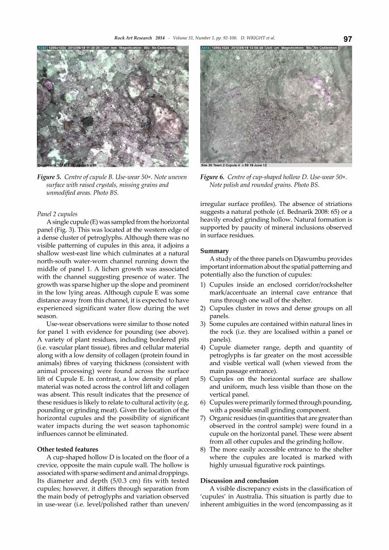
Use-‐‑wear observations (Fig. 5) were similar for each cupule which suggests that consistent production
presence of irregular matrix grains is consistent with pounding. A number of grains displayed small amounts of polish which might be indicative of minor grinding component. Grinding is likely to have occurred during a late stage of cupule production, however, it is uncertain
after production or part of the engraving process. A low density of plant residues (including an
isolated starch grain and some bordered pits) were observed across cupule A. While starch residue was absent across the control lift a similar frequency of plant residues was recorded. Grinding studies have shown that processing starchy materials generally results in starch clusters and/or the spread of granules and plant residues across a worked area (Stephenson 2011). As such, the presence of an isolated starch granule is
cultural activity.Residues noted across the worked surface of cupule
B include a low density of carbonised plant materials
Similar observations were recorded across cupule C. The frequency and type of plant and carbonised residues observed across the worked surfaces of cupules B and C were likewise noted across the control surface lifts. As such use-‐‑relatedness of these residues cannot be established.
Mineral residues (pounded rock matrix grains) were observed across all lifts on panel 1. The density of mineral residues, however, was considerably lower across the control compared with the three cupules lifts, where a medium mineral density was noted. It is reasonable to assume that the minerals therefore relate to the forces involved with cupule manufacture leading to mineral dislodgment and crushing.
The panel 1 cupules cluster between three clearly defined lines (Fig. 2). Macroscopic examination suggested that these lines were natural; however, use-‐‑wear analysis was used to test for manipulation during cupule production. A section of the major top
(i.e. broken rock matrix, damaged crystals). The matrix
sheared surfaces as would be expected if the line had
Figure 4.on the cupule wall (cupule A, panel 1). Photo BS.
97Rock Art Research 2014 -‐‑ Volume 31, Number 1, pp. 92-‐‑100. D. WRIGHT et al.
Panel 2 cupules
A single cupule (E) was sampled from the horizontal panel (Fig. 3). This was located at the western edge of a dense cluster of petroglyphs. Although there was no
shallow west-‐‑east line which culminates at a natural north-‐‑south water-‐‑worn channel running down the middle of panel 1. A lichen growth was associated with the channel suggesting presence of water. The growth was sparse higher up the slope and prominent in the low lying areas. Although cupule E was some distance away from this channel, it is expected to have experienced significant water flow during the wet season.
Use-‐‑wear observations were similar to those noted for panel 1 with evidence for pounding (see above). A variety of plant residues, including bordered pits
along with a low density of collagen (protein found in
animal processing) were found across the surface lift of Cupule E. In contrast, a low density of plant material was noted across the control lift and collagen was absent. This result indicates that the presence of these residues is likely to relate to cultural activity (e.g. pounding or grinding meat). Given the location of the
water impacts during the wet season taphonomic
Other tested features
crevice, opposite the main cupule wall. The hollow is associated with sparse sediment and animal droppings. Its diameter and depth (5/0.3 cm) fits with tested
the main body of petroglyphs and variation observed in use-‐‑wear (i.e. level/polished rather than uneven/
suggests a natural pothole (cf. Bednarik 2008: 65) or a heavily eroded grinding hollow. Natural formation is supported by paucity of mineral inclusions observed in surface residues.
Summary
A study of the three panels on Djawumbu provides
potentially also the function of cupules: 1) Cupules inside an enclosed corridor/rockshelter
mark/accentuate an internal cave entrance that runs through one wall of the shelter.
2) Cupules cluster in rows and dense groups on all panels.
3) Some cupules are contained within natural lines in the rock (i.e. they are localised within a panel or panels).
4) Cupule diameter range, depth and quantity of petroglyphs is far greater on the most accessible and visible vertical wall (when viewed from the main passage entrance).
5) Cupules on the horizontal surface are shallow and uniform, much less visible than those on the vertical panel.
6) Cupules were primarily formed through pounding, with a possible small grinding component.
7) Organic residues (in quantities that are greater than observed in the control sample) were found in a cupule on the horizontal panel. These were absent from all other cupules and the grinding hollow.
8) The more easily accessible entrance to the shelter where the cupules are located is marked with
Discussion and conclusion
‘cupules’ in Australia. This situation is partly due to inherent ambiguities in the word (encompassing as it
Figure 6.Note polish and rounded grains. Photo BS.
Figure 5.
Rock Art Research 2014 -‐‑ Volume 31, Number 1, pp. 92-‐‑100. D. WRIGHT et al.98does all cup-‐‑shaped petroglyphs), but also mistaken
for these sites. The outward appearance of grinding hollows, mine-‐‑markers and natural features may be similar to cupules, particularly when found on horizontal panels (cf. Bednarik 2008). The Djawumbu
cupules (including metric, residue and use-‐‑wear).
(i.e. pounding, with a small grinding component). It
(or potentially ground) hollow located within a site dominated by cupules (Figs 5 and 6). Following Bednarik (2008: 68) we emphasise the value of microscopic
microscopes are inexpensive and generally allow for
pounded surfaces (Figs 5 and 6).Residue analysis has also provided useful inform-‐‑
ation. A single cupule tested on the horizontal surface (panel 2) showed evidence of possible use-‐‑related collagen and plant residues. This result may support utilitarian or ceremonial use of horizontal cupules for processing animal and plant materials during the recent period (cf. Coulson et al. 2011; Taçon et al. 1997: 947; Zepeda-‐‑Herman 2012). In contrast, use-‐‑related residues were absent across the three cupules investigated on the vertical panel and from the grinding hollow on the
for these features. Residue analysis suggests inter-‐‑ and intra-‐‑site complexities exist in terms of the role of cupules for the Aboriginal people who made and used
ritual and secular functions, especially for horizontally placed cupules. As grinding was observed on all cupules (not only those with collagen/plant residues), this appears to be evidence for production rather than secondary use.
While no ethnographic information exists in Aus-‐‑tralia for the use of cupules for pounding plant/animal products it is interesting to note that grindstones have been used to pound (as opposed to grind) pieces of kangaroo tail, goannas, small rodents, small mammals and cooked lizards (see Hayden 1979: 141; Yohe et al. 1991: 660). Similarly, grinding slabs were used to pulverise and grind the vertebrae of reptiles, rabbits and feral cats to assist consumption.
Based on residue and use-‐‑wear analysis it appears that cupules were a product of their own manufacture (i.e. non-‐‑utilitarian petroglyphs, potentially emphasising an important cultural site). Previous experimental studies suggested cupule production was a lengthy process (cf. Bednarik 2008: 68), indicative of protracted activities at the Djawumbu site. It is likely that a subsequent, potentially temporally discrete, phase of grinding occurred at which point animals/plants may have been ground or pounded onto horizontal cupules.
A key factor in understanding the Djawumbu cupule site is its place in the wider cultural landscape.
While we cannot know whether the surrounding rock art, stone arrangements and archaeological deposits are contemporary with the cupule site, the density of sites within the Djawumbu region (including painted rock art and a ring of stone boulders near the entrance to the cupule passageway) suggests this was an important complex. Moreover, paintings used to mark the main entrance are considered unusual (the large ‘human’
the focus, it is clear that the Djawumbu Massif has a high density of painted rock art, along with stone arrangements and pounded areas in sandstone bedrock (e.g. Chaloupka 1975; Kamminga and Allen 1973). Madjedbebe, at the base of the outlier was occupied during both Pleistocene and Holocene periods with evidence for burial activity within the past 7000 years (Kamminga and Allen 1973; Roberts et al. 1990). Oral histories further identify the socio-‐‑ceremonial
communities (Chaloupka 1978: iii; Jimmy Galareya Namarnyilk pers. comm. 2010; Toby Gangali and Dolly Yarnmalu cited in Layton 1981: 12–13; Kamminga and Allen 1973: 53). The 2012 re-‐‑discovery of a large cupule site (one of only two such sites recorded within Mirarr country, with the second found in July 2013 on top of a neighbouring massif) further cements Djawumbu as
landscape. The Djawumbu site supports a northern Australian
cupule tradition. As with other documented sites, cupules are pecked and pounded into vertical and horizontal walls, appearing to cluster around natural boundaries (i.e. lines) and features (i.e. the cave mouth). Following Taçon et al. (1997: 961) this pock-‐‑marked form of petroglyph ‘has strong “natural” roots, indicative of an early coming to terms with and marking of the landscape’. The frequent link with geological features suggests cupules were visual markers for culturally
, structuring human movement through country.
As with all rock art, we will never know the exact or many varied meanings cupules may have had for the people who made them. However, by studying
analysis, residue analysis, landscape placement and relationships to geological features, we can advance our knowledge of their mode of production, function and use. Unfortunately, the Djawumbu cupules are not amenable to dating with our means but when this is also possible a temporal dimension can be added. All of this leads to more robust interpretations based on science rather than speculation.
Acknowledgments
We would like to thank Mirarr Gundjeihmi for providing access to their country and funding this project. Thanks to the team of volunteers who assisted survey of Mirarr country, in particular Phil and Janet Davill and John Hayward who assisted with analysis/mapping at the cupule site. Thanks
99Rock Art Research 2014 -‐‑ Volume 31, Number 1, pp. 92-‐‑100. D. WRIGHT et al.
to ERA for providing access to the Jabiluka leasehold area. Thanks to University of Queensland for providing BS with bench space to enable completion of analysis and Michelle Langley for commenting on an earlier draft of this paper,
RAR referees who provided highly constructive feedback.
Dr Duncan WrightSchool of Humanities, Gold Coast Campus
Australia
Dr Sally K. MaySchool of Archaeology and Anthropology and Rock Art Research CentreThe Australian National UniversityCanberra, ACT 0200Australia
Professor Paul S.C. TaçonSchool of Humanities, Gold Coast Campus
Australia
In The Groove Analysis Pty LtdCharlane AvenueIndooroopilly, QLD 4068Australia
Final MS received 26 August 2013.
REFERENCES
, J. and R. 1998. Starch residues on pounding implements from Jimnium rock-‐‑shelter. In R. Fullagar (ed.), rtools, pp. 109–126. Sydney University Archaeological Methods Series 6, Archaeological Computing Laboratory, Sydney University, Sydney.
, M. 2012. A review of rock art dating in the Kimberley, Western Australia. 39(3): 573–577.
and R. 1998. Clues to stone tool function re-‐‑examined: comparing starch grain frequencies on used and unused obsidian artefacts. Journal
25: 1231–1238., P. B. and R. G. 2013. Tracing the
emergence of palaeoart in sub-‐‑Saharan Africa. Rock Art Research 30: 33–54.
, R. G. 1993a. About cupules. Rock Art Research 10: 138–139.
, R. G. 1993b. Palaeolithic art in India. Man and Environment 18(2): 33–40.
, R. G. 2008. Cupules. Rock Art Research 25: 61–100., R. G. 2010. The interpretation of cupules. In R.
Querejazu Lewis and R. G. Bednarik (eds),
, pp. 67–73. BAR International Series 2073, Archaeopress, Oxford.
and E.
Tasmania. Rock Art Research 24: 161–170. and E. 2003. The cave
petroglyphs of Australia. Cave Art Research 30: 1–7., S. 1990. 50,000 year old site in Australia — is it really
that old? 31: 93. , S. 1991. Art and Tasmanian prehistory: evidence for
changing cultural traditions in a changing environment. In P. Bahn and A. Rosenfeld (eds),
Darwin 1988, pp. 96–108. Oxbow, Oxford. , T. Y. 2012. Expanding archaeological approaches
to ground stone: modeling manufacturing costs, analyzing absorbed organic residues and exploring social dimensions of milling tools. Unpubl. PhD thesis, School of Anthropology, University of Arizona.
, G. 1975. Report on Aboriginal traditional land ownership of the Alligator Rivers Region, Part II. The land-‐‑owning groups (clans) and their traditional territories. Unpubl. report for the Northern Land Council, Darwin.
, G. 1978. Djawumbu-‐‑Madjawarnja site complex. Unpubl. report to the Australian Heritage Commission, Canberra.
, G. 1993a.
. Reed New Holland, Sydney.
, G. 1993b. Kakadu National Park: its cultural,
, pp. 3–31. Australian National Parks and Wildlife Services, Canberra., N. and A. 2005. AMS dating of rock art
in the Laura Region, Cape York Peninsula, Australia — protocols and results of recent research. 79: 661–668.
, R. 1983. Tasmanian west coast Aboriginal rock art . National Parks and Wildlife Service Occasional
Paper 5, Australian Heritage Commission, Canberra. and A. 2011. Ritualized
behavior in the Middle Stone Age: evidence from Rhino Cave, Tsodilo Hills, Botswana. 2011: 18–61.
, B. J. 1982.
. Darwin, Museums and Art Galleries of the Northern Territory.
, M. 2007. Introduction and overview of Kimberley rock art. In M. Donaldson and K. Keneally (eds),
, pp. 1–24. Kimberley Society Incorporated, Perth. , R. 1979.
. Australian Institute of Aboriginal Studies, Canberra. , J. and P. D. 2009. A re-‐‑evaluation of
‘petroglyphs’ on Blue Tier, northeast Tasmania. Australian 69: 11–20.
, J. 1987. Rock art of the Koolburra Plateau, north Queensland. Rock Art Research 4: 91–126.
, J. 1997. Australia. Angus & Robertson, Sydney.
, N. 1991. Explorations of the Panaramitee style. In P. Bahn and A. Rosenfeld (eds),
Rock Art Research 2014 -‐‑ Volume 31, Number 1, pp. 92-‐‑100. D. WRIGHT et al.100Darwin, 1988, pp. 120–135. Monograph 10, Oxbow Books, Oxford.
, R. and K. 1995. The Granites: its history, art and ethnography. Unpubl. report prepared for the Aboriginal Areas Protection Authority, Alice Springs., R. G. 1989. Dulde Range rock art survey. Unpubl.
report to the Aboriginal Areas Protection Authority, Alice Springs
, P. 1990. How old are the artefacts in Malakunanja II? 25: 122–124., R. and S. 1990. Archaeological report on
Resource Assessment Commission, Australian Government Publishing Service, Canberra.
, J. and H. 1973. Alligator Rivers environmental .
Government Printer, Darwin., I. 1980. . Northern
Land Council, Darwin.
India. Rock Art Research 13: 38–46., R. 1981. Statement on the Alligator Rivers Stage
Two Land Claim: (1) Traditional foraging and camping patterns; (2) Rock paintings. Unpubl. report for the Northern Land Council.
, L. 1976. An archaeological approach to the study of Australian rock art. Unpubl. MA thesis, University of Sydney, Sydney.
, L. 1979. The archaeology of Australian Aboriginal art. In S. M. Mead (ed.), , pp. 83–110. University Press of Hawaii, Honolulu.
, H. 1984. Variation in style and distribution of rock engravings in the Pilbara region (Western Australia). Rock Art Research 1: 5–24.
, H. 1985. An introduction to the Spear Hill rock art complex, northwestern Australia. Rock Art Research 2: 48–64.
, H. 1991. A survey of rock art in the Victoria River District, Northern Territory. Rock Art Research 8: 36–46
, H. 1993. Reply to comments and an update on the Victoria River District. Rock Art Research 10: 38–40.
, A. W. and D. W. 1980. Aboriginal site survey of the Jabiluka Project area, Pancontinental Mining Limited, Environment Division, Jabiluka Division. Unpubl. report.
, C. P. 1976. . Rigby, Adelaide.
, D. J. and J. 1999. . Allen and Unwin, Sydney.
, B. E. 1986. Cupule petroglyphs in the Diablo Range, California. 8(2): 246–259.
, D. 1934. La Ferrassie. Préhistoire 3: 1–92.
and Q. 1998a. Optical and radiocarbon dating at Jinmium rock shelter in northern Australia. Nature 393: 358–362.
and M. A. 1990. Thermoluminescence dating of a 50,000-‐‑year old human occupation site in northern Australia. Nature 345(6271): 153–156.
and M. 1998b. Single-‐‑aliquot and single-‐‑grain
at Malakunanja II rock shelter in northern Australia. 16: 19–24.
, A. 1999. Rock art and rock markings. Australian 49: 28–33.
and Colorado Desert District 2009. Feasibility of using protein residue analysis to determine material processed within bedrock milling features.
23: 1–13., P. C. 1977. Variations in Tasmanian petroglyphs. In P. J. Ucko (ed.),
, pp. 429–438. Australian Institute of Aboriginal Studies, Canberra., P. C. 2008. More Tasmanian cupules. Rock Art Research 25: 204–207.
, B. 2011. In the groove: an integrated functional analysis of arid zone millstones from Queensland. Unpubl. BA (Hons) thesis, School of Social Sciences, University of Queensland.
tool for collagenous residues associated with grinding practices.
, H. and I. 1986. The 1985 Annual Report for the archaeological section of the Kakadu National Parks Scientific Services ANPWS. Unpubl. report
Parks HQ Reference Library, Jabiru., P. S. C. and C. 1994. Australia’s ancient
of Arnhem Land, NT. 4(2): 211–248.
and K. 1997. Cupule engravings from Jinmium-‐‑Granilpi (northern Australia) and beyond: exploration of a widespread and enigmatic class of rock markings. 71: 942–965.
and F. 2003. The Early to Middle Stone Age transition and the emergence of modern behaviour at site 8-‐‑B-‐‑11, Sai Island, Sudan. 45(2): 187–193.
, G. L. 1994. west Australia. The Bradshaw Foundation, Edition Limitee, Carouge-‐‑Geneva.
, A. 1997. Sampling of accretions, Jinmium area, northern Territory, Unpubl. progress report by Alan Watchman to James Cook University, Cairns August 1997.
, A. 2004. Minimum age for a petroglyph on a
Park, Northern Territory, Australia. Rock Art Research 21: 187–195.
and C. 1997. AMS radiocarbon age estimates for early rock paintings in the Kimberley, N.W. Australia: preliminary results. Rock Art Research 14(1): 18–26.
, D. 1992. The early rock art of the Kimberley, Australia. Paper presented to Symposium F, Second AURA Con-‐‑gress, Cairns.
Kimberley, Australia. Rock Art Research 10: 24–37., C. 2012. Acorns on slicks?
26: 172–178.RAR 31-1115
Related Documents


