Improving topological maps for safer and robust navigation A. C. Murillo, P. Abad, J. J. Guerrero, C. Sag¨ u´ es Abstract— Nowadays we frequently find big amounts of data to work with, what facilitates many robotic tasks and helps to solve perception problems. At the same time, this fact origins an interesting ongoing research problem: how to organize and arrange big sets of information to be useful in later uses. Topological mapping is a very useful tool to arrange and deal with big amounts of reference images for robotic tasks. There are many previous works on topological mapping and many others use this kind of maps for topological localization, planning and navigation. This work is focused on the problem of carefully design topological map building processes that facilitate the posterior robot tasks that use them and make them safer. We propose a new hierarchy of topological maps focused on this aspect. The experiments included in this paper were run outdoors using omnidirectional images and GPS information, and show the good topological maps obtained and how they allow robust and safer localization and navigation tasks. I. I NTRODUCTION Current autonomous systems are able to acquire large and detailed datasets of their environment, which allows them to obtain better interpretations and models of this environment. These issues also provide the robots with larger autonomy and capability of performing higher level tasks. Unfortunately, big amounts of data have also disadvantages: harder and more expensive computations are required to sort and make use of them. This problem is particularly important working with big image datasets, since they need powerful and intelligent designs to process them in a useful way. In most robotic tasks, a basic step is to obtain a represen- tation of the environment, by interpreting the sensory data acquired online or in exploration phases. Focusing on vision sensors, this task consists of arranging the acquired images into a visual memory or reference map. We need to organize the acquired data efficiently but more importantly, in a way as useful as possible to be used later. Big and accurate metric maps are often not necessary, so higher abstraction levels, e.g. topological or object-based maps are a good solution, at least on the top of a hierarchy of maps. This idea has been considered in hierarchical localization methods with a topological level on top of a metric one [1], [2]. Our work is focused on how to improve a hierarchy of topological maps: how do we build a topological map we can use later in the most efficient, robust and safe way possible? This paper presents our proposal to improve typical topological mapping techniques with a series of steps focused on the later usage of that map. Some previous works try to integrate the topological map building with its posterior use, such as the works in [3] or [4], A. C. Murillo, P. Abad, J. J. Guerrero and C. Sag¨ u´ es are with the I3A/DIIS at the University of Zaragoza, 50010 Spain. [email protected] This work was supported by projects DPI2006-07928, DPI2009-14664. where they demonstrate how to navigate using the maps they build. In [4], their authors also pointed that the performance of tasks such as localization and navigation, depends tightly on the way the reference maps are built. Then, we should pay special attention to this building process: e.g, if the topological map is composed by very distant reference nodes (images), localization on this map would be very hard, even impossible, without a very powerful wide baseline matching technique. Typically we find two types of topological mapping ap- proaches, offline or online, with clear advantages and disad- vantages for each type, commented in more detailed in next section. Our proposal runs offline, since we need to have data from the whole environment to indicate what we consider safe areas to drive. However, we try to include interesting properties typical from online approaches, taking into ac- count the temporal consistency of the images, since they were acquired sequentially. Another idea proposed is to augment the typical map levels used in hierarchical approaches, metric and topological, by sub-dividing the topological level into two different ones: a coarser one for topological localization and a more detailed one for safer navigation. Fig. 1. Robot and sensors used, omnidirectional camera and GPS receiver. The experiments demonstrating our approach use a robot equipped with an omnidirectional camera and a self- positioning system (see Fig. 1), in this case GPS, but others such as an improved odometry indoors would work as well. Although we use GPS information to build the map, it can be used as reference by other robots without GPS receiver. Section II presents a brief comparison of previous topo- logical mapping works, section III describes our proposal and section IV shows the results obtained with it. Finally section V concludes the work. II. TOPOLOGICAL MAP BUILDING Topological map building is an old subject of interest in the robotics field. Many interesting results have been The 2009 IEEE/RSJ International Conference on Intelligent Robots and Systems October 11-15, 2009 St. Louis, USA 978-1-4244-3804-4/09/$25.00 ©2009 IEEE 3609

Welcome message from author
This document is posted to help you gain knowledge. Please leave a comment to let me know what you think about it! Share it to your friends and learn new things together.
Transcript
Improving topological maps for safer and robust navigation
A. C. Murillo, P. Abad, J. J. Guerrero, C. Sagues
Abstract— Nowadays we frequently find big amounts of datato work with, what facilitates many robotic tasks and helps tosolve perception problems. At the same time, this fact originsan interesting ongoing research problem: how to organize andarrange big sets of information to be useful in later uses.Topological mapping is a very useful tool to arrange anddeal with big amounts of reference images for robotic tasks.There are many previous works on topological mapping andmany others use this kind of maps for topological localization,planning and navigation. This work is focused on the problemof carefully design topological map building processes thatfacilitate the posterior robot tasks that use them and make themsafer. We propose a new hierarchy of topological maps focusedon this aspect. The experiments included in this paper were runoutdoors using omnidirectional images and GPS information,and show the good topological maps obtained and how theyallow robust and safer localization and navigation tasks.
I. INTRODUCTION
Current autonomous systems are able to acquire largeand detailed datasets of their environment, which allowsthem to obtain better interpretations and models of thisenvironment. These issues also provide the robots with largerautonomy and capability of performing higher level tasks.Unfortunately, big amounts of data have also disadvantages:harder and more expensive computations are required to sortand make use of them. This problem is particularly importantworking with big image datasets, since they need powerfuland intelligent designs to process them in a useful way.
In most robotic tasks, a basic step is to obtain a represen-tation of the environment, by interpreting the sensory dataacquired online or in exploration phases. Focusing on visionsensors, this task consists of arranging the acquired imagesinto a visual memory or reference map. We need to organizethe acquired data efficiently but more importantly, in a way asuseful as possible to be used later. Big and accurate metricmaps are often not necessary, so higher abstraction levels,e.g. topological or object-based maps are a good solution,at least on the top of a hierarchy of maps. This idea hasbeen considered in hierarchical localization methods with atopological level on top of a metric one [1], [2].
Our work is focused on how to improve a hierarchy oftopological maps: how do we build a topological map wecan use later in the most efficient, robust and safe waypossible? This paper presents our proposal to improve typicaltopological mapping techniques with a series of steps focusedon the later usage of that map.
Some previous works try to integrate the topological mapbuilding with its posterior use, such as the works in [3] or [4],
A. C. Murillo, P. Abad, J. J. Guerrero and C. Sagues are with the I3A/DIISat the University of Zaragoza, 50010 Spain. [email protected]
This work was supported by projects DPI2006-07928, DPI2009-14664.
where they demonstrate how to navigate using the maps theybuild. In [4], their authors also pointed that the performanceof tasks such as localization and navigation, depends tightlyon the way the reference maps are built. Then, we shouldpay special attention to this building process: e.g, if thetopological map is composed by very distant reference nodes(images), localization on this map would be very hard, evenimpossible, without a very powerful wide baseline matchingtechnique.
Typically we find two types of topological mapping ap-proaches, offline or online, with clear advantages and disad-vantages for each type, commented in more detailed in nextsection. Our proposal runs offline, since we need to have datafrom the whole environment to indicate what we considersafe areas to drive. However, we try to include interestingproperties typical from online approaches, taking into ac-count the temporal consistency of the images, since they wereacquired sequentially. Another idea proposed is to augmentthe typical map levels used in hierarchical approaches, metricand topological, by sub-dividing the topological level intotwo different ones: a coarser one for topological localizationand a more detailed one for safer navigation.
Fig. 1. Robot and sensors used, omnidirectional camera and GPS receiver.
The experiments demonstrating our approach use a robotequipped with an omnidirectional camera and a self-positioning system (see Fig. 1), in this case GPS, but otherssuch as an improved odometry indoors would work as well.Although we use GPS information to build the map, it canbe used as reference by other robots without GPS receiver.
Section II presents a brief comparison of previous topo-logical mapping works, section III describes our proposaland section IV shows the results obtained with it. Finallysection V concludes the work.
II. TOPOLOGICAL MAP BUILDING
Topological map building is an old subject of interestin the robotics field. Many interesting results have been
The 2009 IEEE/RSJ International Conference onIntelligent Robots and SystemsOctober 11-15, 2009 St. Louis, USA
978-1-4244-3804-4/09/$25.00 ©2009 IEEE 3609
presented for a long time, not only based on vision sensors[5], but also using for instance range sensors [6]. Initially,topological maps were a particularly useful tool to facilitateplanning and navigation. However, in recent contributions re-garding topological mapping, we find additional motivations.
On one hand, the need of tools to deal with big datasets, inparticular image sets, and efficiently process and use them.Indeed, grouping reference images into topological nodes orclusters and keeping only the corresponding centroids allow amore efficient use of the reference information: e.g., in visualbased localization, there is no need to compare a certainquery view with all the reference set but only with the clustercentroids. In this regard, recent hierarchical approaches fortopological map building have shown nice results [7] [8].Numerous recent works in the field of computer vision havealso presented interesting results on how to classify, arrangeand represent big sets of images [9], [10]. They aim the samegoal, to facilitate the use of reference data in posterior tasks,such as visual localization or location recognition.
On the other hand, we tend to provide autonomous deviceswith higher abstraction concepts of their environment.Topological and cognitive maps are a good approachtowards it [11] [12], providing easier interaction withhumans and augmenting the kind of concepts and decisionsthe robots can deal with.
There are two big groups of topological mappingapproaches: offline and online approaches. First one triesto optimize the image clustering once the whole data sethas been acquired [7]. This presents the advantage of beingable to get an overall optimum, but it has the disadvantageof being offline and usually computationally expensive.Online approaches instantiate a new cluster set each timethe algorithm detects a significant change in the imageacquired. Many different criteria has been studied to definewhat a significant change is: sometimes the partition is justof small subsets along the image sequence, while othertimes there is a complex decision process. These are usuallyless accurate but more efficient and they allow the map tobe obtained as the robot moves as proposed in [13], [14].
In the approach proposed in this paper, we try to make useof the advantages of both types of methods. First we applyan offline approach to get a good estimation of the overallclustering once the data set is acquired, based only on theappearance of the images. Afterwards, we apply a filter thattakes into account that the images where taken sequentially,and therefore consecutive images have higher probability ofbelonging to the same cluster. This is an issue that mostonline methods take into account implicitly. More details onour proposal are given in the following section.
III. ENHANCING TOPOLOGICAL MAPS FOR SAFERNAVIGATION
As mentioned previously, our proposal aims improvingthe way of building topological maps, in order to facilitatemobile robots to use them later. Typically the topological
map is integrated as one level of a hierarchical localizationsystems, divided into metric and topological steps. Here wepropose to sub-divide this level into two other levels ofaccuracy, obtained as detailed in the following points.
A. First level of the topological map: clustering.
This first step aims an image clustering based on imagesimilarity, with some interesting characteristics in the pro-cess, such as automatic selection of number of clusters andan online filter to take into account the temporal continuityof the reference images since they came from a sequence.
Once the reference images have been acquired in a guidedexploration tour, they are organized following the next steps.
1) Local features and correspondences: SURF [16] fea-tures are extracted for all images. Then, correspondencesbetween each pair of images are established using a standardapproximate nearest neighbour technique together with afast robustness filter to check consistent rotation between allfeature correspondences.
2) Image similarity evaluation: similarity between pairsof images is obtained using the following expression.
DIS =1
2
m · dlen
(1
f1+
1
f2) + P0
(f1 − m)
f1+ P0
(f2 − m)
f2(1)
DIS is a dissimilarity measure, where m is the number ofmatches, fi the number of features in the image i, d isthe average Euclidean distance between the descriptors ofthe matched features, len the length of the descriptor vectorand P0 a penalization weight to the amount of non-matchedfeatures. P0 has been experimentally set to a value of 1.6.To transform DIS into a similarity measure normalized in[0, 1], we define the following:
SIM = e−DIS
(max(DIS)) . (2)
3) Initial clustering: we use the graph cuts based cluster-ing technique from [7] with the self-tuning approach from[15], that allows automatic detection of the best numberof clusters for the dataset. This methods require to turninto binary the similarity measure values. Then, a threshold,typically from 0.3 to 0.4, is established for our similaritymeasure (2).
4) Online-filter: clustering results are refined with theproposed online filter, what prunes possible clustering mis-classifications in a simple way. It follows the temporal orderthe images have been acquired, they all come from the samesequence, and if an image is clustered in a different node thanprevious and next images, it is considered a likely mistakeand therefore changed to same cluster as the neighbours.
5) Representative image selection: finally, a few imagesto represent each cluster are selected, these are the topo-logical map nodes. We select for each cluster its centroidimage and the furthest image from this centroid. Keepingtwo images per cluster allows more robust visual topologicallocalization afterwards. This choice also facilitates a finalmetric localization step using some structure from motiontechnique between multiple views, such as the metric local-ization run in the hierarchical localization from [2], where
3610
robust correspondences between current view and referenceimages are needed.
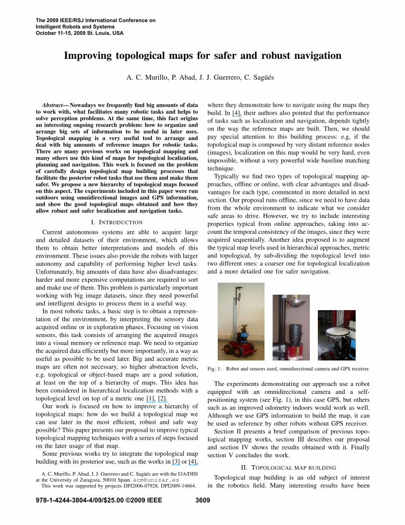
A few examples of the grouping obtained after theseclustering steps are shown in Fig. 2.
Fig. 2. Two of the clusters obtained for the datasets used in the experiments.
B. Second level of the topological map: the navigation map.
Second issue dealt with this approach is to determinethe connectivity among cluster representative images, clustercentroids for short, and therefore the possibility of navigationbetween them. The goal is to establish possible trajectorypaths for the robot between the different reference locationsexplored (the different clusters). We need to decide whereand how many way-points are necessary, besides clustercentroids, to have a safe navigation graph. To obtain thisnavigation map, we take into account not only the visualinformation but also the positioning information from theGPS tags associated to the images.
1) Clusters similarity evaluation: first, a similarity evalua-tion between clusters is performed, according to the numberof local feature correspondences between the images thatcompose each of them, with a bonus if their GPS locationsare close to each other. More formally written, if Ca and Cb
are the set of images from clusters a and b respectively, thevisual similarity among those clusters V (a, b) is defined as
V (a, b) =
Pi∈Ca
Pj∈Cb
Sij
|Ca||Cb|, (3)
with |Ca| and |Cb| the number of elements in Ca and Cb andSij the elements of the similarity matrix built previously toperform the initial clustering, see eq. (2).
We first obtain the appearance similarity between clustersand then add a bonus B to it depending on the Euclideandistance, D(a, b), between centroid GPS locations of clustersa and b:
if D(a, b) < kDimg(|Ca| + |Cb|) then V (a, b) = V (a, b) + B,
with k a value between 0 and 1 depending on how strong wewant this filter to be, and Dimg the average distance betweenevery two consecutive images in our sequence.
2) Establishing connections: every couple of centroidsthat have a similarity V (a, b) over the established thresholdare considered connected, and this path is added as a newarc in the navigation graph.
To improve these initially established connections, twosimple additional filters are defined based on the GPS
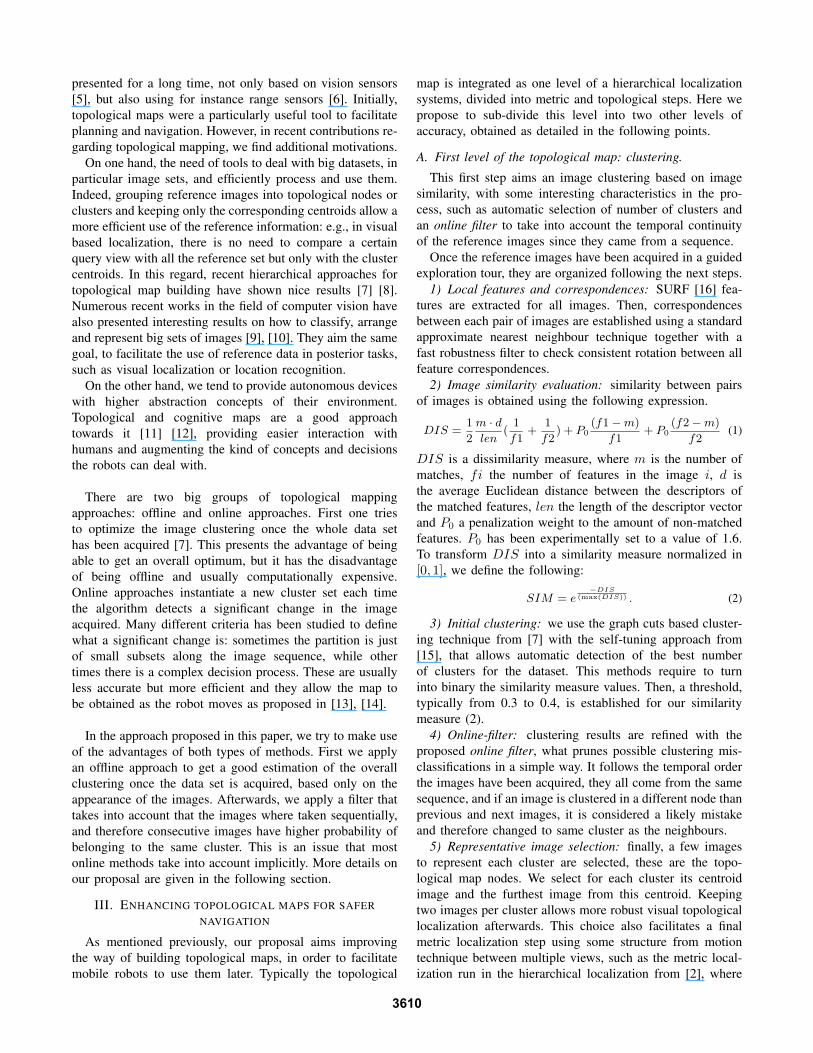
Fig. 3. Small example of the Split&Merge filter, to improve how a certainline segment fits to a trajectory.
measurements. The first one analyzes the distance betweenthe two most similar images we can find taking one fromeach cluster of a certain connection. If this distance is toobig, we break the connection between these clusters.
The second filter checks that the following condition istrue for every pair of connected clusters:
D(a, b) < Dimg · (|Ca|+ |Cb|). (4)
In simple words, it checks that the distance between twocluster centroids is below the maximum possible theoreticaldistance: according to the average separation between twoconsecutive images in the original sequence Dimg multipliedby the total number of images in both clusters |Ca|+ |Cb|.
3) Establishing safe way-points through a Split&Mergealgorithm: finally a process is run to adjust the navigationgraph arcs, allowed trajectories, to previously visited paths.Here the arcs are fitted as close as possible to the trajectoriesfollowed in supervised exploration since we know those aresafe terrain. This way we can avoid our robot to navigateinto dangerous surfaces, not easy to detect with typicalreactive navigation systems, such as water, dense grass orsmall stones areas. To achieve this, we apply the well knowSplit&Merge algorithm for line fitting [17] to the set of pointscomposed by the GPS locations of the reference images usedto build the map. Fig. 3 shows a brief example on howthis algorithm improves an initial line set to fit better to aparticular point set, establishing as many extra segments asnecessary. More details on results obtained with this filtercan be seen in the experimental section.
IV. EXPERIMENTAL RESULTS
This section presents several experiments to test our pro-posal in a real campus outdoor environment. All experimentswere performed around the same area to facilitate the local-ization and navigation tests with our robots on the same areasthe topological maps were built. Three different datasetswere acquired in this environment. All of them consistof a sequence of omnidirectional images, acquired with aconventional camera pointing to an hyperbolic mirror (seeFig. 1), and the GPS tag associated to each image, acquiredwith a differential GPS sensor. Note the GPS signal is notalways very accurate when navigating close to buildings butmost of the time it helps a lot for building an improved map.The datasets used are:
CPS1: 130 images acquired during a 200 m. loop.CPS2: 135 images from an open trajectory of around
240 m. Only every 5th image is used to build the map.CPS3: 306 images acquired during a more complex tra-
jectory of around 500 m, with several loops included.
3611
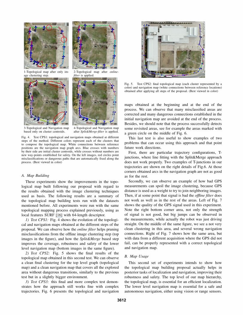
1-Topological map after only im-age clustering step.
2-Topological map after online-filter is applied.
3-Topological and Navigation mapbased only on cluster centroids.
4-Topological and Navigation mapafter Split&Merge-filter is applied.
Fig. 4. Test CPS1: topological and navigation maps obtained at differentsteps of the method. Different colors represent each of the clusters thatto compose the topological map. White connections between referencepositions are the navigation map graph arcs. Blue crosses with numbersby their side are initial cluster centroids, while crosses without numbers arenew way-points established for safety. On the left images, red circles pointmisclassifications or dangerous paths that are automatically fixed along theprocess. (Best viewed in color)
A. Map Building
These experiments show the improvements in the topo-logical map built following our proposal with regard tothe results obtained with the image clustering techniquesused as basis. The following results are a summary ofthe topological map building tests run with the datasetsmentioned before. All experiments were run with the sametopological mapping process explained previously, using aslocal features SURF [16] with 64-length descriptor.
1) Test CPS1: Fig. 4 shows the evolution of the topologi-cal and navigation maps obtained at the different steps of theproposal. We can observe how the online filter helps pruningmisclassifications from the offline image clustering step (topimages in the figure), and how the Split&Merge based stepimproves the coverage, robustness and safety of the lowerlevel navigation map (bottom images in the same figure).
2) Test CPS2: Fig. 5 shows the final results of thetopological map obtained in this second test. We can observea clean final clustering for the top level graph (topologicalmap) and a clean navigation map that covers all the exploredarea without dangerous transitions, similarly to the previoustest but in a slightly bigger environment.
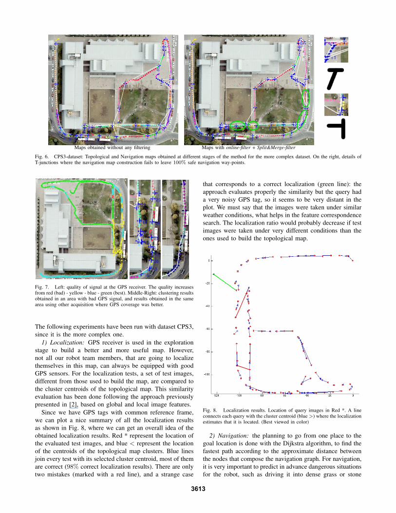
3) Test CPS3: this final and more complex test demon-strates how the approach still works fine with complextrajectories. Fig. 6 presents the topological and navigation
Fig. 5. Test CPS2: final topological map (each cluster represented by acolor) and navigation map (white connections between reference locations)obtained after applying all steps of the proposal. (Best viewed in color)
maps obtained at the beginning and at the end of theprocess. We can observe that many misclassified areas arecorrected and many dangerous connections established in theinitial navigation map are avoided at the end of the process.Besides, we should note that the process successfully detectssome revisited areas, see for example the areas marked witha green circle on the middle of Fig. 6.
This last test is also useful to show examples of twoproblems that can occur using this approach and that pointfuture work directions.
First, there are particular trajectory configurations, T-junctions, where line fitting with the Split&Merge approachdoes not work properly. Two examples of T-junctions in ourtrajectories are shown on the right details of Fig.6. At thosecorners obtained arcs in the navigation graph are not as goodas for the rest.
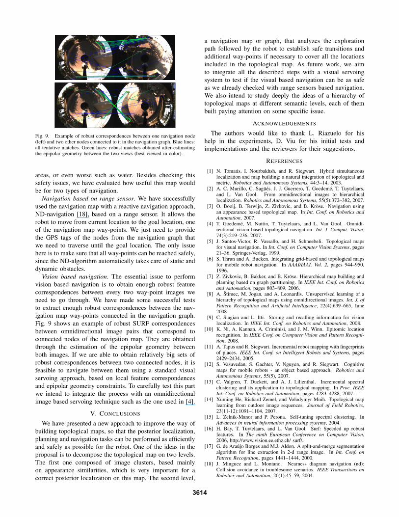
Secondly, we can observe an example of how bad GPSmeasurements can spoil the image clustering, because GPSdistance is used as a weight to try to join neighboring images.Then, if at some point that signal is bad the offline filter doesnot work as well as in the rest of the areas. Left of Fig. 7shows the quality of the GPS signal used in this experiment.Note the right bottom corner area, not only the strengthof signal is not good, but big jumps can be observed inthe measurements, while actually the robot was just drivingstraight. On the middle of the same figure, we see a not veryclean clustering in this area, and several wrong navigationconnections. Right of Fig. 7 shows how the same area, butwith data from a different acquisition where the GPS did notfail, can be properly represented with a correct topologicaland navigation map.
B. Map Usage
This second set of experiments intends to show howthe topological map building proposal actually helps inposterior tasks of localization and navigation, improving theirrobustness and safety. The top level of our map hierarchy,the topological map, is essential for an efficient localization.The lower level navigation map is essential for a safe andautonomous navigation, either using vision or range sensors.
3612
Maps obtained without any filtering Maps with online-filter + Split&Merge-filter
Fig. 6. CPS3-dataset: Topological and Navigation maps obtained at different stages of the method for the more complex dataset. On the right, details ofT-junctions where the navigation map construction fails to leave 100% safe navigation way-points.
Fig. 7. Left: quality of signal at the GPS receiver. The quality increasesfrom red (bad) - yellow - blue - green (best). Middle-Right: clustering resultsobtained in an area with bad GPS signal, and results obtained in the samearea using other acquisition where GPS coverage was better.
The following experiments have been run with dataset CPS3,since it is the more complex one.
1) Localization: GPS receiver is used in the explorationstage to build a better and more useful map. However,not all our robot team members, that are going to localizethemselves in this map, can always be equipped with goodGPS sensors. For the localization tests, a set of test images,different from those used to build the map, are compared tothe cluster centroids of the topological map. This similarityevaluation has been done following the approach previouslypresented in [2], based on global and local image features.
Since we have GPS tags with common reference frame,we can plot a nice summary of all the localization resultsas shown in Fig. 8, where we can get an overall idea of theobtained localization results. Red * represent the location ofthe evaluated test images, and blue < represent the locationof the centroids of the topological map clusters. Blue linesjoin every test with its selected cluster centroid, most of themare correct (98% correct localization results). There are onlytwo mistakes (marked with a red line), and a strange case
that corresponds to a correct localization (green line): theapproach evaluates properly the similarity but the query hada very noisy GPS tag, so it seems to be very distant in theplot. We must say that the images were taken under similarweather conditions, what helps in the feature correspondencesearch. The localization ratio would probably decrease if testimages were taken under very different conditions than theones used to build the topological map.
Fig. 8. Localization results. Location of query images in Red *. A lineconnects each query with the cluster centroid (blue >) where the localizationestimates that it is located. (Best viewed in color)
2) Navigation: the planning to go from one place to thegoal location is done with the Dijkstra algorithm, to find thefastest path according to the approximate distance betweenthe nodes that compose the navigation graph. For navigation,it is very important to predict in advance dangerous situationsfor the robot, such as driving it into dense grass or stone
3613
200 400 600 800 1000 1200 1400 1600 1800 2000
100
200
300
400
500
600
700
Fig. 9. Example of robust correspondences between one navigation node(left) and two other nodes connected to it in the navigation graph. Blue lines:all tentative matches. Green lines: robust matches obtained after estimatingthe epipolar geometry between the two views (best viewed in color).
areas, or even worse such as water. Besides checking thissafety issues, we have evaluated how useful this map wouldbe for two types of navigation.
Navigation based on range sensor. We have successfullyused the navigation map with a reactive navigation approach,ND-navigation [18], based on a range sensor. It allows therobot to move from current location to the goal location, oneof the navigation map way-points. We just need to providethe GPS tags of the nodes from the navigation graph thatwe need to traverse until the goal location. The only issuehere is to make sure that all way-points can be reached safely,since the ND-algorithm automatically takes care of static anddynamic obstacles.
Vision based navigation. The essential issue to performvision based navigation is to obtain enough robust featurecorrespondences between every two way-point images weneed to go through. We have made some successful teststo extract enough robust correspondences between the nav-igation map way-points connected in the navigation graph.Fig. 9 shows an example of robust SURF correspondencesbetween omnidirectional image pairs that correspond toconnected nodes of the navigation map. They are obtainedthrough the estimation of the epipolar geometry betweenboth images. If we are able to obtain relatively big sets ofrobust correspondences between two connected nodes, it isfeasible to navigate between them using a standard visualservoing approach, based on local feature correspondencesand epipolar geometry constraints. To carefully test this partwe intend to integrate the process with an omnidirectionalimage based servoing technique such as the one used in [4].
V. CONCLUSIONS
We have presented a new approach to improve the way ofbuilding topological maps, so that the posterior localization,planning and navigation tasks can be performed as efficientlyand safely as possible for the robot. One of the ideas in theproposal is to decompose the topological map on two levels.The first one composed of image clusters, based mainlyon appearance similarities, which is very important for acorrect posterior localization on this map. The second level,
a navigation map or graph, that analyzes the explorationpath followed by the robot to establish safe transitions andadditional way-points if necessary to cover all the locationsincluded in the topological map. As future work, we aimto integrate all the described steps with a visual servoingsystem to test if the visual based navigation can be as safeas we already checked with range sensors based navigation.We also intend to study deeply the ideas of a hierarchy oftopological maps at different semantic levels, each of thembuilt paying attention on some specific issue.
ACKNOWLEDGEMENTS
The authors would like to thank L. Riazuelo for hishelp in the experiments, D. Viu for his initial tests andimplementations and the reviewers for their suggestions.
REFERENCES
[1] N. Tomatis, I. Nourbakhsh, and R. Siegwart. Hybrid simultaneouslocalization and map building: a natural integration of topological andmetric. Robotics and Autonomous Systems, 44:3–14, 2003.
[2] A. C. Murillo, C. Sagues, J. J. Guerrero, T. Goedeme, T. Tuytelaars,and L. Van Gool. From omnidirectional images to hierarchicallocalization. Robotics and Autonomous Systems, 55(5):372–382, 2007.
[3] O. Booij, B. Terwijn, Z. Zivkovic, and B. Krose. Navigation usingan appearance based topological map. In Int. Conf. on Robotics andAutomation, 2007.
[4] T. Goedeme, M. Nuttin, T. Tuytelaars, and L. Van Gool. Omnidi-rectional vision based topological navigation. Int. J. Comput. Vision,74(3):219–236, 2007.
[5] J. Santos-Victor, R. Vassallo, and H. Schneebeli. Topological mapsfor visual navigation. In Int. Conf. on Computer Vision Systems, pages21–36. Springer-Verlag, 1999.
[6] S. Thrun and A. Bucken. Integrating grid-based and topological mapsfor mobile robot navigation. In AAAI/IAAI, Vol. 2, pages 944–950,1996.
[7] Z. Zivkovic, B. Bakker, and B. Krose. Hierarchical map building andplanning based on graph partitioning. In IEEE Int. Conf. on Roboticsand Automation, pages 803–809, 2006.
[8] A. Stimec, M. Jogan, and A. Leonardis. Unsupervised learning of ahierarchy of topological maps using omnidirectional images. Int. J. ofPattern Recognition and Artificial Intelligence, 22(4):639–665, June2008.
[9] C. Siagian and L. Itti. Storing and recalling information for visionlocalization. In IEEE Int. Conf. on Robotics and Automation, 2008.
[10] K. Ni, A. Kannan, A. Criminisi, and J. M. Winn. Epitomic locationrecognition. In IEEE Conf. on Computer Vision and Pattern Recogni-tion, 2008.
[11] A. Tapus and R. Siegwart. Incremental robot mapping with fingerprintsof places. IEEE Int. Conf. on Intelligent Robots and Systems, pages2429–2434, 2005.
[12] S. Vasuvedan, S. Gachter, V. Nguyen, and R. Siegwart. Cognitivemaps for mobile robots - an object based approach. Robotics andAutonomous Systems, 55(5), 2007.
[13] C. Valgren, T. Duckett, and A. J. Lilienthal. Incremental spectralclustering and its application to topological mapping. In Proc. IEEEInt. Conf. on Robotics and Automation, pages 4283–4288, 2007.
[14] Xuming He, Richard Zemel, and Volodymyr Mnih. Topological maplearning from outdoor image sequences. Journal of Field Robotics,23(11-12):1091–1104, 2007.
[15] L. Zelnik-Manor and P. Perona. Self-tuning spectral clustering. InAdvances in neural information processing systems, 2004.
[16] H. Bay, T. Tuytelaars, and L. Van Gool. Surf: Speeded up robustfeatures. In The ninth European Conference on Computer Vision,2006, http://www.vision.ee.ethz.ch/ surf/.
[17] G. de Araujo Borges and M.J. Aldon. A split-and-merge segmentationalgorithm for line extraction in 2-d range image. In Int. Conf. onPattern Recognition, pages 1441–1444, 2000.
[18] J. Minguez and L. Montano. Nearness diagram navigation (nd):Collision avoidance in troublesome scenarios. IEEE Transactions onRobotics and Automation, 20(1):45–59, 2004.
3614


Foreword We offer a warm welcome to all of the attendees of the 2009 IEEE/RSJ International Conference on Intelligent Robots and Systems (IROS2009). This is a conference that over the years has established itself as a truly global enterprise of major technical importance. Our conference venue is St. Louis, Missouri located on the Mississippi River. St. Louis is the historical gateway to the West during the early years of growth and expansion in the United States. Crossing the Mississippi was the demarcation from east to west for early pioneers embarking on new hopes and horizons in the unsettled regions to the west. Building on this history, the conference theme is “Exploring New Horizons in Intelligent Robots and Systems.” Indeed, most think of IROS as a conference where an attractive blend of recent results encompassing basic through applied research can be viewed. We believe this year’s technical program offers just that.
Even under the current conditions of global economic stress, IROS 2009 continues the tradition of wide interest and participation from all over the world. 1599 papers were submitted from 53 countries. After a rigorous review process, 936 papers were accepted for presentation at the conference. The technical program consists of three plenary talks, 192 technical sessions in 16 tracks, 18 tutorials/workshops, and 13 video presentations. Session technical topics cover the full gamut from emerging areas of interest to more traditional subject areas within intelligent systems and robots. Some of the largest contributions have occurred in areas such as robot audition, biological inspiration, haptics, human-robot interactions, humanoids, medical robotics, and rehabilitation robotics. Like all recent IROS’s, you face a challenge to navigate amongst the 16 tracks to hear the papers you are most interested. We have prepared this digest to assist you as much as possible in this challenge. We sincerely hope that you enjoy the conference, and that it provides you with useful and important information about current research.
We would like to thank all of the members of the IROS 2009 Organizing Committee for their contributions. It takes a dedicated team to be able to accomplish a conference of this size, and we are grateful to each of the committee members who have dedicated so much of their time and effort to IROS 2009. Finally, our thanks to all of the authors and participants who provide the intellectual exchanges that are the essence of IROS.
Ning Xi, General Chair William R. Hamel, Program Chair
Related Documents