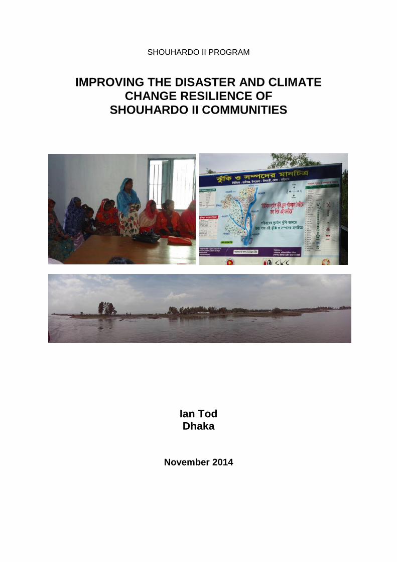
SHOUHARDO II PROGRAM IMPROVING THE DISASTER AND CLIMATE CHANGE RESILIENCE OF SHOUHARDO II COMMUNITIES Ian Tod Dhaka November 2014

Welcome message from author
This document is posted to help you gain knowledge. Please leave a comment to let me know what you think about it! Share it to your friends and learn new things together.
Transcript
SHOUHARDO II PROGRAM
IMPROVING THE DISASTER AND CLIMATE CHANGE RESILIENCE OF
SHOUHARDO II COMMUNITIES
Ian Tod Dhaka
November 2014

Improving the Disaster and Climate Change Resilience of SHOUHARDO II Communities
13 November 2014 2
Improving the Disaster and Climate Change Resilience of SHOUHARDO II Communities
13 November 2014 3
Improving the Disaster and Climate Change Resilience of SHOUHARDO II Communities
Executive Summary ................................................................................................. 5
Abbreviations and Acronyms ............................................................................... 10
1. Introduction ...................................................................................................... 11 1.1 Disasters, Climate Change and the Rural Poor .............................................................. 11 1.2 The SHOUHARDO II Program ................................................................................................. 12 1.3 Flood-related Hazards ............................................................................................................... 13 1.4 Erosion Hazard of the Char ..................................................................................................... 15 1.5 Other Major Physical Hazards ................................................................................................ 20 1.6 Objectives of this Study ............................................................................................................ 20 1.7 Methodology .................................................................................................................................. 21 1.8 Acknowledgements .................................................................................................................... 22
2. Disaster and Climate Risk Management Activities of the Program ............. 23 2.1 Background .................................................................................................................................... 23 2.2 Capacity Building ........................................................................................................................ 24
2.2.1 Overview ................................................................................................................................................ 24 2.2.2 Communities ........................................................................................................................................ 24 2.2.3 Union and Upazila ............................................................................................................................. 26 2.2.4 National Institutions .......................................................................................................................... 27 2.2.5 Flood Forecasting and Warnings ............................................................................................... 27
2.3 Contingency Systems ................................................................................................................ 30 2.4 Climate Change Adaptation Measures ............................................................................... 30
2.4.1 Background ........................................................................................................................................... 30 2.4.2 Measures Specifically designed for Climate Change Adaptation.............................. 30 2.4.3 Infrastructure ........................................................................................................................................ 31 2.4.4 DCRM Activities .................................................................................................................................. 35 2.4.5 Support to Agriculture ...................................................................................................................... 35
2.5 Women’s Empowerment ........................................................................................................... 55 2.6 Integration of DCRM within SHOUHARDO II ................................................................... 56
3. Key Findings of the Study............................................................................... 57 3.1 Flood Damages ............................................................................................................................ 57 3.2 Flood Warning System ................................................................................................................ 61 3.3 Response to the Cold Wave ....................................................................................................... 62 3.4 Current Climate and Climate Change ................................................................................. 63
4. Conclusions and Recommendations ............................................................. 65 4.1 What Worked well ........................................................................................................................ 65 4.2 What did not work so well ........................................................................................................ 67 4.2 Overall Conclusion ...................................................................................................................... 68 4.4 Recommendations ...................................................................................................................... 68
References .............................................................................................................. 70
Annex 1 Terms of Reference ................................................................................. 73
Annex 2 Key Informants ........................................................................................ 81
Annex 3 Participants and Locations of Discussions and Sites Visited ............. 84
Annex 4 Discussion Note on the Flood Forecasting Models ............................. 88
Improving the Disaster and Climate Change Resilience of SHOUHARDO II Communities
13 November 2014 4
List of Tables
Table 1.1 Overall Goal and Strategic Objectives of SHOUHARDO II Error! Bookmark not defined. Table 1.2 Flood-related Hazards of the SHOUHARDO II Program Error! Bookmark not defined. Table 2.1 Comparison of Probabilistic and Deterministic Flood Forecasting Models ............. 28 Table 2.3 Grants Available to PEP households ............................................................................ 36 Table 2.4 Agricultural Activities in SHOUHARDO II ..................................................................... 55 Table 2.4 Agricultural Activities in SHOUHARDO II ..................................................................... 55 Table 3.1 Flood Damages in Program Areas ................................................................................. 59
List of Figures
Figure 1.1 Landforms beside and within Main River Channel ................................................... 14 Figure 1.2 Village Map prepared by Rahmatpur VDC, Jatrapur Union, Kurigram Sadar ........ 17 Figure 1.3 Changes in Char formation in Rahmatpur, Jatrapur Union, Kurigram ................... 18 Figure 1.4 Changes in River bank at Mollikpara, Maijbari Union, Kazipur ................................ 19 Figure 1.5 Methodological Framework ........................................................................................ 21 Figure 2.1 Conceptual Framework of DCRM in SHOUHARDO II ................................................ 23 Figure 2.2 Incorporation of CVCA outputs into Union Planning ................................................ 26 Figure 2.3 10-day Water Level Forecast for Kazipur on the Jamuna River. ............................. 29 Figure 3.1 Timeline Showing the Impact of Disasters on Family Wellbeing .............................. 60 Figure 3.2. 184 years of Rainfall in Calcutta. .................................................................................. 64
Improving the Disaster and Climate Change Resilience of SHOUHARDO II Communities
13 November 2014 5
Executive Summary 1. INTRODUCTION Disasters, Climate Change and the Rural Poor S1 Disasters are a major contributor to entrapping poor and extremely poor (PEP) households in poverty and food insecurity. Disasters can reverse or shatter years of development in a very short period, and development gains are not sustainable without addressing disaster risks. The SHOUHARDO II Program S2 SHOUHARDO II Program focuses on improving food security and solving the underlying causes that include social injustice and discrimination, lack of participation and voice, and heightened vulnerability to natural disasters and climate change. The overall goal is to transform the lives of 370,000 Poor and Extreme Poor (PEP) households (HH) in 11 of the poorest and marginalized districts in Bangladesh by reducing their vulnerability to food insecurity. Objectives of the Study S3 The purpose of the Study is to capture the effectiveness of capacity building, contingency systems and the climate change adaptation measures; document samples of all climate change adaptation interventions; demonstrate how the various interventions contributed to food security and women’s empowerment and provide recommendations for the possible adaptation of new innovative climate change interventions. Methodology S4 The methodology for the Study was primarily qualitative except where secondary data was available. The approach included initial review and familiarization; group discussions with key stakeholders and key informant interviews. Group discussions were held with 10 Village Development Committees (VDCs), 7 Partner Non-Government Organisations (PNGOs), 6 Union Parishads/Union Disaster Management Committees (UMDCs), 1 Upazila Disaster management Committee (UzDMC), 2 Direct Delivery Teams, 4 Regional Offices and 1 School Based Teenager Brigade (SBTB). In addition, Key Informant Interviews (KII) were held with PEP households including recipients of improved stoves, recipients of Program grants for activities such as improved rice varieties, keyhole gardens and comprehensive homestead gardens and beneficiaries of the Program’s Disaster and Climate Risk Management (DCRM) activities including flood warnings and infrastructure.
2 DISASTER AND CLIMATE RISK MANAGEMENT ACTIVITIES OF THE PROGRAM
Background S5 SHOUHARDO II is a very extensive Program, undertaking a broad range of activities in different environments throughout the country. Communities in Bangladesh face numerous hazards that can become disasters, resulting in major challenges PEP households to develop their resilience and great hardship when disasters strike. Capacity Building S6 SHOUHARDO II focused its capacity building efforts on communities and local government institutions, at mainly the union level and to lesser extent at the upazila level. In addition, SH-II worked with CARE-Bangladesh at a national level to develop organisations involved in DCRM, including the Department of Disaster Management and Bangladesh Water Development Board’s (BWDB) Flood Forecast Warning Centre. S7 Village Development Committees (VDCs) were trained in community based planning and in the use of Climate Vulnerability and Capacity Analysis (CVCA). The outcome of the
Improving the Disaster and Climate Change Resilience of SHOUHARDO II Communities
13 November 2014 6
planning was a range of maps, tables and charts that were used to prepare the Community Action Plan (CAP). S8 The Program worked with Union Parishads to develop Union Disaster Management Committees (UDMC) and Union Disaster Volunteers (UDVs). Support was also given to develop Upazila Disaster Management Committees (UzDMC). Support provided to UDMC include training on DCRM; use of the search and rescue equipment provided and training for Union Disaster Volunteers (UDVs) on disaster preparedness, contingency planning, search and rescue. S9 At a national level SHOUHARDO II participated along with CARE-Bangladesh on several national forums including the National Disaster Management Advisory Committee (NDMAC); the Department of Disaster Management (DDM) and the Ministry of Disaster Management and Relief (MODMR); UN Clusters for Emergency Response and Joint Needs Assessment. S10 The Program followed on from work started in SHOUHARDO I by providing support to Regional Integrated Multi-Hazard Early Warning System (RIMES) in collaboration with BWDB’s Flood Forecasting and Warning Centre (FFWC) to expand and further develop 10-day flood forecasts and flash flood forecasts. RIMES also disseminated flood forecasts by emails and SMS texts. Contingency Plans S11 Contingency plans were prepared by the VDC as part of community based planning, and also by the Union Parishad as part of the Union Disaster Management Plan (UDMP). Contingency plans prepared VDCs included various information including at risk households; Village resources; Delegation of responsibilities; and contact details for key personnel and service providers. Climate Change Adaptation Measures S12 As a cross cutting issue, DCRM affects all SHOUHARDO II strategic objectives hence all Program activities are affected by Disaster Risk reduction (DRR) and Climate Change Adaptation (CCA) to some extent. Some activities were specifically designed with climate change in mind while other activities were modified to address disaster or climate change issues. S13 Measures specifically designed for Climate Change Adaptation (CCA) include Climate Vulnerability and Capacity Analysis (CVCA); provision of improved stoves for cooking; Floating Gardens; and tree planting. S14 SHOUHARDO II funded a range of infrastructure for DRR and CCA (construction of raised homesteads, School-cum-Flood Shelters and village protection walls, renovation of cyclone shelters), communications (maintenance of roads and footpaths, and construction of bridges and culverts), water supply (installation of tubewells, tubewell platforms), sanitation (low cost household latrines, latrines in schools and public places), and capacity building (Community Resource Centres (CRC), Early Childhood Care and Development (ECCD) renovation). Infrastructure requirements were identified from CAPs and DMPs. S15 SHOUHARDO II also addresses disaster and climate issues through livestock vaccination, SBTB, awareness raising with Enhancement Knowledge and Transformation Action (EKATA) groups and Mothers Groups and testing for arsenic in all tubewells in SHOUHARDO II villages. S16 Support to agriculture and other Income Generating Activities (IGA) aimed at improving PEP livelihoods is the main activity of the Program The main investments made in

Improving the Disaster and Climate Change Resilience of SHOUHARDO II Communities
13 November 2014 7
agriculture by PEP households that are related to DRR and CCA include comprehensive homestead development; keyhole gardens; flood tolerant, late, short duration and drought tolerant rice varieties; floating gardens; improved agricultural technologies; diversification of rabi crops; Cage Aquaculture for Greater Economic Security (CAGES) fisheries and support to capture and culture fisheries. Empowerment S17 Ways in which SO-5 activities supported SO-3 included: ensuring that 50% of the UDVs were women; ensuring that there was a balance of male and female members in the VDC and office bearers were shared between men and women; targeting female-headed households for emergency relief; preparing training materials on disaster preparedness and disaster response for EKATA and Mothers Groups; ensuring at least two women members on UDMC; and ensuring women involvement in infrastructure construction.
3 KEY FINDINGS OF THE STUDY Flood Environments S18 SHOUHARDO works in 8 different flood environments (Island Char, Attached Char, Protected Mainland, Moderately Flooded Beels, Deeply Flooded Haor, Floodplain, Flash Flood, and Coastal) even though the Program was designed for the char, haor and coastal environments. Each of the 8 flood environments has distinct characteristics and improving the flood resilience of communities requires different priorities to be addressed. The Char Environment S19 Chars are mid-channel islands located within the active channels of the major rivers. The char environment is very harsh and is subject to numerous natural hazards including severe river flooding, erosion and drought. The landform of the chars is dynamic due to ever-present threat and occurrence of erosion. Char communities have adjusted to some extent to account to the threat of erosion, but erosion has the potential to undermine if not destroy the disaster and climate resilience of char communities. Flood damages S20 During August 2014 there were significant floods of the major northern rivers resulting in major damages to chars and adjacent mainland in 4 districts (Kurigram, Bogra, Jamalpur and Pabna). 178,575 households living in 780 villages were affected by the floods, and 52,986 ha of crops (mainly aman rice) were destroyed or damaged. 11,955 houses were destroyed and 42,587 houses were partially damaged. In addition, the floods caused erosion of homesteads, buildings and farmland; loss of employment opportunities; loss of fisheries. disruption of transport, loss of safe sanitation; contamination of safe drinking water supplies and waterlogging of fuel and fodder. The 2014 flood was the only major riverine flood event during SHOUHARDO II. Disaster Response S21 The only other Program-wide disaster during SHOUHRDAO II was the cold wave in January 2013. The Program responded by distributing 20,000 blankets to 11,572 households. Flood warning system S22 A reliable flood forecasting and warning system has been developed by the Flood Forecasting and Warning Centre (FFWC) of BWDB. The traditional 3-day deterministic forecast has been extended successfully to 5-days,with support from the Comprehensive Disaster Management Programme (CDMP) and the reliability of the 10-day probabilistic medium-range forecast was improved with support from Regional Integrated Multi-Hazard Early Warning System (RIMES) and SHOUHARDO II. The dissemination and response elements of the flood warning system in riverine areas, developed by FFWC, the Ministry of Disaster Management and Relief (MoDMR) and local government institutions, are less
Improving the Disaster and Climate Change Resilience of SHOUHARDO II Communities
13 November 2014 8
developed and problems persist with communities unable to receive or understand flood warnings in a timely way. More work is required to ensure that dissemination is effective and households are able to respond to the warnings received. The cyclone warning system in coastal areas is more developed and functioned well in 2013 when Cyclone Mahasen threatened. Current Climate and Climate Change S23 SHOUHARDO II identified climate change adaptations by asking communities how the climate was changing and then providing solutions to help them adapt. There was a shortage of analysis to determine if the famers’ perceptions were supported by climate data or advice on how the climate may be changing in the longer term. There is a lack of agreement about how the climate is changing in Bangladesh. One study based on climatic and hydrological analyses shows that there is no systematic increase in the incidence or variability of drought, floods or cyclones in Bangladesh in the past 50 years (Brammer 2014). Another study shows that temperatures are increasing but that there are no significant trends with changes with rainfall (CDMP 2013). Better understanding of how the climate is changing is required to be able to verify farmers’ perceptions of climate change and identify suitable climate change adaptations. Possible climate change adaptations include the system of rice intensification and participatory varietal selection. S24 In coastal areas, recent estimates indicate that the sea level is currently rising at 1.3 mm/year, that is by 13 mm (= 0.5 inch) in 10 years, in which case sea level rise may be balanced by sedimentation carried by the main rivers. Climate adaptation measures in coastal areas include: managing coastal embankments in ways that allow silt-laden tidal water to enter; promote raised beds or platforms on which to grow appropriate crops; promoting fish farming in perennially flooded areas and re-establishing mangrove forests to protect the coastline, enhance sedimentation and fish production.
4. CONCLUSIONS AND RECOMMENDATIONS What worked well Capacity Building (Activation of UMDCs and UDVs; Increased community awareness of climate change; Flood forecasting; Flood preparedness; Emergency response) Contingency Planning (UDMC and VDC Contingency Plans) Climate Change Adaptation Measures (Improved stoves, infrastructure, DCRM activities and Support to Agriculture) Empowerment. (Involvement of women in disaster and climate risk management activities). What worked not so well Capacity Building (Dissemination and response to flood forecasts; Level of Technical Support and scientific analysis; Supporting communities to develop resilience to different Hazards).
Climate Change Adaptation Measures (Flood tolerant rice varieties; Access to
Sanitation; Access to Safe Drinking Water; Shelter; Identifying the need for lighting) Empowerment (not separating men and women to identify and prioritise hazards and actions) Overall conclusion SHOUHARDO II has increased the disaster and climate change resilience of PEP households, mainly with respect to disaster preparedness, awareness of climate and climate change issues, improved livelihoods, empowerment of women and access to services and local government institutions, but many PEP households are still vulnerable to major disasters such floods, erosion and cyclones
Improving the Disaster and Climate Change Resilience of SHOUHARDO II Communities
13 November 2014 9
Recommendations Capacity Building.
Simplify the Community Based Adaptation (CBA)/CVCA processes by identifying the key information actually used to prepare Community Action Plans.
Provide more scientific analysis and technical support.
Develop and implement program strategies to address different hazards, especially erosion.
Further support dissemination of flood forecasts and warnings and flood response
Allocating funds for emergency use to PNGOs and local government institutions (unions).
Climate Change Adaptation
Develop a strategy to spread the use of improved stoves.
Develop strategy to improve lighting options for PEP households
Continue developing strategies for enhancing agricultural livelihoods of PEP households including the promotion of adaptive/smart technologies.
Prepare a manual on the planning, design and construction of village protection walls.
Undertake a study to determine why char households do not use their own resources to invest in homestead raising and to identify ways to make homestead raising sustainable.
Develop and implement a strategy to improve the shelter (houses) of PEP families
Women’s Empowerment
Ensure separation of men and women when prioritising hazards and actions
Develop and implement a strategy for safe sanitation
Develop and implement a strategy to improve lighting in PEP households including assessing the scope for promoting of solar lamps.
Improving the Disaster and Climate Change Resilience of SHOUHARDO II Communities
13 November 2014 10
Abbreviations and Acronyms BMD Bangladesh Meteorological Department BRRI Bangladesh Rice Research Institute BWDB Bangladesh Water Development Board CAGES Cage Aquaculture for Greater Economic Security CAP Community Action Plan CARE-BD CARE Bangladesh CBDM Community Based Disaster Management CBA Community Based Adaptation CCA Climate Change Adaptation CDMP Comprehensive Disaster Management Programme CLP Chars Livelihood Programme CLTS Community Led Total Sanitation CRC Community Resource Centre CVCA Climate Vulnerability and Capacity Analysis DCRM Disaster and Climate Risk Management DD Direct Delivery (by CARE-BD) DDM Department of Disaster Management DRR Disaster Risk Reduction ECCD Early Childhood Care and Development ECMWF European Commission Medium Weather Forecast EKATA Empowerment Knowledge and Transformative Action FFWC Flood Forecasting Warning Centre FGD Focus group Discussions IGA Income Generating Activity KII Key Informant Interviews LCS Labour Contracting Society LGED Local Government Engineering Department MoDMR Ministry of Disaster Management and Relief MPW Mound Protection Wall MTR Mid-Term Review NDMAC National Disaster Management Advisory Committee PEP Poor and Extremely Poor PIC Project Implementation Committee PNGO Partner Non-Government Organisation PPR Peste de Petits Ruminants (also known as ‘goat plague’) RHS Raised Homestead RIMES Regional Integrated Multi-Hazard Early Warning System SBTB School Based Teenager Brigade SH-II SHOUHARDO II SO Strategic Objective SOD Standing Order on Disasters UDMC Union Disaster Management Committee UDMP Union Disaster Management Plan UDV Union Disaster Volunteer UISC Union Information Service Centre UNISDR United Nations International Strategy for Disaster Reduction UP Union Parishad UPC Union Parishad Chairman UzDMC Upazila Disaster Management Committee USAID United Sates Agency for International Development UzDMC Upazila Disaster Management Committee VDC Village Development Committee

Improving the Disaster and Climate Change Resilience of SHOUHARDO II Communities
13 November 2014 11
1. Introduction
1.1 Disasters, Climate Change and the Rural Poor Disasters are a major contributor to entrapping poor and extremely poor (PEP) households in poverty and food insecurity, as PEP households do not have the resources to be able to absorb the shocks and stresses caused by disasters. Disasters can reverse or shatter years of development in a very short period, and development gains are not sustainable without addressing disaster risks. Disaster risk reduction (DRR) is the concept and practice of reducing disaster risks through systematic efforts to analysis and management the causal factors of disasters including through reduced exposure to hazards, lessened vulnerability of people and property, wise management of land and the environment, and improved preparedness for adverse events (UNISDR 2009). A comprehensive approach to reduce disaster risks is set out in the Hyogo Framework for Action (UNISDR 2005). The Hyogo Framework for Action provides concrete guidelines for protecting lives, limiting damages and ensuring communities can recover quickly. Its five priorities are to:
make DRR a local and national priority
improve early warning systems
build a culture of safety and resilience using knowledge, innovation and education
reduce the underlying risk and factors
strengthen disaster preparedness for effective response. There are four cross cutting issues that are key to the success of DRR, namely:
implementing a multi-hazard approach
sensitivity to gender and culture
participation of communities and volunteers, and
capacity building and transfer of technologies between stakeholders. Many hazards faced by rural communities are related to uncertainties with the climate and severe weather events and for development to be sustainable the impact of climate change needs to be addressed. Climate change refers to any change in climate over time, whether due to natural variability or a result of human activity and may increase the frequency of hazards becoming disasters. Climate change adaptation (CCA) is the adjustment to natural or human systems in response to actual or expected climate stimuli or their effects, which moderates harm or exploits beneficial opportunities. The models that predict global climate changes are very large scale and the tools to interpret the results locally are still being developed. Hence, determining how climate change will affect the frequency and severity of future disasters is very challenging and requires the separation of short-term climate variability that can be determined from experience and analysis of weather records from long-term climate change trends that may severely disrupt future weather patterns.
Resilience is the ability of people, households, communities, countries, and systems to mitigate, adapt to, and recover from shocks and stresses in a manner that reduces chronic vulnerability and facilitates inclusive growth (USAID 2012). Shocks and stresses take many forms. Dramatic events such as floods, cyclones, or earthquakes can have a devastating, immediate impact. Stresses can take less apparent but insidious forms and often have more

Improving the Disaster and Climate Change Resilience of SHOUHARDO II Communities
13 November 2014 12
gradual onsets than shocks, including events such as drought, global economic volatility, or natural resource depletion. In areas of chronic poverty, for example, a simple increase in food prices can trigger significant underlying vulnerability and result in crisis. Conflict can be both a shock as well as an underlying source of stress that can make communities more vulnerable to other shocks when they hit. The actual impact of any given shock or set of stressors at the community level is largely determined by the magnitude of the hazard itself, combined with the vulnerability to the shock and the capacity of those affected to withstand them. In the most catastrophic case, a shock can completely overwhelm a community to the point of collapse. At a less extreme level, a society may eventually recover, but diminished livelihoods and resources may leave affected populations worse off and more vulnerable than before. A key challenge for development programs aimed at supporting PEP households to move out of poverty and achieving food security is to improve their resilience to disasters and climate change.
1.2 The SHOUHARDO II Program SHOUHARDO (Strengthening Household Ability to Respond to Development Opportunities) II Program focuses on addressing the availability, access, utilization and stabilization of food security and solving the underlying causes that include social injustice and discrimination, lack of participation and voice, and heightened vulnerability to natural disasters and climate change. The overall goal and strategic objectives of the Program are shown in Table 1.1. The five-year Multi-Year Assistance Program (MYAP) builds on previous phase (SHOUHARDO I) and is funded by USAID, the Government of Bangladesh and CARE
Table 1.1 Overall Goal and Strategic Objectives of SHOUHARDO II
Project title Strengthening Household Ability to Responding to
Development Opportunities (SHOUHARDO)
Overall Goal
Transform the lives of 370.000 Poor and Extreme Poor (PEP) households (HH) in 11 of the poorest and marginalized districts in Bangladesh by reducing their vulnerability to food insecurity
Strategic Objectives (SO)
(1) "Availability
of" and "access to" nutritious
foods enhanced
& protected for 370,000
PEP households
(2) Improve health, hygiene
and nutrition status of 281,000 children under 2 years of
age
(3) PEP
women and adolescent
girls empowered
in their families,
communities & UP
(4) Local elected
bodies & government
service providers
responsiveness &
accountability to the PEP increased
(5) Targeted
community members & government institutions are better
prepared for, mitigate, & respond to disasters &
adapt to climate change
Program Coverage 1573 communities of 172 unions under 31 upazilas of 11 districts of North Char, Mid Char, Haor and Coastal Areas of Bangladesh
Improving the Disaster and Climate Change Resilience of SHOUHARDO II Communities
13 November 2014 13
Strategic Objective SO-5 focuses specifically on Disaster and Climate Risk Management (DCRM) and has two Intermediate Results (IRs):
IR1 Disaster contingency systems in place and functioning and
IR2 Influence local and national humanitarian assistance initiatives. The Program recognises that SO-5 is a cross-cutting issue for all of SHOUHARDO-II’s strategic objectives and their related activities. SO-5 follows a comprehensive approach to risk reduction by improving disaster preparedness, response and recovery through capacity building of households, communities and local government institutions; improving livelihoods; constructing infrastructure; developing early warning systems as well as providing emergency relief. The program facilitates the implementation of the government’s Standing Orders on Disaster (SOD) by training and equipping Union Disaster Volunteers (UDV), by activating Union Disaster Management Committees (UDMC). SO5 acknowledge the importance of climate variability on the food security and livelihoods of PEP households through training Village Development Committees (VDC) on Climate Vulnerability and Capacity Analysis (CVCA) and identification of adaptive technologies. The SHOUHARDO II Program is funded by United States Agency for International Development (USAID) and the Government of Bangladesh and the Program’s total resource is about $128 million, comprising of cash and commodities. The Program operates in 1573 rural communities in 172 unions. 90% of the implementation is through 16 local Partner Non-Government Organisations (PNGOs) and the remaining 10% is through direct delivery by SHOUHARDO II staff. SHOUHARDO II builds on the experience of SHOUHARDO I and earlier food security initiatives. The Program operates in four regions: North and Middle Char, the Hoar and Coastal. Each of these four regions have their own unique environment, but are similar only in that communities are dominated by PEP households that are some of the most marginalised households in Bangladesh due to several factors including their remoteness, harshness of the environment and inequalities in the distribution of natural resources.
1.3 Flood-related Hazards Flooding is a perennial hazard for households living in riverine areas, causing loss of human life and significant damage and disruption to livelihoods, homesteads, infrastructure and agricultural production. SHOUHARDO II has four working area, namely the North Char, Middle Char, Haor and Coastal areas. The term ‘char’ has a specific meaning and refers to land within the active river channels of the major rivers, as shown in Figure 1.1. Similarly, the term ‘haor’ refers to land located in the Sylhet Depression in the north-east that is deeply flooded for 4-6 months of the year, and for the rest of the year the landscape is dry with open water confined to a few rivers and beels.

Improving the Disaster and Climate Change Resilience of SHOUHARDO II Communities
13 November 2014 14
Figure1.1 Landforms beside and within Main River Channel
SHOUHARDO I and its predecessors worked mainly with communities located on either island or attached chars, or in the haor or in coastal areas. SHOUHARDO II has moved away from these locations, and works with PEP communities located in a range of flood environments as shown in Table 1.2. Each of these flood environments has distinct flood-related hazards and improving the flood resilience of communities requires different priorities to be addressed. SHOUHARDO II was designed for the haor, char and coastal environments, and the priority needs of the other flood environments were not recognised. For example, there is much less demand for raised homesteads in protected flood plains where floods are a rare event as compared to chars where floods are almost an annual event.
Improving the Disaster and Climate Change Resilience of SHOUHARDO II Communities
13 November 2014 15
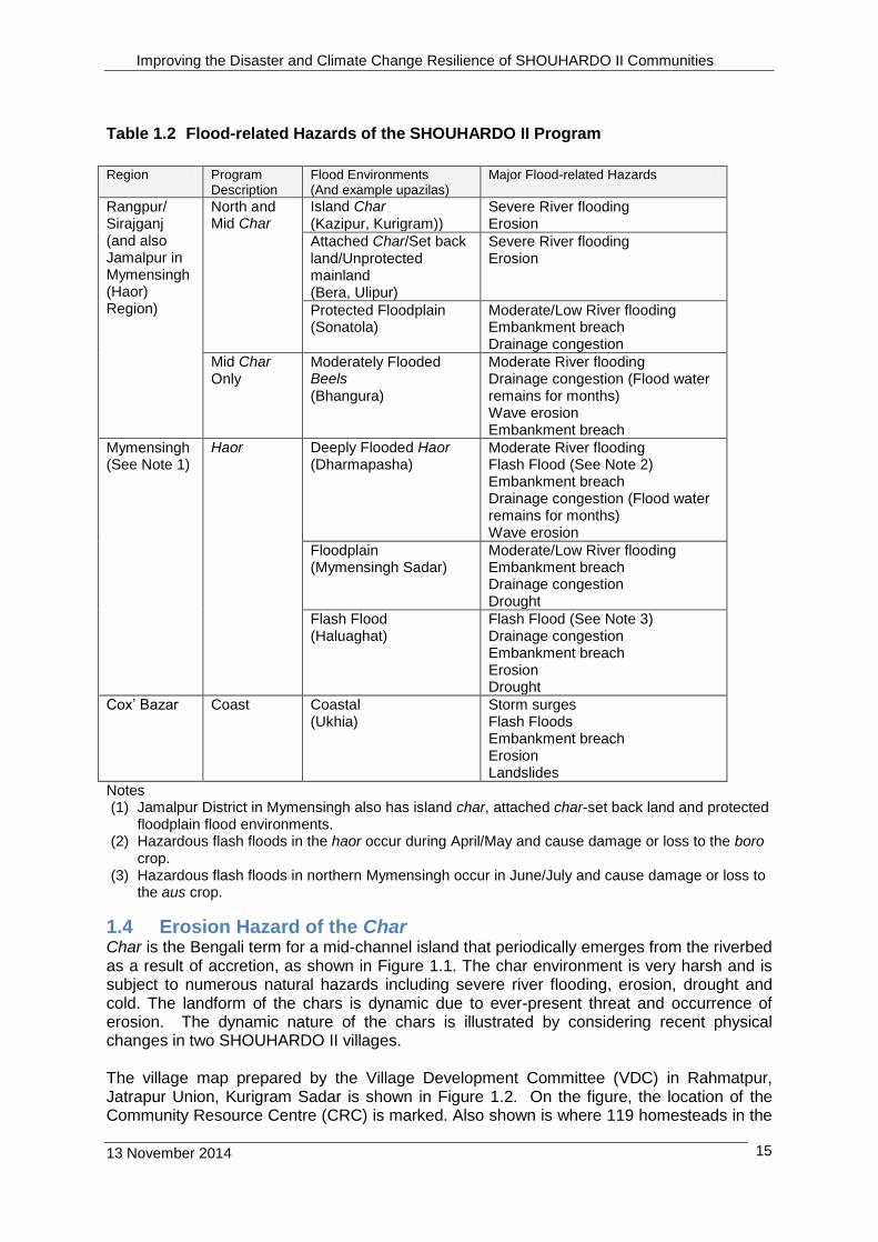
Table 1.2 Flood-related Hazards of the SHOUHARDO II Program
Region Program
Description Flood Environments (And example upazilas)
Major Flood-related Hazards
Rangpur/ Sirajganj (and also Jamalpur in Mymensingh (Haor) Region)
North and Mid Char
Island Char (Kazipur, Kurigram))
Severe River flooding Erosion
Attached Char/Set back land/Unprotected mainland (Bera, Ulipur)
Severe River flooding Erosion
Protected Floodplain (Sonatola)
Moderate/Low River flooding Embankment breach Drainage congestion
Mid Char Only
Moderately Flooded Beels (Bhangura)
Moderate River flooding Drainage congestion (Flood water remains for months) Wave erosion Embankment breach
Mymensingh (See Note 1)
Haor Deeply Flooded Haor (Dharmapasha)
Moderate River flooding Flash Flood (See Note 2) Embankment breach Drainage congestion (Flood water remains for months) Wave erosion
Floodplain (Mymensingh Sadar)
Moderate/Low River flooding Embankment breach Drainage congestion Drought
Flash Flood (Haluaghat)
Flash Flood (See Note 3) Drainage congestion Embankment breach Erosion Drought
Cox’ Bazar Coast Coastal (Ukhia)
Storm surges Flash Floods Embankment breach Erosion Landslides
Notes (1) Jamalpur District in Mymensingh also has island char, attached char-set back land and protected
floodplain flood environments. (2) Hazardous flash floods in the haor occur during April/May and cause damage or loss to the boro
crop. (3) Hazardous flash floods in northern Mymensingh occur in June/July and cause damage or loss to
the aus crop.
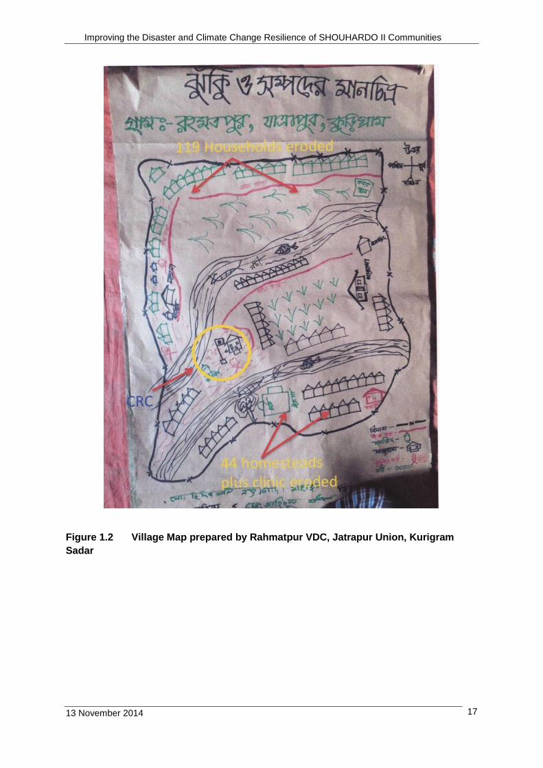
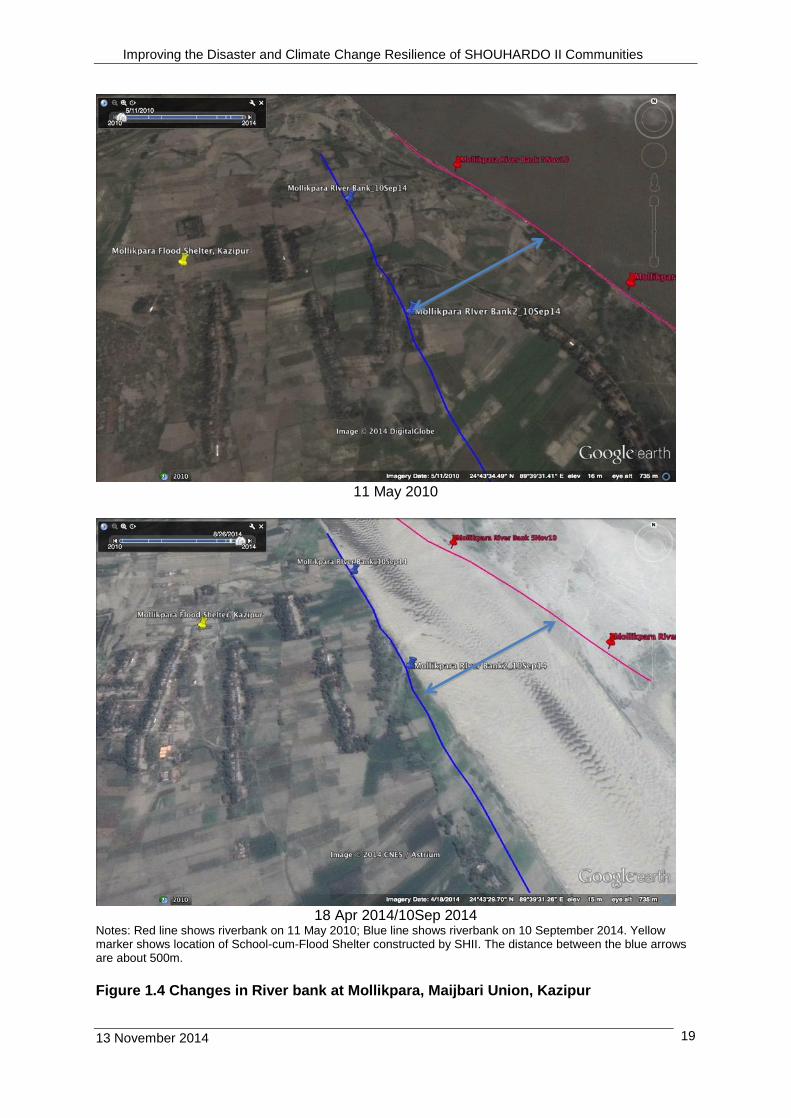
1.4 Erosion Hazard of the Char Char is the Bengali term for a mid-channel island that periodically emerges from the riverbed as a result of accretion, as shown in Figure 1.1. The char environment is very harsh and is subject to numerous natural hazards including severe river flooding, erosion, drought and cold. The landform of the chars is dynamic due to ever-present threat and occurrence of erosion. The dynamic nature of the chars is illustrated by considering recent physical changes in two SHOUHARDO II villages. The village map prepared by the Village Development Committee (VDC) in Rahmatpur, Jatrapur Union, Kurigram Sadar is shown in Figure 1.2. On the figure, the location of the Community Resource Centre (CRC) is marked. Also shown is where 119 homesteads in the
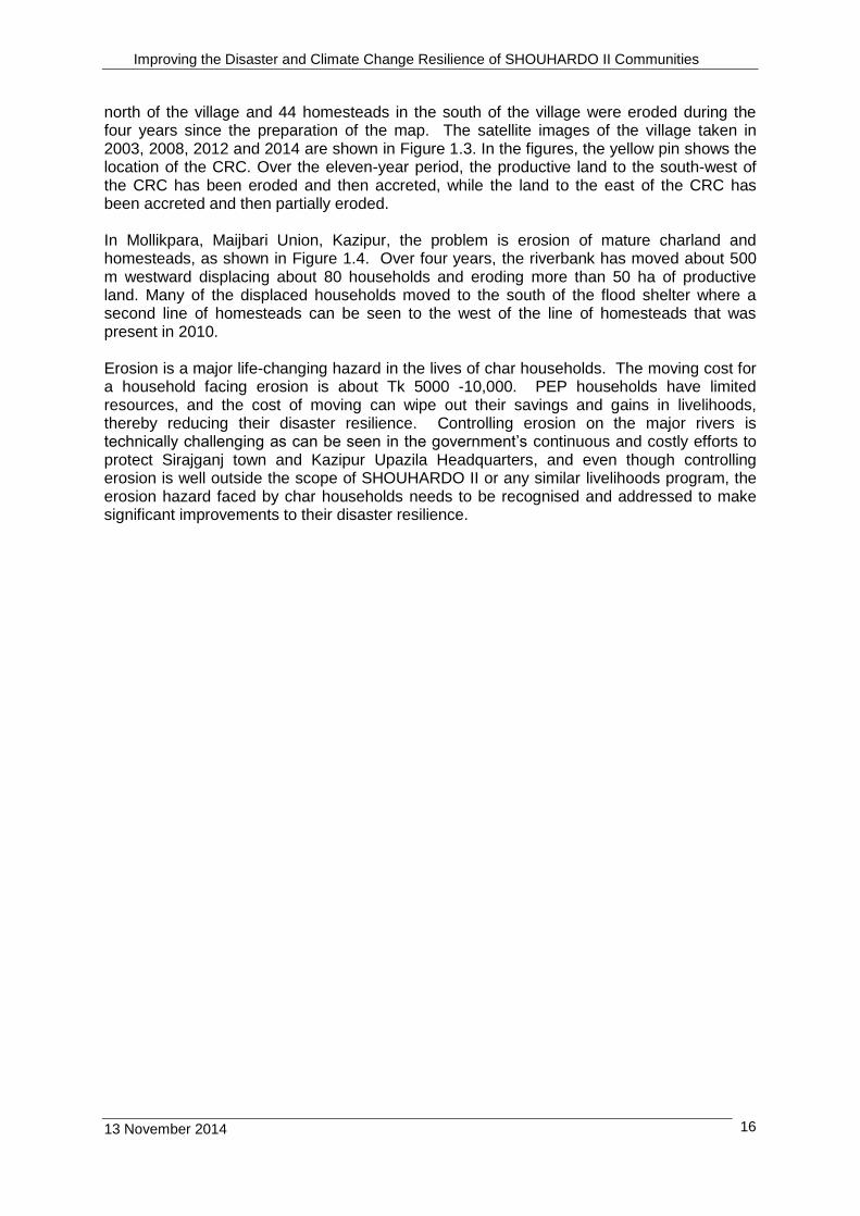
Improving the Disaster and Climate Change Resilience of SHOUHARDO II Communities
13 November 2014 16
north of the village and 44 homesteads in the south of the village were eroded during the four years since the preparation of the map. The satellite images of the village taken in 2003, 2008, 2012 and 2014 are shown in Figure 1.3. In the figures, the yellow pin shows the location of the CRC. Over the eleven-year period, the productive land to the south-west of the CRC has been eroded and then accreted, while the land to the east of the CRC has been accreted and then partially eroded. In Mollikpara, Maijbari Union, Kazipur, the problem is erosion of mature charland and homesteads, as shown in Figure 1.4. Over four years, the riverbank has moved about 500 m westward displacing about 80 households and eroding more than 50 ha of productive land. Many of the displaced households moved to the south of the flood shelter where a second line of homesteads can be seen to the west of the line of homesteads that was present in 2010. Erosion is a major life-changing hazard in the lives of char households. The moving cost for a household facing erosion is about Tk 5000 -10,000. PEP households have limited resources, and the cost of moving can wipe out their savings and gains in livelihoods, thereby reducing their disaster resilience. Controlling erosion on the major rivers is technically challenging as can be seen in the government’s continuous and costly efforts to protect Sirajganj town and Kazipur Upazila Headquarters, and even though controlling erosion is well outside the scope of SHOUHARDO II or any similar livelihoods program, the erosion hazard faced by char households needs to be recognised and addressed to make significant improvements to their disaster resilience.
Improving the Disaster and Climate Change Resilience of SHOUHARDO II Communities
13 November 2014 17
Figure 1.2 Village Map prepared by Rahmatpur VDC, Jatrapur Union, Kurigram
Sadar
Improving the Disaster and Climate Change Resilience of SHOUHARDO II Communities
13 November 2014 18
24 September 2003 15January 2008
15 February 2012 24 April 2014
(Note: Yellow pin shows location of CRC visited on 6 September 2014)
Figure 1.3 Changes in Char formation in Rahmatpur, Jatrapur Union, Kurigram
Improving the Disaster and Climate Change Resilience of SHOUHARDO II Communities
13 November 2014 19
11 May 2010
18 Apr 2014/10Sep 2014
Notes: Red line shows riverbank on 11 May 2010; Blue line shows riverbank on 10 September 2014. Yellow marker shows location of School-cum-Flood Shelter constructed by SHII. The distance between the blue arrows are about 500m.
Figure 1.4 Changes in River bank at Mollikpara, Maijbari Union, Kazipur

Improving the Disaster and Climate Change Resilience of SHOUHARDO II Communities
13 November 2014 20
1.5 Other Major Physical Hazards PEP households face many hazards and two hazards that are often overlooked or underestimated are darkness and cold. PEP households use small kerosene lamps, called kupi, for lighting. Typically a kupi is an uncovered lamp comprising of a small inexpensive can containing kerosene with a single hand made wick of discarded fabric. A kupi has an open flame that creates a serious fire hazard and tends to be quite smoky. The kerosene for the kupi costs about Tk 7-10 per night. A kupi is not very practical outside, as the wind and rain tend to dowse the flame. Few PEP households have hurricane lamps or torches. Men use cigarette lighters for light, and more recently mobile phones are used. The lack of light causes women real problems in carrying out domestic tasks (such as child rearing, food preparation and looking after the elderly) after dark and in going outside at night. This has numerous negative impacts such as women not drinking sufficient water to avoid going to the toilet after dark (even when there is latrine nearby). Light is also essential for studying and doing IGA activities after dark. Electricity is becoming more available throughout the country but in the chars and the remote haor, it will be many decades before communities are connected to the national grid. In addition, even where there is electricity PEP households tend to be the last to receive connections, as they cannot afford the connection charges. A few better-off households have solar home light systems that provide sufficient power for about 4 (four) 60 W light bulbs plus a television set or video player but solar system home light systems cost about Tk 30,000 and are well beyond the means of PEP households. Cold is another major hazard especially in northern Bangladesh. In Bangladesh, temperatures normally fall to around 10oC during December, January or February and cold waves occur when temperatures fall below 10oC. A moderate cold wave is when temperatures fall to 6 o – 8o C. During a severe cold wave temperatures fall to 4 o – 6oC. The homeless, sick, elderly and children are the most affected mainly by hypothermia and respiratory problems including pneumonia. PEP households do not have the resources to maintain clothes or bedding material suitable for cold, and their shelter tends to be poorly constructed from materials that provide little protection from cold. During cold waves, the coping strategy for PEP households tends to be huddling around a fire. Cold waves also affect livelihoods because the biting cold and dense fogs force people to stay indoors, making them unavailable for work. The growth of agricultural crops are also adversely affected, as are fisheries where the cold affects fish breeding and growth and fog causes fish mortality due to depletion of dissolved oxygen. In January 2013, there was a severe cold wave when temperatures fell to their lowest point in Bangladesh’s post-independence history, resulting in the deaths of about 80 people (ACAP 2014). The lowest temperature of 3oC was recorded in Sydepur in Nilphamari District under Rangpur Division. The cold wave affected more than 2 million households. The government distributed cash grants of Tk 50 million (over US$600,000), 22,675 tonnes of rice and 730,000 blankets. Moderate cold waves also occurred in 2013/14, 2010/11, 2009/10. In 2002/03, about 100 people died during the cold wave.
1.6 Objectives of this Study The purpose of this Study is to:
Capture the effectiveness of capacity building effort, contingency systems and the climate change adaptation measures that were undertaken;
Improving the Disaster and Climate Change Resilience of SHOUHARDO II Communities
13 November 2014 21
Document samples of all climate change adaptation interventions that have been adopted by members of the SHOUHARDO II community;
Demonstrate how the various interventions contributed to women’s empowerment; and
Provide recommendations for the possible adaptation of new innovative climate change interventions.
In addition, as SO5 is a cross cutting theme, the integration of DCRM throughout SHOUHARDO II will be considered.
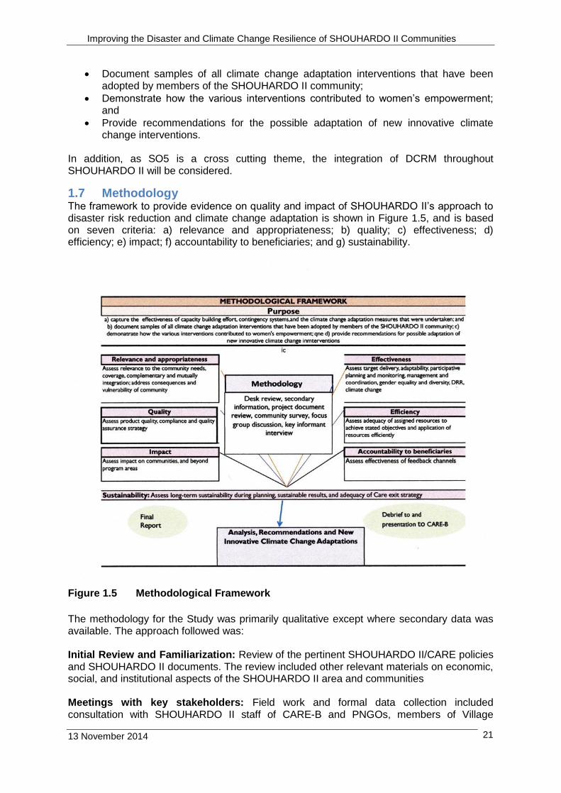
1.7 Methodology The framework to provide evidence on quality and impact of SHOUHARDO II’s approach to disaster risk reduction and climate change adaptation is shown in Figure 1.5, and is based on seven criteria: a) relevance and appropriateness; b) quality; c) effectiveness; d) efficiency; e) impact; f) accountability to beneficiaries; and g) sustainability.
Figure 1.5 Methodological Framework
The methodology for the Study was primarily qualitative except where secondary data was available. The approach followed was: Initial Review and Familiarization: Review of the pertinent SHOUHARDO II/CARE policies and SHOUHARDO II documents. The review included other relevant materials on economic, social, and institutional aspects of the SHOUHARDO II area and communities Meetings with key stakeholders: Field work and formal data collection included consultation with SHOUHARDO II staff of CARE-B and PNGOs, members of Village
Improving the Disaster and Climate Change Resilience of SHOUHARDO II Communities
13 November 2014 22
Development Committees and other CBOs, elected officials of local government institutions, and staff of the national and local government organisations. Information was collected through Focus Group Discussions (FGD) and Key Informant Interviews (KII). Information collection: Detailed information on different topics was collected through discussion (specifically FGD) with direct beneficiaries and families, communities and non-beneficiaries, elected local government officials and staff and government staff, while taking into account gender, and diversity. FGDs were held with 10 VDCs, 7 PNGOs, 6 Union Parishads/UMDCs, 2 Direct Delivery Teams, 4 regional offices and 1 School Brigade. KII were held with program beneficiaries including 6 recipients of improved stoves, 3 keyhole gardeners, households receiving improved rice varieties and with comprehensive homestead gardeners. The people met are given in Annex 2 and the discussions held along with the participants, location and sites visited are listed in Annex 3.This information collected was used with official and program data to analyse the effectiveness of SO-5 activities. Women Empowerment. Women empowerment was determined by considering (i) Influence and access to assets including possession of resources and wealth, as well as better health, more time, access to certain services such as loans, information and training, health centres and markets (ii) Knowledge and know-how on DRR and climate change (iii) The will or ability to make their own choices before, during and/or post-disaster (iv) Capacity to make decisions, take on responsibility, be free to use one’s resources (assets, knowledge, will). The fieldwork for the Study was undertaken by Dr. Ian Tod, Independent Consultant, between September 2nd and September 23rd.
1.8 Acknowledgements Dr. Tod relied on the goodwill and candour of the people with whom he discussed the SHOUHARDO II Program. Dr. Tod is extremely grateful for the time that SHOUHARDO II PEP households and other community members, SHOUHARDO staff and the staff of PNGOs and other organisations made available to meet with him and for the wide-ranging insights so generously shared. In particular. Dr Tod appreciated the assistance given by Shafiqur Rahman, Humanitarian Assistance Coordinator, and Palash Mondal, Senior Technical Manager Humanitarian Assistance, for providing information about the SHOUHARDO II Program, and arranging and participating in the field visits. The photographs in the Report were taken by Dr. Tod and Palash Mondal.
Improving the Disaster and Climate Change Resilience of SHOUHARDO II Communities
13 November 2014 23
2. Disaster and Climate Risk Management Activities of the Program
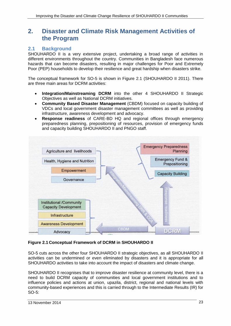
2.1 Background SHOUHARDO II is a very extensive project, undertaking a broad range of activities in different environments throughout the country. Communities in Bangladesh face numerous hazards that can become disasters, resulting in major challenges for Poor and Extremely Poor (PEP) households to develop their resilience and great hardship when disasters strike. The conceptual framework for SO-5 is shown in Figure 2.1 (SHOUHARDO II 2011). There are three main areas for DCRM activities:
Integration/Mainstreaming DCRM into the other 4 SHOUHARDO II Strategic Objectives as well as National DCRM initiatives.
Community Based Disaster Management (CBDM) focused on capacity building of VDCs and local government disaster management committees as well as providing infrastructure, awareness development and advocacy.
Response readiness of CARE-BD HQ and regional offices through emergency preparedness planning, prepositioning of resources, provision of emergency funds and capacity building SHOUHARDO II and PNGO staff.
Figure 2.1 Conceptual Framework of DCRM in SHOUHARDO II
SO-5 cuts across the other four SHOUHARDO II strategic objectives, as all SHOUHARDO II activities can be undermined or even eliminated by disasters and it is appropriate for all SHOUHARDO activities to take into account the impact of disasters and climate change. SHOUHARDO II recognises that to improve disaster resilience at community level, there is a need to build DCRM capacity of communities and local government institutions and to influence policies and actions at union, upazila, district, regional and national levels with community-based experiences and this is carried through to the Intermediate Results (IR) for SO-5:

Improving the Disaster and Climate Change Resilience of SHOUHARDO II Communities
13 November 2014 24
IR 1 Disaster Contingency systems in place and functioning
IR 2 Influence local and national humanitarian assistance initiatives CARE-BD has been involved with disaster emergency response since the start of its activities in Bangladesh, and SHOUHARDO II continued to support CARE-BD with improving and updating its emergency preparedness, prepositioning of emergency items and capacity building of CARE-BD staff and PNGOs. SHOUHARDO II provides an annual budget allocation of $150,000 to CARE-BD for use in emergencies when there is a need. The allocation allows CARE-BD to respond quickly to disasters and is subject to prior approval by USAID. There is also provision for CARE-BD to use up to 10% of their in-country food commodity stock for emergency response, again with prior approval from USAID (CARE-BD 2010). SHOUHARDO II program also maintains a stock of 11 non-food items for 10,000 HHs, 6 Water Treatment Plants, 3 Mobile Kitchens and 9 Zodiac Boats as emergency response preparation. For this Study, the effectiveness of specific activities related SO-5 were assessed, namely:
Capacity building
Contingency Systems
Climate Change Adaptation Measures
Women’s Empowerment
Mainstreaming and Integrating DRR/CCA In this Chapter, SO-5 activities related to these specific activities are described. In the next Chapter the performance of the specific activities are discussed with respect to their contribution to improving the disaster and climate resilience of SHOUHARDO communities and related institutions.
In August 2014, prior to the start of Study, there were significant floods on the major rivers in the North and Mid-Char regions, and to lesser extent in the Haor Region. The coastal region was relatively unaffected by floods or heavy rainfall during this period. The occurrence of floods was timely as the last significant flood in the North and Mid-Chars was in 2007. The 2014 flood provided an opportunity to determine the effectiveness of various DCRM activities supported by SHOUHARDO II including disaster preparedness, flood warnings, and flood response.
2.2 Capacity Building
2.2.1 Overview SHOUHARDO II identified that the competencies and skills of organisations, groups and communities need to be strengthened to improve their disaster and climate change resilience in a sustainable way. SHOUHARDO II focused its capacity building efforts on communities and local government institutions, at mainly the union level and to lesser extent at the upazila level. In addition, SH-II worked with CARE-Bangladesh at a national level to develop organisations involved in DCRM, including the Department of Disaster Management and BWDB’ s Flood Forecast Warning Centre.
2.2.2 Communities Disaster and climate resilience of communities was developed by building the capacity of the Village Development Committee (VDC) that was formed as part of SO-4 (Governance) VDCs were orientated in the use of Climate Vulnerability and Capacity Analysis (CVCA) (CARE international 2009). The CVCA methodology helps communities to understand the

Improving the Disaster and Climate Change Resilience of SHOUHARDO II Communities
13 November 2014 25
implications of climate change on their lives and livelihoods. By combining local knowledge with scientific data, it provides a framework for dialogue within the community as well as between communities and other stakeholders. The results provide a solid foundation for the identification of practical strategies to facilitate community-based adaptation (CBA) to climate change. In practice, SHOUHARDO II modified the CVCA methodology by focusing on the community’s experience of climate change and not including scientific data. The CVCA process involves four inter-related strategies:
Promotion of climate resilient livelihoods in combination with income diversification and capacity building for planning and improved risk management;
Disaster risk reduction strategies to reduce the impact of hazards particularly of vulnerable households and individuals;
Capacity development for local civil society and government institutions so that they can provide better support to communities, households and individuals in their adaptation efforts; and
Advocacy and social mobilisation to address the underlying causes of vulnerability, such as poor governance, lack of control over resources or limited access to basic services.
Outputs from the community based planning and the CVCA include:
Seasonal crop calendar
Chart of Historical Disasters
Hazard ranking
Vulnerability matrix
Institutional Map (Venn diagram)
Resource list
Gender Analysis Framework (GAF)
Hazard (Risk) map
Contingency plan These outputs are compiled into the Climate Change Adaptation (CCA) Plan, from which the priority actions are identified and placed into the Community Action Plan (CAP). Given the dynamic nature of vulnerability to hazards including climate change, CAP is updated annually. The CAP and Risk and Resource maps are submitted to the Union Parishad for incorporation into the DRR/CCA sections of the Union Disaster Management Plan and Union Annual Development Plan as shown in Figure 2.2.

Improving the Disaster and Climate Change Resilience of SHOUHARDO II Communities
13 November 2014 26
Figure 2.2 Incorporation of CVCA outputs into Union Planning
The outputs from the community based planning and CVCA provide insights into the inequalities within communities and households that make certain people more vulnerable. The understanding gained provides a platform for communities to identify and design activities to improve their disaster and climate resilience
2.2.3 Union and Upazila In the unions where the Program operated. SHOUHARDO II worked with union parishads to develop Union Disaster Management Committees (UDMC) and Union Disaster Volunteers (UDVs). Support was also given to develop Upazila Disaster Management Committees (UzDMC). Although both are a requirement under the government’s Standing Orders on Disaster (SOD), UDMC’s were found to be not functioning or not performing well in the SHOUHARDO II unions, and elsewhere in non-SHOUHARDO II unions (Khan and Jonsson 2013). Support provided to UDMC included:
Training on DCRM including disaster preparedness, preparing UDMCs including DRR/CCA and contingency planning, receiving and disseminating flood warnings, disaster response and recovery.
Provision and training on the use of the search and rescue equipment provided including portable megaphones (for ‘miking’), stretchers, lifebuoys, torchlights and first aid kit.
Training for Union Disaster Volunteers (UDVs) on disaster preparedness, contingency planning, search and rescue. There are four UDVs (two male and two female) in each of the 9 wards in a union. UDVs are appointed by the Union Parishad Chairman (UPC).
UDMCs are scheduled to meet monthly but SHOUHARDO II found that quarterly meetings were more functional. Additional meetings were arranged when there was a disaster. Concurrently, the government provided resources to establish Union Information Service Centre (UISC). The Centre’s visited had laptop computer, printer and Internet access, as well as an operator who was competent in operating the equipment. For example, the operator knew how to access the website of the Flood Forecasting and Warning Centre (FFWC) to learn about flood warnings. See Section 2.2.5 for more details).
Climate Vulnerability
and Capacity Analysis
Union Disaster
Management Plan
Community Action
Plan
Climate Change
Adaptation Plan
Union Development
Plan
Open budget
GoB Fiscal
Framework
Improving the Disaster and Climate Change Resilience of SHOUHARDO II Communities
13 November 2014 27
2.2.4 National Institutions SHOUHARDO II participated along with CARE-Bangladesh on several national forums including:
Representation on the National Disaster Management Advisory Committee (NDMAC)
Advocating for government approval of a Disaster Management Act to provide a legal framework for Standing Orders on Disasters (SOD). The Act was passed into law in 2012 (Wahra 2013).
Working with the Department of Disaster Management (DDM) and the Ministry of Disaster Management and Relief (MODMR) on, for example, training materials for Union Disaster Volunteers, formulation of national disaster policy and implementation of SOD
UN Clusters for Emergency Response
Lead role in joint needs assessment (post-disaster damage and needs assessment) for the Humanitarian Coordination Task Team. For example, (HCTT 2014)
DCRM materials prepared by SHOUHARDO II were also used by the following:
Proshar, the project being implemented by ACDI/VOCA and Project Concern International, acknowledges the contribution of CARE-BD/SHOUHARDO II in their training modules for UDMCs and UzDMCs.
Koinonia has reprinted the Climate Change Flip Chart for use in their CBA activities.
Department of Disaster Management (DDM) used CARE-BD findings in the preparation of DRR/CCA materials.
2.2.5 Flood Forecasting and Warnings SHOUHARDO II supported the development of 10-day flood forecasts, 20-25 days forecasts and flash flood forecasts by funding Regional Integrated Multi-Hazard Early Warning System (RIMES) in collaboration with BWDB’s Flood Forecasting and Warning Centre (FFWC). FFWC was established in 1972 and is mandated to provide flood forecasts and warnings during the flood season (April to October) as directed by the government’s Standing Orders on Disaster (SOD). There are no equivalent drought or erosion forecasting systems. Flood forecasts are determined from rainfall and water level data including:
BWDB hydro-meteorological monitoring stations within Bangladesh
Additional rainfall and water level data from upper river catchments in India
Additional meteorological data from the Bangladesh Meteorological Department (BMD) and the European Commission Medium Weather Forecast (ECMWF).
Satellite and radar images. Two forecasts are prepared:
5-day forecasts at 54 locations on 29 rivers using deterministic methods.
10 day forecast 38 locations using probabilistic methods. The features of the two methods are compared in Table 2.1. An output forecast from the probabilistic 10-day RIMES model is shown in Figure 2.3.

Improving the Disaster and Climate Change Resilience of SHOUHARDO II Communities
13 November 2014 28
Table 2.1 Comparison of Probabilistic and Deterministic Flood Forecasting Models
Probabilistic Model1
Deterministic Model 2
Forecast period: 1-10 days (medium range) 1- 5 days (short range)
Start of modelling
2005-7 1992
No of forecast locations
38 locations 54 locations
Type of forecast Upper, lower and average forecast of water level forecast
Single water level forecast
Type of model Hydrological model Hydrological and hydraulic model
Model(s) used (1) CFAB model for boundary generation.
(2) MIKE11
(1) MIKE11
Input data Water level gauge observations, satellite and European Commission Medium Climate Forecast (ECMWF) rainfall for the whole Ganges-Brahmaputra-Meghna basin
Observed water level gauge and rainfall within Bangladesh as input plus. Indian Meteorological Department rainfall data in adjacent stations (for 5-day forecast)
Boundary location
Hardinge bridge and Bahadurabad, Boundary location Pankha, Noonkhawa,
Approach Probabilistic Uses lumped data based and distributed catchment model
Deterministic Uses lumped conceptual model
Computer system
Linux based Windows based
Notes (1) Model initially developed in 2005-07 with support from SHOUHARDO I. From 2012, SHOUHARDO II provided support to RIMES to further develop the probabilistic model. (2) Model developed from early 1990’s. From 2012, CDMP supported FFWC to extend the forecast period from 3 to 5 days
Features of the Probabilistic and Deterministic models are discussed in more detail in Annex 4.

Improving the Disaster and Climate Change Resilience of SHOUHARDO II Communities
13 November 2014 29
An output from the probabilistic 10-day RIMES model is shown in Figure 2.2.
Figure 2.3 10-day Water Level Forecast for Kazipur on the Jamuna River.
The data are used to identify existing floods and input to numerical flood forecasting models. The results of the model computations are used to prepare flood warning products including flood warning bulletins, rainfall distribution maps and flood inundation maps. FFWC disseminate flood warnings through e-mail, mobile messages, fax and its own dedicated website (www.ffwc.gov.bd). RIMES also disseminate their flood forecasts in 15 pilot unions, by emails to 100 national stakeholders and 120 district and union information service centres (UISC), and by SMS texts to UDMC members. RIMES is developing pilot flash flood early warning systems at Sunamganj and Cox’s Bazar, with the purpose of providing warnings to save boro crops and household possessions. The Flash Flood Advisory System was built using rainfall intensity–duration thresholds. Flash floods are likely to occur when forecast or observed rainfall exceeds the rainfall threshold that are derived empirically, using simplified relationships between rainfall and flash flood occurrence. The thresholds need to be updated regularly as more data becomes available. The flash flood early warning system has still to be field-tested including the effectiveness of flash flood early warning dissemination. SHOUHARDO II communities accessed flood warnings from different sources including:
Union Parishad Chairman and members and the UISC.
Text messages relayed from the FFWC.
Radio and television Once a flood was likely and a flood warning received, the UDMC activated the UDVs to disseminate flood warnings by making announcements through a portable public address system (locally known as ‘miking’) and going from house to house in vulnerable areas. Announcements were also made from public address systems at mosques. Flood warnings were also posted on Disaster Information Boards provided by the Program at the UP

Improving the Disaster and Climate Change Resilience of SHOUHARDO II Communities
13 November 2014 30
headquarters. The Boards also displayed disaster related information such as the names of UDMC members and UDVs and planned activities.
2.3 Contingency Systems Contingency planning is a management process that analyses specific potential events or emerging situations that might threaten society or the environment and establishes arrangements in advance to enable timely, effective and appropriate responses to such events and situations. (UNISDR 2009). Contingency planning results in organized and coordinated courses of action with clearly identified institutional roles and resources, information processes, and operational arrangements for specific actors at times of need. Based on scenarios of possible emergency conditions or disaster events, it allows key actors to envision, anticipate and solve problems that can arise during crises. Contingency planning is an important part of overall preparedness. Contingency plans need to be regularly updated and exercised. Contingency plans were prepared by the VDC as part of community based planning, and also by Union Parishad as part of the Union Disaster Management Plan (UDMP). Contingency plans prepared by VDCs included various information including:
At risk households (vulnerable people such as disabled, infants, pregnant women)
Village resources (pucca roads, earth roads and footpaths, bridges and culverts, shelters, schools, mosques, health centres etc.) and the resources at risk (for example from erosion).
Delegation of responsibilities (Identifying who will be responsible for disseminating early warnings, evacuation, search and rescue, first aid, camp management, assessment and coordination).
Contact details for key personnel and service providers
Contingency planning also included raising awareness of disaster management through dramas and by arranging activities to observe National Disaster Preparedness Day (in March) and International Day for Disaster Reduction (in October).
2.4 Climate Change Adaptation Measures
2.4.1 Background As a cross cutting issue, DCRM affects all SHOUHARDO II strategic objectives hence all Program activities are affected by DRR and CCA to some extent. Some activities were specifically designed with climate change in mind while other activities were modified to take account to climate change. DCRM activities are described in this section along with the impact of CDRM on other SHOUHARDO II activities.
2.4.2 Measures Specifically designed for Climate Change Adaptation
Climate Vulnerability and Capacity Analysis (CVCA) As discussed in Section 2.2.2, the CVCA methodology provided a framework for engaging stakeholders, assessing current vulnerabilities and understanding future climate risks. Communities used the seasonal calendar and other tools to determine whether the climate was changing and what were the related impacts.
Improving the Disaster and Climate Change Resilience of SHOUHARDO II Communities
13 November 2014 31
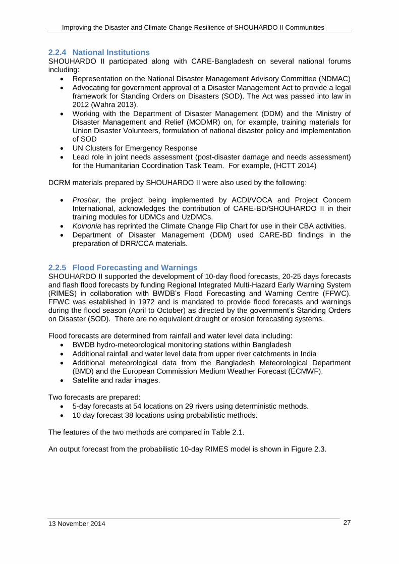
Improved stoves. SHOUHARDO provided 50 improved stoves/union to PEP households (See Photo). Each stoves cost about Tk. 850 for a single burner stove and Tk.1200 for a double burner stove. The numerous advantages of the improved stoves include:
Lower fuel consumption
Removal of smoke from the kitchen
Hotter flames for cooking
Reduced risk of being burnt while cooking
Less carbon on bottom of cooking pots
Less emission of carbon dioxide Chimneys need cleaning every 25-30 days for wood fuel and every 10-12 days if leaves are used as fuel. There
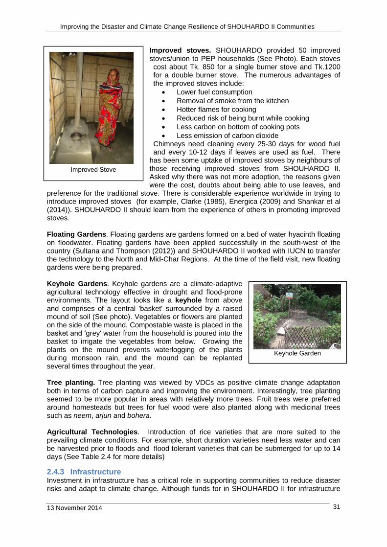
has been some uptake of improved stoves by neighbours of those receiving improved stoves from SHOUHARDO II. Asked why there was not more adoption, the reasons given were the cost, doubts about being able to use leaves, and
preference for the traditional stove. There is considerable experience worldwide in trying to introduce improved stoves (for example, Clarke (1985), Energica (2009) and Shankar et al (2014)). SHOUHARDO II should learn from the experience of others in promoting improved stoves. Floating Gardens. Floating gardens are gardens formed on a bed of water hyacinth floating on floodwater. Floating gardens have been applied successfully in the south-west of the country (Sultana and Thompson (2012)) and SHOUHARDO II worked with IUCN to transfer the technology to the North and Mid-Char Regions. At the time of the field visit, new floating gardens were being prepared. Keyhole Gardens. Keyhole gardens are a climate-adaptive agricultural technology effective in drought and flood-prone environments. The layout looks like a keyhole from above and comprises of a central 'basket' surrounded by a raised mound of soil (See photo). Vegetables or flowers are planted on the side of the mound. Compostable waste is placed in the basket and ‘grey' water from the household is poured into the basket to irrigate the vegetables from below. Growing the plants on the mound prevents waterlogging of the plants during monsoon rain, and the mound can be replanted several times throughout the year. Tree planting. Tree planting was viewed by VDCs as positive climate change adaptation both in terms of carbon capture and improving the environment. Interestingly, tree planting seemed to be more popular in areas with relatively more trees. Fruit trees were preferred around homesteads but trees for fuel wood were also planted along with medicinal trees such as neem, arjun and bohera. Agricultural Technologies. Introduction of rice varieties that are more suited to the prevailing climate conditions. For example, short duration varieties need less water and can be harvested prior to floods and flood tolerant varieties that can be submerged for up to 14 days (See Table 2.4 for more details)
2.4.3 Infrastructure Investment in infrastructure has a critical role in supporting communities to reduce disaster risks and adapt to climate change. Although funds for in SHOUHARDO II for infrastructure
Improved Stove
Keyhole Garden

Improving the Disaster and Climate Change Resilience of SHOUHARDO II Communities
13 November 2014 32
were much smaller for than the infrastructure funds in SHOUHARDO I and fell far short of demand, there was a range of investments made in infrastructure for disaster risk reduction (raised homesteads (RHS), School-cum-Flood Shelters, renovation of cyclone shelters, village protection walls), communications (roads, footpaths, bridges, culverts), water supply (installation of tubewells, tubewell platforms), sanitation (low cost household latrines, latrines in schools and public places), and capacity building (Community Resource Centres (CRC), ECCD renovation). Infrastructure requirements were identified from CAPs and DMPs. Most of the small infrastructure was implemented by Labour Contracting Societies (LCS) (CARE-BD 2011a), while large structures were implemented by LGED using contractors (CARE-BD 2011c). Earthworks were generally implemented as cash-for-works by Project Implementation Committees (PIC) (CARE-BD 2011d). Infrastructure activities were managed by Direct Delivery (DD) or PNGOs (CARE-BD 2011b). The main items of SHOUHARDO II infrastructure related to disaster risk reduction and climate change adaptation were:
Raised Homesteads. Homestead raising involved the raising of homestead compounds above highest flood level plus 0.75m freeboard. Benefits of creating a flood-free homestead area include more dry space for domestic activities, reduction of diarrhoea and skin diseases, more scope for homestead gardening, reduction in building maintenance costs, dry place to keep livestock during floods, a place for non-raised households to take shelter during floods and removing the need to evacuate during floods. In SHOUHARDO II the tendency was to raise the homesteads of a clusters of 3-5 households, as clusters provide more overall raised space and made for easier service delivery. The average cost of a raised homestead was about TK 30,000/household and the work was usually by Project Implementation Committee. Raised homesteads provide flood free environment but in char areas there is an ever-present risk of erosion. In Sirajganj (Mid-Char) Region during the SHOUHARDO II period, 351 homesteads were raised, while in Mymensingh (Haor) region 506 homesteads were raised. However, although there are clear benefits from raising homesteads, there is no evidence of households raising their homesteads to the level specified by SHOUHARDO II (or CLP) using their own resources. It would be useful to understand why even middle or better off households are unwilling to invest Tk 20,000-30,000 to raise their homesteads to SHOUHARDO II levels and yet are willing to invest Tk 35,000 in solar power systems.
Raised Homestead

Improving the Disaster and Climate Change Resilience of SHOUHARDO II Communities
13 November 2014 33
Schools-cum-Flood Shelters Flood shelters are provided in riverine areas to provide refuge to households forced to evacuate their homesteads during floods. Multipurpose flood shelters extend the benefits of the investment in flood shelters by allowing the raised land and buildings to be used for other purposes throughout the year. For example, designing schools that can be utilised as flood shelters provides multiple benefits to communities. In Mollikpara, Kazipur, Sirajganj, about 35 households took refuge in the recently completed school-cum-flood shelter (See Photo)
Renovation of Cyclone Shelters Numerous cyclone shelters were constructed during the 1990’s after the disastrous cyclone in 1991. Many of these structures are about 20 years old and are dilapidated due to poor construction or inadequate maintenance even though they are used as schools. Under SHOUHARDO II, renovation of a cyclone shelter involved replacement of doors and windows, re-plastering and painting and partial replacement of sections of roof and floor slabs. Renovation of cyclone shelters was supervised by LGED using contractors. During the alert for Cyclone Mahasen in May 2013, households moved to cyclone shelters in anticipation of the storm (BBC 2013). The capacity of each cyclone shelter ranges 500-1000 people depending on its size. According to the UPC, the population of Julia Palang Union is about 55,000, and everyone was able to access a safe places in anticipation of cyclone Mahasen by moving to either shelters or other large buildings such as the hospital or moved inland. People started moving to safe places about 2 days before the cyclone was due to strike.
Roads, Bridges and Culverts. Better communications is always identified by VDCs as a necessity to reduce their disaster risk and improve their daily lives. SHOUHADO II funds were provided for the maintenance and upgrading of earthen roads, and construction of structures including bridges, culverts and U-drains. For example, in Mymensingh (Haor) Region, during SHOHARDO II, 38 box culverts/U-drains were constructed and 61 earth roads were maintained. In Sirajganj, only 1 U-drain is planned for construction this year and no earthen road schemes were implemented. Some structures and the earth road upgrading and maintenance were constructed
by LCS, which improved the skills of the participating PEP households and provided more benefits to the community
School-cum-Flood Shelter
Renovated Cyclone Shelter
New Road Culvert
Improving the Disaster and Climate Change Resilience of SHOUHARDO II Communities
13 November 2014 34
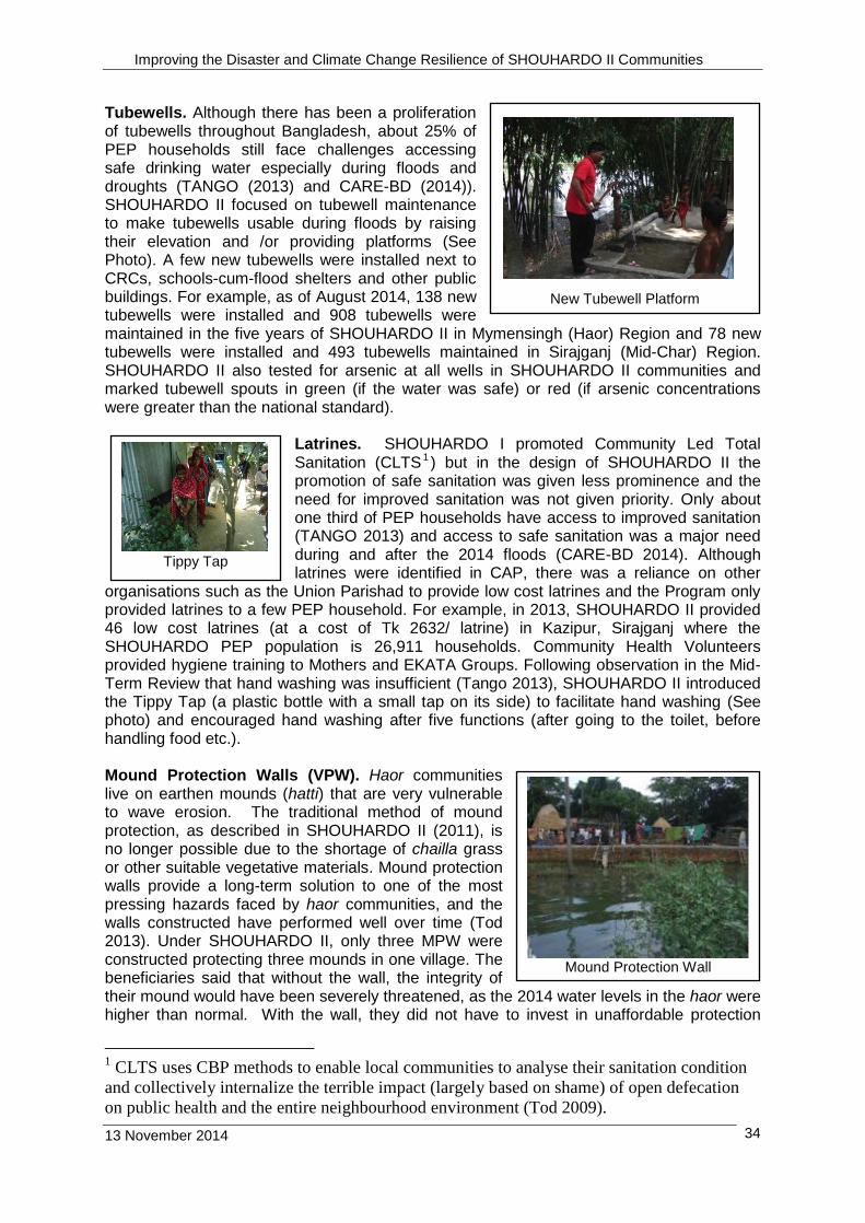
Tubewells. Although there has been a proliferation of tubewells throughout Bangladesh, about 25% of PEP households still face challenges accessing safe drinking water especially during floods and droughts (TANGO (2013) and CARE-BD (2014)). SHOUHARDO II focused on tubewell maintenance to make tubewells usable during floods by raising their elevation and /or providing platforms (See Photo). A few new tubewells were installed next to CRCs, schools-cum-flood shelters and other public buildings. For example, as of August 2014, 138 new tubewells were installed and 908 tubewells were maintained in the five years of SHOUHARDO II in Mymensingh (Haor) Region and 78 new tubewells were installed and 493 tubewells maintained in Sirajganj (Mid-Char) Region. SHOUHARDO II also tested for arsenic at all wells in SHOUHARDO II communities and marked tubewell spouts in green (if the water was safe) or red (if arsenic concentrations were greater than the national standard).
Latrines. SHOUHARDO I promoted Community Led Total Sanitation (CLTS 1 ) but in the design of SHOUHARDO II the promotion of safe sanitation was given less prominence and the need for improved sanitation was not given priority. Only about one third of PEP households have access to improved sanitation (TANGO 2013) and access to safe sanitation was a major need during and after the 2014 floods (CARE-BD 2014). Although latrines were identified in CAP, there was a reliance on other
organisations such as the Union Parishad to provide low cost latrines and the Program only provided latrines to a few PEP household. For example, in 2013, SHOUHARDO II provided 46 low cost latrines (at a cost of Tk 2632/ latrine) in Kazipur, Sirajganj where the SHOUHARDO PEP population is 26,911 households. Community Health Volunteers provided hygiene training to Mothers and EKATA Groups. Following observation in the Mid-Term Review that hand washing was insufficient (Tango 2013), SHOUHARDO II introduced the Tippy Tap (a plastic bottle with a small tap on its side) to facilitate hand washing (See photo) and encouraged hand washing after five functions (after going to the toilet, before handling food etc.). Mound Protection Walls (VPW). Haor communities live on earthen mounds (hatti) that are very vulnerable to wave erosion. The traditional method of mound protection, as described in SHOUHARDO II (2011), is no longer possible due to the shortage of chailla grass or other suitable vegetative materials. Mound protection walls provide a long-term solution to one of the most pressing hazards faced by haor communities, and the walls constructed have performed well over time (Tod 2013). Under SHOUHARDO II, only three MPW were constructed protecting three mounds in one village. The beneficiaries said that without the wall, the integrity of their mound would have been severely threatened, as the 2014 water levels in the haor were higher than normal. With the wall, they did not have to invest in unaffordable protection
1 CLTS uses CBP methods to enable local communities to analyse their sanitation condition
and collectively internalize the terrible impact (largely based on shame) of open defecation
on public health and the entire neighbourhood environment (Tod 2009).
New Tubewell Platform
Tippy Tap
Tippy Tap
Mound Protection Wall

Improving the Disaster and Climate Change Resilience of SHOUHARDO II Communities
13 November 2014 35
works or evacuate, and their mound was intact when the water receded. SHOUHARDO II and CARE-BD have extensive experience of implementing village protection works and should be working with the government to develop a strategy to protect village mounds from wave erosion, so that people can continue to live in the haor.
2.4.4 DCRM Activities DCRM is cross cutting issue for all SHOUHARDO II’s strategic objectives; some of the activities related to disaster risk management implemented under SO5 and under other SOs are shown in Table 2.2.
Table 2.2 DCRM Activities of SHOUHARDO II
Activity Description Comment
Activities Directly under SO5
School Brigades 50 students trained in disaster preparedness and response. Key to family/HH level disaster preparedness and response
School brigades established at 18 schools on a pilot basis.
Arsenic testing See Section 2.4.3 Tubewells
Activities under other SOs
Livestock vaccination (SO1 and SO4)
Before and after flood Vaccines given included for Foot and Mouth Disease (for cattle), PPR (goat plague) for goats and sheep, Plague and Cholera for ducks and Pox for chickens
Livestock from several villages brought to one location for vaccination by Upazila veterinary services.
Awareness raising with Mothers Groups and EKATA groups (SO2 and SO3)
Training Sessions on Health and Emergencies
Motivate HH savings for emergencies (e.g. for pregnant mothers to pay for boat to clinic)
Promoting health messages
About 30% of SHOUHARDO II villages have EKATA groups (Tango 2013).
2.4.5 Support to Agriculture SO-1 received about 57% of the total SHOUHARDO II budget and the main activity was providing PEP households with grants to improve their livelihoods. Improving PEP household incomes is critical to improving their disaster resilience. The grants available for investment by PEP households in agriculture or IGAs are shown in Table 2.3. The main investments made in agriculture by PEP households are shown in Table 2.4.

Improving the Disaster and Climate Change Resilience of SHOUHARDO II Communities
13 November 2014 36
Table 2.3 Grants Available to PEP households
Activity Input package and training topics
Grant Amount (See Note 1)
Category
Comprehensive Homestead Development (CHD)
Sapling, seed/seedlings, organic fertilisers, chicken/duck/goat/sheep, fencing
Tk 3000+ training (basic and follow up)
Extreme poor
Tk 1500 + training (basic and follow up)
Poor
Agriculture/Field crops
Seed/seedlings, Organic fertilisers, irrigation, filed preparation, crop management
Tk 2000 + training (basic and follow up)
Extreme poor
Tk 1000 + training (basic and follow up)
Poor
Fishing -culture Fingerling, lime, fishmeal, fertiliser.
Same as Field Crops
Fishing -capture Fish net, boat, aluminium patil/pot
Same as Field Crops
IGA Entrepreneur development and business management training and skill training based on the selected trade
Same as CHD
Note: (1) Each HH allocated 1 input package, although a HH can also receive food from SO2.
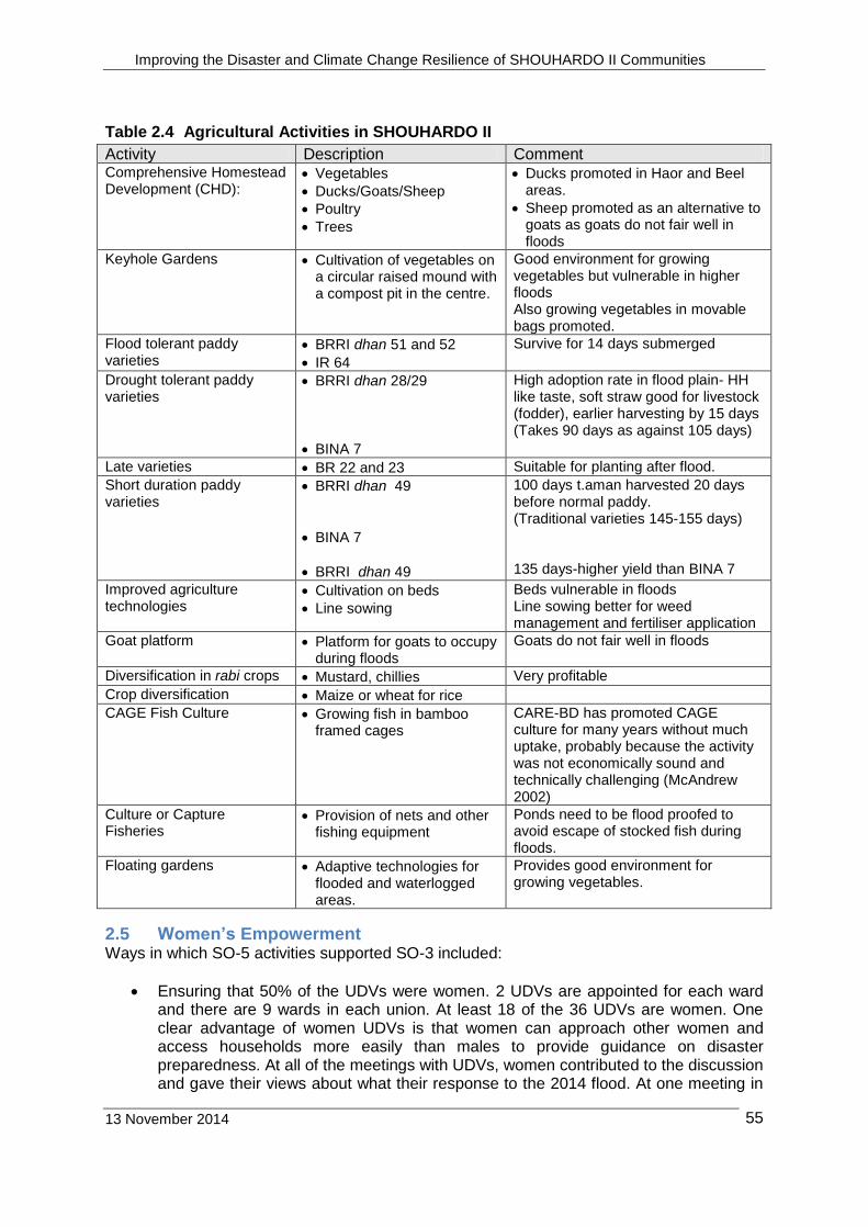
Improving the Disaster and Climate Change Resilience of SHOUHARDO II Communities
13 November 2014
55
Table 2.4 Agricultural Activities in SHOUHARDO II
Activity Description Comment Comprehensive Homestead Development (CHD):
Vegetables
Ducks/Goats/Sheep
Poultry
Trees
Ducks promoted in Haor and Beel areas.
Sheep promoted as an alternative to goats as goats do not fair well in floods
Keyhole Gardens Cultivation of vegetables on a circular raised mound with a compost pit in the centre.
Good environment for growing vegetables but vulnerable in higher floods Also growing vegetables in movable bags promoted.
Flood tolerant paddy varieties
BRRI dhan 51 and 52
IR 64
Survive for 14 days submerged
Drought tolerant paddy varieties
BRRI dhan 28/29
BINA 7
High adoption rate in flood plain- HH like taste, soft straw good for livestock (fodder), earlier harvesting by 15 days (Takes 90 days as against 105 days)
Late varieties BR 22 and 23 Suitable for planting after flood.
Short duration paddy varieties
BRRI dhan 49
BINA 7
BRRI dhan 49
100 days t.aman harvested 20 days before normal paddy. (Traditional varieties 145-155 days) 135 days-higher yield than BINA 7
Improved agriculture technologies
Cultivation on beds
Line sowing
Beds vulnerable in floods Line sowing better for weed management and fertiliser application
Goat platform Platform for goats to occupy during floods
Goats do not fair well in floods
Diversification in rabi crops Mustard, chillies Very profitable
Crop diversification Maize or wheat for rice
CAGE Fish Culture Growing fish in bamboo framed cages
CARE-BD has promoted CAGE culture for many years without much uptake, probably because the activity was not economically sound and technically challenging (McAndrew 2002)
Culture or Capture Fisheries
Provision of nets and other fishing equipment
Ponds need to be flood proofed to avoid escape of stocked fish during floods.
Floating gardens Adaptive technologies for flooded and waterlogged areas.
Provides good environment for growing vegetables.
2.5 Women’s Empowerment Ways in which SO-5 activities supported SO-3 included:
Ensuring that 50% of the UDVs were women. 2 UDVs are appointed for each ward and there are 9 wards in each union. At least 18 of the 36 UDVs are women. One clear advantage of women UDVs is that women can approach other women and access households more easily than males to provide guidance on disaster preparedness. At all of the meetings with UDVs, women contributed to the discussion and gave their views about what their response to the 2014 flood. At one meeting in

Improving the Disaster and Climate Change Resilience of SHOUHARDO II Communities
13 November 2014
56
Cox’s Bazar, women UDVs were very forthright although in that case they talked about the response to Cyclone Mahasen (BBC (2013) and SHOUHARDO II (undated)) and flash floods in 2013.
School Based Teenager Brigade. SBTBs comprise of 50% female students.
Ensuring that there was a balance of male and female members in the VDC. The VDC visited generally had about 50/50 representation of men and women member, with the office bearers (chairperson, vice chairperson, secretary) often being shared between men and women. It was noticeable that women were often present at the beginning of discussion but when topics related to agriculture or flood damages came up, men dominated the discussion with the women present.
Targeting female-headed households for emergency relief. With their knowledge of PEP households in communities and the contingency plans, SHOUHARDO targeted female-headed households for emergency relief during the 2014 flood.
Sessions on disaster preparedness and disaster response were prepared for EKATA Volunteers to train EKATA and Mothers Groups. About 30% of SHOUHARDO II villages have EKATA groups.
Ensuring at least two women members on UDMC. During meetings with UPC, UDMC female members were usually present, and, in 1 meeting, 2 female UDMC members were also present.
Ensuring women involvement in infrastructure construction. For example, in Sirajganj (Mid-Char) Region the construction of raised homesteads provided 27,492 workdays, out of which 47% were for women and 53% for men. The Regional Office’s target was for 50%/50% allocation for women and men which is higher than the SHOUHARDO II Guideline requirement of 35-40% women workdays (CARE BD 2011d). For other infrastructure, out of 10,373 workdays, 24% were for women and 76% were for men. In schemes for larger structures under LGED, the employment ration was 17% women to 83% men. Women received the same pay rates as men.
Following CARE-BD’s policy on Sexual Harassment (CARE-BD undated). During distribution of food and non-food items, there was a complaints box for recipients to place complaints of inappropriate behavior by staff distributing the items. Reportedly, the complaints box was used occasionally and appropriate action was taken on all complaints received as, in accordance with the Program’s standing instruction, staff were assigned to collect all complaints monthly and all complaints were addressed at a regional level.
The success of climate change initiatives depends on understanding the differences in adaptive capacity between women and men and between different social groups and designing adaptation strategies that ensure vulnerable people have equal access to resources. rights and opportunities. Women are more vulnerable to climate change impacts than men as they are generally poorer, rarely have an equal say in household decision making and typically lack secure access to the resources required for adaptation. The CVCA methodology discussed in Section 2.2.2 was used to identify climate change adaptations by recognising different vulnerability within communities and households, and identifying who is vulnerable and why (CARE International 2009 and CARE International 2014).
2.6 Integration of DCRM within SHOUHARDO II Integrating DCRM with all SHOUHARDO II activities is one of the main focuses of SO5 (see Figure 2.1). The Program’s approach to integrating and mainstreaming DCRM was to place SO5 (Humanitarian Assistance) staff at SHOUHARDO II headquarters, regional and hub offices, and for PNGOS to have staff responsible for SO5 activities. The designated SO5 staff interacted with staff working on the other 4 SOs to ensure that DCRM was taken into account throughout the Program. Examples of the integration of DCRM into different Program activities included:
Improving the Disaster and Climate Change Resilience of SHOUHARDO II Communities
13 November 2014
57
Vaccination of livestock prior to the flood season and promotion of improved rice varieties (SO1-Agriculture and Livelihoods)
Provision of raised homesteads and mound protection walls and promotion of keyhole gardens (SO2 Health, Hygiene and Nutrition)
Raising flood preparedness awareness of EKATA groups (SO3 Women’s Empowerment)
Developing the capacity and skills of UDMCs and UDVs and promoting DCRM at district and national level (SO4-Governance)
These examples are discussed in more detail in the earlier sections of this Chapter, as are other examples showing the integration of DCRM into Program activities.
3. Key Findings of the Study
3.1 Flood Damages
During August 2014 there were significant floods on the major northern rivers including the Brahmaputra/Jamuna, Teesta and Dharla. For example, at the village of Rahmatpur located on a char in the Brahmaputra River (See Section 3.2 and Figure 3.3), river water levels started to rise about August 5/6th and the flood peaked about August 14th. Although villagers said that they received warnings, the date that villagers received their first warning is uncertain. Unfortunately, by the time the warning was received, farmers had already transplanted the aman crop. Water levels started to recede about August 23rd. By September 7th, most households had returned to their homesteads although some households delayed their return, as their homesteads were still not usable. Most of the cropped land was emerging from the floodwaters but the aman crop was ruined after being submerged for 21 days or more. According to villagers in Kurigram, the 2014 peak flood level was higher than the last major flood in 2007, although this claim could not be verified. The main damages caused by the flood were:
Submergence of the transplanted aman (as well as aman in seed beds awaiting transplanting), and other field crop for extended periods (resulting in crop failure)
Loss of fish from ponds
Flooding of homesteads (requiring households to relocate to nearby raised homesteads or flood shelters or embankments)
Collapse of houses and plinths (caused by strong currents, poor quality building materials and/or inadequate foundations)
Collapse of public buildings (schools, mosques, health centres etc.) (caused strong currents, poor quality building materials and/or inadequate foundations)
Erosion of homesteads, buildings and farmland (resulting from changing alignments of river channels)
Loss of employment opportunities (caused mainly from loss of aman crop)
Disruption of transport (caused by strong river currents, insufficient number of boats, submergence of roads, paths etc.).
Loss of access to safe sanitation (caused by latrines collapsing or being eroded)
Contamination of safe drinking water supplies (by flood water entering tubewells)
Disruption of services (caused by poor transport links, and excessive demand)
Waterlogging of fodder and fuel reserves (resulting from flooding of homesteads).
Flood damages along the main Brahmaputra/Jamuna River are shown in Table 3.1. Data on infrastructure losses or area of land lost to erosion are not available. Interestingly there
Improving the Disaster and Climate Change Resilience of SHOUHARDO II Communities
13 November 2014
58
was very little loss of life during the floods and even the number of livestock losses was small (if any)2 which indicate that the preparedness measures taken by communities were effective. Many communities arranged for livestock vaccinations before the flood (See Table 2.2).
2 For example, in Kazipur Upazila, out of the 27,090 households affected, there were reportedly only 4
deaths from drowning during the flood (two elderly people and two young people) and the UNO had received no reports of livestock being lost, although there was Tk 600,000 loss or damage to fodder. In addition, an estimated 800 tubewells were affected or damaged by the flood.

Improving the Disaster and Climate Change Resilience of SHOUHARDO II Communities
13 November 2014
59
Table 3.1 Flood Damages in Program Areas Region/District Upazila HH
affected Villages affected
Unions affected
Area of crops
destroyed
Houses Damaged
1
Educational/ Religious Buildings damaged
1
(Number) (Number) (Number) (ha) (Number) (Number)
Kurigram Rawmari, Kurigram Sadar, Chilmari and Ulipur
37,450 400 27 48,500 4506 (F) 17645 (P)
8 (F) 69 (P)
Bogra3 Sonotola
Sariakandi2
65,500 69 11 11,332 5000 (F) 8235 (P)
No data
Jamalpur Islampur Dewanganj
32,035 164 20 No data 525 No data
Sirajganj 3 Kazipur
Sonatola 128,352 92 11 3801 1924 (F)
16707 (P) 180 (F)
Pabna Bera Bhangura
16,500 53 10 54 No data No data
Notes (1) F indicates fully damaged; P indicates partially damaged (2) Brahmaputra Right Flood Protection embankment breached at several locations in Sariakandi.
Reportedly, about 100,000 people living in 100 villages were affected by the breaches and up to 2000 households took refuge on the remaining embankment. In addition to causing severe flooding in ‘protected’ villages on the nearby floodplain, flooding through the breaches reportedly contributed to the severe flooding in Chalan Beel where SHOUHARDO II is also working in Bhangura Upazila.
(3) 800 households took refuge on flood protection embankments or in schools. In addition, a 300 m length of the embankment breached in Kazipur inundating 300 households.
Source CARE-BD (2014) and SHOUHARDO II Field Offices
Data is not available on the impact of floods in the north east (haor). Reportedly, one SHOUHARDO II PNGO (ASD) helped of UDVs rescue 198 households (911 people). 5 (five) households out of 198 were non-PEP. The households rescued were taken to three flood shelters. Rescued people stayed 2 days in the flood shelters before returning to their homesteads as the water receded. Even with improved communications including flood-free roads and mobile phones, data on flood damages was incomplete even one month after the peak flood. The constraints involved with collecting accurate data in severe flood areas should be addressed, and improved assessment methods identified. The vulnerability of many SHOUHARDO II PEP households was exposed by the 2014 flood as was the vulnerability of PEP households in adjacent areas, and CARE-BD undertook emergency relief operations using SHOUHARDO II resources to provide water purification sachets for 40,000 households to have potable water for seven days. Staff and beneficiaries were trained in the use of the sachets prior to their distribution by PNGOs. In addition, 4000 dry food packs were provided for internally displaced people who were unable to cook and had no access to food (CARE-BD 2014). CARE-BD is presently negotiating a recovery program with USAID to help 70,000 flood-affected households re-establish their livelihoods. The 2014 Flood shows that the disaster resilience of many SHOUHARDO II PEP households is very fragile. Gains may have been made in disaster preparedness as indicated by few deaths, small number of livestock losses and many char households being
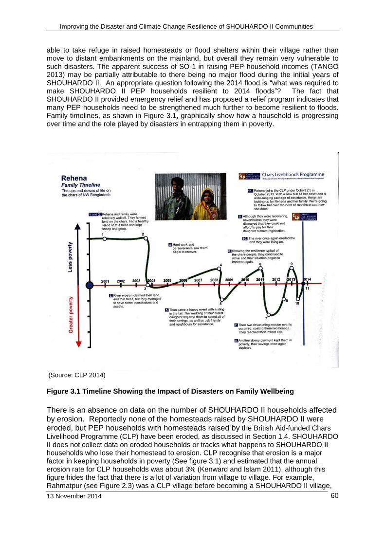
Improving the Disaster and Climate Change Resilience of SHOUHARDO II Communities
13 November 2014
60
able to take refuge in raised homesteads or flood shelters within their village rather than move to distant embankments on the mainland, but overall they remain very vulnerable to such disasters. The apparent success of SO-1 in raising PEP household incomes (TANGO 2013) may be partially attributable to there being no major flood during the initial years of SHOUHARDO II. An appropriate question following the 2014 flood is “what was required to make SHOUHARDO II PEP households resilient to 2014 floods”? The fact that SHOUHARDO II provided emergency relief and has proposed a relief program indicates that many PEP households need to be strengthened much further to become resilient to floods. Family timelines, as shown in Figure 3.1, graphically show how a household is progressing over time and the role played by disasters in entrapping them in poverty.
(Source: CLP 2014)
Figure 3.1 Timeline Showing the Impact of Disasters on Family Wellbeing
There is an absence on data on the number of SHOUHARDO II households affected by erosion. Reportedly none of the homesteads raised by SHOUHARDO II were eroded, but PEP households with homesteads raised by the British Aid-funded Chars
Livelihood Programme (CLP) have been eroded, as discussed in Section 1.4. SHOUHARDO II does not collect data on eroded households or tracks what happens to SHOUHARDO II households who lose their homestead to erosion. CLP recognise that erosion is a major factor in keeping households in poverty (See figure 3.1) and estimated that the annual erosion rate for CLP households was about 3% (Kenward and Islam 2011), although this figure hides the fact that there is a lot of variation from village to village. For example, Rahmatpur (see Figure 2.3) was a CLP village before becoming a SHOUHARDO II village,
Improving the Disaster and Climate Change Resilience of SHOUHARDO II Communities
13 November 2014
61
and the VDC estimates that of the 163 homesteads lost to erosion in last four years, about 85-90 homesteads were raised by CLP. CLP also does not track what happens to eroded households.
3.2 Flood Warning System The three elements of a Flood Warning System are:
Forecasting. Comprises of data provision and preparation of flood forecasts and warnings that have to be accurate so that end-users have confidence in their reliability.
Dissemination. The process that relays the forecast and warning information to end-users. Key factors in dissemination include the speed at which information can be communicated to end users, and the packaging of information into forms that are understandable and usable by end-users.
Response. Requires that those at risk understand and are confident in the forecast and that they have options to take action to mitigate the impact of floods.
FFWC has developed a reliable system for preparing flood forecasts and warnings. FFWC’s traditional 3-day forecast has been extended successfully to 5-days, and the RIMES 10-day forecasts are becoming more reliable (RIMES 2014). For example, at Kazipur on the Jamuna River, the RIMES model predicted 8-days in advance the flood that crossed the danger level on August 19th (as shown in Figure 2.2). Unfortunately by mid-August, farmers had planted the aman crop, and the 8-day warning was of little use as they had already made the investment. However 8-days provided more time for the message to be disseminated and for households to prepare for the flood. The dissemination and response elements of the flood warning system in riverine areas are less developed. Dissemination has two elements: transmitting the warning to end-users and the content of the warning to be understood. The transmission of warnings is much easier than a decade ago with the proliferation of mobile phones and the Internet being available throughout the country. RIMES evaluated the dissemination of its forecasts during the normal 2013 monsoon (RIMES 2013) and found that:
Forecasts would be more useful if disseminated in Bangla
Need to send forecast to potential users including respected villagers such as teachers3, UP members, and Religious leaders.
Greater use should be made of Union Information Service Centres (UISC)
Extensive training should be provided to show recipients how the forecasts can be utilised
Need to keep a data base of end users updated, as people often change their mobile phone numbers
Another assessment revealed that on receipt of the forecast, UDMC members discuss the forecast at the Union Parishad and then disseminate the forecast and what it means, in terms of potential impacts and response actions, to community members (SHOUHARDO II (Undated)). The assessment found that people in the community used the forecasts for various purposes, including assessing the flood threat to their household and livestock, making farming decisions on seedbed preparation, planting, and harvesting and stocking food as may be needed. Furthermore members of the community noted that the forecasts
3 Teachers are the only governments staff based in villages. Other government staff, for example staff
of the Departments of Heath or Agriculture, are based at union level and visit individual villages only periodically. Hence, they are not appropriate as focal points for disseminating flood warnings to communities.
Improving the Disaster and Climate Change Resilience of SHOUHARDO II Communities
13 November 2014
62
predicted the trend in rising/falling water levels fairly accurately. The assessment also revealed gaps in the early warning system, including:
Not all UDMC members are able to understand and interpret the forecast, and
Not all UDMC/UP members were confident in the reliability of forecasts and this prevented them from disseminating the forecast, fearing people’s loss of confidence in them.
The assessment recommended that further training was provided for UDMC members and other key stakeholders in interpretation of forecast. As both assessments found, more work is required on the second element of dissemination that is ensuring that recipients understand the forecast received. In 2014, RIMES sent SMS and emails of forecasts in Bangla to selected individuals and UISCs. However, based on discussions with VDCs and UDMCs after the 2014 flood, there still seems to be lack of clarity about when messages were received and how to interpret the information received and villagers relied on information from several sources such as UISC, UDVs, UP members, TV and radio, before taking action. One problem is that forecasts are made at specific stations and the challenge for end-users is to interpret forecasts at the station to what may happen with flood levels locally. Using a flag system or flood pillars to relate forecasts locally have been tried (ADB 2006) but more work is required to ensure communities can interpret the forecasts. Having received a flood warning, villagers need to be able to respond. For example, they need to identify high ground where they can take refuge. SHOUHARDO II has funded the construction of flood shelters and raised homesteads and both were fully utilised during the 2014 flood but there is a need to determine whether all households were able to find high ground within their community or whether some households had to migrate to distant embankments where conditions are more basic and much less secure. In each of their unions, SHOUHARDO II also provided a Risk and Resources map, which was displayed in two prominent places. With the addition of information on water levels and topography, the maps could be used to assist communities to interpret flood warnings and identify possible actions. FFWC is developing flood The cyclone warning system in coastal areas is more developed. BMD issues cyclone warnings and the warning information is disseminated to local government institutions who pass the warning to communities via UDMC members and UDVs (SHOUHARDO II 2013 and BBC 2013). There is a clear message given that people need to move to cyclone shelters or other buildings that are above surge water levels or higher ground inland. In 2013, when Cyclone Mahasen threatened Jalia Palong in Cox’s Bazar, the UDMC and the UDVs said that all households moved to suitable places such as cyclone shelters, the two-storey hospital building and higher ground inland. In their disaster plan, the UDMC also asked for additional cyclone shelters although the existing density of shelters seems to be sufficient.
3.3 Response to the Cold Wave The only other Program-wide disaster was the severe cold wave in January 2013, in which at least 80 people died from the cold. The Program responded by distributing 20,000 blankets to 11,572 household. Overall, the government and donors distributed 84,000 blankets to 43,572 households. Reportedly, although the blankets were very useful and much appreciated for the short duration of the cold wave, many PEP households subsequently sold the blankets for several reasons including the lack of a safe place to store the blankets, and the need for money. In
Improving the Disaster and Climate Change Resilience of SHOUHARDO II Communities
13 November 2014
63
the next year (2014) when there was another cold wave albeit less severe, the PEP households who had sold the blankets were again vulnerable to the cold and needed assistance.
3.4 Current Climate and Climate Change The approach of SHOUHARDO II to identify climate change adaptations was focused on asking communities how they thought the climate was changing and then providing solutions to help farmers adapt to their perception of how the climate was changing. There was a shortage of analysis to determine if the famers’ perceptions were supported by climate data or advice on how the climate may be changing in the longer term. Although it is probably unrealistic to expect farmers from PEP households to take into account climate changes that may happen over the coming decades, the need to integrate science with local knowledge is a key part of the CVCA process used by SHOUHARDO II (CARE International 2012). There is a recognised challenge to interpret locally the outputs of the large scale global circulation models on which much of the climate change debate are based, due to the absence of suitable tools. SHOUHARDO II is in effect helping farmers to adapt to short climate fluctuations.
So, how is the climate in Bangladesh changing at present? Analysis of 50 years of temperature and rainfall data found no evidence to-date of climate change in Bangladesh due to global warming (Brammer 2014). The climatic and hydrological analyses carried out in this study showed no systematic increase in the incidence or variability of drought, floods or cyclones in Bangladesh in the past 50 years4. In fact, maximum temperatures in inland areas have decreased, probably responding to land use changes; and those land use changes plus urban warming could account for observed slight increases in minimum temperatures. In contrast, CDMP (2013) found that the overall temperature trend was in all-Bangladesh is rising at a rate of about 1.2o C per century and the trend has become stronger in recent years. CDMP also found that measured rainfall is essentially free of any significant change or trend. Ahmed et al (2012) came to a similar conclusion that total monsoon rainfall is either negligibly declining or even increasing. Analysis of 184 years of rainfall data for Calcutta is given in Figure 3.2 and shows a long-term cycle in the rainfall pattern as well as considerable scatter around the mean. The importance of the Calcutta data is the length of the data set as Bangladesh data tends to start in the 1950’s and the Calcutta climate will be similar at least to the south-west of the country.
4 The 50-year period is relevant because global temperatures resumed an upward trend from around
1978 after being almost static for most of the 1940-70s period.
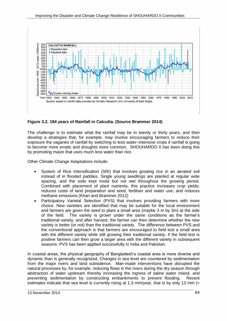
Improving the Disaster and Climate Change Resilience of SHOUHARDO II Communities
13 November 2014
64
Figure 3.2. 184 years of Rainfall in Calcutta. (Source Brammer 2014)
The challenge is to estimate what the rainfall may be in twenty or thirty years, and then develop a strategies that, for example, may involve encouraging farmers to reduce their exposure the vagaries of rainfall by switching to less water–intensive crops if rainfall is going to become more erratic and droughts more common. SHOUHARDO II has been doing this by promoting maize that uses much less water than rice. Other Climate Change Adaptations include:
System of Rice Intensification (SRI) that involves growing rice in an aerated soil instead of in flooded paddies. Single young seedlings are planted at regular wide spacing, and the soils kept moist but not wet throughout the growing period. Combined with placement of plant nutrients, this practice increases crop yields; reduces costs of land preparation and seed, fertiliser and water use; and reduces methane emissions (Khan and Brammer 2012)
Participatory Varietal Selection (PVS) that involves providing farmers with more choice. New varieties are identified that may be suitable for the local environment and farmers are given the seed to plant a small area (maybe 3 m by 3m) at the side of the field. The variety is grown under the same conditions as the farmer’s traditional variety, and after harvest, the farmer can then determine whether the new variety is better (or not) than the traditional variety. The difference between PVS and the conventional approach is that farmers are encouraged to field test a small area with the different variety while still growing their traditional variety. If the field test is positive farmers can then grow a larger area with the different variety in subsequent seasons. PVS has been applied successfully in India and Pakistan.
In coastal areas, the physical geography of Bangladesh’s coastal area is more diverse and dynamic than is generally recognized, Changes in sea level are countered by sedimentation from the major rivers and land subsidence. Man-made interventions have disrupted the natural processes by, for example, reducing flows in the rivers during the dry season through abstraction of water upstream thereby increasing the ingress of saline water inland, and preventing sedimentation by constructing embankments to prevent flooding. Recent estimates indicate that sea level is currently rising at 1.3 mm/year, that is by only 13 mm (=
Improving the Disaster and Climate Change Resilience of SHOUHARDO II Communities
13 November 2014
65
0.5 inch) in 10 years (Brammer 2014). Climate adaptation measures in coastal areas include:
Maintain freshwater flow to western parts of the Ganges Tidal Floodplain in order to prevent the salt-water front from moving further inland.
Manage Coastal Embankment Project (polders) in ways that allow tidal water to enter them at appropriate times of the year in order to deposit sediment at sufficient rates to raise land levels in parallel with a rising sea-level and local land subsidence rates
Promote raised beds or platforms on which to grow appropriate crops. This is a measure that farmers are familiar with and has been promoted by SHOUHARDO II. .
Promote fish farming (including shrimp farming) in perennially flooded areas.
Re-establishing mangrove forests to protect the coastline, enhance sedimentation and enhance fish production.
When considering climate change impacts, one author notes that the impacts of a slowly-rising sea-level are currently much less than those generated by rapidly increasing population pressure on Bangladesh’s available land and water resources and by exposure to existing environmental hazards, and the latter problems need priority attention (Brammer 2014).
4. Conclusions and Recommendations
4.1 What Worked well Capacity Building Activation of UMDCs and UDVs. UMDCs supported by UDVs seem onto have taken an active role in the floods. Warning messages were received and relayed to UP members. UDVs went around their area spreading the warning and advising to prepare for the flood by arranging a portable chula, stocking up of dry food and fuel, and start to arrange to move to a higher location such as a nearby flood shelter or raised homestead. For those in need, UDVs arranged transport or provided assistance with moving. UDMCs liaised with UzDMC to organise the distribution of relief. Increased community awareness of climate change. The CVCA process has raised awareness of VDCs members on climate issues including current climate irregularities and climate change. The CVCA combined with CBP results in a very thorough data collection and analysis, and numerous outputs. It must be time consuming for VDC members to participate in the process, and consideration should be given to identify the essential outputs with of simplifying the process. In addition, there could have been more science to back up or refute villagers’ perceptions of climate and climate change, as suggested in the CVCA methodology.
Flood forecasting. Support for RIMES improved 10-day flood forecasts to complement the 5-day forecasts prepared by FFWC. Flood preparedness. Training provided to UDVs and awareness raising activities for EKATA and other community groups improved disaster preparedness of many households. Emergency response. SHOUHARDO II improved emergency response by activating and developing of UDMCs, UDVs and VDCs through which the government and non-government organisations could assess relief requirements and channel relief more transparently and efficiently. In addition, SHOUHARDO II built the capacity of the 16 PNGOs by providing
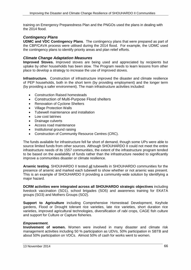
Improving the Disaster and Climate Change Resilience of SHOUHARDO II Communities
13 November 2014
66
training on Emergency Preparedness Plan and the PNGOs used the plans in dealing with the 2014 flood.
Contingency Plans UDMC and VDC Contingency Plans. The contingency plans that were prepared as part of the CBP/CAVA process were utilised during the 2014 flood. For example, the UDMC used the contingency plans to identify priority areas and plan relief efforts.
Climate Change Adaptation Measures Improved Stoves. Improved stoves are being used and appreciated by recipients but uptake by other households has been slow. The Program needs to learn lessons from other place to develop a strategy to increase the use of improved stoves. Infrastructure. Construction of infrastructure improved the disaster and climate resilience of PEP households, both in the short term (by providing employment) and the longer term (by providing a safer environment). The main infrastructure activities included:
Construction Raised homesteads
Construction of Multi-Purpose Flood shelters
Renovation of Cyclone Shelters
Village Protection Walls
Tubewell maintenance and installation
Low cost latrines
Drainage culverts
Access road maintenance
Institutional ground raising
Construction of Community Resource Centres (CRC). The funds available for infrastructure fell far short of demand, though some UPs were able to source limited funds from other sources. Although SHOUHARDO II could not meet the entire infrastructure needs of its 1557 communities, the extent of the infrastructure program tended to be based on the availability of funds rather than the infrastructure needed to significantly improve a communities disaster or climate resilience. Arsenic testing. SHOUHARDO II tested all tubewells in SHOUHARDO communities for the presence of arsenic and marked each tubewell to show whether or not arsenic was present. This is an example of SHOUHARDO II providing a community-wide solution by identifying a major hazard. DCRM activities were integrated across all SHOUHARDO strategic objectives including livestock vaccination (SO1), school brigades (SO5) and awareness training for EKATA groups (SO3) and Mothers Groups (SO2). Support to Agriculture including Comprehensive Homestead Development, Keyhole gardens, Flood or Drought tolerant rice varieties, late rice varieties, short duration rice varieties, improved agricultural technologies, diversification of rabi crops, CAGE fish culture and support for Culture or Capture fisheries. Empowerment. Involvement of women. Women were involved in many disaster and climate risk management activities including 50 % participation as UDVs, 50% participation in SBTB and about 50% participation on VDCs. Almost 50% of cash for works went to women.
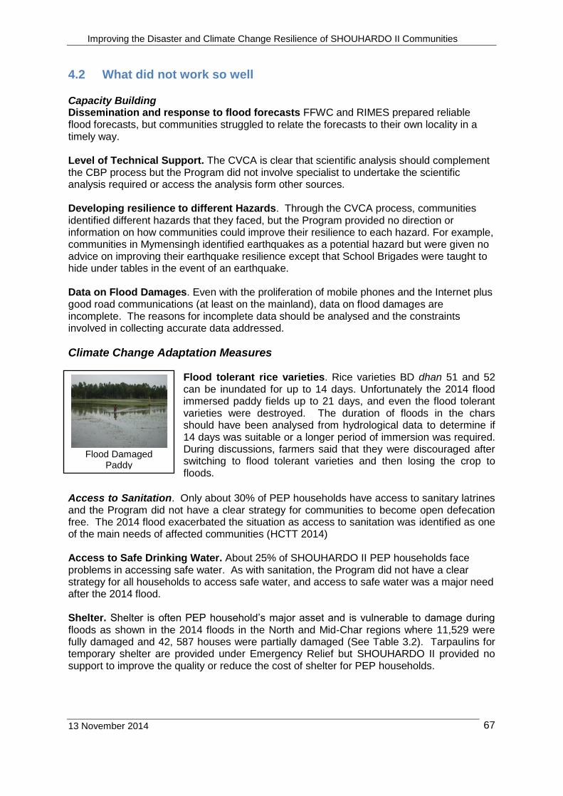
Improving the Disaster and Climate Change Resilience of SHOUHARDO II Communities
13 November 2014
67
4.2 What did not work so well Capacity Building Dissemination and response to flood forecasts FFWC and RIMES prepared reliable flood forecasts, but communities struggled to relate the forecasts to their own locality in a timely way. Level of Technical Support. The CVCA is clear that scientific analysis should complement the CBP process but the Program did not involve specialist to undertake the scientific analysis required or access the analysis form other sources. Developing resilience to different Hazards. Through the CVCA process, communities identified different hazards that they faced, but the Program provided no direction or information on how communities could improve their resilience to each hazard. For example, communities in Mymensingh identified earthquakes as a potential hazard but were given no advice on improving their earthquake resilience except that School Brigades were taught to hide under tables in the event of an earthquake. Data on Flood Damages. Even with the proliferation of mobile phones and the Internet plus good road communications (at least on the mainland), data on flood damages are incomplete. The reasons for incomplete data should be analysed and the constraints involved in collecting accurate data addressed.
Climate Change Adaptation Measures Flood tolerant rice varieties. Rice varieties BD dhan 51 and 52 can be inundated for up to 14 days. Unfortunately the 2014 flood immersed paddy fields up to 21 days, and even the flood tolerant varieties were destroyed. The duration of floods in the chars should have been analysed from hydrological data to determine if 14 days was suitable or a longer period of immersion was required. During discussions, farmers said that they were discouraged after switching to flood tolerant varieties and then losing the crop to floods.
Access to Sanitation. Only about 30% of PEP households have access to sanitary latrines and the Program did not have a clear strategy for communities to become open defecation free. The 2014 flood exacerbated the situation as access to sanitation was identified as one of the main needs of affected communities (HCTT 2014) Access to Safe Drinking Water. About 25% of SHOUHARDO II PEP households face problems in accessing safe water. As with sanitation, the Program did not have a clear strategy for all households to access safe water, and access to safe water was a major need after the 2014 flood. Shelter. Shelter is often PEP household’s major asset and is vulnerable to damage during floods as shown in the 2014 floods in the North and Mid-Char regions where 11,529 were fully damaged and 42, 587 houses were partially damaged (See Table 3.2). Tarpaulins for temporary shelter are provided under Emergency Relief but SHOUHARDO II provided no support to improve the quality or reduce the cost of shelter for PEP households.
Flood Damaged
Paddy
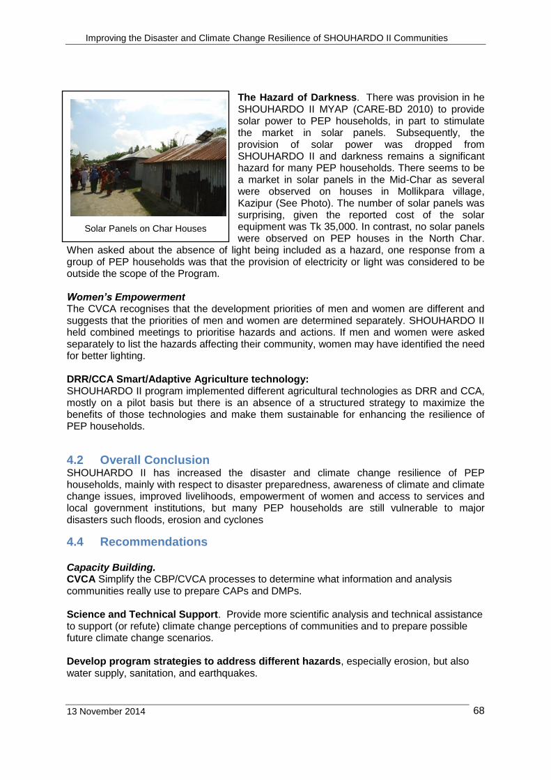
Improving the Disaster and Climate Change Resilience of SHOUHARDO II Communities
13 November 2014
68
The Hazard of Darkness. There was provision in he SHOUHARDO II MYAP (CARE-BD 2010) to provide solar power to PEP households, in part to stimulate the market in solar panels. Subsequently, the provision of solar power was dropped from SHOUHARDO II and darkness remains a significant hazard for many PEP households. There seems to be a market in solar panels in the Mid-Char as several were observed on houses in Mollikpara village, Kazipur (See Photo). The number of solar panels was surprising, given the reported cost of the solar equipment was Tk 35,000. In contrast, no solar panels were observed on PEP houses in the North Char.
When asked about the absence of light being included as a hazard, one response from a group of PEP households was that the provision of electricity or light was considered to be outside the scope of the Program. Women’s Empowerment The CVCA recognises that the development priorities of men and women are different and suggests that the priorities of men and women are determined separately. SHOUHARDO II held combined meetings to prioritise hazards and actions. If men and women were asked separately to list the hazards affecting their community, women may have identified the need for better lighting. DRR/CCA Smart/Adaptive Agriculture technology: SHOUHARDO II program implemented different agricultural technologies as DRR and CCA, mostly on a pilot basis but there is an absence of a structured strategy to maximize the benefits of those technologies and make them sustainable for enhancing the resilience of PEP households.
4.2 Overall Conclusion SHOUHARDO II has increased the disaster and climate change resilience of PEP households, mainly with respect to disaster preparedness, awareness of climate and climate change issues, improved livelihoods, empowerment of women and access to services and local government institutions, but many PEP households are still vulnerable to major disasters such floods, erosion and cyclones
4.4 Recommendations Capacity Building. CVCA Simplify the CBP/CVCA processes to determine what information and analysis communities really use to prepare CAPs and DMPs. Science and Technical Support. Provide more scientific analysis and technical assistance to support (or refute) climate change perceptions of communities and to prepare possible future climate change scenarios. Develop program strategies to address different hazards, especially erosion, but also water supply, sanitation, and earthquakes.
Solar Panels on Char Houses
Improving the Disaster and Climate Change Resilience of SHOUHARDO II Communities
13 November 2014
69
Flood Forecasts and Warnings Further support dissemination of flood forecasts and warnings and flood response Climate Change Adaptation Improved Stoves. Learn lessons from other place to develop a strategy to spread the use of improved stoves Infrastructure
Village protection walls. Prepare a manual on the planning, design and construction of village protection walls based on their extensive experience of implementing village protection works in the haor.
Raised homesteads. Undertake a study to determine why char households do not use their own resources to invest in homestead raising and to identify ways to make homestead raising sustainable.
Shelter. Develop and implement a strategy to improve the houses of PEP families. Empowerment
Ensure separation of men and women when prioritising hazards and actions
Develop and implement a strategy for safe sanitation
Develop and implement a strategy to improve lighting in PEP households. For example, promoting solar powered lamps (rather than solar powered systems) in char areas.
Improving the Disaster and Climate Change Resilience of SHOUHARDO II Communities
13 November 2014
70
References ACAPS (2014) Pre-Disaster Secondary Data on Cold Wave. JNA, Dhaka. Ahmed, A U, S R
Hassan, B Etzold and S Neelormi. “Where the Rainfalls” Project Case Study : Bangladesh. Report No. 2 Bonn: United Nations University Institute for Environment and Human Security (UNU-EHS)
Asian Development Bank (2006) Early Warning Systems Study. Dhaka Barrett, A T, R A McIntosh. M. Pritchard, M Hannan, Z. Alam and M Marks (2013) Asset
Values: Why are some Households doing better than Others? Innovation, Monitoring and Learning Division, Chars Livelihoods Programme, RDA, Bogra
Barrett, A., M. Hannan, Z. Alam and M. Pritchard (2014) Impact of the Chars Livelihoods Programme on the Disaster Resilience of Chars Communities. Innovation, Monitoring and Learning Division, Chars Livelihoods Programme, RDA, Bogra
BBC (2013) Tropical Storm Mahasen strikes Southern Bangladesh http://www.bbc.co.uk/news/world-asia-22537615
Brammer H (2012) Combining sustainable agricultural production with economic and environmental benefits. The Geographical Journal 2012, the Royal Geographic Society, London
Brammer H (2014) Bangladesh dynamic coastal regions and sea-level rise. Climate Rick Management 1 (2014) 51-62
Brammer H (2014) Climate change and sea level rise in Bangladesh: A reality check. Journal of the Tropical Agricultural Association, London
CARE BD (2010) SHOUHARDO II (Strengthening Household Ability to respond to Development Opportunities II). MYAP Proposal, Dhaka
CARE BD (2011) Baseline Study Report. SHOUHARDO II Program, Dhaka CARE BD (2011) Disaster and Climate Risk Management (DCRM). Strategy Implementation
Guidelines. Dhaka CARE BD (2011a) Guideline for the Implementation of Structural Schemes through Labor
Contracting Societies. SHOUHARDO II Program. Dhaka CARE BD (2011b) Infrastructure Planning and Implementation Guideline. Implementing
Agencies: CARE and Partner NGOs. SHOUHARDO II Program Dhaka CARE BD (2011c) Large Structure Planning and Implementation Guidelines. To be
implemented by LGED. SHOUHARDO II Program, Dhaka CARE BD (2011d) Cash for Work (CFW) guideline. Implementing Agencies: CARE and
Partner NGOs. SHOUHARDO II Program, Dhaka CARE International (2009) Climate Vulnerability and Capacity Analysis (CVCA) Handbook.
www.careclimatechange.org CARE International (2014) 2015 and beyond: Action for a just, gender-equitable and
sustainable future. Briefing paper. CARE-BD (2014) Flooding in North East and North West Bangladesh: Emergency Update.
Update #1. September. CARE-BD, Dhaka CARE-BD (2014) Women’s Empowerment: The Journey So Far. SHOUHARDO II Program,
Dhaka CARE-BD (undated) Code of Conduct of Accountability, Prevention and Response to Sexual
Harassment, Exploitation and Abuse of Program Participants/Community, for CARE Bangladesh and Partner Staff. Dhaka.
CARE-BD, Centre for Global Change (CHG) and Water Aid (2013) Assessment of Household Vulnerabilities to Climate Change in the Haor Region of Bangladesh. CARE-Bangladesh, Dhaka
CDMP (2013) Development of Four Decade Long Climate Scenario & Trend: Temperature, Rainfall, Sunshine & Humidity. MoDMF, Dhaka.
Improving the Disaster and Climate Change Resilience of SHOUHARDO II Communities
13 November 2014
71
Chars Livelihood Program (2014) Family Timelines in Brochure with Materials describing CLP, Maxwell Stamp, RDA, Bogra.
Clarke R (editor) (1985) Wood Stove Dissemination –Proceedings of Conference held at Wolfheze, the Netherlands, Practical Action, United Kingdom
Department of Disaster Management DDM (2014) Flood Response Preparedness Plan of Bangladesh. Ministry of Disaster Management and Relief, Dhaka
Department of Disaster Management DDM (undated) Community Based Disaster Preparedness Institutionalization. Ministry of Disaster Management and Relief, Dhaka
Energica (2009 ) Pre-feasibility study for an improved cook stoves project in Northern Ghana. Submitted to: CARE Denmark and Danish Energy Agency http://www.careclimatechange.org/files/reports/Cookstoves_Ghana2009.pdf
HUMANITARIAN COORDINATION TASK TEAM HTCC (2014) Flooding in North Western Bangladesh. (draft) August 31st.
IFRC&RCS (2012) Disaster risk reduction: a global advocacy guide. International Federation of Red Cross and red Crescent Societies, Geneva, Switzerland.
ISDR (2005) Hyogo Framework for Action 2005-2015: Building Resilience of Nations and Communities for Disaster. World Conference on Disaster Reduction, Kobe, Hyogo, Japan. 18-22 January 2005.
Kenward S and R Islam (2011) A Study to Asses the Life-span and Occupancy of CLP Raised Plinths. Chars Livelihood Programme, RDA, Bogra.
Khan A I, G Jonsson (2013) Report on the Functionality Assessment of Union Disaster Management Committees. Comprehensive Disaster Management Programme (CDMP II), Dhaka
King S (2014) Community-Based Adaptation in Practice: A Global Overview of CARE International’s Practice of Community-Based Adaptation (CBA) to Climate Change. CARE International
McAndrew K (2002) Risks to small-scale cage farmers in Bangladesh, with emphasis on fish health experiences of the CARE-CAGES Project. p. 215-223. In: J.R. Arthur, M.J. Phillips, R.P. Subasinghe, M.B. Reantaso and I.H. MacRae. (eds.) Primary Aquatic Animal Health Care in Rural, Small-scale, Aquaculture Development. FAO Fish. Tech. Paper 406. Available at http://www.fao.org/docrep/005/y3610e/y3610E22.htm
Mondal, P. (2014) Integrating Disaster Risk Reduction and Climate Change Adaptation in Development Program: Experience from the Northern Chars in Bangladesh. Paper presented to the NCBA2 Conference, Dhaka
Parvin, S and P Thompson (2012) Adapting Natural Resource Management to Climate Change and Increasing Salinity: Flood and Salinity adapted enterprises for the poor. Briefing Paper 1, Shiree Innovation Project, Dhaka.
RIMES (2013) Community Response to Early Warning System for Flood-2013 (draft). Regional Integrated Multi-hazard Early Warning System, FFWC, BWDB, Dhaka.
RIMES (2014) Medium Range Forecast (1-10 days) Evaluation Report (Draft). Regional Integrated Multi-hazard Early Warning System, FFWC, BWDB, Dhaka.
Scott, Z, R. Few, J. Leavy, M. Tarazona, and K. Wooster (2014) Strategic Research into National and Local Capacity Building for Disaster Risk Management. Literature Review Version 1. Oxford Policy Management Unit, Oxford, United Kingdom.
Shankar A., M Johnson, E. Kay, R Pannu, T Beltramo, E Derby, S. Harrell, C Davis and H Petach (2014) Maximising the benefits of improved cookstoves: moving from acquisition to correct and consistent use. Volume 2 Number 3, Global Health Science and Practice
SHOUHARDO (undated) Early Warning: Saving Lives and Livelihoods available at : http://www.carebangladesh.org/shouhardoII/fld_latst.php
SHOUHARDO II (2011) Disaster and Climate Risk Management (DCRM): Strategy Implementation and Guidelines

Improving the Disaster and Climate Change Resilience of SHOUHARDO II Communities
13 November 2014
72
SHOUHARDO II (2011) Winners’ Wisdom: Coping with Practices in Disaster Management in Bangladesh. SHOUHARDO Program, Dhaka
SHOUHARDO II (2012) CVCA findings and their use. Mymensingh Regional Office SHOUHARDO II (2012) CVCA findings and their use. Rangpur Regional Office SHOUHARDO II (2012) CVCA findings and their use. Sirajganj Regional Office SHOUHARDO II (2013) Striking Preparedness to Strike out ‘Mahasen’ available at:
http://www.carebangladesh.org/shouhardoII/fld_latst.php SHOUHARDO II (2014) Community Reflections: Best Practices of SHOUHARDO II Program
in Bangladesh. CARE-BD, Dhaka SHOUHARDO II (2014) Women’s Empowerment: the Journey So Far: The experience of the
SHOUHARDO Program in Bangladesh. CARE-BD, Dhaka. Sultana, P and P Thompson (2012) Adapting Natural Resource Management to Climate
Change and Increasing Salinity: Flood and Salinity adapted enterprises for the poor. Briefing Paper 1, Shiree Innovation Project, Dhaka.
TANGO (2013) Mid-term review of SHOUHARDO II Multi Year Assistance. CARE-BD Dhak Tod I C (2013) Technical Review of Village Protection Walls Food Security for the Ultra Poor
in the Haor (FSUP-H), Bangladesh. CARE International, London. Tod I C and G Mustafa (2009) Thematic Study of Infrastructure. SHOUHARDO I, CARE-
BD, Dhaka. UNISDR (2005) Hyogo Framework for Action 2005-2015: Building the Resilience of
Communities to Disasters. Final Report of the World Conference on Disaster Reduction (A/CONF.206/6). 18-15 January 2005, Kobe, Hyogo, Japan. www.unisdr.org/hfa
UNISDR (2009) Terminology on Disaster Risk Reduction http://www.unisdr.org/files/7817_UNISDRTerminologyEnglish.pdf
Wahra, G.N (editor) (2013) Bangladesh: Disaster Report. Disaster Forum, Dhaka.
Improving the Disaster and Climate Change Resilience of SHOUHARDO II Communities
13 November 2014
73
Annex 1 Terms of Reference
Terms of Reference (TOR) For the
Study on the effectiveness of Disaster Risk Reduction and Climate Change Adaptation interventions in the SHOUHARDO II Program
I. Introduction & Program Background The SHOUHARDO (Strengthening Household Ability to Responding to Development Opportunities) II Program has been implemented in four regions (North Char, Mid-Char, Haor and Coastal), reaching 11 districts, 30 Upazilas and 172 Unions since June 2010. The five-year Multi-Year Assistance Program (MYAP) builds on the previous phase (SHOUHARDO) which established an effective, integrated model for reducing child malnutrition while contributing to greater livelihood security and women’s empowerment. The program focuses on addressing the availability, access, utilization and stabilization of food security and solving the underlying causes that include social injustice and discrimination, lack of participation and voice, and heightened vulnerability to natural disasters and climate change. The overall goal of the SHOUHARDO II program is to: “Transform the lives of 370,000 Poor and Extreme Poor (PEP) households (HH) in 11 of the poorest and marginalized districts in Bangladesh by reducing their vulnerability to food insecurity.” In order to achieve this goal, the Program has the five key Strategic Objectives (SO) (see Annex 1 for overview) and Strategic Objective SO-5 focuses specifically on Disaster and Climate Risk Management (DCRM) that focused to achieve two intermediate results (IRs) i) Disaster contingency systems in place and functioning and ii) Influence local and national humanitarian assistance initiatives. SO5 namely Disaster & Climate Risk Management (DCRM) is a cross-cutting issue for all activities and strategies of SHOUHARDO-II which is a comprehensive approach combining risk reduction activities (infrastructure, appropriate seeds, livestock protection activities, etc.); early warning and disaster response etc. are being implemented in SHOUHARDO II program. The program also put its efforts to strengthen the capacity of UZ/UDMCs in the working areas through training and facilitating SoD activities by the DMCs i.e. Risk & Resources Mapping, Contingency Planning and community based disaster risk reductions (CBDRR) etc. SHOUHARDO-II also have a plan to develop team of Disaster Volunteers in each of the working Unions which as a front force of UDMCs. Within the context of SHOUHARDO II, SO5 acknowledge the role of climate variability on the food security and livelihoods of PEP households residing in targeted communities. Through its use of the Climate Vulnerability and Capacity Analysis (CVCA) and use of adaptive technologies, SHOUHARDO II is trying to adapt to climate change.

Improving the Disaster and Climate Change Resilience of SHOUHARDO II Communities
13 November 2014
74
Climate Vulnerability and Capacity Analysis (CVCA) SHOUHARDO II has adopted CVCA as a “new participatory methodology” in order to facilitate community analysis of vulnerability and adaptive capacity with regard to climate change. Based on CVCA guidance provided by CARE International the methodology seeks to combine local knowledge with scientific data in order to enhance awareness of climate risks and adaptation strategies. In addition to serving as the basis for formulation of a Climate Change Adaptation (CCA) Plan, the CVCA process is intended to serve as a vehicle for mainstreaming Disaster and Climate Risk Management into all other SOs and local government plans. Thus far, it’s most applicable linkage outside of SO5 is with SO1 in terms of confirming the susceptibility of traditional agricultural practices to damage or loss from climate change and identifying new ‘climate smart’ practices. Prominent examples include piloting of ‘floating gardens’ in flood-prone areas, provision of quality seed and training on cultivation of improved short-season rice and drought and flood tolerant varieties. Creation of disaster-resistant infrastructure SHOUHARDO II seeks to build in the success of the first phase by continuing support for community infrastructure that supports livelihoods and reduces risks resulting from natural disasters and climate change. CARE views Disaster and CRM Climate Risk Management (DCRM) as a “cross-cutting issue” for all activities and argues that structural activities carried out under the program directly contribute to all five SOs. The main types of infrastructural activities implemented by SHOUHARDO II include:
Water supply and sanitation: community and household latrines, construction and maintenance of deep tube wells
Disaster risk mitigation and climate change adaptation: Construction and maintenance of flood /cyclone shelters cum schools; homestead plinth raising; embankment maintenance; slope/mound protection measures,
Transportation/drainage: Submergible roads; road renovation/maintenance; box culverts; small scale bridges; u-drains
Infrastructure is different than other components within SO5 in that it involves the direct participation of Regional Infrastructure Managers (RIM) employed by CARE, Infrastructure Officers (IO) with PNGOs and CARE, representatives of the GOB’s Local Government Engineering Department (LGED) and Labor Contracting Societies (LCS). At the community level, completion of CVCA is intended to help identify (and guide construction of) infrastructure projects associated with SO5. Achievements/Results: CVCA Climate Vulnerability and Capacity Analyses (CVCA) have reportedly been completed in all target communities and their findings have been incorporated into Community Action Plans (CAPs) and informed development of some Union Disaster Management Plans (UDMP). Approximately 25-30 percent of individual issues listed on CAPs were identified through the CVCA process5,6. Importantly, the assessments also revealed that Village Development Committees (VDCs) have been given responsibility for implementing the vast majority of activities deemed necessary by the CVCA. Among the CVCAs examined, the most common
5 CARE Bangladesh. 2012. CVCA Findings and their Use. Sirajganj Regional Office. November 2012.
6 CARE Bangladesh. 2012. Findings of CVCA Analysis. SHOUHARDO II Program, Haor Area, CARE
Bangladesh. November 2, 2012.
Improving the Disaster and Climate Change Resilience of SHOUHARDO II Communities
13 November 2014
75
priority activities for coping with climate change include plinth raising, road maintenance and construction, culvert/canal construction and embankment, tree plantations, cultivation of drought- and flood-tolerant crops and installation of tube wells. Infrastructure Gauging the effectiveness of infrastructure projects implemented under SHOUHARDO II has been challenging. The 2013 ARR reported that a total of 4702 small- and medium-scale infrastructure projects were completed by CARE & PNGOs. II. Consultancy Purpose of the consultancy Aside from improvement or expansion of infrastructures, SHOUHARDO II seeks to promote a more holistic approach to Disaster Risk Reduction through strengthening capacity of targeted community and institutions and climate change adaptation including low-cost measures which households and communities can maintain themselves (efficient cook stoves, tolerant crop varieties, small-scale irrigation, traditional resource management practices, etc.). The purpose of the consultancy is to capture the effectiveness of capacity building effort, contingency systems and the climate change adaptation measures that were undertaken, as well as to document samples of all climate change adaption interventions that have been adopted by members of the SHOUHARDO II community. Where possible the consultant shall demonstrate how the various interventions contributed to enhancing Women’s’ Empowerment. Consultant shall provide recommendations for the possible adaption of new innovative climate change adaptations interventions. Detailed Description 1) Review the SHOUHARDO II DRR and CVCA process and summarize/analyze to which extent these capture/promote a more holistic approach to climate adaptation and disaster risk reduction. Where possible the consultant shall demonstrate how this process contributed to enhancing Women’s’ Empowerment. 2) Document samples of all Disaster Risk Reduction (DRR) and climate change adaption interventions that have been adopted by members of the SHOUHARDO II community and how these have promoted an enhanced understanding of DRR and climate change issues among program beneficiaries and other program stakeholders. Where possible the consultant shall demonstrate how the various interventions contributed to enhancing Women’s’ Empowerment. This should include, but not be limited to:
Agriculture technologies include crops diversification, promoting climate tolerant crop varieties and skilled based IGA.
Infrastructure schemes – Flood proofing of houses and flood shelter cum school, mound protection, box culverts, U-drains, earthen road, community ground raising, CRC, latrines, tube well etc.
Energy efficient technologies include providing improved cook stoves within PEP and promoting the technology among wider communities
Institutional capacity development and mass awareness – (a) Awareness raising at all level including training to Disaster Management Committees, Committees, youth volunteers and school children (b) Rearing sheep instead of goats (c) Promote energy efficient stoves (d) Communities and institutions prioritizes DRR/CCA issues in development plans etc.
Early warning system development and dissemination - providing early warning
Improving the Disaster and Climate Change Resilience of SHOUHARDO II Communities
13 November 2014
76
dissemination equipment to Union Parishad and supporting FFWC to develop and scale up long lead flood forecast
3) Provide recommendations for the possible innovative climate change adaptation interventions that are currently not being implemented. Proposed interventions should have a proven track record of their application within the Bangladesh and/or South East Asia context. III. Process and methodology The Consultant(s) will prepare a work plan immediately upon signature of contracts. The work plan will describe how the consultancy will be carried out and may propose refinements to the scope of work. This work plan (see sample key steps below) will be approved by the SHOUHARDO II Chief of Party. The work plan will address the following elements/ subject to discussion and fine tuning with the consultant:
Expectations of the final report;
Specific Roles and Responsibilities;
Scheduling and timelines for activities and deliverables;
Methodological framework Key Tasks The Consultant(s) will be required to: Prepare a work plan with timeline and deliverables in consultation with the SHOUHARDO II team;
Consultant should draw a representative sample from SHO II communities7 that fall in Char, Haor and Coast for data collection. And, all relevant stakeholders and interventions8 should be consulted for collecting data using participatory methods and tools. List of relevant stakeholders and probable interventions are given as Annex-2. Familiarization with the monitoring and evaluation frameworks of the program;
Review all relevant program documentation (reports, guidelines, baseline, mid-term review, etc.)
Integration ‘within and beyond program components’ is the key guiding principle of SO5. Meaning, all SO activities are undertaken in a manner so that DRR/CCA is integrated. These efforts are also there for developing local government development plan. Consultant should also analyze SO5 contributions in the light of national and international priorities in regards to DRR and CCA (i.e., NDMP, SOD, BCCSAP and HFA).Undertake selective field research, including Focus Group Discussions and Key Informant Interviews
Submit a draft report by 30 September 2014;
Submit a satisfactory final report (not less than 30-35 pages including an executive summary aside from relevant annexes) by no later than 25 October 2014
Conduct a feedback/sharing session with the program staff on the findings and recommendations.
7 SHO II works with 1557 communities of 172 Unions under 30 Upazila in 11 districts. The list will be
provided to the winning bidder 8 The list of relevant stakeholders and interventions will be provided to winning bidder
Improving the Disaster and Climate Change Resilience of SHOUHARDO II Communities
13 November 2014
77
Other dimensions could be added as the consultant sees fit given time and budget available. Outputs and deliverables The Consultant(s) will prepare:
1. A draft work plan;
2. A draft report with annexes (list of people interviewed, methodology, survey instruments, etc.)
3. E-mail and phone updates/de-briefs on progress of the review at regular intervals;
4. Within stipulated deadline (and after receiving comments on the draft report), the Consultant(s) will submit a final report including an abstract/executive summary and all relevant annexes;
5. Conduct a feedback/training/sharing session with the SHOUHARDO II program staff on the findings and recommendations.
6. Both draft report and final report should provide high-resolution pictures documenting the climate change adaption interventions, which are captured in the report.
CARE will assess the quality of the final report based on the degree to which the report demonstrates that the evaluation has fulfilled the purpose for which it was conducted.
Improving the Disaster and Climate Change Resilience of SHOUHARDO II Communities
13 November 2014
78
IV. Level of Effort and Budget The time frame proposed for the submission of the report is by no later than 25 October 2014. The level of effort is estimated to 30 - 45 person-days. Time breakdown will be set by the consultant in consultation with the SHOUHARDO II program team in Dhaka, Bangladesh. Travel expenses and per diems will be covered by CARE directly. All contractual, travel, payment procedure will be done according to CARE rules and procedures and will be coordinated by the CARE Bangladesh Dhaka office.
V. Consultant(s) Qualifications
The consultant can be individual(s) or firm having expertise on Disaster Risk Reduction and (DRR) and Climate Change and expected to have experience in food security of poor and extreme poor (PEP). However, the study is preferred to be lead by an international expert.
VI. Contract Supervision
The SHOUHARDO II point person will be responsible for:
Coordinate site visit, key meetings, interviews, etc.
Feedback throughout all phases of execution.
Supplying the needed documents
Approval of all deliverables (e.g. work plan, the draft final report and the final report).
The Consultant(s) are responsible for:
Preparing a draft work plan;
Preparing the report;
Coordinating with the SHOUHARDO II program in Bangladesh;
The day–to–day management of operations;
Regular progress reporting to SHOUHARDO II;
The production of deliverables in accordance with contractual requirements
Improving the Disaster and Climate Change Resilience of SHOUHARDO II Communities
13 November 2014
79
ToR Annex 1: SO1: "Availability of" and "access to" nutritious foods enhanced and protected for 370,000 PEP households. IR1.1: Improved and diversified agriculture systems developed and linked with private and public services. IR1.2: Increased household income among PEP in the target communities. SO2: Improved health, hygiene and nutrition status of 281,000 children under 2 years of age. IR2.1: "Access to" and "utilization of" health and nutrition services improved to care givers of children under 2 years of age. IR2.2: Care givers of children under 2 adopt improved health, hygiene and nutrition behavior and caring practices. SO3: PEP women and adolescent girls empowered in their families, communities and Union Parishad (UP). IR3.1: Influence of PEP women and adolescent girls in decision making increased. IR3.2: Local support systems strengthened to reduce Violence Against Women (VAW). SO4: Local elected bodies and government service providers responsiveness and accountability to the PEP increased. IR4.1: Nation Building Departments (NBD) and Union Parishads proactively work to address the needs of the PEP, especially women. IR 4.2: PEP access to entitlements and services increased, including safety nets and natural resources. SO5: Targeted community members and government institutions are better prepared for, mitigate, and respond to disasters and adapt to climate change. IR5.1: Disaster contingency systems in place and functioning. IR5.2: Influence local and national humanitarian assistance initiatives.

Improving the Disaster and Climate Change Resilience of SHOUHARDO II Communities
13 November 2014
80
ToR Annex 2: The list of relevant stakeholders and interventions
SL no Respondents Interventions Level
1. Village Development Committee members and Disaster focal persons at VDC
-Inclusion of CCA interventions in all sectors through CAP -Homestead plinths and other infrastructure
Village
2. CoG group members and Sub Assistant Agriculture Officer (field crop, livestock)
Cropping pattern (incl. floating garden) and adaptive variety
Village
3. Community Agriculture Volunteer
Crop intensification and agriculture technology including Adaptive variety
Village
4. MCHN-Mother group member
Improved stoves Tippy Tap, health prep
Village
5. Community members (PEP+Non-PEP), LCS and LGED
Flood shelter cum school construction/maintenance, Cyclone shelter cum school maintenance, box culverts, Wave protection wall, U-drains, earthen/rural road, homestead plinths raising, community ground raising, community resource centre construction, HH/community latrines, tube well installation and arsenic tests etc.
Village, LGED at National, District, Upazila
6. Disaster Volunteers
Role in early warning (Incl. RIMES where applicable), awareness and proactive initiatives, local risk analysis and planning
Village + Union
7. UDMC members
Role in DCRM as per SoD (i.e. capacity building, risk assessment, planning, meeting, early warning, evacuation and recovery
Union
8. SBTB members
Role in Awareness, School safety plan and DRR initiatives
School (selective schools)
9. UzDMC members UDMP, Training, Meeting etc. Upazila

Improving the Disaster and Climate Change Resilience of SHOUHARDO II Communities
13 November 2014
81
Annex 2 Key Informants A) SHOUHARDO II: CARE-BD and PNGO Staff CARE-BD HQ Marc Nosbach, Chief of Party, SHOUHARDO II Monzu Morshed, Deputy Chief of Party SHOUHARDO II Shafiqur Rahman, Humanitarian Assistance Coordinator Palash Mondal, Senior Technical Manager, Humanitarian Assistance H J M Kamal, National Technical Coordinator Md. Anjar Alam, Senior Technical Manager Infrastructure, (PNGOs) Md. Mizanur Rahman, Senior Technical Manager Infrastructure, (LGED) Ashrafiz Zaharia Prodhan, Senior Technical Manager (SO3) Karen Moore, Assistant Country Director (Programme) Zubaidur Rahman, Resource Management Coordinator (SHI) Harun-or-Rashid, Climate Change Coordinator Manjur Rashid, Knowledge Management Coordinator Mehrul Islam, Director Khan Tawhid Parvez, Senior Technical Manager (SO2) Rangpur Regional Office (CARE-BD/SHOUHARDOII) Sabrata Kumar Saha, Regional Coordinator Md. Mohabbat Ali, Regional Programme Manager Ruhul Islam, Regional Infrastructure Manager, Md. Abu Bakar Siddique, Technical Manager (SO5) Aslam Hossain, Technical Manager (SO2) Md. Hedyatul Islam, Technical Manager (SO1) Bimola Bala, Technical Manager (SO3) Direct Delivery Team, Kaunia Nihar Kumar Pramanik, Field Supervisor, Kaunia Team Office Md. Mahmudul Hasan, Field Supervisor, Kaunia Team Office Kurigram Hub Office (CARE-BD) Laizu Begum, Program Officer SKS Ulipur Md. Baharam Khan, Program Manager, SH II Program Solidarity, Kurigram Harun Ar Rashid Lal, Executive Director Tanzina Khatun, Programme Manager SHOUHARDO II Humayun Kabir Surjo, Programme Director SHOUHARDO II Sirajganj Regional Office (CARE-BD) Khalequez Zaman, Regional Coordinator Bisowjit Kumar Roy, Technical Manager (SO5) Md. Abdul Hai Khan, Technical Manager (SO1) S M Khaledul Ahsan, Technical Manager (SO2) Md. Sadakur Raihan, Regional Resource Manager Razon chandra Saha, Regional Commodity Logistical Manager A S M Mahbub Husain, Regional Infrastructure Manager Biswojit Banik, Regional Monitoring and Evaluation Manager
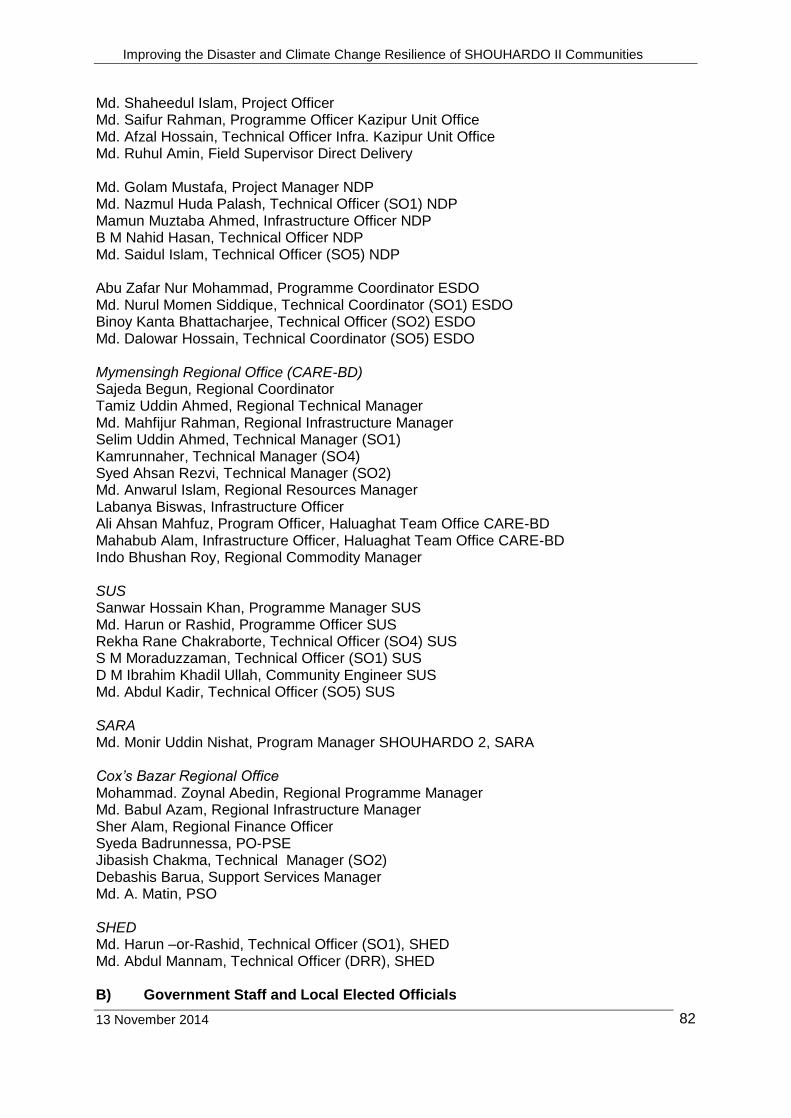
Improving the Disaster and Climate Change Resilience of SHOUHARDO II Communities
13 November 2014
82
Md. Shaheedul Islam, Project Officer Md. Saifur Rahman, Programme Officer Kazipur Unit Office Md. Afzal Hossain, Technical Officer Infra. Kazipur Unit Office Md. Ruhul Amin, Field Supervisor Direct Delivery Md. Golam Mustafa, Project Manager NDP Md. Nazmul Huda Palash, Technical Officer (SO1) NDP Mamun Muztaba Ahmed, Infrastructure Officer NDP B M Nahid Hasan, Technical Officer NDP Md. Saidul Islam, Technical Officer (SO5) NDP Abu Zafar Nur Mohammad, Programme Coordinator ESDO Md. Nurul Momen Siddique, Technical Coordinator (SO1) ESDO Binoy Kanta Bhattacharjee, Technical Officer (SO2) ESDO Md. Dalowar Hossain, Technical Coordinator (SO5) ESDO Mymensingh Regional Office (CARE-BD) Sajeda Begun, Regional Coordinator Tamiz Uddin Ahmed, Regional Technical Manager Md. Mahfijur Rahman, Regional Infrastructure Manager Selim Uddin Ahmed, Technical Manager (SO1) Kamrunnaher, Technical Manager (SO4) Syed Ahsan Rezvi, Technical Manager (SO2) Md. Anwarul Islam, Regional Resources Manager Labanya Biswas, Infrastructure Officer Ali Ahsan Mahfuz, Program Officer, Haluaghat Team Office CARE-BD Mahabub Alam, Infrastructure Officer, Haluaghat Team Office CARE-BD Indo Bhushan Roy, Regional Commodity Manager SUS Sanwar Hossain Khan, Programme Manager SUS Md. Harun or Rashid, Programme Officer SUS Rekha Rane Chakraborte, Technical Officer (SO4) SUS S M Moraduzzaman, Technical Officer (SO1) SUS D M Ibrahim Khadil Ullah, Community Engineer SUS Md. Abdul Kadir, Technical Officer (SO5) SUS SARA Md. Monir Uddin Nishat, Program Manager SHOUHARDO 2, SARA Cox’s Bazar Regional Office Mohammad. Zoynal Abedin, Regional Programme Manager Md. Babul Azam, Regional Infrastructure Manager Sher Alam, Regional Finance Officer Syeda Badrunnessa, PO-PSE Jibasish Chakma, Technical Manager (SO2) Debashis Barua, Support Services Manager Md. A. Matin, PSO SHED Md. Harun –or-Rashid, Technical Officer (SO1), SHED Md. Abdul Mannam, Technical Officer (DRR), SHED B) Government Staff and Local Elected Officials
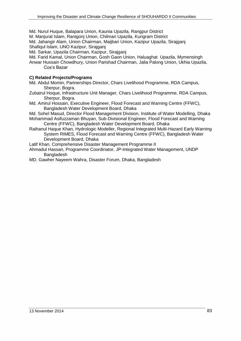
Improving the Disaster and Climate Change Resilience of SHOUHARDO II Communities
13 November 2014
83
Md. Nurul Huque, Balapara Union, Kaunia Upazila, Rangpur District M. Manjural Islam, Ranigonj Union, Chilmari Upazila, Kurigram District Md. Jahangir Alam, Union Chairman, Maijbari Union, Kazipur Upazila, Sirajganj Shafiqul Islam, UNO Kazipur, Sirajganj Md. Sarkar, Upazila Chairman, Kazipur, Sirajganj Md. Farid Kamal, Union Chairman, Gosh Gaon Union, Haluaghat Upazila, Mymensingh Anwar Hussain Chowdhury, Union Parishad Chairman, Jalia Palong Union, Ukhia Upazila,
Cox’s Bazar C) Related Projects/Programs Md. Abdul Momin, Partnerships Director, Chars Livelihood Programme, RDA Campus,
Sherpur, Bogra. Zubairul Hoque, Infrastructure Unit Manager, Chars Livelihood Programme, RDA Campus,
Sherpur, Bogra. Md. Amirul Hossain, Executive Engineer, Flood Forecast and Warning Centre (FFWC),
Bangladesh Water Development Board, Dhaka Md. Sohel Masud, Director Flood Management Division, Institute of Water Modelling, Dhaka Mohammad Asifuzzaman Bhuyan, Sub-Divisional Engineer, Flood Forecast and Warning
Centre (FFWC), Bangladesh Water Development Board, Dhaka Raihanul Haque Khan, Hydrologic Modeller, Regional Integrated Multi-Hazard Early Warning
System RIMES, Flood Forecast and Warning Centre (FFWC), Bangladesh Water Development Board, Dhaka
Latif Khan, Comprehensive Disaster Management Programme II Ahmadul Hassan, Programme Coordinator, JP-Integrated Water Management, UNDP
Bangladesh MD. Gawher Nayeem Wahra, Disaster Forum, Dhaka, Bangladesh

Improving the Disaster and Climate Change Resilience of SHOUHARDO II Communities
13 November 2014
84
Annex 3 Participants and Locations of Discussions and Sites Visited Date District Upazila Union Village/Location Main Discussions held and Activities Visited
Rangpur Region
Sep 4 Rangpur Sadar North Char Regional Office
RC, RIM, TM (SO2), TM (SO3), RPM, TM (SO5), STM-HA, TM (SO1)
Sep 5 Rangpur Kaunia Balapara Direct Delivery Team Office CARE-BD
Field Supervisor
Uttar Horishwar VDC incl. chairman, vice chairman,
+ 2 members, CHV, DV. 2 EKATA members, 2 beneficiaries
Bridge (by LCS)
1.25 km Earthen road (by PIC)
Balapara Union Parishad Bhavan
UDMC incl. chairman, secretary and 2 UP Members
15 DV
Sep 6 Kurigram Ulipur Durgapur Goraipachpir VDC incl. president and 5 members. 6 LCS members incl. president
Bridge (Contractor)
Chilmari Ranigonj Koyarpara VDC incl. president, secretary, 11 members (7F/4M), EKATA (4 members), CAV, CHV, Programme Manager SKS, TO (SO5) SKS, Regional Technical Manager CARE-BD, Senior Technical Manager (Humanitarian Assistance)-CARE-BD.
CRC, Keyhole Garden, Food Distribution Centre, Improved rice varieties, Improved stove
Ranigonj Union Parishad Bhavan
Union Disaster Management Committee incl. UCM, UCS plus 6 members, Regional Technical Manager CARE-BD, Senior Technical Manager (Humanitarian Assistance)-CARE-BDD.
16 DV, Programme Manager SKS, TO (SO5) SKS, Regional Technical Manager CARE-BD, STM (SO5-HQ)
Ulipur SKS Team Office SKS (Programme Manager, AO, TO (SO2), TO (SO5), Field Supervisor (Manager), TO (SO4), TO (SO1), TO(Infrastructure), PO ) CARE (Technical Manager (SO5), Infrastructure Officer
Sep 7 Kurigram Kurigram Sadar
Solidarity SH II office Solidarity staff incl. Executive Director, Programme Manager, Project Director, Finance Officer, TO (SO5), TO(SO4), TO(SO3), Information Officer, TO(SO2) and TO(SO1)
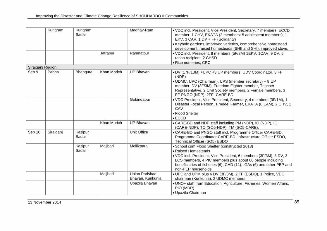
Improving the Disaster and Climate Change Resilience of SHOUHARDO II Communities
13 November 2014
85
Kurigram Kurigram Sadar
Madhav-Ram VDC incl. President, Vice President, Secretary, 7 members, ECCD member, 1 CHV, EKATA (2 members+5 adolescent members), 1 EKV, 3 CAV, 1 DV + FF (Solidarity)
Keyhole gardens, improved varieties, comprehensive homestead development, raised homesteads (SHII and SHI), improved stove.
Jatrapur Rahmatpur VDC incl. President, 8 members (5F/3M) 1EKV, 1CAV, 9 DV, 5 ration recipient, 2 CHSD
Rice nurseries, CRC
Sirajganj Region
Sep 9 Pabna Bhangura Khan Morich UP Bhavan DV (17F/13M) +UPC +3 UP members, UDV Coordinator, 3 FF (NDP)
UDMC, UPC (Chairman), UPS (member secretary) + 8 UP member, DV (3F/3M), Freedom Fighter member, Teacher Representative, 2 Civil Society members, 2 Female members, 3 FF-PNGO (NDP), 2FF- CARE-BD
Gobindapur VDC President, Vice President, Secretary, 4 members (3F/1M), 1 Disaster Focal Person, 1 model Farmer, EKATA (6 EAM), 2 CHV, 1 CAV
Flood Shelter
ECCD
Khan Morich UP Bhavan CARE-BD and NDP staff including PM (NDP), IO (NDP), IO (CARE-NDP), TO (SO5-NDP), TM (SO5-CARE),
Sep 10 Sirajganj Kazipur Sadar
Unit Office CARE-BD and PNGO staff incl. Programme Officer CARE-BD, Programme Coordinator CARE-BD, Infrastructure Officer ESDO, Technical Officer (SO5) ESDO
Kazipur Sadar
Maijbari Mollikpara School cum Flood Shelter (constructed 2013)
Raised Homesteads
VDC incl. President, Vice President, 6 members (3F/3M), 3 DV, 3 LCS members, 4 PIC members plus about 60 people including beneficiaries of fisheries (6), CHD (11), IGAs (6) and other PEP and non-PEP households.
Maijbari Union Parishad Bhavan, Kunkunia
UPC and UPM plus 6 DV (3F/3M), 2 FF (ESDO), 1 Police, VDC chairman (Kunkunia), 2 UDMC members
Upazila Bhavan UNO+ staff from Education, Agriculture, Fisheries, Women Affairs, PIO (MDR)
Upazila Chairman
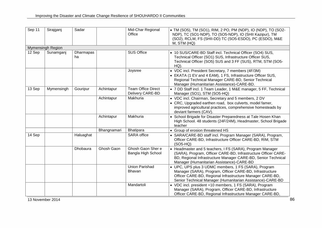
Improving the Disaster and Climate Change Resilience of SHOUHARDO II Communities
13 November 2014
86
Sep 11 Sirajganj Sadar Mid-Char Regional Office
TM (SO5), TM (SO1), RIM, 2 PO, PM (NDP), IO (NDP), TO (SO2-NDP), TC (SO1-NDP), TO (SO5-NDP), IO (SHII Kazipur), TM (SO2), RCLM, FS (SHII-DD) TC (SO5-ESDO), PC (ESDO), M&E M, STM (HQ)
Mymensingh Region
12 Sep Sunamganj Dharmapasha
SUS Office 10 SUS/CARE-BD Staff incl. Technical Officer (SO4) SUS, Technical Officer (SO1) SUS, Infrastructure Officer SUS, Technical Officer (SO5) SUS and 3 FF (SUS), RTM, STM (SO5-HQ).
Joysree VDC incl. President Secretary, 7 members (4F/3M)
EKATA (1 EV and 4 EAM), 1 FS, Infrastructure Officer SUS, Regional Technical Manager CARE-BD, Senior Technical Manager (Humanitarian Assistance)-CARE-BD.
13 Sep Mymensingh Gouripur Achintapur Team Office Direct Delivery CARE-BD
7 DD Staff incl. 1 Team Leader, 1 M&E manager, 5 FF, Technical Manager (SO1), STM (SO5-HQ)
Achintapur Makhuria VDC incl. Chairman, Secretary and 5 members, 2 DV
CRC, Upgraded earthen road, box culverts, model famer, improved agricultural practices, comprehensive homesteads by deviant farmers (CAV).
Achintapur Makhuria School Brigade for Disaster Preparedness at Tale Hosen Khan High School. 48 students (24F/24M), Headmaster, School Brigade teacher
Bhangnamari Bhatipara Group of erosion threatened HS
14 Sep Haluaghat SARA office SARA/CARE-BD staff incl. Program Manager (SARA), Program, Officer CARE-BD, Infrastructure Officer CARE-BD, RIM, STM (SO5-HQ)
Dhobaura Ghosh Gaon Ghosh Gaon Sher e Bangla High School
Headmaster and 5 teachers, I FS (SARA), Program Manager (SARA), Program, Officer CARE-BD, Infrastructure Officer CARE-BD, Regional Infrastructure Manager CARE-BD, Senior Technical Manager (Humanitarian Assistance)-CARE-BD
Union Parishad Bhavan
UPC, UPS plus 3 UDMC members, 1 FS (SARA), Program Manager (SARA), Program, Officer CARE-BD, Infrastructure Officer CARE-BD, Regional Infrastructure Manager CARE-BD, Senior Technical Manager (Humanitarian Assistance)-CARE-BD
Mandartoli VDC incl. president +10 members, 1 FS (SARA), Program Manager (SARA), Program, Officer CARE-BD, Infrastructure Officer CARE-BD, Regional Infrastructure Manager CARE-BD,
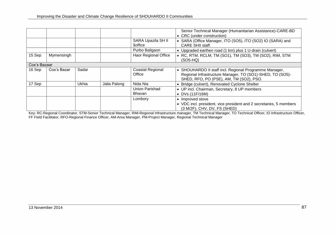
Improving the Disaster and Climate Change Resilience of SHOUHARDO II Communities
13 November 2014
87
Senior Technical Manager (Humanitarian Assistance)-CARE-BD
CRC (under construction)
SARA Upazila SH II §office
SARA (Office Manager, ITO (SO5), ITO (SO2) IO (SARA) and CARE SHII staff.
Purbo Baligaon Upgraded earthen road (1 km) plus 1 U-drain (culvert)
15 Sep Mymensingh Haor Regional Office RC, RTM, RCLM, TM (SO1), TM (SO3), TM (SO2), RIM, STM (SO5-HQ)
Cox’s Bazaar
16 Sep Cox’s Bazar Sadar Coastal Regional Office
SHOUHARDO II staff incl. Regional Programme Manager, Regional Infrastructure Manager, TO (SO1)-SHED, TO (SO5)-SHED, RFO, PO (PSE), AM, TM (SO2), PSO.
17 Sep Ukhia Jalia Palong Nida Nia Bridge (culvert), Renovated Cyclone Shelter
Union Parishad Bhavan
UP incl. Chairman, Secretary, 8 UP members
DVs (11F/16M)
Lombory Improved stove
VDC incl. president, vice president and 2 secretaries, 5 members (3 M/2F), CHV, DV, FS (SHED)
Key: RC-Regional Coordinator, STM-Senior Technical Manager, RIM-Regional Infrastructure manager, TM Technical Manager, TO Technical Officer, IO Infrastructure Officer, FF Field Facilitator, RFO-Regional Finance Officer, AM-Area Manager, PM-Project Manager, Regional Technical Manager
Improving the Disaster and Climate Change Resilience of SHOUHARDO II Communities
13 November 2014 88
Annex 4 Discussion Note on the Flood Forecasting Models A5.1 Background Major floods in Bangladesh are generated outside Bangladesh from rainfall in the Ganges, Brahmaputra and Meghna (GBM) rivers basins, as well as from snow melt from the Himalayas. Floods can be made worse by runoff and congested drainage from excessive rainfall within Bangladesh. The GBM basins have total catchment area of approximately 1.72 million km2 of which only about 7.5% is within Bangladesh. The Brahmaputra River above Bahadurabad has a length of approximately 2,900 km and a catchment area about 583,000 km2. The length of the Ganges River is about 2,600 km and a catchment area of approximately 907,000 km2. The upper reaches of the Meghna River originate in the Manipur Hills in India and its main tributary the Barak River has a length of 900 km. The catchment area of the Meghna is about 230,000 km2, and includes one of the wettest areas of the world, Cherrapunji where the average annual rainfall is about 10 m. Bangladesh Water Development Board’s (BWDB) Flood Forecasting and Warning Centre (FFWC) has the mandate to provide flood forecasts and warnings services. FFWC was established in 1972. The Centre is fully operational during the flood season (April-October), as directed in the government’s Standing Orders on Disaster (SOD). FFWC prepare flood forecasts using numerical computer models. Since 1992, FFWC have used the MIKE II computer model to prepare flood forecasts. The inputs to the model are daily rainfall and water levels that are used to interpret the present water levels and forecast changes of water levels during the next few days. In 1995, the MIKE 11 Super Model was introduced and the 2-day flood forecasts were available at 30 locations. In 2000-2004, the range of the model was extended to cover the centre, north-east and north-west of the country and the forecast period increased to 3-days. From 2009, flood forecasts were prepared for 38 locations on 21 rivers and from 2012 the Super Model was further improved to increase the forecast period to 5 days and prepare flood forecasts for 54 locations on 29 rivers. Initially, the scope for developing flood forecasting models was constrained by hydrological data not being available outside the boundaries of Bangladesh as India refused to provide water level or climate data for the upper basins which covered 92.5% of the catchment areas of the rivers carrying the main flood flows. In recent years, India has agreed to provide some climate data from nearby stations, which has helped to improve the accuracy of the forecasts. MIKE II is a deterministic model, in which no randomness is involved in the developing flood forecasts. A deterministic model will thus always produce the same output from a given starting condition or initial state. If the starting conditions were known exactly, then flood forecasts could be predicted accurately. However, in practice, weather systems are chaotic and water level and climate data cannot be measured precisely. Hence the accuracy of flood forecasts from deterministic models tends to diminish as the time of forecast increases. With further technical development, better data availability and considerable effort, FFWC took 9 years to increase the forecasting period from 2 days to 3 days and another 8 years to increase the forecast period from 3 to 5 days. The present forecast of 5 days is about at the limit of the flood forecasts possible from a deterministic model. With the development of radar and satellite imagery in the late 1990’s, regional weather data can be generated from analysis if the weather systems over the GBM basin, overcoming the constraints on the availability of weather and river data imposed by national boundaries.

Improving the Disaster and Climate Change Resilience of SHOUHARDO II Communities
13 November 2014 89
However, using regional weather data requires large data sets and the accuracy of the rainfall determined from the data becomes more uncertain. To account for these uncertainties in the data, probabilistic of statistical models are better for flood forecasting using regional weather data. During the period 2005-2008, a long lead-time probabilistic flood forecast model was developed by the Regional Integrated Multi-Hazard Early Warning System (RIMES) and Climate Forecast Application Network (CFAN), USA, in collaboration with FFWC. Model development was funded by SHOUHARDO I. In 2012, SHOUHARDO II provided further funding to RIMES to enhance the model to cover short (1-10 days), medium (20-25 days) and long term (1-6 months) time periods. The methodology used by the two models to calculate flood forecasts are shown in Figure 1, with Figure 1a showing the methodology for the FFWC Super Model and Figure 1b showing the methodology for the Long Lead Model. In this Note, the main features of the FFWC Super Model and the RIMES long-lead time model are discussed.

Improving the Disaster and Climate Change Resilience of SHOUHARDO II Communities
13 November 2014 90
Output Forecast Product
Forecasting Model Daily Input Data
Water Levels
Collected from 84 sites
Rainfall
Collected from 56 sites
MIKE 11 Hydrologic Model
5-day Water Level forecasts at 54 locations on 21 rivers
Flood inundation map
Rainfall Surface map
Figure 1a: 3/5-Day Super Model
Generation of Probabilistic Q
Daily Input Data
NOAA and NASA (I.e. CMORPH and GPCPP) satellite precipitation and
GTS rain gauge data
Statistical Rendering
Downscaling of forecasts
Statistical Correction
ECMWF Operational Ensemble forecast
MIKE 11 Hydrologic Model Lumped
Distributed
Multi-model
Forecasting Model
Accounting for uncertainties
Final error Correction
Generation of discharge and critical level forecasts
10-day Discharge forecast
Output Forecast Product
10-day Water Level forecast
River Discharges Daily Ganges and Brahmaputra data
Updated distributed hydrological model
parameters
Figure 1b: 10-Day Long Lead Model
Flood Watch
Flood Watch
Improving the Disaster and Climate Change Resilience of SHOUHARDO II Communities
13 November 2014 91
A5.2 Super Model Flood Forecasts Input data. Each day during the forecasting season, water level data from 84 recording stations and rainfall from 56 recording stations are transmitted from around the country to FFWC. The locations of the recording stations are shown in Figure 2. The data are sent to FFWC between 08:30 and 10:00 hrs. by each day phone. The data are recorded in a register and then entered into a database for use in the day’s run of the flood forecasting model. FFWC tried 5 Automatic Water Level (AWL) Recording Stations but they did not work well, mainly due to management problems. FFWC plan to install 29 AWLs in future. Boundary conditions: The boundary for the Super Model is set where the major rivers enter Bangladesh, namely Noonkhawa on the Brahmaputra River and Pankha on the Ganges River. FFWC collects water level data at these two points and the data is input into the model as boundary conditions Flood Forecasting. Flood forecasts are calculated using the MIKE 11 computer program9 that simulates flow and water level in rivers, flood plains and other inland water bodies. MIKE 11 is a 1-dimensional river model, developed by DHI (formerly the Danish Hydraulics Institute). MIKE11 is operated through an efficient interactive menu system with systematic layouts and sequencing of menu The Hydrodynamic model at the centre of the model is complemented by a number of additional modules and extensions covering different aspects of river modelling including GIS10, Rainfall-runoff and structures. For real-time flood forecasting, FFWC uses Flood Watch, a decision support system that combines an advanced time series database with the MIKE 11 Flood Forecast hydrodynamic modeling and forecasting system and Arc View GIS. Flood Watch provides the integration of a flood forecasting system in a GIS environment for real-time flood forecasting. Flood Watch comprises a number of elements:
The Flood Watch Graphical User Interface (GUI), a customized Arc View project which provides a live display of station measurements and forecasts;
The MIKE 11 hydrodynamic modeling system with additional flood forecasting (FF) module;
The Flood Watch database for the storage of real time data; Once the database is established and the graphical display of stations configured, Flood Watch allows fast and easy handling of the procedures involved in the management of a real-time flood forecasting and warning system. Outputs. The main forecast products from the Super Model include:
3 and 5-day (experimental) water level forecasts at 54 locations. An example of part of the daily 5-day forecasts is given in Figure A5-3.
Flood inundations maps
Rainfall intensity Distribution Map
9 The computational core of MIKE 11 is hydrodynamic simulation module that provides fully
dynamic solution to the complete non-linear 1-D Saint Venant equations, diffusive wave approximation and kinematic wave approximation, as well as the Muskingum method and Muskingum-Cunge method for simplified channel routing. For more details, see http://www.mikebydhi.com/products/mike-11

Improving the Disaster and Climate Change Resilience of SHOUHARDO II Communities
13 November 2014 92
Figure A5.2: Location of Water Level and Rainfall Recording Points in the Super
Model

Improving the Disaster and Climate Change Resilience of SHOUHARDO II Communities
13 November 2014 93
Figure A5.3 Example of Super Model 5-day flood forecasts.
Improving the Disaster and Climate Change Resilience of SHOUHARDO II Communities
13 November 2014 94
5.3 Long Lead Flood Forecasts The long lead flood forecasts also uses both the MIKE 11 and Flood Watch modeling systems but has additional components to calculate rainfall and runoff from regional weather systems. The updated Super Model is used for customization of real-time flood forecasting utilizing long lead flood forecasts system predictions. The customized Super Model is then used for the flood forecasting of extended lead-time using climate forecast application data for medium range (1-10 day) flood forecasting. In the first phase (2005-2008) 10-day forecasts were made at 18 locations. In second phase starting in 2012, forecasting was extended to 38 locations. Boundary conditions: Unlike the Super Model, the boundaries for the long-lead model are the discharge at Bahadurabad on the Brahmaputra River and Hardinge Bridge on the Ganges River. Rating curves at the two locations are used to determine discharges from the forecast water levels. Input data. Input data are used to either drive the forecasts, or correct the forecasts and provide a calibration of the basin discharge. Input data comprises of:
Discharge data. Daily Brahmaputra and Ganges river discharges.
Hydrologic model parameters. Real time rainfall data are available for all the catchments, therefore, all these catchments are adopted in the medium range rainfall-runoff model to avoid complexity and save development time. The re-delineation of catchments was carried out to exclude catchments or rivers or reaches upstream of Bahadurabad and Hardinge Bridge.
National Oceanic and Atmospheric Administration (NOAA) Tropical Rainfall Measuring Mission (TRMM11) and National Aeronautics and Space Administration (NASA) (CMORPH12) satellite rainfall data and CPC rain gauge data
ECMWF Ensemble Prediction Systems (EPS). ECMWF/EPS provides a practical tool for estimating rainfall. The ECMWF/EPS forecasts are run daily 51 times to generate 51 sets of discharge forecasts at Bahadurabad and Hardinge Bridge and Bhairab Bazar (experimental). Statistical Rendering Forecasts are downscaled to computation grid 0.5 by 0,5 degree. In addition, statistical corrections are made by quantile to quantile mapping of downscaled forecasts at each grid point/forecast lead-time. Flood forecast modeling. The Time of Forecast (ToF) is the time when the forecast is made and hindcast13 period defines the simulation period up to the ToF. Water level and
11
The Tropical Rainfall Measuring Mission (TRMM) is a joint space mission between NASA and the Japan Aerospace Exploration Agency (JAXA) designed to monitor and study tropical rainfall. The term refers to both the mission itself and the satellite that the mission uses to collect data. The satellite was launched on November 27, 1997. 12
CMORPH (Climate Prediction Centre CPC MORPHing technique) produces global precipitation
analyses at very high spatial and temporal resolution. The technique uses precipitation estimates that have been derived from low orbiter satellite microwave observations exclusively, and whose features are transported via spatial propagation information that is obtained entirely from geostationary satellite IR data. 13
Hindcast is a method of testing a mathematical model. Known or closely estimated inputs for past
events are entered into the model to see how well the output matches the known results. Hindcasting is also known as backtesting.
Improving the Disaster and Climate Change Resilience of SHOUHARDO II Communities
13 November 2014 95
rainfall data collected by FFWC are utilized during the 3-day Hindcast period, and for the 10 day forecast simulations are made for the 7 days. Under the long lead flood forecasts system initiative, both Flood Watch and MIKE 11 models were used for flood forecasting using medium range flood forecasts. The updated FFWC model is used for customization of real-time flood forecasting utilizing medium range flood forecasts system predictions. The customized Super Model is then used for the flood forecasting of extended lead-time using climate forecast application data thatFraserAliso13 is named as medium range (1-10 day) flood forecast model. A customized Flood Watch system has been developed from Super Model Flood Watch using Long Lead forecast data to provide 10-day flood forecasts. Development of Flood Watch for Long Lead Range data comprises configuration of database, preparation of parameter files, modification of Arc View GIS project file etc. Furthermore, forecasts simulations have also been carried out with the Ensemble Mean and plus or minus one standard deviation. The Flood Watch database has been configured to store the Medium Range discharge forecasts and rainfall data has been provided for 0.5° by 0.5° grids for the complete Ganges, Brahmaputra and Meghna basins. The data coverage extends from 20°N 70°E to 35°N 100°E. However, the Flood Watch database stores only the rainfall data relevant to Super Model catchments. Therefore, the grids, which fall within or intercepted by the model catchments are stored in the database. The Arc View GIS project file for Super Model Flood Watch has been modified. Outputs. The main outputs from the Medium Range model are 10-day forecasts prepared daily for the 34 stations shown in Figure A5.4. An example of the 10-day forecast is shown in Figure A5.5 A5.4 Discussion. Increasing the time of forecast provides significant social and economic benefits, but lengthening the time of forecast is technically challenging. Forecasts are based on initial and boundary data and uncertainties in either influence the accuracy of forecasts. The Super Model has extended the time of forecast to 5-days that is about the limit of accurate forecasting using a deterministic model and the constraints on availability of real time water level, rainfall and model boundary data. The Long Lead Model is based on probabilistic modelling using both estimated regional rainfall data and real time rainfall and water level data. The Long Lead Model requires a much larger input data set and the regional weather data needs statistical rendering to smooth out uncertainties. The Super Model is embedded in the Long Lead Model. It is prudent to continue developing both models as the Super Model provides reliable short-term flood forecasts that many users understand and find useful. The Long Lead Model also provides reliable flood forecasts (RIMES 2014), but the different format of the long lead forecasts requires more time for users to understand and utilize the outputs (RIMES 2014). A comprehensive analysis of the future of the Super Model and the Long Lead Model should be undertaken to determine the optimum way to develop flood forecasting in Bangladesh.

Improving the Disaster and Climate Change Resilience of SHOUHARDO II Communities
13 November 2014 96
Figure A5.4 Location of Medium Range Forecast Stations.
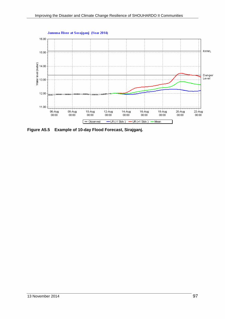
Improving the Disaster and Climate Change Resilience of SHOUHARDO II Communities
13 November 2014 97
Figure A5.5 Example of 10-day Flood Forecast, Sirajganj.
Related Documents