RESEARCH ARTICLE Improving Species Distribution Modelling of freshwater invasive species for management applications Marta Rodrı ´guez-Rey ID *, Sofia Consuegra, Luca Bo ¨ rger, Carlos Garcia de Leaniz Department of Biosciences, Swansea University, Swansea, United Kingdom * [email protected] Abstract Freshwater ecosystems rank among the most endangered ecosystems in the world and are under increasing threat from aquatic invasive species (AIS). Understanding the range expansion of AIS is key for mitigating their impacts. Most approaches rely on Species Distri- bution Models (SDMs) to predict the expansion of AIS, using mainly environmental vari- ables, yet ignore the role of human activities in favouring the introduction and range expansion of AIS. In this study, we use five SDM algorithms (independently and in ensem- ble) and two accuracy measures (TSS, AUC), combined with a null modelling approach, to assess the predictive performance of the models and to quantify which predictors (environ- mental and anthropogenic from the native and introduced regions) best explain the distribu- tion of nine freshwater invasive species (including fish, arthropods, molluscs, amphibians and reptiles) in a large island (Great Britain), and which species characteristics affect model performance. Our results show that the distribution of invasive species is difficult to predict by SDMs, even in cases when TSS and AUC model accuracy values are high. Our study strongly advocates the use of null models for testing SDMs performance and the inclusion of information from the native area and a variety of both human-related and environmental pre- dictors for a more accurate modelling of the range expansion of AIS. Otherwise, models that only include climatic variables, or rely only on standard accuracy measures or a single algo- rithm, might result in mismanagement of AIS. Introduction Developing a scientific basis for monitoring and managing invasive species and implementing measures to manage pathways to prevent introductions is one of the CBD Aichi Targets for 2020 [1]. Freshwater invasions are of special concern, as freshwater ecosystems are among the most diverse and endangered ecosystems in the world [2], harbouring more than a quarter of all freshwater fauna threatened or recently extinct [3], in part due to the impact of non-native freshwater species on native biodiversity [4]. Despite an increase in the number of studies focusing on freshwater invasions in recent years [5], the main drivers of the introduction and spread of aquatic invasive species (AIS) are still unknown [6]. PLOS ONE | https://doi.org/10.1371/journal.pone.0217896 June 17, 2019 1 / 14 a1111111111 a1111111111 a1111111111 a1111111111 a1111111111 OPEN ACCESS Citation: Rodrı ´guez-Rey M, Consuegra S, Bo ¨rger L, Garcia de Leaniz C (2019) Improving Species Distribution Modelling of freshwater invasive species for management applications. PLoS ONE 14(6): e0217896. https://doi.org/10.1371/journal. pone.0217896 Editor: Paulo De Marco Ju ´nior, Universidade Federal de Goias, BRAZIL Received: May 30, 2018 Accepted: May 21, 2019 Published: June 17, 2019 Copyright: © 2019 Rodrı ´guez-Rey et al. This is an open access article distributed under the terms of the Creative Commons Attribution License, which permits unrestricted use, distribution, and reproduction in any medium, provided the original author and source are credited. Data Availability Statement: All relevant data used in this investigation are available through the open electronic sources cited within the paper and in Table 1. Funding: Funding for the study was provided by the European Commission through a Marie Sklodowska-Curie ITN (AQUAINVAD-ED; Grant agreement no 642197). The funder had no role in study design, data collection and analysis, decision to publish, or preparation of the manuscript.

Welcome message from author
This document is posted to help you gain knowledge. Please leave a comment to let me know what you think about it! Share it to your friends and learn new things together.
Transcript

RESEARCH ARTICLE
Improving Species Distribution Modelling of
freshwater invasive species for management
applications
Marta Rodrıguez-ReyID*, Sofia Consuegra, Luca Borger, Carlos Garcia de Leaniz
Department of Biosciences, Swansea University, Swansea, United Kingdom
Abstract
Freshwater ecosystems rank among the most endangered ecosystems in the world and are
under increasing threat from aquatic invasive species (AIS). Understanding the range
expansion of AIS is key for mitigating their impacts. Most approaches rely on Species Distri-
bution Models (SDMs) to predict the expansion of AIS, using mainly environmental vari-
ables, yet ignore the role of human activities in favouring the introduction and range
expansion of AIS. In this study, we use five SDM algorithms (independently and in ensem-
ble) and two accuracy measures (TSS, AUC), combined with a null modelling approach, to
assess the predictive performance of the models and to quantify which predictors (environ-
mental and anthropogenic from the native and introduced regions) best explain the distribu-
tion of nine freshwater invasive species (including fish, arthropods, molluscs, amphibians
and reptiles) in a large island (Great Britain), and which species characteristics affect model
performance. Our results show that the distribution of invasive species is difficult to predict
by SDMs, even in cases when TSS and AUC model accuracy values are high. Our study
strongly advocates the use of null models for testing SDMs performance and the inclusion of
information from the native area and a variety of both human-related and environmental pre-
dictors for a more accurate modelling of the range expansion of AIS. Otherwise, models that
only include climatic variables, or rely only on standard accuracy measures or a single algo-
rithm, might result in mismanagement of AIS.
Introduction
Developing a scientific basis for monitoring and managing invasive species and implementing
measures to manage pathways to prevent introductions is one of the CBD Aichi Targets for
2020 [1]. Freshwater invasions are of special concern, as freshwater ecosystems are among the
most diverse and endangered ecosystems in the world [2], harbouring more than a quarter of
all freshwater fauna threatened or recently extinct [3], in part due to the impact of non-native
freshwater species on native biodiversity [4]. Despite an increase in the number of studies
focusing on freshwater invasions in recent years [5], the main drivers of the introduction and
spread of aquatic invasive species (AIS) are still unknown [6].
PLOS ONE | https://doi.org/10.1371/journal.pone.0217896 June 17, 2019 1 / 14
a1111111111
a1111111111
a1111111111
a1111111111
a1111111111
OPEN ACCESS
Citation: Rodrıguez-Rey M, Consuegra S, Borger L,
Garcia de Leaniz C (2019) Improving Species
Distribution Modelling of freshwater invasive
species for management applications. PLoS ONE
14(6): e0217896. https://doi.org/10.1371/journal.
pone.0217896
Editor: Paulo De Marco Junior, Universidade
Federal de Goias, BRAZIL
Received: May 30, 2018
Accepted: May 21, 2019
Published: June 17, 2019
Copyright: © 2019 Rodrıguez-Rey et al. This is an
open access article distributed under the terms of
the Creative Commons Attribution License, which
permits unrestricted use, distribution, and
reproduction in any medium, provided the original
author and source are credited.
Data Availability Statement: All relevant data used
in this investigation are available through the open
electronic sources cited within the paper and in
Table 1.
Funding: Funding for the study was provided by
the European Commission through a Marie
Sklodowska-Curie ITN (AQUAINVAD-ED; Grant
agreement no 642197). The funder had no role in
study design, data collection and analysis, decision
to publish, or preparation of the manuscript.

Species Distribution Models (SDMs) have widely been used as a management tool for AIS
[7]. These correlative techniques allow to model the distribution of species and map the spatial
suitability of areas based on the identification of statistical associations between species’ occur-
rence and predictor variables [8]. SDM outputs can be used for predicting changes in species’
distributions under environmental change and devise conservation and management strate-
gies [9]. Recent studies using SDMs have generated estimates of habitat suitability for AIS
mainly using environmental variables [7], based on the assumption of a natural colonisation
pattern, whereby species increase their range in areas with favourable environmental condi-
tions. This approach, using only climatic variables, has allowed the development of models for
forecasting invasive species’ distributions under future scenarios of climate change [10]. How-
ever, human-mediated range-shifts, although less predictable, may play a larger role than cli-
mate change in driving the expansion of AIS [11].
Human-related factors play indeed a fundamental role in the introduction and dispersal of
invasive species [12, 13], and accordingly, consideration of human mediated dispersion
appears essential for improving the explanatory and predictive accuracy of models [14]. Exist-
ing SDMs studies have incorporated variables such as human population density or presence
of roads [15] to account for the effect of human-mediated dispersal, but more detailed human-
related variables are required to account for propagule pressure (e.g. aquaculture, horticulture,
shipping frequency) [16].
Here, we assessed the relative ability of human-mediated and environmental predictors to
model the invasion of nine AIS belonging to five broad taxa (molluscs, arthropods, fish,
amphibians, and reptiles) in Great Britain, as a case study. We included environmental vari-
ables from both the native and invaded ranges of the species (to predict their potential eco-
physiological range) and human-related variables (to predict their human-induced geographi-
cal range), and tested model performance in relation to: (i) type of predictors (environmental
in the native and invaded region, environmental only in the invaded region or environmental
and anthropic in the invaded region) and (ii) characteristics of the species’ spatial records and
their invasion (e.g., time since first introduction, economic interest, distance between the
southernmost and northernmost records).
To test the predictive ability of the different models, our approach differs from similar stud-
ies on invasive species in that it includes a large range of anthropic variables [17], control of
most important biases [18] temporally independent evaluation [17, 19] and a robust approach
based on TSS and AUC statistics combined with comparisons to null models [20] (Fig 1).
Materials and methods
Study area and species
Islands provide good opportunities for studying invasion processes due to their isolation–here
we used Great Britain. We divided the study area into 5x5 Km2 grid cells but excluded those
with less than 70% of the grid area (typically, coastal ones), giving a total of 8,735 valid cells.
We used this grid resolution to avoid streams from different catchments being present in the
same grid and to retain as many presence/absence records as possible. Grid cells have been
previously used as reference area to study the distribution of freshwater species in broad areas
when using river fragment as reference is arbitrary and computationally tedious [13, 21, 22].
We modelled the distribution of nine species from five different taxa (fish, arthropods, mol-
luscs, amphibians and reptiles): the wels catfish (Silurus glanis), pumpkinseed (Lepomis gibbo-sus), zander (Sander lucioperca) and sunbleak (Leucaspius delineates) amongst the fish; signal
crayfish (Pacifastacus leniuscus), killer shrimp (Dikerogammarus villosus) amongst the arthro-
pods; the zebra mussel (Dreissena polymorpha) among the molluscs; the marsh frog
Improving Species Distribution Models of freshwater invaders
PLOS ONE | https://doi.org/10.1371/journal.pone.0217896 June 17, 2019 2 / 14
Competing interests: The authors have declared
that no competing interests exist.

(Pelophylax ridibundus) amongst the amphibians, and the red-eared slider (Trachemys scripta)
among the reptiles. Species occurrence records in the invaded region were obtained from the
NBN Gateway database (http://www.nbn.org.uk/), which is the most complete source of non-
native species distribution data in Great Britain [23] and species occurrence in the native area
were obtained from the Global Biodiversity Information Facility (GBIF, http://gbif.org).
To account for sampling bias [24] we compared the distribution of the nine invasive study
species with the distribution of similar native species for each taxon. This comparison
accounted for the number of presence of native species in the absence of invasive species. The
purpose of this analysis was to make sure that grid cells included in our study had been sam-
pled for similar species, providing greater confidence on the absence of AIS [25, 26]. We used
data from the NBN database to compare the distribution of invasive fish in Great Britain with
those of brown trout (Salmo trutta), Atlantic salmon (Salmo salar), spined loach (Cobitis tae-nia), European bullhead (Cottus gobio) and Allis shad (Alosa alosa); we used the distribution
of the common frog (Rana temporaria) and the common toad (Bufo bufo) for amphibians, and
the distribution of 21 species of Gammarus was used as a control for the killer shrimp. We
could not find comparable data for the distribution of the red-eared slider, the zebra mussel
and the signal crayfish since there are no native sliders in Great Britain and the native freshwa-
ter pearl mussel (Margaritifera margaritifera) and the white-clawed crayfish (Austropotamo-bius pallipes) are critically endangered, or endangered, respectively, and their current
distributions would not be representative.
We used data from GBIF to compare the distribution in the native area of the pumpkinseed
with the largemouth bass (Micropterus salmoides) which is a well sampled species due to its
interest as a game species, the signal crayfish with the pilose crayfish (Pacifastacus gambelii)
Fig 1. Diagram of the Species Distribution Modelling procedure. Dashed boxes mark the parts of the approach that have been improved in our study as compared to
the common procedure.
https://doi.org/10.1371/journal.pone.0217896.g001
Improving Species Distribution Models of freshwater invaders
PLOS ONE | https://doi.org/10.1371/journal.pone.0217896 June 17, 2019 3 / 14

the only native crayfish sharing distribution range [27], and the red eared slider with the south-
ern painted turtle (Chrysemys picta) and river cooter (Pseudemys concinna). Wels catfish,
sander and sunbleak were compared to barbel (Barbus barbus), northern pike (Esox lucius)and gudgeon (Gobio gobio).
Pseudo-absences and background data corresponded to those areas without invasive spe-
cies. We randomly selected pseudo-absences after checking the sampling effort, instead of
incorporating the sampling effort to the model because most invasive species had more than
70% of their area sampled; justified by the presence of at least another related species or lack of
sampling bias information [25, 26]. We also used this approach to avoid bias towards places
with a high number of occurrence records, as many invasive species might be introduced in
remote places where sampling is less common due to the accessibility [24].
As the spatial domain of the study area needs to be constrained in order to retain only
meaningful ecological variables [28], we excluded those cells that were 200 kilometres beyond
the northernmost presence for each species in the invaded area, and used a convex hull of
occurrences in the native area, to obtain a more representative environmental domain [29].
Modelling scenarios and predictor variables
Three different scenarios were used based on the inclusion of different types of predictors: (i)
environmental variables only in the invaded area (INVADED), (ii) environmental variables in
both the native and the invaded area (NATIVE) and (iii) environmental and anthropic vari-
ables in the invaded area (MIXED). Anthropogenic variables cannot be combined with the
native range since they usually have the contrary effect than in the invaded area since human
activities use to negatively impact native species distribution ranges [30]. We used 19 biocli-
matic variables, as well as altitude and slope as topographic variables, and land use as a proxy
for the fundamental niche [9, 31]. We extracted the mean values of the grid cells of all the vari-
ables (Table 1) in each grid cell using the zonal statistic tool in QGIS [32]. Using the hydrogra-
phy map, we estimated land use predictors within a 50 m buffer strip from each river bank.
In order to model human-mediated geographical range expansion (i.e. promoted by
anthropically mediated spread and/or propagule pressure), we included the distance to the
closest town and city (with more than 100,000 habitants), and population density as an indica-
tor of human presence and pressure. As an indicator of human accessibility, we used road den-
sity, distance to the nearest port, and distance to the nearest boat launch ramp. We also
included density of reservoirs, lakes, and canals as an indicator of building infrastructures and
places that may facilitate the spread and/or arrival of AIS through human activities like
angling, canoeing or boating [34]. Aquaculture facilities, garden centres and pet stores have
been reported to be sources of introduction and dispersal of AIS [35]. For that reason, we
included the distance to these three types of facilities to account for potential sources of intro-
duction and propagule pressure. All proximity variables (e.g., distance to boat launch ramp or
to pet stores) were calculated by creating a distance map in QGIS and then extracting the
mean values for each grid cell. All models using the invaded area included the Euclidean dis-
tance to the first record of introduction to account for spatially-correlated patterns of dispersal,
as this approach has previously been shown to perform better than more complex SDMs mod-
els [36, 37]. We accounted for collinearity by calculating the Variance Inflation Factor [VIF
[38], based on the R-squared value of the regression of one variable against all other variables
and defined as VIF_j = 1/(1-R_j^2),. Twelve bioclimatic variables were excluded due to multi-
collinearity (VIF > 10; see Table 1), retaining 23 variables for modelling [39]. For each sce-
nario and species, the distribution was analysed using five independent SDMs algorithms:
Generalised Additive Models [GAM [40]] using the mgcv package in R [41] and MaxEnt [42]
Improving Species Distribution Models of freshwater invaders
PLOS ONE | https://doi.org/10.1371/journal.pone.0217896 June 17, 2019 4 / 14
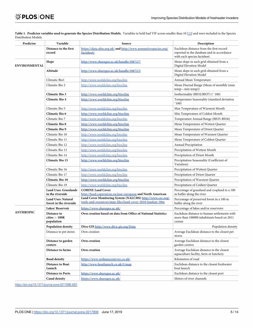
Table 1. Predictor variables used to generate the Species Distribution Models. Variables in bold had VIF scores smaller than 10 [33] and were included in the Species
Distribution Models.
Predictor Variable Source Description
Distance to the first
record
https://data.nbn.org.uk/ and http://www.nonnativespecies.org/
factsheet/
Euclidean distance from the first record
reported in the database and in accordance
with each species factsheet.
ENVIRONMENTAL
Slope http://www.sharegeo.ac.uk/handle/10672/7 Mean slope in each grid obtained from a
Digital Elevation Model
Altitude http://www.sharegeo.ac.uk/handle/10672/5 Mean slope in each grid obtained from a
Digital Elevation Model
Climatic Bio1 http://www.worldclim.org/bioclim Annual Mean Temperature
Climatic Bio 2 http://www.worldclim.org/bioclim Mean Diurnal Range (Mean of monthly (max
temp—min temp))
Climatic Bio 3 http://www.worldclim.org/bioclim Isothermality (BIO2/BIO7) (� 100)
Climatic Bio 4 http://www.worldclim.org/bioclim Temperature Seasonality (standard deviation�100)
Climatic Bio 5 http://www.worldclim.org/bioclim Max Temperature of Warmest Month
Climatic Bio 6 http://www.worldclim.org/bioclim Min Temperature of Coldest Month
Climatic Bio 7 http://www.worldclim.org/bioclim Temperature Annual Range (BIO5-BIO6)
Climatic Bio 8 http://www.worldclim.org/bioclim Mean Temperature of Wettest Quarter
Climatic Bio 9 http://www.worldclim.org/bioclim Mean Temperature of Driest Quarter
Climatic Bio 10 http://www.worldclim.org/bioclim Mean Temperature of Warmest Quarter
Climatic Bio 11 http://www.worldclim.org/bioclim Mean Temperature of Coldest Quarter
Climatic Bio 12 http://www.worldclim.org/bioclim Annual Precipitation
Climatic Bio 13 http://www.worldclim.org/bioclim Precipitation of Wettest Month
Climatic Bio 14 http://www.worldclim.org/bioclim Precipitation of Driest Month
Climatic Bio 15 http://www.worldclim.org/bioclim Precipitation Seasonality (Coefficient of
Variation)
Climatic Bio 16 http://www.worldclim.org/bioclim Precipitation of Wettest Quarter
Climatic Bio 17 http://www.worldclim.org/bioclim Precipitation of Driest Quarter
Climatic Bio 18 http://www.worldclim.org/bioclim Precipitation of Warmest Quarter
Climatic Bio 19 http://www.worldclim.org/bioclim Precipitation of Coldest Quarter
Land Uses: Grasslands
in the riverside
CORINE Land Cover
http://land.copernicus.eu/pan-european and North American
Land Cover Monitoring System (NALCMS) http://www.cec.org/
tools-and-resources/map-files/land-cover-2010-landsat-30m
Percentage of grassland and cropland in a 100
m buffer along the river
Land Uses: Natural
forest in the riverside
Percentage of preserved forest in a 100 m
buffer along the river
ANTHROPIC
Lakes/ Reservoir https://www.sharegeo.ac.uk/ Percentage of lakes and/or reservoirs
Distance to
cities > 100K
population
Own creation based on data from Office of National Statistics Euclidean distance to human settlements with
more than 100000 inhabitants based on 2011
census
Population density Diva-GIS http://www.diva-gis.org/Data Population density
Distance to pet stores Own creation Average Euclidean distance to the closest pet
stores
Distance to garden
centers
Own creation Average Euclidean distance to the closest
garden centres
Distance to farms Own creation Average Euclidean distance to the closest
aquaculture facility, farm or hatchery
Road density https://www.ordnancesurvey.co.uk/ Kilometres of road
Distance to Boat
Launch
http://www.boatlaunch.co.uk/#/map Euclidean distance to the closest freshwater
boat launch
Distance to Ports https://www.sharegeo.ac.uk/ Euclidean distance to the closest port
Canal density https://www.sharegeo.ac.uk/ Meters of river channels
https://doi.org/10.1371/journal.pone.0217896.t001
Improving Species Distribution Models of freshwater invaders
PLOS ONE | https://doi.org/10.1371/journal.pone.0217896 June 17, 2019 5 / 14

using the dismo package [43], Boosted Regression Trees [BRT [44]], Generalized Linear Mod-
els [GLM [45]] and Random Forest models [RF [46]]; and an ensemble model including all
these algorithms. For this, we used biomod2 package in R [47] and the ensemble was calculated
by averaging model predictions weighted by ROC and TSS. We included single algorithms
and ensemble to minimise the uncertainty of the techniques selection and outputs[48].
Training and testing data
We divided the presence data on the invaded region into training and testing data sets for each
species based on the date the species were first reported in a given locality. This approach is
more robust than randomly selecting training and testing presence data [19, 49, 50]. It also
allows the evaluation of each model using a temporally independent validation to recreate the
invasion process followed by the species and investigate if the patterns detected by the models
at time 1 are similar at time 2[37, 51, 52]. We selected the 70% oldest records for training and
the remaining 30% of records (i.e. most recent) for testing. For the NATIVE models, we
included all the presence records available in the native region in addition to the 70% of rec-
ords of the invaded region to account for whole range of conditions where the species are able
to persist [53]. For training pseudo-absences, we randomly chose the same number of grid
cells as the presence for each species to minimize the potential effect of prevalence. Testing
pseudo-absences were selected based on the correction for sorting bias (see below).
Spatial sorting bias may pose a problem due to spatial autocorrelation and tends to generate
inflated model results [54]. We removed this bias by pairwise distance sampling implemented
in the dismo package in R [43].
Model performance was assessed using True Skills Statistic [TSS [55]] and the Area Under
the Curve [AUC, [56]] measures of accuracy. Although the idea that SDMs perform better
than random when AUC is> 0.5 [57] and/or TSS is> 0 [55] is widespread, this makes the
implicit assumption that there is no spatial sorting bias in the evaluation data. For this reason,
we built null models to assess whether the performance of the SDMs for each species, algo-
rithms/ensemble and scenario was better than expected by chance. This is a suggested
approach when using pseudo-absences that allows for significance testing of SDMs [20]. Null
model can be based on randomizations of ecological data or random sampling from a distribu-
tion [58]. In our study, the null models (i.e. those expected by chance alone) were created
using the same training and testing distribution data used for the real models but with ran-
domly reshuffled predictors. For each species, algorithms/ensemble and scenario we obtained
1000 null models, each one with different rearrangement of the predictors [20, 59] obtained by
permutation using base R [60]. We then run 1,000 permutations for each model, and as for the
real models, we then calculated performance statistics as above.
In order to extract the distribution of performance statistics (i.e. TSS and AUC) for the null
models (thereafter TSSnull and AUCnull), we assessed the upper limit of the 95 confidence
interval by calculating the 97.5 percentile in the distribution of the 1,000 performance statistics
generated for each null model. Then, we calculated the differences in the accuracy measures
between the null model and the real model by subtracting the real model statistic value by the
null model statistic value (thereafter ‘effect size’, AUCes and TSSes). Hence, positive values
indicate that the model performed better than null models, whereas negative values indicate
that the model performed worse than null models (i.e. no better than random).
We obtained the best model for the nine species for each of the five different algorithms
(GAM, MaxEnt, BRT, RF and GLM) and the ensemble model, and the two values of SDM per-
formance (i.e., TSSes and AUCes) to determine which overall scenario (i.e. Native, Invaded or
Mixed) predicted the species distribution best. To analyse the importance of scenario,
Improving Species Distribution Models of freshwater invaders
PLOS ONE | https://doi.org/10.1371/journal.pone.0217896 June 17, 2019 6 / 14

algorithm and, the characteristics of the species’ records and species invasion (see Table 2) in
the performance, we used the values of all the models better than null and employed linear
mixed models (LMM) for each performance metrics (AUCes and TSSes) considering species
as random factor.
Regarding the characteristics of the species, we considered that the ‘time since introduc-
tion’, the number of localities occupied by the species (i.e., ‘number of records’) and the ‘dis-
tance between the northernmost and southernmost occurrences’ were indicators of the
available time for adaptation or species ability to cope with new conditions, potentially affect-
ing model performance. Likewise, proximity between native and invaded region (i.e., ‘native
region’) could indicate similarity of conditions whereas ‘economic interest’ might favour the
species to be present in particular localities (e.g., recreational areas) which might be easy to
predict. Species characteristics were extracted from the factsheet published by GB Non-native
Species Information Portal (www.nonnativespecies.org/factsheet/) and the spatial records
characteristics were obtained from the species distributions using QGIS. We assessed LMM
assumptions by checking residual plots, normality of residuals, and plots of scaled residuals
versus fitted values. No significant deviations from linearity or normality were found nor obvi-
ous outliers. All analyses were conducted in R 3.3.1 [61].
Results
Between 71% and 72% of the grid cells with watercourses in Great Britain included at least one
record of a native species of the amphibian and fish groups, respectively. In the native area of
the different species between a 69% and a 95% of the grids were sampled for at least a related
species.
All TSS for the real models (TSSreal) values but six were higher than 0, and all but 16
AUCreal values were higher than 0.5. The average and standard deviation value for the TSS and
AUC performance statistics from the real models were 0.25 ± 0.15 and 0.60 ± 0.11 respectively
(S1 Table). TSSnull values averaged 0.36±0.24 and AUCnull values averaged 0.68±0.13. The spe-
cies with best average results was the red-eared slider with average of TSS and AUC of 0.66
and 0.28, respectively. The species with highest values of performance in the null models was
the killer shrimp with average of TSSnull and AUCnull of 0.67 and 0.86, respectively. (S1
Table). The best performance values for the effect size were for the sunbleak according to the
AUCes (0.078) and the TSSes (0.25).
The null model approach indicated that models performed better than chance for seven of
the nine AIS: signal crayfish, zebra mussel, red-eared slider, zander, wels catfish, marsh frog
and sunbleak (S1 Table). Importantly, this approach showed that relying on a given TSS or
Table 2. Characteristics of the species’ spatial records and their invasion used as predictors to model the overall performance ability of the freshwater invasive Spe-
cies Distribution Models.
Species Time since Introduction (yrs.) Economic interest No. presences Distance between N-S occurrences (km.)
Zebra mussel 191 No 376 398
Red-eared slider 60 Yes 87 406
Marsh frog 133 No 66 230
Pumpkinseed 97 No 20 486
Zander 138 Yes 115 172
Killer shrimp 6 No 8 90
Signal crayfish 40 Yes 544 506
Sunbleak 21 No 18 182
Wels catfish 152 Yes 94 250
https://doi.org/10.1371/journal.pone.0217896.t002
Improving Species Distribution Models of freshwater invaders
PLOS ONE | https://doi.org/10.1371/journal.pone.0217896 June 17, 2019 7 / 14

AUC value is not sufficient to conclude that a model is reliable since the same or similar accu-
racy measures’ values (AUC and TSS) for the real models were both better and worse than
chance according to the null models (S1 Table). For instance, AUC values of 0.58 (Signal cray-
fish Ensemble Native model) were better than chance according to the null models (0.03
whereas AUC values of 0.7 (Red-eared slider GAM Invaded) or 0.73 (Pumpkinseed GAM
Invaded) were worse than null models (S1 Table). Similarly, relying only on a single perfor-
mance statistic or a single modelling algorithm can mask model uncertainty. Specifically, 26
out of the total of 135 fitted models (19.3%) performed better than expected by chance accord-
ing to both performance statistics (i.e. TSSes and AUCes), whereas if only one performance
statistic is considered (i.e. TSSes or AUCes), the number of valid models increased to 39 (29%)
(S1 Table). For example, for the wels catfish, the Mixed and Invaded Scenarios with Maxent
performed better than the null model (all AUCes and TSSes = 0.03) whereas using Ensemble
or GLM modelling, only the Invaded Scenario was better than chance and only according to
one of the effect sizes (TSSes for Ensemble = 0.08 and AUCes for GLM = 0.003), and no GAM
and RF models did better than chance. For marsh frog, Mixed MaxEnt, Native GAM and
Mixed and Native for RF performed better than expected by chance, whereas no Ensemble or
GLM models for this species performed better than the null models. We were unable to obtain
results for the BRT null models because the algorithm did not converge. Therefore, this algo-
rithm was only considered as part of the ensemble.
Null models performed best in 55% of the cases followed by the Mixed scenario (29%),
Native scenario (7%) and Invaded (7%) (Fig 2). According to the Wald test, scenario was a sig-
nificant predictor of the TSSes (Table 3) and in the LMM the Native Scenario had a negative
relationship (estimate = -0.032, sd = 0.01, p<0.01) and Mixed Scenario had a positive relation-
ship (estimate = 0.1, sd = 0.03, p<0.05) with the TSSes. Algorithm and Time since introduc-
tion had also a marginally significant relationship with the TSSes (Table 3). None of the
considered predictors had an effect on the AUC effect size (Table 3). Least square means and
Fig 2. Summary of the best model scenario for the nine invasive species under study according to the three
different algorithms/ensemble and the two statistics (i.e. TSS and AUC). ‘Invaded’ scenario included environmental
predictors from invaded regions, ‘Native’ included environmental predictors from both native and invaded regions
and ‘Mixed’ scenario included environmental and anthropogenic from the invaded region. When two scenario
obtained same values another category was created with the ‘ = ‘ symbol to illustrate it.
https://doi.org/10.1371/journal.pone.0217896.g002
Improving Species Distribution Models of freshwater invaders
PLOS ONE | https://doi.org/10.1371/journal.pone.0217896 June 17, 2019 8 / 14

their confidence intervals from the AUCes and TSSes mixed models illustrated the differences
in performance for the different algorithms over the different scenarios (Fig 3).
Discussion
We have shown that both environmental (from the native and invaded ranges) and anthropic
variables should be included in models that aim to understand and predict the distribution of
aquatic invasive species. Our results also highlight the fact that different species may require
different sets of predictors and that the inclusion of information about conditions in the spe-
cies’ native area may be required to model their distribution accurately, making it difficult to
generalize across taxa. Therefore, including as much information in the models as possible will
help to find the model with the best predictive ability for the species under study, and will per-
mit comparisons between different modelling approaches, as it is not possible to know a prioriwhich ones might work best, in agreement with the justification of using ensemble modelling
approaches [48].
When the aim is to forecast species’ distributions for management purposes, it has been
suggested that the inclusion of anthropogenic variables is essential [16, 62]. For example,
human-mediated dispersal may be the only reason for the rapid spread of invasive plants [63],
Fig 3. Meanvalues of AUCes and TSSes for the five algorithms with results and the three scenarios. Boxes indicate
the least square means based on a linear mixed models considering Scenario and Algorithm. Error bars indicate the
95% confidence interval of the least square means.
https://doi.org/10.1371/journal.pone.0217896.g003
Table 3. Results from Wald test of the linear mixed models applied to analyse the relationship between model performance (measured by TSSes and AUCes effect
size values) and the type of scenario, algorithm, their interaction and species’ characteristics.
AUCes TSSes
Predictor Chisq df p-value Chisq df p-value
Scenario 3.9904 3 0.263 12.2460 3 0.007
Algorithm 3.5642 4 0.468 9.2427 4 0.055
Scenario:Algorithm 7.9929 7 0.333 1.0903 6 0.982
Distance between northernmost and southernmost records 0.0313 1 0.860 0.3420 1 0.559
Number of presences 0.4068 1 0.524 0.0026 1 0.959
Economic interest = YES 0.1582 1 0.691 1.5679 1 0.211
Time since Introduction 0.0198 1 0.888 3.6201 1 0.057
https://doi.org/10.1371/journal.pone.0217896.t003
Improving Species Distribution Models of freshwater invaders
PLOS ONE | https://doi.org/10.1371/journal.pone.0217896 June 17, 2019 9 / 14

stressing the need to consider a variety of predictors. In practice, many management and con-
servation plans rely on models that forecast species distributions based only on climatic vari-
ables [64], which, according to our study, might result in less effective management of some
AIS if resources are invested in addressing the wrong type of drivers. Certainly, models that
only use climatic variables are useful to delimit management actions to suitable regions where
the species are potentially able to spread without human intervention (i.e., fundamental niche
[65]). However, for many species, projecting the distribution of invasive species onto future
scenarios of climate change to forecast species expansion will benefit from the integration of
anthropogenic variables [16] because human-mediated range-shifts might be more intense
than shifts due to climate change [11].
Regarding model performance, our SDMs did not explain the distribution better than
chance for two of the nine freshwater invasive species according to the null models. This high-
lights the difficulties of understanding invasion patterns for some species [66]. Also, the effect
sizes (TSSes and AUCes) were low for the better than null models which might be a result of
our more robust evaluation of predictive ability, as we accounted for sorting bias and tested
the models with a real time independent evaluation.
However, seven species obtained models that performed better than chance even with our
robust evaluation procedure, supporting the validity of using SDMs in invasion biology with
the right set of predictor variables and algorithms.
AUC and TSS are some of the most commonly used statistics for measuring model accu-
racy of correlative species distribution models [67]. However, according to our results perfor-
mance needs to be further assessed, for example, by comparison to null models [59]. AUC
validity has been criticised before [68, 69] and although the use of null models for SDMs had
been previously recommended [20, 70], this approach has not yet been widely adopted.
None of the characteristics of the species had a significant effect on the performance. How-
ever, time since the first introduction was marginally significant for one of the performance
metrics (Table 3) so we considered inappropriate to rule out their effects on performance. Pre-
vious studies indicated that the characteristics of the species distribution patterns affected the
accuracy of SDMs [71]. Time since the first introduction is important for species to adapt and
reach suitable areas, making it difficult to discriminate between occupied and unoccupied
localities [72]. Newly arrived species typically have small range sizes and, as it has been
reported previously [73], modelling species with small number of occurrences or restricted
range size requires caution and special protocols particularly in the early stages of invasion,
when data limitations make SDMs less accurate [74].
Our study is the first attempt to model freshwater invasions including detailed information
from both native and invaded regions and also on anthropic and propagule pressure of differ-
ent taxa in a relatively isolated system, accounting for bias in the SDMs to avoid overfitting
[18]. Our models did not explain the distribution of killer shrimp and pumpkinseed and for
other species the predictive performance was low which might be due to the lack of consider-
ation of biological interactions which is one of the factors governing species’ distributions
[65]. The use of mechanistic models might further improve our understanding of AIS dispersal
[75] by detecting niche shifts during invasion [76]. Given that the number of invasive species
continues to increase [77], there is an urgent need to improve predictive management methods
since most countries still lack the ability to control invasive species effectively [78].
In conclusion, our study suggests the use of null models to assess model performance will
help gain a better understanding of macroecological processes in invasion biology, because
relying only on AUC and TSS or a single modelling algorithm is insufficient to obtain reliable
models for management. Forecasting invasive species distribution under future scenarios of
climate change will be more realistic for a higher number of species if a combination of
Improving Species Distribution Models of freshwater invaders
PLOS ONE | https://doi.org/10.1371/journal.pone.0217896 June 17, 2019 10 / 14

bioclimatic and anthropogenic variables is considered. Finally, our results also indicate that
the distribution of freshwater species with restricted number of records, with higher distances
between northernmost and southernmost records and that lack economic interest are particu-
larly difficult to predict, and should therefore be a research priority.
Supporting information
S1 Table. True Skill Statistic (TSS) and Area Under the Curve (AUC) results for real and
null models for eleven species, two algorithms and the ensemble, and three scenarios.
Effect size corresponds to the difference between the real model and the highest 95CI values of
both discrimination statistics.
(DOCX)
Author Contributions
Conceptualization: Marta Rodrıguez-Rey, Carlos Garcia de Leaniz.
Data curation: Marta Rodrıguez-Rey.
Formal analysis: Marta Rodrıguez-Rey.
Funding acquisition: Sofia Consuegra.
Methodology: Marta Rodrıguez-Rey, Sofia Consuegra, Luca Borger, Carlos Garcia de Leaniz.
Project administration: Sofia Consuegra.
Supervision: Sofia Consuegra, Luca Borger, Carlos Garcia de Leaniz.
Visualization: Marta Rodrıguez-Rey.
Writing – original draft: Marta Rodrıguez-Rey.
Writing – review & editing: Marta Rodrıguez-Rey, Sofia Consuegra, Luca Borger, Carlos Gar-
cia de Leaniz.
References1. UNEP. The strategic plan for biodiversity 2011–2020 and the Aichi biodiversity targets. In: UNEP/CBD/
COP/DEC/X/2, editor. COP CBD Tenth Meeting 29 October 2010; Nagoya, Japan: CBD; 2011.
2. Dudgeon D, Arthington AH, Gessner MO, Kawabata Z-I, Knowler DJ, Levêque C, et al. Freshwater bio-
diversity: importance, threats, status and conservation challenges. Biological Reviews. 2006; 81
(2):163–82. https://doi.org/10.1017/S1464793105006950 PMID: 16336747
3. IUCN. IUCN Red List of Threatened Species. In: IUCNredlist, editor. Version 2010.4. ed2011.
4. VilàM, Basnou C, Pysek P, Josefsson M, Genovesi P, Gollasch S, et al. How well do we understand
the impacts of alien species on ecosystem services? A pan-European, cross-taxa assessment. Fron-
tiers in Ecology and the Environment. 2010; 8(3):135–44. https://doi.org/10.1890/080083
5. Tricarico E, Junqueira AOR, Dudgeon D. Alien species in aquatic environments: a selective comparison
of coastal and inland waters in tropical and temperate latitudes. Aquatic Conservation: Marine and
Freshwater Ecosystems. 2016; 26(5):872–91. https://doi.org/10.1002/aqc.2711
6. Sorte CJB, Ibañez I, Blumenthal DM, Molinari NA, Miller LP, Grosholz ED, et al. Poised to prosper? A
cross-system comparison of climate change effects on native and non-native species performance.
Ecology Letters. 2013; 16(2):261–70. https://doi.org/10.1111/ele.12017 PMID: 23062213
7. PapeşM, Havel JE, Vander Zanden MJ. Using maximum entropy to predict the potential distribution of
an invasive freshwater snail. Freshwater Biology. 2016; 61(4):457–71. https://doi.org/10.1111/fwb.
12719
8. Elith J, Leathwick JR. Species distribution models: ecological explanation and prediction across space
and time. Annual review of ecology, evolution, and systematics. 2009; 40:677–97.
Improving Species Distribution Models of freshwater invaders
PLOS ONE | https://doi.org/10.1371/journal.pone.0217896 June 17, 2019 11 / 14

9. Domisch S, Jahnig SC, Simaika JP, Kuemmerlen M, Stoll S. Application of species distribution models
in stream ecosystems: the challenges of spatial and temporal scale, environmental predictors and spe-
cies occurrence data. Fundamental and Applied Limnology. 2015; 186(1–2):45–61. https://doi.org/10.
1127/fal/2015/0627
10. Britton JR, Cucherousset J, Davies GD, Godard MJ, Copp GH. Non-native fishes and climate change:
predicting species responses to warming temperatures in a temperate region. Freshwater Biology.
2010; 55(5):1130–41. https://doi.org/10.1111/j.1365-2427.2010.02396.x
11. Hulme PE. Climate change and biological invasions: evidence, expectations, and response options.
Biological Reviews. 2016:n/a-n/a. https://doi.org/10.1111/brv.12282 PMID: 27241717
12. Hulme PE. Trade, transport and trouble: managing invasive species pathways in an era of globalization.
Journal of Applied Ecology. 2009; 46(1):10–8. https://doi.org/10.1111/j.1365-2664.2008.01600.x
13. Gallardo B, Aldridge DC. The ‘dirty dozen’: socio-economic factors amplify the invasion potential of 12
high-risk aquatic invasive species in Great Britain and Ireland. Journal of Applied Ecology. 2013; 50
(3):757–66.
14. Menuz DR, Kettenring KM, Hawkins CP, Cutler DR. Non-equilibrium in plant distribution models–only
an issue for introduced or dispersal limited species? Ecography. 2015; 38(3):231–40. https://doi.org/10.
1111/ecog.00928
15. Dullinger S, Kleinbauer I, Peterseil J, Smolik M, Essl F. Niche based distribution modelling of an inva-
sive alien plant: effects of population status, propagule pressure and invasion history. Biological Inva-
sions. 2009; 11(10):2401–14.
16. Gallardo B, Zieritz A, Aldridge D. The importance of the human footprint in shaping the global distribu-
tion of terrestrial, freshwater and marine invaders. PloS one. 2015; 10(5):e0125801–e. https://doi.org/
10.1371/journal.pone.0125801 PMID: 26018575
17. Uden DR, Allen CR, Angeler DG, Corral L, Fricke KA. Adaptive invasive species distribution models: a
framework for modeling incipient invasions. Biological Invasions. 2015; 17(10):2831–50. https://doi.org/
10.1007/s10530-015-0914-3
18. Radosavljevic A, Anderson RP. Making better Maxent models of species distributions: complexity, over-
fitting and evaluation. Journal of Biogeography. 2014; 41(4):629–43. https://doi.org/10.1111/jbi.12227
19. Araujo MB, Pearson RG, Thuiller W, Erhard M. Validation of species–climate impact models under cli-
mate change. Global Change Biology. 2005; 11(9):1504–13. https://doi.org/10.1111/j.1365-2486.2005.
01000.x
20. Raes N, ter Steege H. A null-model for significance testing of presence-only species distribution models.
Ecography. 2007; 30(5):727–36. https://doi.org/10.1111/j.2007.0906–7590.05041.x
21. Rodrigues JFM, Coelho MTP, Varela S, Diniz-Filho JAF. Invasion risk of the pond slider turtle is under-
estimated when niche expansion occurs. Freshwater Biology. 2016; 61(7):1119–27. https://doi.org/10.
1111/fwb.12772
22. Fletcher D, Gillingham P, Britton J, Blanchet S, Gozlan RE. Predicting global invasion risks: a manage-
ment tool to prevent future introductions. Scientific reports. 2016; 6:srep26316.
23. Roy HE, Preston CD, Harrower CA, Rorke SL, Noble D, Sewell J, et al. GB Non-native Species Informa-
tion Portal: documenting the arrival of non-native species in Britain. Biological invasions. 2014; 16
(12):2495–505.
24. Albert CH, Yoccoz NG, Edwards TC, Graham CH, Zimmermann NE, Thuiller W. Sampling in ecology
and evolution–bridging the gap between theory and practice. Ecography. 2010; 33(6):1028–37.
25. Merow C, Smith MJ, Silander JA. A practical guide to MaxEnt for modeling species’ distributions: what it
does, and why inputs and settings matter. Ecography. 2013; 36(10):1058–69. https://doi.org/10.1111/j.
1600-0587.2013.07872.x
26. Phillips SJ, Dudık M, Elith J, Graham CH, Lehmann A, Leathwick J, et al. Sample selection bias and
presence-only distribution models: implications for background and pseudo-absence data. Ecological
Applications. 2009; 19(1):181–97. PMID: 19323182
27. Garbarino R, Struzeski TM, Casadevall TJ. US Geological Survey. 2002.
28. Acevedo P, Jimenez-Valverde A, Lobo JM, Real R. Delimiting the geographical background in species
distribution modelling. Journal of Biogeography. 2012; 39(8):1383–90. https://doi.org/10.1111/j.1365-
2699.2012.02713.x
29. Tsoar A, Allouche O, Steinitz O, Rotem D, Kadmon R. A comparative evaluation of presence-only meth-
ods for modelling species distribution. Diversity and distributions. 2007; 13(4):397–405.
30. Pimm SL, Jenkins CN, Abell R, Brooks TM, Gittleman JL, Joppa LN, et al. The biodiversity of species
and their rates of extinction, distribution, and protection. Science. 2014; 344(6187):1246752. https://doi.
org/10.1126/science.1246752 PMID: 24876501
Improving Species Distribution Models of freshwater invaders
PLOS ONE | https://doi.org/10.1371/journal.pone.0217896 June 17, 2019 12 / 14

31. Peterson AT. Ecological niches and geographic distributions (MPB-49): Princeton University Press;
2011.
32. Team QD. Quantum GIS Geographic Information System. Open Source Geospatial Foundation Proj-
ect; 2016.
33. Hairs JF, Anderson RE, Tatham RL, Black WC. Multivariate data analysis. Englewood Cliffs, NJ: Prin-
tice Hall. 1998.
34. Kilian JV, Klauda RJ, Widman S, Kashiwagi M, Bourquin R, Weglein S, et al. An assessment of a bait
industry and angler behavior as a vector of invasive species. Biological Invasions. 2012; 14(7):1469–
81. https://doi.org/10.1007/s10530-012-0173-5
35. Padilla DK, Williams SL. Beyond ballast water: aquarium and ornamental trades as sources of invasive
species in aquatic ecosystems. Frontiers in Ecology and the Environment. 2004; 2(3):131–8.
36. De Marco P, Diniz-Filho JAF, Bini LM. Spatial analysis improves species distribution modelling during
range expansion. Biology Letters. 2008; 4(5):577–80. https://doi.org/10.1098/rsbl.2008.0210 PMID:
18664417
37. Rodrıguez-Rey M, Jimenez-Valverde A, Acevedo P. Species distribution models predict range expan-
sion better than chance but not better than a simple dispersal model. Ecological Modelling. 2013;
256:1–5.
38. Dormann CF, Elith J, Bacher S, Buchmann C, Carl G, Carre G, et al. Collinearity: a review of methods
to deal with it and a simulation study evaluating their performance. Ecography. 2013; 36(1):27–46.
39. Chatterjee S, Hadi AS. Regression analysis by example: John Wiley & Sons; 2006.
40. Hastie TJ, Tibshirani RJ. Generalized additive models: CRC press; 1990.
41. Wood S, Wood MS. Package ‘mgcv’. R package version. 2016:1.7–29.
42. Phillips SJ, Anderson RP, Schapire RE. Maximum entropy modeling of species geographic distribu-
tions. Ecological modelling. 2006; 190(3):231–59.
43. Hijmans RJ, Phillips S, Leathwick J, Elith J, Hijmans MRJ. Package ‘dismo’. Circles. 2016; 9:1.
44. Friedman JH. Greedy function approximation: a gradient boosting machine. Annals of statistics.
2001:1189–232.
45. Hosmer DW, Lemeshow S. Special topics. Applied Logistic Regression, Second Edition. 2000:260–
351.
46. Cutler DR, Edwards TC, Beard KH, Cutler A, Hess KT, Gibson J, et al. Random Forest for Classification
in Ecology. Ecology. 2007; 88(11):2783–92. https://doi.org/10.1890/07-0539.1 PMID: 18051647
47. Thuiller W, Georges D, Engler R, Breiner F, Georges MD, Thuiller CW. Package ‘biomod2’. 2016.
48. Marmion M, Parviainen M, Luoto M, Heikkinen RK, Thuiller W. Evaluation of consensus methods in pre-
dictive species distribution modelling. Diversity and Distributions. 2009; 15(1):59–69. https://doi.org/10.
1111/j.1472-4642.2008.00491.x.
49. Jimenez-Valverde A, Peterson AT, Soberon J, Overton JM, Aragon P, Lobo JM. Use of niche models in
invasive species risk assessments. Biological Invasions. 2011; 13(12):2785–97. https://doi.org/10.
1007/s10530-011-9963-4
50. Roberts DR, Bahn V, Ciuti S, Boyce MS, Elith J, Guillera-Arroita G, et al. Cross-validation strategies for
data with temporal, spatial, hierarchical, or phylogenetic structure. Ecography. 2017:n/a-n/a. https://doi.
org/10.1111/ecog.02575
51. Svenning J-C, Fløjgaard C, Marske KA, Nogues-Bravo D, Normand S. Applications of species distribu-
tion modeling to paleobiology. Quaternary Science Reviews. 2011; 30(21):2930–47.
52. Dobrowski SZ, Thorne JH, Greenberg JA, Safford HD, Mynsberge AR, Crimmins SM, et al. Modeling
plant ranges over 75 years of climate change in California, USA: temporal transferability and species
traits. Ecological Monographs. 2011; 81(2):241–57. https://doi.org/10.1890/10-1325.1
53. Broennimann O, Guisan A. Predicting current and future biological invasions: both native and invaded
ranges matter. Biology Letters. 2008; 4(5):585–9. https://doi.org/10.1098/rsbl.2008.0254 PMID:
18664415
54. Hijmans RJ. Cross-validation of species distribution models: removing spatial sorting bias and calibra-
tion with a null model. Ecology. 2012; 93(3):679–88. PMID: 22624221
55. Allouche O, Tsoar A, Kadmon R. Assessing the accuracy of species distribution models: prevalence,
kappa and the true skill statistic (TSS). Journal of Applied Ecology. 2006; 43(6):1223–32.
56. Fielding AH, Bell JF. A review of methods for the assessment of prediction errors in conservation pres-
ence/absence models. Environmental conservation. 1997; 24(01):38–49.
57. Swets J. Measuring the accuracy of diagnostic systems. Science. 1988; 240(4857):1285–93. https://
doi.org/10.1126/science.3287615 PMID: 3287615
Improving Species Distribution Models of freshwater invaders
PLOS ONE | https://doi.org/10.1371/journal.pone.0217896 June 17, 2019 13 / 14
58. Gotelli NJ, McGill BJ. Null versus neutral models: what’s the difference? Ecography. 2006; 29(5):793–
800.
59. Borger L, Nudds TD. Fire, humans, and climate: modeling distribution dynamics of boreal forest water-
birds. Ecological Applications. 2014; 24(1):121–41. https://doi.org/10.1890/12-1683.1 PMID: 24640539
60. Whittingham MJ, Swetnam RD, Wilson JD, Chamberlain DE, Freckleton RP. Habitat selection by yel-
lowhammers Emberiza citrinella on lowland farmland at two spatial scales: implications for conservation
management. Journal of Applied Ecology. 2005; 42(2):270–80. https://doi.org/10.1111/j.1365-2664.
2005.01007.x
61. R-project. R: A language and environment for statistical computing. In: Computing RFfS, editor. Vienna,
Austria2016.
62. Bellard C, Leroy B, Thuiller W, Rysman JF, Courchamp F. Major drivers of invasion risks throughout the
world. Ecosphere. 2016; 7(3):e01241–n/a. https://doi.org/10.1002/ecs2.1241
63. Horvitz N, Wang R, Wan F-H, Nathan R. Pervasive human-mediated large-scale invasion: analysis of
spread patterns and their underlying mechanisms in 17 of China’s worst invasive plants. Journal of Ecol-
ogy. 2017; 105(1):85–94. https://doi.org/10.1111/1365-2745.12692
64. Sinclair S, White M, Newell G. How useful are species distribution models for managing biodiversity
under future climates? Ecology and Society. 2010; 15(1).
65. Grinnellian Soberon J. and Eltonian niches and geographic distributions of species. Ecology Letters.
2007; 10(12):1115–23. https://doi.org/10.1111/j.1461-0248.2007.01107.x
66. Luoto M, Poyry J, Heikkinen R, Saarinen K. Uncertainty of bioclimate envelope models based on the
geographical distribution of species. Global Ecology and biogeography. 2005; 14(6):575–84.
67. Elith J H. Graham C, P. Anderson R, Dudık M, Ferrier S, Guisan A, et al. Novel methods improve predic-
tion of species’ distributions from occurrence data. Ecography. 2006; 29(2):129–51. https://doi.org/10.
1111/j.2006.0906–7590.04596.x
68. Jimenez-Valverde A. Insights into the area under the receiver operating characteristic curve (AUC) as a
discrimination measure in species distribution modelling. Global Ecology and Biogeography. 2012; 21
(4):498–507.
69. Lobo JM, Jimenez-Valverde A, Real R. AUC: a misleading measure of the performance of predictive
distribution models. Global ecology and Biogeography. 2008; 17(2):145–51.
70. Olden JD, Jackson DA, Peres-Neto PR. Predictive models of fish species distributions: a note on proper
validation and chance predictions. Transactions of the American Fisheries Society. 2002; 131(2):329–
36.
71. Heikkinen RK, Luoto M, Araujo MB, Virkkala R, Thuiller W, Sykes MT. Methods and uncertainties in bio-
climatic envelope modelling under climate change. Progress in Physical Geography. 2006; 30(6):751–
77.
72. Williamson M, Dehnen-Schmutz K, Kuhn I, Hill M, Klotz S, Milbau A, et al. The distribution of range
sizes of native and alien plants in four European countries and the effects of residence time. Diversity
and Distributions. 2009; 15(1):158–66. https://doi.org/10.1111/j.1472-4642.2008.00528.x
73. Breiner FT, Guisan A, Bergamini A, Nobis MP. Overcoming limitations of modelling rare species by
using ensembles of small models. Methods in Ecology and Evolution. 2015; 6(10):1210–8. https://doi.
org/10.1111/2041-210X.12403
74. Morales N, Fernandez I, Baca-Gonzalez V. MaxEnt’s parameter configuration and small samples: are
we paying attention to recommendations? A systematic review. PeerJ. 2017; 5(e3093). https://doi.org/
10.7717/peerj.3093.
75. Gallien L, Munkemuller T, Albert CH, Boulangeat I, Thuiller W. Predicting potential distributions of inva-
sive species: where to go from here? Diversity and Distributions. 2010; 16(3):331–42. https://doi.org/10.
1111/j.1472-4642.2010.00652.x
76. Chapman DS, Scalone R, Stefanić E, Bullock JM. Mechanistic species distribution modeling reveals a
niche shift during invasion. Ecology. 2017; 98(6):1671–80. https://doi.org/10.1002/ecy.1835 PMID:
28369815
77. Seebens H, Blackburn TM, Dyer EE, Genovesi P, Hulme PE, Jeschke JM, et al. No saturation in the
accumulation of alien species worldwide. Nature Communications. 2017; 8:14435. https://doi.org/10.
1038/ncomms14435 PMID: 28198420
78. Early R, Bradley BA, Dukes JS, Lawler JJ, Olden JD, Blumenthal DM, et al. Global threats from invasive
alien species in the twenty-first century and national response capacities. Nature Communications.
2016; 7:12485. https://doi.org/10.1038/ncomms12485 PMID: 27549569
Improving Species Distribution Models of freshwater invaders
PLOS ONE | https://doi.org/10.1371/journal.pone.0217896 June 17, 2019 14 / 14
Related Documents


![Modelling species distributions without using species ...webpages.icav.up.pt/PTDC/BIA-BEC/105093/2008/most_revel/[A].pdf · Modelling species distributions without using species distributions:](https://static.cupdf.com/doc/110x72/5b31859e7f8b9ab5728c37a7/modelling-species-distributions-without-using-species-apdf-modelling-species.jpg)