1 Gayana 75(1): 1-13, 2011 ISSN 0717-652X Implementation of an Eco-hydrological classification in Chilean Rivers Implementación de una clasificación Eco-hidrológica para los Ríos de Chile M. PEREDO-PARADA 1* , F. MARTÍNEZ-CAPEL 2 , D. QUEVEDO 3 AND A. B. HERNÁNDEZ-MASCARELL 2 1 Plataforma de Investigación en Ecohidrología y Ecohidráulica (EcoHyd). Santiago. Chile. 2 Instituto para la Investigación y Gestión Integrada de Zonas Costeras (IGIC). E.P.S. de Gandía. Universidad Politécnica de Valencia. España 3 Departamento de Ingeniería en Obras Civiles. Facultad de Ingeniería. Universidad de Santiago. Santiago. Chile *E-mail: [email protected] ABSTRACT Concern has grown in Chile to protect and conserve aquatic ecosystems taking into account the high degree of habitat degradation. As a first step towards the development of conservation plans, it is necessary to classify these ecosystems in order to learn about them and understand their different types and functions. Considering that hydrological regime is the main factor in the composition of river ecosystems, an Eco-Hydrological Classification of Chilean Rivers (REC-Chile) has been developed. REC-Chile is based on the hierarchical superposition of the controlling factors of the hydrological pattern in Chile. REC-Chile is a multi-scale classification system, allowing to represent different river patterns at different spatial scales according to the selected controlling factors. The typology of the river segment is represented as a 6-digit code, in which the position of the digit represents the controlling factor and the digit value represents the factor category. This hierarchical configuration and the assignment of geography- independent classes makes REC-Chile an easy way of interpreting the hydrological classes. Given the flexibility provided by the multi-scale nature of REC-Chile, and the simplicity in the interpretation of the classes, it is expected that REC-Chile will become a very useful and suitable tool for developing conservation plans for aquatic ecosystems. KEY WORDS: Hierarchical classification, controlling factors, hydrological pattern, rivers, Chile RESUMEN En Chile existe un aumento en la precupación por proteger y conservar los ecosistemas acuáticos debido al elevado estado de deterioro del hábitat. Como un primer paso para desarrollar planes de conservación se hace necesario realizar una clasificación de estos ecosistemas para conocer y entender los distintos tipos y su funcionamiento. Entendiendo que el caudal es el principal factor en la composición de ecosistemas fluviales, se ha desarrollado una clasificación Eco- Hidrológica de los ríos de Chile (REC-Chile) basada en una superposición jerárquica de factores controladores del patrón hidrológico en Chile. REC-Chile es multiescalar, permitiendo según los factores controladores seleccionados representar distintos patrones fluviales a diversas escalas espaciales. La tipología del tramo de río se representa como un código de 6 dígitos, en donde la posición del dígito representa al factor controlador y el valor a la categoría de éste. Esta configuración jerárquica, así como la asignación geográficamente independiente de sus clases, dota a la REC-Chile de facilidad en la interpretación hidrológica de las clases. Debido a la ductilidad y flexibilidad, entregada por la multiescalaridad y por la sencilla interpretación de sus clases, se espera que la REC-Chile se convierta en una herramienta para desarrollar planes de conservación de los ecosistemas acuáticos. PALABRAS CLAVES: Clasificación jerárquica, factores controladores, patrón hidrológico, ríos, Chile. INTRODUCTION Concern over the sustainable management of continental waters bodies is constantly increasing worldwide, in both the public and private ambit. Chile is also involved in this process, since the river ecosystems distributed over the whole length of the country have extraordinary value due to the high degree of endemicism of the species they

Welcome message from author
This document is posted to help you gain knowledge. Please leave a comment to let me know what you think about it! Share it to your friends and learn new things together.
Transcript
1
Gayana 75(1): 1-13, 2011 ISSN 0717-652X
Implementation of an Eco-hydrological classifi cation in Chilean Rivers
Implementación de una clasifi cación Eco-hidrológica para los Ríos de Chile
M. PEREDO-PARADA1*, F. MARTÍNEZ-CAPEL2, D. QUEVEDO3 AND A. B. HERNÁNDEZ-MASCARELL2
1Plataforma de Investigación en Ecohidrología y Ecohidráulica (EcoHyd). Santiago. Chile. 2Instituto para la Investigación y Gestión Integrada de Zonas Costeras (IGIC). E.P.S. de Gandía. Universidad Politécnica de Valencia. España3Departamento de Ingeniería en Obras Civiles. Facultad de Ingeniería. Universidad de Santiago. Santiago. Chile*E-mail: [email protected]
ABSTRACT
Concern has grown in Chile to protect and conserve aquatic ecosystems taking into account the high degree of habitat degradation. As a fi rst step towards the development of conservation plans, it is necessary to classify these ecosystems in order to learn about them and understand their different types and functions. Considering that hydrological regime is the main factor in the composition of river ecosystems, an Eco-Hydrological Classifi cation of Chilean Rivers (REC-Chile) has been developed. REC-Chile is based on the hierarchical superposition of the controlling factors of the hydrological pattern in Chile. REC-Chile is a multi-scale classifi cation system, allowing to represent different river patterns at different spatial scales according to the selected controlling factors. The typology of the river segment is represented as a 6-digit code, in which the position of the digit represents the controlling factor and the digit value represents the factor category. This hierarchical confi guration and the assignment of geography- independent classes makes REC-Chile an easy way of interpreting the hydrological classes. Given the fl exibility provided by the multi-scale nature of REC-Chile, and the simplicity in the interpretation of the classes, it is expected that REC-Chile will become a very useful and suitable tool for developing conservation plans for aquatic ecosystems.
KEY WORDS: Hierarchical classifi cation, controlling factors, hydrological pattern, rivers, Chile
RESUMEN
En Chile existe un aumento en la precupación por proteger y conservar los ecosistemas acuáticos debido al elevado estado de deterioro del hábitat. Como un primer paso para desarrollar planes de conservación se hace necesario realizar una clasifi cación de estos ecosistemas para conocer y entender los distintos tipos y su funcionamiento. Entendiendo que el caudal es el principal factor en la composición de ecosistemas fl uviales, se ha desarrollado una clasifi cación Eco-Hidrológica de los ríos de Chile (REC-Chile) basada en una superposición jerárquica de factores controladores del patrón hidrológico en Chile. REC-Chile es multiescalar, permitiendo según los factores controladores seleccionados representar distintos patrones fl uviales a diversas escalas espaciales. La tipología del tramo de río se representa como un código de 6 dígitos, en donde la posición del dígito representa al factor controlador y el valor a la categoría de éste. Esta confi guración jerárquica, así como la asignación geográfi camente independiente de sus clases, dota a la REC-Chile de facilidad en la interpretación hidrológica de las clases. Debido a la ductilidad y fl exibilidad, entregada por la multiescalaridad y por la sencilla interpretación de sus clases, se espera que la REC-Chile se convierta en una herramienta para desarrollar planes de conservación de los ecosistemas acuáticos.
PALABRAS CLAVES: Clasifi cación jerárquica, factores controladores, patrón hidrológico, ríos, Chile.
INTRODUCTION
Concern over the sustainable management of continental waters bodies is constantly increasing worldwide, in both the public and private ambit. Chile is also involved in
this process, since the river ecosystems distributed over the whole length of the country have extraordinary value due to the high degree of endemicism of the species they
Gayana 75(1), 2011
2
contain, among others. About aquatic vertebrates, the endemicism reported to date is 81% for fi sh (Habit et al. 2006) and 60.7% for amphibians (Ortíz & Díaz-Páez 2006). Among aquatic invertebrates an endemicism of 91.7% has been reported for gastropods (Valdovinos 2006), 30.8% for bivalves (Parada & Peredo 2006), 74.4% for malacostraca (Jara et al. 2006), 56% for ephemeroptera (Camousseight 2006) and 57% for plecoptera (Vera & Camousseight 2006). Furthermore, given the increasing deterioration and/or fragmentation of habitats, freshwater species today present serious conservation problems (Habit et al. 2006, Ortíz & Díaz-Páez 2006, Parada & Peredo 2006, Valdovinos 2006; Perez-Losada et al. 2002; Bahamonde et al. 1998).
To date, few information exists about conservation measurements for Chilean freshwater species (Peredo et al. 2006; Parada & Peredo 2005; Peredo et al. 2005; Habit et al. 2002) and their habitats (Habit et al. 2006). Likewise, most of these studies lack of accuracy on local distribution (Habit et al. 2006, Parada & Peredo 2006, Valdovinos 2006), which one is indispensable information for carrying out management and conservation programmes of Chilean freshwater species and river ecosystems.
The Chilean Government has developed the National Strategy for Hydrographic Basins (Estrategia Nacional de Gestión Integrada de Cuencas Hidrográfi cas - ENGICH) as an instrument for the protection and conservation of aquatic ecosystems; its role is to contribute to the sustainable use of water resources, harmonizing the protection of ecosystems with the availability of the resource (CONAMA 2007). To ensure the appropriate implementation of ENGICH, all the water bodies existing in the country must be studied and classifi ed.
Landscape classifi cations have been developed for management purposes, as tools for understanding ecosystems. Such classifi cations allow data interpretation, inventories development, the extrapolation of information from specifi c sites to larger areas, development of objects and standards, etc. (Bailey 2009; Omernik & Bailey 1997).
There are a variety of methods for developing a classifi cation of natural aquatic systems, including taxonomic classifi cation and those based on regionalization. Taxonomic classifi cations are not necessarily based on the physical or ecological processes which govern aquatic ecosystems. Methods based on regionalization, also known as ecoregions, respond to a physical focus which considers the control variables of fl uvial processes and their patterns (González del Tánago & García de Jalón 2006; Bailey et al. 1978). The ecoregions are homogeneous zones with regard to certain characteristics or parameters on a determined spatial scale (Snelder et al. 2005; Omernik & Bailey 1997; Bailey et al. 1978). Snelder
& Biggs (2002) pointed out that these ecoregions are unable to represent the longitudinal gradients in a river ecosystem, which were synthesized in the River Continuum Concept (Vannote et al. 1980); therefore the use of such ecoregions for river classifi cation are limited.
Since the 1980’s several authors have addressed landscape classifi cation by means of hierarchical organization systems for rivers. They recognise that rivers belong to a basin, which one feeds them. Therefore, it is expected that the rivers are being infl uenced by the watershed characteristics, accepting that ecological processes in a river depend on physical factors which occur at several scales (González del Tánago & García de Jalón 2006; Snelder & Biggs 2002; Montgomery & Buffi ngton 1997, Omernik & Bailey 1997; Frissell et al. 1986).
Snelder & Biggs (2002) developed the River Environmental Classifi cation (REC) to classify the rivers of New Zealand based on the following premises: a) Ecological patterns are dependent on a number of factors associated with the regional scale of the various physical processes; b) The ecological characteristics of rivers respond to fl uvial processes; and c) Classes are assigned to each segment of river geographically independent. In the REC, the typology of each river segment is determined by the hierarchical superposition of controlling factors, which are the principal causes of the spatial variation of the hydrological pattern at a determined scale (Snelder et al. 2005; Snelder & Biggs 2002).
There are many eco-hydrological similarities between the rivers of Chile and those of New Zealand. Hydrological regime, river geomorphology, and presence of certain fi sh taxa, e.g. Galaxias maculatus and Geotria australis (Vila et al. 2006; Dyer 2000; Mc Dowall 2000) and numerous species of macroinvertebrates (Winterbourn 1981) are among the main similarities that we found. Due to this, we hypothesized that these similarities would enable the REC to be adapted for Chile, taking into account the existing geomorphological and climatic differences, expecting that it would constitute a management tool for Chilean river ecosystems.
The present work has two objectives: to implement a REC in Chile (REC-Chile), and to interpret some of its classes for its application in management and planning of river ecosystems.
METHODS
REC-CHILE CONTROLLING FACTORS
The controlling factors selected for the implementation of REC-Chile are based on those used in the REC developed
3
Eco-Hydrological River Classifi cation of Chile: MATIAS PEREDO-PARADA ET AL.
by Snelder and Biggs (2002) for New Zealand, adapted to the climatic and environmental conditions of Chile. The controlling factors selected were: Climate, Source of Flow, Geology, Catchment Relative Position, Land Use and Reach Slope. Each one of these are subdivided into a categories according to controlling factors meaning.
In the hierarchy of REC-Chile, Climate is the only macro-scale controlling factor. Principally, it determines hydrological characteristics such as fl ow magnitude and frequency of fl ooding and low fl ow period (Snelder et al. 2005; Snelder & Biggs 2002). The categories used were based on Blair’s climate classifi cation Arid, Semi-Arid, Mid-Wet, Wet and Very Wet, (Heras 1973).
The Source of Flow factor acts at a mesoscale level, indicating the stream fl ow is originated by rainfall, snow-melt, glaciers or a combination of these (Fleming 2005; Snelder et al. 2004). This controlling factor has its origin from the topography of the watershed (Snelder et al. 2002) considering how this impacts on fl ow regime. Thus, this controlling factor is related to seasonality of fl ow regimes, sediments supply and transport process at a watershed scale (Snelder & Biggs 2002). Precipitation in Chile is mainly related to orographic effects, since the Andes mountain range acts as a barrier to the moist winds coming from the Pacifi c Ocean (Villagrán & Hinojosa 2005; Rutllant 2004). This fact makes possible associate the altitude of a watershed with its precipitation as proportion to the total precipitation of the whole basin.
The Source of Flow factor includes fi ve categories of topographical origin (Low Elevation, Valley, Mid-Mountain, Mountain and Eternal Snow) and three categories which ones due to their physical characteristics change the fl ow regime (Lakes, Glaciers and Regulations). The categories of topographical origin were assigned by a relationship between catchment mean altitude and its accumulated precipitation percentage with respect to the total rainfall basin. Thus, the Low Elevation category refers to watershed at 300 m.a.s.l. or lower. This category present a low accumulated precipitation, less than 25% of the total rainfall basin, and extreme seasonal variations between summer and winter. Valley corresponds to a watershed located between 300 and 1000 m.a.s.l, with percentages of accumulated precipitation averaging between 25% and 40% of the total rainfall basin. This category present a higher mean annual fl ow and more moderate seasonal variations than Low Elevation. Mid-mountain refers to watersheds between 1000 and 2400 m.a.s.l., with high percentages of accumulated precipitation (between 40% and 70%) incorporating, the contribution of snow-melt during spring-summer; this leads to the formation of a higher peak fl ow in winter (high rainfall period) and another smaller peak in spring-summer (dry period).
Mountain corresponds to watershed between 2400 and 4200 m.a.s.l., characterised by a high contribution of snow-melt and small amounts from precipitation, resulting in a small peak in the fl ow regime in winter and another larger peak in early summer. Eternal snow are watersheds above 4200 m.a.s.l. They only receive snow-melt, presenting high fl ows in summer and low in winter.
Among fl ow modifi er categories, the Glacier category is assigned to any reach river whose watershed contains a glacier with an area covering more than 20%. Lakes refer to water bodies where fl ow regime is modifi ed by signifi cant water storage, usually reducing and delaying fl ood events. To evaluate whether such a modifi cation is produced, the Lake Index (LI) is calculated (equation 1) which estimates the precipitation on the lake as compared to the basin which drains into the river reach.
Where AL is the lake area, ALW is the lake watershed area, VLW is the mean annual precipitation in the lake watershed, and VW is the annual precipitation of the basin.
The LI index evaluates whether or not the infl uence of water body represents a signifi cant modifi cation to the hydrograph of a watershed; it was proposed by Snelder and Biggs (2002) and modifi ed later (T. Snelder pers comm). To determine the threshold value for the LI in Chilean rivers a comparison between annual hydrographs of gauging stations with the same REC-Chile code, with and without the presence of a lake upstream was made. The critical value for this was estimated at 0.020, meaning signifi cant regulation effect by the lake at values above this threshold.
Given that categories of Source of Flow factor are related to hydrological patterns in a natural regime, it was necessary to incorporate the category Regulations to take into account man-made regulation structures.
The Geology factor is related, at mesoscale level, to the water geo-chemical characteristics, dominated by the geological properties of the aquifer (Herrera et al. 2006; Gonzalez et al. 1999). An important parameter of water quality in Chilean rivers is constituted by dissolved salts due to the marine and/or volcanic origin of the basins (Vila & Molina 2006), showing a pronounced north-south gradient. This factor defi ned eight categories as follow: Alluvial, Plutonic Rocks, Volcanic Rocks, Sediment and Mix of Sediment and Volcanic Rocks (Sedim and Mix Sed-Volc Rocks), Sedimentary Rocks, Fractured Volcanic Rocks and

Gayana 75(1), 2011
4
Carbonated Rocks. A category named Not Recognised was incorporated for cases where it is impossible to establish the geological origin.
Catchment Relative Position is the fourth controlling factor. It is related to the catchment area of a river reach as a proportion of the whole basin. It describes aspects of the hydrological pattern such as magnitude of mean fl ow, intensity and attenuation of fl ood fl ows, and fl ux of sediments. The assignation rule was determined according to the relative position of the catchment within the basin, defi ning the following categories: Headwater, Upper Reach, Middle Reach and Low Reach. The categories Endorreic and International (i.e. transboundary river) were assigned manually.
The Land Use factor is related to mesoscale processes, such as initial interception and evapotranspiration; it also controls physical-chemical aspects of the water quality resulting from soil leaching into, or carried down by, the river (Sliva & Dudley 2001; Johnson et al. 1997). Nine categories were defi ned: City Areas, Agriculture, Praire and Shrubs, Woods, Areas without Vegetation, Reservoirs, Snow and Glaciers and Areas without Information.
The last controlling factor is Reach Slope. This describes morpho-hydraulic patterns at a microscale level such as local transport of sediment, river-bed erosion, mean velocity of fl ow and infl uence of bank conditions. The assignation rule is determined according to the slope along the river reach in three categories: Low, Medium and High.
REC-CHILE IMPLEMENTATION.REC-Chile was implemented through Geographical Information System (GIS) in rivers represented as a digital hydrographic network at 1:250,000 scale. The information used to develop the classifi cation, as well as the river network, was provided by the General Water Authority of Chile (Dirección General de Aguas – DGA). This information includes precipitation contours, potential and actual evapotranspiration contours (1:250,000), elevation contours (1:250,000), watershed areas (1:50,000), basin areas (1:50,000), geology (1:50,000) and land use (1:50,000).
The REC-Chile mapping was done according to the spatial scale of each controlling factor (top-down scaling) following the assignation rules defi ned for each category. In Climate, Source of Flow and Geology categories factors, the concept of River Continuum was considered (Vannote et al. 1980) propagating downstream the characteristics of the most infl uential categories. In Climate factor, four categories were propagated which onesdominate the fl ow magnitude. The order of propagation of these categories was: Semi-Arid, Mid-Wet, Wet and Very Wet. In Source
of Flow factor, seasonal characteristics of the hydrograph were propagated. First one, the topographical categories were propagated (Low elevation, Valley, Mid-Mountain, Mountain and Eternal Snow) and, second one, the categories assigned manually (Lakes, Glaciers and Regulations). In Geology factor, propagation criterion was based on the dissolved salts contribution due to the lithology of different soil types. The propagation order of these categories was: Plutonic Rocks, Volcanic Rocks, Sedimentary and Mix Sed-Volcanics Rocks, Sedimentary Rocks, Fractured Volcanic Rocks, and, fi nally Carbonated Rocks.
REC-Chile was developed in basins located between 18°S and 43°S. The classifi cation was not implemented in the more southerly basins (43ºS to 55ºS) due to lack of information to defi ne the controlling factors.
Once REC-Chile had been designed and implemented, two simple applications were done to show how to interpret the REC-Chile classes to determine the hydrological pattern and the natural geo-chemical quality of the waters. In a fi rst case, basic aspects of mean annual hydrograph from 4 gauging stations in natural or slightly modifi ed regimes were compared with their respective REC-Chile codes, which ones were obtained by the Climate and Source of fl ow hierarchical superposition (second level). In the second case, the mean electrical conductivity (EC) in 67 segments of river distributed throughout Chile were compared with their respective REC-Chile codes at a third level, which ones were obtained by the Climate, Source of Flow and Geology hierarchical superposition. The data for the annual hydrographs and the EC were provided by DGA.
RESULTS
REC-CHILE CLASSIFICATION
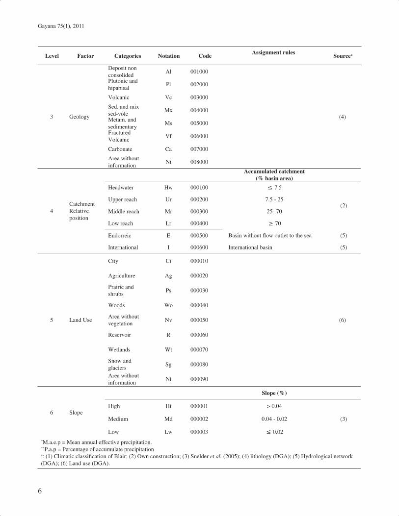
Table 1 shows the REC-Chile with each one of the controlling factors and its categories, assignment rules and the code associated to each category.
The resulting classifi cation presents a tree structure in which each category of controlling factor number i are divided among the categories of controlling factor i + 1. The classifi cation levels are defi ned according to the hierarchical superposition controlling factors.
The fi rst classifi cation level corresponds to the fi rst controlling factor (Climate), the second classifi cation level is the hierarchical superposition of the fi rst two factors (Climate and Source of fl ow), the third level is defi ned by adding the Geology factor to the second level and so on down to the sixth and last classifi cation level defi ned by the hierarchical superposition of all the REC-Chile controlling

5
Eco-Hydrological River Classifi cation of Chile: MATIAS PEREDO-PARADA ET AL.
factors. The sixth classifi cation level is refl ected in a six-digit code. The digit position represents the classifi cation level and the digit value represents the category of the controlling factor at this level.
The classes are defi ned according to the hierarchical superposition of the factor categories at the level selected. Thus for the fi rst level the classes are the Climate categories, for the second level the resulting classes are the Climate categories combined with the Source of fl ow categories, i.e. Arid is combined with the categories Low Elevation, Valley, Mid-Mountain, Mountain, Eternal Snow, Lakes, Regulations and Glacier. This procedure is repeated for each controlling factor categories until the Reach Slope factor to create all classes at sixth level of classifi cation.
The potential number of classes in any classifi cation level depends on the number of categories at that level and the number of classes in the previous levels, and thus the potential number of classes is given by the mathematical combination of the number of categories in each controlling factor. For example, the second level potentially has 40 classes (5 x 8), the third level potentially has 320 classes (5
x 8 x 8). REC-Chile has 46,080 potential classes. However, not all the potential classes occur physically in the REC-Chile domain, in which exists 3049 classes in a total area of 515,000 km2 aproximatelly.
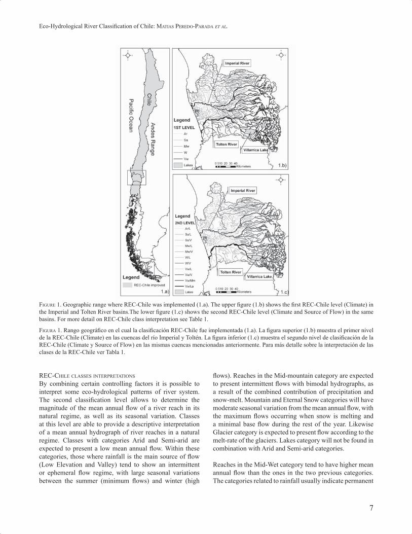
Due to the spatial scale of each controlling factor, the classes at Climate level defi ne larger homogenous areas than the classes at the Source of fl ow level, and this generates differences in the spatial scale of the patterns generated. Figure 1 shows the classifi cation at the fi rst two levels for two basins located in northern Patagonia (Imperial and Toltén Rivers). This shows the downstream propagation of the most infl uential categories. At the fi rst level (Fig. 1b), propagation of Very Wet (Vw) category coming from the rains which occur in the Andes mountains can be observed. Likewise, the second level (Fig. 1c) shows the propagation of the Very Wet / Mid-Mountain class (Vw/Mm) in the Imperial River and the Very Wet / Lakes class (Vw/La) in the Toltén River. On the one hand, this would mean that the hydrograph of the Imperial River should have a seasonal pattern approximately similar to the Andes mountains precipitation regime; on the other hand, the hydrograph of the Toltén River would be infl uenced by the damping effect of the Villarrica Lake.
TABLE 1. REC-Chile classifi cation levels, factors, categories, codes and assignment rules.
TABLA 1: Niveles de clasifi cación de la REC-Chile, sus categorías, códigos y reglas de asignación
Level Factor Categories Notation Code Assignment rules Sourcea
1 Climate
M.a.e.p. (mm)
Arid Ar 1000000 ≤ 250
(1)
Semi-arid Sa 2000000 250 - 500
Mid-Wet Mw 3000000 500 - 1,000
Wet W 4000000 1,000 - 2,000
Very Wet Vw 5000000 2,000
2Source of fl ow
P.a.p (%)Elevation (m.a.s.l.)
Low elevation L 010000 ≤ 25 300
(2)
Valley V 020000 25 - 40 300 - 1,000
Mid-Mountain Mm 030000 40 - 751,000 - 2,400
Mountain M 040000 75 >2,400 - 4,200
Eternal snows Es 050000 Without liquid rainfall ≥ 4,200
Lakes La 060000 Lake infl uence index ≥ 0.020 Ec. 1
Regulation Rg 070000 Assigned Manually
Glaciers G 080000 Glacier area > 20% Watershed area (3)
Gayana 75(1), 2011
6
Level Factor Categories Notation CodeAssignment rules
Sourcea
3 Geology
Deposit non consolided
Al 001000
(4)
Plutonic and hipabisal
Pl 002000
Volcanic Vc 003000
Sed. and mix sed-volc
Mx 004000
Metam. and sedimentary
Ms 005000
Fractured Volcanic
Vf 006000
Carbonate Ca 007000
Area without information
Ni 008000
4Catchment Relative position
Accumulated catchment(% basin area)
Headwater Hw 000100 ≤ 7.5
(2)Upper reach Ur 000200 7.5 - 25
Middle reach Mr 000300 25- 70
Low reach Lr 000400 ≥ 70
Endorreic E 000500 Basin without fl ow outlet to the sea (5)
International I 000600 International basin (5)
5 Land Use
City Ci 000010
(6)
Agriculture Ag 000020
Prairie and shrubs
Ps 000030
Woods Wo 000040
Area without vegetation
Nv 000050
Reservoir R 000060
Wetlands Wt 000070
Snow and glaciers
Sg 000080
Area without information
Ni 000090
6 Slope
Slope (%)
High Hi 000001 > 0.04
(3)Medium Md 000002 0.04 - 0.02
Low Lw 000003 ≤ 0.02
*M.a.e.p = Mean annual effective precipitation.**P.a.p = Percentage of accumulate precipitationa: (1) Climatic classifi cation of Blair; (2) Own construction; (3) Snelder et al. (2005); (4) lithology (DGA); (5) Hydrological network (DGA); (6) Land use (DGA).
7
Eco-Hydrological River Classifi cation of Chile: MATIAS PEREDO-PARADA ET AL.
FIGURE 1. Geographic range where REC-Chile was implemented (1.a). The upper fi gure (1.b) shows the fi rst REC-Chile level (Climate) in the Imperial and Tolten River basins.The lower fi gure (1.c) shows the second REC-Chile level (Climate and Source of Flow) in the same basins. For more detail on REC-Chile class interpretation see Table 1.
FIGURA 1. Rango geográfi co en el cual la clasifi cación REC-Chile fue implementada (1.a). La fi gura superior (1.b) muestra el primer nivel de la REC-Chile (Climate) en las cuencas del río Imperial y Toltén. La fi gura inferior (1.c) muestra el segundo nivel de clasifi cación de la REC-Chile (Climate y Source of Flow) en las mismas cuencas mencionadas anteriormente. Para más detalle sobre la interpretación de las clases de la REC-Chile ver Tabla 1.
REC-CHILE CLASSES INTERPRETATIONS
By combining certain controlling factors it is possible to interpret some eco-hydrological patterns of river system. The second classifi cation level allows to determine the magnitude of the mean annual fl ow of a river reach in its natural regime, as well as its seasonal variation. Classes at this level are able to provide a descriptive interpretation of a mean annual hydrograph of river reaches in a natural regime. Classes with categories Arid and Semi-arid are expected to present a low mean annual fl ow. Within these categories, those where rainfall is the main source of fl ow (Low Elevation and Valley) tend to show an intermittent or ephemeral fl ow regime, with large seasonal variations between the summer (minimum fl ows) and winter (high
fl ows). Reaches in the Mid-mountain category are expected to present intermittent fl ows with bimodal hydrographs, as a result of the combined contribution of precipitation and snow-melt. Mountain and Eternal Snow categories will have moderate seasonal variation from the mean annual fl ow, with the maximum fl ows occurring when snow is melting and a minimal base fl ow during the rest of the year. Likewise Glacier category is expected to present fl ow according to the melt-rate of the glaciers. Lakes category will not be found in combination with Arid and Semi-arid categories.
Reaches in the Mid-Wet category tend to have higher mean annual fl ow than the ones in the two previous categories. The categories related to rainfall usually indicate permanent
Gayana 75(1), 2011
8
fl ow with seasonal variations corresponding to rainfall regime. Mid-mountain category is related to bimodal annual hydrographs, but with a higher peak fl ow in winter than in Arid and Semi-arid categories. Mountain, Eternal Snow and Glacier categories present high fl ows in late spring and early summer. The combination Mid-Wet and Lakes categories do not exist
For Wet and Very Wet categories, higher mean annual fl ows can be expected. The presence of rainfall categories is related to continuous fl ows and an important increase at peak fl ow periods. Mid-Mountain and Mountain categories will present bimodal hydrographs; in the case of Mid-Mountain, the higher peak fl ow will occur in winter due to rainfall, whereas the opposite will be possible of the Mountain category due to the contribution of snow-melt in summer. Eternal Snow and Glacier categories will have a similar behaviour to Mountain category. Lakes category means a damping effect of the seasonal fl ow variations, and alteration fl ow timing; extreme fl ows are expected to occur in late winter and late summer. The classes combining Very Wet and Eternal Snow categories do not exist.
Table 2 shows the REC-Chile codes, at the second level of classifi cation, for four gauging stations distributed along the country. Based on these codes a descriptive interpretation is made of the mean annual hydrograph.
The Salado River station belongs to Arid and Eternal Snow class (Ar/Es). For this class the hydrological pattern may be expected to present low mean annual fl ows, with maximum mean monthly fl ows at snow-melt season (January to March) and minimum mean monthly fl ows in the cold season (June to August). The Choapa River station belongs to Mid-wet and Mountain class (Mw/M).
This station may be expected to have higher mean annual fl ows than the Salado River station. The hydrograph should present two peaks, one at the start of the snow-melt season (November and December) and another smaller peak in the rainy season (June to August). The Aconcagua station is inside Wet and Glacier class (W/G), where the mean annual fl ow should be greater than previous station. The hydrograph should have a maximum mean monthly fl ow at early summer (December and January) and relatively low fl ow during the rest of the year. Finally, the Itata station belongs to Very Wet and Mid-mountain class (Vw/Mm), where the mean annual fl ow should therefore be higher than all others stations. The maximum monthly mean fl ows should be during the rainy season (June to August) and the minimum mean monthly fl ows in the summer months (January to March).
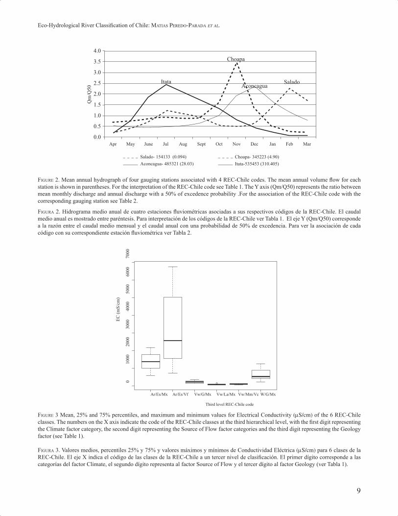
Table 2 shows that both the mean annual fl ows and Figure 2 the mean annual hydrographs , which are consistent with the classifi cation. For all the stations, the shape of the hydrograph is similar to that described by the REC-Chile classes, just as are the seasonal variations too.
To characterize the natural geo-chemical quality of the water, the following aspects must be considered: local lithology, climate, vegetation and residence time of the water in the aquifer, which is a function of the climate (Drever 2002). Another important aspect to be considered is the composition of the infl ow water on the system (Allan & Castillo 2007) and the origin of the water circulating in the river. The controlling factors used to characterize the natural geo-chemical quality of the water are Climate, Source of Flow and Geology. Therefore, the third level of classifi cation enables to make a prediction of the mean Electrical Conductivity (EC, μS/cm) for each class.
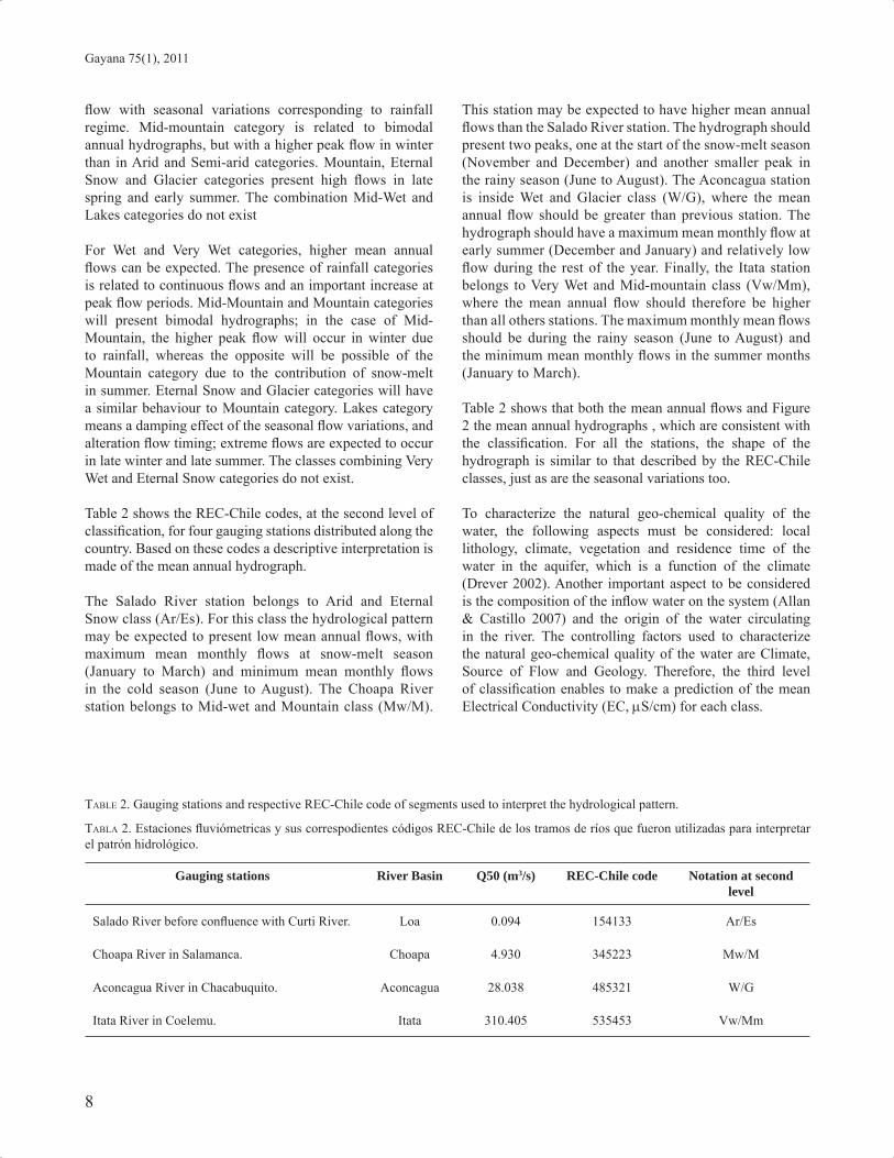
TABLE 2. Gauging stations and respective REC-Chile code of segments used to interpret the hydrological pattern.
TABLA 2. Estaciones fl uviómetricas y sus correspodientes códigos REC-Chile de los tramos de ríos que fueron utilizadas para interpretar el patrón hidrológico.
Gauging stations River Basin Q50 (m3/s) REC-Chile code Notation at second level
Salado River before confl uence with Curti River. Loa 0.094 154133 Ar/Es
Choapa River in Salamanca. Choapa 4.930 345223 Mw/M
Aconcagua River in Chacabuquito. Aconcagua 28.038 485321 W/G
Itata River in Coelemu. Itata 310.405 535453 Vw/Mm
9
Eco-Hydrological River Classifi cation of Chile: MATIAS PEREDO-PARADA ET AL.
FIGURE 2. Mean annual hydrograph of four gauging stations associated with 4 REC-Chile codes. The mean annual volume fl ow for each station is shown in parentheses. For the interpretation of the REC-Chile code see Table 1. The Y axis (Qm/Q50) represents the ratio between mean monthly discharge and annual discharge with a 50% of excedence probability .For the association of the REC-Chile code with the corresponding gauging station see Table 2.
FIGURA 2. Hidrograma medio anual de cuatro estaciones fl uviométricas asociadas a sus respectivos códigos de la REC-Chile. El caudal medio anual es mostrado entre paréntesis. Para interpretación de los códigos de la REC-Chile ver Tabla 1. El eje Y (Qm/Q50) corresponde a la razón entre el caudal medio mensual y el caudal anual con una probabilidad de 50% de excedencia. Para ver la asociación de cada código con su correspondiente estación fl uviométrica ver Tabla 2.
���
���
���
���
���
���
���
���
���� � � ���� ��� �� ��� ��� ��� ��� � � ��� � �
� � �� !������!!"���#�$���� �� !�%����!"�%���$
&'� !������!"��#�$(� � ������!"�������$
(� �
&'�
���� �� � � ��
)*
+)��
,'-��!�����!./& &'-��!����
�+/0+�1 23+4+�1 23+5 +�1�+/0+26 23+�*+2� 7+4+�1
8���
9���
����
����
����
����
����
�
/&
!"*�+
�*$
FIGURE 3 Mean, 25% and 75% percentiles, and maximum and minimum values for Electrical Conductivity (μS/cm) of the 6 REC-Chile classes. The numbers on the X axis indicate the code of the REC-Chile classes at the third hierarchical level, with the fi rst digit representing the Climate factor category, the second digit representing the Source of Flow factor categories and the third digit representing the Geology factor (see Table 1).
FIGURA 3. Valores medios, percentiles 25% y 75% y valores máximos y mínimos de Conductividad Eléctrica (μS/cm) para 6 clases de la REC-Chile. El eje X indica el código de las clases de la REC-Chile a un tercer nivel de clasifi cación. El primer dígito corresponde a las categorías del factor Climate, el segundo dígito representa al factor Source of Flow y el tercer dígito al factor Geology (ver Tabla 1).
Gayana 75(1), 2011
10
Arid category of the Climate factor is expected to have a high EC value, and as the level of precipitation rises, the EC will diminish; thus Very Wet category should have the lowest EC. The categories of the second controlling factor, Source of Flow, have less effect on the EC than Climate factor. Categories with a rainfall origin (Low Elevation, Valley and Mid-Mountain) present a lower EC than those coming from snow-melt (Mountain, Eternal Snow and Glacier) due to leaching from volcanic soils. Lakes category may present lower values due to the physical-chemical processes which occur in lakes. Finally, the third factor categories (Geology) presents EC values according to the presence of ions associated with each type of lithology. Thus Alluvial category will present the lowest EC values, followed by Plutonic Rocks, Volcanic, Sediment and Mix Sed-volcanic, and fi nally Sedimentary Rocks. A special case is the category of Fractured Volcanic Rocks, since this permits to occur a greater leaching of ions.
Figure 3 shows the EC values of sampling points grouped by the third level REC-Chile code. These values appear to be in agreement with the interpretations done from the REC-Chile classes. It is observed that the classes with Arid category (Ar/Es/Mx and Ar/Es/Vf) present the highest values and that these diminish as the level of precipitation increases. The effect of Source of Flow factor is also observed, since within the Very Wet category, the Glaciers category (Vw/G/Mx) presents the highest concentration, while Lakes category (Vw/La/Mx) has a lower EC concentration. Finally in the class Ar/Es, it is seen that the Fractured Volcanic Rocks category has a higher concentration than compound rocks of volcanic and sedimentary origin.
DISCUSSION
The results of this study show that it is possible to implement the REC in the particular environmental conditions existing in Chile. The controlling factors and categories developed for this country seem to represent in a suitable way the various climatic, hydrological and geological conditions. For example, using REC-Chile at the second level, i.e. combining the Climate and Source of Flow factors, it is possible to describe approximately the hydrological pattern of a segment of river. This allows compare magnitudes of mean annual fl ow between segment of river for different classes and estimate a fi rst approach of the annual hydrograph, as is shown in the present study.
Furthermore, at the third classifi cation level a good characterization of the geo-chemical quality of the water could be achieved. It is in agreement with previous studies in which it is indicated that precipitation, the lithology of
the basin, the origin of fl ow and the residence time are the principal factors (Allan & Castillo 2007; Drever 2002; Custodio & Llamas 1976).
It must be stressed that REC-Chile incorporates the River Continuum Concept (Vannote et al. 1980) and represents the longitudinal changes downstream as a result of the propagation of upstream characteristics in the downstream directions.
The development of REC-Chile in a GIS environment allows the observation and easy handling of the river segment’s data. One great advantage of this tool is the possibility of managing information coming from the controlling factors selected by the user according to the objectives and the scale of the work. This give it great fl exibility to obtain patterns of the distribution of hydrological and physical-chemical variables which determine the ecological characteristics of segments of river.
REC-Chile classifi cation is able to classify rivers at a microscale equivalent to river reach (km order). This prevents the REC-Chile to classify rivers considering fl uvial processes? that ocurr at a lower spatial scale. If required to carry out a classifi cation at a lower spatial scale than river reach, it would be necessary to decrease the classifi cation unit (for example at mesohabitat unit). Any modifi cation to REC-Chile, either including controlling factors and/or categories will result in an increase of the total number of classes.
A joint use of the REC-Chile and a geodatabase of aquatic communities, e.g. macroinvertebrates or fi sh, brings great benefi ts in terms of its use in management and planning of aquatic ecosystems (Peredo-Parada et al. 2009a). Among other things, REC-Chile will enable estimating spatial distribution patterns for species with scarce information, because statistical techniques can relate the physical characteristics of the river segments with species presence/absence data (Peredo-Parada et al. 2009b; Snelder et al. 2004). It is also helpful in the design of monitoring networks, in order to ensure a suitable distribution of sampling points across an area of interest (Hawkins et al. 2000), and also to investigate about habitat suitability for aquatic species at the mesoscale level.
In order that a landscape classifi cation becomes a useful aquatic management tool, it must be developed by consensus of all sectors involved in management of aquatic ecosystems. Furthermore, the landscape classifi cation must have a number of classes that facilitates handling and decision making. The great number of REC-Chile classes goes against this premise, could result in a complex management framework. Therefore, it is necessary to decrease the number
11
Eco-Hydrological River Classifi cation of Chile: MATIAS PEREDO-PARADA ET AL.
of classes. This reduction must be carried out by evaluating the classifi cation strength at different number of classes and will be necessary to perform a physical interpretation of the classes. These two analysis will allow to group the classes that present a similar interpretation without missing the correct classifi cation structure. Due to the tree confi guration of the REC-Chile to achieve a great reduction in the total number of classes, the number of categories at higher level must be decreased,
Other important application of the REC-Chile is the determination of river reaches in natural condition, which could be used as a reference in restoration planning (Hawkins et al. 2000). If there are no reaches in natural conditions, REC-Chile allows to assess the maximum ecological potential within a certain class using various indexes, e.g. freshwater fi sh index (Noble et al. 2007; Schmutz et al. 2007), macroinvertebrates index (Figueroa et al. 2003, 2007), and riparian vegetation index (Palma & Figueroa 2009; Munné et al. 1998, 2003). With the application of such kind of indexes, REC-Chile could make possible to determine the hydrologic and ecological degree of alteration of river segments, in relation to reference sites. It can also be used to extrapolate ecological information within the classes (Omernik & Bailey 1997). These applications are useful for prioritizing and designing fl uvial restoration activities.
CONCLUSIONS
The REC-Chile classifi cation system is an adaptation to the climatic, topographic and geological conditions of Chile of the River Environmental Classifi cation (REC) developed by Snelder & Biggs (2002).
This classifi cation system is a tool for river classifi cation with a digit-code based on the hierarchical superposition of six factors which control the hydrological pattern (Climate, Source of Flow, Geology, Catchment Relative Position, Land Use and Reach Slope). The classifi cation of river reaches is represented as a 6-digit code, where the digit position is the classifi cation level and its value is the category of the factor at that level.
REC-Chile offers various advantages with respect an ecorregion approach. First, it allows the various eco-hydrological patterns of Chilean rivers to be described by the superposition of appropriate controlling factors depending on the objective of the classifi cation, thus allowing study on various spatial scales. Second, it has the ability to manage rivers as hydrological networks considering their longitudinal continuity, allowing changes to be detected from one watershed to another even if they are geographically close to one another, thus providing a more exact characterization
of Chilean rivers. Third, it is implemented in a GIS environment, facilitating geographical interpretation and changes from one scale of work to another.
An easy interpretation of the REC-Chile classes at different classifi cation levels enables a simple assessment of different fl uvial patterns, e.g. at the second classifi cation level the mean annual hydrograph of river segments can be described. At the third classifi cation level, aspects of the natural geo-chemical quality of the water can be compared.
Finally we expect the REC-Chile classifi cation system become a useful tool for the conservation and management of river ecosystems in Chile, supporting the determination of their ecological potential state and the selection of suitable methods for assigning environmental fl ow regimes in different river types.
ACKNOWLEDGEMENTS
This research has been supported by National Committee of Sciences and Technology (CONICYT) and Spanish Agency of International Cooperation for Development (AECID) through grant for Matias Peredo. We wish to thank to General Water Authority of Chile (DGA) for providing the data sets.
REFERENCES
ALLAN, D. & CASTILLO, M. 2007. Stream ecology. Structure and function of running waters. 2nd edition. Springer Dordrecht, The Netherlands. 436 pp.
BAEZA, D., MARTÍNEZ-CAPEL, F. & GARCÍA DE JALÓN, D. 2003. Variabilidad temporal de caudales: Aplicación a la gestión de ríos regulados. Ingeniería del agua 10(4):469-478.
BAHAMONDE, N., CARVACHO, A., JARA, C., LÓPEZ, M., PONCE, F., RETAMAL, M.A. & RUDOLFF, E. 1998. Categorías de conservación de decápodos nativos en aguas continentales de Chile. Boletín del Museo Nacional de Historia Natural 47:91-100.
BAILEY, R.G. 2009. Ecosystem Geography. 2nd Edition Springer. New York. EEUU. 251 pp
BAILEY, R.G., PFISTER, R.D. & HENDERSON, J.A. 1978. Nature of Land and Resource Classifi cation. Journal of Forestry 76(10):650-655.
CAMOUSSEIGHT, A. 2006. Estado de conocimiento de los Ephemeroptera de Chile. Gayana 70(1):50-56.
CONAMA 2007. Estrategia Nacional de Gestión Integrada de Cuencas Hidrográfi cas. Gobierno de Chile. 60 pp.
CUSTODIO, E. & LLAMAS, M. 1976. Hidrología Subterránea. Ediciones Omega S.A. Barcelona. 1157 pp.
DREVER, J. 2002. The Geochemistry of Natural Waters. Surface and Groundwater Environments. Prentice Hall. Third Edition. New Jersey. ISBN: 0-13-272790-0. 436 pp.
DYER, B. 2000. Sistematic review and biogeography of the

Gayana 75(1), 2011
12
freshwater fi shes of Chile. Estudios Oceanológicos 19:77-98.
FIGUEROA, R., VALDOVINOS, C., ARAYA, E. & PARRA, O. 2003. Macroinvertebrados bentónicos como indicadores de calidad de agua de ríos del sur de Chile. Revista Chilena de Historia Natural 76:275-285.
FIGUEROA, R., PALMA, A., RUIZ, V. & NIELL, X. 2007. Análisis comparativo de índices bióticos utilizados en la evaluación de la calidad de las aguas en un río mediterráneo de Chile: Río Chillán, VIII Región. Revista Chilena de Historia Natural 80:225-242.
FLEMING, S. 2005. Comparative analysis of glacial and nival streamfl ow regimes with implications for lotic habitat quantity and fi sh species richness. River Research and Applications 21:363-379.
FRISSELL, C., LISS, W.J., WARREN, C.E. & HURLEY, M.D. 1986. A hierarchical framework for Stream Habitat Classifi cation: Viewing Streams in Watershed context. Environmental Management 10:199-214.
GONZÁLEZ, L., MARDONES, M., SILVA, A. & CAMPOS, E. 1999. Hidrogeoquímica y comportamiento del agua subterránea en la cuenca del río Claro, Región del Biobío, Chile. Revista Geológica de Chile. 26(2):145-157.
GONZÁLEZ DEL TÁNAGO, M. & GARCÍA DE JALÓN, D. 2006. Propuesta de caracterización jerárquica de los ríos españoles para su clasifi cación según la Directiva Marco de la Unión Europea. Limnética 25(3):693-712.
HABIT, E., GONZÁLEZ, S. & VICTORIANO P. 2002. Alcances sobre el uso sustentable de la ictiofauna de sistemas fl uviales. Theoria 11:15-20.
HABIT, E., DYER, B. & VILA, I. 2006. Estado de conocimiento de los peces dulceacuícolas de Chile. Gayana 70(11):100-112.
HAWKINS, C., NORRIS, R., GERRITSEN, J., HUGHES, R., JACKSON, S., JOHNSON, R. & STEVENSON, J. 2000. Evaluation of the use of landscape classifi cations for the predictios of freshwater biota: synthesis and recommendations. Journal of American Benthological Society. 19(3):541-556.
HERAS, R. 1973. Estudio de sequias. Ediciones Centros de Estudios Hidrográfi cos, Madrid. 46 pp.
HERRERA, C., PUEYO, J.J., SAEZ, A. & VALERO-GARCÉS, B. 2006. Relación de aguas superfi ciales y subterráneas en el área del lago Chungará y lagunas de Cotacotani, norte de Chile: un estudio isotópico. Revista Geológica de Chile. 33(2):299-325.
JARA C.G., RUDOLPH, E.H. & RIQUELME, E.R. 2006. Estado de conocimiento de los malacostracos dulceacuícolas de Chile. Gayana 70(1):40-49.
JOHNSON L., RICHARDS, C., HOST, G. & ARTHUR, J. 1997. Landscape infl uences on water chemistry in Midwestern stream ecosystems. Freshwater Biology 37(1):193–208.
MC DOWALL, M.C. 2000. Biogeography of the southern cool-temperate galaxioid fi shes: evidence from metazoan macroparasite faunas. Journal of Biogeography 27:1221-1229.
MONTGOMERY, D.R. & BUFFINGTON, J.M. 1997. Channel-reach morphology in mountain drainage basins. Geological Society of America Bulletin 109:596-611.
MUNNÉ, A., SOLA, C. & PRAT, N. 1998. QBR: Un índice rápido para la evaluación de la calidad de los ecosistemas de ribera. Tecnología del Agua 175:20-37.
MUNNÉ, A., PRAT, N., SOLA, C., BONADA, N. & RIERADEVALL, M. 2003. A simple fi eld method for assessing the ecological quality of riparian habitat in rivers and streams. QBR index. Aquatic Conservation: Marine and Freshwater Ecosystems 13:147-164.
NOBLE, R., COWX, I.G., GOFFAUX, D. & KESTEMONT, P. 2007. Assessing the health of European rivers using functional ecological guilds of fi sh communities: standarising species classifi cation and approaches to metric selection. Fisheries Management and Ecology 14:381-392
OMERNIK, J. & BAILEY, R. 1997. Distinguish between watersheds and ecoregions. Journal of the American Water Resources Association. 33 (5):935-949.
ORTÍZ, J.C. & DÍAZ-PAEZ, H. 2006. Estado de conocimiento de los anfi bios de Chile. Gayana 70(1):114-121.
PALMA, A. & FIGUEROA, R. 2009. Evaluación de ribera y hábitat fl uvial a través de los índices QBR e IHF. Gayana. 73(1):57-63
PARADA, E. & PEREDO, S. 2005. La relocalización como una herramienta de conservación y manejo de la biodiversidad. Lecciones aprendidas con Diplodon chilensis (Gray 1828)(Bivalvia:Hyriidae). Gayana 69(1):41-47.
PARADA, E. & PEREDO, S. 2006. Estado de conocimiento de los bivalvos dulceacuícolas de Chile. Gayana 70(1):82-87.
PEREDO, S., PARADA, E., VALDEBENITO, I. & PEREDO, M. 2005. Relocation of the freshwater mussel Diplodon chilensis (Hyriidae) as a strategy for its conservation and management. Journal Molluscan Studies 71:195-198.
PEREDO, S., PARADA, E., VALDEBENITO, I. & PEREDO, M. 2006. Effect of aerial exposure on physiological condition and survival of Diplodon chilensis (Hyriidae) during translocation. Malacologia 49(1):217-221.
PEREDO-PARADA, M., MARTÍNEZ-CAPEL, F., GARÓFANO-GÓMEZ, V., ATENAS, M. & RIESTRA, F. 2009. Base de datos eco-hidrológica de los ríos de Chile: una herramienta de gestión para los ecosistemas acuáticos. Gayana 73(1):119-129.
PEREDO-PARADA, M., MARTÍNEZ-CAPEL, F., ALCARAZ, J.D. & BARGAY, M. 2009 Potential geographical distribution of two endemic freshwater fi shes (P. gillissi and D. camposensis) of Chile. En: Proceedings of the International Symposium on Ecohydraulics. ISBN: 978-981-08-2100. (Eds. International Association of Hydraulic Engineering and Research (IAHR) and Universidad de Concepción), Concepción. Chile.
PÉREZ-LOSADA, M., JARA, C.G., BOND-BUCKUP, G. & CRANDALL, K.A. 2002. Conservation phylogenetics of chilean freshwater crabs Aegla (Anomura,Aeglidae): assigning priorities for aquatic habitat protection. Biological Conservation 105:345-353.
RUTLLANT, J. 2004 Aspectos de la circulación atmosférica de gran escala asociada al ciclo ENOS 1997-1999 y sus consecuencias en el régimen de precipitación en Chile central. En: El niño-La niña 1997-2000 sus efectos en Chile (Eds: Avaria, S., Carrasco, J., Rutllant, J. & Yañez E.). CONA, Chile, Valparaíso:61-76.
SLIVA, L. & DUDLEY, D. 2001. Buffer Zone versus Whole Catchment Approaches to Studying Land Use Impact on River Water Quality. Water Research 35(14):3462-3472.
SNELDER, T. & BIGGS, B. 2002. Multiscale River Enviroment Classifi cation for Water Resources Management. American
13
Eco-Hydrological River Classifi cation of Chile: MATIAS PEREDO-PARADA ET AL.
Water Resources Association 38(5):1225-1239.SNELDER, T., CATTANEO, F., SUREN, A. & BIGGS, B. 2004. Is the River
Environment Classifi cation an improved landscape-scale classifi cation of rivers?.Journal of the North American Benthological Society. 23(3):580-589
SNELDER, T., BIGGS, B. & WOODS, R. 2005. Improved Eco-Hydrological Classifi caction of Rivers. River Research and Applications. 21:609-628.
SCHMUTZ, S., COWX, I.G., HAIDVOGL, G. & PONT, D. 2007. Fish-based methods for assessing European running waters: a synthesis. Fisheries Management and Ecology 14:369-380
VALDOVINOS, C. 2006. Estado de conocimiento de los gastrópodos dulceacuícolas de Chile. Gayana 70(1):88-95.
VANNOTE, R.L., MINSHALL, G.W., CUMMINS, K.W., SEDELL, J.R. & CUSHING, C.E. 1980. The River Continuum Concept. Canadian Journal of Fisheries and Aquatic Science. 37:130-137.
Recibido: 00.00.00Aceptado: 00.00.00
VERA, A. & CAMOUSSEIGHT, A. 2006. Estado de conocimiento de los plecópteros de Chile. Gayana 70(1):57-64.
VILA, I. & MOLINA, X. 2006. Variables químicas y biológicas. En: Manual de Calidad del Agua. Servicio Agrícola y Ganadero. (Eds. Molina X. & Vila, I.). Santiago 106 pp.
VILA, I., PARDO, R., DYER, B. & HABIT, E. 2006. Peces límnicos: Diversidad, origen y estado de conservación. En: Macrófi tas y vertebrados de los sistemas límnicos de Chile (Eds. Vila I, Veloso, A., Schlater, R. & Ramirez, C.), pp. 73-103. Editorial Universitaria, Santiago, Chile.
VILLAGRÁN, C. & HINOJOSA, L.F. 2005. Esquema biogegráfi co de Chile. En: Regionalización Biogeográfi ca en Iberoámeríca y tópicos afi nes (Eds. Llorente, J. & Morrone, J. J.) 551-577 pp. Ediciones de la Universidad Nacional Autónoma de México, Jiménez Editores, México.
WINTERBOUR, M.J., ROUNICK, J.S. & COWIE, B. 1981. Are New Zealand stream ecosystems really different? New Zealand Journal of Marine and Freshwater Research 15:321-328.
Related Documents


