Impacts of the Beni-Jomsom Road (Kali Gandaki Valley) on traditional social structures, settlements, and tourism in the Kali Gandaki Valley, Nepal Master Thesis to achieve the academic degree MASTER of Natural Sciences at the Karl-Franzens-University Graz submitted by Reinhard ROUBAL Department of Geography and Regional Science Assessor: O. Univ. Prof. Dr. Friedrich M. Zimmermann Co-Supervisor: Prof. Pushkar K. Pradhan (Department of Geography, Tribhuvan University, Nepal)

Welcome message from author
This document is posted to help you gain knowledge. Please leave a comment to let me know what you think about it! Share it to your friends and learn new things together.
Transcript

Impacts of the Beni-Jomsom Road (Kali Gandaki Valle y) on
traditional social structures, settlements, and tou rism in
the Kali Gandaki Valley, Nepal
Master Thesis
to achieve the academic degree
MASTER of Natural Sciences
at the Karl-Franzens-University Graz
submitted by
Reinhard ROUBAL
Department of Geography and Regional Science
Assessor: O. Univ. Prof. Dr. Friedrich M. Zimmermann
Co-Supervisor: Prof. Pushkar K. Pradhan
(Department of Geography, Tribhuvan University, Nepal)

2
Acknowledgements
This thesis was carried out at the Department of Geography and Regional Science
under the supervision of O. Univ.-Prof. Dr. Friedrich Zimmermann, to whom I offer
my sincere gratitude for his guidance, encouragements and abundance of patience
throughout the development of this thesis.
Furthermore I want to thank my co-supervisor, Prof. Dr. Pushkar K. Pradhan for his
approaches and assistance during my research stay in Nepal.
Finally and most important, I want to thank my parents Erika and Karl for giving me
the opportunity to finish my studies and for their long support in every possible way.
Sincerely,
Reinhard Roubal

3
Abstract
This thesis deals with the impacts of the road, from Beni into the Kali Gandaki valley
to Jomsom and further to Muktinath, Nepal, on the social structures, settlements and
tourism in that region. The main research question is how the road development
does have impacts on the daily life of the local population. Beside the physical
threats through landslides and dust, the focus lies on the economic impacts.
Trekking tourism has played a decisive role in generating great income as the region
is home to the world-famous Annapurna Circuit Trek. The road construction affects
this tourism sector in a crucial manner. On the other side, the famous pilgrimage site
of Muktinath which is the highest settlement of the research area, receives masses
of pilgrims since the temple site is reachable by Jeep. In this aspect, the
transformation of these tourism structures is pointed out in detail. A research stay in
Nepal has been undertaken to observe the impacts on site. Numerous key informant
and stakeholder interviews with the local population, representatives of the tourism
industry and tourists have been conducted.
Based on the four pillars of sustainability, the results of the field survey have been
classified into ecological, economic, social as well as institutional impacts. Which
groups of the population benefit from the present development and which suffer from
it was a further research question which has been revealed during the field survey.
Furthermore, the development of the road construction in the Kali Gandaki valley up
to Upper Mustang is still going on - opening up new challenges of managing these
developments in a way to sustain the unique natural beauty of the region while
strengthens its communities and their tradition.

4
Zusammenfassung
Die Masterarbeit beschäftigt sich mit den Auswirkungen der Straße, von Beni in das
Kali Gandaki Tal nach Jomsom und weiter nach Muktinath, Nepal, auf die sozialen
Strukturen, Siedlungen und den Tourismus in dieser Region. Die zentrale
Forschungsfrage ist, welche Auswirkungen der Straßenbau auf den Alltag der
lokalen Bevölkerung hat. Neben den Gefahren von Hangrutschungen und der
enormen Staubentwicklung durch die Straße liegt der Fokus in den ökonomischen
Auswirkungen. Trekkingtourismus hat in dieser Region seit Jahrzehnten als
willkommene Einnahmequelle für die lokale Bevölkerung gedient. Durch den
Straßenbau wurden diese Tourismusstrukturen massiv beinflusst. Auf der anderen
Seite reisen seit der Erreichbarkeit der berühmten Tempelanlagen von Muktinath per
Jeep Massen an Pilgertouristen ins Tal. Die gravierenden Veränderungen bezüglich
dieser Tourismusstrukturen sind in dieser Arbeit hervorgehoben. Eine
Forschungsreise nach Nepal ermöglichte eine Beobachtung und
Informationsbeschaffung vor Ort. Qualitative Interviews mit Einheimischen,
Vertretern der Tourismusindustrie sowie Touristen wurden durchgeführt.
Basierend auf den vier Säulen der Nachhaltigkeit wurden die Ergebnisse in
ökologische, ökonomische, soziale sowie institutionelle Auswirkungen untergliedert.
Welche Bevölkerungsgruppen vom Straßenbau profitieren und welche benachteiligt
wurden, war eine weitere Forschungsfrage. Die sich noch immer in Bau befindende
Straße nach Upper Mustang und weiter nach Tibet eröffnet neue
Herausforderungen, diese Entwicklungen in jenem Maße zu managen, dass die
einzigartige Naturlandschaft erhalten und die lokalen Strukturen wie auch deren
Kulturen gestärkt bleiben.

5
Contents
1 Introduction ......................................................................................................... 9
1.1 Problem Statement ..................................................................................... 10
1.2 Research aims ............................................................................................ 12
1.3 Structure and limitation of the study ............................................................ 13
2 Research methodology ..................................................................................... 15
2.1 Literature ..................................................................................................... 15
2.2 Field survey and data collection in Nepal .................................................... 16
2.3 Focus groups .............................................................................................. 18
2.3.1 Key Informants Interviews ................................................................... 19
2.3.2 Stakeholder interviews ........................................................................ 21
3 Theoretical approaches: From sustainable development to poverty alleviation ... through infrastructure and tourism .................................................................... 23
3.1 Sustainable Development ........................................................................... 23
3.2 Definition and forms of developing countries and poverty ........................... 28
3.3 Road development impacts on poverty reduction ....................................... 35
3.4 Tourism impacts in developing countries .................................................... 38
3.4.1 Pro-poor tourism ................................................................................. 40
3.4.2 Sustainability in mountain tourism communities ................................. 42
4 Nepal and the area of research ......................................................................... 58
4.1 Nepal .......................................................................................................... 58
4.1.1 Physical setting of Nepal ..................................................................... 58
4.1.2 Economy and Infrastructure in Nepal .................................................. 67
4.1.3 Poverty and development needs in Nepal .......................................... 70
4.1.4 Socio-cultural and religious structures ................................................ 71
4.2 The Kali Gandaki valley .............................................................................. 72
4.2.1 Physical setting of the Kali Gandaki valley.......................................... 72
4.2.2 Socio-cultural and religious structures ................................................ 72
4.2.3 Tourism in the Kali Gandaki valley ...................................................... 74
5 The Beni-Jomsom road ..................................................................................... 74

6
5.1 Historical overview about a road into the Kali Gandaki valley ..................... 76
5.2 Planning, implementation and monitoring ................................................... 77
6 Field survey: from Beni to Muktinath ................................................................. 78
6.1 Classification and sub-areas of research .................................................... 78
6.2 Ecological impacts ...................................................................................... 79
6.2.1 Landslides and debris falls .................................................................. 79
6.2.2 Noise and dust pollution...................................................................... 82
6.2.3 Waste problem .................................................................................... 89
6.3 Economic impacts ....................................................................................... 93
6.3.1 Reduction of travel time and cost ........................................................ 93
6.3.2 Impacts of the road on agriculture ...................................................... 96
6.3.3 Impacts of the road on tourism ........................................................... 98
6.4 Social impacts ........................................................................................... 117
6.4.1 Modernisation vs. Traditional structures ........................................... 117
6.4.2 Migration ........................................................................................... 120
6.5 Institutional impacts .................................................................................. 120
7 Conclusion ...................................................................................................... 123

7
List of figures
Figure 1: Components of the Human Development Index. ....................................... 33
Figure 2: Road Development Impact Schema .......................................................... 36
Figure 3: Topographic zonal map of Nepal .............................................................. 59
Figure 4: Physiographic subdivisions of Nepal.. ....................................................... 60
Figure 5: Generalized geologic map of Nepal. ......................................................... 63
Figure 6: A schematic geologic cross section of the Himalaya. ................................ 64
Figure 7: Climate zones of Nepal ............................................................................. 66
Figure 8: Precipitation distribution of Nepal. ............................................................. 67
Figure 9: The importance of the trade in the Kali Gandaki valley ............................. 73
Figure 10: Road impression near Ghasa .................................................................. 75
Figure 11: Landslide on colluvium north of Beni. ...................................................... 81
Figure 12: Man-made debris fall near Jomsom ........................................................ 81
Figure 13: Landslide in Rupse Chhahara ................................................................. 82
Figure 14: Same spot in 2011, the road is visible above the trail ............................. 82
Figure 15: Small stall, in the past beside the trade route.......................................... 85
Figure 16: The village of Marpha .............................................................................. 86
Figure 17: Hot springs of Tatopani ......................................................................... 108
Figure 18: House damage due to the road construction in Ghasa ......................... 110
Figure 20: The traditional trade and trekking route through Marpha ...................... 111
Figure 19: The road near Marpha .......................................................................... 111
Figure 21: Yearly tourist passengers at Jomsom Airport ........................................ 113
Figure 22: Arrivals of pilgrims by Helicopter ........................................................... 115
Figure 23: The same spot in the year 2011 ............................................................ 115
Figure 24: Locals suffer from traffic in the centre of Muktinath. .............................. 116
Figure 25: Muktinath - pilgrims ............................................................................... 116
Figure 26: The motorized shuttle service of Muktinath. .......................................... 117
Figure 27: The way from the temple site down to the village .................................. 117
Figure 28: Nestlé meets ‘Om mani padme hum’. ................................................... 118
Figure 29: Modernisation meets tradition. Impressions .......................................... 119

8
Figure 30: Beni Bus station with ticket counter for Tatopani, Ghasa and Jomsom . 122
List of tables
Table 1: Short- and long-term effects of road development on the residents. .......... 37
Table 2: Objective Conditions in Mountain Areas and their Implications for Mountain
Tourism. ................................................................................................................... 48
Table 3: Change in prices of agricultural products in Kagbeni . ............................... 98

9
1 Introduction
Nepal, this fascinating country, full of natural and mystical jewels, home of the
highest mountains of our planet. What comes into our mind if we hear about Nepal?
Maybe we think of Mount Everest, Himalaya trekking, jungle safari, amazing,
multifarious cultural sights and a society which still lives its culture like hundred years
ago. That´s the imagination most of us maybe have, when we think of Nepal. Mainly
and in most parts of the country, we still can find that way of live, that close relation
to nature, usage of what is growing around the settlements and religious as well as
cultural activities as an important part of their daily life.
But there exists another Nepal as well! We can watch farmer tilling their fields by
using their oxen, colourful dressed women harvesting their fields by hand, while
listening to music coming from their mobile phones. In some areas there is even
mobile phone connection over 5000 m above sea level, one week of trekking away
from the next road and the sounds of engines. Since 2011 there is high speed
internet access at the Everest base camp, while in Kathmandu the inhabitants have
to get by on sometimes only 72 hours of electricity in a week.
Tourism meets tradition, modernisation meets poorest conditions! Nepal, one of the
poorest countries in South Asia, seems to be at the crossroads. After ten years of
civil war, a political transformation from monarchy to democratic republic, an ongoing
transition from conflict to peace, this multi-ethnic state tries to bear the challenge of
those transitions while confronting long-standing development challenges. To
improve any kinds of infrastructure in a country covered by steep hills plus the
deepest valleys and highest mountains is one of the basic challenges to strengthen
national economy and peace building.
This thesis deals about an area, where I have been before I started to study in Graz,
and before that road has been constructed in the Kali Gandaki valley in Nepal. A
long-traditional trade route, a world famous trekking destination since decades, this
valley now undergoes a change, linked with many transformations in different fields.

10
The impact on the daily way of life for the local population, transformations in
economic patterns with focus on tourism structures, and as the base of all, the
environment, is the content of this study.
1.1 Problem Statement
Situated between the two turbo-driven economies of China to the north and India to
the south, Nepal seems to be the buffer in between. Not just in an economic point of
view but also concerning the topography, Nepal range from the flat, low Terai in the
south to the highest mountains, cut by the deepest valleys in the north of the country.
Infrastructural connections in form of trade routes through the Himalayan range,
between the rich Indo-Gangetic plain of India and the barren plateau of Tibet have
played an important role for rice and salt trades for centuries. After the Chinese
government invaded the province of Tibet in 1959, the closure of the border between
Tibet and Nepal led to an end of these commercial relations.
Since Nepal opened its borders for tourists in the 1950ies, tourism industry became
a powerful tool to improve the national economy. Within the next decades, more and
more foreigners recognized and explored the beauty and breathtaking scenery of
Nepal its richness in ethnics and authentic cultures. Especially for mountaineers and
trekkers, Nepal established itself as one of the most beautiful trekking destinations in
the world.
Due to the topography, a weak economic development and conflicts in many districts
in the past, the more than spare national road net as well as other infrastructural
connections allowed just few cities and regions to become the main tourist and
trekking destinations inside the country. The Annapurna region, north of Pokhara,
which includes the research area for this thesis, gained popularity since the 1960ies,
and turned into the main trekking destination with over 76.000 trekkers in the year

11
2000 which represents about 60 per cent of the total tourist arrivals in that year in
Nepal.
Hand in hand with the tourism development, the demographic growth began in Nepal
from the 1950s onward and between 1961 and 1991 the national population
doubled. Local demand for resources was growing in a faster rate than the
environment could provide. The consequences of deforestation and gradual over-
harvesting lead to further deterioration. Especially in the mountain environment,
where resources, but also opportunities for economic improvement are limited,
tourism has the potential to strengthen these local economies.
The Kali Gandaki valley, an inner Himalayan valley where Tibetan culture is still
alive, stays in memory as an Eldorado for trekker, far away from the next road, and
has been developed as one of the major trekking areas in Nepal. The newly
constructed road, linking Jomsom and further Muktinath to the national road net,
represents the aim of the Rural Development Plan to connect all District
Headquarters with infrastructural connection. Much talked about, especially in the
field of the trekking tourists and beyond the boarder, the road has crucial impacts on
that area. Infrastructural connection as a base for improvement of living standard,
demotion and decreasing income through trekking tourists who, to some extent, are
shocked about the loss of the scenic beauty and silence in that trekking area. An
increasing number of domestic but mainly Indian pilgrims now have the possibility to
visit the holy temple of Muktinath by road while in many villages along the road
tourism business is as good as lost.
Many aspects, different perspectives, speculations and the fact that these
developments were predictable for years but happened without management, with
lack of linkages between the different levels, face a multifarious prospect with both
positive and negative impacts. As it happens everywhere, change is always
accompanied by adjustment and restructuring of what was before into new
conditions and challenges.

12
1.2 Research aims
The aim of this study, derived from the problem statement above, is to estimate and
determine the different impacts of the Beni-Jomsom road on the traditional social
structures and settlements with focus on the transition of the tourism structure in the
Kali Gandaki valley. Several research questions can be assembled as follows:
� In which aspects does the infrastructural connection have impacts on
the local communities?
� Is an appreciation of this peripheral area due to the infrastructural
connection observable?
� In which fields can essential changes be ascribed to the road access?
� For which population groups (ethnic, occupation, closeness to road) did
the road access bread essential transformation in their daily life and
had crucial impacts in regard to the living standard?
This thesis discusses the impact of the Beni-Jomsom road on the local communities
within a holistic approach. Impacts and transitions within the communities cannot be
discussed without integrating the environmental aspects. Therefore the ecological,
economic, social as well as the institutional dimensions, also known as the four
pillars of sustainability, are treated and build the subchapters.
In conclusion and to take a step forward to the results which could be compiled
during the field survey in Nepal, further future-oriented research questions are of
crucial importance:
� Which transformations are required to reduce the negative impacts with
regard to the road access?
� Which transformations are required to enforce the positive impacts with
regard to the road access?

13
� How can these transformations be realised into implementation
(approach)?
1.3 Structure and limitation of the study
The first chapter brought an insight about the topic of this study and presented the
problem statement which manifests in the research questions and aims, already
mentioned above. Chapter 2 deals with the research methodology adopted in this
thesis and shows the framework of the containing issues of the field survey in Nepal.
Beside an explanation about the used literature and its collection, detailed
information is given about the composition and structure of the field survey.
Theoretical input about the relevant special fields is presented in chapter 3.
Sustainable development and tourism with focus on developing countries, pro-poor
tourism, the impact of infrastructure, i.e. road projects on poverty reduction and the
specificities of mountain tourism are discussed. Chapter 4 provides an overview
about the fascinating country and further about the area of research where the field
survey was carried out. While chapter 5 reveals the situation concerning active
projects in the area of research, chapter 6 deals with the information which could
have been selected in terms of planning, implementation and monitoring of the Beni-
Jomsom road. The lead through of the field survey and its results, which pose the
core element of this thesis, is given in chapter 7. Based on that, prospective
projections with regard to a sustainable development in the mountain area for both
environment and locals, summing up with a conclusion, build the last chapter.
With regard to the limitation of the study, the framework was not definitely fixed in
detail when I left Austria for my research stay. The planning and implementation of
the field survey was not concretised till the meeting and discussion with Prof. Dr.
Pushkar Pradhan at the Department of Geography, Tribhuvan University in
Kathmandu. After clearing several questions, the planning and execution of the field
survey was organised solely by me. To hire a guide as an interpreter was taken into

14
consideration. The relatively wide-spread English skills in the Kali Gandaki valley
due to tourism and the independency – temporal and spatial – lead to the decision to
accomplish the field survey without guide, by hindsight the right decision.
Further, an extension of the thesis — a comparison between the impacts of the Beni-
Jomsom road with the recently ongoing road construction in the Marsyangdi valley,
east of the Kali Gandaki valley and first half of the famous Annapurna Circuit Trek —
came into question. Because of the already comprehensive topic, that consideration
has been left out, but would definitely be an interesting study to compare.
Nevertheless I trekked the whole Annapurna Circuit Trek, lead interviews with
several stakeholders about the recent road construction which will minimise the
world famous trek from originally 18 to 21 days of trekking, down to three off-the road
trekking days. While this study is thus ‘solely’ focused on the Kali Gandaki valley, the
last chapter will bring several mentions and prospects concerning infrastructural
development in the neighbouring Marsyangdi valley.

15
2 Research methodology
The thematic framework of this thesis is diversified from ecological, social and
economic as well as institutional impacts, the four pillows of sustainability. It is the
holistic, interdisciplinary approach in terms of sustainability which creates the scale
of this thesis. Therefore, issues of different disciplines like sociology, ethnology and
economy as well as ecology create the structure of this study.
In general, it is of decisive importance to link together these different disciplines, their
importance and impacts when dealing with a topic. Not just in the view of Buddhism
but also in system theory and the interdisciplinary interactions in the context of
sustainability, the understanding of the importance of causes and effects, their
interactions and net workings are indispensable.
2.1 Literature
After setting up the structure and limits of the study, a widespread literature search
was the base of this study. Basic information about Nepal and the area of research,
its topography, ecological and economic setting as well as its social structures are
given. Theoretical contents concerning the relevant issues include poverty and
poverty alleviation in developing countries. Within this context, the role of
infrastructure and accessibility improvement as a tool for poverty alleviation was a
main part of my literature research. The importance of sustainable tourism for
poverty reduction with emphasis on pro-poor tourism and the special features of
mountain tourism and its sustainability presents another literature focus of this
thesis. Concerning the latter, the specialized library of the Department of Geography
and Regional Science in Graz exhibits a good repertoire.
Actual data and statistics about poverty and economy in Nepal were found on
different online-portals of statistic bureaus, governmental websites of the respective

16
departments or non-governmental organizations who update their website regularly.
The online book store of International Centre for Integrated Mountain Development
(ICIMOD) provides free downloads of topic related publications from poverty
reduction to access improvement and sustainable development in mountain areas.
2.2 Field survey and data collection in Nepal
As the topic of this thesis definitely consists to a great extent of a practical approach,
a trip to Nepal and the area of research was indispensable. It was even more the
wish to combine the achievement of the Master degree with a research stay abroad.
The connection and friendship of Prof. Dr. Friedrich M. Zimmermann with Prof.
Pushkar Pradhan, Head of the Department of Geography at the Tribhuvan University
in Kathmandu, Nepal, made it possible to substantiate the possibility of a research
stay in Nepal. It has to be mentioned that I already visited the area of research in
spring 2005 before I started to study. At that time the Kali Gandaki valley was without
road connection, but the construction has already been in progress and the
questions, doubts and impacts of the road were on everyone´s lips.
Therefore it was of advantage to prepare myself for the field survey and data
collection in Nepal, especially in terms of expectations and the way of life,
organization and mentality of the local population. Concerning the observation of the
area of research, I could use images as well as impressions of the Kali Gandaki
valley in times without road connection and so I had the valuable advantage to have
a comparison to the present post-road situation and ongoing development of the
area of research.
During my research stay in Nepal from February to beginning of July 2011 I was in
contact with my co-supervisor Prof. Pushkar Pradhan in Kathmandu. Before leaving
for the area of research, further discussions about theoretical input, key informants
and stakeholder interviews as well as the implementation of the field survey had to

17
be done. Mr. Pushkar Pradhan gave useful inputs and advises for several key
informants interviews in Kathmandu and Pokhara.
The planning, prearrangements and implementation of the field survey in the Kali
Gandaki valley, from Beni up to Muktinath, was self-organised. After consideration to
take a guide as an interpreter or not, the field survey was carried out without guide,
which had the deciding advantage to be more flexible and independent. The crucial
factor which were the doubts to have difficulties in conversations with the locals due
to the language. Disregarding some basic phrases, my Nepali language skills were
not enough to discuss the impacts of the road. But already in advance it was known
that the area of research has a history of tourism since decades and apart from that,
many locals, even not involved in tourism, speak English due to education or a
former job abroad. Interviews and talks with social worker and guides or mule
owners who are descended from families who are not involved in tourism or families
who live in more remote villages, away from the road and without English skills,
information, perceptions and ideas about those locals could be collected. During the
field survey I tried to get as much information as possible from the different
population stratums, from the former head of the District Development Committee
(DDC) of Mustang over hotel owners, farmers and mule owners to religious
representatives from the monasteries. A detailed list of the Key Informant and
Stakeholder Interviews is shown in the next subchapter.
Beside the proper field survey it was of vital importance to receive as much as useful
information about the road construction itself, activities and representations of the
Annapurna Conservation Area Project (ACAP) and the tourism-related stakeholders
as well as the response of various national-level positions like the Nepal Tourism
Board (NTB). Most of the Key Informants Interviews were lead in the beginning of
the research stay, while some contacts arose out of the field survey in the area of
research or through other contacts which were of essential importance. Some
interviews were lead after the proper observation in the Kali Gandaki valley to
discuss my observations and impressions.

18
In general it has to be mentioned that in some cases it was very difficult to arrange
interviews and even after fixing an appointment it sometimes took some more weeks
trying to contact and to finally get the chance for an interview. Therefore it was of
deciding advantage that I planned to stay longer in Nepal, as a “western” time
scheduling had to be adapted to the mentality of the host country! The most decisive
factor for handling those difficulties is time and the understanding that some courses
of action cannot be compared with our “western” way of thinking! Another reason for
some difficulties was the extensive occurrence of so called “bandhas”, strikes of
different organizations and coalitions against the government in April and May due to
the extension of the Constituent Assembly´s term. Sometimes even several days a
week, public transportation as well as most of the offices and agencies did not
operate and were closed. Together with the relatively high number of holidays as
well as unofficial days off it was a truly time-consuming matter to carry out some
interviews.
2.3 Focus groups
The modification of the research methodology from a quantitative information search
and data acquisition through questionnaires to a solely qualitative approach with Key
Informants and Stakeholder Interviews admits a more detailed insight into the
different, diversified fields of impacts and a more significant representation of the
different groups of population in the area of research.
The catalogue of the different Key Informant and Stakeholder Interviews which were
compiled in advance was discussed with Prof. Pushkar Pradhan and was finally
improved and subdivided into stakeholder- and spatial-related structure.

19
2.3.1 Key Informants Interviews
a) National level offices
• Mr. Sunil Sharma, Manager Research, Planning & Monitoring, Nepal
Tourism Board, Kathmandu
• Mr. Siddharta Bajrachaya, Environment specialist, National Trust for
Nature Conservation
• Department of Roads, Kathmandu (unsuccessful)
• Army Headquarter Kathmandu (unsuccessful)
b) District level offices
• Mrs. Shradha Shrestha, Senior Officer, Nepal Tourism Board, Regional
Office, Pokhara
• Mr. Baikuntha Prasad Acharya, Officer In Charge, Nepal Tourism Board,
Regional Office, Pokhara
• Department of Roads, Pokhara (unsuccessful)
• Army Headquarter Pokhara (successful)
• Mr. Yogendra, Ing. Road Construction
• Hotel Association Nepal, Pokhara
• Trekking Agencies Association Nepal, Pokhara
• Mr. Narendra Lama, Tourism Officer, Annapurna Conservation Area
Project, Pokhara

20
• Mr. Tek Gurung, Tourism Manager, Annapurna Conservation Area Project,
Pokhara
• Mr. Lal Prasak Gurung, Director of Annapurna Conservation Area Project,
Pokhara
• Mr. Santosh Sherchan, Officer in Charge, Annapurna Conservation Area
Project, Jomsom
c) Village level offices
• Mr. Bishal Sharchan (ACAP Official), Owner of Hotel Florida, Ghasa
• Mr. Lapka Dandu, Mukhiya (Head of VDC Muktinath), (unsuccessful)
• Mr. Buddhi Bahadur Gurung, ACAP staff, ACAP Office Kalapani
d) Tourists along the route
During the whole research stay in Nepal and especially during the proper field
survey several tourists were interviewed. The questions were based on
SWOT-Analysis (Strengths, Weaknesses, Opportunities, Threats). I spoke to
trekking groups who had guides and porters as well as to individual trekkers. I
could speak to foreign students who study the same field and therefore had a
deepened knowledge concerning the field of research. Further I spoke to
(foreign) families who travelled with children and to mountain bikers both of
whom have diverse opinions compared to trekker.

21
2.3.2 Stakeholder interviews
a) Trekking agencies*
• Mr. Deepak Raj Adhikari, L.N. Treks & Expedition P. Ltd., Pokhara
• Mr. Hira K.C. SISNE Rover Trekking Ltd., Pokhara
• Mr. Hira Dhamala, Karnali Excursions, Kathmandu
• Staff of ECO Treks, Kathmandu
• Staff of Nepal Environmental Treks & Expedition, Kathmandu
*Note: I visited more Trekking Agencies in Kathmandu and Pokhara but just mention
those from whom I got crucial, useful information.
b) Hotels, Lodges, Restaurants
• Mr. Bhuwan Gauchan, Dhaulagiri Lodge, Tatopani
• Owner of Annapurna Lodge & Restaurant, Dana
• Owner of Eagle´s Nest Lodge, Ghasa
• Mr. Bishal Sharchan (ACAP Official), Owner of Hotel Florida, Ghasa
• Mrs. Sasi Hirachan, Marpha Restaurant & Bakery +Coffee Shop, Marpha,
Mustang
• Mr. Dhara, owner of Mustang Gateway Hotel & Yak Donalds Restaurant,
Kagbeni

22
• Mr. Pro. Angkya, Bob Marley Guesthouse, Muktinath
• Mr. Pro. Karma Lama, Hotel Monalisa, Muktinath
• Owner of Hotel Dreamhome, Muktinath
c) Health Centres / Health Posts
• Dr. Pradeep Bhattarai, Health Care Centre, Lete
• Staff of Health Post Muktinath
d) Apple farmer / Trader
• Mr. Bhakti Hirachan, Social worker, apple farmer, former chairman of DDC
Mustang
e) Mule owner
• Mr. Raju Lalchan, Vice-Chairman of Mustang Jeep & Bus Bawasai
Committee, former Mule owner (now Jeep owner!), Marpha, Mustang
• Mr. Karma Gurung, former Mule owner (now Jeep owner!)
f) Transport Service Association
• Mr. Gopal Bhattachan, Chairman of Myagdi Transportation Association
• Mr. Raju Lalchan, Vice-Chairman of Mustang Jeep & Bus Bawasai
Committee

23
g) Key Informants from religious sites
• Mr. Chandra Lama, Monk, Monastery Kagbeni
• Staff of Muktinath, Temple site
h) Educational Institutions
• Mr. Harka Lal Shrestha, Principal of Dhawalagiri Technical School, Lete,
Mustang
3 Theoretical approaches: From sustainable developm ent
to poverty alleviation through infrastructure and t ourism
3.1 Sustainable Development
Sustainable Development, an overloaded, trendy phrase, used in all kinds of
aspects, sounds good but what does it mean? Walking through Thamel, the touristic
centre of Kathmandu, many of the hundreds of trekking agencies caught that word,
beside the prefix “eco-“ or “environmental-friendly”, to green up their image and to be
part of the “right way” of tourism development.
For more than 20 years, the term of Sustainability and Sustainable Development can
be found in literature and discussions which deal with development politics,

24
environmental preservation, resource management and tourism (Bergner 2007: 9).
Moreover, it became such an ideological term that everybody uses, so that it can be
found in all the political discourses to comment and solicit policies, often anything but
sustainable. It is a phrase which is widely used in a ‘meaningless and anodyne way’.
With regard to tourism, it is not just the profit-greedy companies and agencies but
also conservationists, politicians and officials of course, and tourists themselves who
all ‘manipulate the term according to their own definition’ (MOWFORTH and MUNT
2003: 80). Herman Daly, an exponent of the ecological business sciences, mentions
that ‘sustainable development is a term that everybody likes, but nobody is sure what
it means’ (PAULUS 2002: 108). In this matter and to put the term of sustainability on
its right place, its origin and the essential meanings are mentioned in this chapter.
The roots of sustainable development can be found in the ecology, as the World
Conservation Strategy defined “the overall aim of achieving sustainable development
through conservation of living resources” (IUCN 1980). Solely catered to the
ecological aspect as a part of the sustainability, the definition made by the World
Commission on Environment and Development represents a wider, holistic
approach:
“Sustainable development is development that meets the needs of the present
without compromising the ability of future generations to meet their own needs.”
(WCED 1987: 43).
Based on the idea to accomplish a dynamic balance between environmental
soundness, economic growth and a concern for equity, the concept of sustainable
development has to be seen rather as a ‘process of change than an end state which
has to be achieved’ (GURUNG, 1998; In: SHARMA 2000: 9). If seen as a process of
development, underdevelopment is a stage within a process and therefore
changeable (SOFIELD 2003: 31). Development in general can be characterised as a
process of change of state within a spatial unit. Such changes may be generated by
human interventions as well as through momentum (BAUMGARTNER and RÖHRER

25
1998: 18). A programme of action which emphasises this kind of development is
presented below.
Agenda 21
The development of the Homo economicus and his impact in the last century at the
global dimension, economically, ecologically and socially -unfortunately non-
sustainable - lead to inequality and a still growing gap between developed and
developing countries. Many of the latter are confronted with under-utilization of some
of their major resources, external indebtedness, comparatively disadvantageous
exports, inadequate development finance and poor quality of life. Often it is the
untouched nature, its remoteness and the traditional, authentic way of life which
seems to be a comparative advantage of developing countries. Global finance and
trade, affected by policies, the flow of capital, revenues as well as environmental
concerns possess a major impact on sustainable development (WAHAB and PILGRAM
1997: 129).
The concept of sustainable development, defined in the Brundtland report of the
United Nations Conference on Environment and Development (UNCED) (see
definition above), has been put into global public and awareness at the Earth summit
in Rio in 1992. A global action plan called Agenda 21 had been worked out and
adopted by 182 governments as a response to the necessity for strategies to stop
and reverse the unfair effects mentioned above. Sustainability poses as routing
principle in terms like protection of environmental resources, poverty alleviation,
change in consumer buying habits, population and health care policies and
democratisation (Paulus 2002: 11).
To respond to the subjects of this thesis, the terms of mountain development and
tourism within the Agenda 21action plan are briefly explained as follows. In reference
to the importance of sustaining ‘fragile ecosystems’, two chapters deal with it:

26
Chapter 12 attends to dry land ecosystems and Chapter 13 to mountain ecosystems.
‘Fragile ecosystems’ concern areas that are ‘particularly susceptible to damage by
human activities, with relatively slow rates of recovery’ but also address human
communities that depend on these environments and are vulnerable to change ‘by
external human forces, whose magnitude and potential impacts are not always
predictable’ (HARRISON and PRICE, 1997: 5ff., in GODDE et al. 2000: 1f). Chapter 13,
‘Managing fragile ecosystems: sustainable mountain development’, emphasizes the
protection and sustainable development of these regions and includes two
programme areas:
1) Generating and strengthening knowledge about the ecology and sustainable
development of mountain ecosystems.
2) Promoting integrated watershed development and alternative livelihood
opportunities.
(PRICE 1999, In: GODDE et al. 2000: 2)
In the context of sustainable development in tourism, STANCLIFFE (1995, In:
MOWFORTH and MUNT 2003: 105) points out the relevant issues of the Agenda 21.
He refers to two ways how the action plan makes an impact on the tourism industry:
1) Specific mention of tourism as offering sustainable development potential to
particular communities, especially in fragile environments.
2) Tourism will be affected by the Agenda 21 action plan because its impacts
may be modified by the legal framework, policies and management practices
under which it operates.
“Further preferences are that governments are incited to:
� improve and re-orientate pricing and subsidy policies in issues concerning
tourism;
� diversify mountain economies by creating and strengthening tourism;

27
� provide mechanisms to preserve threatened areas that could protect wildlife,
conserve biological diversity or serve as national parks;
� promote environmentally sound leisure and tourism activities, building on
...the current programme of the World Tourism Organisation.
Business and industry, including transnational corporations, are incited to:
� adopt ... codes of conduct promoting best environmental practice;
� ensure responsible and ethical management of products and processes;
� increase self-regulation.”
(STANCLIFFE 1995, In: MOWFORTH and MUNT 2003: 105)
SHARMA (2000: 9 ff) refers to some notions in terms of sustainable development as a
concept of economic growth.
� Intra-generational equity: Alleviation of widespread poverty and unemployment as a focus in which the process of economic growth should be oriented.
� Inter-generational equity: Economic growth which in the context of environmental care and management to provide access to resources and opportunities to future generations at least at the same level as the present.
� Capacity of ecological and social systems: Process of development activities which are sustainable and therefore able to theoretically continue forever.
� Participation of all stakeholders into the process of development and economic growth.
In reality, not all of these notions can be fulfilled perfectly and contradictions will
occur and change with time.

28
3.2 Definition and forms of developing countries an d poverty
In development literature, poverty is usually defined in either absolute or relative
terms. Absolute poverty regards to the minimum costs which are necessary to
sustain human life - basics like food, clothes and shelter. The World Bank sets the
global poverty line threshold of US$ 1,25 per day. People who live on less than this
poverty line are identified to live in extreme poverty. The term of absolute poverty
does not refer to further issues which maintain quality of life and is therefore often
criticized. Relative poverty is actually a measure of income inequality and is defined
as poverty in relation to the economic status of other members in a society. When
discussing poverty, this distinction is of crucial importance. While absolute poverty
can be eradicated, relative poverty can only be alleviated. The latter may vary over
time, from country to country, from society to society and depends on the level of its
economic development (UNESCAP). The term of absolute and relative poverty is
often debated as poverty is a multi-faceted phenomenon and cannot be defined in an
appropriate way without including other indicators. The UNESCO points out that the
two “types” of poverty mentioned above are largely related to income and
consumption (UNESCO). A more dimensional and people-centred scheme for
evaluating poverty and development of a country is the Human Development Index
which is presented more detailed below after some thoughts concerning
“development” in the next subchapter. As there is no imaginable common definition
of poverty, the following statement is an approach which reveals its multifarious
aspects.
“Poverty is a denial of choices and opportunities, a violation of human dignity. It
means lack of basic capacity to participate effectively in society. It means not having
enough to feed and clothe a family, not having a school or clinic to go to, not having
the land on which to grow one’s food or a job to earn one’s living, not having access
to credit. It means insecurity, powerlessness and exclusion of individuals,
households and communities. It means susceptibility to violence, and it often implies

29
living on marginal or fragile environments, without access to clean water or
sanitation”
(UN Statement 1998, In: GORDON 2005)
The United Nations Economic and Social Commission for Asia and the Pacific
(UNESCAP) highlights three interrelated aspects of poverty.
Poverty of income and assets
The most prevalent measurements of poverty, like absolute and relative poverty lines
and Gini-coefficients, are based on money. Actually lack of money is more a
symptom rather than a cause for poverty. While many of the poor are not without
income they are not able to accumulate assets, which is a key aspect for achieving
wealth and dropping out of the cycle of poverty.
Poverty of access to essential infrastructure and s ervices
The lack of basic infrastructure and services like appropriate housing, access to tab
water, electricity, sewerage and waste disposal often leads to an increase of illness
and lower life spans. Especially in urban areas, the poor have no other choice than
to live in illegal and informal settlements, often situated on marginal land with risk of
natural and man-made hazards. Lack of accessibility and affordability of medical
services compounds the cycle of poverty, the same with the educational aspect. The
quality of educational institutes varies, the poor cannot afford the better and often
children quit their education to support their families.

30
Poverty of power and participation in decision-maki ng
People in poverty suffer from health risks, linked with no or weak sanitation, polluted
water, disadvantages in living and working structures and lack of education. They
build the most disadvantaged group within a society but are the one with the least
ability to participate how their countries or cities are governed. Often governances in
developing countries are driven by small elite without inclusion of decision-making
among the poor. Under a good governance which possess participatory, inclusive,
consensus-oriented and transparent properties and look for the needs of the
population, the poor have more chances to participate in decision-making.
Appropriate accessibility and understandable information for the poor is another
aspect which strengthens their power.
Regarding this thesis and the research in the Kali Gandaki valley in Nepal, the main
focus lies upon the aspect of infrastructure and services, in which the interrelated
aspect of money and the aspect of power and participation are discussed as well.
Results of the field survey are discussed in chapter 7.
What are developing countries?
Developed countries, the First World, industrialised countries - opposed to
developing countries, ‘Third World’, ‘the South’, ‘poorer’ or ‘low income’ countries as
the counterpart. Different terms are used in common literature, and all of them have
their advocates and detractors. In this thesis the term of ‘developing countries’ is
used as it is widely spread, although the author affirms that it should be kept in mind
that, if talking about developing and developed countries, latter should not be
interpreted as an end state which has to be reached. It is the meaning of economic,
materialistic-driven development of the ‘West’, in a critical amount at the expense of
the ‘Rest’. First, that is just a part of different fields of development. Second, we are
in a stage where we have to realise that some of the developments have been gone

31
astray, apart from the path of sustainability and global fairness, and that ‘developing
countries’ are appealed for not undergoing the same developments.
Uneven and unequal development takes place, which actually lead to the
appearance of ‘developed’ countries or the First World as the beneficiaries, and the
‘developing’ countries or the Third World as the counterpart. But, for example,
inequality does not occur just globally or between nations but also within a country,
between ethnicities, classes and sex. “Put simply, there are parts of the Third World
in the First World and vice versa” (DODDS 2002: 6, In: MOWFORTH and MUNT 2003:
5).
After these thought-provoking impulses, this chapter provides an insight about the
attributes of developing countries and poverty.
Definitions and Indicators for “Developing countrie s”
Although the term ‘developing country’ is widely used, a uniform definition does not
exist, nor does an international binding country listing for separating developed from
developing countries. It is more an ‘international used, general term of the political
common speech’ (ADERHOLD et al. 2000: 9).
JOB and WEIZENEGGER (2000, In: BECKER 2006: 629) refer to the following points
which represent the main attributes of developing countries:
• high population growth
• decreased life expectancy
• low per-capita income
• poor health care
• low literacy rate
• low living standard

32
• high proportion of employees in primary sector
• polarisation of traditional and modern economic structures
For definitions and classifications of various institutions, these attributes are
weighted differently. The World Bank, for instance, sets up a classification using
merely the gross national income (GNI) per capita. Economies are classified into four
income groups, as followed:
• low income ($1,005 or less)
• lower middle income ($1,006 - $3,975)
• upper middle income ($3,976 - $12,275)
• high income ($12,276 or more)
According to the World Bank, low-income and middle-income economies are
sometimes referred to as developing countries. It is noted that economies within a
group should not be interpreted as experiencing similar development or that other
economies have reached a preferred or final stage of development and that
‘classification by income does not necessarily reflect development status’ (World
Bank). The International Monetary Fund (IMF) distinguishes between ‘advanced’
versus ‘emerging’ and ‘developing economies’. For its more flexible classification,
three main criteria are used:
• per capita income level
• export diversification (so oil exporters that have high per capita GDP would not make the advanced classification because around 70% of its exports are oil)
• degree of integration into the global financial system
(INTERNATIONAL MONETARY FUND)

33
An evaluation scheme which focuses more on people-centred criteria is the Human
Development Index (HDI) by the United Nations Development Programme (UNDP),
which is newly calculated every year for each UN-member country, published in the
annual Human Development Report.
Beside economic development through GNI per capita as one of the three
dimensions, social development through indicators for life expectancy and
educational attainment represents two thirds for assessing the Human Development
Index. Figure 1 illustrates the three dimensions and the four indicators which lead to
the Human Development Index.
Figure 1: Components of the Human Development Index , UNDP (2012).
According to the national Human Development Indexes, the United Nations use the
ranking to distinguish between following Human Development Index groups:
• very high human development countries
• high human development countries
• medium human development countries
• low human development countries

34
In the year 2011, Nepal can be found on rank 157 out of 187 countries, with an HDI
of 0.458 within the group of the low human development countries (UNDP).
Although there is no established convention for the designation of ‘developing’ and
‘developed’ countries, the United Nations use this term for statistical convenience
and distinguish between developing and developed regions. Latter consists of
Northern America, Europe, Japan, Australia and New Zealand (UNSTAT).
In that term, comparisons of statistics regarding ‘developed’ and ‘developing’ regions
or nations are often difficult and call for accurate inspection as different institutions
use different calculation bases (JOB and WEIZENEGGER 2000: In BECKER 2006: 629).
While, as already mentioned above, the terms ‘developing’, ‘developed’ or ‘Third
World’ are often criticized, the United Nations gives particular attention to the poorest
and weakest segment and established the category of Least Developed Countries
(LDC) in 1971. With more than 880 million people, they represent 12 percent of the
world population but account for less than two percent of the world Gross Domestic
Product (GDP) and about one percent of global trade in goods (UN-OHRLSS).
The United Nations office of the High Representatives for Least Developed
Countries, Landlocked Developing Countries and Small Island Developing States
(UN-OHRLSS) was formed in the year 2001 with the key functions to undertake
appropriate international support to the Least Developed Countries, Landlocked
Developing Countries and Small Island Developing States.
Currently, 48 countries are identified as Least Developed Countries, 33 of it in Africa,
14 in Asia, including Nepal, and Haiti in Latin America. To be included in the list, the
following three criteria are the determining factors:
� Low-income criterion: Three-year average Gross National Income (GNI) per
capita, on the basis of the World Bank Atlas method. Inclusion if less than
$905, graduation if more than $1.086.

35
� Human Assets Index (HAI): Indicators are: (a) nutrition: percentage of
population undernourished; (b) health: mortality rate for children aged five
years or under; (c) education: the gross secondary school enrolment ratio;
and (d) adult literacy rate.
� Economic Vulnerability Index (EVI): Indicators are: (a) population size; (b)
remoteness; (c) merchandise export concentration; (d) share of agriculture,
forestry and fisheries in gross domestic product; (e) share of population living
in low elevated coastal zones; (f) instability of exports of goods and services;
(g) victims of natural disasters; and (h) instability of agricultural production.
A country is identified as a Least Developed Country when it meets all of the three
criteria. Large economies with a population more than 75 million are not included.
The Committee for Development Policy (CDP) of the UN Economic and Social
Council review the criteria every three years and supervise those countries which
graduate from the category (UN-OHRLLS).
3.3 Road development impacts on poverty reduction
As mentioned above, one of the three interrelated aspects of poverty, highlighted by
the United Nations Economic and Social Commission for Asia and the Pacific
(UNESCAP), is poverty of access to essential infrastructure and services.
Appropriate Infrastructure is a key factor when handling poverty reduction. In a broad
context, infrastructure covers transport, water and sanitation, energy as well as
information and communication services. This subchapter points out the impacts of
road development on poverty reduction, which poses one of the great challenges of
the research country Nepal. Figure 3 shows the interrelations road projects can have
on the resident communities.

36
Figure 2: Road Development Impact Schema (D EPARTMENT OF ROADS 2007)
The most direct, already during the construction present effect is the generation of
employment of the local population through inclusion into the road building
(DEPARTMENT OF ROADS 2007: 7). The following table gives an overview about how
road development can effect and impact the economic and social structures of the
local population in positive and negative aspects. The term ‘effect’ is used here for
the short to medium-term outcomes, while the term ‘impact’ refers to longer lasting,
in best case sustainable developments.

37
Positive Negative
Sho
rt-t
erm
effe
cts
• Access to markets for agricultural
produce
• Access to the villages by government
health
• Availability of temporary unskilled jobs
for villagers
• Opportunity to provide food and
restaurant services for construction
crew
• Loss of field space
• Social disruption during constructing
resulting from interaction with external
workers
• Girl trafficking
• Increased risk of contracting STDs and
HIV
• Traffic accidents
• Physical disruption during construction
(dust, noise, refuse)
• Aesthetic appearance of the road under
construction, effecting tourism potential
Long
-ter
m i
mpa
cts
• Access to long distance transport
services (personal mobility)
• Access to long distance markets
(Export/Import)
• Easier access to health facilities and
medical treatment
• Increased access to agricultural
extension services, including veterinary
services for livestock
• Reduced environmental pressure due to
reduced reliance on non-sustainable
extraction of wildlife and forest
products
• Increased access to education
• Increased opportunity for the
development of tourism
• Diversification of income sources
• Increased participation in rural
electricity network
• National integration through rural-
urban linkage increase in land value
• Gradual financial deepening and
monetisation in the economy
• Economic exploitation due to linguistic
and educational background, poor
groups are unable to compete effectively
with other socio economic groups
• Girl trafficking
• Smuggling of forest products
• Traffic accidents
• Loss of livelihood of poor (e.g. porters,
owners of small land holdings and
assets)
• Increased noise/pollution
• Increased risk of exposure to negative
influences from towns and cities for
drugs and sex traders for poor rural
women and youth.
Table 1: Short- and long-term effects of road develo pment on the residents (after Departments of Road 2007).
Basically, the impact of road projects on poverty reduction can be divided into (1)
direct impact on personal welfare of the poor and (2) indirect impacts on
strengthening economic growth. The concrete impacts of a road project on poverty
reduction depend on several aspects like the type of infrastructure and services, the

38
area and its local population. Further aspects like governmental regulations, the
operating environment of the project and market structures are relevant. Local
access roads in rural areas usually have a moderate impact on the national
economic growth but direct and substantial impact on the daily life of the local
population (GANNON 1997: 4).
3.4 Tourism impacts in developing countries
Since the beginning of travelling and the development of international tourism,
developing countries as destinations for those who could afford to travel, played a
decisive role. Inspiring, unspoiled landscapes, tropical surroundings and traditional
cultures are some of the attractions which are welcome for tourists coming from
developed countries.
Potentials and threats of tourism in developing cou ntries
In 2011, international tourist arrivals grew up to 980 million with a grow rate of over
four percent. With nearly 47 percent a total number of 458 million tourists have been
received in developing countries (UNWTO). In 2010, after the break-in due to the
financial crisis and economic recession in 2008 and 2009, world tourism grew faster
in these emerging countries (+8 percent) than in advanced countries (+5 percent).
After this economic downturn, world tourism rebounded faster than expected. Five
percent of the world Gross Domestic Product (GDP) and seven percent of the jobs
worldwide are contributed by this sector. It accounts for six percent of the world´s
exports and 30 percent of the world´s exports in services (UNWTO and SNV 2010).
These facts point out the powerful role of tourism globally.
The negative impacts on traditional cultures, ecological impacts like pollution and
deforestation due to highly increased firewood demand do not occur just in mountain

39
areas, these impacts are generally related to tourism in developing countries. On the
other hand it is of crucial importance to understand that tourism is in no way the only
driving force for these developments. It may be seen as ‘one factor in the process of
modernisation that is rolling inexorably forward throughout the developing world’
(EAST et al. 1998: 6).
In general one might mistakenly believe that the economic development and natural
environment cannot go hand in hand, as a result of the opinion that a sophisticated
economy (a non-sustainable) comes along at the expense of the nature and its
resources. In effect an opposite relationship can be observed. It is an appearance of
the third world that environmental pollution and overuse is a consequence of
underdevelopment. Actually it is a downward spiral as poverty is the main reason for
poor land management, and latter implicates increasing poverty (BLAIKIE and
BROOKFIELD 1987, in EAST et al. 1998: 34 f.). Based on the definition of sustainable
development of the WCED Report, sustainable tourism would mean tourism that
meets the needs of the present tourists and host communities and regions while
protecting and strengthening opportunities for the future. This comprehends a way in
which tourism is managed in harmony with the environmental resources, its
protection and diversity and where the host population, their social structures and
cultural aspects are maintained and even meet benefits. The local environment,
people and its culture should benefit from - instead of being the victims of – tourism
(SHARMA 2000: 10). When talking about sustainable tourism, the treatment of
aspects like environment, society and economics cannot be isolated, they have to be
understood on the basis of a holistic, multidimensional approach. Future-oriented
development in tourism has to strengthen the cooperation and interaction from the
local up to the national and further global level, underlying a bottom-up approach
(CATER and LOWMAN 1994; in EAST et al. 1998: 3). It is the local level, the local
environment, the local communities and their cultures where impacts of tourism
become revealed.

40
SHARMA (2000) argues decisive aspects which have to take place at local level and
poses as indicators for sustainable tourism:
� Contribution of tourism to the maintenance and improvement of physical and biological resources and their diversity
� Preservation of culture and values and strengthening community identity - ensuring and promotion through tourism
� Implementation of a process where the benefits of tourism are broadly shared and promotion of wider participation in decision-making concerning development and management of natural resources
� Promotion of positive forward and backward linkages among economic activities and exoneration from pressure on fragile resources
� Contribution to the improvement in the quality of life of the local population
� Endorsement of resource management in a way which support present needs and those of future generations
SHARMA (2000) mentions the problem of conflicting goals and that not all processes
may be inter-coordinated. Moreover he refers to the problem of the right
methodology to assess if a certain process of tourism development is sustainable or
not. In this matter, the concept of carrying capacity exhibits a linkage to that of
sustainable tourism (SHARMA 2000: 10 f.).
3.4.1 Pro-poor tourism
The points and facts of the last chapters highlight that tourism is a powerful industry
which has positive as well as negative impacts on the livelihoods of host
communities in poor countries. While the conventional focus of the international
tourism development was to maximise foreign exchange earnings, the potential to
strengthen net benefits and opportunities for the poor has been neglected. But in

41
recent times, poverty elimination has become more and more the focus point of the
international tourism discussions. Poverty elimination is the focus of the international
development assistance agenda with the aim of halving the proportion of people who
live in poverty by 2015.
According to ASHLEY et al. (2000: 6) the main principles of pro-poor tourism are as
follows:
Participation Poor people must participate in tourism decisions if their
livelihood priorities are to be reflected in the way tourism is
developed
Holistic livelihoods
approach
The range of livelihood concerns of the poor – economic,
social, environmental, short-term and long-term – need to be
recognised. Focusing simply on cash or jobs is inadequate
Distributions Promoting pro-poor tourism requires some analysis of the
distribution of benefits and costs – and how to influence
them
Flexibility Blueprint approaches are unlikely to maximise benefits to the
poor. The pace or scale of development may need to be
adapted; appropriate strategies and positive impacts will take
time to develop; situations are widely divergent
Commercial realism Ways to enhance impacts on the poor within the constraints
of commercial viability need to be sought
Learning As much is untested, learning from experience is essential.
Pro-poor tourism also needs to draw on lessons from poverty
analysis, environmental management, good governance and
small enterprise development

42
In Nepal several pro-poor tourism development initiatives have been established
since the Ninth Plan (1997-2002) of the government has put poverty alleviation as
the major objective of development in Nepal. The “Tourism for Rural Poverty
Alleviation Programme” (TRPAP) was the first large-scale, long-term community-
based pro-poor tourism project in Nepal, an initiative of the Ministry of Culture,
Tourism and Civil Aviation (MoCTCA) with financial and technical support from the
United Nations Development Programme (UNDP), the Department for International
Development (DFID), and SNV Nepal, a Dutch NGO (PANDEY, in KRUK et al. 2011:
97).
3.4.2 Sustainability in mountain tourism communitie s
Mountain areas with their clean air, breath-taking sceneries and majestic beauty,
home of great natural and cultural heritages are a welcoming destination for tourists
all over the world. Especially in our stressful, urban live mountains attract with their
remoteness, natural beauty and, specifically in mountain areas in developing
countries like the Himalayas, the impression of that traditional, slowed down life, in
harmony with nature and that simple contentedness of the local population. But there
is ‘no community that wishes to preserve itself as a museum of backwardness’ (EAST
et al. 1998: 7).
Home to some of the poorest people in the world, mountain areas are generally
inaccessible, fragile and marginalized from political and economic decision-making
(MESSERLI and IVES 1997, in NEPAL 2003: 1). Those aspects, on the one hand, inhibit
opportunities for development, but on the other hand, it is these same features that
provide attraction for foreign tourists (NEPAL 2003: 1).
Mountain tourism is a significant part of the global tourism industry. The Mountain
Partnership 2008 estimates that every year roughly 50 million people visit mountains.
Regarding the appreciation of the Food and Agriculture Organization (FAO),

43
mountains attract about 15 to 20 percent of the global tourism market. In conjunction
with the statistics of the World Travel and Tourism Council (WTTC) and the United
Nations World Tourism Organization (UNWTO) it can be adumbrated that the overall
value of the international tourism market lies between 140 and 188 billion USD per
year and provide employment to roughly 25 to 47 million people. It has to be
mentioned that those figures do not include the extensive amount of domestic
mountain tourists and pilgrims. Based on the data from the WTTC, in South Asia the
domestic market accounts for most of the economic impact in terms of income and
employment, while the international market accounts for most of the value added to
the economy (WTTC 2009, cited in ADB 2010: 11). Compared to tourism in the
plains, mountain tourism is usually more labour intensive. Trekking tourism requires
a larger number of support staff like porters, trekking guides and mule owners as
well as the involved, more labour intensive supplies of goods in remote mountain
tourism destinations which are not connected by road or air. This leads to the
assumption that tourism employment figures in mountain areas are even higher.
Notwithstanding these figures are only guesstimated, they point to the great potential
for mountain economies, many of them which are characterized by weakness, lack
of structure and have to contend with disadvantages compared to the plains (KRUK et
al. 2011: 15 ff).
When discussing the impact of mountain tourism in the Himalayas, many data and
western tourism researches just focus on the overseas, the western tourism.
Regarding the number of tourists, it is the pilgrimage tourism that records the largest
part. But compared to the overseas tourism, the income and cultural disparities are
less dramatic and the social and economic impact is not that outstanding than that of
overseas tourism (East et al. 1998: 6).
The economic status of the pilgrims who take on a visit of religious sites in remote
mountain areas is another aspect. Most of the thousands of pilgrims who visit the
Uttarakhand region in India every year, one of the prime holy Hindu sites in the

44
Himalayas, are either from the low income or lower middle classes (East et al. 1998:
20).
In that term, tourism can be a key factor to enhance those local economies which
faces a lot of difficulties in development through other forms of business.
Development initiatives and environmental conservation through tourism can be a
tool to improve their living standard. But in the same way, in socio-economic and
environmental terms, tourism in mountain regions can affect in different ways – it
offers many opportunities but can also be a source of some serious problems (NEPAL
2003: 1).
3.4.2.1 The Mountain Context and Implications for T ourism
In relation to the physiographic characteristic, mountain areas have certain objective
conditions or ‘specificities’, as described in JODHA 1991. These ‘specificities’,
inaccessibility, fragility, diversity, ‘niche’ or comparative advantage, and marginality
are listed in Table 2, which shows the primary attributes, the adaptation
characteristics and implications for mountain tourism for each term.
It is of crucial importance to understand those objective conditions as they put a
critical dimension to mountain tourism and therefore have to be concerned with
corresponding emphasis. The following explanations and Table 2 mainly refer to
SHARMA (2000: 5ff).
Inaccessibility
Isolated and remote areas in mountains, reachable just through complex terrain,
steep gorges and high passes, do not remain inaccessibility just in term of
physiographical aspects but also in terms of political and economical disadvantages.
External linkages of mountain economies were restricted in the past and even in the
45
present. Mountain communities are mostly reliant on self-sufficiency. The production
of high-value, low-bulk products is an adapted characteristic of those insular and
isolated structures. What means hard live for the local community members,
disadvantaged in many aspects, it is that same characteristic, that relative
remoteness and inaccessibility, which gives such areas potential to nature- and
culture-based high-value tourism. It is the core element of this thesis as the
construction of the Beni-Jomsom road changed the tourism structure in a crucial
way, in an area where trekking tourism, based on natural beauty, traditional culture
but also the term of remoteness, played a decisive role over decades.
Fragility
Due to the geology, altitude, its slope, the edaphic and vegetation conditions,
mountains undergo increased appearance of erosion and landslides. Agricultural
useable land is rare, the low-carrying capacities and vulnerability of the limited
resources in mountain areas, if used intensively, lead to often irreversible
deforestation and degradation, adherent with loss of endemic flora and fauna. These
are the main characteristics of fragility. It implicates that those limited mountain
resources can only be a base for a certain amount of use and activities, both natives
and tourists. While the traditional use was resource-based, with focus on
conservation and recycling of resources, the impact of tourism on some of those
resource-limited areas was immense. The carrying capacity is limited by the physical
and biological conditions and processes of the area. Mountain environment cannot
carry the expansion that tourism, if not managed and overcrowded, and its activities,
implicate. Mountain tourism therefore has to be controlled, linked with conservation
and activities which makes a contribution to environmental regeneration. It should
take place in a sustainable way, within the carrying capacity, oriented on the
resources and its fragility which is an asset for tourism in the same way.

46
Diversity
Mountain environment comprises many different large-scale micro-variations in
terms of physical and biological characteristics. Climatic variations from sub-tropical
to temperate and nival zones induce ecological diversity (EAST et al. 1998: 35).The
diverse resources and environmental situation, linked with the interdependence of
the resulting production bases lead to the adaption of diverse livestock-pastoral
farming systems, agricultural and horticultural development at the different altitudinal
zones. Tourism in these areas can be linked with these agro-pastoral systems and
resource management regimes, if used within the limits of the carrying capacity. The
Establishment of different tourism attractions like rafting, trekking or climbing a peak,
is based on the natural diversity in mountain areas. Mountain tourism can also be a
tool for improvement and distribution of technological options like micro-hydro power,
solar and other renewable technologies, whose conditions vary in a small scale in
mountain areas. Diverse traditional activities like handicraft, carpet-waving etc. have
decisive employment and market potential through mountain tourism (SHARMA 2000:
7). Beside cultural and activity-based attraction, moreover it is the scenic variety that
pulls masses of tourists to the mountains (EAST et al. 1998: 35).
Niche
As an impression of diversity, niches bear small-scale specifications and therefore
comparative advantages in resources and production activities. Extractive use like
mining, logging and the use of hydro-electricity were the traditional exploitations. In
regard to tourism, mountains provide some attractive niche opportunities for specific
activities and the promotion of high-value, skill-based or culture-specific handicrafts.
Of crucial importance is the sustainability pattern, of using such niches in the context
of the carrying capacity, in ecological as well as social and cultural terms.

47
Marginality
All over the world, mountains implicate the aspect of marginality, in geographical, but
further more in economic and political terms. H. Gurung refers to two contradictory
effects and mentions the role of mountains as a space for refuge which affords
independence of attitude, a refuge for ancient cultures and therefore it may
considered as a positive consequence of marginality. The other Gurung calls as the
“frontier of innovation as well as political access” (EAST et al. 1998: 36), which is the
characteristic of marginality discussed in this context. Marginalized from economic
and political decision-making, unequal terms of exchange based on limited own
resources and production lead to increased dependency and gradual loss of
autonomy over resource use. Therefore mountain tourism has to be managed with
emphasis on decentralized, participatory decision-making and resource reinvestment
to link benefits also to the mountain environment and their dwellers. Institutional
participation at the local level to represent the interests of different, often
disadvantaged, poor or low-caste groups need to be implemented. Marginality
therefore has to be embrace decisively in the discussion of sustainable mountain
tourism as latter involve a ‘complete restructuring of the relationship between the
mountains and the plains’ (SHARMA 2000: 7).
Mountain Specificities
Primary Attributes Adaptation Characteristics
Implications for Mountain Tourism
Inaccessibility • Remoteness • Restricted
external linkage • Isolation from
markets • Insular
economies, cultures
• Self-sufficiency • Small-scale
production of high-value, low-bulk goods
• Nature- and culture-based high-value tourism; trekking and other forms of adventure tourism
• Porterage/mule transportation • Induce activities that take advantage of
relative inaccessibility • Need to develop local capability and
support systems
Fragility • Vulnerability of resources to rapid and often irreversible degradation with high-intensity use
• Ethno-engineering; use of indigenous knowledge of resource conservation and recycling
• Wilderness as niche for tourism • Promotion of employment through
environmentally regenerative activities • Conservation by non-use in bio-
diversity hotspots • Determination of limits to acceptable
change/carrying capacity

48
• Emphasis on local resource-centred production system technologies
Diversity • Diverse resources and environmental situation
• Large-scale, micro-variations in physical/ biological attributes
• Interdependence of production bases
• Transhumance practices; diverse upland-lowland farming systems
• Multiple, micro-niche opportunities
• Use of micro-environment for harnessing specific comparative advantages
• Linkage of tourism with agro-pastoral systems and resource management regimes
• Focus on multi-dimensional institutions/technology options (e.g., micro-hydro, solar, and other renewable technologies)
• Employment and market potential of traditional activities (e.g., carpet-weaving, traditional handicraft, etc.)
Niche • Attractions for explorations
• Small-scale specializations
• Location/Area-specific comparative advantages in resources/production activities
• Traditional emphasis on activities that are mostly of an extractive nature such as mining, logging, hydroelectricity
• Recognition of major and minor production niches linked to tourist demand
• Area-specific development of horticulture and vegetable production; environmentally friendly small-scale extractive and processing activities
• Sustainable collection/processing of NTFPs
• Promotion of high-value, skill-based or ethnicity- and culture-specific crafts for the tourism market
Marginality • Limited own resources and production
• Minimal consideration of areas/people by mainstream decision-makers
• Unequal terms of exchange
• Exploitation of resource
• Potentials by core areas/population; use of marginal areas; dependency
• Promotion of participatory decision-making and community-based tourism
• Safeguard and regulate resource use with mandatory resource reinvestment (e.g., ploughing a proportion of tourist revenues in destination areas/regions)
• Tourism for local economic, environmental, social and cultural development
• Development of participatory institutions at the local level for promoting, regulating, monitoring tourism impacts
• Human resources development to cater to tourist needs at the local level wherever feasible
Table 2: Objective Conditions in Mountain Areas and their Implications for Mountain Tourism. Adapted from Jodha (1991) and Sharma (1994), in: Sharma (2000 ).
While JODHA (1991) and SHARMA (1994) differentiate between these five mountain
specificities, H. Gurung mentions that one may note a conjunction between
inaccessibility and marginality and niches as an expression of diversity (EAST et al.

49
1998: 44). Further Gurung highlights the demolishing of some prevailing
misconceptions about mountain environment which are the reason for ‘sentimentality
and exorbitance’ (EAST et al. 1998: 33). At the comparison between notion and
reality of five so-called misconceptions, one of it is the point that mountains are not
fragile, they are dynamic. Although that interesting view of mountains as an area full
of energy and mass wasting, exposed to gravitation laws and geomorphic
processes, I note the solely mention of the physical aspect and the absence of
responding to the aspect of mountains as a living environment for mountain
communities and thus the use of land and resources which are by far more limited
than in the plains. The outcome of these five clarifications ([1] Ecological balance, [2]
Fragility of mountains, [3] Erosion due to deforestation, [4] Native ignorance, [5]
Development versus environment) manifest in the conclusion of (1) the environment
needs careful management, (2) mountains are more exposed to dynamic processes,
(3) in which erosion is elemental, (4) natives impose on the environment to survive,
and (5) development is a pre-condition for conservation. As mountain specificities
the classification of JODHA (see Table 2), extended by a sixth, adaptation
mechanisms (which is in my opinion, not a ‘specificity’ per se), is noted indeed as a
footnote, H. GURUNG just go into three mountain specificities which are conspicuity,
diversity and marginality (EAST et al. 1998: 35). Because of the more deepened and
elaborated approach, I refer to the classification of JODHA (1991) and SHARMA (1994)
in SHARMA (2000).
Mountain tourism therefore is an opportunity for strengthening local economies, has
high potential and niche opportunities but has to be managed in the context of
sustainability as the environment is sensitive and infringements made by humans
may have inexcusable consequences, for the nature and further generations of
mountain communities.

50
Sharma (EAST et al. 1998: 50 ff) alludes to six substantive issues that are conducive
to unsustainability of mountain tourism:
1. Exploitation of environmental resources and environmental pollution
2. Lack of linkage with the local/regional production system
3. Very low retention of benefits in tourist areas and regions
4. High degree of seasonality
5. Socio-cultural impacts resulting from tourism
6. Problem of policy and institutional development
Mountain Tourism Impacts
The following paragraphs give an insight about the impacts of mountain tourism on
ecological and socio-cultural fields. It has to be mentioned that in this case the
impacts discussed below regard to trekking tourism, group as well as free
independent trekkers. The impacts of mountaineering and rafting tourism are not
introduced in the following paragraphs which refer to EAST et al. 1998: 114 ff. and
are thus tailored to the situation in Nepal.
Land Use
Trekking tourism, in particular on famous trekking hotspots like the Everest or
Annapurna region in Nepal, had impacted land use patterns in different ways. On the
one hand conversion of forestry into agricultural land occurred for firewood supply,
on the other hand to cultivate specific crops for the increased demand on location.
Regarding cropping patterns, changes from traditional crops like buckwheat or barley
to an increased cultivation of specific crops like potatoes, fruits and vegetables for
tourist demands took place. As tourist demand is high and contains rapid sales for
farmers, the motivation for such changes went along.

51
Further, agricultural land was converted to build small lodges or tea houses. In the
Sagarmatha National park or the Annapurna Conservation Area, occupation in the
tourism sector exceeded the agriculture as prime activity for some households. In the
Ghorepani area in the southern part of the Annapurna Conservation Area, large
areas of rhododendron forests had to make room for lodge settlements. Lands were
left fallow to rent as camp ground for tourists, as the revenues are higher than
through cultivation. On famous trekking trails, a change from keeping milking animals
to pack animals brought financial benefit to the farmer, carrying goods and items for
the higher tourism demand or tourist loads. The consequences of the changes in
livestock structures lead to an induced pressure on fodder supply, grazing land and
forests. The keeping of buffalos for milk supply by lodge owner, a common
appearance, intensified that pressure.
Summarised, tourism-induced changes in land use patterns are attended by some
profitable advantages for local farmer. But it has to bear in mind that these changes,
if happening, do not affect the environment in a negative way.
Waste problem
The problem of waste management is a critical issue in third world tourism in
general. Due to the vulnerability of the mountain environment and the fact that
decomposition is a much slower process in high altitudes, the waste problem in
concentrated mountain tourism destinations is an exacerbated one. Whereas it is not
the correct way to credit the pressure on local forests and the problem of
deforestation just with the impact of tourism, the problems of piled waste in remote
mountain areas can be ascribed exclusively to tourism development (Nepal 2003:
106).Of course it is not just the tourists but also the locals who are responsible for
the chaotic disposal of household waste, but the rapid increase in the consumption
of non-biodegradable products and the increased import of plastic products into the
remote areas could be imputed to the tourism development. Therefore it can be seen

52
as a lack of management to provide facilities for adequate disposal. The same can
be said about the pollution of water resources by usage of chemical soaps and
wrong location of sanitary facilities next to streams. According to this, awareness
building among locals as well as for tourists and adequate facilities could solve these
problems.
The hot spot of serious waste management problem in the Nepal Himalayas is the
Everest region. SHARMA (1995b) reports that between 1979 and 1988, 840
mountaineering expeditions were responsible for 422 metric tons of disposable
waste, 141 metric tons of non-biodegradable waste and 207 tons of oxygen gas
cylinders. Other sources (SPCC) quoted an average of almost two tons of waste per
kilometre of tourist trail with top areas around Namche, with over 12 tons per
kilometre. Such dimensions in those areas lead to headlines in mass-circulation
magazines like The Economist or Time and designations such as 'the world´s
highest junkyard' (Edmund Hillary, mentioned by Sharma 1995a) and 'the garbage
trail' (Shrestha 1989) appeared in public (NEPAL 2003: 106 ff.).
In Nepal, an average trekking group of 15 people generates an estimated amount of
about 15 kg of non-biodegradable and non-burnable garbage in about ten trekking
days (LAMA and SHERPA 1993, in EAST et al. 1998: 51).Accumulated up to thousands
of trekking tourists in the Nepal Himalayas, the sincerity of waste problem becomes
revealed.
Forest
Deforestation and forest degradation due to increased firewood demand by tourism
and its activities is one of the major impacts of tourism on the mountain environment.
The following factors are relevant for the pressure on forests:
• In some trekking areas tourists outnumber local people

53
• Whereas group trekkers are supposed to use alternative sources of energy,
free independent trekkers depend on lodges which often continue to use
firewood; porters who accompany both types of tourists depend on firewood
as well.
• In mountain areas growing seasons are extremely short.
The prohibition of firewood usage in most National Parks and mountain protected
areas and usage of alternative sources of energy in trekking groups may have
reduced firewood consumption in that area, but cannot recorded in other mountain
tourism areas (LAMA and SHERPA; BANSKOTA and SHARMA, 1995b; BJONNESS;
GURUNG, 1990). Even in National Parks the use of firewood cannot be supposed to
have stopped as the cheap availability of alternative sources of fuel, law enforcement
and monitoring is lacking.
Strongly related to deforestation and another aspect putting pressure on the
mountain environment through tourism is the loss in biomass and habitats.
Especially in high altitudes, near the timber limit, the cumulative effect of the removal
of sparse vegetation on the fragile slopes in combination with a dense flow of tourists
and their porters can be ruinous. The surrounding slopes of highly frequented base
camps are battered in that manner. This fragility gets even intensified by the fact that
the impacting tourism takes place during off growing season, when rainfall is at the
minimum and the soils are extremely dry.
Employment and Income
Mountain tourism definitely has the power of generating substantial employment in
areas where other forms of income are strongly limited. Many of the jobs created by
mountain tourism, porters, cooks, kitchen boys, guides and support staff, may accrue

54
to local people, although, depending on education and other comparative
advantages, also people from other regions are preferred and employed in different
areas in this sector. As mountain tourism is strongly seasonal in Nepal, the jobs are
limited to those seasons. Further, the type of tourist as mentioned above has
different impact on the local employment and income level. Referred to Banskota
and Sharma 1995b, an average trekking group consists of six to ten trekkers, each
requiring two to four support staff. This type of mountain tourists are mostly provided
by their own food items, bought in Kathmandu or Pokhara. That aspect could be of
improvement as many of these items could be produced locally. Free independent
trekkers hire 0.5 to 1.5 support staff but achieve income at the local level in food and
accommodation services, on which those trekkers depend. Such facilities mostly
apply to local people and employment is directly generated in the local area.
Depending on the trekking routes, the average length of staff employment during
each trek varies. In the case of this study the length of the Annapurna Circuit trek will
be squeezed from about 18 days down to three days of trekking (when the road to
Manang will be completed) and is mentioned in chapter 7.3.2.1.If mountain tourism
takes place in National parks or protected areas, as it is the Annapurna Conservation
Area in the case of this study, revenues achieved by entrance permit fees and in
other areas as well implemented trekking peak fees accelerate further considerable
employment and income.
Effects of different tourist types in mountains
The majority of overseas tourists travelling to mountain destinations in Nepal are
trekkers and mountaineers. While mountaineers are part of an organised expedition,
trekkers can be divided into independent and organised groups. Hauck (1996)
identifies three types of trekkers: independent, semi-organised and organised. Group
size, guide and porter services, expenditure patterns and the mode of travel differ
denotative between these three types (NEPAL 2003: 62). Based on case studies and

55
related literature (NEPAL 2003, EAST ET AL. 1998), a classification of just two types,
the organised group trekkers (GT) and the free independent trekkers (FIT), has been
made established when discussing the impacts of trekking tourism.
In regard to the revenues of the local population generated through trekking tourists,
there is a considerable difference between these two types. An organised trekking
group, tightened even when doing a camping tour, bring with them most of the food
and fuel they need, use water, sanitary facilities and use the trails but the benefit to
the local community is marginal. Foreign individual tourists (FITs) are more linked to
the local economies, use local accommodation, buy food and sometimes hire
services like porters or guides locally.
In this matter the so-called tea house trekking has to be mentioned. Historically that
way of lodging goes back to some centuries ago and can be seen as a part of
Nepal´s cultural history. Most of the villages in Nepal, more significant in the
mountains, could be reached only by foot. Walking until dusk and then sharing a
hearth and food with a farming family, exchanging wood or stories of far away, from
Ghurka soldiers who returned back from overseas postings, was a common way of
lodging. With an expression of the traditionally, open hospitality, it persists until the
present, fascinated the foreign travellers in the 1960s and formed the so-called tea
house trekking. What is special and why it is mentioned here is the fact that in this
kind of trekking tourism, compared to group trekking or other forms, most of the
revenues flow directly to the local people who otherwise hardly engage income
within the formal economy and where other opportunities for business are strongly
limited. Tea house trekking definitely provides potential to directly strengthen the
mountain communities and could be seen as Nepal´s historical core of community
based tourism development (EAST et al. 1998: 191 ff.).

56
Socio-cultural Impacts
Without dispute tourism impacts traditional structures, values and the culture of the
host communities, but it is hard to define whether changes are caused just by
tourism or other influences. It is not just tourism but also local people who have been
travelling for education or work and the ongoing modernisation with TV and mobile
phones which affects these structures by bringing new lifestyles, values and ideas.
The priority to work in a tourist-related job rather than pursuing education, changes
from traditional to modern architecture and pollution of sacred places are some of
which can be mentioned as negative impacts caused by tourism. Appreciation and
preservation of traditional cultures may be strengthened by tourism if handled in a
sustainable way. Changes in the behaviour of people, dress, values and
expectations are impacts of economic development as well, which in general can but
does not have to be in relation with tourism imperatively. Both positive and negative
impacts exists, accurate distinctions if solely caused by tourism, economic or other
impacts are difficult to assess.
Other Impacts
As mentioned in the last paragraph, the difficulty to attribute impacts solely by
mountain tourism refers to these other impacts as well, which roughly can be
summarized as follows:
• Impact on women
• Poverty alleviation
• Awareness generation (education, health and hygiene, conservation of natural and cultural resources)

57
Is Carrying Capacity approach a solution?
Primarily carrying capacity was used with reference to investigate ‘the maximal
population of a given species that its environment can support indefinitely’ (EAST et
al. 1998: 40). In a broader context, it deals not only with the population per se but
also contains its economic activities, technologies and consumptions, which amounts
in the definition of the Independent Commission on Population and Quality of Life
(ICPQL) as “the maximal sustainable load that humankind can impose on the
environment before it loses its capacity to support human activity.” (ICPQL 1996: 97)
The concept of carrying capacity is characterised by the dynamic aspect as there is
no fixed value. Different levels of carrying capacity can be determined when
assessing the impact of mountain tourism on the local communities and its
environment. For investigation of the limits of the carrying capacity, three factors call
for linkage: environmental thresholds, investment options and management policies
(CREST 1995b: 16). While the extent and type of investment derive from the
environmental threshold, the local context should be considered for management
policies (EAST et al. 1998: 41).
If discussing the term of tourism in remote mountain areas, where resources are
limited and opportunities for local economies are rare, the concept of carrying
capacity is a framework which attend to sustainable mountain development.

58
4 Nepal and the area of research
4.1 Nepal
4.1.1 Physical setting of Nepal
The landlocked country of Nepal with an area of 147.181 km² lies in the southern
Himalayas, between latitudes 26° and 31° North and longitudes 80° and 89° East.
With its trapezoidal shape the country ranges over 800 km from east to west and 200
km from south to north and is bordered on the two most populated countries, China
to the north and India to the west, south and east. The immense natural,
physiographic and therefore climatic diversity of Nepal becomes clear when
considering the fact that the lowest point lies at 60 m above sea level (Kechana
Kalan) in the southeast, the same country which is home to eight out of the 14 peaks
higher than 8000 m, including Mt. Everest (8.848 m above sea level) which is called
Sagarmatha in Nepali (NEPAL TOURISM BOARD 2012). Figure 3 shows a topographic
zonal map of Nepal. The Kali Gandaki valley is visible well in the northern part of the
mid west.

59
About 64 per cent of the land area lies above 1.000 m above sea level, more than 28
per cent even higher than 3.000 m above sea level (GIZ 2011). Regarding
physiographic zones, different divisions can be found in literature. Depending if
crossings and basin areas are treated separately, up to seven physiographic zones
can be distinguished (DONNER 1994:70ff). Figure 4 shows such a subdivision into
seven zones.
Figure 3: Topographic zonal map of N epal (Mapping Nepal Census 2001 ).

60
A brief explanation of the most common division into three zones is adequate for this
purpose. The Terai, the Mid Hills and the Mountain region are stretched east-west
across the whole country and are intersected by the main river systems, which all
flow, from north to south, into the Ganges River.
The Terai with its lowlands in the south (Outer Terai) is part of the Indo-Gangetic
plains, bordered by the northern Siwalik hills with an altitude up to 1.000 m above
sea level. North of this, the Inner Terai consists of broad, low valleys like the Rapi
valley with its Chitwan National Park. With only 17 per cent of Nepal´s area the Terai
is home to the half of the population and 70 per cent of the agricultural land of the
country (LONELY PLANET 2009:77).
The Mid Hill region with an altitude between 800 and 3.500 m above sea level
contains the Mahabharat Range (1.500 - 2.700 m above sea level) in the south and
the so called Midlands(600 – 3.500 m above sea level) which inhabit the broad,
subtropical valleys like the Kathmandu or Pokhara valley. The mountains of the
Mahabharat Range and the Midlands show steep slopes where possibility for settling
Figure 4: Physiographic subdivisi ons of Nepal. The Kali Gandaki area is framed (modified after Upreti 1999, in Upreti and Yoshida 2 005).

61
is limited, terraced fields are characteristic for this area. Due to the growing
population this environment suffers from widely spread deforestation which comes
along with intense soil erosion and landslides.
The northern part of Nepal, the Mountain region, is part of the Great Himalayan
Range and contains eight of the 14eight-thousanders on earth. North of the main
range, hidden from the monsoon clouds, some inner valleys in the Dolpo, Jumla,
Humla or Mustang region show some similar characteristics with the Tibetan plateau
with cold, dry deserts. The Mountain region is densely populated, settlements can be
found up to 4.900 m above sea level. Potatoes are cultivated even over 4.200 m
above sea level, barley up to 4.500 m above sea level. Alpine pastures are limited by
the tree-line lies at an average height of 3.800 m above sea level, the snow-line lies
at about 5.200 m above sea level (HEIDE et al. 2010:15ff).
4.1.1.1 Origin of the Himalaya
It was about 55 million years ago when the northward moving Indian plate collided
with the southern edge of the Eurasian plate. The Tethys Sea which lied in between
has been swamped out. The northern edge of the Indian plate, covered with
predominantly marine sedimentary rock sequence which are from the age of at least
Paleoproterozoic (1.800 million years) to middle Eocene (41 million years),
subducted under the Asian crust and processes of folding, slicing and uplifting of the
cover sequence formed the Himalayan mountain range. The nearly 2500 km long
mountain range is thus the highest as well as the youngest mountain range on earth.
Even after the continental-continental-collision of these two plates, India is still
moving northward with a rate of 50 mm per year which manifests in the frequency of
earthquakes in and around the Himalayas. Via Global Positioning System (GPS) an
annually upraise of the mountain range of nearly one cm and a horizontal squeezing
of about 20 mm per year can be observed (JACKSON, BILHAM 1994; In: UPRETI,
YOSHIDA 2005). The so-called Indus-Tsangpo Suture Zone, which runs east-west
approximately parallel to the Indus and Tsangpo rivers, marks the present boundary
between the Indian and the Eurasian plate.

62
Thus the Himalaya offers exposures of nearly 40 km thick cross sections of the earth
crust, from high-metamorphic rocks at the bottom of the mountains, formed deep
inside the earth, to unmetamorphosed fossiliferous sedimentary rocks at the top.
Such spectacular exposures can be observed along a single N-S traverse like the
Kali Gandaki and Marsyangdi valleys, thus the area of research is a geological
multifaceted section, further explained in chapter 4.2.1.
It is estimated that, at least for the last 20 million years, the Himalayan mountain
range has been rising at an average of 2 mm annually. Accumulated, this would
mean a net uplift to 40 km. As the highest peaks are just nearly nine km, the rest of
more than 30 km has been eroded away by snow, wind, water, air and other physical
forces to deposit at the huge deltas in the Bay of Bengal and the Arabian Sea,
formed by the sediments of the Himalaya. Thus the erosion acts towards the
continuous uplift of the mountain range which keeps up its height only due to the
ongoing bulldozing of the Indian plate.
Geologic Zones of the Himalaya
Throughout its whole length, the Himalayan range can be divided into four major
geologic zones, with its unique lithology, tectonics, structure and geologic history,
and separated by four major faults (thrusts). While the most northern, so-called
South Tibetan Detachment System (STDS) is a normal fault (fault by which the
overhanging block (above the fault plane) moved downwards relative to the
underlying block) in contrast to the other three which are thrust faults, it separates
the Tibetan-Tethys and the Higher Himalayan Zone. The other three major thrusts
are, from north to south, the Main Central Thrust (MCT), the Main Boundary Thrust
and the Main Frontal Thrust (MFT), separating the Lesser Himalayan Zone and the
Siwalik Zone. The time when these thrusts started to move gets younger from north
to south. While the MCT was active from 25 until 15 million years ago, the MFT is the
only thrust where significant movements take place in present, which manifest in the

63
most active structure of the Himalaya this day (HARRISON et al. 1998; In: UPRETA,
YOSHIDA 2005: 5).
A brief explanation of the different geologic zones, from south to north:
Siwalik (Sub-Himalayan) Zone
Bounded by the Main Frontal Thrust (MFT) in the south and the Main Boundary
Thrust (MBT) in the north, the Siwalik Zone represents the southernmost mountain
range of the Himalaya which rises abruptly from the Indo-Gangetic Plain (Terrai in
Nepal). While a large part of the Siwalik rocks, also called Siwalik Group and
consisting of Neogene to Quaternary (approx. 16 to one million years ago) fluvial
sedimentary rocks, has been overwhelmed by the Lesser Himalayan rocks who
thrust southward along the MBT, the Siwalik Zone itself has thrust over the younger
alluvium of the Indo-Gangetic Plain along the MFT in the south.
Figure 5: Generalized geologic map o f Nepal (modified after Upreti and Le Fort 1999, in Upreti and Yoshida 2005).

64
Lesser Himalayan Zone
Bounded between the Main Boundary Thrust (MBT) to the south and the Main
Central Thrust (MCT) to the north (see Figure 6), the Lesser Himalayan Zone
consists of unfossiliferous low-grade metasedimentary rocks of early to middle
Proterozoic age, in an unconformable structure overlain by younger rocks of Permo-
Carboniferous to Miocene. Restrained between the Higher Himalayan Zone in the
north and the Siwalik Zone in the south, the topography of the Lesser Himalayan
Zone is characterised by its subdued and matured structure. Along the Main
Boundary Thrust (MBT), which can be identified in the field and by air-photos, the
younger Siwalik Zone is tectonically overlain by the much older rocks of the Lesser
Himalayan Zone. To the north, the low-grade sedimentary rocks are often covered
by high-grade metamorphic rocks of the Higher Himalayan Zone that passed over
the Main Central Thrust (MCT).
Higher Himalayan Zone
Extended throughout the whole Himalayan range, the Higher Himalayan Zone lies
between the Lesser Himalayan Zone in the south, separated by the Main Central
Thrust (MCT), and the Tibetan-Tethys Zone in the north, separated by the South
Tibetan Detachment System (STDS) (see Figure 6). While the northern boundary
(STDS) is relatively easy to recognize, the exact location of the Main Central Thrust
faces difficulties. Characterised by metamorphism and deformation processes, this
boundary, even extended to a so-called MCT Zone, shows highly sheared rocks on
Figure 6: A sche matic geologic c ross section of the Himalaya (modified after Harris and Whalley 2001, in Upreti and Yoshida 2005).

65
both sides. At the age of the Neoproterozoic, the Higher Himalayan Zone in Nepal is
composed by high-grade metamorphic gneiss, schist and magmatite.
Tibetan-Tethys Zone
The northernmost tectonic zone of the Himalaya is bounded by the South Tibetan
Detachment System (STDS) in the south and the Indus-Tsangpo Suture Zone (ITSZ)
in the north, latter localising the boundary between the Indian and the Eurasian
plates. Compared to the other zones, the Tibetan-Tethys zone is a wide belt of
sedimentary rocks which are called Tibetan-Tethys Sedimentary Series.
Characterised by very little metamorphism, except near the South Tibetan
Detachment System (STDS), these sediments are at the age of Cambrium to middle
Cretaceous (Colchen et al. 1986; In: Upreta, Yoshida 2005). The upper Kali Gandaki
valley and the close-by Dolpo region represent the best sections of these Tethys
sediments in Nepal where the Tibetan-Tethys Zone is exposed just in few areas (see
Figure 6). Mount Everest and most of the high peaks in Nepal consist of the Tethys
sediments.
4.1.1.2 Climate of Nepal
The Himalayan range plays a major role in the climate of Nepal and has even global
effects on the atmospheric circulation pattern. The path of the summer monsoon
from the south to Asia is considered to be due to the effect of the Himalaya which
causes a rainy season and humid climate in Southeast and South Asia. To the north,
the mountain range affects as a barrier and prevents the monsoon clouds to flow
further north to Inner Asia. This leads to dry climate on the northern side and in Tibet
and heavy rainfall on the southern slopes of the Himalaya. Beside this effect of the
Himalaya, the climate of Nepal depends on the longitudinal as well as the altitudinal
changes with an average temperature drop of 6° each 1.000 m gain in altitude

66
(NEPAL TOURISM BOARD). Therefore, Nepal can be divided into five climate zones
which are shown in Figure 7.
1) Subtropical zone in the south, Terai and Siwalik
2) Warm Temperate zone in the Midland
3) Cool Temperature zone in the Fore Himalaya
4) Alpine zone between 3.000 and 5.000 m above sea level
5) Tundra in the Higher Himalayan Zone above 5.000 m above sea level
Locally, some deep valleys in the Fore Himalaya belong to the temperate and even
subtropical climate, which applies to the Kali Gandaki valley.
The precipitation distribution in Nepal holds great disparities. Whereas in the valley
of Pokhara the average annual precipitation is around 3.800 mm, at Lumle near
Pokhara even 5.244 mm, just 70 kilometres northwest, Jomsom (research area)
Figure 7: Climate zones of N epal (Shrestha et al. 1984, redrawn in Upreti and Yoshida 2005).
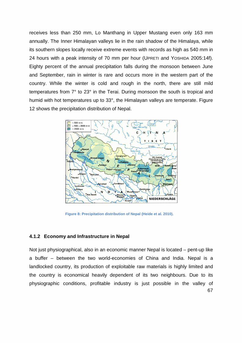
67
receives less than 250 mm, Lo Manthang in Upper Mustang even only 163 mm
annually. The Inner Himalayan valleys lie in the rain shadow of the Himalaya, while
its southern slopes locally receive extreme events with records as high as 540 mm in
24 hours with a peak intensity of 70 mm per hour (UPRETI and YOSHIDA 2005:14f).
Eighty percent of the annual precipitation falls during the monsoon between June
and September, rain in winter is rare and occurs more in the western part of the
country. While the winter is cold and rough in the north, there are still mild
temperatures from 7° to 23° in the Terai. During monsoon the south is tropical and
humid with hot temperatures up to 33°, the Himalayan valleys are temperate. Figure
12 shows the precipitation distribution of Nepal.
Figure 8: Precipitation distribution of Nepal (Heide et al. 2010).
4.1.2 Economy and Infrastructure in Nepal
Not just physiographical, also in an economic manner Nepal is located – pent-up like
a buffer – between the two world-economies of China and India. Nepal is a
landlocked country, its production of exploitable raw materials is highly limited and
the country is economical heavily dependent of its two neighbours. Due to its
physiographic conditions, profitable industry is just possible in the valley of

68
Kathmandu and in the flatlands in the south, near the border to India (DONNER 1994:
455 ff.). Although Nepal holds gold, copper, coal and ore deposits, exploration and
primary production are heavily limited due to the mountainous topography and lack
of funds. Thus Nepal has to import raw materials. Its most important commercial
partner is India which commits Nepal since the 1950ies through transit and economic
agreements. The import of consumer durables from China tightens the economic
situation (KRAEMER 2005, In BERGNER 2007: 56). The tensions between India and
China regarding the construction of the Beni-Jomsom road are mentioned more in
detail in chapter 5.1.
With a per capita income of around US$ 700 in the year 2012, Nepal is among the
poorest countries in the world (WORLD BANK 2014). The roots of the Nepalese
economy originate from the agricultural sector (DEVKOTA 2005: 2). Still formed by
subsistence economy, the agricultural sector employs 68 per cent of the labour force
(MELNIKOVA 2013). Agriculture accounts for 38 per cent, the industry for 16 per cent
and the service sector for 46 per cent of the gross domestic product of Nepal, which
amounted to around US$ 19,1 billion in 2011(WORLD BANK 2014).
Infrastructure
The road network and quality of Nepal are among the poorest in South Asia. The
percentage of Nepal´s population who have access to an all-weather road is about
43 per cent. More than one third of the whole population have to walk for more than
two hours to reach the next all-season road. About 60 per cent of the total 17.282
kilometres ranging road net, most of them rural roads, are not accessible during the
monsoon period from about June to August (WORLD BANK 2009). According to the
Road Statistics 2006/07 of the Department of Roads (DoR, Ministry of Physical
Planning, Works and Transport Management, Government of Nepal), twelve out of
the 75 district headquarters of Nepal were not connected by road, in that time
including Jomsom (DOR 2011). While in the mountainous north of the country
infrastructure is rare and weak, 60 per cent of the national road net stretches across

69
the Terai in the south. Figure 3 in chapter 4.1.1 shows a topographic zonal map,
where the national road net is drawn in. The difference in road density between the
plain south and the mountainous north is well visible.
Tourism in Nepal
With the opening of the borders for tourists in the 1950s, it has been the
mountaineers which were interested in Nepal - as the country with the highest
density of 8000 m. In the 60s and 70s an increase of trekking tourists into the remote
areas of Nepal took place, while the Kathmandu valley received the first ‘pleasure
and sightseeing’ tourists in addition (KRUK et al. 2011: 40). The explosive increase in
international tourist arrivals within decades in the developing country Nepal
happened without control and was demand-oriented. Areas which were visited only
by occasional traders or pilgrims in the past were suddenly compassed by
foreigners. In Austria, for example, the development of tourism in the Alps chronicles
a history of about two hundred years of experience in hosting tourists, which includes
that mountain dwellers had enough time to adapt themselves to the process of
modernisation (EAST et al. 1998: 3).
But third world countries, where tourism is young, did not have that space of time.
The people who lived in their traditional subsistence economy have been catapulted
into the globalized world of modernisation and unlimited mobility. The consequence
was that the local population reacted to meet the needs of the tourists. This
unplanned, ‘laissez-faire development’ of tourism was prone to negative impacts on
the environment as well as social and cultural aspects (SHARMA 2000: ix). The impact
of mass trekking tourism in the Everest and Annapurna region is well documented
and discussed in a multitude of literature (BANSKOTA, SHARMA 1998, SHARMA 2000,
NEPAL, S. K. 2003).
The government of Nepal has realized the potential of tourism as important
economic revenue. The “Nepal Tourism Year 2011” was a governmental-run
campaign with the goal of receiving one million tourists that year. Although this

70
threshold has not been achieved, the more than 736000 tourists who visited Nepal in
2011 generated around US$ 369 million (MINISTRY OF CULTURE, TOURISM AND CIVIL
AVIATION 2013). The potential of Nepal for tourism industry is given without doubt. It
is the aftermath of ten years of civil war and the still ongoing political instability which
are defining the development of tourism in Nepal at the base.
4.1.3 Poverty and development needs in Nepal
One of the main problems of Nepal is the population development. When Nepal
opened its borders in the 1950ies, it accounted about eight million inhabitants
(GURUNG 1982). With resent almost 30 million inhabitants the population almost
quadrupled within 60 years. By contrast, only 18 per cent of the country´s area of
147.181 square kilometres is, due to its topography, cultivable land (GRUBER, In:
LUGER and INMANN 1995: 196). Decreasing fertility, soil erosion and growing land
scarcity deteriorates the conditions. The consequences are increasing dependency
of import and migration into urban areas – mainly the Kathmandu valley and the
Terai.
According to WORLD BANK 2012, some of the main challenges Nepal faces are as
follows:
• On rank 157 out of 187 countries on the Human Development Index, Nepal is
one of the poorest countries in the world.
• Poor reliability and access to power
• Poor physical connectivity (mentioned in detail in chapter 4.1.2)
• Education, especially on secondary schools
• High malnutrition among the population

71
• High vulnerability to the consequences of climate change and earthquakes
4.1.4 Socio-cultural and religious structures
The multifariousness of Nepal also manifest in the population of this country which is
pent-up between the two highest populated nations of the world. In 1950, about 9
million people lived in Nepal. In the last 60 years, the population tripled up to 26.5
million in 2011. Among this population 101 ethnic groups speak over 92 different
languages (CBS 2012). In terms of the origin, the Nepalese can be divided into three
major groups. The Indo-Nepalese account for about three quarters of the total
population and are descendants of immigrated Indians. Most of the high mountain
tribes of Nepal belong to the Tibeto-Nepalese which account for about one quarter of
the population. Tribes like the Newar, Tamang, Thakali, Gurung, Rai and Magar
belong to this group. The Tibetan tribes which just accounts for almost one per cent
build the third group. The famous Sherpa tribe, for instance, belongs to this minority,
as well as Tibetan refugees living in Nepal (MELNIKOVA 2012).
According to the Nepal Population Census 2011, around 80 per cent of the
population of the former Hindu state are Hindus. Around ten per cent are Buddhists,
while Muslims average four per cent and Kirati three per cent. Christians, Sikhs and
adherents to Bön religion represent a minority in Nepal (CBS 2012: 68).

72
4.2 The Kali Gandaki valley
4.2.1 Physical setting of the Kali Gandaki valley
The Kali Gandaki river, situated in central-west Nepal, originates in the northern part
of the Mustang district, close to the Tibetan boarder and flows south through one of
the deepest valleys in the world, surrounded by two of the peaks higher than 8000
m above sea level, Mt. Dhaulagiri (8167 m) and Annapurna I (8091 m). As an
antecedent river, the Kali Gandaki River existed and flowed to the south even before
the uplift of the Himalaya. It passes through all the geologic zones of Nepal, from
north to south the Tibetan-Tethys, Higher Himalayan, Lesser Himalayan and Siwalik
Zone before draining out to the Gangetic Plain. The geologic zones are explained
more detailed in chapter 4.1.1. The section within the area of research, between
Kagbeni in the north and Beni in the south, concerns all except the southernmost
Siwalik Zone.
4.2.2 Socio-cultural and religious structures
The Kali Gandaki valley has a long history as one of the most important trade route
between Tibet and India. Until the closing of the Tibetan border in 1959 by the
Chinese government, about 10.000 tons salt per year were transported from Tibet
through the valley for many centuries (GRAAFEN 2001: 247). Four out of the twelve
major trade routes or passes which exist along the Nepal-Tibet border lie within
Mustang and run through the Kali Gandaki valley. The passes were low enough to
cross almost the whole year (RAI 1994:2). Figure 15 shows the dimension of the
importance of the Kali Gandaki valley on trade in the mid-west region of Nepal and to
Tibet in times of open borders.

73
Figure 9: The importance of the trade in the Kali G andaki valley (Graafen 2001)
The Tibetan influence in the area of research is reflected in the population
distribution of the present religions. Almost 75 per cent of the population living in
Mustang are Buddhists, while the other quarter believes in Hinduism. Thus Mustang
is the district with the highest percentage of Buddhists and the lowest proportion of
Hindus among all districts of Nepal (CBS 2012: 68).

74
The area of research is home to the ethnic group of the Thakali, which live between
Ghasa and Tukuche. North of them, and virtually indistinguishable, the
PaunchgaaUle live as far as Jomsom. While Kagbeni is a Gurung village, the valley
eastward up to Muktinath is inhabited by the BhoTiya (Information from interviews
with Mr. Bhakti and Mr. Dhara, replenished at the Ecomuseum in Jomsom).
4.2.3 Tourism in the Kali Gandaki valley
It was a French expedition which first climbed the summit of the Annapurna in 1950.
From the 60s onwards, the Annapurna massif underwent a steady increase in
trekking tourists. According to Hagen, trekking tourism prevented the Thakalis from
out-migration after their basic income through trade with Tibet has been paralysed in
1960 (LUGER and INMANN 1995: 280). 1976 the air link to Jomsom has been
established. One year later the Annapurna Circuit Trek was born. In that time the
number of visitors to Jomsom and Muktinath already exceeded those to the Everest
region. 1983 the villages of Tukuche, Marpha, Jomsom and Thini have been
provided with electricity. More than 21000 tourists visited the valley in this year.
Three years after, in 1986, the Annapurna Conservation Area Project has been
established with a pilot project in Ghandruk. After ten years of activity around the
Annapurna massif, the Annapurna Conservation Area Project expanded to Upper
Mustang (NEPAL 2003: 58).
5 The Beni-Jomsom road
The road has already been a central theme within the population, the tourism
industry and trekkers around the world years before it has been constructed. To get
information from the governmental authority before the research stay failed. The time

75
I stayed in Nepal I tried to get in contact with responsibilities of the road project,
which definitely was an adventure beyond comparison.
As the road project was primarily lead by the Department of Roads, a visit has been
made. The only information I got, was that the project was given to the army in times
of implementation as a result of political instability with Maoist activity in the Kali
Gandaki valley in that time. The statement that in few weeks (in February) the project
will be given back to the Department of Roads and that then several information
could be given, did not happen until July. The political instability, the frustration of the
again and again repeated failing of the Constituent Assembly to set up a constitution
for the country which should have be done until May 2010 was reflected even in
official circles. Visits of the Army headquarters in Kathmandu as well as in Pokhara
were unsuccessful despite a contact to Mr. Yogendra, an engineer who was involved
in the road construction.
Figure 10: Road impression near Ghasa (Roubal 2011) .
The outcome was rare, but during the field survey I got useful information from Mr.
Bhakti in Marpha. While the first subchapter gives an overview about the history of
the road project into the Kali Gandaki valley, the second subchapter contents the
collected information regarding planning, implementation and maintenance
procedures of the existing road from Beni to Muktinath.

76
5.1 Historical overview about a road into the Kali Gandaki valley
The initial idea of constructing a road into the Kali Gandaki valley dates back already
longer. According to BERNIER (1996) the planning of a road construction has been
launched around 1985. The main reasons why it never has come to an
implementation were the tensions between the opposing governments of India and
China. Nepal heavily depends on foreign aid, not just regarding funding of
infrastructural projects. Commercial agreements with the neighbouring India and
China entrap Nepal into strong dependencies. The route through the Kali Gandaki
valley, when finished further north to Lo Manthang, Upper Mustang, is a valuable
connection between China and Nepal - and India. The increasing influence of China
in Nepal or even India creates and has already created tensions between the major
governments. India fears economic competitions not just in Nepal but also in their
own country. I spoke to many locals and tourist guides who have been in Lo
Manthang in Upper Mustang. A road from the Tibetan side to the border and further
south to Lo Manthang already exists. Imported products from China are available in
Lo Manthang at a cheaper price than similar products in Kathmandu, imported from
India.
As the Chinese government has already funded the Highway from Pokhara to Beni
and the road from Lo Manthang north to the Tibetan border, the funding of the Beni-
Jomsom road by the northern neighbour was obvious. India reacted all of a sudden
and proposed a deal with the Nepalese government: The construction of the
Mahendra Highway, which runs east-west through the plain terai in the south of
Nepal, had started in 1960 but never had been finished due to lack of funds. Hence it
was common to cross the Indian border for an easier east-west transfer. The Indian
government suggested an agreement of funding modern improvement of the
Mahendra Highway – with the condition that the Nepalese government abandon the
construction of the Beni-Jomsom road. These events took place before 1996. The

77
following ten years Nepal has been shocked by a civil war. The rebelling Maoists had
strong influence in the mountainous areas of Nepal, in the Annapurna region as well.
5.2 Planning, implementation and monitoring
The ninth Rural Development plan (1997-2002) has emphasised on poverty
alleviation with the aim of connecting all district headquarters by a road. The
construction of the Beni-Jomsom road became serious within this Rural
Development Plan and started in the year 2000. On 1 June 2001 King Birendra, his
wife and seven other members of the royal family were killed, the state of emergency
has been declared. In these times, the Army was sent into the Kali Gandaki valley to
supervise and take part in the construction of the road. Mr. Bhuwan Gauchan who
runs the Dhaulagiri Lodge in Tatopani mentioned that the waterfall near Ghasa was
a critical spot as Maoists were active in this area. The transports of blasting agents
have been strongly guarded by the Army.
According to Mr. Yogendra who was involved in the construction as an engineer, the
labour force was assembled with one half by the local population, about a third by
skilled labour force and the rest by the Army. This data just apply to the road from
Beni to Jomsom. Several small side and access roads to villages which do not
directly lie next to the road have been done solely by the local population. The same
applies to the section from Jomsom to Kagbeni and further east to Muktinath. Mr.
Dhara from the Mustang Gateway Hotel in Kagbeni, who owns a Jeep and is
therefore member of the Jomsom-Kagbeni-Muktinath Transportation Committee,
refers to the maintenance of the road which is made solely by the Committee. During
the Monsoon season from July to September, the road is closed. Not just during this
closing but also during heavy rainfalls or earthquakes, at many spots landslides
overwhelm the road.

78
6 Field survey: from Beni to Muktinath
6.1 Classification and sub-areas of research
As mentioned in chapter 1.3, an initial framework of a detailed research, its
classification and the focus on niche potentials have not been fixed in advance as
many factors and a decisive approach concerning the execution of the field survey
had to be discussed with my Co-Supervisor Prof. Pushkar Pradhan in Kathmandu.
Several inputs regarding the methodology as well as the emphases on different
fields and sub-areas had to be adapted after the field survey.
Regarding the transformation of tourism structures a classification into several sub-
areas can be made. Of decisive importance in that manner is the high appearance of
pilgrims with their prime purpose to visit the temple of Muktinath. Many of them fly to
Jomsom, directly take a Jeep to Muktinath for worship and if applicable visit Kagbeni
as well for a holy bath in the Kali Gandaki River and return back. Not just the
Nepalese and Indian pilgrims but also for most of the trekkers who do the Annapurna
Circuit Trek it is common to stay two days in Muktinath after they passed the most
tiring day of their trek, the pass of Thorung-La with 5.416 m above sea level. The
very different, dry, desert-like landscape of Upper Mustang and the atmosphere of
worship in and around the temple site are unique on that trek. With the upcoming of
a road connection, masses of pilgrims visit that place, especially during religious
festivals. Therefore Muktinath - as the highest point of the area of research - is
highlighted as a Hot spot within this research.
Another sub-area which is highlighted due to its special position is the village of
Marpha which lies view kilometres south of Jomsom, the Headquarter of Mustang
District. The Thakali village (for further information about Thakali see chapter 4.2.2)
is famous for its apple production and the beauty of the old Tibetan centre of the
village which, in opposite to most of the villages along the road, has been untroubled
by noise and dust as the road does not pass through the village. Tourists of
organized two or three day trips, who come by plane to Jomsom, visit Muktinath and

79
due to the road and the closeness to Jomsom, visit Marpha to buy souvenirs and
apple products before going back to take the flight.
I want to mention that these three Hot Spots are pointed out due to its positions
regarding tourism aspects. All of them lay in the northern research area, visited by
trekkers, tourists coming by public transport now as well as via flight. During my
scheduling I planned to mention the village of Tatopani, situated more in the south
with its hot springs as a Hot Spot. Establishing Hot Spa Tourism due to
infrastructural connection was an assumption which has been considered during the
arrangements of the field survey with my Co-Supervisor Dr. Pradhan but turned out
to be not applicable in that manner. Although or rather because of this Tatopani is
worth a mention as a Hot Spot regarding tourism transformation, as a junction on the
former trekking route, the role of the hot spring and the way of handling the impact of
the road Tatopani is faced with.
6.2 Ecological impacts
A construction of a road into a valley which, beside one small Airport, was just
reachable by foot or with animals, brings a drastic change into the life of the
residents living in that valley. As mentioned in chapter 3.4.2, mountain environment
is a sensible and vulnerable ecosystem which easily can be harmed, often with
irreversible and multiplying consequences.
6.2.1 Landslides and debris falls
The Kali Gandaki valley from Beni up to Jomsom and further to Kagbeni and Upper
Mustang offers one of the most spectacular cross section of the different geological
zones which are described in detail in chapter 4.1.1. These different zones with
numerous sections of different rocks, its characteristics regarding weathering and

80
erosion and the impact of the climatic conditions add up to different areas concerning
vulnerability to natural hazards. From Beni up to Dana, the soft rocks of the Lesser
Himalayan zone (phyllites, slates and other low-grade metamorphic rocks) are highly
prone for weathering and erosion. Heavy rainfall during the monsoon makes this
area highly vulnerable for landslide, soil erosion and debris flow. The Higher
Himalayan zone which ranges from Dana up to Kokhethati is characterised by its
extremely high relief and steep slopes. Its southern front receives heavy rainfall
which makes this area also highly susceptible for landslide, debris flow and rock fall.
Because the valley is narrow and steep in that section, river damming often occurs
after such hazards which causes flash floods downstream after the breaking of the
landslide dams. North of Kokhethati, which is about half way between Beni and
Jomsom, the rain shadow zone of the Himalaya begins. With less than 250 mm
precipitation per year, water induced hazards are rare in this area. Compared to the
southern section, the valley north of Kokhethati–situated in the Tibetan-Tethys zone -
is characterised by a much broader valley bottom with a wide riverbed. The road
runs mainly on or near the riverbed. The absence of the monsoon enables the use of
that section of the road even during the rainy season. Nevertheless, the
development of either steep slopes or glacier-related sediments causes debris and
rock falls in some areas.
As Nepal lies on the very active orogenic zone of the Himalaya, the risk of
earthquake is a constant one and can cause landslides, debris and rock falls as well.
A landslide on colluvium, few kilometres north of Beni, is shown in Figure 11. A
debris fall about one kilometre north of Jomsom at the east side of the valley is
visible in Figure 12. Although this happening was man-made, the rocky steep slopes
are prone for debris and rock fall.

81
These threats have been present since the occurrence of the Himalaya. Settlements
of the mountain communities and trails have been developed in consideration of
these risks. The construction of a road in such a terrain faces high risks regarding
these natural hazards, which have been explained in detail in chapter 6.1. As
mentioned above, the section between Beni and Kokhethati is highly prone to
landslide and debris fall. Every year, during the monsoon period - from June to
September - the road up to Jomsom is closed. The risk of water induced hazards is
too high in that time. After the monsoon, the road has to be repaired year by year
due to landslides and debris falls in many areas within that section. Basically a
distinction can be made between (1) hazard areas which already occurred before the
construction of the road and where latter compound the danger, and (2) areas which
have been avoided before and where the road construction induces risk for landslide
and debris fall. This mainly appears in unsettled terrain where, besides river
damming, the road itself is the main victim in case of mass movements. Figure 13
and 14 shows a danger zone at the confluence of the Rupse Khola stream with the
Kali Gandaki River. In June 2003, a landslide happened on both sides of the Rupse
Khola, which killed one person and destroyed a residential building as well as a
restaurant. Figure 13 shows that area in 2005 (picture by Upreti and Yoshida 2005).
The trekking trail crosses the slide area and the restaurant which can be seen on the
Figure 11: Landslide on colluvium nort h of Beni (Roubal 2011).
Figure 3b: Figure 12: Man-made debris fall near Jomsom (Roubal 2011).

82
left side, has been built on the slid material but has already been reactivated in 2005
threatening the stability of the building. Figure 14 shows the same spot in 2011, the
road crosses the landslide area few metres above the trail, the restaurant has been
reopened!
Having a look at the common and widely used trekking map by Nepamaps, detailed
information about the trekking area also include the marking of landslide areas along
the Kali Gandaki valley on the map.
6.2.2 Noise and dust pollution
The impact of the road regarding noise and dust pollution along the settlements
between Beni and Muktinath are, to some extent, immense. If known the valley as an
idyllic one with breathtaking scenery and days of walking away from the next road,
the noisy trucks with porous exhaust pipes and buses honking the horn as often as it
is necessary and common in the rush hour of Kathmandu, somehow the idyllic is
gone. Without doubt these impacts and the emphasis of the disturbing factors
depend on the perception. In the view of a western traveller, noisy buses are a
Figure 13: Landslide in Rupse Chhahara (Photo taken by Upreti and Yoshida, 2005).
Figure 14: Same spot in 2011, the road is visible above the trail (Roubal 2011).

83
disturbing factor along the trekking route. For some of the residents the sound of the
horn might remind them to finally be part of the national road net now, able to reach
the next city by public bus. The noise and dust of traffic may be linked to a step of
modernisation in the mind of a part of the residents, accept these impacts as
necessary trade-offs for achieving greater benefits from the road. More about this
aspect regarding perception of the residents will be discussed in chapter 6.4.1.
Before highlighting the impacts of the road on the noise and dust pollution, the
situation before the road construction should be mentioned. First of all, the Jomsom
Airport which exists since the 70s runs several flights each morning, depending on
the season and the weather. Marpha, a popular tourist destination just few
kilometres south of Jomsom, suffer from the blustering landings or – depending on
the perception – it is a part of a Marpha day. Another event which happened
regularly before the road was built was the landing of up to three helicopters a day in
Muktinath, bringing pilgrims who could afford, from Kathmandu or Pokhara directly to
the temple site. Beside the noise, the dust pollution on the dry, earthen landing place
was enormous, even it was away from the village, near the entrance of the temple
and the souvenir stalls. Since Muktinath can be reached by road, helicopters for
pilgrim transportation like that are forbidden. Another appearance which is of natural
source but should be mentioned here is the strong valley-wind. The thermal wind
due to air pressure equalisation between the hot Indian plateau and the cold
Himalayas and the Tibetan plateau is in high gear in the north-south facing Kali
Gandaki valley. North of Kokhethati, the broad riverbed and the dry, desert-like
environment receives strong, stormy wind which starts blowing at about midday.
Trekkers have always been advised to bring a mask and trek these passages in the
morning time as walking against that wind is enormous energy-sapping and even
dangerous when crossing a hanging bridge during such gusts of wind. Dust clouds
rolling northward due to mule caravans have been phenomena in times before the
road connection. Caravans have almost been replaced entirely by motorised
vehicles and the advent of traffic on the dusty road compounds the dust pollution
with intensity.

84
The appearance and intensity of dust pollution vary between areas due to several
reasons which are explained in the following. As mentioned above, the area north of
Kokhethati is, due to its dry, desert-like climate and thus marginal vegetation and the
development of the valley wind, in general more prone to dust pollution than the
green, temperate and sub-tropical south of the research area. Another aspect of dust
pollution which is locally more relevant in the southern part is the condition of the
road which is linked to the geological conditions. Although the conditions in the
northern part of the research area is more desert-like, the road is mostly of
stoniness, while the road between Beni and Tatopani, partly some sections further
north, are mostly sandy with lack of gravel. When I walked that section I sometimes
sank into an up to 15 centimetres thick dust layer, the swirling-up of this dust by
vehicles was extreme. In this context, the course of the road through or beside
settlements is the most crucial factor regarding direct dust pollution. With the
exception of few sections and some settlements, the road has been constructed on
the traditional, former trade route which has been lead through the centres of the
villages situated along that route. Many small stalls and tea houses could be found
beside the former trade and trekking path, well situated to serve trekking tourists as
well as residents and mule caravan owner passing through. Although these supply
spots still exist, many of them closed their business because of the road. If not
situated near a bus stop, the public buses and jeeps just pass through, followed by a
massive dust cloud. The majority of the trekkers as well as residents choose such
transportation now, passing through such settlements without stop. Although the
main reason of closing such businesses was the absence of customers, many of the
former stall owners also complained about the immense dust pollution just in front of
their shops. Traditional such sales counters are with open front, in the past facing the
passengers walking by – now facing the dust. Figure 15 shows such a stall close-by
the road. The owner explained two ways of handling such circumstances. Either
barricading the shop from the dust, then it seems like closed – or presenting the
counter and items, living with the change and the impact of the dust. During my field
survey I found both reactions along the road, with the addition of those who already

85
closed their shops. Much more critical than the shops are the housing spaces.
Opposite of the shop seen on Figure 15 is the house of the owner. He complained
that since the appearance of traffic, they cannot open the road- and even side-facing
windows of their house anymore.
As mentioned above, the course of the road through or around settlements is a
decisive factor regarding direct dust and noise pollution. In this context, the particular
situations in Marpha, Kagbeni and Muktinath are explained more in detail.
Marpha, famous for its apple production and the charming place of interest, takes a
separate position as the village centre has been escaped by the road. Visible in
Figure 16, the road passes straight through the fields, while the old, traditional trade
route lead through the village centre which is now untroubled by the traffic of the
road. Such a situation comes upon in several other villages along the Kali Gandaki
valley which have been crossed by caravans, residents and trekkers who now drive
Figure 15: Small s tall, in the past beside the trade route, now facing immense dust pollution by the road (Roubal 2011).

86
around the settlement. The reason why I focus on Marpha is the fact that the Village
Development Committee (VDC), strengthened by persons of high standings and
magnates in the apple industry and tourism, advocated the construction of the road
and are in a lucky, advantaged position now. The aspect of the course of the road
through a village centre or not, as mentioned here, has further socio-economic
impacts regarding income through trekking tourists which are explained in chapter
6.3.3.2.
A potential threat which could not be verified yet around Marpha is the impact of dust
pollution on the pollination process of the apple trees. In other regions in Nepal road
constructions and the upcoming dust pollution have lead to a yield reduction of fruit
trees, as reported in PAUDYAL 1998:81f.
Similar to Marpha is the situation in Kagbeni, where the road runs some hundred
metres above the village before turning into the side valley up to Muktinath. Due to
the geological conditions the narrow of the Kali Gandaki valley around Kagbeni,
which also contributed the village to develop as a strategic beneficial position along
Figure 16: The village of Marpha; the old trade route lead through the village centre, while the road runs straight trough the fields (Roubal 2011).

87
the ancient trade route (see chapter 4.2), accounts for a jet-effect with exceptionally
high wind speeds. The very dry, arid region faces dust pollution anyway due to this
natural phenomenon. The additional pollution by traffic inside the village would be
devastating, keeping in mind that this section of the road – from Jomsom to
Muktinath – receives the highest density of motorized traffic in the Mustang area. No
more buses transfer here, thus the number of Jeeps doing that section, transporting
most of the trekkers and all the pilgrims coming by bus or by flight from the south to
Jomsom, is corresponding high.
Muktinath, the highest-located village of the research area and probably the village
with the most considerable impacts of the road regarding tourism structures,
receives up to hundred jeeps per day during pilgrimage high season (for impacts on
tourism see chapter 6.2). The road ends in Muktinath, but the village has to be
crossed to reach the famous temple site which is further up the slope of the valley
end. Thus the tourist flow – in great numbers pilgrims –within Muktinath faces some
problems which have not been cleared at the time of my research. According to Mr.
Angkya, owner of the famous Bob-Marley Guesthouse, the Jeep stop has changed
several times the last years. In the very beginning, the Jeeps stopped in the village
centre which came along with an immense dust and noise pollution. After civil
commotion the Jeep stop has been displaced to the entrance of the village1, several
hundred meters out of the centre. The run of masses of Indian pilgrims who, in
contrast to the trekking tourists, avoid walking by feet and are anxious of reaching
the temple site as fast and as comfortable as possible, lead to another displacement
of the Jeep stop closer to the centre again. In time of the field survey, hundreds of
pilgrims crossed the village by feet, residents who owned a motorbike offered a
shuttle service (the seat behind the driver) for those who did not want to walk up the
last hundred meters to the entrance of the temple. As mentioned above, this
1 Many of the Tibetan villages in the Himalayas possess gates, chorten (religious building) and mani
walls (stone walls with prayer wheels) at its entrances and exits.

88
religious and natural scenery around the temple of Muktinath has been disrupted by
helicopters before the road connection. Now it is replaced by the occasional noise of
motorbikes above the village and temporary high traffic from the Jeep stop down to
Jomsom. Probably the situation within Muktinath has changed again already since I
have been there, but the very dry, desert-like climate which abets dust pollution, not.
According to Mr. Dhara2 as well as the staff of the Health post in Muktinath, since
few years strong wind also appears in the area of Muktinath which, apart from the
valley wind along the Kali Gandaki valley, did not occur there before. It is probably
an impact of the climate change, compounding dust pollution and thus mentioned
here. Dr. Bhattarai from the Health Centre in Lete noted that a remarkable increase
of eye infections, respiratory diseases like asthma, sore throats and problems with
the lungs, as well as skin allergies of residents living along the road is observable
since the occurrence of traffic. He sees a direct correlation of the increase of these
diseases with the dust pollution caused by the road. Occasionally locals complain
about earache, the doctor mentioned that in some cases there could be a relation to
the locally steady resounding noise of the horn. In fact, during my field survey more
residents complained about the radical signal-horns of the buses than the noise by
the vehicles itself. For explanation, it is common in Nepal that public transportation
usually does not have fix bus stops, getting on and off the bus is possible all along
the route. Thus the excessive usage of the signal-horn when reaching a settlement is
common. Although there are declared bus stops and to some extent even fixed time
schedules along the way from Beni to Muktinath (see chapter 6.5), this – actually not
necessary - noise pollution is definitely a disturbing factor for locals living at the
2Mr. Dhara is owner of the Mustang Gateway hotel in Kagbeni, has a great knowledge about the
region, its development and is involved in the Mustang Transportation Association and the Village
Development Committee of Kagbeni.

89
entrance of a village and next to the road. Mr. Bhakti3 from Marpha spoke about a
planned training for all the bus drivers in order to avoid such disturbing and
unnecessary noise exposure.
Another interesting fact Dr. Bhattarai mentioned is the recently occurrence of
mosquitoes and flies up to Jomsom which were not common in that altitude before.
The fact that global warming causes distribution changes of fauna and flora is well
known. The assumption of the doctor that these insects could be brought into the
valley by buses, Jeeps and trucks is not approved scientifically but could throughout
be a feasible explanation. In that case these changes in bringing in these insects into
the valley by vehicles from the south would be a man-made pulling of fast-tracking
this – actually just as well man-made – impact of global warming.
6.2.3 Waste problem
For tourists of industrialised countries who travel to developing countries it is always
a shock to see the streets, rivers and slopes littered with waste. The waste problem
in Nepal is a serious one. When arriving in Kathmandu, the sight of the roadside
ditches filled up with waste and the Bagmati River which in the meantime seems to
consist of more plastic than water and stones, are the shady sides of the
unforgettable impressions.
In Pokhara the attracting Phewa Lake is – from afar idyllic scenery, enclosed by
tropical forest and rice terraces – highly polluted. Even residents who grew up at the
lakeside complain about skin irritation when they go for a bath. During my stay in
Pokhara I got in contact with Mr. Ji and Mr. Bahardur Thapa, the initiators of the
Pokhara Health Care Project who organise cleaning up campaigns in and around
3Mr. Bhakti is former head of the District Development Committee of Mustang and attaches
importance to implement tourism development around Marpha.

90
Pokhara. Besides witnessing the Lakeside clean-up day and an interesting interview
I was invited to join an excursion to the dumping site of Pokhara. It was built 2005
and has enough capacity for the next 15 years. In average 15 truckloads, which
amount to about 30 tons of waste, get brought every day. From official quarters, 85
per cent of the waste gets separated and recycled, the other 15 per cent ends up in
the dumping site. In reality, all the collected waste, by far not all of the quantity of
domestic waste of Pokhara, attains to the dumping site. There marginal separation of
plastic and iron takes place which can be sold to the so called Kawadi – waste
traders – who take the separated materials to recycling companies in India as in
Nepal such industry does not exist.
The situation in the Kali Gandaki valley is, for south-Asian conditions, comparatively
well and can be accredited to the efforts of the Annapurna Conservation Area Project
(ACAP). Outwardly, the waste management seems to be on almost western
standards, on closer examination the reality is reminiscent of the fact that even the
management of ACAP reaches their limits which are affected by different aspects,
embedded in the conditions of Nepal. These aspects are mentioned in the following
paragraphs, integrated in highlighting the impacts of the road on the waste
management and problems of the area. Expert interviews concerning waste
management in the area of research could be hold with Mr. Narendra Lama, Tourism
Manager, and Mr. Tek Gurung, Assistant of Tourism Development, both from the
Annapurna Conservation Area Project. Some issues were inconsistent but could be
resolved during my own observation in the area.
Basically one should have to keep in mind that the aspect of waste in mountain
areas is of particular context. Due to the altitude, the rotting of waste lasts much
longer than in the lowlands. The mountain environment is a fragile one. The life of its
inhabitants is directly linked to its resources like water supply and as its food source.
When issuing the Trekking Permit for the Annapurna Conservation Area, Information
Boards give advice to the difference of rot resistance of waste in high altitudes. The
immense pollution of the Ganges is a known, sorrowful fact. Here, at the origins of

91
the rivers in the centre of the Himalayas, the water begins to flow for thousands of
kilometres – through Nepal, through India - on the way to the ocean. Mr. Bahardur
Thapa from the Pokhara Health Care Project called the Nepalese the “god`s people”.
Everything they do, including waste and sewage pollutions, flows downstream to
India. The only thing they get from above is the divine´s wee!
With more than 88.000 trekkers in the year 2010, this fragile mountain environment
has to bear the burden. There is demand of beer, Coca-Cola and Snickers in high
altitude. Trekkers pay the multiple prices to have such, so there is supply. As the
Annapurna Circuit trek is world-famous since the 70ies, not just accommodation
services established, the demand and supply-chain strains even up to the highest
point, the Thorung-La pass with more than 5.400 m above sea level.
Within the Annapurna Conservation Area, waste bins are provided along the trekking
trails which are an exemplary service of the management of ACAP. Before the
existence of the road, ACAP provided ten to twelve helicopter flights to Jomsom and
Manang per year for removal of the waste. Because of the high costs and the
possibility of using trucks now, the helicopter flights for waste disposal have been
stopped. According to information from the Headquarter of ACAP, the local Tourism
Development Committees of the villages are responsible for their waste removal
now. Some owner of big lodges or hotels manages to carry out their waste by
themselves. The information that waste separation takes place – biodegradable
waste gets burned, non-biodegradable waste gets removed by the Kawadi – just
applies to some extent. During my field survey and addressing this issue at another
interview in the Headquarter after my field survey, more honest and realistic
information could be collected. To a certain amount which is difficult to estimate, the
collected waste, including plastic, gets burned or dumped. Glass, mainly beer
bottles, can be found piled beside the lodges. A common sight along the Annapurna
trek is the fence-like usage of dozens of bottles as contours for flowerbeds and even
immured into walls – an appearance of the pre-road times, re-using at least a part of
the glass waste. According to Mr. Gurung, beer and vodka bottles get collected by

92
the Kawadi now who bring it back to the breweries for refill. The deposit for one
bottle is 2-3 NRs (about 2-3 Cents). For iron, waste traders pay about 5-6 NRs per
kilogram.
With the construction of the road, waste removal became easier. But in the same
time it is easier to bring in more products, items and materials. The road has opened
opportunities to bring in cheaper materials, non-biodegradable ones. Since the road
connection from Upper Mustang to the Tibetan border, products imported from China
are available there, cheaper than in some parts of Nepal with imports from India. As
mentioned in detail in chapter 6.3.3, tourism structures undergo a transformation.
From the more than 88.000 visitors of the whole Annapurna Conservation Area in
2010, about 12.000 were from SAARC countries4, mostly India. Almost all of them
just visited Muktinath. Awareness building through information folders and advices
for waste prevention for trekkers has to be extended. Unfortunately these pilgrims,
even coming for a worship in the middle of the Himalayan nature, do not have such
appropriate environmental consciousness.
It is hard to appreciate in which extent these actions of waste disposal and removal
take place. Waste bins are provided to collect the upcoming trash, which is
exemplary for Nepalese standards. That a percentage of this waste, not just the
biodegradable part, gets burned or dumped without technological standards, could
be of further discussion. As mentioned above, the waste management in Pokhara is
far away of how it could be. Just south of Beni, a huge waste tip is visible on the
other side of the Kali Gandaki valley, smothered with black smoke. In front of the
ACAP checkpoint in the idyllic village of Kagbeni, the gateway to Upper Mustang, the
abyss down to the Kali Gandaki valley where pilgrims take their holy bath, is full of
waste.
4 South Asian Association for Regional Cooperation includes Bangladesh, Bhutan, India, Maldives,
Nepal, Pakistan and Sri Lanka.

93
What I want to point out is that waste removal for the eye still can be pollution for the
environment. Awareness building like ACAP undertakes, is of decisive importance
and necessity. Facing difficulties in management and embedded in a politically
unstable nation, the inspection of an appropriate implementation of actions, not just
outwardly but in a way that it really makes sense, is a challenge.
6.3 Economic impacts
As mentioned in chapter 4.2, the Kali Gandaki valley has played an important role as
a trade route since centuries. With the closing of the Tibetan border and the
upcoming trekking tourism an economic transition took place. In about the same time
apple farming has been implemented around Marpha which grew up to an
economically important sector. The Thakali people living in the Kali Gandaki valley
are famous all over Nepal for their talent in business making. With the construction of
the road the economic structures, which always have been strong in that region,
undergo another transformation. While the first subchapter deals with the direct
impact on travel time and cost reduction, the second and third subchapter point out
the impact on the agricultural and tourism structures in situ. In a bigger but
accordingly precarious context the impacts of the road connection further north to the
Tibetan border on the national level and the contention between India and China are
just touched on the last subchapter.
6.3.1 Reduction of travel time and cost
The impact of the Beni-Jomsom road on the travel and transportation pattern is
without doubt the most crucial one in the valley. The resident population used to walk
for days along the ancient trade route to reach the next market centre in Beni and

94
the ongoing transportation services to Pokhara. Although the air link to Jomsom has
been established in 1976, this relatively expensive kind of transportation has just
been used by the richer minority of the local population. The same applies to the
transportation of agricultural products out of - as well as import of goods and items
into the Kali Gandaki valley, which is dealt in the next subchapter.
The distance of the road section from Beni to Jomsom amounts to about 65
kilometres with an ascent of about 1900 metres in altitude. From Jomsom to
Muktinath it is about 17 kilometres and 1040 metres of altitude more. Depending on
the speed of walk, the weight of luggage or commanding a mule caravan, this
section took several days of travel. For tourists who trekked the Annapurna Circuit in
the common way (counter clockwise) and reached Muktinath from the east after
passing the Thorung-La pass, the section from Muktinath down to Beni was
recommended to tackle in five day legs at an average of five hours of walking each
day. From Beni it is a four hours bus ride to Pokhara, the main tourist destination in
the region. According to the statements of Mr. Karma Gurung, a former mule
caravan owner from Kagbeni, one way down to Pokhara guiding a caravan has been
conducted in seven days. Nowadays, it is possible to reach that city - where comfort,
a Hard rock café and plenty of touristic attractions are waiting – in just one and a half
days from Muktinath. The impacts of the road on tourism are dealt in detail in chapter
6.3.3, in which the reduction of travel time and cost is implied as one of the most
decisive factor which caused the transformation of the tourism structures in that
region.
For the resident population the link of the Kali Gandaki valley with the national road
net, urban centres and market towns, its following economic flows and social
services contains a crucial change of the way of their life. The step from reaching the
next bigger market town or a hospital in plenty hours of walking to in doing the same
in a few hours bus ride is enormous. The elderly population and handicapped
residents have partly not been able to leave their village without big effort before the
existence of the road.

95
During my field survey I spoke to a resident with walking disability near Dana
(between Ghasa and Tatopani). The middle-aged man told me that he never has
been out of his village before the road was built. For him, the aspect is not about
reduction of travel time, it is quite simply the possibility to go to Beni or even
Pokhara. Ironically, he told me that actually the road has a negative impact on him,
his family and his business. I met him sitting in front of his house next to the
traditional caravan and trekking route which leads through the village, selling small
snacks, drinks and some souvenirs. Before the road has been constructed,
thousands of trekking tourists passed in front of his house every year. With his bright
and forthright character, he made comparatively good income with his few products
in the past. Nowadays very few tourists pass by foot; most of them take the bus from
Ghasa down to Tatopani or Beni. Lucky that the road lays some hundred metres
behind the fields, so he still can sit next to the traditional path without getting covered
by dust –and waiting for trekking tourists, as he said - in a good mood!
Concerning the reduction of cost a distinction between travel (in terms of
transportation of passengers) and transportation of goods can be made. Regarding
transportation of passengers along the Kali Gandaki valley, it is more the ability in
itself to use motorised transportation services now - primarily saving time and effort-
which come to the fore. The accessibility of market centres by jeep or bus, the
enormous time reduction to reach cities eases the life of the resident population. It is
also rather the aspect of reduction of travel time which places emphasis on the
drastic transformation in tourism structures in the region, which will be discussed in
chapter 6.3.3.
One of the main positive impacts of the road construction is – especially for the apple
farmer of Marpha – the reduction of the charge transportation cost. According to Mr.
Raju Lalchan, vice-chairman of the Mustang Transportation association and former
owner of a mule caravan, transportation costs amounted as follow in the year 2007:
One kilogram of freight by Mule cost 20-25 NRs, by Porter 25-30 NRs and per plane

96
or helicopter 40-45 NRs. With the road connection, the transportation charge per
Jeep or Truck amounts to 4-5 NRs per kilogram.
The impact of the road on agriculture, in which the reduction of transportation cost
plays a crucial role, is dealt in detail in the next subchapter.
6.3.2 Impacts of the road on agriculture
Agriculture is definitely the economic sector which undergoes the most positive
change due to the infrastructural connection in the Kali Gandaki valley. The last
subchapter broached the aspect of a distinction between the impact of the road on
transportation of passengers and transportation of goods and groceries. The latter
plays a decisive role regarding the agricultural structures and changes in the Kali
Gandaki valley. It is the aspect of cheap transportation possibilities which are
available now, inducing crucial influences on the export of locally grown products as
well as imports from outside into the valley. While the first subchapter point out the
changes in agricultural production and marketing patterns, the second one
illuminates the changes in the prices of agricultural products of the valley.
The impressive shift of altitude, precipitation characteristics and physiographic
conditions of the valley within the research area from Beni northward to Jomsom and
further north to Kagbeni is manifested in the agricultural structures and its natural
limits. The following information stem from the Ecomuseum in Jomsom: In the
southern part, two harvests per year can be brought in without the need of irrigation
due to the heavy rain in the monsoon season. Winter crops such as hull barley and
wheat sawn in November are harvested at the end of May. Summer crops including
buckwheat, soya beans, potatoes, cauliflowers, carrots, onions and radishes are
cultivated at the beginning of the monsoon in mid-June. The dry, desert-like
conditions north of Kalopani, where the rain shadow effect of the main Himalayan
range induces an arid climate, agriculture becomes more laborious and encounters
97
on natural limits. Fertile soil and precipitation is rare and the vegetation period is
short. The resident population has built up an ingenious irrigation system on
elaborately cultivated fields which are typically situated low in the valley where
agriculture is possible. Barley is cultivated as winter crops and buckwheat in late
summer to autumn. Beside these two main crops cultivatable in that altitude, some
vegetables and fruit trees are grown.
6.3.2.1 Change in agricultural production and marke ting patterns
As mentioned above, it is the aspect of transportation cost which has a positive
impact on agriculture in the valley. The remarkable differences in charges of the
available transport facilities before the existence of the road and now are immense.
The most expensive way of exporting the locally grown products by plane or
helicopter, mainly apples from around Marpha, was just affordable for the wealthy
minority of the farmers. The main and traditional mean of transport by mule caravans
was time-consuming and, especially in terms of food transportation, associated with
a high rate of damage during the transportation. According to Mr. Raju Lalchan,
former mule caravan owner from Marpha, about 20 per cent of the freight became
spoilt on average during five days of transport down to Beni or Pokhara.
Apple farmer of Marpha sold their apple for 10 NRs per kilogram, but the
transportation cost to the next market centre in Beni or Pokhara amounted to 20-25
NRs. With the present transportation charge of 4-5 NRs per kilogram, the export of
products became profitable at all. Farmer can sell their products to a higher price
because of the much lower transportation costs. With the road connection into the
Kali Gandaki valley, agriculture experiences an upturn in the valley. Many of the
former Mule caravan owners sold their animals and now invest in agricultural
production.

98
6.3.2.2 Change in prices
Whereas the transportation charges into or out of the valley went down to a fractional
amount, life is getting more and more expensive all over Nepal. Table 3 shows that
the price of agricultural products more than doubled within five years. I spoke to
locals in Pokhara who referred to similar price development on gas.
Prices per pathi (3 kg) 2006 2011
Potatoes 30-40 100
Beans 100-150 500-600
Buckwheat (Flour) 150 300-350
Barley flour 60-70 150
Table 3: Change in prices of agricultural products in Kagbeni (according to Mr. Dhara, Kagbeni).
As the price development is a national one, there is no correlation to the road
construction as an impact. But as mentioned in the last subchapter, the much lower
transportation charges make agricultural production become more profitable in the
valley now.
6.3.3 Impacts of the road on tourism
The Annapurna region is famous all over the world for its breath-taking, naturally
unique and relatively comfortable treks. Since the boarders of Nepal have been
opened for foreigners and the first ascent of the Annapurna summit by a French
expedition in 1950, the popularity of this region raised continuously. In 1977, the
number of visitors to Jomsom and Muktinath exceeded those to the Everest region
and in the same year the Annapurna Circuit Trek has been established which ranked
among the most popular treks in the world for decades (NEPAL 2003:58).

99
When the salt trade – as a lucrative economic income for the residents – came to an
abrupt end in 1959, the upcoming trekking tourism engaged the position as a
welcoming and profitable income source besides subsistence farming. With the
construction of the road the existing trekking tourism structures - developed for an
almost half century - undergo another profound transformation. Side by side, the
accessibility of the temple of Muktinath by Bus and Jeep lead to an immense run of
thousands of pilgrims. The following subchapter attend to this transformation, while
6.3.3.2 points out the local tourism effects of several villages were the construction of
the road lead to drastic changes.
6.3.3.1 Transformation of tourism structures in the Annapurna region
The importance and development of trekking tourism in the Kali Gandaki valley is
explained in chapter 4.2.3. When I talked to trekking tourists about the impact of the
road, it seemed that the impact of the road on tourism would be the by far most
drastic and negative one. Of course, if discussing with key informants of the tourism
industry, the Annapurna Conservation Area Project and foreign trekkers, the road is
the burning issue. It even was in everyone´s mouth when I visited the Kali Gandaki
valley the first time in the year 2005. The road was not constructed when I trekked
the Annapurna Circuit Trek in that time, but everybody talked about it, its negative
impacts it would have on tourism. The residents who were involved in tourism
remarked criticism on ACAP with an opinion of being abandoned and objected to a
lack of arrangements which could have done in advance. They complained about the
development plan of the government without the participation of the local population.
Of course, these arguments were coming from residents who were involved in
tourism, precisely trekking tourism. Beside the negligible number of pilgrims and
mountaineers which came for expeditions, trekking tourism was the main tourism
sector – the one which seemed to be doomed with the appearance of the road. The
Annapurna region was a top trekking destination to experience breath-taking,

100
naturally and culturally unique Himalayan scenery absent of the noise of vehicles, a
road and all the action which comes along with it. It was an unforgettable experience
to circle the 8000 m high Annapurna massif in pre-road times by feet, spending three
weeks far away from all this motorised hustle and bustle. As mentioned in chapter
3.4.2.1, the – typical for Nepal – teahouse trekking finds its origin in former trade
routes. These structures were well visible along the Kali Gandaki valley when I
trekked through it in the year 2005. Transformed and well established into trekking
tourism, every settlement along the route consisted of small shops, teahouses and
lodges for accommodation. The booming Annapurna Circuit Trek has carried some
capacities to extremes. A passage of about 200 trekkers each day through the small
settlements was common in the peaks of the trekking season (October – November,
March-April). Many of the resident families have given up their traditional lifestyle of
subsistence agriculture to enter into the cash economy through tourism. Although the
air link to Jomsom, established in 1976, allowed to shorten the trek or fly into the
valley, the settlements along the route south to Tatopani and further to a road access
in Beni or Nayapul (via Poon Hill) have well benefited from trekking tourists. These
structures have dramatically changed with the appearance of the road.
Change of present tourist types
On the one hand, the type of tourist visiting the region has shifted – into a
multifaceted shape. Before the existence of the road, the regional tourism structures
were branded by mostly trekkers. The number of mountaineers which came for
expedition was comparatively small, the same to the pilgrims who visited the temple
of Muktinath for worship. Trekking tourists are moving by feet, in a – unfortunately
not by all – gentle way, they get hungry and thirsty after their day leg. Most of them
are not just trekking for physical exercise in nature but also want to get in contact
with the local population, their culture and lifestyle. During the trek, they spend
money on the route - little by little - for food, accommodation, for rests in between,
souvenirs and for cultural attractions. The purposes of visit for trekking tourists,

101
mainly from industrialized countries with other cultural origins, believes and
awareness, are the physical and mental characteristic of trekking itself, linked with
enjoying the unique natural surroundings and the culture which is present in that
area.
With the road access up to the pilgrimage site of Muktinath, a large number of a
quite contrary type of tourist is present in the valley now. From the more than 37000
tourists who visited the Kali Gandaki valley in the year 2010, about 13000 were from
a member state of the SAARC (South Asian Association for Regional Cooperation,
includes Bangladesh, Bhutan, India, Maldives, Nepal, Pakistan and Sri Lanka). Mr.
Narendra Lama, Tourism Manager from the Headquarter of the Annapurna
Conservation Area Project (ACAP) in Pokhara mentioned that almost all of these
13000 tourists were Indian pilgrims who visited the temples of Muktinath for worship.
Other members of the ACAP office in Jomsom talked about up to 20.000 Indians5.
Even if referring to the lower, official number, they account for at least one third of
the total tourist arrivals in the valley. Pilgrims have some quite contrary
characteristics to trekking tourists. Despite the so called Sadhus6 who come from as
far as south India and traditionally cover their distances by feet, exactly barefooted,
the mass pilgrims are generally not interested in trekking. They come for the main
purpose of visiting the place of worship in Muktinath. They come from all over India,
and many of them come by a few-days package tour with an early morning flight
from Pokhara to Jomsom, the trip to Muktinath during the day and back to Jomsom
for an overnight stay – and back to Pokhara. And they come in masses, especially
during religious festivals. In chapter 3.4.2, EAST et al. (1998) mentioned that the
5 The Unit Conservation Office in Jomsom registered 13.098 Indian visitors in the year 2010. It may
be expected that the actual arrivals outnumbers the registered data.
6 In Sanskrit, Sadhu means „good; good man, holy man”, religious ascetics (Hinduism) who have left
behind most of the material attachments and practice meditation and contemplation. In all the worship
sites in Nepal and India, Sadhus can be met in and around temple sites.

102
income and cultural disparities of pilgrimage tourism are less dramatic and the social
and economic impact is not that outstanding than that of overseas tourism. It can be
expected that the economic status of the pilgrims in Nepal are similar than that on
the famous Indian pilgrimage sites where most of the pilgrims belongs to the lower
and middle class. My observation during the field survey led to the affirmation of the
aspect regarding the economic status of the pilgrims and their social and cultural
impact. Concerning the economic impact and the ecological awareness the
disparities between the pilgrimage tourists and the trekking tourists become
perceivable. The diverse characteristics of these two types of tourists arise from
fundamental different origins – of their culture, their religion and the purpose of their
trip. Indian pilgrims come with the main purpose of worship in Muktinath, based on a
profound religious denomination. Everybody who has travelled to a country in Asia
where the religion is strongly anchored in the life of the society knows the difference
to the European – more “religion denomination on paper” – situation. For strong
religious Hindus pilgrimages are an important part of their private religious practices.
The impression I got during the field survey was that these fundamental different
characteristics and purposes of visit of pilgrimage and trekking tourists manifest in
the transformation of the tourism structures which are going on with the road access
in the Kali Gandaki valley.
An Indian pilgrim I talked to compared the phenomenon “trekker” with “pilgrim” in a
humorously way and – somehow - put it in a nutshell. He mentioned that trekking is a
phenomenon of the western civilization, linked to leisure and wealth – spending time
with “just” walking and enjoying the nature, without any “really” important purpose for
their life or to gain income!
Agglomeration of tourist presence in the valley
On the other hand and linked to the aspect mentioned above, the infrastructural
connection has led to a strong agglomeration of the present tourist flow and action

103
structures to few places. Before the existence of the road, the established board and
lodging facilities in every small settlement along the trekking route has brought some
good income for at least few households per village. Originating from the ancient
times of the salt trade through the valley and adopted into the characteristically tea
house trekking (see chapter 3.4.2.1 for more information), these structures have the
attribute of spreading the economic benefit – as well as the other, also negative
impacts of trekking tourism – along the valley. For most of the trekking tourists, the
trekking-through of the Kali Gandaki valley was a part of their Annapurna trek, which
is probably one of several treks on their travel, beside other attractions like jungle
safari in the Chitwan National park, rafting as well as other sightseeing hot spots of
their Nepal journey.
On the contrary, the majority of the pilgrimage tourists who are present in the Kali
Gandaki valley come with the main purpose of visiting the temples of Muktinath.
Situated at the end of the Muktinath valley, a side valley of the Kali Gandaki valley
east of Kagbeni, the temple site lies at an altitude of 3800 m above sea level at the
base of the Thorung pass. Muktinath is the highest village of the research area, the
road ends here. It is a rough travel for the pilgrims, even for those who fly into
Jomsom. The rapid ascent into that altitude causes altitude sickness for many of the
tourists, especially for those coming from the plains of India. To reach the temple site
for worship is the goal of their pilgrimage tour into the Kali Gandaki valley. The run
on Muktinath caused by the accessibility by Jeep led to a drastic change of the
tourism structures in that small village. The local effects on Muktinath are therefore
mentioned separately in subchapter 6.3.3.3. According to Gruber (1995), road
constructions to pilgrimage sites in mountainous regions of India lead to a run of
pilgrims and concentrated settling around the sites. The famous pilgrimage site of
Badrinath – former heavily reachable with long distances of trekking through
dangerous gorges – receives the main part of the pilgrims since the road
construction. While a small city with numerous of basic accommodation facilities has
been arisen in Badrinath, the former resting places and settlements along the
trekking route have been expired (LUGER and INMANN 1995:196).

104
As briefly mentioned above, many of the pilgrimage tourists come in organized
groups. Beyond the Nepalese boundaries, it is possible to book a Muktinath
pilgrimage package tour in tourist offices all over India as well as online through a
multitude of tourist operators. Depending on the package, visits to several other
pilgrim sites like Pashupatinath in Kathmandu are combined. But the trip to
Muktinath which is being offered by most of the operators is quite similar. If arriving
by airplane in Jomsom – flights just operate in the morning because of the strong
valley wind which starts around midday – the visit of the temples in Muktinath by a
two hours Jeep ride takes place in the same day. The tourists do not spend a night in
Muktinath but go back to Jomsom to stay the night there. In the early morning of the
next day they take a flight back to Pokhara. Some of the operators supplement their
tour with a stop in Kagbeni on the way back to Jomsom or, if there is enough time, a
side trip to Marpha. The itinerary of the cheaper offers with arrival by Jeep is alike.
Filled up with sightseeing in Kathmandu and Pokhara, the real trip to Muktinath by an
eight to ten hours Jeep ride from Pokhara, visiting the temple site and going back to
Jomsom is made in one day. The next day the tourists may already enjoy the return
Jeep ride to Pokhara - for further sightseeing. The local effects of these structures –
pilgrimage day trippers in Muktinath, Jomsom as the – beside the Eco-museum –
rather less attractive, dusty district headquarter with its accommodation facilities and
the airport, Kagbeni and Marpha as potential stops – are explained in detail in the
next subchapter.
Back to the world of trekking, with the construction of the road the second half of the
famous Annapurna Circuit Trek has become motor able. After crossing the Thorung
pass with 5416 m above sea level, a great part of the trekker take a Jeep to Jomsom
and further a bus to Beni or a flight to Pokhara instead of walking in the dust of the
road. Some add one day leg of trekking via Kagbeni to stay the next night in Marpha
which is worth a visit. But since the ability of leaving the valley by bus exists - after a
tough trek and a lack of alternative routes to a walk in the dust of the road – very few
tourists keep on trekking further south as it was common before the existence of the
road. Shortness of time is another aspect which is relevant in these days – the road

105
contributes to the ability to even hurry in the former peaceful, slowed down valley
atmosphere. When shortening the trek by taking a flight from Jomsom back to
Pokhara or even fly into the valley, the district headquarter has served as a transport
nodal point even before the construction of the road. The change of flight
movements in conjunction with the road access as well as the local tourism effects of
the mentioned villages are explained more in detail in the next subchapter.
Regarding the proportion of tourists who arrive by flight and those who come by bus
or Jeep, just incomplete and rare data from the Annapurna Conservation Area
Project may be consulted for an assessment. In Ghasa, the village near the district
boarder of Myagdi and Mustang district, all the tourists who pass by Bus or Jeep,
have to register at the check post of the Annapurna Conservation Area Project. In
Jomsom there is another check post where those passengers who arrive by vehicle
as well as those who use the air link, have to register. According to this statistics, in
the year 2009 just about ten percent of the tourists who have been registered in
Jomsom passed Ghasa. In the first six month of the year 2010 (data ends in August),
it has been around 30 per cent. As mentioned in the next subchapter, the flight
movement data show that there is no significant chance in the number of tourist
passengers between 2008 and 2010. The assumption which can be made here is
that after the completion of the road in the year 2008 the ability of travelling into the
Kali Gandaki valley by Bus has become public with an increasing number of
passengers using that infrastructural connection.
What is highly obvious is that the transformation of the tourist movement in the Kali
Gandaki valley has led to a strong agglomeration of touristic action with benefit to
few places and loss of income through trekking tourism in the settlements which had
such in pre-road times but suffer from that development. The small villages,
especially south of Jomsom, between Marpha and Tatopani, have lost their ability of
generating benefit from tourism. The next subchapter points out the different local
tourism effects of the road connection in those villages which underwent a drastic

106
change, summing up with the regions which are suffering from loss of benefit
through tourism.
6.3.3.2 Local tourism effects
The last subchapter points out the far-reaching impacts of the road on the regional
tourism structures, its transformation and the consequences which go far beyond the
boundaries of the Nepalese tourism landscape. As mentioned above, the tourist flow
within the valley from Beni up to Muktinath has undergone a development into a
concentrated action on few places. Already during the initial phase of this research a
point-out of several hot spots has been aspired. The field survey on site has – in
some cases –affirmed some assumptions, in others the factual situation completely
differs from the assumed one. In the following these hot spots, their roles and
developments are highlighted. The case of Muktinath is to such an extent dominant
that this hot spot is deserved closer attention in the next subchapter.
Tatopani
Translated into English, Tatopani means ‘hot water’ and refers to the hot springs
which let this small settlement become relevant – not just for trekking tourists. At an
altitude of 1190 m above sea level, it is the southernmost village of the research area
with touristic potential, about 20 kilometres north of Beni. Before the existence of the
road it has become an established place for an overnight stay, with the opportunity of
relaxing the tired muscles from days of trekking in the hot springs next to the river.
The common route of the Annapurna Circuit Trek was, coming all the way from
Muktinath down the Kali Gandaki valley to Tatopani, to leave the valley here and
climb up along the eastern side valley to Shikha and further to Ghorepani. After an
ascent of 2000 m, the trekkers become rewarded with a grand view from the famous
Poon Hill (3193 m above sea level) to the Annapurna Range, Mt. Dhaulagiri and into
107
the Kali Gandaki valley. From here, it is just one day leg to the next paved road
which leads to Pokhara. This section is part of the famous Ghorepani-Ghandruk-
Trek, an easy few days trek without high altitudes and for those who cannot afford
more time. Easily reachable from Pokhara, these southern slopes of the Annapurna
range is well-visited by tourists. But just a fractional amount of tourists who do this
trek descend to Tatopani. The same to the trekkers of the Annapurna circuit trek.
Coming from north, mainly by Jeep or Bus, it is a minor part who decides to drop off
in Tatopani for a bath in the hot springs and probably extend two more days to trek
the last two day legs of the original Annapurna Circuit Trek.
Mr. Bhuwan Gauchan who runs the Dhaulagiri Lodge in Tatopani, with a fine grasp
about the tourism development in the region, mentioned that tourism business
decreased by 20 to 30 per cent between 2006 and 2011 in his village. But the main
reason for this downturn would be the political instability in Nepal, the not-existence
of a sustainable tourism management plan, he noted – and finished the interview
with the sentence: “There is no plan, no management, no hope!”
The attraction which gave the village its name has been confronted with the road
construction first hand. Before the field survey has been undertaken, the ability of an
established wellness tourism movement potential due to the road connection was in
discussion. But the observation has matter-of-factly shown something else. Situated
next to the river, the dusty road is actually just separated by a stone wall from the
pools of the hot springs.

108
Figure 17: The road runs just next to the pools o f the hot springs, separated just by a stone wall (Roub al 2011).
The amenity of what made the village become popular – the hot springs, which could
have brought in association with some kind of wellness flair - suffers in a dusty and
noisy manner from the road construction.
Ghasa
In pre-road times, Ghasa was one of the several small villages on the traditional
trade route between Beni, district headquarter of the Myagdi district, and Jomsom,
district headquarter of the Mustang district. Over the decades of the blooming
trekking tourism in the valley, Ghasa was a welcoming place for an overnight stay,
one day leg north of Tatopani. Therefore invested in plenty of Lodges and Hotels –
like in all the other villages along the trekking route – the village did not have any
special attraction like the hot springs in Tatopani.
With the construction of the road and the implementation of the transportation
system, Ghasa has been imposed as a transport nodal point. The fact that the village

109
is located near the district boarder of Myagdi and Mustang district and the
established transportation system which is separated into the Myagdi Transportation
Association and the Mustang Jeep & Bus Bawasai Committee brought Ghasa into
this position. If travelling into the Kali Gandaki valley by Bus or Jeep from Beni or
vice versa now, it is necessary to change the vehicle in Ghasa as the Myagdi
Transportation Association run between Beni and Ghasa and the Mustang Jeep &
Bus Bawasai Committee from Ghasa northward to Jomsom and Muktinath. For
detailed information about the transportation system see chapter 6.5. A dusty
bulldozed plane into the slope east of the settlement, which concentrates along the
traditional trade route, is the place where the change of Buses and Jeeps takes
place. During the day the connection proceed in a hurry, even when vehicles just
leave when they are full – which means for example a Jeep which is accredited for
five passengers in Europe, filled up with people even in the luggage space does not
leave with less than twelve passengers!
During religious festivals like Dashain in April or October or when arriving in the late
afternoon, passengers have to stay one night in Ghasa to continue their journey next
day. The big Lodges and Hotels which were originally built for trekking tourists and
which are under-worked since the breakdown of the trekking tourism become used in
these cases. But the rush of vehicle changing does not bring any benefit to the
dwellers of Ghasa apart from some small snack and drink shanties.
Concerning the impact of the road construction on the settlements in terms of house
damage, the section just north of the Bus and Jeep stop in Ghasa is an upsetting
example of how much consideration has been taken to existing buildings of the
residents. Figure 18 shows the damage of a great many of houses between the
constructed road and the traditional trade path which borders just right of the ruined
house fronts. The occupants had to leave their houses to settle down on other lands.
Payments of compensations did not take place in such cases.

110
Figure 18: House damage due to the road constructio n in Ghasa (Roubal 2011)
Marpha
As the so-called ‘Apple capital of Nepal’, Marpha enjoys a certain local value, not just
for its agricultural position. Surrounded by fields and apple orchards, with a Tibetan
monastery and a charming view of the place, Marpha definitely has touristic
potential. One day leg of trekking from Muktinath, it is a welcoming village to stay
overnight on the Annapurna Circuit Trek. Due to its location just seven kilometres
south of Jomsom, even for those who arrive or leave the valley by airplane Marpha is
worth a side trip. As mentioned in chapter 6.2.2, the centre and the traditional trade
path through the village has been untroubled by the road which leads about 150
metres away straight through the fields.
All these aspects argue for a further prospective potential in tourism development of
the village. Even though the times when two hundred trekkers passed through the
village per day in trekking peak season is over, Marpha is in a lucky position to keep
on generating benefit through tourism. During the field survey I got profound
information about the development of the village and the region from Mr. Bhakti

111
Hirachan. Former Head of the District Development Committee and dedicated apple
farmer, he calls himself ‘social worker’. The position Marpha enjoys, he mentioned,
not just regarding tourism but also the implantation of the horticulture centre, results
from concentrate commitment of the locals. The ethnic group of Thakali which are
resident in and around Marpha are known to be successful in business making. The
apple farmers of the region are glad about the infrastructural connection (see chapter
6.3.2). Regarding the transformation of the tourism structures, the Village
Development Committee tries to change over to more comfort and high standard
accommodations. While the former trekking tourists asked for cheap
accommodation, the Indian and also pilgrims want attached bathroom and hot
shower. Luxury tourism will become more and more important in Marpha, Mr. Bhakti
assured. Organised tourist groups, even when arriving or leaving by airplane from
Jomsom, have the opportunity for a half-day side trip to Marpha, if the itinerary
admits of such a time slot. The Village Development Committee of Marpha aspires
that this opportunity will become more and more appreciated.
Figure 20: The road runs straight through the fields, whereas the village of Marpha is located at the edge of the valley plain (Roubal 2011).
Figure 19: The traditional trade and also trekking route runs through the centre of Marpha (Roubal 2011)

112
Jomsom
Jomsom, the headquarter of the Mustang district, has always been faced with the
dust due to the dry, semi-desert conditions and the strong valley wind which daily
blows through the north-south facing main street – the traditional, stone-flagged
trade route. Most of the Hotels and Lodges, the check post of the Annapurna
Conservation Area Project as well as the small airport border on that street which got
a new place of importance – the Bus and Jeep stand. Situated at the southern part of
Jomsom, passengers who want to use the transportation service further north, have
to cross the Kali Gandaki River by foot as the bridge is impassable by vehicles. After
a walk of several hundred metres, the Jeep stop for a connection further north to
Kagbeni or Muktinath is situated on the other side of the river at the north-eastern
end of Jomsom. As mentioned in chapter 6.5, solely Jeeps transfer further north.
Due to the air link which has been established in 1976, Jomsom has posed as a
transport nodal point even in pre-road times. For trekkers of the Annapurna Circuit
Trek who continued to walk instead of taking a flight from Jomsom back to Pokhara,
the beautiful village of Marpha just seven kilometres south was a welcoming
alternative to Jomsom which, beside the Eco-museum, has not much going for. But
for all the tourists who left the valley by plane, an overnight stay in Jomsom was
necessary as the departures are always in the morning because of the strong valley
wind which starts around midday. Nowadays it is easily possible to spend the night in
Marpha and take a Jeep or Bus in the early morning to Jomsom for the flight.
Departures and in general the air link to Jomsom is highly depending on the weather
conditions. If departures have not been possible during bad weather days,
passengers had to wait for one more day. Now there is one more possibility – to take
the road!
With big effort it was possible to get flight movement data from the Airport of
Jomsom. Figure 21 shows the yearly tourist passengers at Jomsom Airport from
2004 until 2010.

113
6.3.3.3 Hot spot Muktinath: Pilgrimage tourism
When trekking the Annapurna Circuit Trek, the day of arrival in Muktinath is an
unforgettable experience. After more than one week of trekking into the Marsyangdi
valley, the day of crossing the Thorung pass with 5416 m above sea level is the top
of the whole trek. An ascent of nearly 1000 m at this height is breath-taking, the
following descent of 1600 m into the completely different landscape of Mustang
accompanied by burning thighs. Reaching Muktinath after this highlight day and
having a Yak steak and a cold beer may be interpreted as some kind of salvation for
some of those who crossed the pass.
Hindus call the temple site ‘Muktichhetra’, which means ‘place of salvation’. The
following explanations about the religious background of the temple site derive from
detailed information sheets at the Ecomuseum in Jomsom. The Mahabharata, the
ancient Hindu epic written about 300 B.C., mentions Muktinath as Shaligrama
because of its ammonite fossils called ‘shaligram’. For Hindus these ‘shaligrams’
represent several deities, basically those associated with Vishnu, the Lord of
Salvation. Buddhists worship the same ammonite fossils as Gawa Jogpa, the
‘serpent deity’. Muktinath is a sacred pilgrimage site for both Hindus and Buddhists.
0
10000
20000
30000
40000
2004200520062007200820092010
Tourist passengers movements in Jomsom
Tourist passengers
(airport)
No. Of visitors in
Mustang (ACAP)
Figure 21: Yearly tourist passengers at Jomsom Airport (Airport Jomsom 2011) and No. of visitors in Mustang (check post in Puthang, Unit Conservation Office Jomsom, Annapurna Conservation Area Project 2011).

114
The main temple, embedded in a poplar grove, houses the image of Vishnu. For
Buddhists consider the image of Vishnu as the Bodhisattva Avalokiteshvara7, the
protective deity of the Tibetan Buddhists. Behind the temple, springs are piped into
108 water spouts in the shape of boar heads. Hindus believe that bathing here and
in pools in front of the temple brings salvation after death.
Another attraction is the Jwala Mai temple, just 50 metres away. For Hindus, it is
believed that Brahma, the creator, made an offering here by lighting a fire on water.
The miraculous fire revered by Hindus and Buddhists burns on water, stones and
earth. Natural gas jets burn in small recesses curtained under the altar of
Avalokiteshvara.
As mentioned in chapter 6.3.3.1, the road connection to Muktinath has led to an
immense run of pilgrims to this important pilgrimage site. When I visited Muktinath in
the year 2005, before the road construction, it was common that up to three times a
day a helicopter landed next to the temple site, full of pilgrims who could afford. A
flight from Pokhara to Muktinath and back cost about 16.000 NRs per person,
around 150 € in that time. With the accessibility by road, these helicopter flights have
been stopped. The days I stayed in Muktinath in April 2011, one of the peak season
for pilgrims, about hundred jeeps arrived from Jomsom every day. Facing such
masses of pilgrims already led to conflicts in Muktinath with a population figure of
nearly one thousand.
7 Avalokiteshvara is one of the high gods of the Tibetan pantheon and the most popular Bodhisattva.
Bodhisattva is god who has chosen a human form in order to fulfill his commitments as a benefactor
of the religion. The Dalai Lama is the incarnation of Bodhisattva Avalokiteshvara.

115
When arriving in Muktinath by Jeep from the valley, the temple site lies behind the
village, about one hundred meters of altitude further up the slope on which the
village lies. Of course, pilgrimage tour operators force the Jeep drivers to bring them
as near as possible to the temple site. The only way is the dusty main street, which
runs through the centre of Muktinath and on which most of the 13 hotels are
clustered. After the opening of the road Jeeps used to drive until the village square.
The traffic, noise and dust resuspension has been immense in front of the houses of
the abutting owners. After insurgence by locals, the position of the Jeep stand has
changed to the southern entrance of Muktinath. Thus the pilgrims have to walk
through the village to reach the temple site. In the time of the field survey this
arrangement has already been softened again to a minor degree. Figure 24 shows
the section within the village where Jeeps actually were not allowed anymore. Self
made speed breakers are a try of the house owners to not get dusted that much –
the entrance into the kitchen as well as the souvenirs they sell in front.
Figure 22: Arrivals of pilgrims by Helicopter near the entrance of the temple were common in pre -road times (Roubal 2005).
Figure 23: The same spot i n the year 2011: The souvenir stalls are the same, prayer flags grace th e former landing place, shuttle service by motorbike in the front (Roubal 2011).

116
The refusal to walk by a great part of the pilgrims has already bred a new source of
income for some locals who own a motorbike. Pilgrims who already had to walk
through the centre of Muktinath can use a two-wheel shuttle service from the end of
the village centre to the temple site. The ascent of about one hundred metres in
altitude is exhausting and most of the pilgrims are not acclimatized at all when
arriving in Muktinath at 3800 m above sea level. A shuttle up to the temple site cost
300 Indian Rupees in times of the field survey, which is about the same price than a
two hundred kilometres Bus ride from Kathmandu to Pokhara. The locals who run
this shuttle service generate beneficial income over the year.
Figure 24: Locals suffer from traffic, noise and dust through the centre of Muktinath (Roubal 2011).
Figure 25: After an arrangement the Jeep stop is at the entrance of Muktinath. Pilgrims have to walk through the village (Roubal 2011).

117
6.4 Social impacts
With the upcoming of the road connection into the Kali Gandaki valley, many aspects
of the life of the residents have changed. While the impacts on trekking tourism can
be read around the world and other economic benefits became public, the social
impacts are the more silent one. The first subchapter points out the contrast of the
ongoing modernisation to the old, traditional structures which are still widely present
in the valley. The impact of the road connection on migration of the local population
is content of the second subchapter.
6.4.1 Modernisation vs. Traditional structures
Nepal is a developing country which faces many challenges to achieve political
stability and an increase in prosperity. Poverty in developing countries means that in
several facets development progress hard and depressed or even stays stuck. A
shift to the world of the industrialised countries shows a hastening, spinning up
development - which in some fields and heads already calls for a winding down
Figure 26: The motorized shuttle s ervice from the village up to the temple site is well used by the pilgrims. The white wall which can be seen in the background borders the temple site (Roubal 2011).
Figure 27: The way from t he temple site down to the village – if going by foot (Roubal 2011).

118
movement. It is the aspect many tourists are looking for - to get away from all the
hustle and bustle of the ‘normal’ course of life. Nepal, if escaping from the rush of
Kathmandu, is a proper destination for doing this. But in the view of the host
communities, it is more than understandable that an upturn from poverty to
prosperity, from developing to developed countries is in everyone´s mind. The poor
of the Third World aspire to the western way of life, especially the young generation.
The Himalaya is place to a multifarious ethnic landscape with old tradition. The
influence of the Tibetan culture in the Nepalese Himalaya can be experienced during
a trek. Ethnic lifestyles and techniques of handicraft, the way they till a field often
seem like a time shift into centuries ago – but the mobile phone connection is great
there, even in some hidden valleys in Nepal. High speed internet access is available
at the Everest base camp. The world of tradition and modernism clashes in an often
tremendous way.
The communities of the Kali Gandaki valley already passed by years of
overcrowding trekkers with the upcoming of the popularity of the Annapurna Circuit
Trek and the Jomsom Trek decades ago. The impact of tourism and therefore some
kind of touch with modern structures and western lifestyle is nothing new.
Figure 28: Nestl é meets ‘Om mani padme hum’. Recycled prayer wheel at the Annapurna Circuit Trek (Roubal 2011)

119
With the road connection to Muktinath, mobile reception is given in the Kali Gandaki
valley. Welcoming and of course a great improvement for those who use it, the wave
of modernisation spills up the valley more and more.
During the stay in Kagbeni I had an encouraging interview with Mr. Chandra Lama,
monk of the monastery. His attitude to the development in the region from the view
of a monk practising contemplation was interesting. He referred to the increasing
influence of mobile phones, internet, the ability of taking a Jeep to Jomsom instead
of walking as a step into laziness and the noise as factors which hinder the way of
contemplation and inner peace. Luckily a Lama from Upper Mustang, who was in
Kagbeni for visit, accompanied the interview. Surprisingly, he talked about positive
prospects as the road connection will facilitate transportation of materials for
restoring the temples in Upper Mustang. As well as transportation of information and
teachings for the monks – with a neglect of the inner, spiritual side, Mr. Lama
chipped in with laughs.
Figure 29: Modernisation meets tradition. Impressions f rom the area of research (Roubal 2011).

120
6.4.2 Migration
With the construction of the road into the Kali Gandaki valley, the living standard in
the valley has risen. In contrast to the capital of Nepal, electricity is available in the
Kali Gandaki valley around the clock – as well as clean water. An owner of a
restaurant in Pokhara told me that he holds land in the Kali Gandaki valley but was
never interested in using it. But now, the road makes its access much easier and –
provided with electricity and drinking water - the land actually has great potential for
settling down or even establishing a small tourism business. Another man I talked to
in Pokhara mentioned that he had a small shop next to the trekking trail near
Jomsom. With the appearance of the road, the business broke down and instead the
dust came up. He decided to leave Jomsom and is now working in Pokhara.
Despite the official statistics about absentees of Nepal (CBS 20012) which are not
meant here, clear migration movements could not have arisen. Without fail the road
led to an increase of movement – into the valley as well as to Beni or further to
Pokhara for residents living in Mustang. Concrete information regarding migration
through the road connection could not have generated.
6.5 Institutional impacts
Transportation System
With the construction of the road and therefore the possibility to reach Jomsom and
further Muktinath by vehicle is one of the most decisive changes for local people who
live in the Kali Gandaki valley. The widespread transportation network with mule
caravans in the remote valleys of the Himalayas, its importance for the local
economy and the impact of the road on that field is discussed in this chapter.

121
With the accessibility of the Kali Gandaki valley up to Muktinath and soon further to
Upper Mustang by bus or Jeep, the caravan transportation business along the Kali
Gandaki River was practically be doomed. Instead of that the bus and Jeep
transportation evolved as an assured business for the future. Those who could afford
buying a Jeep, invested in such vehicle. Many of the former mule owners sold their
caravan and put in the modern, motorised means of transportation.
As the road from Beni to Muktinath passes through the two districts of Myagdi and
Mustang, two separate, district drawn transportation committees have been
established. The Myagdi Transportation Association runs between Beni and Ghasa,
the village which lies near the district border and the Mustang Jeep & Bus Bawasai
Committee which operate transportation further up the valley. The latter is separated
in two subsections, one from Ghasa to Jomsom, the other from Jomsom northward
to Kagbeni and Muktinath.
The gateway to enter the Kali Gandaki valley by vehicle from the southern side is
Beni, which can be reached by the Baglung Highway from Pokhara via Baglung. The
section between Pokhara and Baglung is paved and was constructed before the year
2000 with financial support by the Chinese government. In time of the field survey,
the section between Baglung and Beni was unpaved, but agile road works, fixing
stone walls and drainage systems, could be observed.
During the rainy season which starts in June and lasts until September, many
sections are endangered by landslides. In that time the road from Beni to Jomsom is
closed for vehicles and the transportation services are not operating in that section.
Even outside of the rainy season landslides occur, caused by heavy rainfall or
frequently occurring earthquakes. Beside those natural hazards, due to lack of
security or technical inspections the used vehicles, sometimes with surpassing bald
tires, pose another cause of risk when travelling up to Jomsom. During the research
stay in Nepal I heard about several accidents with about dozen of passengers who
died.

122
Beni, the district headquarters of Myagdi district and infrastructural junctions to rural
regions further north and west, has a huge bus station. The ticket counter for the
connection to Jomsom is a small, less than four square-meter corrugated metal
cabin where tickets to Tatopani, Ghasa or Jomsom can be issued.
The Myagdi Transportation Association, led by the chairman Mr. Gopal Bhattachan,
consists of about 50 buses and about 35 Jeeps. The frequency of departures into the
Kali Gandaki valley varies highly on seasonality and especially around religious
festivals in Muktinath. In average about five buses and five Jeeps leave per day, in
times of important religious festivals like Dashain and Janai Purnima in April and
October, the number increases up to 40 buses a day.
Usually passengers have to change the means of transport in Ghasa, from there up
to Jomsom the Mustang Jeep & Bus Bawasai Committee is operating, as mentioned
above. With the exception of that, two buses a day run directly from Beni to Jomsom
and as well as the other direction whereat one direct bus run by the Myagdi
Transportation Association, the other by the Mustang Jeep & Bus Bawasai
Committee. Those buses leave at 7 am and 8 am in summer and 8 am and 9 am in
winter, three other buses to Ghasa leave at fixed departure times in contrast to the
Figure 30: Beni Bus station w ith the ticket counter for Tatopani, Ghasa and Jomsom (Roubal 2011).

123
other buses and Jeeps, which leave when they are full. It has to be mentioned that a
Jeep which is accredited for five persons in Europe, is presumed to be full in this
case when there are at least twelve passengers! A ticket from Beni to Tatopani
(about two hours) costs between 300 and 350 Nepali Rupees, to Ghasa (about four
hours) 650 NRs and an approximately seven hour trip from Beni directly to Jomsom
1300 NRs. Those prices are displayed for foreigners, Nepalese passenger pay about
the half of that price. Compared to common transportation fees in Nepal, those
prices are immense.
7 Conclusion
Nepal, the Himalayan state with its strong cultures, the multifarious ethnics and an
Eldorado for trekkers is on the way from conflict to peace, from poverty to prosperity.
After ten years of civil war, the country has to bear its aftermath while confronting
long-standing development challenges. Poverty reduction is a core element in the
national development plans of Nepal. Due to its topographical landscape,
infrastructure is one of the main weaknesses which call for development, especially
in rural areas.
The road construction into the Kali Gandaki valley has brought crucial changes for
the resident population, their economic structures and abilities through mobility. As
an area with long trekking history, the tourism structures in the valley have
underwent a drastic transformation. Based on the four pillars of sustainability, the
results of the field survey and key informant interviews have been classified into
ecological, economic, social as well as institutional impacts.
Due to the topography of the Kali Gandaki valley, the southern section of the
research area bears high physical threats through landslides and debris falls. During
the monsoon season, the road is closed anyway. In contrast, the villages of the

124
northern, desert-like area of Mustang are facing problems caused by the strong road
dust resuspension. This thesis also points out the waste management of the
Annapurna Conservation Area Project and how the road connection has changed
these structures.
The focus of this thesis lies on the economic impact of the Beni-Jomsom road.
Agricultural production and marketing patterns have changed in a crucial way. The
immense reduction of transportation costs due to the infrastructural connection plays
a decisive role for the farmer of the Kali Gandaki valley.
The probably most discussed aspect regarding the road construction is the impact of
the road on the tourism structures in the region. The world-famous Annapurna Circuit
Trek has become accessible by vehicle for more than the half of the route. While the
locals who were involved in tourism suffer from a remarkable decrease in trekkers
along the route, Muktinath receives masses of pilgrims. The different characteristics
and structures of pilgrimage tourism to trekking tourism are dealt in this thesis, as
well as local tourism effects of some villages which are worth a mention in regard to
crucial changes and potentials caused by the road connection.
With the accessibility of the Kali Gandaki valley by vehicle, the daily life of the
residents has made a step into the world of modernisation. Mobile phone connection
is available in the valley now. Modernisation has made one more step into region
where it meets old, traditional structures.
The development of the road construction into the Kali Gandaki valley has been
widely discussed. The finishing of the section to Upper Mustang opens up a
connection between the two neighbouring countries of China and India. The impacts
of that linkage are far beyond the influence of Nepal’s government. But even at the
regional and national level, it is the political instability, the aftermath of the ten years
civil war and a weak economy Nepal has to bear. Locals who are involved in tourism
complained about the lack of activities of the Annapurna Conservation Area Project
in regard to the road development in a welcoming trekking destination before it.

125
The undergoing development calls for a re-thinking in terms of new strategies and
approaches to manage the impacts of the infrastructural connection in the Kali
Gandaki valley. Basically an increase in living standard, an uncontrolled
development - as a strategy for rural development – can cause further threats on this
vulnerable mountain region. Appropriate strategies and – as the base of this -
faithfully interactions between the different players and levels are necessary for a
sustainable development of such a unique area.

126
Literature
ADERHOLD, et al. (2000). Tourismus in Entwicklungsländer. Eine Untersuchung über
Dimensionen, Strukturen, Wirkungen und Qualifizierungsansätze im
Entwicklungsländer-Tourismus – unter besonderer Berücksichtigung des deutschen
Urlaubsmarktes, Ammerland.
BANSKOTA, K., SHARMA, B. (1995b). Tourism for Mountain Community Development:
Case Study Report on the Annapurna and Gorkha Regions of Nepal. Discussion
Paper Series No.MEI 95/11. International Centre for Integrated Mountain
Development (ICIMOD), Kathmandu, 233 p.
BANSKOTA, K., SHARMA, B. (1998). Understanding Sustainability in Mountain Tourism.
Case Study of Nepal. In: EAST, P., LUGER, K., und INNMANN, K. (Hrsg.), 1998:
Sustainability in Mountain Tourism. Perspectives from the Himalayan Countries.
Book Faith India und Studienverlag Austria, Delhi, p. 111- 146.
BAUMGARTNER, C., RÖHRER, C. (1998). Nachhaltigkeit im Tourismus.
Umsetzungsperspektiven auf regionaler Ebene. Manz Verlag Schulbuch, Wien, Köln,
Aarau/Bern, 135 p.
BERGNER, A. (2007). Tourismus als Mittel zur Armutsminderung in Nepal. Das
“Tourism for Rural Poverty Alleviation Programme” (TRAP). Ibidem-Verlag,
Stuttgart, 170 p.
BERNIER, X. (1996). Transports, constructions et développement en Himalaya central
(le cas du Népal). Thèse de doctorat, Aix-en-Provence, 2 tomes.

127
BERNOT, E. (2009). The Construction of a road in the Kali Gandaki valley. Stakes and
consequences. Summary of a research paper, Nanterre University, Paris, 18 p.
BLAIKIE, P., BROOKFIELD H. (1987). Land Degradation and Society, London, 320 p.
CATER, E., LOWMAN, G. (Eds.) (1994). Ecotourism. A Sustainable Option? John Wiley
& Sons, Chichester.
CENTRAL BUREAU OF STATISTICS (2012). National Population and Housing Census
2011. (03.12.2012),
http://cbs.gov.np/wpcontent/uploads/2012/11/National%20Report.pdf
CENTRE FOR RESOURCE & ENVIRONMENTAL STUDIES (CREST) (1995b). Carrying
Capacity of Himalayan Resources for Mountain Tourism Development. International
Centre for Integrated Mountain Development, Kathmandu
COLCHEN et al. (1986). Recherches géologiques dansl’ Himalaya du Népal,
Annapurna-Manaslu-Ganesh, Editions du Centre National de la Recherche
Scientifique, Paris, 136 p.
DEPARTMENT OF ROADS (2007). Interim Guidelines for Enhancing Poverty Reduction
Impact of Road Projects. Geo-environment and Social Unit, Ministry of Physical
Planning and Works, Government of Nepal, Kathmandu, 158 p.

128
DEPARTMENT OF ROADS (2011). Road Statistics 2006/07. Ministry of Physical
Planning, Works and Transport Management, Government of Nepal.(06.01.2011),
http://www.dor.gov.np/road_statistic_2008/Report%20Pages/tables/6.pdf.
DEUTSCHE GESELLSCHAFT FÜR INTERNATIONALE ZUSAMMENARBEIT (GIZ) GMBH (2011).
Länderübersicht Nepal. (05.01.2011), http://liportal.giz.de/nepal.html?fs=..
DONNER W. (1994). Lebensraum Nepal. Eine Entwicklungsgeographie. Mitteilungen
des Institutes für Asienkunde. Nr. 226, Hamburg.
GANNON C. (1997). Poverty and Transport. Transportation Water Urban
Development, World Bank, 96 p.
GORDON, D. (2005). Indicators of Poverty and Hunger. Expert Group Meeting on
Youth Development Indicators. United Nations Headquarters, New York.
(20.03.2013),
http://www.un.org/esa/socdev/unyin/documents/ydiDavidGordon_poverty.pdf
GOVERNMENT OF NEPAL, MINISTRY OF CULTURE, TOURISM AND CIVIL AVIATION (2013).
Nepal Tourism Statistics 2012. Kathmandu, 125 p.
GRAAFEN R. (2001). Kagbeni – Contributions to the village´s history and geography.
In: POHLE, P. and HAFFNER, W. (2001). Gießener geographische Schriften 77,
Selbstverlag des Instituts für Geographie der Justus-Liebig Universität, Gießen

129
GURUNG, H. (1982). Population Increase in Nepal 1971-1981. In: New ERA
Occasional Paper No 004. Kathmandu, p. 1-21.
GRUBER, G. (1995). Vater Himmel und Mutter Erde. Modernisierung, Tourismus und
Entwicklung im Himalaya, In: LUGER, K., INMANN, K. (Ed.) (1995). Verreiste Berge.
Kultur und Tourismus im Hochgebirge. Tourismus: transkulturell und transdisziplinär.
Band 1, Studienverlag, Innsbruck, p. 173-203.
HAGEN, T. (1995). Brückenbauen zur Dritten Welt. Kultur und Tourismus aus
entwicklungspolitischer Perspektive, In: LUGER, K., INMANN, K. (Ed.) (1995). Verreiste
Berge. Kultur und Tourismus im Hochgebirge. Tourismus: transkulturell und
transdisziplinär. Band 1, Studienverlag, Innsbruck, p. 271-287.
HARRISON, D., PRICE, M.F. (1997). Fragile environments, fragile communities? An
introduction. In: PRICE, M.F. (ed.). People and Tourism in Fragile Environments. John
Wiley & Sons, Chichester, pp. 1-18.
HARRISON et al. (1998). A model for the origin of Himalayan anatexis and inverted
metamorphism. Journal of Geophysical Research, v. 103 (B11), p. 27017-27032.
HAUCK, D. (1996). Trekkingtourismus in Nepal. Kulturgeographische Auswirkungen
entlang der Trekkingrouten im vergleichenden Überblick. Geobuch-Verlag.
HEIDE, S., VAN et al. (2010). Nepal, Nelles Verlag, München, 164 p.

130
INDEPENDENT COMMISSION ON POPULATION AND QUALITY OF LIFE (1996). Caring for the
Future: A Radical Agenda for Change, New York
INTERNATIONAL CENTRE FOR INTEGRATED MOUNTAIN DEVELOPMENT, CENTRAL BUREAU
OF STATISTICS (2003). Mapping Nepal Census Indicators 2001 and Trends,
Kathmandu, 334 p.
JOB, H., WEIZENEGGER, S. (2000). Tourismus in Entwicklungsländern, In: BECKER, C.
(Ed.) (2006). Geographie des Freizeit und des Tourismus. Bilanz und Ausblick,
Leibzig, p. 629-640.
JODHA, N.S. (1991). Mountain Perspective and Sustainability: A Framework for
Develpment Strategies. In BANSKOTA, JODHA and PARTAP (ed). Sustainable Mountain
Agriculture: Perspectives and Issues. Vol. 1, Oxford IBH, New Delhi.
LONELY PLANET, (2009). Nepal. Lonely Planet Publications, Australia, 420 p.
LUGER, K., INMANN, K. (Ed.) (1995). Verreiste Berge. Kultur und Tourismus im
Hochgebirge. Tourismus: transkulturell und transdisziplinär. Band 1, Studienverlag,
Innsbruck, 357 p.
KRAEMER, K. H. (2006). Landeskundliche Informationsseiten (LIS): Nepal, (2006),
http://mandela.inwent.org/v-ez/lis/nepal/

131
KRUK, E. et al. (2011). Integrated Tourism Concepts to contribute to Sustainable
Mountain Development in Nepal. Proceedings to the Regional Workshop.
Kathmandu, 246 p.
KYEONGAE, C., PRADHAN P. (2010). Unleashing Economic Growth. Region-based
urban development strategy for Nepal. Asian Development Bank, Manila, 146 p.
MELNIKOVA, L. (2013). Nepal. Landeskundliche Informationsseite der Deutschen
Gesellschaft für Internationale Zusammenarbeit, (12.05.2013),
http://liportal.giz.de/nepal/wirtschaft-entwicklung.html
MOWFORTH, M., MUNT, I. (2003). Tourism and Sustainability. Development and new
Tourism in the Third World. London, New York, 2003, 338 p.
NEPAL, S. K. (2003). Tourism and the environment. Perspectives from the Nepal
Himalaya. Himal Books / Studienverlag Innsbruck-Wien-München, Kathmandu, 205
p.
NEPAL TOURISM BOARD (2012). Geography. (12.11.2012),
http://welcomenepal.com/promotional/know-nepal/geography.
PAUDYAL, D. P. (1998). Access Improvement and Sustainable Development. Rural
Road Development in Nepal. Discussion Paper Series Nr. MEI 98/6. International
Centre for Integrated Mountain Development (ICIMOD), Kathmandu, 97 p.

132
PAULUS, S. (2002). Nachhaltige Entwicklung erfordert übersektorales Handeln. Die
Erfahrungen der GTZ; In: E + Z – Entwicklung und Zusammenarbeit; Nr. 4, Frankfurt:
108-111.
RAI, R. K. (1994). Along the Kali Gandaki - The Thakalis, Bon dKar and Lamaist
Monasteries - The Ancient Salt Route in Western Nepal. Book Faith India, 1994.
SHARMA: (2000). Tourism as Development. Case Studies from the Himalaya. Himal
Books, Studienverlag Innsbruck-Wien-München, Nepal, 179 p
SOFIELD, T.H.B. (2003): Empowerment of Sustainable Tourism Development.
Sydney, Tokio.
STANCLIFFE, A. (1995). Agenda 21 and tourism: an introductory guide, Tourism
Concern, London
WAHAB, S., PILGRAM, J.J. (1997). Tourism, Development and Growth: the challenge
of sustainability. Routledge, London, 302 p.
WORLD BANK (2007). Nepal: Transport at a Glance, 2007. Core Road Performance
Indicators.(06.01.2011)
http://siteresources.worldbank.org/INTSARREGTOPTRANSPORT/1812598-
1130163732725/21884244/Nepal_Transport_At_Glance_2007_update_2008.pdf.
WORLD BANK (2007). Nepal Transport Sector. (06.01.2011),
http://web.worldbank.org/WBSITE/EXTERNAL/COUNTRIES/SOUTHASIAEXT/EXT

133
SARREGTOPTRANSPORT/0,,contentMDK:20560914~menuPK:869038~pagePK:3
4004173~piPK:34003707~theSitePK:579598,00.html.
WORLD BANK (2009). Connecting Nepal´s Rural Poor to Markets. (06.01.2011),
http://www.worldbank.org/en/news/feature/2009/12/17/connecting-nepals-rural-poor-
to-markets
WORLD BANK (2010). NEPAL Road Sector Development Project Additional
Financing. Project Paper. Document of the World Bank, 52 p.
WORLD BANK (2012). Nepal Overview. (07.12.2012),
http://www.worldbank.org/en/country/nepal/overview
WORLD BANK (2014). Nepal at a glance. (15.08.2014),
http://devdata.worldbank.org/AAG/npl_aag.pdf
WORLD COMMISSION ON ENVIRONMENT AND DEVELOPMENT (WCED) (1987). Our
Common Future, New York.
SPRUNG, C. (2002). Nepal: Bevölkerung, Kultur und Gesellschaft. (10.12.2010),
www.suedasien.info/laenderinfos/270
WORLD BANK (2012). How we classify countries. (12.01.2012),
http://data.worldbank.org/about/country-classifications

134
INTERNATIONAL MONETARY FUND (2012).World Economic Outlook. How does the WEO
categorize advanced versus emerging and developing economies? (12.03.2012),
http://www.imf.org/external/pubs/ft/weo/faq.htm#q4b
UNITED NATIONS DEVELOPMENT PROGRAMME (UNDP). Human Development Reports,
Human Development Index. (12.03.2012), http://hdr.undp.org/en/statistics/hdi/
UNITED NATIONS DEVELOPMENT PROGRAMME (UNDP). Human Development Report
2011. (12.12.2012), http://www.undp.org.np/publications/
UNITED NATIONS DEVELOPMENT PROGRAMME (UNDP). Human Development Index and
its components. (12.03.2012),
http://hdr.undp.org/en/media/HDR_2011_EN_Table1.pdf
UNITED NATIONS ECONOMIC AND SOCIAL COMMISSION FOR ASIA AND THE PACIFIC
(UNESCAP).Tackling Poverty. (20.07.2012),
http://www.unescap.org/pdd/prs/PovertyIssues/tackling.asp
UNITED NATIONS EDUCATIONAL, SCIENTIFIC AND CULTURAL ORGANIZATION
(UNESCO).Poverty. (20.07.2012), http://www.unesco.org/new/en/social-and-human-
sciences/themes/international-migration/glossary/poverty/
UNITED NATIONS STATISTICS DIVISION (UNSTAT). Composition of macro geographical
(continental) regions, geographical sub-regions, and selected economic and other
groupings. (12.03.2012), http://unstats.un.org/unsd/methods/m49/m49regin.htm#ftnc

135
UNITED NATIONS OFFICE OF THE HIGH REPRESENTATIVES FOR LEAST DEVELOPED
COUNTRIES, LANDLOCKED DEVELOPING COUNTRIES AND SMALL ISLAND DEVELOPING
STATES (UN-OHRLSS). Least Developed Countries – About LDCs. (12.03.2012),
http://www.unohrlls.org/en/ldc/25/
UNITED NATIONS OFFICE OF THE HIGH REPRESENTATIVES FOR LEAST DEVELOPED
COUNTRIES, LANDLOCKED DEVELOPING COUNTRIES AND SMALL ISLAND DEVELOPING
STATES (UN-OHRLSS). Criteria for Identification and Graduation of LDCs.
(12.03.2012), http://www.unohrlls.org/en/ldc/164/
UNITED NATIONS WORLD TOURISM ORGANISATION (UNWTO), (March 2012). World
Tourism Barometer, (24.03.2012),
http://dtxtq4w60xqpw.cloudfront.net/sites/all/files/pdf/unwto_barom12_02_march_ex
cerpt.pdf
UNITED NATIONS WORLD TOURISM ORGANISATION (UNWTO), SNV (2010).Manual on
Tourism and Poverty Alleviation, Practical Steps for Destinations. (15.03.2012),
http://step.unwto.org/en/content/tourism-and-poverty-alleviation-1
Related Documents


