Citation: Kulkova, M.A.; Kashuba, M.T.; Agulnikov, S.M.; Kulkov, A.M.; Streltsov, M.A.; Vetrova, M.N.; Zanoci, A. Impact of Paleoclimatic Changes on the Cultural and Historical Processes at the Turn of the Late Bronze—Early Iron Ages in the Northern Black Sea Region. Heritage 2022, 5, 2258–2281. https://doi.org/ 10.3390/heritage5030118 Received: 18 June 2022 Accepted: 16 August 2022 Published: 19 August 2022 Publisher’s Note: MDPI stays neutral with regard to jurisdictional claims in published maps and institutional affil- iations. Copyright: © 2022 by the authors. Licensee MDPI, Basel, Switzerland. This article is an open access article distributed under the terms and conditions of the Creative Commons Attribution (CC BY) license (https:// creativecommons.org/licenses/by/ 4.0/). heritage Article Impact of Paleoclimatic Changes on the Cultural and Historical Processes at the Turn of the Late Bronze—Early Iron Ages in the Northern Black Sea Region Marianna A. Kulkova 1, * , Maya T. Kashuba 2, * , Sergey M. Agulnikov 3 , Alexander M. Kulkov 4 , Mikhail A. Streltsov 1 , Maria N. Vetrova 5 and Aurel Zanoci 6 1 Department of Geology and Geoecology, Herzen State Pedagogical University, 191186 St. Petersburg, Russia 2 Institute for the History of Material Culture RAS, 191186 St. Petersburg, Russia 3 National Archaeological Agency of the Ministry of Cultureand Research, MD-2000 Chisinau, Moldova 4 RDMI Center, Institute of Earth Sciences, St. Petersburg State University, 199155 St. Petersburg, Russia 5 Institute of Earth Sciences, St. Petersburg State University, 191186 St. Petersburg, Russia 6 Faculty of History and Philosophy, Moldova State University, MD-2000 Chisinau, Moldova * Correspondence: [email protected] (M.A.K.); [email protected] (M.T.K.) Abstract: The Late Bronze Age crisis is one of the most significant events in human history an had occurred in about 1200 BCE. The aridization was one the reasons of a decline of agriculture, migrant expansion and the transition to nomadic style of life. In Eastern Mediterranean the collapse of the advanced civilizations such as the Mycenaean, Hittite, Canaanite, Akkadian occurred in this time. The reconstruction of cultural-historical processes at the turn of the Bronze-Early Iron Ages and environment during this “critical” period of 13th–9th centuries BCE in the Northern Black Sea region is important for understanding this event. Interdisciplinary investigations of the paleoclimatic reconstructions and the cultural traditions have been carried out at the key archaeological sites located in the North-Western Pontic region (Saharna Mică, Saharna Mare, Glinjeni II-La S , ant , , Dikiy Sad sites and Cazaclia necropolis). For reconstruction of paleoclimatic conditions and anthropogenic activity, the methods of geochemical indication of paleoclimatic conditions and radiocarbon dating were applied. The climatic changes in the Dniester basin towards aridization around 11th–9th century’s calBC were a crisis of the Belozerka culture in the Pontic steppe and the trigger for the spreading of the Cozia-Saharna cultural communities into the forest-steppe zone and the formation of fortified settlements the Saharna Miˇ ca, the Saharna Mare and the Glinjeni II-La S , ant , . Keywords: Early Iron Age; paleoclimate; Cozia-Saharna; Basarabi-S , oldănes , ti; Belozerka; geochemical indicators; radiocarbon dating; Late Bronze Age crisis 1. Introduction The Late Bronze Age crisis is one of the most significant events in human history and had occurred in about 1200 BCE [1–11]. This collapse was a cause of the cultural transformations, the appearance of new structures of society and a changeover from one lifestyle to another. After the collapse of the Late Bronze Age the transition to the “Dark Ages” had occurred [12–17]. The climatic episode of the 3.2 ka calBP (12th–10th centuries BCE) was considered as a W-climatic curve with two phases of aridization which have been broken by the brief episode of increasing humidity about 3000–2950 calBP/1000–950 calBC. In the region of the Mediterranean basin, this episode falls within the framework from ca. 1200 to 950 BCE. The first stage of the culmination of aridization was about ca. 1150 BCE and the second maximum was to ca. 950 BCE [11,18]. The end of the Late Bronze Age in the Carpathian-Danubian basin dates from 15th to 9th/8th centuries BCE. The Late Bronze Age began earlier and extended over the period of the 2nd ka BC on the eastern European part, to the East of the Carpathians. In the Heritage 2022, 5, 2258–2281. https://doi.org/10.3390/heritage5030118 https://www.mdpi.com/journal/heritage

Welcome message from author
This document is posted to help you gain knowledge. Please leave a comment to let me know what you think about it! Share it to your friends and learn new things together.
Transcript
Citation: Kulkova, M.A.; Kashuba,
M.T.; Agulnikov, S.M.; Kulkov, A.M.;
Streltsov, M.A.; Vetrova, M.N.;
Zanoci, A. Impact of Paleoclimatic
Changes on the Cultural and
Historical Processes at the Turn of the
Late Bronze—Early Iron Ages in the
Northern Black Sea Region. Heritage
2022, 5, 2258–2281. https://doi.org/
10.3390/heritage5030118
Received: 18 June 2022
Accepted: 16 August 2022
Published: 19 August 2022
Publisher’s Note: MDPI stays neutral
with regard to jurisdictional claims in
published maps and institutional affil-
iations.
Copyright: © 2022 by the authors.
Licensee MDPI, Basel, Switzerland.
This article is an open access article
distributed under the terms and
conditions of the Creative Commons
Attribution (CC BY) license (https://
creativecommons.org/licenses/by/
4.0/).
heritage
Article
Impact of Paleoclimatic Changes on the Cultural and HistoricalProcesses at the Turn of the Late Bronze—Early Iron Ages in theNorthern Black Sea RegionMarianna A. Kulkova 1,* , Maya T. Kashuba 2,* , Sergey M. Agulnikov 3, Alexander M. Kulkov 4 ,Mikhail A. Streltsov 1, Maria N. Vetrova 5 and Aurel Zanoci 6
1 Department of Geology and Geoecology, Herzen State Pedagogical University, 191186 St. Petersburg, Russia2 Institute for the History of Material Culture RAS, 191186 St. Petersburg, Russia3 National Archaeological Agency of the Ministry of Cultureand Research, MD-2000 Chisinau, Moldova4 RDMI Center, Institute of Earth Sciences, St. Petersburg State University, 199155 St. Petersburg, Russia5 Institute of Earth Sciences, St. Petersburg State University, 191186 St. Petersburg, Russia6 Faculty of History and Philosophy, Moldova State University, MD-2000 Chisinau, Moldova* Correspondence: [email protected] (M.A.K.); [email protected] (M.T.K.)
Abstract: The Late Bronze Age crisis is one of the most significant events in human history an hadoccurred in about 1200 BCE. The aridization was one the reasons of a decline of agriculture, migrantexpansion and the transition to nomadic style of life. In Eastern Mediterranean the collapse ofthe advanced civilizations such as the Mycenaean, Hittite, Canaanite, Akkadian occurred in thistime. The reconstruction of cultural-historical processes at the turn of the Bronze-Early Iron Agesand environment during this “critical” period of 13th–9th centuries BCE in the Northern Black Searegion is important for understanding this event. Interdisciplinary investigations of the paleoclimaticreconstructions and the cultural traditions have been carried out at the key archaeological sites locatedin the North-Western Pontic region (Saharna Mică, Saharna Mare, Glinjeni II-La S, ant, , Dikiy Sad sitesand Cazaclia necropolis). For reconstruction of paleoclimatic conditions and anthropogenic activity,the methods of geochemical indication of paleoclimatic conditions and radiocarbon dating wereapplied. The climatic changes in the Dniester basin towards aridization around 11th–9th century’scalBC were a crisis of the Belozerka culture in the Pontic steppe and the trigger for the spreading ofthe Cozia-Saharna cultural communities into the forest-steppe zone and the formation of fortifiedsettlements the Saharna Mica, the Saharna Mare and the Glinjeni II-La S, ant, .
Keywords: Early Iron Age; paleoclimate; Cozia-Saharna; Basarabi-S, oldănes, ti; Belozerka; geochemicalindicators; radiocarbon dating; Late Bronze Age crisis
1. Introduction
The Late Bronze Age crisis is one of the most significant events in human historyand had occurred in about 1200 BCE [1–11]. This collapse was a cause of the culturaltransformations, the appearance of new structures of society and a changeover from onelifestyle to another. After the collapse of the Late Bronze Age the transition to the “DarkAges” had occurred [12–17]. The climatic episode of the 3.2 ka calBP (12th–10th centuriesBCE) was considered as a W-climatic curve with two phases of aridization which have beenbroken by the brief episode of increasing humidity about 3000–2950 calBP/1000–950 calBC.In the region of the Mediterranean basin, this episode falls within the framework from ca.1200 to 950 BCE. The first stage of the culmination of aridization was about ca. 1150 BCEand the second maximum was to ca. 950 BCE [11,18].
The end of the Late Bronze Age in the Carpathian-Danubian basin dates from 15th to9th/8th centuries BCE. The Late Bronze Age began earlier and extended over the periodof the 2nd ka BC on the eastern European part, to the East of the Carpathians. In the
Heritage 2022, 5, 2258–2281. https://doi.org/10.3390/heritage5030118 https://www.mdpi.com/journal/heritage

Heritage 2022, 5 2259
steppe zone of Eastern Europe during the humid climatic stage (1500–1200 BCE) the mixedeconomic style, including mobile pastoralism with agricultural elements, has spread, forexample, in the Sabatinovka culture [19–23]. In the period of the Srubnaya (Timber-grave)culture (16th/15th–12th centuries BCE) developed on the Ukraine territory, the climate washumid but at the end of the stage around ca.1100 BCE, it became drier. This is the stage ofprolonged arid conditions according to several authors [11,16,24].
During the final Bronze Age stage, the Belozerka culture was developed in the steppezone of the Northern Black Sea region [25–30]. In the burial rituals, there appeared acombination of the burial ceremony and barrow-free burial as in the Cazaclia, Budurzhel,Shirokoe, Brilevka, Pervomaevka, and Kompanytsy burials. The society of the Belozerkaculture was very complex and highly stratified with welldefined social distinction. Accord-ing to S. Agulnikov [30], during its final stage, the Belozerka culture was under pressurefrom the Early Hallstattian culture. The development of black polished pottery with flutesis a marker of the Hallstattian cultural influence on the Belozerka culture. The bearers ofthe Noua-Sabatinovka culture occupied the steppe zone of the south-western part of theNorthern Black Sea region. At the turn of 13th–12th centuries BCE the Belozerka culturehad been formed in this area, in the burial ceremony of which the components of threeprevious cultures such as the Sabatinovka, Srubnaya and Noua were established. The maincultures and their chronology are presented in the Figure 1.
Figure 1. The scheme of main cultures of the Late Bronze—Early Iron Ages mentioned in the text forNorthern Black Sea region.
In the forest-steppe zone between the rivers of Dniester and Don because of migra-tions, new cultures with complex economic types like the Chernoless culture have beenformed [31].The beginning of the final stage of the Late Bronze and the transition to theEarly Iron Age (end of 13th–10th centuries BCE) coincided with the disintegration of theSrubnaya and Andronovo cultural-historical societies. The analysis of artifacts and culturallayers at the main archaeological sites of the Northern Black Sea region is crucial for detailreconstructions of cultural-historical processes and the environment during this “critical”
Heritage 2022, 5 2260
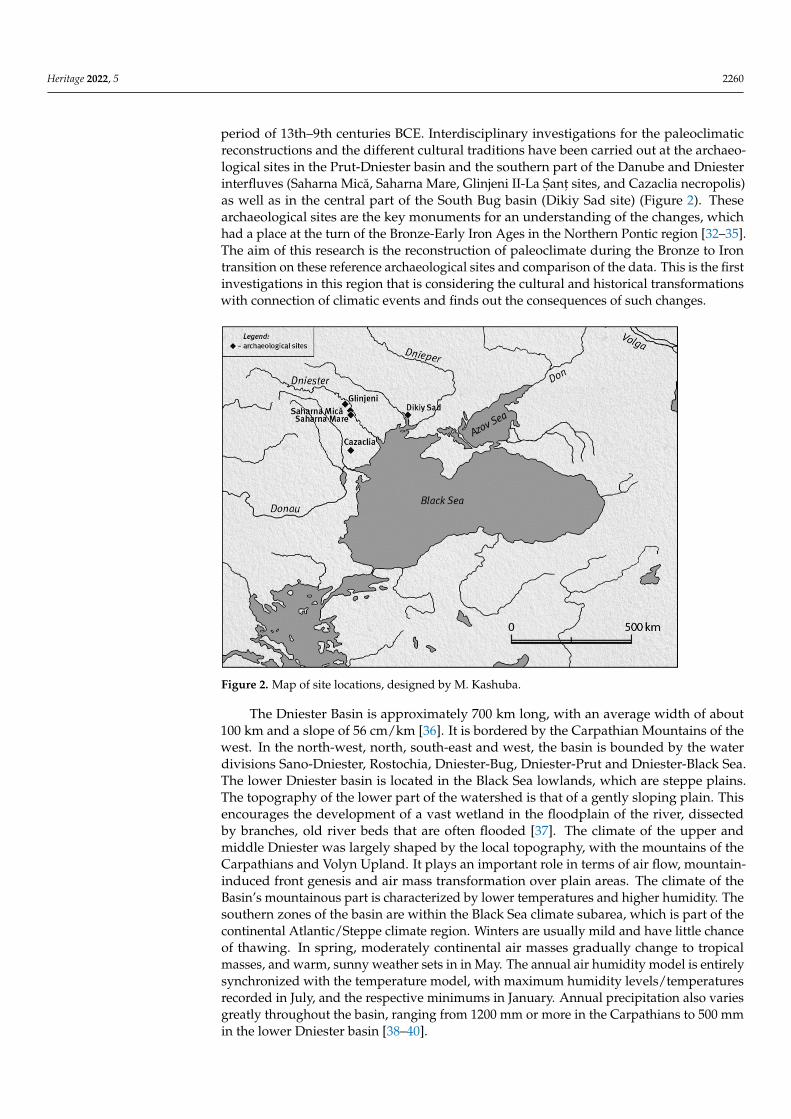
period of 13th–9th centuries BCE. Interdisciplinary investigations for the paleoclimaticreconstructions and the different cultural traditions have been carried out at the archaeo-logical sites in the Prut-Dniester basin and the southern part of the Danube and Dniesterinterfluves (Saharna Mică, Saharna Mare, Glinjeni II-La S, ant, sites, and Cazaclia necropolis)as well as in the central part of the South Bug basin (Dikiy Sad site) (Figure 2). Thesearchaeological sites are the key monuments for an understanding of the changes, whichhad a place at the turn of the Bronze-Early Iron Ages in the Northern Pontic region [32–35].The aim of this research is the reconstruction of paleoclimate during the Bronze to Irontransition on these reference archaeological sites and comparison of the data. This is the firstinvestigations in this region that is considering the cultural and historical transformationswith connection of climatic events and finds out the consequences of such changes.
Figure 2. Map of site locations, designed by M. Kashuba.
The Dniester Basin is approximately 700 km long, with an average width of about100 km and a slope of 56 cm/km [36]. It is bordered by the Carpathian Mountains of thewest. In the north-west, north, south-east and west, the basin is bounded by the waterdivisions Sano-Dniester, Rostochia, Dniester-Bug, Dniester-Prut and Dniester-Black Sea.The lower Dniester basin is located in the Black Sea lowlands, which are steppe plains.The topography of the lower part of the watershed is that of a gently sloping plain. Thisencourages the development of a vast wetland in the floodplain of the river, dissectedby branches, old river beds that are often flooded [37]. The climate of the upper andmiddle Dniester was largely shaped by the local topography, with the mountains of theCarpathians and Volyn Upland. It plays an important role in terms of air flow, mountain-induced front genesis and air mass transformation over plain areas. The climate of theBasin’s mountainous part is characterized by lower temperatures and higher humidity. Thesouthern zones of the basin are within the Black Sea climate subarea, which is part of thecontinental Atlantic/Steppe climate region. Winters are usually mild and have little chanceof thawing. In spring, moderately continental air masses gradually change to tropicalmasses, and warm, sunny weather sets in in May. The annual air humidity model is entirelysynchronized with the temperature model, with maximum humidity levels/temperaturesrecorded in July, and the respective minimums in January. Annual precipitation also variesgreatly throughout the basin, ranging from 1200 mm or more in the Carpathians to 500 mmin the lower Dniester basin [38–40].
Heritage 2022, 5 2261
2. Materials and Methods2.1. Materials—Characterization of Site and Sampling Strategy2.1.1. The Dikiy Sad Site
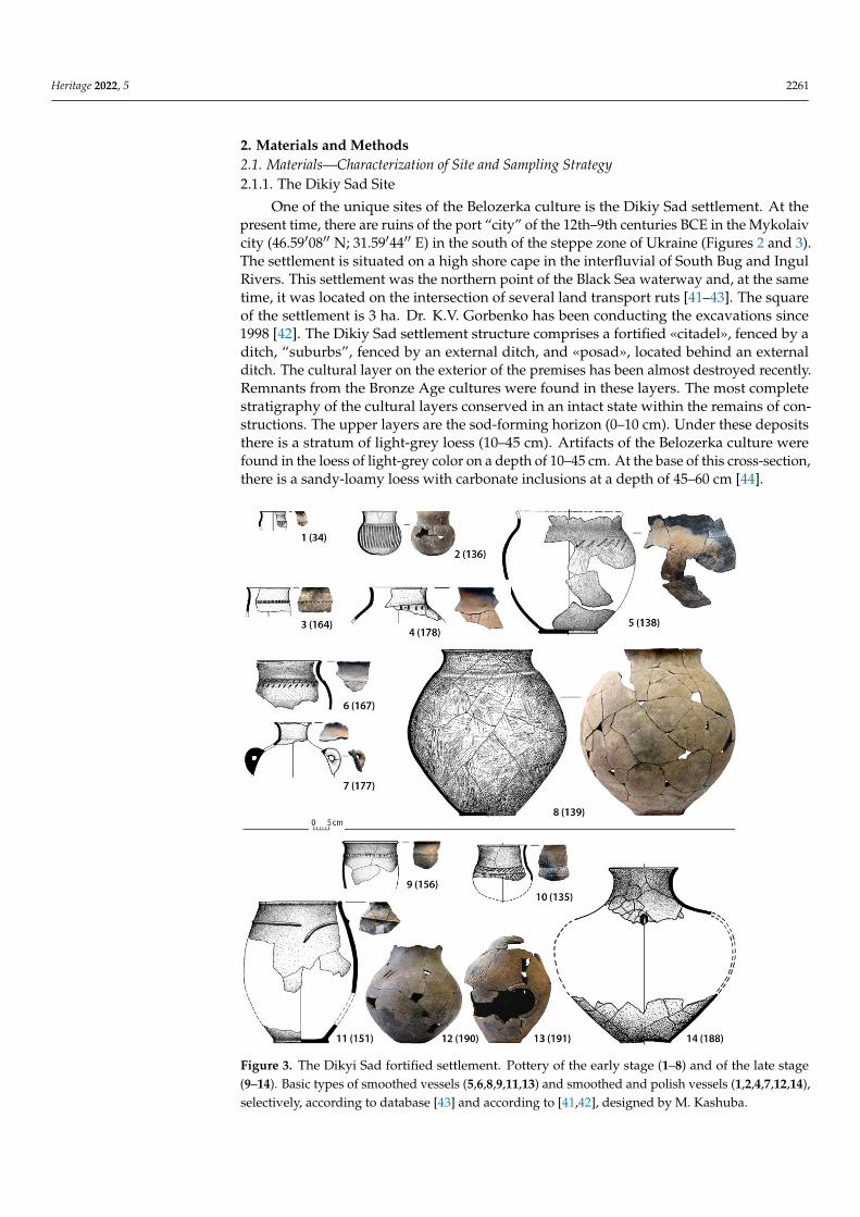
One of the unique sites of the Belozerka culture is the Dikiy Sad settlement. At thepresent time, there are ruins of the port “city” of the 12th–9th centuries BCE in the Mykolaivcity (46.59′08′′ N; 31.59′44′′ E) in the south of the steppe zone of Ukraine (Figures 2 and 3).The settlement is situated on a high shore cape in the interfluvial of South Bug and IngulRivers. This settlement was the northern point of the Black Sea waterway and, at the sametime, it was located on the intersection of several land transport ruts [41–43]. The squareof the settlement is 3 ha. Dr. K.V. Gorbenko has been conducting the excavations since1998 [42]. The Dikiy Sad settlement structure comprises a fortified «citadel», fenced by aditch, “suburbs”, fenced by an external ditch, and «posad», located behind an externalditch. The cultural layer on the exterior of the premises has been almost destroyed recently.Remnants from the Bronze Age cultures were found in these layers. The most completestratigraphy of the cultural layers conserved in an intact state within the remains of con-structions. The upper layers are the sod-forming horizon (0–10 cm). Under these depositsthere is a stratum of light-grey loess (10–45 cm). Artifacts of the Belozerka culture werefound in the loess of light-grey color on a depth of 10–45 cm. At the base of this cross-section,there is a sandy-loamy loess with carbonate inclusions at a depth of 45–60 cm [44].
Figure 3. The Dikyi Sad fortified settlement. Pottery of the early stage (1–8) and of the late stage(9–14). Basic types of smoothed vessels (5,6,8,9,11,13) and smoothed and polish vessels (1,2,4,7,12,14),selectively, according to database [43] and according to [41,42], designed by M. Kashuba.
Heritage 2022, 5 2262
2.1.2. The Cazaclia Necropolis (Belozerka Culture)
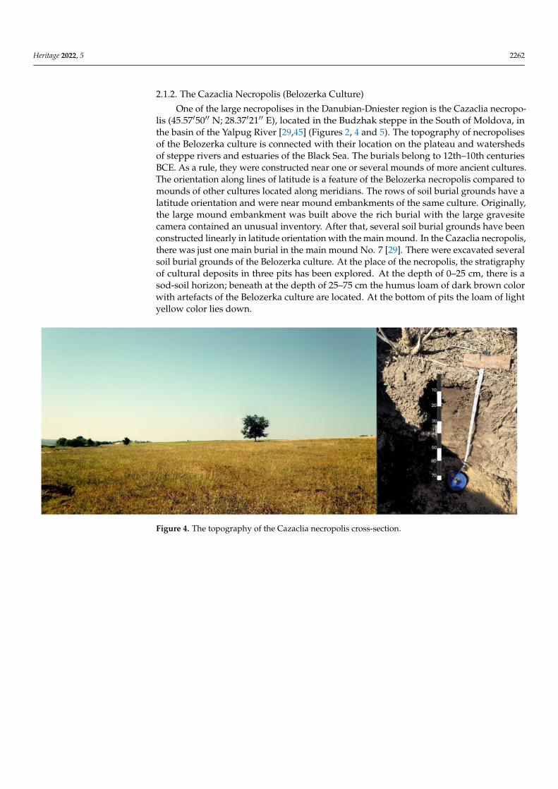
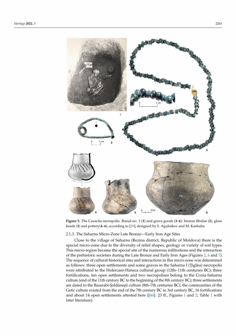
One of the large necropolises in the Danubian-Dniester region is the Cazaclia necropo-lis (45.57′50′′ N; 28.37′21′′ E), located in the Budzhak steppe in the South of Moldova, inthe basin of the Yalpug River [29,45] (Figures 2, 4 and 5). The topography of necropolisesof the Belozerka culture is connected with their location on the plateau and watershedsof steppe rivers and estuaries of the Black Sea. The burials belong to 12th–10th centuriesBCE. As a rule, they were constructed near one or several mounds of more ancient cultures.The orientation along lines of latitude is a feature of the Belozerka necropolis compared tomounds of other cultures located along meridians. The rows of soil burial grounds have alatitude orientation and were near mound embankments of the same culture. Originally,the large mound embankment was built above the rich burial with the large gravesitecamera contained an unusual inventory. After that, several soil burial grounds have beenconstructed linearly in latitude orientation with the main mound. In the Cazaclia necropolis,there was just one main burial in the main mound No. 7 [29]. There were excavated severalsoil burial grounds of the Belozerka culture. At the place of the necropolis, the stratigraphyof cultural deposits in three pits has been explored. At the depth of 0–25 cm, there is asod-soil horizon; beneath at the depth of 25–75 cm the humus loam of dark brown colorwith artefacts of the Belozerka culture are located. At the bottom of pits the loam of lightyellow color lies down.
Figure 4. The topography of the Cazaclia necropolis cross-section.
Heritage 2022, 5 2263
Figure 5. The Cazaclia necropolis. Burial no. 1 (1) and grave goods (3–6): bronze fibulae (2), glassbeads (3) and pottery(4–6), according to [29], designed by S. Agulnikov and M. Kashuba.
2.1.3. The Saharna Micro-Zone Late Bronze—Early Iron Age Sites
Close to the village of Saharna (Rezina district, Republic of Moldova) there is thespecial micro-zone due to the diversity of relief shapes, geology or variety of soil types.This micro-region became the special site of the numerous infiltrations and the interactionof the prehistoric societies during the Late Bronze and Early Iron Ages (Figures 2, 6 and 7).The sequence of cultural-historical sites and interactions in this micro-zone was determinedas follows: three open settlements and some graves in the Saharna I (Tiglău) necropoliswere attributed to the Holercani-Hansca cultural group (12th–11th centuries BC); threefortifications, ten open settlements and two necropolises belong to the Cozia-Saharnaculture (end of the 11th century BC to the beginning of the 8th century BC); three settlementsare dated to the Basarabi-Soldănesti culture (8th–7th centuries BC); the communities of theGetic culture existed from the end of the 7th century BC to 3rd century BC, 16 fortificationsand about 14 open settlements attested here ([46]: 23 ff., Figures 1 and 2; Table 1 withlater literature).
Heritage 2022, 5 2264
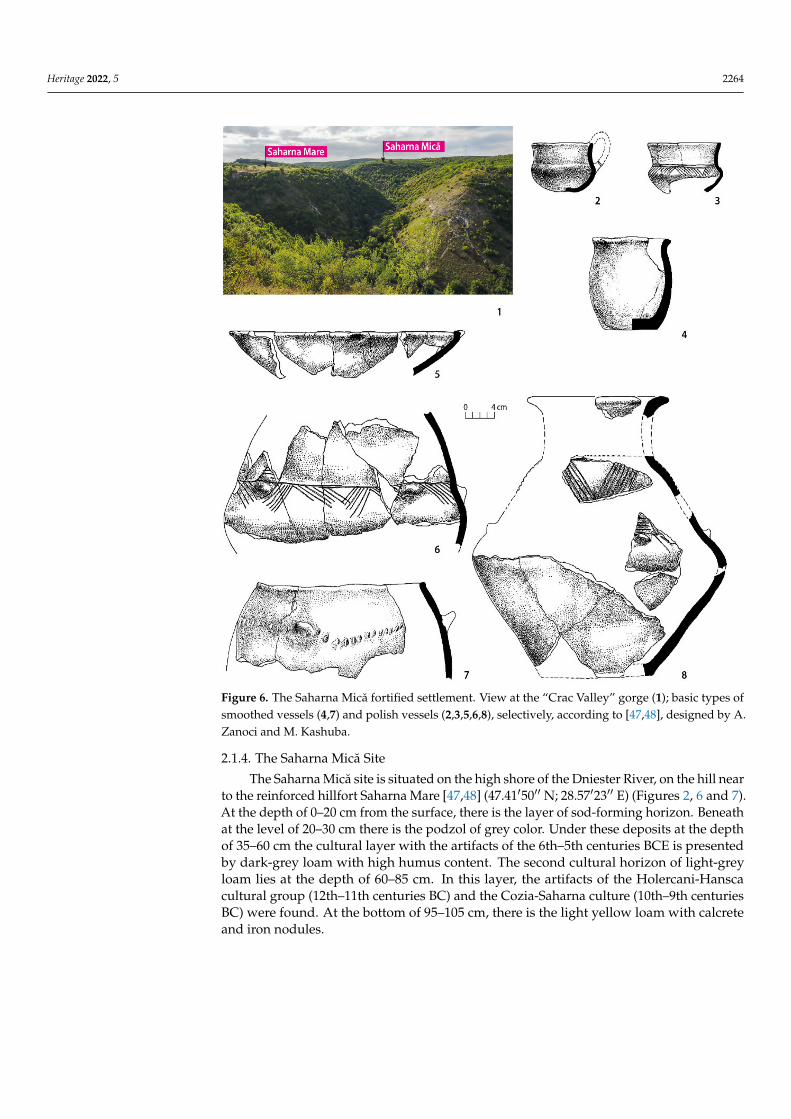
Figure 6. The Saharna Mică fortified settlement. View at the “Crac Valley” gorge (1); basic types ofsmoothed vessels (4,7) and polish vessels (2,3,5,6,8), selectively, according to [47,48], designed by A.Zanoci and M. Kashuba.
2.1.4. The Saharna Mică Site
The Saharna Mică site is situated on the high shore of the Dniester River, on the hill nearto the reinforced hillfort Saharna Mare [47,48] (47.41′50′′ N; 28.57′23′′ E) (Figures 2, 6 and 7).At the depth of 0–20 cm from the surface, there is the layer of sod-forming horizon. Beneathat the level of 20–30 cm there is the podzol of grey color. Under these deposits at the depthof 35–60 cm the cultural layer with the artifacts of the 6th–5th centuries BCE is presentedby dark-grey loam with high humus content. The second cultural horizon of light-greyloam lies at the depth of 60–85 cm. In this layer, the artifacts of the Holercani-Hanscacultural group (12th–11th centuries BC) and the Cozia-Saharna culture (10th–9th centuriesBC) were found. At the bottom of 95–105 cm, there is the light yellow loam with calcreteand iron nodules.
Heritage 2022, 5 2265
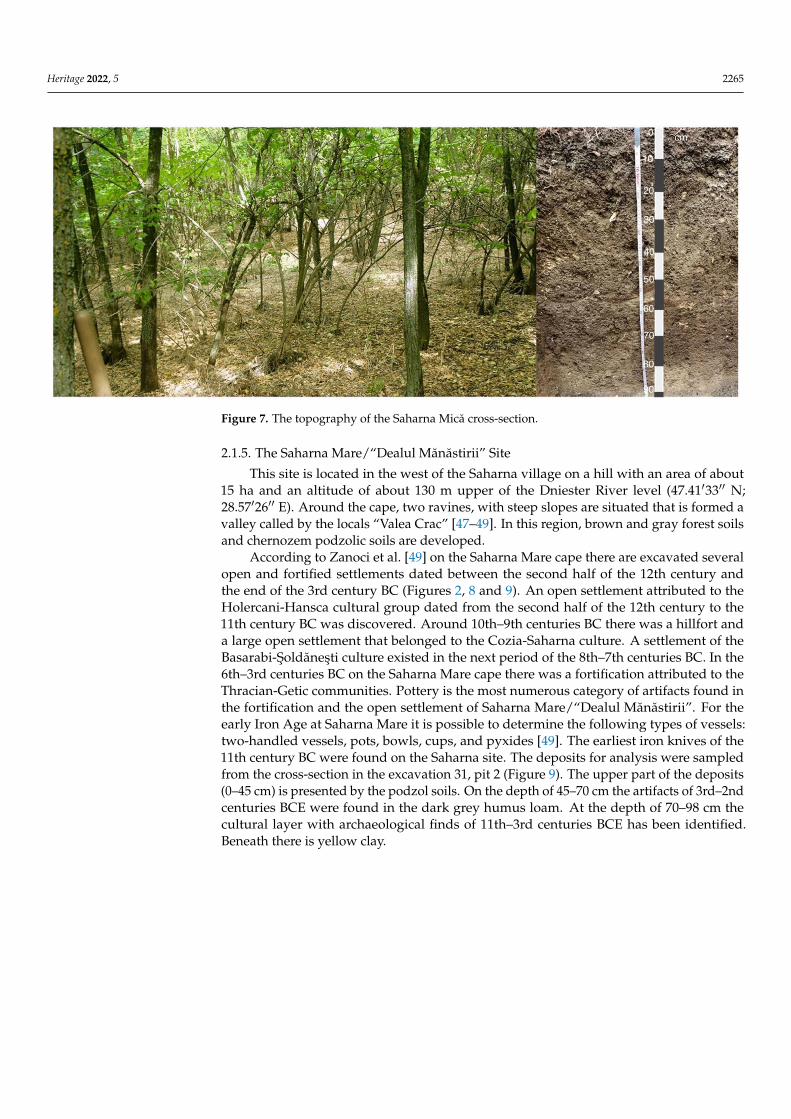
Figure 7. The topography of the Saharna Mică cross-section.
2.1.5. The Saharna Mare/“Dealul Mănăstirii” Site
This site is located in the west of the Saharna village on a hill with an area of about15 ha and an altitude of about 130 m upper of the Dniester River level (47.41′33′′ N;28.57′26′′ E). Around the cape, two ravines, with steep slopes are situated that is formed avalley called by the locals “Valea Crac” [47–49]. In this region, brown and gray forest soilsand chernozem podzolic soils are developed.
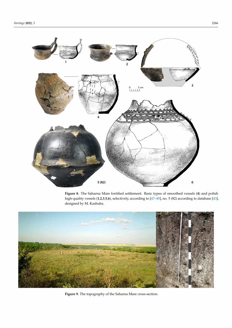
According to Zanoci et al. [49] on the Saharna Mare cape there are excavated severalopen and fortified settlements dated between the second half of the 12th century andthe end of the 3rd century BC (Figures 2, 8 and 9). An open settlement attributed to theHolercani-Hansca cultural group dated from the second half of the 12th century to the11th century BC was discovered. Around 10th–9th centuries BC there was a hillfort anda large open settlement that belonged to the Cozia-Saharna culture. A settlement of theBasarabi-Soldănesti culture existed in the next period of the 8th–7th centuries BC. In the6th–3rd centuries BC on the Saharna Mare cape there was a fortification attributed to theThracian-Getic communities. Pottery is the most numerous category of artifacts found inthe fortification and the open settlement of Saharna Mare/“Dealul Mănăstirii”. For theearly Iron Age at Saharna Mare it is possible to determine the following types of vessels:two-handled vessels, pots, bowls, cups, and pyxides [49]. The earliest iron knives of the11th century BC were found on the Saharna site. The deposits for analysis were sampledfrom the cross-section in the excavation 31, pit 2 (Figure 9). The upper part of the deposits(0–45 cm) is presented by the podzol soils. On the depth of 45–70 cm the artifacts of 3rd–2ndcenturies BCE were found in the dark grey humus loam. At the depth of 70–98 cm thecultural layer with archaeological finds of 11th–3rd centuries BCE has been identified.Beneath there is yellow clay.
Heritage 2022, 5 2266
Figure 8. The Saharna Mare fortified settlement. Basic types of smoothed vessels (4) and polishhigh-quality vessels (1,2,3,5,6), selectively, according to [47–49], no. 5 (82) according to database [43],designed by M. Kashuba.
Figure 9. The topography of the Saharna Mare cross-section.

Heritage 2022, 5 2267
2.1.6. The Glinjeni II-La S, ant, Site
The Glinjeni II-La S, ant, fortified settlement is located in the Rezina district, Republic ofMoldova (47.48′54′′ N; 28.52′29′′ E) in the river basin of the Dniester, in the southwesternperiphery of the modern village Glinjeni, Republic of Moldova. The site description wasmentioned elsewhere [50]. The site is located at an elevation of 184 m above sea level.It was based on the upper terrace of the left bank of the deep and narrow river plainof the Chorna, a right tributary of the Dniester Estuary and stretches over a length of42 km, an approximately west-east location (Figures 2, 10 and 11). The Glinjeni II-La S, ant,is a multilayer fortified settlement (Late Paleolithic to Early Medieval, with interruption)without traceable vertical stratigraphy [51]. All finds from different stages were establishedin the main cultural layer with a thickness from 0.6 to 1.2 m. A horizontal stratigraphy withfeatures (dwellings, pits, ditches) of different chronology was applied. Some structureswere attributed to so-called mixed complexes, which existed a long time and were rebuiltseveral times. The group of so-called mixed ceramics with elements of both culturaltraditions such as the earlier Cozia-Saharna and the later Basarabi-S, oldănes, ti dated fromthe 10th–beginning of 7th centuries BC [51] were discovered in the process of excavations.The investigations of pottery from this site were published elsewhere [50]. The stratigraphyof the cultural layers at the sites is presented by the podzol horizon (0–20 cm); 20–40 cm ishumus horizon; 40–80 cm is light grey sandy loam with artifacts of Cozia-Saharna and thelater Basarabi-S, oldănes, ti cultures (Figure 11).
The sediments from the cross-sections at the sites were taken through each two/fivecentimeters of stratigraphic successions for analysis of the geochemical and mineralogicalcompositions. The deposits of cultural layers were sampled for radiocarbon dating.
Figure 10. The Glinjeni II-La S, ant, fortified settlement. Basic types of polish high-quality vessels(1,2—large pots with high neck; 3,4—cups; 5—bowl), selectively, according to [51], designed byM. Kashuba.

Heritage 2022, 5 2268
Figure 11. The Glinjeni II-La S, ant, cross-section.
2.2. Methods
For reconstruction of paleoclimatic conditions and anthropogenic activity, the methodof geochemical indication of environmental-paleoclimatic conditions was applied [52–55].An important criterion is the assessment of anthropogenic activity by the geochemicalmethod in the layers of the stratigraphic sequence at the sites. Such an approach allows us tosynchronize the changes of anthropogenic activity in lithological layers with climatic eventsoccurring in a given time period. The method of geochemical indication of environmentaland climatic conditions [53] is the most all-purpose method based on the mineralogicaland geochemical characteristics of various genesis sediments. On this base the factors ofenvironmental and climatic changes such as a relative temperature, a relative precipitation,and water level variations in the basin can be determined. Loose sedimentary deposits weresampled at the archaeological sites, along cross-sections with a clear lithological sequence,every 2–5 cm. For geochemical analysis, after each crushing cycle, control sieving wascarried out, and the residue is crushed to the desired grain size [56]. Then all crushedmaterial is combined. Manual reduction is carried out by the method of multiple (no morethan 3 with one crushing) quartering and combining the material of two opposite quadrantsto continue processing according to the accepted scheme. Due to the heterogeneity of thedistribution of components in large and small fractions, before reducing the samples, theyare mixed and then quartered.
The sample is ground to a powder to a particle size of 200 meshes, 0.074 mm (to thestate of powder). For X-ray spectral Fluorescence analysis using the Spectroscan Max-WDspectrometer, 300 mg samples were pressed into a tablet using a boric acid substrate.
The geochemical indicators and modules were used to reconstruct the features ofthe formation of sedimentary deposits. The relative temperature changes for terrigenoussediments can be characterized by the distribution of the titanium module (TiO2/Al2O3)and the change in the content of zirconium (Zr) in the sedimentary stratum [57]. Thetitanium module, in this case, shows the accumulation of accessory, weathering-resistantminerals of the titanium group in the psammitic fraction, and alumina in the pelliticfraction, which is formed in result of more intense chemical weathering in a warm andhumid climate. Changes in the temperature balance were also determined based on themodules Na2O/K2O, Sr/Rb, which reflect the transformation of plagioclase/feldspar, mica,clay minerals depending on weathering processes, mainly temperature effects.

Heritage 2022, 5 2269
The destruction of potassium feldspar, according to the authors [54,55], is slower thanthat of plagioclases and leads to the accumulation of potassium (K2O) as a component ofmica and clay minerals resistant to subsequent weathering.
The Nesbitt and Young Index (CIA) shows the degree of transformation of aluminosil-icate minerals and changes in the mineral composition in result of chemical weathering,depending on the relative humidity of the climate (CIA = Al2O3/(Al2O3 + CaO + Na2O +K2O) × 100%) [58]. The CaO/MgO (Ca/Mg) ratio shows the increase in calcium relative tomagnesium in the carbonate component under arid conditions, and has also been used toanalyze changes in humidity and temperature balances under arid conditions.
The marker P2O5antr = P2O5/(P2O5 + Na2O) was used to assess the anthropogenicimpact [53,59]. Elevated values of this indicator correlate well with the horizons of culturaldeposits contained in the traces of ancient people activity and the artifacts. In this case, theratio can be established and separated phosphorus of anthropogenic origin from calciumand phosphorus of lithogenic origin, which are associated with the lithological componentof the deposits.
The radiocarbon dating of cultural deposits was conducted using the standard methodon humic acids from soils. The radiocarbon dating of humic acids was performed throughthe radiometric liquid scintillation technique in the Isotopic Lab of Herzen State University(St. Petersburg) [60,61]. The results of radiocarbon dating are presented in Table 1. Thesoil samples were pretreated by the standard method using hydrochloric acid (3% HCl) forancient carbonate removal. After that, humiс acids were extracted by alkali (1% NaOH) [62].The lithium carbide was obtained in the process of carbidization at T = 750 ◦C in an ovenin a vacuum atmosphere. The counting liquid is benzene obtained in the process ofpolymerization of acetylene on chromium catalysis. Acetylene was produced as a resultof lithium carbide decomposition of water [63]. The radiocarbon activity was measuredwith the help of low background scintillation counter Quantulus 1220. The applicationof scintillations (POPOP and PPO) needs to add in benzene [64]. The date calibrations(Figure 12) were carried out with help of the program OxCal 4.4. [65].
Table 1. Radiocarbon dates on humid acid of soils from archaeological sites of the Prut-Dniester basinand the southern part of the Danube and Dniester interfluves.
No. Archaeological Site Lab Index 14C Age BP Calibrated Date(2σ) calBC
1 No. 1 Saharna Mare, cross-section2 (excavation 31), pit 2 SPb-3192 2435 ± 35 751–406
2 No. 3 Glinjeni II-La S, ant, , 2019(60–50 cm) SPb-3194 2810 ± 30 1050–849
3 No. 4 Saharna Mică (40–50 cm) SPb-3195 2528 ± 40 798–5404 No. 5 Saharna Mică (95–90 cm) SPb-3196 2867 ± 30 1185–927
5 No. 6 Cazaclia necropolis,cross-section 3 (40–35 cm) SPb-3197 2833 ± 30 1108–906
6 No. 7 Saharna Mică, cross-section1 (70–60 cm) SPb-3198 2860 ± 30 1122–927

Heritage 2022, 5 2270
Figure 12. Calibrated dates for cultural deposits from the Saharna Mică, the Saharna Mare site, theCazaclia necropolis, and the Glinjeni II-La S, ant, settlement.
3. Results
The interpretation of geochemical data of sedimentary strata for each archaeologicalsite is considered in separate sections of this chapter. The variations of geochemicalindicators are presented in Figures 13–17.
3.1. The Dikiy Sad Site
The Dikiy Sad site is located in the shore zone of the Black Sea and has been influencedby temperate marine climate. The relative temperature changes were established on thebase of geochemical indicators (Zr, Na2O/K2O) in loess in the cross-section on the site(Figure 13). The relative precipitation was determined with help of the CIA module. Theanthropogenic activity was characterized by means of P2O5antr variations compared tobackground concentrations in these deposits. It is worth noting the sedimentation on thissite was in the period of humid climatic conditions for this area: CIA (70–76%). In thebottom part of the cross-section (56–54 cm) the loess formation was in the conditions ofhumid and warm climate: CIA (76%), Na2O/K2O (0.71%), Zr (40–42 ppm).The anthro-pogenic activity is low: P2O5antr (0.16%). At a depth of 54–44 cm, there is light yellow loesswith inclusions of calcrete. These deposits were sedimented during more dry and coldconditions: CIA (70–72%), Na2O/K2O (0.84%), Zr (38–27 ppm). The climatic changes to thehumid and warm conditions are registered in the layer of sandy loess deposits at a depthof 43–33 cm: CIA (73–75%), Na2O/K2O (0.52–0.75%), Zr (30–38 ppm). The anthropogenicactivity in this period increased: P2O5antr (0.45%) in comparison to the background levelof P2O5antr in loess (0.18%). These deposits are the cultural layer containing artifacts ofthe 13th/12th–11th centuries BCE. In deposits on a depth of 26–24 cm the next stage ofclimatic changes was recorded. According to the climatic indicators the climate becamemore dry (CIA 70–71%) and cold (Na2O/K2O 0.85–0.92%, Zr 31–42 ppm). The anthro-pogenic activity is low: P2O5antr (0.25%). The maximum of aridization was recorded in thedeposits at the depth of 20–16 cm: CIA (70%), Na2O/K2O (0.92%), Zr (30–32 ppm). Thehigh anthropogenic activity is a characteristic of this layer: P2O5antr (0.76%). This layer isthe cultural deposits of the 11th–10th centuries BCE. The sedimentation at the depth of16–10 cm was in the warm and humid conditions: CIA (74–76%), Na2O/K2O (0.32–0.52%),
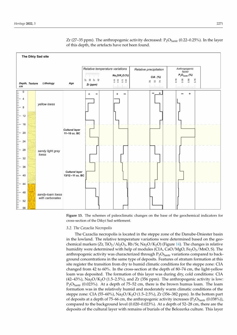
Heritage 2022, 5 2271
Zr (27–35 ppm). The anthropogenic activity decreased: P2O5antr (0.22–0.25%). In the layerof this depth, the artefacts have not been found.
Figure 13. The schemes of paleoclimatic changes on the base of the geochemical indicators forcross-section of the Dikyi Sad settlement.
3.2. The Cazaclia Necropolis
The Cazaclia necropolis is located in the steppe zone of the Danube-Dniester basinin the lowland. The relative temperature variations were determined based on the geo-chemical markers (Zr, TiO2/Al2O3, Rb/Sr, Na2O/K2O) (Figure 14). The changes in relativehumidity were determined with help of modules (CIA, CaO/MgO, Fe2O3/MnO, S). Theanthropogenic activity was characterized through P2O5antr variations compared to back-ground concentrations in the same type of deposits. Features of stratum formation at thissite register the transition from dry to humid climatic conditions for the steppe zone: CIAchanged from 42 to 60%. In the cross-section at the depth of 80–74 cm, the light-yellowloam was deposited. The formation of this layer was during dry, cold conditions: CIA(42–43%), Na2O/K2O (1.5–2.5%), and Zr (356 ppm). The anthropogenic activity is low:P2O5antr (0.023%). At a depth of 75–52 cm, there is the brown humus loam. The loamformation was in the relatively humid and moderately warm climatic conditions of thesteppe zone: CIA (55–60%), Na2O/K2O (1.5–2.5%), Zr (356–382 ppm). In the bottom partof deposits at a depth of 75–66 cm, the anthropogenic activity increases (P2O5antr (0.038%)),compared to the background level (0.020–0.023%). At a depth of 52–28 cm, there are thedeposits of the cultural layer with remains of burials of the Belozerka culture. This layer

Heritage 2022, 5 2272
sedimented during humid and warm conditions: CIA (57–62%), Na2O/K2O (2.0–2.2%),Zr (376–398 ppm). The anthropogenic activity increases in deposits of this layer: P2O5antr(0.030–0.042%). The radiocarbon age of soils from the depth of 40–35 cm is 1108–900 сalBC(2σ) (Table 1).
Figure 14. The schemes of paleoclimatic changes on the base of the geochemical indicators forcross-section of the Cazaclia necropolis.
3.3. The Saharna Mică Site
The Saharna Mică site is situated in the forest-steppe zone on the hilly bank of theDniester river. The sediments at the site are presented by soils and humus loams. Theanthropogenic activity at the site was determined by the P2O5antr in the deposits com-pared to the background level for this type of sediment. The relative temperature changeswere determined using geochemical indicators (Zr, TiO2, Rb/Sr) (Figure 15). Changes inthe relative humidity are characterized by the markers (Fe2O3/TiO2, Cl, S, LOIorg). Thelight yellow sand with carbonate inclusions occurs at the depth of 100–85 cm. The de-posits were formed in a moderately humid and cool climate: LOI (6.4–8.4%), Fe2O3/TiO2(7.24–7.3%), Zr (268–208 ppm), Rb/Sr (0.28–0.48 ppm). The anthropogenic activity: P2O5antr(0.20–0.25%), the background level for these deposits (0.05%). For the cultural layer at adepth of 95–90 cm, the 14C date of 1190–930 calBC (2σ) (Table 1) was obtained from thehumus extract of the soil. Deposits at a depth of 85–65 cm are dark grey humus clayeysand. The deposits were formed in a warm and humid climate: LOI (8.2–8.4%), Fe2O3/TiO2(7.16–7.24%), Zr (268–288 ppm), Rb/Sr (0.30–0.68 ppm). The anthropogenic activity in-

Heritage 2022, 5 2273
creased: P2O5antr (0.26–0.16%). The cultural deposits at a depth of 70–60 cm have the dateon humus of 1122–927 calBC (2σ) (Table 1). At a depth of 65–55 cm, sedimentation changes,and deposits of clayey sand are changed into grey humus sand. The climatic conditionsfor this period can be characterized as very warm and dry: LOI (7.5–8.0%), Fe2O3/TiO2(7.24–7.35%), Zr (260–288 ppm), Rb/Sr (0.68–0.70 ppm). The anthropogenic activity islow: P2O5antr (0.1–0.12%). Changes in the climatic conditions are recorded in deposits ofgrey humus sand, at a depth of 50–32 cm. In the lower part of the deposits, at a depth of50–45 cm, according to geochemical indicators, warm and humid conditions are recorded:LOI (7.0–8.3%), Fe2O3/TiO2 (7.44–7.64%), Zr (268–288 ppm), Rb/Sr (0.48–0.68 ppm). Theanthropogenic activity increases P2O5antr (0.16–0.18%). For deposits at a depth of 40–50 cm,the radiocarbon date obtained from a humus extraction is ca. 800–540 calBC (2σ) (Table 1).The deposits (45–35 cm) were formed in a more humid and cooler climate: LOI (8.4–9.0%),Fe2O3/TiO2 (7.3–7.32%), Zr (228 ppm), Rb/Sr (0.3–0.33 ppm). The anthropogenic activityis high: P2O5antr (0.16–0.28%). Artifacts of the Getic culture were found in these deposits.At a depth of 35–20 cm, deposits of a grey podzolic horizon are developed. In the sedi-ments, high anthropogenic activity is recorded according to geochemical data: P2O5antr(0.16–0.24%). The deposits were formed in cooler and humid climatic conditions: LOI(9.0–10.4%), Fe2O3/TiO2 (7.44–7.64%), Zr (252–220 ppm), Rb/Sr (0.3–0.45 ppm).
Figure 15. The schemes of paleoclimatic changes on the base of the geochemical indicators forcross-section of the Saharna Mică site.

Heritage 2022, 5 2274
3.4. The Saharna Mare/“Dealul Mănăstirii” Site
The Saharna Mare settlement is located close to the Saharna Mică site in the forest-steppe zone, on a hill. The lower part of the deposits of the cross-section is presented bylight yellow loam, a depth of 95–92 cm (Rb/Sr 0.64–0.7 ppm) (Figure 16). The light greyloam occurs at a depth of 92–70 cm. The deposits were formed during a period of warmand rather humid conditions: LOI (8.2–9.2%), Fe2O3/TiO2 (6.8–7.2%), Zr (172–152 ppm),Rb/Sr (0.54–0.52 ppm). The anthropogenic activity increases P2O5antr (0.18–0.26%). Indeposits at a depth of 85–60 cm, artifacts of the Holercani-Hansca cultural group and theearly phase of the Cozia-Saharna culture of the 12th–11th centuries BCE were found. Thelight grey loam occurs at a depth of 70–45 cm. Deposits at a depth of 70–57 cm were formedin a humid and cool climate: LOI (7.2–7.5%), Fe2O3/TiO2 (7.0–7.2%), Zr (112–132 ppm),Rb /Sr (0.44–0.46 ppm). The anthropogenic activity is high: P2O5antr (0.24–0.26%). Depositsat this depth are dated by means of the radiocarbon dating on humic acids about ca.750–400 calBC(2σ) (Table 1). At a depth of 57–45 cm, the sediments were formed in theconditions of warmer and more humid climate: LOI (7.2–8.5%), Fe2O3/TiO2 (6.8–7.1%),Zr (170–172 ppm), Rb/Sr (0.44–0.54 ppm). The anthropogenic activity is high: P2O5antr(0.14–0.26%). Artifacts of the 6th–5th centuries BC were found in sediments at a depth of60–45 cm. Soil deposits occur at a depth of 45–5 cm. The formation of deposits occurredin humid conditions of a temperate climate: LOI (7.2–10.2%), Fe2O3/TiO2 (7.0–7.2%), Zr(172–112 ppm), Rb/Sr (0.54–0.74 ppm). The anthropogenic activity is P2O5antr (0.10–0.20%).
Figure 16. The schemes of paleoclimatic changes on the base of the geochemical indicators forcross-section of the Saharna Mare site.

Heritage 2022, 5 2275
3.5. The Glinjeni II-La S, ant, Site
At the Glinjeni II-La S, ant, site, located in the forest-steppe zone, near the settlements ofSaharna Mică and Saharna Mare, cultural deposits are represented by light grey sandy loam.At a depth of 76–68 cm, there is a light yellow sandy loam, the formation of which occurredduring the humid and warm climatic episode (Figure 17): CIA (46–52%), Na2O/K2O(0.55–1.15%), Zr (328–330 ppm), Rb/Sr (0.46–0.61 ppm) (Figure 17). The increased an-thropogenic activity of P2O5antr (0.31%) was recorded at a depth of 76 cm. At a depth of68–56 cm, the light grey sandy loam was formed during decreasing humidity. At a depthof 68–64 cm, high anthropogenic activity was registered: P2O5antr (0.42%). In this period,the climate according to the geochemical indicators was warm and humid: CIA (53–55%),Na2O/K2O (0.4–0.41%), Zr (348–350 ppm), Rb/Sr (0.61 ppm). Deposits at a depth of64–60 cm have been formed as a result ofaclimaticshift toward drier and colder conditions:CIA (46–48%), Na2O/K2O (1.15–1.41%), Zr (310–324 ppm), Rb/Sr (0.52–0.56 ppm). Theanthropogenic activity is low: P2O5antr (0.05%). At a depth of 60–52 cm, deposits weresedimented in the conditions of dry and hot climate: CIA (46–48%), Na2O/K2O (0.4–0.5%),Zr (348–330 ppm), Rb/Sr (0.60–0.46 ppm). The anthropogenic activity increases P2O5antr(0.30–0.42%). For this layer, the radiocarbon date on humic acids is ca.1050–850 calBC (2σ)(Table 1). In sediments, at a depth of 52–46 cm, strong aridization and cooling are recorded:CIA (46%), Na2O/K2O (1.15%), Zr (308–310 ppm), Rb/Sr (0.56 ppm). The anthropogenicactivity is lower: P2O5antr (0.26%). In a layer at a depth of 80–40 cm, materials of theCozia-Saharna and the Basarabi-Soldănesti cultures were found. The climatic changesduring the formation of deposits at a depth of 46–20 cm can be characterized as moderatelyhumid and cool.
Figure 17. The schemes of paleoclimatic changes on the base of the geochemical indicators forcross-section of the Glinjeni II-La S, ant, site.

Heritage 2022, 5 2276
4. Discussion
According to some researchers [66], in Eurasia during 1700–1300 calBC a moderatelyshort humid climatic episode was determined. This climatic event coincides with theCaspian Sea transgressive phase. Favorable humid climatic conditions were recorded in thesouth of Eastern Europe in the period of the Srubnaya culture development (16th/15th–12thcenturies calBC) [67]. In the economy of the Sabatinovka culture (16th/15th–13th centuriescalBC), elements of agriculture in the modern zone of the dry steppe were noted, whichis reliably associated with significant climatic moisture at that time [68]. The Belozerkaculture was formed in the final stage of the Bronze Age (12th–10th centuries calBC). In thesettlement of Dikiy Sad, which was located in the coastal part of the Northern Black Searegion, the climatic conditions were quite favorable at this time. The formation of culturaldeposits with artifacts of the late Sabatinovka and Belozerka cultures at the settlement datesback to 13th/12th–11th centuries BC. The radiocarbon dates (1266–1100 and 975–875 calBC)were obtained for this culture at the Dikiy Sad site [35]. According to the geochemicalindicators of paleoclimatic conditions (CIA, Na2O/K2O, Zr), the deposits at the depth of26–24 cm at the site were formed in the transitional period from humid and favourable todrier and cooler climatic conditions. The maximum aridization is recorded to ca. 11th–10thcenturies calBC in the deposits at the depth of 20–16 cm. For this period, the maximumanthropogenic activity was established at the settlement. According to [31,69], an economiccrisis that was noted among the tribes of the Belozerka culture can probably be associatedwith the gradual drying up of pastures and less livestock compared to the previous period.The climatic changes were recorded according to geochemical indicators (CIA, Na2O/K2O,Zr) in the deposits on the depth of 52–28 cm at the Cazaclia burial ground, belonging tothe Belozerka culture and located in the steppe zone of the Danube-Dniester interfluves.The humid and warm climatic conditions were determined for the layer of the Belozerkaculture in a necropolis dated to ca. 1108–900 calBC.
In the Prut-Dniester interfluve of the forest-steppe zone, there was a transition from amoderately humid and cool climate (around ca. 1185 calBC) to warm climatic conditionsaround 1120–930 calBC. On the base of geochemical indicators (LOI, Fe2O3/TiO2, Zr,Rb/Sr), the deposits at the depth of 70–60 cm were sedimented during warm and humidconditions. In this period, bearers of the Holercani-Hansca cultural group (12th centuriescalBC) and the Cozia-Saharna culture (end of 11th–10th centuries calBC) appear at theSaharna Mica site. After 11th–10th centuries calBC, the climate became drier. Around800–540 calBC a transition to humid and cooler conditions occurred. The cultural layerwith artifacts of the Getic culture has been formed in the warmer stage and it dates back tothe 6th–5th centuries calBC. At the Saharna Mare settlement, humid and warm conditionswere also recorded during the cultural layer formation with the Cozia-Saharna cultureremains at a depth of 85–60 cm. A dry climatic episode was reported immediately afterthis period. The formation of sediments in the period of 750–400 calBC was in more humidand cooler climatic conditions according to the geochemical indicators (LOI, Fe2O3/TiO2,Zr, Rb/Sr). The cultural layer at the depth of 60–45 cm with artifacts of the Getic culture(6th–5th centuries calBC) at this site was formed in a warm and humid climate.
At the Glinjeni II-La S, ant, site, there was a transition from humid and warmer climaticconditions with high anthropogenic activity (a cultural layer at a depth of 68–60 cm withartefacts of the Cozia-Saharna culture at the end of 11th–10th centuries calBC) to drier andcooler conditions, when anthropogenic activity sharply decreases. Then a transition to thearid and warm climatic conditions occurred around ca. 1050–850 calBC. At the end of thisepisode, the beginning of the Basarabi-Soldănesti cultural layer formation at a depth of60–52 cm which is characterised by high anthropogenic activity was recorded.
Thus, in a favorable climatic period about ca. 12th century calBC, characterized byhumid climatic conditions, in the central part of the Prut-Dniester interfluve, differentcultures were developed. These cultures relate roughly to the Thracian cultural group, suchas Holercani-Hansca [70]. The Belozerka culture was formed as a result of the merger of theSrubnaya, Sabatinovka and Noua cultures during a short episode of climate deterioration
Heritage 2022, 5 2277
around 13th–12th centuries calBC. The changes of climatic conditions around 11th–10thcenturies calBC to the aridization led to a crisis of the Belozerka culture in the Pontic steppe,whose economy was a mixed pastoral-agricultural type. The beginning of the final stage ofthe Late Bronze Age (late 13th–10th centuries calBC) also coincided with the disintegrationof the Srubnaya and Andronovo cultural and historical communities [67,69] The maindirections of cultural interrelationships during this period were latitudinal connectionsextending along the northern border of the steppe. The end of the functioning of theTrans-Eurasian “tin” way on the segment between the Volga and the Dnieper also datesback to the 12th–10th centuries BCE [71].
The climatic changes in the Dniester basin toward aridization around 11th–9th cen-turies calBC were the trigger for the spreading of the Cozia-Saharna cultural communitiesinto the forest-steppe zone and the formation of fortified settlements such as the SaharnaMica, the Saharna Mare and the Glinjeni II-La S, ant, . Further deterioration of climatewas a cause of the abandonment of some settlements. The appearance of carriers of theBasarabi-Soldănesti culture at the settlement of Glinjeni II-La S, ant, occurred in the periodof aridization at the end of 9th–8th centuries calBC. Climatic change toward cooling isrecorded around 8th–7th centuries calBC in this region.
Dry conditions in the period of ca. 11th–9th centuries BCE also led to the expansionof the “Cimmerians” into the Pontic steppes from the North Caucasus to the Danube [72].In the Dnieper region at this time, the Chernoleskaya culture collapsed, and the Zhabotinculture appeared at the end of the 9th century BCE. At the same time, climatic changesplayed a role in the transition from a traditional pastoral economy to nomadic pastoralismoccurred in this period.
By the end of the 7th centuriy BCE the steppe zone expanded into the forest-steppezone.Transformations had a place in the forest-steppe zone, however, the original characterof settlements, dwellings, the composition of the herd, details of clothing, ceramics, burialstructures and rituals (the Archaic Scythia culture) have been preserved. By the turn of the6th–5th centuries BCE the Scythian nomads actively occupied the steppe zone and exactlythey left the culture of Classical (Herodotus) Scythia.
5. Conclusions
The climatic events of the 12th–8th centuries BCE, associated with arid conditions, werethe trigger for changes in the economic system of the final Bronze Age societies living inthe steppe and forest-steppe in the Northern part of the Black Sea. The expansion of mobiletribes from other territories was reflected in the transformation of the local communities andthe emergence of innovations in the economy and technologies, such as the manufactureof iron products (mainly tools). The distribution of the Hallstatt (Carpathian-Danubian)cultures with new technologies of pottery manufacture and iron metallurgy in the forest-steppe zone of the region, stimulated the development and contributed to the emergence ofnew types of syncretic ceramics and new forms of economy. The socially stratified societiesof the Late Bronze Age with a complex internal structure and especially in the final time inthe steppe zone turned out to be more vulnerable to various external conditions, such asclimate change.
Author Contributions: Conceptualization, M.A.K. and M.T.K.; data curation, A.M.K., M.T.K., A.M.K.,M.N.V., A.Z. and M.A.S.; formal analysis and investigation, M.A.K., A.M.K., M.A.S., S.M.A., A.Z. andM.N.V.; methodology, M.A.K. and M.T.K.; methodology, A.M.K. and M.T.K.; project administration,M.A.K.; visualization, M.A.K., M.T.K. and A.M.K.; writing—original draft, M.A.K. and M.T.K.;writing—review andediting, M.A.K. and M.T.K. All authors have read and agreed to the publishedversion of the manuscript.
Funding: This research was funded by Russian Science Foundation, project No. 22-18-00065 “Culturaland historical processes and paleoenvironment in the Late Bronze-Early Iron Age of the North-Western Black Sea region: interdisciplinary approach”.
Heritage 2022, 5 2278
Institutional Review Board Statement: The study does not require ethical approval.
Informed Consent Statement: Informed consent was obtained from all subjects involved in the study.
Data Availability Statement: Kaiser, E.; Kashuba, M.; Gavrylyuk, N.; Hellström, K.; Winger, K.;Bruyako, I.; Daszkiewicz, M.; Gershkovich, Y.; Gorbenko, K.; Kulkova, M.; Nykonenko, D.; Schneider, G.;Senatorov, S.; Vetrova, M.; Zanoci, A. Dataset of the Volkswagen Fond Project no. 90 216 “Early mountednomads and their vessels Ceramic analysis project aimed at supporting the reconstruction of socio-economicconditions in mobile populations north of the Black Sea between 1100 and 600 BC”. [Data set]. Zenodo 2019.Available online: https://doi.org/10.5281/zenodo.3521608 (accessed on 25 July 2022).
Acknowledgments: The authors wish to thank Ivan Litsuk (graphic artist, St. Petersburg, Russia) forthe help with materials and drawings and photographs of the finds.
Conflicts of Interest: The authors declare no conflict of interest. The funders had no role in the designof this study; interpretation of data; in the writing of the manuscript.
References1. De Menocal, P.B. Cultural responses to climate change during the late Holocene. Science 2001, 292, 667–673. [CrossRef]2. Yon, M. The End of the Kingdom of Ugarit. In The Crisis Years: The 12th Century BC. From beyond the Danube to the Tigris; Ward,
W.A., Sharp Joukowsky, M., Eds.; Kendall/Hunt Publishing Company: Dubuque, IA, USA, 1992; pp. 111–122.3. Yon, M. The City of Ugarit at Tell Ras Shamra; Hardcover; Eisenbrauns: Winona Lake, IN, USA, 2006; p. 179, ISBN 13: 978-1-57506-029-3.4. Bryce, T. The Kingdom of the Hittites; Oxford University Press: Oxford, UK, 2005; p. 554, ISBN 13: 9780199281329. [CrossRef]5. Bryce, T. The World of the Neo-Hittite Kingdom. A Political and Military History; Oxford University Press: Oxford, UK, 2012; p. 356,
ISBN 13: 978-0199218721.6. Carpenter, R. Discontinuity in Greek Civilization; Cambridge University Press: Cambridge, UK, 1966; p. 77.7. Weiss, B. The decline of the Late Bronze Age civilization as a possible response to climate change. Clim. Chang. 1982, 4, 173–198.
[CrossRef]8. Weiss, H.; Courtney, M.-A.; Wetterstrom, W.; Guichard, F.; Senior, L.; Meadow, R.; Curnow, A. The genesis and collapse of third
millennium north Mesopotamian civilization. Science 1993, 261, 995–1004. [CrossRef] [PubMed]9. Weiss, H.; Bradley, R.S. What Drives Societal Collapse? Science 2001, 291, 609–610. [CrossRef] [PubMed]10. Neumann, J.; Parpola, S. Climatic change and the eleventh-tenth-century eclipse of Assyria and Babylonia. J. Near East. Stud.
1987, 46, 161–182. [CrossRef]11. Kaniewski, D.; van Campo, E.; Guiot, J.; Le Burel, S.; Otto, T.; Baeteman, C. Environmental Roots of the Late Bronze Age Crisis.
PLoS ONE 2013, 8, e71004. [CrossRef]12. Whitley, J. Social diversity in Dark Age Greece. Annu. Br. Sch. Athens 1991, 86, 341–365. [CrossRef]13. Drake, B.L. The influence of climatic change on the Late Bronze Age Collapse and the Greek Dark Ages. J. Archaeol. Sci. 2012,
39, 1–9. [CrossRef]14. Palaima, T.G. Linear B. In The Oxford Handbook of the Bronze Age Aegean; Cline, E., Ed.; Oxford University Press: Oxford, UK, 2010;
pp. 356–372, ISBN 13: 978-0199873609.15. Ussishkin, D. Levels VII and VI at Tel Lachish and the end of the Late Bronze Age in Canaan. In Palestine in the Bronze and Iron
Ages, Papers in Honour of Olga Tufnell; Tubb, J.N., Ed.; Institute of Archaeology Publications: London, UK, 1985; pp. 213–230,ISBN 13: 9780905853154.
16. Hodder, I.; Hutson, S. Reading the Past: Current Approaches to Interpretation in Archaeology; Cambridge University Press: Cambridge,UK, 1986; p. 244, ISBN 13: 978-0521528849.
17. Kaniewski, D.; van Campo, E. 3.2 ka BP megadrought and the Late Bronze Age collapse. In Megadrought and Collapse: From EarlyAgriculture to Angkor; Weiss, H., Ed.; Oxford University Press: New York, NY, USA, 2017; pp. 161–182. [CrossRef]
18. Kulkova, M.A. Adaptation of Ancient Communities to Environmental Changes in the Holocene in the Regions of the Middle East, WesternEurope, the Balkans and the Northern Black Sea Coast; A Study Guide, Part 1; A.I. Herzen State Pedagogical University: St. Petersburg,Russia, 2021; p. 160, ISBN 978-5-8064-3028-2/978-5-8064-3027-5. (In Russian)
19. Sava, E. Die spätbronzezeitlichen Aschehügel (“Zol’niki”)-ein Erklärungsmodell und einige historisch-wirtschaftliche Aspekte.Praehist. Z. 2005, 80, 65–109. [CrossRef]
20. Sava, E. Viehzucht und Ackerbau in der Noua-Sabatinovka Kultur. In Interpretationsraum Bronzezeit. Bernhard Hänsel von SeinenSchülern Gewidmet; Universitätsforschungen zur Prähistorischen Archäologie, 121; Horejs, B., Jung, R., Kaiser, E., Terzan, B., Eds.;Rudolf Habelt: Bonn, Germany, 2005; pp. 143–159, ISBN 13: 9783774933781.
21. Sava, E.; Kaiser, E. Die Siedlung mit “Aschehügeln” Beim Dorf Odaia-Miciurin, Republik Moldova. Archäologische und Naturwis-senschaftliche Untersuchungen; Biblioteca Tyragetia XIX; Muzeul National de Istorie a Moldovei: Chisinău, Moldova, 2011;ISBN 978-9975-80-525-4.
22. Gershkovich, Y.P. Farmers and Pastoralists of the Pontic Lowland during the Bronze Age. In Prehistoric Steppe Adaptation and theHorse; McDonald Institute, Monographs; Levine, M., Renfrew, C., Boyle, K., Eds.; McDonald Institute for Archaeological Research:Cambridge, UK, 2003; pp. 307–318.

Heritage 2022, 5 2279
23. Kaiser, E.; Sava, E.; Sîrbu, M.; Mistreanu, E.; Bubulici, V. Similar but Different! Late Bronze Age Settlement. Features in the Steppeand Forest Steppe. In Objects, Ideas and Travelers. Contacts between the Balkans, the Aegean and Western Anatolia during the Bronze andEarly Iron Age, Proceedings of the Conference in Tulcea, Tulcea, Romania, 10–13 November 2017; Volume to the Memory of Alexandru,Vulpe; Universitätsforschungen zur Prähistorischen Archäologie, 350; Maran, J., Bajenaru, R., Ailincai, S.C., Popescu, A.D.,Hansen, S.I., Eds.; Rudolf Habelt: Bonn, Germany, 2020; pp. 395–417, ISBN 978-3-7749-4248-6.
24. Spiridonova, E.A.; Lavrushin, Y.A. Correlation of Geological and Paleoenvironmental Events of the Holocene in the Arctic, Borealand Arid Zones of Eastern Europe. In Quaternary Geology and Paleogeography of Russia; Alekseev, M.N., Choreva, I.M., Eds.; Geos:Moscow, Russia, 1997; pp. 151–170, ISBN 5-89118-28-6. (In Russian)
25. Otroshchenko, V.V. Belozerka culture. In Cultures of the Bronze Age on the Territory of Ukraine; Berezanskaya, S.S., Otroshchenko,V.V., Cherednichenko, N.N., Sharafutdinova, I.N., Eds.; Naukova Dumka: Kiev, Ukraine, 1986; pp. 117–152. (In Russian)
26. Otroshchenko, V.V. Radiocarbon chronology of the bilozerka culture—Based on barrows near the village of Zapovitne (the‘Stepnoy’ cemetery). In The Foundations of Radiocarbon Chronology of Cultures between the Vistula and Dnieper: 4000–1000 BC.Baltic-Pontic Studies; Baltic-Pontic Studies: Poznan, Poland, 2003; Volume 12, pp. 336–364.
27. Vanchugov, V.P. Belozerka Culture Sites in the North-Western Black Sea Region. The Problem of the Formation of the Belozerska Culture;Naukova Dumka: Kiev, Ukraine, 1990; p. 168, ISBN 5-12-001514-X. (In Russian)
28. Vancugov, V.P. Das Ender der Bronzezeit im nördlichen Schwarzmeergebiet. Die Belozerka-Kultur. Eurasia Antiq. 1996, 2, 287–309.29. Agulnikov, S. Necropola Culturii Belozerka de la Cazaclia; Bibliotheca Thracologica 14; Institutul Român de Tracologie (Editat de:
Vavila Edinf SRL): Bucuresti, Romania, 1996; p. 116, ISBN 973-97996-2-0.30. Agulnikov, S.M. Chronology and periodization of the Belozerska culture sites of the Prut-Dniester interfluves. Rev. Arheol. S. N.
2005, I, 77–91.31. Bochkarev, V.S.; Kashuba, M.T. Cultural and Historical Situation in the South of Eastern Europe on the Eve of the Iron Age. Strat.
Plus 2018, 3, 207–220.32. Kashuba, M.T. From the Bronze Age to the Iron Age in the Northern Black Sea Region. In Time and Materiality: Periodization and
Regional Chronologies at the Transition from Bronze to Iron Age in Eurasia (1200–600 BCE). Prähistorische Archäologie in Südosteuropa 31;Kaiser, E., Schier, W., Eds.; Verlag Marie Leidorf: Rahden, Germany, 2021; pp. 361–381. ISBN 978-3-89646-688-4.
33. Kashuba, M. Early Iron in forest-steppe between Dniester and Siret (Cozia-Saharna culture). Strat. Plus 2000, 3, 241–488.(In Russian)
34. Kas, uba, M. Primă epocă a fierului (sec. XII–VIII/VII î.Hr.). Începuturile relatiilor de clasă. Cultura Cozia-Saharna. CulturaSoldănesti (Basarabi-Soldănesti); In Istoria Moldovei. Epoca Preistorică Si Antică (Până în Sec., V); Dergachev, V.A., Levit,ki, O., Eds.;Academia de S, tiint,e a Moldovei, Institutul Patrimoniului Cultural, Centru Arheologie: Chisinău, Moldova, 2010; pp. 357–380,ISBN 978-9975-78-937-0.
35. Gorbenko, K.V. Settlement “Dikiy Sad” in the context of socio-economic and cultural relations of the Baltic and Black Sea regionsof the 12th–11th centuries BC. Proc. Gomel State Univ. Named after F. Skorina 2014, 4, 44–49.
36. Vyshnevsky, V.I. Rivers and Water Bodies of Ukraine. Status and Uses; Vipol: Кyiv, Ukraine, 2000; p. 376.37. Fatkin, К.I. Increasing Floodplain Capacity of Dniester Wetlands as an Evidence of Ongoing Subsidence Process in the Northern
Black Sea Coast Area. USSR Acad. Sci. Geogr. 1956, 1, 79–85.38. HydroMeteoIsdat. Reference Book on the USSR’s Climate; Series 3, Historical Data, Issue 10, Ukrainian SSR, Book 1; HydroMeteoIs-
dat: Leningrad, Russia, 1990; p. 605. (In Russian)39. HydroMeteoIsdat. Thermal and Water Regime in the Ukrainian Part of the Carpathian Mountains; Sakali, L.I., Ed.; HydroMeteoIsdat:
Leningrad, Russia, 1985; p. 366. (In Russian)40. OSCE/UNECE. OSCE/UNECE Project: Transboundary Co-Operation and Sustainable Management of the Dniester River; Bärlund, K.,
Snoy, B., Eds.; Housing and Land Management Division, The UN Economic Commission for Europe: Geneva, Switzerland; OSCEEconomic and Environmental Activities: Vienna, Austria, 2005.
41. Gorbenko, K.V.; Grebennikov, Y.S. The “Dikyi Sad” fortified settlement as a uniting link in the context of economic, politicaland cultural relation of 1200–1000 BC (the Baltic shore, the Pontic region and the Mediterranean). In Routes between the Seas:Baltik-Boh-Bug-Pont from the 3rd to the Middle of the 1st Millennium BC. Baltic-Pontic Studies; Baltic-Pontic Studies: Poznan, Poland,2009; Volume 4, pp. 374–389.
42. Gorbenko, K. The Main Aspects of the Material Culture of the Hillfort Dikiy Sad. Емiнaк 2016, 4, 19–32. (In Russian)43. Kaiser, E.; Kashuba, M.; Gavrylyuk, N.; Hellström, K.; Winger, K.; Bruyako, I.; Daszkiewicz, M.; Gershkovich, Y.; Gorbenko, K.;
Kulkova, M.; et al. Dataset of the Volkswagen Fond Project no. 90 216 “Early Mountednomads and their Vessels Ceramic AnalysisProject Aimed at Supporting the Reconstruction of Socio-Economic Conditions in Mobile Populations North of the Black Seabetween 1100 and 600 BC”. [Data Set]. Zenodo 2019. Available online: https://zenodo.org/record/3521608#.Yuj2WBxBxPY(accessed on 25 June 2022).
44. Madyanova, N.P.; Kulkova, M.A.; Gorbenko, K.V. Reconstruction of paleoclimatic conditions of sediment accumulation ofBronze—Early Iron Age deposits at the site “Dikiy Sad” (Ukraine). In Geology, Geoecology, Evolutionary Geography, Proceedingsof the International Seminar XV, 16–17 December 2016, St. Peterburg, Russia; Nesterov, E.M., Snytko, V.A., Machov, S.I., Eds.; A.I.Herzen State Pedagogical University: St. Petersburg, Russia, 2016; pp. 318–322.
Heritage 2022, 5 2280
45. Agulnikov, S.M. About topography and planning of Belozerka culture cemeteries. In Ancient Necropolises—Funeral and MemorialRitualism, Architecture and Planning of Necropolises; Nosov, E.N., Ed.; Institut for the History of Material Culture RAS, The StateHermitage Museum: St. Petersburg, Russia, 2018; pp. 79–87.
46. Băt, M.; Asăndulesei, A. Iron Age sites in the Saharna micro-zone: GIS and Spatial Analysis. In Interdisciplinary Research in IronAge Sites from the Tisa-Dniester Area, Proceedings of Saharna Summer Colloquium III; Zanoci, A., Ed.; Editura Mega: Tulcea, Romania,2018; pp. 21–43.
47. Niculită, I.; Zanoci, A.; Arnăut, T. Habitatul Din Mileniul I a. Chr. în Regiunea Nistrului Mijlociu (Siturile Din Zona Saharna);BibliotecaTyragetia 18. Academia de Stiinte a Moldovei, Muzeul National deArheologie si Istorie a Moldovei (TipographiaBonsOffices): Chisinău, Moldova, 2008; p. 408, ISBN 978-9975-80-192-8.
48. Niculită, I.; Zanoci, A.; Băt, M. Evolutia Habitatului Din Microzona Saharna în Epoca Fierului; Muzeul National de Istorie a Moldovei(Tipogr. “Bons Offices”): Chisinău, Moldova, 2016; p. 464, ISBN 978-9975-80-903-0/978-9975-87-160-0.
49. Zanoci, A.; Kulkova, M.A.; Băt, , M.; Kulkov, A.M. Early Iron Age Pottery from Saharna Mare–Dealul Mănăstirii: InterdisciplinaryApproach. Peuce SN 2020, XVIII, 67–109. Available online: https://portal.issn.org/resource/ISSN/0258-8102 (accessed on25 June 2022).
50. Kulkova, M.A.; Kashuba, M.T.; Kulkov, A.M.; Vetrova, M.N. Pottery of Early Iron Age from the Glinjeni II-La S, ant, (North-WesternPontic Sea region): Composition, Technology and Raw Material Sources. Heritage 2021, 4, 2853–2875. [CrossRef]
51. Goltseva, N.V.; Kashuba, M.T. Glinjeni II. Multilayer Site of the Middle Dniester Region (Materials from Excavations 1978–1979 and1989–1990); Mako: Tiraspol, Moldova, 1995; p. 272. (In Russian)
52. Brisset, E.; Miramont, C.; Guiter, F.; Anthony, E.J.; Tachikawa, K.; Poulenard, J.; Arnaud, F.; Delhon, C.; Meunier, J.-D.; Bard,E.; et al. Nonreversible geosystem destabilisation at 4200 cal. BP: Sedimentological, geochemical and botanical markers of soilerosion recorded in a Mediterranean alpine lake. Holocene Lond. Sage 2013, 23, 1863–1874. [CrossRef]
53. Kulkova, M.A. Applied Paleolandscape Geochemical Research Methods; A Study Guide; A.I. Herzen State Pedagogical University:St. Petersburg, Russia, 2012; p. 152, ISBN 978-5-8064-1678-1. (In Russian)
54. Chen, J.; Ji, J.; Qiu, G.; Lu, H. Geochemical studies on the intensity of chemical weathering in Luochuan loess-paleosol sequence,China. Sci. China Ser. D 1998, 41, 235–241.
55. Chen, J.; An, Z.; Head, J. Variation of Rb/Sr Ratios in the Loess-Paleosol Sequences of Central China during the Last 130,000 Yearsand Their Implications for Monsoon Paleoclimatology. Quat. Res. 1999, 51, 215–219. [CrossRef]
56. Sampling, I.A.E.A. Storage and Sample Preparation Procedure for X-ray Fluorescence Analysis of Environmental Materials.Markowicz, A., Dargie, M., Eds.; International Atomic Energy Agency: Vienna, Austria, 1997; Volume 28, p. 55.
57. Yudovich, Y.E.; Ketris, M.P. Geochemical Indicators of Lithogenesis (Lithological Geochemistry); Geoprint: Syktyvkar, Russia, 2011;p. 742, ISBN 978-5-498-00021-3. (In Russian)
58. Nesbitt, H.W.; Young, G.M. Early Proterozoic climates and plate motions inferred from major element chemistry of lutites. Nature1982, 299, 715–717. [CrossRef]
59. Kulkova, M.A.; Gusentsova, T.M.; Nesterova, L.A.; Nesterov, E.M. The reconstruction of functional zones at Neolithic to EarlyIron Age sites in the Neva river basin (Russia) by means of geochemical markers. In Helsinki Harvest, Proceedings of the 11th NordicConference on the Application of Scientific Methods in Archaeology. MASF 7; Archaeological Society of Finland: Helsinki, Finland,2019; pp. 72–92.
60. Yustina, T.H. Radiocarbon Dating using LSC. Widyanuklida 2004, 5, 1–9.61. Hogg, A.; Cook, G. Liquid scintillation counting (LSC)—Past, present, and future. Radiocarbon 2022, 64, 541–554. [CrossRef]62. Chichagova, O.A. Radiocarbon Dating of Soil Humus: A Method and Its Application in Soil Science and Paleogeography; Science: Moscow,
Russia, 1985; p. 158. (In Russian)63. Arslanov, K.A. Radiocarbon: Geochemistry and Geochronology; Leningrad State University: Leningrad, Russia, 1987; p. 300.
(In Russian)64. Kulkova, M.A. Radiocarbon (14C) in the Environment and the Method of Radiocarbon Dating [Text]; A Study Guide; A.I. Herzen State
Pedagogical University: St. Petersburg, Russia, 2011; p. 40, ISBN 978-5-8064-1673-6. (In Russian)65. Bronk Ramsey, C. Methods for Summarizing Radiocarbon Datasets. Radiocarbon 2017, 59, 1809–1833. [CrossRef]66. Kremenetski, K.V. Steppe and Forest-steppe Belt of Eurasia. Holocene Environmental History. In Prehistoric Steppe Adaptation
and the Horse; McDonald Institute Monographs; Levine, M., Renfrew, C., Boyle, K., Eds.; McDonald Institute for ArchaeologicalResearch: Cambridge, UK, 2003; pp. 11–27, ISBN 1-902937-09-0.
67. Parzinger, H. Ukraine and South Russia in the Bronze Age. In The Oxford Handbook of the European Bronze Age; Fokkens, H.,Harding, A., Eds.; Oxford University Press: Oxford, UK, 2013. [CrossRef]
68. Gerasimenko, N.P.; Gladirevs’ka, M.B.; Gorbenko, K.V. The human natural environment of the final period of the Bronze Age inthe settlement of the Dikiy Sad. Phys. Geogr. Geomorphol. 2009, 56, 282–294. (In Ukrainian)
69. Bockarev, V. Die Bronzezeit in Osteuropa. In Bronzezeit. Europa ohne Grenzen. 4.–1. Jahrtausend v. Chr; Ausstellungskatalog;Piotrovski, J.J., Bockarev, V.S., Ermitaž, G., Eds.; Chistyi List Publish.: St. Petersburg, Russia, 2013; pp. 47–64.
70. Kashuba, M. Hallstatt in the Northern Black Sea Region. Modern Studies. Archaeol. News 2012, 18, 232–252. (In Russian)

Heritage 2022, 5 2281
71. Kushtan, D.P. Trans-Eurasian “tin” way of the Late Bronze Age/Transition from the Bronze Age to the Iron Age in NorthernEurasia. Proceedings of the Round Table. Russ. Archaeol. Yearb. 2012, 2, 246–263. (In Russian)
72. Kotova, N.; Makhortykh, S. Human adaptation to past climate changes in the northern Pontic steppe. Quat. Int. 2010, 220, 88–94.[CrossRef]
Related Documents