III - DESIGN STANDARDS 28 2 - CIRCULATION CLASSIFICATION AND CHARACTER The Circulation Classification and Character section of the Design Standards chapter prescribes the types of circulation routes, the location of the circulation routes, the connections and transitions between the circulation routes, and the character of the circulation routes for the Alston ACCP. The General Provisions provide overall guidelines for all circulation routes. Two diagrams (Figure III.2 and Figure III.3) are provided on pages 30 -31: The Circulation Diagram: Recommended Locations and Types of Intersections, Access Points, Collector Streets, and Street A Conceptual Locations provides information on site access and the two street types that form the basis of the minimum required length for “main streets”. The Circulation Diagram: Conceptual Street Type Classifications illustrates the circulation route locations and types. The table following the Street Type Classifications diagram adds descriptions of typical locations for each circulation type. A menu of circulation typical plans gives specific dimensions for the character of the various circulation route types. The prescriptions documented in this chapter are critical in order to achieve the pedestrian-friendly network of streets vital to a walkable, sustainable new community. GENERAL PROVISIONS The Circulation Plans found within this section vary from the current Town of Cary Street Design Standards and shall apply to the Alston ACCP only. The Alston ACCP calls for a pedestrian-oriented, mixed-use community design that requires comprehensive changes to all aspects of planning including street design. The typical plan variations for non-thoroughfares depend upon a recommended 25 mph posted speed limit, naturally integrated traffic calming measures such as frequent intersections, on-street parking, bends in the streets and similar, and approval by the Town of Cary Planning and Engineering Departments. Transitions from one Circulation Type or Character to another shall be designed to ensure smooth changes between paving, parking, sidewalks, planting strips and similar. In exceptional cases, the Engineering and Planning Departments may require alternative street sections depending on specific site conditions and/or to address safety and/or traffic flow issues. At an intersection where two different circulation route types meet (with the exception of alleys) the larger curb radius range shall be used. Variations shall require approval by the Town of Cary Planning and Engineering Departments. Crosswalks of a different paving material, texture and color from the asphalt street are encouraged where sidewalks traverse vehicular travel lanes. Crosswalks with brick pavers with flashing (variation) are preferred in the Town Center, Neighborhood Center and Special District zones. Paving materials shall be approved by the Town of Cary Planning and Public Works and Utilities Departments. Landscaping, including median and street tree plantings, shall be planted and maintained by the property owner(s), developers, homeowner’s associations and/or other private entities. Landscaping within the I-540 and NC 55 interchange, as described in the Entry A: I-540 Gateway in Chapter III part 3 of the document, is encouraged to be provided by, but is not the responsibility of the developers of the property located in each quadrant of the interchange. General Provisions for Street Trees: A single species of tree or a small group of complementary tree species as approved by the Town of Cary Planning Department, shall be consistent along an entire circulation route (the length of the street), but shall vary from one circulation route to the next. For example, one street may have Hedge Maples and Southern Sugar Maples, while the next street over may have White Oaks, Laurel Oaks and Red Oaks. Refer to the Town of Cary Community Appearance Manual for approved tree species. Where street length exceeds 2,400 feet, larger or more varied groups of complementary tree species shall be used to avoid a 1. 2. 3. 4. 5. 6. a.

Welcome message from author
This document is posted to help you gain knowledge. Please leave a comment to let me know what you think about it! Share it to your friends and learn new things together.
Transcript
III - desIgn standards
28
2 - cIrculatIon classIfIcatIon and character
The Circulation Classification and Character section of the Design Standards chapter prescribes the types of circulation routes, the location of the circulation routes, the connections and transitions between the circulation routes, and the character of the circulation routes for the Alston ACCP. The General Provisions provide overall guidelines for all circulation routes. Two diagrams (Figure III.2 and Figure III.3) are provided on pages 30 -31:
The Circulation Diagram: Recommended Locations and Types of Intersections, Access Points, Collector Streets, and Street A Conceptual Locations provides information on site access and the two street types that form the basis of the minimum required length for “main streets”.
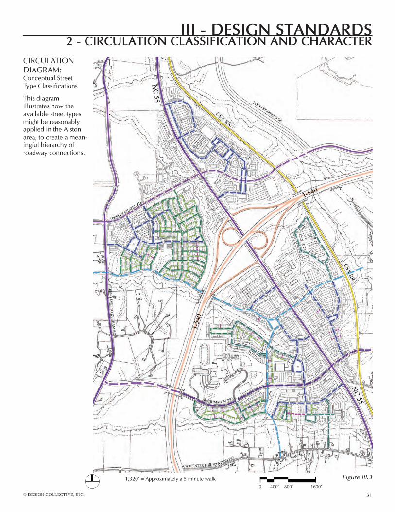
The Circulation Diagram: Conceptual Street Type Classifications illustrates the circulation route locations and types. The table following the Street Type Classifications diagram adds descriptions of typical locations for each circulation type. A menu of circulation typical plans gives specific dimensions for the character of the various circulation route types.
The prescriptions documented in this chapter are critical in order to achieve the pedestrian-friendly network of streets vital to a walkable, sustainable new community.
GeneRAL PRovISIonSThe Circulation Plans found within this section vary from the current Town of Cary Street Design Standards and shall apply to the Alston ACCP only. The Alston ACCP calls for a pedestrian-oriented, mixed-use community design that requires comprehensive changes to all aspects of planning including street design. The typical plan variations for non-thoroughfares depend upon a recommended 25 mph posted speed limit, naturally integrated traffic calming measures such as frequent intersections, on-street parking, bends in the streets and similar, and approval by the Town of Cary Planning and engineering Departments.
Transitions from one Circulation Type or Character to another shall be designed to ensure smooth changes between paving, parking, sidewalks, planting strips and similar.
In exceptional cases, the engineering and Planning Departments may require alternative street sections depending on specific site conditions and/or to address safety and/or traffic flow issues. At an intersection where two different circulation route types meet (with the exception of alleys) the larger curb radius range shall be used. variations shall require approval by the Town of Cary Planning and engineering Departments.
Crosswalks of a different paving material, texture and color from the asphalt street are encouraged where sidewalks traverse vehicular travel lanes. Crosswalks with brick pavers with flashing (variation) are preferred in the Town Center, neighborhood Center and Special District zones. Paving materials shall be approved by the Town of Cary Planning and Public Works and Utilities Departments.
Landscaping, including median and street tree plantings, shall be planted and maintained by the property owner(s), developers, homeowner’s associations and/or other private entities. Landscaping within the I-540 and nC 55 interchange, as described in the entry A: I-540 Gateway in Chapter III part 3 of the document, is encouraged to be provided by, but is not the responsibility of the developers of the property located in each quadrant of the interchange.
General Provisions for Street Trees:A single species of tree or a small group of complementary tree species as approved by the Town of Cary Planning Department, shall be consistent along an entire circulation route (the length of the street), but shall vary from one circulation route to the next. For example, one street may have Hedge Maples and Southern Sugar Maples, while the next street over may have White oaks, Laurel oaks and Red oaks. Refer to the Town of Cary Community Appearance Manual for approved tree species. Where street length exceeds 2,400 feet, larger or more varied groups of complementary tree species shall be used to avoid a
1.
2.
3.
4.
5.
6.a.

© DESIGN COLLECTIVE, INC.
III - desIgn standards
29
2 - cIrculatIon classIfIcatIon and character
monoculture. The Town of Cary may approve or require variations in the width of planting strips between curb and sidewalk from those shown in the following Circulation Plans and Sections, depending on the species of street tree selected, planting technology or methods used and engineering design of the back of curb and sidewalk. Final planting strip width will be determined at site development plan stage.Trees shall be planted at regular intervals along circulation routes appropriate to the particular location and species. Refer to the Town of Cary Community Appearance Manual for approved tree species and planting intervals.Street trees are required along all new internal circulation routes and existing Town/State circulation routes, except where such circulation routes are adjacent to existing wooded areas, and existing trees are sufficient as shown on a site development plan and approved by the Town of Cary Planning Department. Trees and other plantings within nCDoT controlled and maintained right-of-ways shall meet nCDoT standards (refer to nCDoT Guidelines for Planting within Highway Right-of-Way).Street trees shall be placed in planting strips within the public right-of-way, set 3 feet minimum from curb face and centered in the planting strip or within minimum 4 foot by 6 foot planting pits within sidewalks or hardscape areas.Street trees shall be placed a minimum of 3’ off the edge of greenways and multi-use trails. Street trees shall be placed to align where possible with lot lines and to screen walls of units so as to frame and not block the front porches, stoops and doors of units. Landscape maintenance plans should address limbing streetscape trees. In order to create comfortable pedestrian passage, street trees shall have their limbs pruned over sidewalks to approximately 7 feet above grade when reasonably mature. Street trees shall be straight and true, have healthy trunks and a full, balanced crown and branching habit. Street trees with unbalanced crowns, a poor branching habit, and excessively bent or curved trunks will be rejected and shall, if deemed necessary by the Town of Cary Planning Department, be replaced.
The typical plans for Collector, Street A, and Street B circulation types found in this section of the Alston ACCP, when applied to residential development, were designed to be used with an alley-loaded housing product. When an alley-loaded product is not used for at least 60% of a residential development, then alternate parking provisions shall be provided equal to an additional 0.25 parking spaces per dwelling unit.
b.
c.
d.
e.
f.g.
h.
7.

III - desIgn standards
30
2 - cIrculatIon classIfIcatIon and character
Planned or approved by nCDoT full- service intersection
Recommended full-service intersection
Recommended right-in/right-out and left-over intersection
Recommended right-in/right-out thoroughfare access point
Collector Street
Street A from Thoroughfare to a connection with a Collector
Street A extending from Thoroughfare to a connection with another Street A, Collector, or Thor-oughfare
CIRCULATIon DIAGRAM: Recommended Locations and Types of Intersections, Access Points, Collector Streets, and Street A Conceptual Locations
The recommended thoroughfare intersec-tions and access points shown on this diagram are subject to approval by nCDoT.
Figure III.2
© DESIGN COLLECTIVE, INC.
III - desIgn standards
31
2 - cIrculatIon classIfIcatIon and character
CIRCULATIon DIAGRAM: Conceptual Street Type Classifications
This diagram illustrates how the available street types might be reasonably applied in the Alston area, to create a mean-ingful hierarchy of roadway connections.
0 400’ 800’ 1600’
1,320’ = Approximately a 5 minute walk Figure III.3

III - desIgn standards
32
2 - cIrculatIon classIfIcatIon and character
CLASSIFICATIon PUBLIC oR PRIvATe DeSIGnATIon
DeSCRIPTIon oF TyPICAL LoCATIon
I-540 (FReeWAy) See nCDoT standards location set by nCDoT
THoRoUGHFARe public location set by Town of Cary
CoLLeCToR public location set by Town of Cary
STReeT A public or private
Street A provides connectivity between thoroughfares and collectors and/or from
thoroughfares and/or collectors to Street B types. Street A types are typically
found in mixed-use areas, commercial areas, and office areas, but may also be
found in residential areas.
STReeT B public or private
Street B provides circulation through residential areas. Street B types
connect with thoroughfares, collectors, and/or Street A types.
ALLey privateAlleys may provide connectivity along the
rear of residential lots between Street A and/or Street B types.
PASSAGe private Passages provide mid-block pedestrian connections through residential areas.
CSX RAIL LIne existing location
CIRCULATIon CLASSIFICATIonS
noTeS
1. Providing connectivity throughout the Alston Regional Activity Center is key; the circulation diagram illustrates a high degree of roadway connectivity.
2. Thoroughfare and collector locations are set.
3. Alleys are optional.
4. Both public and private streets should conform to the menu of typical plan diagrams contained in this document.

© DESIGN COLLECTIVE, INC.
III - desIgn standards
33
2 - cIrculatIon classIfIcatIon and character
: Travel Lanes : Travel Lanes widened for shared vehicle and bicycle useP(a) : Parking (angled)P(p) : Parking (parallel)c : Curb and GutterPl : Planting StripSW : SidewalkSB : SetbackMU : Multi-Use Trailr : Curb Radius
b b
Building Footprint
Tree in Pit (plan)
Crosswalk
Tree in Planting Strip (plan)
Tree in Planting Strip (section)
Tree in Pit (section)
Key for Cross Sections and Typical Plans on Pages 34 - 41

Right-of-Way varies25’SB
25’SB
III - desIgn standards
34
2 - cIrculatIon classIfIcatIon and character
thoroughfare:
Right-of-Way varies30’SB
30’SB
•Dimensions within the Right-of-Way and curb radii shall be as per the Town of Cary Comprehensive Plan. •Twenty-five to thirty foot setbacks are required along Thoroughfares.•Trees and other plantings within NCDOT controlled and maintained right-of-ways are subject to NCDOT approval (refer to nCDoT Guidelines for Planting within Highway Right-of-Way).
© DESIGN COLLECTIVE, INC.
III - desIgn standards
35
2 - cIrculatIon classIfIcatIon and character
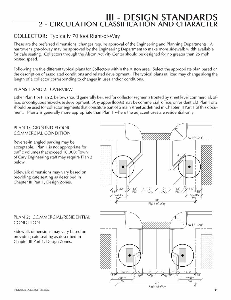
collector: Typically 70 foot Right-of-WayThese are the preferred dimensions; changes require approval of the engineering and Planning Departments. A narrower right-of-way may be approved by the engineering Department to make more sidewalk width available for cafe seating. Collectors through the Alston Activity Center should be designed for no greater than 25 mph posted speed.
Following are five different typical plans for Collectors within the Alston area. Select the appropriate plan based on the description of associated conditions and related development. The typical plans utilized may change along the length of a collector corresponding to changes in uses and/or conditions.
PLAnS 1 AnD 2: oveRvIeW
either Plan 1 or Plan 2, below, should generally be used for collector segments fronted by street level commercial, of-fice, or contiguous mixed-use development. (Any upper floor(s) may be commercial, office, or residential.) Plan 1 or 2 should be used for collector segments that constitute part of a main street as defined in Chapter III Part 1 of this docu-ment. Plan 2 is generally more appropriate than Plan 1 where the adjacent uses are residential-only
PLAn 1: GRoUnD FLooR CoMMeRCIAL ConDITIon
Reverse-in angled parking may be acceptable. Plan 1 is not appropriate for traffic volumes that exceed 10,000; Town of Cary engineering staff may require Plan 2 below.
Sidewalk dimensions may vary based on providing cafe seating as described in Chapter III Part 1, Design Zones.
PLAn 2: CoMMeRCIAL/ReSIDenTIAL ConDITIon
Sidewalk dimensions may vary based on providing cafe seating as described in Chapter III Part 1, Design Zones.
r=15’-20’
45˚
8.5’ 12’ 12’ 12’ 12’ 8.5’
SW
P(a) P(a)
SW
b bSB SBvARIeS vARIeS
14.5’ 6’ 12’ 12’ 14.5’
SW
P(p)
SW
6’P(p) SBb bSB
vARIeS vARIeS
r=15’-20’
2.5’
2.5’
c c
70’Right-of-Way
2.5’
c
2.5’
c
70’Right-of-Way
III - desIgn standards
36
2 - cIrculatIon classIfIcatIon and character
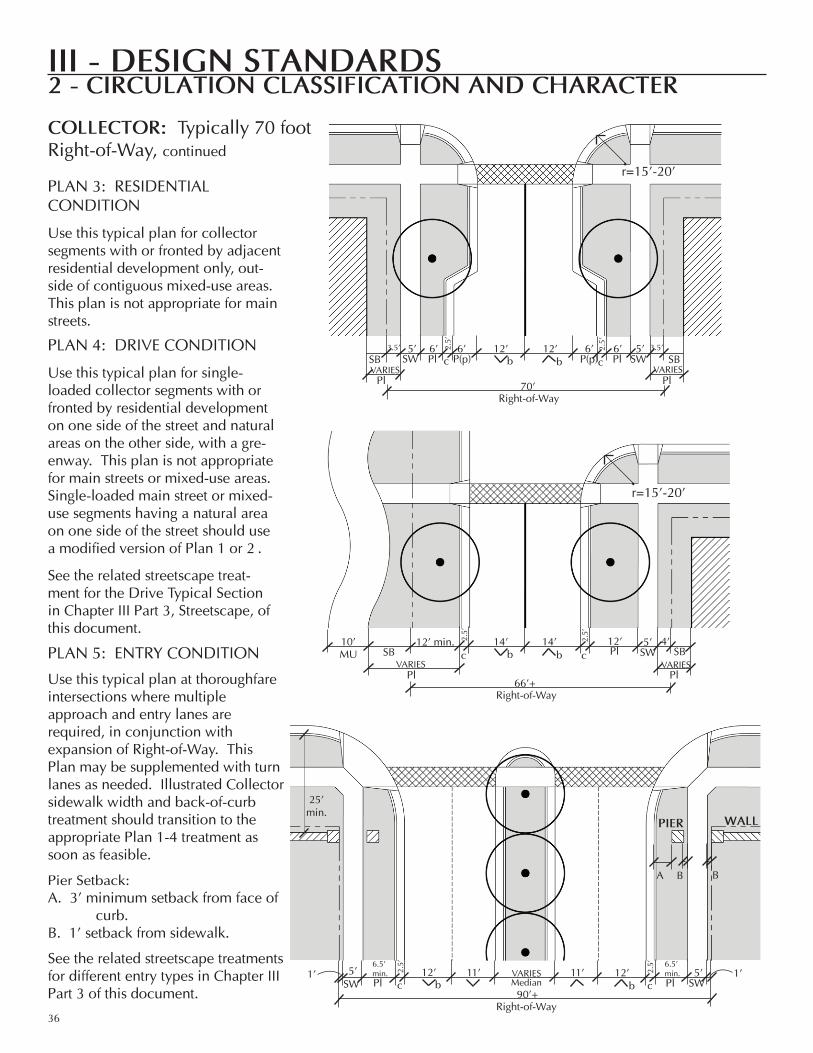
collector: Typically 70 foot Right-of-Way, continued
PLAn 3: ReSIDenTIAL ConDITIon
Use this typical plan for collector segments with or fronted by adjacent residential development only, out-side of contiguous mixed-use areas. This plan is not appropriate for main streets.
PLAn 4: DRIve ConDITIon
Use this typical plan for single-loaded collector segments with or fronted by residential development on one side of the street and natural areas on the other side, with a gre-enway. This plan is not appropriate for main streets or mixed-use areas. Single-loaded main street or mixed-use segments having a natural area on one side of the street should use a modified version of Plan 1 or 2 .
See the related streetscape treat-ment for the Drive Typical Section in Chapter III Part 3, Streetscape, of this document.
PLAn 5: enTRy ConDITIon
Use this typical plan at thoroughfare intersections where multiple approach and entry lanes are required, in conjunction with expansion of Right-of-Way. This Plan may be supplemented with turn lanes as needed. Illustrated Collector sidewalk width and back-of-curb treatment should transition to the appropriate Plan 1-4 treatment as soon as feasible.
Pier Setback:A. 3’ minimum setback from face of curb.B. 1’ setback from sidewalk.
See the related streetscape treatments for different entry types in Chapter III Part 3 of this document.
A B B
r=15’-20’
3.5’ 5’ 12’ 12’ 5’ 3.5’
SW P(p) P(p) SWb b6’ 6’ 6’ 6’
PlPlvARIeS
SB
12’ min. 14’ 14’ 5’ 4’SWb b
12’Pl
Pl
SB
PlvARIeS
10’MU
25’ min.
Wall
Pl Pl
SBvARIeS
SB
6.5’ min. 12’ 12’ 5’
90’+Right-of-Way
SWb bPl Pl11’5’
SW11’
MedianvARIeS 1’1’
r=15’-20’
2.5’
2.5’
c c
70’Right-of-Way
vARIeS
2.5’
2.5’
c c
66’+Right-of-Way
PIer
6.5’ min.
2.5’
c
2.5’
c

45˚
© DESIGN COLLECTIVE, INC.
III - desIgn standards
37
2 - cIrculatIon classIfIcatIon and character
street a: Typically 62 foot Right-of-WayThese are the preferred dimensions; changes require approval of the engineering and Planning Departments. A narrower right-of-way may be approved by the engineering Department to make more sidewalk width available for cafe seating.
Following are four different typical plans for Street A Circulation Types within the Alston area. Please select the appro-priate plan based on the description of associated conditions and related development.
PLAnS 1 AnD 2: oveRvIeW
either Plan 1 or Plan 2, below, should generally be used for Street A segments fronted by street level commercial, of-fice, or contiguous mixed-use development. (Any upper floor(s) may be commercial, office, or residential.) Plan 1 or 2 should be used for Street A segments that constitute part of a main street as defined in Chapter III Part 1. Plan 1 is generally more appropriate than Plan 2 on Street A segments where the adjacent uses are residential-only.
PLAn 1: CoMMeRCIAL/ReSIDenTIALConDITIon
Sidewalk dimensions may vary based on providing cafe seating as described in Chapter III Part 1, Design Zones.
PLAn 2: GRoUnD FLooR CoMMeRCIAL ConDITIon
Reverse-in angled parking may be accept-able.
Sidewalk dimensions may vary based on pro-viding cafe seating as described in Chapter III Part 1, Design Zones.
r=10’-15’
11.5’ 6’ 11’ 11’ 6’ 11.5’
62’Right-of-Way (or private street dimension)
SW
P(p) P(p)
SW
SB SBvARIeS vARIeS
6.5’ 12’ 11’ 11’ 12’ 6.5’
SW
P(a) P(a)
SW64’
Right-of-Way (or private street dimension)
b bSB SBvARIeS vARIeS
r=10’-15’
2.5’
2.5’
c c
2.5’
2.5’
c c
III - desIgn standards
38
2 - cIrculatIon classIfIcatIon and character
street a: Typically 62 foot Right-of-Way, continued
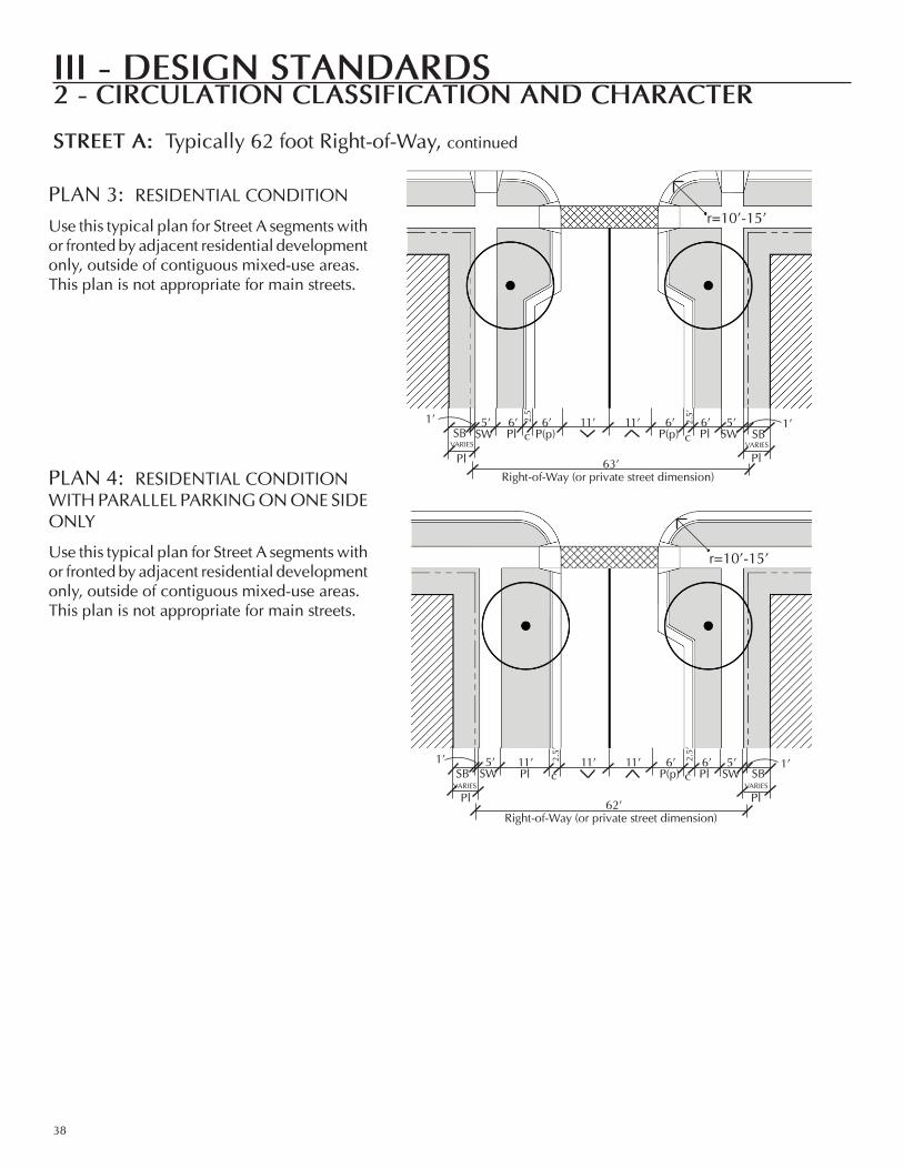
PLAn 3: ReSIDenTIAL ConDITIon
Use this typical plan for Street A segments with or fronted by adjacent residential development only, outside of contiguous mixed-use areas. This plan is not appropriate for main streets.
PLAn 4: ReSIDenTIAL ConDITIonWITH PARALLeL PARKInG on one SIDe onLy
Use this typical plan for Street A segments with or fronted by adjacent residential development only, outside of contiguous mixed-use areas. This plan is not appropriate for main streets.
r=10’-15’
r=10’-15’
6’ 11’ 11’ 5’6’SW
6’PlPl SBP(p)
5’SW
6’P(p)
vARIeSSB
11’ 11’ 11’ 5’6’SW
6’PlPl SBP(p)
5’SW
vARIeSSB
1’1’
1’1’ 2.5’
2.5’
c c
2.5’
2.5’
c c
PlvARIeS
Pl
PlvARIeS
Pl
63’Right-of-Way (or private street dimension)
62’Right-of-Way (or private street dimension)
© DESIGN COLLECTIVE, INC.
III - desIgn standards
39
2 - cIrculatIon classIfIcatIon and character
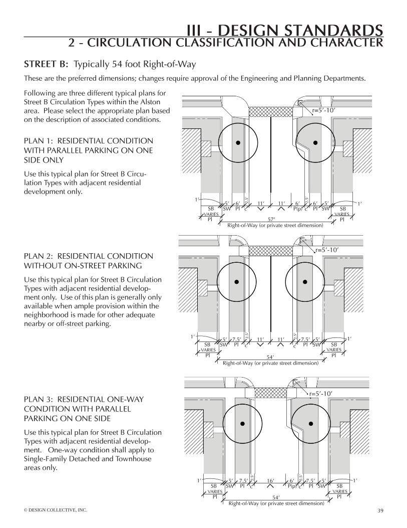
street B: Typically 54 foot Right-of-WayThese are the preferred dimensions; changes require approval of the engineering and Planning Departments.
PLAn 1: ReSIDenTIAL ConDITIon WITH PARALLeL PARKInG on one SIDe onLy
Use this typical plan for Street B Circu-lation Types with adjacent residential development only.
r=5’-10’
6’ 11’ 11’ 5’6’SW
6’PlPl
vARIeSSBP(p)
5’SW
vARIeSSB
1’1’
PLAn 2: ReSIDenTIAL ConDITIonWITHoUT on-STReeT PARKInG
Use this typical plan for Street B Circulation Types with adjacent residential develop-ment only. Use of this plan is generally only available when ample provision within the neighborhood is made for other adequate nearby or off-street parking.
PLAn 3: ReSIDenTIAL one-WAyConDITIon WITH PARALLeL PARKInG on one SIDe
Use this typical plan for Street B Circulation Types with adjacent residential develop-ment. one-way condition shall apply to Single-Family Detached and Townhouse areas only.
7.5’ 11’ 11’ 5’SW
7.5’PlPl
vARIeSSB
5’SW
vARIeSSB
1’1’
r=5’-10’
r=5’-10’
7.5’ 16’ 5’SW
7.5’PlPl
vARIeSSB
5’SW
vARIeSSB
6’P(p)
1’1’
Following are three different typical plans for Street B Circulation Types within the Alston area. Please select the appropriate plan based on the description of associated conditions.
2.5’
2.5’
c c
2.5’
2.5’
c c
2.5’
2.5’
c c
PlPl
Pl Pl
Pl Pl
57’Right-of-Way (or private street dimension)
54’Right-of-Way (or private street dimension)
54’Right-of-Way (or private street dimension)
III - desIgn standards
40
2 - cIrculatIon classIfIcatIon and character
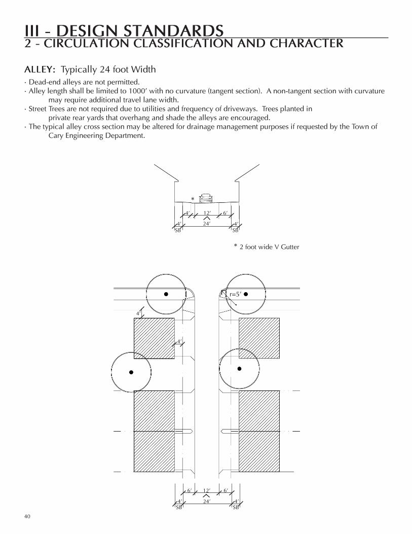
alleY: Typically 24 foot Width
r=5’
•Dead-end alleys are not permitted.•Alley length shall be limited to 1000’ with no curvature (tangent section). A non-tangent section with curvature may require additional travel lane width.•Street Trees are not required due to utilities and frequency of driveways. Trees planted in private rear yards that overhang and shade the alleys are encouraged. •The typical alley cross section may be altered for drainage management purposes if requested by the Town of Cary engineering Department.
4’
4’
12’
24’
6’
SB4’
SB
6’
4’
* 2 foot wide v Gutter
*12’
24’
4’
SB4’
SB
6’
4’
Pass
age
Pass
age
Sidewalk Sidewalk
StreetStreet
© DESIGN COLLECTIVE, INC.
III - desIgn standards
41
2 - cIrculatIon classIfIcatIon and character
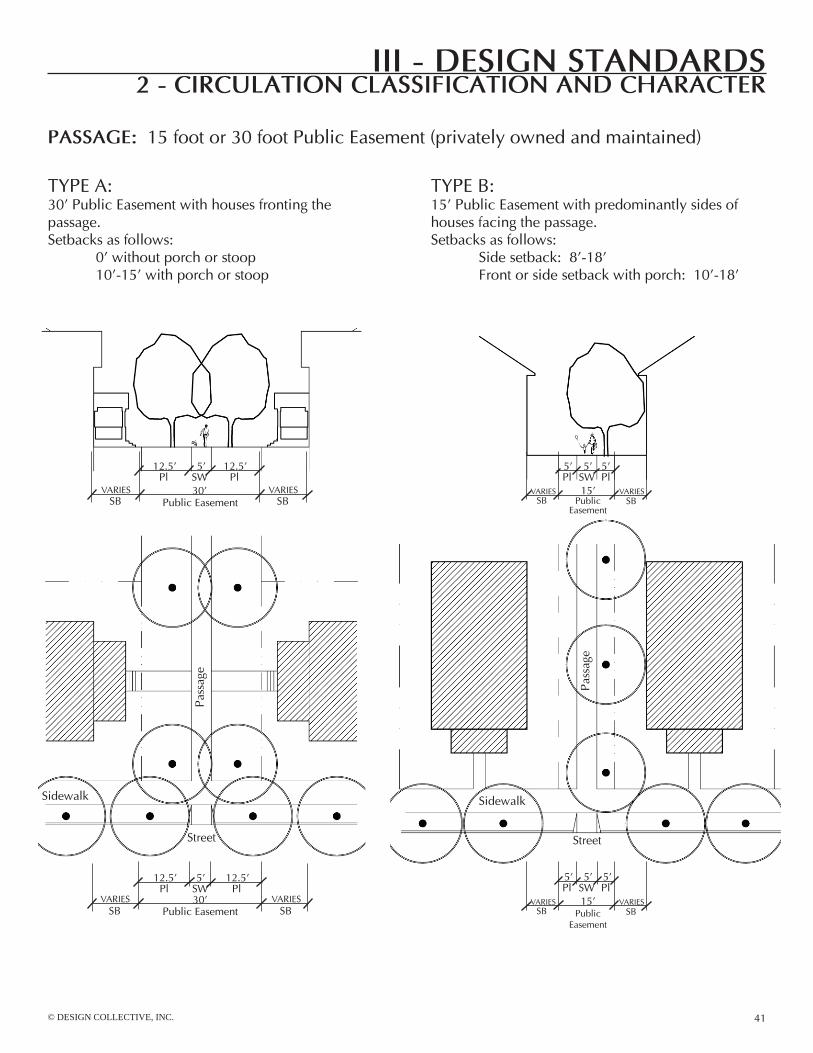
Passage: 15 foot or 30 foot Public easement (privately owned and maintained)
TyPe A:30’ Public easement with houses fronting the passage. Setbacks as follows: 0’ without porch or stoop 10’-15’ with porch or stoop
TyPe B:15’ Public easement with predominantly sides of houses facing the passage. Setbacks as follows: Side setback: 8’-18’ Front or side setback with porch: 10’-18’
5’
30’
12.5’
SB
12.5’
vARIeSSW
SBvARIeS
Pl Pl
5’
30’Public easement
12.5’
SB
12.5’
vARIeSSW
SBvARIeS
Pl Pl5’
15’
5’
SBvARIeS
SW
SBvARIeS
Pl5’Pl
5’
15’
5’
SBvARIeS
SW
SBvARIeS
Pl5’Pl
Public easement
Public easement Public easement
III - desIgn standards
42
3 - streetscape entrIes and sectIons
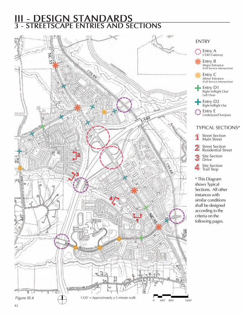
* This Diagram shows Typical Sections. All other instances with similar conditions shall be designed according to the criteria on the following pages.
0 400’ 800’ 1600’1320’ = Approximately a 5 minute walkFigure III.4
enTry
TypIcAl SecTIonS*
entry AI-540 Gateway
entry BMajor entrance(Full Service Intersection)
entry cMinor entrance(Full Service Intersection)
entry D1right In/right out/left over
entry D2right In/right out
entry eUnderpass/overpass
1234
Street SectionMain Street
Street Sectionresidential StreetSite SectionDriveSite SectionTrail Stop

© DESIGN COLLECTIVE, INC.
III - desIgn standards
43
3 - streetscape entrIes and sectIons
GenerAl provISIonS For All STreeTScApe enTrIeS
STreeTScApe eleMenTS AnD The AlSTon SeAlThe consistency in character and quality of the entry features and streetscapes throughout Alston will define the identity of this area as a special destination. The provisions in this chapter will ensure that the quality of each piece of development is up-held and that each piece of development adds to the character of Alston.
one of the streetscape elements that will tie the Alston area together as a unified place is the brick pier. The piers are required at the entries (as described on the following pages) into neighborhoods or developments and include a repeating seal unique to the Alston area. neighborhood nameplates identifying Alston center, Mccrimmon, evans Farm, parkside, or petty Farm shall be included with all entry B features. For example, the pier could announce entry into the parkside neighborhood as shown in the illustration at right.
The repeating seal for Alston has been designed by a local artist, catherine parrish. Specifications are available from the Town of cary planning Department. The Alston seal shall be included as part of the uniform sign plan for each project. The artist’s logo design is an important part of the required streetscape entry features located on Figure III.4.
SIGnAGeIf part of a required Streetscape entry Feature, a double-faced sign (see diagram below) with an interior angle that is 90 de-grees or less shall have only one display face measured in com-puting sign area.
1.
2.
TypIcAl SecTIonS*
III - desIgn standards
44
3 - streetscape entrIes and sectIons
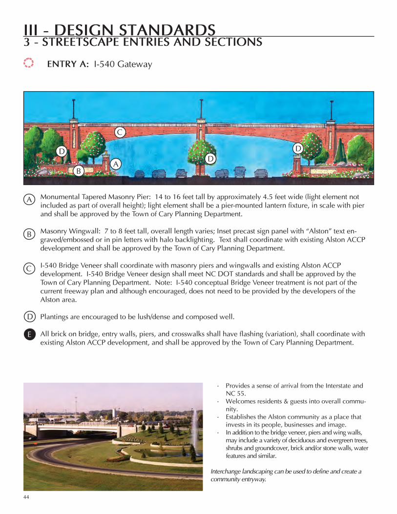
entry a: I-540 Gateway
provides a sense of arrival from the Interstate and nc 55.Welcomes residents & guests into overall commu-nity.establishes the Alston community as a place that invests in its people, businesses and image.In addition to the bridge veneer, piers and wing walls, may include a variety of deciduous and evergreen trees, shrubs and groundcover, brick and/or stone walls, water features and similar.
Interchange landscaping can be used to define and create a community entryway.
•
•
•
•
AB
c
DDD
Monumental Tapered Masonry pier: 14 to 16 feet tall by approximately 4.5 feet wide (light element not included as part of overall height); light element shall be a pier-mounted lantern fixture, in scale with pier and shall be approved by the Town of cary planning Department.
Masonry Wingwall: 7 to 8 feet tall, overall length varies; Inset precast sign panel with “Alston” text en-graved/embossed or in pin letters with halo backlighting. Text shall coordinate with existing Alston Accp development and shall be approved by the Town of cary planning Department.
I-540 Bridge veneer shall coordinate with masonry piers and wingwalls and existing Alston Accp development. I-540 Bridge veneer design shall meet nc DoT standards and shall be approved by theTown of cary planning Department. note: I-540 conceptual Bridge veneer treatment is not part of the current freeway plan and although encouraged, does not need to be provided by the developers of the Alston area.
plantings are encouraged to be lush/dense and composed well.
All brick on bridge, entry walls, piers, and crosswalks shall have flashing (variation), shall coordinate with existing Alston Accp development, and shall be approved by the Town of cary planning Department.
D
c
A
B
e

© DESIGN COLLECTIVE, INC.
III - desIgn standards
45
3 - streetscape entrIes and sectIons
entry B: Major entrance - Full Service Intersection
Welcomes residents & guests off nc 55 arte-rial and into Town center and neighborhoods.Shall include unique building elements, pe-destrian elements such as benches and waste receptacles, decorative paving, signage, water, plantings and similar.
landscaping, walls, columns, and other elements announce a major community entrance.
•
•
A AB c c
D
e
F
Tapered Masonry pier: 8 to 10 feet tall by approximately 3 feet wide (optional light element not included as part of overall height); 3 feet minimum off curb, 1 foot off sidewalk; optional pier-mounted light shall be a lantern fixture, in scale with pier and shall be approved by the Town of cary planning Department. Masonry Wingwall: 5 to 7 feet tall; overall length varies. May include sign panel with development and/or neighborhood name. Text shall coordinate with existing Alston Accp development and shall be approved by the Town of cary planning Department.
Signature light Fixture with Thematic Banners: 12 to 16 feet tall; light shall be a pole-mounted acorn fixture, coordinating with existing Alston Accp development and shall be approved by the Town of cary planning Department.
covered Bus Shelter: Shall be architecturally compatible with other streetscape elements and existing Accp development; shall meet Town of cary c-Tran and/or Triangle Transit Authority (TTA) Standards (refer to TTA Amenities Standards).
Street Trees: Shall be set 3 feet minimum off curb and 3 feet minimum off edge of greenways and multi-use trails (refer to the Town of cary community Appearance Manual for approved tree species).
Seasonal planting and evergreen shrubs.
pedestrian elements such as benches, bike racks, waste receptacles and similar shall be decorative and shall coordinate in color and character with other streetscape elements and existing Accp development.
All brick on entry walls, piers and crosswalks shall have flashing (variation), shall coordinate with existing Alston Accp development, and shall be approved by the Town of cary planning Department.
A
D
F
e
c
B
G
h

III - desIgn standards
46
3 - streetscape entrIes and sectIons
entry c: Minor entrance - Full Service Intersection
Transition from arterials (such as nc 55) or resi-dential streets into a more urban setting.Shall include unique building elements, pedestrian elements such as benches and waste receptacles, decorative paving, signage, plantings, and similar.
landscaping, columns, and pedestrian elements signify a special transition.
•
•
D
c
B
A
c
Tapered Masonry pier: 8 to 10 feet tall by approximately 3 feet wide (optional light element not included as part of overall height); 3 feet minimum off curb, 1 foot off sidewalk; optional pier-mounted light shall be a lantern fixture, in scale with pier and shall be approved by the Town of cary planning Department.
light Fixture: 10 to 14 feet tall; street signage and seasonal planting incorporated into fixture; light shall be a pole-mounted acorn fixture, coordinating with existing Alston Accp development and be approved by the Town of cary planning Department.
Street Trees: Shall be set 3 feet minimum off curb and 3 feet minimum off edge of greenways and multi-use trails (refer to the Town of cary community Appearance Manual for approved tree species).
Seasonal planting.
pedestrian elements such as benches, bike racks, waste receptacles and similar shall be decorative and shall coordinate in color and character with other streetscape elements and existing Accp development. All brick on entry walls, piers and crosswalks shall have flashing (variation), shall coordinate with existing Alston Accp development, and shall be approved by the Town of cary planning Department.
A
B
c
D
e
F

© DESIGN COLLECTIVE, INC.
III - desIgn standards
47
3 - streetscape entrIes and sectIons
For use at important entries where a traffic signal cannot be provided.Typically includes a median and one or two travel lanes in each direction to accommodate turning lanes and no parking at the immediate entry.The entry may be demarcated by piers, wall signage, planting, significant building elements, etc.
landscaping, walls, columns, and other elements define key intersections into different segments of a community.
•
•
•
BA
cD
e
F
GG
hhh
Tapered Masonry pier: 8 to 10 feet tall by approximately 3 feet wide (optional light element not included as part of overall height); 3 feet minimum off curb, 1 foot off sidewalk; optional pier-mounted light shall be a lantern fixture, in scale with pier and shall be approved by the Town of cary planning Department. Water Feature with Sculptural Water element: 1.5 to 3 feet tall; optional piers as part of water basin shall be approximately 3 feet wide and a maximum of 4 feet tall. public art may be an alternative to a fountain; other alternatives may be approved by the planning Director. Masonry pier (to match piers which are part of water basin): approximately 3 feet wide and a maximum of 4 feet tall. Masonry Wingwall: 2.5 to 3 feet tall; overall length varies. May include sign panel with development and/or neighborhood name. Text shall coordinate with existing Alston Accp development and shall be approved by the Town of cary planning Department.
Signature light Fixture: 12 to 16 feet tall; light shall be a double arm pole-mounted acorn fixture, coordinating with existing Alston Accp development and shall be approved by the Town of cary planning Department.
ornamental Trees in Median (refer to the Town of cary community Appearance Manual for approved tree species).
Street Trees: Shall be set 3 feet off curb and 3 feet minimum off edge of greenways and multi-use trails (refer to the Town of cary community Appearance Manual for approved trees).
Seasonal planting.
All brick on entry walls, piers and crosswalks shall have flashing (variation), shall coordinate with existing Alston Accp development, and shall be approved by the Town of cary planning Department.
A
D
F
e
c
G
h
B
I
entry d1: right In / right out Intersection
entry d2: right In / right out / left over Intersection
III - desIgn standards
48
3 - streetscape entrIes and sectIons
Serves as a gateway, welcoming residents & guests into a particular part of the community.Material options include brick, stone, pre-cast concrete, and combinations thereof.May include a variety of deciduous and evergreen trees, shrubs and groundcover, brick and/or stone walls, water features and similar.
Underpass and overpass treatments may be defined by use of materials and landscaping.
•
•
•
entry e: Underpass•Underpass at East-West Collector and I-540, linking Evans Farm with Alston Center Tapered Masonry pier:6 to 10 feet tall by approximately 3 feet wide (light element not included as part of overall height); light element shall be a pier-mounted lantern fixture, in scale with pier and shall be approved by the Town of cary planning Department.
Masonry Wingwall: 4-6 feet tall; overall length varies. May include sign panel with development and/or neighborhood name. Text shall coordinate with existing Alston Accp development and shall be approved by the Town of cary planning Department.
Bench: Shall be integral to wingwall or surface mounted.
I-540 Bridge veneer shall coordinate with masonry piers and wingwalls and existing Alston Accp development. I-540 Bridge veneer design shall meet nc DoT standards and shall be approved by the Town of cary planning Department. conceptual Bridge veneer treatment is encouraged, but does not need to be provided by the developers of the Alston area.
plantings are encouraged to be lush/dense and composed well.
entry e: overpass•Overpass of O’Kelly Chapel over the CSX Rail line (If an at-grade crossing is approved, the provision below does not apply.)•Overpass of McCrimmon Parkway over the CSX Rail line•Overpass of McCrimmon Parkway over I-540Bridge veneer is optional since it is likely to be visible only from the railroad or freeway. If used, it shall coordinate with existing Alston Accp development. Signature piers and light elements on the bridge deck are encouraged to be incorporated into the overpass design. Bridge veneer and/or deck element design shall meet ncDoT standards and shall be approved by the Town of cary planning Department. conceptual Bridge veneer treatment does not need to be provided by the developers of the Alston area.
A
D
e
c
B
D
© DESIGN COLLECTIVE, INC.
III - desIgn standards
49
3 - streetscape entrIes and sectIons
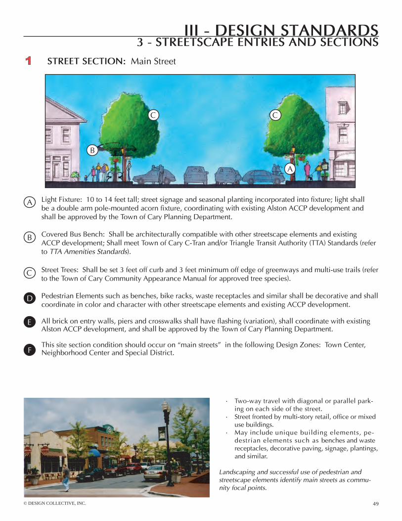
street sectIon: Main Street
Two-way travel with diagonal or parallel park-ing on each side of the street.Street fronted by multi-story retail, office or mixed use buildings.May include unique building elements, pe-destrian elements such as benches and waste receptacles, decorative paving, signage, plantings, and similar.
landscaping and successful use of pedestrian and streetscape elements identify main streets as commu-nity focal points.
•
•
•
A
B
cc
light Fixture: 10 to 14 feet tall; street signage and seasonal planting incorporated into fixture; light shallbe a double arm pole-mounted acorn fixture, coordinating with existing Alston Accp development and shall be approved by the Town of cary planning Department.
covered Bus Bench: Shall be architecturally compatible with other streetscape elements and existing Accp development; Shall meet Town of cary c-Tran and/or Triangle Transit Authority (TTA) Standards (refer to TTA Amenities Standards).
Street Trees: Shall be set 3 feet off curb and 3 feet minimum off edge of greenways and multi-use trails (refer to the Town of cary community Appearance Manual for approved tree species).
pedestrian elements such as benches, bike racks, waste receptacles and similar shall be decorative and shall coordinate in color and character with other streetscape elements and existing Accp development.
All brick on entry walls, piers and crosswalks shall have flashing (variation), shall coordinate with existing Alston Accp development, and shall be approved by the Town of cary planning Department.
This site section condition should occur on “main streets” in the following Design Zones: Town center, neighborhood center and Special District.
A
c
B
D
e
F

III - desIgn standards
50
3 - streetscape entrIes and sectIons
street sectIon: residential
can be one or two-way travel with parallel park-ing on one or both sides.Includes a planting strip for street trees and light poles, sidewalk, and setback to porch or stoop.
landscaping and pedestrian elements help to define a residential street.
•
•
A
B B
light Fixture: 10 to 14 feet tall; light shall be a double arm pole-mounted acorn fixture, coordinating with existing Alston Accp development and shall be approved by the Town of cary planning and engineering Departments.
Street Trees: Shall be set a minimum of 3 feet off of curb and centered in planting strip and/or set a minimum of 3 feet off the edge of greenways and multi-use trails (refer to the Town of cary community Appearance Manual for approved tree species).
pedestrian elements such as benches, bike racks, waste receptacles and similar shall be decorative and shall coordinate in color and character with other streetscape elements and existing Accp development.
This site section condition may occur in the following Design Zones: neighborhood center (within residential areas), neighborhood General and neighborhood edge.
A
B
c
D

© DESIGN COLLECTIVE, INC.
III - desIgn standards
51
3 - streetscape entrIes and sectIons
Where indicated on the Streetscape Diagram, the Streetscape shall include a neighborhood entry, welcoming people into a specific part of the community.entries may take the form of pier signage, wall signage, cantilever signs, plantings with low walls, ornamental fence, pavilion, or other small structure(s).community signage that consists of similar materials, font styles and plantings establish continuity.
landscaping, walls, and pedestrian elements provide definition of and transition between the natural and built environment.
•
•
•
sIte sectIon: Drive
A Bc
DD
eF
Tapered Masonry pier: 8 to 10 feet tall by approximately 3 feet wide (optional light element not included as part of overall height); 3 feet minimum off curb, 1 foot off sidewalk; optional pier-mounted light shall be a lantern fixture, in scale with pier and shall be approved by the Town of cary planning Department.
Masonry Wingwall: 2.5 to 3 feet tall; overall length varies.
Bollard lighting (or other trail lighting as approved by the Town): Spaced evenly along sidewalk, path or multi-use trail; trail may also be lit with street lights only as the trail meanders adjacent to the street paving if adequate light levels can be met.
Street Trees: Shall be set a minimum of 3 feet off of curb and centered in planting strip and/or set a minimum of 3 feet off the edge of greenways and multi-use trails (refer to the Town of cary community Appearance Manual for approved tree species).
Seasonal planting.
Interpretive Signage: Identifying natural features.
light Fixture (not shown in section): 10 to 14 feet tall; shall be a pole-mounted acorn fixture, coordinating with existing Alston Accp development and shall be approved by the Town of cary planning Department.
This site section condition should occur where a single-loaded street runs adjacent to a natural area in the following Design Zones: Town center, neighborhood center, neighborhood General and neighborhood
A
D
F
e
c
B
G
3
h
III - desIgn standards
52
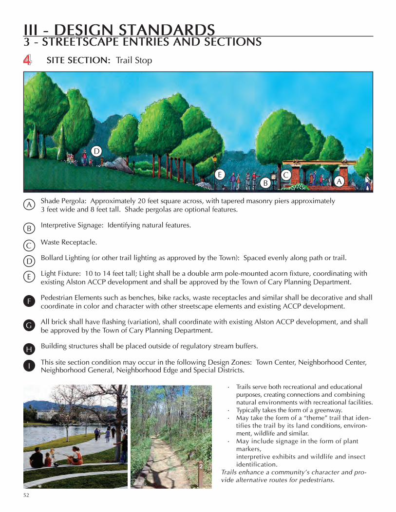
3 - streetscape entrIes and sectIonssIte sectIon: Trail Stop
Trails serve both recreational and educational purposes, creating connections and combining natural environments with recreational facilities.Typically takes the form of a greenway. May take the form of a “theme” trail that iden-tifies the trail by its land conditions, environ-ment, wildlife and similar.May include signage in the form of plant markers, interpretive exhibits and wildlife and insect identification.
Trails enhance a community’s character and pro-vide alternative routes for pedestrians.
•
••
•
ABc
D
e
4
Shade pergola: Approximately 20 feet square across, with tapered masonry piers approximately3 feet wide and 8 feet tall. Shade pergolas are optional features.
Interpretive Signage: Identifying natural features. Waste receptacle.
Bollard lighting (or other trail lighting as approved by the Town): Spaced evenly along path or trail.
light Fixture: 10 to 14 feet tall; light shall be a double arm pole-mounted acorn fixture, coordinating withexisting Alston Accp development and shall be approved by the Town of cary planning Department.
pedestrian elements such as benches, bike racks, waste receptacles and similar shall be decorative and shall coordinate in color and character with other streetscape elements and existing Accp development.
All brick shall have flashing (variation), shall coordinate with existing Alston Accp development, and shall be approved by the Town of cary planning Department.
Building structures shall be placed outside of regulatory stream buffers.
This site section condition may occur in the following Design Zones: Town center, neighborhood center, neighborhood General, neighborhood edge and Special Districts.
A
D
e
c
B
G
F
h
I

© DESIGN COLLECTIVE, INC.
III - DesIgn stanDarDs
53
4 - publIc artPublic Art in AlstonPublic art is a special element required throughout the Alston area. At the locations noted on the map to the right, Figure iii.5, public art shall be integrated on the site of the development. For the Gateway Features, one feature is required per intersection quadrant; more than one may be provided. At least one public art feature is required for each Pedestrian oriented Feature. Gateway Features will be located within the largest development by acreage unless another arrangement is agreed to by quadrant property owners.
the following information about Gateway Features and Pedestrian oriented Features is from the town of cary Public Art Master Plan; please see the Public Art Master Plan for more information and details on public art in cary.
GAtEWAY FEAturEsGateways are considered the defining of areas that mark transition into the town as well as the areas that mark Figure iii.5

III - DesIgn stanDarDs
54
4 - publIc art
art-outside.co.uk art-outside.co.uk
art-outside.co.uk
art-outside.co.uk
transition into distinct neighborhoods or places within the town. Gateway artworks can provide distinction and purposeful experiences for these points of transition, act as directional cues, and create moments of recognition and memory. in general, gateways are viewed as an opportunity for cary to express and present itself to visitors or those passing through, and to create the first and lasting impressions of “welcome” to the community. PEDEstriAn oriEntED FEAturEs:these artworks are features that engage at a pedestrian scale. in general, this includes all types, media, and experiences that function for and interact with walkers, strollers, bikers, bladers, and other pedestrian activities.

© DESIGN COLLECTIVE, INC.
III - DesIgn stanDarDs
55
4 - publIc art
Public Art ProjEctsPublic art is artwork that is integrated on the site of the development. Artwork is best located on any exterior site visible and accessible at all times to the public.
Eligible art projects include:one of a kind building features and enhancements designed by artists such as gates, benches, and fountainsPedestrian elements such as benches, bike racks, lighting, bollards, tree grates, and decorative pavingArtist-designed landscape art enhancements such as walkways, bridges, or art features with a gardensculpture--freestanding, wall-supported or suspended, kinetic--in durable materials suitable for the siteArtist-designed entry walls, masonry piers, crosswalks
notes:Project developers shall meet with the town’s Public Art coordinator during the site plan approval process. Public art design will be included as part of site plan review.As part of site plan submittal, a statement about art integration and design including photo examples and/or drawings is required for Gateway Features.Public art in Alston may be incorporated into the required streetscape Entry Features defined in chapter iii section 3 of this document. For example, an artist may design a custom column finial to add to the signature Alston pier as shown in the sketch to the left.All art projects must be centrally or prominently located and highly public.Public art projects will be complete prior to issuance of a certificate of occupancy.
a)
b)
c)
d)
e)
a)
b)
c)
d)e)
in the photograph to the right, public art was integrated into the multi-use trail along Highcroft Drive at the Alexan at Panther creek Apartments in Alston’s Mccrimmon neighborhood. Artist Erik beerbower created the theme, “nature Meets urbanism”, a pattern illustrating the reflection of the urban development and a time capsule of current development as of 2007. in the compass design above, the organic pattern was generated from this apartment complex site location.
0 400’ 800’ 1600’
1,320’ = Approximately a 5 minute walk
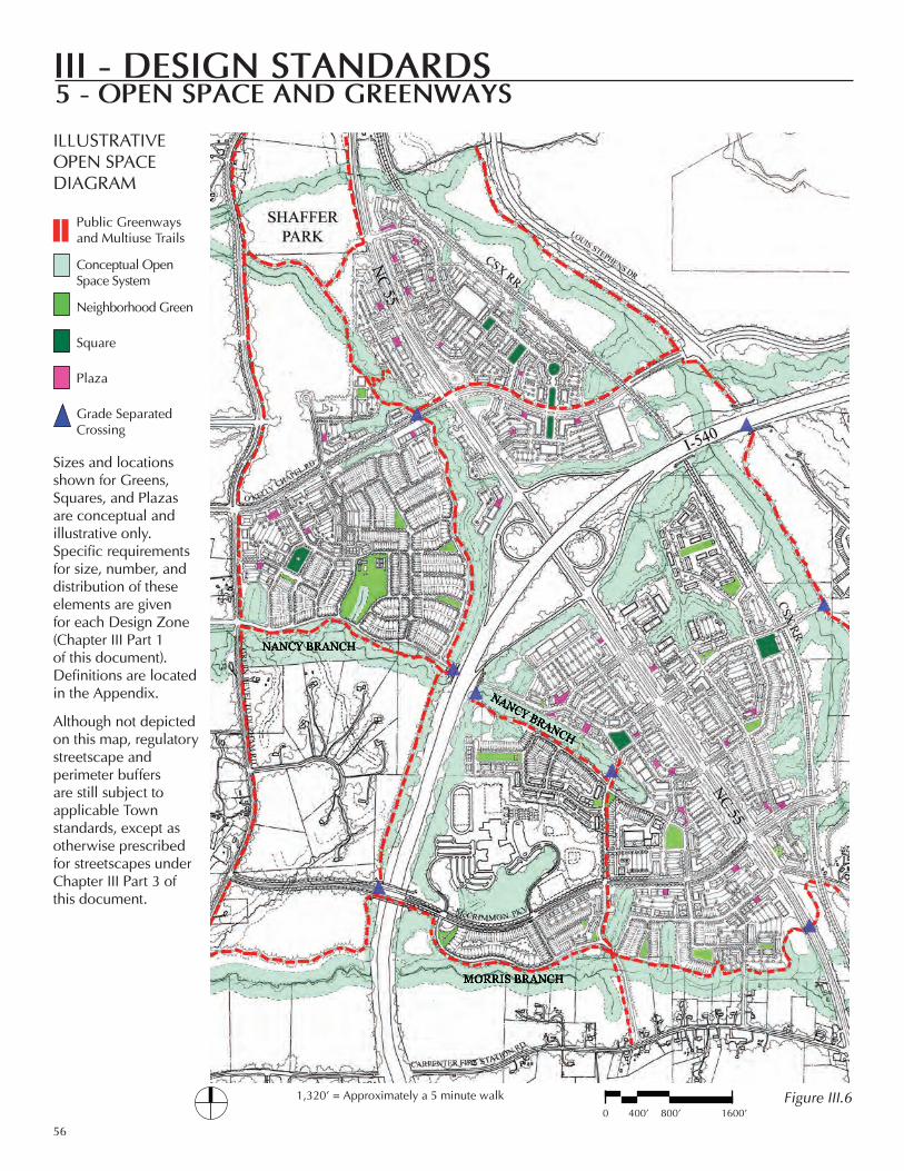
III - desIgn standards
56
Public Greenways and Multiuse Trails
Conceptual Open Space System
Neighborhood Green
Square
Plaza
Grade Separated Crossing
Sizes and locations shown for Greens, Squares, and Plazas are conceptual and illustrative only. Specific requirements for size, number, and distribution of these elements are given for each Design Zone (Chapter III Part 1 of this document). Definitions are located in the Appendix.
Although not depicted on this map, regulatory streetscape and perimeter buffers are still subject to applicable Town standards, except as otherwise prescribed for streetscapes under Chapter III Part 3 of this document.
IlluSTrATIve OPeN SPACe DIAGrAM
5 - open space and greenways
Figure III.6
© DESIGN COLLECTIVE, INC.
III - desIgn standards
57
5 - open space and greenways
FreewAy BuFFerS
The Town’s standard 100’ freeway buffers should be used adjacent to the I-540 Outer wake expressway with the following exceptions:1. The Planning Director may approve buffer reductions adjacent to the freeway on/off ramps in the Parkside, Town Center, or Petty Farm neighborhood provided that: (a) The buffer width is reduced to no less than 50 feet and planted as a Type A opaque buffer; (b) Only non-residential or mixed use buildings are located adjacent to said buffer; (c) Adverse views from the on/off ramps (including but not limited to rooftop mechanical systems, loading docks, and service areas) are adequately mitigated in the proposed development plan. 2. In the evans Farm neighborhood, the I-540 on-ramp buffer should be no less than 100 feet, to more effectively shield residential uses from freeway impacts. The Illustrative Open Space Diagram depicts a buffer of about 140 - 160 feet wide.
STreAM BuFFerS AND weTlANDS
Some stream buffers are shown on the Illustrative Open Space Diagram for illustrative purposes only. However, the diagram should not be construed as showing all the required regulatory stream buffers or wetlands, nor the precise locations of such buffers. The type and location of required stream buffers and wetlands will be determined as part of development plan re-view, with a verified hydrological survey.
SPeCIAl BuFFer requIreMeNTS FOr NANCy BrANCH AND MOrrIS BrANCH
The Town’s 2002 Northwest Area Plan recommended the provision of open space corridors along Nancy Branch and Morris Branch, with a variable total width averaging about 400 feet overall (from outer edge to outer edge of buffer). The buffer widths along Nancy and Morris Branch can be varied on either side of the streams in order to achieve a comparable amount of open space as would have been achieved with a uniform 200 foot buffer each side of the stream. This Concept Plan modifies and clarifies those recommendations within its plan area as follows:1. Nancy Branch, west of I-540: The open space corridor may have, in total, no less than 80% of the amount of open space as would have been achieved within the plan area using a uniform 200 foot buffer each side of the stream.2. Nancy Branch, east of I-540: It is anticipated that wider buffer areas close to I-540 will be provided in order to allow the Nancy Branch buffer to narrow to just slightly more than the regulatory 100 foot buffer through the heart of the Town Center area continuing through the McCrimmon Neighborhood. In order to foster the desired urban environment, this open space corridor may have, in total, no less than 70% of the amount of open space as would have been achieved with a uniform 200 foot buffer each side of the stream.3. Morris Branch, east of I-540: It is anticipated that wider buffer areas close to I-540 and/or east of the north-south collector will be provided in order to allow the Morris Branch buffer to narrow in the area south of Panther Creek High School. The open space corridor may have, in total, no less than 80% of the amount of open space as would have been achieved within the plan area using a uniform 200 foot buffer each side of the stream.4. Minimal Stream Buffer. In no cases can the Nancy Branch and Morris Branch stream buffers be reduced below the regulatory 100 foot buffer, or 130 feet where a greenway is to be located adjacent to the side of the buffer.5. Greenways will be located outside of the regulatory 100 foot stream buffer.
OPeN SPACe CreDITS
1. Greens, squares, and plazas, as defined in Chapter Iv Part 3, Definitions, and as required under Chapter III Part 1, Design Zones, are not currently eligible to be considered for Town of Cary public parkland credit. This is because these areas are intended to be privately-owned and publicly accessible green spaces and because the individual sizes (areas) of such spaces are minimal.
Related Documents