Request for an Incidental Harassment Authorization under the Marine Mammal Protection Act by U.S. Geological Survey 2-D Seismic Reflection Scientific Research Survey Program: Mapping the U.S. Atlantic Seaboard Extended Continental Shelf Region and Investigating Tsunami Hazards, August-September 2014 and April-August, 2015 March 2014 Submitted to: National Marine Fisheries Service Office of Protected Resources 1315 East-West Hwy Silver Spring, MD 20910 Request Prepared by: Ecology and Environment, Inc. 348 Southport Circle Virginia Beach, VA 23452

Welcome message from author
This document is posted to help you gain knowledge. Please leave a comment to let me know what you think about it! Share it to your friends and learn new things together.
Transcript
Request for an Incidental Harassment Authorization under the Marine Mammal Protection Act
by
U.S. Geological Survey
2-D Seismic Reflection Scientific Research Survey Program: Mapping the U.S. Atlantic Seaboard Extended
Continental Shelf Region and Investigating Tsunami Hazards, August-September 2014
and April-August, 2015
March 2014
Submitted to:
National Marine Fisheries Service Office of Protected Resources
1315 East-West Hwy Silver Spring, MD 20910
Request Prepared by:
Ecology and Environment, Inc.
348 Southport Circle Virginia Beach, VA 23452

TABLE OF CONTENTS
List of Tables .................................................................................................................................. iv List of Figures ................................................................................................................................. iv Acronyms and Abbreviations ......................................................................................................... vi
I. DESCRIPTION OF THE ACTIVITY ......................................................................................... 1
Overview of the Activity ................................................................................................................. 1
Vessel Specifications ....................................................................................................................... 5
Airgun Description .......................................................................................................................... 5
Predicted Sound Levels .................................................................................................................... 5
Description of Operations ................................................................................................................ 9
Multibeam Echosounder and Sub-bottom Profiler ........................................................................ 10
II. DATES, DURATION, AND REGION OF ACTIVITY ........................................................... 10
III. SPECIES AND NUMBERS OF MARINE MAMMALS IN AREA ....................................... 10
IV. STATUS, DISTRIBUTION, AND SEASONAL DISTRIBUTION OF AFFECTED SPECIES OR STOCKS OF MARINE MAMMALS ................................................................ 11
Mysticetes ...................................................................................................................................... 18
Pinnipeds ........................................................................................................................................ 24
V. TYPE OF AUTHORIZATION REQUESTED ......................................................................... 25
VI. NUMBERS OF MARINE MAMMALS THAT COULD BE TAKEN ................................... 25
VII. POTENTIAL IMPACT ON SPECIES OR STOCKS .............................................................. 25
Summary of Potential Effects of Airgun Sounds ........................................................................... 26
Number of Marine Mammals that could be Exposed to 160 dB re 1µPARMS ................................ 31
VIII. ANTICIPATED IMPACTS ON SUBSISTENCE USES .......................................................... 41
IX. ANTICIPATED IMPACTS ON HABITAT .............................................................................. 41
X. ANTICIPATED IMPACT OF LOSS OR MODIFICATION OF HABITAT ON MARINE MAMMALS ................................................................................................................ 41
XI. MITIGATION MEASURES ....................................................................................................... 42
Planning Phase ............................................................................................................................... 42
Proposed Exclusion Zones ............................................................................................................. 42
Mitigation During Operations ........................................................................................................ 44
XII. PLAN OF COOPERATION ....................................................................................................... 46
XIII. MONITORING AND REPORTING PLAN ............................................................................. 46
Vessel-based Visual Monitoring .................................................................................................... 47
Passive Acoustic Monitoring ......................................................................................................... 47
PSVO Data and Documentation .................................................................................................... 48

TABLES OF CONTENTS, CONTINUED
USGS IHA Application for the U.S Extended Continental Shelf Region, 2014 Page | iv
XIV. COORDINATING RESEARCH TO REDUCE AND EVALUATE INCIDENTAL TAKE ............................................................................................................................................ 49
XV. LITERATURE CITED ............................................................................................................... 49
LIST OF TABLES Table 1 Predicted Distances to Sound Levels ≥ 190, 180 and 160 dB re 1 μPaRMS ......................... 9
Table 2 The Habitat, Regional Abundance, and Conservation Status of Marine Mammals that Could Occur In or Near the Study Area ............................................................................ 12
Table 3 Densities and Estimates of Possible Numbers of Individuals That Could be Exposed to 160 dB re 1 µPARMS During Each of Proposed 2014 and 2015 2-D Seismic Surveys......37
Table 4 Densities and Estimates of Possible Numbers of Individuals That Could be Exposed to 160 dB re 1 µPARMS During Spring (March, April, May) 2015 2-D Seismic Survey…...38
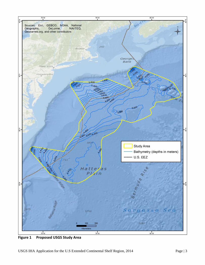
LIST OF FIGURES Figure 1 Proposed USGS Study Area ............................................................................................... 3
Figure 2 Proposed Seismic Survey Lines, Phases 1 and 2 ................................................................ 4
Figure 3 Modeled Deep-Water Received Sound Exposure Levels (SELs) from the 36-Airgun Array Towed at 9 Meters Depth ......................................................................................... 7
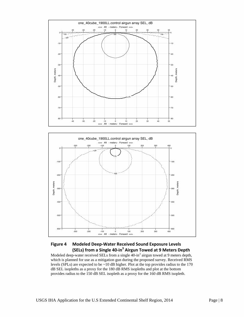
Figure 4 Modeled Deep-Water Received Sound Exposure Levels (SELs) from a Single 40-in3 Airgun Towed at 9 Meters Depth ....................................................................................... 8
Figure 5 2014 Proposed Survey – Ensonified Buffer ...................................................................... 33
Figure 6 2015 Proposed Survey – Ensonified Buffer ...................................................................... 33

ACRONYMS AND ABBREVIATIONS
μ micro
2-D two dimensional
BOEM Bureau of Ocean Energy Management
CeTAP Cetaceans and Turtle Assessment Program
dB decibel
ECS extended continental shelf
EEZ Exclusive Ecomonic Zone
EIS Environmental Impact Statement
ESA Endangered Species Act
EZ exclusion zone
IHA Incidental Harassment Authorization
in3 cubic inch(es)
kHz kiloHertz
kw kilowatt(s)
L-DEO Lamont-Doherty Earth Observatory
MBES multibeam echosounder
NASA National Aeronautics and Space Administration
NEFSC Northeast Fisheries Science Center
NMFS National Marine Fisheries Service
NOAA National Oceanic and Atmospheric Administration
NODE (U.S. Department of the) Navy Operating Area (OPAREA) Density Estimates
NSF National Science Foundation
OBIS Ocean Biogeographic Information System
OEIS Overseas Environmental Impact Statement
OPAREA Operating Area
Pa Pascal
PAM Passive acoustic monitoring
PEIS Final Programmatic Environmental Impact Statement (EIS)/Overseas Environmental Impact Statement (OEIS) for Marine Seismic Research funded by the National Science Foundation or Conducted by the U.S. Geological Survey (June 2011)
PSAO Protected Species Acoustic Observer

ACRONYMS AND ABBREVIATIONS, CONTINUED
USGS IHA Application for the U.S Extended Continental Shelf Region, 2014 Page | vi
PSVO Protected Species Visual Observer
PTS permanent threshold shift
R/V Langseth Research Vessel Marcus G. Langseth
RMS root-mean-squared
SAR Stock Assessment Report
SBP sub-bottom profiler
SEFSC Southeast Fisheries Science Center
SEL sound exposure level
SERDP Strategic Environmental and Development Program
SPL sound pressure level
TTS temporary threshold shift
UME Unusual Mortality Event
USGS United States Geological Survey

USGS IHA Application for the U.S Extended Continental Shelf Region, 2014 Page | 1
I. DESCRIPTION OF THE ACTIVITY
Overview of the Activity The United States Geological Survey (USGS), Coastal and Marine Geology Program (Debbie
Hutchinson, Principal Investigator), plans to conduct a regional marine two dimensional (2-D) seismic survey in the northwest Atlantic Ocean within the U.S. Exclusive Economic Zone (EEZ) and extending into International Waters as far as 350 nautical miles from the U.S. coast (Study Area) (Figure 1). Water depths in the Study Area range from approximately 1,400 meters to 5,400 meters. The proposed USGS survey is planned to be conducted in two phases; one survey during August and September, 2014, and the second survey is expected to take place between April 1 and August 31, 2015 (specific dates to be determined). The activities for both Phase 1 and Phase 2 are included in this application (Figure 2).
USGS plans to use conventional marine seismic methodology to: (1) establish the outer limits of the U.S. continental shelf, also referred to as the Extended Continental Shelf (ECS) as defined by Article 76 of the Convention of the Law of the Sea; and (2) study the sudden mass transport of sediments down the continental shelf as submarine landslides that may pose significant tsunamigenic (i.e., earthquake potential along the subduction zone) hazards to the Atlantic and Caribbean coastal communities.
The proposed survey will use the Research Vessel Marcus G. Langseth (R/V Langseth) as the sole source vessel. To conduct the proposed survey, the R/V Langseth will deploy a 36-airgun array as the energy source and one 8-kilometer multichannel hydrophone cable as the receiving system. The hydrophone cable will receive the returning acoustic signals from the towed airgun array and the data will be processed on-board the R/V Langseth as the survey occurs.
Each proposed surveys (2014 and 2015) will each consist of a 17- to 18-day leg (exclusive of transit and equipment deployment and recovery) comprising approximately 1,700 nautical trackline miles (approximately 3,150 kilometers) of 2-D seismic reflection coverage. The airgun array will operate continuously during the survey with shutdowns only for repairs and marine mammal and sea turtle mitigation. Data will continue to be acquired between line changes. The successive track segments can be surveyed as almost one continuous line. Turns of no greater than 120 degrees will be required to move from one line segment to the next. The 2014 proposed survey design consists primarily of the track lines that run along the periphery of the overall Study Area, including several internal track lines (Figure 2). The proposed 2014 survey will occur in water depths ranging between 1,450 meters and 5,400 meters. The 2015 proposed survey consists of additional dip and tie lines. (Dip lines are lines that are perpendicular to the north-south trend of the continental margin. Strike lines are parallel to the margin. Tie lines are any line that connects other lines.) The 2015 survey design may be modified based on the 2014 results.
Along with the airgun operations, two additional acoustical data acquisition systems will be operated during the survey. A Kongsberg EM122 multibeam echosounder (MBES) and a Knudsen Model 3260 Chirp sub-bottom profiler (SBP) will be operated continuously during the seismic operations in
A detailed description of the specific activity or class of activities that can be expected to result in incidental taking of marine mammals.

USGS IHA Application for the U.S Extended Continental Shelf Region, 2014 Page | 2
order to map the ocean floor. MBES and SBP will not operate during transits at the beginning and end of the survey.
The Langseth has been used to conduct research seismic surveys world-wide since 2008. All of the seismic surveys have been operated under incidental harassment authorizations issued by NMFS. Environmental assessments, IHA’s and post-cruise reports environmental impact for most of these cruises cruises can be found on the NMFS Protected Resource website. Many of these reports and applications were prepared by LGL Limited, Environmental Research Associates, under contract to Lamont Doherty Earth Observatory or the USGS. Because material from earlier documents is owned by the U.S. Government and in the public domain, some material common to these documents may have been used verbatim herein without attribution. The USGS acknowledges role of LGL in preparing material that has been used.
USGS IHA Application for the U.S Extended Continental Shelf Region, 2014 Page | 3
Figure 1 Proposed USGS Study Area
75' W
Sources: Esri, GEBCO, NOAA, National Geographic, Delorme, NAVTEQ, Geonames.org, and other contributors
Bo ton.
New York
Pho~adetphoa
7'5
0 100
Kiometers
70' W
N
+ 292
C StudyArea
-- Bathymetry (depths in meters)
- U.S. EEZ
Sea
200
70' W 65' W

USGS IHA Application for the U.S Extended Continental Shelf Region, 2014 Page | 4
Figure 2 Proposed Seismic Survey Lines, Phases 1 and 2
Sources: Esri, GEBCO, NOAA, National Geographic, Delorme, NAVTEQ, Geonames.org , and other contributors
Bo ton.
New York
Pho~adetphoa
7'5
0 100
Kiometers
200
N
+ 292
Bank
L StudyArea
-- Bathymetry (depths in meters)
- U.S. EEZ
-- Phase 1 - 2014
-- Phase 2-2015
Sea

USGS IHA Application for the U.S Extended Continental Shelf Region, 2014 Page | 5
Vessel Specifications The R/V Marcus G. Langseth will be used as the source vessel; it is owned by the NSF and
operated by Lamont-Doherty Earth Observatory (L-DEO) of Columbia University. The R/V Langseth was designed as a seismic research vessel with a quiet propulsion system to avoid interference with the seismic signals. The operation speed during seismic acquisition is typically 7.8 to 8.3 kilometers per hour (4.2 to 4.5 knots). When not towing seismic survey gear, the R/V Langseth can cruise at 20 to 24 kilometers per hour (11 to 12 knots). The R/V Langseth was further described in Section 2.2.2.1 of the Final Programmatic Environmental Impact Statement (EIS)/Overseas Environmental Impact Statement (OEIS) for Marine Seismic Research funded by the National Science Foundation or Conducted by the U.S. Geological Survey (June 2011; referred to herein as the PEIS) and the Record of Decision (June 2012).
Airgun Description During the proposed 2-D survey, the airgun array to be used will consist of 36 airguns (plus 4
spare airguns), with a total volume of approximately 6,600 cubic inches (in3). The airgun array and configuration are described and illustrated in the PEIS in Section 2.2.3.1 and on Figure 2.11, respectively. For the 2014 and 2015 proposed survey, the airgun array will be towed at a depth of 9 meters and shot intervals will be 50 meters (approximately 20 to 24 seconds). The firing pressure of the array is 2,000 pounds per square inch.
Predicted Sound Levels The airgun array that will be used for the USGS East Coast survey is the full 4-string 6,600-in3
array, which is described and illustrated in the PEIS in Section 2.2.3.1.
Received sound levels have been predicted by L-DEO’s model (Diebold et al. 2010, provided as Appendix H of the PEIS) as a function of distance from the airguns, for the 36-airgun array at any tow depth and for a single 1900LL 40-in3 airgun (i.e., the mitigation gun), which will be used during power-downs. This modeling approach uses ray tracing for the direct wave traveling from the array to the receiver and its associated source ghost (reflection at the air-water interface in the vicinity of the array), in a constant-velocity half-space (infinite homogeneous ocean layer, unbounded by a seafloor). In addition, propagation measurements of pulses from the 36-airgun array at a tow depth of 6 meters have been reported in approximately 1,600 meters water depth (deep water), 50 meters depth (shallow water) and a slope site (intermediate water depth) in the Gulf of Mexico in 2007–2008 (Tolstoy et al. 2009; Diebold et al. 2010), while propagation measurements of pulses from the 18-airgun 2-string array also at a tow depth of 6 meters have been reported for the same shallow and deep sites (Diebold et al. 2010).
For deep water and intermediate water depth cases, these field measurements cannot be used readily to derive mitigation radii because at those sites, the calibration hydrophone was located at a roughly constant depth of 350 to 500 meters, which may not intersect all the sound pressure level (SPL) isopleths at their widest point from the sea surface down to the maximum relevant water depth for marine mammals of approximately 2,000 meters. Figures 2 and 3 in Appendix H of the PEIS show how the values along the maximum SPL line that connects the points where the isopleths attain their maximum width (providing the maximum distance associated with each sound level) may differ from values obtained along a constant depth line. At short ranges, where the direct arrivals dominate and the effects of

USGS IHA Application for the U.S Extended Continental Shelf Region, 2014 Page | 6
seafloor interactions are minimal, the data recorded at the deep and slope sites are suited for comparison with modeled levels at the depth of the calibration hydrophone. At larger ranges, the comparison with the mitigation model—constructed from the maximum SPL, through the entire water column at varying distances from the airgun array—is the most relevant. The results are summarized below.
In deep water and intermediate depth water environments, comparisons at short ranges between sound levels for direct arrivals recorded by the calibration hydrophone and model results for the same array tow depth are consistent (Figures 12 and 14 in Appendix H of the PEIS). Consequently, isopleths falling within this domain can be reliably predicted by the L-DEO model, while they may be imperfectly sampled by measurements recorded at a single depth. At larger distances, the calibration data show that seafloor reflected and sub-seafloor refracted arrivals dominate, while the direct arrivals become weak and/or incoherent (Figures 11, 12 and 16 in Appendix H of the PEIS). Aside from local topography effects, the region around the critical distance (approximately 5 kilometers in Figures 11 and 12, and approximately 4 kilometers in Figure 16, in Appendix H of the PEIS) is where the observed levels rise very close to the mitigation model curve. However, the observed sound levels fall almost entirely below the mitigation model curve (Figures 11, 12 and 16 in Appendix H of the PEIS). Thus, analysis of the Gulf of Mexico calibration measurements demonstrates that although simple, the L-DEO model is a robust tool for estimating mitigation radii.
The proposed survey on the East Coast margin will acquire data with the 36-airgun array at a tow depth of 9 meters. The survey will take place entirely in deep water (greater than 1,000 meters). The deep-water radii obtained from 9-meter tow depth L-DEO model results will be used down to a maximum water depth of 2,000 meters (Figure 3).
Measurements have not been reported for the single 40-in3 airgun. The 40-in3 airgun would be considered under the low-energy sources category in the PEIS. In Section 2.4.2 of the PEIS, Alternative B (the Preferred Alternative) conservatively applies a 100-meter exclusion zone (EZ) for all low-energy acoustic sources in water depths greater than 100 meters. This approach is adopted here for the single Bolt 1900LL 40-in3 airgun that will be used during power-downs. In addition, L-DEO model results are used to determine the 160- and the 190-decibel (dB) radii for the 40-in3 airgun in deep water (Figure 4).
Table 1 shows the distances at which the 160-dB, 180-dB, and 190-dB root-mean-squared (RMS) sound levels are expected to be received for the 36-airgun array and the single (mitigation) airgun.
The 180-dB re 1 micro (μ) pascal (Pa) RMS distance is the safety criterion as specified by the National Marine Fisheries Service (NMFS) (2000) for cetaceans. If marine mammals or sea turtles are detected within or about to enter the appropriate exclusion zone, the airguns would be immediately powered down (or shut down if necessary).

USGS IHA Application for the U.S Extended Continental Shelf Region, 2014 Page | 7
Figure 3 Modeled Deep-Water Received Sound Exposure Levels (SELs) from the 36-Airgun Array Towed at 9 Meters Depth
Modeled deep-water received sound exposure levels (SELs) from the 36-airgun array planned for use during the survey, at a 9-meter tow depth. Received RMS levels (SPLs) are expected to be ~10 dB higher. Plot at the top provides radius to the 170 dB SEL isopleths as a proxy for the 180 dB RMS isopleths and plot at the bottom provides radius to the 150 dB SEL isopleth as a proxy for the 160 dB RMS isopleth.
USGS IHA Application for the U.S Extended Continental Shelf Region, 2014 Page | 8
Figure 4 Modeled Deep-Water Received Sound Exposure Levels (SELs) from a Single 40-in3 Airgun Towed at 9 Meters Depth
Modeled deep-water received SELs from a single 40-in3 airgun towed at 9 meters depth, which is planned for use as a mitigation gun during the proposed survey. Received RMS levels (SPLs) are expected to be ~10 dB higher. Plot at the top provides radius to the 170 dB SEL isopleths as a proxy for the 180 dB RMS isopleths and plot at the bottom provides radius to the 150 dB SEL isopleth as a proxy for the 160 dB RMS isopleth.

USGS IHA Application for the U.S Extended Continental Shelf Region, 2014 Page | 9
Table 1 Predicted Distances to Sound Levels ≥ 190, 180 and 160 dB re 1 μPaRMS Predicted distances to which sound levels ≥190, 180 and 160 dB re 1 μPaRMS are expected to be received during the proposed survey on the East Coast margin in 2014 and 2015. For the single mitigation airgun, the EZ is the conservative EZ for all low-energy acoustic sources in water depths >100 meter defined in the PEIS.
Source and Volume Water Depth
(meters)
Predicted RMS Radii
(meters)
190 dB 180 dB 160 dB
Single Bolt airgun, 40 cubic-inch >1,000 13 100
388
36-gun array totaling 6,600 cubic inches >1,000 286
927
5,780
Southall et al. (2007) provided detailed recommendations for new science-based noise exposure criteria. Although the NSF is aware that the National Oceanic and Atmospheric Administration (NOAA) is revising acoustic guidance for marine mammals, at the time of preparation of this Incidental Harassment Authorization (IHA) application, NOAA has not issued an official revised version of that policy. As such, this IHA application has been prepared in accordance with the current NOAA acoustic guidance and the procedures are based on best practices noted by Pierson et al. (1998) and Weir and Dolman (2007).
Description of Operations During the survey, the source vessel, the R/V Marcus G. Langseth, will tow a standard 36-airgun
array at a depth of 9 meters. The R/V Langseth also will tow one 8-kilometer long hydrophone streamer cable. As the airgun array is towed along the survey lines, the hydrophone streamer cable will receive and record the returning acoustic signals from the towed airgun array and the data will be processed on-board the R/V Langseth as the survey occurs.
During the 2014 survey, 1,700 nautical track line miles (approximately 3,150 kilometers) of 2-D survey lines will be shot (Figure 2). All water depths will be greater than 1,000 meters. Due to the almost continuous nature of the 2014 and 2015 survey track line segments (Figure 2), full turns will not be required. Only 90 to 120-degree turns will be conducted with 2-D seismic data being collected continuously during the turns. In addition to the operations of the airgun array during the 2-D survey, a MBES and a SBP also will run continuously. The plan for the 2015 (Figure 2) survey is similar in all respects to the 2014.

USGS IHA Application for the U.S Extended Continental Shelf Region, 2014 Page | 10
Multibeam Echosounder and Sub-bottom Profiler Along with the airgun operations, two additional acoustical data acquisition systems will be
operated during the survey. The ocean floor will be mapped with the Kongsberg EM 122 MBES and a Knudsen Chirp 3260 SBP. These sound sources will be operated from the R/V Langseth continuously throughout the survey.
The Kongsberg EM 122 MBES operates at 10.5 to 13 (usually 12) kiloHertz (kHz) and is hull-mounted on the R/V Langseth. The maximum source level is 242 dB re 1 μPaRMS. The Knudsen Chirp 3260 SBP normally is operated to provide information about the sedimentary features and the bottom topography that is being mapped simultaneously by the MBES. The SBP is capable of reaching water depths of 10,000 meters and penetrating tens of meters into the sediments. The nominal power output is 10 kilowatts (kw), but the actual maximum radiated power is 3 kW or 222 dB re 1 μPa m.
II. DATES, DURATION, AND REGION OF ACTIVITY
The proposed survey area would be bounded by the following geographic coordinates:
40.5694° N / -66.5324° W 38.5808° N / -61.7105° W 29.2456° N / -72.6766° W 33.1752° N / -75.8697° W 39.1583° N / -72.8697° W
The proposed 2014 survey activities will generally occur within the outer portions of the Study Area. The proposed 2015 survey will in-fill more of the Study Area. The track lines proposed for both years occur primarily within International Waters (approximately 80% in 2014 and 90% in 2015, Figure 2). Water depths range between approximately 1,450 meters and 5,400 meters; no survey lines will extend to water depths less than 1,000 m. The exact dates of the survey are dependent on logistics and weather conditions; however, the R/V Langseth is expected to depart Newark, New Jersey, on August 16, 2014, and transit to the survey area, returning to Norfolk, Virginia, on September 6, 2014. The seismic operations will take approximately 16 days to complete. Approximately one day transit will be required at the beginning and end of the program. The survey schedule is inclusive of weather and other contingency (e.g. equipment failure) time.
The proposed 2015 survey will be virtually identical to the program planned for 2014. Geographic area, duration, and trackline coverage are similar. Exact dates for the survey in 2015 are uncertain, but are scheduled to occur within the April to August time frame.
III. SPECIES AND NUMBERS OF MARINE MAMMALS IN AREA
The date(s) and duration of such activity and the specific geographical region where it will occur.
The species and numbers of marine mammals likely to be found within the activity area.

USGS IHA Application for the U.S Extended Continental Shelf Region, 2014 Page | 11
Thirty-eight marine mammal species could occur within the Study Area. To avoid redundancy and consolidate species-specific information, required information regarding species and numbers of species as is required under Section III, is included below in Section IV
IV. STATUS, DISTRIBUTION, AND SEASONAL DISTRIBUTION OF AFFECTED SPECIES OR STOCKS OF MARINE MAMMALS
Sections III and IV are integrated here to minimize repetition.
Forty-five species of marine mammals, including 30 odontocetes, 7 mysticetes, 7 pinnipeds, and 1 sirenian are known to occur in western North Atlantic Ocean (Waring et al. 2013; Read et al. 2009). Of those 45 species of marine mammals, 34 cetaceans and 4 pinnipeds could be found within the Study Area during the summer months (see Table 2). Six of the cetaceans are listed as Endangered under the Endangered Species Act (ESA) (sei, blue, fin, North Atlantic right, humpback, and sperm whales). Fourteen of the 34 cetacean species, although present in the wider western North Atlantic Ocean, are considered rare in the survey area; however, due to the chance that an individual could be found within the Study Area during the proposed survey, they are discussed in this document. The four pinniped species (harbor seal, harp seal, gray seal, and hooded seal) also are considered rare within the Study Area. All pinnipeds known to occur within the North Atlantic Ocean are considered coastal species and any sightings would be considered extralimital; however, due to the limited chance that they could occur within the Study Area during the summer months, similar to the rare cetacean species, they are discussed in this document.
General information on the taxonomy, ecology, distribution, seasonality and movements, and acoustic capabilities of mysticetes, odontocetes, and pinnipeds are provided in Sections 3.6.1, 3.7.1, and 3.8.1 respectively, of the PEIS. The general distribution of mysticetes, odontocetes, and pinnipeds in the North Atlantic is discussed in Sections 3.6.3.4, 3.7.3.4, and 3.8.3.4, respectively, of the PEIS. In addition, Section 3.1 of the Atlantic OCS Proposed Geological and Geophysical Activities Mid-Atlantic and South Atlantic Planning Areas Draft Programmatic Environmental Impact Statement (Bureau of Ocean Energy Management 2012) reviews similar information for all marine mammals that may occur within the Study Area.
The rest of this section deals specifically with their distribution within the Study Area and near the proposed 2014 survey area. Various surveys have been conducted throughout the western North Atlantic, including within sections of the Study Area. The main source of information used here is the Ocean Biogeographic Information System (OBIS) database hosted by Rutgers and Duke Universities (Read et al. 2009). This database includes survey data collected during the Cetaceans and Turtle Assessment Program (CeTAP) conducted between 1978 and 1982 and consisted of both aerial and vessel-based surveys between Cape Hatteras, North Carolina, and the Gulf of Maine. The database also includes survey data collected during the NOAA Northeast Fisheries Science Center (NEFSC) and the NOAA Southeast Fisheries Science Center (SEFSC) stock assessment surveys conducted in 2004 (which surveys between Nova Scotia, Canada, and Florida).
A description of the status, distribution, and seasonal distribution (when applicable) of the affected species or stocks of marine mammals likely to be affected by such activities.
USGS IHA Application for the U.S Extended Continental Shelf Region, 2014 Page | 12
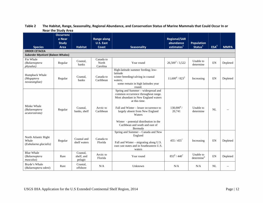
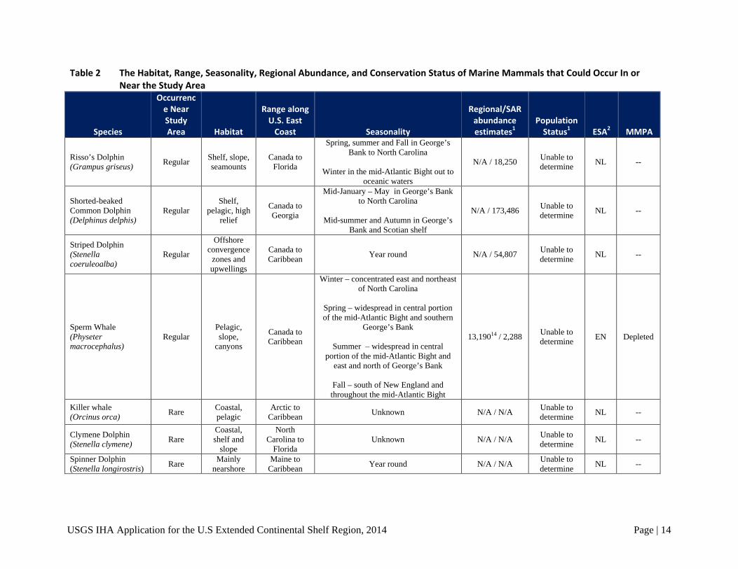
Table 2 The Habitat, Range, Seasonality, Regional Abundance, and Conservation Status of Marine Mammals that Could Occur In or Near the Study Area
Species
Occurrence Near Study Area Habitat
Range along U.S. East
Coast Seasonality
Regional/SAR abundance estimates1
Population Status1 ESA2 MMPA
ORDER CETACEA Suborder Mysticeti (Baleen Whales) Fin Whale (Balaenoptera physalus)
Regular Coastal, banks
Canada to North
Carolina Year round 26,5003 / 3,522 Unable to
determine EN Depleted
Humpback Whale (Megaptera novaeangliae)
Regular Coastal, banks
Canada to Caribbean
High-latitude summer feeding; low-latitude winter breeding/calving in coastal waters;
some remain in high latitudes year round.
11,6004 / 8235 Increasing EN Depleted
Minke Whale (Balaenoptera acutorostrata)
Regular Coastal, banks, shelf
Arctic to Caribbean
Spring and Summer – widespread and common occurrence throughout range. Most abundant in New England waters
at this time.
Fall and Winter – lesser occurrence to largely absent from New England
Waters
Winter - potential distribution in the Caribbean and south and east of
Bermuda
138,0006 / 20,741
Unable to determine NL --
North Atlantic Right Whale (Eubalaena glacialis)
Regular Coastal and shelf waters
Canada to Florida
Spring and Summer – Canada and New England
Fall and Winter – migrating along U.S. east cast states and in Southeastern U.S.
waters
455 / 4557 Increasing EN Depleted
Blue Whale (Balaenoptera musculus)
Rare Coastal,
shelf, and pelagic
Arctic to Florida Year round 8558 / 4407 Unable to
determine6 EN Depleted
Bryde’s Whale (Balaenoptera edeni) Rare Coastal,
offshore N/A Unknown N/A N/A NL --

USGS IHA Application for the U.S Extended Continental Shelf Region, 2014 Page | 13
Table 2 The Habitat, Range, Seasonality, Regional Abundance, and Conservation Status of Marine Mammals that Could Occur In or Near the Study Area
Species
Occurrence Near Study Area Habitat
Range along U.S. East
Coast Seasonality
Regional/SAR abundance estimates1
Population Status1 ESA2 MMPA
Sei Whale (Balaenoptera borealis)
Rare
Mostly pelagic,
some offshore
Canada to Massachusetts Year round 10,3009 / 35710 Unable to
determine EN Depleted
Suborder Odontoceti (Toothed Whales, Dolphins, and Porpoises)
Atlantic White-sided Dolphin (Lagenorhynchus acutus)
Regular Shelf and slope
Central West Greenland to
North Carolina
January – May in Georges Bank to Jeffrey’s Ledge
June – September primarily in Bay of
Fundy to George’s Bank
October - December in Gulf of Maine to George’s Bank
Year round from Massachusetts to
North Carolina
10s–100s of 1000s11 / 48,8197
Unable to determine NL --
Atlantic Spotted Dolphin (Stenella frontalis)
Regular Shelf, offshore
Massachusetts to Caribbean Year round N/A / 44,715 Unable to
determine NL --
Bottlenose Dolphin (Tursiops truncatus) Regular
Coastal, shelf,
pelagic
Canada to Florida Year round N/A / 77,53212 Unable to
determine NL --
Long-Finned Pilot Whale (Globicephala melas)
Regular Mostly pelagic
Canada to North
Carolina Year round 780,00013 /
26,535 Unable to determine NL --
Short-Finned Pilot Whale Globicephala macrorhynchus)
Regular Mostly
pelagic, high relief
North Carolina to
Florida Year round 780,00013 /
21,515 Unable to determine NL --
Pantropical Spotted Dolphin (Stenella attenuata)
Regular Coastal, shelf and
slope
Massachusetts to Florida Year round N/A / 3,333 Unable to
determine NL --
USGS IHA Application for the U.S Extended Continental Shelf Region, 2014 Page | 14
Table 2 The Habitat, Range, Seasonality, Regional Abundance, and Conservation Status of Marine Mammals that Could Occur In or Near the Study Area
Species
Occurrence Near Study Area Habitat
Range along U.S. East
Coast Seasonality
Regional/SAR abundance estimates1
Population Status1 ESA2 MMPA
Risso’s Dolphin (Grampus griseus) Regular Shelf, slope,
seamounts Canada to
Florida
Spring, summer and Fall in George’s Bank to North Carolina
Winter in the mid-Atlantic Bight out to
oceanic waters
N/A / 18,250 Unable to determine NL --
Shorted-beaked Common Dolphin (Delphinus delphis)
Regular Shelf,
pelagic, high relief
Canada to Georgia
Mid-January – May in George’s Bank to North Carolina
Mid-summer and Autumn in George’s
Bank and Scotian shelf
N/A / 173,486 Unable to determine NL --
Striped Dolphin (Stenella coeruleoalba)
Regular
Offshore convergence
zones and upwellings
Canada to Caribbean Year round N/A / 54,807 Unable to
determine NL --
Sperm Whale (Physeter macrocephalus)
Regular Pelagic, slope,
canyons
Canada to Caribbean
Winter – concentrated east and northeast of North Carolina
Spring – widespread in central portion of the mid-Atlantic Bight and southern
George’s Bank
Summer – widespread in central portion of the mid-Atlantic Bight and
east and north of George’s Bank
Fall – south of New England and throughout the mid-Atlantic Bight
13,19014 / 2,288 Unable to determine EN Depleted
Killer whale (Orcinus orca) Rare Coastal,
pelagic Arctic to
Caribbean Unknown N/A / N/A Unable to determine NL --
Clymene Dolphin (Stenella clymene) Rare
Coastal, shelf and
slope
North Carolina to
Florida Unknown N/A / N/A Unable to
determine NL --
Spinner Dolphin (Stenella longirostris) Rare Mainly
nearshore Maine to
Caribbean Year round N/A / N/A Unable to determine NL --

USGS IHA Application for the U.S Extended Continental Shelf Region, 2014 Page | 15
Table 2 The Habitat, Range, Seasonality, Regional Abundance, and Conservation Status of Marine Mammals that Could Occur In or Near the Study Area
Species
Occurrence Near Study Area Habitat
Range along U.S. East
Coast Seasonality
Regional/SAR abundance estimates1
Population Status1 ESA2 MMPA
Rough-Toothed Dolphin (Steno bredanensis)
Rare Mostly pelagic
Virginia to Florida Unknown N/A / 271 Unable to
determine NL --
Fraser’s Dolphin (Lagenodelphis hosei) Rare Shelf and
slope
North Carolina to
Florida Unknown N/A / N/A Unable to
determine NL --
Harbor Porpoise (Phocoena phocoena) Rare
Shelf, coastal, pelagic
Canada to North
Carolina
October – December and April – June in Maine through New Jersey
January – March in Canada to North
Carolina
July – September in northern Gulf of Maine and Southern Bay of Fundy
~500,00015 / 79,8339
Unable to determine NL --
False Killer Whale (Pseudorca crassidens)
Rare Pelagic N/A Unknown N/A / N/A N/A NL --
Pygmy Killer Whale (Feresa attenuata) Rare Pelagic N/A Unknown N/A / N/A Unable to
determine NL --
Dwarf Sperm Whale (Kogia sima) Rare Deep waters
off shelf Massachusetts
to Florida Unknown N/A / 3,78516 Unable to determine NL --
Pygmy Sperm Whale (Kogia breviceps) Rare Deep waters
off shelf Massachusetts
to Florida Unknown N/A / 3,78516 Unable to determine NL --
Melon-Headed Whale (Peponocephala electra)
Rare Deep waters off shelf
North Carolina to
Florida Year round N/A / N/A Unable to
determine NL --
Sowerby’s Beaked Whale Mesoplodon bidens)
Rare
Pelagic, deep slope,
canyons
Canada to Florida Year round N/A / 7,09217
Unable to determine
NL
--
Blainville’s Beaked Whale (Mesoplodon densirostris)
Canada to Florida Year round N/A / 7,09217 --
Gervais’ Beaked Whale (Mesoplodon europaeus)
Canada to Florida Year round N/A / 7,09217 --

USGS IHA Application for the U.S Extended Continental Shelf Region, 2014 Page | 16
Table 2 The Habitat, Range, Seasonality, Regional Abundance, and Conservation Status of Marine Mammals that Could Occur In or Near the Study Area
Species
Occurrence Near Study Area Habitat
Range along U.S. East
Coast Seasonality
Regional/SAR abundance estimates1
Population Status1 ESA2 MMPA
True’s Beaked Whale (Mesoplodon mirus)
Canada to Bahamas Year round N/A / 7,09217 --
Cuvier’s Beaked Whale (Ziphius cavirostris)
Canada to Florida Year round N/A / 6,532 --
Northern Bottlenose Whale (Hyperoodon ampullatus)
Rare Pelagic Arctic to New Jersey Unknown N/A / N/A Unable to
determine NL --
ORDER CARNIVORA
Clade Pinnipedia
Harbor seal (Phoca vitulina) Rare Coastal
Canada to North
Carolina
Year round in Canada to Massachusetts
September – May in Rhode Island to New Jersey (possibly south to North
Carolina)
N/A / 70,142 Unable to determine NL
--
Gray seal (Halichoerus grypus) Rare Coastal,
pelagic
Canada to North
Carolina
Year round in Canada to Massachusetts
September – May in Rhode Island to New Jersey (possibly south to North
Carolina)
N/A / 348,900 Increasing NL --
Harp seal (Phoca groenlandica) Rare
Ice whelpers, pelagic
Canada to New Jersey
Winter – Summer in Arctic
Fall as far south as New Jersey
8.6–9.6 million18 / N/A Unknown NL --
Hooded Seal (Cystophora cristata) Rare
Ice whelpers, pelagic
Canada to Caribbean
January – May in New England
Summer and Autumn in Caribbean 600,00019 / N/A Unable to
determine NL --
USGS IHA Application for the U.S Extended Continental Shelf Region, 2014 Page | 17
Table 2 The Habitat, Range, Seasonality, Regional Abundance, and Conservation Status of Marine Mammals that Could Occur In or Near the Study Area
Species
Occurrence Near Study Area Habitat
Range along U.S. East
Coast Seasonality
Regional/SAR abundance estimates1
Population Status1 ESA2 MMPA
Key: N/A = Not available or not assessed Sources: 1 SAR (stock assessment report) abundance estimates are from the Draft Marine Mammal Stock Assessment Reports 2013 for the Western North Atlantic Stock unless otherwise noted. 2 U.S. Endangered Species Act: EN = Endangered; NL = Not listed (ECOS 2013) 3 Best estimate for the North Atlantic in 2007 (International Whaling Commission [IWC] 2014) 4 Best estimate for the western North Atlantic in 1992–1993 (IWC 2014) 5 Minimum estimate for Gulf of Maine Stock (Waring et al. 2013) 6 Best estimate for the North Atlantic in 2002–2007 (IWC 2014) 7 Estimate for the Western North Atlantic Stock (Waring et al. 2013) 8 Estimate for the central and northeast Atlantic in 2001 (Pike et al. 2009) 9 Estimate for the Northeast Atlantic in 1989 (Cattanach et al. 1993) 10 Nova Scotia Stock (Waring et al. 2013) 11 Tens to low hundreds of thousands in the North Atlantic (Reeves et al. 1999) 12 Western North Atlantic Offshore Stock (Waring et al. 2013) 13 Estimate for both long- and short-finned pilot whales in the central and eastern North Atlantic in 1989 (IWC 2014) 14 Estimate for the North Atlantic (Whitehead 2002) 15 Estimate for the North Atlantic (Jefferson et al. 2008) 16 This estimate includes both the dwarf and pygmy sperm whales
17 Estimate includes all Mesoplodon in the Atlantic 18 Northwest Atlantic (Department of Fisheries and Oceans 2012) 19 Northwest Atlantic (Andersen et al. 2009)

USGS IHA Application for the U.S Extended Continental Shelf Region, 2014 Page | 18
Mysticetes Fin whale (Balaenoptera physalus)
Fin whales are one of the more common mysticete species found within the Study Area and in the waters surrounding it. According to Palka (2006), they are the most commonly sighted ESA-listed large whale in the western North Atlantic. Hundreds of OBIS sightings of this species near the Study Area boundaries are recorded and 14 sightings within it are recorded. The three most recent sightings were recorded in 2003 and 2004 and were observed during the NEFSC Right Whale Survey. All other sightings are from the 1970s and 1980s.
The NMFS (2010) reports summer feeding grounds mostly between 41°20’ and 51°00’N latitude (shore to 1,829 meters). The Study Area and proposed project survey dates coincide with this cycle of the fin whale. Fin whale mating and births occur in the winter (November to March), with reproductive activity peaking in December and January. Hain et al. (1992) suggested that calving takes place during October to January in latitudes of the U.S. Mid-Atlantic region. The proposed 2014 survey period of August–September will not interfere with the reproduction cycle.
Humpback whale (Megaptera novaeangliae)
Sightings data show that humpback whales traverse coastal waters from the northeastern to the southeastern U.S. They can also be found farther offshore, including the Study Area (Waring et al. 2011). Reports of humpback whale sightings off Delaware Bay and Chesapeake Bay during the winter suggest that the Mid-Atlantic region, including the western portion of the Study Area, may serve as wintering grounds for this species (Swingle et al. 1993; Barco et al. 2002). OBIS logged four sightings of humpback whales within the Study Area. The most recent sighting is from 2006 and was recorded by the NEFSC Right Whale Survey.
Minke whale (Balaenoptera acutorostrata)
The minke whale is among the most widely distributed and most abundant of the baleen whales (Carwardine 1998). The OBIS database reports several sightings of the minke whale along the western edge of the Study Area. The sightings increase toward the northwest, in an area identified as the year-round feeding and mating grounds for the North Atlantic right whale located in the waters off New England. In 1980, OBIS reported three sightings of the minke whale within the Study Area.
North Atlantic right whale (Eubalaena glacialis)
Research results suggest the existence of six major congregation areas for the North Atlantic right whale: the coastal waters of the southeastern U.S., the Great South Channel, Georges Bank/Gulf of Maine, Cape Cod and Massachusetts Bays, the Bay of Fundy, and the Scotian Shelf (Waring et al. 2011). Movements of individuals within and between these congregation areas are extensive, and data show distant excursions, including into deep water off the continental shelf (Mate, Nieukirk, and Kraus 1997; Baumgartner and Mate 2005). Congregations in U.S. eastern seaboard waters are recorded west of the Study Area; however, movements of the North Atlantic right whale could result in their presence within the Study Area. In addition, year-round feeding and mating grounds exist for the North Atlantic right whale located in the waters off New England. The area overlaps the north section of the Study Area. While the OBIS database makes reference to hundreds of sightings in the vicinity of the Study Area, mainly along the continental shelf, along the western boundary edge of the Study Area, and in the year-round feeding and mating grounds, the OBIS database does not report any sightings within the borders of

USGS IHA Application for the U.S Extended Continental Shelf Region, 2014 Page | 19
the Study Area. Overall, the range and seasonal distribution of North Atlantic right whales (particularly males) is not fully understood at this time.
Blue whale (Balaenoptera musculus)
Blue whales are only considered “occasional visitors” within U.S. EEZ waters (Waring et al. 2010). However, this species has been acoustically recorded in the deep offshore waters east of the U.S. EEZ (Clark 1995). The OBIS database reports only one blue whale observation within the Study Area boundary, which was recorded in 1969. Blue whales are considered rare within the Study Area due to the lack of observations within the area, their overall sparse existence within the region, and their preference for the colder waters of Canada (Waring et al. 2013).
Bryde’s whale (Balaenoptera edeni/brydei)
There is no known U.S. management population of Bryde’s whale in the U.S. western North Atlantic waters. The seasonal distribution of this whale is not well known (Reilly et al. 2008). The species generally prefers sub-tropical to tropical and warm temperate waters. The northern extent of its range is ~40°N (NOAA Fisheries Service, Office of Protected Resources [NOAA Fisheries OPR] 2012a). There are no OBIS sightings reported within the Study Area or its surrounding waters. Bryde’s whales are considered rare within the waters of the Study Area.
Sei whale (Balaenoptera borealis)
Sei whales are typically associated with steep bathymetric relief, such as the continental shelf break, canyons, or basins situated between banks and ledges where prey is concentrated (Kenney and Winn 1987; Schiling et al. 1992; Best and Lockyer 2002). The range of this highly migratory species includes the continental shelf waters of the northeastern U.S. and extends to south of Newfoundland (Jefferson et al. 2008). Sei whales are not common in U.S. Atlantic waters (NMFS 2012); however, OBIS reports six sightings of the sei whale within the Study Area. The most recent sightings occurred in June 2001 and October 2006, both of which were recorded during the NEFSC Right Whale Survey.
Odontocetes Atlantic White-sided Dolphin (Lagenorhynchus acutus)
The Atlantic white-sided dolphin has thousands of recorded sightings in the OBIS database. The sightings occur in coastal, shelf and slope waters, with the majority occurring on the shelf north of the Study Area. Within the Study Area boundaries, ten sightings of this species are recorded in the OBIS database. Nine of those sightings were from the late 1970s and early 1980s, and one sighting was reported in 2002 during the NEFSC Right Whale Survey.
Atlantic Spotted Dolphin (Stenella frontalis)
Within the Study Area, OBIS records indicate that eight Atlantic spotted dolphins have been sighted. The sightings were divided between mid- and base-slope waters. Four were observed in 1998 during the NEFSC survey. The other four were observed in 2004 during the NEFSC Mid-Atlantic Marine Mammal Abundance Survey.
Bottlenose Dolphin (Tursiops truncatus)
Within the western North Atlantic stock of bottlenose dolphin, at least six genetically distinct stocks are distributed from southern Long Island, New York, to central Florida (NOAA Fisheries OPR 2013a). These are further divided into two morphotypes: coastal and offshore (Waring et al. 2006). Those

USGS IHA Application for the U.S Extended Continental Shelf Region, 2014 Page | 20
bottlenose dolphins expected to occur within the Study Area would primarily be from the offshore morphotype. The offshore morphotype is primarily found along the outer continental shelf and continental slope in the western North Atlantic (Waring et al. 2006). OBIS sightings are in the thousands for the bottlenose dolphin in coastal and shelf, slope and abyssal waters. Approximately 100 sightings of this species (likely consisting of the offshore morphotype) in the Study Area have been recorded.
As a note, the bottlenose dolphin population most recently affected by the 2013 Unusual Mortality Event (UME) along the U.S. Mid-Atlantic states was likely primarily that of the coastal morphotype. Due to the preference of the offshore morphotype for deeper continental shelf and slope waters, it is not expected that this population was affected by the UME.
Long-Finned Pilot Whale (Globicephala melas)
The long-finned pilot whale is considered uncommon in the mid-Atlantic waters, including the Study Area. While the species prefers deep pelagic waters in temperate and sub-polar climates (NOAA Fisheries OPR 2012b), there are only five OBIS sightings of this species within the Study Area boundary. Three of those five sightings occurred in the 1980s. The OBIS database has hundreds of sightings of this species along the shelf and coastal waters of the U.S. and Canada.
Short-Finned Pilot Whale (Globicephala macrorhynchus)
Similar to the long-finned pilot whale, the short-finned pilot whale is considered uncommon in mid-Atlantic waters, including the Study Area. This species also prefers deeper waters; however, it differs from the long-finned pilot whale in that it prefers warmer temperate and tropical waters (NOAA Fisheries OPR 2012c). While no OBIS sightings of this species within the Study Area are recorded, OBIS has records of 18 sightings of this species, all of which occurred since 2004. The sightings primarily occurred along the continental shelf break.
Pantropical Spotted Dolphin (Stenella attenuata)
This species is known to occur over deeper waters (Waring et al. 2009). There are six OBIS sightings of the pantropical spotted dolphin within the Study Area. Three occurred in shelf and slope waters, one in slopes waters, one at the base of the slope, and one in abyssal depths of 5000 meters. The latter was observed in 2005 during the Sargasso 2005 cetacean sightings survey.
Risso’s Dolphin (Grampus griseus)
The Risso’s dolphin is considered common within the Study Area. The OBIS database has over 100 sightings of this species within the boundaries, and thousands along adjacent coastal, shelf and slope waters. Many of the sightings occur in the shelf and slope waters, nine sightings occurred in the deeper waters, in isobaths of 4,400 meters.
Shorted-beaked Common Dolphin (Delphinus delphis)
The short-beaked common dolphin is considered common within the Study Area and surrounding waters. Within the Study Area, the OBIS database reports 83 sightings. Four studies have reported sightings since the year 2000. The NEFSC Right Whale Survey recorded 14 sightings in 2001 and four sightings in 2002. Also in 2001, the Canada Maritime Regional Cetacean Sightings identified one short-beaked common dolphin. Lastly, in 2004 the NEFSC Mid-Atlantic Marine Mammal Abundance Survey reported observing eight of these species.
USGS IHA Application for the U.S Extended Continental Shelf Region, 2014 Page | 21
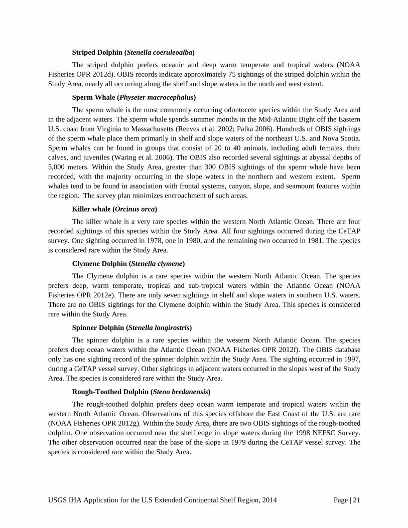
Striped Dolphin (Stenella coeruleoalba)
The striped dolphin prefers oceanic and deep warm temperate and tropical waters (NOAA Fisheries OPR 2012d). OBIS records indicate approximately 75 sightings of the striped dolphin within the Study Area, nearly all occurring along the shelf and slope waters in the north and west extent.
Sperm Whale (Physeter macrocephalus)
The sperm whale is the most commonly occurring odontocete species within the Study Area and in the adjacent waters. The sperm whale spends summer months in the Mid-Atlantic Bight off the Eastern U.S. coast from Virginia to Massachusetts (Reeves et al. 2002; Palka 2006). Hundreds of OBIS sightings of the sperm whale place them primarily in shelf and slope waters of the northeast U.S. and Nova Scotia. Sperm whales can be found in groups that consist of 20 to 40 animals, including adult females, their calves, and juveniles (Waring et al. 2006). The OBIS also recorded several sightings at abyssal depths of 5,000 meters. Within the Study Area, greater than 300 OBIS sightings of the sperm whale have been recorded, with the majority occurring in the slope waters in the northern and western extent. Sperm whales tend to be found in association with frontal systems, canyon, slope, and seamount features within the region. The survey plan minimizes encroachment of such areas.
Killer whale (Orcinus orca)
The killer whale is a very rare species within the western North Atlantic Ocean. There are four recorded sightings of this species within the Study Area. All four sightings occurred during the CeTAP survey. One sighting occurred in 1978, one in 1980, and the remaining two occurred in 1981. The species is considered rare within the Study Area.
Clymene Dolphin (Stenella clymene)
The Clymene dolphin is a rare species within the western North Atlantic Ocean. The species prefers deep, warm temperate, tropical and sub-tropical waters within the Atlantic Ocean (NOAA Fisheries OPR 2012e). There are only seven sightings in shelf and slope waters in southern U.S. waters. There are no OBIS sightings for the Clymene dolphin within the Study Area. This species is considered rare within the Study Area.
Spinner Dolphin (Stenella longirostris)
The spinner dolphin is a rare species within the western North Atlantic Ocean. The species prefers deep ocean waters within the Atlantic Ocean (NOAA Fisheries OPR 2012f). The OBIS database only has one sighting record of the spinner dolphin within the Study Area. The sighting occurred in 1997, during a CeTAP vessel survey. Other sightings in adjacent waters occurred in the slopes west of the Study Area. The species is considered rare within the Study Area.
Rough-Toothed Dolphin (Steno bredanensis)
The rough-toothed dolphin prefers deep ocean warm temperate and tropical waters within the western North Atlantic Ocean. Observations of this species offshore the East Coast of the U.S. are rare (NOAA Fisheries OPR 2012g). Within the Study Area, there are two OBIS sightings of the rough-toothed dolphin. One observation occurred near the shelf edge in slope waters during the 1998 NEFSC Survey. The other observation occurred near the base of the slope in 1979 during the CeTAP vessel survey. The species is considered rare within the Study Area.

USGS IHA Application for the U.S Extended Continental Shelf Region, 2014 Page | 22
Fraser’s Dolphin (Lagenodelphis hosei)
The Fraser’s dolphin prefers deep ocean waters, primarily deeper than 1,000 meters (NOAA Fisheries OPR 2012h). The overall number of sightings of this species in the western North Atlantic Ocean is low. There are no OBIS sightings of the Fraser’s dolphin within the Study Area and only one OBIS sighting in the waters adjacent to its boundaries. This dolphin species was observed near the western boundary of the Study Area and is considered rare within the Study Area.
Harbor Porpoise (Phocoena phocoena)
The harbor porpoise is primarily a coastal species, preferring waters less than 200 meters deep (NOAA Fisheries OPR 2013b). The OBIS database has records for thousands of sightings of the harbor porpoise in the coastal and shelf waters around the Gulf of Maine. Within the Study Area, only three sightings have been reported. Two observations occurred in the slope waters near the northern extent of the Study Area, and one at abyssal depth of 5,000 meters. The third observation was recorded in 1978 during the Programme Integre de recherches sur les oiseaux pelagiques Northwest Atlantic survey. The species is considered rare within the Study Area.
False Killer Whale (Pseudorca crassidens)
The false killer whale does not have a U.S.-managed population in the western North Atlantic Ocean, yet the species can be found sparingly offshore of the Mid-Atlantic states, primarily in waters deeper than 1,000 meters (NOAA Fisheries OPR 2013c). There are only 11 OBIS sightings of this species off the U.S. coast with two occurring within the Study Area; one was recorded in 1971, with the other two occurring in 1997. The false killer whale is considered rare within the Study Area and adjacent waters.
Pygmy Killer Whale (Feresa attenuata)
The pygmy killer whale is rare within the western North Atlantic Ocean. The species is found primarily in deeper tropical and sub-tropical waters (NOAA Fisheries OPR 2012i). There is only one OBIS sighting of the pygmy killer whale in the Study Area. It was observed in 1981 during the CeTAP aerial survey. Two other OBIS sightings were recorded along the shelf-waters, near the Study Area. The pygmy killer whale is considered rare with the Study Area.
Pygmy and Dwarf Sperm Whale (Kogia breviceps and K. sima)
Both the dwarf and pygmy sperm whale are most commonly found over the continental shelf edge and slope (NOAA Fisheries OPR 2012j, 2012k). Considered rare in the Mid-Atlantic region, the pygmy sperm whale has no OBIS-recorded sightings within the Study Area. However, three sightings have been recorded in the slope waters near the Study Area. One sighting was recorded in 2004 during the NEFSC Mid-Atlantic Marine Mammal Abundance Survey, and the two other sightings were recorded in 1998 during the NEFSC Survey. Similar to the pygmy sperm whale, the dwarf sperm whale is also considered rare in the Mid-Atlantic region, including in the Study Area. There are only two sightings recorded in the OBIS database. One sighting occurred in 2004 during the NEFSC Mid-Atlantic Marine Mammal Abundance Survey. The other sighting occurred in 1998 during the NEFSC Survey. Both species are considered rare within the Study Area.
Melon-Headed Whale (Peponocephala electra)
The melon-headed whale prefers warm, deeper, tropical waters (NOAA Fisheries OPR 2012l). The melon-headed whale is considered rare within the Study Area and in all adjacent waters. While no OBIS sightings within the Study Area have been recorded, one sighting was recorded near the

USGS IHA Application for the U.S Extended Continental Shelf Region, 2014 Page | 23
southeastern extent of its boundary. This sighting occurred during the Sargasso 2005 cetacean sightings survey. This species is considered rare within the Study Area
Sowerby’s Beaked Whale (Mesoplodon bidens)
The Sowerby’s beaked whale prefers deep, cold temperate waters within the western North Atlantic (NOAA Fisheries OPR 2012m). During surveys (both aerial and vessel), the various Mesoplodon species are difficult to differentiate. OBIS reports eight sightings of the Sowerby’s beaked whale within the Study Area. Six have occurred along the shelf with the other two being in the slope waters. The species is considered rare within the Study Area.
Blainville’s Beaked Whale (Mesoplodon densirostris)
The Blainville’s beaked whale is known to occur in deep, offshore waters spanning from tropical to temperate (NOAA Fisheries OPR 2012n). Similar to the Sowerby’s beaked whale, the Blainville’s beaked whale is difficult to discern from other Mesoplodon species during both aerial and vessel surveys. The OBIS data report only one sighting of the Blainville’s beaked whale, recorded in 2004 during the NEFSC Mid-Atlantic Marine Mammal Abundance Survey. A second sighting near the northeast extent of the Study Area was logged in 1995 by the NEFSC. The species is considered rare within the Study Area.
Gervais’ Beaked Whale (Mesoplodon europaeus)
The Gervais’ beaked whale can primarily be found in deep warm temperate, tropical, and sub-tropical waters (NOAA Fisheries OPR 2012o). Similar to the Sowerby’s beaked whale, the Gervais’ beaked whale is difficult to discern from other Mesoplodon species during both aerial and vessel surveys. No OBIS sightings of the Gervais’ beaked whale within the Study Area or in any adjacent waters have been recorded. This species is considered rare within the Study Area.
True’s Beaked Whale (Mesoplodon mirus)
The True’s beaked whale can primarily be found in deeper, warm temperate waters in the western North Atlantic Ocean (NOAA Fisheries OPR 2012p). Similar to the Sowerby’s beaked whale, the True’s beaked whale is difficult to discern from other Mesoplodon species during both aerial and vessel surveys. The OBIS database does not have any records for sightings of the True’s beaked whale within the Study Area. However, of the 20 OBIS sightings for this species, two exist in the waters adjacent to the northwest boundary line of the Study Area. During the NEFSC 1995 survey, one True’s beaked whale was spotted along the shelf edge. In 2003, during the Virginia Aquarium Marine Mammal Strandings 1998-2008, the second was reported stranded near approximately 76°N, 37°W. Survey details do not report on the type of stranding. This species is considered rare within the Study Area.
Cuvier’s Beaked Whale (Ziphius cavirostris)
The Cuvier’s beaked whale in can be found in temperate, tropical, and sub-tropical waters. Primarily, this species prefers deeper pelagic waters, being found in water depths greater than 1,000 meters (NOAA Fisheries OPR, 2012q). Of all the beaked whales, the Cuvier’s was the most commonly recorded in the OBIS database. The recorded sightings occurred in the shelf and slope waters adjacent to and within the Study Area. The 15 sightings within the Study Area occurred mostly in the slope waters in the northwest portion. While more common than the other beaked whale species, the Cuvier’s beaked whale is considered rare within the Study Area.

USGS IHA Application for the U.S Extended Continental Shelf Region, 2014 Page | 24
Northern Bottlenose Whale (Hyperoodon ampullatus)
The northern bottlenose whale is considered extremely uncommon/rare within U.S. western North Atlantic Ocean waters. This species prefers cold, deep waters (greater than 2,000 meters), primarily within the temperate to sub-arctic region (NOAA Fisheries OPR 2012r). Only one sighting of this species is in the OBIS database. The observation occurred in 2006 during the NEFSC Right Whale Survey. The northern bottlenose whale is considered rare within the Study Area and adjacent waters.
Pinnipeds Harbor seal (Phoca vitulina)
The harbor seal is considered rare outside of their coastal habitat in the U.S. western North Atlantic Ocean waters. This species prefers temperate coastal habitats, using rock, reefs, beach, or drifting ice on which to haul out. During summer months, this species can primarily occur in the nearshore waters of the Gulf of Maine and into Canadian waters (Waring et al. 2013). Two aerial sightings of this species were recorded offshore Cape Cod, Massachusetts around the 100-meter isobath. No sightings of harbor seals within or adjacent to the Study Area are recorded in the OBIS database. The harbor seal is considered rare within the Study Area and adjacent waters.
Gray seal (Halichoerus grypus)
The gray seal is considered rare outside of their coastal habitat in the U.S. western North Atlantic Ocean waters. This species prefers cold water coastal habitats, using rocks, sandbars and icebergs to haul out on. During summer months, this species can primarily be found in the nearshore waters of the Gulf of Maine and into Canadian waters (Waring et al. 2013). No sightings of gray seals within or adjacent to the Study Area are recorded in the OBIS database. The gray seal is considered rare within the Study Area and adjacent waters.
Harp Seal (Pagophilus groenlandicus)
The harp seal is considered rare outside its cold water habitat in the North Atlantic, and can be found primarily in the pack ice in the North Atlantic Ocean. During summer months, the harp seal can be found at its Arctic summer feeding grounds. No sightings of harp seals within or adjacent to the Study Area are recorded in the OBIS database. The harp seal is considered rare within the Study Area and adjacent waters.
Hooded seal (Cystophora cristata)
The hooded seal is considered rare outside its cold weather habitat. While this species can be found in deep waters, they are primarily found among pack ice. The species has been observed as far south as the Florida and the Caribbean; however, this is unusual as the species survives best in cold water habitats (NOAA Fisheries OPR 2012s). No sightings of hooded seals within or adjacent to the Study Area are recorded in the OBIS database. The hooded seal is considered rare within the Study Area and adjacent waters.
V. TYPE OF AUTHORIZATION REQUESTED
The type of incidental taking authorization that is being requested (i.e., takes by harassment only, takes by harassment, injury and/or death), and the method of incidental taking.
USGS IHA Application for the U.S Extended Continental Shelf Region, 2014 Page | 25
The USGS requests an IHA pursuant to Section 101(a)(5)(D) of the Marine Mammal Protection Act (MMPA) for incidental take by harassment during its planned seismic surveys in the western North Atlantic Ocean during late August and early September, 2014.
The operations outlined in Section I have the potential to take marine mammals by harassment. Sounds will be generated by the airguns used during the survey, by the echosounder and sub-bottom profiler, and by general vessel operations. “Takes” by harassment potentially could result when marine mammals near the activities are exposed to the pulsed sounds generated by the seismic sources. The effects will depend on the species of cetacean, the behavior of the animals at the time of reception of the stimulus, and received level of the sound (see Section VII). The proposed survey activities may result in disturbance reactions from any marine mammals within proximity to the source vessel. Based on the planned operations and mitigation measures (see Section XI), no serious injury to any marine mammals is expected, and no lethal takes are expected.
VI. NUMBERS OF MARINE MAMMALS THAT COULD BE TAKEN
The materials for Sections VI and Section VII are combined and presented in reverse order to
minimize duplication among sections.
VII. POTENTIAL IMPACT ON SPECIES OR STOCKS
The materials for Section VI and Section VII are combined and presented in reverse order to
minimize duplication between sections:
• A summary of potential impacts on marine mammals from airgun operations is presented first, as required for Section VII. A more comprehensive review of the relevant background information is included in the PEIS in Sections 3.6.4.3, 3.7.4.3, and 3.8.4.3, and in Appendix E.
• The estimated numbers of marine mammals that could be affected by the proposed survey in the U.S. ECS region off the Atlantic Seaboard during late August and early September, 2014are presented. This section includes a description of the rationale for the USGS’s estimates of the potential numbers of harassment “takes” during the planned survey, as required in Section VI.
Summary of Potential Effects of Airgun Sounds Airguns have the potential to affect marine mammals in a number of ways, including tolerance,
masking (of natural sounds including inter- and intra-specific calls), behavioral disturbance, and physiological responses such as temporary or permanent hearing impairment or other non-auditory effects (Richardson et al.1995; Nowacek et al. 2007; Southall et al. 2007; Wright et al. 2007; Tyack 2009).
By age, sex, and reproductive condition (if possible), the number of marine mammals (by species) that may be taken by each type of taking identified in [Section V], and the number of times such takings by each type of taking are likely to occur.
The anticipated impact of the activity upon the species or stock of marine mammal.

USGS IHA Application for the U.S Extended Continental Shelf Region, 2014 Page | 26
Physiological impacts, such as permanent threshold shift (PTS) (which could be considered an injurious event) and temporary threshold shift (TTS) (which is not considered an injurious event) could occur as a result of airgun operations (Southall et al. 2007). However, neither physiological impact is expected to occur during the proposed survey due to use of mitigation measures (described below). While the potential for PTS and TTS cannot be entirely excluded, it is highly unlikely (as summarized in the PEIS in Sections 3.6.7, 3.7.7, and 3.8.7) that this auditory impairment would occur as a result of the proposed 2014 survey. It is also highly unlikely that other non-auditory physiological or physical effects would occur as a result of the proposed survey. It is more likely that, should a marine mammal come within proximity to the proposed survey while the seismic airguns are operating, some behavioral disturbance could occur. However, this disturbance is expected to be short-term and localized. Monitoring and mitigation protocols will reduce any potential impacts to marine mammals. As a result of these protocols, it is anticipated that no marine mammals will be exposed to survey sounds that could cause behavioral disturbance.
Tolerance
Tolerance occurs when animals, often within areas commonly exposed to human-generated noise, do not appear to display a response to these human-generated sounds (Richardson et al. 1995). The pulsed sounds from airguns are known to be detectable in the water up to thousands of kilometers away from the source (Nieukirk et al. 2004). Numerous studies have been conducted on the reaction of marine mammals to seismic airgun pulses. Responses vary as marine mammals have been found to both tolerate the noise and to avoid the noise, indicating that response to noise may be related to individual species. Some studies have reported that marine mammals located a few kilometers from the seismic source have shown no apparent reaction to the noise, while other studies report behavioral reactions such as avoidance in both baleen whales and toothed whales (specifically sperm whales) (Malme et al. 1985; Richardson, Würsig, and Greene 1986; Ljungblad et al. 1988; McCauley et al. 2000a). Although individual baleen and toothed whales, as well as (less frequently) pinnipeds, have shown to exhibit behavioral reactions to airgun pulses at certain times, at other times, all three types of marine mammals have exhibited no obvious response. The relative responses of individual baleen whales, toothed whales, and pinnipeds are expected to be quite variable and depend on factors such as species, age, and previous exposures of the animal to human-generated sound.
Masking
Masking occurs when human-generated sounds interfere or obscure the ability of a marine mammal to detect sound signals they would otherwise receive (Richardson et al. 1995). The number of studies specific to the masking effects of pulsed sounds on marine mammal calls is limited. It is expected that those marine mammal species that could potentially be affected by masking may still be able to receive and emit sounds during the relatively quiet periods between the airgun pulses (Simard 2005; Clark and Gagnon 2006). Some baleen whales have been reported to cease calling due to the presence of pulsed sounds; however, other studies have reported that some baleen have increased the consistency of calls to compensate for presence of pulsed sounds (Clark and Gagnon 2006; Di Iorio and Clark 2010). Other studies have reported that whales have continued calling in the presence of seismic activity (Nieukirk et al. 2004; Richardson et al. 1986; Madsen et al. 2002). Small odontocetes predominantly rely on sounds within the higher frequencies. These frequencies are much higher than the dominant frequencies produced by seismic airguns, thereby limiting the potential for masking related to these species. Due to the intermittent nature of seismic airgun pulses, the relatively short timeframe of the proposed 2014 survey, and the large area to be covered during the proposed 2014 survey (reducing repeated seismic pulses
USGS IHA Application for the U.S Extended Continental Shelf Region, 2014 Page | 27
within a small area as is common of seismic surveys), it is expected that masking effect from the seismic pulses will be minor.
Disturbance Reactions
Disturbance effects can be expressed in a variety of ways including both obvious and more subtle reactions. These behavioral disturbance reactions can include (but are not limited to) flight response, changes in diving patters, foraging, and breathing, and avoidance or displacement (Tyack 2009; Nowacek et al. 2007). Temporary exposure and the potential brief reactions to that exposure are not expected to result in any significant disruption to behavioral patterns and will not result in harassment or “taking” (NMFS 2001; National Research Council 2005; Southall et al. 2007). The proposed 2014 survey is not expected to result in any permanent effects to any individuals or populations.
Reactions to sound, if any, depend on the species, state of maturity, experience, current activity, reproductive state, time of day, and many other factors (Richardson et al. 1995; Wartzok et al. 2004; Southall et al. 2007; Weilgart 2007). If a marine mammal reacts to an underwater sound by changing its behavior or moving a small distance, the impacts of the change are unlikely to be significant to the individual, let alone the stock or population. However, if a sound source displaces marine mammals from an important feeding or breeding area for a prolonged period, impacts on individuals and populations could be significant (Lusseau and Bejder 2007; Weilgart 2007). Currently, the majority of research and information regarding effects of seismic surveys is focused on individual animals and little information exists regarding effects at the population or community level.
Given the many uncertainties in predicting the quantity and types of impacts of sound on marine mammals, it is common practice to estimate how many mammals would be present within a particular distance of human activities and/or exposed to a particular level of anthropogenic sound. In most cases, this approach likely overestimates the numbers of marine mammals that would be affected in some biologically important manner. One of the reasons for this is that the selected distances/isopleths are based on limited studies indicating that some animals exhibited short-term reactions at that specific distance or sound level. The exposure calculations then assume that all animals exposed to this level would react in a biologically significant manner, similar to the few species that were observed exhibiting a reaction at that time.
The sound criteria used to estimate how many marine mammals might be disturbed to some biologically significant degree by seismic survey activities are primarily based on behavioral observations of a few species. Detailed studies have been done on humpback, gray, bowhead, and sperm whales, and on ringed seals. Less detailed data are available for some other species of baleen whales and small-toothed whales, but for many species there are no data on responses to marine seismic surveys.
Baleen whales. Baleen whales generally tend to avoid operating airguns, but avoidance radii are quite variable. Whales often are reported to show no overt reactions to pulses from large arrays of airguns at distances beyond a few kilometers, even though the airgun pulses remain well above ambient noise levels out to much longer distances. However, baleen whales exposed to strong noise pulses from airguns often react by deviating from their normal migration route and/or interrupting their feeding and moving away. Overall, the largest avoidance radii recorded (20 to 30 kilometers) for a reaction to seismic airguns involved migrating bowhead whales (Miller et al. 1999; Richardson et al. 1995). In the cases of migrating gray and bowhead whales, the observed changes in behavior appeared to be of little or no biological consequence to the animals, they simply avoided the sound source by displacing their migration route to
USGS IHA Application for the U.S Extended Continental Shelf Region, 2014 Page | 28
varying degrees, still within the natural boundaries of the migration corridors (Malme et al. 1984; Malme and Miles 1985; Richardson et al. 1995).
Responses of humpback whales to seismic surveys have been studied during migration, on summer feeding grounds, and on Angolan winter breeding grounds; there also has been discussion of effects on the Brazilian wintering grounds. During full-scale seismic surveys off Western Australia, avoidance reactions were reported to begin at 5 to 8 kilometers away from the full airgun array and 2 kilometers away from the single airgun. Traveling pods of humpback whales generally remained approximately 3 to 4 kilometers away from the active survey, and more sensitive resting pods of cow-calf pairs maintained an avoidance distance of 7 to 12 kilometers. However, some individual humpback whales, especially males, approached within distances of 100 to 400 meters (McCauley et al. 1998, 2000b).
On summer feeding grounds in southeast Alaska, humpback whales did not exhibit persistent avoidance when exposed to seismic pulses, although some humpback whales did exhibit a “startle” response (Malme et al. 1985). It has been suggested that South Atlantic humpback whales wintering off Brazil may be displaced or even may strand upon exposure to seismic surveys; however, these data were more circumstantial and subject to other explanations (International Association of Geophysical Contractors 2004). Data from subsequent years indicated that no observable direct correlation between strandings and seismic surveys existed.
Currently, there are no data on reactions of right whales to seismic surveys. However, results from studies conducted of the closely related bowhead whale indicate that responses of this whale can be variable, depending on their activity (migrating vs. feeding). While at summer feeding grounds, bowhead whales showed no reactions to seismic surveys being conducted between 6 and 99 kilometers away (Richardson et al. 1986). More recent studies also indicate that feeding bowhead whales are more tolerant of higher sound levels. Migrating bowhead whales, on the other hand, appear to be more sensitive and responsive to pulsed seismic sounds. Bowhead whale migrating in the Alaskan Beaufort Sea generally show substantial avoidance of seismic surveys (Miller et al. 1999; Richardson et al. 1995).
Reactions of feeding and migrating (not wintering) gray whales to seismic sounds also have been studied. In the Bering Sea (off St. Lawrence Island), 50 percent of feeding gray whales were reported to have stopped feeding at received sound pressure levels of 173 dB re 1 µPa on an (approximate) RMS basis, and that 10 percent of feeding whales interrupted feeding at received levels of 163 dB re 1 µPaRMS
(Malme et al. 1986, 1988). These findings were generally consistent with the results of studies conducted on larger numbers of gray whales migrating off California and western Pacific gray whales feeding off Sakhalin, Russia.
Studies have not been conducted on other Balaenoptera species (i.e., blue, sei, fin, and minke whales); however, these species occasionally have been observed in ensonified areas during various seismic surveys. Observations made during seismic surveys off the United Kingdom between 1997 and 2000 indicate that mysticetes (mainly fin and sei whales) were sighted at a similar rate while large seismic arrays were operating and while they were silent (Stone 2003; Stone and Tasker 2006). Localized avoidance also was observed during this time. Fin/sei whales also have been reported to spend less time submerged during periods when seismic arrays were firing compared to times when silent.
Data on short-term reactions by cetaceans to impulsive noises are not necessarily indicative of long-term or biologically significant effects. Whether impulsive sounds affect reproductive rate or

USGS IHA Application for the U.S Extended Continental Shelf Region, 2014 Page | 29
distribution and habitat use in subsequent days or years is unknown. However, gray whales have continued to migrate annually along the west coast of North America with substantial increases in the population over recent years, despite intermittent seismic exploration (and much ship traffic) in that area for decades. The western Pacific gray whale population did not seem affected by a seismic survey in its feeding ground during a previous year. Bowhead whales have continued to travel to the eastern Beaufort Sea each summer, and their numbers have increased notably
Toothed whales. Little systematic information is available about reactions of toothed whales to sound pulses. However, there are recent systematic studies on sperm whales (i.e., Gordon et al. 2006; Madsen et al. 2006). There is also an increasing amount of information about responses of various odontocetes to seismic surveys based on monitoring studies (i.e., Stone 2003; Smultea et al. 2004; Stone and Tasker 2006). Seismic operators and marine mammal observers on seismic vessels regularly see dolphins and other small-toothed whales near operating airgun arrays but, in general, there is a tendency for most delphinids to show some avoidance of operating seismic vessels (Richardson et al. 2009; Barkaszi, Epperson, and Bennett 2009). In most cases, the avoidance radii for delphinids appear to be small, on the order of 1 kilometer or less, and some individuals show no apparent avoidance. Based on observations from active seismic surveys off the United Kingdom, small odontocetes exhibited greater avoidance to operating airguns than previously reported (Stone et al. 2003; Gordon et al. 2004; Stone and Tasker 2006). The observer data also indicated that small odontocetes were feeding less and were interacting with the vessel less during activity seismic surveys. Captive bottlenose dolphins (and beluga whales) exhibited changes in behavior when exposed to strong, pulsed sounds similar in duration to those typically used in seismic surveys (Finneran et al. 2000, 2002, 2005). However, overall, the animals tolerated high, received levels of sound before exhibiting aversive behaviors. Porpoises, like delphinids, show variable reactions to seismic operations, and reactions apparently depend on species. Harbor porpoises have been reported to show stronger avoidance to seismic operations than Dall’s porpoises (Stone 2003; MacLean and Koski 2005; Bain and Williams 2006).
Studies of all three species of sperm whale reported that they show avoidance reactions in general to vessels not operating seismic airguns (Richardson et al. 1995; Würsig et al. 1998; Baird 2005). In studies where sperm whales were exposed to seismic airguns, the species response indicates considerable tolerance to the airgun noise. The whales generally do not show strong avoidance, and they continue to call. Research does indicate; however, that diving and foraging behaviors can be altered upon exposure to airgun sound (Jochens et al. 2008; Miller et al. 2009; Tyack 2009). Specific data on the behavioral reactions of beaked whales to seismic surveys is almost non-existent; the majority of information regarding beaked whales is in connection with military sonar events. Most beaked whales are illusive and tend to avoid approaching vessels of other types (Würsig et al. 1998). The species may dive for an extended period when approached by a vessel. However, based on both visual and acoustic observations, some northern bottlenose whales remained in the general area and continued to produce high-frequency clicks when exposed to sound pulses from distant seismic surveys. Most beaked whales would likely show strong avoidance of an approaching seismic vessel, as they would with any other vessel, although this has not been specifically documented.
Overall, odontocete reactions to large arrays of airguns are variable and, at least for delphinids, seem to be confined to a smaller radius than has been observed for the more responsive of the mysticetes and some other odontocetes. Based on available data, ≥170 dB re 1 µPaRMS disturbance criterion (rather than ≥160 dB re 1 µPaRMS) would be appropriate for delphinids. This is based on reaction distances for
USGS IHA Application for the U.S Extended Continental Shelf Region, 2014 Page | 30
delphinids being more consistent with the 170 dB re 1 µPaRMS radius, and delphinids being less responsive than other more responsive cetaceans.
Pinnipeds. Information on the reactions of pinniped species to pulsed seismic airgun sounds is limited. Based on early observations, pinnipeds appear to be quite tolerant of pulsed sounds. Other reports indicate that pinnipeds were tolerant of loud, pulsed sounds when they were strongly attracted to an area for feeding or reproductive purposes (Mate and Harvey 1987; Reeves et al. 1996). In more recent studies, avoidance of pinnipeds during seismic surveys has been reported as being relatively small, within 100 to a few hundred meters. Many seals remained within 100 to 200 meters of the survey track lines while an operating seismic survey passed (Moulton and Lawson 2002). Other observations made during seismic surveys in the Chuckchi and Beaufort Seas reported that pinnipeds were observed less when the seismic airguns were operating than when they were silent (Miller et al. 2005). Overall, behavioral reactions from pinnipeds to pulsed seismic sounds are variable. It is expected that localized avoidance of operating seismic airguns may occur; however, it cannot be guaranteed that these species would fully avoid an operating seismic vessel during active surveys.
Hearing Impairment and other Physical Effects
Temporary or permanent hearing impairment is a possibility when marine mammals are exposed to very strong sounds. TTS has been demonstrated and studied in certain captive odontocetes and pinnipeds exposed to strong sounds (Southall et al. 2007). However, neither specific occurrences of TTS nor permanent hearing damage (i.e., PTS, in free-ranging marine mammals exposed to sequences of airgun pulses during realistic field conditions) have been documented. Current NMFS policy regarding exposure of marine mammals to high-level sounds is that cetaceans and pinnipeds should not be exposed to impulsive sounds with received levels ≥180 dB and 190 dB re 1 μPaRMS, respectively (NMFS 2000). These criteria have been used in establishing the exclusion (shutdown) zones planned for the proposed seismic survey. However, those criteria were established before any information about minimum received levels of sounds necessary to cause auditory impairment in marine mammals existed.
Recommendations for science-based noise exposure criteria for marine mammals, frequency weighting procedures, and related matters were published by Southall et al. (2007). Those recommendations have not, as of late 2013, been formally adopted by the NMFS for use in regulatory processes and during mitigation programs associated with seismic surveys. However, some aspects of the recommendations have been considered in certain EISs and small take authorizations under the MMPA. The NMFS has indicated that they may soon issue new noise exposure criteria for marine mammals that account for the now-available scientific data on TTS, the expected offset between the TTS and PTS thresholds, differences in the acoustic frequencies to which different marine mammal groups are sensitive, and other relevant factors.
The planned monitoring and mitigation measures for this project are designed to detect marine mammals occurring near the airgun array and to avoid exposing them to sound pulses that have the potential, to cause hearing impairment (see Sections XI and XIII). Also, many cetaceans and (to a limited degree) pinnipeds show some avoidance of the area where received levels of airgun sounds are high enough such that hearing impairment could potentially occur. In those cases, the avoidance responses of the animals themselves would reduce or (most likely) avoid any possibility of hearing impairment. Appendix E of the PEIS provides a thorough review of the current knowledge available regarding TTS, PTS, and strandings and mortalities for marine mammals and seismic surveys.
USGS IHA Application for the U.S Extended Continental Shelf Region, 2014 Page | 31
Non-auditory physical effects may also occur in marine mammals exposed to strong underwater, pulsed sound. These non-auditory physiological effects or injuries could include stress, neurological effects, gas bubble formation in the blood or tissues, and other types of organ or tissue damage. It is possible that some marine mammal species (i.e., beaked whales) may be especially susceptible to injury and/or stranding when exposed to strong pulsed sounds. This is likely due to the deep-diving behavior of these species, which could result in a situation similar to “the bends” in humans if the animals are disturbed at depth and rise too quickly to the surface. However, no specific evidence exists regarding the potential for non-auditory effects to occur as a result of seismic surveys. Any effects resulting from the proposed seismic survey are expected to be limited to behavioral avoidance of the seismic vessel, as this reaction appears the most common among most baleen whales, some toothed whales, and some pinnipeds. Therefore, those animals avoiding the seismic survey vessel would be even less likely to incur auditory or non-auditory physical effects. The planned monitoring and mitigation, along with the brief duration of exposure expected, and the deep water environment of the Study Area, would all further reduce the potential for marine mammals to be exposed to pulsed sounds strong enough to cause non-auditory physical effects.
Potential Effects of Multibeam Echosounder and Sub-bottom Profiler Signals
The PEIS included a comprehensive review of potential affects from both MBESs and SBPs (see Sections 3.6.4.3; 3.7.4.3; 3.8.4.3; and Appendix E). The PEIS concluded that the operation of MBESs and SBPs is unlikely to impact odontocetes, mysticetes, or pinnipeds because the intermittent and narrow, downward-directed nature of both acoustic sources would result in no more than one or two brief pinging exposures of any individual animal, due to the movement and speed of the survey vessel.
Number of Marine Mammals that could be Exposed to 160 dB re 1µPARMS
All anticipated takes would be “takes by harassment” of small numbers of marine mammals and are expected to involve only temporary changes in behavior. No injury is expected to result from the proposed 2014 survey due to the proposed mitigation measures discussed below in Section XI. The methods used to estimate the number of marine mammals that could be affected during the proposed survey are described below. In general, the estimates are based on the consideration of the number of marine mammals that could be disturbed by the sounds resulting from the 36-airgun array during the approximately 3,150 kilometers of proposed 2014 survey lines in the U.S. ECS region of the Atlantic seaboard. The sources of data used to determine the “take” estimates are described below.
It is assumed that the airgun array and other sound sources (i.e., MBESs and SBPs) will be operated simultaneously. Therefore, any marine mammal close enough to be affected by an MBES or an SBP would already be affected by the airguns. However, even if the airguns are not operating simultaneously with the other sound sources, as stated earlier, marine mammals are not expected to exhibit anything more than short-term and negligible responses to the MBES and the SBP given the characteristics of the sound (i.e., narrow-downward directed beam) and other considerations as described in Sections 3.6.4.3; 3.7.4.3, 3.8.4.3, and Appendix E of the PEIS. Such reactions, as those expected from an MBES and an SBP alone are not considered to constitute a “taking” (NMFS 2001). Therefore, the “take” estimates described below do not take into account any additional allowance to include any marine mammals that could be affected by sound sources other than airguns.

USGS IHA Application for the U.S Extended Continental Shelf Region, 2014 Page | 32
Basis for Estimating Exposure
Incidental takes were estimated for each species by estimating the likelihood of a marine mammal being present within the expected ensonified area during active 2-D seismic surveys. Expected marine mammal presence in the vicinity of the Study Area during the proposed summer 2014 survey are described in Section IV. Based on the location of the Study Area and the time of year of the proposed 2014 survey, up to 38 marine mammal species have the potential to occur somewhere within the Study Area. Potential exposure is estimated based on the estimated density (animals per unit area) of each species within the Study Area and the amount of area estimated to be within the 160 dB re 1µPaRMS ensonified radius of the 36-airgun array (Table 1; Figure 5). The estimated 160 dB re 1µPaRMS ensonified zone was determined as described in Section I.
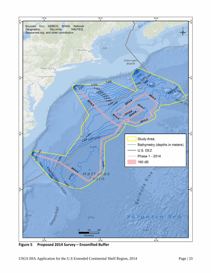
USGS IHA Application for the U.S Extended Continental Shelf Region, 2014 Page | 33
Figure 5 Proposed 2014 Survey – Ensonified Buffer
~F7~s·w ~~~ Sources· E . G . Srt GE eographic , BCO, NOAA Geonames ' Delorme · National .org , and other co~tr·b NAVTEQ ' utors '
~ N
+
New York
Pho~adelphoa
Bo ton . 292
70' W
L Study Area ~ - Bathymetry (de t . - U S p hs In meters)
· · EEZ
- Phase 1 - 2014
160 dB
Sea
65' W

USGS IHA Application for the U.S Extended Continental Shelf Region, 2014 Page | 34
Figure 6 Proposed 2015 Survey – Ensonified Buffer
~F7~s·-w ~~~==== Sources: Esri 1o·w Geographic ' GEBCO, NOAA . Geonames ' Delorme • National
.org, and other co~tributor~AVTEQ, N
+
New York ..
Boston. 292
,___ Study Area
- Bathymetry (d - U.S. EEZ epths tn meters)
- Phase 2-2015
160 dB
Sl?a

USGS IHA Application for the U.S Extended Continental Shelf Region, 2014 Page | 35
Density estimates for marine mammals within the vicinity of the Study Area are limited. Density data for species found along the East Coast of the U.S. generally extend slightly outside of the U.S. EEZ. The Study Area, however, extends well beyond the U.S. EEZ, and is well off the continental shelf break. The survey lines for the proposed 2014 survey are located in the far eastern portion of the Study Area, primarily within the area where little to no density data are currently available. It was determined that the best available information for density data (for those species where density data existed) of species located off the U.S. East Coast was housed at the Strategic Environmental and Development Program (SERDP) / National Aeronautics and Space Administration (NASA) / NOAA Marine Animal Model Mapper and OBIS-SEAMAP database. Within this database, the model outputs of all four seasons from the U.S. Department of the Navy Operating Area (OPAREA) Density Estimates (NODE) for the Northeast OPAREA and Southeast OPAREA (Department of the Navy 2007a, 2007b) were used to determine the mean density (animals per square kilometer) for 19 of the 38 marine mammals with the potential to occur within the Study Area. Those species include fin whale, minke whale, Atlantic spotted dolphin, bottlenose dolphin, long-finned and short-finned pilot whale, Pantropical spotted dolphin, Risso’s dolphin, Short-beaked common dolphin, striped dolphin, sperm whale, rough-toothed dolphin, dwarf and pygmy sperm whale, and Sowerby’s, Blainville’s, Gervais’, True’s, and Cuvier’s beaked whales. Model outputs for each season are available in the database. The data from the NODE summer density models, which include the months of June, July, and August, were used as the 2014 survey is proposed to take place between late August and early September. Of the seasonal NODE density models available, it is expected that the summer models are the most accurate and robust as the survey data used to create all of the models were obtained during summer months. The models for the winter, spring, and fall are derived from the data collected during the summer surveys, and therefore are expected to be less representative of actual species density during those seasons.
It should be noted that the mean density for those species was calculated based on the area within the Study Area where density data existed. The outer portion of the Study Area, where the majority of the proposed 2014 survey lines are located, was classified as “no data” in the database. Therefore, the density estimates that were used are based on species density for a portion of the Study Area. Due to the lack of more comprehensive and available data, the NODES data have been determined to be the best available data for that area. The density data likely do not extend out to the eastern portion of the Study Area as marine mammal surveys generally do not occur this far offshore. Therefore, there is a general lack of information in this region.
For those species that did not have density model outputs within the SERDP/NASA/NOAA and OBIS-SEAMAP database, or those species with density outputs that did not extend into the Study Area at all (i.e., all four pinniped species, or the sei whale), but for which OBIS sightings data within or adjacent to the Study Area exists, a Requested Take Authorization for the mean group size of the species is included. Mean group sizes were determined based on data reported from the CeTAP surveys (CeTAP 1982).
The estimated numbers of animals potentially exposed to sound during the proposed 2014 survey were determined using the 160 dB re 1µPaRMS threshold criterion for all cetaceans and pinnipeds. It is assumed that any marine mammals that are exposed to airgun sounds within this threshold could change their behavior sufficiently to be considered “taken by harassment.” Table 3 shows the density estimates for each species as described above and the estimated numbers of individual marine mammals that could be exposed to ≥160 dB re 1µPaRMS during the active 2-D seismic survey. This estimate assumes that the individual animals do not move away from the seismic survey vessel, therefore, resulting in exposure. As

USGS IHA Application for the U.S Extended Continental Shelf Region, 2014 Page | 36
stated earlier, for species for which densities were unavailable, but for which OBIS sightings within or adjacent to the Study Area exist, a Requested Take Authorization for the mean group size of the species is included.
It should be noted, that unlike previous USGS, NSF, and L-DEO seismic surveys aboard the R/V Langseth, the proposed survey will be conducted as essentially one continuous line. The survey will not be conducted in a pattern of parallel lines and will not include full turns of the vessel. Therefore, the ensonified area for the proposed survey does not include a contingency factor (typically 25%) in line-kilometers. The proposed survey also is not expected to shut down the airguns, only to power-down the airguns, should a marine mammal enter within the 160 dB re 1µPaRMS EZ. Given this, the ensonified area for the single mitigation gun would be much smaller than that of the full array (see Table 1). Therefore, the use of the full 160 dB re 1µPaRMS ensonified area for the entire 3,150 kilometers of survey lines is expected to overestimate of the actual ensonified area should the single mitigation airgun need to be used at any time. It is assumed that the estimates of the numbers of individual marine mammals that could be exposed to sounds at 160 dB re 1µPaRMS are overall precautionary due to the overestimated ensonified area and the estimation of species presence within the large Study Area, and are likely to overestimate the actual number of marine mammals that could be exposed. These estimates assume that there would be no weather, equipment, or mitigation delays, which is highly unlikely.
Note that although the survey track is continuous through the turns and no mitigation gun will be necessary. However, the mitigation airgun may be used in the event of minor, short duration equipment maintenance. Longer maintenance or repair periods (greater than two hours) of the seismic equipment would warrant complete shut-down of the seismic source, including the mitigation gun. The normal ramp-up procedures would be followed at the completion of these longer shut-down periods.
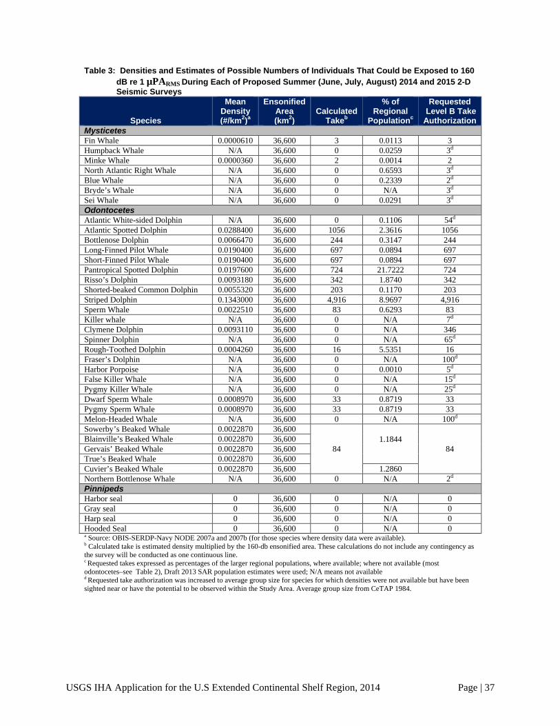
USGS IHA Application for the U.S Extended Continental Shelf Region, 2014 Page | 37
Table 3: Densities and Estimates of Possible Numbers of Individuals That Could be Exposed to 160 dB re 1 µPARMS During Each of Proposed Summer (June, July, August) 2014 and 2015 2-D Seismic Surveys
Species
Mean Density (#/km2)a
Ensonified Area (km2)
Calculated Takeb
% of Regional
Populationc
Requested Level B Take Authorization
Mysticetes Fin Whale 0.0000610 36,600 3 0.0113 3 Humpback Whale N/A 36,600 0 0.0259 3d Minke Whale 0.0000360 36,600 2 0.0014 2 North Atlantic Right Whale N/A 36,600 0 0.6593 3d Blue Whale N/A 36,600 0 0.2339 2d Bryde’s Whale N/A 36,600 0 N/A 3d Sei Whale N/A 36,600 0 0.0291 3d Odontocetes Atlantic White-sided Dolphin N/A 36,600 0 0.1106 54d Atlantic Spotted Dolphin 0.0288400 36,600 1056 2.3616 1056 Bottlenose Dolphin 0.0066470 36,600 244 0.3147 244 Long-Finned Pilot Whale 0.0190400 36,600 697 0.0894 697 Short-Finned Pilot Whale 0.0190400 36,600 697 0.0894 697 Pantropical Spotted Dolphin 0.0197600 36,600 724 21.7222 724 Risso’s Dolphin 0.0093180 36,600 342 1.8740 342 Shorted-beaked Common Dolphin 0.0055320 36,600 203 0.1170 203 Striped Dolphin 0.1343000 36,600 4,916 8.9697 4,916 Sperm Whale 0.0022510 36,600 83 0.6293 83 Killer whale N/A 36,600 0 N/A 7d Clymene Dolphin 0.0093110 36,600 0 N/A 346 Spinner Dolphin N/A 36,600 0 N/A 65d Rough-Toothed Dolphin 0.0004260 36,600 16 5.5351 16 Fraser’s Dolphin N/A 36,600 0 N/A 100d Harbor Porpoise N/A 36,600 0 0.0010 5d False Killer Whale N/A 36,600 0 N/A 15d Pygmy Killer Whale N/A 36,600 0 N/A 25d Dwarf Sperm Whale 0.0008970 36,600 33 0.8719 33 Pygmy Sperm Whale 0.0008970 36,600 33 0.8719 33 Melon-Headed Whale N/A 36,600 0 N/A 100d Sowerby’s Beaked Whale 0.0022870 36,600
84
1.1844
84
Blainville’s Beaked Whale 0.0022870 36,600 Gervais’ Beaked Whale 0.0022870 36,600 True’s Beaked Whale 0.0022870 36,600 Cuvier’s Beaked Whale 0.0022870 36,600 1.2860 Northern Bottlenose Whale N/A 36,600 0 N/A 2d Pinnipeds Harbor seal 0 36,600 0 N/A 0 Gray seal 0 36,600 0 N/A 0 Harp seal 0 36,600 0 N/A 0 Hooded Seal 0 36,600 0 N/A 0 a Source: OBIS-SERDP-Navy NODE 2007a and 2007b (for those species where density data were available). b Calculated take is estimated density multiplied by the 160-db ensonified area. These calculations do not include any contingency as the survey will be conducted as one continuous line. c Requested takes expressed as percentages of the larger regional populations, where available; where not available (most odontocetes–see Table 2), Draft 2013 SAR population estimates were used; N/A means not available d Requested take authorization was increased to average group size for species for which densities were not available but have been sighted near or have the potential to be observed within the Study Area. Average group size from CeTAP 1984.

USGS IHA Application for the U.S Extended Continental Shelf Region, 2014 Page | 38
Table 4: Densities and Estimates of Possible Numbers of Individuals That Could be Exposed to 160
dB re 1 µPARMS During Spring (March, April, May) 2015 2-D Seismic Surveys
Species
Mean Density (#/km2)a
Ensonified Area (km2)
Calculated Takeb
% of Regional
Populationc
Requested Level B Take Authorization
Mysticetes Fin Whale 0.0000600 36,600 3 0.113 3 Humpback Whale 0.0010170 36,600 38 0.3276 38 Minke Whale 0.0000350 36,600 2 0.0014 2 North Atlantic Right Whale N/A 36,600 0 0.6593 3d Blue Whale N/A 36,600 0 0.2339 2d Bryde’s Whale N/A 36,600 0 N/A 3d Sei Whale N/A 36,600 0 0.0291 3d Odontocetes Atlantic White-sided Dolphin N/A 36,600 0 0.1106 54d Atlantic Spotted Dolphin 0.0285700 36,600 1046 2.3393 1046 Bottlenose Dolphin 0.0069560 36,600 255 0.3289 255 Long-Finned Pilot Whale 0.0108000 36,600 396 0.0408 396 Short-Finned Pilot Whale 0.0108000 36,600 396 0.0508 396 Pantropical Spotted Dolphin 0.0194900 36,600 714 21.422 714 Risso’s Dolphin 0.0092150 36,600 338 1.8520 338 Shorted-beaked Common Dolphin 0.0053940 36,600 198 0.1141 198 Striped Dolphin 0.1330000 36,600 4,868 8.8817 4,868 Sperm Whale 0.0019050 36,600 70 0.5307 70 Killer whale N/A 36,600 0 N/A 7d Clymene Dolphin 0.0093110 36,600 341 N/A 341 Spinner Dolphin N/A 36,600 0 N/A 65d Rough-Toothed Dolphin 0.0004200 36,600 16 5.9041 16 Fraser’s Dolphin N/A 36,600 0 N/A 100d Harbor Porpoise N/A 36,600 0 0.00010 5d False Killer Whale N/A 36,600 0 N/A 15d Pygmy Killer Whale N/A 36,600 0 N/A 25d Dwarf Sperm Whale 0.0008850 36,600 33 0.8719 33 Pygmy Sperm Whale 0.0008850 36,600 33 0.8719 33 Melon-Headed Whale N/A 36,600 0 N/A 100d Sowerby’s Beaked Whale
0.0021370
36,600
79 1.1139 79 Blainville’s Beaked Whale 36,600 Gervais’ Beaked Whale 36,600 True’s Beaked Whale 36,600 Cuvier’s Beaked Whale 36,600 1.2094 Northern Bottlenose Whale N/A 36,600 0 N/A 2d Pinnipeds Harbor seal 0 36,600 0 N/A 0 Gray seal 0 36,600 0 N/A 0 Harp seal 0 36,600 0 N/A 0 Hooded Seal 0 36,600 0 N/A 0 a Source: OBIS-SERDP-Navy NODE 2007a and 2007b (for those species where density data were available). b Calculated take is estimated density multiplied by the 160-db ensonified area. These calculations do not include any contingency as the survey will be conducted as one continuous line. c Requested takes expressed as percentages of the larger regional populations, where available; where not available (most odontocetes–see Table 2), Draft 2013 SAR population estimates were used; N/A means not available d Requested take authorization was increased to average group size for species for which densities were not available but have been sighted near or have the potential to be observed within the Study Area. Average group size from CeTAP 1984.

USGS IHA Application for the U.S Extended Continental Shelf Region, 2014 Page | 39
It also should be noted that as summarized from the PEIS in the above section, “Summary of Potential Airgun Effects,” delphinids appear to be less responsive to airgun sounds than some mysticetes. The 160 dB re 1µPaRMS criterion that the NMFS currently uses to determine potential Level B harassment to all cetaceans was based on recorded reactions of gray and bowhead whales. For delphinids and pinnipeds, a 170 dB re 1µPaRMS disturbance criterion may be more appropriate. Based on this, the estimates of potential “takes by harassment” presented in Table 3 would, therefore, be considered precautionary. Note that the ensonified area (36,600 km2) shown in Table 3 is calculated for the 2014 survey. The 2015 survey is expected to ensonify an almost identical area (to within 2 %); therefore takes requested are identical for each of the two years. However, the 2015 survey may be scheduled for an earlier time slot. Table 4 indicates the number of takes that would be expected were the survey to be scheduled in the spring rather than summer. The data suggest that spring takes would be higher for only two species: Humpback Whale and Bottlenose Dolphin. Spring takes would be fewer for nine species, and unchanged for the remaining species.
Potential Number of Marine Mammals Exposed
The potential number of different individual marine mammals that could be exposed to airguns at or exceeding 160 dB re 1µPaRMS can be determined using the total area that will be located within the 160-dB radius at any one point during the entire survey. In many seismic surveys, this total marine area includes overlap, as seismic surveys are often conducted in parallel survey lines where the ensonified areas of each survey line will overlap. The proposed 2014 survey lines, however, will not have overlap as the individual line segments of the complete 2014 proposed survey line do no run parallel to each other. The entire survey could be considered one continual survey line with slight turns (no more than 90 degrees) between each line segment (see Figures 5 and 6). During the proposed 2014 survey, the seismic vessel will continue on the extensive survey line path, not staying within a smaller defined area as most seismic surveys do. Therefore, due to the structure of the proposed 2014 survey, there is a potential for one marine mammal to be exposed to the airgun sounds more than once. It is expected however that, if an individual is exposed at least once at any one point during the survey, that animal is more likely to avoid the survey vessel should it encounter the survey vessel farther down the survey line, reducing the likelihood of a second exposure.
The number of potential individuals exposed to airgun sounds ≥160 dB re 1µPaRMS were determined by multiplying each expected species density (for those species that had density data) by the total ensonified area for the entire 3,150 kilometers of the survey line. The total area expected to be ensonified was determined by creating the 160-dB buffer around the entire survey line (see Table 1). This was done using ESRI ArcGIS. Using this approach, a total of 33,193 square kilometers will fall within the 160-dB isopleth throughout the course of the proposed 2014 survey. This approach does not allow for turnover in the marine mammal populations in the area, therefore, the actual number of marine mammals could be underestimated. However, it is expected that the line kilometers used to calculate the potential exposures and the fact that these calculations assume that no marine mammals would move away from the track line during active surveys before the received sound levels reach 160 dB re 1µPaRMS result in an overestimation of potential individual exposures.
The total number of individual animals that could be exposed to received levels of seismic sounds ≥160 dB re 1µPaRMS during the entire proposed 2014 survey is 9,866 (Table 3). That total includes 97 cetaceans listed as Endangered under the ESA, including 3 fin whales (0.011 percent of the regional population), 3 humpback whales (0.026 percent of the regional population), 3 North Atlantic right whales

USGS IHA Application for the U.S Extended Continental Shelf Region, 2014 Page | 40
(0.66 percent of the regional population), 2 blue whales (0.234 percent of the regional population), 3 sei whales (0.029 percent of the regional population), and 83 sperm whales (0.629 percent of the regional population).
Most of the cetaceans (89.2 percent) potentially exposed are delphinids. The most common species in the area are expected to be the striped dolphin (4,916 estimated individuals [8.97 percent of the regional population]), Atlantic spotted dolphin (1056 estimated individuals [2.36 percent of the regional population]), and Pantropical spotted dolphin (724 estimated individuals [21.72 percent of the regional population]). No “takes” of pinnipeds are expected due to a lack of species observations within the Study Area, the great distance offshore , and the extreme depth of the Study Area, as these species are primarily found in coastal waters. It should be noted that the regional populations for each species are the populations reported in the 2013 NMFS Stock Assessment Report (SAR) for species populations within U.S. waters. Therefore, population percentages may be underestimated for actual population sizes that would include waters outside the U.S. EEZ.
Conclusions
As stated earlier, the proposed 2014 survey will consist of operating a seismic airgun array that will introduce pulsed intermittent noise into the marine environment. During this time, both an MBES and an SBP will be operating simultaneously. During the survey, the R/V Langseth will be towing a full 36-airgun array with a total volume discharge of approximately 6,600 in3. Regular vessel operations also are likely to produce sound within the marine environment; however, continuous noise sources such as this are not commonly known to affect marine mammals to the point of “taking.” In addition, no takes are expected to result from the operation of the echosounder operations given the discussion found in Sections 3.6.4.3, 3.7.4.3, 3.8.4.3, and Appendix E of the PEIS.
Cetaceans. Sections 3.6.7 and 3.7.7 of the PEIS concluded that with the implementation of the proposed monitoring and mitigation measures, unavoidable impacts to mysticetes and odontocetes (in the Northwest Atlantic Detailed Analysis Area and Mid-Atlantic Ridge Qualitative Analysis Area) are expected to be limited to short-term behavioral disturbance and short-term localized avoidance of the area where airguns are operating. These impacts will result in only a small number of Level B behavioral effects. Level A effects are highly unlikely, and seismic operations are unlikely to adversely affect any ESA-listed species.
Pinnipeds. Section 3.8.7 of the PEIS concluded that pinnipeds are absent or rare in most locations where seismic surveys occur. This is true for the proposed 2014 surveys. However, with the implementation of the proposed monitoring and mitigation measures, impacts to pinnipeds are expected to be limited to behavioral disturbance and, in some cases, localized avoidance of the area where airguns are operating. Level A effects are highly unlikely. Due to the lack of species presence data within the Study Area and the species’ preferences for more coastal waters, the proposed survey is not expected to encounter any pinniped species.
This IHA application presents the estimated potential number of marine mammals that could be exposed to pulsed seismic airgun sounds during the proposed 2014 survey. Based on this, “take authorizations” by Level B harassment also have been requested for each species. Overall, the requested take authorizations represent a small percentage of the overall U.S. regional population for each species (see Table 3). Exposure estimates for only one species, the pantropical spotted dolphin, represent greater than 20 percent of the regional population of any species with 656 requested takes. However, it is expected that these, as with the estimates for all of the potential species exposures, are overestimates for

USGS IHA Application for the U.S Extended Continental Shelf Region, 2014 Page | 41
the reasons outlined previously. It should also be noted that any bottlenose dolphins potentially encountered during the proposed 2014 survey would primarily be from the offshore morphotype population. This morphotype is genetically distinct from the coastal morphotype populations, which are the populations primarily affected by the recent 2013 UME. Therefore, the potential for Level B harassment of 221 individuals of the offshore bottlenose dolphin morphotype, which represents 0.28 percent of the regional population, would not further affect the potentially vulnerable population of the coastal morphotype.
Overall, the relatively short-term exposures to any marine mammals are unlikely to result in any long-term negative consequences to either individual and animals or populations.
VIII. ANTICIPATED IMPACTS ON SUBSISTENCE USES
There is no legal subsistence hunting for marine mammals in the western North Atlantic, so the
proposed activities will not have any impact on the availability of the species or stocks for subsistence users.
IX. ANTICIPATED IMPACTS ON HABITAT
The proposed seismic survey would not result in any permanent impact on habitats used by
marine mammals or to their food sources. The main impact on marine mammals associated with the proposed 2014 survey activity will be temporarily elevated noise levels and the associated direct effects, as discussed in Section VII, above. Seismic airguns also have the potential to affect fish and invertebrates that serve as prey for marine mammal species. The effects of airguns on fish and invertebrates are reviewed in the PEIS in Sections 3.2.4.3 and 3.3.4.3, and in Appendix D. The PEIS concluded that seismic airguns could have both direct and indirect effects on fish and invertebrate species, including behavioral changes and other non-lethal, temporary impacts, and injury or mortal impacts on individual fish located within direct proximity to an active high-energy acoustic source. However, significant impacts from the proposed 2014 survey to fish or invertebrate populations are not anticipated.
X. ANTICIPATED IMPACT OF LOSS OR MODIFICATION OF HABITAT ON MARINE MAMMALS
The proposed 2014 survey is not expected to have any habitat-related effects with the potential to result in significant or long-term impacts on either individual marine mammals or their populations. This is a result of the limited duration of the proposed 2014 survey (approximately 19 days) and the large area
The anticipated impact of the activity on the availability of the species or stocks of marine mammals for subsistence uses.
The anticipated impact of the activity upon the habitat of the marine mammal populations, and the likelihood of restoration of the affected habitat.
The anticipated impact of the loss or modification of the habitat on the marine mammal populations involved.
USGS IHA Application for the U.S Extended Continental Shelf Region, 2014 Page | 42
the survey will cover. There is a potential that the small number of marine mammals present within the vicinity of the survey vessel while the full airgun array is operating would be temporarily displaced as much as a few kilometers. However, as stated earlier, the proposed 2014 survey is not operating in a small, defined location. The proposed 3,150 kilometers of survey lines are not parallel and the seismic vessel will continuously move along that line. This reduces the potential to create a specific area offshore with repeated seismic activity that marine mammals may avoid.
XI. MITIGATION MEASURES
Marine mammals are known to occur within the Study Area. To minimize potential impacts that
could occur to species and/or stocks, airgun operations will be conducted in accordance with the MMPA and the ESA. This will include obtaining permission for incidental harassment of incidental “takes” of marine mammals and other federally listed species. The proposed activities will take place both within the U.S. EEZ and in International Waters.
The following subsections outline the proposed mitigation measures that will be followed during the proposed 2014 survey. The procedures described here are based on protocols used during previous L-DEO seismic research cruises as approved by the NMFS.
Planning Phase As discussed in the PEIS (Section 2.4.1.1), mitigation of potential impacts from the proposed
survey begins during the planning phase. The USGS worked with L-DEO and NSF to identify potential time periods to carry out the survey, taking into consideration key factors such as environmental conditions (i.e., the seasonal presence of marine mammals). As most marine mammal species are expected to occur in the Study Area year-round, altering the timing of the proposed 2014 survey from summer months would result in no net benefits to these species. After consideration of what energy source level was necessary to achieve the research goals, USGS determined that the standard R/V Langseth 36-airgun array with a total volume of approximately 6,600 in3 was appropriate.
Proposed Exclusion Zones Based on L-DEO’s model (Diebold et al. 2010 and Appendix H of the PEIS), received sound
levels have been predicted for the proposed 2014 survey. The predicted received sound levels are a function of distance from the airguns for both the full 36-airgun array and the single 1900LL 40-in3 airgun (mitigation gun), which would be used during power-downs (see Figures 3 and 4). This modeling approach uses ray tracing for the direct wave traveling from the array to the receiver and its associated source ghost (reflection at the air-water interface in the vicinity of the array), in a constant-velocity half-space (infinite homogeneous ocean layer, unbounded by a seafloor). In addition, propagation measurements of pulses from the 36-airgun array at a tow depth of 6 meters have been reported in approximately 1,600 meters water depth (deep water), 50 meters depth (shallow water) and a slope site (intermediate water depth) in the Gulf of Mexico in 2007–2008 (Tolstoy et al. 2009; Diebold et al. 2010).
The availability and feasibility (economic and technological) of equipment, methods, and manner of conducting such activity or other means of effecting the least practicable adverse impact upon the affected species or stocks, their habitat, and on their availability for subsistence uses, paying particular attention to rookeries, mating grounds, and areas of similar significance.
USGS IHA Application for the U.S Extended Continental Shelf Region, 2014 Page | 43
For deep water and intermediate water depth cases, these field measurements cannot be used readily to derive mitigation radii. At these sites, the calibration hydrophone was located at a roughly constant depth of 350 to 500 meters, which may not intersect all the SPL isopleths at their widest point from the sea surface down to the maximum relevant water depth for marine mammals of approximately 2,000 meters. Figures 2 and 3 in Appendix H of the PEIS show how the values along the maximum SPL line that connects the points where the isopleths attain their maximum width (providing the maximum distance associated with each sound level) may differ from values obtained along a constant depth line. At short ranges, where the direct arrivals dominate and the effects of seafloor interactions are minimal, the data recorded at the deep and slope sites are suited for comparison with modeled levels at the depth of the calibration hydrophone. At larger ranges, the comparison with the mitigation model—constructed from the maximum SPL through the entire water column at varying distances from the airgun array—is the most relevant. The results are summarized below.
Comparisons at short ranges between sound levels for direct arrivals recorded by the calibration hydrophone and model results for the same array tow depth are consistent (Figures 12 and 14 in Appendix H of the PEIS). Consequently, isopleths falling within this domain can be reliably predicted by the L-DEO model, while they may be imperfectly sampled by measurements recorded at a single depth. At larger distances, the calibration data show that seafloor reflected and sub-seafloor refracted arrivals dominate, while the direct arrivals become weak and/or incoherent (Figures 11, 12 and 16 in Appendix H of the PEIS). Aside from local topography effects, the region around the critical distance (approximately 5 kilometers on Figures 11 and 12, and approximately 4 kilometers in Figure 16 in Appendix H of the PEIS) is where the observed levels rise close to the mitigation model curve. However, the observed sound levels are found to fall almost entirely below the mitigation model curve (Figures 11, 12, and 16 in Appendix H of the PEIS). Thus, analysis of the Gulf of Mexico calibration measurements demonstrates that although simple, the L-DEO model is a robust tool for estimating mitigation radii.
During the proposed 2014 survey, the proposed seismic operations will occur entirely in deep water (i.e., greater than 1,000 meters). Therefore, for the purposes of the proposed 2014 survey, only deep-water radii were predicted. For the full 36-airgun array, the deep-water radii were obtained from 9-meter tow depth L-DEO model results to a maximum water depth of 2,000 meters.
Measurements have not been reported for the single 40-in3 airgun. The 40-in3 airgun fits under the PEIS low-energy sources (i.e., any towed acoustic source whose receive level is ≤180 dB re 1 µPaRMS at 100 meters from the source, including any single airgun with a volume ≤ 425 in3). In the PEIS (Section 2.4.2), Alternative B (the Preferred Alternative) conservatively applies a 100-meter EZ for all low-energy acoustic sources in water depths greater than 100 meters. This approach is adopted here for the single Bolt 1900LL 40-in3 airgun that would be used during power-downs. In addition, L-DEO model results are used to determine the 160- and 190- dB radii for the 40-in3 airgun in deep water.
Table 1 shows the modeled distances for both the 36-airgun array and the single mitigation gun at which the 160, 160, and 190 dB re 1 µPaRMS received levels are expected to be reached. The 180-dB re 1 μPaRMS distance is the safety criterion as specified by NMFS (2000) for cetaceans. If marine mammals or sea turtles are detected within, or about to enter, the appropriate exclusion zone, the airguns would be immediately powered down (or shut down if necessary).
New, detailed recommendations for science-based noise exposure criteria have been presented by Southall et al. (2007). The USGS is aware that NOAA is in the process of revising the current guidance for marine mammals regarding acoustic exposure. However, at the time of this IHA application, that

USGS IHA Application for the U.S Extended Continental Shelf Region, 2014 Page | 44
guidance has not been finalized. The USGS is prepared to revise its procedures for estimating the number of marine mammals “taken,” EZ’s, etc., as may be required by any new guidelines that may result.
Mitigation during Operations Mitigation measures that will be adopted during the proposed survey include: (1) power-down
procedures, (2) ramp-up procedures; and (3) special procedures for situations of species of particular concern.
Power-down Procedures
A power-down involves reducing the number of airguns operating such that the radius of the 180-dB (or 190-dB) zone is decreased to the extent that an observed marine mammal(s) is (are) no longer observed within the EZ. As the proposed survey does not include any full turns (only 90-degree turns maximum), the seismic airgun array will continue to operate at full power between line segments. The survey will be conducted as the segments are one continuous line. During a power-down, only one airgun will be operating. The continued operation of one-airgun is intended to alert any marine mammals of the presence of the seismic vessel.
If a marine mammal is detected within, or is likely to enter the EZ, the airgun array would be powered down immediately. During a power-down situation of the full air-gun array, only a 40-in3 airgun will be operated. Following a power-down situation, airgun activity will not resume until the marine mammal has cleared the EZ. The animal will be considered clear of the EZ if it:
• is visually observed to have left the EZ; or
• has not been seen within the EZ for 15 minutes in the case of small odontocetes and pinnipeds; or
• has not been seen within the EZ for 30 minutes in the case of mysticetes and large odontocetes including sperm, pygmy sperm, dwarf sperm, and beaked whales; or
• the vessel has moved outside the applicable EZ in which the animal in question was last seen.
Following a power-down and subsequent animal departure from the EZ as described above, the airgun array would resume full operations. Based on previous R/V Langseth marine seismic surveys, it has been determined that following a power-down, ramp-up from the single mitigation gun is not necessary as the single mitigation gun serves to warn any marine mammals within the vicinity of the survey of the seismic activities underway. It has also been determined that the ramp-up procedures may unnecessarily extend the length of the survey time needed to collect the seismic data. Previous surveys conducted by L-DEO and NSF in consultation with the NMFS have concluded that undergoing ramp-up procedures following an extended power-down is not necessary. Therefore, this IHA application does not include this practice as part of the monitoring and mitigation plan.
If an animal is observed within the smaller designated EZ for the single airgun (see Table 1), the airguns will be completely shut down. Airgun operation will not be resumed until the above conditions are met, as applicable.
USGS IHA Application for the U.S Extended Continental Shelf Region, 2014 Page | 45
Shutdown Procedures
Operating airgun(s) will be shut down if a marine mammal is observed within or approaching the EZ for the single airgun. During a shutdown, all operating airguns will be turned off immediately. Airgun activity will not resume until the marine mammal(s) has cleared the EZ for the full array, as described above under “Power-down Procedures.”
Ramp-up Procedures
A ramp-up procedure will be followed when starting the airguns at the beginning of seismic operations or anytime the entire array has been shut down for a specified period of time. Based on other surveys conducted by L-DEO using the R/V Langseth and using an airgun array of similar size as the proposed 2014 survey, a period of approximately 10 minutes is proposed for the 2014 survey. Ramp-up will not occur if an observed marine mammal has not cleared the EZ as described above.
Ramp-up will consist of beginning with the smallest airgun in the array (40 in3). Airguns will then be added in a sequence such that the source level of the array will increase in steps not exceeding 6 dB per 5-minute period. A 36-airgun array is expected to take approximately 30 minutes to achieve full operations. During the ramp-up, NMFS-approved Protected Species Visual Observers (PSVOs) will monitor the EZ, and if a marine mammal is sighted, a power-down or shutdown will be implemented, as applicable, as though the full array were operating.
Ramp-up may not be initiated unless the full EZ is visible to the PSVOs for no less than 30 minutes, whether conducted in daytime or nighttime. Ramp-up may commence even if the entire EZ is not visible for 30 minutes if at least one airgun (40 in3 or smaller) has been operating during the interruption of seismic survey operations. Therefore, it is not expected that the full airgun array will be ramped-up from a completion shutdown at night or during poor visibility conditions (i.e., thick fog). However, if one airgun has continued during a power-down period, ramp up to full power will be permissible at night or in poor visibility conditions. This is based on the assumption that marine mammals would be alerted to the presence of the seismic vessel by the continually operating mitigation airgun. Ramp-up of the airguns will not be initiated if a marine mammal is present within the EZ of the airgun array to be operated.
As stated above under “Power-down Procedures,” based on previous R/V Langseth marine seismic surveys, it has been determined that following a power-down, ramp-up from the single mitigation gun is not necessary as the single mitigation gun serves to warn any marine mammals within the vicinity of the survey of the seismic activities underway. Therefore, this IHA application does not include this practice as part of the monitoring and mitigation plan.
Special Procedures for Situations or Species of Concern
It is unlikely that a North Atlantic right whale (NARW) will be encountered during the proposed survey. However, if a NARW is visually identified at any distance from the vessel during seismic operations, the airguns will be shut down immediately and remain off for a minimum of 30 minutes after the animal is beyond visual range before resuming with ramp-up. This is due to the species rarity and conservation status. In addition, it is unlikely that concentrations (groups of 6 or more individuals) of humpback, fin, sperm, blue, or sei whales will be encountered, but if so, they will be avoided.

USGS IHA Application for the U.S Extended Continental Shelf Region, 2014 Page | 46
XII. PLAN OF COOPERATION
Not applicable. The proposed activity will take place in the western North Atlantic, and no
activities will take place in or near a traditional Arctic subsistence hunting area.
XIII. MONITORING AND REPORTING PLAN
The USGS proposes to sponsor marine mammal monitoring during the proposed 2014 survey in
order to implement the proposed mitigation measures that require real-time monitoring and to satisfy the anticipated monitoring requirements of the IHA.
The proposed Monitoring and Reporting Plan for the USGS is described below. The USGS understands that this Monitoring and Reporting Plan will be subject to review by the NMFS and that refinements may be required.
The monitoring work described in association with the proposed 2014 survey has been planned as a self-contained project, independent of any other related monitoring projects that may be occurring
Where the proposed activity would take place in or near a traditional Arctic subsistence hunting area and/or may affect the availability of a species or stock of marine mammal for Arctic subsistence uses, the applicant must submit either a plan of cooperation or information that identifies what measures have been taken and/or will be taken to minimize any adverse effects on the availability of marine mammals for subsistence uses. A plan must include the following:
(i) A statement that the applicant has notified and provided the affected subsistence community with a draft plan of cooperation;
(ii) A schedule for meeting with the affected subsistence communities to discuss
proposed activities and to resolve potential conflicts regarding any aspects of either the operation or the plan of cooperation;
(iii) A description of what measures the applicant has taken and/or will take to
ensure that proposed activities will not interfere with subsistence whaling or sealing; and
(iv) What plans the applicant has to continue to meet with the affected communities,
both prior to and while conducting activity, to resolve conflicts and to notify the communities of any changes in the operation.
The suggested means of accomplishing the necessary monitoring and reporting that will result in increased knowledge of the species, the level of taking or impacts on populations of marine mammals that are expected to be present while conducting activities and suggested means of minimizing burdens by coordinating such reporting requirements with other schemes already applicable to persons conducting such activity. Monitoring plans should include a description of the survey techniques that would be used to determine the movement and activity of marine mammals near the activity site(s) including migration and other habitat uses, such as feeding.

USGS IHA Application for the U.S Extended Continental Shelf Region, 2014 Page | 47
simultaneously in the same regions. The USGS is prepared to discuss coordination of its monitoring program with any related work that subsequently might be conducted by other groups insofar as it is practicable and desirable.
Vessel-based Visual Monitoring Vessel-based PSVO observations will take place during daytime airgun operations and before and
during start-ups of airguns during daytime or nighttime. Airgun operations will be suspended when marine mammals are observed within, or about to enter, the designated EZ where there is concern about potential effects on hearing or other physical effects (see Section XI). PSVOs also will be on watch for marine mammals within the EZ for at least 30 minutes prior to the start of seismic operations following an extended shutdown. PSVOs will remain on watch during daytime periods when the seismic airguns are not operating in order to compare animal abundance and behaviors during times of operation and no operation.
In total, five PSVOs will be deployed aboard the R/V Langset. Two PSVOs will remain on watch during daytime seismic operations, with at least one PSVO remaining on watch during meal times and restroom breaks. PSVO shifts will last no longer than four hours at a time. The R/V Langseth crew will be instructed to assist in observing any marine mammals while they are on watch.
The R/V Langseth will serve as the observation platform for marine mammals during the proposed 2014 survey. When the PSVO is stationed on the observation platform, the PSVO eye level will be approximately 21.5 meters above sea level, and each observer will have a good view around the entire vessel. PSVOs will use reticle binoculars (7x50 Fujinon), big-eye binoculars (25x150), and the naked eye during observations. Laser range-finding binoculars (Leica LRF 1200 laser rangefinder or equivalent) will be available to assist with distance estimation. Those are useful in training PSVOs to estimate distances visually, but are generally not useful in measuring distances to animals directly; that is done primarily with the reticles in the binoculars. In addition, both forward-looking infrared camera and night vision monoculars will be available for use in low-light conditions.
Passive Acoustic Monitoring Passive acoustic monitoring (PAM) will be conducted to complement the visual monitoring
program. Visual monitoring typically is not effective during periods of poor visibility or at night, and even with good visibility, is unable to detect marine mammals when they are below the surface or beyond visual range. Acoustical monitoring can be used in addition to visual monitoring to improve species detection, identification, and localization of cetaceans. However, it should be noted that PAM only works when a marine mammal is actually vocalizing. During the proposed 2014 survey, PAM will be monitored in real-time so that visual observers can be advised when cetaceans are acoustically detected.
The PAM system available on-board the R/V Langseth consists of both hardware and software. The deployed part of the system includes a towed hydrophone array stretching approximately 250 meters behind the vessel. The hydrophones are located on the last 10 meters of the towed cable. The cable will typically be towed at 20 meters depth or less. The Pamguard software is used to amplify, digitize, and processed the acoustic signals received by the hydrophones. This particular system can detect marine mammal vocalizations at frequencies up to 250 kHz. The PAM hydrophones respond in the 10 Hz to 200 kHz bandwidth.
USGS IHA Application for the U.S Extended Continental Shelf Region, 2014 Page | 48
One Protected Species Acoustic Observer (PSAO) or one PSVO will monitor the PAM system at all times in shifts no greater than six hours. A PSAO will design and set up the PAM system and be present to operate, oversee, and troubleshoot any technical problems with the PAM system during the proposed survey. When the PAM system detects a vocalization, the PAM operator will alert the PSVOs to the presence of a marine mammal, and a power-down or shutdown can be initiated, if required. The PSAO will enter the vocalization data into a database. The data to be entered includes an acoustic encounter identification number, whether it was linked with a visual sighting, date, time when first and last heard and when any additional information was recorded, position, and water depth when first detected, bearing if determinable, species or species group (e.g., unidentified dolphin, sperm whale), types and nature of the sounds heard (e.g., clicks, continuous, sporadic, whistles, creaks, burst pulses, strength of signal, etc.), and any other notable information.
PSVO Data and Documentation PSVOs will record data to estimate the numbers of marine mammals exposed to various received
sound levels and to document the behavior of the animal upon sighting. These data will be included in the report submitted to the NMFS and will be used to estimate numbers of marine mammals potentially “taken” by harassment. PSVOs will also provide information needed to order a power-down or a shutdown of airguns when marine mammals are within or near the appropriate EZ.
When a sighting is made, the following information about the sighting will be recorded:
1. Species, group size, age/size/sex categories (if determinable), behavior when first sighted and after initial sighting, heading (if consistent), bearing and distance from seismic vessel, sighting cue, apparent reaction to the airguns or vessel (e.g., none, avoidance, approach, paralleling, etc.), and behavioral pace.
2. Time, location, heading, speed, activity of the vessel, sea state, visibility, and sun glare.
The data listed under (2) will be recorded at the start and at the end of each observation watch, and during watch whenever there is a change in one or more of the variables.
All observations and power-downs or shutdowns will be recorded in a standardized format. Data will be entered into an electronic database. The accuracy of the data entry will be verified by computerized data validity checks as the data are entered and by subsequent manual checking of the database. These procedures will allow initial summaries of data to be prepared during and shortly after the field program and will facilitate transfer of the data to statistical, graphical, and other programs for further processing and archiving.
Results from the vessel-based observations will provide:
1. The basis for real-time mitigation (airgun power-down or shutdown).
2. Information needed to estimate the number of marine mammals potentially taken by harassment, which must be reported to the NMFS.
3. Data on the occurrence, distribution, and activities of marine mammals in the area where the seismic study is conducted.
4. Information to compare the distance and distribution of marine mammals relative to the source vessel at times with and without seismic activity.

USGS IHA Application for the U.S Extended Continental Shelf Region, 2014 Page | 49
5. Data on the behavior and movement patterns of marine mammals and turtles seen at times with and without seismic activity.
A report will be submitted to the NMFS and the USGS within 90 days of the completion of the proposed 2014 survey cruise. A second report will similarly be filed upon completion of the 2015 survey. The report will describe the seismic operations conducted and sightings of marine mammals within the vicinity of the operations. The report will include full documentation of methods, results, and interpretation pertaining to all monitoring. The report will summarize the dates and locations of seismic operations, and all marine mammal sightings (dates, times, locations, activities, associated seismic survey activities). Finally, the report will include estimates of the number and nature of exposures that could result in “takes” of marine mammals by Level B harassment or in other ways.
XIV. COORDINATING RESEARCH TO REDUCE AND EVALUATE INCIDENTAL TAKE
The USGS will coordinate the planned marine mammal monitoring program associated with the
seismic survey (as summarized in Sections XI and XIII) with any parties who express interest in this survey activity. The USGS will coordinate with applicable U.S. agencies (i.e., NMFS) and will comply with their requirements.
XV. LITERATURE CITED Andersen, J. M., Y. F. Wiersma, G. Stenson, M. O. Hammill, and A. Rosing-Asvid. 2009. Movement
Patterns of Hooded Seals (Cystophora cristata) in the Northwest Atlantic Ocean During the Post-Moult and Pre-Breed Seasons. J. Northw. Atl. Fish Sci., 42: 1–11. doi:10.2960/J.v42.m649.
Antochiw, D., A. Dubuque, S. Milne, D. Palacios, and M. Piercy. n.d. Marine mammal and sea turtle monitoring report for the Costa Rica 3D seismic survey (Bangs Crisp Project) in the Pacific Ocean offshore Costa Rica, 7 April 2011–12 May 2011, R/V Marcus G. Langseth. Rep. from RPS, Houston, TX, for Lamont-Doherty Earth Observatory of Columbia Univ., Palisades, NY, and National Marine Fisheries Service, Silver Spring, MD. 45 p. +app.
Barco, S.G., W.A. McLellan, J.M. Allen, R.A. Asmutis-Silvia, R. Mallon-Day, E.M. Meagher, D.A.Pabst, J.Robbins, R.E. Seton, W.M. Swingle, M.T. Weinrich, and P.J. Clapham. 2002. Population Identity of Humpback Whales (Megaptera novaeangliae) in the Waters of the U.S. Mid-Atlantic States. Journal of Cetacean Research and Management4 (2):135-141.
Bain, D.E. and R. Williams. 2006. Long--range effects of airgun noise on marine mammals: responses as a function of received sound level and distance. Paper SC/58/E35 presented to the IWC Scientific Committee, IWC Annual Meeting, 1--13 June, St. Kitts.
Baird, R.W. 2005. Sightings of dwarf (Kogia sima) and pygmy (K. breviceps) sperm whales from the main Hawaiian Islands. Pacific Science. 59:461--466.
Suggested means of learning of, encouraging, and coordinating research opportunities, plans, and activities relating to reducing such incidental taking and evaluating its effects.
USGS IHA Application for the U.S Extended Continental Shelf Region, 2014 Page | 50
Baumgartner M.F. and B.R. Mate. 2005. Summer and fall habitat of North Atlantic right whales (Eubalaena glacialis) inferred from satellite telemtetry. Canadian Journal of Fish and Aquatic Science. 62: 527-543.
Barkaszi, M.J., D.M. Epperson, and B. Bennett. 2009. Six--year compilation of cetacean sighting data collected during commercial seismic survey mitigation observations throughout the Gulf of Mexico, USA. Pages 24--25 in Abstracts of the 18th Biennial Conference on the Biology of Marine Mammals, 12--16 October 2009, Québec City, Canada.
Best, P.B. and C.H. Lockyer. 2002. Reproduction, Growth and Migration of Sei Whales Balaenoptera borealis Off the West Coast of South Africa in the 1960s. South African Journal of Marine Science 24:111-133.
Bureau of Ocean Energy Management. 2012. Atlantic OCS Proposed Geological and Geophysical Activities Mid-Atlantic and South Atlantic Planning Areas Draft Programmatic Environmental Impact Statement. Volume I: Chapters 1-8. Online: http://www.boem.gov/BOEM-Newsroom/Library/Publications/2012/BOEM-2012-005-vol1-pdf.aspx.
Cattanach, K.L., J. Sigurjónsson, S.T. Buckland, and T. Gunnlaugsson. 1993. Sei whale abundance in the North Atlantic, estimated from NASS-87 and NASS-89 data. Report of the International Whaling Commission.
43:315-321.
Cetacean and Turtle Assessment Program (CeTAP). 1982. A Characterization of Marine Mammals and Sea Turtles in the Mid- and North Atlantic Areas of the U.S. Continental Shelf. Final Report of the Cetacean and Turtle Assessment Program. December 1982. Prepared for: U.S. Department of the Interior Bureau of Land Management.
Clark, C.W. 1995. Application of U.S. Navy underwater hydrophone arrays for scientific research on whales. Rep. Int. Whal. Comm. 45: 210-212.
Clark, C.W. and G.C. Gagnon. 2006. Considering the temporal and spatial scales of noise exposures from seismic surveys on baleen whales. International Whaling Commission Working Pap. SC/58/E9.
Department of Fisheries and Oceans. 2012. Current Status of Northwest Atlantic Harp Seals (Pagophilus groenlandicus). DFO Can. Sci. Advis. Sec. Sci. Advis. Rep. 2011/070. Online: http://www.dfo-mpo.gc.ca/csas-sccs/Publications/SAR-AS/2011/2011_070-eng.pdf . Accessed December 16, 2013.
Department of the Navy. 2007a. Navy OPAREA Density Estimates (NODE) for the Northeast OPAREAs: Boston, Narragansett Bay, and Atlantic City. Naval Facilities Engineering Command, Atlantic; Norfolk, Virginia, Contract N62470-02-D-9997, Task Order 0045. Prepared by Geo-Marine Inc. Plano, Texas.
___________. 2007b. Navy OPAREA Density Estimates (NODE) for the Southeast OPAREAs: VACAPES, CHPT, JAX/CHASN, and Southeastern Florida & AUTEC-Andros. Naval Facilities Engineering Command, Atlantic; Norfolk, Virginia. Contract N62470-02-D-9997, Task Order 0060. Prepared by Geo-Marine, Inc. Hampton, Virginia.
Diebold, J.B., M. Tolstoy, L. Doermann, S.L. Nooner, S.C. Webb, and T.J. Crone. 2010. R/V Marcus G. Langseth seismic source: modeling and calibration. Geochemistry Geophysics Geosystems. 11(12): 20 pages

USGS IHA Application for the U.S Extended Continental Shelf Region, 2014 Page | 51
Di Iorio, L. and C.W. Clark. 2010. Exposure to seismic survey alters blue whale acoustic communication. Biology Letters. 6:51--54.
Finneran, J.J., C.E. Schlundt, D.A. Carder, J.A. Clark, J.A. Young, J.B. Gaspin, and S.H. Ridgway. 2000. Auditory and behavioral responses of bottlenose dolphins (Tursiops truncatus) and beluga whale (Delphinapterus leucas) to impulsive sounds resembling distant signatures of underwater explosions. Journal of the Acoustical Society of America. 108:417--431.
Finneran, J.J., C.E. Schlundt, R. Dear, D.A. Carder, and S.H. Ridgway. 2002. Temporary shift in masked hearing thresholds in odontocetes after exposure to single underwater impulses from a seismic watergun. Journal of the Acoustical Society of America. 111:2929--2940.
Finneran, J.J., D.A. Carder, C.E. Schlundt, and S.H. Ridgway. 2005. Temporary threshold shift in bottlenose dolphins (Tursiops truncatus) exposed to mid--frequency tones. Journal of the Acoustical Society of America. 118(4):2696--2705.
Gordon, J., D. Gillespie, J. Potter, A. Frantzis, M.P. Simmonds, R. Swift, 1 and D. Thompson. 2004. A review of the effects of seismic surveys on marine mammals. Marine Technology Society Journal. 37(4):16--34.
Gordon, J., R. Antunes, N. Jaquet and B. Würsig. 2006. An investigation of sperm whale headings and surface behaviour before, during and after seismic line changes in the Gulf of Mexico. International Whaling Commission Working Paper SC/58/E45.
Hain, J.H.W., M.J. Ratnaswamy, R.D. Kenney, and H.E. Winn. 1992. The fin whale, Balaenoptera physalus, in waters of the northeastern United States continental shelf. Report of the International Whaling Commission 42:653-669.
Hauser, D.D.W., M. Holst, and V.D. Moulton. 2008. Marine mammal and sea turtle monitoring during Lamont- Doherty Earth Observatory’s marine seismic program in the Eastern Tropical Pacific, April–August 2008. LGL Rep. TA4656/7-1. Rep. from LGL Ltd., King City, Ont., and St. John’s, Nfld., for Lamont-Doherty Earth Observatory of Columbia Univ., Palisades, NY, and National Marine Fisheries Service, Silver Spring, MD. 98 p.
Holst, M. 2009. Marine mammal and sea turtle monitoring during Lamont-Doherty Earth Observatory’s TAIGER marine seismic program near Taiwan, April–July 2009. LGL Rep. TA4553-4. Rep. from LGL Ltd., King City, Ont. for Lamont-Doherty Earth Observatory of Columbia Univ., Palisades, NY, and National Marine Fisheries Service, Silver Spring, MD. 103 p.
Holst, M. and J. Beland. 2008. Marine mammal and sea turtle monitoring during Lamont-Doherty Earth Observatory’s seismic testing and calibration study in the northern Gulf of Mexico, November 2007–February 2008. LGL Rep. TA4295-2. Rep. from LGL Ltd., King City, Ont., for Lamont-Doherty Earth Observatory of Columbia Univ., Palisades, NY, and National Marine Fisheries Service, Silver Spring, MD. 77 p.
Holst, M. and M.A. Smultea. 2008. Marine mammal and sea turtle monitoring during Lamont-Doherty Earth Observatory’s marine seismic program off Central America, February–April 2008. LGL Rep. TA4342-3. Rep. from LGL Ltd., King City, Ont., for Lamont-Doherty Earth Observatory of Columbia Univ., Palisades, NY, and National Marine Fisheries Service., Silver Spring, MD. 133 p.

USGS IHA Application for the U.S Extended Continental Shelf Region, 2014 Page | 52
Holst, M., M.A. Smultea, W.R. Koski, and B. Haley. 2005a. Marine mammal and sea turtle monitoring during Lamont-Doherty Earth Observatory’s marine seismic program in the eastern tropical Pacific Ocean off Central America, November–December 2004. LGL Rep. TA2822-30. Rep. from LGL Ltd., King City, Ont., for Lamont-Doherty Earth Observatory of Columbia Univ., Palisades, NY, and National Marine Fisheries Service, Silver Spring, MD. 125 p.
_____________. 2005b. Marine mammal and sea turtle monitoring during Lamont-Doherty Earth Observatory’s marine seismic program off the northern Yucatán Peninsula in the southern Gulf of Mexico, January–February 2005. LGL Rep. TA2822-31. Rep. from LGL Ltd., King City, Ont., for Lamont-Doherty Earth Observatory of Columbia Univ., Palisades, NY, and National Marine Fisheries Service, Silver Spring, MD. 96 p.
International Association of Geophysical Contractors. 2004. Further analysis of 2002 Abrolhos Bank, Brazil humpback whale strandings coincident with seismic surveys. International Association of Geophysical Contractors, Houston, TX.
International Whaling Commission (IWC). 2014. Whale population estimates: population table. Last updated September 1, 2009. Online: http://iwc.int/estimate.htm. Accessed March 7, 2014.
Jefferson, T.A., M.A. Webber, and R.L. Pitman. 2008. Marine mammals of the world: a comprehensive guide to
their identification. Elsevier, London, U.K. 573 p. Jochens, A. D. Biggs, K. Benoit--Bird, D. Engelhaupt, J. Gordon, C. Hu, N. Jaquet, M. Johnson, R.
Leben, B. Mate, P. Miller, J. Ortega--Ortiz, A. Those, P. Tyack, and B. Würsig. 2008. Sperm whale seismic study in the Gulf of Mexico/Synthesis report. OCS Study MMS 2008--006. Report from the Department of Oceanography, Texas A&M University, College Station, TX, for the Minerals Management Service, Gulf of Mexico OCS Region, New Orleans, LA.
Kenney R.D. and H.E. Winn. 1987. Cetacean Biomass Densities Near Submarine Canyons Compared to Adjacent Shelf/Slope Areas. Continental Shelf Research 7:107-114.
Ljungblad, D.K., B. Würsig, S.L. Swartz, and J.M. Keene. 1988. Observations on the behavioral
responses of bowhead whales (Balaena mysticetus) to active geophysical vessels in the Alaskan Beaufort Sea. Arctic 41:183-194.
Lusseau, D. and L. Bejder. 2007. The long--term consequences of short--term responses to disturbance experience from whale watching impact assessment. International Journal of Comparative Psychology. 20:228-236.
MacLean, S.A. and W.R. Koski. 2005. Marine mammal monitoring during Lamont--Doherty Earth Observatory’s seismic program in the Gulf of Alaska, August–September 2004. LGL Report TA2822--28. Prepared by LGL Ltd., King City, Ont., for Lamont--Doherty Earth Observatory, Columbia University, Palisades, NY, and NMFS, Silver Spring, MD.
Madsen, P.T., B. Mohl, B.K. Nielsen, and M. Wahlberg. 2002. Male sperm whale behavior during exposures to distant seismic survey pulses. Aquatic Mammals. 28:231--240.
Madsen, P.T., M. Johnson, P.J.O. Miller, N. Aguilar de Soto, J. Lynch, and P.L. Tyack. 2006. Quantitative measures of air gun pulses recorded on sperm whales (Physeter macrocephalus) using acoustic tags during controlled exposure experiments. Journal of the Acoustical Society of America. 120:2366–2379.
USGS IHA Application for the U.S Extended Continental Shelf Region, 2014 Page | 53
Malme, C.I., B. Würsig, B., J.E. Bird, and P. Tyack. 1988. Observations of feeding gray whale responses to controlled industrial noise exposure. Pages 55--73 in W.M. Sackinger, M.O. Jeffries, J.L. Imm, and S.D. Treacy, eds. Port and Ocean Engineering Under Arctic Conditions. Vol. II. Symposium on Noise and Marine Mammals. University of Alaska Fairbanks, Fairbanks, AK.
Malme, C.I., B. Würsig, J.E. Bird, and P. Tyack. 1986. Behavioral responses of gray whales to industrial noise: feeding observations and predictive modeling. Outer Continental Shelf Environmental Assessment Program, Final Report. BBN Rep. 6265. OCS Study MMS 88--0048. Prepared by BBN Labs Inc., Cambridge, MA, for NMFS and MMS, Anchorage, AK.
Malme, C.I. and P.R. Miles. 1985. Behavioral responses of marine mammals (gray whales) to seismic discharges. Pages 253--280 in G.D. Greene, F.R. Engelhard, and R.J. Paterson, eds. Proceedings of the Workshop on Effects of Explosives Use in the Marine Environment, Jan. 1985, Halifax, NS. Technical Report 5. Canadian Oil & Gas Lands Administration, Environmental Protection Branch, Ottawa, ON.
Malme, C.I., P.R. Miles, P. Tyack, C.W. Clark, and J.E. Bird. 1985. Investigation of the potential effects of underwater noise from petroleum industry activities on feeding humpback whale behavior. BBN Report 5851; OCS Study MMS 85-0019. Prepared by BBN Labs Inc., Cambridge, MA, for MMS, Anchorage, AK.
Malme, C.I., P.R. Miles, C.W. Clark, P. Tyack, and J.E. Bird. 1984. Investigations of the potential effects of underwater noise from petroleum industry activities on migrating gray whale behavior/Phase II: January 1984 migration. BBN Report 5586. Prepared by Bolt Beranek & Newman Inc., Cambridge, MA, for MMS, Alaska OCS Region, Anchorage, AK.
Mate, B.M., S. L. Nieukirk, and S.D. Kraus. 1997. Satellite-Monitored Movements of the Northern Right Whale Journal of Wildlife Management. 61:1393-1405.
Mate, B.R. and J.T. Harvey. 1987. Acoustical deterrents in marine mammal conflicts with fisheries. ORESU--W--86--001. Oregon State University, Sea Grant College Program, Corvallis, OR.
McCauley, R.D., M-N. Jenner, C. Jenner, K.A. McCabe, and J. Murdoch. 1998. The response of humpback whales (Megaptera novaeangliae) to offshore seismic survey noise: preliminary results of observations about a working seismic vessel and experimental exposures. APPEA Journal. 38:692-707.
McCauley, R.D., J. Fewtrell, A.J. Duncan, C. Jenner, M.-N. Jenner, J.D. Penrose, R.I.T. Prince, A. Adhitya, J. Murdoch and K. McCabe. 2000a. Marine seismic surveys - a study of environmental implications. APPEA Journal. 40:692-706.
____________. 2000b. Marine seismic surveys: Analysis of airgun signals; and effects of air gun exposure on humpback whales, sea turtles, fishes and squid. Report from Centre for Marine Science and Technology, Curtin University, Perth, Western Australia, for Australian Petroleum Production & Exploration Association, Sydney, NSW.
Miller, G.W., R.E. Elliott, W.R. Koski, V.D. Moulton, and W.J. Richardson. 1999. Whales. Pages 5-1 to 5-109 in W.J. Richardson, ed. Marine mammal and acoustical monitoring of Western Geophysical's open--water seismic program in the Alaskan Beaufort Sea, 1998. LGL Report TA2230--3. Prepared by LGL Ltd., King City, Ont., and Greeneridge Sciences Inc., Santa Barbara, CA, for Western Geophysical, Houston, TX, and NMFS, Anchorage, AK, and Silver Spring, MD.
USGS IHA Application for the U.S Extended Continental Shelf Region, 2014 Page | 54
Miller, G.W., V.D. Moulton, R.A. Davis, M. Holst, P. Millman, A. MacGillivray, and D. Hannay. 2005. Monitoring seismic effects on marine mammals—southeastern Beaufort Sea, 2001--2002. Pages 511-542 in S.L. Armsworthy, P.J. Cranford, and K. Lee, eds. Offshore Oil and Gas Environmental Effects Monitoring/Approaches and Technologies. Battelle Press, Columbus, OH.
Miller, P.J.O., M.P. Johnson, P.T. Madsen, N. Biassoni, M. Quero, and P.L. Tyack. 2009. Using at--sea
experiments to study the effects of airguns on the foraging behavior of sperm whales in the Gulf of Mexico. Deep--Sea Research I. 56:1168--1181.
National Marine Fisheries Service (NMFS). 2000. Small takes of marine mammals incidental to specified activities: marine seismic-reflection data collection in southern California/Notice of receipt of application. Federal Register. 65(60, 28 Mar.): 16374-16379.
__________. 2001. Small takes of marine mammals incidental to specified activities; oil and gas exploration drilling activities in the Beaufort Sea/Notice of issuance of an incidental harassment authorization. Federal Register. 66:9291--9298.
__________. 2010. Endangered and Threatened Wildlife and Plants: Threatened Status for Southern Distinct Population Segment of Eulachon. Federal Register 75:13012-13024.
__________. 2012. Sei Whale (Balaenoptera borealis) 5 Year Review: Summary and Evaluation. Silver Spring, MD.
Nieukirk, S.L., K.M. Stafford, D.K. Mellinger, R.P. Dziak, and C.G. Fox. 2004. Low-frequency whale and seismic airgun sounds recorded in the mid-Atlantic Ocean. Journal of the Acoustical Society of America. 115: 1832-1843.
National Research Council. 2005. Marine Mammal Populations and Ocean Noise: Determining When Noise Causes Biologically Significant Effects. U. S. National Research Council, Ocean Studies Board. (Authors D.W. Wartzok, J. Altmann, W. Au, K. Ralls, A. Starfield, and P.L. Tyack). National Academies Press, Washington, DC.
NOAA Fisheries Service, Office of Protected Resources (NOAA Fisheries OPR). 2012a. Bryde’s Whale (Balaenoptera edeni). Updated December 5, 2012. Online: http://www.nmfs.noaa.gov/pr/species/mammals/cetaceans/brydeswhale.htm. Accessed November 15, 2013.
___________. 2012b. Long-finned pilot whale (Globicephala melas). Updated December 12, 2012. Online: http://www.nmfs.noaa.gov/pr/species/mammals/cetaceans/pilotwhale_longfinned.htm. Accessed November 15, 2013.
___________. 2012c. Short-finned pilot whale (Globicephala macrorhynchus). Updated December 12, 2012. Online: http://www.nmfs.noaa.gov/pr/species/mammals/cetaceans/pilotwhale_shortfinned.htm. Accessed November 15, 2013.
___________. 2012d. Striped dolphin (Stenella coeruleoalba). Updated December 12, 2012. Online: http://www.nmfs.noaa.gov/pr/species/mammals/cetaceans/stripeddolphin.htm. Accessed November 15, 2013.

USGS IHA Application for the U.S Extended Continental Shelf Region, 2014 Page | 55
___________. 2012e. Clymene dolphin (Stenella clymene). Updated December 12, 2012. Online: http://www.nmfs.noaa.gov/pr/species/mammals/cetaceans/clymenedolphin.htm. Accessed November 15, 2013.
___________. 2012f. Spinner dolphin (Stenella longirostris). Updated December 12, 2012. Online: http://www.nmfs.noaa.gov/pr/species/mammals/cetaceans/spinnerdolphin.htm. Accessed November 15, 2013.
___________. 2012g. Rough-toothed dolphin (Steno bredanensis). Updated December 12, 2012. Online: http://www.nmfs.noaa.gov/pr/species/mammals/cetaceans/roughtootheddolphin.htm. Accessed November 15, 2013.
___________. 2012h. Fraser’s dolphin (Lagenodelphis hosei). Updated December 12, 2012. Online: http://www.nmfs.noaa.gov/pr/species/mammals/cetaceans/frasersdolphin.htm. Accessed November 15, 2013.
___________. 2012i. Pygmy killer whale (Feresa attenuata). Updated December 12, 2012. Online: http://www.nmfs.noaa.gov/pr/species/mammals/cetaceans/pygmykillerwhale.htm. Accessed November 15, 2013.
___________. 2012j. Pygmy sperm whale (Kogia breviceps). Updated December 12, 2012. Online: http://www.nmfs.noaa.gov/pr/species/mammals/cetaceans/pygmyspermwhale.htm. Accessed November 15, 2013.
___________. 2012k. Dwarf sperm whale (Kogia sima). Updated December 12, 2012. Online: http://www.nmfs.noaa.gov/pr/species/mammals/cetaceans/dwarfspermwhale.htm. Accessed November 15, 2013.
___________. 2012l. Melon-headed whale (Peponocephala electra). Updated December 12, 2012. Online: http://www.nmfs.noaa.gov/pr/species/mammals/cetaceans/melonheadedwhale.htm. Accessed November 15, 2013.
___________. 2012m. Sowerby’s beaked whale (Mesopodon bidens). Updated December 12, 2012. Online: http://www.nmfs.noaa.gov/pr/species/mammals/cetaceans/beakedwhale_sowerbys.htm. Accessed November 15, 2013.
___________. 2012n. Blainville’s beaked whale (Mesopodon europaeus). Updated December 12, 2012. http://www.nmfs.noaa.gov/pr/species/mammals/cetaceans/beakedwhale_blainvilles.htm. Accessed November 15, 2013.
___________. 2012o. Gervais’ beaked whale (Mesopodon densirostris). Updated December 12, 2012. http://www.nmfs.noaa.gov/pr/species/mammals/cetaceans/beakedwhale_gervais.htm. Accessed November 15, 2013.
___________. 2012p. True’s beaked whale (Mesopodon mirus). Updated December 12, 2012. http://www.nmfs.noaa.gov/pr/species/mammals/cetaceans/beakedwhale_trues.htm. Accessed November 15, 2013.
___________. 2012q. Cuvier’s beaked whale (Ziphius cavirostris). Updated December 12, 2012. http://www.nmfs.noaa.gov/pr/species/mammals/cetaceans/beakedwhale_cuviers.htm. Accessed November 15, 2013.

USGS IHA Application for the U.S Extended Continental Shelf Region, 2014 Page | 56
___________. 2012r. Northern bottlenose whale (Hyperoodon ampullatus). Updated December 12, 2012. http://www.nmfs.noaa.gov/pr/species/mammals/cetaceans/beakedwhale_cuviers.htm. Accessed November 15, 2013.
___________. 2012s. Hooded seal (Crystophora cristata). Updated November 26, 2012. http://www.nmfs.noaa.gov/pr/species/mammals/pinnipeds/hoodedseal.htm. Accessed November 25, 2013.
___________. 2013a. Marine Mammal Stock Assessment Reports (SARs) by Species/Stock. Online: http://www.nmfs.noaa.gov/pr/sars/species.htm#dolphins. Accessed December 15, 2013.
__________. 2013b. Harbor porpoise (Phocoena phocoena). Updated May 2, 2013. Online: http://www.nmfs.noaa.gov/pr/species/mammals/cetaceans/harborporpoise.htm. Accessed November 15, 2013.
__________. 2013c. False killer whale (Pseudorca crassidens). Updated August 14, 2013. Online: http://www.nmfs.noaa.gov/pr/species/mammals/cetaceans/harborporpoise.htm. Accessed November 15, 2013.
Nowacek, D.P., L.H. Thorne, D.W. Johnston, and P.L. Tyack. 2007. Responses of cetaceans to anthropogenic noise. Mammal Review 37:81-115.
Palka, D.L. 2006. Summer abundance estimates of cetaceans in US North Atlantic Navy Operating Areas. Northeast Fisheries Science Center Reference Document 06-03. NMFS, Northeast Fisheries Science Center, Woods Hole, MA.
Pierson, M.O., J.P. Wagner, V. Langford, P. Birnie, and M.L. Tasker. 1998. Protection from, and mitigation of, the potential effects of seismic exploration on marine mammals. Chapter 7 In: M.L. Tasker and C. Weir (eds.), Proceedings of the Seismic and Marine Mammals Workshop, London, U.K., 23–25 June 1998.
Pike, D.G., G.A. Víkingsson, T. Gunnlaugsson, and N. Øien. 2009. A note on the distribution and abundance of blue whales (Balaenoptera musculus) in the central and northeast North Atlantic. NAMMCO Scientific Publication Series. 7:19-29.
Read, A.J., P.N. Halpin, L.B. Crowder, B.D. Best, and E. Fujioka (eds.). 2009. OBIS-SEAMAP: Mapping
marine mammals, birds and turtles. Online: http://seamap.env.duke.edu. Accessed November 25, 2013.
Reeves, R.R., R.J. Hofman, G.K. Silber, and D. Wilkinson. 1996. Acoustic deterrence of harmful marine mammal--fishery interactions: proceedings of a workshop held in Seattle, Washington, 20--22 March 1996. NOAA Technical Memorandum NMFS--OPR--10. NMFS, Northwest Fisheries Science Center, Seattle, WA.
Reeves, R.R., C. Smeenk, R.L. Brownell, Jr., and C.C. Kinze. 1999. Atlantic white-sided dolphin Lagenorhynchus acutus (Gray, 1828). p. 31-58 In: S.H. Ridgeway and R. Harrison (eds.), Handbook of marine mammals, Vol. 6: The second handbook of dolphins and the porpoises. Academic Press, San Diego, CA. 486 p.
Reeves, R.R., B.S. Stewart, P.J. Clapham, and J.A. Powell. 2002. Guide to Marine Mammals of the
World. New York: Alfred A. Knopf. 527 p.

USGS IHA Application for the U.S Extended Continental Shelf Region, 2014 Page | 57
Reilly, S.B., J.L. Bannister, P.B. Best, M. Brown, R.L. Brownell Jr., D.S. Butterworth, P.J. Clapham, J. Cooke, G.P. Donovan, J. Urbán, and A.N. Zerbini. 2008. Balaenoptera edeni. In: IUCN 2012. IUCN Red List of Threatened Species. Version 2013.1. Online: www.iucnredlist.org. Accessed: 18 June 2013.
Richardson, W.J., M. Holst, W.R. Koski, and M. Cummings. 2009. Responses of cetaceans to large-source seismic surveys by Lamont--Doherty Earth Observatory. Page 213 in Abstracts of the 18th Biennial Conference on the Biology of Marine Mammals, 12--16 October 2009, Québec City, Canada.
Richardson, W.J., C.R. Greene, Jr., C.I. Malme, and D.H. Thomson. 1995. Marine Mammals and Noise. Academic Press, San Diego, CA.
Richardson, W.J., B. Würsig, and C.R. Greene. 1986. Reactions of bowhead whales, Balaena mysticetus, to seismic exploration in the Canadian Beaufort Sea. Journal of the Acoustical Society of America. 79:1117--1128.
Schilling, M.R., I. Seipt, M.T. Weinrich, S.E. Frohock, A.E. Kuhlberg, and P.J. Clapham. 1992. Behaviour of Individually-Identified Sei Whale Balaenoptera borealis During an Episodic Influx into the Southern Gulf of Maine in 1986. Fisheries Bulletin. 90:749-755.
Simard, Y., F. Samaran, and N. Roy. 2005. Measurement of whale and seismic sounds in the Scotian Gully and adjacent canyons in July 2003. Page 97-115 in K. Lee, H. Bain and C.V. Hurley, eds. Acoustic Monitoring and Marine Mammal Surveys in The Gully and Outer Scotian Shelf Before and During Active Seismic Surveys. Environmental Studies Research Funds Report 151.
Southall, B., Bowles, A., Ellison, W., Finnerman, J., Gentry, R., Greene Jr., C., Katsak, D., Ketten, D., Miller, J., Nachtigall, P. Richardson, W., Thomas, J., Tyack, P. 2007. Marine Mammal Noise Exposure Criteria: Initial Scientific Recommendations. Aquatic Mammals. 33(4): 411-509.
Smultea, M.A., M. Holst, W.R. Koski, and S. Stoltz. 2004. Marine mammal monitoring during Lamont-Doherty Earth Observatory’s seismic program in the southeast Caribbean Sea and adjacent Atlantic Ocean, April– June 2004. LGL Rep. TA2822-26. Rep. from LGL Ltd., King City, Ont., for Lamont-Doherty Earth Observatory of Columbia Univ., Palisades, NY, and National Marine Fisheries Service, Silver Spring, MD. 106 p.
Stone, C.J. 2003. The effects of seismic activity on marine mammals in UK waters 1998--2000. JNCC Report 323. Joint Nature Conservation Committee, Aberdeen, Scotland.
Stone, C.J. and M.L. Tasker. 2006. The effects of seismic airguns on cetaceans in UK waters. Journal of Cetacean Research and Management. 8:255-263.
Swingle, W.M., S.G. Barco, T.D. Pitchford, W.A. McLellan, and A. Pabst. 1993. Appearance of juvenile humpback whales feeding in the nearshore waters of Virginia. Marine Mammal Science. 9(3):309-315
Tolstoy, M., J. Diebold, L. Doermann, S. Nooner, S.C. Webb, D.R. Bohenstiehl, T.J. Crone, and R.C. Holmes.2009. Broadband calibration of R/V Marcus G. Langseth four-string seismic sources. Geochemistry Geophysics Geosystems. 10(8).
Tyack, P.L. 2009. Human-generated sound and marine mammals. Physics Today 62(11): 39-44.

USGS IHA Application for the U.S Extended Continental Shelf Region, 2014 Page | 58
Waring, G. T., E. Johnson, K. Maze-Foley, and P.E. Rosel, editors. 2013. Draft U.S. Atlantic and Gulf of Mexico Marine Mammal Stock Assessments – 2013. Online: http://www.nmfs.noaa.gov/pr/sars/pdf/ao2013_draft.pdf.
____________. 2011. U.S. Atlantic and Gulf of Mexico Marine Mammal Stock Assessment – 2010. NOAA Tech Memo NMFS NE 219; 595p. Online: http://www.nefsc.noaa.gov/publications/tm/tm219/tm219.pdf
Waring, G.T., E. Josephson, C.P. Fairfield, K. Maze-Foley, editors. 2006. U.S. Atlantic and Gulf of Mexico Marine Mammal Stock Assessments-2005. NOAA Tech Memo 194. Online: http://www.nefsc.noaa.gov/publications/tm/tm194/tm194.pdf
Waring, G.T., E. Josephson, C.P. Fairfield-Walsh, K. Maze-Foley, editors. 2009. U.S. Atlantic and Gulf of Mexico Marine Mammal Stock Assessments-2008. NOAA Tech Memo 210. Online: http://www.nefsc.noaa.gov/publications/tm/tm210/tm210.pdf
Wartzok, D., A.N. Popper, J. Gordon, and J. Merrill. 2004. Factors affecting the responses of marine mammals to acoustic disturbance. Marine Technology Society Journal. 37(4):6-15.
Weir, C.R. and S.J. Dolman. 2007. Comparative review of the regional marine mammal mitigation guidelines implemented during industrial seismic surveys, and guidance towards a worldwide standard. Journal of International Wildlife Law and Policy. 10(1):1-27.
Weilgart, L.S. 2007. A brief review of known effects of noise on marine mammals. International Journal of Comparative Psychology. 20:159--168.
Whitehead, H. 2002. Estimates of the current global population size and historical trajectory for sperm whales. Marine Ecology Progress Series. 242:295-304.
Wright, A.J., N. Aguilar Soto, A.L. Baldwin, M. Bateson, C.M. Beale, C. Clark, T. Deak, E.F. Edwards, A. Fernández, A. Godinho, L.T. Hatch, A. Kakuschke, D. Lusseau, D. Martineau, L.M. Romero, L.S. Weilgart, B.A. Wintle, G. Notarbartolo-di-Sciara, and V. Martin. 2007a. Do marine mammals experience stress related to anthropogenic noise? International Journal of Comparative Psychology. 20:274-316.
Wright, A.J., N. Aguilar Soto, A.L. Baldwin, M. Bateson, C.M. Beale, C. Clark, T. Deak, E.F. Edwards, A. Fernández, A. Godinho, L.T. Hatch, A. Kakuschke, D. Lusseau, D. Martineau, L.M. Romero, L.S. Weilgart, B.A. Wintle, G. Notarbartolo-di-Sciara and V. Martin. 2007b. Anthropogenic noise as a stressor in animals: A multidisciplinary perspective. International Journal of Comparative Psychology. 20: 250-273.
Würsig, B., S.K. Lynn, T.A. Jefferson, and K.D. Mullin. 1998. Behaviour of cetaceans in the northern Gulf of Mexico relative to survey ships and aircraft. Aquatic Mammals. 24:41--50.
Related Documents