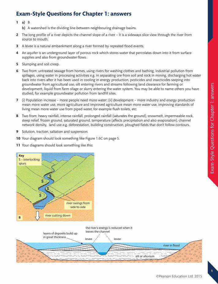
1 ©Pearson Education Ltd. 2015 Exam-Style Questions for Chapter 1: answers Exam-Style Questions for Chapter 1: answers 1 a) B b) A watershed is the dividing line between neighbouring drainage basins. 2 The long profile of a river depicts the channel slope of a river – it is a sideways slice view through the river from source to mouth. 3 A levee is a natural embankment along a river formed by repeated flood events. 4 An aquifer is an underground layer of porous rock which stores water that percolates down into it from surface supplies and also from groundwater flows. 5 Slumping and soil creep. 6 Two from: untreated sewage from homes, using rivers for washing clothes and bathing, industrial pollution from spillages, using water in processing activities e.g. in separating ore from soil and rock in mining, discharging hot water back into rivers after it has been used in cooling in energy production, pesticides and insecticides seeping into groundwater from agricultural use, silt entering rivers and streams following land clearance for farming or development, liquid from farm silage or slurry entering the water system. You may be able to name others you have studied, for example groundwater pollution from landfill sites. 7 (i) Population increase – more people need more water; (ii) development – more industry and energy production mean more water use, more agriculture and improved agriculture mean more water use, improving standards of living mean more water use from piped water, for example flush toilets, etc. 8 Two from: heavy rainfall, intense rainfall, prolonged rainfall (saturates the ground), snowmelt, impermeable rock, steep relief, frozen ground, saturated ground, temperature (affects precipitation and also evaporation), channel network density, land use e.g. deforestation, building construction, ploughed fields that don’t follow contours. 9 Solution, traction, saltation and suspension. 10 Your diagram should look something like Figure 1.6C on page 5. 11 Your diagrams should look something like this: river swings from side to side Key S – interlocking spurs B river cutting down silt or alluvium levee levee river in flood layers of deposits build up in great thickness the river’s energy is reduced when it leaves the channel

Welcome message from author
This document is posted to help you gain knowledge. Please leave a comment to let me know what you think about it! Share it to your friends and learn new things together.
Transcript
1
©Pearson Education Ltd. 2015
Exam
-Sty
le Q
uest
ions
for
Cha
pter
1: a
nsw
ers
Exam-Style Questions for Chapter 1: answers1 a) B
b) A watershed is the dividing line between neighbouring drainage basins.
2 The long profile of a river depicts the channel slope of a river – it is a sideways slice view through the river from source to mouth.
3 A levee is a natural embankment along a river formed by repeated flood events.
4 An aquifer is an underground layer of porous rock which stores water that percolates down into it from surface supplies and also from groundwater flows.
5 Slumping and soil creep.
6 Two from: untreated sewage from homes, using rivers for washing clothes and bathing, industrial pollution from spillages, using water in processing activities e.g. in separating ore from soil and rock in mining, discharging hot water back into rivers after it has been used in cooling in energy production, pesticides and insecticides seeping into groundwater from agricultural use, silt entering rivers and streams following land clearance for farming or development, liquid from farm silage or slurry entering the water system. You may be able to name others you have studied, for example groundwater pollution from landfill sites.
7 (i) Population increase – more people need more water; (ii) development – more industry and energy production mean more water use, more agriculture and improved agriculture mean more water use, improving standards of living mean more water use from piped water, for example flush toilets, etc.
8 Two from: heavy rainfall, intense rainfall, prolonged rainfall (saturates the ground), snowmelt, impermeable rock, steep relief, frozen ground, saturated ground, temperature (affects precipitation and also evaporation), channel network density, land use e.g. deforestation, building construction, ploughed fields that don’t follow contours.
9 Solution, traction, saltation and suspension.
10 Your diagram should look something like Figure 1.6C on page 5.
11 Your diagrams should look something like this:
river swings from side to side
KeyS – interlocking spurs
Briver cutting down
silt or alluvium
leveelevee
river in �ood
layers of deposits build up in great thickness
the river’s energy is reduced when itleaves the channel

2
©Pearson Education Ltd. 2015
Exa
m-S
tyle
Que
stio
ns fo
r C
hapt
er 1
: ans
wer
s12 Hard engineering strategies can successfully defend areas from flooding, either by damming rivers to regulate
discharge, by providing walls or embankments, or by diverting floodwaters away from threatened areas. Where hard engineering involves dams and reservoirs, it can provide additional benefits such as a reliable supply of water, a source of water for water transfer projects and a source of power from HEP. However, hard engineering strategies are typically very expensive to build and to maintain. Dams and reservoirs must be dredged frequently to clear them of the silt that is deposited as the river’s flow is reduced. Dams may deprive areas downriver of their water supply. Flood walls and embankments can hide the river from view and be obtrusive. Channel straightening or flood relief channels can move water quickly away from one settlement, only to increase the damage done by flooding downstream.
13 Your answer will depend on the case study you have learned for this topic, but some general pointers for this question would be: (i) do not forget to give the name of your named example, (ii) make sure you refer to your named example throughout your answer and give relevant detail. This will really make your answer a good answer. (iii) The question asks about the aims of the water storage project; for example it might have been to store water for energy generation – the aim of the Three Gorges Dam project in China was to provide around 10% of China’s current energy needs. (iv) When you consider the impacts, remember that impacts can be positive as well as negative.
14 Three from: width, depth, discharge, gradient, bedload.

3
©Pearson Education Ltd. 2015
Exam
-Sty
le Q
uest
ions
for
Cha
pter
2: a
nsw
ers
Exam-Style Questions for Chapter 2: answers1 a) erosion (wave erosion)
b) headland
c) spit
2 Managed retreat involves abandoning existing coastal defences and allowing the sea to flood inland until it reaches higher land or a new line of coast defences.
3 Two from: hydraulic action, abrasion, corrosion, attrition.
4 The most common would include two from: cliff, wave-cut platform, cave, arch, stack, stump, headlands and bays.
5 The most common would include two from: beaches, sand dunes, bars, spits, tombolos, cuspate forelands.
6 Swash is the forward movement of a wave up a beach. Backwash is the backwards movement of the water as it runs back down the beach under gravity.
7 Your sketch should look something like the second part of Figure 2.1 on page 11.
8 Your sketch should look something like Figure 2.2 on page 11.
9 There is a wide range of options here, including two from: just touching coral can cause it to die off, many different kinds of pollution (anything that increases sediment in the water as well as chemicals that actively damage the coral), overfishing, damage by boat keels or boat moorings, using coral as building material, sea level rises due to global warming.
10 Soft engineering methods try to work with natural processes and use natural elements of the coastal system, such as beaches, bars and vegetation cover. Hard engineering aims to protect against erosion and flooding buy building some kind of sea defence, either from rocks, concrete or wood.
11 A ‘do nothing’ approach might simply mean that the coast in question is already well protected, either by natural or man-made defences, and therefore nothing further needs to be done. In this case, the benefits of the scheme are that time and money do not need to be spent defending these areas. Instead, resources can be focused on areas more in need of defending or managing. There are no real costs to this approach, providing the initial appraisal of the state of the coastal defences has been done properly. In other situations, however, the coast may be under very serious threat of erosion or flooding but the reasons are not strong enough to justify defending it. In this case, the benefit is that attention and money can be focused on areas that do have valid reasons for defence. In this case, there is a wide range of costs that you can explore in your answer. These include economic costs such as the loss of farmland, people losing their homes and businesses, loss of roads and pathways; social and political problems caused by people feeling they have been abandoned when they should be protected from this type of threat; and environmental problems to do with loss of natural habitat.
12 If you chose coral reefs: biodiversity, role in protecting low-lying coasts from tropical storms, fishing, tourism. If you chose mangroves: biodiversity (act as nurseries for many fish species), role in trapping sediment and reclaiming land, protection of low-lying coasts from storm surges and tsunamis, fuel and building material.
13 Your answer will depend on your case study. There is a wide range of possible impacts, such as loss of life or accident from cliff collapses, economic losses if homes or businesses are damaged by coastal erosion or flooding, difficulties in getting affordable insurance for properties or businesses threatened by cliff collapse or flooding, difficulties in attracting tourists to stay in accommodation threatened by coastal erosion or flooding, losses to farmland. Make sure you use as much relevant detail from your case study as you can, and make sure to name your case study and give its location.
14 The vertical transect should marked with a tape measure or ranging poles to keep the sample sites in a straight line. At 2 m intervals up the beach, place the quadrat on the surface and select ten stones from inside it. Measure the size and shape of each of the ten stones.

4
©Pearson Education Ltd. 2015
Exa
m-S
tyle
Que
stio
ns fo
r C
hapt
er 3
: ans
wer
s
Exam-Style Questions for Chapter 3: answers1 a) A tropical storm (hurricane is also an acceptable answer).
b) 4 days: 29 October to 1 November.
c The data came from satellite images but acceptable answers would also include weather stations.
2 An event produced by environmental processes that threatens or actually causes damage and destruction to people, their property and settlements.
3 False.
4 The epicentre is the point on the surface above an earthquake’s focus.
5 There are several different hazards. Choose two from: lava flows, ash, gas emissions, pyroclastic flows, lahars, forest fires, volcanic bombs, floods (from damming of rivers or melting of ice).
6 Primary effects are the immediate impact of a natural hazard. Secondary effects happen later, in the medium and longer term, as knock-on effects of the damage done by the natural hazard.
7 Winds can reach up to 250 km/h, strong enough to demolish buildings, destroy cars and leave wreckage over roads. Storm surges are also a hazard: the low pressure and strong winds associated with a hurricane can cause a local rise in sea level. This can cause widespread destruction and loss of life in affected areas.
8 Volcanic ash makes soil very fertile and people live near volcanoes because of this. Also, some volcanoes can be dormant for centuries, so people do not expect them to erupt, while others erupt regularly but not in a dangerous, explosive way. Once large settlements have developed near a volcano, there are many social and economic attractions, such as good jobs, that outweigh people’s concerns about living near a volcano. People may be optimistic and believe that it won’t happen to them.
9 This will depend on your choice of case study but an example answer may say something like this: There was a major earthquake in Haiti in January 2010 of magnitude 7.0 on the Richter scale. More than 316,000 people were killed and many died when many their homes were destroyed. Often these homes were poorly constructed and so were easily destroyed. More than 1 million people were made homeless and major buildings were destroyed in the capital Port au Prince. Roads were badly damaged so it took more than 3 days to reach some of the smaller towns affected. Later it was found that 250,000 homes and 30,000 offices or factories had been severely damaged and had to be demolished.
10 This will depend on your choice of case study. Your answer should focus on relevant detail from your case study, for example: An earthquake occurred in L’Aquila, Italy, in 2009. 290 people were killed, mostly by collapsing buildings. Camps were set up immediately, the emergency services and army were sent in to look for survivors, cranes and diggers were available to help clear rubble in the search for survivors, international rescue teams with expertise in dealing with the immediate impacts of an earthquake arrived quickly to help out.
11 There are differences between volcanoes which make some eruptions more violent and destructive than others. There are also differences in the locations of volcanoes that mean their impact is bigger in some areas than others. Your reasons will probably include two of the following:
Some eruptions happen in populated areas and others in unpopulated areas.
Some eruptions happen in richer countries that can afford to monitor volcanoes for eruptions and so can evacuate people and defend property.
Composite volcanoes produce violent and more dangerous eruptions that are infrequent and irregular, while shield volcanoes produce gentler eruptions that are frequent and regular so people are expecting them and can stay safe.
The nature of the lava and its gas content.
12 This answer will depend on the examples you use. Here is some indicative content about Hurricane Katrina and Cyclone Nargis:
Prediction: Hurricane Katrina was tracked and people had plenty of warning to evacuate. Cyclone Nargis was tracked by Bangladesh but the government of Myanmar did not act on the information.
Protection: Katrina’s storm surges were too powerful for New Orleans’ levee system but this has since been upgraded. Myanmar cannot afford the huge investment required for protection. Natural protection in both countries had been reduced by the clearing of coastal marshes.

5
©Pearson Education Ltd. 2015
Exam
-Sty
le Q
uest
ions
for
Cha
pter
3: a
nsw
ers
©Pearson Education Ltd. 2015
Preparation: 80 per cent of people were evacuated from New Orleans; most people in Myanmar had no idea Nargis was coming.
13 Your answer should make comparisons between LICs and HICs, even though the question only mentions LICs. The question says ‘Examples will help your answer’ – this actually means ‘use examples if you want to get good marks’, so use your case studies and pick relevant details from them to back up your arguments. For good marks, compare a range of reasons rather than just one or two. The focus of your answer should be on how the level of development affects the country’s abilities to prepare for and recover from earthquakes.
14 You should select a relatively large number of sites (20–30) in order to identify variations, and choose a good range of locations (including grassed areas, tarmac areas, open areas, passageways between buildings, under trees, close to buildings, away from buildings). Measurements should be collected at the same time to make the data comparable. Choose safe locations to reduce the risk of accidents.
6
©Pearson Education Ltd. 2015
Exam
-Sty
le Q
uest
ions
for
Cha
pter
4: a
nsw
ers
Exam-Style Questions for Chapter 4: answers1 One from farming, forestry, fishing, mining, quarrying.
2 Middle income country.
3 As a percentage of the total workforce that they employ, as a percentage of their contribution to GDP or GNI.
4 An energy gap is the difference between a country’s demand for energy and its ability to produce that energy from its own sources.
5 Sectoral shift describes changes in the relative importance of the three main economic sectors to the economy as a whole as the country develops.
6 a) It is dominated by the primary sector, which employs 75 per cent of the population. Of the remaining 25 per cent, around two-thirds are employed in the secondary sector and 10 per cent in the tertiary sector.
b) The tertiary sector only develops when a country becomes prosperous and its population has enough disposable income to spend on services.
c) Currently, China’s three sectors are about equal in size. However, as the country develops, the primary sector will reduce in size as agriculture is modernised and rural–urban migration results in most of the rural population moving to find work in the industrial centres. The secondary sector may continue to expand because of China’s position in the global manufacturing market and the ready supply of labour from rural migrants. However, as China’s urban population grows more prosperous the tertiary sector should expand significantly.
7 ‘Footloose’ describes economic activities that are not tied to a particular location by strong location factors.
8 Your answer should focus on the growth of prosperity within large sections of a country’s population. People earn more and therefore have disposable income to spend on luxuries such as entertainment, meals out, recreation and holidays. Increasing prosperity also means a rising demand for improved services from the government (paid for by taxes, which raise more money in a prosperous society) such as schools, hospitals, rubbish collection. Commercial companies develop more and more services to compete against their rivals. Technological developments mean new services also develop, such as internet service providers, internet-based shopping and distribution services, online entertainment services.
9 Reasons could include:
transport – containerisation and the revolution in quick and cheap global transport
TNCs – global corporations locate manufacturing in the cheapest areas to generate low-priced goods for HIC and MIC markets
communications – it is now possible to speak to anyone in the world in real time cheaply and easily
energy – universally available and relatively cheap in some MICs and LICs
government policy – incentivises the relocation of manufacturing.
10 Your reasons are likely to include rapid increases in population in some MICs and many LICs leading to an increase in the number of people needing energy, and the increased energy demand that goes with economic development and rising living standards.
11 You must use a named example of a hi-tech industry and details from that example to explain the different factors that have affected its location. These details will, of course, depend on the case study you have chosen but your answer is likely to cover a range of location factors that could include government policy, developments in technology, transport and communication factors, access to information, R&D, and a skilled labour force.
12 Your answer should identify the major sources of non-renewable energy: oil, natural gas, coal. If you feel that nuclear energy is non-renewable then you can make the case for its inclusion here too (depends on supplies of uranium). Advantages are likely to include:
efficient – it is easy to derive massive amounts of energy from it, existing power-production technology is set up to run from it, large supplies remain of many non-renewables (e.g. coal), some non-renewables are located in many countries around the world (e.g. coal)
reliable output – no breaks in electricity generation when night falls, the wind drops, etc.
oil and gas are easy to transport – they can be piped and stored until needed.

7
©Pearson Education Ltd. 2015
Exam
-Sty
le Q
uest
ions
for
Cha
pter
4: a
nsw
ers
Disadvantages are:
finite
polluting (though some are more polluting than others)
some forms are explosive, potentially very hazardous in the case of nuclear power
politically destabilising because some countries can control supplies.
13 This answer will depend on the case study example you choose but generally the causes of deindustrialisation in HICs are:
a global shift in manufacturing
a decline in the importance of coal as an energy source
a lack of other manufacturing industries to replace lost jobs.
The consequences are:
job losses (often whole communities depended on a single employer)
out-migration
social problems
in some cases, regeneration of the industrial environment
the replacement of employment by the tertiary sector, including public-sector jobs for the government.
14 You could count the number of views that supported the new development and the number of views that opposed it (this could be expressed in percentage terms). A tally count could be made of the reasons given for people’s views in order to help create a classification of the reasons.

8
©Pearson Education Ltd. 2015
Exam
-Sty
le Q
uest
ions
for
Cha
pter
5: a
nsw
ers
Exam-Style Questions for Chapter 5: answers1 Temperate grassland.
2 Primary consumer = one from: insects, wombat, kangaroo; Secondary consumer = one from: frilled lizard, emu, echidna; Tertiary consumer = one from: laughing kookaburra, wedge-tailed eagle, dingo.
3 Intensive agriculture uses a small amount of land (1 mark) to produce a high yield (1 mark).
4 The outward spread of the built up area.
5 Two from: subsistence, commercial, arable, pastoral, mixed.
6 Two from: developing HYVs, increasing use of irrigation, developing synthetic pesticides and herbicides and modernising farm techniques.
7 Two from: extending farmed area, using herbicides, using pesticides, crop rotation, mechanisation, irrigation, plant and animal breeding, application of fertilisers, control of conditions – polytunnels, greenhouses, genetic modification.
8 Rice cultivation in LICs and horticulture or market gardening in HICs are the examples given in the textbook. The question asks you to describe, so you need to develop each example with a brief description as to why it is intensive, e.g. ‘rice is cultivated in small parcels of land which require irrigation, careful weeding and attention to the crop throughout the growing season’.
9 Goods are material things or products that can be taken directly from an ecosystem and put to use (e.g. timber from a forest). Services are long-term benefits that people can gain from ecosystems (e.g. forests trap carbon dioxide from the atmosphere). Use examples from, for example, the temperate grassland ecosystem in your explanation.
10 Make sure your answer includes both causes (rural poverty, hardship of rural life, lack of rural services, lure of better jobs and lifestyles in the cities) and consequences (downwards spiral of rural poverty as people leave, rural–urban migration dominated by young men, which leaves women, children and older men in rural areas to farm the land). Make sure your answer is about consequences in rural areas not in urban ones.
11 Develop arguments for and against. Arguments in favour include higher crop yields, cheaper food, better quality food, less use of herbicides and pesticides. Arguments against could include possible contamination of other plants, impacts on human health as yet unknown, many LIC farmers struggle to afford the seeds for GM crops, some plants do not produce seeds.
12 An explanatory answer that includes the following:
natural causes, e.g. poor soils, drought, floods, tropical cyclones, etc.
human causes, e.g. rural indebtedness, population increase, cash-cropping, rural–urban migration, overgrazing, etc.
at least two consequences, which could include increased poverty, risk of malnutrition/famine, downwards spiral of decreased productivity, increased rural–urban migration.
A really good answer would include relevant detail, an explanation of the linkages between causes and consequences.
13 Your answer should refer to the following:
the name of your LIC example and how irrigation works there (e.g. from wells)
the advantages irrigation brings: for example in Bangladesh it has enabled rice to be grown all year, in response to a rapidly increasing population
the disadvantages of irrigation: for example in Bangladesh over-use has led to waterlogging of crops, salinisation and falling water tables, requiring ever-deeper wells
an overview or conclusion: do you think the advantages outweigh the disadvantages or vice versa?
Remember, if a question asks for a named example and you don’t provide one, your answer will not do very well, even if the rest of what you write is brilliant.
14 There are a range of possible hazards, you would need to give two from: sunburn in summer, catching cold or hypothermia in winter, danger from litter (e.g. broken bottles) in the sand, slips, trips, bumps, ‘stranger danger’, collisions with people using sand dunes for quad biking or mountain biking, aggressive dogs that have been let off the lead in sand dune area.
9
©Pearson Education Ltd. 2015
Exam
-Sty
le Q
uest
ions
for
Cha
pter
6: a
nsw
ers
Exam-Style Questions for Chapter 6: answers1 Around 2.6 billion.
2 a) The process of becoming more urban.
3 There are many to choose from. The textbook refers to the following favelas in São Paulo: Heliópolis, Paraisópolis and Jaguare.
4 One from: poor housing, an unattractive living environment, poor quality services, evidence of unemployment, social problems.
5 Reasons could include: population growth being highest in the cities, high rates of rural–urban migration, economic developments being focused in the cities.
6 Your definition should include something about the spread of low-density, often detached or semi-detached housing (1 mark) around the edges of a city or town (1 mark).
7 Two from: Tokyo, Guangzhou, Jakarta, Seoul, Shanghai, Mexico City, Delhi, New York City, São Paulo, Karachi, Mumbai, Manila, Los Angeles, Osaka, Beijing, Moscow, Cairo, Kolkata, Buenos Aires, Dhaka, Bangkok, Tehran, Istanbul, Lagos, Rio de Janeiro, London and Paris.
8 Examples could include: space for large car parks, excellent road and rail links, space to bring many different retailers together, lower land prices, location serving a regional market rather than just a city area, pleasant environment.
9 Reasons could include: 1) that the pace of industrialisation is too fast for services to keep up with, for example provision of sanitation services, health services, education services; 2) that there are more people coming to the city than there are jobs available, which leads to the development of a large informal sector (black market). Other reasons could include: 3) the social pressures caused by so many people living so close together in difficult circumstances; 4) the lack of planning which means new developments are not always linked to transport networks and road systems are quickly swamped by levels of traffic that they were not designed for, etc.
10 Land use segregation is due to two main factors: land value and locational needs. Since an urban plot will be sold to the highest bidder, the industries whose locational needs are best served by that plot will pay the most to be located there.
11 Shanty towns are all very different but they do have some shared characteristics: shanty town residents usually have no legal right to the land they occupy; shanty town dwellings usually start as makeshift homes; shanty towns are often built on land that is unsafe or undesirable, for example land that frequently floods or land that is far from the urban centre. Shanty towns usually have very few or no services, unless residents campaign to have these provided, such as electricity or sanitation. Residents of shanty towns tend to be rural–urban migrants.
12 Inner-city areas are first developed to provide housing for factory workers. Suburbanisation results in businesses and better-paid workers moving out to the suburbs, leaving inner cities to decay and to be populated only by poorer people who can’t afford to live anywhere else. Deindustrialisation removes the factories from the inner city, leaving waste ground and derelict sites. However, commuter journeys from the suburbs become increasingly intolerable because of growing congestion. This results in inner-city areas being regenerated and gentrified as wealthy city workers move back to the inner city to be close to their work.
13 Good answers will refer to evidence in Figure 6.11, will give a detailed explanation of a range of factors and will investigate the linkages between those factors. Your answer could refer to 1) counterurbanisation being due to dissatisfaction with urban living amongst a proportion of the urban population; 2) Figure 6.11 shows it occurs when a very high proportion of the population is urban, 3) it is associated with a reduction in economic development in the city – the city starts to have less to offer. You could explain the reasons why benefits of living in the city begin to be outweighed by urban problems: congestion, pollution, social problems. You could discuss technological developments, such as broadband networks that allow people to access office systems from remote locations.
14 A good answer will give a detailed explanation of a range of advantages and disadvantages, developing the points made (not just listing them). You may be able to include an example in your answer. Advantages of brownfield sites:
helps to revive old and disused urban areas
reduces loss of countryside
located near to sources of labour

10
©Pearson Education Ltd. 2015
Exa
m-S
tyle
Que
stio
ns fo
r C
hapt
er 6
: ans
wer
sinfrastructure already provided.
Disadvantages include:
can be expensive to clear old buildings
expensive to decontaminate land, etc.
often surrounded by run-down neighbourhoods, which may put off potential purchasers
high levels of pollution
may not have good access to modern roads.
15 To achieve good marks your answer must name a city with shanty towns. Good answers will give a detailed account of a range of strategies being adopted to improve conditions and will include some evaluation of the strategies. The strategies discussed will depend on the case study you have chosen, but may include: self-help schemes and campaigns, local authority provision (e.g. provision of new homes or better building materials), demolition and eviction schemes by governments, rural enterprise schemes to reduce rural–urban migration.
16 With all samples, the larger the number of sampling sites the better, as data gathered are more representative.
©Pearson Education Ltd. 2015
11
Exam
-Sty
le Q
uest
ions
for
Cha
pter
7: a
nsw
ers
Exam-Style Questions for Chapter 7: answers1 c) Actions that meet the needs of the present without reducing the ability of future generations to meet their needs.
2 Desertification is a natural process that humans can exacerbate or fail to prevent.
3 The major greenhouse gas is carbon dioxide but methane, nitrous oxides and CFCs are also significant, as is water vapour.
4 The Kyoto Protocol or Kyoto agreement or treaty. Using the name Kyoto is what gets you the mark!
5 Desertification is the spread of desert-like conditions into semi-arid areas.
6 Consequences include loss of farmland and decline in food production, which can lead to malnutrition and even famine and starvation, and large-scale migrations as people flee the affected area.
7 Consequences could include:
increased CO2 in the atmosphere (enhanced greenhouse effect) caused by burning of trees and loss of the carbon sink that the tropical rainforest provides
soil erosion and leaching of nutrients from tropical soils
flooding caused by increased run off
loss of habitat for animals, plants and indigenous peoples
loss of biodiversity
pollution from mining and agriculture
also positive consequences connected to economic development.
8 Consequences could include: rising sea levels, more hazards, ecosystem changes, economic opportunities, health issues and increased conflicts over scarce resources.
9 Two developed reasons from the following: removing vegetation cover (e.g. deforestation, overgrazing), loss of soil structure through overcultivation, compacting soil through use of heavy machinery, ploughing fields in the same direction as the slope, decreased rainfall, more intense rainfall; these could be linked to increased human and animal populations.
10 Two developed reasons from the following: commercial logging, to build roads, to clear land for peasant farmers and settlers, to clear land for large-scale commercial agriculture, for mining, for dams for HEP and water supply.
11 The enhanced greenhouse effect is the warming of the Earth’s atmosphere because pollution is preventing heat from escaping into space. Greenhouse gases emitted by human activities cause the pollution, which greatly increase the concentration of greenhouse gases naturally found in the atmosphere.
12 Two developed strategies from:
adapting to rising sea levels (building sea defences or moving settlements)
adapting to more hazards (improve warning systems and preparation for disasters)
adapting to ecosystem changes by abandoning desertified areas, opening up new areas for development
adapting to the spread of diseases/health issues (more investment in treatments and education)
adapting to more conflicts over scarce resources (investment in civil defence, international cooperation to defuse tensions).
13 Points to develop could include: burning of fossil fuels for power and for cars, deforestation, burning of wood for fuel linked to economic development and increasing consumption in both HICs and, increasingly, in LICs.
14 The strategies used include replanting vegetation cover, contour ploughing, building small dams across streams and in gullies, building small bunds (walls) across fields to retain water, change to organic farming, change to permaculture. A really good answer will consider the advantages and disadvantages of two or three strategies (for example, the need for solutions in some LICs to be low cost, which makes bunds an effective strategy and a change to organic farming a less effective strategy). It will perhaps include an overview that very little can be done if rainfall continues to decrease, and that soil erosion may reduce naturally if an increase in rainfall through the year creates more vegetation cover.

©Pearson Education Ltd. 2015
12
Exam
-Sty
le Q
uest
ions
for
Cha
pter
7: a
nsw
ers
15 Your examples may be the Kyoto Protocol and the Copenhagen Accord, or other agreements that you have studied. Problems should focus on the difficulty of encouraging major polluters such as the USA to change to a low-energy lifestyle and the difficulty of getting LICs and RICs to sign up to agreements that hamper their economic development when much of the global warming crisis is the result of HIC development in the past. Use relevant examples and details in your answer and make effective linkages between points and your development of them.

©Pearson Education Ltd. 2015
13
Exam
-Sty
le Q
uest
ions
for
Cha
pter
8: a
nsw
ers
Exam-Style Questions for Chapter 8: answers1 b) The process that has created a more connected world.
2 Transnational corporation.
3 Mass tourism is popular, organised, large-scale tourism.
4 This will depend on your example: the one in the textbook is Bhutan.
5 Two from: labour costs, access to resources, cheaper land, lack of trade unions, light government control for example on pollution.
6 A production chain is the series of stages involved in the production of a product.
7 Two from: more money for the host country, more jobs, multiplier effects, better infrastructure, development, etc.
8 Asylum seekers are forced migrants who have asked for permission to permanently reside in the country they have migrated to.
9 Two developed reasons from: labour is much cheaper in countries such as the Philippines and India, low operating costs (since the advent of internet telephony), large number of English speakers, high investment in those countries in this industry.
10 Two developed reasons from: the clearance of sites to create facilities for mass tourism; the pollution from land use, litter, sewage; the overuse of water resources for swimming pools, water parks, sprinklers for grass lawns, showers and toilets; the destruction caused by tourist activities; and the CO2 emissions involved in air travel.
11 Two characteristics from: sustainable aims, often in ‘special’ locations with unique characteristics, aims to educate visitors and increase their appreciation of local culture, tries to minimise the consumption of non-renewable resources and environmental damage, locally orientated (controlled by local people, employing local people, using local produce), profits stay in the local community, contributes to conservation of local biodiversity.
12 The reasons why governments seek to encourage more migrants are usually economic – because the country needs more people. Where populations are rapidly aging, young immigrants can really help maintain a productive economy that can support an elderly, retired population.
13 Points to develop could include workers with more leisure and more disposable income.
©Pearson Education Ltd. 2015
14
Exa
m-S
tyle
Que
stio
ns fo
r C
hapt
er 9
: ans
wer
s
Exam-Style Questions for Chapter 9: answers1 Birth rate.
2 Infant mortality rate.
3 High income country.
4 LIC (it is the life expectancy of those born in Cameroon in 2012).
5 Two from: more energy used to power industrial development, more energy used because of urbanisation, more energy used because of rising standards of living (cars instead of mopeds, air conditioning, refrigerators, etc.).
6 Quality of life is a social measure of development. Instead of just looking at people’s income it considers other things such as access to healthcare, literacy rates, housing quality, access to safe water, life expectancy.
7 HDI measures human development and ranks countries in order according to their HDI score. It combines statistics on life expectancy, literacy, education and standards of living for each country.
8 The MIC classification groups countries with very different characteristics. For example, one problem is that some of the economies in this classification are emerging economies, with rapid economic development, and others are not – some might even be described as stagnating economies. A second problem is that the range of GNI per capita for the MIC classification is very wide: from $1026 to $12,475 using 2011 GNI per capital figures. The difference between a country at the bottom of that category and one at the top would be so great that it is a problem view them both in the same way in terms of economic development.
9 There are many reasons that could explain this, for example: one region may be a very important port where trade from all round the world arrives, while the other region might not have any ports or important trade routes. One region may have rich, fertile soils while the other has poor soils and gets many droughts. Any two suitable reasons will gain full marks on this question.
10 The main areas of impact are from population growth increasing poverty because there aren’t enough jobs in the right places; unemployment, especially in the cities; inadequate housing, for example shanty towns; physical infrastructure, for example a lack of proper sanitation, poor roads and transport. Make sure you link your descriptions to the cause of rapid population growth in each of the two cases you give.
11 The North–South divide model – advantages are that it gives a clear picture of a divided world: the rich north and the poor south. This is easy for people to understand and clearly highlights the unfair distribution of wealth between the powerful industrialised countries of the North and the powerless and dependent poor countries of the South. The disadvantages are that it doesn’t recognise the rise of the emergent economies which are developing very rapidly in the South, or the differences in development in the North, e.g. between western Europe and the countries of formerly communist eastern Europe. It also puts ‘southern’ countries in a weak and dependent role, which many of them no longer occupy (e.g. China) –if they ever did.
12 This answer will depend on the case study you choose. Remember to name the country and to focus your answer on causes, and link those causes to consequences.
13 This answer will depend on the case study you choose. Remember to name the country, to identify the population changes that are happening and explain why these present a problem. Describe the way the government set about addressing the problem. For China’s one-child policy you do not need to go into the problems caused by the policy unless you do so to show how management of the change has altered to take account of the problems caused by the initial policy.
Related Documents