Environmental Assessment Report The views expressed herein are those of the consultant and do not necessarily represent those of ADB’s members, Board of Directors, Management, or staff, and may be preliminary in nature. Initial Environmental Examination for Orissa Project Number: 37066 June 2009 India: Rural Roads Sector II Investment Program (Project 4) Prepared by [Author(s)] [Firm] [City, Country] Prepared for [Executing Agency] [Implementing Agency] Prepared by Ministry of Rural Development for the Asian Development Bank (ADB). The initial environmental examination is a document of the borrower. The views expressed herein do not necessarily represent those of ADB’s Board of Directors, Management, or staff, and may be preliminary in nature.

Welcome message from author
This document is posted to help you gain knowledge. Please leave a comment to let me know what you think about it! Share it to your friends and learn new things together.
Transcript
Environmental Assessment Report
The views expressed herein are those of the consultant and do not necessarily represent those of ADB’s members, Board of Directors, Management, or staff, and may be preliminary in nature.
Initial Environmental Examination for Orissa Project Number: 37066 June 2009
India: Rural Roads Sector II Investment Program
(Project 4)
Prepared by [Author(s)]
[Firm]
[City, Country]
Prepared for [Executing Agency] [Implementing Agency]
Prepared by Ministry of Rural Development for the Asian Development Bank (ADB).
The initial environmental examination is a document of the borrower. The views expressed herein do not necessarily represent those of ADB’s Board of Directors, Management, or staff, and may be preliminary in nature.
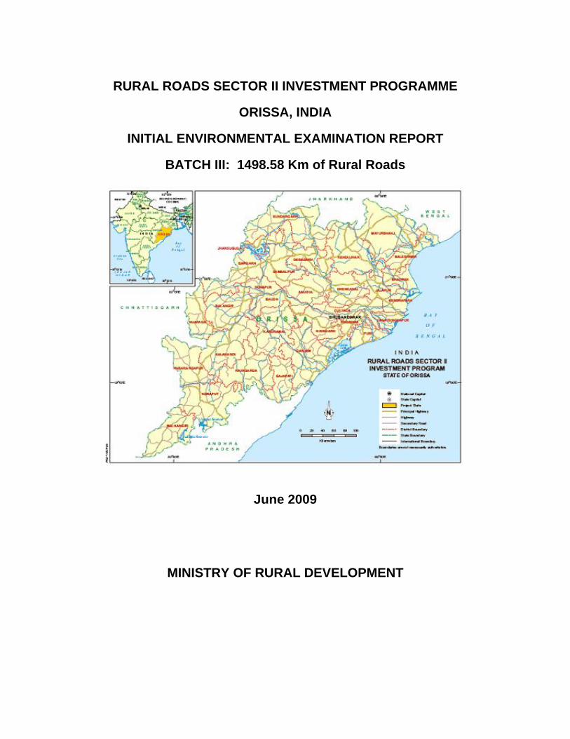
RURAL ROADS SECTOR II INVESTMENT PROGRAMME
ORISSA, INDIA
INITIAL ENVIRONMENTAL EXAMINATION REPORT
BATCH III: 1498.58 Km of Rural Roads
June 2009
MINISTRY OF RURAL DEVELOPMENT
Acronyms and Abbreviations
ADB : Asian Development Bank BIS : Bureau of Indian Standards CD : Cross Drainage CGWB : Central Ground Water Board CO : Carbon Monoxide COI : Corridor of Impact DM : District Magistrate EA : Executing Agency EAF : Environment Assessment Framework ECOP : Environmental Codes of Practice EIA : Environmental Impact Assessment EMAP : Environmental Management Action Plan EO : Environmental Officer FEO : Field Environmental Officer FGD : Focus Group Discussion FFA : Framework Financing Agreement GOI : Government of India GP : Gram Panchayat GSB : Granular Sub Base HC : Hydro Carbon IA : Implementing Agency IEE : Initial Environmental Examination IRC : Indian Road Congress LPG : Liquefied Petroleum Gas MFF : Multitranche Financing Facility MORD : Ministry of Rural Development MORTH : Ministry of Road Transport and Highways MOU : Memorandum of Understanding NAAQS : National Ambient Air Quality Standards NGO : Non Governmental Organisation NOx : Nitrogen Oxide NC : Not Connected NGO : Non-Government Organization NRRDA : National Rural Road Development Agency PIU : Project Implementation Unit PIC : Project Implementation Consultants PRIs : Panchyati Raj Institutions PMGSY : Pradhan Mantri Gram Sadak Yojana POL : Petroleum, Oil and Lubricants PPTA : Project Preparation Technical Assistance ROW : Right-of-Way RPM : Respirable Particulate Matter RRP : Report and Recommendation of the President RRSIP II : Rural Roads Sector II Investment Program SRRDA : State Rural Road Development Agency SBD : Standard Bidding Documents SO2 : Sulphur di-Oxide SPM : Suspended Particulate Matter TA : Technical Assistance TOR : Terms of Reference TSC : Technical Support Consultants UG : Upgradation WBM : Water Bound Macadam ZP : Zilla Parisad
TABLE OF CONTENTS
Section - 1 INTRODUCTION 1-1
1-1 GENERAL 1-1 1-2 PROJECT IDENTIFICATION AND LOCATION 1-1 1-3 RURAL ROAD CONSTRUCTION PROPOSALS 1-2 1.4 INITIAL ENVIRNMENTAL EXAMINATION 1-2
1-4.1 Corridor of Impact and Study Area 1-2 1-4.2 Field Visits 1-3 1-4.3 Secondary Data Collection 1-3 1-4.4 Primary Data Collection 1-3
1-5 Purpose of the Report 1-3 Section - 2 DESCRIPTION OF PROJECT 2-1
2.1 Type of project 2-1 2.2 Category of project 2-1 2.3 Need For Project 2-1 2.4 Location and Selection Criteria of Roads for IEE 2-1 2.5 Size or Magnitude of Operation 2-3 2.6 Schedule for Implementation 2-3 2.7 Description of Project 2-4
2.7.1 Rural Road Construction Proposals 2-4 2.7.2 Present Condition 2-4 2.7.3 Available Right of Way (ROW) 2-6 2.7.4 Alignment and Profile 2-6 2.7.5 Traffic 2-6 2.7.6 Economic Assessment 2-6
Section - 3 DESCRIPTION OF ENVIRONMENT 3-1 3.1 GENERAL 3-1 3.2 PHYSICAL RESOURCES 3-1
3.2.1 Topography 3 -1 3.2.2 Geology 3-2 3.2.3 Earthquake Zone / Sensitivity 3-2 3.2.4 Climate 3-2 3.2.5 Surface Water 3-4 3.2.6 Ground Water 3-4 3.2.7 Soil 3-8 3.2.8 Water Quality 3-8 3.2.9 Ambient Air Quality 3-8
3.2.10 Ambient Noise Quality 3-8 3.2.11 Drought & Cyclone 3-9 3.2.12 Land Use 3-9
3.3 ECOLOGICAL RESOURCES 3-9 3.3.1 Terrestrial Flora 3-9 3.3.2 Terrestrial/ Avian Fauna 3-12 3.3.3 Forests 3-13 3.3.4 Wildlife 3-13 3.3.5 Rare or Endangered Species 3-13 3.3.6 Fisheries 3-14 3.3.7 Aquatic Biology 3-14
3.4 HUMAN AND ECONOMIC DEVELOPMENT 3-14 3.4.1 Population and Community 3-14 3.4.2 Industries 3-14 3.4.3 Flood Control Facilities 3-14 3.4.4 Agriculture 3-14 3.4.5 Archaeological/ Historical Monuments 3-15 3.4.6 Temples / Shrines / Idols 3-15
Section - 4 POTENTIAL ENVIRONMENTAL IMPACTS AND MITIGATION MEASURES 4-1 4.1 GENERAL 4-1 4.2 ENVIRONMENTAL PROBLEMS DUE TO PROJECT (ROAD) LOCATION 4-1
4.2.1 National Parks/Wild Life Sanctuaries 4-1 4.2.2 Archaeological/ Heritage Monuments 4-1 4.2.3 Natural Habitat/Nature reserves 4-2 4.2.4 Reserve Forests/ Protected Forest and/or Unclassified Forest Areas/ Lands 4-2
4.3 ENVIRONMENTAL PROBLEMS DUE TO PROJECT (ROAD) DESIGN 4-2 4.3.1 Embankment construction 4-2 4.3.2 Soil erosion 4-3 4.3.3 Clearing of vegetation 4-3 4.3.4 Cross Drainage 4-4 4.3.5 Roadside Sanitation 4-4 4.3.6 Road cutting for Conveyance of Irrigation Pipes 4-5
4.4 ENVIRONMENTAL PROBLEMS ASSOCIATED WITH PROJECT (ROAD) CONSTRUCTION 4-5
4.4.1 Geology / Stone Quarries 4-5 4.4.2 Hydro-geology/Ground Water 4-6
4.4.3 Soil/ Borrow Areas 4-7 4.4.4 Land Use 4-8 4.4.5 Drainage 4-9 4.4.6 Water Quality 4-9
4.4.7 Terrestrial Flora & Fauna 4-10 4.4.8 Loss of Forest land/ Cover 4-11 4.4.9 Aquatic Flora & Fauna 4-11
4.4.10 Air quality 4-11 4.4.11 Noise 4-12 4.4.12 Vibration 4-13 4.4.13 Construction Debris 4-13 4.4.14 Archaeological/ Historical Monuments 4-13 4.4.15 Road Side Shrines/Temples 4-13 4.4.16 Road Side Sanitation 4-14
4.5 ENVIRONMENTAL PROBLEMS RESULTING FROM PROJECT OPERATIONS 4-14
4.6 POTENTIAL ENVIRONMENTAL ENHANCEMENT MEASURES 4-15 4.6.1 Retrieval of Green (Tree) Cover 4-15 4.6.2 Improvement in Air/Noise Quality 4-15 4.6.3 Improvement of Road Side Sanitation 4-15
4.6.4 Socio-economic Benefits 4-15 4.7 ENVIRONMENTAL MANAGEMENT AND MONITORING PLAN 4-15
Section – 5 INSTITUTIONAL REQUIREMENTS AND ENVIRONMENTAL AND MONITORING PLAN 5-1
5-1 GENERAL 5-1 5-2 ENVIRONMENTAL MANAGEMENT ACTION PLAN 5-1
5-2.1 Issues / Project Actions / Environmental Attributes 5-1 5-2.2 Mitigation Measures 5-1
5-3 RESPONSIBILITY FOR IMPLEMENTATION 5-1 5-4 EMAP IMPLEMENTATION MONOTORING 5-1 5-5 INSTITUTIONAL REQIREMENTS FOR IMPLEMENTATION OF EMAP 5-1
5-5.1 Institutional Requirements- Construction Stage 5-1 5-5.2 Institutional Requirements- Operation Stage 5-2
Section - 6 PUBLIC CONSULTATIONS AND INFORMATION DISCLOSURES 6-1 6-1 INTRODUCTION 6-1 6-2 OBJECTIVES 6-1 6-3 METHODOLOGY ADOPTED FOR PUBLIC CONSULTATIONS 6-1
6-3.1 Stages and Levels of Consultation 6-1 6-3.2 Contents 6-2 6-3.3 Public Hearing, Schedule-IV, under EIA Notification of MoEF 6-2 6-3.4 Issues Raised and Community Perception 6-2
Section - 7 FINDINGS AND RECOMMENDATIONS 7-1 7-1 FINDINGS AND RECOMMENDATIONS 7-1
Section - 8 CONCLUSIONS 8-1 8-1 CONCLUSIONS 8-1
APPENDICES
Appendix 1 List of 1498.58 km of Rural Roads under Third Annual Batch of ADB Loan Assistance –
Orissa
Appendix 2 Environmental Management Plan
Appendix 3 List of persons interacted during Public Consultation
Initial Environmental Examination Report Batch III Roads– Orissa
1-1
SECTION 1: INTRODUCTION 1.1 GENERAL
The Government of India (GOI) is currently implementing the Pradhan Mantri Gram Sadak Yojana (PMGSY) Program in many states of India through the Ministry of Rural Development (MORD). The main objective of PMGSY is to connect the unconnected habitations with a population of 1000 or more (500 or more in the case of Hilly States, including North East, Desert and Tribal areas) in the first phase. The National Rural Roads Development Agency (NRRDA) under the Ministry of Rural Development, Government of India, is the Agency responsible for overall management, supervision and execution. NRRDA is a part of MORD. The Orissa State Rural Road Agency (OSRRA) is the implementation agency of PMGSY program in Orissa.
The Asian Development Bank (ADB) is providing loan for the Rural Roads Sector Project –II (RRSP II) to support the national rural roads program known as Pradhan Mantri Gram Sadak Yojna (PMGSY) in Assam, West Bengal and Orissa states. The ADB’s loan assistance will be implemented in four annual batches. First annual batch consisted of 3,000 km rural roads (about1000 km in each state) and was prepared under ADB’s Technical Assistance. In Orissa, the construction work of second annual batch is nearing completion.
The Detailed Project Reports (DPRs) for third annual batch that cover 310 roads for total 1498.58 km length have been prepared by the PIUs with support of consultants. The third batch project as per agreed Environmental Assessment Review Framework (EARF)1 has to be categorized based on the ADB’s Environmental Assessment Requirement, 2003 and environmental assessment needs to be prepared for each road. Based on the environmental conditions of the project areas and the nature of project activities, the third batch project has been categorised as ‘Category B’ project, The Initial Environmental Examination (IEE) for each road was prepared by using the environmental checklist as per agreed EARF, and this environmental checklist is served as the IEE. The Environmental checklist for each road of the third batch was prepared by the PIC.
This summary IEE report covers: (i) listing all of the subprojects, (ii) assessing sample subprojects including field visits (iii) additional information from summary of all 310 environmental checklists of the roads covered by the Batch III and secondary information of baseline scenario of the different districts of Orissa. and (iii) describing general mitigation measures, monitoring, institutional arrangements and others that are common to all the subprojects.
1.2 PROJECT IDENTIFICATION AND LOCATION
The OSRRA has selected about 1498.58 km of rural roads to be taken up under the third annual batch of ADB loan assistance under RRSP II in Orissa. The 1498.58 km of roads
1 The Environmental Assessment Review Frame work was prepared and agreed during the preparation of the MFF under loan MFF 001-IND Rural Road Sector II Investment Program, approved 2005.
Initial Environmental Examination Report Batch III Roads– Orissa
1-2
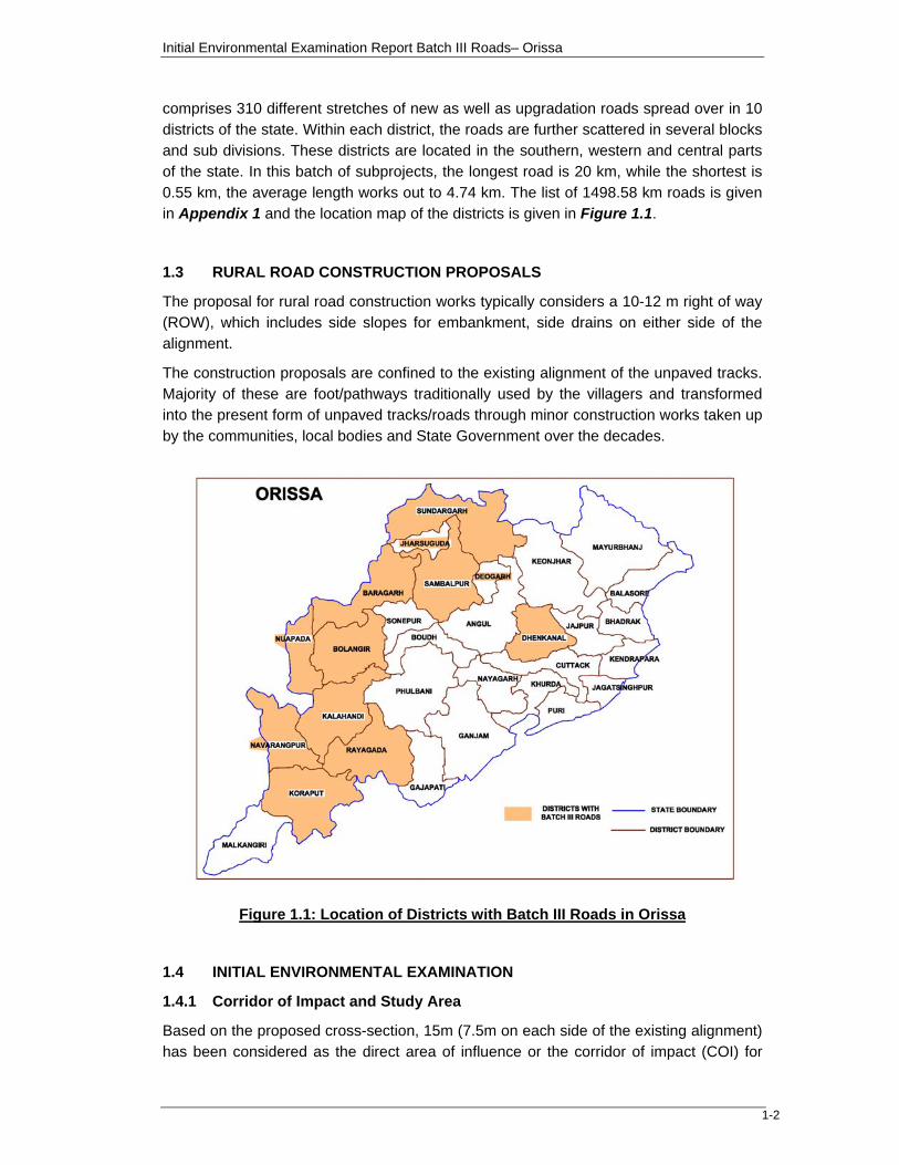
comprises 310 different stretches of new as well as upgradation roads spread over in 10 districts of the state. Within each district, the roads are further scattered in several blocks and sub divisions. These districts are located in the southern, western and central parts of the state. In this batch of subprojects, the longest road is 20 km, while the shortest is 0.55 km, the average length works out to 4.74 km. The list of 1498.58 km roads is given in Appendix 1 and the location map of the districts is given in Figure 1.1.
1.3 RURAL ROAD CONSTRUCTION PROPOSALS
The proposal for rural road construction works typically considers a 10-12 m right of way (ROW), which includes side slopes for embankment, side drains on either side of the alignment.
The construction proposals are confined to the existing alignment of the unpaved tracks. Majority of these are foot/pathways traditionally used by the villagers and transformed into the present form of unpaved tracks/roads through minor construction works taken up by the communities, local bodies and State Government over the decades.
Figure 1.1: Location of Districts with Batch III Roads in Orissa
1.4 INITIAL ENVIRONMENTAL EXAMINATION
1.4.1 Corridor of Impact and Study Area
Based on the proposed cross-section, 15m (7.5m on each side of the existing alignment) has been considered as the direct area of influence or the corridor of impact (COI) for
Initial Environmental Examination Report Batch III Roads– Orissa
1-3
IEE. In addition, a 10 km wide corridor (5 km on each side) of the proposed alignment has been considered for assessment of the baseline environmental conditions of the region as a whole.
1.4.2 Field Visits
The TSC has been appointed to assist the OSRRA in environmental and social safe guard during the project implementation. The TSC has prepared this Initial Environmental Examination Report. For this the consultants visited project roads during November 2008 - February 2009.
For Initial Environmental Examination (IEE), 33 sample rural roads in 10 districts (195.06 km) from different stretches / locations were selected, which broadly represent the third batch of 1498.58 km spread across the 10 districts.
1.4.3 Secondary Data Collection
Upon the completion of field appraisal, secondary environmental data pertaining to the significant environmental issues were collected from various governments and non-governmental / research institutions for assessment of the baseline environment of the project locations / region as a whole.
1.4.4 Primary Data Collection
The primary data generation was limited to the ecological investigation of typical sensitive areas among the selected rural road construction proposals. Similarly, a rapid tree enumeration survey was also carried out in some of the selected stretches of the rural road construction proposals. The details of the investigations are included under the section 3.0 – Description of Environment.
1.5 PURPOSE OF THE REPORT
This report summarises the Initial Environmental Examination (IEE) of the third annual batch of 1498.58 km of rural roads in Orissa and is based on the review of the sample ECOP/environmental check lists prepared for the sub projects by the PIUs. The IEE has been carried out in accordance with the Bank’s Environmental Assessment Guidelines, 2005.
Initial Environmental Examination Report – Orissa
2-1
SECTION 2: DESCRIPTION OF PROJECT 2.1 TYPE OF PROJECT
The PMGSY program has mandate to provide all-weather roads to all the rural habitations within the country by year 2007. The PMGSY guidelines have the following priorities for establishing the rural connectivity.
Unconnected habitations with population of 1000 or more
Unconnected habitations with population of 500 to 999 or in population located in designated hilly or desert areas or with predominantly scheduled caste or scheduled tribe population, greater than 250.
Population of 1000 or more presently connected by all-weather gravel roads.
Population that satisfy the criteria described in category two above presently connected by all weather roads.
Population of 1000 or more presently connected by all weather paved or WBN roads requiring rehabilitation.
Population that satisfy the criteria described in category two above presently connected by all weather paved or WBM requiring rehabilitation
2.2 CATEGORY OF PROJECT
The Rural Road Development Program under the PMGSY is categorised as ‘B’ in accordance with the ADB’s Environmental Assessment Guidelines, 2003 and Initial Environmental Examination (IEE) are to be carried out for projects under the Category B. The Category B projects are judged to have some adverse environmental impacts but of lesser degree and / or significance than Category A projects, which require detailed EIA studies.
2.3 NEED FOR PROJECT
The rural road connectivity is seen as a catalyst for rural sector development by promoting access to health, education facilities and as an avenue to increased economic opportunities, leading to increased agricultural income and productive employment opportunities. The rural road development project is expected to play a dominant role in development of rural sector and ensuring sustainable poverty reduction program.
2.4 LOCATION AND SELECTION CRITERIA OF ROADS FOR IEE
The third batch of 1498.58 km of rural roads is spread over 10 districts. The district wise distribution of the 1498.58 km roads is given in Table 2.1.
Table 2.1 : District wise Distribution of Rural Roads under Batch III Road Length
(Km) Sl. No. District No of
Packages No of Roads
Total Length (km)
Average Road
Length (Km) Min Max
1 Bargarh 24 42 174.07 4.14 0.55 9.81 2 Bolangir 12 21 120.94 5.76 1.53 12.70 3 Dhenkanal 24 37 134.23 3.48 0.60 9.90 4 Kalahandi 19 29 190.71 6.58 0.60 16.40
Initial Environmental Examination Report – Orissa
2-2
Road Length (Km) Sl.
No. District No of Packages
No of Roads
Total Length (km)
Average Road
Length (Km) Min Max
5 Koraput 36 54 263.79 4.91 0.99 20.00 6 Nowrangpur 22 35 162.71 4.65 1.00 19.2 7 Nuapada 42 19 87.93 4.89 1.25 9.80 8 Rayagada 29 29 178.67 6.16 1.65 18.00 9 Sambalpur 1 1 2.63 2.63 2.63 2.63 10 Sundargarh 32 44 182.9 4.22 0.96 10.45 Grand Total 241 311 1498.58 4.74 0.55 20.00
Based on the environmental criteria, at least one road from each district having Batch III road was selected in consultations with the PIU of OSRRA at district level. The list of the sample roads of 195.06 km at 33 different stretches / locations, which broadly represent the batch III roads, is given in Table 2.2. The list of 1498.58 km roads is given in Appendix 1.
Table 2.2: List of Selected Roads for Initial Environmental Examination in Orissa Sl. No. District Package No. Name of Road Road Length
(Km) 1 Balangir OR 05 ADB 18/III Taliudar To Uperbahal (UG) 7.00 2 Balangir OR 05 ADB 18/III Upperbahal to Taljuri (NC) 13.66 3 Balangir OR 05 ADB 29/III Titilagarh Satbhauri RD Road To Mahulpada (NC) 1.000 4 Bargarh OR 03 ADB 45/III Deogaon To Bichhuan Chhak 22.00 5 Bargarh OR 03 ADB 29/III Bijepur To Badabrahmani Chhak (UG) 14.00 6 Bargarh OR 03 ADB 36/III Ranimal To Tuhilamal 7.00 7 Bargarh OR 03 ADB 30/III Sargipali To Surupali 3.00 8 Dhenkanal OR 09 ADB 47/III PWD Road To Kusumjodi 2.50 9 Dhenkanal OR 09 ADB 38/III Pangatira TS To Dasipur 4.00 10 Dhenkanal OR 09 ADB 32/III Dolia Chhaka To Bam 3.00 11 Dhenkanal OR 09 ADB 29/III PWD Road To Dangapal 1.50 12 Dhenkanal OR 09 ADB 40/III NH-42 To Shivapur 4.00 13 Dhenkanal OR 09 ADB 42/III PWD Road To Gopalpur Chhak Upto Niwidha 5.00 14 Kalahandi OR 15 ADB 45/III Parla To Behera (UG) 7.00 15 Kalahandi OR 15 ADB 46/III RD Road To Behera (UG) 13.00 16 Kalahandi OR 15 ADB 44/III RD Road To Tendapali (NC) 6.00 17 Kalahandi OR 15 ADB 41/III Gunupur To Sirimaska (UG) 16.00 18 Kalahandi OR 15 ADB 41/III PWD Road To Pollingpadar (NC) 4.00 19 Kalahandi OR 15 ADB 40/III RD Road To Dholpas (NC) 2.50 20 Koraput OR 19 ADB 37B/III Doliamba Chahak (6120) To Dudhari (1012) 4.00 21 Koraput OR 19 ADB 36/III PWD Road To Rajput 5.75 22 Koraput OR 19 ADB 36/III Rajput To Muhibedi 1.80 23 Koraput OR 19 ADB 53/III Sindhiput To Barakhumti 4.00 24 Raygada OR 27 ADB 29/III P.W.D. Road to Nauda (073) 2.80 25 Nawarangpur OR 22 ADB 33/III Nakatiguda to Betajharan road (021) 5.00 26 Nuapada OR 24 ADB 23/III PWD Road To Ainlabhata 3.00 27 Nuapada OR 24 ADB 23/III PWD Road To Dabri 4.00 28 Nuapada OR 24 ADB 13/III PWD Road To Kortipapadar 1.00 29 Sambalpur OR 28 ADB 12/III Khandokata to Sahajbahali 2.63 30 Sundargarh OR 30 ADB 35/III Kacharu To Karamabahal 7.41 31 Sundargarh OR 30 ADB 34/III Kadobahal To Ghanti Chhak 5.40 32 Sundargarh OR 30 ADB 43/III Birkera To Badadalki 10.45 33 Sundargarh OR 30 ADB 40/III MDR 28 To Kardega 1.66
Total 195.06
Initial Environmental Examination Report – Orissa
2-3
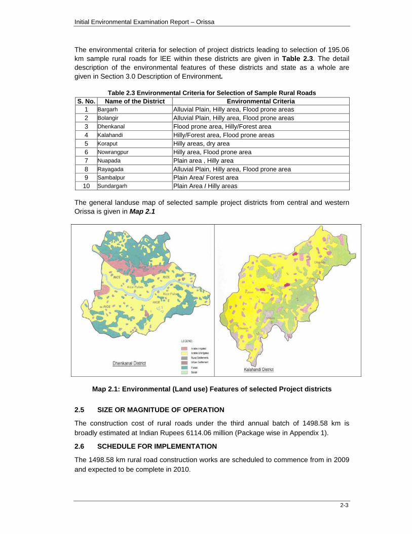
The environmental criteria for selection of project districts leading to selection of 195.06 km sample rural roads for lEE within these districts are given in Table 2.3. The detail description of the environmental features of these districts and state as a whole are given in Section 3.0 Description of Environment.
Table 2.3 Environmental Criteria for Selection of Sample Rural Roads
S. No. Name of the District Environmental Criteria 1 Bargarh Alluvial Plain, Hilly area, Flood prone areas 2 Bolangir Alluvial Plain, Hilly area, Flood prone areas 3 Dhenkanal Flood prone area, Hilly/Forest area 4 Kalahandi Hilly/Forest area, Flood prone areas 5 Koraput Hilly areas, dry area 6 Nowrangpur Hilly area, Flood prone area 7 Nuapada Plain area , Hilly area 8 Rayagada Alluvial Plain, Hilly area, Flood prone area 9 Sambalpur Plain Area/ Forest area
10 Sundargarh Plain Area I Hilly areas The general landuse map of selected sample project districts from central and western Orissa is given in Map 2.1
Map 2.1: Environmental (Land use) Features of selected Project districts
2.5 SIZE OR MAGNITUDE OF OPERATION
The construction cost of rural roads under the third annual batch of 1498.58 km is broadly estimated at Indian Rupees 6114.06 million (Package wise in Appendix 1).
2.6 SCHEDULE FOR IMPLEMENTATION
The 1498.58 km rural road construction works are scheduled to commence from in 2009 and expected to be complete in 2010.
Initial Environmental Examination Report – Orissa
2-4
2.7 DESCRIPTION OF PROJECT
2.7.1 Rural Road Construction Proposals
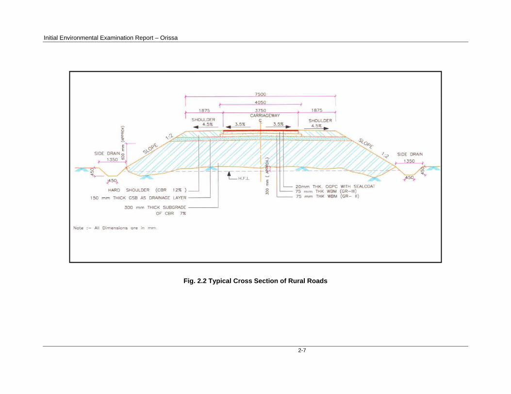
The rural road construction work will provide 7.5 m roadway width with 3.75 m carriageway in plain terrain. The proposal considers a 3.75 m cement concrete pavement with lined storm water drains for stretches passing through the habitations. The pavement design considers a base layer of variable thickness as per the design with granular sub base; 150 mm thick water bound macadam (WBM grade I & II) and finally topped with 20 mm thick bituminous pavement. Adequate cross drainage structures like pipe or slab culverts/bridge structures are considered for drainage channels across the roads. The construction will be in accordance with Indian Roads Congress (IRC) road manual. Figure 2.2 is showing typical cross section of the rural roads.
The rural road construction works will be in conformity with the Rural Roads Manual and Technical Specifications (IRC:SP20:2002) for Rural Roads published by the Indian Road Congress (IRC) on behalf of Ministry of Rural Development Government of India.
2.7.2 Present Condition
At present the rural habitations to be covered under PMGSY are connected to the nearest paved road network through unpaved tracks. Generally, these are the traditional village pathways that have transformed into the present tracks or unpaved roads through minor construction work undertaken over the decades under various programs by the local bodies and State Governments. The tracks are not all weather roads have corrugations at several stretches but vehicular traffic like farm tractors, light commercial vehicles still do ply on these tracks in dry seasons.
The present environmental condition of the sample roads from the environmental impact checklist prepared by PIUs is summarized in Table-2.4
Table 2.4: Summary of Environmental Condition of Sample Roads
Environmental impact checklist points Status as reported in the Checklists A. Climate Conditions Temperature (oC) High Maximum 47oC Low Minimum 7oC Humidity (%) High Maximum 92% Low Minimum 15% Rainfall (mm/year) 1020 mm to 2146.8 mm Rainy Season (---month to ---month) June to October B. Locations of the Road Coastal area None of the roads are in coastal belt Mangrove (along roadside) None of roadside having mangroves Hilly/Mountainous area Kalahandi, Koraput & Sundargarh districts have partial
or more hilly roads Forest area No road passes through forest area needing Forest
Clearance Lake/Swamp None of the roads having Lake/Swamp near it. Inhabited area Bargarh, Balangir, Kalahandi, Nabarangpur, Denkanal,
Nuapada, Rayagada, Sambalpur, Koraput & Sundargarh roads having inhabited area
Initial Environmental Examination Report – Orissa
2-5
Environmental impact checklist points Status as reported in the Checklists Agricultural land Bargarh, Denkanal, Sonepur, Bolangir, Kalahandi,
Nuapada, Rayagada, Sambalpur, Koraput & Malkangiri roads having side by agriculture land area
Barren land Bargarh, Balangir, Kalahandi, Nabarangpur, Denkanal, Nuapada, Rayagada, Sambalpur, Koraput & Sundargarh roads having side by barren land
Flat area Bargarh, Balangir, Kalahandi, Nabarangpur, Denkanal, Nuapada, Rayagada, Sambalpur, Koraput & Sundargarh roads having side by flat area
C. Description of the Road Environment Is the area along the project road prone to landslide problems?
None of the roads have landslide problems
Is the area along the project road prone to flooding problems?
Bargarh, Kalahandi & Bolangir roads are prone to flooding problems
Along the road and within 500 m of the road shoulder, is there any area with natural habitat?
None of the roads have Natural habitats along or within 500m.
Along the road and within 500 m of the road shoulder, is there any species of flora and fauna that is classified as endangered species?
None of the roads have any species of flora and fauna that is classified as endangered species.
Along the road and within 500 m of the road shoulder, is there any faunal breeding ground?
None of the roads have any faunal breeding ground.
Along the road and within 500 m of the road shoulder, is there any bird migration area?
None of the roads have any bird migration area.
D. Impacts and Proposed Mitigation Measures Encroachment on historical/cultural areas? None of the roads have encroachment on
historical/cultural areas. Disfiguration by road embankments, cuts, landscape by road embankments, cuts, fills, and quarries?
None of the roads have disfiguration by road embankments, cuts, landscape by road embankments, cuts, fills, and quarries.
Encroachment on precious ecology (e.g. sensitive or protected areas)?
None of the roads have encroachment on precious ecology
Water hydrology of waterways crossed by roads, resulting in increased sediment in streams affected by increased soil erosion at construction site?
None (mitigation measures are proposed)
Deterioration of surface water due to sanitary wastes from worker-based camps and chemicals used in construction?
None (mitigation measures are proposed)
Inconvenient environmental condition due to poor sanitation and solid waste disposal in construction camps and work sites?
None (mitigation measures are proposed)
Inconvenient environmental condition due possible transmission of communicable diseases from workers to local populations?
None (mitigation measures are proposed)
Deterioration of surface water quality due to silt runoff? None (mitigation measures are proposed) Increased local air pollution due to rock crushing, cutting and filling works, and chemicals from asphalt processing?
None (mitigation measures are proposed)
Noise and vibration due to blasting and other civil works? None (mitigation measures are proposed) Inconvenience due to land slide or erosion? None Dislocation or involuntary resettlement of people? None Other social concerns relating to inconveniences in living conditions in the project areas that may trigger cases of upper respiratory problems and stress?
None
Creation of temporary breeding habitats for mosquito vectors of disease?
None (mitigation measures are proposed)
Accident risks associated with increased vehicular traffic leading to loss of life?
None (mitigation measures are proposed)
Inconvenience due to transportation of construction materials?
None (mitigation measures are proposed)
Initial Environmental Examination Report – Orissa
2-6
Environmental impact checklist points Status as reported in the Checklists E. Public Consultation Consultation with local community was conducted before finalizing the alignment?
Yes (for each road)
Any suggestion received in finalizing the alignment? Yes for all district roads If suggestions received, do they get incorporated into design?
Yes for all district roads
F. Permit/Clearance Required Prior to Commencing Civil Work
SPCB–Non objection Certificate None Forest Department None MOEF None For water extraction None For Quarry Having Licensed quarries For Disposing Spoil Materials None Others(Describe in the remarks column) None
2.7.3 Available Right of Way (ROW)
The existing width of tracks generally varies between 3-8m in stretches passing through agricultural lands or habitations and 8-10m in stretches through the open lands / agricultural fields. As per the information available with OSRRA, in most of the roads the required ROW of 10-12m is available even in stretches passing through the agricultural lands. The ROW has been generally encroached and put to agricultural use by the adjacent landowners in almost all the road construction proposals.
The private landowners along the proposed right of way (ROW) are voluntarily parting the encroached land and in some cases parted even their own private land without any compensation, anticipating the benefits from the road construction works. In case of construction works through the intermediate rural settlements/habitations the carriageway width is restricted to 5.5 m and a cement concrete pavement is considered in all such cases.
2.7.4 Alignment and profile
The construction works are to be confined to the existing alignment of the unpaved tracks. The existing horizontal and vertical alignment / profile will be generally maintained except for minor smoothening or corrections to sustain consistent design speed without causing any land acquisition requirements and thereby the possible social and/or environmental concerns.
2.7.5 Traffic
The present traffic data on each of these rural roads typically vary between 10-15 vehicles per day on most of the rural stretches. The traffic largely comprises motor cycles/two wheelers, tractors, light commercial vehicles, animal drawn carts and bicycles.
2.7.6 Economic Assessment
The economic analysis carried out under the project has indicated that the rural road construction works will act as a catalyst for the rural economic growth and poverty alleviation of the community in the region.
Initial Environmental Examination Report – Orissa
2-7
Fig. 2.2 Typical Cross Section of Rural Roads
Initial Environmental Examination Report - Orissa
3-1
SECTION-3: DESCRIPTION OF ENVIRONMENT
3.1 General
The baseline environment of the study area along with environmental profile within the corridor of impact (COI) of the project roads are given in this section.
The State of Orissa is divided into the following broad regions for assessment of the baseline environment profile of the project districts as a whole and along the Corridor of Impact (COI) of the 135.47km sample roads.
Upland Districts with Mixed landuse in Northern and Western Part of State
Uplands Districts with Mixed landuse in Southern and Central Part of State
From the agro-climatic zones point of view, the state has three different land types viz highland, middle and lowland areas. The fundamental climatic differences are relatively minor. The significant physical difference lies in the drainage Highland areas that drain relatively quickly and flatter lowland areas those drain more slowly. The result is a marked difference in water table and soil moisture retention levels. Soil moisture levels remain high for much longer in lowland areas and therefore present extended cropping opportunities.
3.2 Physical Resources 3.2.1 Topography
Orissa is located between the parallels of 17.49'N and 22.34'N latitudes and meridians of 81.27'E and 87.29'E longitudes. It is bounded by the Bay of Bengal on the east; Madhya Pradesh on the west and Andhra Pradesh on the south. It has a coast line of about 450 kms. It extends over an area of 155,707 square kms. According to the 1991 census, it has a total population of 31,512,070 (3.73 percent of the total population of India) out of which about 16,237,000 are male and 15,275,070 are female. This region is the combination of several deltas of varied sizes and shapes formed by the major rivers of Orissa, such as the Subarnarekha, the Budhabalanga, the Baitarani, the Brahmani, the Mahanadi, and the Rushikulya. Therefore, the coastal plain of Orissa is called the "Hexadeltaic region" or the "Gift of Six Rivers". It stretches along the coast of the Bay of Bengal having the maximum width in the Middle Coastal Plain (the Mahanadi Delta), narrow in the Northern Coastal Plain (Balasore Plain) and narrowest in the Southern Coastal Plain (Ganjam Plain). The North Coastal Plain comprises the deltas of the Subarnarekha and the Budhabalanga rivers and bears evidences of marine transgressions. The Middle Coastal Plain comprises the compound deltas of the Baitarani, Brahmani and Mahanadi rivers and bears evidences of past 'back bays' and present lakes. The South Coastal Plain comprises the laccustrine Plain of Chilika Lake and the smaller delta of the Rushikulya River. The plateaus are mostly eroded plateaus forming the western slopes of the Eastern Ghats with elevation varying
Initial Environmental Examination Report - Orissa
3-2
from 305-610 metres. There are two broad plateaus in Orissa : (i) the Panposh - Keonjhar -Pallahara plateau comprises the Upper Baitarani catchment basin, and (ii) the Nabrangpur - Jeypore plateau comprises the Sabari basin.
3.2.2 Geology
The state of Orissa is on the eastern coast of India extending from 17 49 'N to 22 34'N Latitude and from 81 27'E to 87 29É longitude. Geographically, Orissa can be divided into four parts - the Coastal Plains, Central Tract, Northern Plateau and the Eastern ghats. The coastal plain stretches along the eastern margin of the state from the Subarnerekha in the North to the Rusikulya in the South. It comprises of Balasore, Cuttack, Puri and Ganjam districts.. The central tract comprises of the mountainous region covering around 3/4th area of the State-stretching from North to South. The Northern plateau is an extension of the Chhotangapur plateau covering the districts of Mayurbhanj, Keonjhar, Sambalpur and Eastern Sundargarh. The Eastern ghats covers the South Western portion of the state forming an undulating plateau through Ganjam and Koraput district in the South and parts of Kalahandi and Phulbani in South West.The central and southern coastal districts of the state are largely covered with lgneous Sedimentary and Metamorphic rocks. The lgneous rocks comprise Granite, Grano-Diorite Pegmatite type. The sedimentary rocks are largely alluvium in nature. The metamorphic rocks comprise khondalite, Charcoknites and unclassified Crystallines. The Eastern and western districts are largely covered with mixed formations comprising Alluvium, Laterite, Granite, Grano-Diorite Pegmatite, Gneisses, Khondalite, Charcoknites and unclassified Crystallines.
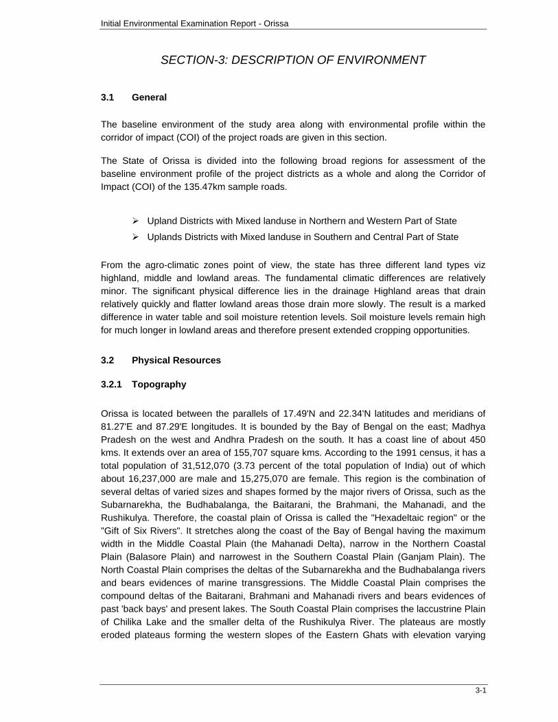
The Rocks and Mineral map of the project districts is given in Figure 3.1
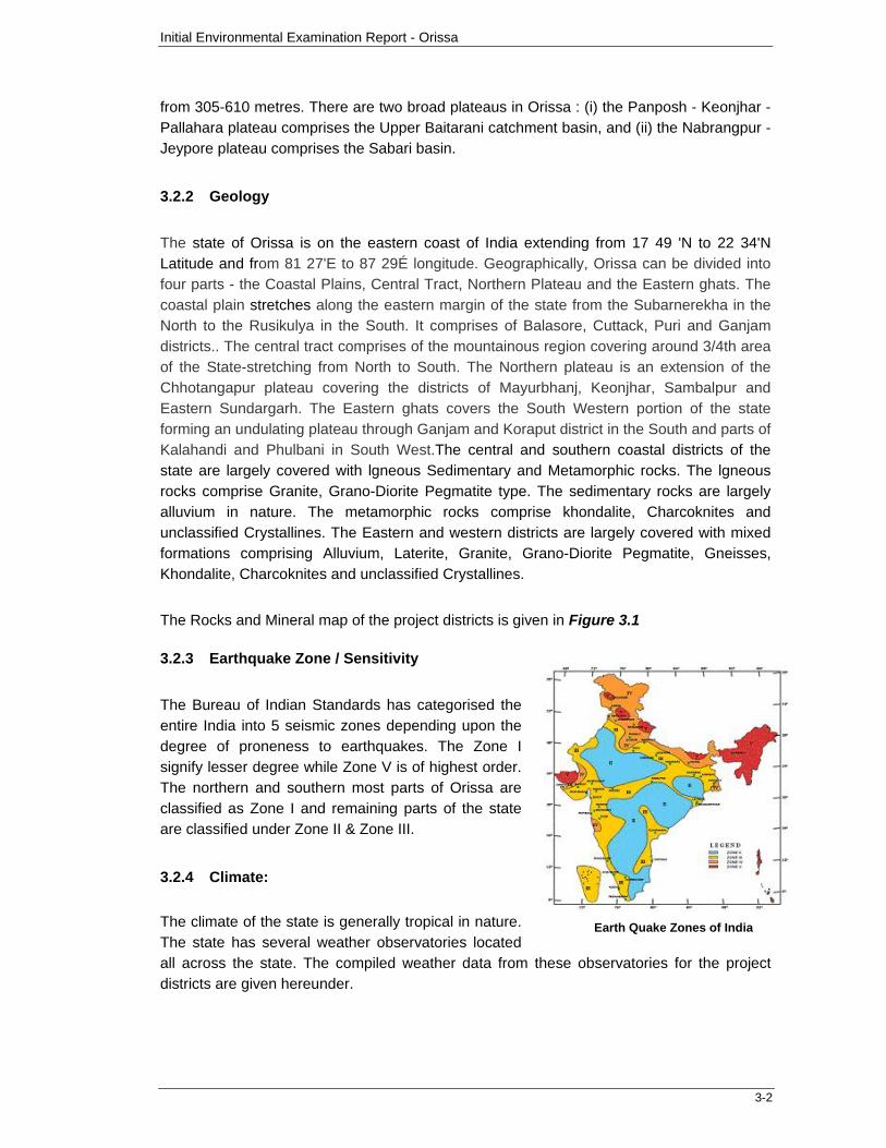
3.2.3 Earthquake Zone / Sensitivity
The Bureau of Indian Standards has categorised the entire India into 5 seismic zones depending upon the degree of proneness to earthquakes. The Zone I signify lesser degree while Zone V is of highest order. The northern and southern most parts of Orissa are classified as Zone I and remaining parts of the state are classified under Zone II & Zone III.
3.2.4 Climate:
The climate of the state is generally tropical in nature. The state has several weather observatories located all across the state. The compiled weather data from these observatories for the project districts are given hereunder.
Earth Quake Zones of India
Initial Environmental Examination Report - Orissa
3-3
Figure No.- 3.1 Rocks and Minerals of Project Districts
Initial Environmental Examination Report - Orissa
3-4
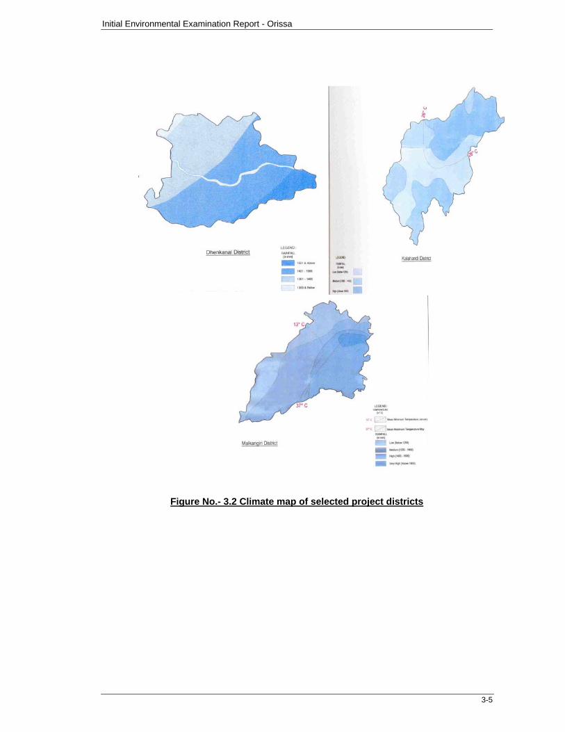
Temperature: The mean minimum and mean maximum annual temperature across the state covering the Northern, Eastern, Western and Southern districts is 13.50C and 370C respectively. In certain parts of the state, occasionally the mean maximum temperature can rise up to 470C.
Relative Humidity: Normally, May to October months are humid and January to April are dry. The relative humidity is normally more in coastal districts as compared to the upland districts. The relative humidity in project districts range between 15 to 92%.
Wind: The predominant wind direction in the state is South during both morning (24% of time) and evening hours (26% of time). The calm period prevail for 50% of time during morning hours and 61% of time in the evening hours. The mean wind speed ranges between 2.6 km/ h to 4.9 km/h. Generally, April to June is windy as compared to other months. The region has clear visibility even more than 20km for over 250 days in a year. The cyclonic storms over the Bay of Bengal particularly in the south and western parts of the state cause widespread cyclonic weather, which in turn lowers the temperature and cause high relative humidity and sultry weather conditions.
Rainfall: The rainfall in the project districts range between 1020 mm to 2146.8 mm, out of which more than 80% is received between June to September.
The Climate map of selected project districts is given in Figure 3.2.
3.2.5 Surface Water:
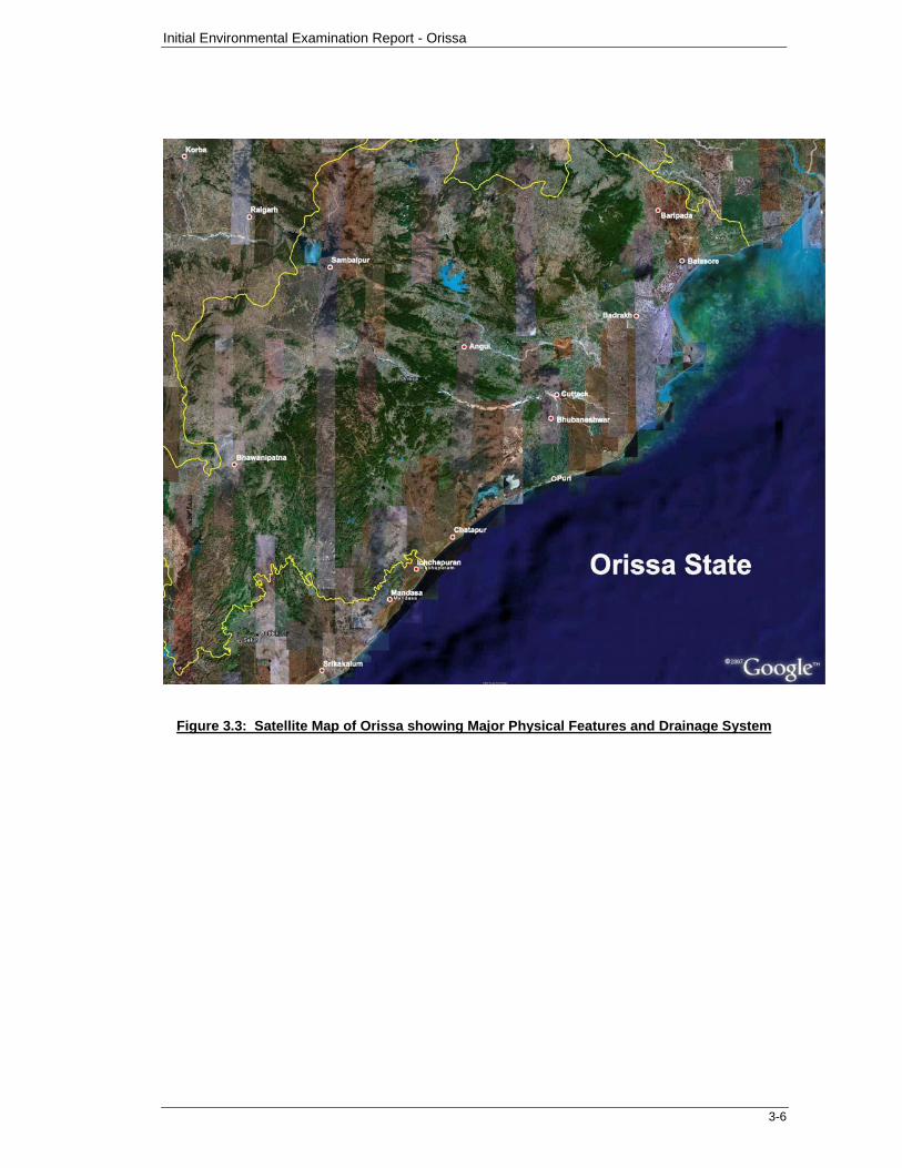
Orissa has three major river basins, namely Mahanadi, Brahmani and Subarnarekha basins. Among these, Mahanadi is the largest, followed by Brahmani and Subarnarekha basins. The Northern parts of the state is drained by Subarnarekha river, the central part (partly) of the state is drained by Brahmani whereas the Mahanadi River drains central (largely) and Southern parts of the State. The satellite map of Orissa showing the major physical features and the drainage system is presented in Figure 3.3.
3.2.6 Ground Water:
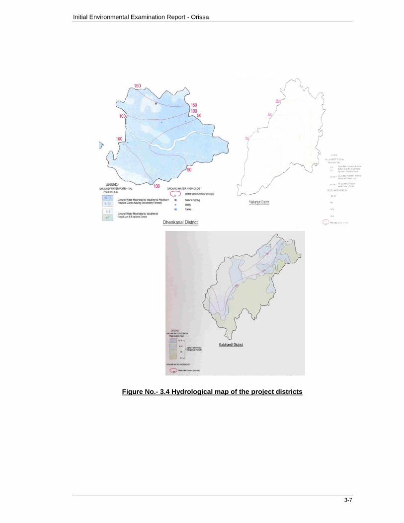
The groundwater potential in the project districts vary from than 1 litre/sec to 40 litre/sec. the hydro-geological formations in the coastal districts range between porous confined aquifers having primary intra-granular porosity (with yields up to 40 litre/sec). to upland regions with generally limited ground water potential having less intra-granular porosity and fractures (with yield less than 1 litre/sec) the occurrence of ground water table range from 1m above mean sea level to 500 m above mean sea level across the state.
The hydrogeology of the project districts showing the ground water potential, water table contour is given in Figure 3.4
Initial Environmental Examination Report - Orissa
3-5
Figure No.- 3.2 Climate map of selected project districts
Initial Environmental Examination Report - Orissa
3-6
Figure 3.3: Satellite Map of Orissa showing Major Physical Features and Drainage System
Initial Environmental Examination Report - Orissa
3-7
Figure No.- 3.4 Hydrological map of the project districts
Initial Environmental Examination Report - Orissa
3-8
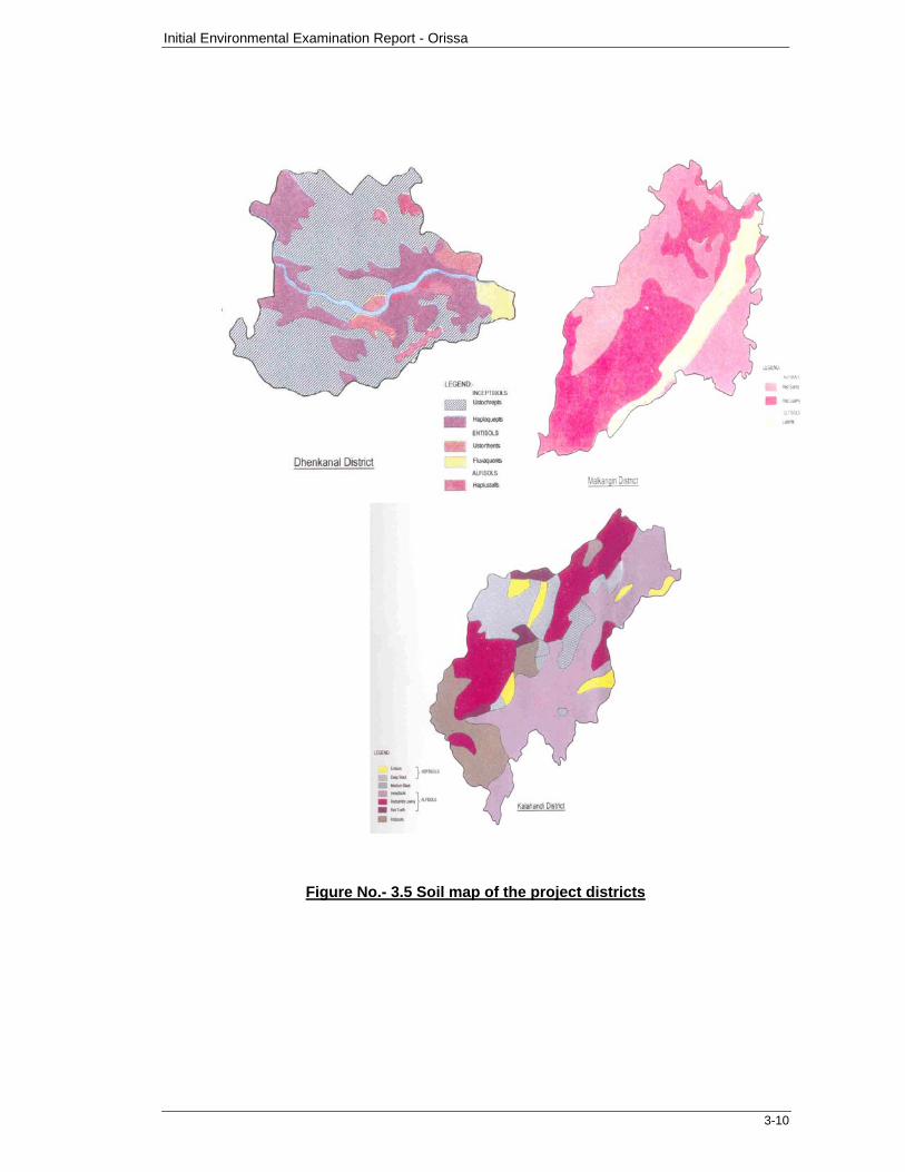
3.2.7 Soils: The state has different soil types ranging from fertile alluvial deltaic soils in coastal plains, mixed red and black soils in central table land, red and yellow soils with low fertility in northern plateau and red, black& brown forest soils in Eastern Ghat region. The soil types differ widely from high acidic with the degree of acidity varying widely. The majority of soils in Orissa are light textured red soils, which have low water holding capacity, low fertility and are highly erodable.
The major soil types within the project districts can be classified into five groups namely inceptisols, ultisols, entisols, aridisols and alfisols, these soil types can be further classified into brown, red, yellow and lateritc soils. The entisols is subclassified into younger alluvial, and laterite soils. The aridisols is sub-classified into saline and saline alkali soils. The alfisols is sub-classified into deltaic alluvial soils, older alluvial soils, red gravel soils, red sandy soils, red sandy soils, red loamy and mixed red black soils.
The soil types of the project districts is given in Figure 3.5
3.2.8 Surface Water Quality
The rural road construction proposals normally cross small drainage channels (Mostly agricultural field channels), which eventually join the major channels/rivulets. All of these channels generally remain dry for most part of the year and drain the storm water for few weeks only during or after the monsoon. Therefore, surface water quality is expected to remain as such.
3.2.9 Ambient Air Quality:
The Central Pollution Control Board and State Pollution control Board maintain database on the ambient air quality of the state. However, such database is limited to major cities/urban centres and some selected industrial areas. No secondary data is available for the project districts particularly representing the rural areas.
Along the proposed road construction proposals, neither there is significant industrial activity nor significant vehicular traffic contributing to air pollution. Therefore, the ambient air quality is expected to be within the National Ambient Air Quality Standards (NAAQS) for all parameters excepting the dust or particulate matter. The occasional vehicular movement on unpaved roads lead to formation of dust clouds over short periods. The airborne dust increases the concentration of both the Suspended Particulate Matter (SPM) and Respirable Particulate Matter beyond the limits of the NAAQS as prescribed in Environmental Protection Act, 1986, which is an umbrella act for the protection of environment in the country published by Ministry of Environment and Forest (MOEF).
3.2.10 Ambient Noise Quality
Similar to the database on air quality, the Central Pollution Control Board and State Pollution control Board maintain a database on the ambient noise levels for major
Initial Environmental Examination Report - Orissa
3-9
cities/urban centres and some selected industrial areas. No secondary data is available for the project districts particularly representing the rural areas. Along the proposed road construction proposals, neither there is significant industrial activity nor significant vehicular traffic contributing to ambient noise levels. The occasional vehicular movement on the unpaved roads contributes to increased noise levels over short duration limited to daytime.
The existing roads do not appear to have vehicular traffic in the night time. Therefore the ambient noise levels are expected to be within the National Ambient Noise Standards.
3.2.11 Drought & Cyclone:
Orissa has both chronically draught prone and cyclone affected areas within the state. Some of the chronically drought prone areas are Kalahandi, Bolangir and Koraput districts.
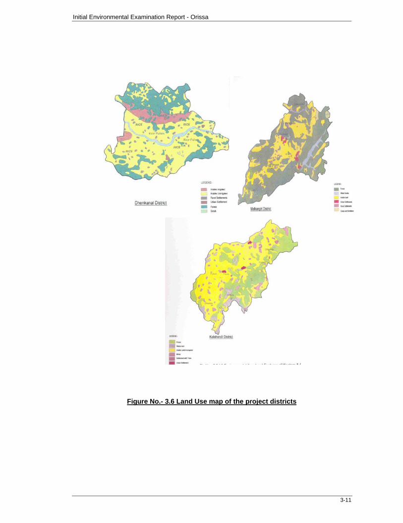
3.2.12 Land Use:
The land use pattern within the project districts can be broadly classified into arable irrigated, arable un-irrigated, forest areas, waste land/scrub, and rural / urban settlements areas. The land use pattern of project districts is shown in Figure 3.6.
3.3 Ecological Resources: 3.3.1 Terrestrial flora: Plants/animals and environment are inter related to each other. With the change in environmental conditions, the vegetation cover as well as animals reflect several changes in its structure, density and composition.
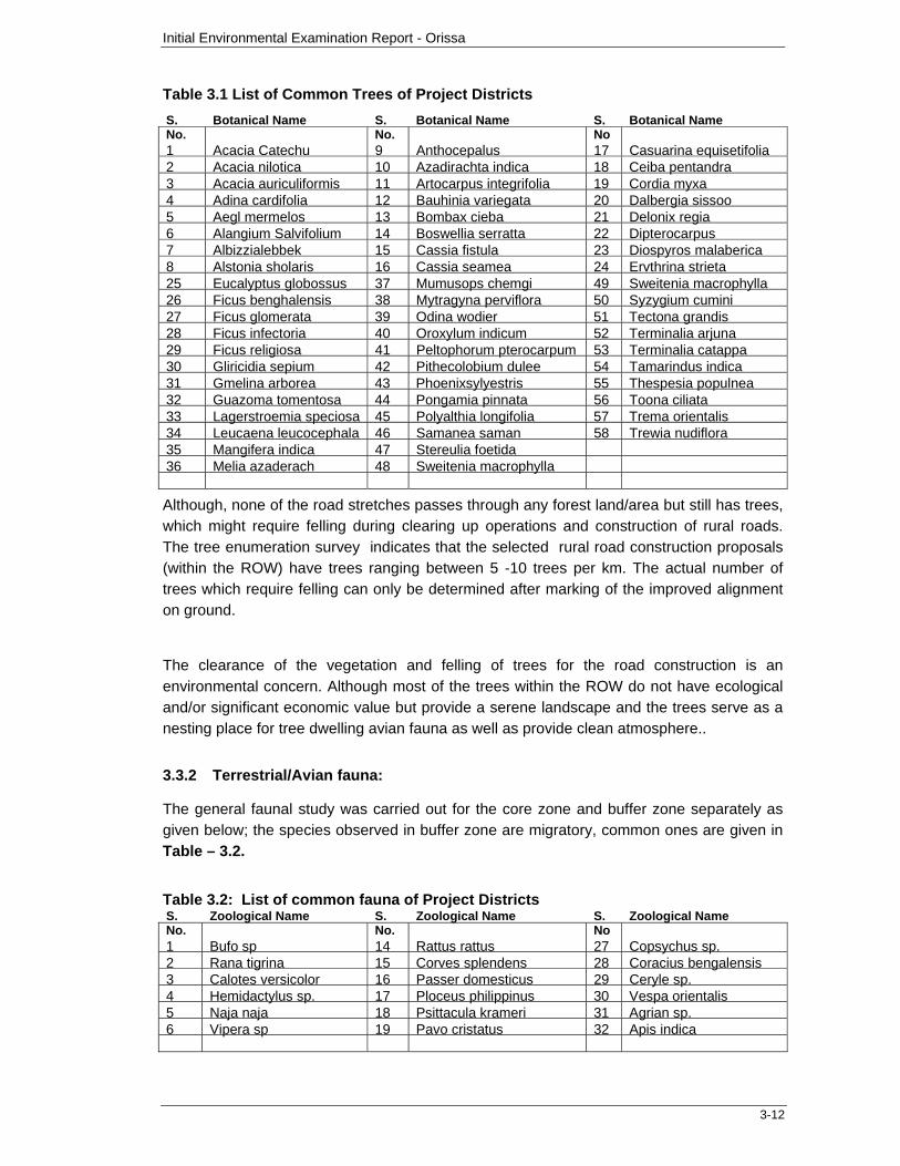
During the field investigations, the most dominant terrestrial flora within the project districts was recorded. The prevailing vegetation cover over the area is mainly of tropical dry deciduous forest [5B/C-1/C] as per the Champion and Seth (1968) “Classification of forest type of India”. The dominant flora comprised generally the trees planted along side of the rural road proposals, particularly the stretches along agricultural lands. Many of these are planted by the adjacent landowners and often perceived, as a fence to their respective lands. Some of these trees may be required to be felled during the clearing up operations for road construction. The common trees observed alongside of the sample road projects are presented in Table 3.1
Initial Environmental Examination Report - Orissa
3-10
Figure No.- 3.5 Soil map of the project districts
Initial Environmental Examination Report - Orissa
3-11
Figure No.- 3.6 Land Use map of the project districts
Initial Environmental Examination Report - Orissa
3-12
Table 3.1 List of Common Trees of Project Districts
S. No.
Botanical Name S. No.
Botanical Name S. No
Botanical Name
1 Acacia Catechu 9 Anthocepalus 17 Casuarina equisetifolia 2 Acacia nilotica 10 Azadirachta indica 18 Ceiba pentandra 3 Acacia auriculiformis 11 Artocarpus integrifolia 19 Cordia myxa 4 Adina cardifolia 12 Bauhinia variegata 20 Dalbergia sissoo 5 Aegl mermelos 13 Bombax cieba 21 Delonix regia 6 Alangium Salvifolium 14 Boswellia serratta 22 Dipterocarpus 7 Albizzialebbek 15 Cassia fistula 23 Diospyros malaberica 8 Alstonia sholaris 16 Cassia seamea 24 Ervthrina strieta 25 Eucalyptus globossus 37 Mumusops chemgi 49 Sweitenia macrophylla 26 Ficus benghalensis 38 Mytragyna perviflora 50 Syzygium cumini 27 Ficus glomerata 39 Odina wodier 51 Tectona grandis 28 Ficus infectoria 40 Oroxylum indicum 52 Terminalia arjuna 29 Ficus religiosa 41 Peltophorum pterocarpum 53 Terminalia catappa 30 Gliricidia sepium 42 Pithecolobium dulee 54 Tamarindus indica 31 Gmelina arborea 43 Phoenixsylyestris 55 Thespesia populnea 32 Guazoma tomentosa 44 Pongamia pinnata 56 Toona ciliata 33 Lagerstroemia speciosa 45 Polyalthia longifolia 57 Trema orientalis 34 Leucaena leucocephala 46 Samanea saman 58 Trewia nudiflora 35 Mangifera indica 47 Stereulia foetida 36 Melia azaderach 48 Sweitenia macrophylla
Although, none of the road stretches passes through any forest land/area but still has trees, which might require felling during clearing up operations and construction of rural roads. The tree enumeration survey indicates that the selected rural road construction proposals (within the ROW) have trees ranging between 5 -10 trees per km. The actual number of trees which require felling can only be determined after marking of the improved alignment on ground.
The clearance of the vegetation and felling of trees for the road construction is an environmental concern. Although most of the trees within the ROW do not have ecological and/or significant economic value but provide a serene landscape and the trees serve as a nesting place for tree dwelling avian fauna as well as provide clean atmosphere..
3.3.2 Terrestrial/Avian fauna:
The general faunal study was carried out for the core zone and buffer zone separately as given below; the species observed in buffer zone are migratory, common ones are given in Table – 3.2.
Table 3.2: List of common fauna of Project Districts S. No.
Zoological Name S. No.
Zoological Name S. No
Zoological Name
1 Bufo sp 14 Rattus rattus 27 Copsychus sp. 2 Rana tigrina 15 Corves splendens 28 Coracius bengalensis 3 Calotes versicolor 16 Passer domesticus 29 Ceryle sp. 4 Hemidactylus sp. 17 Ploceus philippinus 30 Vespa orientalis 5 Naja naja 18 Psittacula krameri 31 Agrian sp. 6 Vipera sp 19 Pavo cristatus 32 Apis indica
Initial Environmental Examination Report - Orissa
3-13
S. No.
Zoological Name S. No.
Zoological Name S. No
Zoological Name
7 Fumambulus pennanti 20 Columba livia 33 Musca domestica 8 Felis sp. 21 Egretta sp. 34 Periplanata sp. 9 Cuon sp 22 Pycnonotus sp. 35 Lasioderma sp. 10 Bos sp. 23 Acridotheres tristis 36 Pachlomerus sp. 11 Bubalis babalis 24 Eudynamys scolopacea 37 Schistocera sp. 12 Eqqus sp. 25 Apus affinis 38 Camponotus sp. 13 Herpestes sp. 26 Ardeola grayii 39 Gryllus sp. Amphibians: Among amphibians toad (Bufo sp.) and frog (Rana tigrina) are reported. Reptiles: Among reptiles Indian garden lizards (Calotes versicolor), house lizards (Hemidactylus sp.) are generally reported while cobra (Naja naja) and viper (Vipera sp.) are rarely reported. Mammals: Among mammals Indian palm squirrel (Fumambulus pennanti), cat, dog (Cuon sp.), cow, Buffalo, rat (Rattus rattus) etc. are reported. Aves: Among aves common birds like crow (Corves splendens), sparrow (Passer domesticus), parrot (Psittacula krameri), baya (Ploceus philippinus), peafowl (Pavo cristatus), pigeon (Columba livia), Egretta sp. etc. are reported. Arthropods: Among arthropods common insects viz Butterflies, Dragonflies, Wasps; Grasshopper, Cockroach, House fly, Beetles, Mosquitoes etc are reported. 3.3.3 Forests: The prevailing vegetation cover over the area is mainly of tropical dry deciduous forest [5B/C-1/C] as per the Champion and Seth (1968) “Classification of forest type of India”.
The forest map of orissa indicates that central districts like Angul, Denkanal are having dense forest areas while south and western parts have a mix of dense and open forest areas.
3.3.4 Wildlife: The occurrence of wild life species and or threatened or endangered species has not been reported within the corridor of impact of any of the road construction proposals under the IEE studies. 3.3.5 Rare or endangered species: Endangered and threatened animals of India have been listed in the Schedule I and Schedule II of the Wildlife (Protection) Act, 1972 (amended in 2001). The details of these species present in the study area are given below: No threatened, rare, endangered or endemic species were observed during the survey in core zone. In buffer zone following species were rarely reported.
Initial Environmental Examination Report - Orissa
3-14
Schedule I: None of the species were recorded from Schedule I. Schedule II:
Birds: Peafowl- Pavo cristatus Reptiles: Indian cobra- Naja naja
3.3.6 Fisheries: None of the sample project roads area is having any fish culture ponds. However, in remaining roads of third annual batch small fisheries ponds of natural/manmade may appear. No encroachment shall be allowed in such cases.
3.3.7 Aquatic Biology:
No wetland or big water bodies are existing in and around the selected project roads area. Therefore construction works are not envisaged to affect aquatic biology of the area. Certain small ponds may be in remaining roads of third annual batch impact corridors, which has to be protected form runoff of the construction work and shall not be disturbed. 3.4 Human and Economic Development:
3.4.1 Population and Community; Orissa has a population of 32 million. About 87% of the population lives in the villages and one third of the rural population does not own any land other than homesteads. 25% of Orissa's Population is Tribal. The southern and the south western districts of Koraput, Malkangiri, Rayagada, Nawarangpur and Kalahandi show a higher percentage ST population compared to the other western and central project districts.
3.4.2 Industries:
Although Angul, Koraput and Rayagada have major industrial areas, none of them fall within the core or the buffer zone of the proposed road corridors. In general, mineral mining is common in hilly areas of Koraput, Rayagada and Kalahandi while coal mining is the major mining activities of Dhenkanal and Jharsuguda districts. Sundargarh is known for the iron ore mining areas and rourkela steel plant. None of these mining areas fall within the core or the buffer zone of the proposed road corridors.
3.4.3 Flood Control facilities: Orissa is generally prone to various disasters like flood, cyclone, drought and fire. The last super cyclone in 1999 is an unforgettable event in the history of Orissa so also the High Flood in 2001 and the drought in 2002. Bargarh, Sonepur and Bolangir roads are prone to flood during monsoon season. Various organizations working in Orissa in the field of disaster management as given below might be consulted for any further precaution in construction work apart from proper drainage provisions.
Orissa State Disaster Mitigation Authority National Informatics Centre UNDP
3.4.4 Agriculture:
The majority of the population in project districts is dependent on forest and subsistence agriculture. Podu cultivation (slash and burn) is practiced extensively by the tribals in the "dongar" (Upland). In the high hill slopes pulses, millets, mandya (ragi) and oilseeds like niger and mustard are grown. In the "Bilo" (low land) paddy is cultivated. Horticulture is also practiced particularly among the tribals. Vegetables are also cultivated crops being sweet
Initial Environmental Examination Report - Orissa
3-15
potato, beans, chilly and yam. The agriculture is rain-fed. The agricultural implements used are deshi wooden plough, wooden plod-breaker (coporpotta) and phouda sickle and hand axe etc.
3.4.5 Archeological/Historical monuments:
Although, Orissa is known to have several archaeological and historical/protected monuments spread all over the state, none of them are situated within 5km on each side from the sample rural roads.
3.4.6 Temples/Shrines/Idols/Statues:
The corridor of impact (COI) or the direct influence area of the 135.47km road (sample) construction proposals have no shrines, idols, tombs and roadside small temples which might be impacted or require relocation due to the construction works.
Initial Environmental Examination Report: Batch III Roads – Orissa
4-1
SECTION 4: POTENTIAL ENVIRONMENTAL IMPACTS AND MITIGATION MEASURES
4.1 GENERAL
The environmental impacts due to construction of rural roads particularly along existing unpaved alignment induce relatively less adverse Impacts as compared to construction along new alignments. The impacts due to construction of rural roads can be largely mitigated through engineering designs. Good construction practices accompanied by appropriate environmental mitigation measures or Environmental Code of Practices.
The screening of potential impacts due to the rural road construction works in Orissa along with the appropriate mitigation measures (wherever applicable) are summarized under the following different stages.
Environmental Problems due to Project Location Environmental Problems Related to Design Environmental Problems Associated with Construction Stage Environmental Problems Resulting in Project Operations Potential Environmental Enhancement Measures Additional Considerations
4.2 ENVIRONMENTAL PROBLEMS DUE TO PROJECT (ROAD) LOCATION
4.2.1 National Parks/Wild Life Sanctuaries
Potential Impacts: Out of the 195.06 km of sample rural road construction works in 33 different stretches/ locations, none are passing through the National Parks/wild life sanctuaries.
The current environmental regulations of the Ministry of Environment & Forests, Government of India does not permit development activity within the National Parks/Wild Life sanctuaries that are not in consonance of section 29 of Wild Life Act 1972.
Mitigation: As none of the construction proposals are through the National parks/ sanctuaries, no environmental/ecological threat to any National Park/ Wildlife sanctuaries are perceived due to the location of any of the 1498.58 km road length in 10 districts of the Orissa State. Further, the subsequent annual batches that pass through sanctuaries, national parks or roads that will affect the movement or life of endangered species will be excluded and not considered under the ADB loan assistance program.
4.2.2 Archaeological/ Heritage Monuments
Potential Impacts & Mitigation: Although, Orissa is known to have several archaeological and historical/ protected heritage monuments spread all over the state, none of them are situated within 5 km on each side from the sample rural roads of 195.06 km. Therefore no environmental impacts are envisaged on the Archaeological/Heritage Monuments due to the location of road construction proposals.
Initial Environmental Examination Report: Batch III Roads – Orissa
4-2
In case, archaeological/ heritage monuments are situated within 5 km on each side of the remaining 1303.52 km of roads in the third annual batch and roads that will be taken up in the non funded PMGSY schemes
4.2.3 Natural Habitat/Nature reserves
Potential Impacts: None of the 33 sample stretches, having an aggregate length of 195.06 km of sample are within 5 km radius of natural habitat/ nature reserves notified by the Government of India. Therefore no environmental/ecological threat to any Natural Habitat/Nature reserves is perceived due to the location of road construction proposals.
Mitigation: As none of the proposals are either passing through or within 5 km on each side from the sample rural roads of 195.06 km of Natural habitat/nature reserves notified by Government of India. Therefore, no ecological threat to any Natural habitats/ nature reserves is perceived due to the location of any of the I48 km sample roads. In the remaining length of batch III i.e. 1303.52 km if any road is found to be passing through natural habitat or reserved forest, it will not be taken up in ADB funding. Further those roads will also be enclosed from ADB funding that will affect movement and life of endangered species of fauna.
4.2.4 Reserve Forests/ Protected Forest and/or Unclassified Forest Areas/ Lands
Potential Impacts: None of the 33 sample roads visited passed through Reserved Forests/ Protected Forest and or unclassified Forest areas / lands. For remaining length of Batch III roads, PIC has confirmed that none of the road is passing through Reserved Forests/ Protected Forests and or unclassified Forest area/ lands.
Mitigation: Since none of the project road in Batch III is passing through any type of forest, therefore, no mitigation measure is warranted.
4.3 ENVIRONMENTAL PROBLEMS DUE TO PROJECT (ROAD) DESIGN
4.3.1 Embankment construction
Potential Impacts & Mitigation: Generally road construction proposals follow the existing alignment of the unpaved roads with minor smoothening of horizontal and vertical alignment/profiles.
Assessment of the present road conditions and the construction proposals indicates that no major embankment construction (embankment height greater than 5m) will be required in any of the sample rural roads construction works. The proposals are also consciously confined to the existing alignment with minor corrections for vertical/horizontal profile in order to minimize environmental and social Impacts. Therefore no major Impacts are foreseen due to the road construction proposals.
Initial Environmental Examination Report: Batch III Roads – Orissa
4-3
4.3.2 Soil erosion
Potential Impacts:
The soil in the study area is mostly of alluvial and laterite type.. Erosion will be exacerbated if the vegetation is removed from the sides since roots are known to hold soil together. This will however be for the duration until the compensatory afforestation and roadside turfing have matured. In stretches where raised carriageway has been planned, slope protection measures are required.
To prevent the eroded material from entering the watercourse, silt fencing and/or sand bags can be provided at the end of ditches or cascade arrangements can be provided at the end of ditches as they enter the watercourse. While the former requires frequent cleaning to prevent built-up, the voids in the cascade will be filled up by eroded material and eventually vegetation will be established there.
No soil erosion is envisaged when the road is in operation as all the slopes and embankments of the project road shall be stabilised through sound engineering techniques and checks will be made that the works have been carried out to the required standard.
Soil erosion results in the loss of soil cover, slope stability and addition of sediment loading to drainage channels. The problem of soil erosion is likely to be more pronounced during the construction stage along bridge-end fills, over steep banks and embankment slopes.
Mitigation Measures
The slope of the road embankment has been fixed at 1:2, which is stable and reduces the possibilities of slope failures. This protection will mainly be provided at approaches of major and minor bridges. The approaches of these cross drainage structures will be provided a stable slope with stone pitching or other suitable engineering methods such as turfing, brick pitching etc. The slope protection will be done in accordance with recommended practice. For treatment of embankment slopes for erosion control, IRC: 56-1974. All the culverts to be constructed as cross drainage structures; the slopes will be protected by turfing with grasses and shrubs.
To check the slope stabilisation of the borrow pits adjacent to the embankment, the depth of the pit will be so regulated that the bottom edge of pit shall not intersect the imaginary line of slope 1:4 drawn from the top edge of the nearest embankment. To avoid embankment slippage and erosion, borrow pits shall not be dug continuously.
4.3.3 Clearing of vegetation
Potential Impacts & Mitigation: The vegetative cover/trees1 within the right of way will be impacted due to clearing operations of the right of way for road construction works.
1. 1 The list of trees recorded within the corridor is presented under Section 3.3.1 - Flora
Initial Environmental Examination Report: Batch III Roads – Orissa
4-4
Almost all the 195.06 km sample roads have trees on either side of the tracks. The presence of trees within RoW is minimal and whatever present here and there do not have any significant ecological and/or commercial value but appear to have been planted by the adjacent landowners and often perceived as boundary to their private lands.
The clearing of trees within the ROW will have a visible impact on the road users and also temporarily upon the tree dwelling fauna. The clearing operations of the right of way will not have any impact on wild life species, threatened or endangered as these are not known to occur along the ROW.
Mitigation: The impacts due to tree clearing operations of the right of way can be retrieved by re-plantation of the corridor. As per the regulations of the State Forest Department, prior approvals are to be sought for tree felling. The approvals for tree felling particularly for road construction works are generally issued by the Department of Forests with a stipulation that at least three new saplings are to be planted for every tree felled and maintained for three years. The cost of re-plantation of the corridor including maintenance up to 3 years will be borne by Gram Panchyat from their annual plan budget. The selection of species will be finalized in consultation with the Department of Forests, Government of Orissa.
The Impacts due to tree felling within the right of way is applicable to the 195.06 km sample roads and the entire subsequent annual batches including the balance 1303.52 km of the third annual batch.
4.3.4 Cross Drainage
Potential Impacts: None of the rural road construction proposals (195.06 km, 33 different stretches/locations) are across any major rivulets/ drainage channels within their respective river basins. However, road proposals cross several small drainage channels, which are non-perennial and drain the storm water during monsoon.
Mitigation: The project preparation of the road proposals has considered adequate cross drainage structures like hume pipe, RCC or slab culverts and minor bridges in some cases at all such locations to ease the storm discharge during or after the monsoon. The bridge design takes care of anticipated flow as these have been design on 100 years return flood basis.
4.3.5 Roadside Sanitation
Potential Impacts: The local bodies and the State Governments have constructed tube wells along the existing roads particularly near habitations to meet the water supply needs of community. These have been provided with a platform around the tube well, which connects to nearest pit through a lined open drain. The drains appear to be of standard type design and often do not connect up to the nearest pits as per specific site requirements or the pits are often seen to be overflowing without proper drainage leading to improper and unsatisfactory sanitary conditions in and around the tube wells.
Initial Environmental Examination Report: Batch III Roads – Orissa
4-5
Mitigation: Provision of adequate sanitary arrangements with lined drains connecting up to the nearest natural drain or the roadside drains constructed, as a part of road construction proposal will improve the sanitary conditions around the tube wells. A cost provision for such arrangement has been made under Environmental Management Action Plan. In some cases the project roads are prone to water logging from local habitations. At such locations drains have been proposed along road side
4.3.6 Road cutting for Conveyance of Irrigation Pipes and Other Purposes
Potential Impacts: Along many stretches of the road construction proposals, agricultural landowners across the existing roads appear to share the water for irrigation purposes. The tube well water from one side of the road is taken to other side through pipes beneath the road by making a temporary incision at the road surface. In addition to water some for irrigation, some time to drain storm water the road is cut by the locals.
Mitigation: The practice of digging the roads for taking the pipes across the road can be prevented by laying 150mm diameter cement concrete pipes at regular intervals to serve as ducts, particularly along stretches having agricultural land on one or either side. This will provide an option to take the irrigation water pipes across the road through these ducts without road cutting and prevent unwarranted digging of roads. In addition, the village community leaders are to be encouraged to form a watchdog committee to safeguard against un-warranted digging of roads for laying pipes or for any other reasons, unless it is utmost essential. Since adequate cross drainage structures have been planned, it is anticipated that road will not be out for draining the storm water from agriculture fields during monsoon.
4.4 ENVIRONMENTAL PROBLEMS ASSOCIATED WITH PROJECT (ROAD) CONSTRUCTION
4.4.1 Geology / Stone Quarries
Potential Impacts: The quantity of stone aggregates for road construction works conforming to specifications are to be sourced from either the existing or the new quarry sites and hauled to work sites through existing roads.
Impact Mitigation: Quarry operations in the region/ state are regulated by the state department and require license and compliance of the state environmental regulations. Nonetheless, implementation of the following measures will limit or mitigate the impacts:
Aggregates are to be sourced only from the approved/licensed quarry sites, complying with the local/ state environmental and other applicable regulations'
At times the contractors may set up their own quarries and/ or aggregate crushing units in nearby areas to the construction sites. Any such practice shall have a consent or No Objection Certificate from the State Pollution Control Board
Occupational safety procedures/practices for the work force should be in
Initial Environmental Examination Report: Batch III Roads – Orissa
4-6
place at all quarries as per local regulations.
Quarry and crushing units should have adequate dust suppression measures like water sprinklers in work areas and along approach roads to quarry sites. All the work personnel likely to be exposed to heavy dust levels shall be provided with dust masks.
The quarries shall have valid environmental compliance certificates obtained from the state pollution control board from time to time.
Water tankers with suitable sprinkling system are to be deployed along the haulage roads. Water shall be sprinkled regularly to suppress the airborne dust due to the dumper/truck movement. The required frequency is to be determined as per site conditions.
Trucks/ dumpers deployed for the material transportation are to be spillage proof. In any case, all haul roads are to be inspected at least once daily to clear accidental spillage, if any;
Material stacking sites are to be access controlled for unauthorised entry of people, grazing cattle and stray animals;
4.4.2 Hydro-geology/Ground Water
Potential Impacts: The construction water requirement of the road construction works is likely to be met through ground water. Therefore, the potential impacts, if any will be from the use of ground water for the meeting the water requirements of construction works, sprinkling of water for dust suppression, stabilisation of embankments/ shoulders, watering of roadside re-plantations, water for the work force camps, and alike.
An assessment of the construction water demand and the available/ recommended ground water yield/potential2 of the project region indicate that use of ground water for rural road construction works will not have any significant impacts on the geo-hydrological resources of the region.
Impact Mitigation: Although, the impacts may not be significant due to use of ground water for rural road construction works, following preventive measures are suggested
Ensure prior approvals are obtained from State Ground Water Authorities, for the construction of new tube/bore wells wherever required
If the water is sourced from existing agricultural tube wells, the contractor must perform a yield test on such wells and the source are to be used under approval of OSRRA. In addition the owner of tube well is to be clearly informed of the implications of water withdrawal in excess quantities than usual) and a written consent is to be obtained
1. 2 The ground water potential of the project region as recommended by the Central Ground Water Board is described under Section 3.2.6- Ground water.
Initial Environmental Examination Report: Batch III Roads – Orissa
4-7
The contractor must be encouraged to source water from more than one agricultural tube well and such tube wells shall be at least 300m away from each other
Extreme precaution is to be exercised while finalising the locations of new tube/bore wells (wherever applicable); the wells shall be away (at least 300m) from the existing tube wells particularly those which are meeting the daily needs of communities
Under no circumstances the contractor is to be allowed to source water from tube wells, which are being used by the community for their daily needs
The wells constructed for the works are to be left in good working condition for the use of the local community (wherever applicable)
4.4.3 Soil/ Borrow Areas
Potential Impacts: The road construction works will require significant quantities of good quality earth for embankment construction and other components of the road construction as per the engineering design.
The project preparation of rural roads has identified all such potential areas for borrowing including assessing the suitability of the material. In certain situations, contractors also negotiate with the local villagers to lease or outright purchase of agricultural lands for mining the earth. Borrowed earth is to be transported to construction sites through existing roads. Borrowing and hauling operations are to be regulated to contain impacts.
Impact Mitigation: Impacts due to borrowing earth can be significantly mitigated by the following measures:
Detailed investigations are to be carried out by the contractor to identify the borrow options/areas. The borrow areas are to be approved by the respective PIUs not only for the material quality but also for its location.
The contractor must the discouraged to use the agricultural land (either through lease or purchase) for borrowing the earth, until no feasible alterative options are available
Within the identified borrow areas, the topsoil (upto 15-20cm) must be preserved and used for re-vegetation of borrowed areas. The actual extent of borrow area/zones to be excavated are to be demarcated with signboards and the operational areas are to be access controlled
Borrowing areas are to be provided with gentle side slopes. revegetated (to contain erosion and connected to nearest drainage channel to avoid the formation of cess-pools during / after rainy seasons
As per the current regulations, use of fly ash is mandatory for all construction
Initial Environmental Examination Report: Batch III Roads – Orissa
4-8
works within a radius of 100 km from any thermal power plant. Therefore, fly ash will be used in all road construction works, which are within the 100 km from thermal power stations. Although there are thermal power plants (Ib Valley (OPGCL), Talcher Kaniha (NTPC), Talcher thermal (NTPC), Angul (NALCO), Damanjodi (NALCO), Rourkela (RSP), Hirakud (INDAL) and Chaudwar of ICCL) within the prescribed range of 100 km from the project roads, due to their engineering unsuitability and cost considerations no fly ash is planned to be used in the project roads.
All machinery and vehicles deployed in borrowing operations is to conform to the vehicle emission and noise regulations of the State Pollution Control Board
Operations are to be limited to day hours only. Provisions of protective gears like earplugs are to be made available to the work force exposed to noise levels beyond the threshold limits. Rotation of personnel may be exercised as an alternative option. All operation areas are to be water sprinkled to contain dust levels to the National Ambient Air Quality Standards
4.4.4 Land Use
Potential Impacts: The road construction works will require clearing of right of way {ROW) i.e 5 to 6 m on either side from the centerline of the present alignment. The land use pattern along the existing tracks is generally agriculture lands interspersed with rural habitations.
The cleaning of the ROW could have following impacts
Diversion of land under agricultural use
Diversion of forestland (in specific cases)
Loss of tree cover along the existing ROW
Diversion of land under agricultural use: The clearing operations of the ROW will lead to permanent change in land use in some stretches of the road construction particularly along agricultural lands. The clearing operations for construction of 195.06 km of roads will change the present land use in about 23.4 ha3 of land from the present agriculture to road construction. It is important to note that this 23.4 ha of land is scattered over 33 stretches / locations over a length of 195.06 km. The impact arising out of this change in land use is very negligible as compared to the benefits that can accrue from the road construction to the rural economy, benefits to the community in terms of easy and faster accessibility to better education, health facilities and poverty alleviation among others.
1. 3 The estimate considers that out of the required 12m ROW, on an average 1.5m wide of agricultural land on each side of alignment will be required in 40% length of sample roads i.e. 195.06 Km. The rest of the right of way is assumed to have habitations, where the fences are to be shifted backwards
Initial Environmental Examination Report: Batch III Roads – Orissa
4-9
Generally private landowners along the proposed ROW are voluntarily parting their land and in many cases vacate the encroached government land along ROW without any demand for compensation anticipating the social benefits due to the road construction. The OSRRA currently implementing PMGSY works apparently have not faced any social resentment in this regard. In some cases, the assistance of district administration and community leaders have been sought and the matters have been sorted out without any legal channel or compensation. The issues arising out of this is separately addressed in the Social Impact Analysis under Social Assessment Report.
Diversion of Forest Land: No diversion of forest land is planned in Batch III roads. Hence no impact in forest is anticipated
Impact Mitigation: The impacts due to loss of tree cover can be retrieved through measures like compensatory afforestation of degraded forest in the same region and re-plantation of the ROW as already mentioned in the mentioned in the previous sub section. The loss of agricultural land although is minimal is irretrievable.
Other than this, establishment of camp sites for the work force, work sites, construction of road diversions during works also will lead to change in land use. But these are temporary and largely limited to the construction stage. Adopting specific control measures and restoration of the site to its previous state can mitigate impacts after completion of operations. The measures are detailed in environmental management action plan under Section 5.0.
4.4.5 Drainage
Potential Impacts: As mentioned in the previous sections, the project preparation has considered cross drainage structures (pipe / RCC or slab culverts and minor bridges in some cases) and therefore the road construction works will not alter and rather improve the existing drainage system of the region.
Impact Mitigation: The cross drainage structures are scheduled for construction during dry season to avoid impacts on watercourses. Further the drainage channels on both upstream and down stream across the road works are to be cleaned for at least 50m and restored to its previous state after completion of construction works.
4.4.6 Water Quality
Potential Impacts: Discharge of effluents from construction sites, liquid and solid waste discharges from POL4 storage areas, work force camps and all other operational areas may impact the water quality of the drainage channels if disposed off directly. As there are no perennial surface water bodies/drainage channels within 5 km on each side from the sample rural roads of 195.06 km of the road construction work, no such impacts are foreseen.
1. 4 POL: Petroleum, Oil and Lubricants
Initial Environmental Examination Report: Batch III Roads – Orissa
4-10
Impact Mitigation: Scheduling the construction works to non-monsoon months can prevent the impacts on water quality due to the discharge of effluents from construction and related sites. Disposal of solid and liquid waste into dry channel beds is also to be strictly prohibited at any stage of the road construction.
The work force camps shall be provided with adequate septic tank and soak pits so that the discharges from these areas do not impact the near by drainage channels. Similarly the discharge of liquid and solid waste from POL storage areas into the drainage channels is to be prohibited.
As the rural roads are not subjected to vehicular traffic carrying hazardous chemicals, the impacts on water courses/quality due to hazardous spills from accidents from vehicles carrying hydrocarbons, chemicals, acids and similar other substances are not foreseen. The impacts arising from wayside amenities are not foreseen as the rural road construction works does not have any provision for such facilities.
4.4.7 Terrestrial Flora & Fauna
Potential Impacts: The impacts on flora due to road construction can be categorised in to the following two types
Clearing of vegetation cover within the right of way
Loss of forest land/cover due to diversion of forest land to road construction works
Clearing of vegetation: The vegetative cover / trees5 within the right of way will be impacted due to clearing operations of the right of way for road construction works. Almost all road construction proposals have trees on either side of the tracks. Most of the trees within the right of way do not have any significant ecological and/or commercial value but appear to have been planted by the adjacent landowners and often perceived as boundary to their private lands.
The clearing of trees within the ROW will have a visible impact on the road users and also temporarily upon the tree dwelling fauna. The clearing operations of the right of way will not have any impact on wild life species, threatened or endangered spices as these are not known to occur along the ROW.
Impact Mitigation: The impacts due to tree clearing operations of the right of way can be retrieved by re-plantation of the corridor. As per the regulations of the State Forest Department, prior approvals are to be sought for tree felling. The approvals for tree felling particularly for road construction works are generally issued with a stipulation that at least three new saplings are to be planted for every tree felled and maintained for three years. The cost of re-plantation of the corridor including maintenance up to 3 years is to be borne by the project Implementation authorities/ Panchyat department under annual plan budget. The selection of species will be finalised in consultation with the
1. 5 The list of trees recorded within the corridor is presented under Section 3.3.1 - Flora
Initial Environmental Examination Report: Batch III Roads – Orissa
4-11
Department of Forests, Government of Orissa and generally should represent the common trees of the project region as provided in Table 3.1 under section 3.0.
4.4.8 Loss of Forest land/ Cover
Potential Impacts: The loss of tree cover due to road construction works have been discussed under the previous subsection 4.4.4.
Impact Mitigation: The loss of tree cover within the ROW due to road construction works can be retrieved through compensatory afforestation as per the stipulations of Government of India and Department of Forests, Government of Orissa.
4.4.9 Aquatic Flora & Fauna
Potential Impacts: As mentioned under Section 4.4.3, the road construction will also involve construction of drainage structures, which can be scheduled for dry season. Therefore the construction works will not induce any impacts on the aquatic flora & fauna in the region.
Impact Mitigation: No mitigation measures are required except for cleaning of the channel beds up to 50m on both upstream and down stream sides and restoration to its previous state after completion of construction works.
4.4.10 Air quality
Potential Impacts: During the road construction works, dust and emissions from the construction equipment, hot mix plants and other vehicles deployed various construction activities are the major sources of air pollution. During the operation stage, vehicular emission is a major contributor to the air pollution both in urban and rural environment. The vehicular emissions are determined by several factors like fuel composition, level of engine maintenance, vehicle age, speed and congestion, traffic and road condition. Human health, terrestrial flora and faunal health are the most immediate receptors of the vehicular emissions.
As the rural roads are not subjected to significant vehicular traffic, the emissions will not be a major contributor to the air pollution. Instead the road construction will have beneficial impact on the air quality along the roads as compared to present situation. The construction works after completion: will ensure relatively a dust free environment during or after vehicle passage, reduced vehicular emissions due to more uniform speed and less frequent acceleration/ deceleration of vehicles which otherwise contribute to increased fuel consumption and therefore increased pollution as compared to the present: situation. The most notable beneficiaries will be women and children who are exposed to increased dust and other emissions due to poor condition of the present unpaved tracks.
Impact Mitigation: Air quality impacts during the construction stage are transitory in nature and can be largely mitigated by the measures described below
Initial Environmental Examination Report: Batch III Roads – Orissa
4-12
All construction equipment and machinery deployed shall not be older than 3 years and regularly maintained
Vehicles/equipments are to be regularly subjected for emission tests and have valid 'Pollution Under Control' certificates. Re-validation of certificates will be done once in a month;
All vehicles deployed for material haulage are to be spillage proof Water tankers with suitable sprinkling system are to be deployed along the haulage roads and in the work sites to suppress airborne dusts from truck/ dumper movements particularly on unpaved roads. Actual frequency may be determined by the con tractor / PIU6 as per the site conditions
Construction or work force camps are to be provided with fuel7 so that dependence on firewood is totally avoided; The use of LPG shall be mandatory in work force camps of road construction works passing through forest lands
All operational areas under the rural road construction works are to be regularly monitored at least bi-monthly for air quality parameters; SPM, RPM, SO2, NOx, HC, CO. This will enable identification of the operations/areas of concern for air pollution mitigation, if any.
Operational areas include work sites, haulage roads, hot mix plants, quarries, borrow sites and spoil disposal sites.
All hot mix plants under the road construction works are to be located at least 500m away from the human settlements and preferably on the leeward side
The operation stage air quality Impacts, which mainly relates to the fuel composition, emission norms for vehicles among others are generally beyond the purview of the road construction authorities.
4.4.11 Noise
Potential Impacts: Both the construction and operation of roads induce noise impacts. While the noise Impacts during the construction stage can be largely controlled, operation stage Impacts are generally beyond the purview of the road construction authorities. The major factors contributing to noise levels during the road operation stage are vehicular (engine) noise, driving behaviour, pavement condition and road geometry, most dominant of these being vehicular noise.
Noise induced by the construction activities is generally intermittent and depends on the type of specific operation, location, function, and equipment usage cycles and attenuates quickly with distance. 1. 6 PIU- Project Implementation Unit see section 6.0 for Institutional Requirements for Implementation of EMAP 7 Liquefied Petroleum Gas (LPG) will be a preferred fuel
Initial Environmental Examination Report: Batch III Roads – Orissa
4-13
Impact Mitigation: Impacts of noise during the construction activities can be largely controlled by the following measures
All equipment/ vehicles deployed for the construction activities shall conform to stipulated noise emission criteria by the Central Pollution Board; not older than 3 years and regularly maintained;
Work force likely to be exposed to noise levels beyond the threshold limits is to be provided with protective gears like hear plugs. Rotation of personnel every four hours should be considered as a supplement measure
Limiting the operations to daytime only particularly near the human settlement areas.
The noise impacts after the completion of the road construction works is not likely to be significant. Due to the construction works, settlements along the roads are likely to be exposed to relatively lower vehicular noise as compared to the present situation due to the improved pavement conditions and smoother movement of traffic.
4.4.12 Vibration
Potential Impacts: Vibrations induced by heavy traffic can impact on the roadside buildings particularly old or ancient structures. As the rural roads are neither subjected to any significant vehicular traffic nor any ancient archeologically important structures have been recorded along any of the road construction proposals, no impacts due to vibration are envisaged Therefore no specific measures for mitigating vibration are required.
4.4.13 Construction Debris
Potential Impacts: The rural road construction works are not expected to generate construction debris, which require safe handling prior to disposal. Hence no specific mitigation measures are required or suggested.
4.4.14 Archaeological/ Historical Monuments
Potential Impacts & Mitigation: Although, Orissa is known to have several archaeological and historical/protected heritage monuments spread all over the state, none of such protected/heritage monuments are situated within 5 km on each side from the sample rural roads of 195.06 km. Therefore no environmental impacts are envisaged on the Archaeological/Heritage Monuments due to the location of road construction works. In case, archaeological/heritage monuments are situated within 5 km on each side in the remaining 1303.52 length km of Batch III roads in the third annual batch and roads that will not be taken up under the ADB funding.
4.4.15 Road Side Shrines/Temples
Potential Impacts & Mitigation: The 195.06 km sample roads do not have any major shrines/temples within the right of way and requiring relocation due to road construction.
Initial Environmental Examination Report: Batch III Roads – Orissa
4-14
In case, major shrines/temples are situated within the right of way and requiring relocation in any of the remaining 1303.52 km of roads in the third annual batch the road will not be taken up under ADB finding. The PIC has confirmed that there are no major religious structures in the RoW of remaining 1303.52 km length of rural roads.
4.4.16 Road Side Sanitation
Potential Impacts: Road side sanitation problems will be seen during construction and operations at locations of habitations of proper drainage is not provided along road side. This will lead to water stagnation.
Mitigation: The project design provides adequate drainage arrangements at habitations whenever water logging problems have been faced.
4.5 ENVIRONMENTAL PROBLEMS RESULTING FROM PROJECT OPERATIONS
No major environmental problems are perceived due to the project operations except for an increased degree of threat to the safety of the pedestrians/ slow moving traffic due to the increased speed of the motorised vehicles in comparison to the present situation. On the contrary, the project operations would enhance certain environmental attributes, which are described in the following section. Some minor impacts and mitigation measures are discussed below.
Impacts
During operation phase major impact can result from vehicular pollution. These pollutants include sulphur dioxide, nitrogen oxides, particulates, lead, carbon monoxide, hydrocarbon etc. Some secondary pollutants like ozone, Peroxyacetyl nitrate (PAN) etc. are formed depending upon meteorological factors, topography, etc. Dust is another important air pollutant that is generated due to bad maintenance of road, accumulation of wastes on roads etc. Impact during operation phase is continuous and to some extent unavoidable.
The impact on ambient air quality will be insignificant during operation because numbers of vehicles in a day are expected to be around 10-15 numbers. due to creation of paved surface dust generation will also be minimised.
In India emission regulations are being made more stringent day by day. Already lead has been abolished from petrol. Indian emission standards are now following to meet Bharat ll norms and if there is effective enforcement there should be reduction, in impacts as these standards take effect over time. By the time construction will be over Bharat lll stage emission norms will be applicable. The present air quality is below permissible limit of CPCB.
Mitigation Measures
Compensatory plantation to be taken up will also screen the dust and other emissions.
Initial Environmental Examination Report: Batch III Roads – Orissa
4-15
4.6 POTENTIAL ENVIRONMENTAL ENHANCEMENT MEASURES
4.6.1 Retrieval of Green (Tree) Cover
The re-plantation of the corridor (three saplings per tree felled) including maintenance up to three years will enable to retrieve the tree cover in a better managed manner. The retrieved tree cover will enhance the environmental aesthetics and serene to the road users as compared to present situation.
4.6.2 Improvement in Air/Noise Quality
The post road construction stage will enhance the ambient air quality through reduction of the dust concentration and vehicular emissions. The paved surface will contribute to a relatively a dust free environment during or after vehicle passage due to paved roads, reduced vehicular emissions due to more uniform speed and less frequent acceleration/ deceleration of vehicles The most notable beneficiaries will be the women and children8 who are exposed to increased dust and other emissions due to poor condition of the present unpaved tracks.
4.6.3 Improvement of Road Side Sanitation
Provision of adequate sanitary arrangements around tube wells will improve the present unsatisfactory sanitary conditions along side of the road. The improved sanitary conditions will also prolong the life and aesthetic value of the newly improved road.
4.6.4 Socio-economic Benefits
The road construction works is expected to promote better & faster access to health, education facilities and act as a avenue to increased economic opportunities, increased agricultural income and productive employment opportunities. The economic assessment carried out by the National Rural Roads Development Authority (NRRDA) in Orissa and several other states also has amply demonstrated both tangible and non-tangible benefits due to the connectivity of rural habitations under PMGSY.
4.7 ENVIRONMENTAL MANAGEMENT AND MONITORING PLAN
The generic Environmental Management Plan (EMP) as a part of the ECOP has been used in the first and second batches. The same will be used for the bidding document for civil work contracts of the third batch so that implementation of all the environmental measures can be ensured. The implementation actions, responsibilities and timeframes have been specified for each component and adverse impact anticipated. The EMP applicable for batch III roads is presented in Appendix 2.
1. 8 Women spend significant time along roadside either doing various domestic chores or collecting water. Children are seen playmg along road side or collecting water along with the elders
Initial Environmental Examination Report: Batch III Roads – Orissa
5-1
SECTION- 5 5.0 INSTITUTIONAL REQUIREMENTS & ENVIRONMENTAL MONITORING PLAN 5.1 General
The IEE of the rural road construction proposals has identified potential impacts and their mitigation measures. An environmental mitigation action plan (EMAP) has been drawn up for implementing the mitigation measures. A monitoring plan for implementation of EMAP along with the required institutional framework is also given in this section.
5.2 Environmental Mitigation Action Plan
The EMAP broadly comprises; Identification of the project action (s) and environmental attributes those are likely to be
impacted. Appropriate mitigation and/or environmental enhancement measures Responsible agency for the implementation of the mitigation measures Monitoring Frequency
5.2.1 Issues / Project Actions / Environmental Attributes
The project actions, which generally induce environmental impacts are clearing operations of RoW, traffic diversions, construction of campsites, haul roads, quarry and borrowing operations, transportation of materials, construction of cross drainage structures, air & noise pollution at all operational areas from the construction equipment, plant and machinery, sanitation in workforce camps and plant sites among others.
5.2.2 Mitigation Measures
Appropriate mitigation and /or environmental enhancement measures are identified for all project actions during the construction stage, which are likely to impact the certain environmental attributes. The mitigation measures in the form of an Environmental Management Action Plan (EMAP) are given in Appendix 2.
5.3 Responsibility for Implementation
The EMAP is to be appended to the Standard Bidding Documents (SBD) of all the construction packages so that it serves as a condition of contract for adopting the Environmental Code of Practices (ECoP) by the prospective contractor(s). The implementation of the EMAP and/or ECoP by the contractor (s) is to be administered by the Project Implementation Unit (PIU) of the OSRRA through the Project Implementation Consultant (PIC).
5.4 EMAP Implementation Monitoring
A monitoring frequency for overseeing the implementation of the EMAP is given in Appendix 3.
5.5 Institutional Requirements For Implementation of EMAP 5.5.1 Institutional Requirements – Construction Stage
The third annual batch of 1498 km will be packaged into several construction contract packages (district wise) by the Project Implementation Unit (PIUs) of OSRRA. In order to support PIUs and OSRRA, on technical matter NRRDA has appointed Technical Support
Initial Environmental Examination Report: Batch III Roads – Orissa
5-2
Consultants (TSC). The technical support consultant has environmental expert in their team. The environmental expert of TSC will periodically review the EMAP compliances at site. The project Implementation Consultant (PIC) appointed by the PIU shall be responsible for the Supervision of Construction works. The PIC shall also provide one Environmental Officer (EO) in their team. The contractor shall implement the EMAP through its own FEO (Field Environmental Officer) in coordination with the EO provided by the PIC.
The institutional requirement for the implementation of Environmental Management Action Plan (EMAP) is given in Figure 5.1. The roles and responsibilities for implementation of EMAP during the construction stage are described herein.
5.5.1.1 Environmental Officer: The Project Implementation Consultant (PIC) responsible for Construction Supervision will provide for Environmental Officer (EO). The EO will be responsible to ensure adherence and implementation of EMAP at all stages of works by the contractor. The EO, if found warranting may also conduct field tests, independent of the contractor to determine the effectiveness of EMAP under approval of PIC/PIU.
The broad duties / responsibilities of the Environmental Officer will include Review of project design and specifications to ensure their adequacy and suitability
with respect to the implementation of EMAP and or ECoP Collection and dissemination of relevant environmental documents including
amendments to environmental protection acts issued by the various agencies, namely, ADB, Government of India / State and local bodies;
Interact with the counterpart of the Contractor(s), review work progress/plans and ensure implementation of the EMAP;
Co-ordination with the NGOs, community groups and Government departments on environmental issues, provide clarifications/ and obtain clearances during project implementation if any, as required from the regulatory authorities and/or submitting periodic compliance reports as required by the State Authorities;
Monitoring sensitive environmental attributes during construction to ensure that the suggested mitigation measures in the EMAP are implemented;
Documentation of the environmental management/monitoring activities for the regular project implementation progress report; and
Conducting environmental training/awareness programmes for the contractors, the project implementation personnel and the communities.
5.5.1.2 Environmental Monitoring Agency: The Contractor(s) will engage the services of an
independent and qualified agency to conduct environmental field investigations under the EMAP. The agency shall be approved and certified by the state regulatory agencies. The EO will supervise the monitoring carried out by the agency.
5.5.2 Institutional Requirements – Operation Stage During use of road after construction, the respective contractors will carry out maintenance works including safeguard requirements for five years. Subsequent to demobilization of the contractor after 5 years, the maintenance activities will be carried out unde4r the supervision of the PIUs.
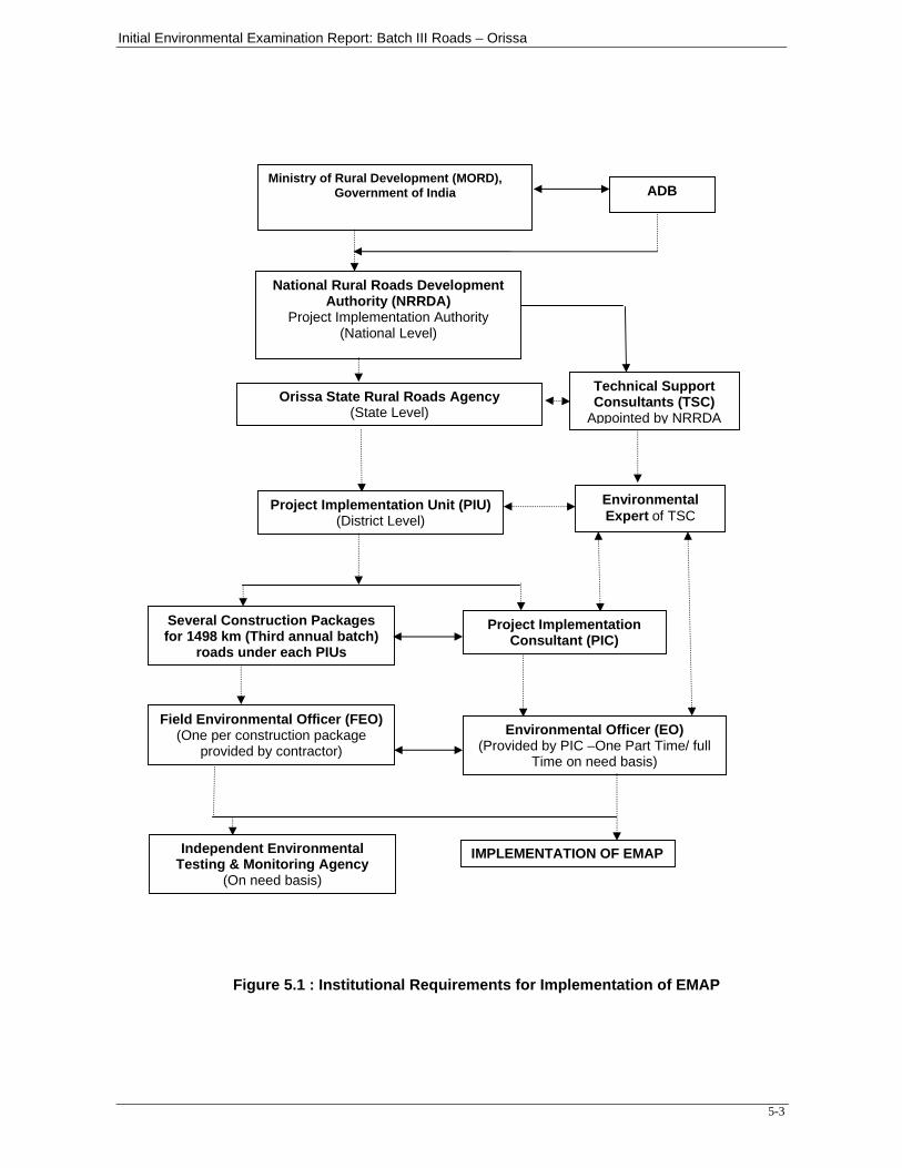
Initial Environmental Examination Report: Batch III Roads – Orissa
5-3
Figure 5.1 : Institutional Requirements for Implementation of EMAP
Ministry of Rural Development (MORD), Government of India
National Rural Roads Development Authority (NRRDA)
Project Implementation Authority (National Level)
Orissa State Rural Roads Agency(State Level)
Project Implementation Unit (PIU)(District Level)
Several Construction Packages for 1498 km (Third annual batch)
roads under each PIUs
Project Implementation Consultant (PIC)
Field Environmental Officer (FEO)(One per construction package
provided by contractor) Environmental Officer (EO)
(Provided by PIC –One Part Time/ full Time on need basis)
Independent Environmental Testing & Monitoring Agency
(On need basis)
IMPLEMENTATION OF EMAP
ADB
Technical Support Consultants (TSC)
Appointed by NRRDA
Environmental Expert of TSC
Initial Environmental Examination Report: Batch III Roads - Orissa
6-1
SECTION – 6: PUBLIC CONSULTATIONS AND INFORMATION DISCLOSURES
6.1 INTRODUCTION
The rural project comprising of 1498 km rural roads is likely to affect the communities residing around the corridor of impact and their activities. Moreover successful implementation of the project requires co-ordinated efforts of various stakeholders at different levels. Hence, consultation at different levels was used as a tool to inform and educate stakeholders about the proposed action both before and after the development decisions were made. Public consultation was useful for gathering environmental data, understanding likely impacts and community’s needs and preferences.
The various alternatives could be evolved and sustainable mitigation measures could be formulated through consultations. It assisted in identification of the problems associated with the project as well as the needs of the population likely to be impacted. This participatory process helped in reducing the public resistance to change and enabled the participation of the local people in the decision making process. The involvement of the various stakeholders ensured that the affected population and other stakeholders are informed, consulted and are allowed to participate at various stages of project preparation.
6.2 OBJECTIVES
The main objective of the consultation process was to minimise negative impacts of the project and to maximise the benefits of the project. Other objectives of the consultation process were the following:
- To promote public awareness about the proposed project especially amongst the potentially impacted communities/individuals;
- To educate the communities/individuals close to project roads about the proposed course of action and the project alternatives;
- To solicit the views of communities/individuals residing near rural roads proposed for construction on environmental and social problems;
- To gather inputs from the affected communities/individuals in crucial decisions regarding mitigation of the identified environmental and social issues;
- To stimulate community self evaluation and analysis; and - To ensure lessening of public resistance to change by providing them a
platform in the decision making process
6.3 METHODOLOGY ADOPTED FOR PUBLIC CONSULTATIONS
6.3.1 Stages and Levels of Consultation
Public consultation was conducted both at screening stage as well as IEE stage. Consultations conducted at screening stage played an important role in scoping the level and extent of consultation to be taken in the project preparation stage. A list of persons consulted is enclosed in Appendix 4. Public consultations have been held at three levels as follows:
Local level (village level/Block level) villagers through which roads are passing. District level consultations involving District Magistrates, revenue department,
PIU officials, local forest department; and Institutional level consultations with State Forestry Department and State
Pollution Control Board.
Initial Environmental Examination Report: Batch III Roads - Orissa
6-2
Tools for Consultation
Public Consultation was done using various tools including, discussion with village panchayats, government officials and other stakeholders. (i) Formal/Informal discussion
During the transect walk, consultations were held with the panchayat officials and villagers. Also during the reconnaissance survey and site visits, discussions were carried out informally drawing people into dialogue to obtain an overview of likely impacts and concerns of the community. Consultation was held at several locations along the rural roads alignment covering areas where public activity was intense and close to proposed alignment covering Owners of houses located close to rural roads.
A checklist of questions was kept ready and responses were elicited from people and guidelines were issued to field assistants for the purpose. The FGDs were held at Dhenkanal, Sambalpur, Sundargarh, Bargarh, Bolangir, Rayagada, Koraput and Kalahandi during the period September 2008 to February 2009. The date and location wise details are as under: Sl No
Location Date of Consultation Participants
1 Dhenkanal 7/9/2008 PIU officials, PIC team leader, Sarpanch and villagers of Kusumjodi village
2 Sambalpur 8/9/2008 PIU officials, PIC team leader, Sarpanch and villagers of Khandakata and Sahajbahali villages
3 Sundargarh 9/9/2008 PIU officials, PIC team leader, PIC environmentalist, Sarpanch and villagers of Karmabahal village
4 Bargarh 13/11/2008 PIU officials, PIC environmentalist, Sarpanch and villagers of Ranimal village
5 Bolangir 24/10/2008 PIU officials, PIC environmentalist, Sarpanch and villagers of Taliudar and Uparbahal villages
6 Rayagada 27/10/2008 PIU officials, PIC team Leader, PIC environmentalist, Sarpanch and villagers of Nauda village
7 Koraput 16/2/2009 PIU officials, PIC environmentalist, Sarpanch and villagers of Rajput and Muhibedi villages
8 Kalahandi 25/10/2008 PIU officials, PIC team Leader, PIC environmentalist, Sarpanch and villagers of Dholpas and Behera villages
(iii) Institutional Level / Stake Holders Consultation The institutional level consultations were held with representatives of institutions having stakes in implementation of the project. The institutions contacted included state forest department, State Pollution Control Board etc.
In addition to the official listed above the officials from other departments were also contacted on several occasions. The contacted officials included Tehsildars, NGOs, industry department and respective – district magistrate Offices.
Initial Environmental Examination Report: Batch III Roads - Orissa
6-3
6.3.2 Contents The consultation with institutional officials focussed on the following issues. - Project description: - Need for the construction of rural roads and benefits of the
project. - Social and environmental assessment processes vis-à-vis- GOI and the
multilateral funding agency requirements. - The extent / nature of negative social and environmental impact and the need for
rehabilitation and resettlement in the project. Avoidance and mitigation aspects in the project.
- People’s participation in planning, implementation and Monitoring & Evaluation Stage.
6.3.3 Public Hearing, Schedule IV, under EIA notification of MoEF
The implementation of third annual batch of rural road projects will not require public hearing in the light of revised EIA Notification in the year 2006.
6.3.4 Issues Raised and Community Perception
Some of the general issues raised during the different consultation sessions can be summed up as follows.
Water Logging and Drainage
Participants had a fear construction of rural roads with new alignment may alter natural drainage pattern in the area and may cause flooding and water logging in the agriculture fields if adequate cross drainage structures are not provided.
Loss of Livelihood and Income Restoration Options
This issue was raised by maximum number of villagers, as loss of fertile land will deteriorate their income sources.
Road Safety
Safety issues were paramount in all the consultation sessions. Woman participants raised the issue of their children’s safety.
Land Acquisition
People were concerned about the land requirements of the project and impact on their agriculture land. They were also of the view that community should be consulted before the road designs are finalised.
Loss of Idols/Shrines
Participants showed resistance for shifting of idols, burial grounds and other religious structures at certain locations.
Loss of Trees Due to Road Construction
Respondents were of the opinion that trees cutting should be avoided or else minimised. For trees to be cut compensatory plantation should be done. Some villagers expected additional plantation should be done. Recommended tree species for plantation were other local varieties.
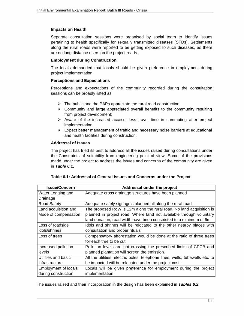
Initial Environmental Examination Report: Batch III Roads - Orissa
6-4
Impacts on Health
Separate consultation sessions were organised by social team to identify issues pertaining to health specifically for sexually transmitted diseases (STDs). Settlements along the rural roads were reported to be getting exposed to such diseases, as there are no long distance users on the project roads.
Employment during Construction
The locals demanded that locals should be given preference in employment during project implementation.
Perceptions and Expectations
Perceptions and expectations of the community recorded during the consultation sessions can be broadly listed as:
The public and the PAPs appreciate the rural road construction. Community and large appreciated overall benefits to the community resulting
from project development; Aware of the increased access, less travel time in commuting after project
implementation; Expect better management of traffic and necessary noise barriers at educational
and health facilities during construction;
Addressal of Issues
The project has tried its best to address all the issues raised during consultations under the Constraints of suitability from engineering point of view. Some of the provisions made under the project to address the issues and concerns of the community are given in Table 6.1. Table 6.1: Addressal of General Issues and Concerns under the Project
Issue/Concern Addressal under the project
Water Logging and Drainage
Adequate cross drainage structures have been planned
Road Safety Adequate safely signage’s planned all along the rural road. Land acquisition and Mode of compensation
The proposed RoW is 12m along the rural road. No land acquisition is planned in project road. Where land not available through voluntary land donation, road width have been constricted to a minimum of 6m.
Loss of roadside idols/shrines
Idols and shrines will be relocated to the other nearby places with consultation and proper rituals
Loss of trees Compensatory afforestation would be done at the ratio of three trees for each tree to be cut.
Increased pollution levels
Pollution levels are not crossing the prescribed limits of CPCB and planned plantation will screen the emission.
Utilities and basic infrastructure
All the utilities, electric poles, telephone lines, wells, tubewells etc. to be impacted will be relocated under the project cost.
Employment of locals during construction
Locals will be given preference for employment during the project implementation
The issues raised and their incorporation in the design has been explained in Tables 6.2.
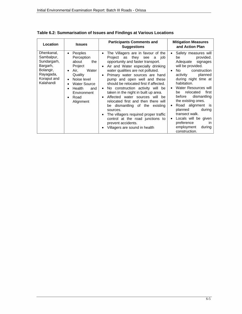
Initial Environmental Examination Report: Batch III Roads - Orissa
6-5
Table 6.2: Summarisation of Issues and Findings at Various Locations
Location Issues Participants Comments and Suggestions
Mitigation Measures and Action Plan
Dhenkanal, Sambalpur, Sundargarh, Bargarh, Bolangir, Rayagada, Koraput and Kalahandi
• Peoples Perception about the Project
• Air, Water Quality
• Noise level • Water Source • Health and
Environment • Road
Alignment
• The Villagers are in favour of the Project as they see a job opportunity and faster transport.
• Air and Water especially drinking water qualities are not polluted.
• Primary water sources are hand pump and open well and these should be relocated first if affected.
• No construction activity will be taken in the night in built up area.
• Affected water sources will be relocated first and then there will be dismantling of the existing sources.
• The villagers required proper traffic control at the road junctions to prevent accidents.
• Villagers are sound in health
• Safety measures will be provided. Adequate signages will be provided.
• No construction activity planned during night time at habitation.
• Water Resources will be relocated first before dismantling the existing ones.
• Road alignment is planned during transect walk.
• Locals will be given preference in employment during construction.
Initial Environmental Examination Report : Batch III Roads- Orissa
7-1
CHAPTER-7
FINDINGS AND RECOMMENDATIONS
7.0 FINDINGS AND RECOMMENDATIONS The findings and recommendations of the IEE for the rural road construction works are
summarized hereunder:
The IEE has been carried out for 1498 km of rural roads, which represent the third annual batch.
The potential impacts have been screened in accordance with the Environmental
Assessment Guidelines, 2003 of ADB and required adequate mitigation measures have been suggested in the form of an environmental mitigation action plan (EMAP).
The anticipated environmental impacts are largely generic in nature and can be
mitigated by adopting suitable mitigation measures.
The Institutional Requirements for implementation of mitigation measures has been identified along with a frequency for monitoring of EMAP.
The TSC shall prepare quarterly progress report on environmental compliances. This
will help in effective implementation of EMAP.
The IEE also indicate that rural road construction works does not warrant further EIA study for subsequent rural road construction works in Orissa.
Initial Environmental Examination Report : Batch III Roads- Orissa
8-1
CHAPTER- 8
CONCLUSION
8.1 CONCLUSION
Based on the IEE study and screening surveys conducted for the Project, associated potential
adverse environmental impacts can be mitigated to an acceptable level by adequate implementation of the measures as stated in the IEE Report. Adequate provisions shall be made in the Project to cover the environmental mitigation and monitoring requirements, and their associated costs as suggested in environmental budget.
As already mentioned the proposed project, i.e. widening and strengthening of the road
network by creating additional road capacity between different points of the road network will improve operational efficiency and can act as an effective mechanism for reducing economic and environmental costs of the road stretches. The project brings considerable improvement to possible exposure levels to population when compared with no project scenario.
Overall, the major social and environmental impacts associated with proposed projects are
limited to the construction period and can be mitigated to an acceptable level by implementation of recommended measures and by best engineering and environmental practices.
1
Annexure 1 Orissa: List of Roads under ADB Assisted PMGSY Batch-III
Length in Km Sl. No
Block Package No. Name of Proposed road N.C U.G Total
Name of the District:Bargarh 1 Bargarh OR-03-ADB-42/III PWD Road to Sahajbahal 3.410 - 3.410 2 Bheden OR-03-ADB-43/III Bheden to Baramkela Chhak - 3.540 3.540 3 Barpali OR-03-ADB-43/III Bargarh Bheden Canal Road at 15th Km to Baramkela 1.800 - 1.800 4 Attabira OR-03-ADB-44/III Hirlipali Chhak to Tangarpali Chhak on Main canal - 7.260 7.260 5 Attabira OR-03-ADB-44/III Bargarh Main Canal to Tangarpali 1.100 - 1.100 6 Bargarh OR-03-ADB-45/III Deogaon to Bichhuan chhak (Part A) - 8.460 7 Bhatli OR-03-ADB-46/III Deogaon to Bichhuan chhak (Part B) - 7.560 7.560 8 Bhatli OR-03-ADB-47/III Deogaon to Bichhuan chhak (Part C) - 5.970 5.970 9 Bhatli OR-03-ADB-47/III RD Road (T-03) to Bichhuan (011) 1.200 - 1.200 10 Sohela OR-03-ADB-48/III Panimura to Kusuda 1.800 - 1.800 11 Sohela OR-03-ADB-48/III PWD road to Panimura - 4.800 4.800 12 Sohela OR-03-ADB-49/III R.D.Road to Kangaon 2.400 - 2.400 13 Sohela OR-03-ADB-49/III NH 6 to Kangaon Chhak - 2.250 2.250 14 Sohela OR-03-ADB-49/III A) Dasmile Lebdi Road to Nagaon 1.800 - 1.800 15 Sohela OR-03-ADB-50/III RD road to Beherapali (022) 2.000 - 2.000 16 Sohela OR-03-ADB-50/III SH-3 to Beherapali Chhak - 2.650 2.650 17 Paikmal OR-03-ADB-28/III Jhengadihi to Nagdihi 2.070 - 2.070 18 Paikmal OR-03-ADB-28/III P.W.D. Road at Majhipali Chhak (Majhipali chhak) to
Mahulpali(Temri) Part A - 3.700 3.700
19 Paikmal OR-03-ADB-28/III P.W.D. Road at Majhipali Chhak (Majhipali chhak) to Mahulpali(Temri) Part B
- 3.500 3.500
20 Paikmal OR-03-ADB-28/III PWD Road at Majhipali chhak(Temri) to Mahulpali (Bukuramunda)
- 3.500 3.500
21 Bijepur OR-03-ADB-29/III Bijepur to Badabrahmani Chhak - 6.200 6.200 22 Bijepur OR-03-ADB-30/III Sargipali to Surupali 2.500 - 2.500 23 Paikmal OR-03-ADB-31/III P.W.D. Road at Majhipali Chhak (Majhipali chhak) to
Mahulpali (Bukuramunda) UG Part B - 4.470 4.470
24 Paikmal OR-03-ADB-31/III R.D.Road to Mahulpali 1.000 - 1.000 25 Paikmal OR-03-ADB-32/III Bhubansurpur to Pathrel - 8.000 8.000 26 Paikmal OR-03-ADB-33/III RD road (T-05) to Georgegarh 1.000 - 1.000 27 Paikmal OR-03-ADB-33/III SH 3 at 104 Km to Purena (114) 1.400 - 1.400 28 Paikmal OR-03-ADB-33/III L-55 square to Paikmal - 3.900 3.900 29 Jharbandh OR-03-ADB-34/III Jharbandh to Dova Part B - 8.600 8.600 30 Jharbandh OR-03-ADB-35/III Jharbandh to Dova Part A - 9.810 9.810 31 Bijepur OR-03-ADB-36/III Ranimal to Tuhilamal 7.110 - 7.110 32 Bijepur OR-03-ADB-36/III Bijepur to Ranimal (Badabaunsen Chhak) - 6.130 6.130 33 Bijepur OR-03-ADB-37/III Bijepur to Ranimal (Badabaunsen Chhak) - 8.000 8.000 34 Bijepur OR-03-ADB-38/III Bijepur-Laumunda RD Road to Arda 0.550 - 0.550 35 Bijepur OR-03-ADB-38/III Bijepur-Laumunda RD Road to K.Gandpali 1.100 - 1.100 36 Bijepur OR-03-ADB-38/III B)Bijepur-Laumunda RD Road to Ailpur 1.100 - 1.100 37 Bijepur OR-03-ADB-38/III R.D.Road to Jampali Road 1.230 - 1.230 38 Bijepur OR-03-ADB-39/III Bijepur to Badabrahmani Chhak (A) - 8.000 8.000 39 Padmapur OR-03-ADB-40/III Lumbarjuna to Charpali 1.500 - 1.500 40 Padmapur OR-03-ADB-40/III SH 3 to Lumbarjuna - 7.500 7.500 41 Padmapur OR-03-ADB-41/III MDR 36 to Buden - 4.500 4.500 42 Paikmal OR-03-ADB-51/III Chhindekela to Patraguda 9.700 - 9.700
Name of the District:Bolangir 43 Patnagarh OR-05-ADB-18/III Larambha to Fatamunda Gp 9.460 0.000 9.460 44 Puintala OR-05-ADB-19/III SH-14 to Chhatapipal 8.190 - 8.190 45 Puintala OR-05-ADB-19/III Chhatapipal Chhak to Belbahali 1.860 - 1.860
2
Length in Km Sl. No
Block Package No. Name of Proposed road N.C U.G Total
46 Puintala OR-05-ADB-20/III Randa to Gandabahal Road 2.820 - 2.820 47 Puintala OR-05-ADB-20/III MDR to Siletpada 3.380 - 3.380 48 Losingha OR-05-ADB-21/III Upperbahal to Taljuri 10.950 - 10.950 49 Losingha OR-05-ADB-22/III Taliudar to Uperbahal - 10.500 10.500 50 Deogaon OR-05-ADB-23/III T-02 Bagada chhak to Upparjhar 12.700 - 12.700 51 Deogaon OR-05-ADB-24/III Mursingha to Karuajhar (via Landapathar) 9.000 - 9.000 52 Deogaon OR-05-ADB-24/III RD road to Badabandha 2.900 - 2.900 53 Saintala OR-05-ADB-25/III Ghunsar to Kansar 2.610 - 2.610 54 Saintala OR-05-ADB-25/III Kansar to Kusumel 4.900 - 4.900 55 Saintala OR-05-ADB-25/III Kusumel to Ampali 2.910 - 2.910 56 Saintala OR-05-ADB-26/III N.H. 201 to Samara via Kankelgaon 4.500 - 4.500 57 Saintala OR-05-ADB-26/III Tikrapara Deysond RD road to Kenduudar 2.610 - 2.610 58 Agalpur OR-05-ADB-27/III Roth Chhak to Duduka - 6.500 0.000 59 Agalpur OR-05-ADB-27/III RD road to Roth 3.000 - 3.000 60 Gudvella OR-05-ADB-28/III Gudvella to Biramunda via Jamut 10.990 - 10.990 61 Gudvella OR-05-ADB-28/III PWD road to Chinchad 1.630 - 1.630 62 Titilagrah OR-05-ADB-29/III Titilagarh to Gulmi 8.000 - 8.000 63 Titilagrah OR-05-ADB-29/III Titilagarh satbhauri RD road to Mahulpada 1.530 - 1.530
Name of the District:Dhenkanal 64 Kankadahad OR-09-ADB-28/III Birasal to Kankana 5.490 - 5.490 65 Kankadahad OR-09-ADB-28/III Kankana to Raibol 1.890 - 1.890 66 Kankadahad OR-09-ADB-29/III PWD road to Dangapal (Ka) (h-028) 1.060 - 1.060 67 Kankadahad OR-09-ADB-29/III L-21 (Kankadahad to Kot) to Karagola 1.000 - 1.000 68 Kankadahad OR-09-ADB-30/III Dolla chhak to Bam 3.270 - 3.270 69 Kankadahad OR-09-ADB-31/III Childa chhak to Kantol 5.110 - 5.110 70 Kankadahad OR-09-ADB-32/III Dolia chhak to Kantapal - 9.000 9.000 71 Kankadahad OR-09-ADB-33/III Kankadahad to Childa chhak 9.900 - 9.900 72 Kankadahad OR-09-ADB-34/III Jangu to Gatarei 4.620 - 4.620 73 Kankadahad OR-09-ADB-35/III Gatarei to Ghagaramunda 4.860 - 4.860 74 Kankadahad OR-09-ADB-36/III Ghagaramunda chhak to Katumunda (Upto Block Border) 1.650 - 1.650 75 Kankadahad OR-09-ADB-36/III T-5 (Pangatire to Talcher Block border) Gatarei to Vegia 2.210 - 2.210 76 Kankadahad OR-09-ADB-37/III Jangu T-5 (Pangatira to Talcher Block Border) to Asanabahali 7.010 - 7.010 77 Kankadahad OR-09-ADB-38/III L-73 (Jangu-Asanbahali) to Khanda 0.600 - 0.600 78 Kankadahad OR-09-ADB-38/III Pangatira TS to Dasipur - 2.850 2.850 79 Kankadahad OR-09-ADB-39/III PWD road to Kuturia 4.150 - 4.150 80 Odapada OR-09-ADB-40/III NH-42 to Bido 3.120 - 3.120 81 Odapada OR-09-ADB-40/III NH-42 to Sivapur 3.030 - 3.030 82 Odapada OR-09-ADB-40/III L-55 to Kochilamada 2.070 - 2.070 83 Odapada OR-09-ADB-41/III NH-42 to Balarampur road 9.840 - 9.840 84 Odapada OR-09-ADB-41/III L-28 (Kasiadihi) to Sariapada 1.420 - 1.420 85 Odapada OR-09-ADB-42/III NH-42 to Meramundali 1.680 - 1.680 86 Odapada OR-09-ADB-42/III R.D Road to Gopalpur 1.020 - 1.020 87 Odapada OR-09-ADB-42/III PWD road to Gopalpur Chhak upto Nimidha - 5.760 5.760 88 Hindol OR-09-ADB-43/III T1 PWD Road to Nua 3.430 - 3.430 89 Kankadahad OR-09-ADB-44/III Mohabirroad to Dasipur - 5.380 5.380 90 Kankadahad OR-09-ADB-44/III Dasipur to Ranibol 2.510 - 2.510 91 Kankadahad OR-09-ADB-45/III Dasipur to Gurujangule 6.500 - 6.500 92 Kankadahad OR-09-ADB-45/III Mahabiroad to T4 Bhalugadia 1.000 - 1.000 93 Kankadahad OR-09-ADB-46/III Batagaon to Birasal - 9.770 9.770 94 Kamakhyanagar OR-09-ADB-47/III PWD road to Kusumjodi 1.830 - 1.830 95 Kamakhyanagar OR-09-ADB-47/III Kusumjodi to Salapada 0.660 - 0.660 96 Bhuban OR-09-ADB-48/III R.D. Road to Jayapur 0.780 - 0.780 97 Bhuban OR-09-ADB-48/III Marthapur to Jineilo 2.950 - 2.950 98 Bhuban OR-09-ADB-48/III Marthapur to Odhana 2.810 - 2.810
3
Length in Km Sl. No
Block Package No. Name of Proposed road N.C U.G Total
99 Hindol OR-09-ADB-49/III L-101(RD Road) to Kumursinga 1.120 - 1.120 100 Hindol OR-09-ADB-49/III L-101(RD Road) to Tarakabeda 2.880 - 2.880 Name of the District : Kalahandi 101 Bhawanipatna OR-15-ADB-36/III Artal to Balipati 3.300 - 3.300 102 Bhawanipatna OR-15-ADB-36/III Kanduljhore to Kandakhal 3.510 - 3.510 103 Bhawanipatna OR-15-ADB-37/III Attangguda to Jugsaipatna A - 16.400 16.400 104 Bhawanipatna OR-15-ADB-37/III Attangguda to Jugsaipatna B 0.600 - 0.600 105 Lanjigarh OR-15-ADB-38/III RD road to Mundagaon 5.800 - 5.800 106 Lanjigarh OR-15-ADB-38/III Sikerkupa to Kamardha A 3.000 - 3.000 107 Lanjigarh OR-15-ADB-38/III Sikerkupa to Kamardha B - 3.200 3.200 108 Th. Rampur OR-15-ADB-39/III Mahulpatna to Khamarpadar 6.500 - 6.500 109 Th. Rampur OR-15-ADB-40/III RD road to Dholpas 2.550 - 2.550 110 Th. Rampur OR-15-ADB-41/III Gunupur to Sirimaska - 16.000 16.000 111 Th. Rampur OR-15-ADB-41/III PWD road to Polingpadar 2.450 - 2.450 112 Th. Rampur OR-15-ADB-42/III Sirimaska to Th. Rampur - 12.000 12.000 113 Dharamgarh OR-15-ADB-43/III Chanchanbahali to Dhanarpur 3.030 - 3.030 114 Dharamgarh OR-15-ADB-44/III RD road to Tendapali 4.620 - 4.620 115 Dharamgarh OR-15-ADB-45/III Parla to Behera - 9.300 9.300 116 Dharamgarh OR-15-ADB-46/III RD road to Behera - 13.000 13.000 117 Dharamgarh OR-15-ADB-47/III Tambachhada to Kharipadar - 10.750 10.750 118 Dharamgarh OR-15-ADB-48/III RD road to Taranja 0.930 - 0.930 119 Golamunda OR-15-ADB-48/III RD road to Funda 1.320 - 1.320 120 Golamunda OR-15-ADB-49/III Brundabahal to Daspur Nandol - 15.210 15.210 121 Dharamgarh OR-15-ADB-50/III Sandhikulihari to Dumurguda via Kankari 15.720 - 15.720 122 Golamunda OR-15-ADB-51/III Udeshurang to Kuhura 8.010 - 8.010 123 Golamunda OR-15-ADB-51/III Mahaling to Bordi 4.500 - 4.500 124 Golamunda OR-15-ADB-51/III Udeshurang to Kuhura - 5.490 5.490 125 Golamunda OR-15-ADB-51/III Kendumundi to Kantamal 1.200 - 1.200 126 Jaipatna OR-15-ADB-52/III Ektaguda to Kumjhore 5.000 - 5.000 127 Golamunda OR-15-ADB-53/III Daspur to Chapuria 8.600 - 8.600 128 Jaipatna OR-15-ADB-54/III Uchhala to Ghantiguda 4.000 - 4.000 129 Jaipatna OR-15-ADB-54/III Uchhala to Ghantiguda - 4.720 4.720 Name of the District:Koraput 130 Bandhugam OR-19-ADB-20/III Batiguda to Semlaguda 1.000 - 1.000 131 Bandhugam OR-19-ADB-20/III Mundaguda to Batiguda 2.000 - 2.000 132 Bandhugam OR-19-ADB-20/III P.Borigumma to B.Dubuli 1.550 - 1.550 133 Bandhugam OR-19-ADB-21/III Ratali to Bada Indhanpur 9.600 - 9.600 134 Kotpad OR-19-ADB-22/III Dangari to Pachia 5.410 - 5.410 135 Jeypore OR-19-ADB-24/III R D Road to Nuaput 3.700 - 3.700 136 Jeypore OR-19-ADB-24/III Kaligaon to Malidaleiput 2.150 - 2.150 137 Boipariguda OR-19-ADB-25/III Kota Malkangiri to Majhiguda 5.500 - 5.500 138 Koraput OR-19-ADB-26/III Gunjiguda (Pendajam) to Paligumandi 10.600 - 10.600 139 Boipariguda OR-19-ADB-27/III Goraput to Totapada 10.000 - 10.000 140 Kotpad OR-19-ADB-28/III P W D Road to Mahantyput 1.600 - 1.600 141 Kotpad OR-19-ADB-28/III P W D Road to Guniaguda 2.000 - 2.000 142 Kotpad OR-19-ADB-28/III Guniaguda to Dangariguda 6.000 - 6.000 143 Dasmantapur OR-19-ADB-29/III Chikambo to Dumbaguda - 10.000 10.000 144 Jeypore OR-19-ADB-30/III Jeypore to Gadapadar road - 3.400 3.400 145 Jeypore OR-19-ADB-30/III RD road to Paliguda (Dubuli) 7.000 - 7.000 146 Borigumma OR-19-ADB-31/III NH 43 to Kosaguda 1.580 - 1.580 147 Borigumma OR-19-ADB-31/III Sasahandi to Pujariguda 1.780 - 1.780 148 Kotpad OR-19-ADB-32/III Sanparia to Aunli - 20.000 20.000- 149 Borigumma OR-19-ADB-42/III N H 201 to Khandiguda 4.100 - 4.100
4
Length in Km Sl. No
Block Package No. Name of Proposed road N.C U.G Total
150 Borigumma OR-19-ADB-43/III Kamta to Ratali 4.400 - 4.400 151 Borigumma OR-19-ADB-44/III Bodigam to Tokiguda 6.400 - 6.400 152 Jeypore OR-19-ADB-45/III NH 43 to Souraguda 4.800 - 4.800 153 Jeypore OR-19-ADB-46/III NH 43 to Keraput 3.500 - 3.500 154 Jeypore OR-19-ADB-46/III Putra to Bhatra 0.990 - 0.990 155 Borigumma OR-19-ADB-47/III NH 43 to Bisoiput (0/0 to 1/0) 1.000 - 1.000 156 Borigumma OR-19-ADB-47/III NH 43 to Bisoiput (1/0 to 3/100) 2.100 - 2.100 157 dasamantap OR-19-ADB-48/III Girligumma to Daurasuni 12.000 - 12.000 158 Kotpad OR-19-ADB-51/III Pachia to S.Kuhudi 8.190 - 8.190 159 Boipariguda OR-19-ADB-52/III Kota Malkangiri (5/500 km) to Majhiguda 13/500 km) - 8.000 8.000- 160 Koraput OR-19-ADB-54/III Ganjeipadar to Pucci Road 2.000 - 2.000 161 Dasmantapur OR-19-ADB-55/III SH-4 to Majango Road 8.000 - 8.000 162 Dasmantapur OR-19-ADB-56/III Mujango to Killar Road 4.000 - 4.000 163 Kotpad OR-19-ADB-57/III Murtahandi to Manchahandi Road 2.600 - 2.600 164 Nandapur OR-19-ADB-58/III RD road to Khuda 1.200 - 1.200 165 Narayanpatna OR-19-ADB-33/III PWD Road to Konda Borigi - 12.550 12.550- 166 Narayanpatna OR-19-ADB-33/III Konda Borigi to Borigi (PS Road Konda Borigi) 2.670 - 2.670 167 Laxmipur OR-19-ADB-34/III R D Road to Nisar 2.520 - 2.520 168 Laxmipur OR-19-ADB-34/III PWD Road to Keskapadu 4.500 - 4.500 169 Bandhugaon OR-19-ADB-35/III PWD Road to Garidi 1.980 - 1.980 170 Bandhugaon OR-19-ADB-35/III Garidi to Ambliput 3.720 - 3.720 171 Similiguda OR-19-ADB-36/III Rajput to Mukhibedai 3.800 - 3.800 172 Similiguda OR-19-ADB-36/III PWD Road to Rajput - 5.750 5.750 173 Similiguda OR-19-ADB-37/III Dudhari to Ghataguda 1.700 - 1.700- 174 Similiguda OR-19-ADB-37/III Doliamba Chakka to Dudhari - 4.500 4.500 175 Similiguda OR-19-ADB-38/III Hataguda to Kumbharguda 3.000 - 3.000- 176 Similiguda OR-19-ADB-38/III Renga to Hataguda - 16.050 16.050 177 Similiguda OR-19-ADB-39 (A)/III Bhejaput to Charangul 3.900 - 3.900 178 Similiguda OR-19-ADB-39(B)/III Beheraguda to Lunguri 2.000 - 2.000 179 Pottangi OR-19-ADB-40/III R D Road to Pondei 10.000 - 10.000 180 Pottangi OR-19-ADB-41/III Badliguda to Joginaikguda 3.800 - 3.800 181 Pottangi OR-19-ADB-41/III NH-23 to Badliguda - 3.000 3.000 182 Similiguda OR-19-ADB-53/III Sundhiput to Barkuntuni 5.000 - 5.000- 183 Similiguda OR-19-ADB-53/III R D Road to Sundhiput - 1.500 1.500 Name of the District:Nabarangapur 184 Dabugam OR-22-ADB-31/III Dabugam to Umerhand 5.000 - 5.000 185 Nabarangpur OR-22-ADB-32/III R D Road Jn to Bangapalli 2.350 - 2.350 186 Papadahandi OR-22-ADB-33/III Naktiguda to Tumberla - 0.840 0.840- 187 Papadahandi OR-22-ADB-33/III Naktiguda to Tumberla 2.300 - 2.300 188 Papadahandi OR-22-ADB-33/III Naktiguda to Tumberla 5.000 - 5.000 189 Papadahandi OR-22-ADB-34/III Dahadamal Jn to Bheja 2.900 - 2.900 190 Papadahandi OR-22-ADB-34/III Dahadamal Jn to Dahadamal 2.250 - 2.250 191 Nandahandi OR-22-ADB-35/III Lauguda Jn to Dahana - 6.650 6.650 192 Nandahandi OR-22-ADB-35/III Lauguda Jn to Phupugam - 1.800 1.800 193 Nandahandi OR-22-ADB-35/III Lauguda Jn to Phupugam 1.450 - 1.450 194 Nabarangpur OR-22-ADB-36/III R D Road Jn to Tentuliguda 1.400 - 1.400 195 Nabarangpur OR-22-ADB-36/III R D Road Jn to Tirliambaguda - 19.200 19.200- 196 Raighar OR-22-ADB-15/III Kaudola to Simuda 4.500 - 4.500- 197 Raighar OR-22-ADB-16/III Kaudola to Bharanda Khunta - 5.600 5.600- 198 Raighar OR-22-ADB-16/III Rabanaguda to Tarangapuri 1.000 - 1.000 199 Raighar OR-22-ADB-17/III Jatiarpara to Marigam 4.400 - 4.400 200 Raighar OR-22-ADB-18/III Chalanpara to Raighar - 4.520 4.520- 201 Raighar OR-22-ADB-19/III Chalanpara to Debagam 3.150 - 3.150 202 Raighar OR-22-ADB-19/III Birisadi JN to Nadipara 2.500 - 2.500
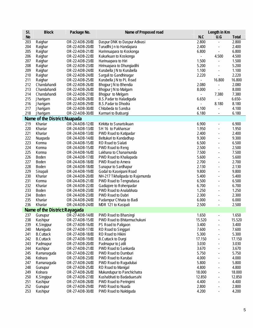
5
Length in Km Sl. No
Block Package No. Name of Proposed road N.C U.G Total
203 Raighar OR-22-ADB-20/III Daspur DNK to Daspur Adivasi 2.800 - 2.800 204 Raighar OR-22-ADB-20/III Turudlhi Jn to Handapara 2.400 - 2.400 205 Raighar OR-22-ADB-21/III Harinnuapara to Koskonga 6.800 - 6.800 206 Raighar OR-22-ADB-22/III Kukurkuan to Koskonga - 4.500 4.500 207 Raighar OR-22-ADB-23/III Harinuapara to Hiri 1.500 - 1.500 208 Raighar OR-22-ADB-23/III Hirinuapara to Dhungiadihi 5.200 - 5.200 209 Raighar OR-22-ADB-24/III Kurubella JN to Kurubella 1.100 - 1.100 210 Raighar OR-22-ADB-24/III Sarguli to Gandhinagar 2.220 - 2.220 211 Raighar OR-22-ADB-25/III Kurubella JN to PL Road - 16.800 16.800 212 Chandahandi OR-22-ADB-26/III Bhojpur JN to Bhendia 2.080 - 2.080 213 Chandahandi OR-22-ADB-26/III Bhojpur JN to Malgam 8.000 - 8.000 214 Chandahandi OR-22-ADB-27/III Bhojpur to Melgam - 7.380 7.380 215 Jharigam OR-22-ADB-28/III B.S.Padar to Haladiguda 6.650 - 6.650- 216 Jharigam OR-22-ADB-29/III B.S.Padar to Dhodra - 8.180 8.180 217 Jharigam OR-22-ADB-30/III Chitabeda to Sandsa 4.100 - 4.100 218 Jharigam OR-22-ADB-30/III Karmari to Butisargi 6.180 - 6.180 Name of the District:Nuapada 219 Khariar OR-24-ADB-12/III Kirkitta to Sunarisikuan 6.900 - 6.900 220 Khariar OR-24-ADB-13/III SH 16 to Pakhansar 1.950 - 1.950 221 Khariar OR-24-ADB-13/III PWD Road to Katipadar 2.400 - 2.400 222 Nuapada OR-24-ADB-14/III Beltukuri to Kandadhap 9.300 - 9.300 223 Komna OR-24-ADB-15/III RD Road to Sialati 6.500 - 6.500 224 Komna OR-24-ADB-15/III PWD Road to Reng 2.500 - 2.500 225 Komna OR-24-ADB-16/III Lakhana to Chanamunda 7.500 - 7.500 226 Boden OR-24-ADB-17/III PWD Road to Khaliapada 5.600 - 5.600 227 Boden OR-24-ADB-18/III PWD Road to Amera 2.700 - 2.700 228 Boden OR-24-ADB-18/III Sunapur to Sardhapur 2.130 - 2.130 229 Sinapali OR-24-ADB-19/III Godal to Kaseipani Road 9.800 - 9.800 230 Khariar OR-24-ADB-20/III NH-217 Tikhalipada to Rajamunda 5.400 - 5.400 231 Komna OR-24-ADB-21/III PWD Road to Tengnabasa 6.500 - 6.500 232 Khariar OR-24-ADB-22/III Gadiajore to Rohenpadar 6.700 - 6.700 233 Boden OR-24-ADB-23/III PWD Road to Analabhata 1.250 - 1.250 234 Boden OR-24-ADB-23/III PWD Road to Dabri 2.300 - 2.300 235 Khariar OR-24-ADB-24/III Padampur Chhata to Badi 6.000 - 6.000 236 Khariar OR-24-ADB-24/III MDR 121 to Kasipali 2.500 - 2.500 Name of the District:Rayagada 237 Gunupur OR-27-ADB-14/III PWD Road to Bharsingi 1.650 - 1.650 238 Kashipur OR-27-ADB-15/III PWD Road to Bhitarmuchukuni 15.520 - 15.520 239 K.Singipur OR-27-ADB-16/III PS Road to Paligaon 3.400 - 3.400 240 Muniguda OR-27-ADB-17/III RD Road to Singgari 7.600 - 7.600 241 B.Cuttack OR-27-ADB-18/III RD Road to Hikini 5.300 - 5.300 242 B.Cuttack OR-27-ADB-19/III B.Cuttack to Durgi 17.150 - 17.150 243 Padmapur OR-27-ADB-20/III Padmapur to Jatili 3.030 - 3.030 244 Kashipur OR-27-ADB-21/III PWD Road to Sankarda 3.670 - 3.670 245 Ramanaguda OR-27-ADB-22/III PWD Road to Dumburi 5.750 - 5.750 246 Kolnara OR-27-ADB-23/III PWD Road to Karubai 4.000 - 4.000 247 Ramanaguda OR-27-ADB-24/III PWD Road to Rugudubai 5.800 - 5.800 248 Gunupur OR-27-ADB-25/III RD Road to Manigal 4.800 - 4.800 249 Kolnara OR-27-ADB-26/III Mukundupur to Panchichatra 18.000 - 18.000 250 K.Singipur OR-27-ADB-27/III Kushabhati to Badaduarsahi 12.850 - 12.850 251 Kashipur OR-27-ADB-28/III PWD Road to Peringirni 4.400 - 4.400 252 Gunupur OR-27-ADB-29/III PWD Road to Nuada 2.800 - 2.800 253 Kashipur OR-27-ADB-30/III PWD Road to Naktiguda 4.200 - 4.200
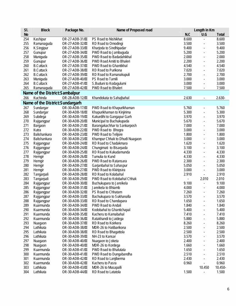
6
Length in Km Sl. No
Block Package No. Name of Proposed road N.C U.G Total
254 Kashipur OR-27-ADB-31/III PS Road to Nishikhat 8.600 - 8.600 255 Ramanaguda OR-27-ADB-32/III RD Road to Omodingi 3.500 - 3.500 256 K.Singipur OR-27-ADB-33/III Kharjoda to Sindhipadar 9.400 - 9.400 257 Gunupur OR-27-ADB-34/III PWD Road to Jambuguda 5.200 - 5.200 258 Muniguda OR-27-ADB-35/III PWD Road to Badadahikhal 2.000 - 2.000 259 Gunupur OR-27-ADB-36/III PWD Road Amiti to Bhaleri 2.200 - 2.200 260 B.Cuttack OR-27-ADB-37/III PWD Road to Ghantikhal 4.540 - 4.540 261 B.Cuttack OR-27-ADB-38/III RD Road to Purikona 7.020 - 7.020 262 B.Cuttack OR-27-ADB-39/III RD Road to Ramanakupuli 2.700 - 2.700 263 Muniguda OR-27-ADB-40/III PS Road to Tamili 3.000 - 3.000 264 B.Cuttack OR-27-ADB-41/III S.Buduni to Kodagulumi 3.000 - 3.000 265 Ramanaguda OR-27-ADB-42/III PWD Road to Bhaleri 7.500 - 7.500 Name of the District:Sambalpur 266 Kuchinda OR-28-ADB-12/III Khandokata to Sahajbahal 2.630 - 2.630- Name of the District:Sundargarh 267 Sundargar OR-30-ADB-17/III PWD Road to Khapurikhaman 5.760 - 5.760 268 Sundargar OR-30-ADB-18/III Khapurikhaman to Kinjirima 5.300 - 5.300 269 Subdega OR-30-ADB-19/III Kakurdihi to Gangapur Garh 3.970 - 3.970 270 Rajgangpur OR-30-ADB-20/III Municipal to Buchukupada 5.670 - 5.670 271 Bargaon OR-30-ADB-21/III Barangakachhar to Sankarposh 7.000 - 7.000 272 Kutra OR-30-ADB-22/III PWD Road to Bhogra 3.000 - 3.000 273 Balishankara OR-30-ADB-23/III PWD Road to Telijore 1.800 - 1.800 274 Balishankara OR-30-ADB-23/III Khampur Chhak to Dhudi Nuagaon 3.000 - 3.000 275 Rajgangpur OR-30-ADB-24/III RD Road to Chadakmara 1.620 - 1.620 276 Rajgangpur OR-30-ADB-24/III Chungimati to Bisarpada 3.100 - 3.100 277 Rajgangpur OR-30-ADB-25/III RD Road to Kukudamunda 4.330 - 4.330 278 Hemgir OR-30-ADB-26/III Tumulia to Kund 4.330 - 4.330 279 Hemgir OR-30-ADB-26/III PWD Road to Ratansara 2.300 - 2.300 280 Hemgir OR-30-ADB-27/III Garjanbahal to Sahaspur 5.050 - 5.050 281 Hemgir OR-30-ADB-27/III PWD Road to Kkiripsira 3.000 - 3.000 282 Tangarpali OR-30-ADB-28/III RD Road to Kolabahal 2.910 - 2.910 283 Tangarpali OR-30-ADB-29/III PWD Road to Kolobahal Chhak - 2.010 2.010 284 Rajgangpur OR-30-ADB-30/III Buchukupara to Jareikela 9.100 - 9.100 285 Rajgangpur OR-30-ADB-31/III Jareikela to Bhiamb 4.000 - 4.000 286 Rajgangpur OR-30-ADB-32/III PS Road to Chhatam 7.260 - 7.260 287 Rajgangpur OR-30-ADB-33/III Bachukupara to Sukhanalla 3.570 - 3.570 288 Rajgangpur OR-30-ADB-33/III RD Road to Chandapara 1.650 - 1.650 289 Kuarmunda OR-30-ADB-34/III PWD Road to Andali 1.840 - 1.840 290 Kuarmunda OR-30-ADB-34/III Kodobahal to Ghantichapal 5.400 - 5.400 291 Kuarmunda OR-30-ADB-35/III Kacheru to Kamabahal 7.410 - 7.410 292 Kuarmunda OR-30-ADB-36/III Ratakhandi to Jaidega 5.880 - 5.880 293 Nuagaon OR-30-ADB-37/III RD Road to Koirkera 8.260 - 8.260 294 Lathikata OR-30-ADB-38/III MDR-26 to Hatibarikona 2.500 - 2.500 295 Lathikata OR-30-ADB-38/III RD Road to Bhagattola 2.500 - 2.500 296 Lathikata OR-30-ADB-39/III NH-23 to Kansar 3.570 - 3.570 297 Nuagaon OR-30-ADB-40/III Nuagaon to Joketa 2.400 - 2.400 298 Nuagaon OR-30-ADB-40/III MDR-26 to Kordega 1.660 - 1.660 299 Kuarmunda OR-30-ADB-41/III PWD Road to Bhalutata 1.650 - 1.650 300 Kuarmunda OR-30-ADB-41/III PWD Road to Dungabandha 2.510 - 2.510 301 Kuarmunda OR-30-ADB-42/III RD Road to Lanjiberma 2.430 - 2.430 302 Kuarmunda OR-30-ADB-42/III Kacheru to Pasra 0.960 - 0.960 303 Lathikata OR-30-ADB-43/III MDR-26 to Musapalli 10.450 10.450- 304 Lathikata OR-30-ADB-44/III RD Road to Latatola 1.500 - 1.500

7
Length in Km Sl. No
Block Package No. Name of Proposed road N.C U.G Total
305 Lathikata OR-30-ADB-44/III Gailo to Lamijira 2.400 - 2.400 306 bonai OR-30-ADB-45/III Jangara to Bargaon 9.300 - 9.300 307 Koira OR-30-ADB-46/III Jamudihi to Chordhara 9.000 - 9.000 308 Lahunipada OR-30-ADB-47/III NH-215 to Amrudi 6.210 - 6.210 309 Lahunipada OR-30-ADB-47/III NH-23 to Juniani 1.320 - 1.320 310 Lahunipada OR-30-ADB-48/III Lunga to Dhokamunda 4.020 - 4.020
Grand Total 1047.970 456.810 1504.780
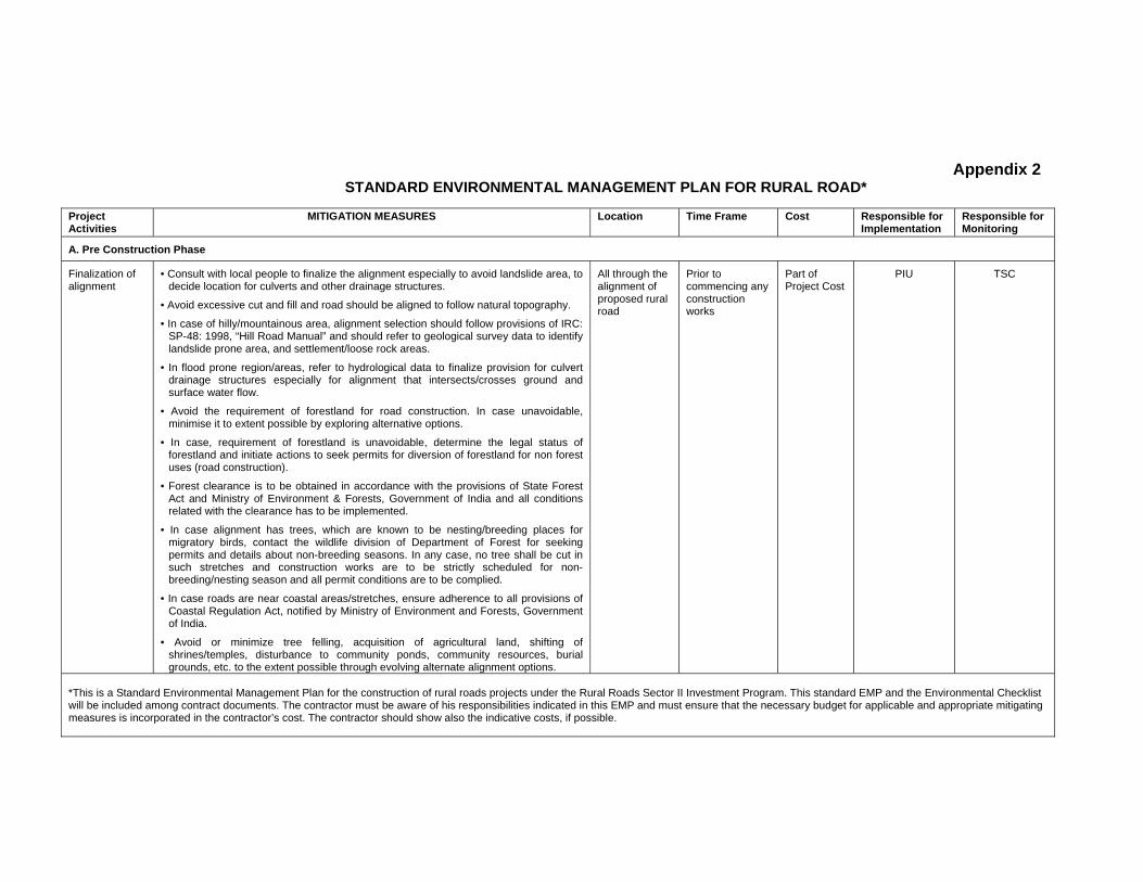
Appendix 2 STANDARD ENVIRONMENTAL MANAGEMENT PLAN FOR RURAL ROAD*
Project Activities
MITIGATION MEASURES Location Time Frame Cost Responsible for Implementation
Responsible for Monitoring
A. Pre Construction Phase
Finalization of alignment
• Consult with local people to finalize the alignment especially to avoid landslide area, to decide location for culverts and other drainage structures.
• Avoid excessive cut and fill and road should be aligned to follow natural topography.
• In case of hilly/mountainous area, alignment selection should follow provisions of IRC: SP-48: 1998, “Hill Road Manual” and should refer to geological survey data to identify landslide prone area, and settlement/loose rock areas.
• In flood prone region/areas, refer to hydrological data to finalize provision for culvert drainage structures especially for alignment that intersects/crosses ground and surface water flow.
• Avoid the requirement of forestland for road construction. In case unavoidable, minimise it to extent possible by exploring alternative options.
• In case, requirement of forestland is unavoidable, determine the legal status of forestland and initiate actions to seek permits for diversion of forestland for non forest uses (road construction).
• Forest clearance is to be obtained in accordance with the provisions of State Forest Act and Ministry of Environment & Forests, Government of India and all conditions related with the clearance has to be implemented.
• In case alignment has trees, which are known to be nesting/breeding places for migratory birds, contact the wildlife division of Department of Forest for seeking permits and details about non-breeding seasons. In any case, no tree shall be cut in such stretches and construction works are to be strictly scheduled for non-breeding/nesting season and all permit conditions are to be complied.
• In case roads are near coastal areas/stretches, ensure adherence to all provisions of Coastal Regulation Act, notified by Ministry of Environment and Forests, Government of India.
• Avoid or minimize tree felling, acquisition of agricultural land, shifting of shrines/temples, disturbance to community ponds, community resources, burial grounds, etc. to the extent possible through evolving alternate alignment options.
All through the alignment of proposed rural road
Prior to commencing any construction works
Part of Project Cost
PIU
TSC
*This is a Standard Environmental Management Plan for the construction of rural roads projects under the Rural Roads Sector II Investment Program. This standard EMP and the Environmental Checklist will be included among contract documents. The contractor must be aware of his responsibilities indicated in this EMP and must ensure that the necessary budget for applicable and appropriate mitigating measures is incorporated in the contractor’s cost. The contractor should show also the indicative costs, if possible.

Project Activities
MITIGATION MEASURES Location Time Frame Cost Responsible for Implementation
Responsible for Monitoring
Land acquisition
• Land acquisition, compensation packages, resettlement and rehabilitation, poverty alleviation programs for affected people and all other related issues are addressed in Social Impacts and Resettlement & Rehabilitation report.
All through the alignment of proposed rural road (as applicable)
Pre construction Phase
Encumbrance- free land to be made available by the State Government
State Government/PIU
TSC
B. Construction Phase
Land clearing operations
•The road land width requiring clearing shall be clearly demarcated on ground.
• During land clearing operations, topsoil shall be collected, preserved, and reused as a base for turfing of embankment slopes or development of barren areas along roadside.
• Trees falling within roadway width and other vegetative cover are to be removed.
• Small temples, shrines if any is within the road land width, the same may be shifted to adjacent areas in consultation with local community leaders.
• During clearing operations, any treasure trove, slabs with epigraphical evidence or edicts, sculptural or any material found and appear to have historical importance, it should be brought to the notice of Department of Archaeology, and instructions of this Department, if any, must be followed.
• All public utilities like power transmission cables, telephone cables, water/sewerage lines, drains, tube wells etc falling within road land width shall be inventoried, and arrange for relocation /shifting to adjacent areas in consultation with the respective agencies/authorities.
• Establish and maintain interaction with local community to ensure that no social resentment sets in due to operations.
All through the alignment of proposed rural road (as applicable)
Pre construction Phase
Encumbrance- free land to be made available by the State Government to the contractor Relocation of utilities are to be undertaken by respective departments and costs are to be reimbursed
All facilities are to be planned and implemented by PIU and/or contractor as per the conditions of civil works
Contractor’s responsibility by PIU and PIU responsibility by TSC
Establishment of temporary office and storage area
• The temporary office and storage area for construction works shall be located away from human settlement areas (minimum 500 m) and forest areas (minimum 1 km).
• The office and storage areas shall preferably be located on barren/waste lands and conversion of agricultural/cultivable lands for office and storage areas shall not be allowed under any circumstances.
• All fuel oil/lubricants loading/unloading and storage areas shall be paved (impermeable), and have separate storm water collection system with facility for separation of oil/lubricants prior to discharge.
• The temporary office and storage area shall be provided with adequate water supply, sanitation, septic tank/soak pit of adequate capacity so that it functions properly for the entire duration of its use.
• After completion of construction works, the site shall be restored to its previous state
As determined by contractor under approval of PIU
Pre construction and Construction Phase
To be included in contractor’s cost
All facilities are to be planned and implemented by contractor under approval by PIU / PIC
PIU

Project Activities
MITIGATION MEASURES Location Time Frame Cost Responsible for Implementation
Responsible for Monitoring
by undertaking clean up operations.
Construction Camp Sites
• The construction campsites shall be located away from any local human settlement areas and preferably located on lands, which are barren/waste lands.
• The camps shall be located, at a minimum, 5 km from forest areas to deter trespassing of construction labour.
• The campsites shall be provided with adequate water supply, sanitation and all requisite infrastructure facilities. This would minimize dependence on outside resources, presently being used by local populace and minimize undesirable social friction thereof.
• The camps shall have septic tank/soak pit of adequate capacity so that it can function properly for the entire duration of its use.
• Construction camps shall be provided with kerosene/LPG to avoid dependence on firewood for cooking to the extent possible.
• After completion of construction works, location of campsites shall be restored to its previous state by undertaking clean up operations.
As determined by contractor under approval of PIU
Pre construction and Construction Phase
To be included in contractor’s cost
All facilities are to be planned and implemented by contractor under approval by PIU / PIC
PIU
Mobilization of construction materials - Stone aggregates, earth and construction water
• Stone aggregates shall be sourced only from licensed existing quarries.
• A list of such existing quarries is available from responsible department/ authority for mining related works in each state. In case new quarries are to be opened, quarry license/permits are to be obtained from this department/authority.
• In case, only stone crushing plants are to be installed near work sites, required permits are to be obtained and all conditions of permits are to be complied.
• Ensure stone quarries and crushing units have pollution control system; occupational safety procedures/practices in place and regular inspection shall be carried to ensure compliance. This shall be a pre-condition for sourcing of materials from quarries/crushing plants.
• Earth borrow areas identified during DPR stage shall be revisited to assess its environmental sensitivity and ensure it is not an ecologically sensitive areas. Permits are to be obtained from authorities and all permit conditions are complied.
• The borrow areas are to be demarcated with signboards and operational areas are to be access controlled.
• Topsoil from borrow areas (first 30cm) are to be preserved and used for redevelopment of borrow areas as per IRC provisions or as a base for turfing along embankment slopes.
• The borrow areas as an option may be converted into ponds wherever possible, which can be used for storage of rainwater, a practice prevalent in West Bengal.
• Conversion of agricultural lands for borrowing earth is to be discouraged to the use
As determined by contractor under approval of PIU
Pre construction and Construction Phase
To be included in contractor’s cost
All facilities are to be planned and implemented by contractor under approval by PIU / PIC
PIU
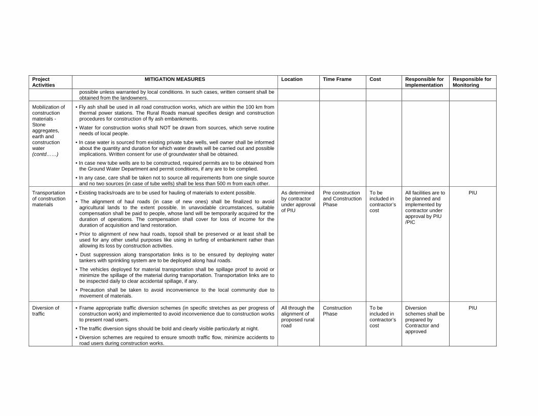
Project Activities
MITIGATION MEASURES Location Time Frame Cost Responsible for Implementation
Responsible for Monitoring
possible unless warranted by local conditions. In such cases, written consent shall be obtained from the landowners.
Mobilization of construction materials - Stone aggregates, earth and construction water (contd……)
• Fly ash shall be used in all road construction works, which are within the 100 km from thermal power stations. The Rural Roads manual specifies design and construction procedures for construction of fly ash embankments.
• Water for construction works shall NOT be drawn from sources, which serve routine needs of local people.
• In case water is sourced from existing private tube wells, well owner shall be informed about the quantity and duration for which water drawls will be carried out and possible implications. Written consent for use of groundwater shall be obtained.
• In case new tube wells are to be constructed, required permits are to be obtained from the Ground Water Department and permit conditions, if any are to be complied.
• In any case, care shall be taken not to source all requirements from one single source and no two sources (in case of tube wells) shall be less than 500 m from each other.
Transportation of construction materials
• Existing tracks/roads are to be used for hauling of materials to extent possible.
• The alignment of haul roads (in case of new ones) shall be finalized to avoid agricultural lands to the extent possible. In unavoidable circumstances, suitable compensation shall be paid to people, whose land will be temporarily acquired for the duration of operations. The compensation shall cover for loss of income for the duration of acquisition and land restoration.
• Prior to alignment of new haul roads, topsoil shall be preserved or at least shall be used for any other useful purposes like using in turfing of embankment rather than allowing its loss by construction activities.
• Dust suppression along transportation links is to be ensured by deploying water tankers with sprinkling system are to be deployed along haul roads.
• The vehicles deployed for material transportation shall be spillage proof to avoid or minimize the spillage of the material during transportation. Transportation links are to be inspected daily to clear accidental spillage, if any.
• Precaution shall be taken to avoid inconvenience to the local community due to movement of materials.
As determined by contractor under approval of PIU
Pre construction and Construction Phase
To be included in contractor’s cost
All facilities are to be planned and implemented by contractor under approval by PIU /PIC
PIU
Diversion of traffic
• Frame appropriate traffic diversion schemes (in specific stretches as per progress of construction work) and implemented to avoid inconvenience due to construction works to present road users.
• The traffic diversion signs should be bold and clearly visible particularly at night.
• Diversion schemes are required to ensure smooth traffic flow, minimize accidents to road users during construction works.
All through the alignment of proposed rural road
Construction Phase
To be included in contractor’s cost
Diversion schemes shall be prepared by Contractor and approved
PIU
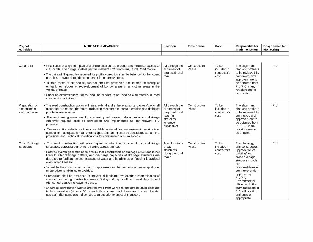
Project Activities
MITIGATION MEASURES Location Time Frame Cost Responsible for Implementation
Responsible for Monitoring
Cut and fill
• Finalisation of alignment plan and profile shall consider options to minimise excessive cuts or fills. The design shall as per the relevant IRC provisions, Rural Road manual.
• The cut and fill quantities required for profile correction shall be balanced to the extent possible, to avoid dependence on earth from borrow areas.
• In both cases of cut and fill, top soil shall be preserved and reused for turfing of embankment slopes or redevelopment of borrow areas or any other areas in the vicinity of roads.
• Under no circumstances, topsoil shall be allowed to be used as a fill material in road construction activities.
All through the alignment of proposed rural road
Construction Phase
To be included in contractor’s cost
The alignment plan and profile is to be reviewed by contractor, and approvals are to be obtained from PIU/PIC, if any revisions are to be effected
PIU
Preparation of embankment and road base
• The road construction works will raise, extend and enlarge existing roadway/tracks all along the alignment. Therefore, mitigation measures to contain erosion and drainage problems are essential.
• The engineering measures for countering soil erosion, slope protection, drainage wherever required shall be considered and implemented as per relevant IRC provisions.
• Measures like selection of less erodable material for embankment construction, compaction, adequate embankment slopes and turfing shall be considered as per IRC provisions and Technical Specifications for construction of Rural Roads.
All through the alignment of proposed rural road (in stretches wherever applicable)
Construction Phase
To be included in contractor’s cost
The alignment plan and profile is to be reviewed by contractor, and approvals are to be obtained from PIU/PIC, if any revisions are to be effected
PIU
Cross Drainage Structures
• The road construction will also require construction of several cross drainage structures, across streams/rivers flowing across the road.
• Refer to hydrological studies to ensure that construction of drainage structures is not likely to alter drainage pattern, and discharge capacities of drainage structures are designed to facilitate smooth passage of water and heading up or flooding is avoided even in flood season.
• Schedule the construction works to dry season so that impacts on water quality of stream/river is minimise or avoided.
• Precaution shall be exercised to prevent oil/lubricant/ hydrocarbon contamination of channel bed during construction works. Spillage, if any, shall be immediately cleared with utmost caution to leave no traces.
• Ensure all construction wastes are removed from work site and stream /river beds are to be cleaned up (at least 50 m on both upstream and downstream sides of water courses) after completion of construction but prior to onset of monsoon.
At all locations of CD structures along the rural roads
Construction Phase
To be included in contractor’s cost
The planning, and construction/ upgradation of existing/new cross drainage structures roads are responsibilities of contractor under approval by PIC/PIU Environmental officer and other team members of PIC will monitor and ensure appropriate
PIU
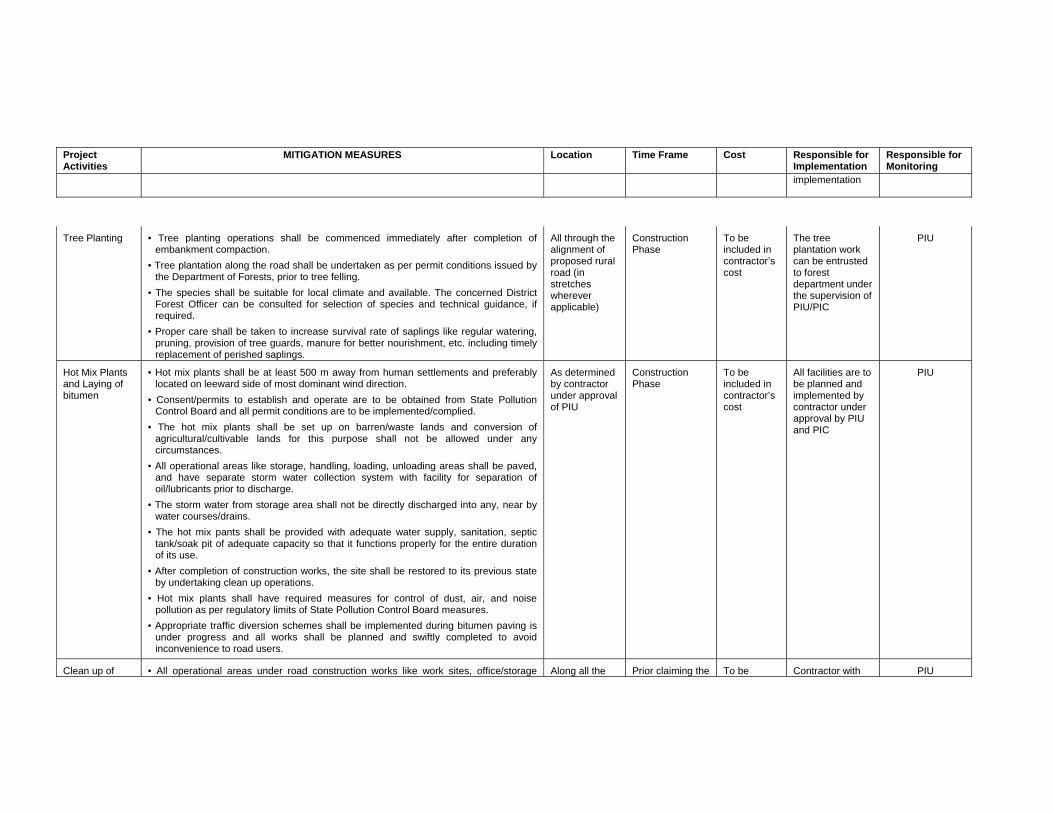
Project Activities
MITIGATION MEASURES Location Time Frame Cost Responsible for Implementation
Responsible for Monitoring
implementation
Tree Planting
• Tree planting operations shall be commenced immediately after completion of embankment compaction.
• Tree plantation along the road shall be undertaken as per permit conditions issued by the Department of Forests, prior to tree felling.
• The species shall be suitable for local climate and available. The concerned District Forest Officer can be consulted for selection of species and technical guidance, if required.
• Proper care shall be taken to increase survival rate of saplings like regular watering, pruning, provision of tree guards, manure for better nourishment, etc. including timely replacement of perished saplings.
All through the alignment of proposed rural road (in stretches wherever applicable)
Construction Phase
To be included in contractor’s cost
The tree plantation work can be entrusted to forest department under the supervision of PIU/PIC
PIU
Hot Mix Plants and Laying of bitumen
• Hot mix plants shall be at least 500 m away from human settlements and preferably located on leeward side of most dominant wind direction.
• Consent/permits to establish and operate are to be obtained from State Pollution Control Board and all permit conditions are to be implemented/complied.
• The hot mix plants shall be set up on barren/waste lands and conversion of agricultural/cultivable lands for this purpose shall not be allowed under any circumstances.
• All operational areas like storage, handling, loading, unloading areas shall be paved, and have separate storm water collection system with facility for separation of oil/lubricants prior to discharge.
• The storm water from storage area shall not be directly discharged into any, near by water courses/drains.
• The hot mix pants shall be provided with adequate water supply, sanitation, septic tank/soak pit of adequate capacity so that it functions properly for the entire duration of its use.
• After completion of construction works, the site shall be restored to its previous state by undertaking clean up operations.
• Hot mix plants shall have required measures for control of dust, air, and noise pollution as per regulatory limits of State Pollution Control Board measures.
• Appropriate traffic diversion schemes shall be implemented during bitumen paving is under progress and all works shall be planned and swiftly completed to avoid inconvenience to road users.
As determined by contractor under approval of PIU
Construction Phase
To be included in contractor’s cost
All facilities are to be planned and implemented by contractor under approval by PIU and PIC
PIU
Clean up of
• All operational areas under road construction works like work sites, office/storage
Along all the
Prior claiming the
To be
Contractor with
PIU
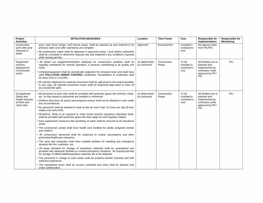
Project Activities
MITIGATION MEASURES Location Time Frame Cost Responsible for Implementation
Responsible for Monitoring
construction work Sites and Disposal of waste
area, work force camps, and borrow areas, shall be cleaned up and restored to its previous state soon after operations are complete.
• All construction waste shall be disposed in approved areas. Local district authorities shall be consulted to determine disposal site and implement any conditions imposed while issuing permits.
alignment
final payment
included in contractor’s cost
the approve plan from PIC/PIC
Equipment/ vehicles deployed for Construction works
• All diesel run equipment/vehicles/ deployed for construction activities shall be regularly maintained for smooth operation, a measure contributing to air quality and noise.
• Vehicles/equipment shall be periodically subjected for emission tests and shall have valid POLLUTION UNDER CONTROL certificates. Revalidation of certificates shall be done once in 3 months.
• All vehicles deployed for material movement shall be spill proof to the extent possible. In any case, all material movement routes shall be inspected daily twice to clear off any accidental spills.
As determined by contractor
Construction Phase
To be included in contractor’s cost
All facilities are to planned and implemented by contractor under approval by PIC/ PIC
PIU
Occupational Safety and Health Hazards at Work and camp sites
• All personnel at work sites shall be provided with protective gears like helmets, boots, etc. so that injuries to personnel are avoided or minimized.
• Children (less than 18 years) and pregnant women shall not be allowed to work under any circumstances.
• No personnel shall be allowed to work at site for more than 10 hours per day (8-hour makes one work shift).
• Workforce, likely to be exposed to noise levels beyond regulatory stipulated limits, shall be provided with protective gears like hear plugs etc and regularly rotated.
• Dust suppression measures like sprinkling of water shall be ensured at all operations areas.
• The construction camps shall have health care facilities for adults, pregnant women and children.
• All construction personnel shall be subjected to routine vaccinations and other preventive/healthcare measures.
• The work and campsites shall have suitable facilities for handling any emergency situation like fire, explosion, etc.
• All areas intended for storage of hazardous materials shall be quarantined and provided with adequate facilities to combat emergency situations. All required permits for storage of inflammable/hazardous materials are to be obtained.
• The personnel in charge of such areas shall be properly trained, licensed and with sufficient experience.
• The operational areas shall be access controlled and entry shall be allowed only under authorization.
As determined by contractor
Construction Phase
To be included in contractor’s cost
All facilities are to planned and implemented by contractor under approval by PIC/ PIC
PIU
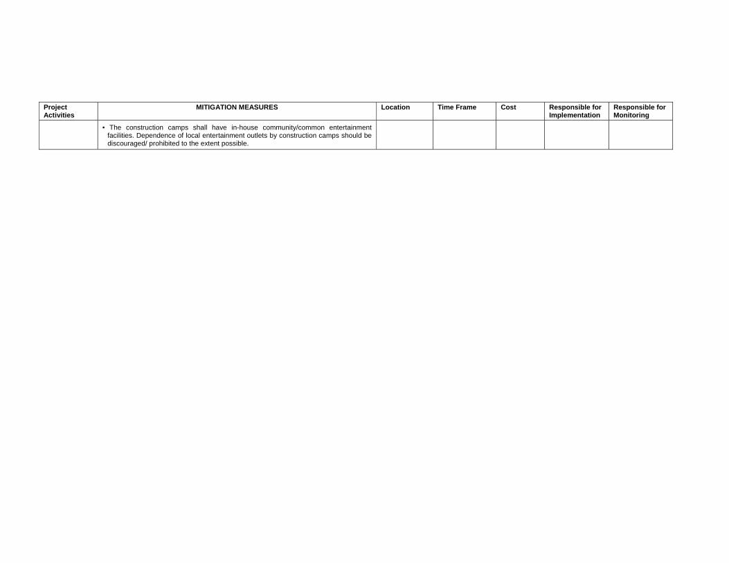
Project Activities
MITIGATION MEASURES Location Time Frame Cost Responsible for Implementation
Responsible for Monitoring
• The construction camps shall have in-house community/common entertainment facilities. Dependence of local entertainment outlets by construction camps should be discouraged/ prohibited to the extent possible.
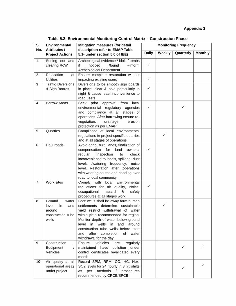
Appendix 3 Table 5.2: Environmental Monitoring Control Matrix – Construction Phase
Monitoring Frequency S. No.
Environmental Attributes / Project Actions
Mitigation measures (for detail description refer to EMAP Table 5.1- under section 5.0 of IEE) Daily Weekly Quarterly Monthly
1 Setting out and clearing RoW
Archeological evidence / idols / tombs if noticed /found –inform Archeological Department
2 Relocation of Utilities
Ensure complete restoration without impacting existing users
3 Traffic Diversions & Sign Boards
Diversions to be smooth sign boards in place, clear & bold particularly in night & cause least inconvenience to road users
4 Borrow Areas Seek prior approval from local environmental regulatory agencies and compliance at all stages of operations. After borrowing ensure re-vegetation, drainage, erosion protection as per EMAP
5 Quarries Compliance of local environmental regulations in project specific quarries and at all stages of operations
6 Haul roads Avoid agricultural lands, finalization of compensation for land owners, regular inspection to check inconvenience to locals, spillage, dust levels /watering frequency, noise level. Restoration after ;operations with wearing course and handing over road to local community
7 Work sites Comply with local Environmental regulations for air quality, Noise, occupational hazard & safety procedures at all stages work
8 Ground water level in and around construction tube wells
Bore wells shall be away form human settlements determine sustainable yield restrict withdrawal of water within yield recommended for region. Monitor depth of water below ground level in wells in and around construction tube wells before start and after completion of water withdrawal for the day
9 Construction Equipment / Vehicles
Ensure vehicles are regularly maintained have pollution under control certificates revalidated every month
10 Air quality at all operational areas under project
Record SPM, RPM, CO, HC, Nox, SO2 levels for 24 hourly in 8 hr. shifts as per methods / procedures recommended by CPCB/SPCB
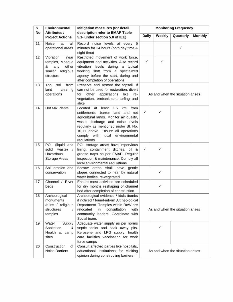
Monitoring Frequency S. No.
Environmental Attributes / Project Actions
Mitigation measures (for detail description refer to EMAP Table 5.1- under section 5.0 of IEE) Daily Weekly Quarterly Monthly
11 Noise at all operational areas
Record noise levels at every 5 minutes for 24 hours (both day time & night time)
12 Vibration near temples, Mosque & any other similar religious structure
Restricted movement of work force, equipment and activities. Also record vibration levels during a typical working shift from a specialized agency before the start, during and after completion of operations
13 Top soil from land clearing operations
Preserve and restore the topsoil. If can not be used for restoration, divert for other applications like re-vegetation, embankment turfing and alike
As and when the situation arises
14 Hot Mix Plants Located at least 1.5 km from settlements, barren land and not agricultural lands. Monitor air quality, waste discharge and noise levels regularly as mentioned under Sl. No. 10,11 above. Ensure all operations comply with local environmental regulations
15 POL (liquid and solid waste) / Hazardous Storage Areas
POL storage areas have impervious lining, containment ditches, oil & grease traps as per EMAP. Regular inspection & maintenance. Comply all local environmental regulations
16 Soil erosion and conservation
Borrow areas shall have gentle slopes connected to near by natural water bodies, re-vegetated
17 Channel / River beds
Ensure most activities are scheduled for dry months reshaping of channel bed after completion of construction
18 Archeological monuments /ruins / religious structures / temples
Archeological evidence / idols /tombs if noticed / found-inform Archeological Department. Temples within RoW are relocated in consultation with community leaders. Coordinate with Social team.
As and when the situation arises
19 Water Supply Sanitation & Health at camp sites
Adequate water supply as per norms septic tanks and soak away pits. Kerosene and LPG supply, health care facilities vaccination for work force camps
20 Construction of Noise Barriers
Consult affected parties like hospitals, educational institutions for eliciting opinion during constructing barriers
As and when the situation arises
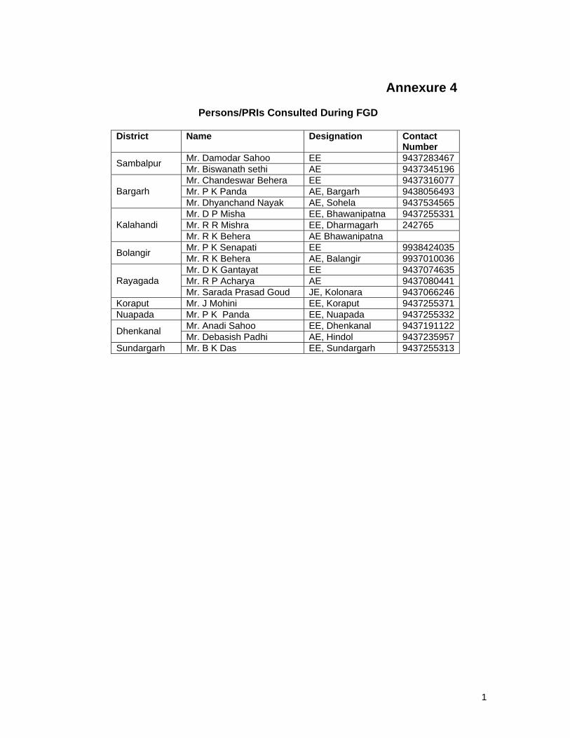
1
Annexure 4
Persons/PRIs Consulted During FGD
District Name Designation Contact
Number Mr. Damodar Sahoo EE 9437283467 Sambalpur Mr. Biswanath sethi AE 9437345196 Mr. Chandeswar Behera EE 9437316077 Mr. P K Panda AE, Bargarh 9438056493 Bargarh Mr. Dhyanchand Nayak AE, Sohela 9437534565 Mr. D P Misha EE, Bhawanipatna 9437255331 Mr. R R Mishra EE, Dharmagarh 242765 Kalahandi Mr. R K Behera AE Bhawanipatna Mr. P K Senapati EE 9938424035 Bolangir Mr. R K Behera AE, Balangir 9937010036 Mr. D K Gantayat EE 9437074635 Mr. R P Acharya AE 9437080441 Rayagada Mr. Sarada Prasad Goud JE, Kolonara 9437066246
Koraput Mr. J Mohini EE, Koraput 9437255371 Nuapada Mr. P K Panda EE, Nuapada 9437255332
Mr. Anadi Sahoo EE, Dhenkanal 9437191122 Dhenkanal Mr. Debasish Padhi AE, Hindol 9437235957 Sundargarh Mr. B K Das EE, Sundargarh 9437255313
Related Documents


