Ž . Journal of Volcanology and Geothermal Research 85 1998 153–172 Identification and dating of tephra layers from Quaternary sedimentary sequences of Inner Anatolia, Turkey C. Kuzucuoglu a, ) , J.-F. Pastre a , S. Black b , T. Ercan c , M. Fontugne d , H. Guillou d , C. Hatte d , M. Karabiyikoglu c , P. Orth a , A. Turkecan c ´ ¨ a Laboratory of Phys. Geogr., URA 141 CNRS r UniÕ. Paris I, 1 Pl. A. Briand 92195 Meudon cedex, France ´ b EnÕironmental Sci. DiÕ., I.E.B.S., Lancaster UniÕersity, Lancaster, LA1 4YQ, UK c MTA General Directorate, Department of Geological Studies, 06520 Ankara, Turkey d CFR, CEA r CNRS, AÕenue de la Terrasse, 92198 Gif-s r YÕette cedex, France ´ Abstract Results presented here are part of a research programme to investigate the environmental evolution in central Anatolia during the Pleistocene. In this study, tephra are used as chronostratigraphical markers between lacustrine sequences studied in cores or in sections surrounding eruptive centres of the Central Anatolian Province. At different locations in the Konya Plain and Cappadocia, tephra have been identified, characterized and linked to eruptions of the nearby volcanoes. Seven different tephra have been clearly identified in lacustrine sequences of the Konya Plain. 14 C dates on shells or organic matter, as well as 230 Thr 234 U ages on gypsum, give a chronological framework to the tephra layers. In addition, the study of the sediment fill of the Eski Acigol maar near Nevsehir has allowed the recognition of several eruptions during Late Glacial ¨ and Holocene in the vicinity of Acigol. The results show the first tephra to be identified in lacustrine sequences of Anatolia; ¨ Ž . they also show the Cappadocian volcanism to be very young F35 ka . This young volcanism is often of a basaltic type and does not include thick differenciated pyroclastic deposits. q 1998 Elsevier Science B.V. All rights reserved. Keywords: tephra; tephrochronology; Inner Anatolia; Late Pleistocene; Holocene; lacustrine sequences 1. Introduction Ž . The Central Anatolian Volcanic Province CAVP is composed of several eruptive centres comprising voluminous volcaniclastic material. It is limited westwards by the tectonic depressions of the Tuz golu and of the Konya Plain and southwards by the ¨ Ž . Taurus Mountains Fig. 1 . Volcanism in this region started early in the Upper Miocene and continued ) Corresponding author. Tel.: q33-1-45-07-55-74; Fax: q33- 1-45-07-58-30; E-mail: [email protected] Ž . until the Quaternary Innocenti et al., 1975 . Calc-al- kaline lavas are dominant. There are four main large Quaternary strato-volcanoes: Karadag, Golludag, ¨¨ Hasandag and Erciyes dag, of which the last two were active during Late Pleistocene. In association with the stratovolcanoes, there are numerous mono- genic centres: scoria cones, related lava flows and maars. Silicic domes are intercalated in the large complexes. Most of the Pleistocene volcanoes are constructed on an extensive ignimbrite pile of Neo- gene age which extends over a 20,000-km 2 area in Ž . and around the Nevsehir plateau Fig. 1 . 0377-0273r98r$19.00 q 1998 Elsevier Science B.V. All rights reserved. Ž . PII: S0377-0273 98 00054-7

Welcome message from author
This document is posted to help you gain knowledge. Please leave a comment to let me know what you think about it! Share it to your friends and learn new things together.
Transcript

Ž .Journal of Volcanology and Geothermal Research 85 1998 153–172
Identification and dating of tephra layers from Quaternarysedimentary sequences of Inner Anatolia, Turkey
C. Kuzucuoglu a,), J.-F. Pastre a, S. Black b, T. Ercan c, M. Fontugne d, H. Guillou d,C. Hatte d, M. Karabiyikoglu c, P. Orth a, A. Turkecan c´ ¨
a Laboratory of Phys. Geogr., URA 141 CNRSrUniÕ. Paris I, 1 Pl. A. Briand 92195 Meudon cedex, France´b EnÕironmental Sci. DiÕ., I.E.B.S., Lancaster UniÕersity, Lancaster, LA1 4YQ, UK
c MTA General Directorate, Department of Geological Studies, 06520 Ankara, Turkeyd CFR, CEArCNRS, AÕenue de la Terrasse, 92198 Gif-srYÕette cedex, France´
Abstract
Results presented here are part of a research programme to investigate the environmental evolution in central Anatoliaduring the Pleistocene. In this study, tephra are used as chronostratigraphical markers between lacustrine sequences studiedin cores or in sections surrounding eruptive centres of the Central Anatolian Province. At different locations in the KonyaPlain and Cappadocia, tephra have been identified, characterized and linked to eruptions of the nearby volcanoes. Sevendifferent tephra have been clearly identified in lacustrine sequences of the Konya Plain. 14C dates on shells or organicmatter, as well as 230Thr234U ages on gypsum, give a chronological framework to the tephra layers. In addition, the study ofthe sediment fill of the Eski Acigol maar near Nevsehir has allowed the recognition of several eruptions during Late Glacial¨and Holocene in the vicinity of Acigol. The results show the first tephra to be identified in lacustrine sequences of Anatolia;¨
Ž .they also show the Cappadocian volcanism to be very young F35 ka . This young volcanism is often of a basaltic type anddoes not include thick differenciated pyroclastic deposits. q 1998 Elsevier Science B.V. All rights reserved.
Keywords: tephra; tephrochronology; Inner Anatolia; Late Pleistocene; Holocene; lacustrine sequences
1. Introduction
Ž .The Central Anatolian Volcanic Province CAVPis composed of several eruptive centres comprisingvoluminous volcaniclastic material. It is limitedwestwards by the tectonic depressions of the Tuzgolu and of the Konya Plain and southwards by the¨
Ž .Taurus Mountains Fig. 1 . Volcanism in this regionstarted early in the Upper Miocene and continued
) Corresponding author. Tel.: q33-1-45-07-55-74; Fax: q33-1-45-07-58-30; E-mail: [email protected]
Ž .until the Quaternary Innocenti et al., 1975 . Calc-al-kaline lavas are dominant. There are four main largeQuaternary strato-volcanoes: Karadag, Golludag,¨ ¨Hasandag and Erciyes dag, of which the last twowere active during Late Pleistocene. In associationwith the stratovolcanoes, there are numerous mono-genic centres: scoria cones, related lava flows andmaars. Silicic domes are intercalated in the largecomplexes. Most of the Pleistocene volcanoes areconstructed on an extensive ignimbrite pile of Neo-gene age which extends over a 20,000-km2 area in
Ž .and around the Nevsehir plateau Fig. 1 .
0377-0273r98r$19.00 q 1998 Elsevier Science B.V. All rights reserved.Ž .PII: S0377-0273 98 00054-7

( )C. Kuzucuoglu et al.rJournal of Volcanology and Geothermal Research 85 1998 153–172154
Ž . Ž .Fig. 1. Location of sites studied. Captions: 1 Aciditic and intermediate intrusive rocks; 2 Rocks other than intrusive and eruptiveŽ . Ž . Ž . Ž . Ž .Primary, Secondary and Tertiary ; 3 Basic and ultrabasic intrusive rocks; 4 Mio-Pliocene volcanics; 5 Pleistocene volcanics; 6
Ž . Ž . Ž .Quaternary sediments; 7 Salt lake; 8 Main faults; 9 Location of cores and sections studied.
( )C. Kuzucuoglu et al.rJournal of Volcanology and Geothermal Research 85 1998 153–172 155
The Neogene–Quaternary volcanism of the CAVPhas been investigated by several authors who mainlyconcentrated on its petrographical characteristicsŽPasquare, 1968; Innocenti et al., 1975; Besang et´al., 1977; Keller et al., 1977; Batum, 1978; Pasquareet al., 1988; Tokel et al., 1988; Aydar, 1992; Ercanet al., 1992; Bigazzi et al., 1993; Le Pennec et al.,
.1994 .Ž .Pasquare et al. 1988 suggested three main peri-´
ods for the evolution of the CAVP: the first periodŽeffusive centres and domes of andesitic composi-
.tion covering the interval from 13.5 to 8.5 Ma; aŽ .second period 8.5–9 to 2.7 Ma during which the
Keciboyduran–Melendiz volcanic complex wasformed and widespread ignimbritic units were de-
¨posited in the Urgup BasinrNevsehir Plateau. The¨Ž .third period 2.7 Ma to Holocene is characterized by
Žthe growth of great central volcanoes e.g., Erciyes.and Hasan dag with numerous monogenetic vol-
canic centers roughly located along a NE–SW lineŽfrom Kayseri to Konya e.g., from the Erciyes to the
.Karadag, Fig. 1 .In and around the vicinity of the CAVP, there are
several Quaternary basins of various shapes andsizes. The largest ones are of tectonic origin. Theyare located in the periphery of the Cappadocian
Ž .volcanic region Fig. 1 : Tuz Golu and Konya plains¨ ¨to the west, Derinkuyu and Nigde basins to thesouth, and the Sultansazligi depression to the east.Among the smaller depressions identified within theCAVP some are of volcanic origin such as theAcigol caldera. Most of the basins have been occu-¨pied, during Pleistocene times, by lakes or marsheswhich filled them with sediments allowing, not onlythe reconstruction of past environments and climatic
Žchanges Roberts et al., 1979; Kuzucuoglu et al.,1997a,b,c, 1998; Fontugne et al., 1999; Kashima et
.al., in press , but also tephrochronological investiga-tions. Such research is based on the identification oftephra layers interstratified within the lacustrine de-posits, and consequent comparison with tephra layers
Žin situ in the nearby volcanic province Pastre et al.,.1998 .
Tephrochronological investigations are still uniquein Anatolia. Apart from the Minoan eruptionŽ .Thera–Santorini which is now well located in Ana-
Žtolia in several lacustrine sequences Sullivan, 1988,.1990; Roberts et al., 1997; Eastwood et al., in press ,
only a few tephra have been reported in cored se-quences of the Tuz golu and of the Konya Plain¨ ¨Ž .Inoue and Saito, 1997; Kashima et al., in press .Specific studies on these latter tephra have not yetbeen published. There are no other available data onchemical analyses of glass shards from Anatoliantephra. The following results are the first in a seriesof studies on tephra from the Cappadoccian plains,as well as of pumice deposits from the CappadocianPleistocene volcanoes.
2. Area description, methods and material studied
The tephra presented here have been identified inlacustrine sequences from the Konya Plain and fromthe Eski Acigol maar near Nevsehir in Cappadocia¨Ž .Fig. 1 . In both locations, two main volcanic unitshave been studied from in situ tephra deposits:
Ž . Žnamely a the Konya volcanoes from SW to NE:Karadag, Karapinar cones, Karacadag cones and
. Ž .maars and b the Cappadocian Quaternary volca-Žnoes from SW to NE: Hasan dag, Golludag, Acigol¨ ¨ ¨
.caldera and Erciyes dag . Results presented hereconcern tephra interstratified with lacustrine sedi-ments, which may originate from several of thenear-by volcanic areas mentioned above. Morespecifically, the main volcanic centres which couldbe sources of the tephra from field observations are:the Karapinar strombolian cones, Hasan dag, Acigol¨domes, maar and cones in Cappadocia.
In the Konya Plain, tephra layers have been sam-pled mainly in the Eregli plain, from two coresŽ . Ž .CAK, DUD and a 14-m-deep well VAH . TheCAK and DUD cores are located in the centre andsouth of the Akgol marshes. The VAH well is lo-¨cated on the northwestern border of the Eregli plain.Two other tephra layers have been identified insections quarried in a beach deposit on the north-western shores of the Late Pleistocene Konya lake at
Ž .Gocu Fig. 1 . In Cappadocia, the tephra record is¨ ¨based on the Eski Acigol lacustrine sequence filling¨
Ž .the Acigol maar Fig. 1 .¨
2.1. Coring
Sixty-four millimeter diameter cores were ex-tracted using a hydraulic rotary, Craelius XC-90H,
( )C. Kuzucuoglu et al.rJournal of Volcanology and Geothermal Research 85 1998 153–172156
truck-mounted corer. The CAK and DUD cores were29.5 m long; the Eski Acigol 95-3 core was 20 m¨long. The cores were subsequently split into 1 msections for ease during transportation.
2.2. Magnetic susceptibility
Ž .Firstly, low field magnetic susceptibility xhi wasmeasured on the 1-m-long untouched cores of theCAK and Eski Acigol sequences, at the CFR labora-¨
Ž .tory Gif srYvette . Measurements were performedat 1-cm interval on U-channels with a BartingtonMS-2 susceptibility meter. The aim was partly tolook for specific peaks related to tephra layers. Re-peated interruptions of the profiles obtained are dueto the effects at both ends of the 1-m-long coreswhen passed in the susceptibility meter. Main peaksin the CAK core point out to reworked sand deposits,the tephra layers being poorly marked. For example,
Ž .the biotitic-rich tephra layer CAK 1 at y19.50 min the CAK core is not perceptible on the magneticprofile because of signal dilution from humic mate-rial. For this reason, the magnetic susceptibility pro-file was not conducted on the DUD core. However,it was measured on the Eski Acigol 95-3 core be-¨cause the sediments were mainly composed of amor-
Ž .phous silica diatoms, glass and carbonates; in sucha sequence, the ferro-magnesian minerals present intephra gave easily identifiable signals.
2.3. Sampling
Tephra was identified either when logged duringcoring or during sampling in the laboratory. Sam-pling occurred after establishing magnetic suscepti-bility profiles on the whole cores. Tephra samplingwas performed according to visual recognition of thetephra layers on the opened cores, and to specificsignals on the magnetic susceptibility profiles whenthese signals did not obviously correspond to re-worked material imported from the drainage basin.
2.4. Methods of tephra analyses
In all cases, the tephra were first observed under abinocular microscope. Afterwards, the tephra sam-ples were washed in dionised water on a 40 mmsieve and dried. The sand fraction collected was then
examined under a binocular and an optical micro-scope for initial tephra identification. Minerals andglass were mounted in epoxy and polished using1-mm grain-sized diamond powder. Electron micro-probe analyses were performed in the National Mu-
Ž .seum of Natural History Paris and in the Petrogra-Ž .phy Laboratory of the Paris VI University Paris , on
Ž .a Cameca-Camebax Castaing microprobe WDS ;analysis conditions were 15 kV, 10–12 nA, with a10 s counting time, and use of a ZAF correctionprogramme. Karapinar basaltic scoriae were analysedusing an EDS microprobe at the CFR in GifsrYvette. Whole-rock analyses were performed us-
Ž .ing X-ray Fluorescence XRF at MTA geochemistrylaboratory. Petrographic numenclature was adopted
Ž .from Le Bas et al. 1986 for glass and total rocks,Ž .mineralogic classification from Morimoto 1988 for
Ž .pyroxenes and from Leake 1978 for amphiboles.Major oxide composition used in text and dia-grammes are normalised to 100% in order to allowcomparison. Mean results in tables are not nor-malised in order to assess analysis conditions.
2.5. Infrared spectroscopy
The method used for the calculation of mineralcomposition of samples from the cored lacustrinesediments was based on the Fourier transform in-
Ž .frared FTIR absorbance spectroscopy in the mid-infrared range. Samples were prepared using the KBrdisc method at the ORSTOM Sedimentology Labora-
Ž .tory Bondy, France . The quantitative determinationof the mineral content was performed by making amulticomponent analysis of the experimental spec-trum using the spectra of each component in each
Žsample, in reference to standard spectra Bertaux et.al., 1998 .
2.6. Dating methods and rationale
Various methods have been used for the dating ofin situ and interstratified tephra.
14C dating was performed by b-counting at theŽ .CFR at Gif srYvette samples ‘Gif’ and at the
Underground Laboratory in the French Alps atŽ .Modane samples denoted ‘GifrLSM’ , using con-
ventional method with a proportional counter. Three¨ ¨Ž .sequences VAH, GOCU, Eski Acigol 95-3 con-¨

( )C. Kuzucuoglu et al.rJournal of Volcanology and Geothermal Research 85 1998 153–172 157
Table 1Characteristics of the tephra layers presented
Tephra characteristics Characteristics of associated sample dated
Ž . Ž . Ž .Symbol Depth m Type of Mean size Thickness Depth m Material Dating Age Katephra dated method obtained
CAK 1 y19.60 m biotite 1.6 to 0.1 mm 20 cm y25 m gypsum Urth 209.5q50ry34y19.80 m trachytic y11.13 m gypsum UrTh 164q54ry36
glassCAK 2 y9.25 m trachytic -50 mm 8 cm y8.20 m gypsum UrTh 109"8
y9.33 m glassDUD 1 y11.55 m trachytic 1.8 to 0.4 mm 10 cm y12 m gypsum UrTh 89"15
Ž .y11.65 m glass beddedDUD 2 y8.60 m trachytic -50 mm 8 cm y8.35 m gypsum UrTh 68"12
y8.68 m glass14VAH ‘1’ y13.5 m reworked 0.8 to 0.06 mm 10 cm y13.50 m organic C conv G33.0 B.P.Ž .y13.6 m scoriae layer GifrLSM 974714VAH 2 y8.35 m basaltic 0.6 to 0.3 mm 35 cm y7.30 m organic C conv 24.4"0.8 B.P.Ž .y8.7 m scoriae layer GifrLSM 9749
VAH 3 y3.95 m basaltic 2.0 to 0.5 mm 60 cm y2.5 m shells stratigraphic -17 B.P.y4.55 m scoriae correlation
14¨ ¨GOCU 1 top of aphyric 1.8 to 0.4 mm 3 cm paleosol organic C conv 28.3"1.1 BPŽ .unit I obsidian of unit I layer GifrLSM 1050514¨ ¨GOCU 2 unit VII acidic 100–125 mm 2 cm within Dreissena C convŽ .unit V shells Gif 10504 14.1"0.075 B.P.Ž .Gif 10905 19.24"0.36 B.P.
Gol-95.3 y19.30 m rhyolitic coarse )1.70 m¨T1 )20.0 m glass sandGol-95.3 y19.30 m obsidian coarse 20 cm¨T2 )20.0 m rich sandGol-95.3 y19.30 m obsidian fine sand 2 mm¨T3 )20.0 m rich
14Gol-95.3 y19.30 m basaltic coarse 2 cm y16.50 m organic C conv 13.97"0.22 B.P.¨aŽ . Ž .T4 )20.0 m sand material Gif 10598 spurious age
Gol-95.3 y19.30 m rhyolitic fine sand 6 mm¨T5 )20.0 mGol-95.3 y19.30 m basalticq fine sand 8 mm¨T6 )20.0 m plagiocl.Gol-95.3 y19.30 m basaltic fine sand 3=1 mm y15.32 m organic 14C conv 12.73"0.12 B.¨
aŽ . Ž .T7 )20.0 m thin 1 mm material Gif 10591 spurious agebedded 2=0.8 mmlayers 1 mm
14 aGol-95.3 y19.30 m basaltic fine sand 2 mm y13.57 m organic C conv 14.18"0.32 B.P.¨Ž .T8 )20.0 m material Gif 10590
Gol-95.3 y19.30 m basaltic fine sand 15 mm¨T9 )20.0 m
14 aGol-95.3 y19.30 m pumice fine sand 6 mm y11.91 m organic C conv 12.76"0.16 B.P.¨Ž .T10 )20.0 m qobsidian material Gif 10597
qamphib.qfeldspar
Gol-95.3 y19.30 m plagio.q fine sand 5 cm¨T11 )20.0 m glassGol-95.3 y19.30 m basaltic 8 mm¨T12 )20.0 m
14 aGol-95.3 y19.30 m basaltic fine sand 2 mm y9.73 m organic C conv 11.18"0.09 B.P.¨Ž .T13 )20.0 m material Gif 10588
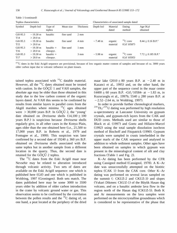
( )C. Kuzucuoglu et al.rJournal of Volcanology and Geothermal Research 85 1998 153–172158
Ž .Table 1 continued
Tephra characteristics Characteristics of associated sample dated
Ž . Ž . Ž .Symbol Depth m Type of Mean size Thickness Depth m Material Dating Age Katephra dated method obtained
Gol-95.3 y19.30 m basaltic fine sand 2 mm¨T14 )20.0 m
14 aGol-95.3 y19.30 m basaltic fine sand 4 mm y7.48 m organic C conv 8.44"0.16 B.P.¨Ž .T15 )20.0 m material Gif 10587
Gol-95.3 y19.30 m basalticq fine sand 1 mm¨T16 )20.0 m clinopyr.
14 aGol-95.3 y19.30 m basalticq 3 mm y5.98 m organic C conv 7.72"0.185 B.P.¨Ž .T17 )20.0 m clinopyr. material Gif 10595
a14C dates in the Eski Acigol sequence are provisional, because of low organic matter content of samples and because of ca. 3000 years¨older carbon input due to volcanic influence on plant tissues.
tained tephra associated with 14C datable material.However, all the 14C dates obtained must be treated
¨ ¨with caution. In the GOCU 1 and VAH samples, theabsolute age may be older than those obtained in thisstudy due to the low carbon content of the organiclayers dated. At VAH this seems to be confirmed byresults from similar layers in parallel cores from theAkgol marshes where minima 14C ages obtained¨
¨ ¨were )30,000 years B.P. In GOCU 2, the ‘young’Ždate obtained on Dreissena shells 14,100"100
.years B.P. is suspicious because Dreissena shellsregularly give, in all other cases in the Konya Plain,
Žages older than the one obtained here i.e., 21,500 to17,000 years B.P. in Roberts et al., 1979 and
.Fontugne et al., 1999 . This suspicion was laterconfirmed by a second date of 19240"360 yrs B.P.obtained on Dreissena shells associated with thesame tephra but in another sample from a differentlocation in the quarry. Thus, the second date is
¨ ¨retained for the GOCU 2 tephra.The 14C dates from the Eski Acigol maar near¨
Nevsehir may be related to alteration introducedthrough volcanic activity. Two sets of dates areavailable on the Eski Acigol sequence: one which is¨
Ž .published here Gif and one which is published inŽ .Woldring, 1997 Groningen . Both sets match. The
dates published here may be some 3000 to 3500years older by addition of older carbon introductionin the crater by volcanic ground water or gas. Thisobservation seems to be confirmed by the correlationbetween the pollen results and the 14C dating of, onone hand, a peat located at the periphery of the dried
Žmaar lake 2010"80 years B.P. at y2.40 m in.Kazanci et al., 1995 and, on the other hand, the
upper part of the sequence cored in the maar centreŽ4400"60 years B.P. -Gifr10584- at y1.83 m, inKuzucuoglu et al., 1997b; 5540"280 years B.P. at
.y2.52–2.64 m, in Woldring, 1997 .In order to provide further chronological markers,
230 Thr234 U dating was performed by high resolutiona-spectrometry at Lancaster University on gypsumcrystals, and gypsum-rich layers from the CAK andDUD cores. Methods used are similar to those of
Ž .Black et al. 1997 and Goetz and Hillaire-MarcelŽ .1992 using the total sample dissolution isochron
Ž .method of Bischoff and Fitzpatrick 1990 . Gypsumcrystals were sampled in crusts interbedded in theupper marls of the CAK sequence and analysed inaddition to whole sediment samples. Other ages havebeen obtained on samples in which gypsum waspresent in the mineralogical content of silt and clay
Ž .fractions Table 1 and Fig. 2 .K–Ar dating has been performed by the CFR
Ž .using Cassignol method Cassignol, 1978 . A K–Ardate was unsuccessfully attempted on the biotitic
Ž .tephra CAK 1 from the CAK core. Other K–Ardating was performed on several lavas sampled on
Ž .the summit : CKUZ-2 and CKUZ-3 and slopesŽ .Yukari Dikmen: CKUZ-1 of the Buyuk Hasan dag¨ ¨volcano, and on a basaltic andesite lava flow in the
Ž .region north of the Hasan dag CKUZ-5 . Both Kand Ar measurements on the lava samples wereperformed on the microcrystalline groundmass whichis considered to be representative of the phase that

( )C. Kuzucuoglu et al.rJournal of Volcanology and Geothermal Research 85 1998 153–172 159
Ž . Ž . Ž .Fig. 2. The DUD and CAK stratigraphic logs and mineralogic sequences. Captions: 1 Lacustrine light grey marls; 2 Root-rich layer; 3Ž . Ž . Ž . Ž . Ž . Ž . Ž . Ž .Peat and organic matter-rich layer; 4 Gypsum-rich layer; 5 Shell-rich section; 6 Sands; 7 Alkali feldspar % ; 8 Andesine % ; 9
Ž .Obsidian % . N.B. Percentages of quartz, alkali feldspar, andesine and obsidian have been measured by infrared spectrometry. Referencefor ‘obsidian’ is an analysed obsidian. Note: DUD position is N37830X35Y–E33842X42Y. CAK position is N37833X 02Y–E33843X50Y.
has crystallised during the solidification of the lavas.Phenocrysts and xenocrysts, which may carry excess40Ar, were removed using heavy liquids of appropri-ate densities, and magnetic separations.
Potassium was analysed by atomic absorption andflame emission spectrophotometry. Argon was ex-tracted from 1 to 2.6 g of groundmass sample byradio frequency heating induction in a high vaccum

( )C. Kuzucuoglu et al.rJournal of Volcanology and Geothermal Research 85 1998 153–172160
Table 2K–Ar ages of samples from Hasan dag
40 40 Ž .Sample K) Weight molten Ar) Ar) Age "2s Age mean Petrographyy1 3Ž . Ž . Ž . Ž . Ž .wt.% g % 10 molrg ka value
CKUZ-1 1.814"0.018 1.70080 y0.110 -0 -0 -0 Basaltic andesite1.814"0.018
CKUZ-2 1.988"0.020 1.59334 1.707 1.1921 34"3 Basaltic andesiteCKUZ-2 1.988"0.020 2.48930 1.639 1.1172 32"2 33"2CKUZ-3 2.204"0.022 2.46114 1.196 1.0896 29"2 Basaltic andesiteCKUZ-3 2.204"0.022 2.60235 1.035 1.0772 28"1 29"1CKUZ-5 0.997"0.010 1.65643 1.761 1.5998 93"5 Basaltic andesiteCKUZ-5 0.997"0.010 2.51566 2.913 1.5677 91"3 92"4
Ž .Age calculations are based on the decay and abundance constants from Steiger and Jager 1977 .¨
glass line, and purified with titanium sponge andZr–Al getters. Argon was analysed using a 16808, 6cm radius, 620 V accelerating potential mass spec-trometer working in a semi-static mode. The isotopiccomposition of Ar content was determined using an
Žunspiked K–Ar technique Cassignol, 1978; Gillot et.al., 1982 . Results are presented in Table 2.
3. Results and analyses
Results are presented below according to the ageŽ .of the tephra, with the oldest CAK 1 discussed
first. For each tephra, the description of the sequenceprecedes the description of the tephra and the resultsof the analyses.
(3.1. The Upper Pleistocene tephra isotopic stages 5) (and 4 from the centre of the Akgol marshes Eregli¨
)plain
The 29.50-m-deep cores CAK and DUD havebeen extracted in the eastern subbasin of the Konyaplain, within the Eregli marshes–Akgol wetland area.¨CAK and DUD were located 3.5 km apart, CAKbeing set to the north, within a small sabkha-typeround-shaped evaporitic area, subjected to deflationand salt crusting during summer. DUD was locatedcloser to the centre of the Akgol freshwater lake, ca.¨1 km north of a swallow hole in which the Akgol¨
Ž .lake water used to flow Orth, 1996 . The altitudeswere 999 m for CAK and 998.5 m for DUD, thebottom of the Konya plain being flat and ranging
from 998 m in the lowest parts to 1002 m where thebase of the plain meets the beaches deposited on theshores of the former Upper Pleistocene Konya LakeŽ .de Meester, 1970 .
The stratigraphic logs of CAK and DUD coresŽ . Ž .Fig. 2 show similar features, with a 10-m CAK to
Ž .15-m DUD thick upper part being lacustrine lightgrey marls overlying a thick, mollusca-rich, reddish-
Ž .black peat up to over 4 m thick in DUD . In bothcores the part under the peat is composed of 5–6-m-thick light grey lacustrine marls covering a secondshell-rich peat layer interrupted by thinner lacustrinemarl episodes.
The dating framework for the tephra sequencesfrom both cores is produced by 4 230 Thr234 U dateson gypsum from the CAK core and by 4 230 Thr234 U
Ž . 14dates on gypsum from the DUD core Table 1 . Cdating was tentatively performed in both CAK andDUD cores on top of the organic matter-rich layersclosest to the surface, giving results out of range of
Ž . 230 234the method used Fig. 2 . Thr U ages show thatthe peat-like deposit corresponds to the last inter-
Ž 18glacial EO isotope substage 5e, from 115 to 128ka, in Shackleton, 1969; Imbrie et al., 1984; Wino-
.grad et al., 1997 while the lowest part of the uppermarl layers correspond to the isotope stages 4 to 5dŽ . Ž .from ca. 55 to 115 ka Table 1 and Fig. 2 and the
Žhighest part of the upper marls 7.5 m in DUD and.ca. 4 m in CAK correspond to isotope stages 3 and
2.Within this chronostratigraphic frame, the CAK 1
tephra appears to have been deposited during theŽ .previous interglacial isotope stage 7 while the other

( )C. Kuzucuoglu et al.rJournal of Volcanology and Geothermal Research 85 1998 153–172 161
Table 3Mean values and single microprobe analyses of glass from the different sites
¨ ¨ ¨ ¨ ¨ ¨ ¨ ¨ ¨Tephra CAK 1 CAK 2 DUD 1 VAH 2 VAH 3 GOCU 1 GOL T1 GOL T5 GOL T11 GOL T16 GOL T17 GOL T17
Ž . Ž .Analysis 10 13 12 6 6 5 7 11 2 1 1 a 3 b
SiO 56.89 60.42 60.66 46.38 44.06 75.76 76.55 75.09 74.85 55.06 47.40 52.612
TiO 0.36 0.29 0.31 0.08 0.25 0.02 0.03 0.07 0.04 1.20 1.13 1.622
Al O 17.99 18.16 18.08 27.10 26.45 12.95 13.13 13.59 12.82 15.94 16.59 17.142 3
FeO 3.37 1.98 1.97 0.82 0.89 0.69 0.68 0.83 0.82 5.94 8.33 7.75MnO 0.06 0.05 0.06 0.02 0.07 0.05 0.08 0.10 0.06 0.06 0.22 0.20MgO 0.76 0.29 0.30 0.05 0.15 0.01 0.00 0.05 0.00 4.55 6.73 3.09CaO 3.55 1.93 1.92 13.01 12.37 0.33 0.35 0.48 0.38 7.40 12.59 9.06Na O 4.74 5.24 5.14 3.42 3.76 2.91 2.88 3.29 2.22 4.20 3.52 4.672
K O 5.81 5.68 5.66 0.13 0.27 4.03 4.19 4.44 3.84 4.19 1.16 2.182
Total 93.53 94.05 94.10 91.00 88.27 96.73 97.88 97.94 95.02 98.54 97.67 98.33
Ž .Mean values correspond here to chemically homogenous sets. For example Gol17, the most basic glass a is presented apart from more¨Ž .evoluated glass b . The line ‘analysis’ corresponds to the number of analyses taken into account for one sample.
Ž .tephra identified DUD 1, DUD 2, CAK 2 belong tothe first part of the Glacial, i.e., between ca. 55 kaand 115 ka.
CAK 1, the oldest tephra of the set presented here,is located at a depth of 19.60–80 m in the second
Ž .peat-like unit Fig. 2 . The tephra is dispersed over a20-cm-thick layer, but concentrated within a 7-cm-thick layer. It is composed of a pale grey vesiculated
Ž .glass mixed with frequent biotites s.l. and a fewŽ .clinopyroxenes and amphiboles Table 4 . Quantita-
tive variations of the mineralogic constituants maybe related either to its fall in water or to ejectionvelocity, eruption characteristics and wind condi-tions. The glass has a homogeneous trachytic compo-sition with 61% SiO and more than 10% K Oq2 2
Ž .Na O Table 3 and Fig. 3 . We assume that the2
enrichment of the glass in alkalis reflects the normalenrichment of glass when compared to whole rockcomposition. This glass composition points to anorigin in a more basic event, i.e., probably a dacitic
Ž .Fig. 3. Total alkali-silica diagram of the glass studied data normalized to 100% .
( )C. Kuzucuoglu et al.rJournal of Volcanology and Geothermal Research 85 1998 153–172162
episode. Such products are typical in the Quaternarystrato-volcanoes of the CAVP. Chronologically itcould belong to the Hasan dag or Erciyes dag rather
Žthan to any other volcano e.g., Karadag,. ŽGolludag . . . . The Hasan dag being the closest 70¨ ¨
.km in direct line , would be a better candidate, asseveral lava flows from there have been dated in the
Žsame time span i.e., 277"19 ka in Ercan et al.,.1992 .
CAK 2 is a 8-cm-thick, silt-size, tephra at 9.25–33Ž .m depth in CAK core Fig. 2 . It has been recog-
nized after infrared spectroscopy analyses had shownthe presence of alkali feldspars. It is characterized byrare vesiculated glass shards associated withfeldspars, amphiboles, clinopyroxenes and biotites.The presence of detrital elements such as quartzpoints out to a tephric horizon that has been re-
worked from a contemporaneous fall. The mineralcomposition and chemical characteristics of the glassŽ .SiO norm.s64.5% are very similar to those of2
Ž .DUD 1 see below and Table 3 . The cross-correla-tion between CAK 2 and DUD 1 is confirmed by thesuperposed 230 Thr234 U-based chronology where
ŽCAK 2 is post-dated by the period 117–101 ka at.y8.20 m in CAK and DUD 1 is also post-dated by
Ž . Žthe period 104–74 ka at y12 m in DUD Table 1.and Fig. 2 .
DUD 1, a 10-cm-thick tephra has been found inthe upper marl unit, at a 11.60 m depth. It iscomposed of grey, poorly vesiculated glass and manyabundant minerals: feldspars, brown amphibole,
Ž .green clinopyroxenes, biotites and apatites Table 4 .With 64% SiO , the trachytic glass is more evolved2
than the glass from CAK 1. It contains some smaller
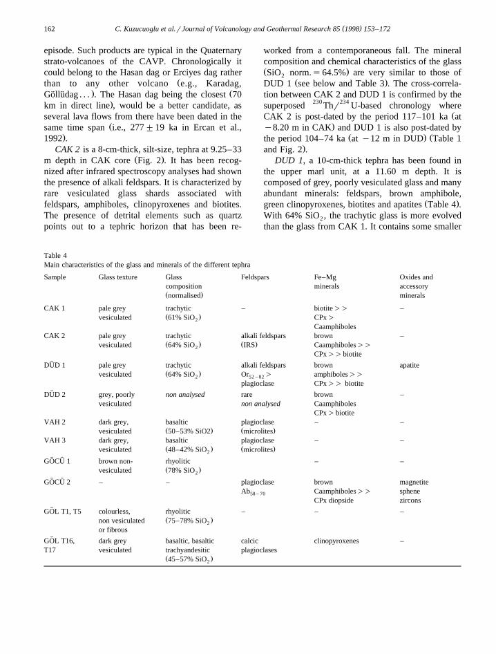
Table 4Main characteristics of the glass and minerals of the different tephra
Sample Glass texture Glass Feldspars Fe–Mg Oxides andcomposition minerals accessoryŽ .normalised minerals
CAK 1 pale grey trachytic – biotite)) –Ž .vesiculated 61% SiO CPx)2
CaamphibolesCAK 2 pale grey trachytic alkali feldspars brown –
Ž . Ž .vesiculated 64% SiO IRS Caamphiboles))2
CPx))biotite¨DUD 1 pale grey trachytic alkali feldspars brown apatite
Ž .vesiculated 64% SiO Or ) amphiboles))2 52 – 82
plagioclase CPx)) biotite¨DUD 2 grey, poorly non analysed rare brown –
vesiculated non analysed CaamphibolesCPx)biotite
VAH 2 dark grey, basaltic plagioclase – –Ž . Ž .vesiculated 50–53% SiO2 microlites
VAH 3 dark grey, basaltic plagioclase – –Ž . Ž .vesiculated 48–42% SiO microlites2
¨ ¨GOCU 1 brown non- rhyolitic – –Ž .vesiculated 78% SiO2
¨ ¨GOCU 2 – – plagioclase brown magnetiteAb Caamphiboles)) sphene58 – 70
CPx diopside zircons¨GOL T1, T5 colourless, rhyolitic – – –
Ž .non vesiculated 75–78% SiO2
or fibrous¨GOL T16, dark grey basaltic, basaltic calcic clinopyroxenes –
T17 vesiculated trachyandesitic plagioclasesŽ .45–57% SiO2

( )C. Kuzucuoglu et al.rJournal of Volcanology and Geothermal Research 85 1998 153–172 163
plagioclases, but the abundant free feldspars areŽ .sanidines Or Table 4 and Fig. 4 . According to52 – 82
Ž .the classification of Morimoto 1988 , the pyroxenesare Wo diopsides. The calcic amphiboles can be47 – 48
Ž .classified as ferroan pargasites Leake, 1978 . Somecalcitic grains are present probably from the sur-rounding limestones that have been incorporated inthe tuff by processes such as bioturbation. However,this layer can be regarded as a direct fall becausesanidines are non-existant in the drainage basin. Thismineralogical composition, including alkali feldspars,is quite uncommon in the Quaternary pyroclastics ofthe CAVP province.
DUD 2 is a 8-cm-thick, silt-size, tephra interstrat-ified in lacustrine gypsum-rich layers at a 8.60 m
Ž .depth in the CAK core upper marl unit . It containspoorly vesiculated grey glass associated with alkalifeldspars, amphiboles, clinopyroxenes and rare bi-
Ž .otites Table 4 . Its composition is very homogenousŽ .and there is no external elements unlike CAK 2 .
For these reasons, it can be considered as an in situtephra layer.
3.2. The VAH sequence: two tephra layers related tothe high leÕel stand of the Upper Pleistocene Konya
( )lake Fig. 5
The VAH sequence is located next to apalaeobeach on the northern shores of the Konyapalaeolake in the Eregli plain, in the vicinity of the
ŽKarapinar strombolian volcanic field Keller, 1974;.Kuzucuoglu et al., 1994 .
The Karapinar volcanic area is composed of twobasaltic product types of different ages. Fissure dom-inated lava flows constructed two plateaux separat-ing the Karapinar subbasin to the north from theEregli subbasin to the south-east. The K–Ar age ofthese flows ranges from 161"10 ka to 363"8 kaŽ .Ercan et al., 1992 . A younger volcanic phase hasconstructed three strombolian cones and three maarsinstalled along a SW–NE line, from the Eregli plainŽ .the Buyuk Meke, 280 m high cone to the Kara-¨ ¨
Žcadag Pliocene volcano to the north the Karapinar–.Acigol maar, 100 m deep . This volcanic area has¨
Ž .been studied by Keller 1974 who already thoughtof a possible Upper Pleistocene age for the Karap-inar strombolian cones and maars. This hypothesis isconfirmed by our results.
Fig. 4. AnrAbrOr diagram of some feldspars from the differentsites.
The VAH sequence has been sampled every 5 cmon the walls of a dried well. The stratigraphy showslight grey lacustrine marls interrupted several timesby scoriae falls and organic matter rich layers associ-ated with abundant mollusca fauna. The lower partŽ .from y14 to y13.5 m is composed of a sandy andmollusca-rich, dark grey, marshy layer, covered by a
Ž . Žthin -5 cm basaltic scoriae tephric layer VAH.‘1’ . On the top of it, a 10-cm-thick organic matter-
14 Žrich layer gave a C age of G33 ka GifrLSM. 149747 out of range of the C classic method. In the
middle part of the sequence, two basaltic scoriaeŽ .layers VAH 2 and VAH 3 are separated by a
clayey–marshy episode, very rich in mollusca, inwhich a thin peaty horizon has given an uncal. 14C
Ž .age of 24,400"800 years B.P. GifrLSM 9749 ,thus giving a relative age to both scoriae falls, withVAH 2 possibly deposited between ca. 30 ka and25–24 ka and VAH 3 younger than ca. 25–24 ka.The upper part of the sequence is composed of atypical lacustrine carbonate environment, probablydeposited during the 21–17 ka BP high level standof the Upper Pleistocene Konya palaeolake. The endof this stage is signaled, from y3 m on, by animportant sand input, rich in various minerals, asso-ciated with Dreissena shells. This phase correspondsto a shore deposit related to the contracting phase of

( )C. Kuzucuoglu et al.rJournal of Volcanology and Geothermal Research 85 1998 153–172164
Ž . Ž . Ž .Fig. 5. The VAH sequence. Captions: 1 Lacustrine light grey marls; 2 Basaltic scoriae layer; 3 Basaltic scoriae associated withŽ . Ž . Ž . Ž . Želements of lacustrine and alluvial origin; 4 Organic matter-rich layer; 5 Sand input rounded fine grains ; 6 Mollusca shells width
. Ž .variation of caption means variations in the relative amounts of the shell fragments present ; 7 Dreissena shells. Note: VAH position isN37836X40Y–E33837X 02Y.
Ž .the palaeolake Fontugne et al., 1999 . The upper1.45 m are not visible, being covered by the stonering of the well.
The VAH ‘1’ tephric layer is sandy, 5 cm thick,mostly composed of basaltic scoriae associated withsome allogenous elements from the lake drainagearea and several shell fragments. This associationpoints out for reworking from the scoriae-covered
slopes. Thus, VAH ‘1’ has not been included in thecomparative analyses procedure. The VAH 2 scoriaefall is 35 cm thick, from y8.35 to y8.70 m, withthe middle 12 cm exclusively composed of basaltic
Ž .scoriae. Grain size is smaller 0.3–0.6 mm than thatof the VAH 3 fall. The VAH 3 basaltic scoriae fall is60 cm thick, from y3.95 to y4.55 m, with the basal15 cm exclusively composed of 0.8 to 2 mm grain-

( )C. Kuzucuoglu et al.rJournal of Volcanology and Geothermal Research 85 1998 153–172 165
sized elements. This deposit is thicker than the previ-ous one and has completely interrupted the lacustrine
Ždeposition mainly carbonates, fine sand input and.mollusca shells at that time .
According to whole rock analyses, the upperŽtephra VAH 3 has a basaltic composition 49.6%
.SiO . The middle tephra VAH 2, however, is more2Ž .differenciated with 53.2% SiO basaltic andesite2
and has lower amounts of FeO, MgO and TiO .2Ž .These results are confirmed by microprobe EDS
Ž .glass analyses Table 3 and point to an origin in theKarapinar volcanic field. Whole scoriae from thevarious cones around the VAH spot, together withwhole scoriae from the VAH 2 and VAH3 tephra,have been analysed for comparison. The insufficientchemical variations as well as the uncertain qualityof the analyses on glass from the scoriae do notallow more precision than to show that the bestcandidate for the origin of these tephra is the Buyuk¨ ¨Meke which is 1 km far of the VAH well. The wholerock analyses show comparable amounts of SiO2
between VAH 2 and the Buyuk Meke, indicating¨ ¨also that VAH 3 is alumina-enriched and Fe oxide-poor. However, both scoriae layers have the lowestMgO contents of all the samples studied.
( )3.3. The Gocu sequence Fig. 6¨ ¨
The Gocu beach is located at the foot of the¨ ¨Ž .Bozdag 1530 m , on the northwestern shores of the
Konya Plain. The location, in the western part of thepalaeolake, is different from the previous ones. Con-sequently, the material from the sections studied inGocu is also very different since it is mainly com-¨ ¨prised of a coarse-grained lacustrine shore deposit.Two tephra have been identified in open sectionsvariously distributed in a quarry. The sequence shownin Fig. 6 represents the synthesis of three separate
Ž .sections Karabiyikoglu et al., 1999 .The top 2 m of the unit I is visible only in a hole
¨ ¨dug on the floor of the quarry. The GOCU 1 tephraand the 14C dated palaeosol immediately above ithave been sampled from this hole. The bottom 4 mare known from a 6 m long core extracted next to thehole. The upper part of the sequence is reconstructedon the basis of wide and high sections available inthe 5-km-long sand quarry. Covering a reddishpalaeosol ending unit II and 14C dated 21,960"250
Fig. 6. Stratigraphic log and position of tephra in the Gocu beach¨ ¨Ž . Ž .deposit sequence. Captions: 1 Lacustrine marls; 2 Gravels and
Ž . Ž . Ž .sands; 3 Pebbles and gravels; 4 Palaeosol; 5 CryoturbatedŽ . Ž . Ž . Ž .palaeosoil dated ; 6 Organic matter-rich layer dated ; 7 Pale
Ž . Ž .green lacustrine clay; 8 Reddish colluvium; 9 Unconformity;Ž . Ž .10 Stratigraphic unit; 11 Tephra. N.B. This section is a synthe-sis from several outcrops in the Gocu sand and gravel quarries.¨ ¨Ages are 14C dates conv. dates year B.P. performed on shells or
Žorganic matter-rich layers Fontugne et al., 1999; Karabiyikoglu et.al., 1999 .
Ž .years B.P. Gif 10904 , a lacustrine fine sand andclay episode is interstratified between Units II and I;
14 Ž .it is C dated 20,730"120 years B.P. Gif 10270on a continuous black thin organic layer at the base
¨ ¨of this intermediate episode. The GOCU 2 tephra ortephric deposit has been found in two separate loca-tions within the overlying Unit IV, also a shoreline
( )C. Kuzucuoglu et al.rJournal of Volcanology and Geothermal Research 85 1998 153–172166
deposit. 14C aging is provided by Dreissena shellsimmediately covering the tephra layer in both loca-tions with the following results: 14,100"75 years
ŽB.P. Gif 10504; age considered as contaminated by.calcite recrystallisation and 19,240"360 years B.P.
Ž .Gif 10905; age retained . A younger sand and gravel14 Ž .unit is C dated 17,510"330 years B.P. Gif 10337
on Dreissena shells sampled in the youngest cross-bedded sand deposit.
¨ ¨The GOCU 1 tephra covers a cryoturbatedpalaeosol 14C dated 28,300 " 1100 years B.P.Ž .GifrLSM 10505 on organic matter. It is formed ofnon-vesiculated brown obsidian glass containing
Ž .more than 76% SiO Tables 3 and 4 . There are no2
accompanying minerals and the entire layer appearsto be an obsidian sand. Such a tephra cannot berelated to any classic pyroclasticrairfall type like aplinian fall. The breaking and the dispersion of theglass shards seem to point to a post-extrusion explo-sive process. Although obsidian is known in theHasan dag itself, it is not an important product ofthis volcano. The main areas associated with obsid-ian extrusions in the CAVP are the Golludag and the¨ ¨
Ž .Acigol Nevsehir complex. The Golludag obsidians¨ ¨¨ ¨are too old for any correlation with GOCU 1, since
they have been fission track dated 0.9"0.2 Ma andŽ .0.86"0.1 Ma Batum, 1978 , and 1.33 to 0.98 Ma
Ž .Bigazzi et al., 1993 . In the Acigol complex, Bigazzi¨Ž .et al. recognized three groups of obsidians: 1 older
pre-collapse obsidian flows, aged between 180 andŽ . Ž . Ž .190 ka; 2 post-collapse domes 75 ka ; 3 very
young domes located in the west side inside theAcigol caldera, aged 20"6 ka and 19"7 ka, and¨
Ž .15.5"2.5 ka in Innocenti et al. 1975 . In theyounger products of the volcanic activity of theAcigol complex, an aphyric obsidian-rich tephra is¨
Ž .noticed by Druitt et al. 1995 : the Korudagi tuff. Asfar as dynamics are concerned, this pyroclastite could
¨ ¨be compared with GOCU 1. The possible relation-¨ ¨ship between GOCU 1 and the Korudagi should,
however, be viewed with caution because of thelower Na O content given by the probe analyses for2
¨ ¨ Ž .the GOCU 1 glass ;3.3% compared to the Ko-Ž .rudagi tuff glass ;4.5% . However, the origin of
¨ ¨GOCU 1 being from the recent obsidian activity ofthe Acigol complex remains highly probable.¨
¨ ¨The GOCU 2 layer contains only minerals whichare slightly blunted, in relation to some reworkingŽ .tephric layer . The main phases are plagioclasesŽ .Ab , automorphic amphiboles, green clinopy-58 – 70
Ž .roxenes and magnetites Table 1 . The absence ofglass is either due to weathering or to density-relatedsedimentation conditions. The presence of smallamounts of calcite, quartz and biogenic aragoniteŽ .shell fragments agree with the suspected rework-ing. The calcic amphiboles are more or less silicicŽ .42 and 46% SiO . According to Leake’s classifica-2
Ž .tion 1978 , they include edenitic hornblende andferro-pargasite. With Wo)45%, most of the pyrox-
Ž .enes are diopsides Morimoto, 1988 . This layershows the typical mineralogy of an acidic tephra, butthe absence of glass forbids a more precise interpre-tation. The presence of some sphene and prismaticzircon gives a particular identity and signature to thistephra which may be used to identify it elsewhere,although no source for such a tephra has yet been
¨ ¨recognized in the CAVP. The age of the GOCU 2deposit is given by a 19,240"30 years B.P. 14C dateŽ .Gif 10905 of associated Dreissena shells; another
Ž .age obtained 14,100"75 years B.P; Gif 10504 isdisregarded as it is out of range of the ages usuallygiven by Dreissena shells in the Konya palaeolakeshore deposits. As a matter of fact, all 14C ages
Žpublished in the Konya Plain de Meester, 1970;Roberts et al., 1979, Kuzucuoglu et al., 1997a, 1998;
.Fontugne et al., 1999 give a range of 23,000–21,000to 17,000 years B.P. ages to the Konya palaeolake.The 14,000–12,000 years B.P. period corresponds to
Žmarsh development and low lake levels dated onmollusca shells and organic matter from burried
.marshy layers in the subbasins of the Konya plainŽ .Fontugne et al., 1999 as well as in the Tuz golu¨ ¨
Ž .basin Kashima et al., in press . However, in theŽ . 14Aksehir basin, Kazanci et al. 1994, 1997 have C
Ž . Ž . Ž .Fig. 7. Stratigraphic log and position of tephra in the Eski Acigol sequence. Captions: 1 Upper peat Zone I ; 2 Pale grey to dark brown¨Ž . Ž . Ž . Ž . Ž . Ž .clay, non laminated Zone II ; 3 Yellowish green clay, laminated Zone III ; 4 Yellowish white clay, laminated Zone IV ; 5 Yellowish
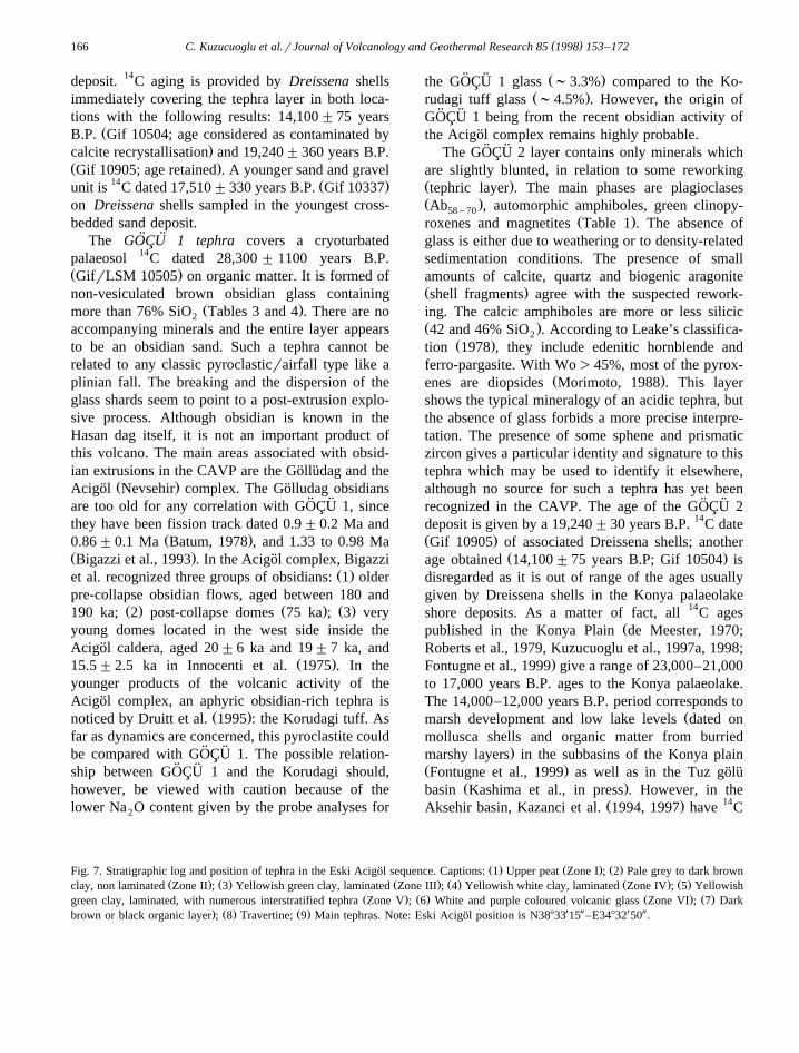
Ž . Ž . Ž . Ž .green clay, laminated, with numerous interstratified tephra Zone V ; 6 White and purple coloured volcanic glass Zone VI ; 7 Dark. Ž . Ž . X Y X Ybrown or black organic layer ; 8 Travertine; 9 Main tephras. Note: Eski Acigol position is N38833 15 –E34832 50 .¨

( )C. Kuzucuoglu et al.rJournal of Volcanology and Geothermal Research 85 1998 153–172 167

( )C. Kuzucuoglu et al.rJournal of Volcanology and Geothermal Research 85 1998 153–172168
dated Dreissena shells from abandoned coastalbeaches 14,125"105 years B.P. and 13,825"95years B.P.
3.4. Late Glacial and Holocene tephra from Eski( )Acigol 95-3 core Fig. 7¨
Ž .In the Acigol Nevsehir caldera, several maars¨are occupied by rhyolitic domes, except the EskiAcigol maar, located immediately south of the¨Nevsehir–Aksaray highway. It is Late Pleistocene inage, the obsidian forming the nearby domeŽ . ŽGuneydag being dated 26–14 ka Innocenti et al.,¨
.1975; Bigazzi et al., 1993 . The Eski Acigol maar¨was occupied by a brackish lake drained in 1972. In
Ž .1995, a 20-m-long core was drilled core 95-3Ž .Kuzucuoglu et al., 1997b . Some 1-m-long sectionssuffered extension and deformation. Depths in Figs.7 and 8 are given assuming regular extension of eachcored section.
The Eski Acigol maar fill is composed of six¨units. Between an upper, 2-m-thick, peat depositŽ .zone I and a basal )2-m-thick volcanic glass
Ž .deposit zone VI , the lacustrine record shows threemain other units: 6 m of non-laminated, banded silts
Žand peaty silts, Mid to Late-Holocene in age zone.II ; 8 m of laminated greenish silts and peaty silts
with several grey to black tephra layers interstratifiedŽ .zone III ; 2.5 m of laminated white to yellowish
Ž . Ž .silts zone IV . A transition zone zone V shows 80cm of white laminated silts interrupted by severalbedded, basaltic tephra. According to a plot of 14Cages versus depth, and assuming a correction forregular organic matter ’aging’, the sedimentation ratevaries from 0.8 mmryr in zone II to 1 mmryr inzone III. The change in sedimentation rate betweenzones II and III may represent climatic changesbetween Late Glacial and Holocene.
The Eski Acigol maar is set within the maar¨occupied by the Guneydag dome dated 20"6 ka¨Ž .Bigazzi et al., 1993 ; it should, therefore, beyounger. Until now, no 14C date older than 14,320"
Ž .170 years B.P. Woldring, 1997 has been obtainedon the sediment fill. Uncalibrated conventional 14Cdating, performed on organic matter at various depthsof the 20-m-long 95-3 core confirms that the wholesequence contains the Late-glacial and most of the
ŽHolocene. However, the pollen diagram Woldring,
.1997 suggests almost certainly that a 3000-yearhomogeneous aging of the 14C dates has taken place.
The pollen diagram shows the occurrence of dif-ferent taxa during periods where they are not presentat any other location around the eastern Mediter-ranean basin. Pistaccia is centered at 11,000 years
Ž14 .B.P. C uncal. in Eski Acigol whereas it is dated¨between 7000–9000 years B.P. in Mediterranean sea
Žcores and in the bordering land Cheddadi et al.,.1991; Rossignol-Strick et al., 1992 . Similarly, the
Artemisia or Chenopodiaceae peak around 6000–7000 years B.P. in Eski Acigol is generally observed¨around 3500 years B.P. According to the pollendiagram, the ages obtained at Eski Acigol appear to¨be ca 3000–3500 years too old. Taking into accountthe volcanic geological substrate and the low depthof the lake, this ’aging’ cannot result from hardwater effect; it rather indicates diffuse volcanic CO2
14 Ždegassing that is C-free Sulerzhitzky, 1971;.Fontugne et al., 1997 . Variations in degasing rate
may be also at the origin of some 14C age inversions.The basal volcanic deposit below 19.00 m has a
strong signature on the magnetic susceptibillity pro-Ž .file Fig. 7 . It is composed of two sets of deposits: a
matrix-free, light purple to white, coarse sand-sizeŽ .glass tephra )200 cm thick and a grey coarse
Ž .sand-size obsidian tephra 22 cm thick . From thesebottom sands to y6.90 m, 15 other tephra have beencounted, with a higher occurrence in the organic
Ž .laminated lowest part T3 to T7 . At y14.10 m, theŽsequence is interrupted by a calcitic travertine ages
calculated on the basis of regular sedimentation rate.between two dated layers : ;14,300 years B.P. or
;11,300 years B.P.? 1 Between y14.10 and 6.90Ž .m ;8150 years B.P. or ;5000 years B.P.? there
are 10 tephra layers identified under the binocular,corresponding to strong to light peaks on the mag-
Ž .netic susceptibility profile Table 1 and Fig. 7 . EachŽbasaltic tephra layer appears as thin 1 to 15 mm
.thick, with the exception of the 5-cm-thick T8dark-grey layers.
Ž .The lowest layers T1 to T3 are rhyolithic prod-ucts made of obsidian glass and fibrous pumices
1 Ages associated with a question mark are proposed assumingthat a regular 3000 years ’aging’ of the organic matter by volcanicgas emission has occurred along the whole sequence.

( )C. Kuzucuoglu et al.rJournal of Volcanology and Geothermal Research 85 1998 153–172 169
Ž .Tables 1, 3 and 4 . It is difficult to assess whetherthey are real tephra falls or reworked tephric depositscoming from the surrounding area, as their compo-nents are quite similar to the other products of theAcigol complex itself. However, the lowest layer¨Ž .T1 which is pure rhyolithic glass with more than
Ž .77% SiO Tables 3 and 4 could be a direct fall2
because of its homogeneity in grain size and compo-sition. This type of deposit, without any vesiculated
¨ ¨glass is similar to the GOCU 1 tephra, thus confirm-ing their possible pyroclastic origin.
ŽThe upper tephra of the Eski Acigol sequence T4¨.to T17 are mainly composed of fine dark ashes
made of more or less vesiculated glass. The composi-tion of the analysed samples T5, T16 and T17 ischaracteristic of basalts or basaltic trachyandesites
Ž .with 45–57% SiO Table 3 . Some clinopyroxenes2
and plagioclases point towards a similar origin. Moresilicic products, such as obsidian glass and rhyoliticmicro-pumices are clearly xenoliths from the Acigol¨rhyolitic complex. They either come from the upperpart of the basement on which the basaltic vents areinstalled or from the edge of the maar-crater. Theymay also have been incorporated into the sedimentfill of the maar by run-off or aeolian input. Thesebasaltic tephra are clearly related to a strombolianactivity close to the maar. Such products exist in theBogazkoy quarry, some 5 km east of the Eski Acigol¨ ¨maar, in the form of 50 to 120 cm thick scoriaecovering the plinian falls and surges of the Acigol¨caldera complex. Strombolian sources could be the
Žvolcanoes of the basaltic series of Obruktepe near.Icik, in the Acigol caldera .¨
ŽThe time span between T4 dated )14,000, or. Ž11,000 years B.P.? and T17 dated ca. 7720 or 4320
.years B.P.? corresponds to the transition periodbetween Late Glacial and Lower to Mid-Holocene.The ages of the tephra recorded in the Eski Acigol¨sequence are thus new evidences for the existence ofactive volcanism in the northern part of Cappadociaduring a period of both important climatic changesand Neolithic society development.
4. Unspiked K–Ar Dating young Late Pleistocene( )to Holocene lava flows in the Hasan dag Table 3
The presence of a drawing on the walls of aNeolithic house in the archaeological site of Catal
ŽHoyuk aged 8200–7500 years B.P. by conventional¨ ¨14 . Ž .C in the Konya Plain Mellaart, 1967 depicting avolcanic eruption in western Cappadocia was thesole indication for the Holocene age of some of theeruptions. As a result, the Hasan dag summit has
Žbeen sampled two fresh andesitic rocks from thecrater of the Buyuk Hasan dag: CKUZ-2 and CKUZ-¨ ¨.3 ; a young lava flow located on the western flank of
the volcano, near the village of Yukari DikmenŽ .CKUZ-1 , has also been sampled for K–Ar dating.
Ž .Results mean value indicate young ages, 29"1ka and 33"2 ka for basaltic andesites from thesummit and -0 for the Yukari Dikmen basaltic
Ž .andesite lava flow H. Guillou, CFR . These resultsconfirm that the Hasan dag has erupted during theLast Pleniglacial and during the Holocene.
5. Conclusions
5.1. First proposals for a tephrochronology in innerAnatolian lacustrine sequences
There are two main tephra groups identified in thelacustrine sequences presented here: the Konya Plain
Žgives the oldest succession Last Interglacial and.Glacial periods , and the Eski Acigol maar in Cap-¨
Žpadocia gives the youngest succession Late Glacial. Ž .and Holocene Table 1 . Data from the two Japanese
coring programmes in the Tuz golu and Konya Plains¨ ¨seem to confirm the sequence identified in the Konya
ŽPlain Inoue and Saito, 1997; Kashima et al., in.press .
The available tephrochronology is thus the follow-ing: CAK1: biotite-rich and trachytic glass, datedbetween 210"50 ka and 164"50 ka; DUD 1-CAK2: alkali feldspar-rich and trachytic glass, dated ca.100 ka; DUD 2: glass, dated ca. 68"12 ka; VAH 2:
Ž .basaltic scoriae Karapinar volcanoes , dated be-tween 30 and 25–24 ka; VAH 3: basaltic scoriaeŽ .Karapinar volcanoes , dated younger than 25–24
¨ ¨ Ž .ka; GOCU 1: obsidian glass Acigol–Nevsehir area? ,¨¨ ¨dated ca. 28.3"1.1 ka; GOCU 2: acidic tephric
layer with sphene and zircon, dated ca. 19,000 14Cconv. years B.P.; T1 to T3 in the Eski Acigol¨sequence: basal rhyolitic glass, probably related toevents dated ca. 20–9 ka; T4 to T17 in the Eski
( )C. Kuzucuoglu et al.rJournal of Volcanology and Geothermal Research 85 1998 153–172170
Acigol sequence: at least 13 basaltic scoriae falls¨from local eruptions recorded, from ca. )14,000Ž . 14 Ž .)11,000? C conv. years B.P. to 7700 ca. 4700?14C conv. years B.P. One tephra or tephric horizoncontaining pumices, obsidian and feldspars is
Ž . 14recorded at ca. 12,700 ca. 9700? C conv. yearsB.P.
5.2. New dates confirming the recent age of seÕeraleruptions in the Karapinar, Hasan dag and Acigol¨Õolcanic areas
These results not only represent the first steptowards the establishment of an Anatolian Quater-nary tephrochronology but they also show that dur-ing the Pleniglacial, Late Glacial and even Holoceneperiods, several volcanic areas in the CAVP, such asthe Karapinar area, the Hasan dag and the Acigol¨complex, were still active. Such young and produc-tive activity in the province was suspected, but untilnow, had not been established clearly.
Acknowledgements
This work has been realized in the frame of the¨the MTArTUBITAK-CNRS International Scientific
Programme on the Volcanism in Anatolia, the MTA-URA 141 Research Programme on Late Pleistocenein inner Anatolia, with specific support from MTAand CNRS, including the CNRS-VariEnTe Pro-gramme. We would like to thank the MTA Head-quarters in Konya and also Professor Ufuk Esin, theNevsehir Museum and the Turkish Ministry of Cul-ture for providing authorizations for coring EskiAcigol. Coring has been realized by Jemas, Ankara;¨special acknowledgements are addressed to TurgutYilmaz, chief corer. Logistic support in the Eregliplain has benefited from the support of the Koy¨
Ž .Hizmetleri Rural Affairs Erosion Camp in Karap-inar, the municipality of Karapinar and the Aydin-belge family. Infrared spectroscopy analyses havebeen realized on a Perkin Elmer spectrometer at the
ŽDepartment of Sedimentology of ORSTOM Resp. J..Bertaux assisted by M. Jean-Jacques . Thanks are
also due to C. Noury and S. Martin for preparing
samples for 14C dating and M. Jaudon for b-countingat LSM. We thank deeply the anonymous reviewerfor the detailed and constructive observations whichgreatly improved the manuscript.
References
Aydar, E., 1992. Etude volcano—structurale et magmatologiqueŽ .du strato—volcan Hasan Dagi Anatolie Centrale, Turquie .
Unpublished Thesis, Universite de Clermont-Ferrand II,´France.
Batum, I., 1978. Nevsehir guneybatisindaki Golludag ve Acigol¨ ¨ ¨ ¨yoresi volkanitlerinin jeokimyasi ve petrolojisi. Yerbilimleri 4¨Ž .1–2 , 70–88.
Bertaux, J., Frohlich, F., Ildefonse, P., 1998. Multicomponent¨analysis of FTIR spectra: quantification of amorphous andcrystallized mineral phases in synthetic and natural sediments.
Ž .J. Sedim. Res. in press .Besang, C., Eckhardt, F.J., Harre, W., Kreuzer, H., Muller, P.,¨
1977. Radiometrische Alterbestimmungen an neogenen Erup-tivgesteinen der Turkei. Geologisches Jahrbuch, B 25, 3–36.
¨Bigazzi, G., Yeyingil, Z., Ercan, T., Odone, M., Ozdogan, M.,1993. Fission track dating obsidians in Central and NorthernAnatolia. Bull. Volcanol. 48, 109–125.
Bischoff, J.L., Fitzpatrick, J.A., 1990. U-series dating of impurecarbonates: an isochron technique using total-sample dissolu-tion. Geochim. Cosmochim. Acta 55, 543–554.
Black, S., Macdonald, R., Kelly, M.R., 1997. Crustal origin forperalklaine rhyolites from Kenya: evidence from U-seriesdisequilibria and Th-isotopes. J. Petrol. 38, 277–297.
Cassignol, C., Cornette, Y., David, B., Gillot, P.Y., 1978. Tech-nologie potassium–argon. C.E.N., Saclay. Rapp. CEA R-4802,Saclay, France.
Cheddadi, R., Rossignol-Strick, M., Fontugne, M., 1991. EasternMediterranean paleoclimates from 26 to 5 ka BP documentedby pollen and isotopic analysis of a core in the anoxicBannock Basin. Mar. Geol. 100, 53–66.
Druitt, T.H., Brenchley, P.J., Gokten, Y.E., Francaviglia, V.,¨1995. Late Quaternary rhyolitic eruptions from the Acigol¨Complex, central Turkey. J. Geol. Soc., London 152, 655–667.
Eastwood, W.J., Pearce, N.J.G., Perkins, W.T., Lamb, H.F., West-Ž .gate, J.A., Roberts, N. in press . Geochemistry of Santorini
tephra in lake sediments from southwest Turkey. Quat. Sci.Rev.
Ercan, T., Tokel, S., Matsuda, J.I., 1992. Hasandag–KaracadagŽ .Orta Anadolu Kuvaterner Volkaniszmasina iliskin yenijeokimyasal, izotopik ve radyometrik veriler. Turkiye Jeoloji¨Kurumu Bulteni 7, 8–21.¨
Fontugne, M., Hatte, C., Allard, P., Pasquier-Cardin, A., Baubron,´J.C., 1997. Diffuse CO degasing in volcanic areas and 14C2
aging of plants. Abstr. 16th Int. Radiocarbon Conf., Gronin-gen, June 1997, 49.
Fontugne, M., Kuzucuoglu, C., Karabiyikoglu, M., Hatte, C.,´Pastre, J.-F., 1999. From Pleniglacial to Holocene. A 14C

( )C. Kuzucuoglu et al.rJournal of Volcanology and Geothermal Research 85 1998 153–172 171
chronostratigraphy of environmental changes in the KonyaŽ .Plain, Turkey. Quat. Sci. Rev. 18, 2, in press .
Gillot, P.Y., Chiesa, S., Pasquare, G., Vezzoli, L., 1982. -
33,000-years K–Ar dating of the volcano-tectonic horst of theisle of Ischia, Gulf of Naples. Nature 299, 242–244.
Goetz, C., Hillaire-Marcel, C., 1992. U-series disequilibria inearly diagenetic minerals from Lake Magadi sediments, Kenya:dating potential. Geochim. Cosmochim. Acta 56, 1331–1341.
Imbrie, J., Hays, J.D., McIntyre, A., Mix, A.C., Morley, J.J.,Pisias, N.G., Prell, W.L., Shackleton, N.G., 1984. The orbitaltheory of Pleistocene climate: Support from a revised chronol-ogy of the marine E18 O record. In: Berger, A., Imbrie, J.,
Ž .Hays, J., Kukla, G., Saltzman, B. Eds. , Milankovitch andClimate. Reidel, Boston, Part I: 269–305.
Innocenti, F., Mazzuoli, R., Pasquare, G., Redicati de Brozolo, F.,´Villari, L., 1975. The Neogene calc-alkaline volcanism ofCentral Anatolia: geochronological data of Kayseri—Nigdearea. Geol. Mag. 112, 349–360.
Inoue, K., Saito, M., 1997. Climatic changes in the Konya Basin,Turkey, estimated from physicochemical, mineralogical andgeochemical characteristics of its lacustrine sediments. JapanReview 8, 147–164.
Karabiyikoglu, M., Kuzucuoglu, C., Fontugne, M., Kaiser, B.,Mouralis, D., Babayigit, S., 1999. Facies and depositionalsequences of the Late Pleistocene Gocu shoreline system,¨ ¨Konya basin, Central Anatolia: lake level changes and climatic
Ž .implications. Quat. Sci. Rev. 18, 2 in press .Ž .Kashima, K., Naruse, T., Sugiura, K. in press . Sedimentary
environmental change during last 20,000 years at Aksarayarea, south-east part of Lake Tuz, central part of Turkey. Bull.Middle East Culture Centre, Japan.
¨Kazanci, N., Nemec, W., Ileri, O., Karadenizli L., Kavusan, G.,Solak, A.O., Postma, G., Karakas, Z., Ucar, M., 1994. Islah vekurtarma calismalari icin Eber ve Aksehir gollerinin sedimen-¨
¨tolojik incelemesi. Final Report for TUBITAK-YBAG 019¨and for Ankara Univ. Res. Fund 91050101, TUBITAK,
Ž .Ankara, Turkey unpublished .Kazanci, N., Gevrek, A.I., Varol, B., 1995. Facies changes and
high calorific peat formation in a Quaternary maar lake,central Anatolia, Turkey: the possible role of geothermalprocesses in a closed lacustrine basin. Sediment. Geol. 94,255–266.
¨Kazanci, N., Nemec, W., Ileri, O., Karadenizli, L., Criseid, H.C.,1997. Palaeoclimatic significance of the Late Pleistocene de-posits of Aksehir lake, West-central Anatolia. Abstracts of theRegional INQUA Symposium on the Late Quaternary in theMediterranean, Ankara, Turkey, April 1997.
Keller, J., 1974. Quaternary Maar Volcanism near Karapinar inCentral Anatolia. Bull. Volcanol. 38 2, 378–396.
Keller, J., Jung, D., Burgath, K., Wolf, F., 1977. Geologie unePetrologie des neogenen Kalkalkali–Vulkanismus von KonyaŽ .Erenler Dafi-Alaca Dafi Massiv Zentralanatolien . Geol. Jb,Hannover, B 25, 119–138.
Kuzucuoglu, C., Pastre, J.-F., Fontugne, M., 1994. Sequences oftephra and organic layers in the Upper Pleistocene lacustrine
Ž . Ž .sediments in the Konya Basin Turkey abstract . In: IAVCEIAbstract Book, Ankara, Turkey, September 1994.
Kuzucuoglu, C., Karabiyikoglu M., Fontugne, M., Pastre, J.-F.,
Ercan, T., 1997a. Environmental changes in Holocene Lacus-Ž .trine Sequences from Karapinar in the Konya Plain Turkey .
Ž .In: Dalfes, N., Kukla, G., Weiss, H. Eds. , Third MilleniumBC Climate Change and Old World Collapse. NATO ASISeries, Vol. 49, pp. 451–464.
Kuzucuoglu, C., Bertaux, J., Ercan, T., Fontugne, M., Kara-biyikoglu, M., Pastre, J.-F., Turkecan, A., 1997b. Mineralogic¨records of the lacustrine sequence from the Eski Acigol maar¨Ž .Nevsehir, Turkey during the Late Glacial and Holocene.Preliminary results, Abstr. Regional INQUA Symposium onthe Late Quaternary in the Mediterranean, Ankara, Turkey,April 1997.
Kuzucuoglu, C., Bertaux, J., Black, S., Fontugne, M., Kara-biyikoglu, M., Mouralis, D., Orth, P., Pastre, J.-F., 1997c.Upper Pleistocene sedimentary records of environmentalchanges in the Konya Basin, Turkey. Abstracts of the Re-gional INQUA Symposium on the Late Quaternary in theMediterranean, Ankara, Turkey, April 1997.
Kuzucuoglu C., Fontugne, M., Karabiyikoglu, M., 1998. Environ-mental changes in Anatolia during Holocene: examples from
Ž .the Konya Plain, inner Anatolia. In: Otte, M. Ed. , AnatolianŽ .Prehistory. Liege Univ. in press .`
Leake, E., 1978. Nomenclature of amphiboles. MineralogicalMagazine 42, 533–563.
Le Bas, M.J., Le Maıtre, R.W., Streckeisen, A., Zanettin, B.,ˆ1986. A chemical classification of volcanic rocks based on thetotal alkali-silica diagram. J. Petrol. 27, 745–750.
Le Pennec, J.-L., Bourdier, J.-L., Froger, J.-L., Temel, A., Camus,G., Gourgaud, A., 1994. Neogene ignimbrites of the Nevsehir
Ž .plateau central Turkey : stratigraphy, distribution and sourceconstraints. J. Volcanol. Geotherm. Res. 63, 59–87.
Ž .de Meester, T. Ed. , 1970. Soils of the Great Konya Basin,Turkey. Centre of Agricultural Publishing and DocumentationPUDOC, Wageningen.
Mellaart, J., 1967. Catal Huyuk: a neolithic town in Anatolia.¨ ¨Thames & Hudson.
Morimoto, N., 1988. Nomenclature of pyroxenes. Miner. Mag. 52,535–550.
Orth, P., 1996. Etude geomorphologique du bassin occidental´d’Eregli et contribution aux reconstitutions environnementalesdans la plaine de Konya. M. Maıtrise, Univ. Paris I, Paris,ˆFrance.
Pasquare, G., 1968. Geology of the Cenozoic volcanic area of´Central Anatolia. Atti Accad. Naz. Linecei Mem. 9, 55–204.
Pasquare, G., Poli, S., Venzolli, L., Zanchi, A., 1988. Continental´arc volcanism and tectonic setting in Central Anatolia, Turkey.Tectonophysics 146, 217–230.
Pastre, J.-F., Kuzucuoglu, C., Fontugne, M., Guillou, H., Kara-biyikkoglu, M., Ercan, T., Turkecan, A., 1998. Sequences¨volcanisees et correlations tephrologiques au N-W du Hasan´ ´ ´
Ž .Dag haute bassin de la Melendiz, Anatolie centrale, Turquie .Ž .Quarternaire in press .
Roberts, N., Erol, O., de Meester, T., Uerpmann, H.-P., 1979.Radiocarbon chronology of Late Pleistocene Konya lake,Turkey. Nature 281, 662–664.
Roberts, N., Eastwood, W.J., Lamb, H.F., Tibby, J.C., 1997. TheAge and causes of Mid-Holocene environmental change inSouthwest Turkey. In: Dalfes, H.N., Kukla, G., Weiss, H.
( )C. Kuzucuoglu et al.rJournal of Volcanology and Geothermal Research 85 1998 153–172172
Ž .Eds. , Third Millenium BC Climate Change and Old WorldCollapse. NATO ASI Series, Vol. 49, pp. 409–429.
Rossignol-Strick, M., Planchais, N., Paterne, M., Duzer, D., 1992.Vegetation dynamics and climate during the deglaciation inthe south Adriatic basin from a marine record. Quat. Sci. Rev.11, 415–423.
Shackleton, N.J., 1969. The last interglacial in the marine andterrestrial records. Proc. R. Soc. London B 174, 135–154.
Steiger, R.H., Jager, E., 1977. Subcommission on geochronology:¨convention on the use of decay constants in geo- and cos-mochronology. Earth Planet. Sci. Lett. 36, 359–362.
Sulerzhitzky, L.D., 1971. Radiocarbon dating of volcanoes. Bull.Volcanol. 35, 85–94.
Sullivan, D.G., 1988. The discovery of Santorini Minoan tephra inwestern Turkey. Nature 333, 552–554.
Sullivan, D.G., 1990. Minoan tephra in lake sediments in WesternTurkey, dating the eruption and assessing the atmospheric
Ž .dispersal of the ash. In: Hardy, D.A., Renfrew, A.C. Eds. ,Thera and the Aegean World III. Volume Three—Chronol-ogy. Proc. Third Int. Congr., Santorini, Greece. The TheraFoundation, London, pp. 114–118.
Tokel, S., Ercan, T., Akbasli, A., Yildirim, T., Fisekci, A., Selvi,¨Y., Olmez, M., Can, B., 1988. Neogene tholeiitic province of
Central Anatolia: implication for magma genesis and post-col-¨lision lithospheric dynamics. METU J. Pure and Appl. Sci. 21,
461–477, Tokay Symposium.Winograd, I.J., Landwehr, J.M., Ludwig, K.R., Coplen, T.Y.,
Riggs, A.C., 1997. Duration and structure of the past fourinterglaciations. Quat. Res. 48, 141–154.
Woldring, H., 1997. Late Glacial and Holocene vegetation historyof Central Anatolia: the palynological record of Eski Acigol.¨Abstracts of the Regional INQUA Symposium on Late Quater-nary in the Eastern Mediterranean, Ankara, Turkey, April1997.
Related Documents