This article was downloaded by: [41.107.209.68] On: 02 February 2015, At: 06:37 Publisher: Taylor & Francis Informa Ltd Registered in England and Wales Registered Number: 1072954 Registered office: Mortimer House, 37-41 Mortimer Street, London W1T 3JH, UK Click for updates Desalination and Water Treatment Publication details, including instructions for authors and subscription information: http://www.tandfonline.com/loi/tdwt20 Identification and cartography of potential groundwater polluters in Tlemcen urban area (northwest of Algeria) H.S. Fellah ab , M. Adjim ab & F. Bensaoula ac a Faculty of Technology, Hydraulic Department, University of Tlemcen, Algeria, Tel. +213 05 60 31 00 80, Tel. +213 05 57 11 46 22, Tel. +213 05 57 42 46 98 b University of Tlemcen Research Laboratory no 60: Valorization of Water Resources “V.R.E”, BP 230, Tlemcen 13000, Algeria, Tel. +213 43 41 00 13; Fax: +213 28 56 85 c University of Tlemcen Research Laboratory no 25: Promotion for Water, Soil and Mineral Resources, Tlemcen 13000, Algeria Published online: 24 Dec 2014. To cite this article: H.S. Fellah, M. Adjim & F. Bensaoula (2014): Identification and cartography of potential groundwater polluters in Tlemcen urban area (northwest of Algeria), Desalination and Water Treatment, DOI: 10.1080/19443994.2014.992971 To link to this article: http://dx.doi.org/10.1080/19443994.2014.992971 PLEASE SCROLL DOWN FOR ARTICLE Taylor & Francis makes every effort to ensure the accuracy of all the information (the “Content”) contained in the publications on our platform. However, Taylor & Francis, our agents, and our licensors make no representations or warranties whatsoever as to the accuracy, completeness, or suitability for any purpose of the Content. Any opinions and views expressed in this publication are the opinions and views of the authors, and are not the views of or endorsed by Taylor & Francis. The accuracy of the Content should not be relied upon and should be independently verified with primary sources of information. Taylor and Francis shall not be liable for any losses, actions, claims, proceedings, demands, costs, expenses, damages, and other liabilities whatsoever or howsoever caused arising directly or indirectly in connection with, in relation to or arising out of the use of the Content. This article may be used for research, teaching, and private study purposes. Any substantial or systematic reproduction, redistribution, reselling, loan, sub-licensing, systematic supply, or distribution in any form to anyone is expressly forbidden. Terms & Conditions of access and use can be found at http:// www.tandfonline.com/page/terms-and-conditions

Welcome message from author
This document is posted to help you gain knowledge. Please leave a comment to let me know what you think about it! Share it to your friends and learn new things together.
Transcript

This article was downloaded by: [41.107.209.68]On: 02 February 2015, At: 06:37Publisher: Taylor & FrancisInforma Ltd Registered in England and Wales Registered Number: 1072954 Registered office: Mortimer House,37-41 Mortimer Street, London W1T 3JH, UK
Click for updates
Desalination and Water TreatmentPublication details, including instructions for authors and subscription information:http://www.tandfonline.com/loi/tdwt20
Identification and cartography of potentialgroundwater polluters in Tlemcen urban area(northwest of Algeria)H.S. Fellahab, M. Adjimab & F. Bensaoulaac
a Faculty of Technology, Hydraulic Department, University of Tlemcen, Algeria, Tel. +213 0560 31 00 80, Tel. +213 05 57 11 46 22, Tel. +213 05 57 42 46 98b University of Tlemcen Research Laboratory no 60: Valorization of Water Resources“V.R.E”, BP 230, Tlemcen 13000, Algeria, Tel. +213 43 41 00 13; Fax: +213 28 56 85c University of Tlemcen Research Laboratory no 25: Promotion for Water, Soil and MineralResources, Tlemcen 13000, AlgeriaPublished online: 24 Dec 2014.
To cite this article: H.S. Fellah, M. Adjim & F. Bensaoula (2014): Identification and cartography of potentialgroundwater polluters in Tlemcen urban area (northwest of Algeria), Desalination and Water Treatment, DOI:10.1080/19443994.2014.992971
To link to this article: http://dx.doi.org/10.1080/19443994.2014.992971
PLEASE SCROLL DOWN FOR ARTICLE
Taylor & Francis makes every effort to ensure the accuracy of all the information (the “Content”) containedin the publications on our platform. However, Taylor & Francis, our agents, and our licensors make norepresentations or warranties whatsoever as to the accuracy, completeness, or suitability for any purpose of theContent. Any opinions and views expressed in this publication are the opinions and views of the authors, andare not the views of or endorsed by Taylor & Francis. The accuracy of the Content should not be relied upon andshould be independently verified with primary sources of information. Taylor and Francis shall not be liable forany losses, actions, claims, proceedings, demands, costs, expenses, damages, and other liabilities whatsoeveror howsoever caused arising directly or indirectly in connection with, in relation to or arising out of the use ofthe Content.
This article may be used for research, teaching, and private study purposes. Any substantial or systematicreproduction, redistribution, reselling, loan, sub-licensing, systematic supply, or distribution in anyform to anyone is expressly forbidden. Terms & Conditions of access and use can be found at http://www.tandfonline.com/page/terms-and-conditions
Identification and cartography of potential groundwater polluters in Tlemcenurban area (northwest of Algeria)
H.S. Fellaha,b,*, M. Adjima,b, F. Bensaoulaa,c
aFaculty of Technology, Hydraulic Department, University of Tlemcen, Algeria, Tel. +213 05 60 31 00 80;email: [email protected] (H.S. Fellah), Tel. +213 05 57 11 46 22; email: [email protected] (M. Adjim),Tel. +213 05 57 42 46 98; email: [email protected] (F. Bensaoula)bUniversity of Tlemcen Research Laboratory no 60: Valorization of Water Resources “V.R.E”, BP 230, Tlemcen 13000, Algeria,Tel. +213 43 41 00 13; Fax: +213 28 56 85cUniversity of Tlemcen Research Laboratory no 25: Promotion for Water, Soil and Mineral Resources, Tlemcen 13000, Algeria
Received 15 February 2014; Accepted 14 November 2014
ABSTRACT
This paper presents the hazard mapping of groundwater in the Tlemcen urban area (TUA).First, we identified the potential pollution sources (of industrial, agricultural and urban ori-gins) existing in the studied area that can affect the karstic groundwater. It is the mostimportant reserve and the main source of drinking water supply of this area. Then, wemapped all these hazards on a topographic map at scale 1:25,000. Finally, a classified haz-ard map was established. This investigation clearly shows that the groundwater of TUA isfar from being safe from the risk of pollution. Adequate and urgent actions must be takenin order to eliminate or to reduce the risks of contamination of this water resource which ishighly vulnerable because of the lack of protection perimeters.
Keywords: Drinking water resource; Karst aquifer; Contamination risk; Hazard mapping
1. Introduction
Groundwater from karst aquifers is among the mostimportant resources of drinking water for the growingpopulation of the world [1]. In Algeria, and particularlyin Tlemcen, the karst groundwater plays an importantrole in the socioeconomical development of the country[2]. This resource has provided for a long time thedrinking water supply to the population of Tlemcen.Physicochemical analyzes have revealed that the karstwater of the region of Tlemcen is of a very good quality.
It has a calcium–magnesium bicarbonate facies, and itsdry residue varies between 480 and 720 mg/L [3]. How-ever, this water is vulnerable and its high quality maybe jeopardized by anthropogenic impacts [4]. This vul-nerability is mainly due to the highly heterogeneousstructure of the karst aquifers which are recharged bothby diffuse infiltration through the soil and by concen-trated point recharge through dolines and swallowholes. In addition, the hydraulic behavior is stronglyinfluenced by the presence of solutionally enlarged frac-tures and conduits; the permeability is very low in someregions, but very high through fractures and conduits
*Corresponding author.
Presented at the 3rd Annual International Conference on Water (CI.EAU 2013),18–20 November 2013, Algiers, Algeria
1944-3994/1944-3986 � 2014 Balaban Desalination Publications. All rights reserved.
Desalination and Water Treatment (2014) 1–10
www.deswater.com
doi: 10.1080/19443994.2014.992971
Dow
nloa
ded
by [
41.1
07.2
09.6
8] a
t 06:
37 0
2 Fe
brua
ry 2
015

[5]. A vulnerability study of this groundwater that wascarried out in 2007 according to the European approachrevealed that among a total of 28 wells drilled with thepurpose of supplying drinking water, 15 were locatedin very high vulnerability regions [4]. The risk of pollu-tion of this groundwater was pointed out in many pub-lications [6], but so far no risk mapping of this regionwas performed. Since 2005, several springs and wellswere closed due to their nitrate levels exceeding stan-dards or their bacterial contamination rendering thewater unsafe for human consumption. This contamina-tion might have been caused by many factors such asthe ejection of non-treated wastewaters directly into thenatural environment, the irrigations with sewage, theuse of chemical and organic fertilizers, and the drillingof private wells conducted with neglect and no consid-eration whatsoever for the safety standards. All thesefactors are, in fact, due to the non-respect of the ground-water protection policy [6]. This article is a study and areview of the potential and actual polluters of the karstgroundwater in the urban area of Tlemcen. The
different sources of pollution existing in this area aremapped on topographic maps, based on an exhaustiveinventory. Finally, a classified hazard map is elaboratedfor the first time in this region. This map is of a greathelp to the local authorities. It allows deciding on thefirst actions to be undertaken in order to prevent pollu-tion of the karst water of the region.
2. Description of the studied area
Tlemcen urban area (TUA) includes the municipali-ties of Tlemcen, Chetouane, Mansourah, and BeniMester. It is bordered to the north by Sidi Yahia moun-tain and the plain of Hennaya, to the south by Tlemcenmountains, to the east by Oum El Allou mountain, andto the west by Oued Zitoun river (Fig. 1). The TUAsurface area is over 20,000 ha and its population ismore than 270,000 inhabitants. It is the most denselyoccupied region of the Wilaya (Territorial Division) ofTlemcen: it contains 24% of the population within only1.2% of the total surface area of the whole Wilaya [7].
Fig. 1. Geological overview and location of the TUA.
2 H.S. Fellah et al. / Desalination and Water Treatment
Dow
nloa
ded
by [
41.1
07.2
09.6
8] a
t 06:
37 0
2 Fe
brua
ry 2
015
The climate is sub-humid Mediterranean type with anaverage rainfall of 546 mm (1979–2010) and a meanannual temperature of 18˚C [8].
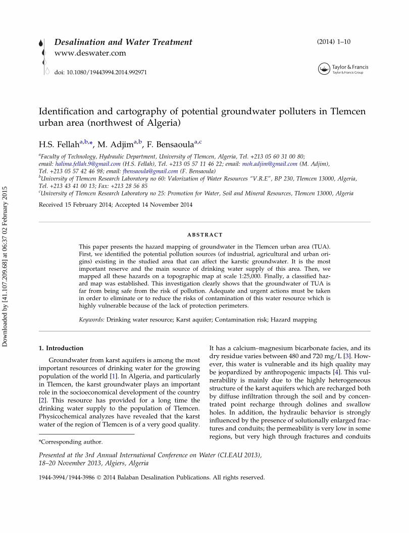
This studied area is located in the foothills of theTlemcen mountains which are formed from a largehorst whose surface consists of karstic limestones of theUpper Jurassic and Lower Cretaceous. In the TUA,these carbonate formations constitute an importantkarst which is covered by a thick neogene sedimenta-tion. Fig. 2 shows a simplified cross-section of this area.The latter corresponds to a collapsed zone as a result oftectonic accidents. This structure was revealed by geo-physical surveys and confirmed by drilling results.
The karst groundwater of this region is intensivelypumped through boreholes and is an important sup-ply of drinking water for the TUA. This water is of agood physicochemical quality, but is very vulnerableto pollution [4]. Karst aquifers are particularly vulner-able to contamination: the absence of thick vegetation,combined with thin soil, enables rapid infiltration ofincoming water and its transfer over long distancesthrough heterogeneous karstic underground [10].Therefore, it is vital to protect this groundwater fromany pollution which could reach the aquifer.
3. Materials and methods
In order to reach our aim, we have identified allpotential pollution sources existing within the TUAthat may expose karstic groundwater of the region topollution risks. Hence, a detailed baseline was com-pleted by surveying all the pollution sources due toanthropogenic actions in this region. We made an
exhaustive inventory of all activities in the region,including agriculture and industry. Many on-site visitswere made in order to verify and complete the alreadyavailable information related to the various potentialsources of pollution existing all over the TUA.
Field surveys and visits to different agencies wereperformed in order to collect all the required dataabout the various hazards identified on-site. The mainlocal agencies visited are: the direction of the agricul-tural services (Direction des Services Agricoles), thedirection of the environment (Direction de l’environn-ement), the direction of energy and mining (Directionde l’Energies et des Mines), the direction of the waterresources of Tlemcen (Direction des Ressources enEau de la wilaya de Tlemcen), the national agency forcountry planning (Agence Nationale de l’Amenage-ment du Territoire), and Tlemcen urban planningagency (Urbanisme de Tlemcen). Finally, the varioussources of pollution within the TUA were identifiedaccording to the hazard inventory proposed by COST620 [11] and mapped on a topographic map at scale1:25,000. Specific symbols are adopted for the differentcategories of potential sources of pollution and thehazards are finally classified into five categoriesdepending on their degrees of harmfulness asrecommended by Ketelaere et al. [12].
4. Description of hazards
The main hazards that were identified in the studyarea are: waste water discharges into surface water-courses, garbage dumps, fuel loading stations,unsecured roads, wastewater release by industrial
Fig. 2. Simplified geological cross-section of the TUA [9].
H.S. Fellah et al. / Desalination and Water Treatment 3
Dow
nloa
ded
by [
41.1
07.2
09.6
8] a
t 06:
37 0
2 Fe
brua
ry 2
015
units, deserted quarries, irrigations by wastewater,and the excessive use of pesticides, chemical andorganic fertilizers. All the hazards inventoried in thestudy area are described herein with more details andmapped on topographic maps at scale 1:25,000.
4.1. Water supply and sanitation within the TUA.
The localities of the TUA are supplied with drink-ing water for a long time by the dam of Maffrouch(located at about 4.5 km to the south of Tlemcen citycenter), as well as by many boreholes drilled in thekarstic aquifer and by some high yield springs. In therecent years, because of the limited water resources inthe region, the drinking water supply has been com-pleted by two desalination plants (Honaine and SoukTleta: located, respectively, at about 45 km to thenorthwest and 65 km to the extreme northwest ofTlemcen) and more recently, the dam of Sikkak(located at about 18 km to the north of Tlemcen citycenter). Some boreholes were left on standby, in orderto be used only in case of special needs.
Until today, the rate of connection of the TUA tothe drinking water network piping supply is about95%, while the connection of the population to thesewage network is only about 92%. The latter is anold network of a unitary type and it is in badcondition [8].
4.2. Potential groundwater polluters over the TUA.
The poor urban planning associated with the rapidurban growth within the TUA has increased the riskof potential pollutants that could contaminate the
groundwater of the region and consequently, mayhave a harmful effect on the health of the population.
Microbiological and chemical analyzes performedby competent local authorities in springs and bore-holes, over the studied area, have shown a no negligi-ble impact of human activities on the quality of thekarst water. 13 supply points were found with concen-trations exceeding the maximum permissible valuesfor drinking water. These supplies were declared asunfit to the human consumption and were systemati-cally closed. Fifty percent of these supply points werefound with high nitrate concentrations, while theremaining points were found with important microbio-logical contaminations. Details on these pollutions aregiven in Table 1.
These contaminations might have been caused bymany hazards such as the ejection of wastewatersdirectly into the natural environment without preli-minary decontamination, the irrigations with sewageand the use of chemical and organic fertilizers.
Across the study area, we identified many hazardsthat can be classified into three main categories: infra-structures development, industrial activities, and agri-cultural activities.
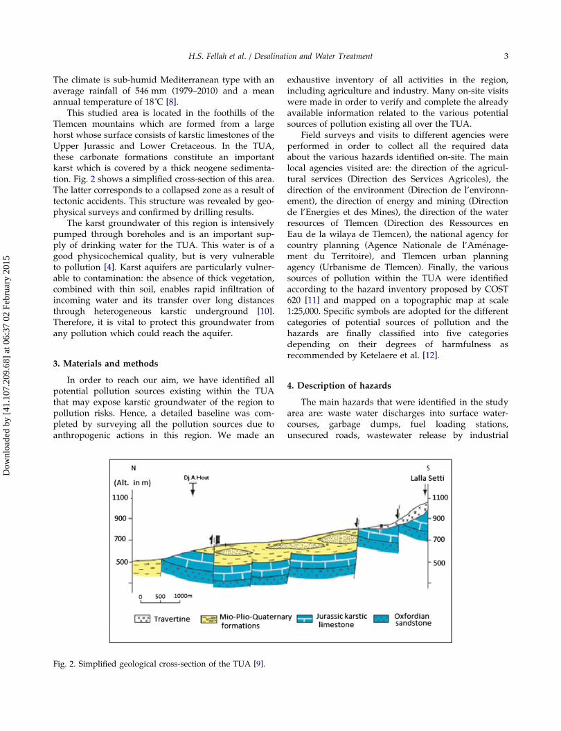
4.2.1. Wastewater discharges
Among the potential sources of pollution, we canmention many wastewater discharges that should betreated but are still untreated up to the present day.The only sewage treatment plant of the TUA is locatedin A. El Hout. 66 discharge points of domestic andindustrial wastewaters through the territory of theTUA were recorded in 2012 [8]. These dischargepoints are in very bad conditions as shown in Fig. 3
Table 1Contaminated water supply points
Water supply point (see location on Fig. 1) TypeReasons for shutting down the waterpoints
Year ofshuttings
Koudia (F1) Borehole High level of nitrates (70 mg/L) andbacterial contamination
2005
Birouana (F2) Borehole Green colored water with bad smell andbacterial contamination
2005
A. Defla (F3) Borehole High level of nitrates (83 mg/L) 2007Oudjlida (F4) Borehole Bacterial contamination (Coliformes &
Escherichia coli)A. Bendou (S1) Spring High level of nitrates (110 mg/L) 2007A. Mokdad (S2), A. Kobet El Djouz (S3), A. El Ancor
(S4), A. El Houtz (S5)Springs High level of nitrates (64–104 mg/L) 2013
A. Sidi El Haloui (S7), A. Karadja (S6), A. SidiLahcen (S8), A. Dar Dbagh1 (S9)
Springs Bacterial contamination (Coliformes &Escherichia coli)
2014
4 H.S. Fellah et al. / Desalination and Water Treatment
Dow
nloa
ded
by [
41.1
07.2
09.6
8] a
t 06:
37 0
2 Fe
brua
ry 2
015
and their number is continuously increasing. In thecontext of environmental protection programs, awastewater treatment plant, using activated sludge, ofa capacity of 384,000 E/H is under construction in thecity of Hennaya [13]. In spite of this effort towardsbetter management of wastewater, there still remainsome ejections from illegal and precarious neighbor-hood that cannot be connected to the sewage network.
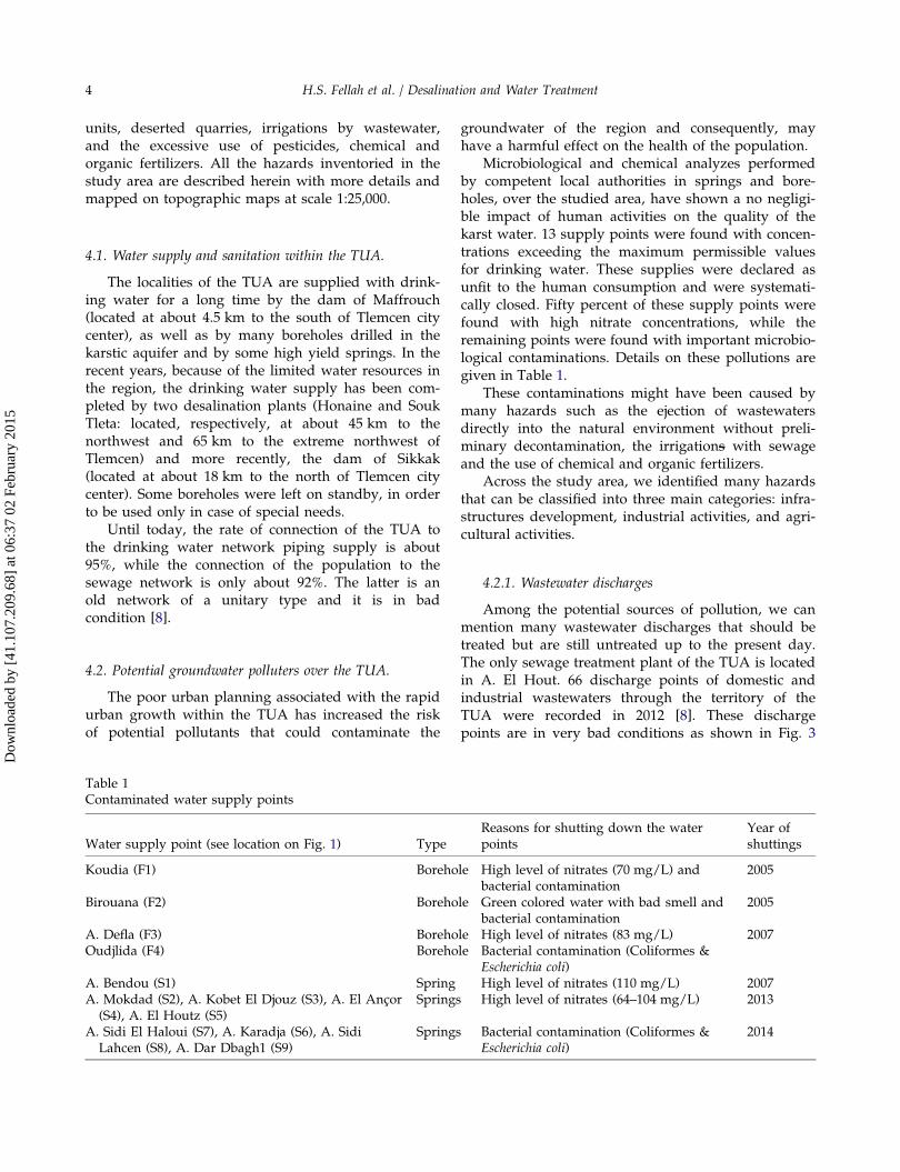
4.2.2. Solid waste material
Solid waste material is one of the major problemscaused by urbanization. It represents a risk to bothhuman health and the environment. In the TUA,domestic household wastes are estimated at about0.5 kg/inhab/d, equivalent to nearly 54,700 tons/year[13]. These unsorted wastes are directly transported tothe sanitary landfill of Saf Saf and partly incineratedwith no further consideration for their deleteriouseffects on the environment. Moreover, our investiga-tion led to the identification of unauthorised garbagedumps in the studied area, such as the site of Koudia(Fig. 4) or the site of Sidi Abderrahmane located in the
town of Beni Mester. The latter occupies today an areaof two hectares and is in continuous expansion.
4.2.3. Fuel loading stations
We have inventoried 12 fuel loading stationsthrough the TUA (Including car wash and oil replace-ment services), which generate high quantities of usedoils (13,000 L/month). These oils are stored in barrelsthat are in principle recovered by NAFTAL (Nationalmarketing company of petrochemical products) [8].However, due to insufficient application of existingsafety guidelines regulating their handling duringstorage and transportation, they remain a danger forthe environment, and particularly, for the highly vul-nerable karst groundwater.
4.2.4. Traffic
Within the TUA, the roads network is varied,dense, and characterized by a high rate of trafficaccidents exposing the environment to a non-negligiblepollution risk during transportation of hazardous prod-ucts such as petrochemical substances. These accidentsmay be a real risk of pollution to the groundwater ofthe region, since only few roads in the TUA have regu-lar roadside channels to collect and drain off meteoricwaters (Fig. 5). Regarding the majority of roadways,dirt is directly washed off underground.
4.2.5. Wastewater release by industrial units
The existence of heavily polluting industries inwholly urbanized regions of the TUA is one of themost important sources of pollution that must be seri-ously taken into consideration. The wastewaters ofthese industries, which contain toxic chemical sub-stances and heavy metals, are very often throwndirectly into the natural environment without pretreat-ment. For instance, SOITEX (textile plant) discharges
Fig. 3. Examples of wastewater discharges within the TUA (photograph by H.S. Fellah, 2012).
Fig. 4. Wild dumpsite of Koudia (photograph by H.S. Fellah,2012).
H.S. Fellah et al. / Desalination and Water Treatment 5
Dow
nloa
ded
by [
41.1
07.2
09.6
8] a
t 06:
37 0
2 Fe
brua
ry 2
015

255 m3/d of wastewater directly in Sikkak River(Fig. 6) [13,14]. Indeed, not all the industrial plants inthe region are equipped with individual pretreatment
systems. The few units equipped with pretreatmentsystems record frequent failures and then, reject theirwastewaters directly into natural watercourses.
4.2.6. Quarries
The territory of the TUA contains several quarriesfor the production of aggregates. They generate largeamounts of waste oil from mechanical devices, operat-ing at these quarries. More than 5,400 L of waste oil aremanipulated each year by various engines of the quar-ries located within the TUA [14]. In addition, whenquarries are deserted, they are often transformed to ille-gal dumping sites, to throw all kinds of products andbecome a dangerous source of pollution (like forinstance the old quarry of Ain el Houtz, Fig. 7). Otherabandoned quarries are being transformed into lakes ofstagnant waters which can be a real risk of pollution tothe groundwater. We cite, for instance, the quarry ofOudjlida (Fig. 7) which is situated on an outcrop of
Fig. 5. Traffic on a ring road of the TUA (photograph byF. Bensaoula, 2013).
Fig. 6. Wastewater of SOITEX (photographs by H.S. Fellah, 2012).
Fig. 7. Abandoned quarries of Ain El Hout (left) and Oujlida (right) (photographs by M. Adjim, 2013).
6 H.S. Fellah et al. / Desalination and Water Treatment
Dow
nloa
ded
by [
41.1
07.2
09.6
8] a
t 06:
37 0
2 Fe
brua
ry 2
015
limestone karst area and hence can be favorable for theinfiltration of stagnant waters which are often a mixtureof storm waters and wastewaters.
4.2.7. Agricultural activities
Although the practice of irrigation with wastewateris prohibited by law, it is still fraudulently practicedin our study area. During the year 2012, more than 47ha were irrigated with such non-conventional waters[15]. In addition to this dangerous source of pollution,it is worth mentioning the excessive and uncontrolleduse of pesticides, chemical, and organic fertilizers. Wealso mention the practice of sheep, cattle, and poultryfarming in the municipality of Beni Mester, which isof an agricultural vocation. However, the informationin the exact locations of the breeding areas on thisregion was not available, and we took into consider-
ation in our study, only the wastes resulting from thisactivity and which are evacuated to the dumping ofSidi Abderahmane. Thus, the production of largeamounts of nitrogenous waste resulting from thisactivity should be managed with great care.
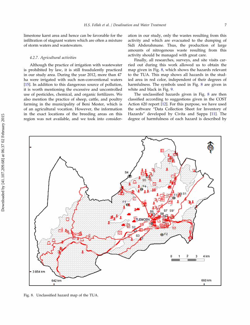
Finally, all researches, surveys, and site visits car-ried out during this work allowed us to obtain themap given in Fig. 8, which shows the hazards relevantto the TUA. This map shows all hazards in the stud-ied area in red color, independent of their degrees ofharmfulness. The symbols used in Fig. 8 are given inwhite and black in Fig. 9.
The unclassified hazards given in Fig. 8 are thenclassified according to suggestions given in the COSTAction 620 report [12]. For this purpose, we have usedthe software “Data Collection Sheet for Inventory ofHazards” developed by Civita and Sappa [11]. Thedegree of harmfulness of each hazard is described by
Fig. 8. Unclassified hazard map of the TUA.
H.S. Fellah et al. / Desalination and Water Treatment 7
Dow
nloa
ded
by [
41.1
07.2
09.6
8] a
t 06:
37 0
2 Fe
brua
ry 2
015
the hazard index (Hi), which is estimated by thefollowing formula [12]:
Hi ¼ H �Qn � Rf
where H is the weighting value of each hazard whichcould vary from 10 to 100, depending on the toxicityas well as on the properties regarding solubility andmobility of the pollutant to be assessed. Qn is theranking factor which may vary between 0.8 and 1.2.This factor enables the comparison between hazardsof the same type by the estimation of the relativequantity that can be released. The reduction factor (Rf)can be assigned a value between 0 and 1, dependingon the likelihood of a contamination event to occurwith respect to the specific hazard. This parametertakes into consideration factors like technical status orlevel of maintenance. Finally, the possible range of thehazard index Hi runs from 0 to 120 scores. This rangeis divided into five Hazard Index Classes which areassigned different colors as shown in Table 2.
The classified hazard map obtained by followingthe above-described procedure is given in Fig. 10. Thesymbols used in this map are the same as those givenin Fig. 9. The hazards found in the studied area repre-sent Hazard Index Classes ranging from very low tohigh hazard. There exist six industrial plants, all
categorized as having a high hazard level. Areas irri-gated by wastewater, fuel loading stations, and 92.4%of wastewater rejections are categorized as having a“Moderate” hazard level. The rest of the hazards areranging from low to very low hazard level.
This map shows clearly that the pollution sourcesas well as the polluted boreholes and springs arespread nearly all over the study area. The bacterialcontamination in the boreholes and springs may beeliminated by implementing protection perimeters.However, this is not always possible for the pollutionby nitrates. Nitrate concentrations are very high insome water points and it is evident to believe that theorigin of this pollution is due to both the ejection ofwaste waters directly into watercourses without treat-ment and to various agricultural activities.
Systems for treatment of wastewaters should bemade mandatory in each industrial factory whetherthey are handling poultry and cattle slaughters ordevoted to oil works. Consequently, it is necessary tomanage efficiently the release of wastewaters in thenatural environment by the realization of new treat-ment plants equipped with adequate channels toensure the safe transport of these waters and theirreuse in other appropriate fields such as in agriculture.
In regions of high hydraulic conductivity, theroads network of the studied area may present apotential risk of pollution in the event of accidentaldischarges of petrochemical products transported bytankers.
We have also inventoried the existence of a hydro-carbon depot in an urban area in the vicinity of agri-cultural fields where the groundwater is very close tothe soil surface. Hydrocarbon leaks in such placeswould present a serious risk of pollution of thegroundwater. In general, petrol stations may have asignificant impact of pollution for the groundwaterresources. Therefore, inspecting regularly all thehydrocarbons tanks would help prevent leakagethreats or any other accident within these stations.
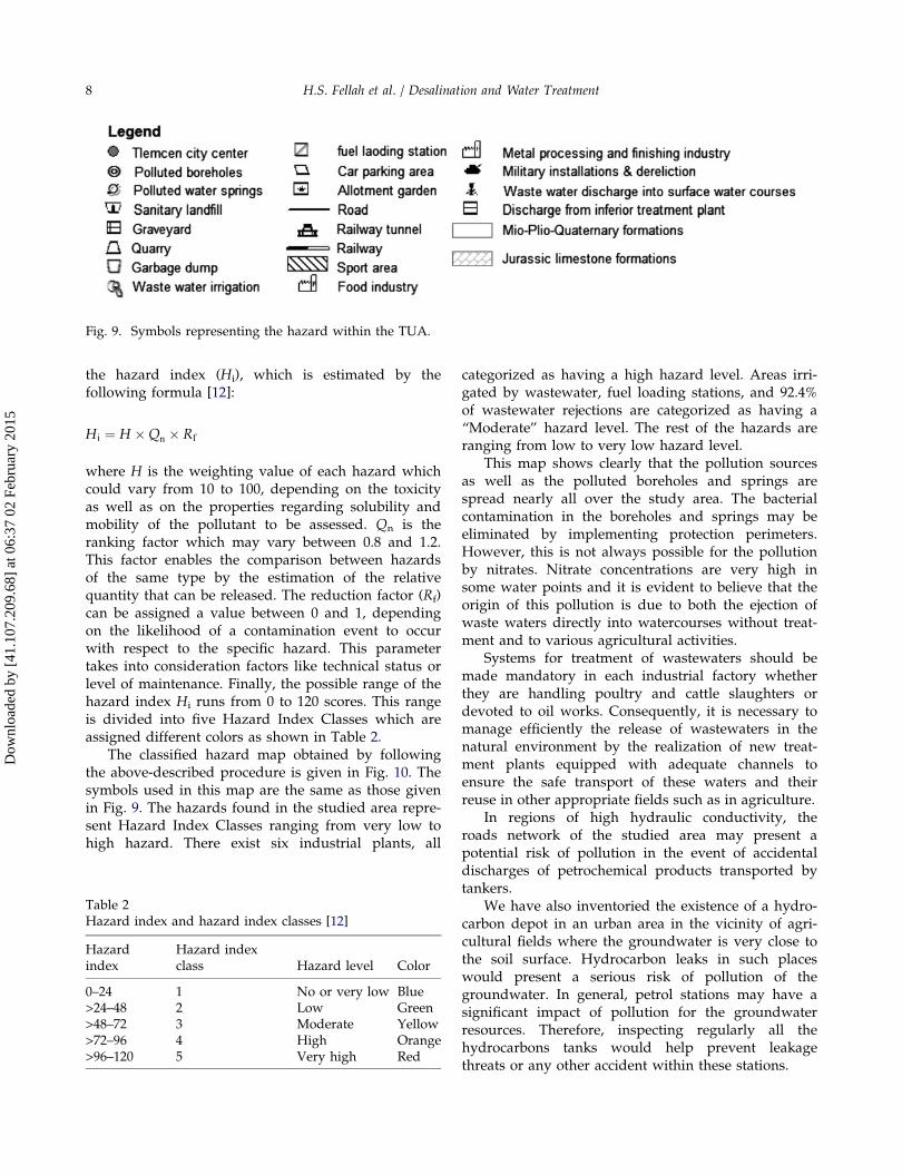
Fig. 9. Symbols representing the hazard within the TUA.
Table 2Hazard index and hazard index classes [12]
Hazardindex
Hazard indexclass Hazard level Color
0–24 1 No or very low Blue>24–48 2 Low Green>48–72 3 Moderate Yellow>72–96 4 High Orange>96–120 5 Very high Red
8 H.S. Fellah et al. / Desalination and Water Treatment
Dow
nloa
ded
by [
41.1
07.2
09.6
8] a
t 06:
37 0
2 Fe
brua
ry 2
015
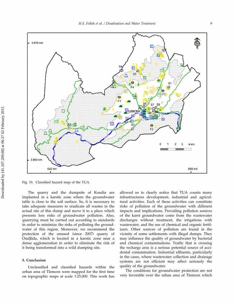
The quarry and the dumpsite of Koudia areimplanted in a karstic zone where the groundwatertable is close to the soil surface. So, it is necessary totake adequate measures to eradicate all wastes in theactual site of this dump and move it to a place whichpresents less risks of groundwater pollution. Also,quarrying must be carried out according to standardsin order to minimize the risks of polluting the ground-water of this region. Moreover, we recommend theprotection of the unused (since 2007) quarry ofOudjlida, which is located in a karstic zone near adense agglomeration in order to eliminate the risk ofit being transformed into a wild dumping site.
5. Conclusion
Unclassified and classified hazards within theurban area of Tlemcen were mapped for the first timeon topographic maps at scale 1:25,000. This work has
allowed us to clearly notice that TUA counts manyinfrastructures development, industrial and agricul-tural activities. Each of these activities can constituterisks of pollution of the groundwater with differentimpacts and implications. Prevailing pollution sourcesof the karst groundwater come from the wastewaterdischarges without treatment, the irrigations withwastewater, and the use of chemical and organic fertil-izers. Other sources of pollution are found in thevicinity of some settlements with illegal dumps. Theymay influence the quality of groundwater by bacterialand chemical contaminations. Traffic that is crossingthe recharge area is a serious potential source of acci-dental contamination. Industrial effluents, particularlyin the cases, where wastewater collection and drainagesystems are not efficient may affect seriously thequality of the groundwater.
The conditions for groundwater protection are notvery favorable over the urban area of Tlemcen which
Fig. 10. Classified hazard map of the TUA.
H.S. Fellah et al. / Desalination and Water Treatment 9
Dow
nloa
ded
by [
41.1
07.2
09.6
8] a
t 06:
37 0
2 Fe
brua
ry 2
015
is densely inhabited and threatened by diverse typesof hazards. Also, the actually existing groundwaterpollution monitoring points are very scarce and maynot reflect the real impact of the various pollutersinventoried all over the studied region. The classifiedhazard map realized in this work may fairly help forthe protection of the karst groundwater. Hence, theestablishment of a risk map could be more helpful tothe local authorities: it would render more efficientthe protection of the vital groundwater of the regionand the related operations. The establishment of sucha map is the aim of further work.
Acknowledgments
This work would have never been possible withoutthe valuable help of various Tlemcen local institutions,particularly: the direction of the agricultural services,the direction of the environment, the direction ofenergy and mining, the direction of the waterresources, the direction of the environment, thenational agency for country planning, and Tlemcenurban planning agency. We would like to express ourheartfelt gratitude and thanks to all the staff of theseinstitutions who gave us help and assistance in carry-ing out this work. We also acknowledge the reviewersfor their constructive criticisms that helped to improvethe content and the clarity of the manuscript.
References
[1] N. Goldscheider, Karst groundwater vulnerabilitymapping: Application of a new method in the Swa-bian Alb, Germany, Hydrogeol. J. 13 (2005) 555–564.
[2] F. Bensaoula, M. Adjim, M. Bensalah, L’importancedes eaux Karstiques dans l’approvisionnement en eaude la population de Tlemcen (Importance of karstwater supply to the population of Tlemcen), Larhyss J.6 (2007) 57–64.
[3] F. Bensaoula, Karstification, hydrogeologie et vulnerab-ilite des eaux karstiques. Mise au point d’outils pourleur protection (application aux monts de Tlemcen)(Karstification, hydrogeology and vulnerability ofkarst water. Development of tools for their protection(application to the Mounts of Tlemcen)), DoctoralThesis, Tlemcen University, Algerie, 2006.
[4] F. Bensaoula, M. Bensalah, Cartographie de lavulnerabilite des eaux karstiques de la region deTlemcen (Algerie), Adaptation et application de l’ap-proche europeenne (Vulnerability mapping of karst
water of the region of Tlemcen (Algeria), Adaptationand application of the European approach), Bulletind’Hydrogeologie, University Neuchatel, Edition PeterLang 22 (2007) 59–76.
[5] N. Doerfliger, F. Zwahlen, Guide pratique: Cartogra-phie de la vulnerabilite en regions karstiques (EPIK)(Practical guide: Groundwater vulnerability mappingin karstic regions (EPIK)), Office federal de l’environn-ement des forets et des paysages (OFEFP), Bern, 1998.
[6] F. Bensaoula, M. Adjim, H. Adjim, Les perimetres deprotection des eaux souterraines et les difficultesd’application du code des eaux. Cas de la wilaya deTlemcen (Groundwater protection perimeters and thedifficulties in applying the water code. Case study ofthe wilaya of Tlemcen), Colloque International: Oasis,Eau et Population, Biskra (Algerie), September 2003.
[7] URBAT, Plan d’Occupation de Sol de Chetouane (Che-touane land use plan), P.O.S UB 15, Phase finale, doc-ument viewed in the direction of the water resourcesof the wilaya of Tlemcen, 2010.
[8] H.S. Fellah, Cartographie de vulnerabilite et du risquede pollution des eaux souterraines dans le groupe-ment urbain de Tlemcen (Vulnerability and risk map-ping of groundwater pollution in Tlemcen urbanarea), Master in Hydraulic, University of Tlemcen,Algeria, 2012.
[9] F. Bensaoula, Etude de la karstification a partir desdonnees de forages : le cas des monts de Tlemcen(Algerie) (Study of karstification from borehole data:The case of the Tlemcen mountains (Algeria)), Karsto-logia 49 (2007) 15–24.
[10] N. Ravbar, Karst aquifer hazard assessment and map-ping on the Classical Karst, Acta Geograph. Slovenica46(2) (2006) 169–189.
[11] F. Zwahlen (Ed.), Vulnerability and Risk Mapping forthe Protection of Carbonate (Karst) Aquifers, FinalReport (COST Action 620), Europeen commission,EUR 20912, Universite Neuchatel, 2004, pp. 297.
[12] D.D. Ketelaere, H. Hotzl, C. Neukum, M. Civita, G.Sappa, Hazard Mapping, Vulnerability and Risk Map-ping for the Protection of Carbonate (Karst) Aquifers,Final Report (COST action 620), Universite Neuchatel2004, pp. 86–104.
[13] ANAT, Plan d’Amenagement du Territoire de la Wi-laya de Tlemcen (Spatial planning of the wilaya ofTlemcen), First phase, Report viewed in the directionof the water resources of the wilaya of Tlemcen, 2010.
[14] ABAK, Etude de plan de gestion des dechets speciauxde la wilaya de Tlemcen (Study of special waste man-agement for the wilaya of Tlemcen), Rapport 2, Mis-sion A, Report viewed in the direction of theenvironment, 2007.
[15] DSA, Rapport sur l’irrigation avec les eaux usees dansla wilaya de Tlemcen (Report on irrigation withwastewater in the wilaya of Tlemcen), Documentviewed in Direction of Agricultural Services, 2012.
10 H.S. Fellah et al. / Desalination and Water Treatment
Dow
nloa
ded
by [
41.1
07.2
09.6
8] a
t 06:
37 0
2 Fe
brua
ry 2
015
Related Documents