1 www.jrc.ec.europa.eu Serving society Stimulating innovation Supporting legislation IACS & SDIs Synergies and Benefits Baveno, October 15, 2013 Katalin TÓTH Objectives of this presentation Walk through some elements of EU legislation and policy actions to see • CAP and Environmental policies of the EU share common aspects • IACS can benefit from SDIs and INSPIRE • The potential and framework for further convergence

Welcome message from author
This document is posted to help you gain knowledge. Please leave a comment to let me know what you think about it! Share it to your friends and learn new things together.
Transcript

1
www.jrc.ec.europa.eu
Serving society
Stimulating innovation
Supporting legislation
IACS & SDIsSynergies and Benefits
Baveno, October 15, 2013
Katalin TÓTH
Objectives of this presentation
Walk through some elements of EU legislation and policy actions to see
• CAP and Environmental policies of the EU share common aspects
• IACS can benefit from SDIs and INSPIRE
• The potential and framework for further convergence

2
CAP is spatialCAP is spatial
3
Council regulation 73/2009
• Preamble (12)
• Particular situation of outermost regions
• Montainous terrain
• Art. 15 and 17
• Identification system for agricultural parcels (on the basis of maps, land registers, other
cartographic documents)
• Computerised geographical information system techniques preferably with aerial/spatial
orthoimagery
• Equivalent accuracy of 1:10 000 scale
• Art. 19
• Graphics indicating the area and position of olive trees
• Art. 20
• Usage of Remote Sensing and GNSS in verifying eligibility
• Art. 124
• Utilised agricultural area (arable land, permanent grassland, permanent crops, kitchen gardens)
• Minimum size of eligible area4

3
Commission regulation 1122/2009
• Preamble (7) (46) (48) (77)
• Use of GIS with data in necessary level of details
• Define the acceptable width of certain features of the field
• Lay down the conditions of using remote sensing
• Art. 2 and 6
• Agricultural parcel: continuous area of land … one single crop group
• Use: area in terms of crop types or ground cover
• Reference parcel: geographically delimited area retaining unique identification (cadastral parcel
or production block)
• National coordinate reference system
• Correct quantification of eligible area
• Art. 12
• Particulars of agricultural parcels in the application: identification, area, location, use, irrigation
• Art. 34
• Details of area determination (tolerance of measurements, taking into account the landscape
elements)5
CAP is environmentalCAP is environmental
6

4
Council regulation 73/2009
• Preamble (9)
• Water management and protecting biodiversity
• Preamble (12)
• Climat constraints
• Preamble (30)
• Afforestation under national schemes
• Art. 5 (Statutory management requirements based on Annex II)• protection of wild birds, of ground waters, waters, natural habitats of flora and fauna
• Art. 6 (Good agricultural and environmental conditions specified by MS/Regions based on Annex III)• soil erosion, organic matter and structure
• min. level of maintenace comprising landscape features
• maintenance/protection of permanent pasture
• Protection and management of water (buffer strips, irrigation)
7
Environment for IACSEnvironment for IACS
8

5
Integrated Administration and Control System
9
?• How is it now?
Spaitial enough?
•Intrinsic spatial component with defined information content (LPIS)•Data from aid applications•MS may include information system for olive calculation•Does not sufficiently support some spatial aspects (montainous terrain, slopes)
Environmental
enough?
•MS shall establish a system guaranteeing an effective control of cross complience•Details not regulated, limited information content (landscape features)
?• How to develop further?
Collect new or choise existing?
10
Collect new
Get exactly what is needed
- According to own specifications- no trouble with deployment of data
Might be expensive:
- technology demanding- (other) data/service dependent- time consuming
Updates might be complicated
no expertise in following the life cycle and the related legal/buisness proceses
Might be not compliant with regulation (best practices)
Ban for collecting data what is available in public administration
Reuse existing
Current data from competent authorities
Might be challangig
- to find what is neded- to face information fragmentation- understand usability of data
Getting data might be complicated
- restrictions in access and use- royalties- liabilities
Data does not fit together
- semantic inconsistency- inconsistent spatial representation- incompatible encodings (formats)

6
Spatial Data Infrastructures
11
What? Why? Which?
SDIs encapsulate policies, institutional and legal arrangements, technologies, and data that enable sharing and effective usage of geographic information
Expected output: interoperability•better accessibility•harmonisation of semantics and spatial representations•consistent data regardless of source
Can be subdivided based on geographic and /or thematic scope•Global, national, regional , local•Environment, transport, etc.
12

7
INSPIRE• Directive 2007/2/EC (INSPIRE) Directive lays
down general rules to establish an Infrastructure for Spatial Information in Europe for the purposes of Community environmental policies and policies or activities which may have an impact on the environment
• INSPIRE is built on the SDIs established and operated by the Member States
• Even though there is no obligation for new data collection, it is a strong trigger for the MS to develop national SDIS and share data in interoperable way and according pre-defined conditions
13
Structure and organisation• Directive 2007/2/EC (INSPIRE): legal framework and general provisions
• Commission Regulations (Implementing Rules, IR): mandatory technical requirements1. Metadata 2. Interoperability of spatial data sets and services3. Services (discovery, view, download, transformation, invoke)4. Data and Service sharing (policy)5. Monitoring & reporting
• Guidelines for voluntary implementation (for each component)
• Operational elements1. Registers/registries2. Geoportal
• Organisational measures1. INSPIRE Committe2. Expert groups (drafting teams, thematic working groups, maintenace and
implementation group)14
8
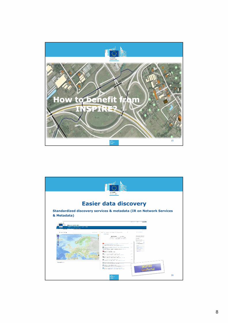
How to benefit from INSPIRE?
How to benefit from INSPIRE?
15
Easier data discovery
16
Standardized discovery services & metadata (IR on Network Services
& Metadata)

9
17
Comprehensive data inventoryMonitoring & Reporting IR
http://inspire.jrc.ec.europa.eu/index.cfm/pageid/182
18
Rules for data sharing
• IR on Data and Service Sharing:conditions of access to spatial data sets and services from Member States by the institutions and bodies of the Community
• Non binding guidelines and documents: model contracts, framework agreements and examples of good practice related to sharing within and between Member States
http://inspire.jrc.ec.europa.eu/index.cfm/pageid/62

10
19
Easier data access• Standardized view, download and transformation (IR on Network
Services)
20
Easier data use
• Facilitate data use and interoperability by adopting common cross-domain models to exchange data (IR on Data Interoperability)

11
Collaboration
• What has already been done?
• Shared technical solutions (standard and model driven approach, notation, data encoding, conformance testing,)
• Collaboration in overlapping themes (specification development in cadastral parcels, orthoimagery, land cover, land use, agricultural facilities)
• Potential for future
• Extending INSPIRE core models according to the requirements of IACS • Combining data from IACS and INSPIRE in GIS analysis• Make use of operational components for
• Registers for promoting interoperability (Feature concept dictionary, glossary, code lists)
• Sharing/publishing information (code lists, geoportal)• Reuse the element of the INSPIRE Generic Conceptual Framework for
documening LPIS core model 21
Thematic fields addressed by INSPIRE
Annex I1. Coordinate reference
systems
2. Geographical grid systems
3. Geographical names
4. Administrative units
5. Addresses
6. Cadastral parcels
7. Transport networks
8. Hydrography
9. Protected sites
Annex II1. Elevation2. Land cover3. Ortho-imagery4. Geology
Annex III
1. Statistical units
2. Buildings
3. Soil
4. Land use
5. Human health and safety
6. Utility and governmental services
7. Environmental monitoring facilities
8. Production and industrial facilities
9. Agricultural and aquaculture facilities
10.Population distribution –demography
11. Area management/ restriction/regulation zones & reporting units
12. Natural risk zones
13. Atmospheric conditions
14. Meteorological geographical features
15. Oceanographic geographical features
16. Sea regions
17. Bio-geographical regions
18. Habitats and biotopes
19. Species distribution
20. Energy Resources
21. Mineral resources
Areas of “quick win” for IACSPotentially beneficiary themes
12
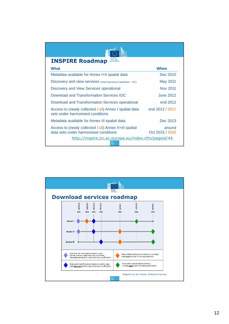
What When
Metadata available for Annex I+II spatial data
Discovery and view services (Initial Operating Capabilities - IOC)
Discovery and View Services operational
Download and Transformation Services IOC
Download and Transformation Services operational
Access to (newly collected / all) Annex I spatial data sets under harmonized conditions
Metadata available for Annex III spatial data
Access to (newly collected / all) Annex II+III spatial data sets under harmonized conditions
Dec 2010
May 2011
Nov 2011
June 2012
end 2012
end 2012 / 2017
Dec 2013
around Oct 2015 / 2020
http://inspire.jrc.ec.europa.eu/index.cfm/pageid/44
INSPIRE Roadmap
Download services roadmap
Diagram by Ian James, Ordnance Survey

13
Framework for synergies: e-Government
Is it relevant?
• Practice of the Member States
• electronic systems for submitting aid applications and/or locating parcels
• geoportals for sharing information connected to location
• ideally these initiatives are part of national eGovernmant strategies
• European Interoperability
Framework (EIF) is a set of recommendations which specify how Administrations, Businesses and Citizens communicate with each other within the EU and across Member States borders
26

14
The ISA programme• Interoperability Solutions for European
Public Administrations
• Contributes to the e-Government Action Plan 2011-2015 and the Digital Agenda for Europe of Europe 2020 by supporting multi-sector interoperable cross-border e-services and resources to help share and reuse them
• Creates a framework that allows efficient and effective electronic cross-border public services for the benefit of citizens and business (interoperable electronic public services).
• Two relevant initiatives:• Action 1.17 – ARe3NA
• Action 2.13 – EULF27
ISA Action 1.17
28
Interoperability
Openness Reuse Collaboration
… sharing reusable components for INSPIRE implementation and interoperability in cross-border/cross-sector contexts.

15
Focus of ARe3NA
29
Input for components not sufficiently addressed so far:
• Registers/registiries• Data sharing - GeoRM
European Union Location Framework
• Action 2.13 is a strategic framework of standards, case studies, guidelines and actions to • realise the potential of location information in Europe,• improve the way how location information is used in MS e-
Government services, • achieve a more aligned approach in policy areas,• establish interoperability and re-use of data, and services, based on
INSPIRE. • Focus areas:
• Policy and strategy alignement• E-Government integration (through best practices)• Standardisation and interoperability (ICT and GI)
• Envisaged pilots• Policies on transport, marine, agriculture• Results may influence INSPIRE maintenace
30

16
Policy and Strategy Alignment:
Consistent EU and Member States policy and legislative approach
Cost Benefit Focus:
Building compelling impact assessments and business cases
e-Government Integration:
Location becomes a key enabler in e-Government systems
Standardization and Interoperability:
Guidance on standards and technologies for interoperability and re-use
Committed Partnerships:
Fostering a highly collaborative community to share and adopt best practices
EULF Strategic Vision V0
• Sets the strategic direction of what the EULF will achieve in the next few years.
• Identifies the relevant stakeholders within ISA, INSPIRE, other EU institutions, Member States, Interest Groups and Communities, and associated projects.
32
http://ec.europa.eu/isa/actions/documents/isa-2.13_eulf-strategic-vision-lite-v0-3_final_en.pdf

17
EULF Approach
EULF Study EULF Study Extension? EULF Implementation?
Focus Areas EULF Study Focus Areas EULF Focus Areas for possible future analysis and action
Policy Domains
tbd? tbd? tbd? tbd? tbd?
2012 2013 2014 2015 2016 2017 2018…
Supporting additional policy domains?
Deliverables
Transport and Marine(tbc) Pilots
Summary1.Spatial infromation is increacingly used
2.There is a natural demand for re-using
spatial information which has triggered the
establishemnts of SDIs
3.Sectorial SDIs are converging and being
integrated with mainstream interoperability
solutions for eGovernment
4.IACS is itegral part of Memeber States’
eGovernment services
5.Environement has been the pioneering
European policy area for SDI development
6.IACS can benefit for existing (environement
focused) SDIs and may benefit even more …
…when the relevant European initiatives in the pipeline are developing in the „right” direction
34
…and conclusion
Influence

18
35
https://joinup.ec.europa.eu/community/eulf/description
http://inspire-forum.jrc.ec.europa.eu/pg/groups/228519/european-union-location-framework-the-study/
https://twitter.com/EULocation#EULF
https://plus.google.com/100280377126827598572/posts
http://ec.europa.eu/isa/actions/02-interoperability-architecture/2-13action_en.htm
https://joinup.ec.europa.eu/community/are3na/description
http://inspire-forum.jrc.ec.europa.eu/pg/groups/120868/a-reusable-inspire-reference-platform/
http://ec.europa.eu/isa/actions/01-trusted-information-exchange/1-17action_en.htm
#ARe3NA
INSPIRE Maintenace and Implementation Framework and Groups:http://inspire.jrc.ec.europa.eu/index.cfm/pageid/5160
36
Thank you!
The author thankfully acknowledges the contribution of the colleagues from H6 - Digital Earth and Reference Data Unit
Related Documents