Preview Draw an outline map of Monsoon Asia in the box to the right. Add a compass rose to your map, showing north, south, east, and west. Add these items if you know their location: the equator, major bodies of water, large mountains, and key countries. Vocabulary Draw a line between the vocabulary term and its definition. In the space next to each definition, draw a picture that represents the term. compass rose equator peninsula plateau a high, flat landform that rises sharply from the land around it a diagram on a map that shows directions such as north, south, east, and west a long, narrow stretch of land that is surrounded by water on three sides an imaginary line that circles the earth and divides the earth into the northern hemisphere and the southern hemisphere Monsoon Asia INTERACTIVE STUDENT NOTEBOOK © Teachers’ Curriculum Institute Mapping Monsoon Asia 1

Welcome message from author
This document is posted to help you gain knowledge. Please leave a comment to let me know what you think about it! Share it to your friends and learn new things together.
Transcript

P r e v i e w
Draw an outline map of Monsoon Asia in the box to the right.
Add a compass rose to your map, showing north, south, east, and west. Add these items if you know their location: the equator, major bodies of water, large mountains, and key countries.
V o c a b u l a r y
Draw a line between the vocabulary term and its definition. In the space next to each definition, draw a picture that represents the term.
compass rose
equator
peninsula
plateau
a high, flat landform that rises sharply from the land around it
a diagram on a map that shows directions such as north, south, east, and west
a long, narrow stretch of land that is surrounded by water on three sides
an imaginary line that circles the earth and divides the earth into the northern hemisphere and the southern hemisphere
Monsoon Asia
I N T E R A C T I V E S T U D E N T N O T E B O O K
© Teachers’ Curriculum Institute Mapping Monsoon Asia 1

M a p p i n g M o n s o o n A s i a ’ s P h y s i c a l F e a t u r e s
Label the map below with the following physical features: Bay of Bengal, Chang Jiang (Yangtze River), Deccan Plateau, Ganges River, Gobi Desert, Himalayas, Huang He (Yellow River), Java, Malay Peninsula, Mekong River, Mount Everest, Philippine Sea, Plateau of Tibet, Sea of Japan (East Sea), and Taklamakan Desert.
Tropic of Cancer
Tropic of Capricorn
20°N
30°N
40°N
50°N
60°N
10°N
0° Equator
20°S
10°S
Tropic of Cancer
Tropic of Capricorn
20°N
30°N
40°N
50°N
10°N
0° Equator
20°S
30°S
10°S
30°S 80°E70°E 90°E 100°E 110°E 120°E 130°E 140°E
130°E 140°E 150°E
150°E
160°E
120°E110°E100°E90°E80°E70°E60°E
60°E
N
S
EWLambert Azimuthal Equal-Area projection0 1,000 kilometers
0 1,000 miles
500
500
TCI5 562GA_LM_07-CH-1.epsFirst proof
INDIANOCEAN
PACIFICOCEAN
I N T E R A C T I V E S T U D E N T N O T E B O O K
© Teachers’ Curriculum Institute Mapping Monsoon Asia 2
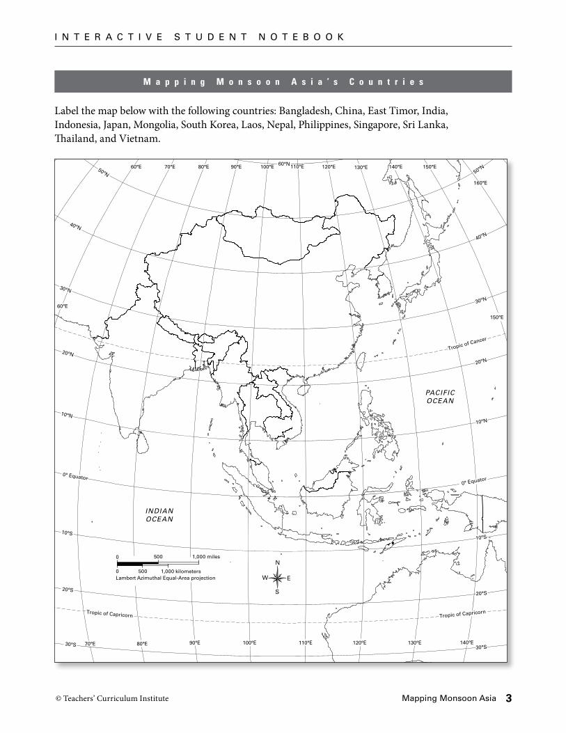
Label the map below with the following countries: Bangladesh, China, East Timor, India, Indonesia, Japan, Mongolia, South Korea, Laos, Nepal, Philippines, Singapore, Sri Lanka, Thailand, and Vietnam.
Tropic of Capricorn
20°N
30°N
40°N
50°N
60°N
10°N
0° Equator
20°S
10°S
Tropic of Cancer
Tropic of Capricorn
20°N
30°N
40°N
50°N
10°N
0° Equator
20°S
30°S
10°S
30°S 80°E70°E 90°E 100°E 110°E 120°E 130°E 140°E
130°E 140°E 150°E
150°E
160°E
120°E110°E100°E90°E80°E70°E60°E
60°E
INDIANOCEAN
PACIFICOCEAN
N
S
EWLambert Azimuthal Equal-Area projection0 1,000 kilometers
0 1,000 miles
500
500
M a p p i n g M o n s o o n A s i a ’ s C o u n t r i e s
I N T E R A C T I V E S T U D E N T N O T E B O O K
© Teachers’ Curriculum Institute Mapping Monsoon Asia 3

P r o c e s s i n g
Using what you learned in this lesson, draw an outline map of Monsoon Asia in the box below.
Add a compass rose to your map, showing north, south, east, and west. Add these items if you know their location: the equator, major bodies of water, large mountains, and key countries.
Monsoon Asia
I N T E R A C T I V E S T U D E N T N O T E B O O K
© Teachers’ Curriculum Institute Mapping Monsoon Asia 4
Related Documents