274 ..--- Thompson, R.A., 1984. The petrology and geochemistry of the Handkerchief Mesa mix- ed magma complex, San Juan Mountains, Colorado: Late Oligocene and Early Mio- cene volcanism in the Rio Grande rift, Taos Plateau, northern New Mexico. Ph.D. Disser., Southern Methodist Univ., Dallas, TX, 180 pp. (unpubl.). Walker, D., Kirkpatrick, R.J., Longhi, J. and Hays, J.F., 1976. Crystallization history of lunar picritic basalt sample 12002: phllse-equilibria and cooling rate studies. Geol. Soc. Am. Bull., 87: 646---1560. Walker, G.P.L. and Skelhorn, R.R., 1966. Some associations of acid and basic igneous rocks. Earth-Sci. Rev., 2: 93-109. Yoder, H.S., 1973. Contemporaneous basaltic and rhyolitic magmas. Am. Min., 58: 153-171. '\ I I . \ IS-;/. \) Journal of Volcano;IJgy and 26 _ 275 Elsevier Science Publishers B.V., Amsterdam - Printed in The Netherlands GEOCHEMISTRY AND GEOTHERMOMETRY OF SPRING WATER FROM THE BLACKF001.: RESERVOIR REGION, SOUTHEASTERN IDAHO AMY HUTSINPILLER* and W.T. PARRY Department of Geology and Geophysics, University of Utah, Salt Lake City, UT 84112, I U.S.A. I (Received July 31,1984; revised and accepted April 24, 1985) ABSTRACT Hutsinpiller, A. and Parry, W.T., 1985. Geochemistry and geothermometry of spring water from the Blackfoot Reservoir region, southeastern Idaho. J. Volcanol. Geo- thermo Res., 26: 275-296. The Blackfoot Reservoir region in southeastern Idaho is recognized as a potential geo- thermal area because of the presence of several young rhyolite domes (50,000 years old), Quaternary basalt flows, and warm springs. North- to northwest-trending high-angle normal faults of Tertiary to Holocene age appear to be the dominant structural control of spring activity. Surface spring-water temperatures average 14°C except for a group of springs west of the Reservoir Mountains which average 33°C. Chemical geothermometers applied to fifty water samples give temperatures less than 75° C except for eight springs along the Corral Creek drainage. The springs along Corral Creek have Na-K-Ca tempera- tures that average 354° C, a direct result of high potassium concentrations in the water. A correction for carbon dioxide applied to the Na-K-Ca geothermometer lowers the esti- mated temperatures of the anomalous springs to near the measured surface temperatures, and Na-K-Ca-Mg temperatures for the anomalous springs are near 100°C. Mixing model calculations suggest that hot water with a temperature of approximately 120° C may be mixing with cooler, more dilute water in the springs from the Corral Creek drainage, a temperature supported by Na-K-Ca-Mg temperatures and mineral saturation temperature». Stability relations of low-temperature phases in the system indicate that the large con- centrations of potassium in the eight anomalous springs are derived from reactions with the potassium-bearing minerals muscovite and K-feldspar. Carbon dioxide and hydrogen sulfide gases may be derived through the oxidation of organic matter accompanied by tbe reduction of sulfate. Concentrations of major and minor elements, and gases found in springs of the Blackfoot Reservoir region are due to water-rock reactions at temperatures less than 100° C. Based on spring geochemistry, a geothermal reservoir of 100° C up to 120° C may exist at shallow (less than 2 km) depths in the Blackfoot Reservoir region. "Present address: 1201 Searchlite Court, Reno, Nevada 89503 J,

Welcome message from author
This document is posted to help you gain knowledge. Please leave a comment to let me know what you think about it! Share it to your friends and learn new things together.
Transcript
274
..--
Thompson, R.A., 1984. The petrology and geochemistry of the Handkerchief Mesa mixed magma complex, San Juan Mountains, Colorado: Late Oligocene and Early Miocene volcanism in the Rio Grande rift, Taos Plateau, northern New Mexico. Ph.D. Disser., Southern Methodist Univ., Dallas, TX, 180 pp. (unpubl.).
Walker, D., Kirkpatrick, R.J., Longhi, J. and Hays, J.F., 1976. Crystallization history of lunar picritic basalt sample 12002: phllse-equilibria and cooling rate studies. Geol. Soc. Am. Bull., 87: 646---1560.
Walker, G.P.L. and Skelhorn, R.R., 1966. Some associations of acid and basic igneous rocks. Earth-Sci. Rev., 2: 93-109.
Yoder, H.S., 1973. Contemporaneous basaltic and rhyolitic magmas. Am. Min., 58: 153-171.
---,~ '\ ~ I I .".--~--- \ IS-;/. \ )
Journal of Volcano;IJgy and Geothermallt",~earch.26 (l~ovJ _ -~g~ 275 Elsevier Science Publishers B.V., Amsterdam - Printed in The Netherlands
GEOCHEMISTRY AND GEOTHERMOMETRY OF SPRING WATER FROM THE BLACKF001.: RESERVOIR REGION, SOUTHEASTERN IDAHO
AMY HUTSINPILLER* and W.T. PARRY
Department of Geology and Geophysics, University of Utah, Salt Lake City, UT 84112, I U.S.A. I
(Received July 31,1984; revised and accepted April 24, 1985)
ABSTRACT
Hutsinpiller, A. and Parry, W.T., 1985. Geochemistry and geothermometry of spring water from the Blackfoot Reservoir region, southeastern Idaho. J. Volcanol. Geothermo Res., 26: 275-296.
The Blackfoot Reservoir region in southeastern Idaho is recognized as a potential geothermal area because of the presence of several young rhyolite domes (50,000 years old), Quaternary basalt flows, and warm springs. North- to northwest-trending high-angle normal faults of Tertiary to Holocene age appear to be the dominant structural control of spring activity. Surface spring-water temperatures average 14°C except for a group of springs west of the Reservoir Mountains which average 33°C. Chemical geothermometers applied to fifty water samples give temperatures less than 75° C except for eight springs along the Corral Creek drainage. The springs along Corral Creek have Na-K-Ca temperatures that average 354° C, a direct result of high potassium concentrations in the water. A correction for carbon dioxide applied to the Na-K-Ca geothermometer lowers the estimated temperatures of the anomalous springs to near the measured surface temperatures, and Na-K-Ca-Mg temperatures for the anomalous springs are near 100°C. Mixing model calculations suggest that hot water with a temperature of approximately 120° C may be mixing with cooler, more dilute water in the springs from the Corral Creek drainage, a temperature supported by Na-K-Ca-Mg temperatures and mineral saturation temperature».
Stability relations of low-temperature phases in the system indicate that the large concentrations of potassium in the eight anomalous springs are derived from reactions with the potassium-bearing minerals muscovite and K-feldspar. Carbon dioxide and hydrogen sulfide gases may be derived through the oxidation of organic matter accompanied by tbe reduction of sulfate. Concentrations of major and minor elements, and gases found in springs of the Blackfoot Reservoir region are due to water-rock reactions at temperatures less than 100° C.
Based on spring geochemistry, a geothermal reservoir of 100° C up to 120° C may exist at shallow (less than 2 km) depths in the Blackfoot Reservoir region.
"Present address: 1201 Searchlite Court, Reno, Nevada 89503
J,

276 277
INTRODUCTION
The Blackfoot Reservoir region is an area of young rhyolite domes and flows, basalt flows, and thermal springs 75 km southeast of the Snake River Plain, Idaho (Fig. 1). The Snake River Plain, a major volcanic-tectonic feature of western North America, shows a complex pattern of generally high heat flow (Blackwell, 1978), but measurement of the regional heat flow is difficult because of widespread circulation of cold groundwater (Brott et aI., 1981). Measured heat flow is high along the margins of the plain but low in the center because of the influence of the Snake River Plain aquifer. Brott et a1. (1978) have developed a thermal model for the Snake River Plain that is consistent with the history of silicic volcanism and have predicted many active geothermal systems in the eastern Snake River Plain where silicic vol· canism began 0.6-5 m.y. ago.
Silicic volcanism in the Blackfoot Reservoir region is younger than 0.1 m.y. (Armstrong et aI., 1975), and some thermal waters show very high chemical temperatures due to high potassium concentrations (Young and Mitchell, 1973; Mitchell, 1976). The age of silicic volcanism is consistent with the trend of eastward decreasing age observed in the Snake River Plain, and the anomalous chemical temperatures are consistent with the prediction of active geothermal systems associated with young volcanism. The purpose of this report is evaluation of spring-water geochemistry in the Blackfoot Reservoir region. High apparent chemical temperatures and the abundance of CO 2 and H2S are suggestive of a high-temperature component in some springs, which is significant to heat flow models of the area and may be better defined with detailed study of the spring-water geochemistry.
Water samples from forty-five springs and four wells were collected and analyzed for major and minor constituents, and the mineralogy of spring deposit samples was determined. Water chemistry is interpreted in terms of mineral-water equilibria. Temperatures of last water-rock equilibria are estimated from the silica content of the water and the Na-K-Ca geothermom· eter with suitable corrections for carbon dioxide, magnesium, and mixin~
with cooler surface waters. Mechanisms are proposed to explain the presenc~
of gases and the warm temperatures of the springs that involve a thermal component at 120"C or lower.
PREVIOUS GEOLOGICAL STUDIES
The Soda Springs-Blackfoot Reservoir region lies in a transition zone between the Basin and Range province to the west and the Middle Rock)' Mountain physiographic province on the east, approximately 75 km south· east of the Snake River Plain, Idaho (Fig. 1). The eastern province is char· acterized by mountains formed by folding and thrust faulting with a hi~h
proportion of mountains to valleys. The western province is typified by block-faulted mountain ranges separated by wide, deeply filled basins and valleys.
I
J Fig. 1. Index map showing the location of the Blackfoot Reservoir region and regional geology. SRP"'Snake River Plain; B&R"'Basin and Range; MRMts"'Middle Rocky Mountains; SS"'Soda Springs. Key to map patterns: horizontal ruling'" Quaternary and Tertiary age valley fill; checks'" Quaternary and Tertiary age volcanic rocks; unpatterned '" Mesozoic and Paleozoic age rocks.
In the mountain ranges of the Basin and Range portion of the area, tilted and faulted Paleozoic and Triassic sedimentary units are present sometimes overlain by the Pliocene age Salt Lake Formation (Fig. 2). The Middle Rocky Mountain province, which occupies the eastern half of the Blackfoot Reservoir region, consists of upper Paleozoic and Mesozoic sedimentary rocks, of which the most extensively exposed are limestones, dolomites, sandstones, and siltstones of Triassic, Permian, and Pennsylvanian ages. The thickness of the Permian Phosphoria Formation in the Soda Springs area ranges from 75 to 150 m (McKelvey et aI., 1967), and the region contains several active phosphate mines. Small exposures of Salt Lake Formation are found along the flanks of the eastern mountain ranges.
Quaternary basalts are abundant in the Blackfoot Reservoir area, forming the Blackfoot and Willow Creek Lava Fields, exposed extensively in Gem Valley, and as small isolated patches in mountainous regions to the east (Fig. 2). The basalts are contiguous and temporally equivalent to the Snake River Group (Armstrong et al., 1975), but are thought to have come from local vents and fissures. Over two dozen cinder cones and two large lava cones occur in the Blackfoot and Gem Valley fields. Well-preserved flow features and thin soils are indicative of a young age. Samples from Gem Valley and the northern Blackfoot River give dates of 0.1 ± 0.03 m.y. and 0.9 ± 0.25 m.y.,
. respectively (Armstrong et aI., 1975).I Three rhyolite domes (China Hat, Middle Cone and North Cone) at thej southem end of the Blackfoot Reservok are older than the enekcling ba..1t
278 279, 1,1°30
.)-=
Gil
D Basalt
.J m Rhyolite
~ Spring Deposits
o Sedimentory Rocks
o 2 4 6 Miles I "i I' i'
o 2 4 6 8 Km
~
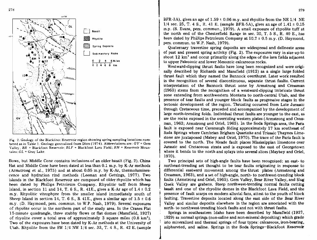
Fill. 2. Geology of the Blackfoot Reservoir region showing spring sampling locations numbered as in Table 1. Geology generalized from Dion (1974). Abbreviations are: GV = Gem Valley; BR = Blackfoot Reservoir; BLF = Blackfoot Lava Field; RM = Reservoir Moun· tains; GL = Gray Lake.
flows, but Middle Cone contains inclusions of an older basalt (Fig. 2). China Hat and Middle Cone have been dated at less than 0.1 m.y. by K-Ar methods (Armstrong et al., 1975) and at about 0.05 m.y. by K-Ar, thermoluminescence and hydration rind methods (Leeman and Gettings, 1977). Two islands in the Blackfoot Reservoir are composed of older rhyolite which has been dated by Phillips Petroleum Company. Rhyolitic tuff from Sheep Island, in section 11 and 14, T. 6 S., R. 41E., gives a K-Ar age of 1.4 ± 0.2 m.y. Rhyolitic vitrophyre from the smaller island immediately south of Sheep Island in section 14, T. 6 S., R 41E., gives a similar age of 1.5 ± 0.6 m.y. (D. Haymond, pers. commun. to W.P. Nash, 1979). Several exposures of rhyolite occur in the northern part of the study area. In the Cranes Flat 15-minute quadrangle, three stubby flows or flat domes (Mansfield, 1927) of rhyolite cover a total area of approximately 3 square miles (0.8 km1
).
Two of the exposures have been dated by K-Ar methods at the University of l1tah. Rhyolite from the SW 1/4 NW 1/4 sec. 33, T. 4 S., R. 42 E. (sample
. BFR-3A), gives an age of 1.59 ± 0.06 m.y. and rhyolite from the NE 1/4 NE 1/4 sec. 25, T. 4 S., R. 41 E. (sample BFR-5A), gives an age of 1.41 ± 0.15 m.y. (S. Evans, pers. commun., 1979). A small exposure of rhyolite tuff at the north end of the Chesterfield Range in sec. 20, T. 5 S., R. 40 E., has been dated by Phillips Petroleum Company at 10.7 ± 0.5 m.y. (D. Haymond, pers. commun. to W.P. Nash, 1979).
Quaternary travertine spring deposits are widespread and delineate areas of past and present spring activity (Fig. 2). The exposures vary in size up to about 12 km 2 and occur primarily along the edges of the lava fields adjacent to upper Paleozoic and lower Mesozoic calcareous rocks.
Westward-dipping thrust faults have long been recognized and were originally described by Richards and Mansfield (1912) as a single large folded
j ' thrust fault which they named the Bannock overthurst. Later work resulted
in the recognition of several discontinuous, separate thrust faults. Current interpretation of the Bannock thrust zone by Armstrong and Cressman (1963) stems from the recognition of a westward-dipping imbricate thrust zone extending from southwestern Montana to north-central Utah, and the1presence of tear faults and younger block faults as progressive stages in the tectonic development of the region. Thrusting occurred from Late Jurassic through Cretaceous time, preceded and accompanied by the development of large north-trending folds. Individual thrust faults are younger to the east, as are the rocks exposed in the overriding western plates (Armstrong and Cressman, 1963; Armstrong and Oriel, 1965). In the Soda Springs area, the Paris fault is exposed near Cavanaugh Siding approximately 17 km southeast of Soda Springs where Cambrian Brigham Quartzite and Triassic Thaynes Limestone are juxtaposed (Mabey and Oriel, 1970). The trace of the Paris fault is covered to the north. The Meade fault places Mississippian limestone over Jurassic and Cretaceous strata and is exposed to the east of Georgetown where it bends to the north and splays into several slices (Maybey and Oriel, 1970).
Two principal sets of high-angle faults have been recognized: an east- to northeast-trending set thought to be tear faults originating in response to differential eastward movement among the thrust plates (Armstrong and Cressman, 1963), and a set of high-angle, north- to northwest-trending block faults (Armstrong and Oriel, 1965). Gem Valley, Bear River Valley, and Slug Creek Valley are grabens. Steep northwest-trending normal faults cutting
, basalt and one of the rhyolite domes in the Blackfoot Lava Field, and the presence of fault scarps on modern alluvial fans, attest to the youth of block faulting. Travertine deposits located along the east side of the Bear River Valley and similar deposits elsewhere in the region are associated with the north- to northwest-trending block faults and not with thrust faults.
Springs in southeastern Idaho have been described by Mansfield (1927, 1929) as normal springs (non-saline and non-mineral depositing) which grade into mineralized and thermal springs of four types: calcareous, iron-bearing, 1sulphureted, and saline. Springs in the Soda Springs-Blackfoot Reservoir
280
281
area are various combinations of the first three types, all of which are carbonated. Most of the sulfur springs and vents are concentrated along the eastern edge of the Bear River Valley. Saline springs occur to the east in the Crow Creek and Freedom 71/2 minute quadrangles.
Young and Mitchell (1973), and Mitchell (1976) have identified geothermal potential in the Blackfoot Reservoir area based on the geologic setting and anomalous subsurface water temperatures predicted by the Na-KCa geochemical thermometer. Mitchell (1976) concludes that there is a possibility of deep geothermal resources or shallow low-temperature geothermal
energy in the region.
WATER COLLECTION AND ANALYSIS
Fifty water samples were collected from an area of approximately 900 km 2 surrounding the Blackfoot Reservoir in southeastern Idaho. Sample locations are shown in Fig. 2. Sampling procedures of Brown et al. (1970) and Presser and Barnes (1974) were followed. The water was filtered through a 0.45-micrometer pore diameter filter and four 500 011 samples were collected from each site in polyethylene bottles with polyseal caps. Two of the samples were acidified to below pH 2 with hydrochloric and nitric acid. The third sample was diluted 10:1 to prevent polymerization of silica, although analysis later showed that the concentrations of silica were so low that the dilutions were unnecessary. Undiluted samples were actually used for silica analysis to eliminate any error introduced by dilution. Temperature, pH, and bicarbonate were measured in the field. The high CO 2 content of the water and the rapid re-equilibration of aqueous carbonate species made it necessary to perform the bicarbonate titration as quickly as possible at the sample site. Even so, the calculated bicarbonate contents are probably slightly lower and the pH measurements slightly higher than those of the' actual springs.
Major dissolved cations were determined by atomic absorption. Sulfate was determined by an indirect atomic absorption method in which sulfate is precipitated as barium sulfate, and excess barium is measured. Chloride and fluoride were measured with a specific ion electrode, and chloride was checked by Mohr titration. A phosphomolybdate method was used to deter· mine orthophosphate colorimetrically. Total orthophosphate is reported as
PO".Activities, fugacities, activity ratios, and activity products of solution spe· cies were calculated using WATEQF (Truesdell and Jones, 1974; Plummer and others, 1976). Temperatures of last water-rock equilibria were calculated for each water analysis using the basic tools provided by Fournier and Row (1966, 1967), Fournier and Truesdell (1973), Paces (1975), Fournier (1977) and Fournier and potter (1979). The assumptions ,made in estimating subsurface temperature from spring water chemistry are (Fournier et al.. 1974): (1) temperature-dependent chemical reactions occur in the subsurface; (2) reacting mineral phases are abundant in excess; (3) equilibrium i.
1 attained between water and reacting minerals; and (4) water composition does not change, or re-equilibrate significantly, or changes in a predictable way on its path to the surface. These basic assumptions are often not valid in the Blackfoot Reservoir springs due to low spring temperatures, high carbon dioxide content, cold water mixing, and other processes as discussed in the following sections.
Silica and Na-K-Ca temperatures were calculated using equations from Fournier (1977) and Fournier and Truesdell (1973). Thermodynamic parameters have been developed for these equations by BenJamin et al. (1983) who observed that the solution composition may be buffered by various alteration phases, but the temperature-composition correlation is preserved. We have chosen to retain the original parameters of Fournier and Truesdell for consistency with CO 2 and Mg corrections described by Paces (1975) and Fournier and Potter (1979).
WATER CHEMISTRY
ITable 1 summarizes the surface temperatures, pH, and concentration of
major and minor elements present in water samples from the Soda Springs-Blackfoot Reservoir area. Arithmetic mean values are presented for groups of springs with similar characteristics. Most of the waters are neutral to very slightly acidic. Approximately 85% of the samples are between pH 6.2 and 7.0. Major cations present are sodium, potassium, calcium, and magnesium. Silica concentrations are generally low, averaging 11 mg/l Si. Hooper Springs contains 33 mg/l Si, the largest amount measured in the region. The relatively high silica at Rh Spr. 1 and 2 was expected because these springs flow directly from glassy rhyolitic rocks. Mole percents of the major cations are plotted on a portion of the (Ca + Mg)·Na-K triangular diagram in Fig. 3. Most of the springs contain very little potassium relative to other cations, are high in calcium and magnesium, and contain varying amounts of sodium. The most noticeable exceptions are SP 104, SP 114, SP 117, and Corral
1 Creek 1, 2, 3, 4, and 6, which contain unusually high concentrations of potassium.
I Major anions present are bicarbonate, sulfate, and chloride. The eig.ht springs that contain anomalous amounts of potassium also contain the largest amounts of sulfate and bicarbonate. Mole percents of the anions are plotted on a portion of the HC0 3-cI-S04 triangular diagram in Fig. 3. Bicarbonate is the dominant anion in springs in this region. SP 100 contains anomalous concentrations of fluorine and phosphate, which is part of the reason for its unusual position within the triangle, as these elements are not considered when calculating the mole percentages. This spring is located less than one mile from the Monsanto Company's elemental phosphorus plant and is probably contaminated with water draining from the tailings and wastes.
Minor elements that make up less than one weight percent of the total dissolved solids include strontium, barium, aluminum, iron, boron, lithium,
1

282 283
iii
::::: ~
S c o
..c..'tlC
~ III
41'"'5 ;, o III
c o .~ .... .... .~ QI .. ~ ~
"'0 ~ .>0: ..tJi:Q QI..c'.... s ,g ...... QI....il ~ s::.;::
.... ~ o c o
:;:; 'Vi o a. S o tJ
...... OJ ~ .S::! ..:l EI:l:l < QI
..c E-o C,.)
~o~mmoo~~o~ ...... ~momm~ ...... o~oo~~~ ~o~mo~o~~~~~oo~~O~~~~~~~O~~~ Ioo~~~~~~~~~~~~~m~~~~~~~~~m
M MM M ~ ~ MM
om~~~~o~ooo~~~o~~~moooo~ ...... ~ 0" ~~~~ ~~~ ...... m ~~ ............ ~~~~ ...... ~
OOMMMOO ~ M ~CIJ ......
.. , lD lD ~ o ~~~~~~~~~~~~~~~~~~~~~~~~~~ ~ 00000000000000000000000000
lDlD~~~~~O~~...... ~~ ...... ~ ...... ~~~ ...... ~~~~m~
~looooo~O~O~OOOO~OOOOOOO~OOO
~ ...... ~ ...... mm~~~~olD~lD~m~m~~lDlD~lDO ...... ...... ~ ~ ~~~ ............ ~~ .................. ~ ~ ...... ~ ......C3
~ lD ~
~~ .................. O~~lDOO ............ OO"""~""""""~"""O~"""~O .... OOOOO~OOO~OOOO~OOOOOOMOOOOCIJ
~~m~~o~~~~~~~o~~o~~~~m~~ ...... ~ ~ ...... ~~ ...... ~~~lDlD ...... ~ ...... ~ ...... ~~ ...... ~~~~ ...... lD
,.... ~ ~ ~ ~ M::a ~
~~lD~~~~OOOlD~~mm~m~~~~lDm~~~ M MP"'"fM~MM ~ M M M ~
~O~lDm~~~lDlD ...... ~ ...... ~O ............ ~o~o~o~~m ~ ...... ~m~ ...... lDO~~~~lD~~m~~~~~~~~~
C,.)'" M~"'" ~~MM~ ~ M OO~ M
~
~~"""~"""~~"""~,,,,,,O ............ ~~~ ...... ~ ...... ~ ...... ~lD~~~ ...... ...... ...... ~~ 0 ...... ~ ......
~ ~ ~:.:: lDm~~mm~~~lD~~~lDlD~mo ~ ...... ~~oom ~ ~ ~ ~~m ~ ...... ~ ~~ ...... ~~~
Z '" ......
...... lDlDom ...... mmm~ ...... o~~~o~~~~o~ ...... o~~ ~OO~~~~~OlD~OlD~~~~~ ...... ~lDlD~~~~~:I: ~~~~~~~~~~~~~~~~~~~~~~~~~~a.
C,.) o
~o~m~~~~~~~~o~~ ...... oooo~~o~mm ...... ~. MMMM,M~MMM~ MMM~M MMMMM~ 1"""'4"'"
~
~ ~ ...... ...... ~
. ~ lD ~ ~ ...... ~~ <'i r: .5 ...;r-l r-l..
- N ~ ~ 'tl • ~ .>0:.>0: 0 0 ...... c~
... Q"l Q"l M M M as .. ~ o ...... c~ ~~ •• , Q1..:l~' - 0" C,.)....... ~ ...... ~ QI .......z =~~~ MO 0 MM ~~M •
~ "'41"'1: =.......... .................. ..<: E-o_~~ a. 'tlo.So "';,. • .. ..<:"'41..-: .... 00
00 ..... t~O~~lDoomo~lD~mo...... ~'tlI:O'I:E ~ooo~o~oooooo ~~..cOOOQl..c ~:I:~~~C,.)CIJ C,.)CIJ..:l:I::I:~CIJ '"
• .j,
...... ~~~~~~~mmo ...... ~~~~~~~~mo ...... ~~~::sa. '"
MMMMP"'"fMMMMI"""1,....~~~~~
~
tli> ~ .5 I: il o
"5i ~ QI
.D. S I: ~
QI ..c.... o.... III .... ~ QI .... ....41
.D. S
•z~
1 (o+Mg
617 ~
8
No K (I
Fig. 3. Mole percentages of major cations and anions in spring and well water from the Blackfoot Reservoir region, southwestern Idaho.
fluorine, and phosphate. The largest concentrations of strontium (3-7 mg/l), boron (0.1-0.6 mg/l), lithium (0.1-0.9 mg/l), and fluorine (Table 1) are found in waters from the Corral Creek springs, SP 104, SP 114, SP 117, and J Soda Springs. l CHEMICAL TEMPERATURES
Springs sampled in southeastern Idaho vary in surface temperature from BOC to 40°C, with an average of 16°C. The warmest waters occur at a group of springs and wells drilled by FMC Corporation from 1966 to 1970 that are located on the west side of the Reservoir Mountains in the Corral Creek drainage. The relatively low temperatures and lack of evidence of steam fumaroles in the area indicate primarily conductive cooling of the water during ascent rather than cooling by steam separation.
Quartz and chalcedony saturation temperatures assuming no steam loss during cooling were calculated from the measured silica content of the springs and are shown in Table 2. Estimated temperatures vary from 43° C to 119° C for quartz saturation, and from 8° C to 89° C for chalcedony saturation. The calculated temperatures are only moderately high for the springs with the highest surface temperatures. In some cases, the chalcedony temperatures are similar to the measured surface temperatures. Two cold springs flowing through rhyolite to the northeast of the Blackfoot Reservoir (Rh Spr. 1 and 2) give high (100° C) calculated temperatures of quartz equilibration probably due to silica dissolved from volcanic glass, but these springs are below saturation with respect to amorphous silica. Estimated silica temperatures are realistic only if water has reached equilibrium with quartz or chalcedony and has not re-equilibrated or mixed with cooler water on its upward path. In the springs of the Blackfoot Reservoir region equilibrium with quartz or chalcedony may not have been reached due to low temperatures or rapid movement of water through the rocks. The Si02 content may be controlled by aluminosilicates rather than a pure silica phase. Most of the warm

234 1 •
285•springs have a rapid flow, which may mean little re-equilibration has oc- TABLE 2 curred; however, mixing with cooler, more dilute waters may be partly responsible for low silica content.
Na-K-Ca temperatures are also shown in Table 2. The estimates vary from -27°C to +74°C, except for eight springs which give anomalously high ternperatures averaging 354° C. Geothermometer temperatures below the measured spring temperatures are the result of deviations from the basic assumptions of mineral-water equilibria. In such cases the measured spring temperature is the best temperature estimate. The springs with high calculated temperature include Corral Creek 1, 2, 3, 4, and 6, SP 104, SP 114, and SP 117. They are roughly aligned in a north-northwesterly direction along the valley of Corral Creek. The anomalous temperatures are a result of large potassium concentrations which are several times greater than any other springs in the area. There may be an abundance of feldspar minerals in the J;:ocks; however, at lower temperatures the amount of Na, K, and Ca in the water may be controlled by reactions between minerals other than feldspars such as micas, clays, and carbonates.
An important characteristic of the springs in the Blackfoot Reservoir region, and one which is not taken into account in the silica or Na-K-Ca geo
, thermometers, is the presence of large amounts of bicarbonate in the water. Concentrations range from less than 100 mg/l to over 3500 mg/l, with the highest amounts found in the Corral Creek springs, SP 104, SP 114, SP 117, and Soda Springs. A correction for the CO2 content in the water with high Na-K-Ca temperature drastically lowers the Na-K-Ca temperatures. The Corral Creek springs, SP 104, SP 114, and SP 117 show CO 2-corrected Na-K-Ca temperatures that average 32° C, very close to their measured surface temperatures (average 29°C). Most of the Blackfoot Reservoir area springs, other than those mentioned above, have Na-K-Ca-C02 temperatures below 0° C, suggesting that a steady-state may exist, not between feldspars, but between other Na, K, and Ca-bearing minerals. Re-equilibration betweeen the water and minerals in the upflow may also be occurring.
A magnesium correction was applied to ten Na-K-Ca temperatures according to the recommendations of Fournier and Potter (1979). The corrected temperatures of eight anomalous Na-K-Ca temperatures are near 100° C. The Na-K-Ca-Mg temperatures (Table 2) are three to four times greater than the measured surface temperatures of the springs. The Mg correction is empirical and based on known water chemistry-temperature pairs (Fournier and Potter, 1979). None of the analyzed waters used in the development of the empirical correction were high bicarbonate waters similar to the Corral Creek samples.
Thermal waters are often enriched in Li as well as other alkalis, and the molar ratio Na/Li may be used as a geothermometer for surface waters (Fouillac and Michard, 1981). The concentration of Li is below the limit of detection (0.04 mg/l) in many of the Blackfoot Reservoir springs, but we have calculated Na/Li temperature for those springs with the highest mea·
I Ch~mical geothermometers indicating temperatures of I '" ' sprIng and well waters in the Blackfoot R . . ast water-rock equlhbna for spring
eservolr region, southeastern Idaho
Sample Map Mea- Quartz Chalce- Na-K-Ca Na-K Na-K-No. sured (cond.) dony T,oC Ca-CO, Ca-Mgtemp. T,oC (cond.) T,oC T,oCT, °c T,oC
I 1 Woodall 1 1 12 43 8 -19Woodall 2 -591 14 53 19 -16Woodall 3 -571 17 58 23 -6Woodall 4 -52
53 19Hooper Spr. 1 8 -2 -422 10 119 89 58 -15Formation Spr.
I 3 12 43 8 -19 -57Poison Ck. 1 4 19 53 19 16Poison Ck, 2 -234 14 58 23 18, Big Spr, -325 12 77 43 -6 -46
77 43 366, Corral Ck. 1 6 40 I Corral Ck. 2 34 1146 38i 77 43 365Corral Ck. 3 34 1066 32 74 40 367Corral Ck. 4 35 1076 28 82 49 368Corral Ck. 6 32 1116 25 62 28 347 23 101Sulfur Spr. 1 7 21 95 63Sulfur Spr. 2 2 -467 11 58 23 -15 -58'SP 100 8 10 93 61 74SP 101 11 31
I 8 21 103 71 49SP 102 6
SP 103 8 12 91 58 43 -189 12 66 31 74SP 104 5 709 22 66 31 370
I SP 105 36 10810 8 43 8 -22SP 106 -5010I 8 43 8 -20SP 107 -5610 8 48 14 -24SP 108 -53I 11 13 53 19I SP 109 -6 -4612 10 58 23 -8SP 110 -4913 2 48 14 -27SP 111 -6113 26• 48 14 20SP 112 -2313t 9 80 46, SP 113 6 -3013 9 71 37 -9I SP 114 -45 j 14 18 48 I SP 115 14 11
14 324 32 8353 19SP 116 3 -41
25 58 23SP 117 31 -2414 28 71 37 325 81SP 118 33I 15 8 62 28I SP 119 -1 -43 , 16 10 107 76 50SP 120 -1317 10 48 14 -11 -51SP 121 18 16 77 43 34Chubb Spr. -2519 13 48 14Soda Spr. 10 -2520 30 82 49Lone Tree Spr. 21 24 62
28 -27 I Hopkins Lod. 22
28 47 -149 80 46 25! Henry 1 23 15 -24
53 19I 1 -40

I 287 286
CHEMICAL EQUI~IBRIA
TABLE 2 (continued)
Quartz Chalce- Na-K-Ca Na-K- Na-KSample Map Mea-No. sured (cond.) dony T,oC Ca-C02 Ca-Mg
temp. T, °c (cond.) T,oC T,oC T,oC T,oC
58 23 -1 -42Henry 2 23 16 23 18 53 19 7 -39Henry 3
Henry 4 23 20 62 28 16 -34 42 -19Henry 5 23 24 71 37
Rh Spr. 1 24 11 109 78 48 4 Rh Spr. 2 24 10 105 73 47 1
sured Li concentrations (Corral Creek, SP 104, SP 114, SP 117, and Soda Springs). Calculated Na/Li temperatures are 210-226°C for Corral Creek springs, SP 104, SP 114, SP 117 and 264°C for Soda Springs and are discordant with other temperature estimates.
The springs near Coz:ral Creek exhibit variations in surface temperature, silica content, and other constituents, thus indicating that they may be of a mixed origin. Mixing models were calculated for six springs assuming cold water temperature is 8° C and silica content is 6 mg/l, similar to several of the coldest springs in the vicinity of Corral Creek. Mixing models conserving enthalpy and dissolved silica are shown on Fig. 4. The estimated temperature of the hot water component ranges from 84°C to 163°C and the fraction of cold water varies from 0.87 to 0.73 (Fig. 4). The best temperature estimate froJll Fig. 4 is 121°C.
16JO~. /ISO /
/ /
/ /
/ /
/ /
/ /ell
... 100
r /
/ /
/ /
/ / 12;1'C.,"
/ ......... /~":::'.. Q /
/ ;;:<.;
/, -' -' ,"'" / -' 0'Q so / -'
-' 'O~... / -' , -'> ,... 84'Co
'" '" is
200 400 600o ENTHALPY Jig
Fig. 4. Dissolved silica versus enthalpy diagram for springs in the Corral Creek area show· ___ ! __ ~ -....l ...1£'O
Activity diagrams are used to interpret some of the chemical characteristics of the spring waters in relation to the stability of minerals which may be in contact with the water. Carbon dioxide has been shown to be an impor· tant component of the springs in the area; therefore, reactions between minerals have been written involving CO2 and H20 as reactants and bicarbonate (HCO;) as a product.
The relative stability fields of phases in the K20-AI203·SiOrH20-C02 system at 25° C and 1 atmosphere and 120° C and 2 atmospheres (boiling curve pressure) have been plotted in Fig. 5. PCO is assigned a value of 0.26
2
atmospheres, which is an average value for the Blackfoot Reservoir springs. Thermodynamic data and equilibrium constants for the reactions are computed using the program SUPCRT (Helgeson et al., 1978). All of the springs have silica activities between those of quartz saturation and amorphous Si02 saturation, as is typical of many ground waters (Garrels and Christ, 1965; Stumm and Morgan, 1970). Most of the waters plot in the stability field of kaolinite. The cluster of points near the muscovite-K-feldspar junction at 120° (dashed line) represent Corral Creek 1, 2, 3,4, and 6, SP 104, SP 114, and SP 117. The high concentrations of potassium in these springs could be due to reactions among muscovite, feldspar and carbon dioxide. A trend of
<:,:'"......
~i o 0 <Y"\...
\ l' '\. 4,.0
GIBBS IfE
.....'.....
0....
o. < _0
1-4 ;; I '. lL
u o :t \ ° \ •• 1o
+ o '1'. o"
N ', R0{ .;-6 o :;;: 0 i Q ' ••...
c( 0ffi !:6' ..... :J '00o: o eP
II (>J
-8 KAOLINITIE
'.
I
-3 -2-5 -4
log QH Si04 4
Fig. 5. Logarithmic activity diagram showing log (aK+ )(aHCO') versus log (aH SiO ), stabil· ity of mineral phases at 25°C, 1 atm (solid lines) and 120"'C, 2 atm (dash~d lines) and1 water compositions for the Blackfoot Reservoir region (open circles), Pea, = 0.26 atm.

288
289 increasing potassium and silica concentrations in the spring-water activities within the kaolinite stability field, may be due to irreversible reactions of the water with muscovite and feldspar.
Stability relations of analcite, albite, kaolinite, and gibbsite in the system Na20-Al203-Si02-H20-C02 at 25 °C and 1 atmosphere at 120° and 2 atmospheres (boiling curve pressure) are shown in Fig. 6. The spring compositions
1mately four miles (6.5 km) east of Soda Springs on the western edge of the Aspen Range at the mouth of Sulfur Canyon. The sulfur and associated small gypsum crystals occur as the cement of a fault breccia composed of tuff, limestone, and quartzite fragments (Richards and Bridges, 1911). Hydrogen sulfide can also be detected in the Blackfoot Reservoir where it is associated
fall well within the stability field of kaolinite at both temperatures, thus the amount of sodium in the water does not appear to be controlled by equilibrium between Na-feldspar and kaolinite. The sodium could be the result of irreversible reactions of the water with Na-feldspar or of reactions of other low-temperature Na-bearing minerals such as smectites.
The abundance of carbonate rocks throughout the Blackfoot Reservoir region make it highly probable that the calcium and magnesium in solution is derived from reactions with limestone, dolomite, and other carbonate rocks. The springs containing high amounts of bicarbonate also contain the most calcium and magnesium.
2
". I
1 or . IALBITE
....oM v .•••
:z:
C:' -2
",
..... "i -: + z" ..:t~,.,.O
o 0""""' '.g-4
.... GIBBS'I TE NI ~~o··~ l 0%
: :8-6 ::l :00
o ! 0>
_.' ! I I fAOLINHE -s . I-4 -i -2I
Log 0H Si0 4 4
Fig. 6. Logarithmic activity diagram showing log (aNa. )(aHCO-) versus log (aH.sio.). stability of mineral phases at 25°e, 1 atm (solid lines) and 120o e, ~ atm (dashed lines) aDd water compositions for the Blackfoot Reservoir region (open circles), pco• = 0.26 atm.
GASES
All of the sampled springs in the Blackfoot Reservoir area are character· ized by large amounts of carbon dioxide. There are also a few areas of noticeable sulfur deposition and H2S odor. Sulfur Springs is located approxi·
with underwater springs and gas seeps. Sulfur-cemented rhyolite fragments were found on the small island south of Sheep Island. Gas bubbles can be seen extending from this island in a southeasterly direction, past the eastern edge of Cinder Island toward the southern end of the reservoir. The eastern side of Cinder Island is a near-vertical cliff which appears to be a fault scarp. The northwest--southeast orientation of the islands and gas bubbles is similar to that of other normal faults to the south and west of the Blackfoot reservoir.
There are several ways to account for the presence of hydrogen sulfide and carbon dioxide gases. Previous authors (Mansfield, 1927; Richards and Bridges, 1911) have suggested a VOlcanic source for the gases due to the proximity of volcanic centers. The possibility may not be entirely ruled out; however, it is far more likely that the gases, in addition to the aqueous spe. cies discussed previously, are derived from reactions of water with the enclosing rocks.
A simple model proposed here is the oxidation of organic matter accompanied by the reduction of sulfate. The two half-cell reactions are (thermodynamic data from Stumm and Morgan, 1970):
1/8 SOl- + 5/4 H+ + e- = 1/8 H2S (g) + 1/2 H20 pEe (25°C) = 5.25 (8)
1/4 CO2 (g) + H+ + e- = 1/4 CH20 + 1/4 H20 pEe (25°C) = -1.20 (9)
To determine whether the reaction is thermodynamically possible under actual conditions, we can calculate the free-energy change for the reaction, ~G = 2.303 RT log(Q/K). t.G is the free-energy change for the reaction, K is the equilibrium constant at 25°C, and Q is the reaction quotient at the same temperature. We will assume that Pea =0.435 atm, the activity of H 0 =1,
2the activity of S04 = 5.82 X 10⁻⁴, ~d pH = 6.22 (from Sulfur Spr. 1). Stumm and Morgan (1970, p. 283) suggest that the concentration of organic matter in natural waters ranges from 0.1 to 10 mg/I. This corresponds to CH 20 concentrations of about 10-5
•5 to 10-3 • 5moles/I. In the Blackfoot
Reservoir area, the actual concentration is probably somewhere between the extremes, due to the abundance of organic-rich sedimentary rocks. Organic matter averages 2.1 weight percent of the Phosphoria Formation (Gulbrandsen, 1967), whose thickness ranges from approximately 75 to 150 m in the Soda Springs area. Other black shale and limestone units are scattered throughout the stratigraphic section. PH S can be estimated between 10-28 •and 10- atmospheres for springs with a noticeable sulfur odor (Stumm and ~Iorgan, 1970, p. 364). For the reaction:
SO~- + 2 CH20 + 2 H+ = H2S (g) + 2 CO2 (g) + 2 H 0 (10)2

291
290
Q == 1014 to 1024, K == 1051.6, Q/K == 10-38 to 10-28
and b.G == 2.303 RT log (Q/K) == -51 to -38 kcal/mole. The oxidation of organic matter and reduction of sulfate is clearly favored thermodynamically under the conditions
given.Depending upon the oxidation potential, pH, and the presence of biological mediators, the oxidation of organic matter to CO2 may also be accompanied by the reduction of oxygen, nitrogen, manganese, or iron species. The oxidation reaction most favored thermodynamically (Stumm and
Morgan, 1970) is: (11)CH 0 + O (g) == H20 + CO2(g) log K (25° C) = 87.8
2 2To determine whether the reaction could occur in the waters around the Blackfoot Reservoir, b.G must be estimated. The concentrations used in the calculation are Peo = 0.26 atm and (CH20) == 10-5.5 (minimum value).
A rough estimate• of Po for use in the calculation can be made at Sulfur2 Springs, where the amount'of sulfate and pH is known, and an estimate (10to 10-8 atm) can be made for PH S. Using reaction (8) wherepEO'(25°C) =
• 5.25 (Stumm and Morgan, 1970): pE == 5.25 + 1/8 log (SO~-) - 5/4 pH - 1/8 log PH S == -2.20 to -2.95 (12)• From the relation: (13) 2 H 0 == 4 H+ + O2 + 4 e
2
where pEe (25°C) == 20.75 (Stumm and Morgan, 1970), the partial pressure
of O2can be calculated from: . , (14)log po. = -4 (pEO) + 2log (H20) + 4 pH + 4 pE == -67 to -70.
67 70 Therefore, for Sulfur Spring 1, Po is approximately 10- to 10- atm. For •the oxidation reaction (11) Q = 1064 , Q/K == 10-
24 , and b.G == 2.303 RT
log (Q/K) == -33 kcal/mole. The oxidation reaction is favored thermody·
namically under these minimum conditions. Similar calculations could be made for other redox processes if the con·
centrations and oxidation states of other elements and gases were known. Mitchell (1976) reports nitrate (N03 ) up to 0.4 mg/l and ammonia (NH3) up to 2 mg/l in spring waters from this area, which suggests that other reduction processes are also occurring. Buddingtonite, an ammonium feldspar, has been reported to occur in the Phosphoria Formation in southeastern Idaho as an alteration product of volcanic glass or its intermediate products (Gul· brandsen, 1974). The ammonium is thought to be derived from the decom· position of organic matter which is abundant in the phosphatic shale.
The source of the sulfate in Blackfoot Reservoir spring water may be gypsum in the Twin Creek, Nugget, Preuss, or other sedimentary units that occur in western Wyoming and southeastern Idaho. These units do not crop out in the Blackfoot Reservoir region perhaps because of volcanic cover. ___ ~1~~ ""oTthl'w,tinl!. and normal faulting.
High sulfate content in water may also reflect sulfate-rich organic matter in shales or limestones. Hembree et al. (1952) report 1212.0 mg/l SOl- in a tributary of the Powder River, Wyoming, flowing over a shale substrate. Subsurface waters flowing through shale, siltstone, limestone, and dolomite commonly contain up to several hundred parts per million sulfate (White et al., 1963). An analysis of drainage water (13° C) from a phosphate mine in the Phosphoria Formation in Garrison, Montana, showed 40 ppm S04, 2.0 ppm CI, 0.9 ppm F, 0.8 ppm N03, and 0.45 ppm P04 (White et al., 1963). The S03 content of phosphorite in the Phosphoria Formation ranges from 1.07 wt.% in the Retort Shale member to 2.17 wt.% in the Meade Peak Shale member (Gulbrandsen, 1967).
The large amounts of sulfur present at Sulfur Springs may be derived from hydrolysis of buried sulfur deposits (4 S + 4 H20 == 3 H2S + H2S04) (Ellis and Mahon, 1964). Although it may be possible that gypsum beds are hidden in fault blocks beneath the Blackfoot Lava field, it is more probable that the source of sulfate lies within the organic-rich sedimentary rocks common to the region and perhaps in localized sulfur deposits.
SPRING DEPOSITS
Extensive spring deposits are found near the edges of the Blackfoot Lava Field in the Soda Springs, Henry, and Cranes Flat 15-minute quadrangles (Fig. 2). The spring deposits consist of travertine which forms ledges, mounds, or cones, that appear to be associated with north- to northwesttrending normal faults, and are adjacent to calcareous and carbonaceous rocks of Triassic, Permian, Pennsylvanian, and Mississippian ages. Present spring activity and deposition are not nearly as widespread as the magnitude of the spring deposits suggests for earlier Quaternary time.
X-ray diffraction analysis of the acid·insoluble residues revealed that quartz, apatite, and gypsum are nearly ubiquitous minerals. The spring waters are supersaturated with respect to apatite. The spring waters are undersaturated with respect to gypsum and anhydrite. Other minerals identified in travertine include pyrite, geothite, gibbsite, a phosphate, and a zeolite (?). The phosphate minerals other than apatite are difficult to identify because they are present in small amounts, have a large range of cation substitution, and can be hydrated or partially hydrated.
HEAT FLOW. GEOTHERMS, AND WARM WATER
Maximum surface spring-water temperatures in the Blackfoot Reservoir region average 40° C at the Corral Creek springs and temperature of last equi· libration with minerals is estimated at 100-120° C. The water may be heated to this temperature by deep circulation without invoking the presence of an igneous body at depth.
The depth to which the water must circulate to reach 100-120°C may be

292
293 estimated from the observed thermal gradient in southeastern Idaho. Brott et al. (1981) tabulate geothermal data from 248 drill holes in southeastern Idaho. Gradient estimates and therefore heatflow estimates for the Snake River Plain are complicated by the presence of the Snake Plain aquifer, but thermal gradients on the southeastern margin average 66 ± 6° C per km which leads to estimated heat flow of 124 ± 13 m W m- 2
• The mean annual surface temperature of the Blackfoot Reservoir region is 5°C. Water of the Corral Creek springs would be required to circulate to a depth of 1.75 km to reach 120°C. The regional heat flow values (Blackwell, 1978) imply a lower thermal gradient and a greater circulation depth to reach 120° C.
Estimation of geotherms, heat flow, and circulation depths is complicated by the presence of young basalt flows, rhyolite domes, and shallow aquifers. It appears reasonable that water can be heated to the moderate temperatures estimated for the Blackfoot area by circulation along faults to depths of a few kilometers.
SUMMARY AND DISCUSSION
There is considerable geologic evidence that geothermal resources are present in the Blackfoot Reservoir region of southeastern Idaho. Thick Quaternary basalt flows occur in the western part of the area in Gem Valley, the Blackfoot Lava Field, and the Willow Creek Lava Field. Abundant basaltic cinder and lava cones and related basaltic intrusive bodies located within the lava fields imply a local source. Three young rhyolite domes (about 50,000 years old) at the southern end of the Blackfoot Reservoir coincide with gravity and magnetic anomalies. The anomalies may be alternatively explained by: (1) deep Tertiary valley fill and thick basalt flows and related basaltic intrusives; (2) a volcanic collapse structure; or (3) a large, shallow, laccolithic silicic magma body. The first explanation has been verified for other geophysical anomalies in the area, and there is no additional evidence for a volcanic collapse structure or magma body in the Blackfoot Reservoir region.
North- to northwest-trending high-angle normal faults of Tertiary to Holocene age appear to be the dominant structural control of spring activity in the area, as attested to by travertine deposits along the east side of the Bear River Valley and Blackfoot Lava Field.
The Blackfoot Reservoir region lies in a zone of high heat flow which parallels the Snake River Plain to the north. From regional heat flow data it is possible to estimate temperature~epthprofiles and calculate that circulating meteoric water may reach temperatures up to 100°C within a few kilometers of the surface. If additonal heat sources are present, such as a cooling magma body, the depth of circulation would be much less. More detailed heat flow data near the Blackfoot Reservoir would be helpful in distinguishing variations in heat flow and assessing the presence of local heat sources.
Chemical geothermometers used to calculate temperatures of last water
1 rock equilibrium must be used with full understanding of the basic assumptions inherent in the method. Quartz- and chalcedony-saturation temperatures average 67° and 34° C, respectively, for springs in the Blackfoot Reservoir region. Unless substantial mixing and re-equilibration with cooler shallower waters has occurred, these temperatures indicate that a hot-water reservoir is probably not present at shallow to moderate depths. Mixing
I J
models based on the silica and enthalpy of warm and cold springs in the Corral Creek drainage denote a hot water component with a temperature of about 120° C present in the subsurface.
Na-K-Ca temperatures vary up to 74°C, except for eight springs along the Corral Creek drainage that average 354°C. Activity diagrams depicting stabil
I ity fields of several common minerals show that the sodium and potassium in the waters are not derived from equilibrium reactions among feldspars and other minerals. Exceptions are the high concentrations of potassium in the eight springs mentioned above, which appear to be derived from reactions between the potassium-bearing minerals muscovite and potassium.feldspar. The anomalous chemical temperatures are a direct result of the large potassium concentrations. It appears that for most of the Blackfoot Reservoir springs, a basic assumption of the Na-K-Ca geothermometer has not been met and the calculated subsurface temperatures have little significance. If the effects of carbon dioxide, which is abundant in springs of the region, are considered, the predicted SUbsurface temperatures of the eight anomalous samples are lowered to an average of 32° C which is close to the measured surface temperature. In using the carbon dioxide or magnesium corrections to the Na-K-Ca geothermometer, the same basic assumptions are inherent in the methods as with the original geothermometer.
Bicarbonate is the major anion present in the Blackfoot Reservoir springs. Many of the springs appear to be "boiling" due to the vigorous release of the gas at surface pressures. The bicarbonate acts as an acidifying agent which increases the reaction rate between rock and water. This is particUlarly evident in the large concentrations of calcium and magnesium seen in the waters, which. are derived from reaction of limestones and other carbonate rocks abundant in the region. As the calcium carbonate-saturated water reaches the surface, CO 2 gas is released due to the decreased pressure and the pH increases causing calcium carbonate to be precipitated.
A thermodynamically feasible mechanism to account for the presence of carbon dioxide and hydrogen sulfide gases is through the oxidation of Of- .
ganic material by the reduction of sulfate. Abundant organic material and sulfate is available from the Phosphoria Formation and other dark shales and limestones in the area. It is both possible and probable that the gases are de- .. rived from water-rock reactions and are not volcanic emanations.
I J
294 295
CONCLUSIONS
There are several conclusions which can be made concerning geothermal potential in the Blackfoot Reservoir region of southeastern Idaho from this study of the spring-water chemistry:
(1) Major and minor elements found in the spring water are derived from water-t'ock reactions which may be enhanced by carbon dioxide and sligthly increased temperatures at depth. There is no need to invoke a volcanic or magmatic source for any of the constituents.
(2) CO2 and H2S gases are also derived from water-rock reactions and are not products of subsurface volcanic activity.
(3) Chemical thermometers must be used with caution in low-temperature CO2-rich environments. The silica geothermometer may be the most useful in these cases.
(4) Based on spring geochemistry, a geothermal reservoir of less than 100°C may exist at shallow (less than 2 km) depths in the Blackfoot Reservoir region. There is no evidence of a high-temperature component in the warm springs. Additional heat-flow data may indicate that temperatures hot enough for local use (space heating, etc.) can be found at exploitable depths in the region. Normal faulting provides conduits for water circulation; however, travertine deposition may result in impedance of the flow within the channels or in pipes.
ACKNOWLEDGEMENTS
. Financial support for this research was provided by the United States Geological Survey Extramural Geothermal Research Grant number 14-08-0001G-545. M. Cleary assisted with water sampling, J. Ballantyne revised WATEQF for use on the UNIVAC 1160 and W.P. Nash and W.J. Arabasz reviewed the manuscript.
REFERENCES
Armstrong, F.C. and Cressman, E.R., 1963. The Bannock Thrust Zone, southeastern Idaho. U.S. Geol. Surv., Prof. Pap. 374-J, 22 pp.
Armstrong, F.C. and Oriel, S.S., 1965. Tectonic development of the Idaho-Wyoming thrust belt. Bull. Am. Assoc. Pet. Geol., 49: 1847-1866.
Armstrong, R.L., Leeman, W.P.. and Malde, H.E., 1975. K-Ar dating, Quaternary and Neogene volcanic rocks of the Snake River Plain, Idaho. Am. J. Sci., 275: 225-251.
Benajmin, T., Charles, R. and Vidale, R., 1983. Thermodynamic parameters and experi· mental data for the Na-K-Ca geothermometer. J. Volcanol. Geotherm. Res., 15: 167186.
Blackwell, D.O., 1978. Heat flow and energy loss in the western United States. In: R.B. Smith and G.P. Eaton (Editors), Cenozoic Tectonics and Regional Geophysics of the
Brott, C.A., Blackwell, D.O. and Zragos, J.P., 1981. Thermal and tectonic implications of heat flow in the eastern Snake River Plain, Idaho. J. Geophys. Res., 86: 1170911734.
Brown, E., Skougstad, M.W. and Fishman, M.J., 1970. MethOds for collection and anal. ysis of water samples for dissolved minerals and gases. U.S. Geol. Surv., Techniques of Water-Resources Investigations, book 5, chapter AI: 160 pp.
Dion, N.P., 1974. An estimate of leakage from Blackfoot Reservoir to Bear River Basin, southeastern Idaho. Idaho, Dep. Water Adm., Water Inf. Bull., No. 34: 24 pp.
Ellis, A.J., 1971. Magnesium concentrations in the presence of magnesium chlorite, calcite, carbon dioxide, quartz. Am. J. Sci., 271: 481-489.
Ellis, A.J. and Mahon, W.A.J., 1964. Natural hydrothermal systems and experimental hot. water/rock interactions. Geochim. Cosmochim. Acta, 28: 1323-1357.
Fouillac, C. and Michard, G., 1981. Sodiumnithium ratio in water applied to geother. mometry of geothermal reservoirs. Geothermics, 10: 55-70.
Fournier, R.O., 1977. Chemical geothermometers and mixing models for geothermal sys' tems. Geothermics, 5: 41-50.
Fournier, R.O. and Potter, R.W. II, 1979. Magnesium correction to the Na-K-Ca chemical geothermometer. Geochim. Cosmochim. Acta, 43: 1543-1550.
Fournier, R.O. and Rowe, J.J., 1966. Estimation of underground temperatures from the silica content of water from hot springs and wet'stream wells. Am. J. Sci., 264: 685697.
Fournier, R.O. and Rowe, J.J., 1977. The solubility of amorphous silica in water at high temperatures and pressures. Am. Mineral., 62: 1052-1056.
Fournier, R.O. and Truesdell, A.H., 1973. An empirical Na·K·Ca geothermometer for natural waters. Geochim. Cosmochim. Acta, 37: 1255-1275.
Fournier, R.O. and Truesdell, A.H., 1974. Geochemical indicators of subsurface temperature-part 2, estimation of temperature and fraction of hot water mixed with cold water. U.S. Geol. Surv., J. Res., 2: 263-270.
Fournier, R.O., White, D.E. and Truesdell, A.H., 1974. Chemical indicators of subsurface temperature-part 1, basic assumptions. U.S. Geol. Surv., J. Res., 2: 259-262.
Garrels, R.M. and Christ, C.L., 1965. Solutions, Minerals, and Equilibria. Freeman, Cooper and Co., San Francisco, Calif., pp. 361-362.
Gulbrandsen, R.A., 1967. Some compositional features of phosphorites of the Phosphoria Formation. Anatomy of the Western Phosphate Field, Intermountain Association of Geologists, 15th Annu. Field Conf., pp. 99-102.
Gulbrandsen, R.A., 1974. Buddingtonite, ammonium feldspar, in the Phosphoria Formation, southeastern Idaho. U.S. Geol. Surv., J. Res., 2: 693-697.
Helgeson, H.C., Delany, J.M., Nesbitt, H.W. and Bird, O.K., 1978. Summary and critique of the thermodYnamic properties of rock-forming minerals. Am. J. Sci., 278 A, 229 pp.
Hembree, C.H., Colby, B.R., Swenson, H.A. and Davis, J.R., 1952. Sedimental and chemical quality of water in the Powder River drainage basin, Wyoming and Montana. U.S. Geol. Surv., Circ. 170: 92 pp.
Lachenbruch, A.H. and Sass, J.H., 1978. Models of an extending lithosphere and heat flow in the Basin and Range province. In: R.B. Smith and G.P. Eaton (Editors), Ceno. zoic Tectonics and Regional Geophysics of the Western Cordillera. Geol. Soc. Am. Mem., 152: 209-250.
Leeman, W.P. and Gettings, M.E., 1977. Holocene rhyolite in southeast Idaho and geothermal potential. Trans. Am. Geophys. Union, 58: 1249.
McKelvey, V.E., Williams, J.S., Sheldon, R.P., Cressman, E.R., Cheney, T.M. and Swan' son, R.W., 1967. The Phosphoria, Park City, and Shedhorn Formations in the western phosphate field. Anatomy of the Western Phosphate Field, Intermountain Association
Western Cordillera. Geol. Soc. Am. Mem., 152: 175-208. of Geologists, 15th Annu. Field Conf., pp. 15-33. Brott, C.A., Blackwell, D.O. and Mitchell, J.C., 1978. Tectonic implications of the heat Mabey, D.R. and Oriel, S.S., 1970. Gravity and magnetic anomalies in the Soda Springs
flow of the western Snake River Plain, Idaho. Geol. Soc. Am. Bull., 89: 1697-1707. region, southeastern Idaho. U.S. Geol. Surv., Prof. Pap. 646·E: 15 pp.I

297 29°
Mansfield, G.R., 1927. Geography, geology, and mineral resources of part of southeastern Idaho. U.S. Geol. Surv., Prof. Pap. 152: 448 pp.
:\Iansfield, G.R., 1929. Geography, geology, and mineral resources of the Portneuf quadrangle, Idaho. U.S. Geol. Surv., Bull. 803: 110 pp.
:\1itchell, J.C., 1976. Geothermal investigations in Idaho, part 6, Geochemistry and geologic setting of the thermal and mineral waters of the Blackfoot Reservoir area, Caribou Country, Idaho. Idaho Dep. Water Resour., Water Inf. Bull. No. 30: 47 pp.
Paces, T., 1975. A systematic deviation from Na-K-Ca geothermometer below 75°C and above 10- 4 atmPco . Geochim. Cosmochim. Acta, 39: 541-544.
Plummer, An. N., Jon~s, B.F. and Truesdell, A.H., 1976. WATEQF, a Fortran IV version of WATEQ, a computer program for calculating chemical equilibrium of natural waters, user's guide. U.S. Geol. Surv., Rep. No. USGS/WRD/WRI-76/070: 61 pp.
Presser, T.S. and Barnes, I., 1974. Special techniques for determining chemical properties of geothermal water. U.S. Geol. Surv., Water Resour. Invest. 22-74: 15 pp.
Reed, M. and Spycher, N., 1984. Calculation of pH and mineral equilibria in hydrothermal waters with application to geothermometry and studies of boiling and dilution. Geochim. Cosmochim. Acta, 48: 1479-1492.
Richards, R.W. and Bridges, J.H., 1911. Sulphur deposits near Soda Springs, Idaho. U.S. Geol. Surv., Bull. 470-J, reprinted in: Anatomy of the Western Phosphate Field, 1967, Intermountain Association of Geologists, 15th Annu. Field Conf., pp. 211-213.
Richards, R.W. and Mansfield, G.R., 1912. The Bannock overthrust - a major fault in southeastern Idaho and northeastern Utah. J. Geol., 20: 681-707.
R'obie, R.A., Hemingway, B.S. and Fisher, J.R., 1978. Thermodynamic properties of minerals and related substances at 298.15K and 1 bar (10' Pascals) pressure and at higher temperatures. U.S. Geol. Surv., Bull. 1452: 456 pp.
Stumm, W. and Morgan, J.J., 1970. Aquatic Chemistry, an Introduction Emphasizing Chemical Equilibria in Natural Waters. Wiley, New York, N.Y., pp. 383-440.
Truesdell, A.H., 1976. Summary of section III; geochemical techniques in exploration. Proc. Second United Nations Symposium on the Development and Use of Geothermal Resources, San Francisco, California, May 1975, pp. liii-Ixiii.
Truesde,ll, A.H. and Jones, B.F., 1974. WATEQ, a computer program for calculating chemical equilibria of natural waters. U.S. Geol. Surv., J. Res., 2: 233-248.
White, D.E., Hem, J.D. and Waring, G.A., 1963. Data of Geochemistry, chapter F. Chemi..:al composition of subsurface waters. U.S. Geol. Surv., Prof. Pap. 440-F: 67 pp.
Young, H.W. and Mitchell, J.C., 1973. Geothermal investigations in Idaho, part 1, Geochemistry and geologic setting of selected thermal waters. Idaho Dep. Water Resour., Water Inf. Bull. No. 30: 43 pp.
Journal of Volcanology and Geothermal Research, 26 (1985) 297-315 Elsevier Science Publishers B.V., Amsterdam - Printed in The Netherlands
HYDROTHERMAL HISTORY OF PITON DES NEIGES VOLCANO (REUNION ISLAND, INDIAN OCEAN)
J.Ph. RAN~ON
Bureau de Recherches Geolog;ques et M;ni~res. Departement G~otherm;e, BP 6009, 45060 Orleans Cedex. France
(Received March 21, 1984; revised and accepted March 4, 1985)
ABSTRACT
Ranl;on, J. Ph., 1985. Hydrothermal history of Piton des Neiges volcano (Reunion Island, Indian Ocean). J. Volcanol. Geotherm. Res., 26: 297-315.
The Piton des Neiges volcano on Reunion Island represents a unique example of an oceanic volcano where the extreme development of amphitheatre-headed valley erosion has led to the formation of three large cirques. They are so large that the island's volcanostructural and petrological history can be traced from its emergence to the latest stages of its sub-aerial evolution (> 2.1 m.y. to 22,000 years ago).
The various magmatic series of the Piton des Neiges are, moreover, abundantly invaded by hydrothermal mineralization. It is this post-magmatic feature, represented by the hydrothermal alteration of the series, which is examined here.
Mineralogical studies (X-ray, microprobe, scanning electron microscope) reveal a large number of hydrothermal species. Of these, zeolites are the most common and five are described here for the first time in Reunion (gonnardite, levynite, erionite, garronite, herschelite).
Six hydrothermal facies characteristic of weak metamorphism are defined: chabazitephillipsite, natrolite-thomsonite, analcime-thomsonite, laumontite-thomsonite, albiteprehnite and prehnite·pumpellyite. The paleo-temperatures covered by these facies range from 0 to 380°C.
On the basis of these data and supporting field observations, three main hydrothermal phases were determined and fitted into the known chronostratigraphy. These three phases have succeeded one another over the last two million years in the Piton des Neiges massif. The extent and mineralogical facies of each phase can be related to the volcanotectonic structures. This sequence has been directly linked to the geological evolution of the massif. The progressive restriction with time of the hydrothermal manifestations to the present Piton des Neiges occurred alongside the focusing of volcanism centralized on this same relief. An attempt is made to reconstruct the island's hydrothermal history.
GEOLOGICAL SETTING
The island of Reunion, part of Mascarene archipelago, lies in the western Indian Ocean, between the Mid-Indian Ocean Ridge and Madagascar. Reunion is a typical intraplate volcano which developed independently from the other Mascarene islands, Mauritius and Rodrigue (Perroud, 1982), and
Related Documents